€¦ · web vie. . . 1. msa vegetation inventory report: western grassland reserve - mt cottrell...
TRANSCRIPT

Vegetation Inventory Report: Western Grassland Reserve - Mount Cottrell NCRMelbourne Strategic Assessment


© The State of Victoria Department of Environment, Land, Water and Planning 2015
This work is licensed under a Creative Commons Attribution 3.0 Australia licence. You are free to re-use the work under that licence, on the condition that you credit the State of Victoria as author. The licence does not apply to any images, photographs or branding, including the Victorian Coat of Arms, the Victorian Government logo and the Department of Environment, Land, Water and Planning logo. To view a copy of this licence, visit http://creativecommons.org/licenses/by/3.0/au/deed.en
ISBN 978-1-74146-791-8 (pdf)
AccessibilityIf you would like to receive this publication in an alternative format, please telephone the DELWP Customer Service Centre on 136186, email [email protected], or via the National Relay Service on 133 677 www.relayservice.com.au. This document is also available on the internet at www.delwp.vic.gov.au
DisclaimerThis publication may be of assistance to you but the State of Victoria and its employees do not guarantee that the publication is without flaw of any kind or is wholly appropriate for your particular purposes and therefore disclaims all liability for any error, loss or other consequence which may arise from you relying on any information in this publication.

Contents
Terms and abbreviations 2
Introduction 3
Purpose and scope 3The survey area 4Previous survey information 4
Survey methods 5
Survey effort 5Definitions 5
Survey results 7
EPBC-listed ‘Matters of National Environmental Significance’ 7FFG-listed values 10Native vegetation according to Ecological Vegetation Classes 11Vegetation patterns - Natural Temperate Grassland ‘states’ 13Plant species 16Hot Spots 20
References 22
Appendix 1: List of vascular plants identified 23
Appendix 2: Notes on plant identification 33
MSA Vegetation Inventory Report: Western Grassland Reserve - Mt Cottrell NCR1

Terms and abbreviations
BCS Biodiversity Conservation Strategy for Melbourne’s Growth Areas (DEPI (2013a))
CaLP Act The Victorian Catchment and Land Protection Act 1994
DELWP The Victorian Department of Environment, Land, Water and the Environment
DEPI The former Victorian Department of Environment and Primary Industries (now DELWP)
DSE The former Victorian Department of Sustainability and Environment (now DELWP)
EPBC Act The Federal Environment Protection and Biodiversity Conservation Act 1999
EVC Ecological Vegetation Class, the units used to describe vegetation type in Victoria
FFG Act The Victorian Flora and Fauna Guarantee Act 1988
MNES Matters of National Environmental Significance, as listed under the EPBC Act.
NCR Nature Conservation Reserve
WGR Western Grassland Reserve
MSA Vegetation Inventory Report: Western Grassland Reserve - Mt Cottrell NCR2

Introduction
The Victorian Government has committed to establish a series of Conservation Areas on the periphery of Melbourne for the conservation of threatened plants, animals and ecological communities (DEPI 2013a). They include a network of small areas within Melbourne’s Urban Growth Boundary, as well as the larger Western Grassland Reserve (WGR, 15,000 ha) and the Grassy Eucalypt Woodland Reserve (approximately 1,200 ha).
The establishment of the reserves is the result of the Melbourne Strategic Assessment, which aims to mitigate environmental losses caused by the expansion of Melbourne’s Urban Growth Boundary. This expansion will impact ‘Matters of National Environmental Significance (MNES)’ listed under the Federal Environment Protection and Biodiversity Conservation Act 1999 (EPBC Act). A ‘Strategic Impact Assessment’ conducted by the Victorian Government recommended ways of mitigating environmental impacts. The mitigation measures agreed to by the Victorian and Australian governments are outlined in the ‘Program Report’ and the ‘Biodiversity Conservation Strategy (DSE 2009, 2013a). The commitments include regular reporting on ecological outcomes. A Monitoring and Reporting Framework (MRF) provides the logic and basis for monitoring target species and communities (DELWP 2015a). The MRF gives specific Key Performance Indicators (KPIs) for each listed species and vegetation community.
All Conservation Areas will be managed to achieve these management targets. The precise management strategy required to achieve the targets will, however, vary from place to place. Each area is different, and each supports a wide range of plant and animal species, different vegetation patterns, management issues, and other features. Detailed information about the type and distribution of assets and threats is required for each property that is protected. Much of that information will be contained in Fauna Inventory and Vegetation Inventory documents for each property.
Purpose and scopeThis Vegetation Inventory document forms part of the basic information required to start managing protected land. It should serve as a useful reference for managers, and also the logical basis of management actions. The specific purpose of this document is to:
Identify and map any EPBC-listed plant species or ecological communities that are the targets of conservation measures under the MSA.
Provide enough information about the distribution of vegetation on the land to allow management planning to proceed. That information includes the distribution of native vegetation types, significant species, and exotic species which threaten natural values.
Fulfil (for the survey area) DELWP’s commitment to produce a detailed inventory of the vegetation values within the WGR (DSE 2011, p38).
Provide a qualitative baseline describing the vegetation when the survey area is brought into the WGR.
This document does not:
constitute a management plan,
describe the fauna of the survey area,
make any claims about the likely presence or absence of values not recorded.
MSA Vegetation Inventory Report: Western Grassland Reserve - Mt Cottrell NCR3

The survey areaThis report covers the Western Grassland Reserve - Mount Cottrell Nature Conservation Reserve (NCR), a rectangular block of land on the west of Troups Rd South, Mount Cottrell (44.3 ha). The survey area is shown in Figure 1.
Figure 1. The location of Mount Cottrell NCR.
Previous survey informationThis area has been the subject of one previous formal vegetation survey:
Brett Lane and Associates (BLA) (2005) completed a flora and fauna survey on 11th October 2005 as part of an assessment of the suitability of the property for an offset site.
Additional verbal information about the botanical values on the property, based on past site visits, has been provided to DELWP:
Colleen Miller (a field naturalist with the Western Melbourne Catchments Network) provided GPS locations for several locally significant plant species.
The weed control staff from Ecodynamics Pty Ltd provided some species records.
A species list for the Mount Cottrell NCR is included in the 4th edition of the Flora of Melbourne (Bull and Stolfo, 2014). That list was provided by DELWP on the basis of the same surveys described in this report, and that list provides no additional information. It is almost identical to the list presented here, but omits a few species recorded since the list was provided.
MSA Vegetation Inventory Report: Western Grassland Reserve - Mt Cottrell NCR4
Survey methods
The site was surveyed using the methods described in DELWP (2015b).
Survey effortThe land was surveyed over 10 days between September and November in 2010, 2013, and 2014. These survey days include vegetation mapping, species searches and point-intercept quadrats for grassland monitoring (as described in DELWP 2015a). The land was also visited briefly on other occasions between November 2010 and November 2014, providing a few additional species records.
DefinitionsNative vegetation
‘Native vegetation’ is defined according to DEPI (2013b): “…either…an area of vegetation where at least 25 per cent of the total perennial understory plant cover is native, or any area with three or more canopy trees where the canopy foliage cover is at least 20 per cent of the area”.
EPBC-listed communities
EPBC-listed communities are described according to the listing advice provided by the Threatened Species Scientific Committee, posted on the Department of Environment website.
Plant taxonomy
Plant taxonomy follows the Royal Melbourne Botanic Gardens Census of Vascular Plants in Victoria (Walsh and Stajsic 2008), unless otherwise noted. Departures from this standard have only been made to follow more recent taxonomic publications (as cited). Occasionally, apparently distinct but unrecognized forms are noted, if they were considered important to record (Appendix 2).
Significance of plants
Several sources are used to describe the conservation status or significance of plant species:
EBPC listed (Critically Endangered, Endangered, Vulnerable). Follows the lists of species and communities maintained by the Australian Department of the Environment, available on the internet.
Listed under the Victorian Government Flora and Fauna Guarantee Act 1988 (FFG Act). Follows the list maintained by DELWP (updated 2013).
Victorian Rare or Threatened (VROT; Endangered in Victoria, Vulnerable in Victoria, Rare in Victoria, Poorly Known). Defined by inclusion on either the ‘Advisory List of Rare or Threatened Plants in Victoria (DEPI 2014)’, maintained by DELWP, or as indicated in the Census (Walsh and Stajsic 2008).
Categories of Weeds
The Victorian Catchment and Land Protection Act 1994 (CaLP Act) lists noxious weeds in several categories, used here:
MSA Vegetation Inventory Report: Western Grassland Reserve - Mt Cottrell NCR5
State prohibited weeds “either do not occur in Victoria but pose a significant threat if they invade, or are present, pose a serious threat and can reasonably be expected to be eradicated. If present, infestations of a State prohibited weed are relatively small. They are to be eradicated from Victoria if possible or excluded from the State.”
Regionally prohibited weeds are “not widely distributed in a region but are capable of spreading further. It is reasonable to expect that they can be eradicated from a region and they must be managed with that goal. Land owners, including public authorities responsible for crown land management, must take all reasonable steps to eradicate regionally prohibited weeds on their land”.
Restricted weeds are “plants that pose an unacceptable risk of spreading in this State and are a serious threat to another State or Territory of Australia. Trade in these weeds and their propagules; either as plants, seeds or contaminants in other materials is prohibited”.
Regionally Controlled weeds are “usually widespread in a region. To prevent their spread, ongoing control measures are required. Land owners have the responsibility to take all reasonable steps to prevent the growth and spread of Regionally controlled weeds on their land.”
MSA Vegetation Inventory Report: Western Grassland Reserve - Mt Cottrell NCR6

Survey results
EPBC-listed ‘Matters of National Environmental Significance’Matters of National Environmental Significance (MNES) are those species or communities listed under the EPBC Act. MNES are the specific environmental values referred to by the Key Performance Indicators and targets (DELWP 2015a).
Three matters of national environmental significance are known to occur naturally at Mount Cottrell NCR:
Natural Temperate Grassland of the Victorian Volcanic Plain (observed in the current study, discussed below),
Spiny Rice-flower (observed in the current study, discussed below),
Striped Legless Lizard (recorded by BLA (2005), discussed in the separate Fauna Inventory Report).
The property also contains vegetation consistent with another EPBC-listed community, however the area is too small (0.07 ha) to meet the criteria for that listed community (Seasonal Herbaceous Wetland (freshwater) of the Temperate Lowland Plains; see ‘Plains Grassy Wetland’ under ‘Vegetation Patterns’).
Natural Temperate Grassland of the Victorian Volcanic Plain (NTG)NTG is a treeless grassland community occurring on heavy soils on basalt terrain, dominated in intact stands by native tussock-forming grasses of the genera Themeda, Poa, Rytidosperma and/or Austrostipa. It also contains a variety of native herbs (notably daisies, Asteraceae), which may be dominant in some cases (TSSC 2008). NTG corresponds closely to ‘Western (Basalt) Plains Grassland Community’ listed under the FFG Act (see below).
NTG covers most of the surveyed land (43.8 ha, 99%).
The NTG found at Mount Cottrell NCR displays some subtle but notable variation from place to place. Such variations exist within any community, but are particularly apparent here because the vegetation remains sufficiently intact for the compositional differences to be observed:
The majority of the property is covered by more-or-less rocky grassland dominated by Themeda triandra. The most abundant native species are Kangaroo Grass (Themeda triandra), Brown-back Wallaby-grass (Rytidosperma duttonianum), Spear-grass (Austrostipa bigeniculata), Tussock-grass (Poa seiberiana), Wood-sorrell (Oxalis perennans), Pink Bindweed (Convolvulus angustissimus), Blue Devil (Eryngium ovinum) and Bluebells (Wahlenbergia spp.).
The eastern portion of the reserve includes a broad, low lying plain with some gilgai terrain that forms part of a poorly-defined drainage line. Like the remainder of intact vegetation on the property, the vegetation is strongly dominated by Kangaroo Grass, but includes a few elements characteristic of very heavy soils and /or marginal wetlands (including Poison Lobelia (Lobelia pratioides), Rough Raspwort (Haloragis aspera), Common Tussock-grass (Poa labillardierei), and Smooth Solenogyne (Solenogyne dominnii).
There are a few very small, subdued stony rises, where the rock cover at the surface is higher than the surrounding area. In these places, species that compete or persist well in rocky situations can be found, including Mulga or Rock Fern (Cheilanthes seiberi), Small Vanilla Lily (Arthropodium minus) and Variable Glycine (Glycine tabacina).
The area of NTG on the property is shown in Figure 2.
MSA Vegetation Inventory Report: Western Grassland Reserve - Mt Cottrell NCR7

Figure 2. Natural Temperate Grassland (NTG) on the property. The species visible include the natives Wahlenbergia victoriensis (Blue flowers), Convolvulus angustissimus (Pink flowers) Leptorynchos squamatus (Yellow flowers), Dichelachne crinita (a grass) and Themeda triandra (a grass). The grassland in the foreground is in extremely good condition that in the background where no flowers are visible is more degraded.
MSA Vegetation Inventory Report: Western Grassland Reserve - Mt Cottrell NCR8

Figure 3. The distributions of Natural Temperate Grassland (NTG) and Seasonal Herbaceous Wetland (SHW) on the One Tree East property.
Spiny rice flower Spiny Rice-flower (Pimelea spinescens subsp. spinescens; Thymelaeaceae) is a small spreading shrub, growing up to 30 cm high. It has narrow, green, oval shaped leaves 2-10 mm long and 1-3 mm wide. The flowers are hairless, pale yellow and unisexual. They have four oval-shaped petal-like lobes and four stalkless green bracts growing at the base. Mature plants possess a thick, straight taproot of ~1 m long. The species is endemic to Victoria and is listed as Critically Endangered (CR) under the EBPC Act. It is also listed Threatened under the FFG Act and endangered (e) on the Victorian Advisory List (DEPI 2014). This species is shown in Figure 4.
Two individual naturally occurring plants were located, one near the eastern boundary (a male plant), one in the north-western corner of the property (gender unknown) (See Figure 10, below). The species was not detected by BLA (2005), being in such low numbers; although the species was presumably present at that time.
MSA Vegetation Inventory Report: Western Grassland Reserve - Mt Cottrell NCR9
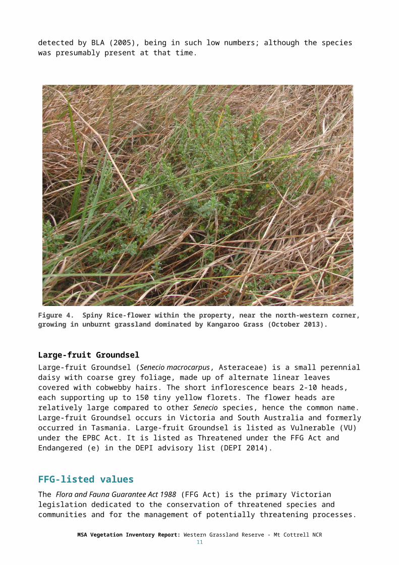
Figure 4. Spiny Rice-flower within the property, near the north-western corner, growing in unburnt grassland dominated by Kangaroo Grass (October 2013).
Large-fruit GroundselLarge-fruit Groundsel (Senecio macrocarpus, Asteraceae) is a small perennial daisy with coarse grey foliage, made up of alternate linear leaves covered with cobwebby hairs. The short inflorescence bears 2-10 heads, each supporting up to 150 tiny yellow florets. The flower heads are relatively large compared to other Senecio species, hence the common name. Large-fruit Groundsel occurs in Victoria and South Australia and formerly occurred in Tasmania. Large-fruit Groundsel is listed as Vulnerable (VU) under the EPBC Act. It is listed as Threatened under the FFG Act and Endangered (e) in the DEPI advisory list (DEPI 2014).
FFG-listed valuesThe Flora and Fauna Guarantee Act 1988 (FFG Act) is the primary Victorian legislation dedicated to the conservation of threatened species and communities and for the management of potentially threatening processes. Although the structure of the MSA and the goals of the WGR do not directly relate to the FFG Act, FFG-listed assets are the responsibility of Victoria to manage, and they provide a useful structure for considering the status of the values on the property.
One FFG-listed community occurs: ‘Western (Basalt) Plains Grassland Community’, which corresponds directly (on this property) with NTG, discussed above.
One FFG-listed species occurs naturally: Spiny Rice-flower, which is also EPBC-listed and was discussed above.
MSA Vegetation Inventory Report: Western Grassland Reserve - Mt Cottrell NCR10

Native vegetation according to Ecological Vegetation ClassesThe survey area contains 43.8 ha of native vegetation (99%).
The patterns of vegetation on the property can be described using two EVCs. The current distribution of EVCs is shown in Figure 5, below. The assumed distribution of EVCs before agricultural settlement (‘pre-1750’) is shown in Figure 6.
Plains Grassland (EVC 132) This EVC corresponds directly (on this property) to NTG, which was described above. DELWP recognizes several variants of Plains Grassland, with all in the surveyed area best referable to ‘Heavy Soils Plains Grassland’, with some affinities with ‘Low Rainfall Plains Grassland’ (e.g. diversity of chenopods).
This EVC, like NTG, covers 43.8 ha of Mount Cottrell NCR (99%).
Plains Grassy Wetland (EVC 125) This EVC describes low lying areas that are inundated after rains. The soils are fertile clays, and the vegetation is composed of grasses, sedges, rushes and herbs. In this area, inundation may occur every year, or every few years, and may occur in any season. The Plains Grassy Wetland vegetation within Mount Cottrell NCR is dominated by Common Swamp Wallaby-grass (Amphibromus nervosus), Common Tussock-grass and rushes (Juncus spp.). This EVC is shown in Figure 7.
This EVC only occurs in the south-eastern corner of the property. This area now holds more water than previously, due to earthworks adjacent to the property, which may cause gradual changes to the vegetation; possibly including the proliferation of Cumbungi (Typha domingensis).
The extent of this EVC on the property is extremely limited, with only 0.04 ha recorded (<0.1%).
MSA Vegetation Inventory Report: Western Grassland Reserve - Mt Cottrell NCR11

Figure 5. The current distribution of native vegetation classified according to EVCs on the property.
Figure 6. The likely pre-1750 distribution of native vegetation according to EVCs.
MSA Vegetation Inventory Report: Western Grassland Reserve - Mt Cottrell NCR12

Figure 7. Plains Grassy Wetland at Mount Cottrell NCR. Common Swamp Wallaby-grass is flowering in the middle ground.
Vegetation patterns - Natural Temperate Grassland ‘states’To assist the management of NTG, DELWP has created a state-and-transition model (STM) of this ecosystem. This is a conceptual model which describes the structure and dynamics of NTG in a way that is useful for management and planning. Any location within the NTG ecosystem (current native vegetation or cleared land) can be described as being in a particular ‘state’. Locations may ‘transition’ (change) between states over time, as a result of natural disturbance or management. The ability to maintain and enhance NTG condition (i.e. reach management targets) depends on the ability to manipulate the transitions between states. Mapping the states is important because locations in a given ‘state’ share a particular set of management constraints and opportunities.
While some states are generally more intact than others, it is important to acknowledge that condition (or ‘quality’ or ‘value’) may vary substantially within a given state; and the assignment of a site to a particular state is not the same as a condition assessment. Certain states (or condition classes within a state) may be degraded to the point that they are no longer part of a listed community (Beeton and McGrath 2009).
Natural Temperate Grassland was identified in several states, described below. These are mapped in Figure 8.
MSA Vegetation Inventory Report: Western Grassland Reserve - Mt Cottrell NCR13

Figure 8. Grassland states on the property
Herb-rich grassland (HG)This state includes the most intact remaining grasslands. These areas have not been de-rocked, have relatively natural (low) nutrient levels, and retain most of their natural species diversity, including the dominant Kangaroo Grass. Many species sensitive to grazing and/or elevated nutrients are restricted to this state on the property. Some such species are relatively common in this vegetation (e.g.Lobe-seed Daisy (Brachyscome dentata), Lemon Beauty-heads (Calocephalus citreus)), others are relatively rare and scattered (e.g. Cut-leaf Goodenia (Goodenia pinnatifida), Scaly Buttons (Leptorhynchos squamatus), Grassland Candles (Stackhousia subterranea)) and some are present as only one or a few individuals (e.g. Austral Trefoil (Lotus australis), Spiny Rice-flower). Taken as a whole, Herb-rich Grassland on the property is relatively species-rich, even compared to other grassland reserves (53 native forbs and sub-shrubs). The degree of weed invasion in Herb-rich Grassland varies markedly. Annual weeds are ubiquitous in the wetter months, with Soft Brome (Bromus hordeaceus) and Wimmera Rye-grass (Lolium rigidum) being most abundant. Perennial weeds are scattered, with Serrated Tussock (Nassella trichotoma) being the most abundant.
Herb-rich grassland covers 22.5 ha of Mount Cottrell NCR (51%). An example of this vegetation is shown in Figure 9.
MSA Vegetation Inventory Report: Western Grassland Reserve - Mt Cottrell NCR14

Figure 9. Herb-rich grassland (HG) at Mount Cottrell NCR.
C3 Grassland (C3G)This state includes areas which have not been de-rocked, but which have lost the naturally-dominant Kangaroo-grass, and may have slightly elevated nutrient levels, as a result of localised patterns of grazing and nutrient accumulation All areas assigned to this state approach ‘Nutrient-enriched grassland’ (NG). The transition between these two states is gradual, as it involves the slow process of de-nutrification. In summer and autumn, the vegetation is dominated by perennial native grasses (Spear-grass and Wallaby-grasses), but in winter and spring, annual nutrient-loving weeds dominate (notably Soft Brome and Wimmera Rye Grass). C3 Grassland retains high numbers of a few native herb species that are relatively tolerant of grazing and elevated nutrients (Australian Sheep’s-burr (Acaena ovina), Common Woodruff (Asperula conferta), Creeping Saltbush (Atriplex semibaccata), Blue Devil, Grassland Wood-sorrell). Figure 10 shows a highly weed-invaded area of C3 Grassland at Mount Cottrell NCR.
C3 Grassland covers 21.6 ha of Mount Cottrell NCR (49%).
Nutrient-enriched Grassland (NG)This state includes areas which have not been de-rocked, but which have elevated nutrient levels as a result of grazing and fertilizer application (as indicated by a high cover of nutrient-loving weeds). These areas have also largely lost the naturally-dominant Kangaroo Grass. Many areas assigned to this state approach ‘C3 grassland’ (C3G). The transition between these two states is gradual, as it involves the slow process of de-nutrification. In summer and autumn, the vegetation is dominated by perennial native grasses (Spear-grasses and Wallaby-grasses), but in winter and spring, annual nutrient-loving weeds dominate (notably Soft Brome and Wimmera Rye Grass). In the Mt Cottrell NCR there is one small area (0.34 ha) of NG near the eastern boundary.
MSA Vegetation Inventory Report: Western Grassland Reserve - Mt Cottrell NCR15

Figure 10. C3 Grassland at Mount Cottrell NCR. The foreground is dominated by Lolium rigidum.
De-rocked nutrient-enriched pasture (DNP)This state describes areas which have had their natural rocky layer removed, and have elevated nutrient levels as a result of grazing and fertilizer application. In Mount Cottrell NCR, this state is restricted to two small areas (totalling 0.4 ha) that were previously used as farm dams. These areas have been filled in, and are now dominated by exotic species.
Plant speciesOne hundred and fifty nine vascular plants were recorded on the surveyed land. While this tally represents a high diversity, the abundance of the species was markedly uneven. A small number of species covered most of the property (the natives Kangaroo Grass and Spear-grass and the exotics Soft Brome and Wimmera Rye Grass). Most species were recorded in few places and in low abundance.
Of the 159 species recorded, 102 were native (64%).
Appendix 1 lists all of the vascular plant species recorded, and describes their estimated abundance, according to vegetation types. This list is intended to be a useful reference guide for managers. Appendix 2 presents notes on plant identification.
Significant native speciesAs noted above, one naturally-occurring species was recorded that is EPBC- and FFG-listed (Spiny Rice-flower). Two additional EPBC- and FFG-listed species were recorded which were introduced to the property.
Four other species were recorded that are listed as rare or threatened in Victoria (VROTs). These species are scattered across the surveyed land, with the largest concentrations on the eastern half of the property. One, Scented Saltbush (Rhagodia parabolica), only occurs under planted windbreak trees, not in the
MSA Vegetation Inventory Report: Western Grassland Reserve - Mt Cottrell NCR16

remnant grassland vegetation, and it is doubtful whether this species occurred historically on this site. It is dispersed by birds, and is common in nearby woodlands.
Table 1 shows all these listed species, with some brief notes about their local occurrence. Figure 11 shows the distribution of some of these species (but not those that are very widespread).
Table 1: Significant native species that are listed under the EPBC-Act, FFG-ACT or on the DEPI VROT Advisory List (DEPI 2014). CE= critically endangered, EN=endangered, V=vulnerable, F = FFG listed, e= endangered, r= rare, k= poorly known.
Species EPBC FFG VROT ObservationsConvolvulus angustissimus subsp. omnigracilis (Slender Bindweed0
k Very common everywhere (1000s of plants, not shown on Figure 11).
Dianella sp. aff. longifolia (Benambra) (Arching Flax-lily)
k A few naturally occurring individuals (~6) scattered, mostly in the eastern half of the property. A further 39 translocated plants occur on the property (not shown in Figure 11).
Lotus australis var. australis (Austral Trefoil)
k Six individuals noted, scattered in the eastern half of the property.
Pimelea spinescens subsp. spinescens (Spiny Rice-flower)
CE F e Two individuals are naturally occurring. About 67 translocated individuals are also present
Rhagodia parabolica (Scented Saltbush) r Two plants under the planted Sugar gums in the south-western corner of the property. Probably outside natural habitat.
MSA Vegetation Inventory Report: Western Grassland Reserve - Mt Cottrell NCR17

Figure 11. The locations of selected significant plant species. The species shown are either EPBC-listed, FFG-listed, or VROT species. Species which are very widespread are not shown.
Figure 12. Selected species found on the property. Clockwise from top left: Lotus australis (k), Ptilotus spathulatus, Wahlenbergia victoriensis, Leptorhynchos squamatus.
MSA Vegetation Inventory Report: Western Grassland Reserve - Mt Cottrell NCR18

WeedsOf the 159 species recorded, 57 are introduced species. Some of the introduced species identified pose serious risks to native vegetation on or near the surveyed land, or to agriculture in the surrounding areas. The identification and mapping of those species is necessary to assist management.
Table 2 lists the species recorded on the property which are listed under the CaLP Act, and notes their category of listing in the Port Phillip region. Figure 13 shows the distribution on the surveyed land of some of these species. Some very abundant species are not shown on the map, for the sake of clarity (e.g. Serrated Tussock).
In addition to these declared noxious weeds, DSE (2011) identified 10 species that were considered to be the most seriously threatening in the WGR. Four of these occur on the surveyed property, but only 2 are declared noxious weeds in the Port Phillip and Westernport region:
Gazania linearis (Gazania) (Not declared noxious, but serious emerging threat)
Lophopyrum ponticum (Tall Wheat Grass) (not declared noxious, but serious emerging threat)
Nassella neesiana (Chilean Needle Grass) (declared noxious, above)
Physalis hederifolia (formerly viscosa) (Prairie Ground-cherry) (declared noxious, above)
Table 2. Declared noxious weeds observed on the surveyed land.
CaLP Act category Weed species ObservationsState Prohibited None NA
Regionally Prohibited None NA
Regionally Controlled Cirsium vulgare (Spear Thistle) Widespread and abundant
Cynara cardunculus (Artichoke Thistle) Widespread and abundant
Eragostis curvula (African love-grass) Not detected, but reportedly controlled in 2012 by Ecodynamics Pty Ltd (Randall Wees, Ecodynamics, pers. comm.)
Lycium ferrocissimum (African Boxthorn) Widely scattered, not common
Nassella trichotoma (Serrated Tussock) Widespread and abundant
Physalis hederifolia (viscosa) (Prairie Ground-cherry)
Occasional
Restricted Nassella neesiana (Chilean Needle Grass) Localised patches, mostly along access track and on eastern edge.
In addition to these species, several others are considered high threat weeds in the context of Mount Cottrell NCR:
Galenia pubescens (Blanket Weed)
Opuntia ?ficus-induca (a Cactus)
Carthamus lanatus (Saffron Thistle)
MSA Vegetation Inventory Report: Western Grassland Reserve - Mt Cottrell NCR19

Figure 13. The locations of selected weed species.
Hot SpotsThe information presented above provides a formal spatial assessment of the values. This section provides a subjective assessment of where these values intersect to create conspicuous concentrations of biological values (and risks), called here “hot spots”. These are the places of particular interest on the property, and places where intensive or intricate management may be justified to protect the values of the site. The assessment of ‘hot spots’ is necessarily subjective, because it takes into account some intangible quantities, including interesting or unusual juxtapositions of biological values for educational purposes, etc.
On the property, the most intact grassland area with the highest diversity of native species is considered to be a single large ‘hot spot’. This area is shown in Figure 14.
MSA Vegetation Inventory Report: Western Grassland Reserve - Mt Cottrell NCR20

Figure 14. ‘Hot spots’, subjectively defined on the subject land
MSA Vegetation Inventory Report: Western Grassland Reserve - Mt Cottrell NCR21

References
Brett Lane and Associates (2005). Flora and fauna assessment, Troups Rd, Mount Cottrell. For PS Marine, Pty Ltd. Report #5130 (1.0). Brett Lane and Associates, North Carlton, Victoria. November 2005.
Brett Lane and Associates (2012). Dexus-Doherteys Rd, Truganina. Translocation and Salvage Plan for Spiny Rice-flower and Arching Flax-lily. BLA unpublished report 9129(10.5), October 2012.
Bull M, Stolfo G (Eds) (2014). Flora of Melbourne, 4th edition. Hyland House, Melbourne.
Department of Environment, Land, Water and Planning (2015a). Monitoring and Reporting Framework: Program Outcomes, for the Melbourne Strategic Assessment. Victorian Government Department of Environment, Lane, Water and Planning, East Melbourne, Victoria.
Department of Environment, Land, Water and Planning (2015b). Property Inventory Guidelines, Melbourne Strategic Assessment. Victorian Government Department of Environment, Land, Water and Planning, East Melbourne, Victoria.
Department of Environment and Primary Industries (2013a). Biodiversity Conservation Strategy for Melbourne's Growth Corridors. Department of Environment and Primary Industries, East Melbourne.
Department of Environment and Primary Industries (2013b). Permitted Clearing of Native Vegetation: Biodiversity Assessment Guidelines. Department of Environment and Primary Industries, East Melbourne.
Department of Environment and Primary Industries (2014). Advisory List of rare or threatened plants in Victoria. Department of Environment and Primary Industries, East Melbourne.
Department of Sustainability and Environment (2009). Delivering Melbourne’s Newest Sustainable Communities. Program Report. Department of Sustainability and Environment, East Melbourne.
Department of Sustainability and Environment (2011). Western Grassland Reserves: Interim Management. Department of Sustainability and Environment, East Melbourne.
Department of Sustainability and Environment (2012). A field guide to Victorian Wetland Ecological Vegetation Classes for the index of wetland condition (2nd Edition). Department of Sustainability and Environment, East Melbourne.
KBR (2011). Translocation and propagation plan for Spiny Rice-flower. Regional Rail Link report RRL-2000-EEC-PLN-0002, October 2011.
Threatened Species Scientific Committee (2008). Advice to the Minister for the Environment, Heritage and the Arts from the Threatened Species Scientific Committee (the Committee) on Amendment to the list of Threatened Ecological Communities under the Environment Protection and Biodiversity Conservation Act 1999 (EPBC Act): Natural Temperate Grassland of the Victorian Volcanic Plain. Canberra, ACT.
Threatened Species Scientific Committee (2012). Commonwealth Listing Advice on Seasonal Herbaceous Wetlands (Freshwater) of the Temperate Lowland Plains (Threatened Species Scientific Committee (TSSC).
Walsh NG, Stajsic V (2008) A census of the vascular plants of Victoria. Royal Botanic Gardens, Melbourne.
MSA Vegetation Inventory Report: Western Grassland Reserve - Mt Cottrell NCR22

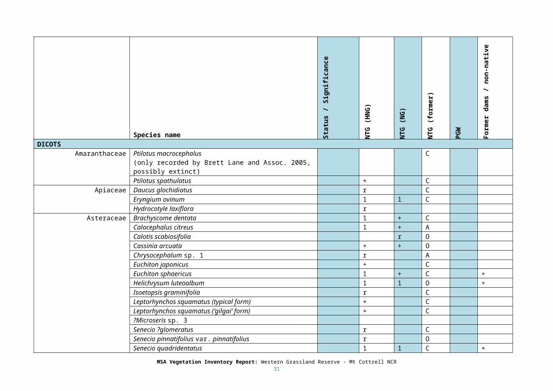
Appendix 1: List of vascular plants identified
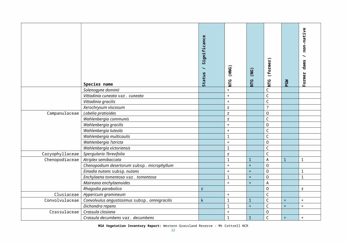
The list below records all vascular plant species recorded, by habitat (community / EVC). The habitats are abbreviated as follows:
NTG (HG) Natural Temperate Grassland / Plains Grassland in the state Herb-rich Grassland.
NTG (NG) Natural Temperate Grassland / Plains Grassland in the state Nutrient-enriched Grassland.
PGW Plains Grassy Wetland
The significance of each species is rated using the following categories:
EPBC: EPBC listed (see main text for discussion of species in this category)
e VROT: Endangered in Victoria.
v: VROT: Vulnerable in Victoria.
r: VROT: Rare in Victoria.
k: VROT: Poorly known in Victoria.
SP: CaLP listed: State Prohibited weed.
RP: CaLP listed: Regionally Prohibited weed.
RC: CaLP listed: Regionally Controlled weed.
Res: CaLP listed: Restricted weed.
The following categories taken from Mueller-Dombois & Ellenberg (1974; Aims and Methods of Vegetation Ecology. Wiley, New York), describe the observed abundance / distribution of each species in each vegetation type in the survey area. These are qualitative estimates that refer to the abundance of the species across the entire site, and may be assigned in retrospect after numerous site visits. The use of the categories makes no reference to the status of the species outside the study area
r Solitary (or at least exceedingly rare)
+ Few individuals, <5% cover
1 Numerous or scattered, <5% cover
2 5-25% cover
3 25-50% cover
4 50-75% cover
5 >75% cover
The direct observations above are modified by the following categories which represent the author’s (S Sinclair) opinion about the former abundance of each taxon before Agricultural land use (pre-1835). The combination of both abundance estimates represents some local measure of depletion:
A: Abundant. Once numerous, and probably once contributed >5% cover within the vegetation type.
C: Common. Once numerous, but probably did not contribute >5% cover within the vegetation type.
O: Occasional. Always rare or incidental within the vegetation type. This includes ‘freak’ occurrences which are observable ‘in’ a vegetation type, but are not ‘of’ it.
MSA Vegetation Inventory Report: Western Grassland Reserve - Mt Cottrell NCR23

Species marked with a ? are doubtful. The location of the ? denotes the level of uncertainty. Species with a ? before their generic names are of doubtful occurrence; often because they have been reported by other observers without supporting specimens or photographs. Species marked with a ? before their specific or subspecific names are of doubtful identity, usually because mature material could not be obtained that displayed all of the characters required for positive identification.
MSA Vegetation Inventory Report: Western Grassland Reserve - Mt Cottrell NCR24
Species name Stat
us /
Sig
nific
ance
NTG
(HN
G)
NTG
(NG)
NTG
(for
mer
)
PGW
Form
er d
ams /
non
-nati
ve
NATIVE SPECIESMONOCOTS
Cyperaceae Carex inversa 1 1 C 1Eleocharis acuta 1Eleocharis pusilla +Isolepis marginata + C +Isolepis victoriensis +Schoenus apogon 1 1 C +
Juncaceae Juncus bufonius + + + +Juncus flavidus 1Juncus homalocaulis +Juncus planifolius +Juncus radula +Juncus subsecundus 1 1 C
Liliaceae Arthropodium minus + CDianella sp. aff. longifolia (Benambra) v + + C
Poaceae C3 Amphibromus macrorhinusAmphibromus nervosus 1Anthosachne scabra s.l. 1 + CAustrostipa bigeniculata 2 3 CAustrostipa oligostachya + C
MSA Vegetation Inventory Report: Western Grassland Reserve - Mt Cottrell NCR25
Species name Stat
us /
Sig
nific
ance
NTG
(HN
G)
NTG
(NG)
NTG
(for
mer
)
PGW
Form
er d
ams /
non
-nati
ve
Austrostipa setacea 1 CDichelachne crinita + C +Lachnagrostis aemula O +Lachnagrostis filiformis + + O 1Microlaena stipoides var. stipoides + + OPoa labillardierei var. labillardierei + O 1Poa sieberiana var. sieberiana 1 + ARytidosperma caespitosum 1 1 C +Rytidosperma duttonianum 2 + A 1 +Rytidosperma setaceum 1 + C
Poaceae C4 Bothriochloa macra 1 + CChloris truncata 1 1 C +Dichantheum sericeum subsp. sericeum + OEnneapogon nigricans + OPanicum effusum + OThemeda triandra 3 + AWalwhalleya proluta 1 1 C
Typhaceae Typha domingensis 1FERNS
Pteridaceae Cheilanthes sieberi subsp. sieberi + CDICOTS
Amaranthaceae Ptilotus macrocephalus(only recorded by Brett Lane and Assoc. 2005, possibly extinct)
C
Ptilotus spathulatus + CApiaceae Daucus glochidiatus r C
MSA Vegetation Inventory Report: Western Grassland Reserve - Mt Cottrell NCR26

Species name Stat
us /
Sig
nific
ance
NTG
(HN
G)
NTG
(NG)
NTG
(for
mer
)
PGW
Form
er d
ams /
non
-nati
ve
Eryngium ovinum 1 1 CHydrocotyle laxiflora r
Asteraceae Brachyscome dentata 1 + CCalocephalus citreus 1 + ACalotis scabiosifolia r OCassinia arcuata + + OChrysocephalum sp. 1 r AEuchiton japonicus + CEuchiton sphaericus 1 + C +Helichrysum luteoalbum 1 1 O +Isoetopsis graminifolia r CLeptorhynchos squamatus (typical form) + CLeptorhynchos squamatus (‘gilgai’ form) + C?Microseris sp. 3Senecio ?glomeratus r CSenecio pinnatifolius var. pinnatifolius r OSenecio quadridentatus 1 1 C +Solenogyne dominii + CVittadinia cuneata var. cuneata + CVittadinia gracilis + CXerochrysum viscosum r ?
Campanulaceae Lobelia pratioides r OWahlenbergia communis r CWahlenbergia gracilis + OWahlenbergia luteola + C
MSA Vegetation Inventory Report: Western Grassland Reserve - Mt Cottrell NCR27

Species name Stat
us /
Sig
nific
ance
NTG
(HN
G)
NTG
(NG)
NTG
(for
mer
)
PGW
Form
er d
ams /
non
-nati
ve
Wahlenbergia multicaulis 1 CWahlenbergia ?stricta + OWahlenbergia victoriensis 1 C
Caryophyllaceae Spergularia ?brevifolia r CChenopodiaceae Atriplex semibaccata 1 1 A 1 1
Chenopodium desertorum subsp. microphyllum + + OEinadia nutans subsp. nutans + + O 1Enchylaena tomentosa var. tomentosa 1 + O 1Maireana enchylaenoides + + ARhagodia parabolica r O r
Clusiaceae Hypericum gramineum + CConvolvulaceae Convolvulus angustissimus subsp. omnigracilis k 1 1 C + +
Dichondra repens 1 + C + +Crassulaceae Crassula closiana + O
Crassula decumbens var. decumbens 1 1 C + +Crassula seiberiana 1 1 C + +
Elatinaceae Elatine gratioloides 1Fabaceae Glycine tabacina + + C
Lotus australis var. australis k r CGeraniaceae Erodium crinitum + C
Goodeniaceae Goodenia pinnatifida + CHaloragaceae Haloragis aspera + + C 1
Lythraceae Lythrum hyssopifolia + + C 1 +Mimosaceae Acacia mearnsii r O
Acacia pycnantha r
MSA Vegetation Inventory Report: Western Grassland Reserve - Mt Cottrell NCR28
Species name Stat
us /
Sig
nific
ance
NTG
(HN
G)
NTG
(NG)
NTG
(for
mer
)
PGW
Form
er d
ams /
non
-nati
ve
Onagraceae Epilobium hirtigerum 1 1 C +Oxalidaceae Oxalis perennans 1 1 C 1
Plantaginaceae Plantago gaudichaudii + CPolygonaceae Rumex brownii 1 1 C +
Rumex dumosus + CRosaceae Acaena ovina 1 1 C
Rubiaceae Asperula conferta 1 1 CStackhousiaceae Stackhousia subterranea + C
Thymeleaceae Pimelea spinescens subsp. spinescens EPBC r C oVioliaceae Melicytus dentatus s.s. + C
Melicytus sp. aff. dentatus (Volcanic Plain variant) r CINTRODUCED SPECIESMONOCOTS
Cyperaceae Cyperus eragrostis NA +Iridaceae Romulea minutiflora + NA
Romulea rosea var. australis 2 2 NA 1 2Poaceae C3 Avena barbata 1 1 NA 1
Briza minor + + NABromus hordeaceus subsp. hordeaceus 2 2 NA 2Bromus madritensis + + NA +Dactylis glomerata + + NA +Ehrharta longiflora + NA +Hordeum glaucum + NA +Lolium rigidum 3 3 NA 3Lophopyrum ponticum r NA
MSA Vegetation Inventory Report: Western Grassland Reserve - Mt Cottrell NCR29
Species name Stat
us /
Sig
nific
ance
NTG
(HN
G)
NTG
(NG)
NTG
(for
mer
)
PGW
Form
er d
ams /
non
-nati
ve
Nassella neesiana R + + NA rNassella trichotoma RC 1 1 NA 1Tribolium acutiflorum r NA rVulpia bromoides 1 1 NA 1
Poaceae C4 ?Eragrostis curvula NADICOTS
Apocynaceae Gomphocarpus fruticosus subsp. fruticosus r NAAizoaceae Galenaia pubescens var. pubescens + + NA 1
Asteraceae Arctotheca calendula + + NA +Aster subulatus NA + +Carthamus lanatus r NACirsium vulgare RC 1 1 NA + 1Conyza bonariensis 1 1 NA 1Cotula coronopifolia NA 1Cynara cardunculus subsp. flavescens RC + 1 NA 1Gazania linearis r r NAGamochaeta purpurea 1 1 NAHelminthotheca echioides 1 1 NA 1Hypochaeris radicata 1 1 NA 1Lactuca saligna + + NA rLeontodon taraxacoides + + NASoliva sessilis r NASonchus oleraceus 1 1 NA +Vellereophyton dealbatum + NA
Brassicaceae Brassica fruticulosa NA 1
MSA Vegetation Inventory Report: Western Grassland Reserve - Mt Cottrell NCR30
Species name Stat
us /
Sig
nific
ance
NTG
(HN
G)
NTG
(NG)
NTG
(for
mer
)
PGW
Form
er d
ams /
non
-nati
ve
Cactaceae Opuntia ?ficus-indica r NACaryophyllaceae Moenchia erecta r NAChenopodiaceae Chenopodium album NA 1
Fabaceae Medicago polymorpha + + NA +Trifolium angustifolium var. angustifolium 1 1 NA +Trifolium ?striatum + NA +Trifolium sp. + NA +
Gentianaceae Centaurium erythraea + + NA +Cicendia quadrangularis r NA
Geraniaceae Erodium botrys 1 1 NA 1Lamiaceae Salvia verbenaca + + NA +Malvaceae Malva sp. NA 1
Plantaginaceae Plantago coronopus 1 1 NA 1Plantago lanceolata + + NA +
Polygonaceae Acetosella vulgaris + + NA +Rumex crispus NA +
Primulaceae Anagalis arvensis + + NA +Rosaceae Rosa rubiginosa NA +
Solanaceae Lycium ferocissimum RC + + NA 1Physalis hederifolia RC + + NA +Solanum nigrum s.l. + + NA +
MSA Vegetation Inventory Report: Western Grassland Reserve - Mt Cottrell NCR31

Appendix 2: Notes on plant identification
Some plants displayed characteristics or variations worthy of note. These may include plants that were difficult to assign to a species, plants which occurred in several apparently distinct but unrecognized forms and plants which could be assigned to a sub-specific rank not formally recognized, but commonly noted and/or listed on the curation version of the Victorian Biodiversity Atlas database:
Juncus subsecundus. A conservative view of this very variable species was taken. Numerous specimens were assigned to this species which approached a number of other species, based on variation in culm striations, inflorescence architecture and stature.
Leptorhynchos squamatus. The property contains two distinct entities: L. squamatus s.s. with broad, hairy basal leaves, scattered across the property, and another undescribed taxon with linear, glabrous, erect basal leaves that occurs in damper locations, referred to in the text as “Leptorhynchos squamatus (Gilgai form)”.
Several plants are marked in the list with a “?” preceding their generic names, specific or subspecific names. These identifications are uncertain and were only observed as immature specimens, or specimens could not be obtained which showed all the relevant features for identification.
MSA Vegetation Inventory Report: Western Grassland Reserve - Mt Cottrell NCR32

www.delwp.vic.gov.au