muizenberghigh.org · web viewgrade 10 tourism . term . 2. map terminology and map symbols;...
TRANSCRIPT
Grade 10 Tourism
Term 2 Map terminology and map symbols; Different Types of Maps
What you need to know at the end of this week:
• Concepts such as scale, direction, distance indicators, legends, map grid References, equator, hemispheres, north pole, south pole, latitude, longitude, time zones, Universal Time Coordinate (UTC), International Date Line (IDL)Resources: Different types of colour maps, as needed for all sections on map work and tour planning
Session 1: BASELINE ASSESSMENT: MAPWORK
Write down the meaning of the following word in your book as revision from SS grade 8 and 9ScaleDirectionDistance indicatorsMap legendsMap grid referencesEquatorHemisphereNorth and South poleLongitudeLatitude
Session 2: Map work notes
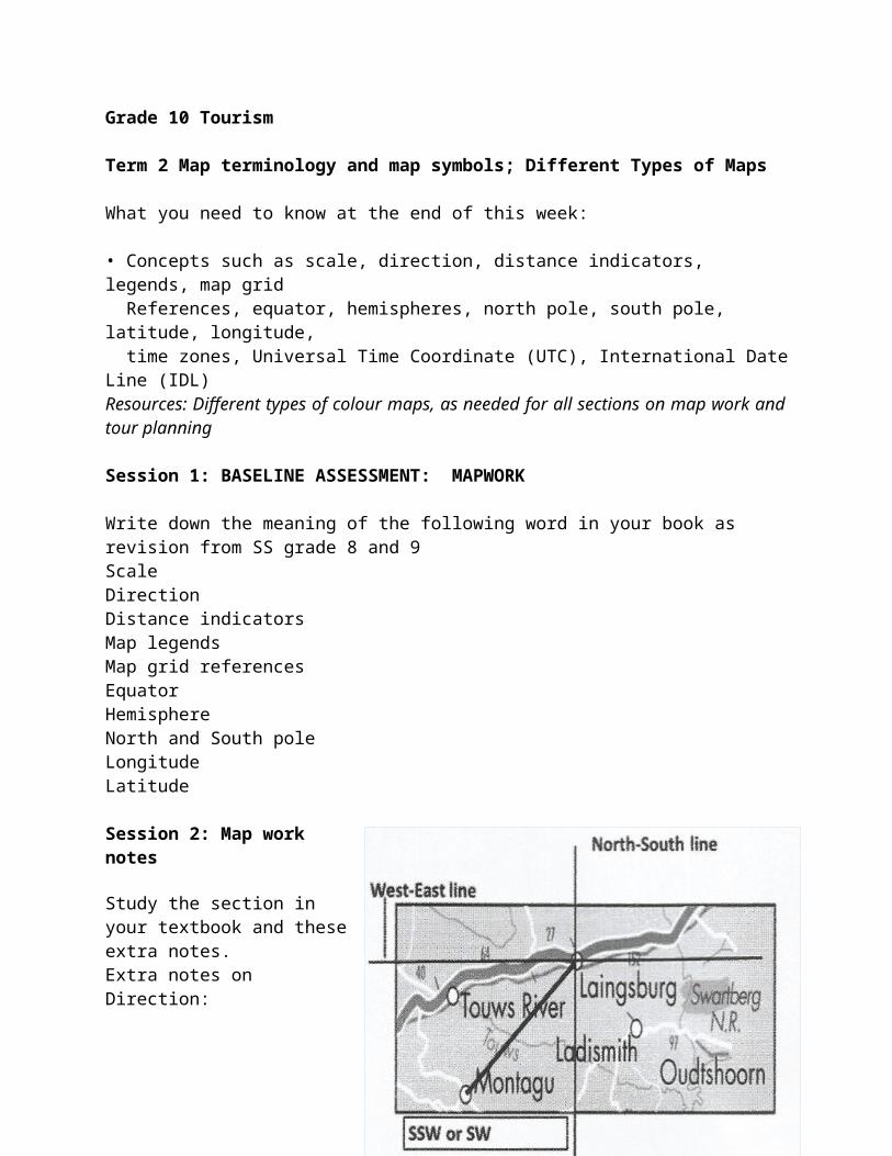
Study the section in your textbook and these extra notes. Extra notes on Direction:Remember from and to: From is the starting point and to is the ending pointStep 1: Draw a vertical line through the point where the direction is being taken: North-South line. Step 2: Then draw a horizontal line through the same point: West-East line. Step 3: Draw a line joining the two places – the place where the direction is being measured to the place to which direction is being measured.
Step 4: Identify the direction
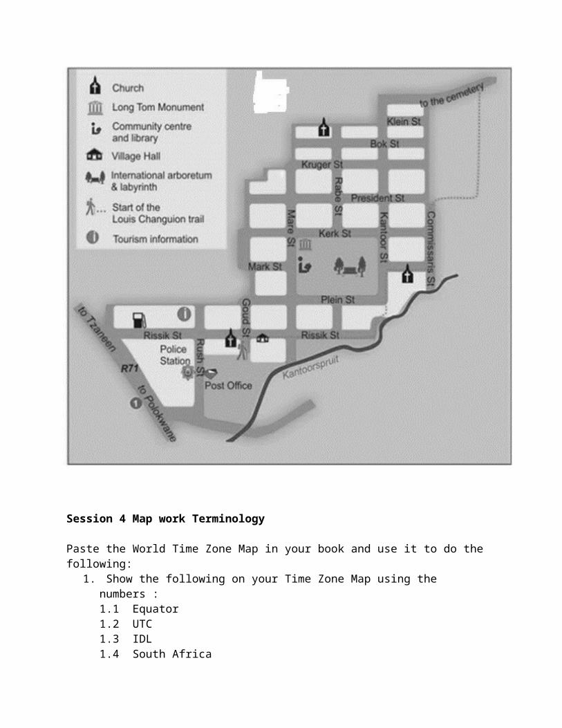
Session 3 Use the map below and answer the following questions.
1. Draw a compass and complete the 16 directions.
2. Indicate what general direction is the: (show the directions on the map)2.1 Church in Bokstreet from the Tourism information office?2.2 Village Hall from the Tourism information office?
3. Tell a tourist the way from the Post Office to the Long Tom Monument. 4. Name two neighboring towns to this map. 5. What is the name of the river running through the town? (A spruit is a river)
Session 4 Map work Terminology
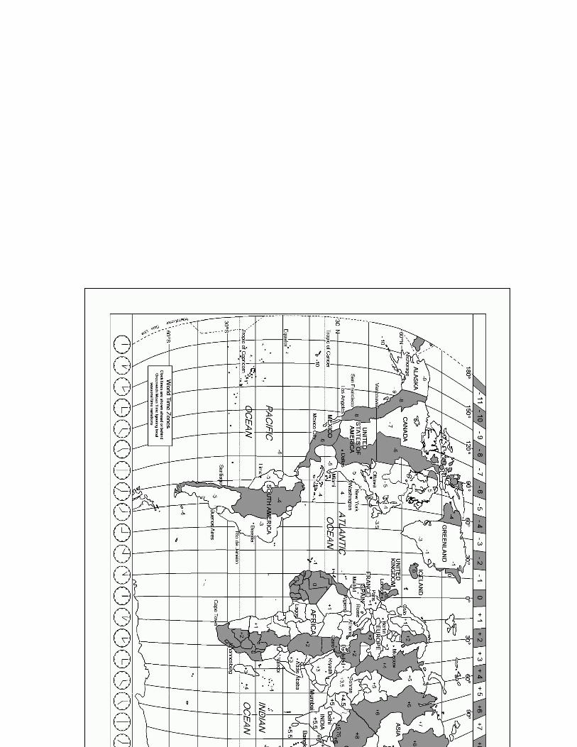
Paste the World Time Zone Map in your book and use it to do the following:1. Show the following on your Time Zone Map using the numbers :
1.1 Equator1.2 UTC1.3 IDL1.4 South Africa1.5 North pole 1.6 South pole1.7 Northern hemisphere1.8 Eastern Hemisphere
2. Now answer the following questions by using the Time Zone Map.2.1 What time zone does South Africa use?2.2 How many degrees is this line from the UTC? Explain your answer.2.3 What would the time difference be between South Africa and the UTC?2.4 How many time zones are between South Africa and England?2.5 If it is 8:00 in England, how late would it be in South Africa?2.6 How many time zones (longitude) are on earth?
3. What is the use of the IDL?
Grade 10 Term 2 Week 12 Different types of maps in a tourism context
What you need to know at the end of this week:
Give an example and explanation of the type of map and its uses and value in tourism.• A variety of maps used in tourism context: road and street maps, political maps, physical maps, specialist maps (reflecting climate, airports, railways, etc.), tourist information maps (National Parks, World Heritage Sites, tourist attractions in specific areas, hiking trails, meanders)• Electronic maps: global positioning systems (GPS), Google street maps, Google Earth and other ICT resources: Computers or smart phones can be used to access examples of electronic maps.
Session 1: A variety of maps used in tourism context
1. Study the maps below. Draw the table in your book. Answer the questions by completing the table.
1.1 Identify the TYPE of maps A-D shown below.1.2Indicate the reason why tourists will use these type of maps.
Type of maps The reason why tourists will use these type of maps
A
A Africa B National roads in South Africa
C Kimberley city centre
D South Africa Rivers and mountains
E Baz bus in South Africa
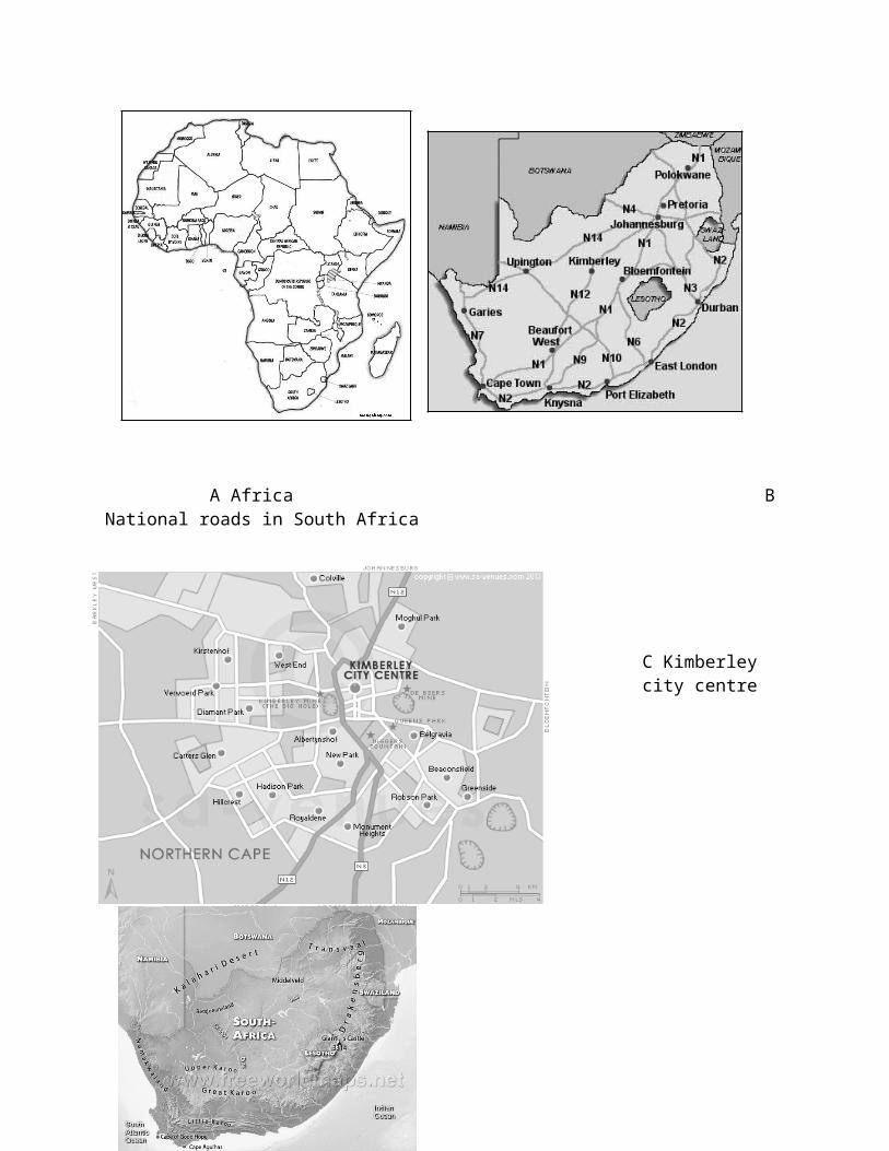
Session 2: A variety of maps used in tourism context1. Study map E and answer the questions that follow: 1.1 Name the four provinces where the Bazbus are travelling.1.2 Name the four towns where they have compulsory stop overs. 1.3 Identify the type of map?1.4 Which type of tourist will use this type of map?1.5 Why will tourists use this type of map?
Session 3: A variety of maps used in tourism context1. Refer to all the maps A-E . Identify which map you will give to the tourists in the following examples.1.1 A family of four driving to Cape Town from Pretoria using the national roads.1.2 An elderly couple is visiting KZN and would like to know where is the Drakensberg mountains1.3 A South African family is planning a road trip from South Africa to Malawi. 1.4 Four friends backpacking between Gauteng and Durban. 1.5 Two friends visiting interesting sites in Northern Cape like the Big Hole in Kimberley.
Session 4: Electronic maps:
1. Where will tourists find electronic maps?2. What is the benefits of electronic maps versus paper maps?
Session 5: Using your textbook create a summary of the different types of maps.