wellhead protection - purdue extension purdue extension wellhead protection - wq-31 1. get maps of...
TRANSCRIPT
Purdue Extension • West Lafayette, Indiana
WQ-31
Inventorying Potential Sources of DrinkingWater Contamination
Barbara C. Cooper,Water Quality EducationSpecialist
Jane R. Frankenberger,Extension AgriculturalEngineer
Fred Whitford,Coordinator, PurduePesticide Programs
for safe drinking water in Indiana
InsideWhat Is a Potential Contaminant Source? 2
How Do You Conduct a Contaminant Source Inventory? 2
What’s Next? 11
Useful Publications 11
Sources for Maps and Aerial Photos 12
Indiana Information Contacts 12
References 13
Wellhead Protection
Wellhead Protection
Clean, safe drinking water is vital toour communities, to our economy,and to our health. If your groundwater becomes contaminated, it maybe lost forever as a water supply ormay require very expensive treatmentto remain usable. The best way youcan ensure safe water, now and for thefuture, is to protect the area aroundyour drinking water supply wellsfrom potential hazards.
This publication provides guidancefor the public water supply operatorsand local wellhead protection planning team memberswho will guide the completion of the contaminantsource inventory. It explains the process ofidentifying regulated and unregulated, presentand past, potential contaminant sources withinthe wellhead protection area. It assumes thatyour wellhead protection planning team hasdefined and mapped your wellhead protectionarea using an appropriate delineation method.(See “Useful Publications” for PurdueExtension publications offering informationon these topics.)
Why Do a Contaminant Source Inventory?Indiana’s Wellhead Protection Rule (327 IAC 8-4.1)requires community water supply systems to “completean inventory of potential sources of contamination (regulatedand non-regulated) within the wellhead protection area.” This
Wellhead ProtectionPlanning Overview• Local planning team
• Delineation of the wellheadprotection area
• Identification of potential sourcesof contamination
• Management of the wellheadprotection area
• Contingency plan
• Public participation, education,and outreach
2
Wellhead Protection - WQ-31 Purdue Extension
rule requires a search of existing databases of regulated sources, buta database search alone will not reveal all potential sources ofcontamination. Volunteers your team recruits must also travelthrough the wellhead protection area to do a site inventory. Andyou should supplement this information by seeking historical landuse data from long-time community residents.
By knowing what potential contamination sources exist near yourdrinking water supply wells, your community can help preventground water contamination through effective management of landactivities. Experiences of other communities have shown that onaverage, wellhead protection is 27 times less costly than cleaning upa contaminated water source, according to the EnvironmentalProtection Agency. Not only is wellhead protection a matter ofcommon sense, it is a good idea from an economic point of view.
What Is a Potential Contaminant Source?A potential contaminant is anything that might get into your drink-ing water that you would not want to drink. A source is afacility or land activity that could release a contaminant.While soil serves as a filter for many things that mightotherwise enter the ground water, it is not capable of remov-ing everything. So it is important to prevent contaminantsat or near the surface of the ground from seeping into theground water.
The most important potential sources of contamination toidentify are those that are particularly hazardous to healthand those occurring in large volumes. Some obviouspotential sources of ground water contamination arehazardous chemicals that are stored, transferred, or usedin the wellhead protection area.
However, many other things are potentially hazardous to groundwater. Other potential sources include abandoned wells, land-fills, animal feed lots, storage lagoons, abandoned undergroundstorage tanks, quarries or mines, and septic systems. Former orabandoned gasoline stations, dry cleaners, and manufacturingfacilities, even though no longer in operation, might also be potentialsources of contamination. The contaminant source inventory is a listof all potential sources of contamination within the wellhead protec-tion area.
How Do You Conduct a Contaminant Source Inventory?To complete an inventory of potential contaminant sources, yourteam will need to identify existing regulated and non-regulatedsources, locate and identify them on a map, and tabulate the col-lected information about the sources. So one of your first tasks is toget base maps your team can use for organizing this data.
3
Purdue Extension Wellhead Protection - WQ-31
1. Get Maps of the WellheadProtection AreaMaps are vital throughout the wellheadprotection planning process. All the informa-tion gathered must be both tabulated anddisplayed on a map in the wellhead protec-tion plan submitted to the Indiana Depart-ment of Environmental Management(IDEM). If your area lies at the edge or cornerof an existing map sheet, you may need toobtain more than one published map tocover your wellhead protection area.
You will need at least three copies of yourbase map(s). One copy you will send toIDEM with your completed plan, one youwill keep as a master copy for yourself, andone you will use as a working map to writeand erase on as changes are made. You willalso need to photocopy (and possibly en-large) the working copy of the base map anddivide it into sections for use by volunteerswho will help with the site survey of thewellhead protection area. The site surveyprocess is described in more detail in a latersection of this publication.
Here are some options for types of mapsyour team can use as your base map. IDEM requires thatyou use either a USGS 7.5 minute topographic quadrangleor a map at a specific scale. (See the sidebar “A Note onScale.”) You can find information on where to acquire thesemaps at the end of this publication.
• Engineering Map—If you had the wellhead protectionarea delineated professionally, you should have receivedfrom the consultant a map of the delineated wellheadprotection area at a scale of between 1:4,800 and 1:12,000.(See “A Note on Map Scale.”) Depending on the detailincluded, your team could reproduce and use this delinea-tion map as the base map for the contaminant sourceinventory.
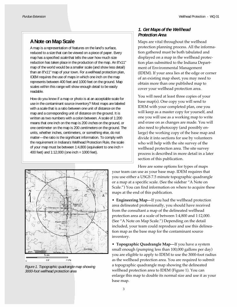
• Topographic Quadrangle Map—If you have a systemsmall enough (pumping less than 100,000 gallons per day)you are eligible to apply to IDEM to use the 3000-foot radiusas the wellhead protection area. You are required to submita topographic quadrangle map showing the delineatedwellhead protection area to IDEM (Figure 1). You canenlarge this map to double its normal size and use it as yourbase map.
A Note on Map ScaleA map is a representation of features on the land’s surface,reduced to a size that can be viewed on a piece of paper. Everymap has a specified scale that tells the user how much sizereduction has taken place in the production of the map. An 8"x11"map of the world would be a smaller scale (and show less detail)than an 8"x11" map of your town. For a wellhead protection plan,IDEM requires the use of maps in which one inch on the maprepresents between 400 feet and 1000 feet on the ground. Mapscales within this range will show enough detail to be easilyreadable.
How do you know if a map or photo is at an acceptable scale foruse in the contaminant source inventory? Most maps are labeledwith a scale that is a ratio between one unit of distance on themap and a corresponding unit of distance on the ground. It iswritten as two numbers with a colon between. A scale of 1:200means that one inch on the map is 200 inches on the ground, orone centimeter on the map is 200 centimeters on the ground. Theunits, whether inches, centimeters, or something else, do notmatter—the ratio is the significant information. To comply withthe requirement in Indiana’s Wellhead Protection Rule, the scaleof your map must be between 1:4,800 (equivalent to one inch =400 feet) and 1:12,000 (one inch = 1000 feet).
Figure 1. Topographic quadrangle map showing3000-foot wellhead protection area
4
Wellhead Protection - WQ-31 Purdue Extension
• Plat Map—Your team can also use a plat map as a base map, if it is ofthe appropriate scale. The advantage of using a plat map is that italready shows property boundaries and land ownership.
• City or County Map—If your wellhead protection area can beindicated on a city or county map and it is the proper scaleof between 1:4,800 and 1:12,000, your team could use thecity or county map as a base map.
• Aerial Photos—Aerial photography provides an optionfor the site survey portion of the contaminant source inven-tory. Because it is often difficult to get a clear photocopy, itis probably not the best choice for the base map. However,an advantage of aerial photos is that evidence of formerhazardous land activities and present land activities can beidentified, and that information can be transferred to yourbase map.
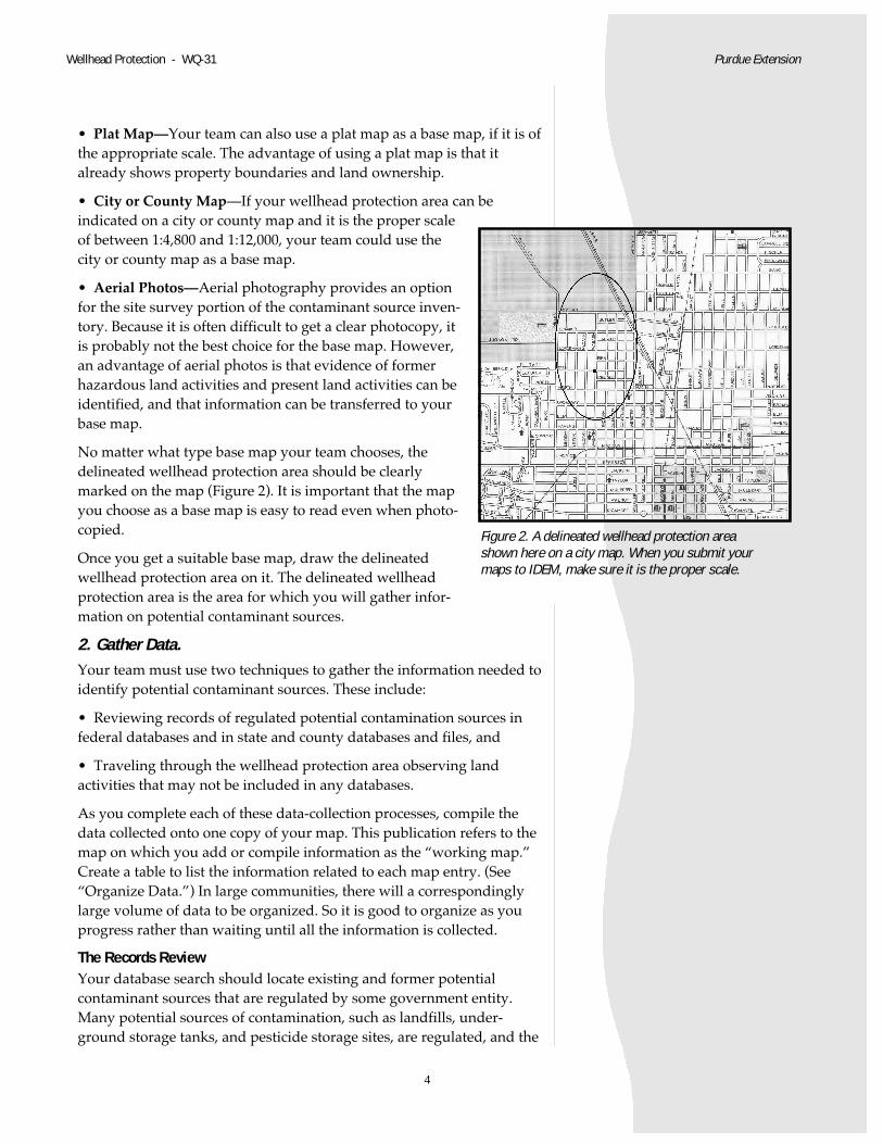
No matter what type base map your team chooses, thedelineated wellhead protection area should be clearlymarked on the map (Figure 2). It is important that the mapyou choose as a base map is easy to read even when photo-copied.
Once you get a suitable base map, draw the delineatedwellhead protection area on it. The delineated wellheadprotection area is the area for which you will gather infor-mation on potential contaminant sources.
2. Gather Data.Your team must use two techniques to gather the information needed toidentify potential contaminant sources. These include:
• Reviewing records of regulated potential contamination sources infederal databases and in state and county databases and files, and
• Traveling through the wellhead protection area observing landactivities that may not be included in any databases.
As you complete each of these data-collection processes, compile thedata collected onto one copy of your map. This publication refers to themap on which you add or compile information as the “working map.”Create a table to list the information related to each map entry. (See“Organize Data.”) In large communities, there will a correspondinglylarge volume of data to be organized. So it is good to organize as youprogress rather than waiting until all the information is collected.
The Records ReviewYour database search should locate existing and former potentialcontaminant sources that are regulated by some government entity.Many potential sources of contamination, such as landfills, under-ground storage tanks, and pesticide storage sites, are regulated, and the
Figure 2. A delineated wellhead protection areashown here on a city map. When you submit yourmaps to IDEM, make sure it is the proper scale.
5
Purdue Extension Wellhead Protection - WQ-31
records about such sites are public information. A search of existingdatabases will provide identification of regulated sources.
You can obtain these records using one of two methods: by hiring aprivate consultant to complete a database search for your specific areaor by searching the databases yourself using a computer with anInternet connection.
You can hire a consultant to perform the search of federal and somestate databases for hazardous materials, past reported spills, and under-ground storage tanks. The price depends on the complexity of thedelineated wellhead protection area and will range between a fewhundred and a few thousand dollars. Some of these providers willplot the data on a map and provide the data in a table, as necessaryfor compliance with Indiana’s Wellhead Protection Rule. Someconsultants who can provide these services are listed on the Web at<http://www.purdue.edu/safewater>.
Whether you hire a consultant or search the databases yourself, beaware that the databases may not be totally accurate. Through personalexperience, someone on your wellhead protection planning team maybe aware of changes that have occurred which make the informationon the databases inaccurate. So check the database information foraccuracy and consistency.
Federal Database SearchIf you or someone on the wellhead protection planning team chooses tosearch the databases, visit <http://www.usepa.gov/enviro> to findinformation about federally regulated facilities.
• Superfund—The federal government locates, investigates, and cleansup the worst hazardous waste sites throughout the United States.These sites are designated “Superfund sites.” Common Superfundsites include abandoned warehouses, landfills, and industrial facili-ties that continually dumped hazardous waste into the environmentbefore it was regulated.
• TRI (Toxics Release Inventory)—TRI contains information aboutmore than 650 toxic chemicals that are being used, manufactured,treated, transported, or released into the environment. Manufactur-ers of these chemicals are required to report the locations and quanti-ties of chemicals stored on-site to state and local governments.
• RCRIS—The database contains an inventory of waste handlers andinformation about their waste handling activities. The waste handlersare classified into three major groups: treatment, storage and dis-posal (TSD) facilities; waste generators; and transporters.
• Permit Compliance System (PCS)—The Clean Water Act requireswastewater dischargers to have a permit that establishes pollutionlimits and specifies monitoring and reporting requirements. NationalPollutant Discharge Elimination System (NPDES) permits regulate
6
Wellhead Protection - WQ-31 Purdue Extension
n
ate
household and industrial wastes that are collected in sewers andtreated at municipal wastewater treatment plants. Permits alsoregulate industrial point sources and concentrated animal feedingoperations that discharge into other wastewater collection systems orthat discharge directly into receiving waters.
As you search each of these databases, number and note the facilitiesyou find in your wellhead protection area on your working map. Youmight choose a distinct shape mark to indicate each type of potentialpollutant. If a facility is on a database, but is no longer in operation,indicate its position on the map, list it in the table, but note its statuswith a term descriptive of its condition, like “closed,” “abandoned,” or“removed.”
State and Local File SearchState and county files of regulated materials often contain data that hasnot been computerized, but recorded on paper in various governmentoffices. Historic records of land activities and uses may also be available.These data files must also be searched.
Like the federal databases, the state and local data files can be searchedin two ways, by hiring a consultant to do the search or by doing ityourself. Someone familiar with the process can search IDEM’s files inthree to eight hours. Some consultants who offer this service are listedon the Safe Water Web site. (See “Indiana Information Contacts.”) Thistask is not recommended for anyone who is unfamiliar with the process.However, if you or someone on the planning team chooses to search thestate and local files, you must be aware of the necessary files to includein your search.
• IDEM’s Office of Land Quality maintains files pertaining tolandfills, military bases, dumps, and municipal sewageoperations. You may view and copy this information byvisiting the Office of Land Quality file room on the eleventhfloor of the Indiana Government Center North located at100 North Senate Avenue in Indianapolis. Files are sortedby county and facility name.
• IDEM’s Office of Land Quality maintains a databaseknown by the acronym ULCERs. This database containsinformation on underground storage tanks, leaking under-ground storage tanks, the Community Right-to-Know Act,and Emergency Responses to spills. You may use this data-base by visiting the Office of Land Quality file room on thesecond floor of the IDEM office at 2525 North Shadeland Avenue inIndianapolis. These files are also sorted by county. (NOTE: TheOffice of Land Quality file room will be moved to Indiana Govern-ment Center North, 12th floor, by March of 2000.) While your localfire department and Local Emergency Planning Committee would be
7
Purdue Extension Wellhead Protection - WQ-31
another source for Community Right-to-Know data, they do nothave information on underground storage tanks or on emergencyresponse to spills.
• You can obtain information about pesticides and a request form forspecific county information on pesticide storage in your wellheadprotection area by calling the Office of the State Chemist at 765-494-1585. This information is on a database that is searched for the areathat you need by personnel in the Office of the State Chemist.
Include the state and county file search information on your workingmap. Once the database and file search information is on the map, youcan enlarge sections for your wellhead protection planning team to usein the site survey for unregulated or otherwise unidentified potentialsources.
The Site SurveyFederal and state databases are not 100% accurate, are focused onfacilities using of large quantities of chemicals, and are incomplete withregard to smaller facilities. Also, the requirement to register under-ground storage tanks applies only to those in use after 1986 and only tothose larger than 500 gallons. A facility that closed before currentregulations were in effect could have left behind a source of contamina-tion. Thus a more thorough survey performed by people who know thearea will offer better protection for your water supply.
This survey is usually completed by community volunteers who driveor walk through the designated wellhead protection area writing downobservations about the various past and present activities taking placein an area. The process is often called a “windshield survey” becausethe observations are usually made through the windshield of a car. Thistype of site survey is the best way to obtain information on non-regu-lated hazardous materials that might be in the wellhead protection area.
By getting community members to assist with the collection of thisinformation you also raise awareness within the community of theimportance of wellhead protection. Try recruiting these volunteers fromlocal service organizations and retired citizens groups. Try also to getyour local newspaper, radio station, and /or television station to publi-cize the event and to communicate the importance of gathering as muchinformation as possible. For very small communities, posting of fliersand bulletins can be highly effective. Because successful wellheadprotection depends on cooperation from everyone, educating the publicabout the goals and requirements of wellhead protection is essential.
Most hazards to ground water are associated with certain activities. Forexample, fertilizer use and pesticide uses are associated with golfcourses, residential and other lawns, and farms and other agriculturaloperations. Chemical solvents and oils are associated with machineshops, auto repair facilities, and certain industrial processes. To cleanclothing, dry cleaning facilities use chemicals that are highly toxic to a
8
Wellhead Protection - WQ-31 Purdue Extension
drinking water supply. Armed with the base map showing the delin-eated wellhead protection area, a few community volunteers can mapthese and other unregulated activities that are potentially harmful to adrinking water supply.
Historic land use data can be assembled through investigating oldChamber of Commerce membership files, historical maps and photos,Sanborn Insurance maps, and Soil and Water Conservation Districtaerial photos. A local history buff is a good resource for information.The collective memory of long-time residents is the best source forhistoric land use information, locations of abandoned wells and under-ground storage tanks, and other potential contaminant sources. Youmight also try asking the local newspaper to run an article requestingpeople with historical land use information to contact the local well-head protection planning team.
Steps for Organizing a Site Survey1. Prepare the maps you will need. Enlarged copies of your existing
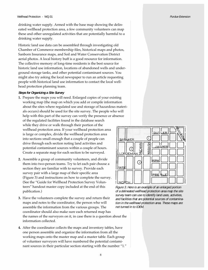
working map (the map on which you add or compile informationabout the sites where regulated use and storage of hazardous materi-als occurs) should be used for the site survey. The people who willhelp with this part of the survey can verify the presence or absenceof the regulated facilities found in the database searchwhile they drive or walk through their portion of thewellhead protection area. If your wellhead protection areais large or complex, divide the wellhead protection areainto sections small enough that a couple of people candrive through each section noting land activities andpotential contaminant sources within a couple of hours.Create a separate map for each section to be surveyed.
2. Assemble a group of community volunteers, and dividethem into two-person teams. Try to let each pair choose asection they are familiar with to survey. Provide eachsurvey pair with a large map of their specific area(Figure 3) and instructions on how to complete the survey.(See the “Guide for Wellhead Protection Survey Volun-teers” handout master copy included at the end of thispublication.)
3. Have the volunteers complete the survey and return theirmaps and notes to the coordinator, the person who willassemble the information from the various groups. Thecoordinator should also make sure each returned map hasthe names of the surveyors on it, in case there is a question about theinformation collected.
4. After the coordinator collects the maps and inventory tables, haveone person assemble and organize the information from all theworking maps onto the master map and a master table. Each groupof volunteer surveyors will have numbered the potential contami-nant sources in their particular section starting with the number “1.”
Figure 3. Here is an example of an enlarged portionof a delineated wellhead protection area map the sitesurvey team can use to identify land uses, activities,and facilities that are potential sources of contamina-tion in the wellhead protection area. These maps arenot turned in to IDEM.
9
This information must be put onto the master map in a sequence thatcorresponds to the way it will be depicted on the table of potentialcontaminants. It is important that there is a one-to-one correspon-dence between the map and the table.
5. Organize the original inventory sheets according to location, andkeep them as an appendix for your on-site, master copy of thewellhead protection plan. Later in the wellhead protection planningprocess, they may be useful in developing your managementstrategy.
3. Organize DataIDEM requires that three things be included in the contaminant sourceinventory section of the wellhead protection plan:
• Narrative description of the land uses in the wellheadprotection area,
• Map showing land uses and locations of both regulated andunregulated potential contaminant sources, and
• Table corresponding to the map.
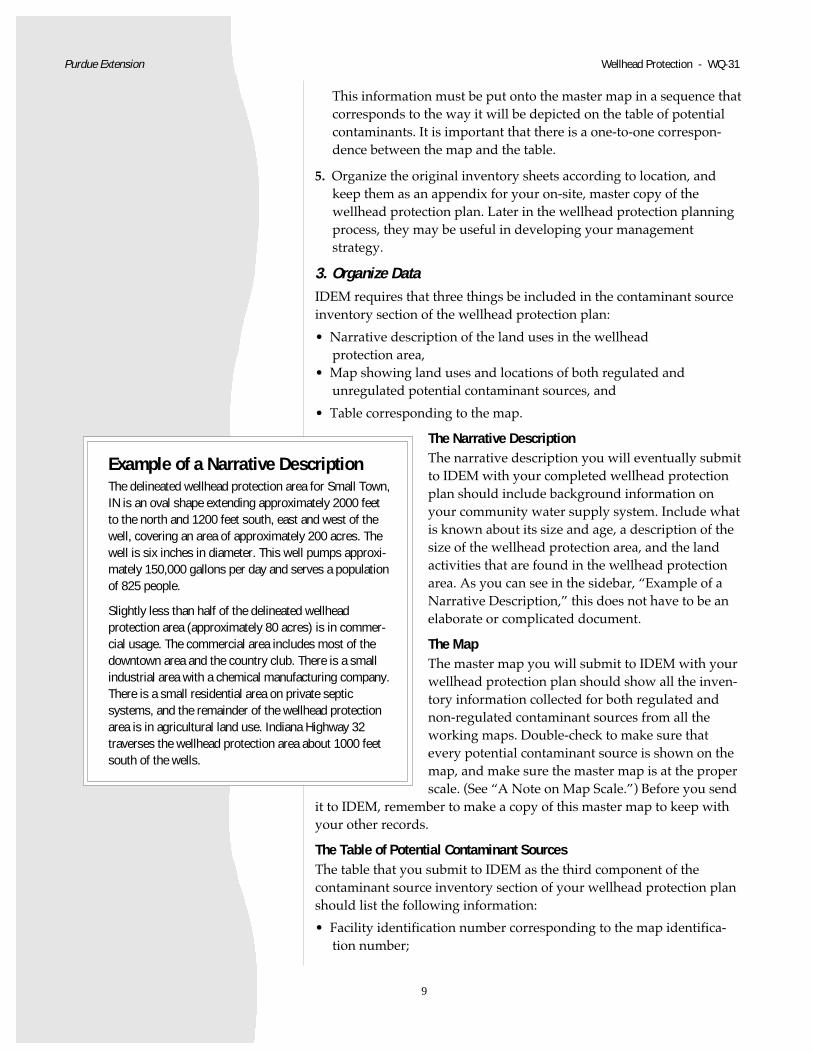
The Narrative DescriptionThe narrative description you will eventually submitto IDEM with your completed wellhead protectionplan should include background information onyour community water supply system. Include whatis known about its size and age, a description of thesize of the wellhead protection area, and the landactivities that are found in the wellhead protectionarea. As you can see in the sidebar, “Example of aNarrative Description,” this does not have to be anelaborate or complicated document.
The MapThe master map you will submit to IDEM with yourwellhead protection plan should show all the inven-tory information collected for both regulated andnon-regulated contaminant sources from all theworking maps. Double-check to make sure thatevery potential contaminant source is shown on themap, and make sure the master map is at the properscale. (See “A Note on Map Scale.”) Before you send
it to IDEM, remember to make a copy of this master map to keep withyour other records.
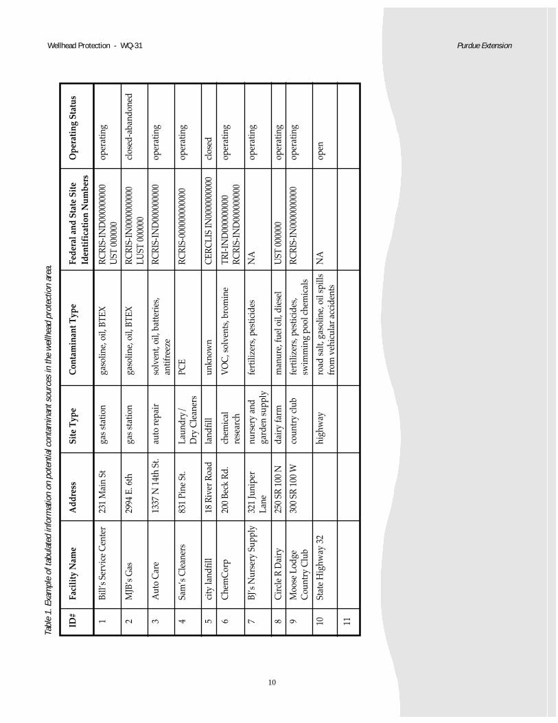
The Table of Potential Contaminant SourcesThe table that you submit to IDEM as the third component of thecontaminant source inventory section of your wellhead protection planshould list the following information:
• Facility identification number corresponding to the map identifica-tion number;
Purdue Extension Wellhead Protection - WQ-31
Example of a Narrative DescriptionThe delineated wellhead protection area for Small Town,IN is an oval shape extending approximately 2000 feetto the north and 1200 feet south, east and west of thewell, covering an area of approximately 200 acres. Thewell is six inches in diameter. This well pumps approxi-mately 150,000 gallons per day and serves a populationof 825 people.
Slightly less than half of the delineated wellheadprotection area (approximately 80 acres) is in commer-cial usage. The commercial area includes most of thedowntown area and the country club. There is a smallindustrial area with a chemical manufacturing company.There is a small residential area on private septicsystems, and the remainder of the wellhead protectionarea is in agricultural land use. Indiana Highway 32traverses the wellhead protection area about 1000 feetsouth of the wells.
10
Wellhead Protection - WQ-31 Purdue Extension
ID#
Faci
lity
Nam
eA
ddre
ssSi
te T
ype
Con
tam
inan
t Typ
eFe
dera
l and
Sta
te S
ite
Ope
rati
ng S
tatu
sId
enti
fica
tion
Num
bers
1Bi
ll’s
Serv
ice
Cen
ter
231
Mai
n St
gas
stat
ion
gaso
line,
oil,
BTE
XRC
RIS-
IND
0000
0000
0op
erat
ing
UST
000
000
2M
JB’s
Gas
2994
E. 6
thga
s st
atio
nga
solin
e, o
il, B
TEX
RCRI
S-IN
0000
0000
00cl
osed
-aba
ndon
edLU
ST 0
0000
0
3A
uto
Car
e13
37 N
14t
h St
.au
to re
pair
solv
ent,
oil,
batte
ries
,RC
RIS-
IND
0000
0000
0op
erat
ing
antif
reez
e
4Sa
m’s
Cle
aner
s83
1 Pi
ne S
t.La
undr
y/PC
ERC
RIS-
0000
0000
0000
oper
atin
gD
ry C
lean
ers
5ci
ty la
ndfil
l18
Riv
er R
oad
land
fill
unkn
own
CER
CLI
S IN
0000
0000
00cl
osed
6C
hem
Cor
p20
0 Be
ck R
d.ch
emic
alV
OC
, sol
vent
s, b
rom
ine
TRI-I
ND
0000
0000
0op
erat
ing
rese
arch
RCRI
S-IN
D00
0000
000
7BJ
’s N
urse
ry S
uppl
y32
1 Ju
nipe
rnu
rser
y an
dfe
rtili
zers
, pes
ticid
esN
Aop
erat
ing
Lane
gard
en s
uppl
y
8C
ircl
e R
Dai
ry25
0 SR
100
Nda
iry
farm
man
ure,
fuel
oil,
die
sel
UST
000
000
oper
atin
g
9M
oose
Lod
ge30
0 SR
100
Wco
untr
y cl
ubfe
rtili
zers
, pes
ticid
es,
RCRI
S-IN
0000
0000
00op
erat
ing
Cou
ntry
Clu
bsw
imm
ing
pool
che
mic
als
10
Stat
e H
ighw
ay 3
2hi
ghw
ayro
ad s
alt,
gaso
line,
oil
spill
sN
Aop
enfr
om v
ehic
ular
acc
iden
ts
11
Tabl
e 1.
Exa
mpl
e of
tabu
late
d in
form
atio
n on
pot
entia
l con
tam
inan
t sou
rces
in th
e w
ellh
ead
prot
ectio
n ar
ea.

11
• Facility name and address;
• Type of facility;
• Type of potential contaminant;
• Any permit numbers and the organization issuing the permits; and
• Operating status of the facility (open, closed, abandoned, or re-moved).
Depending on the complexity and size of your wellhead protection areaand on your access to computer resources, you may find it helpful touse a spreadsheet to keep track of the contaminant source inventoryinformation. Table 1 shows an example of how the information gath-ered in the site inventory can be displayed.
What’s Next?By completing the contaminant source inventory, your wellheadprotection planning team will have identified the most likely sources ofcontamination in your wellhead protection area. At that point, Yourteam can begin working on formulating management and contingencyplans, and on developing a program for public education about well-head protection. You will find information on these topics in futurePurdue Extension publications on wellhead protection planning.
Useful PublicationsThe following Purdue Extension publications provide informationabout other aspects of the wellhead protection process.
• WQ-2, “What Is Groundwater?”
• WQ-24, “Wellhead Protection in Indiana”
• WQ-28, “Forming the Wellhead Protection Planning Team”
• WQ-29, “A Shortcut to Wellhead Protection Delineation for Some Systems”
• WQ-30, “Choosing a Consultant to Delineate the Wellhead Protection Area”
You may find the following two Purdue Extension brochures to beuseful in your community outreach efforts:
• “Wellhead Protection: What Every Farmer Should Know About Wellhead Protection”
• “Protecting Your Drinking Water: What Every Citizen Should Know About Wellhead Protection”
All of the above publications and brochures are available free ofcharge through your county Purdue Extension office or by calling1-888-EXT-INFO.
The USEPA has an informative publication, “Wellhead Protection, AGuide for Small Communities,” EPA/625/R-93/002, available free bycalling 1-800-490-9198.
Purdue Extension Wellhead Protection - WQ-31
12
Wellhead Protection - WQ-31 Purdue Extension
Sources for Maps and Aerial PhotosTopographic Maps• Purdue University (765-496-3209). If you know the name of your
quad, you can send a check for $4 per map, plus $2 for shipping, toLARS, Purdue University, 1202 Potter Engineering Center Room 376,West Lafayette IN 47907-1202, or e-mail [email protected]. Pleaseinclude your telephone number in case more information is needed.
• The Indiana Department of Natural Resources, DNR Map SalesSection, 402 West Washington Street, W-160, Indianapolis, IN 46204-2742, (317-232-4180). Maps are $4.20 each, including tax, with a $3.50shipping and handling fee.
• The Indiana Geological Survey Publication Sales Office at IndianaGeological Survey, 611 North Walnut Grove, Bloomington, IN 47405-2208, (812- 855-7636). They can determine the proper map to supplyif you provide the name of a town, river, or other named landmarknearby. Maps are $4 each, plus tax, with a $3 shipping and handlingcharge.
Plat Maps• Soil and Water Conservation Districts. Most Soil and Water Conser-
vation Districts have plat maps of counties available for a small fee.(These maps are usually at a smaller scale than is required and needto be enlarged.)
• County Clerks, Tax Assessors, and City Engineers. They are otherpotential sources for plat maps.
Aerial Photos• The State Land Office, 302 W. Washington St., Suite E032, Indianapo-
lis, IN 46204. Their photos are at a scale of 1 inch equals 400 feet(1:4800) for most of the state, and 1 inch equals 100 feet (1:1200) forMarion County. Coverage for the whole state is available. The cost is$3 per sheet (plus shipping). Call James Lewis at 317-232-3335 forinformation on how to choose the correct photo-map(s) for yourarea.
Indiana Information Contacts• The Purdue Extension office in your county can provide you with
information and resources on water quality protection. Look in thephone book under county government, or call 1-888-EXT-INFO.
• “Safe Water for the Future” is a Purdue Extension program thatprovides resources statewide on wellhead protection and watershedprotection. Call 765-496-6331, or visit our Web site at <http://www.ecn.purdue.edu/safewater>.
13
Purdue Extension Wellhead Protection - WQ-31
On the following pages, you’ll find the handout, “Guide forWellhead Protection Survey Volunteers.” You can makecopies of this handout to distribute to the volunteers yourecruit for the site survey.
• Indiana Department of Environmental Management, Ground WaterSection, can provide information on Indiana’s Wellhead ProtectionRule and compliance. Call the Groundwater Section at 317-308-3321or 800-451-6027, ext. 308-3321. Information is also available on theWeb at <http://www.ai.org/idem/owm/dwb>.
• Indiana Water and Wastewater Association provides training andon-site assistance to water supply operators. They can be reached at1-888-937-4992 or on the Web at <http://www.iwwa.com>.
• The Indiana “Rural” Water Association also provides education andassistance to water supply operators. They can be reached at 812-988-6631 or (Fax) 812-988-696.
• The EPA Safe Drinking Water Hotline (800-427-4791) is available tohelp state and local officials and the public answer questions aboutdrinking water. The hotline also has information about the NationalRural Water Association’s program to assist small communitiesdevelop local drinking water protection plans.
ReferencesUSEPA, 1995, “Benefits and Costs of Prevention: Case Studies of
Community Wellhead Protection-Volume 1,” USEPA, EPA 813-B-95-005.
USEPA, 1993, “Wellhead Protection: A Guide for Small Communities,”a USEPA Seminar Publication, EPA/625/R-93/002.
Whittman, Jack, 1996, “Wellhead Protection Guide,” Center for UrbanPolicy and the Environment, School of Public and EnvironmentalAffairs, Indianapolis, IN.
Witten, Jon and Scott Horsley, 1995, “A Guide to Wellhead Protection,”Planning and Advisory Service, American Planning Association,PAS Report #457/458.
NEW 3/00
It is the policy of the Purdue University Cooperative Extension Service, David C. Petritz, Director, that all persons shall have equal opportunity and access to its programsand facilities without regard to race, color, sex, religion, national origin, age, or disability. Purdue University is an Affirmative Action employer.
This material may be available in alternative formats.1-888-EXT-INFO
http://www.agcom.purdue.edu/AgCom/Pubs/menu.htm
14
Some normal activities that take place at the land’ssurface have the potential for contaminating ourdrinking water. In the course of the survey youhave volunteered to do, you will gather all theinformation possible about present and pastactivities in the designated portion of your well-head protection area that might affect drinkingwater quality.
This is a very important project, and members ofthe community, like you, are the best people tocomplete this type of survey. No one else knowsyour area better than you do!
Knowing what the potential contaminationsources are will allow your community’s wellheadprotection team and your entire community planhow to manage your wellhead protection area tominimize the impact these potential contaminantsmight have on water quality.
After mentioning a couple of things you should notdo in the course of your survey, this guide ex-plains in more detail how you should conductyour survey of potential drinking water contami-nants.
What Not to DoDo not go onto private property.
Do not interview people. Your survey is a firstpass at determining what is in the wellheadprotection area. Your wellhead protection plan-ning team will collect more information later,when they are deciding on a management strategyand in Phase II of the wellhead protection plan-ning process.
What to Do & How to Do ItFor this survey, your team leader will give you amap of a section of your community’s wellhead
Guide for Wellhead ProtectionSurvey Volunteers
protection area. With that map in hand, you willwalk or drive through the area you have beenassigned, observing the various activities that aretaking place or have taken place.
Be careful to stay on public rights of way duringyour survey. Be friendly and observant, but asunobtrusive as possible.
If someone asks what you are doing, explain thatyou are helping to put together part of a wellheadprotection plan for the community, and refer thequestioner to the water supply manager, or yourwellhead protection team leader if he or she wantsto know more.
Here’s some advice about how to actually conductyour survey.
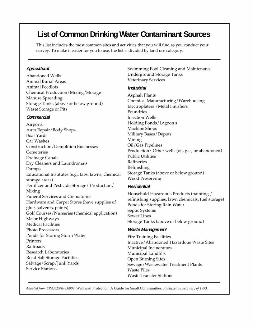
• Look over each property with an eye for thingsthat might be a source of contamination fordrinking water. The “List of Common DrinkingWater Contaminant Sources” included with thisguide lists the most common sources of con-tamination you are likely to encounter duringyour survey. You might want to take a copy ofthis list with you when you conduct yoursurvey.
• When you see something that raises a questionin your mind, note its location with a numberon the map your team leader has given you.(See Figure 1 for an example of a survey map.)
• On another sheet of paper, write a brief descrip-tion of what you saw and exactly where on theproperty you noticed it. Make sure you labeleach brief description with the same number

15
you used to note location on your map. (SeeFigure 2 for an example of some survey notes.)
• Past land activities are as important as presentones. So if you remember that the doctor’s officeon the corner used to be a gas station or drycleaner, for example, record that information, aswell. That way, someone else can use your notesto revisit the site or contact the property owner formore information.
MapIDNumber Address Name of Facility Description & Notes
1 254 Wabash Street Spencer’s Optometry former gas station—haveunderground storage tanksbeen properly removed?
2 2252 Lordeman Magic Dry Cleaners
3 422 McCann CTZ Today pipe sticking up from groundon NE corner, possibleunderground storage tank
4 115 Brown Street Max's Drug Emporium Stained soils - possible oil spill?- parking lot
5
Figure 2. Example of notes taken during site survey
Figure 1. Example of a contaminant source inventory working map
• Please note anything that raises a question in yourmind. Normal activities can cause drinking waterpollution when things go wrong. Later, someonewill check all the things you’ve noted to deter-mine if they are causes for concern.
Thank you for volunteering to help with this veryimportant job!
4
16
AgriculturalAbandoned WellsAnimal Burial AreasAnimal FeedlotsChemical Production/Mixing/StorageManure SpreadingStorage Tanks (above or below ground)Waste Storage or Pits
CommercialAirportsAuto Repair/Body ShopsBoat YardsCar WashesConstruction/Demolition BusinessesCemeteriesDrainage CanalsDry Cleaners and LaundromatsDumpsEducational Institutes (e.g., labs, lawns, chemicalstorage areas)Fertilizer and Pesticide Storage/ Production/MixingFuneral Services and CrematoriesHardware and Carpet Stores (have supplies ofglue, solvents, paints)Golf Courses/Nurseries (chemical application)Major HighwaysMedical FacilitiesPhoto ProcessorsPonds for Storing Storm WaterPrintersRailroadsResearch LaboratoriesRoad Salt Storage FacilitiesSalvage/Scrap/Junk YardsService Stations
List of Common Drinking Water Contaminant Sources
Swimming Pool Cleaning and MaintenanceUnderground Storage TanksVeterinary Services
IndustrialAsphalt PlantsChemical Manufacturing/WarehousingElectroplaters /Metal FinishersFoundriesInjection WellsHolding Ponds/Lagoon sMachine ShopsMilitary Bases/DepotsMiningOil/Gas PipelinesProduction/ Other wells (oil, gas, or abandoned)Public UtilitiesRefineriesRefinishingStorage Tanks (above or below ground)Wood Preserving
ResidentialHousehold Hazardous Products (painting /refinishing supplies; lawn chemicals; fuel storage)Ponds for Storing Rain WaterSeptic SystemsSewer LinesStorage Tanks (above or below ground)
Waste ManagementFire Training FacilitiesInactive/Abandoned Hazardous Waste SitesMunicipal IncineratorsMunicipal LandfillsOpen Burning SitesSewage/Wastewater Treatment PlantsWaste PilesWaste Transfer Stations
This list includes the most common sites and activities that you will find as you conduct yoursurvey. To make it easier for you to use, the list is divided by land use category.
Adapted from EPA/625/R-93/002: Wellhead Protection: A Guide for Small Communities, Published in February of 1993.