weri system - wsscwater.comgisweb.wsscwater.com/weri/help/introduction to weri.pdfintroduction to...
TRANSCRIPT

Washington Suburban Sanitary Commission
Introduction to WSSC’s
WERI System
WSSC June, 2014

Introduction to WSSC WERI System (WERI)
2
Introduction to WSSC’s
WERI System

Introduction to WSSC WERI System (WERI)
3
Table of Contents
Course Objectives .................................................................... 5
Introduction of WERI ................................................................ 6
Start WERI ........................................................................... 7
Main Screen and Orientation……….…………………………………………………………………………..8
Elements of the main WERI Screen ................................................ 9
WERI Toolbar Buttons and Descriptions ................................................................................ 10
Map Display Area ............................................................................................................................. 11
Zoom Into the Display Area........................................................................................................ 12
Flyout Information ......................................................................................................................... 13
Flyout Information ………………………………………………………………………………………………14 Pan the Map ...................................................................................................................................... 14
Zoom to the Previous View .......................................................................................................... 15
Zoom Out .......................................................................................................................................... 15
Zoom to Coordinates…………………………………………………………………………………………………..15
Zoom to Coordinates………………………………………………………………………………………………….16
Customized WERI Tool Buttons .................................................... 17
Customizer WERI tool Button and Descriptions……………………………………….17 Map Tools ....................................................................................................................................................... 18
Layer List .......................................................................................................................................... 18
Layer List………………………………………………………………………………………………………………………………….19
Bookmark ........................................................................................................................................... 20
Measure .......................................................................................................................................21 Measure ............................................................................................................................................. 22
Measure .............................................................................................................................................. 23
Measure .......................................................................................................................................24 Search by Asset ID ....................................................................................................................... 25
Search by Asset ID ....................................................................................................................... 26
Search by 200’ Sheet ................................................................................................................... 27
Search by ADC GRID .................................................................................................................... 27
Search by Contract Number.................................................... 27
Search by Pressure Zone ............................................................................................................. 27
Search for Plumbling Cards………………………………………………………………………………………………….28
Address Lookup ............................................................................................................................... 28
Address Lookup ............................................................................................................................... 29
Query Builder .................................................................................................................................. 30

Introduction to WSSC WERI System (WERI)
4
Query Builder .................................................................................................................................. 31
Query Builder .................................................................................................................................. 32
Query Builder……………………………………………………………………………………………………………..33
Query Builder……………………………………………………………………………………………………………..34 Feedback…………………………………………………………………………………………………………………………………..34
BaseMap……………………………………………………………………………………………………………………….35 MD Aerial…………………………………………………………………………………………………………………………………36
Aerial with labels ............................................................................................................................ 36
Aerial Public ..................................................................................................................................... 37
Data Content………………………………………………………………………………………………………………………...38 WSSC Sewer ................................................................................................................................... 39
Service Alerts ................................................................................................................................. 39
Planned Assets ................................................................................................................................ 40
Merge Map Contents………………………………………………………………………………………………………………40
Merge Map Contents……………………………………………………………………………………………………………..41
Merge Map Contents……………………………………………………………………………………………………………..42
Save Current map Configuration………………………………………………………………………………………..42
Reset Current map Confirguration…………………………………………………………………………………….42
Print current Map………………………………………………………………………………………………………………….43
Print current Map………………………………………………………………………………………………………………….44
WERI Bottom Toolbar Button and Descriptions…………………………………………………..45
Selections……………………………………………………………………………………………………………………………….45
Selection by point…………………………………………………………………………………………………………………45
Selection by point………………………………………………………………………………………………………………...46
Attribute Data………………………………………………………………………………………………………………………47
Contract Drawings………………………………………………………………………………………………………………..47
Clear selection………………………………………………………………………………………………………………………48
Selection by Line………………………………………………………………………………………………………………….49
Selection by Retangle…………………………………………………………………………………………………………49
Selection by Polygon……………………………………………………………………………………………………………50
Selection by Circle……………………………………………………………………………………………………………….50
Export Results……………………………………………………………………………………………………………………….51
Identify Feature……………………………………………………………………………………………………………………51

Introduction to WSSC WERI System (WERI)
5
Course Objectives
By the end of the course, the student will be able to use the WERI
application. The employee will be able to use WERI in his/her daily business
functions. Microsoft Silverlight (downloaded automatically with first use) is
a pre-requisite for this class.
You will be able to do the following:
Get to the WERI Home Page
Explain the layout of the screen components of WERI
Use the Zoom tools and Map tools
List and search the data available
Use the different search functions
View engineering documents
Bookmark references for future access
Utilize the measuring tool
Save Map configuration
Merge Map Content
Print maps

Introduction to WSSC WERI System (WERI)
6
WERI HELP
This application provides some of the functions requested by Commission
users during the 200' sheet interviews. Specifically, the four search
options:
200' sheet number
ADC 2007 grid
Street layers
Street address
The application provides the ability to view data across 200' sheet
boundaries. Water and sewer information are in the WERI system.
Available Data
The data used for this application is obtained from several sources within
the Commission:
Maintenance Management Information System (MMIS)
Permits Processing Information System (PPIS)
Customer Services Information System (CSIS)
Assessments Information System (AIS)
Sewer Model
ADC Data
Information on the ADC data is from ADC 2007 Map books purchased
directly from the company.
Water and Sewer Data
Spatial and attribute data are available.
Property Data
The property data about the lot, the block and the address come from
M-NCPPC.

Introduction to WSSC WERI System (WERI)
7
Start WERI
The WERI application is a browser-based application. To access the WERI
application,
1. Click on the link that was provided to you from WSSC.
2. Once the link is open, enter username and password that was
provided by WSSC.

Introduction to WSSC WERI System (WERI)
8
This is the Main Screen Location/Orientation key
In the upper left corner of the display map, there is a location/orientation
key. It is a greyed out circle that can be seen on your computer. The key
allows you to move the map north/south/east/west when you select the
arrows as such. You can also zoom in and out with the slider on the left of
the circle. The up arrow that is in between the circle and the slider will
bring you back to the north orientation of the map. If you click on the circle
areas, this will allow you to rotate the the display map according to any
contract drawing orientation.

Introduction to WSSC WERI System (WERI)
9
Elements of the WERI Screen
Here are some of the major parts of the screen you will need to focus on.
Toolbar for
Map Display
Map Display
Area
Map Tools
Selection
tools
Identify Features
Data
Content

Introduction to WSSC WERI System (WERI)
10
WERI Top Toolbar Buttons and Descriptions
These buttons help you navigate to the area of interest or search for
information.
Gives the option to zoom to a specific coordinate
Zooms in by a magnification factor of two on the point that
you click
Slide the map around to display areas that are outside of
the current view
Zooms in to the rectangular area you draw with the mouse
Zooms out by a magnification factor of two from the
rectangular area you draw with the mouse
Returns to the previous zoom magnification and location
Allows you to see an area with a view of the streets
Zoom out by a magnification factor of two on the point that
you click
Displays the entire map in the current window
Shows the different tools that can be used on the map
Gives a dropdown menu of the five Basemaps available
StreetView
view

Introduction to WSSC WERI System (WERI)
11
Map Display Area
1. When you want to redisplay the map of the two counties, click on
the Full button
Go farword to the previous zoom magnification and location
Allows you to see the street view of any area
The Map Display area
displays the two counties
and the default layers:
Montgomery
Prince George’s
Water layer
Road Base Map

Introduction to WSSC WERI System (WERI)
12
Zoom Into the Display Area
1. Click the Zoom button.
2. Drag a marquee (drag a rectangle) around the area where you
want to zoom into (click and drag using the mouse) or (click and
drag making a box on the laptop mouse area) once you have
selected the area that you need let go.
Marquee the
area you want
to view.

Introduction to WSSC WERI System (WERI)
13
Flyout Information
Move the mouse over the feature and the attribute data for the feature will
appear.
Pipe: size and contract number
Valve: valve number
Fire hydrant: FH number
Manhole: MH number
Contract number

Introduction to WSSC WERI System (WERI)
14
You may have to turn on/off some layers of information on the legend area.
Pan the Map
When you want to display another part of the map, use the Pan Button.
1. Click the Pan button.
2. Move the mouse on the Map Display Area.
Flyout for Water Main:
Pipe Size + Contract #
Flyout for Water Valve:
Valve # + Contract #

Introduction to WSSC WERI System (WERI)
15
3. Drag the mouse around to display the area that is outside the
current view.
Zoom to the Previous View
1. Click the Previous button.
2. The Map Display Area will return to the previous zoom
magnification and location.
StreetView
1. Click the StreetView button.
2. Zoom into an area on the map and then left click to see the street
view of an area ex: valve caps, new pavement area, fh’s, location
etc.
Zoom Out
1. Click the Zoom Out button.
2. Click on the Map Display Area.
Zoom to Coordinates
1 Click the Coordinates
2 Enter the X and Y coordinates.
3 Click the Zoom to Coordinates

Introduction to WSSC WERI System (WERI)
16
The map display area will zoom to the coordinates

Introduction to WSSC WERI System (WERI)
17
Customized EGIS Tool Button and Descriptions
These tools are specific to WERI
Shows the list and legend of the base content and default
layer(WaterLayer)
Save the current display as a bookmark that can be accessed
later
Measure linear or area and gives coordinates of features
You can search by Asset ID (Water or Sewer), 200' sheet,
ADC Grid, Contract number, Pressure Zone Number,
property Tax ID or Permit Number
Search an address by Street Name, City and Zip Code
Allows advance search on layers

Introduction to WSSC WERI System (WERI)
18
Send Feedback/Suggestions about EGIS to the development
team
Map Tools
To view the layers and ledgend click the layer List button
Switch tabs to view the layers or legend

Introduction to WSSC WERI System (WERI)
19

Introduction to WSSC WERI System (WERI)
20
To add or view bookmarks click the Bookmark button
To add a bookmark, zoom to the area of intrest. Name you bookmark and push Add.
To retrieve your bookmark just open EGIS, go to Map Tools and select the
Bookmark button. Your “saved bookmarks” will show under “Existing
Bookmarks”. Click on your bookmark name and the display will zoom to the
Introduction to WSSC WERI System (WERI)
21
area.To remove a bookmark, simply click on the red X to the right of the
name.
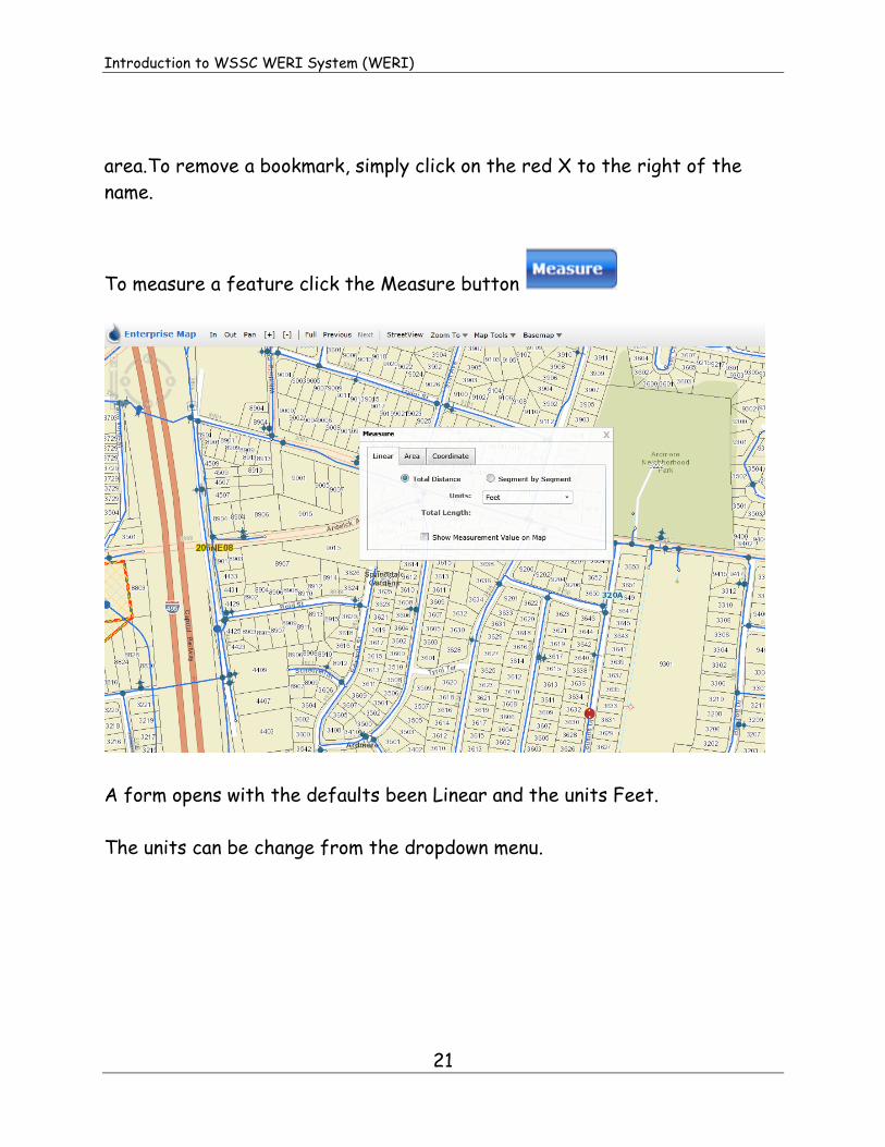
To measure a feature click the Measure button
A form opens with the defaults been Linear and the units Feet.
The units can be change from the dropdown menu.

Introduction to WSSC WERI System (WERI)
22
To measure a feature, click on the map or feature to create a start point,
then click to add a vertex at bends and double-click to end. The distance will
display on the form.
The distance can be displayed on the map by checking the Show Mesurement
Value on Map.

Introduction to WSSC WERI System (WERI)
23
To find the area of a feature click to start, click for each directional change
and double click to end. If the Show measurement Value on Map is checked,
the Area and Perimeter will be displayed on the map. The units can be
changed from the dropdown menu.

Introduction to WSSC WERI System (WERI)
24
To find the coordinates of a feature or location, click the Coordinate tab
and then click on the feature you need the coordinates of and the X and Y
will be displayed.

Introduction to WSSC WERI System (WERI)
25
To search for location or attribute data for Asset ID, 200’ sheet, ADC Grid,
Contract number, Pressure Zone Number, Property Tax ID and permit
Number click the Search button
The form will open to the default, Asset ID (water)
Use the drop down menu to choose
a. The Asset Type
b. The 200 Ft. Sheet
c. The 3-Digit ID
d. Click the Search button
The map will zoom to the location of the asset and will be highlighted.
The Identify feature form will appear showing the attribute data for the
asset.

Introduction to WSSC WERI System (WERI)
26
Click on details to see the Feature Details form.
You can access the linked documents for the feature (eg. Engineering
Drawings or Valve Card). To clear selection click the clear selection botton
Clear selection Details
To do a search for other feature, select the various taps.
Identify Features

Introduction to WSSC WERI System (WERI)
27
200’ sheet search ADC Grid search
Contract number search Pressure zone search

Introduction to WSSC WERI System (WERI)
28
Search for plumbing cards
Once you click the search button for the 200’ sheet. In the
drop down list, click on details. Once here you will be able to search for the
plumbing cards.
Click Plumbling Cards
Details
To lookup an Address click the Address Lookup Button

Introduction to WSSC WERI System (WERI)
29
1. Enter the street name and city in the address text box
2. Click Go
The Address Results window will show all the possible addresses.
From the list, select the address you want to lookup. The map will zoom to
than address.
14501 Sweitzer Lane, Laurel

Introduction to WSSC WERI System (WERI)
30
To perform advance queries, click the Query Builder button
1. Select the layer you which to query. Once the layer is selected, the
upper right window will be populated with the fields you can query on.
Water pipes Query fields

Introduction to WSSC WERI System (WERI)
31
2. Click on a field to query on and you will notice that the upper left
window is populated with the options for the selected field.
3. We will now query to find all pipes with diameter greater that 36”
a. Select diameter and pust the Add to Query button
b. Click the greater than symbol to add it to the querry.

Introduction to WSSC WERI System (WERI)
32
c. From the window with the pipe sizes highlight 36” and click the Add
to Query button. The from should look like the one below.
d. Select the Validate button to see if your query is valid. If
validation is good select the Go button to run the query

Introduction to WSSC WERI System (WERI)
33
The map will now display all the water pipes which are greater that 36”. The
Identify Features will also show the details of all the selected pipes.
Below is the result of a query on water pipes having a diameter of 36” and
materal is Ductile Iron.

Introduction to WSSC WERI System (WERI)
34
To give feedback to the Developers click the Feedback button

Introduction to WSSC WERI System (WERI)
35
Through feedback, you can make a general feedback about the application,
feedback about a bug you discover while using the application or feedback
about any enhancement you would like to see in the application. Push submit
once you have completed your feedback.
BaseMap BaseMap
Road base map
To change the bacemap go to the main toolbar, from the Basemap dropdown
lists select the basemap you want as your background display.
The default basemap is the Road Base Map.

Introduction to WSSC WERI System (WERI)
36
MD Aerial (2011)
Aerial with Labels

Introduction to WSSC WERI System (WERI)
37
Aerial (Public)

Introduction to WSSC WERI System (WERI)
38
Data Content
The default Data Content for EGIS is WSSC Water. At full view, you will
see the pressure zones boundaries, Water Treatment Plants, Water Pumping
Stations, Standpipe and Tanks. As you zoom into the map the water pipes
and there features will start showing up along with the properties
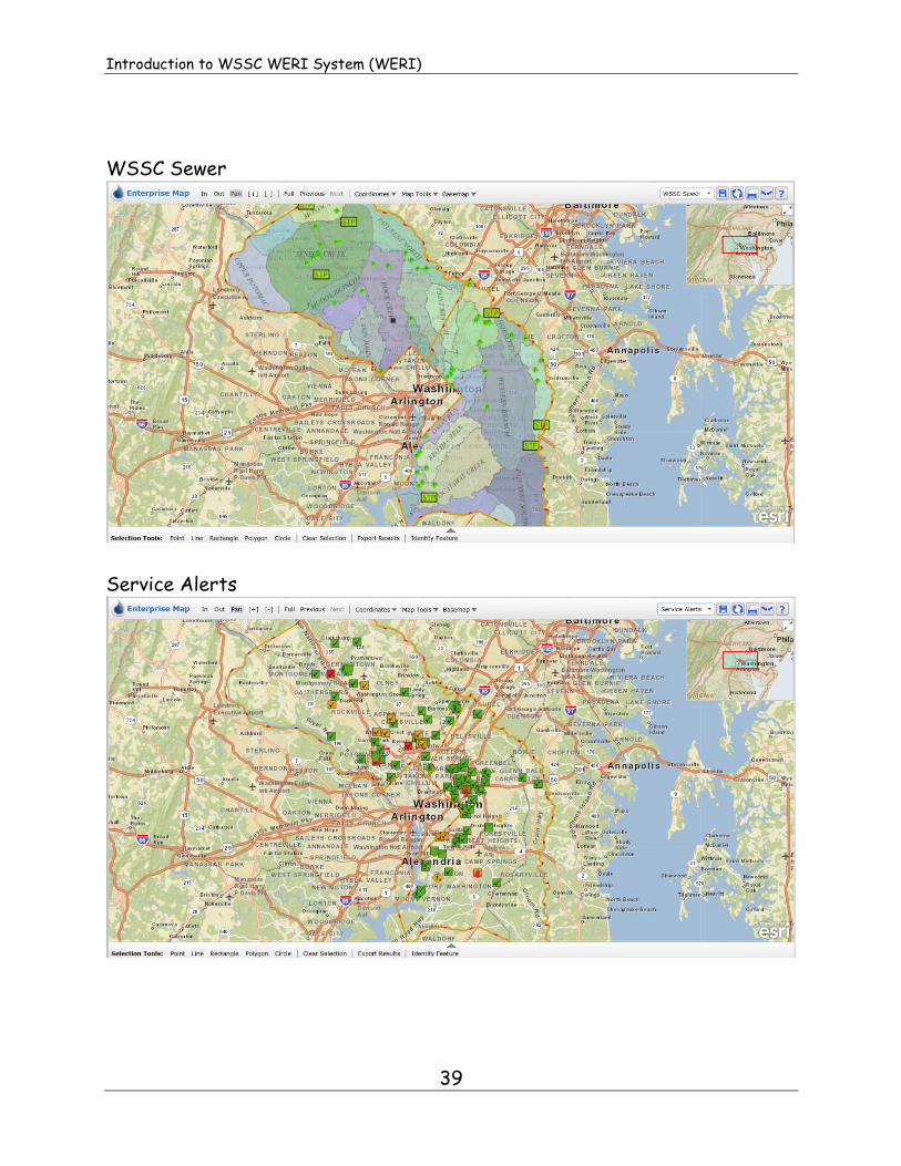
The other available Data Contents are:
1. WSSC Sewer
2. Service Alerts
3. Planned Assets
Other data content will be added as we finalize requirements.
Introduction to WSSC WERI System (WERI)
39
WSSC Sewer
Service Alerts

Introduction to WSSC WERI System (WERI)
40
Planned Assets
Data contents can me merged by clicking on the Merge map contents button
found in the upper right corner of the browser.
Merge map contents

Introduction to WSSC WERI System (WERI)
41
On the Merge Content form check the content you want to merge and click
apply.
The water and sewer contents will merge
and show on the map. An application message will inform you that merge
content have been created.

Introduction to WSSC WERI System (WERI)
42
After merging the view, the Data
Content dropdown menu will display a new data content called “My Content”
which is the newly merged water and sewer content.
The Save Current Map Configuration button is used to save the
configuration of the map at the current scale and Data Content.
The next time you open EGIS, the map will zoom to the area with the data
content you have saved. This will happen each time you open EGIS.
To get back to the default Map Configuration click on the Reset Current
Map Configuration button

Introduction to WSSC WERI System (WERI)
43
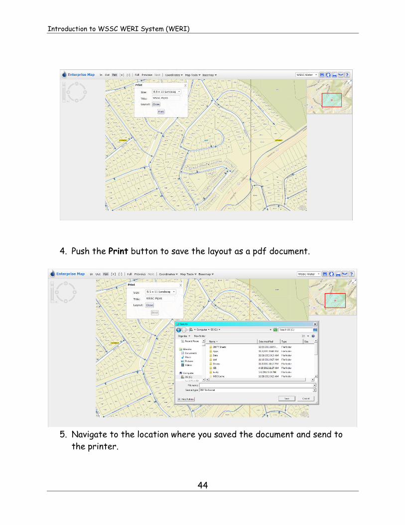
To make a print of the current map click on the Print Current Map button
The print form will open:
1. Choose the size and layout.
2. Create a title
3. Push Open to view the layout. The print button will become active.
Introduction to WSSC WERI System (WERI)
44
4. Push the Print button to save the layout as a pdf document.
5. Navigate to the location where you saved the document and send to
the printer.

Introduction to WSSC WERI System (WERI)
45
WERI Bottom Toolbar Buttons and Descriptions
These buttons are all assocated with the selections, clearing, exporting and
identification of features.
Selection of features using a
point
Selection of features by drawing
a line across the features
Selection of features by drawing
a rectangle around the features
Selection of features by drawing
a Polygon around the features
Selection of features by drawing
a Circle around the features
Clear Selected features
Export the attribute result of
selected features
Display attribute data of
selected features
Selections
To select a feature or muntiply features by point select the Point button
1. Move the mouse to the feature you want to select and click once.
2. The top layer along with any active layer will be selected.

Introduction to WSSC WERI System (WERI)
46
3. The selected features will be highlighted and the identify feature
window will show the feature or features that were selected.
4. Click on a feature to view the attribute data.

Introduction to WSSC WERI System (WERI)
47
5. To view the complete details of a feature, click details. Scroll up or
down to view the attributes.
From the Feature Details form, the historic document can be accessed.
Click on the Engineering Drawing(s) to get to the documents.

Introduction to WSSC WERI System (WERI)
48
Contract 51353 drawing.
To clear selected features click the Clear Selection button

Introduction to WSSC WERI System (WERI)
49
Selection by Line Selection line
Selection by Rectangle, Polygon and Circle are created by clicking in an area
and drag and unclick to view all of the components within the area.
Selection by Retangle

Introduction to WSSC WERI System (WERI)
50
Selection by Polygon
Selection by Circle

Introduction to WSSC WERI System (WERI)
51
Export Results
Once you have the selected the area with the information that you need, you can
then click export results and save them where you want them. It will then create
an excel spreadsheet with the selected information in the location of your choice.
Export Results
Identify Feature
You use the identify feature to select anything on the map area, valves, fire
hydrants, water lines etc. This option allows you to select an single item with
attributed information.
Identify Feature