west lake corridor final environmental impact … · record of decision and section 4(f) evaluation...
TRANSCRIPT

West Lake Corridor Final Environmental Impact Statement/ Record of Decision and Section 4(f) Evaluation Chapter 5 Physical and Environmental Analysis
March 2018
Chapter 5 Physical and Environmental
Analysis

West Lake Corridor Final Environmental Impact Statement/ Record of Decision and Section 4(f) Evaluation Chapter 5 Physical and Environmental Analysis
March 2018
This page intentionally left blank.

West Lake Corridor Final Environmental Impact Statement/ Record of Decision and Section 4(f) Evaluation Chapter 5 Physical and Environmental Analysis
March 2018 5-1
5 Physical and Environmental Analysis
5.1 Introduction Chapter 5 summarizes the physical and environmental characteristics, conditions, and effects from the FEIS Preferred Alternative and identifies the effects of the alternatives considered in the DEIS, including the DEIS NEPA Preferred Alternative. This chapter describes the effect of the Project on physical and environmental resources and the proposed mitigation of impacts. Areas of analysis for this chapter include noise; vibration; air quality; energy; soils, geological resources, and farmlands; water resources; biological resources; hazardous materials; and utilities.
Changes to This Chapter since Publication of the DEIS
Since publication of the DEIS, the data on existing conditions have been updated and design refinements have been made to the DEIS NEPA Preferred Alternative. The Project Area for each of the alternatives remains the same; therefore, some resource areas have few to no changes from the DEIS to the FEIS. The majority of the Project Area is in Indiana, with a small portion extending into Illinois. Construction activities in Illinois would be limited to the existing railroad ROW.
Section 5.2 describes the noise effects in the Project Area. Updates to this section include refined impact information based on updated noise monitoring and analysis including higher speeds and quiet zones. Specific locations for mitigation measures have been added.
Section 5.3 describes the vibration effects in the Project Area. Updates to this section include refined impact information based on updated vibration analysis including higher speeds. Specific locations for mitigation measures have been added.
Section 5.4 on air quality has been largely rewritten as a qualitative analysis to incorporate results of FTA’s Programmatic Assessment and to include recommendations for new attainment status.
Section 5.5 on energy has been largely rewritten to incorporate NICTD’s actual 2016 energy consumption as a basis for estimating future electricity consumption under the No Build Alternative and FEIS Preferred Alternative. A qualitative assessment of motor vehicle and construction-related energy use is also presented.
Section 5.6 describes the soils, geologic resources, and farmlands in the Project Area. Updates include additional geotechnical investigation and analysis of prime farmland that have occurred since publication of the DEIS.
Section 5.7 describes the effect of the Project on water resources. Updates to this section include changes in water resource boundaries, refinements to the Project design causing some previously affected locations to change, and further coordination with regulatory agencies. Wetland mitigation measures have been included.
Section 5.8 describes the effect of the Project on biological resources. Updates to this section include refined impact information based on design refinements to the Project and further coordination with regulatory agencies.
West Lake Corridor Final Environmental Impact Statement/ Record of Decision and Section 4(f) Evaluation Chapter 5 Physical and Environmental Analysis
March 2018 5-2
Section 5.9 describes the hazardous and contaminated materials in the Project Area and hazardous materials related to the Project’s design and operation. Updates to this section include additional information from Phase I and Phase II Environmental Site Assessments (ESAs) and mitigation measures.
Section 5.10 on utilities has been expanded to include specific utility crossing information and design details that identify how the current Project design would avoid impacts on several overhead utility crossings. In addition, a discussion of NICTD’s ongoing coordination efforts with multiple utility companies was added to the section.
Table 5.1-1 summarizes effects, commitments, and mitigation measures for the FEIS Preferred Alternative. For reference, conceptual engineering drawings for the FEIS Preferred Alternative are included in Appendix E.
Section 2.4 of this FEIS lists the alternatives considered and the design refinements included in the FEIS Preferred Alternative.

West Lake Corridor Final Environmental Impact Statement/ Record of Decision and Section 4(f) Evaluation Chapter 5 Physical and Environmental Analysis
March 2018 5-3
Table 5.1-1: Summary of Transportation Effects, Commitments, and Mitigation Measures for FEIS Preferred Alternative
Category FEIS Preferred
Alternative Summary of Physical and Environmental Effects, Commitments, and Mitigation Measures
Noise Operating Phase (Long-term) Direct Impacts
Without mitigation: 376 residences with moderate and 107 residences with severe noise impacts. With mitigation, no severe noise impacts or upper-range moderate noise impacts would occur. Lower-range moderate
noise impact would occur at 237 residences. Construction
Phase (Short-term) Impacts
Elevated noise levels from construction equipment.
Commitments and Mitigation Measures
Operating Phase (Long-term): Receiver-based treatments would be applied as follows: ◦ For 2 single-family homes in Dyer, between milepost (MP) 61.5 and 61.6 ◦ For 5 single-family homes in Hammond, between MP 66.9 and 67.2
Barriers ranging in height from 4 to 5 feet above top-of-rail would be constructed as follows: ◦ In Munster: Between MP 63.4 and 63.6, a barrier approximately 1,210 feet long on the eastern side of the Project alignment Between MP 63.7 and 63.9, a barrier approximately 1,330 feet long on the western side of the Project alignment.
◦ In Hammond: Between MP 65.3 and 65.5, a barrier approximately 580 feet long on the western side of the Project alignment. Between MP 66.3 and 66.4, a barrier approximately 700 feet long on the eastern side of the Project alignment.
A noise barrier wall 370 feet long and 3 feet above the top-of-rail would be constructed in the vicinity of the Jefferson Hotel in Hammond south of MP 68.1. This noise barrier would be on the western side of an elevated portion of the Project alignment.
Construction Phase (Short-term): NICTD would include noise performance specifications in the construction contract documents and would develop a
construction noise management plan.

West Lake Corridor Final Environmental Impact Statement/ Record of Decision and Section 4(f) Evaluation Chapter 5 Physical and Environmental Analysis
March 2018 5-4
Category FEIS Preferred
Alternative Summary of Physical and Environmental Effects, Commitments, and Mitigation Measures
Vibration Operating Phase (Long-term) Direct Impacts
The Project would cause vibration impacts at three residential structures that represent 13 dwelling units.
Construction Phase (Short-term) Impacts
Elevated vibration levels from construction equipment.
Commitments and Mitigation Measures
Operating Phase (Long-term): Between MP 63.7 and 63.9 in Munster, ballast mats or other track support system modifications would be implemented.
This treatment would extend the length of one full trainset on either side of the affected receptor, which would result in approximately 2,360 feet of treatment.
Between MP 66.3 and 66.4 in Hammond, ballast mats or other track support system modifications would be implemented. This treatment would extend the length of one full trainset on either side of the affected receptor, which would result in approximately 1,360 feet of treatment.
Construction Phase (Short-term): NICTD would include vibration performance specifications and would specify vibration limits for construction activities in
the construction contract documents. NICTD would develop a construction vibration management plan.

West Lake Corridor Final Environmental Impact Statement/ Record of Decision and Section 4(f) Evaluation Chapter 5 Physical and Environmental Analysis
March 2018 5-5
Category FEIS Preferred
Alternative Summary of Physical and Environmental Effects, Commitments, and Mitigation Measures
Air Quality Operating Phase (Long-term) Direct Impacts
No impacts expected. Annual regional vehicle miles travelled (VMT) would be reduced from the No Build Alternative. No violations of air quality standards are predicted.
Construction Phase (Short-term) Impacts
The short-term increases in pollutant concentrations, as described below, are not expected to exceed any National Ambient Air Quality Standards (NAAQS), and the construction-related air quality impacts are considered minor.
Temporary increases in emissions and concentrations of air pollutants may be caused by increased traffic volumes and operations on detour routes.
Localized increases in pollutant concentrations would persist for the duration of the construction activities along the corridor and at station locations. Because construction activities would be spread out along the corridor, the duration of construction at any one location would be relatively short (e.g., several weeks), which would tend to limit localized air quality impacts at any given location.
Construction equipment powered by fossil fuels would emit air pollutants similar to those produced by highway vehicles. Exposed earthen materials may produce increased particulate matter when they are moved during construction or
disturbed by wind. Commitments
and Mitigation Measures
Operating Phase (Long-term): No mitigation has been identified or recommended. Construction Phase (Short-term): NICTD would prepare and implement a dust-control plan, a work zone traffic management plan, and a strategy to
control emissions from diesel-powered equipment. Mitigation measures would include the following: ◦ Limit idling of construction equipment during periods of inactivity. ◦ Maintain construction equipment in proper working condition. ◦ Use water or other dust suppressants to ensure that fugitive dust does not leave the construction site. ◦ Limit the speed of construction vehicles on unpaved areas. ◦ Promptly clean up spills and dirt tracked onto paved roads.
NICTD would require the construction contractor to monitor construction activities near residential areas to help ensure that construction does not become an air quality nuisance to nearby residents.

West Lake Corridor Final Environmental Impact Statement/ Record of Decision and Section 4(f) Evaluation Chapter 5 Physical and Environmental Analysis
March 2018 5-6
Category FEIS Preferred
Alternative Summary of Physical and Environmental Effects, Commitments, and Mitigation Measures
Energy Operating Phase (Long-term) Direct Impacts
The Project would result in an increase in electricity consumption and a decrease in gasoline consumption attributable to reduced VMT when compared with the No Build Alternative.
The Project would result in a daily reduction of 163,050 VMT in 2037. The net change in total energy consumed over the Project’s operational life would be negligible when compared with
the No Build Alternative. Construction
Phase (Short-term) Impacts
Construction would result in a minor increase in the use of energy resources compared with the No Build Alternative, and would not result in a substantial change in regional energy use.
Commitments and Mitigation Measures
Operating Phase (Long-term): No mitigation has been identified or recommended. Construction Phase (Short-term): NICTD would require the construction contractor to limit idling of machinery and optimize construction methods and
staging areas in order to reduce fuel use in trucks and construction equipment.

West Lake Corridor Final Environmental Impact Statement/ Record of Decision and Section 4(f) Evaluation Chapter 5 Physical and Environmental Analysis
March 2018 5-7
Category FEIS Preferred
Alternative Summary of Physical and Environmental Effects, Commitments, and Mitigation Measures
Soils, Geological Resources, and Farmlands
Operating Phase (Long-term) Direct Impacts
No long-term impacts on soils would occur, and the underlying geology would not be affected. No prime farmland parcels exist in the Project Area and, therefore, no impacts on farmlands would occur.
Construction Phase (Short-term) Impacts
Impacts on soils would include soil disturbance as a result of clearing, grading, and excavating; compaction from heavy-machinery traffic; potential reduction of soil quality as a result of mixing rock with topsoil; and loss of soil from water and wind erosion.
Soil units that are characterized as having “very limited” suitability for shallow excavations are hydric soils, which may influence ponding and drainage. Impacts on hydric soils would include soil disturbance as a result of clearing, grading, and excavating; compaction from heavy-machinery traffic; potential reduction of soil quality as a result of mixing rock with topsoil; and loss of soil from water and wind erosion.
Commitments and Mitigation Measures
Operating Phase (Long-term): No impacts have been identified; therefore, no mitigation is required. Construction Phase (Short-term): Impacts would be minimized through the implementation of BMPs and erosion and sediment control plans. The Project would comply with applicable permit conditions. NICTD would follow INDNR recommendations where appropriate, including re-vegetation, clearing of trees and brush,
stabilizing soils with temporary vegetation, debris and materials management, use of erosion controls, and application of seed mixes on disturbed areas at the time of restoration.
On-site soil and geotechnical investigations to be completed by NICTD to identify soils in the Project footprint showing limitations for suitability. Soils with limited suitability would require additional engineering and special design to minimize poor performance and high maintenance.

West Lake Corridor Final Environmental Impact Statement/ Record of Decision and Section 4(f) Evaluation Chapter 5 Physical and Environmental Analysis
March 2018 5-8
Category FEIS Preferred
Alternative Summary of Physical and Environmental Effects, Commitments, and Mitigation Measures
Water Resources Operating Phase (Long-term) Direct Impacts
The Project would fill 3.43 acres in 14 jurisdictional wetlands and 0.76 acre in 2 non-jurisdictional wetlands in Indiana. The construction limits of the Project would not extend beyond the Indiana border. No water resources in Illinois would be affected.
No anticipated wetland impacts are considered high-quality aquatic resources. No direct impacts on the Grand Calumet and Little Calumet Rivers. No impacts on floodways. For floodplains, preliminary design would not require compensatory storage. During final
design, if fill is placed within the floodplain, determination of compensatory storage would be done in accordance with the volume lost.
The one water well within the construction limits would be acquired. Approximately 48.4 acres of additional impervious area would be created.
Construction Phase (Short-term) Impacts
Temporary impacts on floodplains would consist primarily of minor grading and erosion and sediment control impacts. The water well within the construction limits, the existing rail bed (to be restored), and the site development of the
station and MSF would be directly affected by construction. Construction has the potential to pollute groundwater. Construction activities would disturb soils and could cause increased runoff that could potentially erode slopes and
drainageways, form gullies, and deposit sediment in adjacent water bodies. Construction activities could disturb soils and affect water quality by carrying sediment in runoff and discharging it into
storm drains.

West Lake Corridor Final Environmental Impact Statement/ Record of Decision and Section 4(f) Evaluation Chapter 5 Physical and Environmental Analysis
March 2018 5-9
Category FEIS Preferred
Alternative Summary of Physical and Environmental Effects, Commitments, and Mitigation Measures
Commitments and Mitigation Measures
Operating Phase (Long-term): Only fill of jurisdictional wetlands within the construction limits requires mitigation. A total of 3.43 acres of wetlands
would be affected by the Project. In the NEPA concurrence letter dated January 9, 2018 (Appendix D), USACE stated that jurisdictional palustrine emergent wetlands would be required to be mitigated at a minimum 1.5:1 ratio, and jurisdictional palustrine forested wetlands would need to be mitigated at a 3:1 ratio. Based on these mitigation ratios, a minimum of 6.56 acres of wetland mitigation would be provided to ensure no net loss of wetlands.
Impacts on non-jurisdictional wetlands are not included in wetland impact calculations for mitigation because they are human-made bio-retention areas that are not under federal or state jurisdiction.
Track that spans the Grand Calumet River and Little Calumet River would have no piers or abutments in the river channel.
The relocated Monon Trail bridge would use new support structures that would fully span the river. No abutments, piers, or sheet pile walls would be constructed in the river channel.
The well near Munster/Dyer Main Street Station would be acquired by NICTD and would be properly capped and abandoned.
In addition to detention facilities, other practices such as vegetated basins/buffers, infiltration basins, and bio-swales would be evaluated to minimize transport of sediment, heavy metals, and other pollutants.
Necessary regional stormwater detention storage per watershed would be developed to ensure that the overall watershed release rate to the designated waterway crossings is not increased.
Construction Phase (Short-term): Erosion- and sediment-control plans would be included with the contract drawings to prevent or reduce the
displacement of soil and other sediments via stormwater runoff within the land development area.

West Lake Corridor Final Environmental Impact Statement/ Record of Decision and Section 4(f) Evaluation Chapter 5 Physical and Environmental Analysis
March 2018 5-10
Category FEIS Preferred
Alternative Summary of Physical and Environmental Effects, Commitments, and Mitigation Measures
Biological Resources
Operating Phase (Long-term) Direct Impacts
Threatened and Endangered Species ◦ No federally protected species are within the Project Area. ◦ For the northern leopard frog (state species of special concern), approximately 6.92 acres of low-quality habitat and
1.99 acres of moderate-quality habitat would be cleared. ◦ For the state endangered Blanding’s turtle, approximately 0.26 acre of low-quality habitat would be cleared. ◦ There are 80.10 acres of vegetated habitat within the Project footprint that would potentially be cleared by the
Project; direct impacts may occur for three state-listed plants. Wildlife and Habitat ◦ The Project would clear 15.97 acres of woodland habitat.
Construction Phase (Short-term) Impacts
Construction-related physical and noise disturbances could temporarily disrupt wildlife habitat use. No effects on threatened and endangered species are anticipated.
Commitments and Mitigation Measures
Operating Phase (Long-term): Threatened and Endangered Species: ◦ Indiana Bat and Northern Long-eared Bat: Only candidate roost trees showing no or low potential for bats exist within
the Project footprint. No mitigation is proposed. ◦ Amphibians and Reptiles: INDNR does not have any record of northern leopard frogs (state species of concern) or
Blanding’s turtles (state endangered) within the Project Area, nor does it foresee any impacts on these species as a result of the Project. No mitigation is proposed.
◦ Insects: No suitable habitat for the Karner blue butterfly exists within the Project footprint. No mitigation is proposed. ◦ State-listed Plant Species: INDNR did not suggest any long-term mitigation for state-listed plant species. However,
measures were taken to avoid potential impacts to Bebb’s sedge (Carex bebbii) during Project design. Bebb’s sedge can grow only in wetland habitats, and impacts to wetlands were avoided where possible.
Woodland Habitat: To mitigate the loss of trees as a result of Project construction, NICTD would continue to coordinate with INDNR regarding the appropriate mitigation for tree replacement. NICTD would comply with INDNR’s tree-replacement guidelines.
Construction Phase (Short-term): Construction impacts include removal of woodland habitat and suitable habitat for state-listed plant species, but are not
anticipated to affect the northern leopard frog, Blanding’s turtle or state-listed plant species. No mitigation is proposed.

West Lake Corridor Final Environmental Impact Statement/ Record of Decision and Section 4(f) Evaluation Chapter 5 Physical and Environmental Analysis
March 2018 5-11
Category FEIS Preferred
Alternative Summary of Physical and Environmental Effects, Commitments, and Mitigation Measures
Hazardous Materials
Operating Phase (Long-term) Direct Impacts
Operation of the MSF could result in additional storage and generation of regulated wastes including oils, greases, solvents, and other waste materials.
Construction Phase (Short-term) Impacts
Construction would potentially disturb five areas of concern: three with identified contamination and two that would be investigated prior to property acquisition and construction since access to properties has not been granted.
The Project would require ground disturbance for bridge piers (elevated track), stations, facilities, utility relocation, and other construction-related activities.
Commitments and Mitigation Measures
Operating Phase (Long-term): NICTD’s safety plan would establish procedures and staff training for proper use, storage, and maintenance of
equipment and disposal of regulated materials. All regulated materials generated as part of maintenance would be disposed of in accordance with state and local
guidelines. Construction Phase (Short-term): To address contamination identified in the Phase II Environmental Site Assessment (ESA) at Areas of Concern (AOCs)
2, 3, and 4, a Contaminated Media Management Plan and Health and Safety Plan would be prepared by NICTD and would include special provisions beyond normal construction recommendations. These provisions may include detailed handling and disposal requirements and additional safety measures to limit worker exposure to contaminated media.
NICTD would provide additional coordination of construction activity and mitigation measures at AOC 2 (Northern Indiana Public Service Company [NIPSCO] Corporation manufactured gas plant site) since the property is undergoing active remediation with engineering controls in place.
Disturbance of the protective cap installed by USEPA, located within the Grand Calumet River and along the northern side of AOC 2, would be avoided during construction and operation by NICTD.
Prior to property acquisition and construction, NICTD would provide subsurface investigation of AOC 1 and 5 after site access is granted. These sites would be evaluated relative to the original work plan submitted for the Phase II ESA for the Project. Any remediation and construction safety measures needed following the investigation would be incorporated with the construction plans.
If inactive water wells, underground storage tanks, or hazardous materials/wastes are encountered during Project planning or construction, Project construction would cease and they would be properly closed and removed in accordance with state and local requirements.

West Lake Corridor Final Environmental Impact Statement/ Record of Decision and Section 4(f) Evaluation Chapter 5 Physical and Environmental Analysis
March 2018 5-12
Category FEIS Preferred
Alternative Summary of Physical and Environmental Effects, Commitments, and Mitigation Measures
Utilities Operating Phase (Long-term) Direct Impacts
No significant impacts on utilities are expected.
Construction Phase (Short-term) Impacts
Construction would result in intermittent impacts on utility service to facilitate utility relocations. Temporary connections would be provided to customers before permanent relocation activities. Utility owners would ultimately decide when and whether disruptions to service would be necessary.
Utility locations that are uncertain or misidentified may be unintentionally damaged during construction. The large number of utilities present in the Project Area increases the likelihood of encountering previously unidentified utilities. Coordination with utility providers would be conducted during the engineering and construction phases to determine accurate locations of utilities within the construction footprint.
Commitments and Mitigation Measures
Operating Phase (Long-term): NICTD would coordinate with public and private utility owners to identify utility facilities that would conflict with the
Project and to develop conceptual plans and cost estimates for the expected relocation, replacement, or protection of such utilities.
Where the Project would conflict with overhead power lines, the lines would be raised by the utility owner to ensure vertical clearance from the track.
Ongoing coordination would continue as the engineering phase progresses to identify additional conflicts and minimize service disruptions, in coordination with utility owners and appropriate local agencies.
Existing utilities would be surveyed during the engineering phase, and efforts would be made to avoid or limit conflicts with existing utilities when practical. Where the Project may conflict with existing utilities, the utilities would be protected in place, relocated, replaced, or abandoned (if possible) in consultation with the utility owner.
Where relocation would be required, efforts would be made to consolidate existing utilities where practical as permitted by the utility owners.
To the extent possible, NICTD would minimize utility service outages and schedule them with the utility owner and customers such that they would present the least inconvenience. Special measures may be incorporated to ensure continuous service to life safety functions such as hospitals, fire protection, emergency response, and other facilities providing critical support such as private medical offices/care facilities.

West Lake Corridor Final Environmental Impact Statement/ Record of Decision and Section 4(f) Evaluation Chapter 5 Physical and Environmental Analysis
March 2018 5-13
Category FEIS Preferred
Alternative Summary of Physical and Environmental Effects, Commitments, and Mitigation Measures
Utilities (cont.) Commitments and Mitigation Measures (cont.)
Construction Phase (Short-term): Prior to any construction, NICTD would use the Indiana utility-locating service (811now.com) to identify and mark
underground utilities within the Project footprint. NICTD would continue to coordinate with utility companies and customers throughout the Project to minimize temporary
effects during construction. Planned service interruptions and would be limited in duration and geographic area. NICTD would provide those
affected with advance notification. NICTD would develop a Project construction, education, and outreach plan that would identify how NICTD will educate
the public and stakeholders about ongoing and upcoming construction and construction impacts. Source: HDR 2017a. Notes: AOC = area of concern; CREC = controlled recognized environmental condition; CWA = Clean Water Act; MGP = manufactured gas plant; MW = megawatt; NAAQS = National Ambient Air Quality Standards; REC = recognized environmental condition; USEPA = United States Environmental Protection Agency; UST = underground storage tank

West Lake Corridor Final Environmental Impact Statement/ Record of Decision and Section 4(f) Evaluation Chapter 5 Physical and Environmental Analysis
March 2018 5-14
5.2 Noise
5.2.1 Regulatory Setting
There have been no changes to the regulatory setting since publication of the DEIS. Figures and text have been added to help explain the analysis.
The noise analysis for the Project was prepared in accordance with FTA’s noise guidance manual, Transit Noise and Vibration Impact Assessment (FTA 2006). The manual includes noise assessment methods and impact thresholds. Operation of the Project would not be subject to state or local noise regulations.
Sound is what we hear when fluctuations in air pressure occur above and below the standard atmospheric pressure, and noise is generally defined as unwanted or undesirable sound. Three variables define characteristics of noise: level (or amplitude), frequency, and time pattern.
Sound pressure level is expressed in decibels (dB). Typical sound levels generally fall between 20 and 120 dB, similar to the range of human hearing. A 3-dB change in sound level is widely considered to be barely noticeable in outdoor environments, and a 10-dB change in sound level is perceived as a doubling (or halving) of the loudness.
The frequency of sound is the rate at which fluctuations in air pressure occur and is expressed in cycles per second, or hertz (Hz). Most sounds consist of a broad range of sound frequencies. The average human ear does not perceive all frequencies equally. Therefore, the A-weighting scale (dBA) was developed to approximate the way the human ear responds to sound levels; it mathematically applies less “weight” to frequencies we do not hear well, and applies more “weight” to frequencies we do hear well. Typical A-weighted noise levels for various types of sound sources are summarized in Figure 5.2-1.
The equivalent average sound level (Leq) is often used to describe sound levels that vary over time, typically for a 1-hour period. Using 24 consecutive 1-hour Leq values, it is possible to calculate daily cumulative noise exposure. The day-night average sound level (Ldn) is a 24-hour cumulative A-weighted noise level that includes all noise that occurs throughout a 24-hour period, with a 10-dBA penalty on noise that occurs during nighttime hours (between 10 PM and 7 AM) when sleep interference might be an issue. The 10-dBA penalty makes the Ldn useful when assessing noise in residential areas or other land uses where overnight sleep occurs.

West Lake Corridor Final Environmental Impact Statement/ Record of Decision and Section 4(f) Evaluation Chapter 5 Physical and Environmental Analysis
March 2018 5-15
Figure 5.2-1: A-weighted Noise Levels
Source: FTA 2006.
5.2.1.1 FTA Transit Noise Criteria
The noise impact criteria used for transit projects are presented in Chapter 3 of FTA’s guidance manual. The FTA noise impact criteria are based on well-documented studies regarding community response to noise. These thresholds are based on the land use of the noise-sensitive receptor and existing noise level. The 24-hour Ldn is used to assess transit-related noise for residential areas and land uses where overnight sleep occurs (Land Use Category 2), and the 1-hour Leq [Leq(h)] is used to assess impacts at locations with daytime and/or evening use (Land Use Category 1 or 3), as shown in Table 5.2-1.

West Lake Corridor Final Environmental Impact Statement/ Record of Decision and Section 4(f) Evaluation Chapter 5 Physical and Environmental Analysis
March 2018 5-16
Table 5.2-1: Noise Land Use Categories
Land Use Category
Noise Metric (dBA)
Description of Land Use Category
1 Outdoor Leq(h)a
Tracts of land where quiet is an essential element in their intended purpose. This category includes lands set aside for serenity and quiet, and such land uses as outdoor amphitheaters and concert pavilions, as well as National Historic Landmarks with significant outdoor use. Also included are recording studios and concert halls.
2 Outdoor Ldn
Residences and buildings where people normally sleep. This category includes homes, hospitals, and hotels where a nighttime sensitivity to noise is assumed to be of utmost importance.
3 Outdoor Leq(h)
Institutional land uses with primarily daytime and evening use. This category includes schools, libraries, theaters, and churches where it is important to avoid interference with such activities as speech, meditation, and concentration on reading material. Places for meditation or study associated with cemeteries, monuments, museums, campgrounds, and recreational facilities can also be considered to be in this category. Certain historical sites and parks are also included.
Source: FTA 2006. Note: Outdoor Leq(h) uses the noisiest hour of transit-related activity during hours of noise sensitivity a 1-hour Leq
The FTA noise impact criteria are defined by two curves that allow a varying amount of project noise based on the existing noise level, as shown in Figure 5.2-2. Below the lower curve, a proposed project is considered to have no impact because the introduction of the project noise would result in an insignificant increase in noise level and number of people highly annoyed. The two degrees of noise impact defined by the FTA criteria are as follows:
Severe Impact: In the severe impact range, a significant percentage of people would be highly annoyed by the project noise. Noise mitigation would normally be specified for severe impact areas unless it is not feasible or reasonable (meaning there is no practical method of mitigating the impact or mitigation measures are cost-prohibitive).
Moderate Impact: In the moderate impact range, changes in the cumulative noise level are noticeable, but may not be sufficient to cause strong, adverse reactions from the community. In this range, other project-specific factors are considered to determine the magnitude of the impact and the need for mitigation. Other factors include the predicted increase over existing noise levels, the types and number of noise-sensitive land uses affected, existing outdoor-indoor sound insulation, and the cost-effectiveness of mitigating noise to more acceptable levels.

West Lake Corridor Final Environmental Impact Statement/ Record of Decision and Section 4(f) Evaluation Chapter 5 Physical and Environmental Analysis
March 2018 5-17
Figure 5.2-2: Noise Impact Criteria
Source: FTA 2006.
Along the existing MED/SSL rail corridor, the existing noise sources would also change as a result of the Project, so the Project noise cannot be defined separately from the existing noise. In this case, the existing noise was calculated and combined with the additional Project noise to assess the increase in cumulative noise exposure. Section 5.2.4 of the DEIS provides the results of this analysis, and the calculated future noise level was assessed for impacts using the cumulative form of the noise criteria shown in Figure 5.2-3.

West Lake Corridor Final Environmental Impact Statement/ Record of Decision and Section 4(f) Evaluation Chapter 5 Physical and Environmental Analysis
March 2018 5-18
Figure 5.2-3: Cumulative Form of the Noise Criteria
Source: FTA 2006.
5.2.1.2 FTA Construction Noise Criteria
FTA’s guidance manual does not provide standardized criteria for construction noise impacts. However, the manual does suggest that the guidelines in Table 5.2-2 are reasonable criteria for assessment. These construction noise criteria are intended to be compared with the combined 1-hour Leq [Leq(h)] of the two noisiest pieces of construction equipment during 1 hour.
Table 5.2-2: Criteria for Construction Noise Assessment
Land Use Daytime Noise Limit (dBA) Nighttime Noise Limit (dBA) Residential 90 80 Commercial and industrial 100 100 Source: FTA 2006. Note: Noise limit is the combined Leq(h) of the two noisiest pieces of construction equipment during 1 hour.

West Lake Corridor Final Environmental Impact Statement/ Record of Decision and Section 4(f) Evaluation Chapter 5 Physical and Environmental Analysis
March 2018 5-19
5.2.2 Methodology
Since publication of the DEIS, design refinements for the Project have been analyzed including higher speeds and quiet zones. Figures have been updated graphically and tables have been added to help explain the analysis.
5.2.2.1 Operation Noise Evaluation Methods
This section describes the methodology used to assess potential noise impacts from operation of the Project. The methodology and modeling assumptions used in this noise analysis were based on the methods and default data presented in FTA’s guidance manual, except where measurements were noted. Operational information was provided by NICTD. The various noise modeling assumptions, including noise levels for proposed noise sources and operating characteristics, are described below.
The Project train would consist of EMU vehicles consisting of eight rail cars during hours of operation. The noise analysis used the single event level (SEL) specification for railcars of 82 dBA in FTA’s guidance manual.
The schedule is based on the future Project train schedule, with 4 additional non-service trains added before 7 AM headed southbound before the start of service. This would result in 27 trains during the daytime (7 AM to 10 PM), 8 trains during the nighttime (10 PM to 7 AM), and 2 trains during the peak hour.
Locations of elevated structures, turnouts, and station platforms were identified based on the conceptual engineering drawings in Appendix E.
Turnouts would increase noise levels by up to 6 dB for nearby receptors because of the gap in the track, according to FTA’s guidance manual.
Elevated structures would increase noise levels by up to 4 dB for nearby receptors because of structure-borne noise, according to FTA’s guidance manual.
Train speeds were based on operating speed by track segment and on a speed profile developed for the Project. Operating speeds would range from 25 to 60 mph. The noise from trains was adjusted for speed according to FTA’s guidance manual.
Train horns were not included in this assessment because Quiet Zones are being implemented at all railroad-highway grade crossings along the new alignment.1 Quiet Zones are segments of a train corridor where the routine sounding of horns can be eliminated because of safety improvements at railroad-highway grade crossings. Safety improvements can vary but often include raised median barriers and four-quadrant gates; these and other improvements consistent with Quiet Zone readiness were included in the design of the Project. Each municipality must apply to FRA for approval of Quiet Zones; if any of the municipalities fail to apply for a Quiet Zone or FRA declines to approve the Quiet Zone, the Project could have additional noise impacts. Horns are still sounded in Quiet Zones for emergencies.
Stationary crossing bells were assumed to sound for a duration of 30 seconds at railroad-highway grade crossings. The noise analysis used the SEL given by FTA’s guidance manual for crossing bells of 109 dBA at 50 feet and a height of 12 feet.
1 The requirements for implementing Quiet Zones have been met by the Project.

West Lake Corridor Final Environmental Impact Statement/ Record of Decision and Section 4(f) Evaluation Chapter 5 Physical and Environmental Analysis
March 2018 5-20
Onboard warning bells were assumed to sound within 500 feet of proposed station platforms for a duration of 23 seconds. The noise analysis used the SEL given by FTA’s guidance manual for onboard warning bells of 83 dBA at 50 feet and a height of 5 feet.
Track curves were assumed to have radii large enough to avoid causing wheel squeal.
Operations from the proposed MSF at Hammond Gateway Station were modeled using the SEL given by FTA’s guidance manual of 118 dBA at 50 feet. The following estimated worst-case operations were used:
o 22 railcar movements during the daytime (7 AM to 10 PM) o 18 railcar movements during the nighttime (10 PM to 7 AM)
Traction power substations were modeled using the SEL given by FTA’s guidance manual of 99 dBA at 50 feet.
“Park-and-Ride” lots were modeled using the SEL given by FTA’s guidance manual of 101 dBA at 50 feet. Daytime and nighttime volumes were based on morning and evening peak-hour ridership projections.
Propagation from Project-related noise sources was calculated according to FTA’s guidance manual. This considers the receptor distance from the track, intervening structures and other obstructions, and acoustically “soft” ground to represent the yards and lawns at receptors.
Noise impacts were evaluated along the proposed alignment following FTA’s guidance manual and the assumptions listed above.
Refer to the DEIS Section 5.2 for an evaluation of Project noise along the existing MED/SSL.
5.2.2.2 Construction Noise Evaluation Methods
The construction noise assessment was based on the methodology described in FTA’s guidance manual. The construction noise analysis identified construction equipment commonly used for this type of project. Data from similar projects were used to estimate for internal combustion engines, numbers of equipment to be used during each phase of construction, the rated horsepower for each piece of equipment, and the duration that each piece of equipment is anticipated to operate during construction activities.
To estimate construction noise levels, a sound power level (SWL) was calculated by converting horsepower to kilowatts, then to SWL. A utilization factor representing the percentage of time items are in use during an hour was developed using FTA’s guidance manual. An adjusted SWL was determined by accounting for the number of pieces of equipment and their utilization factor. The adjusted SWL was then converted to sound pressure level (SPL) at distances of 100, 200, 500, and 1,000 feet. The SPL is expressed as Leq(h) in dBA. The Leq(h) is an energy-based average noise level over a 1-hour period. The resulting noise level from all noise sources during construction (construction equipment) was calculated at fixed distances from the noise source (i.e., bridge or retaining wall locations).
West Lake Corridor Final Environmental Impact Statement/ Record of Decision and Section 4(f) Evaluation Chapter 5 Physical and Environmental Analysis
March 2018 5-21
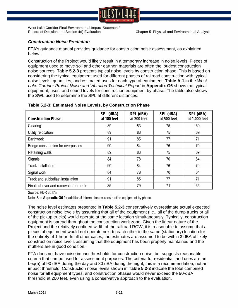
Construction Noise Prediction
FTA’s guidance manual provides guidance for construction noise assessment, as explained below.
Construction of the Project would likely result in a temporary increase in noise levels. Pieces of equipment used to move soil and other earthen materials are often the loudest construction noise sources. Table 5.2-3 presents typical noise levels by construction phase. This is based on considering the typical equipment used for different phases of railroad construction with typical noise levels, quantities, and estimated uses for each type of equipment. Table A-1 in the West Lake Corridor Project Noise and Vibration Technical Report in Appendix G6 shows the typical equipment, uses, and sound levels for construction equipment by phase. The table also shows the SWL used to determine the SPL at different distances.
Table 5.2-3: Estimated Noise Levels, by Construction Phase
Construction Phase SPL (dBA) at 100 feet
SPL (dBA) at 200 feet
SPL (dBA) at 500 feet
SPL (dBA) at 1,000 feet
Clearing 89 83 75 69 Utility relocation 89 83 75 69 Earthwork 91 85 77 71 Bridge construction for overpasses 90 84 76 70 Retaining walls 89 83 75 69 Signals 84 78 70 64 Track installation 90 84 76 70 Signal work 84 78 70 64 Track and subballast installation 91 85 77 71 Final cut-over and removal of turnouts 85 79 71 65 Source: HDR 2017a. Note: See Appendix G6 for additional information on construction equipment by phase.
The noise level estimates presented in Table 5.2-3 conservatively overestimate actual expected construction noise levels by assuming that all of the equipment (i.e., all of the dump trucks or all of the pickup trucks) would operate at the same location simultaneously. Typically, construction equipment is spread throughout the construction work zone. Given the linear nature of the Project and the relatively confined width of the railroad ROW, it is reasonable to assume that all pieces of equipment would not operate next to each other in the same (stationary) location for the entirety of 1 hour. In all other cases, the estimates are assumed to be within 3 dBA of likely construction noise levels assuming that the equipment has been properly maintained and the mufflers are in good condition.
FTA does not have noise impact thresholds for construction noise, but suggests reasonable criteria that can be used for assessment purposes. The criteria for residential land uses are an Leq(h) of 90 dBA during the day and 80 dBA during the night; this is a recommendation, not an impact threshold. Construction noise levels shown in Table 5.2-3 indicate the total combined noise for all equipment types, and construction phases would never exceed the 90-dBA threshold at 200 feet, even using a conservative approach to the evaluation.

West Lake Corridor Final Environmental Impact Statement/ Record of Decision and Section 4(f) Evaluation Chapter 5 Physical and Environmental Analysis
March 2018 5-22
5.2.3 Affected Environment
Since publication of the DEIS, additional noise measurements and analysis have been completed. Figures have been updated graphically to reflect current data.
This section discusses noise-sensitive land uses in the Project Area and presents noise measurement results.
5.2.3.1 Noise-sensitive Land Uses
Noise-sensitive land uses in the Project Area include residences, churches, parks, schools, and other institutional land uses:
Dyer: residences, St. Maria Goretti Catholic Church, and Dyer Nursing and Rehabilitation Center
South Munster: residences, West Lakes Park, and Family Christian Center Church
North Munster: residences and Kiwanis Park
South Hammond: residences, churches, Oak Hill Cemetery, the American Conservatory of Music – Chicago Campus, and Beatniks on Conkey Theater
North Hammond: residences, churches, Harrison Park, Henry W. Eggers School, Jefferson Hotel (multiple-family residence), and Towle Company Theater
5.2.3.2 Existing Noise Measurements
Existing noise was measured in the Project Area from June 6 to June 9, 2017. These measurements were used, along with measurements gathered during the DEIS phase of the Project, to determine existing noise levels throughout the Project Area. Table 5.2-4 summarizes the existing noise measurements. Figure 5.2-4 shows the noise measurement locations.
Source reference-level measurements were also conducted adjacent to the existing SSL. Measurements of train pass-by events were gathered along Brunswick Avenue at 50 feet from the existing track centerline. These measurements were used to determine the SEL of the horn on the NICTD vehicle. This measurement location is shown in Figure 5.2-4 as SEL1.

West Lake Corridor Final Environmental Impact Statement/ Record of Decision and Section 4(f) Evaluation Chapter 5 Physical and Environmental Analysis
March 2018 5-23
Table 5.2-4: Existing Noise Measurements
ID Receptor Description Measurement
Phase FTA Land
Use Category
Peak Hour Noise Level
(Leq)
Day-Night Noise Level
(Ldn) M1 St. Maria Goretti Catholic Church,
500 Northgate Drive, Dyer DEIS 3 56 Not
availablea M2 Residence, 9901 Whitehall Gardens,
Munster DEIS 2 55 60
M3 Residence, 8827 Manor Avenue, Munster DEIS 2 52 54 M4 Vacant, Manor Avenue at Ridge Road,
Munster DEIS 2 55 58
M5 Residence, 736 Sunnyside Avenue, Munster
DEIS 2 58 61
M6 Residence, 7136 Lyman Avenue, Hammond
DEIS 2 62 63
M7 Residence, 6411 Blaine Avenue, Hammond DEIS 2 56 60 M8 Residence, 268 Waltham Street, Hammond DEIS 2 61 61 M9 Residence, 255 Ogden Street, Hammond DEIS 2 60 62 LT1 Residence, 542 Sheffield Avenue, Dyer FEIS 2 50 60 ST2 421 45th Street, Calumet Area Humane
Society,b Munster FEIS Not
applicable 64 62
ST3 Residence, 8000 Frederick Avenue, Munster
FEIS 2 47 45
LT4 Residence, 426 176th Court, Hammond FEIS 2 63 69 LT5 Residence, 408 165th Street, Hammond FEIS 2 56 60 ST6 Hohman Avenue, Harrison Park, Hammond FEIS 3 55 53 ST7 415 Sibley Street, Jefferson Hotel,
Hammond FEIS 2 61 59
LT8 Residence, 4715 Sheffield Avenue, Hammond
FEIS 2 59 66
LT9 Residence, 35 Brunswick Street, Hammond FEIS 2 62 72 Sources: NICTD 2016; HDR 2017a. a This measurement was performed in the DEIS phase, and an Ldn was not calculated for this site or used in the noise analysis. b This location is also representative of the Family Christian Center Church on the other side of the street.

West Lake Corridor Final Environmental Impact Statement/ Record of Decision and Section 4(f) Evaluation Chapter 5 Physical and Environmental Analysis
March 2018 5-24
Figure 5.2-4: Measurement Locations
Source: HDR 2017a.

West Lake Corridor Final Environmental Impact Statement/ Record of Decision and Section 4(f) Evaluation Chapter 5 Physical and Environmental Analysis
March 2018 5-25
5.2.4 Environmental Consequences
Table 5.2-5 summarizes long-term operating effects for the No Build and all Build Alternatives.
Table 5.2-5: Summary of Noise Effects
Alternative Summary of Noise Effects No Build The projected noise levels are expected to be similar to existing conditions. FEIS Preferred Alt. Maximum day-night Project noise levels are predicted to range from 58 dBA to
67 dBA. The elevated noise levels would primarily be attributable to the proximity of noise-sensitive receptors to the proposed alignment (where wheel-rail noise would be the dominant noise from the Project) and additional noise from turnouts located along the alignment. Exceedances of the FTA severe impact criteria are predicted at 107 residences (Category 2 land uses) and 0 institutional receptors (Category 3 land uses). Exceedances of the FTA moderate impact criteria are predicted at 376 residences and 0 institutional receptors. A total of 483 impacts are predicted at residences (FTA Category 2 receptors) and 0 impacts at institutions (FTA Category 3 receptors). Table 5.2-6 lists the impacts by section along the alignment.
Other Build Alternativesa DEIS NEPA Preferred Alt. and Hamm. Alt. Opt. 1 and 3
Maximum day-night Project noise levels are predicted to range from 32 dBA to 67 dBA. The elevated noise levels would primarily be attributable to FRA-required warning horn use within 0.25 mile of all proposed railroad-highway grade crossings. Exceedances of the FTA severe impact criteria are predicted at 145 residences (Category 2 land uses) and 3 institutional receptors (Category 3 land uses). Exceedances of the FTA moderate impact criteria are predicted at 290 residences and 20 institutional receptors. A total of 435 impacts are predicted at residences (FTA Category 2 receptors) and 23 impacts are predicted at institutions (FTA Category 3 receptors).
CR Alt. Opt. 1 - 4 Maximum day-night Project noise levels are predicted to range from 32 dBA to 67 dBA. Exceedances of the FTA severe impact criteria are predicted at 147 residences (Category 2 land uses) and 3 institutional receptors (Category 3 land uses). Exceedances of the FTA moderate impact criteria are predicted at 288 residences and 20 institutional receptors. A total of 435 impacts are predicted at residences (FTA Category 2 receptors), and 23 FTA Category 3 receptor impacts are predicted.
IHB Alt. Opt. 1 - 4 Maximum day-night Project noise levels are predicted to range from 37 dBA to 67 dBA. Exceedances of the FTA severe impact criteria are predicted at 145 residences (Category 2 land uses) and 11 institutional receptors (Category 3 land uses). Exceedances of the FTA moderate impact criteria are predicted at 290 residences and 45 institutional receptors. A total of 435 impacts are predicted at residences (FTA Category 2 receptors), and 56 FTA Category 3 receptor impacts are predicted.
Sources: NICTD 2016; HDR 2017a. a Shaded areas indicate alternatives evaluated in the DEIS.

West Lake Corridor Final Environmental Impact Statement/ Record of Decision and Section 4(f) Evaluation Chapter 5 Physical and Environmental Analysis
March 2018 5-26
5.2.4.1 Long-term Operating Effects
No Build Alternative
Projected noise levels under the No Build Alternative are anticipated to be similar to those under existing conditions. Irrespective of other projects planned and programmed in the region, ambient noise under the No Build Alternative is anticipated to be essentially the same as under existing conditions without the FEIS Preferred Alternative. For example, it takes a doubling of the traffic volumes for the noise levels to increase by 3 dBA, the threshold where most listeners detect the change. However, only marginal increases in traffic levels are predicted in the Project Area between now and 2040, resulting in slightly higher congestion and lower average travel speeds. Along the existing MED/SSL, ambient noise levels at residences adjacent to the rail corridor would be dominated by existing rail operations. The future noise under the No Build Alternative is expected to be similar to the existing conditions since operations are not expected to increase substantially.
FEIS Preferred Alternative
Severe and moderate noise impacts are predicted to occur as part of the Project. Table 5.2-6 presents the number of affected dwelling units. The impacts are further described following the table. Additionally, the West Lake Corridor Project Noise and Vibration Technical Report in Appendix G6 provides detailed exhibits showing noise impact locations.

West Lake Corridor Final Environmental Impact Statement/ Record of Decision and Section 4(f) Evaluation Chapter 5 Physical and Environmental Analysis
March 2018 5-27
Table 5.2-6: Dwelling Units Affected by Noise
Municipality/Section Category 1 Moderate
Category 1 Severe
Category 2 Moderate
Category 2 Severe
Category 3 Moderate
Category 3 Severe
Dyer (south of MP 61.4)
0 0 0 0 0 0
Munster – Megan Way to 45th Street (MP 61.4 to 62.8)
0 0 4 1 0 0
Munster – 45th Street to Ridge Road (MP 62.8 to 64.1)
0 0 266 76 0 0
Munster – Ridge Road to I-94 (MP 64.1 to 65)
0 0 18 0 0 0
Hammond – I-94 to 165th Street (MP 65 to 66.4)
0 0 9 2 0 0
Hammond – 165th Street to Waltham Street (MP 66.4 to 67.15)
0 0 49 0 0 0
Hammond – Waltham Street to Douglas Street (MP 67.15 to 67.8)
0 0 0 0 0 0
Hammond – Douglas Street to Hoffman Street (MP 67.8 to 68.3)
0 0 23 28 0 0
Hammond – Hoffman Street to 143rd Street (MP 68.3 to 69.2)
0 0 7 0 0 0
Total impacts 0 0 376 107 0 0 Source: HDR 2017a.
Moderate impacts are further classified by “upper range” and “lower range.” The severe noise impacts and the upper-range moderate noise impacts are identified in more detail below: A severe noise impact is projected to occur at 1 single-family home and an upper-range moderate noise impact is projected to occur at 1 single-family home in Munster between MP 61.5 and 61.6. These impacts are attributable to the location of the turnout for the northbound siding.
Severe noise impacts are projected to occur at 2 multiple-family buildings in Munster between MP 63.4 and 63.6, resulting in 28 dwelling units affected.

West Lake Corridor Final Environmental Impact Statement/ Record of Decision and Section 4(f) Evaluation Chapter 5 Physical and Environmental Analysis
March 2018 5-28
Severe noise impacts are projected to occur at 2 multiple-family buildings in Munster between MP 63.7 and 63.9, resulting in 48 dwelling units affected.
A severe noise impact is projected to occur at 1 single-family home, and an upper-range moderate noise impact is projected to occur at 1 single-family home in Hammond between MP 65.3 and 65.5.
A severe noise impact is projected to occur at 1 single-family home, and upper-range moderate noise impacts are projected to occur at 2 single-family homes in Hammond between MP 66.3 and 66.4.
Upper-range moderate noise impacts are projected to occur at 5 single-family homes in Hammond between MP 66.9 and 67.2.
Severe noise impacts are projected to occur at Jefferson Hotel in Hammond south of MP 68.1, resulting in 28 dwelling units affected. Jefferson Hotel is currently a multiple-family property with 51 total dwelling units, and the severe impact is predicted to occur at all three floors of the property. An estimated 28 dwelling units face the alignment. The remaining 23 dwelling units facing away from the alignment are projected to experience lower-range moderate impacts.
Mitigation for these impacts is discussed in Section 5.2.5.
Other Build Alternatives Considered in the DEIS
The Build Alternatives considered in the DEIS would have an impact on noise; Table 5.2-6 summarizes the effects. For a description of possible noise effects of the other Build Alternatives considered in the DEIS, refer to the DEIS Section 5.2.4.1.
5.2.4.2 Short-term Construction Effects
For the No Build Alternative, no construction impacts would occur, since the Project would not be built.
For the FEIS Preferred Alternative, construction would result in a temporary increase in noise levels. Pieces of equipment used to move soil and other earthen materials are often the loudest construction noise sources. FTA’s guidance manual suggests construction noise criteria for residential land uses are Leq(h) of 90 dBA during the day and 80 dBA during the night. These construction noise criteria are intended to be compared with the combined Leq(h) of the two noisiest pieces of construction equipment during 1 hour.
The estimated noise levels presented in Table 5.2-3 show that numerous single pieces of equipment may exceed the FTA recommendations if running constantly for 1 hour within 100 feet of a receptor. During the final design and construction phase, NICTD would require construction contractors to develop a construction noise management plan which includes identifying and complying with any applicable local noise ordinances; therefore, construction noise impacts are not anticipated to occur.
5.2.5 Avoidance, Minimization, and/or Mitigation Measures
This section discusses noise mitigation commitments. Noise impacts are projected to occur as a consequence of this Project. To mitigate the anticipated noise impacts, a combination of noise barriers and receiver-based treatments would be implemented.

West Lake Corridor Final Environmental Impact Statement/ Record of Decision and Section 4(f) Evaluation Chapter 5 Physical and Environmental Analysis
March 2018 5-29
5.2.5.1 Long-term Operating Effects
For the No Build Alternative, no Project-related impacts on noise levels would occur, and, therefore, mitigation is not required.
For the FEIS Preferred Alternative, noise analysis results indicate that the Project, as modeled, would cause severe noise impacts at 8 receptors, all of which are Category 2 land uses. The severely affected receptors include both single-family and multiple-family residences that represent 107 affected dwelling units. Analysis results also indicate that the Project would cause moderate noise impacts at 125 receptors. These moderate noise impacts would occur at Category 2 land uses including both single-family and multiple-family residences that represent 376 total affected dwelling units. Of the moderate impacts, 9 would fall in the upper range of moderate impacts shown in Figure 5.2-2. Noise mitigation is discussed below for the severe and upper-range moderate noise impacts, as well as the lower-range moderate noise impacts where reasonable.
A severe noise impact is projected to occur at 1 single-family home and an upper-range moderate noise impact is projected to occur at 1 single-family home in Munster between MP 61.5 and 61.6. These impacts are attributable to the location of the turnout for the northbound siding. To mitigate these impacts, receiver-based treatments would be implemented.
Severe noise impacts are projected to occur at 2 multiple-family buildings in Munster between MP 63.4 and 63.6, resulting in 28 dwelling units affected. To mitigate these impacts, a barrier approximately 1,210 feet long ranging in height from 4 to 5 feet above the top-of-rail would be constructed. This barrier would be on the eastern side of the Project alignment, with a height of 5 feet from MP 63.4 to 63.5 and 4 feet from MP 63.5 to 63.65. This barrier would also reduce noise levels at 46 lower-range moderate noise impacts located between MP 63.4 and 63.6.
Severe noise impacts are projected to occur at 2 multiple-family buildings in Munster between MP 63.7 and 63.9, resulting in 48 dwelling units affected. To mitigate these impacts, a barrier approximately 1,330 feet long and 5 feet above the top-of-rail would be constructed. This barrier would be on the western side of the Project alignment. This barrier would also reduce noise levels at 72 lower-range moderate noise impacts located between MP 63.65 and 63.9.
A severe noise impact is projected to occur at 1 single-family home and an upper-range moderate noise impact is projected to occur at 1 single-family home in Hammond between MP 65.3 and 65.5. To mitigate these impacts, a barrier approximately 580 feet long and 5 feet above the top-of-rail would be constructed. This barrier would be on the western side of the Project alignment, and would also protect 1 lower-range moderate noise impact projected to occur at 1 single-family home between MP 65.3 and 65.5.
A severe noise impact is projected to occur at 1 single-family home and upper-range moderate noise impacts are projected at 2 single-family homes in Hammond between MP 66.3 and 66.4. To mitigate these impacts, a barrier approximately 700 feet long and 5 feet above the top-of-rail would be constructed. This barrier would be on the eastern side of the Project alignment and would also protect 2 lower-range moderate noise impacts projected to occur at single-family homes approximately between MP 66.3 and 66.4.
Upper-range moderate noise impacts are projected to occur at 5 single-family homes in Hammond between MP 66.9 and 67.2. To mitigate these impacts, receiver-based treatments (treatment to the single-family home itself) would be implemented. A noise

West Lake Corridor Final Environmental Impact Statement/ Record of Decision and Section 4(f) Evaluation Chapter 5 Physical and Environmental Analysis
March 2018 5-30
barrier would not be considered feasible mitigation because the railroad-highway grade crossings would result in gaps in the barrier
Severe noise impacts are projected to occur at Jefferson Hotel in Hammond south of MP 68.1, resulting in 28 dwelling units affected. Jefferson Hotel is currently functioning as a multiple-family property with 51 total dwelling units, and the severe impact is predicted to occur at all three floors of the property. An estimated 28 dwelling units face the alignment (the remaining 23 dwelling units are projected to experience lower-range moderate impacts). To mitigate these impacts, a barrier approximately 370 feet long and 3 feet above the top-of-rail would be constructed. This barrier would be on the western side of an elevated portion of the Project alignment. The barrier would eliminate the impact at the first and second floors and would reduce the impact at the third floor to the lower moderate range2; it would additionally benefit the dwelling units on the back side of the building, reducing them to no impact.
The West Lake Corridor Project Noise and Vibration Technical Report in Appendix G6 provides detailed exhibits showing the location of noise mitigation treatments for the Project.
5.2.5.2 Short-term Construction Effects
For the No Build Alternative, no construction impacts would occur, since the Project would not be built.
Construction activities related to the FEIS Preferred Alternative would generate some degree of noise, though usually the impacts are temporary and unavoidable. NICTD would limit noise impacts during construction by requiring the construction contractors to include noise performance specifications in the construction contract documents.
Additionally, construction contractors would be required to develop a construction noise management plan. This may be a stand-alone plan, or it may be included in a larger environmental management plan for the construction project. At a minimum, the plan would include:
An outline of the Project’s noise-control objectives and potential components
A summary of noise-related criteria and local ordinances for construction contractors to abide by
The requirement to perform a preconstruction survey or assessment to identify receptors potentially affected by construction noise and document the preconstruction conditions of particularly susceptible receptors
A list of potential mitigation measures, a plan to implement mitigation, and an approach for deciding the appropriateness of mitigation by construction activity and receptor
An approach to minimize noise impacts on adjacent noise-sensitive stakeholders while maintaining construction progress
A strategy to coordinate with affected Project stakeholders to minimize intrusive construction impacts
A complaint-handling and -resolution procedure for any Project stakeholder 2 It is assumed that 14 dwelling units face the Project alignment on the third floor. The layout of dwelling
units in the Jefferson Hotel is unknown. Based on field observation, the noise analysis assumes that there are no dwelling units on the first floor.

West Lake Corridor Final Environmental Impact Statement/ Record of Decision and Section 4(f) Evaluation Chapter 5 Physical and Environmental Analysis
March 2018 5-31
As stated above, NICTD would require the construction contractor to develop noise specifications and a construction noise management plan. There are several approaches the contractor may use at its discretion to comply with these requirements and the applicable construction noise limits. Noise monitoring of construction activities is effective to limit unanticipated adverse impacts.
Additional examples of noise-control measures that that could be applied during construction as needed include the following:
Scheduling the loudest construction activities during daytime hours in residential neighborhoods, and limiting or completely avoiding their use in the evening and at nighttime
Ensuring that all construction equipment has been properly maintained and is in good working order, with mufflers that are at least as good as the original equipment or a higher-performing replacement; in locations where noise-sensitive receptors could be adversely affected by construction equipment noise, use specially quieted equipment with enclosed engines, noise-reduction packages, and high-performance mufflers
Locating stationary construction equipment as far as possible from noise-sensitive sites
Constructing noise barriers, such as temporary walls or piles of excavated material, between noisy activities and noise-sensitive receivers, where feasible
Rerouting construction-related truck traffic along roads that would cause the least disturbance to residents
Conducting noise monitoring during construction to verify compliance with the limits
Coordinating with the municipalities in the Project Area
5.3 Vibration
5.3.1 Regulatory Setting
There have been no changes to the regulatory setting since publication of the DEIS. Figures, tables, and text have been added to help explain the analysis.
The vibration analysis for the Project was prepared in accordance with the FTA guidance manual, Transit Noise and Vibration Impact Assessment (FTA 2006). The manual includes vibration assessment methods and impact thresholds.
Ground-borne vibration (GBV) consists of rapidly fluctuating motions of the ground transmitted into a receptor (building) from a vibration source, such as transit trains. Vibration velocity level is used to describe vibration levels for transit projects and can also be defined by three variables: level, frequency, and time pattern.
The root mean square (RMS) amplitude of a motion over a 1-second period is commonly used to predict human response to vibration. The vibration velocity level is expressed in terms of vibration decibels (VdB), which is decibels relative to a reference quantity of 1 micro-inch per second. The level of vibration represents how much the ground is moving. The background vibration level in residential areas is usually 50 VdB or lower—well below the threshold of perception for humans, which is around 65 VdB. Annoyance begins to occur for frequent transit events at vibration levels over 70 VdB.
Vibration frequency is also expressed in Hz, and the human response to vibration generally falls between 6 and 200 Hz. Human response to vibration is a function of the average motion over a

West Lake Corridor Final Environmental Impact Statement/ Record of Decision and Section 4(f) Evaluation Chapter 5 Physical and Environmental Analysis
March 2018 5-32
period of time, such as 1 second. Human response to vibration also roughly correlates to the number of vibration events during the day. The more events that occur, the more sensitive humans are to vibration. Figure 5.3-1 illustrates common vibration sources and associated human and structural responses to GBV.
Figure 5.3-1: Common Vibration Sources
Source: FTA 2006.
5.3.1.1 FTA Transit Vibration Criteria
The vibration impact criteria used for transit projects are presented in Chapter 8 of FTA’s guidance manual. FTA identifies separate criteria for both GBV and ground-borne noise (GBN). GBN is often masked by airborne noise; therefore, GBN criteria are primarily applied to subway operations in which airborne noise is negligible. FTA differentiates vibration-sensitive land uses into three distinct categories—similar but not identical to the noise-sensitive land use categories, as shown in Table 5.3-1. The vibration thresholds vary based on the land use and the frequency of the vibration events, as shown in Table 5.3-2.

West Lake Corridor Final Environmental Impact Statement/ Record of Decision and Section 4(f) Evaluation Chapter 5 Physical and Environmental Analysis
March 2018 5-33
Table 5.3-1: Vibration Land Use Categories
Land Use Category Description of Land Use Category
1 High Vibration Sensitivity. Buildings where ambient vibration well below levels associated with human annoyance is essential for equipment or operations within the building. Typically includes vibration-sensitive research and manufacturing facilities, hospitals, and university research operations.
2 Residential. Includes all residential land uses and any building where people sleep, such as hotels and hospitals.
3 Institutional. Schools, churches, other institutions, and quiet offices that do not have vibration-sensitive equipment, but still have the potential for activity interference. Includes certain office buildings, but not all buildings that have office space.
Source: FTA 2006. Note: Special buildings—such as concert halls, television and recording studios, and theaters—have separate vibration impact thresholds because of the unique sensitivity of such buildings.
Table 5.3-2: Vibration Thresholds, by Land Use and Frequency of Event
Land Use Category Frequent Eventsa
Occasional Eventsb
Infrequent Eventsc
GBV impact level (VdB re 1 micro-inch/second) Category 1d (highly sensitive, where vibration would interfere with operations)
65 65 65
Category 2 (where overnight sleep occurs) 72 75 80 Category 3 (institutional with primarily daytime use) 75 78 83 GBN impact level (dBA re 20 micropascals) Category 2 (where overnight sleep occurs) 35 38 43 Category 3 (institutional with primarily daytime use) 40 43 48 Source: FTA 2006. a Frequent events is defined as more than 70 vibration events of the same source per day. Most rapid transit projects fall in this
category. b Occasional events is defined as between 30 and 70 vibration events of the same source per day. Most commuter rail trunk
lines have this many operations. c Infrequent events is defined as fewer than 30 vibration events of the same kind per day. This category includes most commuter
rail branch lines. d The Category 1 criteria limits are based on levels that are acceptable for most moderately sensitive equipment, such as optical
microscopes. Vibration-sensitive manufacturing or research would require detailed evaluation to define the acceptable vibration levels. Vibration-sensitive equipment is generally not sensitive to GBN.
The GBV impact criteria are related to causing human annoyance or interfering with use of vibration-sensitive equipment. The basis for evaluating FTA vibration impact thresholds is the highest expected RMS vibration levels for repeated vibration events from the same source. Some buildings, such as concerts halls, television and recording studios, and theaters, can have higher sensitivity to GBV or GBN but do not fit into the categories in Table 5.3-1. The land uses with special buildings such as these have separate vibration impact thresholds for both GBV

West Lake Corridor Final Environmental Impact Statement/ Record of Decision and Section 4(f) Evaluation Chapter 5 Physical and Environmental Analysis
March 2018 5-34
and GBN. Two theaters are in the Project Area, but neither is directly adjacent to the proposed track. Table 5.3-3 lists the vibration criteria for theater buildings.
Table 5.3-3: Vibration Criteria for Theater Buildings
Type of Building or Room
GBV Impact Criteria (VdB re: 1 micro-inch per second)
for Frequent Events
GBV Impact Criteria (VdB re: 1 micro-inch per second) for Occasional or Infrequent Events
GBN Impact Criteria (dBA re:
20 micropascals) for Frequent Events
GBN Impact Criteria (dBA re:
20 micropascals) for Occasional or Infrequent Events
Concert hall 65 65 25 25 TV studio 65 65 25 25 Recording studio 65 65 25 25 Auditorium 72 80 30 38 Theater 72 80 35 43 Source: FTA 2006.
5.3.1.2 FTA Construction Vibration Criteria
Vibration attributable to construction activities is usually temporary. Thus, the principal concern for construction vibration is potential damage to structures. Table 5.3-4 lists damage criteria that can be applied to protect sensitive or fragile structures. These criteria can be used to identify locations that should be considered more carefully during the Project’s final design phases.
Table 5.3-4: Damage Criteria for Sensitive or Fragile Structures
Building Category Peak Particle Velocity
(inch/second) RMS Velocity
(VdB) I. Reinforced-concrete, steel, or timber (no plaster) 0.50 102 II. Engineered concrete and masonry (no plaster) 0.30 98 III. Non-engineered timber and masonry buildings 0.20 94 IV. Buildings extremely susceptible to vibration damage 0.12 90 Source: FTA 2006. Note: RMS velocity is provided as a reference to the general magnitude of vibration, compared with the operational vibration impact thresholds; assumes a crest factor of 4 (12 VdB).
5.3.2 Methodology
Since publication of the DEIS, design refinements for the Project have been analyzed including higher speeds. A figure has been added to help explain the analysis.
5.3.2.1 Operation Vibration Evaluation Methods
Projected GBV levels from commuter rail pass-by events were predicted using the default ground-surface vibration curves in FTA’s guidance manual. These GBV curves are shown in Figure 5.3-2. The commuter rail trains would travel up to a maximum speed of 60 mph. Following FTA guidance, the surface vibration curves in Figure 5.3-2 were adjusted to reflect

West Lake Corridor Final Environmental Impact Statement/ Record of Decision and Section 4(f) Evaluation Chapter 5 Physical and Environmental Analysis
March 2018 5-35
local conditions (receptor distances), changes in train speed, and special trackwork such as switches. No adjustments were applied for corrugated rail, wheel flats, or other unmaintained rolling stock. NICTD maintains a rail-grinding and wheel-trueing program to maximize track life and to minimize adverse vibration in the community. Finally, no adjustments were applied for different receptor building construction types (i.e., masonry versus timber).
Vibration impacts were evaluated along the proposed alignment following FTA guidance.
Refer to the DEIS Section 5.3 for an evaluation of the vibration from the Project along the existing MED/SSL.
Figure 5.3-2: Surface Vibration Curves
Source: FTA 2006.
5.3.2.2 Construction Vibration Evaluation Methods
A quantitative construction vibration assessment is generally necessary only when the construction activities have potential for damaging fragile buildings or interfering with equipment or activities that are highly sensitive to GBV. Examples include projects that use blasting, pile driving, pavement breaking, vibratory compaction, and drilling or excavating the ground near sensitive structures. Construction vibration was not evaluated quantitatively because the primary vibration sources or activities of concern are not currently proposed. A brief qualitative assessment is provided, as suggested by the FTA’s guidance manual.

West Lake Corridor Final Environmental Impact Statement/ Record of Decision and Section 4(f) Evaluation Chapter 5 Physical and Environmental Analysis
March 2018 5-36
Construction Vibration Prediction
FTA’s guidance manual provides guidance for construction vibration assessment, as explained below.
Most construction equipment can cause ground vibration, which rapidly diminishes in strength with distance. Some construction activities have potential for producing higher vibration levels—such as pavement breaking, vibratory compaction, and drilling or excavating the ground—and the highest vibration levels typically result from blasting activities or impact pile driving. The construction activities associated with this Project would not include blasting. Other activities have potential to create temporary, perceptible vibrations when construction activities move very close to a structure, but these impacts would be temporary and would occur only while the construction equipment moves through that location.
5.3.3 Affected Environment
There have been no changes to the affected environment since publication of the DEIS.
5.3.3.1 Vibration-sensitive Land Uses
Vibration-sensitive land uses in the Project Area include residences, churches, schools, and other institutional land uses:
Dyer: residences, St. Maria Goretti Catholic Church, and Dyer Nursing and Rehabilitation Center
South Munster: residences and Family Christian Center Church
North Munster: residences
South Hammond: residences, churches, the American Conservatory of Music – Chicago Campus, and Beatniks on Conkey Theater
North Hammond: residences, churches, Henry W. Eggers School, Jefferson Hotel (multiple-family residence), and Towle Company Theater
5.3.3.2 Existing Vibration Conditions
Existing vibration sources in the Project Area include local streets and existing freight and commuter rail lines. The SSL currently operates in North Hammond between Hudson and Gostlin Streets. Several rail lines currently exist in the Project Area, including the CSX line in Dyer and Munster and several rail lines in Hammond.
Existing vibration levels were monitored from SSL trains and freight trains operating in North Hammond between Hudson and Gostlin Streets. The average vibration level at 50 feet from SSL trains was 74 VdB, while the average vibration level at 50 feet from freight trains was 81 VdB.
Along the MED/SSL, existing vibration sources include the existing SSL rail service, MED, Amtrak, and freight train traffic.

West Lake Corridor Final Environmental Impact Statement/ Record of Decision and Section 4(f) Evaluation Chapter 5 Physical and Environmental Analysis
March 2018 5-37
5.3.4 Environmental Consequences
Table 5.3-5 summarizes long-term operating effects for the No Build and all Build Alternatives.
Table 5.3-5: Summary of Vibration Effects
Alternative Summary of Vibration Effects No Build The projected vibration levels are expected to be similar to existing conditions. FEIS Preferred Alt. Project vibration levels are predicted to range from 59 VdB to 77 VdB. The elevated
vibration levels would be primarily attributable to proximity to the rail and rail discontinuities at track turnout switches. Overall, no exceedances of the FTA occasional vibration impact criteria are predicted along the existing MED/SSL. However, exceedances at 3 residential structures that represent 13 dwelling units are predicted along the proposed alignment. No other exceedances are predicted under the proposed alignment.
Other Build Alternativesa DEIS NEPA Preferred Alt., CR Alt. Opt. 1 to 4, Hamm. Alt. Opt. 1 and 3
Project vibration levels are predicted to range from 21 VdB to 66 VdB. The elevated vibration levels would be primarily attributable to rail discontinuities at track turnout switches. Overall, no exceedances of the FTA occasional vibration impact criteria are predicted along the existing MED/SSL. However, one exceedance is predicted along the proposed alignment. No other exceedances are predicted under the proposed alignment.
IHB Alt. Opt. 1 to 4 Project vibration levels are predicted to range from 41 VdB to 67 VdB. The elevated vibration levels would be primarily attributable to rail discontinuities at track turnout switches. Overall, no exceedances of the FTA occasional vibration impact criteria are predicted along the existing MED/SSL. However, two exceedances are predicted along the proposed alignment. No other exceedances are predicted under the proposed alignment.
Sources: NICTD 2016; HDR 2017a. a Shaded areas indicate alternatives evaluated in the DEIS.
5.3.4.1 Long-term Operating Effects
No Build Alternative
Projected vibration levels under the No Build Alternative are expected to be similar to existing conditions. Traffic, including heavy trucks and buses, rarely creates perceptible GBV unless vehicles are operating very close to buildings or there are irregularities in the road, such as potholes or expansion joints. The pneumatic tires and suspension systems of automobiles, trucks, and buses eliminate most GBV. Similarly, vibration levels from existing train service along the existing MED/SSL is expected to be the dominant source of vibration in the area, which is not expected to change from the existing condition. As a result, no vibration impacts would be associated with the No Build Alternative because nothing would be built.
FEIS Preferred Alternative
Vibration impacts are predicted to occur as part of the Project. Table 5.3-6 presents the number of affected dwelling units. The impacts are further described following the table. Additionally, the

West Lake Corridor Final Environmental Impact Statement/ Record of Decision and Section 4(f) Evaluation Chapter 5 Physical and Environmental Analysis
March 2018 5-38
West Lake Corridor Project Noise and Vibration Technical Report in Appendix G6 provides detailed exhibits showing vibration impact locations.
Table 5.3-6: Dwelling Units Affected by Vibration
Municipality/Section Category 1 Category 2 Category 3 Dyer (south of MP 61.4) 0 0 0 Munster – Megan Way to 45th Street (MP 61.4 to 62.8) 0 0 0 Munster – 45th Street to Ridge Road (MP 62.8 to 64.1) 0 12 0 Munster – Ridge Road to I-94 (MP 64.1 to 65) 0 0 0 Hammond – I-94 to 165th Street (MP 65 to 66.4) 0 1 0 Hammond – 165th Street to Waltham Street (MP 66.4 to 67.15)
0 0 0
Hammond – Waltham Street to Douglas Street (MP 67.15 to 67.8)
0 0 0
Hammond – Douglas Street to Hoffman Street (MP 67.8 to 68.3)
0 0 0
Hammond – Hoffman Street to 143rd Street (MP 68.3 to 69.2)
0 0 0
Total impacts 0 13 0 Source: HDR 2017a.
The vibration impacts are discussed in more detail below:
GBV impacts are projected to occur at 2 multiple-family buildings in Munster between MP 63.7 and 63.9 because of wayside vibration (wheels rolling on the track). The estimated number of dwelling units in these buildings is 24 units total, 12 units on each of the two floors. Only the ground-floor units closest to the alignment are projected to experience vibration impacts, resulting in 6 impacted dwelling units in each building, for a total of 12 impacted dwelling units. Project-related GBV levels are projected to be 75 VdB at the 6 ground-floor front-row dwelling units, which equals the vibration impact threshold of 75 VdB at these receptors. The 12 dwelling units on the second floor of each building are not anticipated to experience vibration impacts because the floor-to-floor attenuation would reduce the vibration levels to below FTA vibration impact thresholds.
One vibration impact would occur at a single-family home in Hammond between MP 66.3 and 66.4 because of wayside vibration (wheels rolling on the track). Project-related GBV levels are projected to be 76.5 VdB, which exceeds the vibration impact threshold of 75 VdB at this receptor.
Mitigation for these vibration impacts is discussed in Section 5.3.5.
Other Build Alternatives Considered in the DEIS
All of the Build Alternatives considered in the DEIS would have a similar impact on vibration levels as the FEIS Preferred Alternative; Table 5.3-5 summarizes the effects. For a description of possible vibration effects of the other Build Alternatives considered in the DEIS, refer to the DEIS Section 5.3.4.1.

West Lake Corridor Final Environmental Impact Statement/ Record of Decision and Section 4(f) Evaluation Chapter 5 Physical and Environmental Analysis
March 2018 5-39
5.3.4.2 Short-term Construction Effects
For the No Build Alternative, no construction impacts would occur, since the Project would not be built.
During construction of the FEIS Preferred Alternative, vibration would very rarely damage buildings. Construction activities that typically generate the most severe vibrations with the potential for building damage including blasting and pile-driving. No blasting activities are expected to be included on this Project, and pile-driving is expected to occur in some locations. Examples of other construction activities with a potential for vibration impact include concrete pavement breaking, vibratory compaction, and drilling or excavating in the ground near sensitive structures. During the final design and construction phase, NICTD would require construction contractors to develop a construction vibration management plan and include vibration performance specifications in the construction contract documents; therefore, construction vibration impacts are not anticipated to occur.
5.3.5 Avoidance, Minimization, and/or Mitigation Measures
This section discusses vibration mitigation commitments. Vibration impacts are projected to occur as a consequence of this Project. To mitigate the anticipated vibration impacts, track treatments are recommended.
5.3.5.1 Long-term Operating Effects
The No Build Alternative would not result in any direct impacts on vibration levels and, therefore, would not require mitigation. Under the FEIS Preferred Alternative, analysis results indicate that the Project, as modeled, would cause vibration impacts at 3 residential structures that represent 13 dwelling units:
GBV impacts are projected to occur at 2 multiple-family buildings in Munster between MP 63.7 and 63.9. Twelve units on the ground floor are projected to experience vibration impacts. Project-related GBV levels are projected to be 75 VdB at the 12 ground-floor dwelling units, which equals the vibration impact threshold of 75 VdB at these receptors. To mitigate this impact, ballast mats or other track-support system modifications would be implemented. This treatment would extend the length of one full trainset on either side of the affected receptor, which would result in approximately 2,360 feet of treatment.
One vibration impact is projected to occur at a single-family home in Hammond between MP 66.3 and 66.4 that would be attributable to wayside vibration. Project-related GBV levels are projected to be 76.5 VdB, which exceeds the vibration impact threshold of 75 VdB at this receptor. To mitigate this impact, ballast mats or other track-support system modifications would be implemented. This treatment would extend the length of one full trainset on either side of the affected receptor, which would result in approximately 1,360 feet of treatment. This is based on a trainset length of 680 feet, consisting of 8 cars at 85 feet.
Additionally, the West Lake Corridor Project Noise and Vibration Technical Report in Appendix G6 provides detailed exhibits showing vibration mitigation for the Project.

West Lake Corridor Final Environmental Impact Statement/ Record of Decision and Section 4(f) Evaluation Chapter 5 Physical and Environmental Analysis
March 2018 5-40
5.3.5.2 Short-term Construction Effects
The No Build Alternative would not result in any direct impacts on vibration levels and, therefore, would not require mitigation.
The FEIS Preferred Alternative would have vibration impacts during construction. By their nature, construction activities generate some degree of vibration, though usually the impacts are temporary and unavoidable. NICTD would limit vibration impacts during construction by requiring construction contractors to include vibration performance specifications in the construction contract documents.
Additionally, construction contractors would be required to develop a construction vibration management plan. This may be a stand-alone plan, or it may be included in a larger environmental management plan for the construction project. At a minimum, the plan would include:
An outline of the Project’s vibration-control objectives and potential components
A summary of vibration-related criteria and local ordinances for construction contractors to abide by
The requirement to perform a preconstruction survey or assessment to identify receptors potentially affected by construction vibration and document the preconstruction conditions of particularly susceptible receptors
A list of potential mitigation measures, a plan to implement mitigation, and an approach for deciding the appropriateness of mitigation by construction activity and receptor
An approach to minimize vibration impacts on adjacent vibration-sensitive stakeholders while maintaining construction progress
A strategy to coordinate with affected Project stakeholders to minimize intrusive construction impacts
A complaint-handling and -resolution procedure for any Project stakeholder
As stated above, NICTD would require the construction contractor to develop vibration specifications and a construction vibration management plan. To limit vibration impacts from construction activities, the construction contract documents would specify vibration limits for construction activities. There are several approaches the contractor may use at its discretion to comply with these requirements and the applicable construction vibration limits. Vibration monitoring of construction activities is effective in limiting unanticipated adverse impacts. Additional examples of vibration-control measures include the following:
Rerouting construction-related truck traffic along roads that would cause the least disturbance to residents
Performing a preconstruction survey near sites where vibration activities would occur to document the preconstruction conditions of potentially affected structures
Restricting the use of certain vibration-producing equipment near sensitive structures
Conducting vibration monitoring during construction to verify compliance with the limits
Establishing a complaint-resolution procedure to rapidly address any problems that may develop during construction
Coordinating with municipalities in the Project Area

West Lake Corridor Final Environmental Impact Statement/ Record of Decision and Section 4(f) Evaluation Chapter 5 Physical and Environmental Analysis
March 2018 5-41
5.4 Air Quality This section evaluates the Project’s short- and long-term effects on air quality. Because the FEIS Preferred Alternative would result in a modest reduction in VMT, and incorporates by reference recent guidance documents issued by FHWA, FTA, and CEQ, a qualitative analysis was completed to assess the Project’s potential impacts on air quality.
5.4.1 Regulatory Setting
Since publication of the DEIS, the air quality discussion has been largely rewritten as a qualitative analysis and incorporates results of FTA’s Programmatic Assessment. A qualitative air quality analysis is appropriate for this Project, given that the net effect of the Project during operations would be to reduce emissions slightly on a regional basis.
The Clean Air Act of 1990 (42 USC § 7401 et seq.) and its associated regulations are the basic federal statutes and regulations governing air pollution. Provisions that are potentially relevant to this Project are the National Ambient Air Quality Standards (NAAQS), the transportation conformity rule, mobile source air toxics (MSATs) regulations and policies, and greenhouse gas (GHG) emissions. Each of these provisions is discussed in the following paragraphs.
5.4.1.1 National Ambient Air Quality Standards
The Clean Air Act requires USEPA to establish NAAQS for pollutants considered harmful to public health and the environment. Primary standards set limits to protect public health, including the health of sensitive populations, such as people with asthma, children, and the elderly. Secondary standards set limits to protect public welfare, including protection against decreased visibility and damage to animals, crops, vegetation, and buildings.
USEPA has established NAAQS for six principal pollutants, which are called criteria pollutants. These criteria pollutants are carbon monoxide (CO), nitrogen dioxide (NO2), ozone (O3), lead (Pb), particulate matter with particle diameters of 10 microns or less (respirable particulate matter) (PM10), particulate matter with diameters of 2.5 microns or less (fine particulate matter) (PM2.5), and sulfur dioxide (SO2). Table 5.4-1 summarizes the NAAQS.

West Lake Corridor Final Environmental Impact Statement/ Record of Decision and Section 4(f) Evaluation Chapter 5 Physical and Environmental Analysis
March 2018 5-42
Table 5.4-1: National Ambient Air Quality Standards
Pollutant Averaging Period Primary NAAQS Secondary NAAQS CO 8-houra 9 ppm (10,000 μg/m3) None 1-houra 35 ppm (40,000 μg/m3) None NO2 1-hour 100 ppb (188 μg/m3) Same as primary Annual 53 ppb (100 μg/m3) Same as primary O3 (2015 standard) 8-hourb 0.070 ppm Same as primary PM10 24-houra 150 μg/m3 Same as primary PM2.5 24-hour 35 μg/m3 Same as primary Annual 12 μg/m3 15 μg/m3 SO2 1-hour 75 ppb (196 μg/m3) None 3-houra None 0.5 ppm (1,300 μg/m3) Pb Rolling 3-month average 0.15 μg/m3 Same as primary Source: 40 CFR Part 50 Notes: ppb = parts per billion; ppm = parts per million; μg/m3 = micrograms per cubic meter a Must not be exceeded more than once per year. b To attain this standard, the 3-year average of the fourth highest daily maximum 8-hour average O3 concentrations measured at
each monitor within an area over each year must not exceed 0.070 ppm. Final rule signed October 1, 2015, and effective December 28, 2015. The previous (2008) O3 standard additionally remains in effect until the new standard is fully implemented in an area.
5.4.1.2 Transportation Conformity Rule
The Transportation Conformity Rule (40 CFR Part 93, Subpart A) requires that projects that are developed, funded, or approved by USDOT and by MPOs or other recipients of federal funds demonstrate conformity to the State Implementation Plan (SIP) developed pursuant to the Clean Air Act. A determination of conformity is made by USDOT and the MPO.
The Transportation Conformity Rule requires that transportation projects that are regionally important, federally funded, or both must demonstrate conformity to state implementation and maintenance plans. These regulations require that a project:
Be included in a fiscally constrained regional transportation plan,
Be included in a fiscally constrained TIP, and
Not cause or contribute to any new or existing violations of NAAQS.
The Project was recently added to the 2040 CRP and FY 2018–2021 TIP, both of which were recently evaluated for conformity with the SIP (NIRPC 2017b). In a letter dated July 3, 2017, signed by FHWA and FTA, the agencies notified INDOT that its FY 2018–2021 STIP and affected MPOs’ TIPs were approved. In a second letter also dated July 3, 2017, FHWA and FTA notified INDOT that the NIRPC amendment to the 2040 CRP and FY 2018–2021 TIP were found to conform to transportation air quality conformity requirements (found under 40 CFR Part 93, Subpart A). The second letter stated that IDEM, INDOT, and USEPA had all reviewed and recommended approval of the amendment to the 2040 CRP and TIP. The Project is included in the recommended projects described in the 2040 CRP. Given the regional air quality conformity

West Lake Corridor Final Environmental Impact Statement/ Record of Decision and Section 4(f) Evaluation Chapter 5 Physical and Environmental Analysis
March 2018 5-43
determination and the fact that the Project is anticipated to have a beneficial long-term air quality impact, the Project is expected to meet the requirements of the Transportation Conformity Rule.
5.4.1.3 Mobile Source Air Toxics
In addition to the NAAQS, the Clean Air Act requires USEPA to regulate air toxics. MSATs are a subset of air toxics and include nine compounds emitted from highway vehicles, trucks, buses, and nonroad equipment. These are 1,3-butadiene, acetaldehyde, acrolein, benzene, diesel particulate matter (PM), ethylbenzene, formaldehyde, naphthalene, and polycyclic organic matter. Of these, diesel PM remains the dominant MSAT of concern for highway and other transportation projects.
USEPA regulations and standards for vehicle engines and fuels would cause overall MSAT emissions to decline substantially over the next several decades. Based on current and future motor vehicle standards, an analysis of national trends with USEPA’s MOVES2014a model forecasts a combined reduction of 91 percent in total annual emissions of priority MSATs nationwide from 2010 to 2050 (FHWA 2016).
The Project is expected to result in an increase in transit ridership—with a commensurate reduction in vehicular traffic. In accordance with FHWA guidance (2016), this Project is classified as one with “No Meaningful Potential MSAT Effects” because it would have beneficial traffic impacts, and the guidance recommends that no MSAT analysis be conducted for these types of projects.
5.4.1.4 Greenhouse Gas Emissions
The role of CO2 and other human-made GHGs in climate change have been the subject of both debate and increasing regulation in recent years. In the United States, the regulatory framework for CO2 began in earnest on April 1, 2007, when the United States Supreme Court ruled that USEPA had authority to regulate CO2 emissions from automobiles. Since that time, USEPA has developed additional rules regarding the reporting and permitting of GHG emissions; however, current rules do not require any controls or establish any standards related to GHG emissions for transportation projects.
NEPA analyses of GHG emissions and climate change pose challenges in ensuring that meaningful analyses are provided. Virtually all human activities, including those that federal agencies fund or permit, could cause emissions of GHGs, yet it is unlikely that any individual project would generate enough GHG emissions to significantly influence global climate change. Instead, a project contributes to the global climate impact incrementally and cumulatively, combining with emissions from all other sources of GHGs.
FTA considers it practicable to assess the effects of GHG emissions and climate change for transit projects at a programmatic level and has prepared a programmatic assessment to estimate direct and indirect GHG emissions generated from the construction, operation, and maintenance phases of projects across selected transit modes (FTA 2017a). The results of that programmatic assessment have been incorporated into this analysis by reference.

West Lake Corridor Final Environmental Impact Statement/ Record of Decision and Section 4(f) Evaluation Chapter 5 Physical and Environmental Analysis
March 2018 5-44
5.4.2 Methodology
Since publication of the DEIS, the air quality discussion has been largely rewritten as a qualitative analysis to incorporate results of FTA’s Programmatic Assessment.
A qualitative analysis was completed to assess the Project’s potential effects on air quality. This qualitative analysis includes the Project’s operating effects and short-term construction effects associated primarily with the operation of heavy-duty construction equipment. The qualitative analysis describes existing air quality, the expected emissions associated with Project implementation, and the basis for the conclusion that the Project would not significantly affect air quality.
5.4.3 Affected Environment
The discussion of air quality attainment status with respect to the NAAQS has been updated since publication of the DEIS. While attainment status of the Project Area has not yet officially changed since the DEIS, there are some recommendations from states to change the status concerning the new (2015) O3 NAAQS, as detailed below.
The Region of Influence for air quality includes Lake County, Indiana, and Cook County, Illinois. For air quality planning purposes, Lake County is typically grouped with Cook County and other Chicago-area counties and is included in the Chicago-Naperville O3 nonattainment area.
Regional Attainment Status
Lake and Cook Counties are designated as moderate nonattainment with regard to the 2008 8-hour O3 standard. Both counties were previously designated maintenance for the 1997 PM2.5 standard, but that standard was revoked in both counties effective October 24, 2016, so the maintenance status no longer applies for purposes of general conformity and transportation conformity determinations. Both counties are designated attainment for the current (2006 24-hour and 2012 annual) PM2.5 standards. Portions of Cook County are designated nonattainment for Pb and SO2, and maintenance for PM10. In addition, portions of Lake County are designated maintenance for CO, PM10, and SO2. With respect to the 2015 O3 NAAQS, the State of Indiana has recommended, based on monitoring data, that Lake County be designated attainment. For the 2015 O3 NAAQS, the State of Illinois has recommended that Cook County be designated as nonattainment based on monitoring data in the Chicago area.
5.4.4 Environmental Consequences
Air quality impacts for both the No Build Alternative and the FEIS Preferred Alternative were assessed qualitatively. Potential air quality impacts may result from maintenance activities, short-term impacts during construction (FEIS Preferred Alternative only), and long-term impacts associated with traffic and system operation.
Table 5.4-2 summarizes long-term operating effects for the No Build and all Build Alternatives.

West Lake Corridor Final Environmental Impact Statement/ Record of Decision and Section 4(f) Evaluation Chapter 5 Physical and Environmental Analysis
March 2018 5-45
Table 5.4-2: Summary of Air Quality Effects
Alternative Summary of Air Quality Effects No Build Negligible effects on existing air quality. FEIS Preferred Alt. No impacts are expected. Annual regional vehicle miles travelled (VMT)
would be reduced from the No Build Alternative. No violations of air quality standards are predicted.
Other Build Alternatives Considereda DEIS NEPA Preferred Alt., CR Alt. Opt. 1–4, IHB Alt. Opt. 1–4, and Hamm. Alt. Opt. 1 and 3
Microscale CO Impact: Would not cause or contribute to a violation of the NAAQS for CO. Mesoscale Emission Burden: Daily emissions are slightly lower than the No Build Alternative. Conformity Determination: This Project would comply with the conformity requirements on both the regional and local level. GHG Emissions: Predicted to decrease slightly compared with the No Build Alternative.
Sources: NICTD 2016; HDR 2017a. a Shaded areas indicate alternatives evaluated in the DEIS.
5.4.4.1 Long-term Operating Effects
No Build Alternative
Under the No Build Alternative, there would be no construction activities associated with the Project. However, NICTD would construct the DT-NWI Project along the SSL and would continue to operate and maintain that rail line. Construction and operation activities associated with the DT-NWI Project would result in minor localized short-term air quality impacts in the immediate vicinity of those activities as described in the Environmental Assessment prepared for the DT-NWI Project (FTA 2017b).
Commuters from Dyer, Munster, and South Hammond who are interested in riding commuter rail would need to drive to the existing SSL station in Hammond or one of the other stations along the SSL. However, during peak commute hours, several of the arterials and intersections in the Project Area currently experience extended periods of congestion. These current traffic problems would persist with the No Build Alternative and would worsen over time because of continued population growth in northwest Indiana.
FEIS Preferred Alternative
Project implementation would mean that criteria pollutant and GHG emissions would be reduced (versus the No Build Alternative) from motor vehicles in the Project Area because the Project would reduce both the number and length of motor vehicle commute trips. However, slightly increased emissions could result to the extent that fossil-fueled power plants are used to produce electricity to power the trains via overhead electric wires.
Criteria pollutant emissions from motor vehicles vary based on the average speeds of vehicles and the VMT. GHG from motor vehicles are proportional to the VMT. The VMT estimated for the FEIS Preferred Alternative is slightly lower than that for the No Build Alternative because the FEIS Preferred Alternative would result in new rail service, which would reduce highway commute trips. The FEIS Preferred Alternative is projected to generate about 4,650 new daily

West Lake Corridor Final Environmental Impact Statement/ Record of Decision and Section 4(f) Evaluation Chapter 5 Physical and Environmental Analysis
March 2018 5-46
transit trips that are expected to result in a daily reduction of 163,050 VMT in 2037 (HDR 2017c). This lower VMT would result in reduced emissions of both criteria pollutants and GHGs. The Project would not have a substantial effect on motor vehicle speeds in the Project Area.
The FEIS Preferred Alternative would include new parking at each of the new stations in the Corridor. Parking lots would result in slightly elevated local pollutant concentrations, particularly during the morning and evening commute periods when a number of vehicles attempt to enter or leave a parking lot simultaneously. However, given the substantial improvements in motor vehicle emission standards, these slightly elevated pollutant concentrations would not result in pollutant hot spots and would not result in exceedances of the NAAQS at any location in the Project Area.
The provision of “Kiss-and-Ride” lots at the new stations would attract additional traffic to the local streets and arterials surrounding those parking lots. This could result in additional congestion on the arterial roadways during the morning and evening commute periods. However, the overall impact of the Project would be beneficial and would remove a substantial number of north-to-south motor vehicle trips, which would be replaced by rail. The additional congestion along the arterials would result in slightly elevated pollutant concentrations along the arterial roadways; however, no pollutant hot spots are anticipated. This conclusion was verified through hot spot modeling conducted at 173rd Street and Harrison Avenue in Hammond, and at Sheffield Avenue and Main Street in Dyer, which showed that air pollutant concentrations at the worst-case intersections were far below the NAAQS and barely above monitored background concentrations (FTA 2016).
The FEIS Preferred Alternative would result in a minor increase in electricity consumption attributable to the new rail service. This additional regional electricity production would result in a slight increase in both criteria pollutants and GHG emissions from the regional power plants. The increase in criteria pollutants from regional power plants would have an insignificant impact on regional air quality.
FTA’s programmatic assessment (FTA 2017a) assessed the impact of both electrified light rail and diesel commuter rail projects on overall emissions of GHGs by taking into account increased emissions from power plants and decreased emissions from motor vehicles. The majority of GHG emissions that electrified light rail projects are expected to generate are operations-related emissions associated with the production and generation of the purchased electricity used to power the light rail vehicles. For this reason, the net volume of annual GHG emissions from electrified light rail projects largely depends on the fuel source used for electricity generation. Each of the electrified light rail projects analyzed was expected to displace emissions through a reduction in personal vehicle VMT. In 80 percent of the projects (8 of 10) analyzed, an electrified light rail project was found to displace more emissions than it generated on an annual basis (FTA 2017a).
The FTA programmatic assessment also evaluated the impact of diesel-powered commuter rail projects on overall emissions of GHGs. Because FTA (2017a) did not evaluate electrified commuter rail projects, the commuter rail discussion in that document may not be directly comparable to the FEIS Preferred Alternative. However, based on the expected reduction in personal vehicle VMT compared with the No Build Alternative, and the fact that the Project would be electrified (similar to the electrified light rail projects evaluated in FTA 2017a), the FEIS Preferred Alternative would result in a slight reduction of criteria pollutant and GHG emissions compared with the No Build Alternative. This conclusion is consistent with the analy-sis presented in FTA 2017a, the details of which are incorporated by reference in this FEIS.

West Lake Corridor Final Environmental Impact Statement/ Record of Decision and Section 4(f) Evaluation Chapter 5 Physical and Environmental Analysis
March 2018 5-47
Other Build Alternatives Considered in the DEIS
All of the Build Alternatives considered in the DEIS would have similar impacts on air quality as the FEIS Preferred Alternative. Table 5.4-2 summarizes the effects. All of the Build Alternatives would result in a minor increase in electricity consumption attributable to new rail service, and a short-term increase in pollutants during the construction period. In addition, all of the Build Alternatives would have similar impacts on air quality along the arterial roadways and intersections. For a description of possible air quality effects of the other Build Alternatives considered in the DEIS, refer to the DEIS Section 5.4.4.1.
5.4.4.2 Short-term Construction Effects
For the No Build Alternative, no construction impacts would occur, since the Project would not be built.
During construction of the FEIS Preferred Alternative, primary emission sources would include standard types of heavy-duty diesel construction equipment (bulldozers, loaders, cranes, etc.), highway trucks that would deliver construction materials to the site, and construction worker commute vehicles. Construction and earthmoving activities would result in localized increases in pollutant concentrations that would persist for the duration of the construction activities. For example, pollutant concentrations would increase during the day when equipment is operating, and these concentrations would decrease at night when construction activities would cease.
Construction activities would occur both along the corridor and at station locations. Activities along the corridor would include clearing, grading, and earthwork; track construction; placement of ballast; overhead catenary construction; and other activities. Because construction activities would be spread out along the corridor, the duration of construction at any one location would be relatively short (e.g., several weeks), which would tend to limit localized air quality impacts at any given location. Construction activities would occur for a longer period at station locations (up to 1 year or more), but the activities that tend to generate the most emissions (e.g., earthwork) would be of relatively short duration. The short-term increases in pollutant concentrations are not expected to exceed any NAAQS, and the construction-related air quality impacts are considered minor.
In addition to the emissions from construction equipment, emissions would be generated during construction because of diversion of traffic to avoid temporary road or lane closures. The additional vehicle congestion from such diversions would produce some additional air pollutant emissions, but these emissions are not expected to threaten exceedance of any NAAQS. Over the last few decades, USEPA’s increasingly stringent national standards for vehicle tailpipe emissions have substantially reduced CO and other tailpipe pollutant emissions to the extent that there are currently no remaining highway-related nonattainment areas for CO nationwide. The diverted traffic congestion and traffic levels during the Project construction would not approach traffic and congestion levels in the nation’s busiest urban areas, which currently meet the CO NAAQS by wide margins, thanks to USEPA’s nationwide vehicle engine emission standards.

West Lake Corridor Final Environmental Impact Statement/ Record of Decision and Section 4(f) Evaluation Chapter 5 Physical and Environmental Analysis
March 2018 5-48
5.4.5 Avoidance, Minimization, and/or Mitigation Measures
5.4.5.1 Long-term Operating Effects
The No Build Alternative would not result in any direct impacts on air quality and, therefore, would not require mitigation.
The FEIS Preferred Alternative would have minimal local or regional air quality effects. No mitigation measures are proposed.
5.4.5.2 Short-term Construction Effects
The No Build Alternative would not result in any direct impacts on air quality and, therefore, would not require mitigation.
To reduce adverse air quality impacts during construction of the FEIS Preferred Alternative, NICTD would direct the contractor to prepare and implement a Dust Control Plan, a work zone traffic management plan, and a strategy to control emissions from diesel-powered equipment. Given that construction activities would occur adjacent to some residential neighborhoods and businesses, it is recommended that mitigation measures including the following be employed to reduce the impacts:
Limit idling of construction equipment during periods of inactivity.
Maintain construction equipment in proper working condition, including removal from service for repair any non-road equipment with continuously visible exhaust emissions.
Use water or other dust suppressants to ensure that fugitive dust does not leave the construction site.
Limit the speed of construction vehicles on unpaved areas.
Promptly clean up spills and dirt tracked onto paved roadways.
In addition to these recommended mitigation measures, the construction contractor would employ at least one environmental staff member responsible for monitoring construction activities near residential areas to help ensure that construction does not become a nuisance to nearby residences.
5.5 Energy This section evaluates the Project’s short- and long-term effects on energy use and consumption. The Project is anticipated to have negligible to minor impacts on energy use in the region.
Project-related energy use would include the use of fuels for motor vehicles and construction equipment, the use of energy for the production of materials used in construction, and the use of energy for powering commuter rail vehicles.
5.5.1 Regulatory Setting
There have been no changes to the regulatory setting since publication of the DEIS.
Under the regulations for implementing NEPA, CEQ requires that the energy requirements for each alternative be analyzed and that energy conservation and mitigation measures be identified [40 CFR Part 1502.16(e)].

West Lake Corridor Final Environmental Impact Statement/ Record of Decision and Section 4(f) Evaluation Chapter 5 Physical and Environmental Analysis
March 2018 5-49
5.5.2 Methodology
Since publication of the DEIS, this section has been largely rewritten to incorporate NICTD’s actual 2016 energy consumption as a basis for estimating future electricity consumption under the No Build Alternative and FEIS Preferred Alternative. A qualitative assessment of motor vehicle and construction-related energy use is also presented.
Energy consumption for motor vehicles, construction equipment, and production of materials used in construction was assessed qualitatively for each of the alternatives. Energy consumption for powering commuter rail vehicles for the future No Build Alternative and the FEIS Preferred Alternative was estimated by comparing NICTD’s current energy consumption and operations with the expected future operations under both alternatives.
5.5.3 Affected Environment
Since publication of the DEIS, energy use has been updated for NIPSCO and for Lake County, Indiana. Figures have been deleted.
NIPSCO is the main electricity provider in Lake County and provides the majority of power to the NICTD commuter rail system. NIPSCO’s generating facilities have a total installed capacity of 3,305 megawatts (MW). Of the total generation capacity, 77.9 percent is from coal, 21.8 percent is from natural gas, and 0.3 percent is from hydroelectric units. NIPSCO also has two purchase power agreements for 100 MW of wind-generated electric power. NIPSCO’s five largest industrial customers account for approximately 40 percent of its energy demand, with residential and commercial customers accounting for most of the remaining demand. NIPSCO’s peak demand in 2016 was 3,118 MW (NIPSCO 2016).
Additional common energy uses in Lake County include combustion of fuels for heating, industrial processes, and transportation.
5.5.4 Environmental Consequences
The FEIS Preferred Alternative would result in an increase in electricity consumption and a decrease in gasoline consumption attributable to reduced VMT when compared with the No Build Alternative. The net change in total energy consumed over the operational life of the Project would be negligible when compared with the No Build Alternative.
Table 5.5-1 summarizes long-term operating effects for the No Build and all Build Alternatives.

West Lake Corridor Final Environmental Impact Statement/ Record of Decision and Section 4(f) Evaluation Chapter 5 Physical and Environmental Analysis
March 2018 5-50
Table 5.5-1: Summary of Energy Effects
Alternative Summary of Energy Effects No Build The energy consumption would be: 56,693 MMBTU for trucks,
183,455 MMBTU for buses, 103,498 MMBTU for cars, and 0 MMBTU for indirect energy.
FEIS Preferred Alt. The Project would result in an increase in electricity consumption and a decrease in gasoline consumption attributable to reduced VMT when compared with the No Build Alternative. The Project would result in a daily reduction of 163,050 VMT in 2037. The net change in total energy consumed over the Project’s operational life would be negligible when compared with the No Build Alternative.
Other Build Alternatives Considereda DEIS NEPA Preferred Alt., Hamm. Alt. Opt. 1 and 3
The energy consumption would be: 56,431 MMBTU for trucks, 182,605 MMBTU for buses, 103,019 MMBTU for cars, and 3.2 MMBTU for indirect energy.
CR Alt. Opt. 1–4 The energy consumption would be: 56,451 MMBTU for trucks, 182,670 MMBTU for buses, 103,055 MMBTU for cars, and 2.6 MMBTU for indirect energy.
IHB Alt. Opt. 1–4 The energy consumption would be: 56,432 MMBTU for trucks, 182,611 MMBTU for buses, 103,022 MMBTU for cars, and 2.6 MMBTU for indirect energy.
Sources: NICTD 2016; HDR 2017a. Notes: MMBTU = 1 million British thermal units a Shaded areas indicate alternatives evaluated in the DEIS.
5.5.4.1 Long-term Operating Effects
No Build Alternative
Under the No Build Alternative, no construction activities associated with the Project would occur. However, NICTD would construct the DT-NWI Project along the SSL and would continue to operate and maintain that commuter rail line. As described below, NICTD anticipates increasing service frequency on the SSL once the DT-NWI Project is completed, and this increased service would result in increased energy use from train operations.
NICTD’s peak energy demand in 2016 was approximately 6.78 MW, which represented approximately 0.22 percent of NIPSCO’s peak demand (NIPSCO 2017). Overall, NIPSCO projects that peak electric demand in its service territory would grow by 0.4 percent per year from 2016 to 2037, and NICTD’s current and projected future peak demand represents a small fraction of that growth. Even if NICTD’s peak demand were to double by 2037 (which is highly unlikely, given the growth projections presented in the following paragraph), NICTD’s peak demand would represent less than 0.5 percent of NIPSCO’s peak demand.
Currently, NICTD operates approximately 14 round trips per day on the single-track portion of the SSL, and the annual electric consumption in 2016 was 20,913 MW-hours (NIPSCO 2017). By 2022 when the DT-NWI Project is added, NICTD anticipates operating 17 round trips per day on the improved SSL system—an approximately 21 percent increase in trains. This is anticipated to result in an approximately 21 percent increase in electricity consumption to

West Lake Corridor Final Environmental Impact Statement/ Record of Decision and Section 4(f) Evaluation Chapter 5 Physical and Environmental Analysis
March 2018 5-51
25,394 MW-hours. By 2037, NICTD plans on operating approximately 20 round trips per day for a projected future electricity consumption of 29,876 MW-hours.
Additional motor vehicle fuels would be consumed under the No Build Alternative because traffic congestion is anticipated to worsen under this alternative (because of population growth) and vehicles would spend additional time idling in traffic or operating at low speeds on congested roadways. Commuters from Dyer, Munster, and South Hammond who want to ride commuter rail would need to drive to the existing SSL station in Hammond or one of the other stations along the SSL, and this would result in additional fuel consumption from motor vehicles. The overall increase in motor vehicle fuel consumption in the region (Chicago metropolitan area) would be insignificant; however, the No Build Alternative would result in increased energy use when compared with current conditions.
FEIS Preferred Alternative
On opening day in 2022, NICTD plans to operate approximately 12 round trips per day on the 9-mile West Lake Corridor, which would represent an increase in electrical power consumption of approximately 23 percent, or 5,915 MW-hours, when compared with the No Build Alternative. When the new West Lake Corridor operations are added to the expanded DT-NWI operations on the SSL, NICTD’s total energy consumption in 2022 would be approximately 31,310 MW-hours. Operations on the West Lake Corridor in 2037 are anticipated to be the same as 2022 operations; however, as noted previously for the No Build Alternative, operations on the SSL would increase to approximately 20 round trips per day. Based on this increase in operations on the SSL and the 12 round trips per day on the West Lake Corridor, NICTD’s total energy consumption in 2037 is projected to be approximately 35,791 MW-hours. This additional energy consumption is well within the planned growth in NIPSCO’s service territory, and NIPSCO has the generating capacity to easily meet this demand. This increase in electricity consumption would represent a negligible to minor impact on energy resources.
One of the most notable benefits of an expanded commuter rail system is increased ridership, which directly results in fewer VMT by motor vehicles. Based on ridership forecasts, the FEIS Preferred Alternative is projected to generate about 4,650 new daily transit trips that would result in a daily reduction of 163,050 VMT in 2037 (HDR 2017c). This would result in a reduction in energy used by motor vehicles, although this reduction would be small on a regional basis. Overall, the FEIS Preferred Alternative would result in increased electricity consumption and decreased gasoline consumption attributable to reduced VMT. The net change in total energy consumed over the operational life of the Project would be negligible when compared with the No Build Alternative.
Other Build Alternatives Considered in the DEIS
There would be negligible differences in energy use among the other Build Alternatives considered in the DEIS because all of the proposed alternatives would be of similar length and would have similar operational characteristics. All of the Build Alternatives considered in the DEIS would result in a similar decrease in VMT and a similar increase in electricity use for powering the commuter trains. Table 5.5-1 summarizes the effects. For specific possible effects of the other Build Alternatives considered in the DEIS on energy use, refer to the DEIS Section 5.5.4.1.

West Lake Corridor Final Environmental Impact Statement/ Record of Decision and Section 4(f) Evaluation Chapter 5 Physical and Environmental Analysis
March 2018 5-52
5.5.4.2 Short-term Construction Effects
With the No Build Alternative, no construction impacts would occur since the Project would not be built.
Under the FEIS Preferred Alternative, energy in the form of diesel fuel would be used for the operation of construction equipment. Energy would also be used for the production of materials including steel, cement, copper, glass, and asphalt for the new Project facilities. Both the production of the materials and the fuel used by construction equipment would be a one-time irreversible commitment of energy. This would result in a minor increase in the use of energy compared with the No Build Alternative and would not substantially change regional energy use.
5.5.5 Avoidance, Minimization, and/or Mitigation Measures
5.5.5.1 Long-term Operating Effects
The No Build Alternative would not result in any direct impacts on energy use and, therefore, would not require mitigation.
The FEIS Preferred Alternative is intended to provide an alternative mode of transportation. The Project would facilitate reduced use of personal vehicles by shifting drivers from cars to transit. The direct energy use in motor vehicles is expected to decrease as a result of the FEIS Preferred Alternative. Project facilities including stations and lighting would be designed with energy-efficient elements. The Project includes several grade-separated crossings that would minimize conflicts between trains and motor vehicles. Railroad-highway grade crossings would be designed to minimize delay and facilitate traffic flow.
5.5.5.2 Short-term Construction Effects
The No Build Alternative would not result in any direct impacts on energy use and, therefore, would not require mitigation.
For the FEIS Preferred Alternative, measures to reduce energy use during construction typically include limiting idling of construction equipment and optimizing construction methods and staging areas to reduce fuel use in delivery trucks and diesel-powered equipment.

West Lake Corridor Final Environmental Impact Statement/ Record of Decision and Section 4(f) Evaluation Chapter 5 Physical and Environmental Analysis
March 2018 5-53
5.6 Soils, Geologic Resources, and Farmlands This section presents an inventory of soils, geologic resources, and farmlands in the Project Area and identifies the effects that would result from implementation of the No Build Alternative and Build Alternatives.
5.6.1 Regulatory Setting
Since publication of the DEIS, additional information regarding the federal Farmland Protection Policy Act has been included.
5.6.1.1 Soils and Geologic Resources
Federal, state, and local governments may impose special restrictions on land use or land treatment based on soil properties. The following regulations and agencies may require permits to protect soils and geological resources during Project construction and/or operation.
Federal
River Basin Activities (Natural Resources Conservation Service [NRCS] General Manual Title 150, Part 405)
Clean Water Act (33 USC §1251 et seq. [(CWA)
Endangered Species Act of 1973 (NRCS General Manual Title 190, Part 410)
EO 11988, Floodplain Management (3 CFR Part 117 [1978])
NEPA (NRCS General Manual Title 190, Part 410)
Watershed Protection and Flood Prevention Act (Public Law 566) National Watershed Manual
State
IDEM and INDNR
IDEM, Department of Agriculture, Soil and Water Conservation Districts, Conservation Reserve Enhancement Program
Illinois Environmental Protection Agency, Bureau of Land
5.6.1.2 Farmlands
Farmlands are protected under the Federal Farmland Protection Policy Act (FPPA), which is contained within the Agriculture and Food Act of 1981 (Public Law 97-98). The FPPA is applicable to federal programs and includes protection of prime farmland, unique farmland, and land of statewide or local importance. The agency that manages this resource is the United States Department of Agriculture (USDA), NRCS. The FPPA is intended to minimize the impact federal programs have on the conversion of farmland to nonagricultural uses. Farmland (prime farmland, unique farmland, and land of statewide or local importance) is subject to FPPA requirements and does not currently have to be used for cropland. Rather, the land could be forest land, pastureland, cropland, or other land (but not open water or urban land) to be subject to FPPA requirements.

West Lake Corridor Final Environmental Impact Statement/ Record of Decision and Section 4(f) Evaluation Chapter 5 Physical and Environmental Analysis
March 2018 5-54
Additional regulations and agencies that may be applicable include the Farm Security and Rural Investment Act of 2002 (Farm Bill), the 2014 Farm Bill, the USDA Farm Service Agency, and local farm service agencies.
5.6.2 Methodology
Since publication of the DEIS, the definition of farmland has been expanded per the FPPA.
The Project Area considered for this analysis is the area within 0.5 mile of the FEIS Preferred Alternative.
5.6.2.1 Soils and Geologic Resources
Soil characteristics and geological features and resources were assessed using published soil survey books, surficial geology maps, and online mapping services provided by NRCS. On-site soil and geotechnical investigations were conducted as part of the Project’s preliminary engineering phase because differences exist between published mapping and current conditions in the Project Area. Physical soil characteristics in the Project Area were evaluated to determine the soil types present and which soil types require further consideration. Soils that could be seasonally wet, are poorly drained, make up steep slopes, or are more prone to erosion and flooding were considered because these areas could become unstable as foundations for transportation infrastructure.
Using the NRCS Web Soil Survey, suitability and limitations for use were reviewed for soil units in the Project Area, and ratings of not limited, somewhat limited, or very limited were identified for suitability of shallow excavations (NRCS 2017a):
Not limited: The soil has features that are favorable for the specified use. Good performance and low maintenance can be expected.
Somewhat limited: The soil has features that are moderately favorable for the specified use. The limitations can be overcome or minimized by special planning, design, or installation. Fair performance and moderate maintenance can be expected.
Very limited: The soil has one or more features that are unfavorable for the specified use. The limitations generally cannot be overcome without major soil reclamation, special design, or expensive installation procedures. Poor performance and high maintenance can be expected. (NRCS 2017a)
Geological hazards and geological resources were considered, including fault zones and mineral resources. Soil and geological features were compared with plan view and typical section drawings and published documents to determine the areas that may have potential issues with erosion or sedimentation during construction or operations, especially near waterways. In addition, USGS topographic maps were reviewed to evaluate the topography of the Project Area.
5.6.2.2 Farmlands
Impacts on farmland were determined based on the examination of aerial photography and a site visit. Farmland with the potential to be converted to nonfarm use because of any proposed federally funded action must be evaluated by NRCS to determine an impact rating score. NRCS evaluates the impacts and determines the score based on a land evaluation and site assessment system. For corridor projects, such as the Project, the score is determined with the

West Lake Corridor Final Environmental Impact Statement/ Record of Decision and Section 4(f) Evaluation Chapter 5 Physical and Environmental Analysis
March 2018 5-55
use of Form NRCS-CP-106, the Farmland Conversion Impact Rating for Corridor Type Projects, which evaluates the amount of prime, unique, or important farmland that would be converted by a project.
Prime farmland is defined by NRCS as “land that has the best combination of physical and chemical characteristics for producing food, feed, forage, fiber, and oilseed crops” (7 CFR Part 657.5) but is not urban and built-up areas or water areas.3 Unique and important farmlands are subsets of prime farmland.
FPPA does not apply to “land already in or committed to urban development or water storage” [7 USC § 4201(c)(1)(a)].
5.6.3 Affected Environment
Since publication of the DEIS, additional geotechnical investigation and analysis of prime farmland have been included. Figures have been added to clarify data.
5.6.3.1 Soils and Geologic Resources
The bedrock geology in the Project Area is primarily made up of the Niagaran and Cayugan Series, with smaller amounts of Muscatatuck Group and Silurian System present in Illinois. These formations include limestone, dolomite, and argillaceous dolomite rock types. The regional mineral resources in the Project Area include dolomite, limestone, sand, gravel, clay, shale, and coal (Bretz 1955; Chrzastowski n.d.; Illinois State Geological Survey 2005; Indiana Geological Survey 1979; Willman 1971). Figure 5.6-1 illustrates the geological formations present in the Project Area.
The Silurian dolomitic limestone underlies unconsolidated glacial deposits in Lake and Cook Counties. Till makes up a large portion of the glacial deposits covering the Project Area, and various beach ridges mark the former lake stages. The tills consist of unsorted ice-deposited sediment composed of a matrix of silt, clay, and sand in which pebbles, cobbles, and boulders are embedded. Beneath the glacial deposits in the Project Area lie about 5,000 feet of Paleozoic bedrock formations in a gently sloping arch called the Kankakee arch, which parallels the southern curve of Lake Michigan and overlies the Precambrian rock surface composed of granite (Bretz 1955; Chrzastowski n.d.; Willman 1971).
A layer of silty material, or loess, was deposited over the Project Area after the glacial period ended. The primary locations of loess are the floodplains along major rivers. Loess covers till, outwash, and lacustrine material in portions of Lake and Cook Counties. It is less than 40 inches thick throughout most of the Project Area. Standing water left in depressions made by the receding glaciers caused those areas to become very wet during soil formation, and decaying plant material accumulated more quickly than it could decompose, resulting in organic soils (Bretz 1955; Chrzastowski n.d.; Willman 1971).
In the Project Area, the ground elevation ranges from approximately 620 feet above mean sea level at the southernmost point to approximately 585 feet above mean sea level at the
3 Urban and built-up areas are defined by NRCS as “[a] Land Cover/Use category consisting of
residential, industrial, commercial, and institutional land; construction sites; public administrative sites; railroad yards; cemeteries; airports; golf courses; sanitary landfills; sewage treatment plants; water control structures and spillways; other land used for such purposes; small parks (less than 10 acres) within urban and built-up areas; and highways, railroads, and other transportation facilities if they are surrounded by urban areas” (7 CFR 657.5)

West Lake Corridor Final Environmental Impact Statement/ Record of Decision and Section 4(f) Evaluation Chapter 5 Physical and Environmental Analysis
March 2018 5-56
northernmost point. Soils in the Project Area include 12 soil units in Lake County, Indiana, and 15 soil units in Cook County, Illinois (NRCS 2017a). Of these 27 units, two are synonymous between the counties (urban land and water), resulting in 25 different soil units in the Project Area. The most prevalent soil types in the Project Area in Lake County are urban land (28.5 percent) and Bono silty clay (23.3 percent). The most prevalent soil types in the Project Area in Cook County include Watseka loamy fine sand, 0 to 2 percent slopes (3.6 percent); Milford silty clay loam, 0 to 2 percent slopes (2.3 percent); and Gilford fine sandy loam, 0 to 2 percent slopes (2.3 percent). Figure 5.6-2 illustrates the soil map units in the Project Area.
Within the Project Area, 17 of the 25 total soil units in the Project Area were determined to have characteristics and physical properties that make the soil suitability very limited for shallow excavations. Very limited suitability for shallow excavations means that these soils, when disturbed during construction, could result in poor performance and require high maintenance. Table 5.6-1 lists these soil units. In total, 3,654 acres of soils in the Project Area have very limited suitability for shallow excavations, or 65.6 percent of the total Project Area. Figure 5.6-3 illustrates the soil suitability ratings for soil types in the Project Area.
Geotechnical investigations were also conducted to determine current conditions in the Project Area. The bedrock in the northern end of the Project Area was determined to be deeper than originally estimated at 130 feet below ground surface as opposed to 100 feet below ground surface. Because the bedrock is present between 90 and 130 feet below ground surface throughout the Project Area, blasting is not anticipated to be needed for construction of the Project. In addition, the site investigation determined a shallow layer of fill material is located near the ground surface (less than 5 feet deep) throughout the Project Area.
Potential geologic hazards in the Project Area may include nearby faults in Illinois and soil corrosion; however, the potential to encounter karst (that is, limestone bedrock) is considered to be low. Other characteristics that may affect the soil suitability for construction include the location of groundwater within 10 feet of the existing ground surface, and the fact that the area is prone to flooding because of its location near the Little Calumet River.
5.6.3.2 Farmlands
The Project Area is primarily urban in nature. Three agricultural fields are located in the southern portion of the Project Area in Indiana just to the west of the proposed Munster/Dyer Main Street Station. Figure 5.6-4 illustrates the locations of the agricultural parcels in the Project Area. Although there are soils on these parcels suitable for farmlands, these parcels are located within the municipal boundaries of Munster/Dyer and are not zoned for agricultural use and are not considered “farmland” pursuant to 7 USC § 4201(c)(1)(a). Munster and Dyer are included in the Census Bureau map of the Chicago urbanized area. Furthermore, the 2010 Munster comprehensive plan has these parcels designated for development, including but not limited to, transit parking, office, retail and moderate-density housing. Therefore, these parcels are not considered farmland and FPPA does not apply.

West Lake Corridor Final Environmental Impact Statement/ Record of Decision and Section 4(f) Evaluation Chapter 5 Physical and Environmental Analysis
March 2018 5-57
Figure 5.6-1: Geological Formations in the Project Area
Source: HDR 2017a.

West Lake Corridor Final Environmental Impact Statement/ Record of Decision and Section 4(f) Evaluation Chapter 5 Physical and Environmental Analysis
March 2018 5-58
Figure 5.6-2: Soil Map Units in the Project Area
Source: HDR 2017a.

West Lake Corridor Final Environmental Impact Statement/ Record of Decision and Section 4(f) Evaluation Chapter 5 Physical and Environmental Analysis
March 2018 5-59
Table 5.6-1: NRCS Web Soil Survey Results of Very Limited Suitability for Shallow Excavations
Soil Unit Symbol Soil Unit Name Acreage of Soil Unit in Project Area
Cook County, Illinois 49A Watseka loamy fine sand, 0 to 2 percent slopes 201.7 69A Milford silty clay loam, 0 to 2 percent slopes 130.8 125A Selma loam, 0 to 2 percent slopes 37.4 189A Martinton silt loam, 0 to 2 percent slopes 10.0 201A Gilford fine sandy loam, 0 to 2 percent slopes 121.3 741B Oakville fine sand, 1 to 6 percent slopes 67.9 849A Milford-Martinton complex, 0 to 2 percent slopes 82.6 903A Muskego and Houghton mucks, 0 to 2 percent slopes 1.1 3107A Sawmill silty clay loam, heavy till plain, 0 to 2 percent slopes,
frequently flooded 14.2
Subtotal 667.0 Lake County, Indiana Bn Bono silty clay 1,297.5 Mm Maumee loamy fine sand 385.3 Mo Milford silt loam, overwash 28.1 OkB Oakville-Adrian complex, 0 to 6 percent slopes 0.4 PlB Plainfield fine sand, 0 to 6 percent slopes 270.6 Rs Rensselaer loam, calcareous subsoil variant 314.3 SpB Sparta fine sand, 0 to 4 percent slopes 78.8 Ta Adrian muck drained, 0 to 1 percent slopes <0.1 Wk Watseka loamy fine sand 612.0 Subtotal 2,987.0 Total 3,654.0 Source: NRCS 2017a.

West Lake Corridor Final Environmental Impact Statement/ Record of Decision and Section 4(f) Evaluation Chapter 5 Physical and Environmental Analysis
March 2018 5-60
Figure 5.6-3: Soil Suitability Ratings for Soil Types in the Project Area
Source: HDR 2017a.

West Lake Corridor Final Environmental Impact Statement/ Record of Decision and Section 4(f) Evaluation Chapter 5 Physical and Environmental Analysis
March 2018 5-61
Figure 5.6-4: Locations of Agricultural Parcels in Project Area
Source: HDR 2017a.

West Lake Corridor Final Environmental Impact Statement/ Record of Decision and Section 4(f) Evaluation Chapter 5 Physical and Environmental Analysis
March 2018 5-62
5.6.4 Environmental Consequences
Table 5.6-2 summarizes long-term operating effects for the No Build and all Build Alternatives.
Table 5.6-2: Summary of Soils, Geologic Resources, and Farmlands Effects
Alternative Summary of Soils, Geologic Resources, and Farmlands Effects No Build No impact on soils, geologic resources, or farmlands because there would
be no change in existing conditions and, therefore, no operational impacts. FEIS Preferred Alt. No long-term impacts on soils would occur, and the underlying geology
would not be affected. Short-term effects on soils with geotechnical limitations would occur during construction. No prime farmland parcels exist in the Project Area and, therefore, no impacts on farmlands would occur.
Other Build Alternatives Considereda DEIS NEPA Preferred Alt., CR Alt. Opt. 1–4, IHB Alt. Opt. 1–4, and Hamm. Alt. Opt. 1 and 3
No long-term impacts on soils would occur, and the underlying geology would not be affected. Short-term effects on soils with geotechnical limitations would occur during construction. No prime farmland parcels exist in the Project Area and, therefore, no impacts on farmlands would occur.
Sources: NICTD 2016; HDR 2017a. a Shaded areas indicate alternatives evaluated in the DEIS.
5.6.4.1 Long-term Operating Effects
No Build Alternative
The No Build Alternative would not affect soils, geologic resources, or farmlands because the Project would not be constructed. Therefore, no change in existing conditions and no long-term operational impacts on these resources would occur.
FEIS Preferred Alternative
Soils and Geologic Resources
There would be no long-term impacts on soils or the underlying geology because the Project would not result in surface or subsurface disturbance during operation. Short-term effects are discussed in Section 5.6.4.2, and mitigation measures to minimize impacts are discussed in Section 5.6.5.
Farmlands
Implementation of the FEIS Preferred Alternative would not affect farmlands because no parcels could be potentially designated as prime farmland in the Project Area, as described in Section 5.6.3.2. The agricultural properties identified in the Project Area are located within municipal boundaries. Although the soil properties match those of prime farmlands, the parcels are not zoned for agricultural use.

West Lake Corridor Final Environmental Impact Statement/ Record of Decision and Section 4(f) Evaluation Chapter 5 Physical and Environmental Analysis
March 2018 5-63
Other Build Alternatives Considered in the DEIS
The analysis and methodology for the soils, geologic resources, and farmlands remains unchanged from the DEIS to the FEIS. The other Build Alternatives considered in the DEIS would have similar effects as the FEIS Preferred Alternative; Table 5.6-2 summarizes the effects. For specific possible effects of the other Build Alternatives considered in the DEIS on soils, geologic resources, and farmlands, refer to the DEIS Section 5.6.4.1.
5.6.4.2 Short-term Construction Effects
The No Build Alternative would not affect soils, geologic resources, or farmlands because the Project would not be constructed.
Construction impacts for the FEIS Preferred Alternative are described below.
Soils and Geologic Resources
Under the FEIS Preferred Alternative, impacts from construction may result from soil disturbance attributable to clearing, grading, and excavations; compaction attributable to heavy machinery traffic; potential reduction of soil quality attributable to mixing of rock with topsoil; and loss of soil attributable to water and wind erosion. These effects would be temporary, occurring during construction only, and would cease following completion of construction. The FEIS Preferred Alternative is not expected to affect geologic resources in the Project Area because subsurface disturbance for construction would be limited and blasting is not anticipated to be required for Project construction.
Farmlands
The FEIS Preferred Alternative would not affect farmlands because no parcels exist that could be potentially designated as farmland.
5.6.5 Avoidance, Minimization, and/or Mitigation Measures
The No Build Alternative would not have impacts on soils, geologic resources, or farmlands and, therefore, would not require mitigation.
Avoidance, minimization, and/or mitigation of long-term operating effects on water soils, geologic resources, and farmlands for the FEIS Preferred Alternative are discussed in the sections below.
5.6.5.1 Long-term Operating Effects
Soils and Geologic Resources
The FEIS Preferred Alternative would not have a long-term impact on soils or geologic resources. No mitigation measures are proposed.
Farmlands
The FEIS Preferred Alternative would not have a long-term impact on farmlands. No mitigation measures are proposed.

West Lake Corridor Final Environmental Impact Statement/ Record of Decision and Section 4(f) Evaluation Chapter 5 Physical and Environmental Analysis
March 2018 5-64
5.6.5.2 Short-term Construction Effects
The No Build Alternative would not have any short-term construction impacts on soils, geologic features, or farmlands and, therefore, would not require mitigation.
Avoidance, minimization, and/or mitigation of short-term construction effects on soils, geologic features, and farmlands for the FEIS Preferred Alternative are discussed in the sections below.
Soils and Geologic Resources
For the FEIS Preferred Alternative, impacts on soils during construction would be temporary in nature and would be minimized through the implementation of BMPs and erosion and sediment control plans. Areas would be revegetated using appropriate seed mixes native to northern Indiana and northern Illinois. In addition, the Project would comply with applicable permit conditions. To avoid and minimize negative impacts associated with the Project’s construction phase, the following INDNR recommendations would be followed where appropriate:
Revegetate all bare and disturbed areas with a mixture of grasses (excluding tall fescue), legumes, and native shrub and hardwood trees upon completion.
Minimize clearing of trees and brush.
Obtain appropriate permits prior to work.
Stabilize exposed soils with temporary vegetation between November 1 and April 1 if the exposed soils are to be left idle for longer than 7 days.
Do not allow debris or materials to fall into or enter the waterway.
Minimize suspended solids in the waterway.
Use erosion controls on steep slopes and stream banks.
Apply appropriate seed mixes on disturbed areas at the time of restoration.
On-site soil and geotechnical investigations were completed during the Project’s preliminary design phase, and they identified soils in the Project Area showing limitations for suitability. Soils with limited suitability would require additional engineering and special design to minimize poor performance and the potential for more maintenance.
Farmlands
No mitigation measures are proposed for the No Build Alternative because no construction-related impacts would occur if the Project is not built.
No short-term construction impacts on farmlands would result from the FEIS Preferred Alternative. No mitigation measures are proposed because the Project would not affect farmlands because no parcels could be potentially designated as prime farmland in the Project Area.

West Lake Corridor Final Environmental Impact Statement/ Record of Decision and Section 4(f) Evaluation Chapter 5 Physical and Environmental Analysis
March 2018 5-65
Water Resources Features
Surface Waters: water present above the substrate or soil surface (USACE 1987)
Waters of the United States: all waters susceptible to use in interstate or foreign commerce, interstate waters, territorial seas, wetlands adjacent to waters cited above (see 40 CFR Part 230.3 for a complete list)
Wetlands: those areas that are inundated or saturated by surface or groundwater at a frequency and duration sufficient to support, and that under normal circumstances do support, a prevalence of vegetation typically adapted for life in saturated soil conditions (USACE 1987)
5.7 Water Resources This section summarizes the existing wetlands, streams, floodplains, and floodways and describes water quality in the environmental survey boundary. The environmental survey boundary includes the Project footprint and an additional 50 feet on either side of the FEIS Preferred Alternative outside the Project footprint. This section discusses the Project’s potential impacts and NICTD’s planned mitigation measures to offset any Project-related impacts on water resources.
Information concerning wetlands and streams is derived from the West Lake Corridor Project Water Resources Technical Report in Appendix G7. This report provides more in-depth information regarding desktop and survey methods, results, existing conditions, and environmental impacts.
5.7.1 Regulatory Setting
The regulatory setting remains largely unchanged since publication of the DEIS. References to regulations have been removed because no construction in Illinois is proposed under the FEIS Preferred Alternative. References to repealed regulations have been removed.
5.7.1.1 Surface Waters and Wetlands
Waters of the United States
Waters of the United States include traditional navigable waters of the United States and adjacent wetlands, non-navigable tributaries to traditional navigable waters, and wetlands that directly abut such tributaries (40 CFR Parts 110, 112, and 115 et seq.). USACE has jurisdiction over all navigable waters of the United States under Section 10 of the Rivers and Harbors Act of 1899 (33 USC § 403). USACE regulates the placement of dredged or fill materials into Waters of the United States under Section 404 of the federal CWA.
Waters of the State
In Indiana, IDEM has jurisdiction over waters of the State. IDEM administers the Section 401 Water Quality Certification Program. If waters of the State are determined to be non-jurisdictional by USACE, IDEM solely regulates these waters under the State Isolated Wetlands Law (Indiana Code [IC] 13-18-22), and a State Isolated Wetlands Permit may be required prior to any construction.
Wetlands
Wetlands are regulated as waters of the United States and/or waters of the State, depending on connectivity or lack thereof to federally regulated waters of the United States. Wetlands that lack connectivity to federal waters of the United States are known as State Regulated Wetlands, which are regulated under Indiana’s State Isolated Wetlands Law. Prior to the placement of dredged or fill material into these waters, a State Isolated Wetland Permit must be obtained (IDEM 2016a).

West Lake Corridor Final Environmental Impact Statement/ Record of Decision and Section 4(f) Evaluation Chapter 5 Physical and Environmental Analysis
March 2018 5-66
Water Resources Features
Floodplains: “the lowland and relatively flat areas adjoining inland and coastal waters including, at a minimum, that area subject to a one percent or greater chance of flooding in any given year” (44 CFR Part 9.4); areas with a 1% chance of flooding are called the 100-year floodplain, whereas areas with a 0.2% chance of flooding are known as the 500-year floodplain
Floodway: channel of a river or other watercourse and the adjacent land areas that must be reserved to discharge the base flood without cumulatively increasing the water surface elevation more than a designated height (FEMA 2017)
Groundwater: water below the ground surface that is under greater pressure than atmospheric pressure (USACE 1987)
Stormwater: rainwater or melted snow that flows over land or impervious surfaces (e.g., streets, parking lots); it could either infiltrate into the ground and replenish aquifers or run into storm drains, sewer systems, or drainage ditches and cause downstream flooding, stream bank erosion, increased turbidity, or stream contamination, among other effects (USEPA 2017b)
Coastal Zone: coastal waters and adjacent shorelands influenced by each other and in proximity to the shorelines of several coastal states; the coastal zone extends inland from the shorelines only to the extent necessary to control shorelands and those geographical areas that are likely to be affected or vulnerable to sea level rise (16 USC 1453); in Indiana, it is Indiana’s portion of Lake Michigan and the watershed area draining into Indiana’s portion of Lake Michigan (Indiana Register 2013)
Under federal EO 11990 (May 24, 1977), and as amended by EO 12608, federal agencies “to the extent permitted by law, shall avoid undertaking or providing assistance for new construction located in wetlands unless the head of the agency finds (1) that there is no practicable alternative to such construction, and (2) that the proposed action includes all practicable measures to minimize harm to wetlands which may result from such use.”
5.7.1.2 Floodplains and Floodways
Floodplains are protected by federal, state, and local legislation because of their value and functionality. Regulatory agencies with floodplain and floodway authority in the environmental survey area include the Federal Emergency Management Agency (FEMA), USDOT, and INDNR. In some instances, the municipality and/or the county also have authority over impacts on floodplains and/or floodways in their respective jurisdictions.
The following federal orders apply to floodplains and floodways:
EO 11988, Floodplain Management
USDOT Order 5650.2, Floodplain Management and Protection
In addition, state regulations apply to floodplains and floodways:
IC 14-28-1, Indiana Flood Control Act
IC 14-28-3, Indiana Floodplain Management Act
Construction activities in a floodway usually require a permit from INDNR. Additionally, compensatory storage could be required to place fill in a floodway if a rise condition could not be mitigated with a proper bridge hydraulic opening and conveyance design.
Fill volumes would be calculated and compensatory storage would be determined in the Project’s engineering phase. Section 5.7.3 discusses the potentially affected floodplain and floodway area as a result of the Project.

West Lake Corridor Final Environmental Impact Statement/ Record of Decision and Section 4(f) Evaluation Chapter 5 Physical and Environmental Analysis
March 2018 5-67
5.7.1.3 Groundwater and Water Supply
Groundwater is protected by federal and state regulations. The Federal Safe Drinking Water Act (42 USC §§ 3004f–300j-26) establishes wellhead protection areas. In Indiana, public water supplies are protected through the 1989 Groundwater Protection Act (IC 13-18-17-6).
5.7.1.4 Stormwater
The Stormwater Management and Clean Water Regulations Ordinance of Lake County, Indiana (Ordinance No. 1365C), regulates stormwater drainage improvements (Lake County 2013).
5.7.1.5 Coastal Zones
The Coastal Zone Management Act of 1972 (CZMA) (16 USC §§ 1451–1464) provides the basis for protecting the nation’s coastal resources and the Great Lakes. The National Coastal Zone Management Program is authorized through the CZMA and is overseen by a partnership of the National Oceanic and Atmospheric Administration and local or state agencies. A project that is located within a CZMA boundary must be reviewed to ensure that it is consistent with the CZMA. In Indiana, the INDNR Division of Nature Preserves manages its coastal zone management program through the Lake Michigan Coastal Program (LMCP). The LMCP evaluates whether a federal activity is consistent with the laws administered by the State, such as those related to coastal hazards, water quality, water quantity, natural areas, fisheries, wildlife, native and exotic species, recreation, access, cultural resources, economic development, pollution prevention, recycling, reuse, waste management, air quality, and property rights.
5.7.2 Methodology
Since publication of the DEIS, further coordination with the regulatory agencies has been conducted as the design of the Project was refined. Wetlands within the Project’s environmental survey area that were delineated using an approach other than what is defined in the 1987 Corps of Engineers Wetlands Delineation Manual (USACE 1987) and the Regional Supplement to the Corps of Engineers Wetland Delineation Manual: Midwest Region (Version 2.0, 2010 Supplement) (USACE 2010) were re-evaluated using USACE methodology.
5.7.2.1 Surface Waters and Wetlands
Surface Waters
Information on the location of surface waters was obtained from the USGS National Hydrography Dataset (2008). Information on impaired waters was obtained from the Indiana Draft 2016 Section 303(d) List of Impaired Waters (IDEM 2016b). The most recent Section 303(d) List of Impaired Waters approved by USEPA is from 2008. However, IDEM is now preparing the addendum to the 2016 Integrated Report, which would be submitted to USEPA. Information on this section was obtained from the 2016 Draft 303(d) List since it is the most recent and readily available data.
Field reconnaissance included inspections of the identified water bodies. No water or sediment samples were taken and no data were obtained except for what was readily visible during the reconnaissance.
For the purposes of this discussion, surface waters are considered either as meeting water quality standards or as impaired. Under CWA Section 303(d), states are required to determine

West Lake Corridor Final Environmental Impact Statement/ Record of Decision and Section 4(f) Evaluation Chapter 5 Physical and Environmental Analysis
March 2018 5-68
Impervious Surfaces
Areas covered by material that impedes the infiltration of water into the soil. Examples of impervious surfaces are buildings, pavement, concrete, and severely compacted soils. Impervious surfaces could have an effect on local streams, both in water quality and streamflow, and flooding characteristics because water that is otherwise filtered by soil runs directly into water sources.
which waters do not meet water quality standards and report these to USEPA [33 USC § 303(d)]. The reasons for these impairments are also required.
Wetlands
NICTD performed wetland delineations during the fall of 2015. Wetland delineations were conducted using the three criteria (i.e., vegetation, soils, and hydrology) approach defined in the 1987 Corps of Engineers Wetlands Delineation Manual (USACE 1987) and the Regional Supplement to the Corps of Engineers Wetland Delineation Manual: Midwest Region (Version 2.0, 2010 Supplement) (USACE 2010). A second survey was conducted in spring 2017 to capture changes to the environmental survey area and to finalize wetland boundaries.
Wetlands identified in the environmental survey area were named using the convention assigned in the DEIS. USACE determined which wetlands are considered waters of the United States and subject to regulation by USACE. On July 29, 2016, USACE provided a preliminary jurisdictional determination for waters of the United States in the environmental survey area. Wetlands referenced as 1 through 11 and 32 through 40 were determined to be jurisdictional because they are adjacent and assumed to be connected to the Little Calumet River, a navigable water. Wetlands referenced as 12 and 17 were determined to be non-jurisdictional under the CWA because they were created as stormwater detention facilities and, therefore, are exempt from CWA regulations (33 CFR Part 328.3).
In addition, stormwater detention facilities are exempt from Indiana’s Isolated Wetlands Law because they are human-made bodies of surface water created by excavation to retain water (327 Indiana Administrative Code 17). The final determination of jurisdictional waters would ultimately be made by USACE during the CWA Section 401/Section 404 permitting process. Non-jurisdictional wetland impacts are not assessed in this document.
5.7.2.2 Floodplains and Floodways
The Flood Insurance Rate Map and floodplain spatial data were obtained from INDNR to determine locations where floodplains or floodways cross the environmental survey area. (INDNR 2017a).
A hydraulic survey was conducted and preliminary hydraulic modeling and analysis were performed at each channel crossing location, with the modeled channel reaches extending a reasonable distance upstream and downstream of the channel embankment (HDR 2017d). Preliminary design of the proposed structures at all locations was performed to satisfy identified design criteria and to avoid adverse hydraulic impacts near the Project.
5.7.2.3 Groundwater and Water Supply
The aquifer system in Lake County, as described by the INDNR Division of Water, was consulted to determine the types of groundwater systems in the environmental survey area (INDNR 1990, 1994a, 1994b).
NICTD researched information prepared by INDNR to determine water supply in Lake County. The well database provided by INDNR Water Well Viewer was searched for any potential wells in the environmental survey area (INDNR 2017c).

West Lake Corridor Final Environmental Impact Statement/ Record of Decision and Section 4(f) Evaluation Chapter 5 Physical and Environmental Analysis
March 2018 5-69
Total Maximum Daily Load
A calculation of the maximum amount of a pollutant allowed to enter a waterbody so that the waterbody will meet and continue to meet water quality standards for that particular pollutant.
5.7.2.4 Stormwater
For the stormwater analysis, the proposed rail, station, parking lot, and MSF layouts were established in the Project conceptual engineering drawings in Appendix E to determine the amount of added impervious area. The detention requirements were determined in accordance with the local and county regulations applicable where the proposed work would occur.
5.7.2.5 Coastal Zones
In Indiana, the LMCP is tasked with considering regional issues and trying to balance preservation, protection, restoration, and, when possible, development (INDNR 2017b). NICTD obtained information regarding the location of coastal zone management boundaries from INDNR. This information was obtained as a GIS dataset from the LMCP.
5.7.3 Affected Environment
The water resources remain largely unchanged since publication of the DEIS. Changes in water resource boundaries have been submitted and approved by USACE in a Formal Boundary Concurrence Request. Refinements to the Project design have caused some previously affected locations to change. Further coordination with regulatory agencies has been included. Figures have been added and removed to reflect current data.
5.7.3.1 Surface Waters and Wetlands
Surface Waters
Table 5.7-1 identifies surface waters within the environmental survey area, their location, and impairments noted in the CWA Section 303(d) list of impaired waters. The Little Calumet River is listed as Category 4A for recreational use, 5A for aquatic life use, and 5B for fish consumption in Indiana’s 2016 Integrated Water Monitoring and Assessment Report. Category 4A indicates that the individual designated use (in this case, recreational use) is impaired or threatened, but a Total Maximum Daily Load (TMDL) is not required because a TMDL for one or more pollutants has been completed and approved by USEPA and is expected to result in attainment of all water quality standards applicable to the designated use (NICTD 2016c).
Category 5A includes waters for which the individual designated use (in this case, aquatic life use) is impaired or threatened by one or more pollutants for which a TMDL is required.
Category 5B consists of waters for which the individual designated use (in this case, fish consumption) is impaired or threatened because of mercury or polychlorinated biphenyls (PCBs) or both in the edible tissue of fish at levels exceeding Indiana’s human health criteria and for which a TMDL is required.
The Grand Calumet River is listed as Category 5A water for aquatic life and recreational use and as Category 5B water for fish consumption.

West Lake Corridor Final Environmental Impact Statement/ Record of Decision and Section 4(f) Evaluation Chapter 5 Physical and Environmental Analysis
March 2018 5-70
Neither the Grand Calumet River nor the Little Calumet River fully supports the aquatic life, recreational, and fish consumption4 uses.
Table 5.7-1: CWA Section 303(d)-listed Impaired Water Resources within the Environmental Survey Area
Water Resource
Location Assessment Unit ID
Category in CWA Section 303(d) List of Impaired Waters
Impairment
Little Calumet River
MP 7.0–7.1 INK0335_01 5A Dissolved oxygen, impaired biotic communities, nutrients, PCBsa (in fish tissue), chloride
Grand Calumet River
MP 3.4–3.6 INK0347_01 5A Ammonia, dissolved oxygen, impaired biotic communities, nutrients, PCBs (in fish tissue), Escherichia coli (E. coli)
Source: IDEM 2016d. a PCB is an organic compound once commonly used as a coolant and now banned in the United States because of its
environmental toxicity and classification as a persistent organic pollutant.
A letter from INDNR dated November 10, 2014 (see Appendix D), advised that the Grand Calumet River is one of the most contaminated rivers in the country because of a long history of chemical dumping and discharges prior to environmental regulations. The river had contaminated sediments averaging 8 to 10 feet in depth. Through a collaborative effort by government agencies, industry, municipalities, nonprofits, and community residents, remediation of the river through the installation of a cap is nearing completion. In addition, large-scale ecological restoration of adjacent wetland and riparian communities is underway.
Additional information and mapping are provided in the West Lake Corridor Project Water Resources Technical Report in Appendix G7.
Wetlands
The field investigation identified 20 jurisdictional wetlands, accounting for approximately 5.96 acres in the environmental survey area, as shown in Figure 5.7-1 and Table 5.7-2. Delineated wetlands are located in the southern half portion of the environmental survey area, from Dyer to South Hammond. The wetlands include palustrine forested wetlands and palustrine emergent wetlands. All wetlands are of low quality, indicative of disturbance and mostly dominated by buckthorn (Frangula alnus) and common reed (Phragmites australis). Some of these wetlands appear to be created by human-made drainage of the adjacent roads and railroad. Details on the hydrophytic vegetation, soils, and hydrology present within each wetland and in the associated uplands adjacent to the wetlands are provided on the wetland determination data sheets in Appendix C of the West Lake Corridor Water Resources Project Technical Report (Appendix G7). In addition, photographs for each sampling point are included in Appendix D of this report (Appendix G7).
4 Fish consumption is not a designated use in Indiana’s Water Quality Standards. IDEM assesses
Indiana waters for fish consumption pursuant to current USEPA policy and in keeping with CWA goals, which are reflected in Indiana’s Water Quality Standards (327 Indiana Code 2-1-1.5 and 2-1.5-3).

West Lake Corridor Final Environmental Impact Statement/ Record of Decision and Section 4(f) Evaluation Chapter 5 Physical and Environmental Analysis
March 2018 5-71
Figure 5.7-1: Overview of Wetlands in the Environmental Survey Area
Source: HDR 2017a.

West Lake Corridor Final Environmental Impact Statement/ Record of Decision and Section 4(f) Evaluation Chapter 5 Physical and Environmental Analysis
March 2018 5-72
Groundwater and Water Supply Features
Aquifer: a geologic formation that could store and transmit groundwater. The bedrock aquifer system consists of consolidated rock, whereas the unconsolidated aquifer system consists of loose sediments, ranging in grain size from clay and silt to coarse sand
Sole Source Aquifer: the sole or principal drinking water source for an area
Wellhead Protection Area: a surface and subsurface land area that is regulated to prevent contamination of a well that supplies a public water system.
Karst: dissolution of the carbonate rocks along fractures by slightly acidic surface water or groundwater
A Floristic Quality Assessment was completed for wetlands and plant communities located in the environmental survey area using the Chicago Region Floristic Quality Assessment Calculator (USACE 2014). A wetland with a native mean C value of 3.5 or greater or with a Floristic Quality Index of 20 or greater is identified as a high-quality aquatic resource (USACE 2012). The native mean C value and Floristic Quality Index for each delineated wetland are provided in Appendix E of the West Lake Corridor Project Water Resources Technical Report (Appendix G7). The mean C values (native species) for the wetlands in the environmental survey area range from 1.00 at Wetland 32 to 3.53 at Wetland 9.
5.7.3.2 Floodplains and Floodways
According to the Flood Insurance Rate Map for Lake County, the environmental survey area intersects the 100-year floodplain and floodway associated with the Little Calumet and Grand Calumet Rivers.
5.7.3.3 Groundwater and Water Supply
The environmental survey area is within the Lacustrine Plain, a physiographically and geologically distinct region in northwestern Indiana. The surficial deposits of this region are the products of the Wisconsinan age of glaciation that ended approximately 10,000 years ago, and consist of a low-lying and poorly drained complex of clay, sand, and silt. These deposits overlie a bedrock aquifer system that is composed of limestone, dolomite, and shale.
The environmental survey area does not cross a wellhead protection area (IDEM 2017) and is not near a designated sole source aquifer (USEPA 1988).Indiana has only one legally designated sole source aquifer, the St. Joseph aquifer. This aquifer is in the north-central portion of the state and does not provide drinking water in the environmental survey area.
Bedrock Aquifer System
The Silurian and Devonian Carbonates aquifer system limestone and dolomite cover northeastern Lake County. Karst development occurred before the advancement of the glaciers when bedrock was exposed. This system is not very susceptible to contamination because the overlying unconsolidated deposits are relatively thick (INDNR 1990, 1994a).
Unconsolidated Aquifer System
The Calumet aquifer comprises the unconsolidated aquifer system that underlies the environmental survey area. The Calumet aquifer is composed of wind- or water-deposited sand and extends from Lake Michigan through a wedge-shaped area encompassing the northern quarter of Lake County. The Calumet aquifer is unconfined and has not been significantly developed because of the proximity of Lake Michigan, the main source of drinking water. The Calumet aquifer receives recharge from precipitation and the underlying bedrock aquifer system, and discharges to the Grand Calumet River, Little Calumet River, and Lake Michigan. The thickness of the Calumet aquifer ranges from 5 to 75 feet (20-foot average thickness), while

West Lake Corridor Final Environmental Impact Statement/ Record of Decision and Section 4(f) Evaluation Chapter 5 Physical and Environmental Analysis
March 2018 5-73
the total thickness of the surficial deposits in the environmental survey area is 125 to 175 feet. The Calumet aquifer is susceptible to groundwater contamination from urban and industrial sources because permeable sand is exposed at the surface.
The Lacustrine Plain aquifer covers the central portion of the environmental survey area where the Calumet aquifer is absent. The susceptibility to contamination varies from low to high based on the thickness of the lacustrine clays and glacial till (INDNR 1990, 1994b).
Water Supply
Municipalities in the environmental survey area mainly obtain their water as surface water from Lake Michigan because the groundwater supply is insufficient to support the population’s needs (Hartke et al. 1975). One well of an unspecified depth is located in the environmental survey area about 70 feet south of the proposed Munster/Dyer Main Street Station. This water well is on private property.
5.7.3.4 Stormwater
The Town of Dyer, the Town of Munster, and the City of Hammond are designated Municipal Separate Storm Sewer System (MS4) entities. Therefore, they have stormwater management programs and, as such, they are required to take measures to reduce pollutants in stormwater runoff to meet current water quality regulatory requirements. Stormwater in some portions of the environmental survey area flows directly into surrounding vegetated ditches that provide water quality benefits such as sediment stabilization and waterborne sediment filtration. In some locations, runoff drains to storm drain inlets located along the curb of the road, which connect into the storm sewer system or combined sewer systems.
5.7.3.5 Coastal Zones
The environmental survey area is located in the coastal zone management area associated with Lake Michigan, as shown in Figure 5.7-2.

West Lake Corridor Final Environmental Impact Statement/ Record of Decision and Section 4(f) Evaluation Chapter 5 Physical and Environmental Analysis
March 2018 5-74
Figure 5.7-2: Overview of Coastal Zones in the Environmental Survey Area
Source: HDR 2017a.

West Lake Corridor Final Environmental Impact Statement/ Record of Decision and Section 4(f) Evaluation Chapter 5 Physical and Environmental Analysis
March 2018 5-75
5.7.4 Environmental Consequences
This section presents the potential impacts of the FEIS Preferred Alternative on water resources. For more information on the potential impacts, see the West Lake Corridor Project Water Resources Technical Report in Appendix G7. Table 5.7-2 summarizes long-term operating effects for the No Build and all Build Alternatives.
Table 5.7-2: Summary of Water Resources Effects
Alternative Summary of Water Resources Effects No Build No Project-related impacts on water resources. FEIS Preferred Alt. The Project would fill 3.43 acres in 14 jurisdictional wetlands and 0.76 acre
in 2 non-jurisdictional wetlands in Indiana. The construction limits of the Project do not extend beyond the Indiana border. No water resources in Illinois would be affected. No anticipated impacts to high-quality wetlands are expected. No direct impacts on the Grand Calumet and Little Calumet Rivers are expected. No impacts on floodways are expected. For floodplains, preliminary design would not require compensatory storage. During final design, if fill is placed within the floodplain, determination of compensatory storage would be done in accordance with the volume lost. The one water well within the construction limits would be acquired. Approximately 48.4 acres of additional impervious area would be created.
Other Build Alternatives Considereda DEIS NEPA Preferred Alt. and Hamm. Alt. Opt. 1 and 3
Would affect 8.18 acres of low- to moderate-quality wetlands in Indiana. No direct impacts and minimal indirect impacts on the Grand Calumet and Little Calumet Rivers. Negligible indirect impacts on MWRDGC’s Calumet Water Reclamation Plant Ponds. Total fill area of 1.17 acres in floodway and 1.47 acres in Grand Calumet River floodplain, one water well potentially affected, and 26.2 acres of impervious area created.
CR Alt. Opt. 1 Same impacts as DEIS NEPA Preferred Alt., except would affect 8.83 acres of wetlands and total fill area of 1.20 acres in floodway and 1.47 acres in the Grand Calumet and Little Calumet River floodplains.
CR Alt. Opt. 2 and 3 Same impacts as CR Alt. Opt. 1, except would affect 9.25 acres of wetlands.
CR Alt. Opt. 4 Same impacts as CR Alt. Opt. 1, except would affect 5.42 acres of wetlands.
IHB Alt. Opt. 1 Same impacts as DEIS NEPA Preferred Alt., except would affect 20.42 acres of wetlands including 4.42 acres in three high-quality aquatic resource wetlands. No impact on Grand Calumet River and negligible indirect impacts on Flatfoot Lake, total fill area of 1.20 acres in floodway, 1.47 acres in the Grand Calumet and Little Calumet River floodplains, and 35 acres of impervious area created.
IHB Alt. Opt. 2 Same impacts as IHB Alt. Opt. 1, except would affect 20.79 acres of wetlands including 4.42 acres in three high-quality aquatic resource wetlands.
IHB Alt. Opt. 3 and 4 Same impacts as IHB Alt. Opt. 1, except would affect 19.31 acres of wetlands including 4.42 acres in three high-quality aquatic resource

West Lake Corridor Final Environmental Impact Statement/ Record of Decision and Section 4(f) Evaluation Chapter 5 Physical and Environmental Analysis
March 2018 5-76
Alternative Summary of Water Resources Effects wetlands.
Hamm. Alt. Opt. 1 Same impacts as DEIS NEPA Preferred Alt., except would affect 8.10 acres of low- to moderate-quality wetlands.
Hamm. Alt. Opt. 3 Same impacts as DEIS NEPA Preferred Alt., except would affect 4.50 acres of low- to moderate-quality wetlands.
Sources: NICTD 2016; HDR 2017a. Notes: MWRDGC = Metropolitan Water Reclamation District of Greater Chicago a Shaded areas indicate alternatives evaluated in the DEIS.
5.7.4.1 Long-term Operating Effects
No Build Alternative
Under the No Build Alternative, no Project-related impacts on water resources would occur.
FEIS Preferred Alternative
Surface Waters and Wetlands
SURFACE WATERS
Little Calumet River: The FEIS Preferred Alternative would cross the Little Calumet River on a new through-girder bridge. The bridge would be designed to clear-span the river. In addition, the existing Monon Trail bridge would be relocated to the west using new support structures that would fully clear-span the river. As a result, no abutments, piers, or sheet pile walls would be constructed in the water for the Monon Trail bridge.
The Project has the potential to release additional heavy metals, oil and grease (lubricants used in the undercarriage of railcars or track switches), or sediments. These indirect impacts would be minimal because of the low number of trains (24 trains per day) that would be electrically powered rather than diesel powered.
Grand Calumet River: The FEIS Preferred Alternative would cross the Grand Calumet River on a new bridge where it is impaired by a variety of contaminants (Figure 5.7-1). The bridge would be designed to clear span the river, with no piers or abutments in the river channel. The Project has the potential to release additional heavy metals, oil and grease, or sediments. These indirect impacts would be minimal because of the low number of trains that would be electrically powered rather than diesel powered.
WETLANDS
The FEIS Preferred Alternative considers wetland impacts for those wetlands in the environmental survey area that are considered jurisdictional at a federal or state level. Wetlands 12 and 17 (Figure 5.7-1) are human-made bioretention areas that are non-jurisdictional and are not regulated by federal or state government. Impacts on non-jurisdictional wetlands are shown in Table 5.7-3, but are not included in the following wetland impact calculations for mitigation.

West Lake Corridor Final Environmental Impact Statement/ Record of Decision and Section 4(f) Evaluation Chapter 5 Physical and Environmental Analysis
March 2018 5-77
Approximately 14 jurisdictional wetlands totaling 3.43 acres would be affected by filling with soil and ballast rock for the track, stations, parking lots, service roads, and temporary construction access (Table 5.7-4). The majority of the wetlands are highly disturbed and none are considered to be high-quality aquatic resource wetlands (see Section 5.7.5.2).
All wetlands whose areas are affected by 50 percent or greater are considered as being affected in their entirety. Because impacts of that magnitude often result in permanent impacts on the hydrology of the remaining portion of the wetland, this study considers the entire wetland affected for planning purposes. For a more detailed table of wetlands in the environmental survey area and how they would be affected by the Project, see the West Lake Corridor Project Water Resources Technical Report in Appendix G7.
Table 5.7-3: Summary of Non-jurisdictional Wetland Impacts for the FEIS Preferred Alternative
Non-jurisdictional Wetlands in Environmental Survey Area
Cowardin Class Estimated Wetlands in
Environmental Survey Area (acres)
Estimated Impact on Wetlands (acres)
2 total; 2 affected Palustrine emergent 2.36 0.76 Source: HDR 2017a.
Table 5.7-4: Summary of Jurisdictional Wetland Impacts for the FEIS Preferred Alternative
Jurisdictional Wetlands in Environmental Survey Area
Cowardin Class Estimated Wetlands in
Environmental Survey Area (acres)
Estimated Impact on Wetlands (acres)
Palustrine emergent 4.29 2.49 20 total; 14 affected Palustrine forested 1.66 0.94 Total 5.96 3.43 Source: HDR 2017a. Note: Totals do not add up due to rounding.
The Project footprint was also compared against the Great Lakes Restoration Initiative’s Project database. Any areas or projects funded by the Great Lakes Restoration Initiative would not be affected.
Floodways and Floodplains
The Project would cross floodplains and floodways on elevated structures. A detailed analysis of the hydraulic survey and preliminary hydraulic modeling was conducted as part of this FEIS (HDR 2017d). As described in Section 5.7.5, impacts on floodplains would be avoided or minimized. Impacts on floodways would be avoided.
Groundwater and Water Supply
The water well near the proposed Munster/Dyer Main Street Station could be affected by contaminants resulting from operation of the FEIS Preferred Alternative. The soil in this area is Bono silty clay. Any potential impacts on the water well would be minimal because of the presence of clay soils, which minimize the potential for contaminants to move through the soil.

West Lake Corridor Final Environmental Impact Statement/ Record of Decision and Section 4(f) Evaluation Chapter 5 Physical and Environmental Analysis
March 2018 5-78
A review of environmental databases reveals that the environmental survey area is near an environmental remediation institutional control site (leaking underground storage tank [LUST] site). The site is located southeast from the proposed Munster Ridge Road Station. Additionally, two voluntary remediation program sites are in the environmental survey area and proposed construction footprints: one immediately south of 173rd Street at MP 65.4 and one approximately at MP 68.4, south of the crossing of the Grand Calumet River. There is also a cleanup site off of Hohman Avenue, north of the proposed Hammond Gateway Station (Indiana Geological Survey 2016). Further information on these sites is provided in Section 5.9.
The Project would not likely result in additional discharges or impacts on either the unconsolidated aquifer system or the deeper bedrock aquifer system. Moreover, the Project would not create a substantial amount of impervious area, approximately 48.4 acres of additional impervious area,or require establishment of a new wellhead protection area.
Stormwater
Added impervious area would result from the FEIS Preferred Alternative. In accordance with the Lake County stormwater management plan requirements, the proposed work would include design to reduce the proposed peak runoff volume and rate to meet the predevelopment stormwater runoff volume and rate. For more detailed information, see the West Lake Corridor New Start Project Drainage Design Report (May 2017) included in the engineering plans for the Project as a separate submittal. Stormwater facilities and discharges would be monitored and managed during construction in accordance with the requirements of the Indiana 327 15-5, Rule 5 (2012c).
Coastal Zones
The entire FEIS Preferred Alternative is within Indiana’s coastal zone management area. INDNR review would be conducted in coordination with the CWA Section 401 and Section 404 permit reviews. Agency coordination has taken place with several state agencies responsible for the enforcement of these laws during the NEPA process, including several INDNR divisions. See Section 9.3 for more information.
Because the FEIS Preferred Alternative would promote sustainable development, and would have minor impacts related to the other coastal priorities, NICTD does not expect it to have any impacts on coastal zone management in Indiana.
Other Build Alternatives Considered in the DEIS
The other Build Alternatives considered in the DEIS would have similar effects on the water resources with varying impacts as the FEIS Preferred Alternative; Table 5.7-2 summarizes the effects. For specific possible effects of the other Build Alternatives considered in the DEIS on water resources, refer to the DEIS Section 5.7.4.1.
5.7.4.2 Short-term Construction Effects
Under the No Build Alternative, no construction impacts on water resources would occur since the Project would not be built.
Construction activities associated with the FEIS Preferred Alternative would cause disturbance of vegetation and soils, which in turn would increase the potential for erosion and sedimentation. Sediments could be released to wetlands and streams, including impaired waterways. Construction impacts would be limited to potential occurrences of sediment runoff that would not

West Lake Corridor Final Environmental Impact Statement/ Record of Decision and Section 4(f) Evaluation Chapter 5 Physical and Environmental Analysis
March 2018 5-79
affect groundwater. Post-construction impacts would be diminished in quality and any minor detection of hydrocarbons or metals would attenuate in the soil before reaching groundwater. NICTD would develop erosion and sediment control plans that incorporate BMPs to avoid or minimize construction-related impacts on floodplains. Stormwater facilities and discharges would be monitored and managed during construction in accordance with the requirements of the Indiana 327 15-5, Rule 5 (2012c).
5.7.5 Avoidance, Minimization, and/or Mitigation Measures
5.7.5.1 Long-term Operating Effects
The No Build Alternative would not result in any direct impacts on water resources and, therefore, would not require mitigation.
Avoidance, minimization, and/or mitigation of long-term operating effects on water resources for the FEIS Preferred Alternative are discussed in the sections below.
Surface Waters and Wetlands
USEPA has provided guidelines related to the CWA, which include choosing the least environmentally damaging practicable alternative (minimizing impacts), prohibiting the causing or contributing to significant degradation of waters, and minimizing and mitigating unavoidable impacts on waters of the United States and wetlands (USEPA 1994). The Project would not affect the integrity of the soil cap separating contaminated river sediments from surface water in the West Branch of the Grand Calumet River in Hammond (as discussed in Section 5.7.3.1).
In accordance with INDNR (Engineer Regulation 17897) guidelines, the Project would use existing structures for stream crossings where possible, thereby minimizing impacts on surface waters and wetlands (Appendix F in the West Lake Corridor Project Water Resources Technical Report in Appendix G7). By complying with these guidelines, impacts on surface waters because of scouring and impacts on aquatic organisms would be minimized.
Because the Project would potentially affect more than 1 acre of wetlands, a USACE Section 404 Individual Permit and a Section 401 Water Quality Certification from IDEM would be required. In the NEPA concurrence letter dated January 9, 2018 (Appendix D), USACE stated that jurisdictional palustrine emergent wetlands would be required to be mitigated at a minimum 1.5:1 ratio, and jurisdictional palustrine forested wetlands would need to be mitigated at a 3:1 ratio. Based on these mitigation ratios, a minimum of 6.56 acres of wetland mitigation would be provided to ensure no net loss of wetlands. The Section 401 Water Quality Certification would confirm that the Project complies with Indiana’s water quality standards and, therefore, maintains the integrity of existing waterways.
NICTD would purchase wetland mitigation bank credits from established and approved off-site mitigation sponsors in accordance with the applicable USACE and INDNR requirements prior to construction of the Project. To mitigate impacts on wetlands, NICTD is considering two off-site mitigation sponsors near the Project, as well as the proposed in-lieu-fee program for the state of Indiana. These options are discussed in greater detail below.
Shirley Heinze Land Trust
The Shirley Heinze Land Trust has indicated, through a Letter of Intent (see Appendix D), its interest in the perpetual protection of a 50-acre property (Property) in Pine Township, Porter County. The Property falls within the East Branch of the Little Calumet River corridor that was

West Lake Corridor Final Environmental Impact Statement/ Record of Decision and Section 4(f) Evaluation Chapter 5 Physical and Environmental Analysis
March 2018 5-80
designated by INDNR as a Conservation Area in 2014. As a result, the Shirley Heinze Land Trust and other conservation partners have been able to protect over 400 acres in the area.
Mitigation associated with the Project’s wetland impacts could be accommodated through the acquisition of this Property, which contains approximately 10 acres of forested wetlands and 40 acres of agricultural land that would be enhanced and restored, either as a part of mitigation or through funding that would be pursued by Shirley Heinze Land Trust following permanent protection of the Property. As part of the mitigation, the Shirley Heinze Land Trust would be committed to undertaking the required 5 years of monitoring and maintenance, with funding provided by NICTD. After the initial 5 years, Shirley Heinze Land Trust would be committed to protecting the work done in perpetuity.
Oak Ridge Prairie County Park
Lake County Parks has expressed interest in mitigating wetland impacts on its land through a Letter of Intent (Appendix D). Lake County Parks and its consultant EcoLogic Planning, Inc., have outlined a schedule of completion for a 106-acre mitigation bank at Oak Ridge Prairie County Park. Site management would begin in 2018 and would continue through 2023 until performance standards are met. Mitigation credits would be available for purchase in late 2018 into 2019.
Additionally, Oak Ridge Prairie County Park is within the Lake Michigan Watershed. It is currently farmland that exhibits hydric soils and a high water table. Soil and hydrology characteristics as well as close proximity to many high-quality wetland communities make Oak Ridge Prairie County Park an ideal wetland mitigation sponsor. Additionally, this mitigation bank would provide excellent habitat for several federal- or state-listed species including the evening bat, eastern red bat, Franklin’s ground squirrel, Blanding’s turtle, northern leopard frog, rough greensnake, least bittern, whooping crane, Henslow’s sparrow, sedge wren, greater yellowlegs, eastern meadowlark, black and white warbler, blue-winged teal, and American wigeon.
Indiana Stream and Wetland Mitigation Program
INDNR is proposing to sponsor the Indiana Stream and Wetlands Mitigation Program, a statewide in-lieu fee program, to provide an additional compensatory mitigation option to permittees. As with mitigation banks, permittees can buy compensatory mitigation credits from the sponsor. These funds can be accumulated to establish or restore large ecologically valuable stream or wetland habitat within the watershed where impacts occur. As part of the mitigation, INDNR would be responsible for the required 5 years of monitoring and maintenance.
INDNR is moving forward with the final stages of program approval, having recently submitted the Final Instrument to USACE and the Interagency Review Team and foresees program approval by the end of 2017. Advanced credits would be available for purchase after program approval.
Floodplains and Floodways
Effects on floodplains are not expected. There would be no effect on floodways. Properly sized and configured structures would avoid and/or minimize water surface elevation rise impacts from fill placement in floodplains and floodways. Preliminary design of the proposed crossings would not require compensatory storage. However, during final design, if fill is placed within the floodplain, determination of compensatory storage would be done in accordance to volume lost.

West Lake Corridor Final Environmental Impact Statement/ Record of Decision and Section 4(f) Evaluation Chapter 5 Physical and Environmental Analysis
March 2018 5-81
Groundwater and Water Supply
The property where the well is located near the Munster/Dyer Main Street Station construction would be acquired by the Project, and the well would be properly capped and abandoned.
Stormwater
Detention facilities, vegetated basins and buffers, infiltration basins, and bioswales would be evaluated to minimize transport of sediment, heavy metals, and other pollutants. To the extent practicable, regional stormwater detention storage may be necessary per watershed basis to ensure that the overall watershed release rate to the designated waterway crossings is not increased.
Coastal Zones
No impacts on the coastal management zone are expected. No mitigation is proposed.
5.7.5.2 Short-term Construction Effects
The No Build Alternative would not have any short-term construction impacts on water resources and, therefore, would not require mitigation.
Avoidance, minimization, and/or mitigation of short-term construction effects on water resources for the FEIS Preferred Alternative are discussed in the sections below.
Surface Waters and Wetlands
Impacts on surface waters and wetlands such as the addition of fill material or increased sediment loads would be minimized through the implementation of BMPs and erosion and sediment control plans, which would be developed as part of the Section 404 Individual Permit and associated Section 401 Water Quality Certification, and local and state requirements. Erosion and sediment control plans would be included with the contract drawings to prevent or reduce the displacement of soil and other sediments via stormwater runoff within the land development area.
Floodplains and Floodways
Minor temporary construction impacts as a result of the use of cofferdams and/or staging of equipment and material would be minimized through the use of BMPs once construction means and methods have been established by the contractor. No long-term impacts to floodways or floodplains are expected as a result of the Project. No avoidance, minimization, or mitigation measures are proposed.
Groundwater and Water Supply
Erosion and sediment control plans would be required with the contract drawings to prevent or reduce the displacement of soil and other sediments via stormwater runoff within the land development area. Capping the well near Munster/Dyer Main Street Station would prevent any additional sediment from infiltrating the groundwater supply.
Stormwater
NICTD would apply for and obtain state and/or local permits and would adhere to any conditions laid out in the permits to minimize potential increased peak runoff and pollutant loads on stormwater during construction. The IDEM Construction/Land Disturbance Storm Water Permit

West Lake Corridor Final Environmental Impact Statement/ Record of Decision and Section 4(f) Evaluation Chapter 5 Physical and Environmental Analysis
March 2018 5-82
(327 IAC 15-5) would be required since more than 1 acre of land would be disturbed during construction of the FEIS Preferred Alternative. As part of this permit, a Stormwater Pollution Prevention Plan would be prepared, which would include BMPs and erosion control measures. Impacts on water quality as a result of the FEIS Preferred Alternative are not anticipated after implementation of BMPs during construction and adherence to permit conditions.
Coastal Zones
No impacts on coastal zone management areas are expected. No mitigation is proposed.
5.7.6 No Practicable Alternative Finding – Wetlands
The Project is expected to affect approximately 14 of the 20 jurisdictional wetlands found in the environmental survey area, totaling 3.43 acres. Under EO 11990, and as amended by EO 12608, federal agencies, to the extent permitted by law, must avoid undertaking or providing assistance for new construction located in wetlands unless the head of the agency finds:
There is no practicable alternative to such construction; and
The proposed action includes all practicable measures to minimize harm to wetlands that may result from such use.
In making this finding, the head of the agency may take into account economic, environmental, and other pertinent factors. The finding is also required before USACE can issue a federal permit under Section 404 of the CWA or if any other federal agency must issue an approval or permit. This section explains why there is no practicable alternative to affecting wetlands and the practical measures that have been incorporated into the design to reduce impacts on wetlands to the greatest extent possible while minimizing harm to the remainder.
5.7.6.1 No Practicable Alternative
To meet the purpose and need of the Project, the FEIS Preferred Alternative would include new track that runs adjacent to existing operational railroads or uses the former Monon Railroad corridor. Existing structures would be used where possible and practicable. Wetlands are scattered on both sides of the track and near these structures, mainly as the Build Alternatives, including the FEIS Preferred Alternative, move north to South Hammond. Out of the three Build Alternatives and associated options considered, the FEIS Preferred Alternative would have the least wetland impacts. Specifically, the FEIS Preferred Alternative would avoid impacts on wetlands north of South Hammond. In addition, none of the wetlands anticipated to be affected by the FEIS Preferred Alternative are moderate- or high-quality. Moreover, the FEIS Preferred Alternative was refined from the DEIS to further minimize wetland impacts.
The placement of the new track was based on operational and environmental considerations as they relate to the need for the Project. Because land uses in the environmental survey area include primarily industrial and residential uses, opportunities to place the track at a different location in the vicinity are limited. There is no practicable alternative that completely avoids wetland resources and still meets the purpose and need of the Project.
5.7.6.2 Measures to Minimize Harm to Wetlands
The design has progressed throughout the NEPA process, and has minimized impacts on wetlands and other sensitive resources to the extent practicable.

West Lake Corridor Final Environmental Impact Statement/ Record of Decision and Section 4(f) Evaluation Chapter 5 Physical and Environmental Analysis
March 2018 5-83
Wetland delineations were conducted in September and October 2015 and again in May, June, and August 2017 to capture changes that occurred as design progressed. The estimated acreage of impact from the initial design used in the DEIS and the revised design of the FEIS Preferred Alternative are described below. Wetland impacts were reduced by 4.75 acres, from 8.18 to 3.43 acres.
The DEIS included impacts on wetlands that are human-made bioretention areas. Because human-made bio-retention areas do not fall under the jurisdiction of either USACE or IDEM, they do not need to be included in the impact acres used to determine the number of mitigation acres required. Removing these wetlands from the impact total removed 3.36 acres of wetland impacts from the environmental survey area. The DEIS also overestimated wetland boundaries where parcel access was not granted.
Wetland 9 – Wetland 9 is located in Amel Wilking Park. The storage yard proposed in the DEIS was relocated to the maintenance facility in Hammond, which would avoid construction in this area. This wetland has a mean C value of 3.53, making it a high-quality aquatic resource, and by designing around this wetland, NICTD removed all impacts on high-quality aquatic resources. This avoided 0.97 acre of wetland impacts.
Wetlands 8 and 10 – The parking lot was redesigned at this location to avoid wetland impacts. This avoided 0.49 acre of wetland impacts.
5.8 Biological Resources (Wildlife and Habitat, and Threatened and Endangered Species)
This section summarizes the existing federally and state-listed threatened, endangered, and rare species; woodland habitat in the environmental survey area; and potential impacts of the Project on these resources.
Information in this section is derived from the following technical reports included as appendices to this FEIS:
West Lake Corridor Project Indiana Bat and Northern Long-Eared Bat Habitat Assessment (Appendix G8)
West Lake Corridor Project Habitat Surveys for Rare Birds (Appendix G9)
West Lake Corridor Project Habitat Surveys for Rare Insects, Amphibians, and Reptiles (Appendix G10)
West Lake Corridor Project Floristic Quality Assessment and Threatened and Endangered Species Plant Survey Investigation (Appendix G11)
The above-mentioned reports include figures depicting the environmental survey area investigated for the Project and the Project footprint. These reports provide additional information on the survey methodology and results, existing conditions, and environmental impacts.

West Lake Corridor Final Environmental Impact Statement/ Record of Decision and Section 4(f) Evaluation Chapter 5 Physical and Environmental Analysis
March 2018 5-84
5.8.1 Regulatory Setting
Since publication of the DEIS, further research and coordination with regulatory agencies has been conducted as the design of the Project was refined.
The following laws, which are further explained in the aforementioned reports in Appendices G7 to G10, regulate federally and state-listed threatened and endangered species in Indiana:
Endangered Species Act of 1973 (16 USC §§ 1531–1544)
Migratory Bird Treaty Act of 1918 (16 USC §§ 703–712)
Indiana Nongame and Endangered Species Act of 1973 (IC 14-22-34)
Indiana Nature Preserves Act of 1967 (IC 14-31-1)
5.8.1.1 Federally Listed and State-listed Species
Federally Listed Species
In a letter dated November 4, 2014, the United States Fish and Wildlife Service (USFWS) noted the Project was within the range of the following federally listed species.
Indiana bat (Myotis sodalis)
Northern long-eared bat (Myotis septentrionalis)
Karner blue butterfly (Lycaeides melissa samuelis)
Mead’s milkweed (Asclepias meadii)
Pitcher’s thistle (Cirsium pitcheri)
There are no known USFWS previously documented occurrences of these federally listed species in the environmental survey area. Table 5.8-1 lists these five species.
Two additional species with habitat ranges in the environmental survey area have been added to the endangered species list since the 2014 letter. However, neither is known to occur within the Project footprint and was not surveyed (see correspondence with USFWS in Appendix D).
Eastern massassagua rattlesnake (Sistrurus catenatus catenatus)
Rusty patched bumble bee (Bombus affinis)
State-listed Species
The INDNR search of the Natural Heritage Data Center of the environmental survey area found that no animal or plant species listed as state threatened, endangered, or rare have been reported in the environmental survey area. A historical record of the northern leopard frog (Lithobates pipiens), a state species of special concern, has been documented near the environmental survey area between the CN tracks and the NS tracks in Dyer. Additionally, the environmental survey area is within the habitat range for the Blanding’s turtle (Emydoidea blandingii), a state endangered species, currently under review for federal listing. Table 5.8-1 lists these two species.

West LakeRecord of D
March 201
Table 5.8
Common (Scientific
Indiana bat(Myotis sod
Northern lo(Myotis sep
Northern le(Lithobates
Blanding’s (Emydoide
Karner blue(Lycaeidessamuelis)
Mead’s mil(Asclepias
Corridor Final Decision and S
8
8-1: Federa
Name c Name) t dalis)
ong-eared bat ptentrionalis)
eopard frog s pipiens)
turtle ea blandingii)
e butterfly s melissa
lkweed meadii)
EnvironmentaSection 4(f) Eva
lly Listed a
P
Photo: R.
Photo: R.
Photo: A.
Photo: J.
Photo: US
Photo: M.
al Impact Statemaluation
nd State-Lis
Photo
Yeager
Yeager
Hoffman
Harding
SFWS
Redmer
ment/
5-85
sted Specie
Listing
Federally En
Federally Th
State SpecieConcern
State Endang
Federally En
Federally Th
Chapter 5 Ph
es, Lake Co
g Status
ndangered
reatened
es of Special
gered
ndangered
reatened
hysical and En
ounty, India
Prim
White-nos Wind farm
White-nos Wind farm
Chemical Fragment
once dom Agricultur
Habitat lo Collection Being stru Diseasec
Habitat lo Pesticide Collection
Habitat lo
vironmental An
na
mary Threats
se syndrome msa
se syndrome msa
contaminationtation of landsc
minated by wetlareb
ss and degradn for the pet trauck by cars
ss and alteratio use n of individualsd
ss and degrad
nalysis
n capes ands
ation ade
on
d
atione

West LakeRecord of D
March 201
Common (Scientific
Pitcher’s th(Cirsium pi
Sources: a Boyles et b Bouchardc Harding 1
5.8.2
The survspecies amethods Bat HabiInsects, AFloristic QInvestiga
5.8.2.1
Habitat ainvolved include slistening provided each spe
5.8.2.2
A habitatreview ansurveys oreconnai2016 Ran
5.8.2.3
Habitat adesktop surveys omedium, potential
Corridor Final Decision and S
8
Name c Name) histle itcheri)
al. 2011. et al. 2009; King990; NYSDEC 2
Methodo
vey methodoas well as flois available
itat AssessmAmphibians,Quality Asseation (Appen
Birds
assessmentsboth deskto
standing in afor birds. Biodata on the
ecies.
Indiana B
t assessmennd field recoof potential bssance. Thisnge-Wide In
Amphibia
assessmentsreview to deof these arealow, or no hto support o
EnvironmentaSection 4(f) Eva
P
Photo: P.
g et al. 2007; Ko2016. d USFWS
ology
ology used tooristic quality in the West
ment (Appen, and Reptileessment andndix G11).
s for threatenop reviews ana predeterminologists mai
e number of s
Bat and No
nt for the Indonnaissance bat habitat as work was c
ndiana Bat S
ans and Re
s for amphibetermine areas. During th
habitat suitabone or more
al Impact Statemaluation
Photo
Delphey
olozsvary and SwS 2003a. e USF
o determine y is summart Lake Corrid
ndix G8); Wees (Appendd Threatened
ned and endnd field survned area of ntained a ruspecies enc
orthern Lon
diana bat andto determin
area (habitat conducted in
Summer Surv
eptiles
ians and repas of potenthe field survbility for thesof the targe
ment/
5-86
Listing
Federally Th
wihart 1999; McDFWS 2003b. f B
habitat suitarized below. dor Project Inest Lake Corix G10); andd and Endan
dangered birveys. Field ssuitable hab
unning tally dountered as
ng-eared B
d the northee potential bunits) ident
n April, May,vey Guidelin
ptiles took plially suitable
veys, habitat se species b
et species.
Chapter 5 Ph
g Status
reatened
Daniel et al. 200Bell et al. 2002.
ability for thrAdditional d
Indiana Bat arridor Projecd the West Lngered Spec
rd species tourveys cons
bitat for ten mduring the pos well as an e
Bat
rn long-earebat roosting ified during t, and June 2
nes (USFWS
lace in Augue habitat (haunits were c
based on hab
hysical and En
Prim
Habitat lo
08; Rorabaugh 2
reatened anddetail regardand Northernct Habitat SuLake Corridocies Plant Su
ook place in sisted of poinminutes whiloint count suestimate of a
ed bat includhabitat locathe desktop
2017 in accoS 2016).
ust 2016 andabitat units) fclassified asbitat feature
vironmental An
mary Threats
ss and degrad
2005.
d endangereing survey
rn Long-Eareurveys for Raor Project urvey
May 2017. Tnt counts thale looking anurvey which abundance f
ded a desktotions and fiereview and
ordance with
d included a followed by fs having highs with the
nalysis
ationf
ed
ed are
This at nd
for
op eld field
h the
field h,

West Lake Corridor Final Environmental Impact Statement/ Record of Decision and Section 4(f) Evaluation Chapter 5 Physical and Environmental Analysis
March 2018 5-87
Suitable habitat for the northern leopard frog includes access to a permanent water source, connectivity to wetlands, and proximity to grassland areas that could be used for foraging. Suitable habitat for Blanding’s turtle includes access to a permanent water source, emergent structures in open canopy for basking, and potential nesting areas with loose or sandy soil.
5.8.2.4 Insects
Habitat assessments for insects took place in May 2017 and included a desktop review to determine areas of potentially suitable habitat (habitat units) followed by field surveys of these areas. During the field surveys, habitat units were classified as having high, medium, low, or no habitat suitability for these species based on habitat features with the potential to support one or more of the target species.
Suitable habitat for the Karner blue butterfly includes the presence of host plants (used by larvae) and the availability of other forb species for nectar (used by adults).
5.8.2.5 Floristic Quality Assessment and Listed Plant Species
A survey of vascular plants was conducted in early spring 2017. The environmental survey area was divided into 30 habitat units, which were inventoried using floristic quality metrics (that is, species richness,5 mean coefficient of conservatism [C value],6 and Floristic Quality Index7). This survey was intended to document any federally or state-listed plant species occurring in the environmental survey area.
5.8.2.6 Woodland Habitat
A tree count inventory was employed to survey approximately 10 percent8 of the woodland habitat identified. The inventory only incorporated trees with a diameter at breast height of at least 6 inches.
5 Total number of species in a specific survey area or wetland. 6 C value is a number from 0 to 10 assigned to a plant species to represent its affinity for occurrence in
disturbed versus more natural communities. A low C value indicates that a species is more likely to occur in a disturbed community whereas a high C value indicates that a species is likely to occur in a more natural community. The mean C value is the average of all of the C values for the species identified within a specific area divided by the total number of species.
7 The Floristic Quality Index ranges from 0 to 60 and is calculated by multiplying the mean C value of the plant community by the square root of the total number of species. Generally, a Floristic Quality Index below 20 is indicative of disturbed conditions, whereas values between 20 and 30 are representative of moderate diversity and vegetative quality.
8 From previous experience and current coordination with USFWS in conducting woodland habitat characterizations for bat habitat, sampling 10 percent of each woodland habitat area potentially affected was considered to provide suitable data on species composition, size classes, and snag density for habitat characterization.

West Lake Corridor Final Environmental Impact Statement/ Record of Decision and Section 4(f) Evaluation Chapter 5 Physical and Environmental Analysis
March 2018 5-88
5.8.3 Affected Environment
Since publication of the DEIS, refinements to the design of the Project have caused some previously affected locations to change. Additionally, federally and state-listed species with habitat ranges in Illinois that were affected by alternatives presented in the DEIS are no longer affected.
Suitable habitat for the threatened and endangered species surveyed for in the environmental survey area is summarized below. Additional detail is shown in the mapbook included in Appendix B, Exhibit 1, of the West Lake Corridor Project Indiana Bat and Northern Long-Eared Bat Habitat Assessment (Appendix G8); and Appendix B of the West Lake Corridor Project Habitat Surveys for Rare Insects, Amphibians, and Reptiles (Appendix G10).
5.8.3.1 Birds
No threatened or endangered bird species were identified in the environmental survey area.
5.8.3.2 Indiana Bat and Northern Long-Eared Bat
Potential Indiana bat and northern long-eared bat habitat was identified in 13 woodland habitat units totaling 23.27 acres in the environmental survey area. Ten of the habitat units showed no suitability and three showed low suitability. Fifty candidate roost trees were identified in the environmental survey area and evaluated for their potential to serve as roosts for Indiana bats or northern long-eared bats. All candidate roost trees in the environmental survey area are located between MP 64.0 and MP 65.9 in Munster. Forty-five of these trees were considered to have no or low potential to serve as roosts because they lacked suitable tree characteristics and/or exhibited poor surrounding environmental conditions. The remaining five candidate trees, located between MP 64.8 and MP 65.8 in Munster, were rated as having moderate potential based on the presence of notable exfoliating bark or tree damage conducive to providing shelter for bats. No maternity roosts were present in the environmental survey area.
5.8.3.3 Amphibians, Reptiles, and Insects
Amphibians and Reptiles
Sixty-four habitat units were identified totaling 208.86 acres in the environmental survey area and included both natural and developed areas. The vast majority of the environmental survey area provided no suitable habitat for the northern leopard frog or Blanding’s turtle.
Potential suitable habitat was the highest for the northern leopard frog, with 5.84 acres of moderate-quality habitat and 7.16 acres of low-quality habitat. Only low-quality habitat in the environmental survey area was identified for Blanding’s turtle, accounting for 0.37 acre.
Insects
Eight habitat units were identified totaling 56 acres in the environmental survey area. The remaining portion of the environmental survey area was considered unsuitable for the Karner blue butterfly.
No potential suitable habitat for this species was identified in the environmental survey area.

West Lake Corridor Final Environmental Impact Statement/ Record of Decision and Section 4(f) Evaluation Chapter 5 Physical and Environmental Analysis
March 2018 5-89
5.8.3.4 Floristic Quality Assessment and State-listed Plant Species
The vegetated portion of the environmental survey area was divided into 30 habitat units totaling 112.68 acres. The survey team identified 324 plant species to the species level and 14 plant species to the genus level, including nonnative cultivated varieties as well as native species lacking definitive identification characteristics.
With few exceptions, the mean C value (all species) for the habitat units was less than 2.0. The mean C value (all species) for each of the habitat units ranged from a low of 1.0 at habitat unit H13 to a high of 2.45 at habitat unit H09, a small, disturbed wetland surrounded by commercial development north of 45th Street. The Floristic Quality Index (all species) for each habitat unit was less than 20 regardless of the size of the site surveyed and the number of species identified.
The floristic inventory did not yield any occurrences of federally listed plant species in the environmental survey area. Three state-listed plant species were identified (Table 5.8-2). General locations of where these species were documented in the environmental survey area are depicted in Exhibit 1 in Appendix B of the West Lake Corridor Project Floristic Quality Assessment and Threatened and Endangered Species Plant Survey Investigation in Appendix G11.

West Lake Corridor Final Environmental Impact Statement/ Record of Decision and Section 4(f) Evaluation Chapter 5 Physical and Environmental Analysis
March 2018 5-90
Table 5.8-2: State-listed Plant Species Observed in the Environmental Survey Area and Potential Impacts on Their Habitats
Common Name (Scientific Name)
Photographa State Status
Locations in Environmental Survey Area
Locations in Project
Footprint Bebb’s sedge (Carex bebbii)
State Threatened
Wetland 38 in habitat unit H02 in the ditch wetland habitat along the western side of the CSX railroad track (MP 61.40 to 64.54) Habitat unit 21 in the disturbed mesic/wetland woods north of I-80 east of Lyman Avenue (MP 65.1 to 65.3)
Portions of wetland 38 are in the Project footprint. Habitat unit 21 is in the Project footprint.
Northern catalpa (Catalpa speciosa)
State Rare Wetland 9 in habitat unit H01 between Sheffield Avenue and the CSX railroad tracks at the southern Project terminus Wetland 3 in habitat unit H20 associated with the swale forested wetland south of I-80 and just east of the Monon Trail (MP 64.96 to 64.98) Habitat unit 21 in the disturbed mesic/wetland woods north of I-80 east of Lyman Avenue (MP 65.1 to 65.3)
Wetland 3 is in the Project footprint. Habitat unit 21 is in the Project footprint.
Eastern white pine (Pinus strobus)
State Rare Identified in habitat unit H17 in a narrow tree row adjacent to the Monon Trail south of Ridge Road (MP 63.41 to 64.14) and was apparently planted for landscaping
Habitat unit 17 is in the Project footprint.
a NRCS 2017b.
5.8.3.5 Woodland Habitat
Three woodland plots (F1-F3) ranging in size from 0.30 to 1.30 acres were inventoried for all tree species with a diameter at breast height greater than or equal to 6 inches. In general, overall tree density ranged from 113 per acre for plot F3 to 239 per acre for plot F2. All three plots exhibited similar diversity, with 9 to 10 species.

West Lake Corridor Final Environmental Impact Statement/ Record of Decision and Section 4(f) Evaluation Chapter 5 Physical and Environmental Analysis
March 2018 5-91
5.8.4 Environmental Consequences
Table 5.8-3 summarizes long-term operating effects for the No Build and all Build Alternatives.
Table 5.8-3: Summary of Biological Resources Effects
Alternative Summary of Biological Resources Effects No Build Would not affect federally or state-listed species because there would be
no change in existing conditions and no operational impacts. FEIS Preferred Alt. Threatened and Endangered Species: No federally listed species are
located in the Project Area. For the northern leopard frog, approximately 6.92 acres of low-quality habitat and 1.99 acres of moderate-quality habitat would be cleared. For the Blanding’s turtle, approximately 0.26 acre of low-quality habitat would be cleared. There are 80.10 acres of vegetated habitat in the Project footprint that would potentially be cleared by the Project; direct impacts may occur for three state-listed plants. Wildlife and Habitat: Would affect 15.97 acres of woodland habitat.
Other Build Alternatives Considereda DEIS NEPA Preferred Alt. Threatened and Endangered Species: No federally listed species are
located in the Project Area. No direct impacts and only negligible indirect impacts on state-listed species. Wildlife and Habitat: Would affect 20.78 acres of natural habitat.
CR Alt. Opt. 1 and 2 Same impacts as DEIS NEPA Preferred Alt., except would affect 31.64 acres of natural habitat.
CR Alt. Opt. 3 Same impacts as DEIS NEPA Preferred Alt., except would affect 20.8 acres of natural habitat.
CR Alt. Opt. 4 Same impacts as DEIS NEPA Preferred Alt., except would affect 31.58 acres of natural habitat.
IHB Alt. Opt. 1 and 2 Threatened and Endangered Species: No federally listed species are located in the Project Area. Three state-listed species are known to occur at Beaubien Woods/Flatfoot Lake and seven state-listed species are known to occur at Burnham Prairie Nature Preserve, although no direct impacts on state-listed species are expected. Wildlife and Habitat: Would affect 43.97 acres of natural habitat.
IHB Alt. Opt. 3 Same impacts as IHB Alt. Opt. 1, except would affect 33.14 acres of natural habitat.
IHB Alt. Opt. 4 Same impacts as IHB Alt. Opt. 1, except would affect 43.91 acres of natural habitat.
Hamm. Alt. Opt. 1 Same impacts as DEIS NEPA Preferred Alt., except would affect 21.51 acres of natural habitat.
Hamm. Alt. Opt. 3 Same impacts as DEIS NEPA Preferred Alt., except would affect 21.48 acres of natural habitat.
Sources: NICTD 2016; HDR 2017a. a Shaded areas indicate alternatives evaluated in the DEIS.

West Lake Corridor Final Environmental Impact Statement/ Record of Decision and Section 4(f) Evaluation Chapter 5 Physical and Environmental Analysis
March 2018 5-92
5.8.4.1 Long-term Operating Effects
No Build Alternative
Under the No Build Alternative, no adverse permanent or temporary impacts on biological resources would occur as a result of the Project.
FEIS Preferred Alternative
Indiana Bat and Northern Long-eared Bat
There are 8.21 acres of potentially low-quality habitat in the Project footprint. However, because of the urban development of the surrounding landscape, use of this area by either the Indiana bat or the northern long-eared bat is highly unlikely. Twenty-eight candidate roost trees showing no or low potential for roosting would be cleared by the Project. No candidate roost trees showing moderate potential for roosting would be cleared.
Amphibians and Reptiles
For the northern leopard frog, approximately 6.92 acres of low-quality habitat and 1.99 acres of moderate-quality habitat would be cleared. For the Blanding’s turtle, approximately 0.26 acre of low-quality habitat would be cleared.
Insects
There is no evidence of suitable habitat for the Karner blue butterfly; therefore, there are no proposed impacts on suitable habitat.
State-listed Plant Species
There are 80.10 acres of vegetated habitat in the Project footprint that would potentially be cleared by the Project. General locations of listed species documented during the field surveys are described in the habitat unit where they were observed. A species would likely be affected by ground disturbance associated with the Project if it was documented in a habitat unit that is fully or partially in the Project footprint. Table 5.8-2 lists the state-listed species documented, the portion of the environmental survey area where they were observed, and the areas in the Project footprint where such species would be potentially located. Exhibit 1 in Appendix B of the West Lake Corridor Project Floristic Quality Assessment and Threatened and Endangered Species Plant Survey Investigation (Appendix G11) shows the vegetated areas and general location of the state-listed plant species in the environmental survey area.
Bebb’s sedge (Carex bebbii), northern catalpa (Catalpa speciosa), and eastern white pine (Pinus strobus) would likely be displaced by ground disturbance within the Project footprint.
Woodland Habitat
Approximately 15.97 acres of woodland exist in the Project footprint and, therefore, would need to be cleared for construction of the Project.
Other Build Alternatives Considered in the DEIS
The other Build Alternatives considered in the DEIS would have similar effects on the biological resources as the FEIS Preferred Alternative; Table 5.8-3 summarizes the effects. For specific

West Lake Corridor Final Environmental Impact Statement/ Record of Decision and Section 4(f) Evaluation Chapter 5 Physical and Environmental Analysis
March 2018 5-93
possible effects of the other Build Alternatives considered in the DEIS on the biological resources, refer to the DEIS Section 5.8.4.1.
5.8.4.2 Short-term Construction Impacts
Under the No Build Alternative, no construction impacts on biological resources would occur since the Project would not be built.
Construction impacts as a result of the FEIS Preferred Alternative include removal of habitat for the northern leopard frog and Blanding’s turtle due to grading, removal of vegetation, soil erosion, and soil compaction. Additionally, woodland habitat and suitable habitat for state-listed plant species would be cleared. Therefore, mitigation measures would be implemented to offset these impacts, as described in the following section.
5.8.5 Avoidance, Minimization, and/or Mitigation Measures
5.8.5.1 Long-term Operating Effects
The No Build Alternative would not result in any direct impacts on biological resources and, therefore, would not require mitigation. Avoidance, minimization, and/or mitigation of long-term effects on biological resources for the FEIS Preferred Alternative are discussed in the sections below.
Indiana Bat and Northern Long-eared Bat
Only candidate roost trees showing no or low potential for bats exist in the Project footprint. No mitigation is proposed.
Amphibians and Reptiles
Though some potential habitat was found for the northern leopard frog and minimal habitat was found for Blanding’s turtle, INDNR does not have any record of these species within the Project Area or foresee any impacts to these species as a result of the Project. No mitigation is proposed.
Insects
There is no suitable habitat for the Karner blue butterfly in the Project footprint. No mitigation is proposed.
State-listed Plant Species
INDNR did not advise any long-term mitigation measure for state-listed plant species. Northern catalpa (Catalpa speciosa) is common in the area and tends to be weedy. Eastern white pine (Pinus strobus) is likely a planted specimen. However, INDNR did suggest that measures be taken to avoid potential impacts to Bebb’s sedge (Carex bebbii). Bebb’s sedge grows in wetland habitats and impacts to wetlands were avoided where possible.
Woodland Habitat
To mitigate the loss of trees as a result of construction of the Project, NICTD would continue to coordinate with INDNR regarding the appropriate mitigation for tree replacement. NICTD would consult INDNR’s tree replacement guidelines.

West Lake Corridor Final Environmental Impact Statement/ Record of Decision and Section 4(f) Evaluation Chapter 5 Physical and Environmental Analysis
March 2018 5-94
5.8.5.2 Short-term Construction Impacts
Under the No Build Alternative, no adverse permanent or temporary impacts on biological resources would occur as a result of the Project.
Under the FEIS Preferred Alternative, construction impacts would include removal of woodland habitat and suitable habitat for state-listed plant species. However, because of the quality of the habitat that would be impacted, construction is not anticipated to affect the northern leopard frog or Blanding’s turtle, or state-listed plant species. Therefore, no mitigation is proposed.
5.9 Hazardous Materials The presence of potentially contaminated properties in the Project Area is a concern in the development of transit projects for the following reasons:
Potential liabilities associated with purchasing and maintaining such properties
Contaminant migration off the properties (off-site migration)
Potential cleanup costs
Potential impact on public health
Safety and health concerns associated with construction personnel encountering unsuspected wastes or contaminated soil or groundwater
This section describes the properties in the Project Area where the potential exists for encountering contaminated soil and/or groundwater during Project construction. The procedures used to evaluate the Project Area for potentially contaminated properties are described in further detail in the sections below.
In addition, this section presents the results of the corridor-level Phase I ESA relative to the Project Area, and the subsequent Phase II ESA at targeted properties identified along the FEIS Preferred Alternative. More information on the hazardous materials analysis, including complete Phase I and Phase II ESA reports, can be found in the West Lake Corridor Project Hazardous Materials Technical Report in Appendix G12.
5.9.1 Regulatory Setting
Since publication of the DEIS, additional requirements from FTA’s Office of Planning and Environment have been issued and included in the analysis.
Numerous federal and state laws and regulations govern the handling, treatment, storage, and transportation of hazardous and contaminated materials and wastes. Key requirements directing the investigation pertinent to hazardous, contaminated, and regulated materials relevant to the Project include, but are not limited to:
Comprehensive Environmental Response, Compensation, and Liability Act (42 USC § 9601 et seq.)
Superfund Amendments and Reauthorization Act (Public Law 99-499)
Resource Conservation and Recovery Act of 1976 (RCRA) (42 USC § 6901 et seq.)
Federal Occupational Safety and Health Act (OSHA) (29 USC § 651 et seq.)
Toxic Substance Control Act (15 USC § 2601 et seq.)
Indiana Title 329 Solid Waste Management Division (329 IAC 3.1-1-2)
Illinois Solid Waste Management Act (45 ILCS 20)

West Lake Corridor Final Environmental Impact Statement/ Record of Decision and Section 4(f) Evaluation Chapter 5 Physical and Environmental Analysis
March 2018 5-95
FTA’s Office of Planning and Environment issued Standard Operating Procedure #19 (SOP 19) – Consideration of Contaminated Properties including Brownfields in August 2016. SOP 19 provides guidance relating to properties being considered for FTA-funded projects. FTA indicates that the condition of a property being considered for acquisition be as thoroughly assessed as possible prior to approval of the final environmental decision document.
5.9.2 Methodology
Since publication of the DEIS, additional information from the Phase II ESA has been included in the section.
No single, comprehensive source of information is available that identifies known or potential sources of environmental contamination. Therefore, to identify and evaluate properties that potentially contain hazardous or regulated materials (such as petroleum products) or other sources of contamination, a two-phased approach was taken.
The evaluation of the Project began with a modified-scope Phase I ESA that was prepared for the DEIS. The Phase I ESA served to document parcels of concern within a larger Project Area (that encompassed the Project alternatives) and to identify land use related to historic and current involvement with hazardous materials, hazardous waste, and/or petroleum products. The Phase I ESA then identified recognized environmental conditions (RECs), controlled RECs (CRECs), and historical RECs (HRECs) associated with the Project Alternatives. The RECs and CRECs were also ranked by considering risk to the Project Area using identified criteria for Low Risk, Medium Risk, or High Risk. These risk classifications are defined as follows:
Low Risk: Properties identified as CRECs.
Medium Risk: Properties identified as RECs that have closed LUST or other spill incidents, aboveground storage tank (AST)/underground storage tank (UST) sites with no spill-related listings, vehicle repair sites, junk yards, or sites without long-term historical industrial use.
High Risk: Properties identified as RECs that have active or open LUST or other spill incidents, historical dry cleaners, historical auto stations (that is, gas stations), active LUST sites, or sites with identified long-term historical industrial use.
A Phase II ESA was then conducted to evaluate the RECs identified in the Phase I ESA along the FEIS Preferred Alternative. The Phase II investigation was performed for the properties that fulfilled all three of the following characteristics:
Identified as either High, Medium, or Low Risk in the Phase I ESA
Located within the FEIS Preferred Alternative
Being acquired for the Project
REC Definitions
REC- the presence or likely presence of any hazardous substances or petroleum products in, on, or at a property: (1) due to release to the environment; (2) under conditions indicative of a release to the environment; or (3) under conditions that pose a material threat of a future release to the environment.
CREC- a REC that has been addressed to the satisfaction of the applicable regulatory authority, with hazardous substances or petroleum products allowed to remain in place subject to the implementation of required controls (for example, property use restrictions, activity and use limitations, institutional controls, or engineering controls).
HREC- a past release of any hazardous substances or petroleum products that has occurred in connection with the property and has been addressed to the satisfaction of the applicable regulatory authority or meeting unrestricted use criteria established by a regulatory authority, without subjecting the property to any required controls.

West Lake Corridor Final Environmental Impact Statement/ Record of Decision and Section 4(f) Evaluation Chapter 5 Physical and Environmental Analysis
March 2018 5-96
The Phase II ESA served to quantify whether contamination was present on these properties at concentrations that exceeded applicable regulatory standards. In addition to the criteria outlined above, the NIPSCO Corporation MGP site (discussed in the sections below) was also recommended for inclusion in the Phase II ESA, even though an easement/lease is only being pursued for the Project. Elevated concentrations of contaminants in the areas of proposed construction and ongoing remedial activities have the potential to greatly influence the engineering design and construction of the Project at this site.
5.9.3 Affected Environment
Since publication of the DEIS, additional information from the Phase II ESA has been included in the section. Figures have been added to reflect current information.
5.9.3.1 Phase I ESA
A Phase I ESA was prepared for the DEIS and included the evaluation of the Project relative to the proposed alternatives. The DEIS NEPA Preferred Alternative was the Hammond Alternative, Option 2, described in the Phase I ESA. Table 5.9-1 summarizes the number of RECs (and their risk rankings) in the Project Area (0.5 mile on either side of the centerline for each alternative) in the Phase I ESA.
Table 5.9-1: Summary of RECs in the Project Area
Alternative High Risk
(REC) Medium Risk
(REC) Low Risk (CREC)
CR Alt. (all options) 23 22 2 IHB Alt. (all options) 25 18 2 Hamm. Alt. (all options) 32 21 2 Source: NICTD 2016.
5.9.3.2 FEIS Preferred Alternative
Of the sites in Table 5.9-1, the properties in Table 5.9-2 are located within or directly adjacent to the FEIS Preferred Alternative. The FEIS Preferred Alternative includes areas for the proposed railroad tracks, station, MSF, parking, bridges, etc.

West Lake Corridor Final Environmental Impact Statement/ Record of Decision and Section 4(f) Evaluation Chapter 5 Physical and Environmental Analysis
March 2018 5-97
Table 5.9-2: Sites within and adjacent to the FEIS Preferred Alternative
ID Facility Name Facility Address
DEIS Phase I Rank
Within FEIS Preferred
Alternative Adjacent Property
1 Munster Public Works 508 Fischer Street High X 2 Phillips Petroleum 66 323 Ridge Road High X 3 Sunny Cleaners 428 173rd Street High X 4 Monon Rail Yard 173rd Street and Lyman Avenue
(north and south of 173rd Street) Low (CREC)
X
5 None 6922 Harrison Avenue High X 6 MRL Enterprises (scrap
yard) 421 Locust Street High X
7 Ridgeway II/Mobil Gas 260 165th Street High X 8 Various tenants (Alpha
Storage, Ferree Transportation, Straube Piano Co.)
252 Wildwood Road High X
9 Henry Pratt Co. (also known as Specialty Steel Co.)
403 Conkey Street High X
10 F & H Properties 430 Russell Street Low (CREC)
X
11 Roy’s Auto Body 474 Fayette Street Medium X 12 Calumet Industrial Corridor North of Plummer Avenue and west
of Hohman Avenue High X
13 NIPSCO Corp. MGP Wilcox Street and Hohman Avenue High X 14 Unnamed (former Best Auto
Repair) 5004 S. Hohman Avenue Medium X
15 Dombrowski & Holmes 4805 Sheffield Avenue High X 16 Marble Street Industrial Area West of Sheffield Avenue on the
north and south sides High X
17 Marble Street Dump A, B, and C/GM Wrecking
150 Marble Street High X
18 Polish Army Veterans Association (#1 and #2)
241–243 Gostlin Street High X
19 Ridgeway IV 21 Gostlin Street High X 20 Steel Container Corp. 3631 State Line Road Medium X Source: HDR 2017a.
Current or former activity associated with the properties listed in Table 5.9-2 might have contaminated the soil and groundwater on site. For the properties listed as adjacent to the FEIS Preferred Alternative, off-site migration of contamination is possible. Figure 5.9-1 shows the locations of RECs along the FEIS Preferred Alternative.

West Lake Corridor Final Environmental Impact Statement/ Record of Decision and Section 4(f) Evaluation Chapter 5 Physical and Environmental Analysis
March 2018 5-98
5.9.3.3 Phase II ESA
Findings from the Phase I ESA were used to establish high-priority areas of concern (AOCs) where subsurface investigations were needed to assess whether a release of hazardous substances and/or petroleum hydrocarbons had occurred within the Project footprint, and whether the release could adversely affect the scope, schedule, and costs of the Project. The following activities are proposed as a part of the Project:
Redevelopment of the former Monon Rail Yard
Construction of a new MSF and yard in an industrial area in Hammond
Areas of major ground disturbance, such as underground utility relocations
Acquisition of properties along the railroad route
Proposed bridge abutments spanning the Grand Calumet River in an environmentally impaired area
These proposed activities were evaluated in conjunction with the RECs identified in the Phase I ESA to determine the need for additional investigation. Sixteen AOCs were initially selected for subsurface investigation (shown in Appendix C, Table 1.1, of the Phase II ESA in Appendix G12). The 16 AOCs were high- and medium-risk sites that were identified in the Phase I ESA search area (within and adjacent to the alignment). The Monon Rail Yard was later added as an additional AOC (even though it was ranked as a low-risk site), based on proposed redevelopment of this AOC and its CREC status indicating that contaminants are still present at the site. These 17 AOCs were then assessed relative to FTA and NICTD requirements, alignment modification, and property acquisition. Twelve of the AOCs were eliminated because they were adjacent properties along the alignment and not under consideration for property acquisition. The AOCs were then narrowed down to the following five AOCs for the proposed subsurface investigation (see Figures 5.9-2 and 5.9-3 for locations):
AOC 1: Monon Rail Yard
AOC 2: NIPSCO Corporation MGP site9
AOC 3: Dombrowski & Holmes
AOC 4: Marble Street Industrial Area
AOC 5: Marble Street Dump A, B, and C
AOCs 1, 3, 4, and 5 were selected for the Phase II ESA, because of their risk ranking and proposed future property acquisition for the Project. The NIPSCO Corporation MGP site (AOC 2) is under considered for lease/easement, but due to the documented contamination onsite and ongoing remediation, this site was also included to aid in final engineering and construction planning. All five of the AOCs included privately owned parcels. Access agreements for the subsurface investigation (drilling and sample collection) were arranged through NICTD’s Real Estate Department. Access to the Monon Rail Yard (AOC 1) and Marble Street Dump A, B, and C (AOC 5) was not granted by the property owners for each of these properties; therefore, they were excluded from further investigation during this stage, but the investigations would be conducted prior to acquisition and construction.
9 The Unnamed (former Best Auto Repair) parcel listed in Table 5.9-2 as medium risk is located adjacent to the south of the
NIPSCO Corporation MGP site. A small portion of this site was included in the investigation of AOC 2 for the Phase II ESA.

West Lake Corridor Final Environmental Impact Statement/ Record of Decision and Section 4(f) Evaluation Chapter 5 Physical and Environmental Analysis
March 2018 5-99
Figure 5.9-1: Locations of RECs along FEIS Preferred Alternative
Source: HDR 2017a.

West Lake Corridor Final Environmental Impact Statement/ Record of Decision and Section 4(f) Evaluation Chapter 5 Physical and Environmental Analysis
March 2018 5-100
Figure 5.9-2: Location of AOC 1
Source: HDR 2017a.

West Lake Corridor Final Environmental Impact Statement/ Record of Decision and Section 4(f) Evaluation Chapter 5 Physical and Environmental Analysis
March 2018 5-101
Figure 5.9-3: Locations of AOC 2 through 5
Source: HDR 2017a.

West Lake Corridor Final Environmental Impact Statement/ Record of Decision and Section 4(f) Evaluation Chapter 5 Physical and Environmental Analysis
March 2018 5-102
The Phase II ESA included the advancement of 21 borings across AOCs 2, 3, and 4. Soil and groundwater samples (from select locations) were field screened and submitted for laboratory analysis. The samples were analyzed for contaminants of concern (COCs) identified for each AOC. Table 5.9-3 summarizes the sample collection and Figure 5.9-4 illustrates the locations of the borings for the Phase II ESA.
Table 5.9-3: Phase II Investigation Summary
AOC
Total Number of
Borings Laboratory Analysis
Number of Soil
Samples Collected
Number of Water Samples Collected
Laboratory Results
AOC 1: Monon Yard Site access not granted
— — — N/A
AOC 2: NIPSCO MGP 6 VOCs, PAHs, and RCRA Metals
12 0 Table 4.1-2 (Appendix C) of the West Lake
Corridor Phase II ESA AOC 3: Dombrowski & Holmes
9 VOCs, PAHs, and RCRA Metals
17 3 Table 4.2-1 and 4.2-2 (Appendix C) of the West Lake Corridor
Phase II ESA AOC 4: Marble Street Industrial Area
5 VOCs, PAHs, PCBs, and RCRA Metals
9 3 Table 4.3-1 and 4.3-2 (Appendix C) of the West Lake Corridor
Phase II ESA AOC 5: Marble Street Dump A, B, and C
Site access not granted
— — — N/A
Source: HDR 2017a. Notes: PAH = polycyclic aromatic hydrocarbons, VOC = volatile organic compounds
The IDEM Remediation Closure Guide (RCG) describes the use of risk-based screening levels (SLs) to help evaluate contaminated sites. The SLs were derived from Regional Screening Levels published by USEPA. The analytical results of the investigation were compared against these SLs under various scenarios. Under the proposed future use of the Project corridor, the Commercial/Industrial Direct Contact SL and Excavation Direct Contact SL are the most applicable for comparison with the laboratory reported soil concentrations. The IDEM RCG Residential Tap SL was used to evaluate groundwater sample concentrations.
Exceedances of the IDEM RCG SLs at each AOC are further detailed in the West Lake Corridor Project Hazardous Materials Technical Report in Appendix G12.

West Lake Corridor Final Environmental Impact Statement/ Record of Decision and Section 4(f) Evaluation Chapter 5 Physical and Environmental Analysis
March 2018 5-103
Figure 5.9-4: Locations of Phase II ESA Borings
Source: HDR 2017a.

West Lake Corridor Final Environmental Impact Statement/ Record of Decision and Section 4(f) Evaluation Chapter 5 Physical and Environmental Analysis
March 2018 5-104
5.9.4 Environmental Consequences
Table 5.9-4 summarizes long-term operating effects for the No Build and all Build Alternatives.
Table 5.9-4: Summary of Hazardous Material Effects
Alternative Summary of Hazardous Materials Effects No Build No impacts related to hazardous materials. FEIS Preferred Alt. The operation of the proposed MSF could result in additional storage and
generation of regulated wastes including oils, greases, solvents, and other waste materials. These items would be disposed of in accordance with state and local guidelines.
Other Build Alternatives Considereda DEIS NEPA Preferred Alt. and Hamm. Alt. Opt. 1 and 3
The proposed North Hammond MSF and Munster/Dyer Layover Facility would generate regulated materials associated with maintenance activities including oils, greases, solvents, and other waste materials. NICTD would operate the Project under a health and safety program that includes provisions for the safe handling, storing, and disposing of regulated materials. In doing so, operational impacts regarding regulated materials are unlikely to occur. Construction potentially disturbs 32 High Risk, 21 Medium Risk, and 2 Low Risk RECs.
CR Alt. Opt. 1, 2, and 4 The findings for the DEIS NEPA Preferred Alt. apply to the proposed South Hammond MSF. Construction potentially disturbs 23 High Risk, 22 Medium Risk, and 2 Low Risk RECs.
CR Alt. Opt. 3 The findings for the DEIS NEPA Preferred Alt. apply to the proposed Munster/Dyer MSF. Construction potentially disturbs 23 High Risk, 22 Medium Risk, and 2 Low Risk RECs.
IHB Alt. Opt. 1, 2, and 4 The findings for the DEIS NEPA Preferred Alt. apply to the proposed South Hammond MSF. Construction potentially disturbs 25 High Risk, 18 Medium Risk, and 2 Low Risk RECs.
IHB Alt. Opt. 3 The findings for the DEIS NEPA Preferred Alt. apply to the proposed Munster/Dyer MSF. Construction potentially disturbs 25 High Risk, 18 Medium Risk, and 2 Low Risk RECs.
Sources: NICTD 2016; HDR 2017a. a Shaded areas indicate alternatives evaluated in the DEIS.
5.9.4.1 Long-term Operating Effects
No Build Alternative
The No Build Alternative would not encounter any hazardous materials and/or petroleum products, since the Project would not be constructed.
FEIS Preferred Alternative
The FEIS Preferred Alternative would include the operation of the proposed North Hammond MSF. The MSF would be used to maintain commuter rail vehicles. Oils, greases, solvents, and

West Lake Corridor Final Environmental Impact Statement/ Record of Decision and Section 4(f) Evaluation Chapter 5 Physical and Environmental Analysis
March 2018 5-105
other materials for rail vehicle maintenance would be used and stored at the facility. The facility would also generate wastes such as used oil during the course of operation.
NICTD would operate the Project under a health and safety program that includes provisions for the safe handling, storing, and disposing of regulated materials. In doing so, operational impacts regarding regulated materials are protected against.
Restrictive covenants relating to land use and exposure of contaminants to the public might be required during the operation of the Project. Existing contamination might be left in place at concentrations that are below commercial/industrial standards on some parcels within the FEIS Preferred Alternative.
Other Build Alternatives Considered in the DEIS
All of the Build Alternatives considered in the DEIS would have a similar impact on hazardous materials as the FEIS Preferred Alternative; Table 5.9-4 summarizes the effects. For specific possible effects of the other Build Alternatives considered in the DEIS on hazardous materials, refer to the DEIS Section 5.9.4.1.
5.9.4.2 Short-term Construction Effects
Construction activities for the Project could disturb existing hazardous materials and/or petroleum-related contamination in the soil and/or groundwater inside the construction footprint, particularly near identified RECs and CRECs from the Phase I ESA and known contaminated areas identified in the Phase II ESA. Identified RECs or CRECs located outside the construction footprint could still affect the Project, if off-site migration of contaminants has occurred.
The No Build Alternative would not encounter any hazardous materials and/or petroleum products, since the Project would not be constructed.
The FEIS Preferred Alternative would require ground disturbance for bridge piers (elevated track), stations, facilities, utility relocation, and other construction-related activities. Twenty RECs or CRECs were identified along the FEIS Preferred Alternative. Among these sites, five areas were then characterized as AOCs in the Phase II ESA. These sites were prioritized during the NEPA process for further subsurface evaluation, based on requirements of FTA’s SOP 19 and the likelihood of property acquisition in the future.
The following sections discuss the known information regarding contamination that could be encountered during Project construction at these sites.
AOC 1: Monon Rail Yard
Site access for the subsurface investigation of this site was not granted by the landowner. This AOC was identified as a CREC in the Phase I ESA and has a restrictive covenant indicating that the site cannot be used for residential purposes. It is likely that soil and/or groundwater contamination could be encountered when this site is developed for the Project.
AOC 2: NIPSCO Corporation MGP Site
Contamination that exceeded the Commercial/Industrial Direct Contact SLs for some polycyclic aromatic hydrocarbons (PAHs) and volatile organic compounds (VOCs) were found in the samples collected near the northern end of the property. Mercury concentrations that exceeded the Excavation Direct Contact SL were found in nearly all the surface soil samples collected on site.

West Lake Corridor Final Environmental Impact Statement/ Record of Decision and Section 4(f) Evaluation Chapter 5 Physical and Environmental Analysis
March 2018 5-106
AOC 3: Dombrowski & Holmes
The majority of shallow soil samples contained arsenic and lead concentrations that exceeded the Commercial/Industrial Direct Contact SLs. Lead concentrations exceeded the Excavation Direct Contact SL in samples collected at two locations. No COCs were present in the groundwater samples collected at concentrations exceeding Groundwater Residential Tap SL.
AOC 4: Marble Street Industrial Area
No COCs exceeded the Commercial/Industrial or Excavation Direct Contact SLs in the soil samples collected; however, arsenic and lead exceeded the Residential Direct Contact SL for soil at one location and Groundwater Residential Tap SL for groundwater.
AOC 5: Marble Street Dump A, B, and C
Site access for the subsurface investigation of this site was not granted by the landowner. This AOC was identified as a REC in the Phase I ESA. The Comprehensive Environmental Response, Compensation, and Liability Information System database listing indicates that the site was discovered as a contaminated site in 1980, and it is also listed in the Brownfields database. Former site uses included manufacturing of agricultural chemicals and sulfuric acid from 1952 to 1982, and use as an open dump for auto fluff,10 foundry sand, and unknown wastes between 1989 and 1993. It is likely that soil and/or groundwater contamination would be encountered when this site is developed for the Project.
5.9.5 Avoidance, Minimization, and/or Mitigation Measures
5.9.5.1 Long-term Operating Effects
For the No Build Alternative, no mitigation measures are needed since the Project would not be constructed.
The operational impacts of the FEIS Preferred Alternative are expected to be minor. Mitigation measures include proper storage and use of hazardous materials. The operation of the proposed MSF could would result in additional storage and generation of regulated wastes including oils, greases, solvents, and other waste materials. These items would be disposed of in accordance with state and local guidelines. NICTD would establish procedures and staff training for proper storage and use of hazardous materials and petroleum products.
Existing contamination might be left in place at concentrations that are below commercial/industrial standards on some parcels within the FEIS Preferred Alternative. Exposure to the public would be further mitigated by the construction of impervious surfaces (e.g. parking lots and structures) as a part of the Project and use of restrictive covenants that would limit certain land uses and/or activities onsite.
5.9.5.2 Short-term Construction Effects
For the No Build Alternative, no mitigation measures are needed since construction-related impacts would not occur.
10 Auto fluff is defined as the “non-ferrous” component of auto scrap. It can include plastics, foam, textile,
rubber, and glass.

West Lake Corridor Final Environmental Impact Statement/ Record of Decision and Section 4(f) Evaluation Chapter 5 Physical and Environmental Analysis
March 2018 5-107
Short-term construction effects for the FEIS Preferred Alternative include addressing contamination identified in the Phase II ESA at AOCs 2, 3, and 4. Concentrations of arsenic, lead, and/or mercury were found to exceed the Commercial/Industrial Direct Contact SL and Excavation Direct Contact SL. Mercury is a particularly difficult contaminant to segregate during construction, and it is difficult to protect construction workers from exposure. A Contaminated Media Management Plan and Health and Safety Plan for the Project would be prepared and include special provisions for contaminated media management and worker safety considerations beyond normal construction recommendations. Standard personal protective equipment is not considered suitable for the planned construction activities in these areas and would be upgraded to an appropriate level in accordance with OSHA 29 CFR Part 1920.120. Construction workers performing excavation or working within the subsurface would be advised of the existing conditions and be trained in accordance with the requirements of OSHA 29 CFR Part 1920.120.
Additional coordination of construction activity and mitigation measures would occur at AOC 2 (NIPSCO Corporation MGP site), since the property is undergoing active remediation with engineering controls in place. Disturbance of the protective cap installed by USEPA, located within the Grand Calumet River and along the northern side of AOC 2, would be avoided during construction and operation. USEPA, IDEM, and NIPSCO would be consulted regarding construction mitigation measures on site to eliminate or minimize the spread of existing contamination associated with the property.
Subsurface investigation of AOC 1 and 5 would occur after site access is granted but prior to property acquisition and construction. These sites would be evaluated relative to the original work plan submitted for the Phase II ESA for the Project. Any remediation and construction safety measures needed following the investigation would be incorporated into the construction plans.
Prior to construction, NICTD would coordinate with IDEM and enroll in the voluntary clean-up program to address areas of known contamination. Results of the Phase II ESA would be used to determine areas that could require soil removal, restrictive covenants, or other mitigation measures agreed upon with IDEM for the Project.
If previously unidentified hazardous materials and/or petroleum contamination are encountered during construction, the appropriate precautions would be taken to prevent exposure to workers and to minimize the spread of contaminants to the environment. NICTD’s Contaminated Media Management Plan would address any unforeseen contamination that is encountered during construction. The plan would include awareness training and a response plan for engineering and construction crews to properly identify signs of contamination during subsurface activity, regardless of the site’s Phase I ESA risk ranking. Engineering and construction crews would be required to immediately stop work and report the apparent contamination to their supervisor, who would take immediate and appropriate action to protect worker and public safety.
Inactive water wells, USTs, or other hazardous materials or wastes could be encountered during Project planning or construction. If present, they would be properly closed and removed in accordance with state and local requirements. Inactive water wells would be closed so as to not provide a conduit for possible groundwater contamination. If a UST is encountered, it would be removed in accordance with applicable regulatory requirements, and confirmation soil sampling would be conducted to determine whether a release had occurred. If hazardous materials or wastes are encountered, the appropriate state regulatory agency would be contacted. If site buildings are to be demolished or renovated, asbestos and lead-based surveys would be conducted by a qualified contractor.

West Lake Corridor Final Environmental Impact Statement/ Record of Decision and Section 4(f) Evaluation Chapter 5 Physical and Environmental Analysis
March 2018 5-108
5.10 Utilities This section describes existing utilities in the Project Area, identifies the utility owners, and identifies potential effects on utilities that would result from the Project alternatives. It also discusses strategies and coordination activities to avoid, minimize, or mitigate these impacts during Project planning and construction.
5.10.1 Regulatory Setting
There have been no changes to the regulatory setting since publication of the DEIS.
A utility is defined by 23 CFR Part 645 as a privately, publicly, or cooperatively owned line, facility, or system for producing, transmitting, or distributing communications, cable television, power, electricity, light, heat, gas, oil, crude products, water, steam, waste, stormwater not connected with highway drainage, or any other similar commodity, including any fire or police signal system or street lighting system, that directly or indirectly serves the public. The following sections summarize the laws, regulations, and guidelines associated with utility relocation and accommodation.
5.10.1.1 Federal
As a federal transit project, the Project would require integration with existing utility infrastructure that would be subject to FTA’s Project and Construction Management Guidelines (FTA 2011). Laws dealing with utility relocation and accommodation are contained in 23 USC §§ 109(l)(1) and 123. Regulations dealing with utility relocation and accommodation matters are contained in 23 CFR Parts 645.101–645.119 and 645.201–645.215.
5.10.1.2 State
The following are state policies regarding utilities:
105 IAC 13, Utility Facility Relocations on Construction Contracts
IAC 530, Accommodation of Utilities on Right-of-Way
5.10.1.3 Railroad
The following are railroad policies regarding utilities:
CSX permitting policy for utility permits and its Design and Construction Standard Specifications
CN utility installation procedures for the United States
NS wireline and pipeline licenses procedure
Conrail application process for pipe/wire occupations
5.10.2 Methodology
Since publication of the DEIS, the methodology has not changed. Further research and coordination with affected agencies has been conducted as the design of the Project was refined.
Information on utilities in the Project Area was identified through coordination with municipalities, utility companies, and field visits. To the extent feasible, all utilities that cross the

West Lake Corridor Final Environmental Impact Statement/ Record of Decision and Section 4(f) Evaluation Chapter 5 Physical and Environmental Analysis
March 2018 5-109
alignment or that are close to the Project Area and the areas affected by construction have been identified, and NICTD has initiated coordination with the utility owners. Given the developed urban area, electric, telephone, cable, and gas distribution lines are ubiquitous throughout the Project Area, and these lines would be accommodated during construction in consultation with the owners. A number of major utilities including electric transmission lines, electric substations, water mains, fiber optic lines, and large-diameter pipelines are located within or cross the Project Area, and these would need to be accommodated and may need to be relocated or protected as a result of the Project.
Potential impacts on utilities were evaluated within the Project Area at locations where:
Underground utilities are potentially located within the ROW of the FEIS Preferred Alternative
Aerial utilities would be crossed by a portion of the alignment of the FEIS Preferred Alternative
Utility site facilities would be crossed by a portion of the alignment of the FEIS Preferred Alternative
5.10.3 Affected Environment
Since publication of the DEIS, additional information on utilities has been added and refinements to the design of the Project have been analyzed. The FEIS Preferred Alternative has excluded the entire Sprint property from the Hammond Gateway Station footprint to avoid the impact. Figures have been removed or updated graphically to reflect current data.
The majority of the Project Area is in Indiana, with a small portion extending into Illinois. Construction activities in Illinois would be limited to the existing railroad ROW, and utility relocations within Illinois are expected to be minimal.
The municipalities of the Town of Dyer, the Town of Munster, and the City of Hammond provide utility service including water, sewer, and sanitary infrastructure within their service boundaries. Municipal utility infrastructure is typically located within street ROW. Additional utilities including natural gas, electric, telecommunications, and underground pipelines are located in the Project Area.
To date, NICTD has initiated discussions with the following entities that have identified utility infrastructure in the Project Area:
Municipal utilities including Town of Dyer Department of Public Works, Town of Munster Utility Department, Hammond Sanitary District, and Hammond Water Department
Pipeline companies including ONEOK, Valero, and Wolverine Pipeline
Regional utilities including NIPSCO Electric and Gas Divisions
Telecommunications companies including AT&T, CenturyLink, Comcast, Level 3 Communications, MCI Fiber Optic, Rogers Telecom, Sprint-Nextel, Verizon, Turnkey-U.S. Signal Company, Wide Open West, Windstream, and Zayo Group
Franciscan St. Margaret Health

West LakeRecord of D
March 201
NICTD idaffected utility comphases.
5.10.3.1
NIPSCO electricityin the Proeast of thJunction substatioproperty Hohman Calumet at the soMorton C
NIPSCO overheadMaynardtransmissGreenwaangle neperpendiapproxim
In additiodistributioother utilparallel to
Corridor Final Decision and S
8
dentified 188by the Projempanies is o
1 Abovegro
is a providey in northernoject Area inhe proposedarea in Mun
on south of Fadjacent to Avenue andRiver in Hamuthwestern c
Court in Ham
operates twd electric tra Junction arsion lines ru
ay and crossar the point cularly on th
mate location
on to the higon lines throities includino existing st
EnvironmentaSection 4(f) Eva
8 individual uect. Additionaongoing and
ound Utilit
er of natural n Indiana. NInclude a maj alignment i
nster, a distrFisher Streetthe western
d south of thmmond, andcorner of Wi
mmond.
wo sets of hignsmission li
rea. One set ns parallel t
ses the rail awhere the li
he southern ns of the NIP
h-voltage traoughout the Png telephonereets and w
al Impact Statemaluation
utility lines aal field verificwould conti
ty Infrastru
gas and PSCO facilijor substation the Maynaibution t in Munster, side of
he Grand d a substatioillow Court a
gh-voltage nes in the of
o the Pennsalignment at nes enter thside of Fishe
PSCO facilitie
ansmission lProject Areae, cable, or fithin public R
ment/
5-110
nd facilities cation of utilnue during t
ucture
ties on ard
,
on and
sy an e substationer Street in Mes and trans
ines, NIPSCa. The utility fiber optic wiROW, or on
Sourc
Chapter 5 Ph
in the Projeclity locationsthe final des
n. A secondMunster. Figsmission line
CO operatespoles suppo
ires. These ueasements
ce: Google StreeNIPSCO Su
(lo
hysical and En
ct Area that s and coordinsign and con
set crosses gure 5.10-1 es in Munste
s overhead eort the electrutilities are gon private p
etview 2013. ubstation at Wioking southwe
vironmental An
could be nation with tstruction
the alignmeshows the
er.
electric ric lines and generally locproperty.
illow Court est)
nalysis
the
ent
cated

West Lake Corridor Final Environmental Impact Statement/ Record of Decision and Section 4(f) Evaluation Chapter 5 Physical and Environmental Analysis
March 2018 5-111
Figure 5.10-1: NIPSCO Substation and Overhead Transmission Lines
Source: NIPSCO 2016.

West Lake Corridor Final Environmental Impact Statement/ Record of Decision and Section 4(f) Evaluation Chapter 5 Physical and Environmental Analysis
March 2018 5-112
5.10.3.2 Pipelines
The approximate locations of oil and natural gas pipelines in the Project Area were initially obtained from the United States Energy Information Administration, as presented in the DEIS. Table 5.10-1 identifies the location of pipelines in the Project Area, listing all known pipelines that would be crossed by the Project.
Table 5.10-1: Pipeline Locations in the Project Area
Pipeline Type Owner General Location Natural gas NIPSCO Two gas lines in utility corridor south of Fisher Street (Munster) 17 additional gas lines in various locations NGL (Butane) ONEOK South of Hanover Street (Hammond) Petroleum pipeline Valero South of Hanover Street (Hammond) Natural gas Wolverine Parallel to Allison Road (Munster) Source: NICTD West Lake Corridor, Utility Conflicts Spreadsheet, May 24, 2017.
5.10.3.3 Existing Water Service
Existing water service in the Project Area is provided, maintained, and owned by the Town of Dyer, the Town of Munster, and the City of Hammond.:
The water mains in Dyer are all outside the Project Area.
Water mains in Munster primarily traverse the Project Area in an east-to-west direction and are located within the public ROW of the following streets: Superior Drive, 45th Street. Fisher Street, Ridge Road, and Broadmoor Avenue. A north-to-south oriented water main is also on the eastern side of Manor Avenue (parallel to the Monon Corridor). Water mains not located within existing street ROW include an east-to-west line extending under the existing CSX railroad near the southern limit of the municipal boundary, an east-to-west oriented line south of Ridge Road, and a north-to-south oriented water main parallel to the Monon Corridor between 45th and Fisher Streets. The diameters of these water mains range between 6 and 16 inches.
The Hammond Water Works Department is responsible for over 400 miles of water mains, some of which are located in the Project Area. Water mains within or near the Project Area are located in existing street ROW. The diameters of these water mains range between 4 and 54 inches. In addition, water storage tanks are within the Project Area, including an elevated tank near 173rd Street and Harrison Avenue and a large aboveground tank near Hohman Avenue and Michigan Street.

West Lake Corridor Final Environmental Impact Statement/ Record of Decision and Section 4(f) Evaluation Chapter 5 Physical and Environmental Analysis
March 2018 5-113
5.10.3.4 Existing Sanitary and Stormwater Sewer
Sanitary and storm sewer services are owned and maintained by the public works divisions of the municipality in which they are located, including the Town of Dyer, the Town of Munster, and the City of Hammond.
In Dyer, an 8-inch sanitary line is located on the western side of Sheffield Avenue, adjacent to the Project Area. A stormwater line runs along Sheffield Avenue, with pipes connecting to the western side of the street. Information on the size of these pipes is not readily available.
In Munster, a 90-inch stormwater pipe crosses the Project Area south of I-80 (near the intersection of Manor Avenue and Fairbanks Place) and connects to a pump station east of the Project Area, before outletting to the Little Calumet River. Other stormwater pipes are located in the street ROW along Broadmoor Avenue, Ridge Road, Fisher Street, and Superior Avenue. Near the southern end of the municipal boundary, two stormwater pipes under the CSX railroad connect the residential developments on either side. The diameters of these pipes range between 10 and 48 inches.
Sanitary sewers connect to the residential and commercial developments within Munster and are generally located in the public ROW and parallel to streets. A sanitary line is on the eastern side of the Project Area between Fisher and 45th Streets. The diameters of these sanitary sewers range between 8 and 12 inches. Near the southern end of the municipal boundary, a pressurized sewer main under the CSX railroad connects the residential developments on either side.
Most of the Project Area within Hammond is located in the Monon Corridor. No sanitary or stormwater pipes are located within or cross the Project Area from north of I-80/I-94 to south of Douglas Street. North and south of I-80/I-94 are two sanitary sewers that cross the Project Area.
From Douglas Street to the northern limit of Hammond, each street crossed by the Project Area includes combined sanitary and stormwater sewer infrastructure. The diameters of these pipes range between 15 and 18 inches. A 60-inch stormwater pipe also runs along Hohman Avenue. A 72-inch combined sewer overflow pipe is located along Douglas Street.
5.10.3.5 Telecommunications
NICTD has initiated discussions with 12 telecommunications companies that have 33 separate overhead or underground cables crossing the Project corridor. In addition, a fenced Sprint communications facility is located near the Hammond Gateway Station footprint just south of the SSL mainline and east of the Indiana-Illinois state line.

West Lake Corridor Final Environmental Impact Statement/ Record of Decision and Section 4(f) Evaluation Chapter 5 Physical and Environmental Analysis
March 2018 5-114
5.10.4 Environmental Consequences
Table 5.10-2 summarizes long-term operating effects for the No Build and all Build Alternatives.
Table 5.10-2: Summary of Utility Effects
Alternative Summary of Utility Effects No Build No impact on the existing utilities. FEIS Preferred Alt. No substantial impacts on utilities are expected. Other Build Alternatives Considereda DEIS NEPA Preferred Alt. and Hamm. Alt. Opt. 1 and 3
The proposed alignment of the DEIS NEPA Preferred Alt. would result in the adjustment or relocation of utilities that cross or are adjacent to the proposed alignment. The Sprint facility site near the state line would likely conflict with the DEIS NEPA Preferred Alt. and may need to be acquired as part of the Project. The footprint of the DEIS NEPA Preferred Alt. would cross two crude oil pipelines and two petroleum product pipelines. The pipelines may not be directly affected; however, depending on the vertical proximity to the improvements, the pipelines may need to be relocated and/or encased as required to allow maintenance, access, and protection. The proposed elevation of the Project to fly over the Maynard Junction rail crossing would conflict with NIPSCO high tension wires south of Fisher Street in Munster. Several options to resolve this conflict have been identified.
CR Alt. Opt. 1–4 Same impacts as DEIS NEPA Preferred Alt., except would affect three crude oil pipelines and two petroleum product pipelines.
IHB Alt. Opt. 1-4 Same impacts as DEIS NEPA Preferred Alt. south of Sibley Street. North of Sibley Street the proposed elevation of the Project to fly over the IHB and CSX railroads would conflict with ComEd high-voltage transmission lines in Hammond. Would affect two natural gas pipelines and four petroleum product pipelines.
Sources: NICTD 2016; HDR 2017a. a Shaded areas indicate alternatives evaluated in the DEIS.
5.10.4.1 Long-term Operation Effects
No Build Alternative
The No Build Alternative would have no impact on existing utilities because no construction would occur within the West Lake Corridor.
FEIS Preferred Alternative
The proposed alignment of the FEIS Preferred Alternative would result in the adjustment, relocation, or protection of utilities that cross or are adjacent to the proposed alignment. In many cases, utilities that are not directly affected by construction and could be safely crossed may be left in place. In general, overhead or underground utilities may safely cross commuter rail facilities as long as required vertical clearances could be achieved and adequate protections are in place to ensure that the lines are not damaged during construction activities. In areas that require excavation, such as construction of the stations or maintenance facilities, or areas that

West Lake Corridor Final Environmental Impact Statement/ Record of Decision and Section 4(f) Evaluation Chapter 5 Physical and Environmental Analysis
March 2018 5-115
require the installation of new underground facilities, relocation of existing underground utilities may be required. Planned relocations of utilities are typically one of the first construction activities to occur on a major infrastructure project.
Each utility crossing would be identified in advance and addressed on a case-by-case basis. Major underground and overhead utilities in Dyer, Munster, and Hammond that would potentially be affected by the FEIS Preferred Alternative are detailed below. Previously there were potential impacts on the Sprint facility within the Hammond Gateway Station footprint for the DEIS NEPA Preferred Alternative; design refinements for the FEIS Preferred Alternative have excluded the entire Sprint property from the Hammond Gateway Station footprint.
In addition to 19 gas mains and distribution lines operated by NIPSCO, the FEIS Preferred Alternative would cross pipelines operated by ONEOK, Valero, and Wolverine. These pipelines may not be directly affected by the Project; however, depending on the vertical proximity to the improvements, the pipelines may need to be relocated and/or encased to allow maintenance, access, and protection. Each pipeline crossing would be evaluated on a case-by-case basis.
To achieve required clearances, overhead utility lines that cross the rail corridor may need to be raised. In many cases, this could be accomplished by installing taller poles on either side of the crossing location as long as those taller poles would not conflict with other nearby overhead lines. Each overhead utility line crossing would be evaluated on a case-by-case basis to determine the best solution in a given location.
To avoid conflicts with the NIPSCO high-voltage transmission lines south of Fisher Street in Munster, a railroad-highway grade crossing at Fisher Street would be built. Distribution lines at this location may need to be raised to achieve the necessary clearances. The railroad-highway grade crossing at this location would also allow the rail corridor to avoid impacts on the adjacent Fisher Distribution Substation.
Farther south at the Pennsy Greenway, the rail line would begin its transition from at grade to an elevated structure. NIPSCO is currently relocating its high-voltage transmission lines at the Pennsy Greenway. The new location would ensure that adequate clearance to meet all electrical safety standards is available at this location, taking into account the ramp of the elevated structure. No conflicts with the NIPSCO high-voltage transmission lines have been identified at either location.
Accommodation and relocation of both aboveground and underground utilities is a common activity associated with major infrastructure projects. To the extent that all utilities identified in the corridor could be safely crossed, modified, protected, or relocated to avoid conflicts, no substantial impacts on utilities are anticipated.
Other Build Alternatives Considered in the DEIS
All of the Build Alternatives considered in the DEIS would have a similar impact on utilities as the FEIS Preferred Alternative; Table 5.10-2 summarizes the effects. For specific possible effects of the other Build Alternatives considered in the DEIS on the utilities, refer to the DEIS Section 5.10.4.1. Site-specific crossing and protection measures would be developed for each utility line crossing, and utility lines crossed by each Build Alternative would be relocated or protected as necessary to ensure the long-term safety and operation of each utility line.

West Lake Corridor Final Environmental Impact Statement/ Record of Decision and Section 4(f) Evaluation Chapter 5 Physical and Environmental Analysis
March 2018 5-116
5.10.4.2 Short-term Construction Effects
Under the No Build Alternative, no construction-related impacts are anticipated. Potential impacts associated with other projects under the No Build Alternative would be evaluated separately as part of the planning effort for those projects.
Construction of the FEIS Preferred Alternative could result in intermittent impacts on utility service during construction or in advance of other construction activities such as excavation and grading activities, placement of structural foundations, and work that requires large-scale equipment, which could affect subsurface and overhead utilities. Utility service disruptions may be needed during construction to facilitate utility relocations. It is anticipated that these disruptions would be minimal, with temporary connections provided to customers prior to permanent relocation activities. Utility owners would ultimately decide when and if disruptions to service would be necessary.
Utility locations that are uncertain or misidentified could be unintentionally damaged during construction. The large number of utilities present in the Project Area increases the likelihood of encountering previously unidentified utilities. Coordination with utility providers would continue during the final engineering and construction phases to determine accurate locations of utilities in the construction footprint.
5.10.5 Avoidance, Minimization, and/or Mitigation Measures
5.10.5.1 Long-term Operating Effects
The No Build Alternative would not result in any direct impacts on utilities and, therefore, would not require mitigation.
For the FEIS Preferred Alternative, NICTD would continue to coordinate with public and private utility owners to identify utility facilities that would potentially be affected by the Project and to develop conceptual plans and cost estimates for the anticipated relocation, replacement, or protection of those utilities. Where the Project would conflict with overhead power lines, those lines would need to be raised to ensure vertical clearance from the track.
Ongoing coordination would continue as engineering progresses to identify additional impacts and minimize service disruptions, in coordination with utility owners and appropriate local agencies. Existing utilities would be surveyed during the final engineering phase, and efforts would be made to avoid or limit impacts on existing utilities when practical. Where the Project may conflict with existing utilities, the utilities would be protected in place, relocated, replaced, or abandoned (if possible) in consultation with the utility owner.
Where relocation would be required, efforts would be made to consolidate existing utilities where practical to reduce the number of lines (e.g., replace two water mains with a single line) or combine facilities (e.g., use a joint duct bank for underground telecommunication lines) as permitted by the utility owners.
Measures would be taken to minimize utility service outages and to schedule them with the utility owner and customers such that they would present the least inconvenience. Special measures may be incorporated to ensure continuous service to support life safety functions such as hospitals, fire protection, emergency response, and other facilities providing critical support such as private medical offices/care facilities.

West Lake Corridor Final Environmental Impact Statement/ Record of Decision and Section 4(f) Evaluation Chapter 5 Physical and Environmental Analysis
March 2018 5-117
5.10.5.2 Short-term Construction Effects
The No Build Alternative would not result in any short-term construction impacts on utilities and, therefore, would not require mitigation.
For the FEIS Preferred Alternative, the Indiana utility locate service (811now.com) would be engaged to identify and mark underground utilities in the Project Area prior to construction. Continued coordination with utility companies would occur throughout the Project to minimize temporary effects during construction. Interruptions of service may occur during construction of improvements or relocation of utility infrastructure. To the extent practicable, service interruptions would be planned in advance and would be limited in duration and geographic area. Advance notification would be provided to adjacent property owners who would be affected by planned service interruptions. Efforts to schedule service interruptions during non-peak service time periods would help to avoid impacts during critical or peak service periods. Should extended outages be anticipated, alternative temporary utility service would be provided for the duration of the outage. Should unplanned service outages occur, the affected utilities would be restored as quickly as possible.
NICTD would develop a Project construction, education, and outreach plan during the Project’s engineering phase. This plan would identify how NICTD would educate the public and stakeholders about ongoing and upcoming construction and construction impacts (i.e., detours, service interruptions). It would include both broad-based approaches to educate the public (i.e., media, website, newsletters, public meetings) and targeted outreach to those more directly affected by construction activities (direct mail, small group meetings, in-person communication). Construction impacts would be minimized through close coordination with the utility companies and customers who may be affected.

West Lake Corridor Final Environmental Impact Statement/ Record of Decision and Section 4(f) Evaluation Chapter 5 Physical and Environmental Analysis
March 2018 5-118
This page is intentionally left blank.