westgate castle weardale county durham and proposal...westgate castle· weardale· archaeological...
TRANSCRIPT
on behalf of
Altogether Archaeology with
North Pennines AONB Partnership and
Pam and Ian Forbes
Westgate Castle Weardale
County Durham
archaeological investigations
report 2804 January 2012

Contents 1. Summary 1 2. Project background 2 3. Landuse, topography and geology 4 4. Historical and archaeological background 4 5. The surveys 7 6. The evaluation trenches 10 7. The finds 18 8. The palaeoenvironmental evidence 19 9. Conclusions and recommendations 19 10. Sources 20 Appendix 1: Data table 22 Appendix 2: Stratigraphic matrices 24 Appendix 3: Finds index 27

Figures Figure 1: Site location Figure 2: Topographic survey Figure 3: Geophysical survey Figure 4: Geophysical survey Figure 5: Geophysical interpretation Figure 6: Trench locations Figure 7: Trench 1 plan and section Figure 8: Trench 2 plans and section Figure 9: Trench 3 & 4 plans and section Figure 10: Wall [F15], facing north Figure 11: The narrowing embrasure of window [F65], facing east Figure 12: Shaped, chamfered block at the base of the east face of wall [F15] Figure 13: Chamfered blocks at the base of wall [F29] Figure 14: The base of probable staircase [F68], north of wall [F29] Figure 15: Wall footing [F14], facing southwest Figure 16: The south face of wall [F15], facing north Figure 17: Wall [F66], facing west Figure 18: The west face of wall [F66] Figure 19: The base of probable staircase [F68], north of wall [F29] Figure 20: The junction of walls [F66] and [F67], facing northwest Figure 21: Stone surface [63] in doorway [F90], facing south Figure 22: Cobble surface [F24] exposed in the centre of Trench 2 Figure 23: Posthole [77] (indicated) and possible postholes [79] and [81] Figure 24: Leat channel [F75], facing south Figure 25: The floor and west wall of the demolished shed, facing east Figure 26: Trench 3, facing southeast, showing the southeast corner of the castle Figure 27: Window embrasure [F84] Figure 28: The west‐facing doorway of staircase [F83], facing east Figure 29: Flagstone drain [F51] crossing cobble surface [54], facing south Figure 30: Roofing tile dump [30], exposed during the excavation of stairwell [F83] Figure 31: Masonry exposed at the base of the bank of the northern boundary lane Figure 32: Wall [F85], facing south Figure 33: Wall [F86], facing south Figure 34: Overhead view of work in Trench 1 Figure 35: Overhead view of Trench 3 Figure 36: Suggested reconstruction of the castle during the initial phase of occupation
© Archaeological Services Durham University 2012 South Road Durham DH1 3LE tel 0191 334 1121 fax 0191 334 1126 [email protected] www.dur.ac.uk/archaeological.services
Westgate Castle· Weardale· archaeological investigations· report 2804· January 2012
Archaeological Services Durham University 1
1. Summary The project 1.1 This report presents the results of a research programme of geophysical survey and
archaeological evaluation conducted at Westgate Castle, Westgate, Weardale. The works comprised a topographic and geophysical survey and two phases of excavation.
1.2 The works were commissioned by North Pennines AONB Partnership (Altogether
Archaeology), and conducted by Archaeological Services Durham University. 1.3 The works were planned as a community project, organised as part of the North
Pennines AONB Partnership’s Altogether Archaeology project with funding from the Heritage Lottery Fund and English Heritage. Fieldwork was done by Altogether Archaeology volunteers, for whom comprehensive on‐the‐job training in all aspects of fieldwork was provided as an essential element of the project.
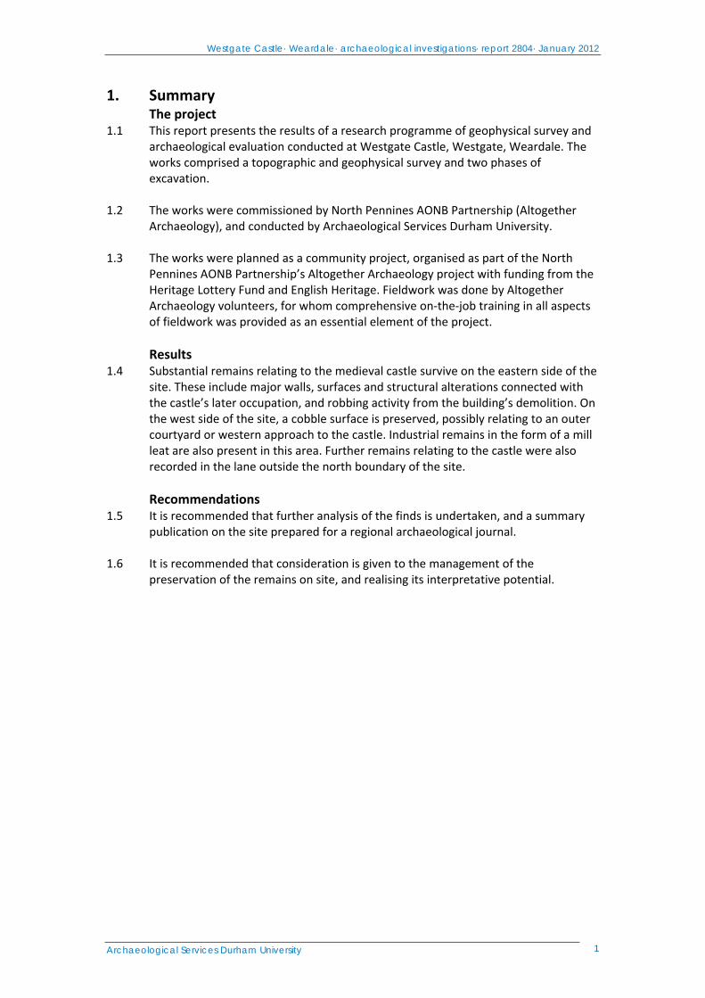
Results 1.4 Substantial remains relating to the medieval castle survive on the eastern side of the
site. These include major walls, surfaces and structural alterations connected with the castle’s later occupation, and robbing activity from the building’s demolition. On the west side of the site, a cobble surface is preserved, possibly relating to an outer courtyard or western approach to the castle. Industrial remains in the form of a mill leat are also present in this area. Further remains relating to the castle were also recorded in the lane outside the north boundary of the site.
Recommendations 1.5 It is recommended that further analysis of the finds is undertaken, and a summary
publication on the site prepared for a regional archaeological journal. 1.6 It is recommended that consideration is given to the management of the
preservation of the remains on site, and realising its interpretative potential.

Westgate Castle· Weardale· archaeological investigations· report 2804· January 2012
Archaeological Services Durham University 2
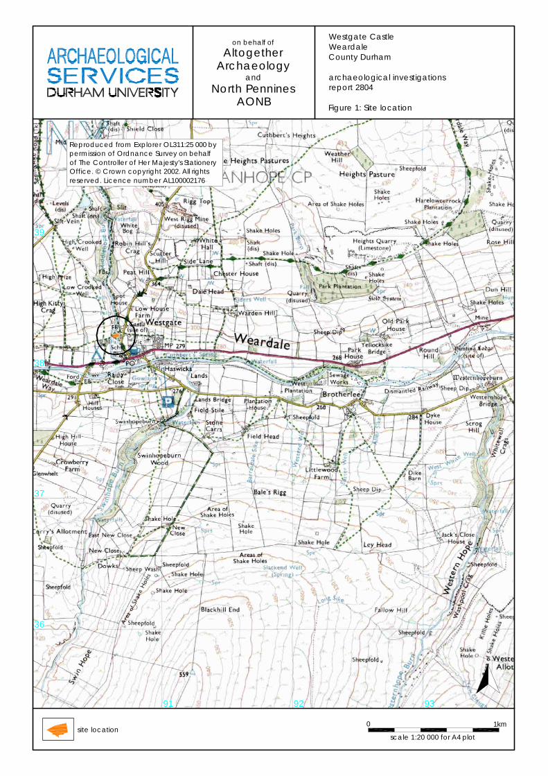
2. Project background Location (Figure 1) 2.1 The site is located at Westgate, Stanhope, County Durham (NGR centre: NY 906
382). It covers an area of approximately 0.11 ha. The site lies on the northwest side of Westgate village, with domestic housing to the north and south, and with an industrial unit on the eastern boundary. The watercourse of the Middlehope Burn lies to the west, and open agricultural land extends beyond the village on all sides. The A689 lies to the south. The site is a Scheduled Ancient Monument (reference number DU126).
Objective 2.2 The objective of the scheme of works was to assess the nature, extent and potential
significance of any archaeological resource within the investigation area, thus contributing to plans for the future management of the site.
Methods statement 2.3 The works have been undertaken in accordance with a Project Design provided by
North Pennines AONB Partnership Historic Environment Officer (Frodsham 2010). Due to the unexpected nature of the remains exposed, trench dimensions and locations were altered to meet the requirements of the site while work was in progress. In accordance with the Scheduled Monument Consent granted for the works, all such alterations were discussed and agreed in advance with English Heritage (Dr. Rob Young, North East Region Historic Environment Adviser ‐ Archaeology).
Dates 2.4 Fieldwork was undertaken between the 24th of March and the 19th June 2011. This
report was prepared for the 27th of January 2012.
Personnel 2.5 The surveys were conducted by Duncan Hale, assisted by Paul Frodsham. Excavation
fieldwork was conducted by a volunteer team, directed by Mark Randerson. This report was prepared by Mark Randerson, with illustrations by Dr Dave Webster and David Graham. Topographic data processing was by Janine Watson. Geophysical data processing and survey text preparation was by Duncan Hale. Specialist reporting was conducted by Duncan Hale (geophysics), Jennifer Jones (conservation and finds), and Dr Charlotte O’Brien (palaeoenvironmental). Sample processing was undertaken by Janet Beveridge. Project Managers were Peter Carne (Archaeological Services) and Paul Frodsham (North Pennines AONB Partnership).
Volunteers
2.6 The following volunteers participated in the fieldwork: June Abbott, Alastair Adams, Ali Alnajjar, Samantha Angel, Michelle Arthy, Sarah Bartram, Jessie Beham, Anne Bowyer, Phil Bowyer, Liz Bregazzi, Val Butcher, Denise Charlton, Pam Collins, John Cross, Hayleigh Deadman, Sam Ferguson, Claire Finn, Shirley Gale, Ray Gill, Colin Goodfellow, Kevin Grieve, Lucy Grieve, Michael Hall, Richard Hall, Scott Harder, Hils Hawkins, Katherine Home, Mark Household, Sophie Laidler, Maureen Ledger, Margaret Manchester, Barbara Metcalfe, Tony Metcalfe, Joyce Moxon, Brian Page, Anthony Pemberton, Christine Powell, Michael Powell, Elaine Reedman, Ian Reedman, Madelaine Remington, Amy Roberts, Kloe Rumsey, Ben Saunders, Norma Skeels, Lisa Snape‐Kennedy, Brian Stirk, Janet Stirk, Caroline
Westgate Castle· Weardale· archaeological investigations· report 2804· January 2012
Archaeological Services Durham University 3
Thompson, Lyn Walton, Carol White, Stuart White, John Whitfield, Rosemary Zakrzewski.
Archive/OASIS 2.7 The site code is WGC11, for Westgate Castle 2011. The archive is currently held by
Archaeological Services Durham University and will be transferred to Bowes Museum in due course. Archaeological Services Durham University is registered with the Online AccesS to the Index of archaeological investigationS project (OASIS). The OASIS ID number for this project is archaeol3‐118473.
Acknowledgements 2.8 Archaeological Services Durham University is grateful for the assistance of Ian and
Pam Forbes, who invited and supported excavation on their land and provided much useful background information about the site, and of Paul Frodsham (North Pennines AONB) and Rob Young (English Heritage) in facilitating the scheme of works. Thanks are also due to Peter Ryder, Martin Roberts and Linda Drury for visiting the project and offering their invaluable comments and suggestions. The Project Managers and Director would like to record their gratitude for the enthusiasm, commitment, expertise and humour of the Altogether Archaeology volunteers who collectively undertook a huge amount of strenuous fieldwork and who created and maintained an inspirational working environment – thanks to all.
Westgate Castle· Weardale· archaeological investigations· report 2804· January 2012
Archaeological Services Durham University 4
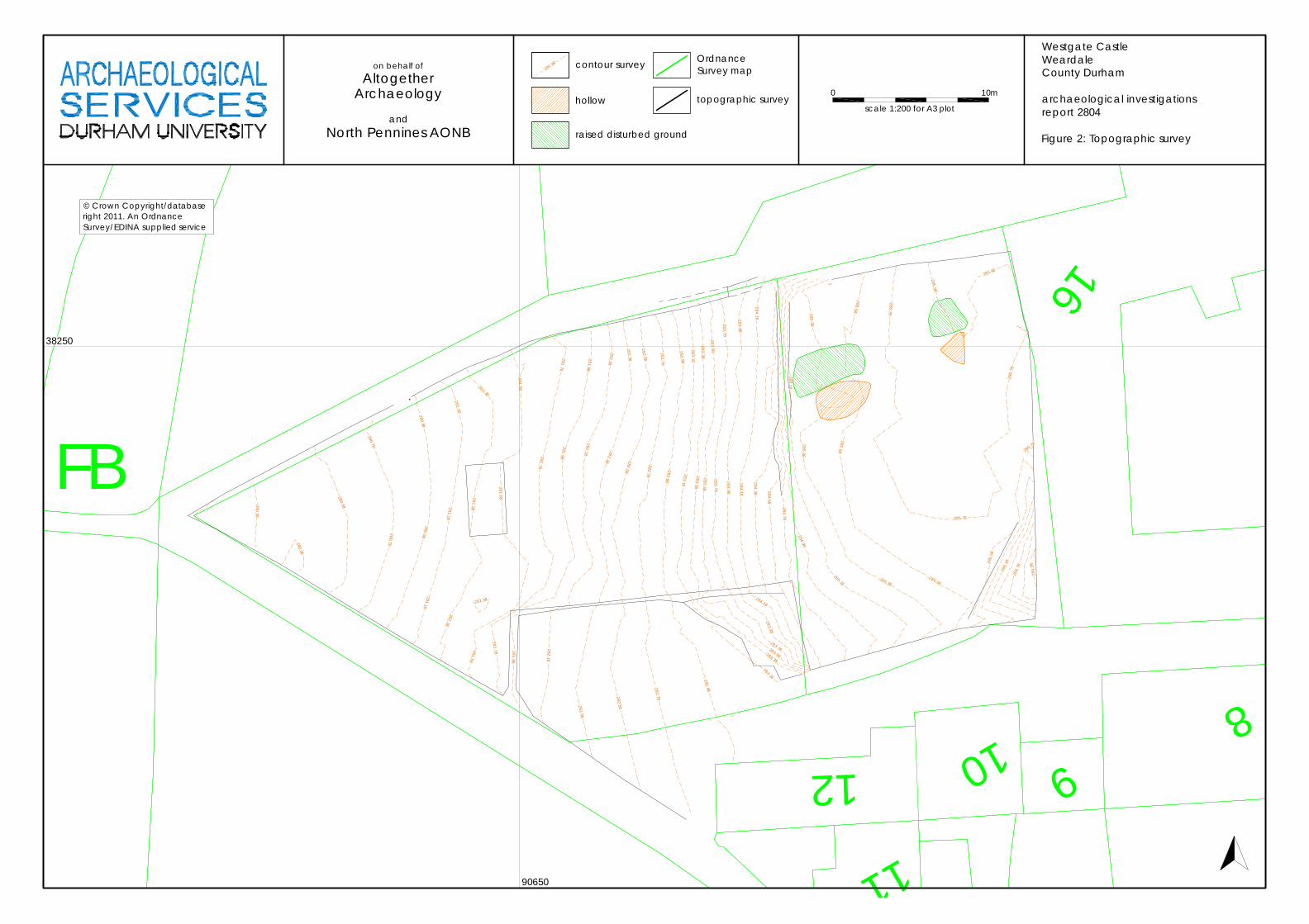
3. Landuse, topography and geology 3.1 At the time of the works, the investigated area comprised an irregular, open area of
overgrown rough ground, roughly triangular in plan, and formerly used as a paddock. It was bordered with stone walls to the north, west and south, and by the buildings of an abattoir to the east.
3.2 The survey area was a sloping piece of ground, rising generally to the east. The
western side of the site lay on a gentle slope, falling toward the Middlehope Burn to the west. The angle of this slope increased to the east, forming a steep bank, aligned roughly north‐south, which bisected the site. A partially‐ruined dry stone wall ran along the crest of this bank. East of this, the ground was more level, forming a rough, uneven plateau. The mean elevation of this higher ground was approximately 285m OD, with the site itself lying between 280‐286m OD. On the north side of the site, a narrow unpaved lane follows the line of the northern boundary.
3.3 The underlying solid geology of the area comprises Tournaisian and Viséan strata of
the Carboniferous Limestone Series, which are overlain by Boulder clay and Morainic drift.
4. Historical and archaeological background 4.1 The history of the castle and of the site has been examined previously, notably by J.
Linda Drury (1978a & b, 1987) and Margaret Manchester (2001). A brief assessment these works is given below.
4.2 In post‐Conquest England, hunting served an important role in maintaining and re‐
enforcing social order. The right to hunt large game, particularly deer, was a jealously‐guarded privilege, supported by a huge weight of law and withheld from the majority of the population (Almond 2003, 29‐38). Hunting was the preserve of the aristocracy, with the martial aspects of the hunt embodying civil authority (Marvin 2006, 50‐65). Equally, the ownership of hunting lands, governed by Forest Law, provided economic power and social domination (Drury 1978a, 88‐90).
4.3 The Bishopric of Durham held a unique position in England. The county formed a
secure bulwark south of the restive Scottish border, and military might was as important as religious power. Bishop Walcher was the first to claim the title of ‘Prince Bishop’ in the eleventh century, and his successors enlarged on this position, wielding considerable political influence. This meant that the Bishops took on the role of secular lords as well as spiritual leaders, demonstrating all the worldly displays of power associated with warriors and statesmen, including the hunt. A charter issued by Henry I in 1107 affirmed Bishop Flambard’s rights to the forests of Durham and Northumberland. A subsequent Royal charter of 1109 granted the Bishopric ownership and hunting rights for all forests between the Tees and Tyne. Splendid hunts in the See were described by the poet Lawrence of Durham in 1130, and the month‐long Great Chase, an elaborate expedition to the forests of upper Weardale, existed from the early years of the twelfth century (Drury 1978a, 90‐91).
4.4 The Great Chase was formalised by Bishop Puiset toward the end of the twelfth
century when he commissioned a comprehensive survey of the See, known as Boldon Book. The Book details all the customary dues of the tenantry to the Bishop from across the county. Frequent mention is made of duties owed in the forest, with
Westgate Castle· Weardale· archaeological investigations· report 2804· January 2012
Archaeological Services Durham University 5
farmers of the lower dale particularly responsible for providing manpower during the rutting and fawning seasons. Twenty‐seven other settlements, drawn from locations across the Bishopric, were obliged to provide service during the Great Chase. No settlements are listed to the west of Stanhope, and life in upper Weardale would have been dominated by the demands of the yearly hunt.
4.5 The details of Boldon Book also give an indication of the elaborate scale of the Great
Chase. Temporary timber buildings were provided for the expedition, constructed by the tenants of Stanhope and occupied by the Bishop and his retinue. These buildings consisted of a great hall measuring 60 feet by 12 feet, an adjacent chapel measuring 40 feet by 15, kennels, a buttery and butchery, a kitchen, and chambers. The halls were peripatetic structures, most probably built on established sites of small lodges scattered throughout the forest (Austin 1982, 11‐71). The medieval settlement of Cambo Keels, a few miles east of Westgate, has been suggested as the possible site of such a hall, although this interpretation has been disputed (Hildyard 1949, 188 – 190; Drury 1976, 140 & 149). These halls would have been occupied on a yearly basis, with a huge influx of manpower occurring each autumn in advance of the Bishop’s grand procession arriving from Durham.
4.6 The landscape of upper Weardale was radically reorganised in the latter half of the
thirteenth century. In roughly 1250 Stanhope Park was created. This was an empaled deer park of over seven square miles, covering the land between the Rookhope and Middlehope Burns. The park contained fallow deer, easier to manage than the previously‐hunted roe, but also requiring less skill and perseverance to pursue (Cummins 1988, 84). The reorganisation suggests that the upper reaches of the dale had become increasingly settled during this period, with both mining and agriculture taking an important role in the forest and limiting the dense, uninhabited woodland preferred by roe deer. The imparkation was followed by the construction of Westgate Castle on the western side of the park; although its actual purpose is not known for certain, it is thought to have fulfilled the same role as the earlier timber halls as a hunting lodge, perhaps alongside a wider role as the headquarters for local mining operations and general estate management. It was probably built around the year 1300, most probably by Bishop Antony Bek, an immensely influential man under whom the powers of the Prince Bishops reached their high‐water mark (Drury 1978a, 93). No references to the structure are known before 1300, but a grant of 1313 details land near to the west gate of Stanhope Park, implying that a western gateway was an established feature by this point.
4.7 Changes to both the economic and social climates signalled the end of the Bishops’
involvement in the Great Chase in the early fifteenth century. Deer were still greatly prized for the provision of winter meat, with three tuns of salt venison listed in the accounts of a banquet hosted by the Bishop of Durham in London in 1387. However, this economic aspect now dominated the hunt, excluding the element of social prestige. Vaccaries for cattle were increasingly established in upper Weardale, even inside the boundary of Stanhope Park (Drury 1976, 141), with lead mining and charcoal manufacture also occupying a greater role, increasing the population and altering the character of the area (Bowes 1990, 48‐53). The annual hunting party itself was discontinued by 1442, when Westgate castle was leased to Lord Thomas Lumley, Master Forester of Weardale, as a permanent residence. The castle was used as a residence for subsequent Masters and continued to form the focus of the
Westgate Castle· Weardale· archaeological investigations· report 2804· January 2012
Archaeological Services Durham University 6
upper dale, hosting the Forest Courts and functioning as the administrative centre for collecting rents and tolls, as well as an occasional prison (Drury 1987, 72‐77).
4.8 The tenancy and upkeep of the castle is comparatively well documented for the
post‐medieval period. A new roof of some 4000 stone slates was ordered for “…the gatehouse at Westgate…” in 1470, and further repairs were carried out in 1476‐79 (Drury 1978b, 31). The Master Forester ordered that the castle be made into a habitable house of nine rooms in 1493, with the work completed the next year. It is not known whether this labour involved creating new rooms inside the building or merely refitting the structure. However, a certain amount of renovation must have been necessary as the castle is known to have housed prisoners between 1492 and 1493. The antiquarian Leland, writing in 1546, described Westgate castle as “…a praty square Pile…”. In the context, this is taken to mean a Pele, the first description of the structure as such. The castle was described as being in a good state of repair on the death of Bishop Tunstall in 1559, when it was catalogued as comprising one great chamber and some lesser ones, a Hall, a buttery, a pantry, and sundry stables and outbuildings. It also contained two lead caldrons, a larger for brewing and a smaller for boiling meat (Drury 1978b, 31).
4.9 Bishop Pilkington had timber and metal removed from the castle between 1561 and
1576. Part of this took the form of a lead roof, indicating that it must have been previously changed from the slates described in 1470. Pilkington eventually replaced the roof with slates again, after considerable pressure, but no further repairs were undertaken. Finally, a case was heard between 1590 and 1591 in which Bishop Hutton sued executors for the damages caused by the previous two bishops. This case provides a very useful description of the castle. Witnesses described a ‘mansion’ 20 yards long and ten yards broad, with an attached gatehouse measuring five by three‐and‐a‐half yards. In addition to the roof, the two lead caldrons had also been stripped out. Beams, joists, and floorboards from a floor had been removed and used for fuel to melt the lead. Iron bars had been removed from 18 windows, and 20 wooden shutters and eight doors were in need of replacing. It is not known whether this total accounts for all the doorways and windows in the building (Drury 1978b, 32). The castle was listed as having an attached area of land, called The Parrock, in 1595 (Manchester 2001, 10).
4.10 Despite the court case, no repairs appear to have been carried out on the castle, and
the structure was described as having “…come to utter decay…” in 1596. Some makeshift repairs must have been undertaken as a Forest Court was held in the building in 1607, although it was considered uninhabitable for this purpose by 1618. Parliamentary Commissioners listed the castle as standing in “…Ruines and the bare walls only…” in 1647, and a survey of the Bishopric’s lands, conducted in 1662 after the restoration of the See, fails to list the structure at all. The masonry of the building was doubtless plundered for usable stone, and a Methodist preacher’s account of the area in 1791 describes “…the crumbling walls of an old castle at Westgate…” (Drury 1978b, 32‐33). An undated sketch plan of the High Town area of Westgate, thought to date from about 1800, depicts a rectangular structure, orientated north‐south, and labelled as ‘Castle’. This plan may have been produced in preparation for the construction of the new Barrington School, built immediately east of the castle site in 1819 using stone plundered from the castle ruins. The castle site is shown vacant in the First Edition Ordnance Survey of 1858 (Manchester 2001, 11‐12).
Westgate Castle· Weardale· archaeological investigations· report 2804· January 2012
Archaeological Services Durham University 7
4.11 There were at least two small‐scale excavations within the eastern part of site during the twentieth century. The first of these was by local resident Thomas Bostock in the early 1930s; local people recall that it revealed part of the castle’s west wall (Ian Forbes pers comm). A second dig in the 1980s exposed lime mortar and plaster (Manchester 2001, 14). No details or records of these works survive, although stone recovered from the earlier excavation is believed to have been reused in nearby buildings. Local convention also holds that the buildings of The Wapping, on land immediately north of the castle, originally formed part of the offices of the Master Forester and were associated with the castle. A small‐scale investigation, carried out on this site in 1981, recorded post‐medieval walls and recovered two sherds of medieval pottery (Cambridge, Drury, & Mills 1983, 62). The Wapping was demolished shortly after this work.
5. The surveys Methods statement 5.1 The topographic and geophysical surveys were undertaken in accordance with a
Project Design (Frodsham 2011) approved by English Heritage, and in accordance with national standards and guidance (below, 5.3 & 5.7).
5.2 Since the geophysical survey areas covered a Scheduled Monument they were
undertaken in accordance with a Section 42 licence granted by English Heritage under the Ancient Monuments and Areas Act 1979 (as amended by the National Heritage Act 1983).
Topographic survey Standards 5.3 The survey was undertaken in accordance with English Heritage ‘Level 3’ guidelines
(Ainsworth et al. 2007). Field methods 5.4 Data was collected using a Leica TCR307 total station survey instrument and one
survey station. Hard detail was recorded, such as walls and fences, as well as the tops and bottoms of earthworks. A regular grid of spot heights was also collected at 2‐3m intervals.
Data processing 5.5 Data was downloaded and initially processed using n4ce mapping software. Data
were then exported to AutoCAD for incorporation with the basemap and other project drawings. All levels have been reduced from a temporary benchmark, whose elevation was established using a Leica GS15 global navigation satellite system (GNSS) with real‐time kinematic (RTK) corrections typically providing sub‐10mm accuracy.
Results 5.6 A topographic survey plan is provided in Figure 2. This shows contours at 0.2m
intervals.
Westgate Castle· Weardale· archaeological investigations· report 2804· January 2012
Archaeological Services Durham University 8
Geophysical survey Standards 5.7 The surveys and reporting were conducted in accordance with English Heritage
guidelines, Geophysical survey in archaeological field evaluation (David, Linford & Linford 2008); the Institute for Archaeologists (IfA) Standard and Guidance for archaeological geophysical survey (2011); the IfA Technical Paper No.6, The use of geophysical techniques in archaeological evaluations (Gaffney, Gater & Ovenden 2002); and the Archaeology Data Service Guide to Good Practice: Geophysical Data in Archaeology (Schmidt & Ernenwein 2011).
Technique selection 5.8 Geophysical survey enables the relatively rapid and non‐invasive identification of
sub‐surface features of potential archaeological significance and can involve a suite of complementary techniques such as magnetometry, earth electrical resistance, ground‐penetrating radar, electromagnetic survey and topsoil magnetic susceptibility survey. Some techniques are more suitable than others in particular situations, depending on site‐specific factors including the nature of likely targets; depth of likely targets; ground conditions; proximity of buildings, fences or services and the local geology and drift.
5.9 In this instance, given the adjacent buildings and the presence of old ironwork on
site, which would have had an adverse impact on any geomagnetic technique, an electrical resistance technique was considered appropriate.
5.10 Earth electrical resistance survey can be particularly useful for mapping stone and
brick features. When a small electrical current is injected through the earth it encounters resistance which can be measured. Since resistance is linked to moisture content and porosity, stone and brick features will give relatively high resistance values while soil‐filled features, which retain more moisture, will provide relatively low resistance values.
Field methods 5.11 A 20m grid was established across each survey area and tied‐in to known, mapped
Ordnance Survey points using a total station survey instrument. Hard features such as the boundary wall were subsequently surveyed with a Leica GS15 global navigation satellite system (GNSS) with real‐time kinematic (RTK) corrections typically providing sub‐10mm accuracy.
5.12 Measurements of electrical resistance were determined using a Geoscan RM15D
Advanced resistance meter with a mobile twin probe separation of 0.5m. A zig‐zag traverse scheme was employed and data were logged in 20m grid units. The instrument sensitivity was set to 0.1ohm. The sample and traverse intervals were set to 1m thus providing 400 sample measurements per 20m grid unit.
5.13 Data were downloaded on site into a laptop computer for initial processing and
storage and subsequently transferred to a desktop computer for processing, interpretation and archiving.
Data processing 5.14 Geoplot v.3 software was used to visualise the geophysical data and to produce
continuous tone greyscale images of the raw data. In this instance, the data have
Westgate Castle· Weardale· archaeological investigations· report 2804· January 2012
Archaeological Services Durham University 9
required no processing at all; they are presented as collected and downloaded from the survey instrument. The greyscale images and interpretations are presented in Figure 3. In the greyscale images, high resistance anomalies are displayed as dark grey and low resistance anomalies are displayed as light grey. Palette bars relate the greyscale intensities to anomaly values in ohm. The datasets are so small, and the anomalous values so clear, that trace plots are not presented in this report.
Interpretation: anomaly types 5.15 A colour‐coded geophysical interpretation plan is provided. Two types of resistance
anomaly have been distinguished in the data:
high resistance regions of anomalously high resistance, which may reflect foundations, tracks, paths and other concentrations of stone or brick rubble
low resistance regions of anomalously low resistance, which may be
associated with soil‐filled features such as pits and ditches Interpretation: features 5.16 A colour‐coded archaeological interpretation plan is provided. 5.17 The mean resistance value for each survey area is very high, almost certainly
reflecting a concentration of stone and rubble materials across much of the site, however, there is sufficient variation in the data to provide anomalies. In Area 1 there is a well‐defined, rectilinear, high resistance anomaly, which indicates the likely presence of stone or brick. In this instance, given the anticipated remains of a castle, the anomalies were interpreted as probable wall‐footings for at least part of a building.
5.18 A relatively low resistance anomaly in the north‐east of Area 1 corresponds to a
small depression in the ground, recorded by the topographic survey. 5.19 A narrow high resistance anomaly aligned broadly north‐south in the east of Area 2
may reflect another wall‐footing or a revetment across the slope. 5.20 Much of the central part of Area 2 is dominated by very high resistance values. A lot
of stone blocks and rubble were noted on the ground here during survey, around a derelict small stone shed; this spread of material prevented data collection in some places. The high resistance anomalies reflect the stone and rubble in the ground here.
5.21 A narrow band of relatively low resistance aligned broadly north‐south on the east
side of the shed could reflect a soil‐filled gulley or channel; this could be a former mill leat.
5.22 A small survey (Area 3) over the lawn of the adjacent house indicated higher
resistance values towards the north, which could indicate a greater quantity of stone or rubble there.

Westgate Castle· Weardale· archaeological investigations· report 2804· January 2012
Archaeological Services Durham University 10
Conclusions 5.23 Resistance survey detected the possible remains of stone footings, areas of rubble
and a possible mill leat.
6. The evaluation trenches Introduction 6.1 Three evaluation trenches were excavated, located to investigate features identified
by the geophysical survey. Trench 1 was positioned across the centre of the raised plateau on the east side of the site, where the survey suggested the north wall of the castle might be located. This trench was originally rectangular, orientated east‐west, although it was extended into an irregular plan to fully record the remains exposed. Trench 2 was orientated east‐west, and was placed on the north side of the west part of the site in order to investigate the varied geophysical readings from this area. Trench 3 was positioned in the presumed area of the south wall of the castle. This trench was moved from the west to the east side of the structure due to problems with access. A further, additional recording exercise was also undertaken on remains found in the pathway outside the north border of the site.
Trench 1 (Figures 6 and 7) 6.2 As noted above, excavations in Trench 1 were targeted on remains as they were
identified. Two substantial stone walls were revealed at the west and east sides of the trench, with the trench extended westwards to fully expose the masonry. Both of these walls were orientated north‐south, and clearly formed the main walls of the castle structure. They were both similarly constructed, with outer fair faces set in rough coursing, and with substantial cores of uncoursed mixed rubble and mortar. Both walls had been significantly robbed, with the outer faces surviving only at the base of the masonry. These faces were made of stone blocks, smoothed and roughly dressed, with squared profiles and outer faces. The blocks varied in size, but principally lay between 0.2m and 0.6m in diameter. The rubble cores were set in a very compact light grey lime mortar, which contained very frequent inclusions of small rounded gravel and pea grit. Moderate inclusions of small, angular fragments of Fluorspar were also encountered, suggesting that mining waste was used as the aggregate when mixing the mortar. Localised changes in the compaction and composition of the mortar were encountered along the walls, demonstrating where separate batches had been mixed and used.
6.3 On the east side of the trench, two separate sections of this main wall were
exposed. Wall [F15: 5.75m x 2.25m] extended from the north side of the trench (Figure 10) with wall [F14] continuing the line of the building to the south. The south end of [F15] had been heavily robbed for dressed stone, with only the rubble core remaining of the upper part of the wall. To the north, the outer faces were better preserved. At the north end of the wall, the remains of a window [F65] were also exposed. This was clearly marked by dressed faces of stone extending through the thickness of the wall, with a shallow internal `step’ visible on the base. This feature formed an internally‐splayed embrasure, 1.2m wide at the west and narrowing to the east in `arrowslit’ form (Figure 11). No remains of leading, glass, or iron window bars were observed, although the outer (eastern) end of the embrasure had been completely robbed. At the east side of the window, a worked stone block was visible extending from the base of the wall. This block was chamfered, with a sloping upper face, forming a `plinth’ above which the wall narrowed (Figure 12).
Westgate Castle· Weardale· archaeological investigations· report 2804· January 2012
Archaeological Services Durham University 11
6.4 A narrower wall extended eastward from the south end of [F15], orientated east‐west. This wall [F29: 2.6m x 1.55m] was of identical construction, with dressed and smoothed outer faces containing a rubble‐and‐mortar core, and again with the upper facing stones removed. This wall was clearly built at the same time as the main castle wall, and was part of the same phase of the structure. However, it also clearly formed a separate part of the building: this was most probably a tower which projected from the east face of the body of the castle (Ryder 2011, pers. com.). Wall [F29] would have formed the north side of this tower. At the east end of the wall, two further dressed blocks were exposed at the base of the structure. These blocks were again chamfered on their upper faces, with the wall narrowing above them. The easternmost block was set 0.5m higher than the western one, with a gap of 0.6m between the two stones as exposed. The eastern block was also chamfered on the west end (Figure 13). This suggests that the blocks originally formed a continuous string course at the base of the external wall of the castle, and that this course rose to the east to mirror the rising slope of the natural ground level. This continuous course was destroyed by later truncation (below, 6.15.).
6.5 At the west end of [F29], the dressed blocks of the southern face of the wall were
exposed. These were keyed in to the east‐facing southern end of main wall [F15]. The remains of a layer of mortar render were visible on the stonework (Figure 14). To the west, Wall [F15] extended to the south. There was no indication of the chamfered string course on this section of masonry, although the base of the wall did widen, with the lowest course extending by 0.1m. Both these elements further suggest that the area south of wall [F29] was internal. Wall [F15] came to a dressed, square end to the south. The continuation of the main castle wall [F14: 0.4m long, 2.2m wide] extended from the south side of the trench. This section of wall had been very heavily robbed, with only the base course of shaped, dressed blocks remaining. The break between these two walls formed an east‐facing doorway [F90], 1.4m wide.
6.6 Although the frame of the door had been completely removed from the southeast
corner of [F15], the base of it remained at the east side of [F14]. A stepped block formed the jamb, with the door itself presumably set slightly to the west of the east side of the wall. The remains of cast lead were attached to the upper surface of this block, potentially indicating where an iron hinge pin had been set in the masonry. The outer face of the frame was decorated with a lark’s‐tongue chamfer along the northeast edge of the block. At the base of the block, horizontal marks were scored into the dressed face, possibly showing the position of a robbed flagstone floor (Figure 15). Although the equivalent blocks were missing from the frame of wall [F15], a horizontal, north‐south aligned slot was exposed in the south face of the wall. This rebate [93: 0.25m square, 1.9m long] was clearly intended to house a draw bar, designed to run along the rear of the door frame (Figure 16).
6.7 At the west side of the trench, a shorter section of the main west wall was exposed
[F66: 1.4m x 2.2m]. This lay underneath the ruined wall which marked the crest of the bank of rising ground, with the ground level dropping away sharply to the west. This wall was again built with fair faces enclosing a rubble core, and had not only been heavily robbed but also significantly damaged by root action from the trees which grow along the line of the ruined wall. The north face of another internally‐spayed window [F55] was exposed on the top of the wall. This was very poorly preserved, with only the `scar’ of the edge of the masonry remaining and none of
Westgate Castle· Weardale· archaeological investigations· report 2804· January 2012
Archaeological Services Durham University 12
the upstanding face of the embrasure (Figure 17). However, it was evident that this window would have stood in the centre of wall [F66], opposite doorway [F90]. Below the window, a few traces of possible mortar rendering were again seen on the east‐facing side of the wall.
6.8 On the west side of [F66], three chamfered blocks extended along the wall, forming
a `plinth’ string course comparable to the remains observed on the external faces of walls [F15] and [F29] to the east. This course [41: 0.28m wide] again served to widen the wall, with [F66] extended 0.12m to the west beneath it. The west face of the wall was exposed to a height of 1.55m. On the north side of the excavated face, a square hole in the masonry was exposed directly underneath string course [41]. This hole [F42] was roughly 0.3m in diameter, capped with one on the shaped blocks of [41] as a lintel but with no other framing evident (Figure 18). It extended horizontally eastward into the thickness of the wall for roughly 0.5m before angling sharply upward: tracing the exact course of the feature was made difficult by the presence of roots growing along the gap it formed in the masonry. This hole was most probably the exit chute of a garderobe, running from the first floor of the building and discharging onto the low ground to the west. The base of the feature was filled with a deposit of dark greyish‐brown sandy silt [37].
6.9 On the east side of the trench, more masonry remains projected northwards from
wall [F29]. This was a wall base [F68: 1.4m x 0.85m], again constructed of dressed outer faces containing a fill of rubble and mortar, which lay to the north of the blocks of the chamfered string course. Although the west side was lost to later truncation, fair faces survived on the north and east sides of the footing, suggesting that it originally formed a sub‐square block. The south end of the stonework overlay the chamfered course at the base of [F29], and the stones were not keyed in to the main wall. This shows that the footing was built after the foundations of the main structure (Figure 19). [F68] may not have been built significantly later that the body of the castle, however, as it most probably formed an external staircase providing access to the living quarters on the first floor of the building. This may have been a hollow structure, with a space for a kennel underneath the stair (Ryder 2011, pers. comm.). To the north and east of the wall footing, two layers of mid brown sandy silt [33] and [34] were exposed, extending across the northeast part of the trench. These layers appeared undisturbed, and were probably associated with the occupation and use of the castle.
6.10 On the western side of the trench, an internal wall was revealed. This wall [F67:
3.2m long, 0.5m wide, 0.75m high] was linear, and extended roughly east‐west across the building from the inner face of wall [F66]. It was again constructed of a rubble‐and‐mortar core contained by two fair faces of smoothed and roughly dressed blocks. However, this wall was clearly a later addition, with the stonework at the west end not keyed into the main structure of the castle (Figure 20). A dense, heavily‐compacted layer of dark brown sandy silt [92], containing frequent inclusions of crushed mortar and angular gravel, lay at the foot of the wall. This deposit had been compressed and formed a surface. However, it appeared to abut wall [F67], post‐dating this alteration to the structure. It is probable that deposit [92] was intended to form a packed earth surface, although it may have originally been a bedding layer for a robbed flagstone floor. To the east of doorway [F90], another, similar surface of very dark brown, moderately compact sandy silt lay against walls
Westgate Castle· Weardale· archaeological investigations· report 2804· January 2012
Archaeological Services Durham University 13
[F14] and [F15]. Again, this was not an original floor layer, contemporary with the building of the castle, but a later deposit.
6.11 The east end of wall [F67] terminated in a sub‐square post hole [60: 0.28m in
diameter]. The wall ended in a flat face against the west edge of this feature, and so the upstanding post must have been integral to it. Another post hole [57: 0.26m in diameter] was located directly to the east, hard against the west face of wall [F15]. Deposits of mortar and plaster, ash, and coal were recovered from the fills of both post holes (see 8.2, below), and the posts made a doorway roughly 0.8m wide. This, like wall [F67], must have been related to the later use and re‐modelling of the castle’s interior. An irregular paved surface of stone slabs [63] lay to the south of this doorway, extending to the southeast where it also filled doorway [F90]. Several of these stone slabs were set square to the two post holes, or even served as post‐packing, indicating that the surface must have been laid down after the construction of the doorframe and internal wall.
6.12 The slabs used for the paving were not dressed or laid with any pattern: they were
set to a straight face along the east face of the line of walls [F14] and [F15] but then extended in an uneven spread, becoming thinner and less closely‐packed to the west. In the centre of doorway [F90], an east‐west orientated line of semi‐dressed slabs [91: 2.4m x 0.58m] were set higher than the surrounding surface. These stones were clearly a deliberate feature (Figure 21). They may have formed a drain or channel, letting moisture soak downslope from the higher ground to the east and preventing dampness building up in the doorway. Surface [63] itself sloped gently downwards to the west, and the stone slabs appeared to have been laid on a slight gradient. It is possible that this surface was constructed to ease access over a step or ledge on the east side of the castle, potentially after a floor surface of dressed, set flagstones had been robbed.
6.13 To the west of the west face of wall [F66], a deposit of dark grey‐brown sandy silt
was exposed [56]. On the north side of the trench, this layer was truncated by a sub‐circular pit [47: 0.5m x 0.8m, 0.27m deep] which lay underneath the probable garderobe exit chute. Only the south side of this pit was exposed, with moderately‐sloping sides falling to a rounded, smooth base. No separate fill was recorded: rather, the feature appeared to be filled by the overlying deposit of mottled mid brown and mid orangey‐brown sandy silt [38]. It therefore may not have been a pit, but the edge of an area of sloping ground, draining waste from the exit chute above. To the south, three possible stake holes were observed. These stake holes [40], [44], and [46] were all narrow, and were not set in any coherent pattern. It is possible that they were the result of root disturbance, which was very heavy in this area of the site. They were also sealed by layer [38].
6.14 Thick, laminated layers of demolition rubble lay across the majority of the trench,
extending from wall [F66] to walls [F15] = [F29]. These overlay all the earlier deposits, and were composed of varied layers of angular stone rubble and decayed lime mortar. This deposit [25] was clearly derived from the destruction of the castle, when the usable, dressed stone had been removed from the upstanding walls and the rubble core had been discarded. To the east of wall [F15], an area of collapse was observed, with faced stones still bonded by lime mortar contained in the rubble dump. Overlying this main deposit were thinner, more sorted layers of rubble [16], [17], [18], and [19]. These contained very similar material, with a particular
Westgate Castle· Weardale· archaeological investigations· report 2804· January 2012
Archaeological Services Durham University 14
concentration of medium angular stones and decayed mortar. These layers probably date to later robbing or reworking of the demolished building, after the main demolition and when the area obviously became an effective `quarry’ for usable stone. A further deposit of very well‐sorted sub‐angular stone fragments, [13], was recorded overlying the area of doorway [F90]. It is possible that this relates to an attempt to re‐excavate the site, or further rob the dressed stone of the door, although any such activity did not reach the depth of the masonry below.
6.15 In the northeast corner of the trench, the outline of a substantial robber pit [F26:
3.25m x 2.6m, 1.4m deep] was exposed. This was filled with a deposit of moderately compact mid brown sandy silt [27] which contained frequent inclusions of rounded stone and decayed mortar, in addition to fragments of several broken clay pipes. Pit [F26] had steeply‐sloping sides and a flat, uneven base, with traces of a stepped edge visible on the north side. The pit was clearly dug to remove building stone from the buried remains of the castle. The east face of [F15] and north face of [F29] were both comprehensively robbed, as was the west side of wall [68], with every stone course removed, including the stepped plinth. It is almost certain that this robbing was connected with the building of the Barrington School to the east. Further to the west, another pit was exposed. This was a far smaller excavation [F28: 0.85m in diameter], and would have only exposed demolition rubble in the centre of the building. A 1939 coin recovered from the fill of this pit suggests it may originally have been dug at the same time as the ‘early 1930s’ investigations mentioned in 4.11, above.
6.16 A deposit of mid grey‐brown subsoil [36] sealed the main area of the trench, and
was in turn overlain by a dark grey‐black topsoil [1]. On the west side of wall [F66], another topsoil layer [12] was exposed. This was cut by a shallow, irregular pit [50] which contained an animal burial of modern date. This was in turn overlain by a deposit of large, angular stone which had clearly fallen downslope from the ruined wall which crowned the north‐south bank.
Trench 2 (Figure 8) 6.17 As with Trench 1, excavations in Trench 2 were targeted after removal of the topsoil.
The majority of work focused on a sondage in the centre of the trench. Here, and irregular, uneven cobble surface [F24] was exposed (Figure 22). This layer was composed of medium to large cobbles, well rounded to sub‐angular in shape. The cobbles were poorly sorted, but were tightly packed into a slightly greyish‐brown deposit of sandy silt. The layer was sloping, with the surface rising gradually upwards to the south and east. The cobbles were packed the densest at this side of the deposit: to the north and west the layer became thinner and less well preserved, with frequent gaps and with the stones less densely packed. On the east side of the layer, a rounded posthole [77: 0.1m in diameter, 0.08m deep] cut through the surface. This was filled with a deposit of mid greyish‐brown silty sand [76]. Further east two similar sub‐rounded features were exposed [79, 81], cutting through the cobble surface. These were possibly postholes, although the features were not definite and may have merely been the result of erosion leaving gaps in the cobble layer (Figure 23).
6.18 The cobble surface was sealed by a deposit of mid greyish‐brown silty sand, which
extended across the western end of Trench 2. This layer [23] varied in thickness, becoming shallower to the east but lying 0.5m deep in the centre of the trench. It
Westgate Castle· Weardale· archaeological investigations· report 2804· January 2012
Archaeological Services Durham University 15
contained occasional small, rounded gravel but frequent irregular lenses of grey‐brown silt, suggesting that it may have been formed partly by water action. This might have been the result of flooding from the Middlehope Burn to the west of the site, or may have been due to waterlogging of the area. To the east, layer [23] was covered by a homogenous, dark greyish‐brown deposit of sandy silt [3: 0.6m thick]. This had the look of an imported soil, used to build up the area, with the layer thickening significantly to the east and appearing to form the main body of the steeply‐rising bank which divided the site. Due to the depth of the deposit, only the west end of the layer was excavated (Figure 22).
6.19 Toward the centre of the trench, cobble surface [F24] was cut through by the
remains of a leat, associated with a former mill. The channel of the leat was orientated north‐south, with moderately sloping sides and a flat, smooth base [F75: 1.7m wide, 0.55m deep]. No evidence of a waterproof lining or stone trough was exposed, suggesting that the leat had been robbed after it went out of use. The feature was filled by a varied series of deposits ([71] – [74]), all of which appeared to have been laid in from the west side, indicating that the channel was deliberately backfilled (Figure 24). The southeast edge of the channel was truncated by a sub‐rectangular cut [F70: 0.45m x 0.3m, 0.2m deep]. This was backfilled by a mixed dark brown sandy silt [69] which contained a dog burial of modern date.
6.20 The remains of an extension to the ruined shed to the south of the trench were also
exposed. On the west side of this structure, a circular construction cut [F10: 0.84m diameter, 0.18m deep] was excavated. This contained the decayed remains of an iron‐bound wooden barrel [9], obviously used as a water butt. This was partially overlain by the base of a stone wall [5: 1.6m long, 0.3m wide], which was set on a bedding layer of irregular mixed rubble [6: 1.5m x 2.5m] that served as a base for the whole structure. To the east, the remains of a parallel wall [F4: 1.08m long, 0.3m wide] were also set on this bedding layer. Both wall footings were orientated north‐northeast to south‐southwest, continuing the alignment of the ruined shed. The footings were one course deep only, and were constructed out of irregular and clearly re‐used stone with no bonding material or mortar visible. The structure was overlain by the remains of a cast concrete floor [7] (Figure 25). The whole of Trench 2 was sealed by a layer of topsoil and turf [2: 0.4m thick], which contained frequent stone rubble in the area of the demolished shed.
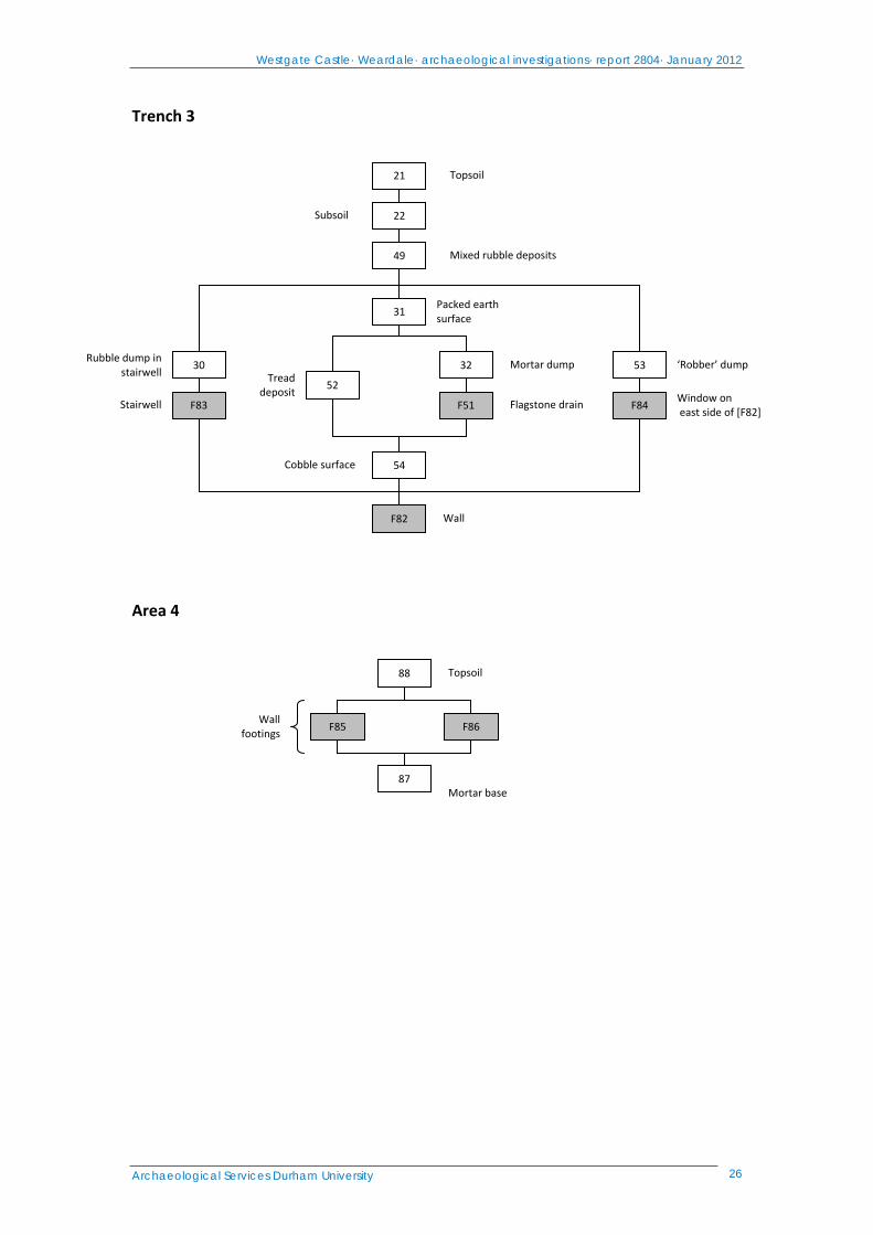
Trench 3 (Figure 9) 6.21 Trench 3, positioned south of Trench 1 in the southeast corner of the site, also
exposed part of the main castle wall. This wall [F82: 5.35m x 3.4m, 2.2m in width] was constructed in exactly the same manner as the main walls exposed in Trench 1, with dressed outer faces containing an uncoursed rubble and mortar core. The wall clearly formed a southward continuation to wall [F14]. It was right‐angled in plan, turning to the west at the southern extent, and formed the southeast corner of the castle (Figure 26). The wall had again been partially demolished and heavily robbed, with the outer dressed and faced stones removed, particularly from the north end and the external southeast corner. The outlines of robber pits were also visible on the exterior of the east part of [F82]. Toward the north end of the wall, the remains of a window [F84] were visible. The north side of this had been completely robbed, leaving a `scar’ line visible in the remaining masonry. The southern side was better preserved, with dressed stone surviving in the centre of the wall to a height of
Westgate Castle· Weardale· archaeological investigations· report 2804· January 2012
Archaeological Services Durham University 16
0.44m (Figure 27). This window was of a similar, internally‐splayed `arrowslit’ type to those seen in Trench 1.
6.22 To the south of this window embrasure stood the remains of a spiral staircase. This
stairwell [F83: 2.3m x 1.4m] was built into the thickness of the wall, occupying the internal southeast corner of the structure. The stairwell was sub‐oval in plan, with the staircase rising in a clockwise spiral from the north, extending from a doorway in the south end of the internal east face of wall [F82]. The posts and jambs of this door had been clearly robbed, leaving obvious scars in the surviving masonry (Figure 28). The bottom step of the staircase, facing the door, was broken. This had presumably been partially robbed, or perhaps smashed during demolition of the castle. Seven stone steps remained in the stairwell, creating a surviving arc of 180°. The upper extent of the staircase had been demolished with the main wall of the building, and so the return of the stair was absent: it would presumably have lead to another door on the internal first‐floor face. Roughly at the centre of the eastern side of the stairwell there was a small recess in the masonry, made of smoothed, unmortared stones. This was clearly a deliberate feature, used to light the stairwell. It possibly formed a shallow candle niche, or may have been part of a narrow light projecting to the outside wall. This part of the east side of [F82] was too badly decayed to allow a positive identification.
6.23 The limited size of the trench prevented much excavation of the external faces of
wall [F82]. However, excavation was possible in the internal angle, on the northwest side of the trench. Here, a densely‐packed layer of sub‐rounded cobbles and dark silty clay [54] was exposed. This formed a rough surface, very similar to that made by [64] to the north. In the centre of the area, a line of east‐west orientated, flat‐set irregular flagstones was uncovered. This feature [F51: 1.1m x 0.38m] was set into a slight depression in surface [54], packed with smaller cobbles, and presumably acted as a form of channel or French drain, again similar to [91] to the north (Figure 29). However, [F51] appeared to be an integral part of surface [54], rather than a later addition, and was presumably created while the cobbles were being laid down. To the south, a dense layer of dark brown ash and silt [52] overlay the cobbles next to the doorway of [F83]. This did not appear to be a deliberate surface, but was more likely a `tread’ deposit, formed by traffic on the stairway. A dump deposit of mortar lay over the cobble surface and drain [F51], and the whole area was sealed by a layer of densely‐packed dank grey‐brown sandy silt and gravel [31: 3.3m x 1.1m, 0.35m thick]. It seems unlikely that deposits [51], [F52], and [54] were ever intended to form an intentional floor for the building. They all lay roughly 0.15m below the level of the bottom sill of stairwell [F83], and a similar depth below a stepped course of stone at the base of the internal south face of wall [F82] (Figure 29). This suggests that cobble surface [54], with its associated drain, was originally a bedding layer, overlain by a flagstone floor which was subsequently robbed. Deposit [31] may have formed during the gradual demolition of the castle.
6.24 Thick, laminated deposits of demolition rubble overlaid most of Trench 3. A dump of
roofing slates, containing both whole and partial tiles, was exposed during the excavation of stairwell [F83]. This deposit [30] has obviously been thrown or dropped down the stairwell (Figure 30) during demolition, attesting to the gradual, piecemeal destruction of the building. To the north, a discrete dump of dark brownish‐grey silty sand was uncovered on the north side of window [F84]. This deposit [53: 1.6m x 1.1m, 0.7m thick] must have been connected with the removal
Westgate Castle· Weardale· archaeological investigations· report 2804· January 2012
Archaeological Services Durham University 17
of the dressed stone from the window embrasure, either during the final stages of the demolition or by the digging of a robber pit. As noted above, the outlines of other robber pits were evident on the east side of wall [F82]. However, the homogenous, undifferentiated nature of the overlying demolition deposits meant that it was not possible to identify any of these pits as individual features during excavation. This main demolition dump [49: 1.7m thick] was principally composed of varied layers of angular stone rubble and decayed lime mortar, again similar to those exposed in Trench 1. An uneven layer of dark brown silty subsoil [22: 0.6m thick] lay over the south side of the trench, mainly to the south of wall [F82], and the area was sealed by a deposit of dark grey‐brown sandy silt topsoil [21]. On the south side of [F82], this topsoil layer was very thin, lying only 0.1m thick above the remains of the masonry, and the continuation of the wall could be seen as a slight ridge in the ground extending for roughly 3m to the west of the trench.
Additional investigations: Area 4 (Figure 9) 6.25 On the north side of the site, outside the excavation area, masonry remains were
observed on the south side of the lane which formed the north boundary. These remains were located on a steeply‐sloping bank, where the ground level rapidly rises to the castle plateau to the south. The remains were cleaned and recorded, although work was limited by the adjacent public path and no excavation was undertaken. Interpretation is difficult, although the features encountered do suggest that elements of the castle complex survive outside the area of the Scheduled Ancient Monument.
6.26 Elements of two masonry walls were recorded, set onto a rubble and mortar base
(Figure 31). This base [87] was comprised of medium sub‐rounded stone and dense, heavily‐compacted mortar, possibly intended to form a building platform. On the west side, the remains of a substantial north‐south orientated wall [F85, 1.3m x 1.45, 0.8m high] were exposed (Figure 32). This had a fair dressed face to the west, with six courses of stonework exposed. The west side of the wall was capped with a heavily‐eroded chamfered `plinth’ stone, identical in form to those found in Trench 1 to the south, and set at the same level as the similar plinth course [41] on the west side of [F66] (Figure 18). On the east side, the wall appeared to narrow. The dressed face of the masonry here was aligned roughly northwest‐southeast as it extended northward from the bank, with an angled block marking the return to a parallel‐sided wall 1.1m wide. This face of wall [F85] was poorly preserved, with only two courses of stone surviving at the greatest extent.
6.27 To the east, the base of a narrower wall was observed. This feature [F86: 0.9m x
0.75m, 0.4m high] was recorded mainly from the surviving west face: the east side of the masonry was fragmentary, and heavily disturbed by root activity. The face as exposed was aligned roughly north‐northwest – south‐southeast, with three courses of stone set in a fair face. At the north end of the wall, the remains of a broken, shaped block were recorded (Figure 33). This appeared to form part of a socket, with southern half of a well‐worn cylinder evident in the stone. The orientation of both walls would indicate that they originally intersected, north of the recorded area. It seems probable that they were constructed at the same time, as both were set onto deposit [87], which also formed a worn surface between them. Each wall was again comprised of an uncoursed rubble‐and‐mortar core with dressed, smoothed faces, matching the construction observed to the south. The west face of [F86] clearly formed a continuation of the west wall of the castle [F66]. However, the narrowing
Westgate Castle· Weardale· archaeological investigations· report 2804· January 2012
Archaeological Services Durham University 18
nature of the masonry suggests that it lay outside the main building, and this wall probably marked the course of the deer park pale. The other remains potentially formed a separate gatehouse (Ryder, pers. comm.), set on an access track to the park which ran on the north side of the castle. The whole area was sealed by a thick deposit of dark grey‐brow sandy silt topsoil [88].
7. The finds Finds statement
7.1 The site produced a large quantity of finds, dominated by pottery (c.2700 sherds) and animal bone (>1500 fragments). Significant quantities of glass (c.360 fragments), clay tobacco pipe (197 pieces) and metal (150 artefact fragments) were also recovered. Other categories of material include stone roof tile, mortar, plaster, geology and industrial residues.
Pottery
7.2 Of the c.2700 sherds, it is estimated that <100 pre‐date the post‐medieval period. The majority of the post‐medieval sherds are very small (<15mm length), and the preponderance of such small pieces in the assemblage suggests that they may have been deliberately crushed for unspecified use. Assessment would focus on the dating and identification of the early sherd group and produce an accurate quantification of the later material.
Animal bone 7.3 The origin of the animal bone assemblage is not known; it is probably too early to
relate to the adjacent abattoir. Though of comparatively recent date, assessment of this assemblage could provide measurable evidence of differences between more modern livestock and earlier animal bone recovered from the area. Assessment could also focus on the remains of at least one horse or donkey buried in the rubble infill of a possible robber pit, and on a calf burial of unknown date found in a garderobe exit deposit on the west wall.
Glass 7.4 Most of the c.360 glass fragments appear to be post‐medieval in date. Assessment
would look at the range of vessel types and dating, and would focus on any examples which pre‐date the post‐medieval period.
Tobacco pipe 7.5 Assessment of the clay pipe assemblage would look at forms and decoration for
dating of the material, and would attempt to identify any maker’s stamps or initials. Metal 7.6 Most of the metal objects are fragments of iron (138 pieces), and many are readily
identifiable as nails. Other metals include copper alloy, lead and tin. X‐radiography would be carried out on c.35 of the iron objects and one copper alloy object to assist with identification and dating.
Other material 7.7 Assessment would examine all categories of material for identification and dating as
far as possible. Recommendations would be made for further study, if appropriate.
Westgate Castle· Weardale· archaeological investigations· report 2804· January 2012
Archaeological Services Durham University 19
8. The palaeoenvironmental evidence Methods 8.1 A palaeoenvironmental assessment was carried out on bulk samples from posthole
fills [58] and [61/62]. A sample of hand‐recovered ‘charcoal’ from context [17] was also examined. The bulk samples were manually floated and sieved through a 500μm mesh. The residues were examined for shells, fruitstones, nutshells, charcoal, small bones, pottery, glass and industrial residues, and were scanned using a magnet for ferrous fragments. The flots were examined at up to x60 magnification using a Leica MZ7.5 stereomicroscope for waterlogged and charred botanical remains.
Results 8.2 Both posthole fills comprised mortar and small amounts of coal, cinder and charcoal.
The charcoal was identified as oak stemwood and is not suitable for radiocarbon dating. A trace of indeterminate, unburnt bone was also recorded in both samples. Four fragments of possible tile were present in context [61/62]. On examination, the ‘charcoal’ sample was found to comprise cinder and coal.
Recommendations 8.3 No further work is recommended on the samples due to the absence of charred
palaeoenvironmental remains. No material suitable for radiocarbon dating is present.
9. Conclusions and recommendations Conclusions 9.1 Substantial remains relating to the medieval castle survive on the eastern side of the
site (Figures 34 & 35). These include major walls, surfaces and structural alterations connected with the castle’s later occupation, and robbing activity from the building’s demolition. On the west side of the site, a cobble surface is preserved, possibly relating to an outer courtyard or western approach to the castle. Industrial remains in the form of a mill leat are also present in this area. Further remains relating to the castle were also recorded in the lane outside the north boundary of the site.
9.2 The main walls of the castle are immensely thick, and very solidly constructed. This
raises the question of the original height of the building. Drury suggests that the structure must have stood two‐storeys high, as the damages listed in court in 1590‐91 mention only one wooden floor (Drury 1978b, 32), and her proposition was followed in Manchester’s reconstructions of the building (Manchester 2001, 27 & 30‐31). However, the walls as exposed would have been capable of supporting a further storey (Ryder 2011, pers comm). It is difficult to see why such massive walls, involving considerable labour, would have been constructed for a two‐storey building, and therefore it seems more probable that the castle originally stood three storeys high. A suggested reconstruction of the castle is illustrated in Figure 34.
9.3 It is possible that only one floor had been ruined when the damages to the castle
were listed, with a second wooden floor remaining intact. Equally, it may be that the ground floor was covered by a stone vault, with wooden flooring between the second and third storeys only. This would explain the 19th‐century description of “…arched vaults now covered up…” on the site (Manchester 2001, 14). If vaults formed the roof of the ground floor, then these would have been buried by demolition rubble and thus could easily have been mistaken for cellars, especially
Westgate Castle· Weardale· archaeological investigations· report 2804· January 2012
Archaeological Services Durham University 20
during the excavation for stone that seems to have accompanied the building of the Barrington School. However, the wall exposed on the south side of Trench 3 did not show any sign of springing outward to begin an arch, despite surviving to a height of 1.2m, and so the case for a vaulted ground‐floor ceiling must remain speculation. No evidence suggesting cellars was seen during the excavations, so it seems unlikely that a third storey of the building existed underground. The high ground in which the building lies has traditionally been believed as the castle mound. It is now demonstrated that this was not a pre‐existing feature used by the builders, nor an artificial mound, created to hold the castle, but the rubble remains of the structure itself, the discarded cores of the first‐ and second‐storey walls having buried the ground floor.
9.4 It seems clear that remains relating to the castle, and to the continuation of the pale
of the deer park, extend to the north of the site, outside the area covered by the Scheduled Ancient Monument listing. There is scope for further study and excavation here, in order to accurately establish the size and extent of the remains of the castle complex. It seems unlikely that any such remains survive in the heavily‐terraced land to the south of the Scheduled area. Further opportunity for study also lies in the western part of the site, where there may be outbuildings and yards, and particularly features relating to the crossing and approach from the Middlehope Burn. It would also be possible to further expose the west external face of the castle. Due to the depth of the remains, and the area of excavation needed to reach them safely, there seems little scope for further evaluation of the main structural remains on the east part of the site.
Recommendations 9.5 It is recommended that further analysis of the finds is undertaken, and a summary
publication on the site prepared for a regional archaeological journal. 9.6 It is recommended that consideration is given to further investigations, perhaps
linked to consolidation thus enabling the site’s interpretative potential to be realised.
10. Sources Ainsworth, S, Bowden, M, McOmish, D & Pearson, T, 2007 Understanding the
Archaeology of Landscapes: A guide to good recording practice. English Heritage
Almond, R, 2003 Medieval Hunting. Sutton Publishing, Sparkford Austin, D (ed), 1982 Boldon Book: Northumberland and Durham. Phillimore,
Chichester Cambridge, E, Drury, J L, and Mills, S A, 1983 The Wapping, Westgate in Weardale.
The Bonny Moor Hen 3, 61‐62 Cummins, J, 1988 The Hound and The Hawk. Phoenix Press, London David, A, Linford, N, & Linford, P, 2008 Geophysical Survey in Archaeological Field
Evaluation. English Heritage Drury, J L, 1976 Early Settlement in Stanhope Park, Weardale, c. 1406‐79. Arch
Aeliana 5∙IV, 139‐149 Drury, J L, 1978a Durham Palatinate Forest Law and Administration, Specially in
Weardale up to 1440. Arch Aeliana 5∙VI, 87‐104
Westgate Castle· Weardale· archaeological investigations· report 2804· January 2012
Archaeological Services Durham University 21
Drury, J L, 1978b Westgate Castle in Weardale ‐ The Last 500 Years. Trans of the Architec and Archaeol Soc of Durham and Northumberland, Vol IV, 31‐33
Drury, J L, 1987 More stout than wise: tenant right in Weardale, in D Marcombe (ed) The Last Principality: Politics, Religion and Society in the Bishopric of Durham, 1494 – 1660. University of Nottingham, Loughborough
Frodsham, P. 2010. Altogether Archaeology Fieldwork Module 3. Westgate Castle Evaluation. Project Design. (Available on North Pennines AONB website)
Gaffney, C, Gater, J, & Ovenden, S, 2002 The use of geophysical techniques in archaeological evaluations. Technical Paper 6, Institute of Field Archaeologists
Hildyard, E J W, and Charlton, J, 1947 A mediæval site in Weardale. Arch Aeliana 4∙XXV, 181‐196
Hildyard, E J W, 1949 Further excavations at Cambokeels in Weardale. Arch Aeliana 4∙XXVII, 177‐206
IfA 2011 Standard and Guidance for archaeological geophysical survey. Institute for Archaeologists
Manchester, M, 2001 An Archaeological Study of Westgate Castle in Weardale, Co. Durham. Unpublished MA dissertation, Department of Archaeology, University of Durham
Marvin, W P, 2006 Hunting Law and Ritual in Medieval English Literature. D S Brewer, Cornwall
Schmidt, A, & Ernenwein, E, 2011 Guide to Good Practice: Geophysical Data in Archaeology. Archaeology Data Service
Westgate Castle· Weardale· archaeological investigations· report 2804· January 2012
Archaeological Services Durham University 22
Appendix 1: Data table
Table 1.1: Context data The symbols in the columns at the right indicate the presence of finds of the following types: P pottery, B bone, M metals, S worked stone, I industrial residues, G glass, C ceramic burnt material, O other materials. No. Area Description P B M S I G C O 1 1 Topsoil and clearance layer, Trench 1 2 2 Topsoil and clearance layer, Trench 2 3 2 Soil build‐up deposit at east end of trench F4 2 Eastern wall of demolished shed F5 2 Western wall of demolished shed
6 2 Rubble bedding layer 7 2 Cast concrete floor 8 2 Backfill of barrel 9 2 Wooden barrel
F10 2 Construction cut for sunken barrel 11 2 Packing stones lining F[10] 12 1 Topsoil west of [F66]
13 1 Demolition rubble spread overlying [F15] F14 1 South end of east castle wall F15 1 North end of east castle wall 16 1 Loose rubble deposit, north of [F29] 17 1 Rubble deposit south of [F29] 18 1 Rubble layer, east end of trench 19 1 Rubble layer, west end of trench 20 1 Backfill of pit [F28] 21 3 Topsoil in Trench 3 22 3 Subsoil 23 2 Silty layer F24 2 Cobble surface 25 1 Main rubble/demolition deposit 26 1 Cut of robber trench, northeast corner 27 1 Fill of [F26] 28 1 Cut of 1920s excavation pit F29 1 Eastern extension arm of [F15] 30 3 Rubble and tile dump 31 3 Packed earth surface
32 3 Mortar dump 33 1 Subsoil layer 34 1 Subsoil layer
35 1 Modern rubble, west side of [F66] 36 1 Subsoil in NE part of trench 37 1 Fill of garderobe 38 1 Subsoil west of [F66]
39 1 Fill of [40] 40 1 Stakehole cut 41 1 Course of chamfered stones, west face of [F66] F42 1 Garderobe chute
43 1 Fill of [44] 44 1 Stakehole cut 45 1 Fill of [46] 46 1 Stakehole cut
47 1 Pit below garderobe 48 1 Subsoil layer, NE corner of trench 49 3 Laminated rubble dump 50 1 Pit cut F51 3 Flagstone drain 52 3 ‘Tread’ surface 53 3 Robber dump deposit
54 3 Cobble surface F55 1 Window in [F66]
Westgate Castle· Weardale· archaeological investigations· report 2804· January 2012
Archaeological Services Durham University 23
No. Area Description P B M S I G C O 56 1 Soil buildup west of [F66]
57 1 East doorway posthole 58 1 Lower fill of [57] 59 1 Upper fill of [57] 60 1 West doorway posthole
61 1 Lower fill of [60] 62 1 Upper fill of [60] 63 1 Stone surface in doorway [F90] 64 1 Cobble and earth surface, west end of trench
F65 1 Window in [F15] F66 1 Main west wall of castle F67 1 Internal wall
F68 1 External `staircase’ wall, NE corner of trench 69 2 Fill of F[70] 70 2 Cut for dog burial 71 2 Fill of F[75]
72 2 Fill of F[75] 73 2 Fill of F[75] 74 2 Fill of F[75] 75 2 Cut of Leet
76 2 Fill of [77] 77 2 Stakehole cut 78 2 Fill of [79]
79 2 Possible stakehole 80 2 Fill of [81] 81 2 Possible stakehole F82 3 Main castle wall, Trench 3
F83 3 Stairwall within [F82] F84 3 Window on east side of [F82] F85 4 Main western wall footing F86 4 Eastern wall footing
87 4 Mortar base 88 4 Topsoil 89 1 Fill of pit [50] – animal burial
F90 1 Doorway between walls [F14] and [F15] F91 1 Flagstone drain in centre of [F90] 92 1 Cobble and earth surface east of [F90] 93 1 Beamslot in wall [F15], north side of [F90]
Westgate Castle· Weardale· archaeological investigations· report 2804· January 2012
Archaeological Services Durham University 24
Appendix 2: Stratigraphic matrices Trench 1
Excavation pit
Subsoil layers
Main demolition dump
Paved surface
Posthole
Window
East castle walls
Surface
WindowGarderobe Stone plinth
Subsoil layer
PitStakeholes
Soil horizon
Topsoil
Modern rubble
Animal burial
= Topsoil
20
F28
17
Demolition deposit19
62
61
60
Posthole
F67
92
38
37
41
F42
47
56
F66
F55
35
50
36
13
Demolition deposits
18
63
57
Beam slot 93
Doorway F90
Internal wall
= West castle wall F14 F15
89
12 1
Demolition deposit
Subsoil
16
F26
27
Robber pit
34
33
F68 Staircase footing
59
58
92Surface
F65
25
91 Flagstone drain
F29 East wall extension
39 43 45
40 44 46
Demolition deposit
Westgate Castle· Weardale· archaeological investigations· report 2804· January 2012
Archaeological Services Durham University 25
Trench 2
Thick soil deposit
2
69
F70
Backfill deposits
Topsoil
Dog burial
Concrete floor
Stone walls
37
F5F4
Silty layer
Cobble surface
Backfill Packing stones
11 8
9
F10
Bedding layer
23
Construction cut
Wooden barrel
F24
71 72
73
74
Leat F75
6
76 78 80
Posthole
77 79 81
Possible postholes
Westgate Castle· Weardale· archaeological investigations· report 2804· January 2012
Archaeological Services Durham University 26
Trench 3
Area 4
Tread deposit
Rubble dump in stairwell
Window on east side of [F82]
‘Robber’ dump
Packed earth surface
21 Topsoil
22Subsoil
49 Mixed rubble deposits
31
30
52
32 53
Stairwell F83 F51 F84 Flagstone drain
Mortar dump
Cobble surface 54
F82 Wall
Topsoil88
Wall footings
F85 F86
87Mortar base
Westgate Castle· Weardale· archaeological investigations· report 2804· January 2012
Archaeological Services Durham University 27
Appendix 3: Finds index Assorted finds Stone tile frags 1 box + 2 large pieces Mortar 0.5 box Plaster 2 bags Stone lids x4 Geology 8 bags CBM 5 bags Vinyl/lino 2 bags Ind res 4 bags Assorted other 14 bags ?Bone comb frag (modernish) 1 Clay pipe 197 frags Metal Iron 138 total (35 for XR) CuA 8 total (1 for XR) Pb 2 total (1 for assessment) Tin 1 Pot 2669 sherds Animal bone 5 boxes Glass 363 sherds
site location
Westgate CastleWeardaleCounty Durham
archaeological investigationsreport 2804
Figure 1: Site location
on behalf ofAltogether
Archaeologyand
North PenninesAONB
Reproduced from Explorer OL311:25 000 bypermission of Ordnance Survey on behalfof The Controller of Her Majesty's StationeryOffice. © Crown copyright 2002. All rightsreserved. Licence number AL100002176
91
0
scale 1:20 000 for A4 plot
1km
39
92 93
38
37
36
16
128
10
11
FB
9
285.78
285.78
285.78
28 5.98
285 .
78
285.98
285.58
285.58
285.58
285.
58
285.
1828
4.78
284.
38
285.38
285.38
285 .38
285.18
28 5.18
284.98
2 84. 78
284.58
284.38
284.18
284 .18
284 .18
283 .98
283.98
2 83 .9 8
283 .78
28 3.7 8
283.78
283.58
283.58
283.58283.38
283.3828 3.38
28 3.18
283.18
283.18
282.98
282 .98
2 82 .7 8
282.78
282.78
282 .98
282.58
282.58
282.58
28 2.38
282.38
282.38282.18
282.18
282.18
281.98
281.98281.78
281.78
281.98
28 1. 78
2 81. 58
2 81. 58
281.58281.38
281.38
281.38
281.38
281. 18
281.18
281.18280. 98
280.98
280.78
280.78
280.58
280.38
280.38
Westgate CastleWeardaleCounty Durham
archaeological investigationsreport 2804
Figure 2: Topographic survey
on behalf ofAltogether
Archaeology
andNorth Pennines AONB
0
scale 1:200 for A3 plot
10mhollow
contour survey285.98
raised disturbed ground
© Crown Copyright/databaseright 2011. An OrdnanceSurvey/EDINA supplied service
38250
90650
OrdnanceSurvey map
topographic survey
16
128
10
11
FB
9
Area 1Area 2
Area 3
Westgate CastleWeardaleCounty Durham
archaeological investigationsreport 2804
Figure 3: Geophysical survey
on behalf ofAltogether
Archaeology
andNorth Pennines AONB
80 ohm 2500
scale 1:200 for A3 plot
10m
resistance survey
© Crown Copyright/databaseright 2011. An OrdnanceSurvey/EDINA supplied service
38250
90650

16
128
10
11
FB
9
Area 1Area 2
Area 3
Westgate CastleWeardaleCounty Durham
archaeological investigationsreport 2804
Figure 4: Geophysical survey
on behalf ofAltogether
Archaeology
andNorth Pennines AONB
high resistance anomaly
low resistance anomaly
0
scale 1:200 for A3 plot
10m
resistance survey
© Crown Copyright/databaseright 2011. An OrdnanceSurvey/EDINA supplied service
38250
90650
16
128
10
11
FB
9
Area 1Area 2
Area 3
Westgate CastleWeardaleCounty Durham
archaeological investigationsreport 2804
Figure 5: Geophysical interpretation
on behalf ofAltogether
Archaeology
andNorth Pennines AONB
soil-filledfeature
stone
0
scale 1:200 for A3 plot
10m
resistance survey
© Crown Copyright/databaseright 2011. An OrdnanceSurvey/EDINA supplied service
38250
90650
16
128
10
11
FB
9
wall
shed
Trench 2Trench 1
Trench 3
Trench 4
wal
l
wall
wall
rem
ains
of w
all
wal l
wall
rockery
Westgate CastleWeardaleCounty Durham
archaeological investigationsreport 2804
Figure 6: Trench locations
on behalf ofAltogether
Archaeologyand
North Penines AONB
0
scale 1:200 for A3 plot
10m
trench
© Crown Copyright/databaseright 2011. An OrdnanceSurvey/EDINA supplied service
38250
90650
Ordnance Survey map
topographic survey
3838
4740
44
46
F66
F5564
F67
F28
25
9191
9392
F15 25
1817
F14
57 60
63
F65
34
F26
68
35
12
38
25
285.45m OD
Section
1
17
18
25
1
113 1313
1819 19
25
25
F14
F29
F65
Plan56
roottruncation
41wall
W
E
extent ofexcavation
Westgate CastleWeardaleCounty Durham
archaeological investigationsreport 2804
Figure 7: Trench 1 plan and section
on behalf ofAltogether Archaeology
andNorth Pennines AONB
section0
scale 1:50 for A3 plot
2m
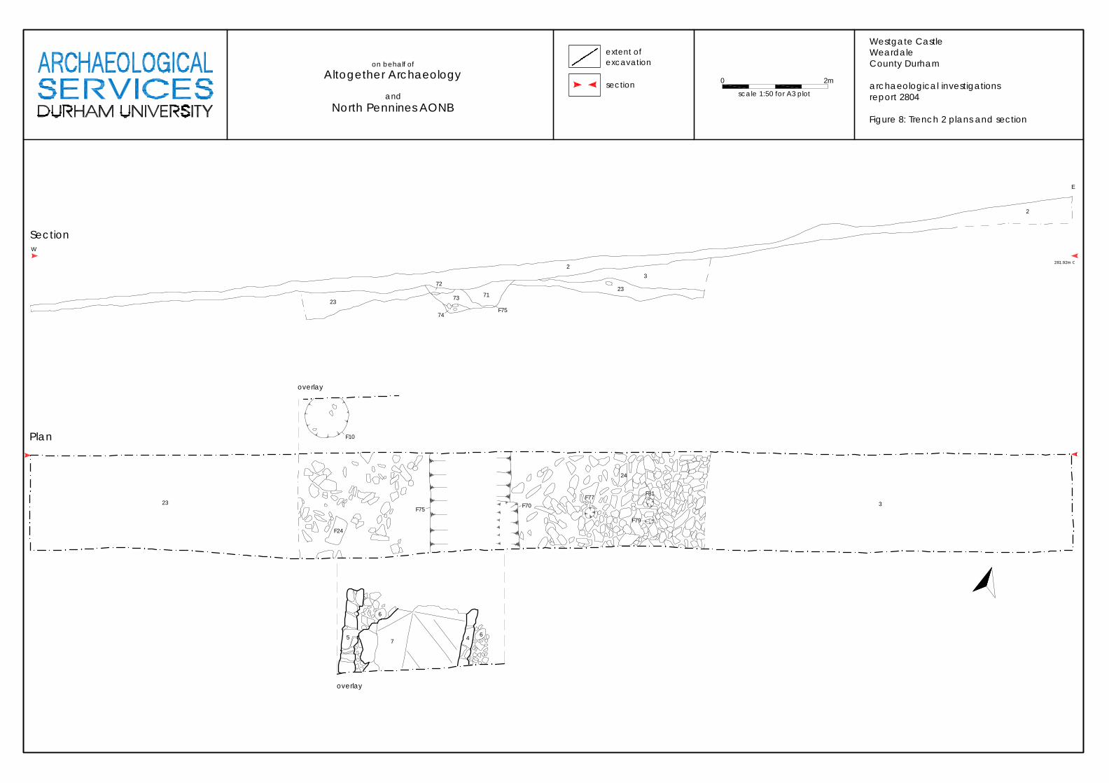
Plan
23
F24
F75 F70F77
24
F81
3
overlay
5
6
7 4 6
overlay
F10
7173
72
23
W
Section
281.92m O
2
23
32
74F75
F79
E
Westgate CastleWeardaleCounty Durham
archaeological investigationsreport 2804
Figure 8: Trench 2 plans and section
0
scale 1:50 for A3 plot
2m
extent ofexcavationon behalf of
Altogether Archaeology
andNorth Pennines AONB
section
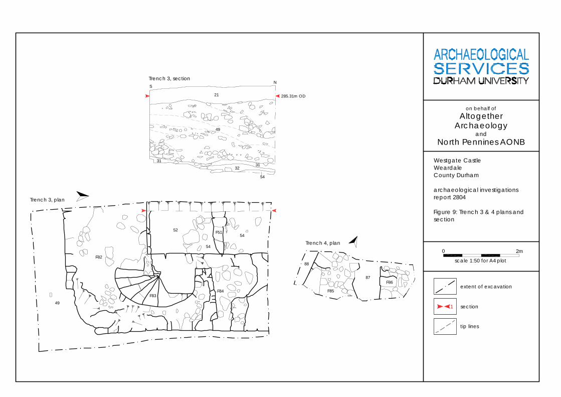
Trench 3, plan
Trench 3, sectionN
S
285.31m OD21
49
31
32
54
49
F82
F83F84
F5154
52
54
31
88
F8687
F85
Trench 4, plan
section
extent of excavation
Westgate CastleWeardaleCounty Durham
archaeological investigationsreport 2804
Figure 9: Trench 3 & 4 plans andsection
on behalf ofAltogether
Archaeologyand
North Pennines AONB
1
0
scale 1:50 for A4 plot
2m
tip lines
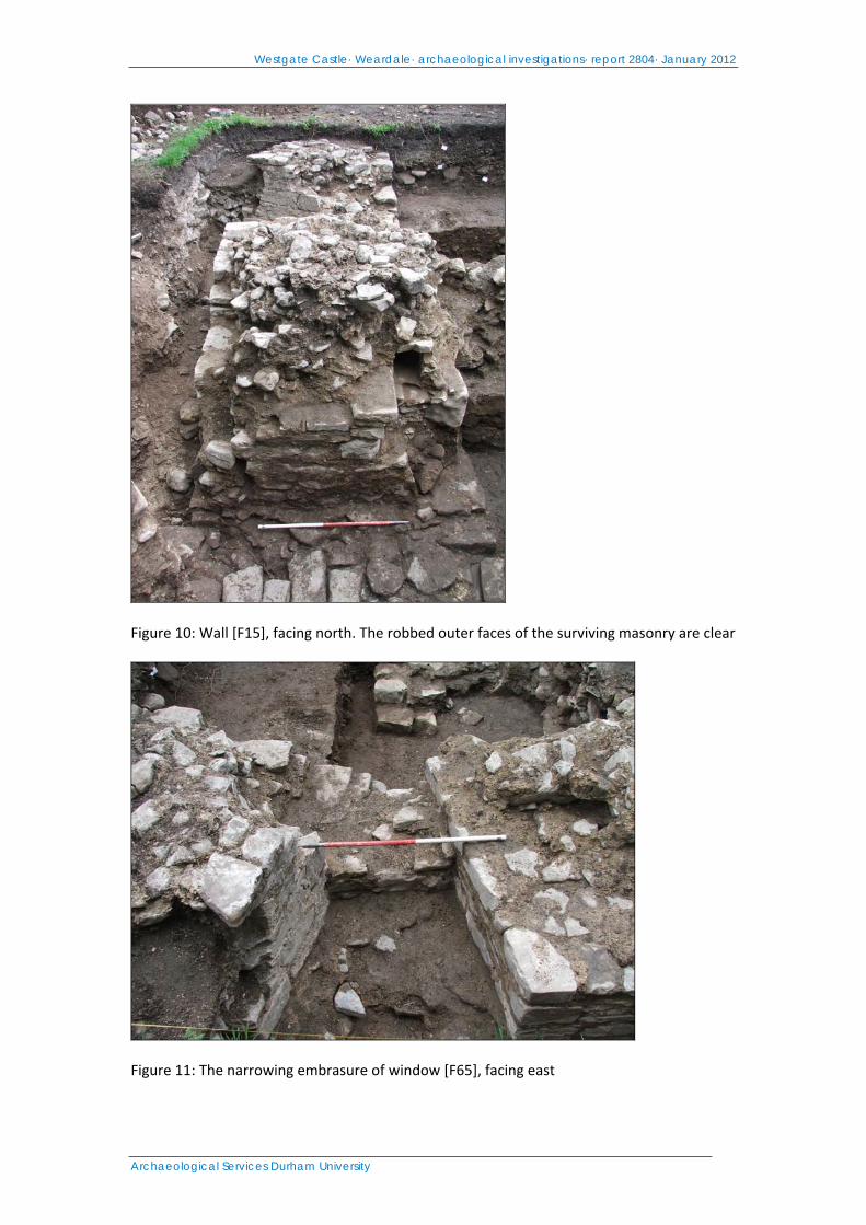
Westgate Castle· Weardale· archaeological investigations· report 2804· January 2012
Archaeological Services Durham University
Figure 10: Wall [F15], facing north. The robbed outer faces of the surviving masonry are clear
Figure 11: The narrowing embrasure of window [F65], facing east
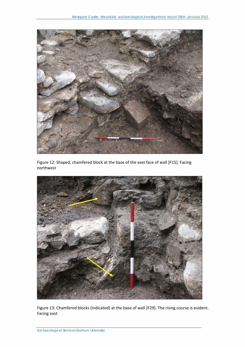
Westgate Castle· Weardale· archaeological investigations· report 2804· January 2012
Archaeological Services Durham University
Figure 12: Shaped, chamfered block at the base of the east face of wall [F15]. Facing northwest
Figure 13: Chamfered blocks (indicated) at the base of wall [F29]. The rising course is evident. Facing east
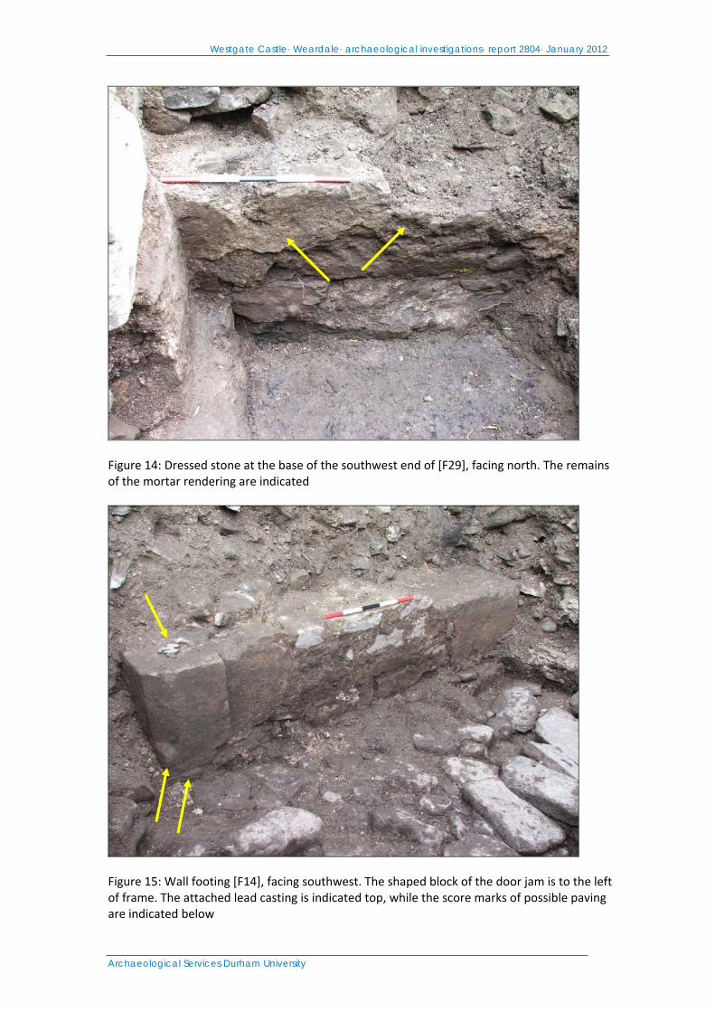
Westgate Castle· Weardale· archaeological investigations· report 2804· January 2012
Archaeological Services Durham University
Figure 14: Dressed stone at the base of the southwest end of [F29], facing north. The remains of the mortar rendering are indicated
Figure 15: Wall footing [F14], facing southwest. The shaped block of the door jam is to the left of frame. The attached lead casting is indicated top, while the score marks of possible paving are indicated below
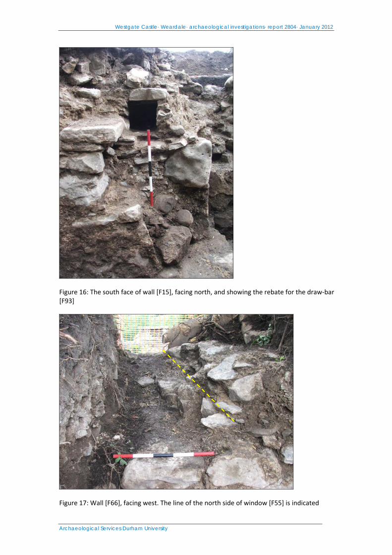
Westgate Castle· Weardale· archaeological investigations· report 2804· January 2012
Archaeological Services Durham University
Figure 16: The south face of wall [F15], facing north, and showing the rebate for the draw‐bar [F93]
Figure 17: Wall [F66], facing west. The line of the north side of window [F55] is indicated

Westgate Castle· Weardale· archaeological investigations· report 2804· January 2012
Archaeological Services Durham University
Figure 18: The west face of wall [F66], showing string course [41] and the exit of the garderobe chute [F42]
Figure 19: The base of probable staircase [F68], north of wall [F29]. Facing east
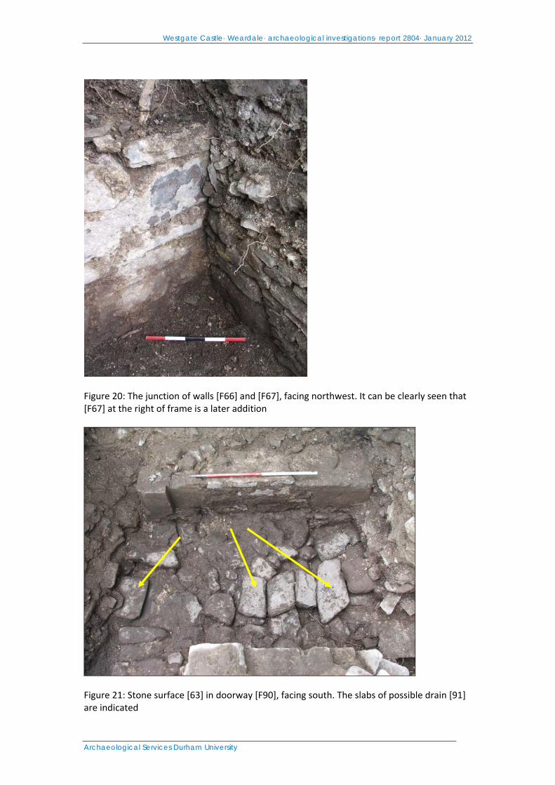
Westgate Castle· Weardale· archaeological investigations· report 2804· January 2012
Archaeological Services Durham University
Figure 20: The junction of walls [F66] and [F67], facing northwest. It can be clearly seen that [F67] at the right of frame is a later addition
Figure 21: Stone surface [63] in doorway [F90], facing south. The slabs of possible drain [91] are indicated
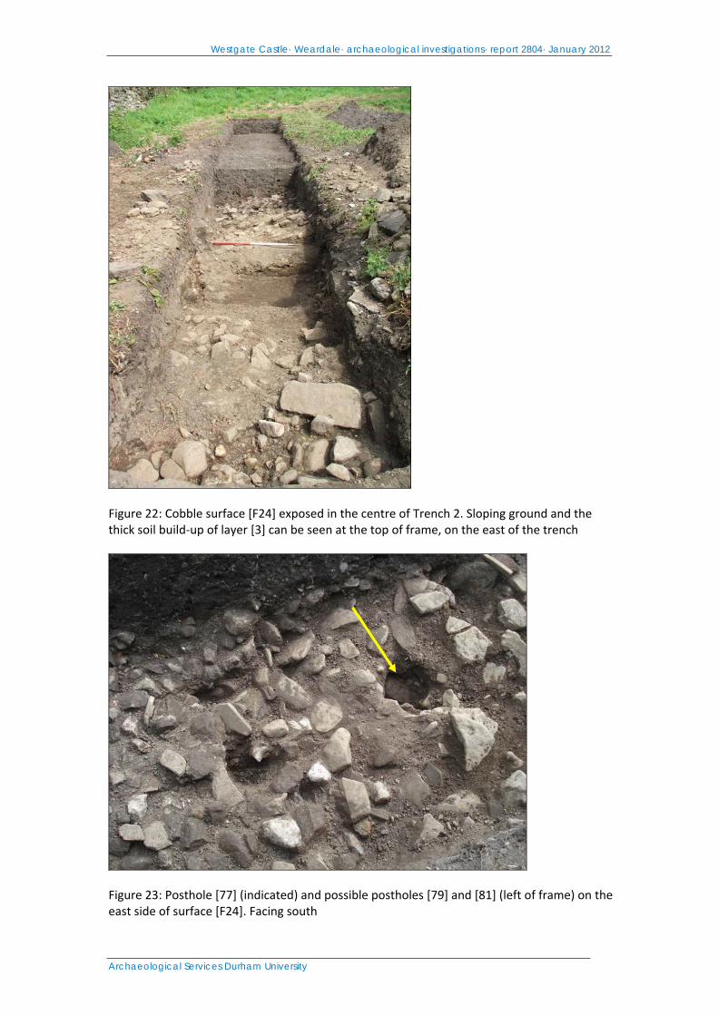
Westgate Castle· Weardale· archaeological investigations· report 2804· January 2012
Archaeological Services Durham University
Figure 22: Cobble surface [F24] exposed in the centre of Trench 2. Sloping ground and the thick soil build‐up of layer [3] can be seen at the top of frame, on the east of the trench
Figure 23: Posthole [77] (indicated) and possible postholes [79] and [81] (left of frame) on the east side of surface [F24]. Facing south

Westgate Castle· Weardale· archaeological investigations· report 2804· January 2012
Archaeological Services Durham University
Figure 24: Leat channel [F75], facing south. The cut of dog burial [F70] is indicated to the left of frame
Figure 25: The floor and west wall of the demolished shed, facing east. The remains of barrel [9] are visible at the bottom left of frame
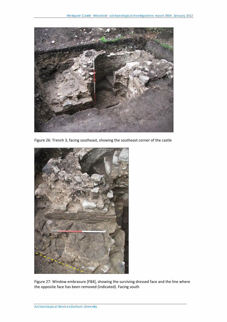
Westgate Castle· Weardale· archaeological investigations· report 2804· January 2012
Archaeological Services Durham University
Figure 26: Trench 3, facing southeast, showing the southeast corner of the castle
Figure 27: Window embrasure [F84], showing the surviving dressed face and the line where the opposite face has been removed (indicated). Facing south
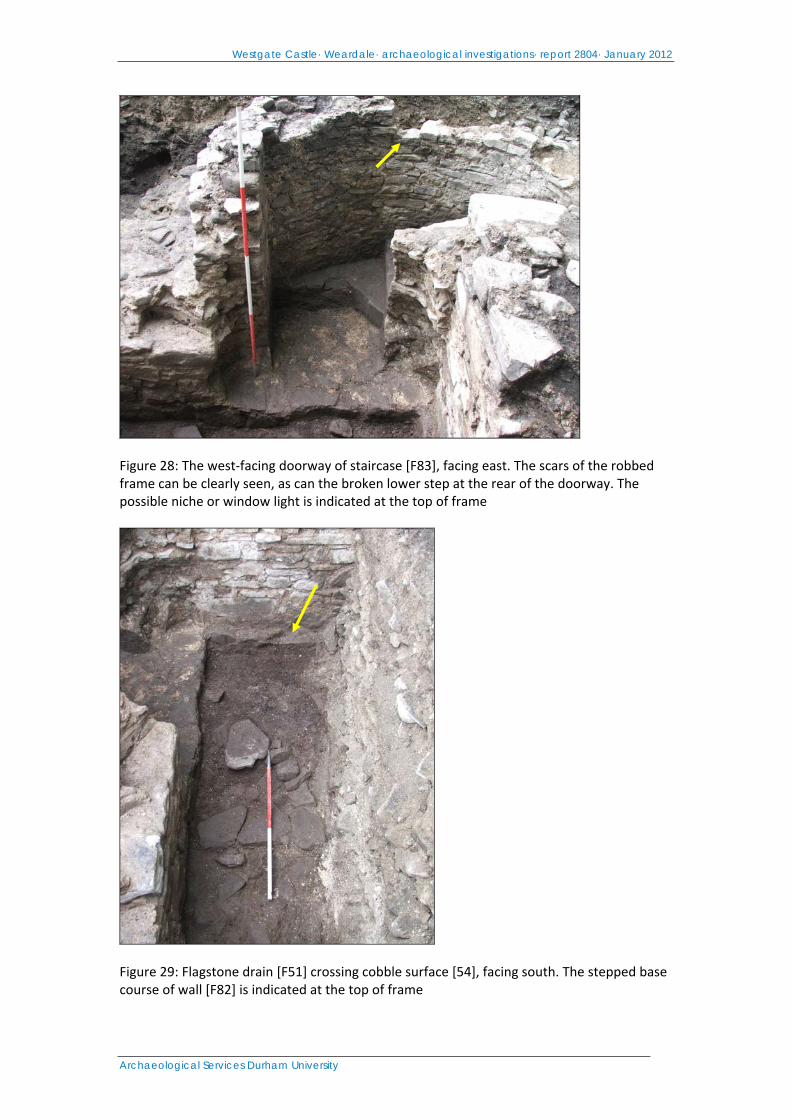
Westgate Castle· Weardale· archaeological investigations· report 2804· January 2012
Archaeological Services Durham University
Figure 28: The west‐facing doorway of staircase [F83], facing east. The scars of the robbed frame can be clearly seen, as can the broken lower step at the rear of the doorway. The possible niche or window light is indicated at the top of frame
Figure 29: Flagstone drain [F51] crossing cobble surface [54], facing south. The stepped base course of wall [F82] is indicated at the top of frame
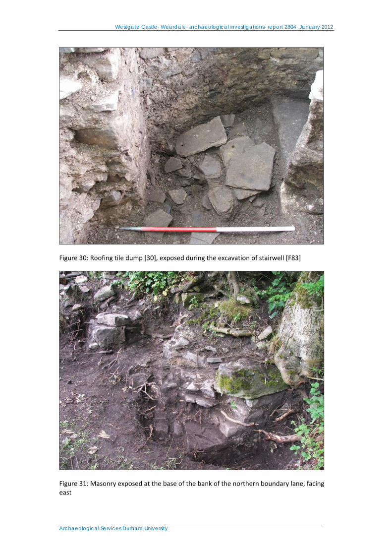
Westgate Castle· Weardale· archaeological investigations· report 2804· January 2012
Archaeological Services Durham University
Figure 30: Roofing tile dump [30], exposed during the excavation of stairwell [F83]
Figure 31: Masonry exposed at the base of the bank of the northern boundary lane, facing east
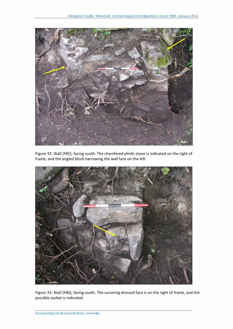
Westgate Castle· Weardale· archaeological investigations· report 2804· January 2012
Archaeological Services Durham University
Figure 32: Wall [F85], facing south. The chamfered plinth stone is indicated on the right of frame, and the angled block narrowing the wall face on the left
Figure 33: Wall [F86], facing south. The surviving dressed face is on the right of frame, and the possible socket is indicated
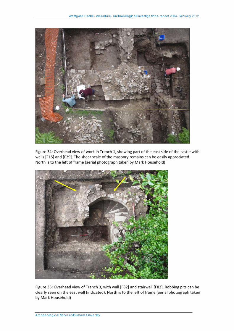
Westgate Castle· Weardale· archaeological investigations· report 2804· January 2012
Archaeological Services Durham University
Figure 34: Overhead view of work in Trench 1, showing part of the east side of the castle with walls [F15] and [F29]. The sheer scale of the masonry remains can be easily appreciated. North is to the left of frame (aerial photograph taken by Mark Household)
Figure 35: Overhead view of Trench 3, with wall [F82] and stairwell [F83]. Robbing pits can be clearly seen on the east wall (indicated). North is to the left of frame (aerial photograph taken by Mark Household)
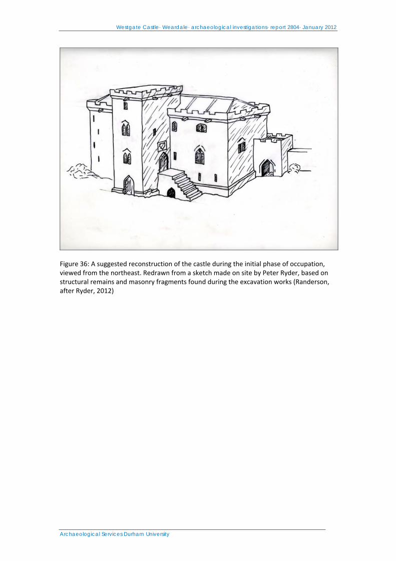
Westgate Castle· Weardale· archaeological investigations· report 2804· January 2012
Archaeological Services Durham University
Figure 36: A suggested reconstruction of the castle during the initial phase of occupation, viewed from the northeast. Redrawn from a sketch made on site by Peter Ryder, based on structural remains and masonry fragments found during the excavation works (Randerson, after Ryder, 2012)