westside and lower west neighborhoods transportation
TRANSCRIPT

Westside and Lower West Neighborhoods Transportation Management Plan Page 1 of 38
ATTACHMENT 1
City of Santa Barbara Public Works Department March 2020
Westside and Lower West Neighborhoods
Transportation Management Plan

Westside and Lower West Neighborhoods Transportation Management Plan Page 2 of 38
TABLE OF CONTENTS INTRODUCTION ________________________________________________ 3
Activation of Neighborhood Transportation Planning Effort ________________________ 3
PROCESS _____________________________________________________ 4
Goal __________________________________________________________________ 4
Objectives ______________________________________________________________ 4
Community Stakeholders and City Advisory Boards _____________________________ 4
Plan Boundary: Westside and Lower West Neighborhoods _______________________ 5
Planning Inputs _________________________________________________ 6
Plan Inputs _____________________________________________________________ 6
Listening Workshop ______________________________________________________ 7
Key Survey Findings ____________________________________________________ 13
Vision Zero Analysis _____________________________________________________ 18
Approach Workshop _____________________________________________________ 22
Westside and Lower West Neighborhoods Plan _______________________ 23
Plan Preface: Vision Zero Focus ___________________________________________ 23
Emerging Themes ______________________________________________________ 24
Projects Underway ______________________________________________________ 35
Projects Included in the Streets Operation Budget _____________________________ 36
Proposed Projects ______________________________________________________ 37
Attachments ___________________________________________________________ 38

Westside and Lower West Neighborhoods Transportation Management Plan Page 3 of 38
INTRODUCTION
Activation of Neighborhood Transportation Planning Effort To improve pedestrian, bicycle, and traffic safety on Santa Barbara’s Westside and Lower
West Neighborhoods, the Public Works Department conducted Vision Zero analysis as well
as initiated a bilingual outreach effort in March 2019 to help the neighborhood identify areas
of concern. The Westside and Lower West Neighborhoods Transportation Management Plan
(Plan) describes the process in which the neighborhood participated, the input they provided,
the Vision Zero analysis, and a safety prioritized action plan. Although not every neighbor of
the Westside and Lower West neighborhoods participated, the Plan includes a representative
cross section of the neighborhood. Approximately $6.7 million of capital infrastructure projects
are in design and should be constructed in the Westside and Lower West Neighborhoods
within the next 1-3 years. In addition to the planned capital infrastructure projects, there are
eleven additional proposed projects representing a funding need of approximately $16 million.
This Plan is a living document and updates may be necessary in the future to assess progress,
take advantage of emerging opportunities and re-evaluate priorities as needed. As new
sections of the bicycle and pedestrian facility network are developed, bicycling and walking
mode share will likely increase and travel patterns will change. Priorities may shift and new
opportunities will become apparent. These changes will be reflected in either an update of the
Plan or in the City’s Capital Improvement Program, which is updated every two years, or in
future updates to the Pedestrian Master Plan and/or Bicycle Master Plan.

Westside and Lower West Neighborhoods Transportation Management Plan Page 4 of 38
PROCESS Goal
The goal of the Westside and Lower West Neighborhoods Transportation Management Plan is to use identified pedestrian, bicycle, and traffic safety concerns as a planning tool for grant funding opportunities and to incorporate into Public Works maintenance efforts.
Objectives 1. Engage the Westside and Lower West Neighborhoods regarding pedestrian, bicycle,
and traffic safety concerns by using a multimedia approach and innovative
communication strategies.
2. Conduct a Vision Zero Traffic Safety Analysis to identify traffic issues through crash
analyses and provide traffic engineering solutions to address those issues.
3. Propose short- and long-term improvements that are responsive to the outcome of the
Vision Zero Safety Analysis and that are responsive to the neighborhoods’ concerns.
Improvements to be prioritized based on safety.
Community Stakeholders and City Advisory Boards

Westside and Lower West Neighborhoods Transportation Management Plan Page 5 of 38
Plan Boundary: Westside and Lower West Neighborhoods
The Westside neighborhood is bounded on the north and east by Highway 101, on the south by Carrillo Street and the base of the Mesa Hills, and on the west by the base of the hills containing Bel Air Knolls. The Westside neighborhood is developed with a mix of single-family, duplex, and multi-family units. The Westside also has a commercial area serving mainly neighborhood uses. The Westside Boys and Girls Club is located in this neighborhood next to Bohnett Park. Harding Elementary, Santa Barbara Community Academy, and La Cumbre Junior High are also in this neighborhood.
The Lower West neighborhood is bounded on the north by Carrillo Street, on the south by Montecito Street, on the east by Highway 101, and on the west by Loma Alta Drive and the base of the Mesa Hills. The Lower West Neighborhood is the City’s most densely settled residential area. The area has a mix of modest single-family homes, many older apartment buildings, and some condominium developments. Lower West has a small commercial market that serves the neighborhood as well as some commercial uses on the corner of Castillo and Montecito Street. Also in this neighborhood is Parque de los Niños and Children’s Orchard, a small park with orchard and vegetable gardens for residents of Santa Barbara's lower Westside. Immediately adjacent to this neighborhood is McKinley Elementary School.

Westside and Lower West Neighborhoods Transportation Management Plan Page 6 of 38
PLANNING INPUTS Plan Inputs

Westside and Lower West Neighborhoods Transportation Management Plan Page 7 of 38
Listening Workshop The first part of the outreach
effort was a Listening
Workshop, held on April 6,
2019, at Harding University
Partnership Elementary
School. The purpose of the
workshop was to hear
pedestrian, bicycle, and
traffic-related concerns
directly from Westside and
Lower West residents.

Westside and Lower West Neighborhoods Transportation Management Plan Page 8 of 38
The workshop was in a facilitation format, with at least one staff facilitator per table. The staff
facilitator at each table prompted residents to provide feedback on the topics of Driving,
Walking, Bicycling, Neighborhood Lighting, Transit, and Parking. Each topic included a
corresponding map, which allowed residents to specify the locations of their concerns.
Everyone at the tables participated. In addition to discussion of these topics, the workshop
included an update on two important safety projects currently in design for the Westside: 1)
the Westside Bike Boulevard Gap Closure Project, which will provide a biking connection
from/to the Downtown and Eastside Neighborhoods; and 2) the West Carrillo Lighting and
Signal Upgrades Project, which addresses lighting insufficiencies along this corridor and
provides new left turn arrows and pedestrian crossing enhancements at the intersection of
West Carrillo and San Andres.
Post-workshop, staff compiled all the comments received. The following major themes emerged:
• Rule of the road concerns
• All road users could be doing a better job
• Difficulty navigating intersections
• 22 intersections were cited as uncomfortable for pedestrians
• 4 intersections were cited as uncomfortable for motorists
• 8 intersections were cited for visibility concerns for all modes of travel
• 14 intersections were cited for poor stop sign compliance or motorists not
yielding to pedestrians
• 2 intersections were cited for poor crossing skills by pedestrians
• Maintenance issues
• 13 locations identified for overgrown vegetation or tree trimming
• Bus stop inadequacies or concerns such as lighting maintenance or need for
concrete pad.
• 8 areas/corridors cited for uplifted sidewalks
• Obstructions/modifications to existing street lighting (need to locate streetlights
below tree canopy)
• Infrastructure needs
• 12 missing sidewalk links were cited by residents as priorities to infill
• 12 intersections were recommended to install access ramps/curb ramps
• Bicycle infrastructure inadequacies (want protected routes, visible bike lanes,
intersection treatments, more crosstown routes)

Westside and Lower West Neighborhoods Transportation Management Plan Page 9 of 38
• 11 corridors cited by residents, 7 intersections cited for additional neighborhood
lighting
• Parking concerns
• Very difficult to park in the evening hours
• Large commercial work trucks taking up resident parking
• Harder to park in areas where there are apartments and areas where accessory
dwelling units have been constructed
A graphic on the next page summarizes the residents’ concerns (Figure 1). The graphic also
includes the traffic collision heat map, which provides an illustration of collisions in the last five
years (2014-2018). The red areas show the highest numbers of collisions, while the yellow
and green areas represent lower numbers. The heat map is a visual tool to identify problem
spots with recurring collision patterns. The problem spots are discussed in the Vision Zero
Analysis of this Plan. Together, the community feedback and the traffic collision problem spots
help staff develop approaches, which are discussed in the Approach Workshop and Emerging
Projects sections of this Plan.

Westside and Lower West Neighborhoods Transportation Management Plan Page 10 of 38
Figure 1: Community Feedback and Traffic Collision Heat Map

Westside and Lower West Neighborhoods Transportation Management Plan Page 11 of 38
Email Feedback
Emails were received from residents who had follow up comments post workshop, as a survey
follow up, and for those residents that were unable to attend the workshop and had comments
to share. Comments received were specific to immediate neighborhood areas and included:
Preference for biking for families along Gillespie, Anapamu and Rancheria Streets. Route enhancements would be appreciated.
Poor stop sign compliance along Chino Streets, especially at 4 way stops. Maintenance of Coronel Street footpath. Better biking route:
o To Downtown after Micheltorena Street Overpass o Through the Castillo Street HWY 101 Underpass o Along Calle Cannon between Flora Vista and Valerio o Along Modoc and Portesuello, adjacent to La Cumbre Junior High o To SBCC o Along Union Pacific Right of Way o Across Montecito Street o Micheltorena and Dutton (improve visibility and enhancements at the
intersection) o Micheltorena Bridge (enhanced return route from Downtown to
Westside/separate bicyclists from vehicles) o Chino/Gillespie (make one way streets) o Construct separated, safe, efficient crossings of Castillo, Carrillo, Micheltorena,
and Mission o Complete Westside bike boulevards through missing links to Loma Alta and
Las Positas o Create a protected/ separated bikeway through the Lower Westside o Increase the safety of Loma Alta for active transportation to SBCC and McKinley o Install a bikeway at grade on City land in Pershing Park between Rancheria
and the harbor Lack of on-street parking near new development. Request for enforcement for those
not using their onsite parking. Better pedestrian improvements:
o Along San Pascual for safe routes to school o Across San Pascual at Cota (better lighting too) o To Bohnett Park (better lighting in vicinity too) o Across San Andres at Sola (request for flashers) o Across Mission at Gillespie (request for flashers) o Valerio and Calle Boca (access ramps) o Valerio at Mountain and Robbins Streets (visibility concerns) o Mission and Modoc. o Chino at Sola (visibility and speeding concerns)
Visibility concerns at the San Pascual/Pedregosa intersection. Lack of on-street parking and lighting along Sunset Ave. Maintenance of Anapamu Bridge. Additional school crossing guard at Micheltorena and Gillespie Evaluate school drop off at Harding and street sweeping times near the school. Speeding concerns along Valerio.

Westside and Lower West Neighborhoods Transportation Management Plan Page 12 of 38
Survey
In addition to the Listening Workshop, Public Works developed an online survey (Attachment
1, Survey Questions). The purpose of the survey was to hear from a broader Westside and
Lower West neighborhoods audience, to gather additional insights about resident perceptions
and concerns relating to traffic, bicycle, and pedestrian safety.
Below is an example of a survey announcement that was distributed via Parent Square to
parents at Harding University Partnership Elementary School, Adams Elementary School,
McKinley Elementary School, Santa Barbara Community Academy, and La Cumbre Junior High.
The survey was also distributed via the City News in Brief, Nextdoor, and through community
advocacy groups like the Coalition of Sustainable Transportation and Santa Barbara Bicycle
Coalition.

Westside and Lower West Neighborhoods Transportation Management Plan Page 13 of 38
Key Survey Findings
The Key Survey Findings are not intended to be a comprehensive breakdown of all data from
the survey. Rather, the purpose of the Key Findings is to capture valuable insights and themes,
which can guide the development of an action plan.
Total Survey Responses: 180
FINDING 1) Over half of households have one preschool or elementary school age child living
at home.
43% Westside households have at least one preschool or elementary school-age child living
at home.
FINDING 2) Primary commute options to school are car and walking.
Three-quarters (75%) of respondents indicated their school-age children are either driven to
school (52%) or they walk (23%). Others bike (12%) or take the bus (6%).
FINDING 3) Westsiders like that their neighborhood is quiet, friendly, and close to Downtown.
When asked what they like most and second-most about their neighborhood, Westside
residents often refer to
quality of life factors such
quietness of the area,
friendly neighbors, and
proximity to Downtown.
Other positive qualities
mentioned were
demographic diversity and
close proximity to Harding
University Partnership School. (Please refer to the “word clouds” that show popular
neighborhood likes: larger is more popular.)
Verbatim Responses (sample):
This is a family friendly neighborhood.
Our neighborhood is walkable from the beach, downtown, and transit. It's very central and
easy to get around from.

Westside and Lower West Neighborhoods Transportation Management Plan Page 14 of 38
Close community. Everyone knows each other on our block.
FINDING 4) Housing, traffic, unsafe drivers, and overcrowded parking are the biggest
challenges.
When asked biggest and second-biggest challenge facing the Westside, combined
responses indicate housing (48%) and traffic (44%) are top concerns. Parking was often
indicated as an “Other” concern along with unsafe drivers and lack of lighting. (Please refer
to the “word clouds” for popular dislikes.)
Verbatim Responses (sample):
• Unkempt yards that are a fire hazard and the emergence of homeless camps.
• Lack of law enforcement support around parking, speeding, and noise.
• PARKING
• Nos falta un poco de Luz en la noche.

Westside and Lower West Neighborhoods Transportation Management Plan Page 15 of 38
FINDING 5) Transportation choices: private cars and walking most favored; bus and carpool
are least favored.
Two-thirds of respondents (65%) indicate they drive a private car five or more days per week.
Nearly two-thirds of respondents (57%) indicate they walk a block or more five or more days
per week. The bus is the least favored mode of transportation, with nearly three-quarters
(71%) of respondents indicating they never ride the bus. Only one-fifth (19%) of respondents
ride a bicycle five or more days per week, with a quarter (28%) indicating they never ride a
bicycle.
FINDING 6) Vast majority agree motorists can do better at sharing the road.
Nearly four-fifths (79% agree; of that, 48% “strongly” agree) of respondents agree that
motorists need to do better at sharing the road, specifically with bicyclists and motorists.
Only 9% disagreed that motorist should do better.
FINDING 7) Most agree that pedestrian actions impair safety.
Nearly two-thirds of respondents (61%) agree that pedestrians often do not look for
oncoming traffic when crossing the street. Almost one-third (29%) disagree that pedestrians
often do not look.
FINDING 8) Most agree that bicyclist actions impair safety.
More than two-thirds of respondents (68%) agree that bicyclists often ignore traffic control

Westside and Lower West Neighborhoods Transportation Management Plan Page 16 of 38
devices such as stop signs and stoplights. Slightly less than one-fifth of respondents (18%)
disagree that bicyclists often ignore traffic signals.
FINDING 9) Most agree that improvements would encourage more walking.
Nearly two-thirds of respondents (61%) agree that they would walk more if improvements
were implemented such as better lighting, sidewalks, and access ramps. A quarter (25%)
of respondents indicated they wouldn’t walk more even if these improvement were made.
FINDING 10) General agreement that parking on the Westside is difficult.
Almost three-quarters (72%) of respondents agree that it is difficult to find parking in their
neighborhood.
FINDING 11) General agreement that parking on Westside is difficult…and getting MORE
difficult.
Approximately two-thirds (65%) of respondents agree that it is getting more difficult to park
in their neighborhood than it used to be. Only 11% disagree that parking is getting more
difficult.
FINDING 12) Vehicles are seen as the biggest concern for people crossing the street;
however, many have no concerns about crossing the street.
About one-third (32%) indicate that vehicles not stopping for pedestrians is the most
concerning factor for pedestrians crossing the street. One-quarter (25%) indicate that
parked vehicles obstructing the view is the most concerning factor for street crossers. Other
concerns mentioned for pedestrians include lack of stop signs and vehicles driving too fast.
Verbatim Responses (sample):
Cars driving way too fast and recklessly due to lack of stop signs at intersection of
Valerio at Chino.
Drivers do not understand concept of unmarked crosswalk.
There is a very long stretch of Modoc with no crosswalks. (Between Las Positas and
Portesuello with no crosswalks - this is ultra dangerous.)
Vehicles traveling too fast for the neighborhood as well as not stopping for pedestrians.
Bad sidewalks with root bumps.

Westside and Lower West Neighborhoods Transportation Management Plan Page 17 of 38
FINDING 13) Sharing the road is biggest concern for bicyclists.
Nearly two-thirds of respondents (61%) indicate that sharing the road with vehicles or the lack
of bike lanes is their biggest concern when riding a bicycle. Only 1% indicate concerns about
bike parking/storage. Almost one-third (30%) indicate that they do not ride a bicycle at all.
(Please refer to the “word cloud” for Q21.)
Verbatim Responses (sample):
Construction zones that block bike lanes then make no accommodation via space or
"share the road" signage to keep bicyclists safer.
Cars driving way too fast in Loma Alta and Canon Perdido. Need Speed bumps.
Motorists inappropriately yielding their right-of-way to me, causing confusion at
intersections.
San Andres, between Micheltorena and Carrillo, is the worst street in Santa Barbara
to ride a bike. People drive fast, pull out of blind driveways, and do not give room for
cyclists.
FINDING 14) Most say they have never inquired with City Public Works.
More than one-half (59%) of respondents indicated they have never called or visited the
City of Santa Barbara Public Works Department to ask a question or express a concern.
However, 41% indicated that they called or visited Public Works to ask a question at least
once.

Westside and Lower West Neighborhoods Transportation Management Plan Page 18 of 38
Vision Zero Analysis
The City’s Supervising Transportation Engineer conducted a traffic safety analysis for the
Westside and Lower West neighborhoods. When performing a traffic safety analysis, collision
data from the Police Department is used to identify trends and recurring collision patterns.
When collisions with similar characteristics are repeated over and over, this may indicate a
safety issue that could be corrected by some type of improvement.
The traffic collision heat map below) (Figure 2) provides an illustration of collisions in the last
five years (2014-2018). The red areas show the highest numbers of collisions, while the yellow
and green areas represent lower numbers. This map is used as a visual tool to identify problem
spots with recurring collision patterns.
Generally, the collisions were spread throughout the study area but were more frequent along
the following corridors: Carrillo Street, Mission Street, and San Andres Street. This was
expected, as these are the busiest streets in the neighborhoods.
Figure 2: 5 Year Collision History

Westside and Lower West Neighborhoods Transportation Management Plan Page 19 of 38
In reviewing the collisions for the Westside and Lower West neighborhoods, a few patterns
were identified that suggest safety problems. These collision patterns are informed solely by
the collision data and not the experiences shared by the neighborhood with City staff. The
following are the key findings from the City’s collision data analyses:
The location with the highest number of pedestrian-involved collisions was the
signalized intersection of Micheltorena Street and San Andres Street. Each of the
pedestrian-involved collisions involved a left-turning vehicle not yielding to a pedestrian
within a crosswalk. This intersection is one of the most traveled intersections in the
Westside neighborhood, particularly for pedestrians: on average, there are over 200
crossings per day.
o To enhance the visibility of pedestrians in the intersection and reinforce their
right-of-way over turning vehicles, the City installed a leading pedestrian interval
(LPI) at this intersection. The LPI gives pedestrians a three-second head start to
begin their crossing at the intersection before the corresponding vehicular signal
turns green. With this head start, pedestrians can better establish their presence
in the crosswalk before motorists attempt to make their turning maneuvers.
While bicycle-involved collisions are spread throughout the neighborhoods, there is a
concentration of them along the San Andres corridor (where about 33% of the total
bicycle-involved collisions occur).
o To provide bicyclists with a safer/alternative route through the Westside, the City
is designing two bicycle boulevards that will extend along Gillespie and San
Pascual Streets. The bicycle boulevards are designed to be low motorized traffic
volume/speed roadways that prioritize bicycle movements as a north-south
connector through the Westside. The bicycle boulevards are discussed further
in the Emerging Projects section of this Plan.

Westside and Lower West Neighborhoods Transportation Management Plan Page 20 of 38
Figure 3: Nighttime 5 Year Collision History Heat Map and Streetlight Locations
There is a concentration of nighttime collisions along San Andres and Carrillo Streets
(Figure 3). While some roadway lighting is present along San Andres Street, it is
intermittent and can be obstructed by tree canopies. Carrillo Street also has some
existing roadway lighting; however, it is sparse along the corridor. To increase nighttime
visibility and to help roadway users be more aware of their surroundings during hours
of darkness, the following is recommended:
o San Andres Street: In the short term, tree canopies were trimmed in May to
increase the effectiveness of existing street lighting. City staff will continue to
monitor. In the long term, a City-owned lighting corridor could be installed to
illuminate the roadway and sidewalks more efficiently.
o Carrillo Street: The West Carrillo Lighting and Signal Upgrades Project is
currently in design to implement a continuous lighting corridor along Carrillo
Street through the Westside. The Project is funded through a federal safety grant
and is expected to enter construction in fall/winter 2020. Specifically, the
improvements include:

Westside and Lower West Neighborhoods Transportation Management Plan Page 21 of 38
Installing corridor lighting to address the nighttime collisions and improve
safety for both motorized and non-motorized (bicycle) users.
Installing left turn arrows at the intersection of Carrillo Street and San
Andres Street for east/westbound Carrillo Street onto San Andres Street.
Significantly shortening the pedestrian crossing distances by realigning
the crosswalks to be more perpendicular to the roadway.
Constructing ADA-compliant pedestrian pathways, including new
pedestrian access ramps at Carrillo Street and San Pascual Street.
Installing audible pedestrian push button systems to communicate
information about the walk and don’t walk intervals, in non-visual formats,
to pedestrians who are blind or have low vision.
Installing advanced dilemma zone traffic signal detection on the Carrillo
Street approaches to minimize the number of drivers that may have
difficultly deciding whether to stop or proceed during the yellow phase of
the signal.
Rehabilitating traffic signals for long-term reliability.
Staff is also studying the intersection of Carrillo Street and San Pascual Street for a potential
crosswalk across Carrillo Street. During the data collection phase, staff noted over 40
pedestrian crossings per day, many of which involved pedestrians darting through traffic.
There has not been a reported pedestrian involved collision since 2011; however, there were
five pedestrian-involved collisions between 2006 and 2011.

Westside and Lower West Neighborhoods Transportation Management Plan Page 22 of 38
Approach Workshop
A follow-up Approach Workshop was held at Harding University Partnership School on June
1, 2019. The objectives of this workshop included the following:
1) Review what
the City heard from
the community via the
initial Listening
Workshop, survey,
and emailed
comments;
2) Discuss the
traffic engineering
analysis;
3) Present
possible approaches
and immediately
receive feedback from
the workshop
participants; and
4) Identify the
next steps of finalizing
the Westside and
Lower West
Neighborhoods
Transportation
Management Plan.

Westside and Lower West Neighborhoods Transportation Management Plan Page 23 of 38
WESTSIDE AND LOWER WEST NEIGHBORHOODS PLAN
Plan Preface: Vision Zero Focus
When reviewing the neighborhoods’ needs in order to finalize the Westside and Lower West
Neighborhoods Transportation
Management Plan, staff
prioritized all the community
needs that were consistent with
the Council-adopted Vision
Zero Strategy. The Vision Zero
Strategy aims to eliminate all
traffic fatalities and severe
injuries while increasing safe,
healthy, and equitable mobility
for all. Vision Zero is based on an underlying ethical principle that it can never be acceptable
that people are killed or seriously injured when moving on public roadways. As an ethics-
based approach, Vision Zero functions to guide priorities and strategic use of limited city
resources. It is a new lens through which public officials and professionals make decisions
based, above all, on safety outcomes. Historically, road users have held most of the
responsibility for safety. Vision Zero changes this relationship by emphasizing that the
responsibility is shared by roadway policy makers, designers, and enforcement, as well as
road users.
The seven Vision Zero core principals include:
1. Life is Most Important
2. Every Person Matters
3. People Make Mistakes
4. Focus on Dangerous Locations and Behaviors
5. Drivers Have a Critical Responsibility
6. Pedestrians and Cyclists are the Most Vulnerable Road Users
7. The Government Shares Responsibility for Safe Streets

Westside and Lower West Neighborhoods Transportation Management Plan Page 24 of 38
Emerging Themes
Three themes have emerged from the community feedback and Vision Zero Traffic Safety
Analysis:
1. Improvements to make the walking experience safer and more inviting;
2. Neighborhood lighting improvements to enhance walking, biking, and driving
experience; and
3. Bicycle improvements to create safer routes to school and work and close gaps in
the bicycle facility network.
Within these themes, there are projects underway, projects that have or will be funded within
the Streets Operational Budget, and projects that are not funded and will require the City to
actively pursue grant opportunities for funding. The project summaries and estimated funds
needed to design and construct the projects follow this section of the Plan.
Improvements to Make the Walking Experience Safer and More Inviting
San Andres and San Pascual serve as primary pedestrian corridors for the Lower West and
Westside neighborhoods. These corridors are also safe routes to school for Harding University
Partnership School, McKinley Elementary School, Santa Barbara Community Academy, La
Cumbre Junior High, and via
bus to Adams Elementary
School. With its large amount of
pedestrian, vehicular, and
bicycle traffic, San Andres is a
designated Vision Zero Priority
Corridor, where a high number
of repeat, preventable
collisions and severe injuries
occur. In the San Andres
Corridor, there were 38 bicycle-
or pedestrian-involved
collisions that resulted in 38 injuries, 3 of which were severe, in the ten-year period from 2008
to 2017.

Westside and Lower West Neighborhoods Transportation Management Plan Page 25 of 38
Incorporated into the Plan are intersection crossing enhancements and lighting improvements
that will help prevent collisions and ensure the walkability, bikeability, and overall safety of this
corridor. The proposed pedestrian enhancements are included in the map on page 26 (Figure
4). The large green and purple dots are the prioritized intersections based on collision data
and what staff heard from the community. The green dots are intersections that already have
planned enhancements coming within the next 1-2 years and will address community
pedestrian safety concerns. The pedestrian enhancements along San Andres will most likely
include curb extensions and rectangular rapid flashing beacons to increase pedestrian
visibility at the intersections. The pedestrian enhancements along Chino Street will most likely
involve pedestrian refuge islands. Pedestrian refuge islands provide a protected space for
pedestrians to wait for an acceptable gap in traffic and help pedestrians navigate one travel
lane at a time.
Sidewalk infill along
Valerio Street (purple
sidewalk link on Figure
4) was the most
common sidewalk infill
request from residents
as a way to separate
pedestrians from
vehicles and to provide
stronger connections to
Harding University
Partnership School and
Elings Park. The red
dots and red links on Figure 4 are other community requested sidewalk infill needs and access
ramps. The Valerio sidewalk is shown as purple on the map to stress the importance of that
sidewalk being programmed for funding first. The City would like to seek grant funding on
behalf of the Westside neighborhood for the intersections with the purple dots and the purple
sidewalk links in spring 2020, when two known State grant sources, the Active Transportation
Program (ATP) and Highway Safety Improvement Program (HSIP), announce grant funding
opportunities. These applications are anticipated to be due in early summer 2020. The
remaining sidewalk infill links and access ramps may also be a good candidate for ATP funding
or Measure A funding.

Westside and Lower West Neighborhoods Transportation Management Plan Page 26 of 38
Figure 4: Proposed Pedestrian Improvements

Westside and Lower West Neighborhoods Transportation Management Plan Page 27 of 38
Neighborhood Lighting Improvements to Enhance Walking, Biking and Driving Experience
Higher quality pedestrian-level and street intersection lighting is necessary to enhance
pedestrian crossing safety and is a Vision Zero core principal to protect our most vulnerable
road users, pedestrians, and cyclists. Southern California Edison recently converted all the
high pressure sodium (HPS) lights to Light Emitting Diode (LED) lights. While this was a
tremendous improvement, some of the street lights in the Westside and Lower West are still
blocked by mature tree canopy. Along San Andres Street, City staff removed some of the lower
tree branches that had presented a traffic safety hazard, but areas with diminished lighting
remain.
Since the existing street lights cannot be adjusted lower than their current positions due to
other utility conflicts, smaller, pedestrian-scale lights are recommended for the San Andres
corridor (Figure 5). Grant funding for improved pedestrian-scale lighting can be pursued in
connection with other proposed pedestrian enhancements. Although lighting improvements
along the San Andres corridor is a primary focus of this Plan, additional areas will continue to
be evaluated.
Lights can also be added to existing utility poles where streetlights do not currently exist. One
example is the area between Mission, Gillespie, Chino, and Islay Streets (green box in Figure
5). To add a streetlight to an existing utility pole ranges from $200-700 per streetlight. Based
on this Plan, approximately 30 streetlights have been identified as needed in the Westside
and Lower West neighborhoods.
As discussed in the Vision Zero Analysis, an existing project is in design along Carrillo
involving new streetlights from the West Downtown neighborhood to partway up Carrillo hill.
The lighting improvement at this intersection is anticipated to increase nighttime visibility in a
way that will eliminate an existing pattern of nighttime pedestrian and bicycle injury collisions.
In early 2020, the City installed streetlights at the intersections of San Pascual at Ortega and
Cota Streets.

Westside and Lower West Neighborhoods Transportation Management Plan Page 28 of 38
Figure 5: Proposed Lighting Improvements

Westside and Lower West Neighborhoods Transportation Management Plan Page 29 of 38
Bicycle Improvements to Create Safer Routes to School and Work
Community outreach from the planning effort and from the 2019 Bicycle Master Plan
demonstrates a clear need for improved bicycle connectivity within the Lower West and
Westside neighborhoods and to Downtown, Eastside,
and Waterfront.
To provide bicyclists with a safer/alternative route
through the Westside, the City received Active
Transportation Grant funds to design and construct a
bicycle boulevard along Chino Street parallel to San
Andres Street. The bicycle boulevard will be a low
motorized traffic volume/speed roadway (less than
1,500 vehicles per day) that will prioritize bicycle movements as a north-south connector
through the Westside. This means that the design of a bike boulevard on Chino Street would
divert vehicle traffic to Gillespie and San Andres Streets. Chino Street was favored by the
larger community during the vetting of the Bicycle Master Plan because it provided for both
regional and local bike traffic. Residents of Chino Street were mixed on using Chino Street,
with some in strong opposition.
As part of the design and construction of the Chino Bike Boulevard, Traffic Operations staff
counted vehicles at multiple locations to determine the appropriate locations for vehicle
diverters and quantify the amount of traffic diversion. This process revealed significant cut-
through traffic through the Westside via Chino Street. The dominant pattern of traffic is
Carrillo/Chino/Micheltorena in the AM peak travel hour and then the reverse flow in the PM
peak hour. Traffic operations determined that diverting this significant flow of traffic on Chino
Street would overwhelm San Andres Street and add additional traffic to Gillespie Street near
Harding Partnership University Elementary, creating significant traffic congestion and
potentially increasing pedestrian collisions. This analysis was shared with the Westside
neighbors and the Bicycle Coalition. The community at the Approach Workshop did not favor

Westside and Lower West Neighborhoods Transportation Management Plan Page 30 of 38
the impacts of a Chino Street diversion. Staff also believes the traffic analysis impacts
identified are not appropriate for the neighborhood.
Figure 6: Dominant Vehicular Patterns in Westside and Lower West Neighborhoods
Staff suggested that instead of Chino Street, two streets be identified for Bike Boulevards
through the Westside: San Pascual for regional bike traffic, and Gillespie Street for local
Westside bike traffic to local schools and Downtown (Figure 7). The community generally
supported these two parallel bicycle boulevards. Gillespie would serve as the neighborhood
safe route to school bicycle route to Harding Partnership University Elementary, Santa
Barbara Community Academy, and La Cumbre Junior High. San Pascual would primarily
serve as a commuter or cross-town route for those cyclists traveling through the Westside to
get to other destinations. Because grant funds have already been awarded for this project, the
City is currently working with the State on the Active Transportation Grant to update this portion
of the project scope within the existing grant award. The other portion of the Active
Transportation Grant project scope, which is still included, is the connection of the north/south
route to Micheltorena and Sola Streets that would lead through Downtown and to the Eastside.
Another bicycle infrastructure need identified by the community is connecting the San Pascual
bicycle boulevard with a stronger, more kid-friendly connection to the future Las Positas and
Modoc Roads Multiuse Path. The Las Positas and Modoc Roads Multiuse Path begins on
Modoc Road close to the City limit at Calle De Los Amigos and travels east to the intersection

Westside and Lower West Neighborhoods Transportation Management Plan Page 31 of 38
of Modoc and Las Positas, and then south along Las Positas to the intersection of Las Positas
and Cliff, which is adjacent to Arroyo Burro Beach. Staff anticipates that when this 2.6-mile
path is constructed in 2020, there will be a higher demand from the Westside and Lower West
neighborhoods to connect to this path since it leads to Arroyo Burro Beach, Elings Park, the
Hidden Valley neighborhood, and UCSB.
In spring 2019, the City received planning grant funding to develop a concept design and
perform additional public outreach based upon a concept design for a multiuse path along the
south side of Modoc Road between Las Positas Road and Mission Street. Another possible
connection from this potential multiuse path could extend from the intersection of Modoc and
Portesuello to the intersection of Portesuello and Gillespie. The major destinations in the
Westside in this three-quarter-mile stretch are Santa Barbara Community Academy, La
Cumbre Junior High School, and the Junipero Street pedestrian bridge overcrossing that leads
to Oak Park and Cottage Hospital.
Between Las Positas Road and Mission Street, Modoc Road is a 38 to 40 foot wide road that
contains long sections of both curb face sidewalk and sidewalk with a landscaped buffer,
several mature street trees, and two on-street timed bike lanes from 7 a.m. to 7 p.m. The
posted speed of Modoc Road is 35mph west of Pilgram Terrance and 30mph east of Pilgram
Terrance. Adjacent to La Cumbre Junior High School, there is a 25mph school zone when
children are present. This section of Modoc Road carries approximately 6,800 vehicles per
day. Over a ten-year period from 2009 to the present, 15 collisions relating to vehicle vs.
bicycle occurred, which resulted in 14 injuries, and 3 collisions relating to vehicle vs.
pedestrian. A multiuse path constructed along this stretch would reduce and potentially
eliminate these types of collisions and is considered the ultimate infrastructure that meets the
needs of all ages and abilities of the Westside neighborhood.
The concept of a multiuse path along Modoc was supported at the Approach Workshop and
at a back-to-school community meeting held in August 2019 at La Cumbre Junior High.
Survey, concept design, and public outreach is estimated to cost $100,000, with $50,225
received from Measure A grant funding and $50,225 from City Streets Capital Funds. Staff
surveyed the area in fall 2019 and returned back to the Westside on January 23, 2020 to
receive feedback on two different design options. Option 1 consists of multiuse path along the
south side of Modoc from Las Positas Road to Portesuello Avenue and then buffered bike
lanes along Modoc between Portesuello Avenue and Mission Street. Option 2 consists of a

Westside and Lower West Neighborhoods Transportation Management Plan Page 32 of 38
separated bike path along the north side of Modoc Road between Las Positas Road and
Mission Street. Both options propose a multiuse path along Portesuello Avenue between
Modoc Road and Gillespie Ave. Both options also impact parking.
On February 27, 2020, the City’s Transportation Circulation Committee heard the staff
presentation on the two options. Staff’s recommendation was for the Transportation
Circulation Committee to find that option 2 is preferred and consistent with the City’s Vision
Zero Strategy, Circulation Element, Pedestrian Master Plan, and Bicycle Master Plan and that
it be included in the Westside and Lower West Transportation Management Plan. It is
envisioned that the two-way path along the north side would be approximately 9 feet wide and
would be located at street level within the existing right of way. There would be a three foot
buffer between the path and vehicular travel way. The buffer would either have a curb and/or
a curb with vertical delineators. The path would need to navigate around two bus stops. Two
high visibility crosswalks with pedestrian activated flashing beacons would be installed at the
school crossing intersections of Modoc Road and Portesuello Avenue and Modoc Road and
Pilgrim Terrace. West of La Cumbre Junior High, 27 overnight parking spaces would be
replaced with 21 all day parking spaces (24 hour parking). East of La Cumbre Junior High
there would be 49 overnight parking spaces replaced with 23 all-day parking spaces. On-street
existing parking demand is anticipated to be met based on night time parking surveys, which
indicated a demand of 8 to 16 parking spaces west of La Cumbre Junior High and 9 to 18
parking spaces east of La Cumbre Junior High. Approximately 2 trees would be need to be
removed to provide site lines for the realigned crosswalks and pedestrian activated flashers
at the intersections of Modoc Road and Portesuello Avenue and Modoc Road and Pilgrim
Terrace. Minor utility impacts are anticipated. This initial investment in the bikeway concept
will position the City well for final design and construction funds from the Active Transportation
Program if the Westside continues to support the project concept. The City anticipates that the
final design and construction cost will be in the ballpark of $3 to $5 million; this estimate will
be refined once a project concept is developed.
The last major bike connection needed is between the Westside and Lower West
neighborhoods. Carrillo Street is a major barrier between the two neighborhoods. The only
through street connecting the two neighborhoods is San Andres Street. The intersection of
San Andres and Carrillo is the only safe crossing location of Carrillo Street between the two
neighborhoods. The project to improve the intersection is expected to be under construction
in late 2020 and early 2021. The design of the intersection improvements includes safer

Westside and Lower West Neighborhoods Transportation Management Plan Page 33 of 38
crossings for pedestrians, and will accommodate a safer, enhanced cycling route along San
Andres Street in the future. To make the connection from the Westside to the Lower West and
beach areas even better would involve parking removal between Anapamu and Canon
Perdido Streets: approximately 12 parking spaces removed along San Andres from Carrillo to
Anapamu, and 12 spaces removed from Carrillo to Canon Perdido. Although this was idea
was supported at the Approach Workshop in concept, follow-up with property owners/tenants
along San Andres in this area is still needed since on-street parking congestion was a
significant issue identified by many Westside and Lower West residents. Another alternative
to parking removal along San Andres from Anapamu to Carrillo is a bike connection from
Gillespie to Anapamu and then Carrillo via a public alley along Mercedes, with a two-way
multiuse path between Mercedes and San Andres. Under the alternative, the only parking
removal required on San Andres Street would be along the west side of the street between
Carrillo Street and Canon Perdido Street (about 12 spaces).

Westside and Lower West Neighborhoods Transportation Management Plan Page 34 of 38
Figure 7: Proposed Bike Improvements

Westside and Lower West Neighborhoods Transportation Management Plan Page 35 of 38
Projects Underway
Three capital infrastructure projects totaling $6.7 million will be constructed in the Westside
and Lower West neighborhoods in the next one to three years that will address the
neighborhood’s emerging themes and are summarized below:
Funded Projects Total Cost
Carrillo/San Andres Intersect ion Safety and Light ing Improvements (drivers and bicyclists also benefit). $ 1,800,000
Curb extensions at the intersect ions of San Pascual and Ortega and Cota Streets (Recently completed) $ 457,000 Westside Gap Closure Project. Includes design and construction of a 3.8 mile bike boulevard through Santa Barbara’s Westside neighborhood to Downtown and the Eastside connecting to schools, employment areas, recreation, and public facilities. $ 4,482,000
Grand Total 6,739,000$
Pedestrian Improvements to Enhance Walking Experience
Neighborhood Lighting Improvements to Enhance Walking, Biking and Driving Experience
Emerging Themes
Bicycle Improvements to Promote Safe Routes to School and Work and Close Gaps in the Bicycle Facility Network
Westside and Lower West Neighborhoods Transportation Management Plan Page 36 of 38
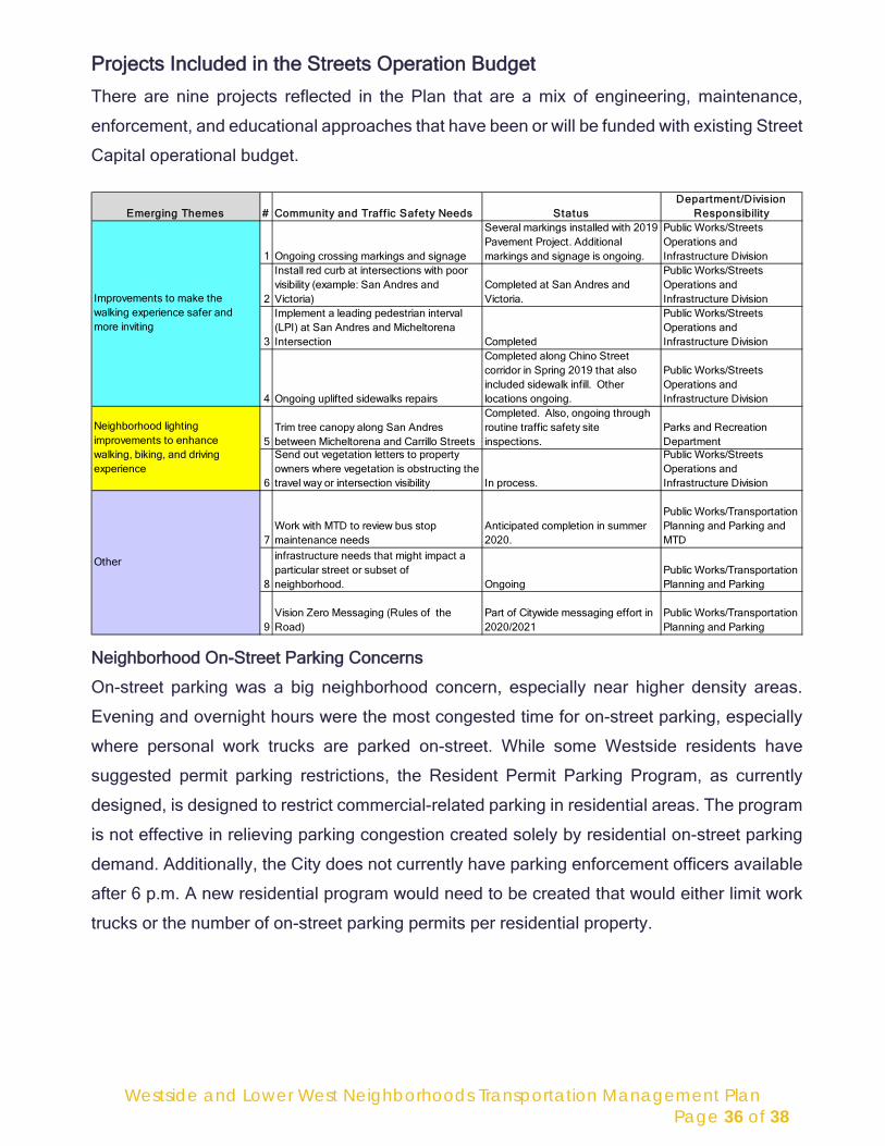
Projects Included in the Streets Operation Budget
There are nine projects reflected in the Plan that are a mix of engineering, maintenance,
enforcement, and educational approaches that have been or will be funded with existing Street
Capital operational budget.
Neighborhood On-Street Parking Concerns
On-street parking was a big neighborhood concern, especially near higher density areas.
Evening and overnight hours were the most congested time for on-street parking, especially
where personal work trucks are parked on-street. While some Westside residents have
suggested permit parking restrictions, the Resident Permit Parking Program, as currently
designed, is designed to restrict commercial-related parking in residential areas. The program
is not effective in relieving parking congestion created solely by residential on-street parking
demand. Additionally, the City does not currently have parking enforcement officers available
after 6 p.m. A new residential program would need to be created that would either limit work
trucks or the number of on-street parking permits per residential property.
Emerging Themes # Community and Traff ic Safety Needs StatusDepartment/Division
Responsibility
1 Ongoing crossing markings and signage
Several markings installed with 2019 Pavement Project. Additional markings and signage is ongoing.
Public Works/Streets Operations and Infrastructure Division
2
Install red curb at intersections with poor visibility (example: San Andres and Victoria)
Completed at San Andres and Victoria.
Public Works/Streets Operations and Infrastructure Division
3
Implement a leading pedestrian interval (LPI) at San Andres and Micheltorena Intersection Completed
Public Works/Streets Operations and Infrastructure Division
4 Ongoing uplifted sidewalks repairs
Completed along Chino Street corridor in Spring 2019 that also included sidewalk infill. Other locations ongoing.
Public Works/Streets Operations and Infrastructure Division
5Trim tree canopy along San Andres between Micheltorena and Carrillo Streets
Completed. Also, ongoing through routine traffic safety site inspections.
Parks and Recreation Department
6
Send out vegetation letters to property owners where vegetation is obstructing the travel way or intersection visibility In process.
Public Works/Streets Operations and Infrastructure Division
7Work with MTD to review bus stop maintenance needs
Anticipated completion in summer 2020.
Public Works/Transportation Planning and Parking and MTD
8
infrastructure needs that might impact a particular street or subset of neighborhood. Ongoing
Public Works/Transportation Planning and Parking
9Vision Zero Messaging (Rules of the Road)
Part of Citywide messaging effort in 2020/2021
Public Works/Transportation Planning and Parking
Improvements to make the walking experience safer and more inviting
Neighborhood lighting improvements to enhance walking, biking, and driving experience
Other

Westside and Lower West Neighborhoods Transportation Management Plan Page 37 of 38
Proposed Projects
The Plan recommends 11 new capital infrastructure projects to address the neighborhoods
emerging themes and are summarized below. These projects are currently unfunded.
Emerging Project
Strategies # Unfunded Projects
I temized Construct ion
CostEstimated Quantity Total Cost
Design (@ 25% of
construct ion cost)
Construct ion Management
(@ 25% of construct ion cost) Grand Total
1
Enhanced Intersections along San Andres Street: Install curb extensions, high visibility crosswalks, and rapid flashing beacons along San Andres Street at the following intersections: Valerio, Arrellaga, Micheltorena, Sola, Victoria, and Anapamu Streets. Install curb extensions at the San Andres / Canon Perdido intersection.Curb extensions cost $450,000 per intersection and Rapid Flashing Beacons cost $50,000 per intersection. 500,000 7 3,500,000 875,000 875,000 5,250,000
2
Enhanced Intersections along Chino Street: Install pedestrian refuge islands along four intersections along Chino Street at Arrellaga, Sola, Victoria and Anapamu Streets. Two pedestrian refuge islands would be installed per intersection. 40,000 4 160,000 40,000 40,000 240,000
3
Sidewalk Infill Along Valerio/Calle Canon to include 0.66 miles of sidewalk infill and 11 access ramps. Access ramps will be installed along both sides of West Valerio Street at the intersections of Hillside, Calle Boca Del Canon, Calle Cerrito, Calle Corte, Calle Canon, and Calle Poniente. Sidewalk will be installed along sections along West Valerio, west of Calle Canon to Elings Park, and from West Valerio to the existing asphalt path along the west side of Calle Canon. 600,000 150,000 150,000 900,000
4
Sidewalk Infill: Approximately 7,290 linear feet within the Westside neighborhood. (Ranges from $12/sq.ft. to $25/sq.ft. depending on utility, wall, topographical constraints and whether a retaining wall is required). For estimate purposed assuming $25/sq. ft. 25 7,290 182,250 45,563 45,563 273,375
5
Pedestrian Access Ramps. Install approximately 44 access ramps in the Westside neighborhood. Ramps range from $12,000 to $20,000 depending on radius and site constraints. For estimate purposes assuming $15k per access ramp. 15,000 44 660,000 165,000 165,000 990,000
6Install new SoCal Edison Streetlights on existing utility poles. Costs vary from $200-700 per light. For estimate purposes assuming $700 per light. 700 30 21,000 5,250 5,250 31,500
7
Install pedestrian scale lighting along San Andres. Lighting ranges from $3k-5k per light depending on a crosswalk/mid-block location. For estimate purposes assuming $5k. 5000 44 220,000 55,000 55,000 330,000
8
Bike lane striping to connect Westside and Lower West Neighborhoods along San Andres Street between Carrillo and Canon Perdido Streets. Parking would need to be removed along the west side of the side (approximately 10-12 spaces). 50,000 12,500 12,500 75,000
9Carrillo Multiuse Path from Mercedes to San Andres. Install an approximate 300- linear -foot multiuse path along Carrillo Street. 25 3,235 80,875 20,219 20,219 121,313
10
Lower Westside Bicycle Boulevard. A bicycle boulevard would be installed along Canon Perdido Street between San Andres and Wentworth Streets, along Wentworth between Canon Perdido and Coronel, along Coronel between Wentworth and Rancheria, and along Rancheria from Coronel to Montecito Street. Standard signing and striping would only be involved. 25,000 6,250 6,250 37,500
11
Separated Bike Path along Modoc Road between Las Positas and Mission Streets and a Multiuse Path along Portesullo between Modoc and Gillespie. Project likely to range from $3-5million. For estimating purposes asssuming $5 million. 5,000,000 1,250,000 1,250,000 7,500,000
Grand Total 15,748,688$
Neighborhood lighting improvements to enhance walking, biking, and driving experience
Bicycle Improvements to Promote Safe Routes to School and Work and Close Gaps in the Bicycle Facility Network
Improvements to make the walking experience safer and more inviting

Westside and Lower West Neighborhoods Transportation Management Plan Page 38 of 38
Attachments
1. Survey Questions 2. Plan Consistency with Transportation Policies and Strategies

Survey for Santa Barbara Westside Residents - Pedestrian & Traffic Safety
The survey questionnaire for residents of the Westside and Lower West Neighborhoods of Santa Barbara is presented by the City of Santa Barbara Public Works Department.
This is a survey for people who live in the Westside and Lower West Neighborhoods of the City of Santa Barbara, in the area indicated by the map shown below. Your thoughts and opinions are important to us and will help make improvements to your neighborhood related to pedestrian, bicycle, and traffic safety.
Please complete the following questionnaire by June 30, 2019. Thank you.
1
ATTACHMENT 1 - SURVEY QUESTIONS

Westside Map
1. Do you live within the Westside or Lower West Neighborhoods indicated on the map above? (chooseone response)
Yes
No
2. Please write the name of the street intersection nearest to where you live. Or write your residenceaddress if you prefer. (ex. “Chino Street and Sola Street” , “___________ and ___________” )
3. What is your gender? (choose one response)
Male
Female
2

4. What is your age? (choose one response)
Under 18
19-25 years
26-34 years
35-44 years
45-55 years
56-65 years
65+ years
5. What is your race? (choose one response)
Asian / Pacific Islander
Black or African American
Hispanic or Latino
Native American
White
Other
6. Including yourself, how many people live within your household? (choose one response)
1 person
2 persons
3 persons
4 persons
5 persons
6 persons
7 persons
8 persons
9 persons
10 or more persons
7. Do you have school-age children living at home?(circle all that apply)
Yes, I have one or more Preschool age
Yes, I have one or more Elementary age
Yes, I have one or more Junior High age
Yes, I have one or more High School age
Yes, I have one or more College age
No, I have no school age children living at home.
3

8. What is the primary form of transportation your student(s) normally takes to get to and from school? (choose one response)
Walking
Bicycle
Bus
Car/Van/Truck
Other
9. What do you like best about living in your neighborhood? (please answer using no more than 50 words)
10. What do you like SECOND best about living in your neighborhood? (please answer using no more than50 words)
11. What do you believe is the biggest challenge facing people who live in the Westside or Lower WestNeighborhoods? (choose one response)
Crime
Drugs
Traffic
Housing
Jobs and the economy
Environmental issues
Other (please specify)
4

12. What do you believe is the SECOND biggest challenge facing people who live in the Westside or LowerWest Neighborhoods? (choose one response)
Crime
Drugs
Traffic
Housing
Jobs and the economy
Environmental issues
Other (please specify)
Number of days
Walk one block or more
Bicycle
Ride the bus
Drive a car or truck
Carpool/Vanpool
13. Please indicate the number days per week that you use each of the following modes of transportation:
Next, here are some statements people have made about traffic and pedestrian safety in the Westside and Lower WestNeighborhoods. Please indicate if you agree or disagree with each statement.
14. “Motorists need to do a better job of sharing the road with pedestrians and bicyclists.”
Strongly Agree
Somewhat Agree
Neutral/No opinion
Somewhat Disagree
Strongly Disagree
5

15. “Pedestrians often do not look for oncoming traffic when crossing the street.”
Strongly Agree
Somewhat Agree
Neutral/No opinion
Somewhat Disagree
Strongly Disagree
16. “Bicyclists often ignore traffic signals such as stop signs and stoplights.”
Strongly Agree
Somewhat Agree
Neutral/No opinion
Somewhat Disagree
Strongly Disagree
17. “I would walk more in my neighborhood if improvements were implemented such as better lighting,sidewalks and access ramps.”
Strongly Agree
Somewhat Agree
Neutral/No opinion
Somewhat Disagree
Strongly Disagree
18. “It is difficult to find street parking in my neighborhood.”
Strongly Agree
Somewhat Agree
Neutral/No opinion
Somewhat Disagree
Strongly Disagree
6

19. “Finding on street parking in my neighborhood is MORE difficult than it used to be.”
Strongly Agree
Somewhat Agree
Neutral/No opinion
Somewhat Disagree
Strongly Disagree
20. What factor concerns you most when walking across streets in your neighborhood? (choose oneresponse)
Width of the street
The “walk” signal not providing enough time
Parked vehicles obstructing the view
Curb wheelchair access ramps
Vehicle traffic not stopping for pedestrians
I have no concerns when walking across the street in my neighborhood
Other (please specify)
21. What factor concerns you most when riding a bicycle? (choose one response)
Sharing the road with motor vehicles
Lack of bike lanes
Lack of secure places to park/store my bike
I do not ride a bicycle.
Other (please specify)
22. Have you ever visited or called the City of Santa Barbara Public Works Department to ask a question orexpress a concern? (choose one response)
Yes, more than once
Yes, one time
No, never
7

1 2 3 4 5 6 7 8 9 10
23. On a scale of 1-10, with 10 being the best, please rate how well the City of Santa Barbara Public WorksDepartment listens to the people living in your neighborhood?
THANK YOU!
If you have any additional feedback or questions, please contact Jessica W. Grant,Supervising Transportation Planner by phone: 805-897-2542 or via email:[email protected].
8

Westside and Lower West Neighborhood Transportation Management Plan (Plan)
Policy Consistency Analysis
Below are the applicable policy/planning documents that the Plan is consistent with:
Vision Zero Strategy – Core Principles
1. Life is Most Important. The protection of human life and health is the overriding goalof traffic planning and engineering, taking priority over vehicle speeds and otherobjectives.
2. Every Person Matters. Everyone has the right to be safe on our streets, regardless ofthe way they choose to travel.
3. People Make Mistakes. In order to prevent and reduce death and serious injury, trafficsystems can and should be designed to account for the inevitability of human error.
4. Focus on Dangerous Locations and Behaviors. City engineering and enforcementefforts will be informed by accurate and timely collision data and focus first on the mostproblematic locations, collision types, and behaviors.
5. Drivers Have a Critical Responsibility. When we drive, we control a machine that caninflict a great deal of physical harm. As drivers, we have a critical responsibility for thesafety of others. We can be acting criminally when we drive and park in ways that putothers at risk.
6. Pedestrians and Cyclists are the Most Vulnerable Road Users. Because they havethe most to lose, pedestrians and cyclists need to abide by the laws in place to keepthem safe.
7. The Government Shares Responsibility for Safe Streets. All elected officials andappropriate government staff will need to collaborate and act to achieve Vision Zero.
General Plan Circulation Element Goals (1997 and 2011)
Goal 2 STRIVE TO ACHIEVE EQUALITY OF CONVENIENCE AND CHOICE AMONG ALL MODES OF TRANSPORTATION
Emphasize alternative modes in order to provide real options and opportunities for people to choose among different forms of transportation rather than relying exclusively on the automobile.
Goal 4 INCREASE BICYCLING AS A TRANSPORTATION MODE
Develop a comprehensive system of bicycle routes which are integrated with other modes of transportation and which provide safe and efficient bikeways.
ATTACHMENT 2
Page 1

Westside and Lower West Neighborhood Transportation Management Plan
Policy Consistency Analysis
Goal 5 INCREASE WALKING AND OTHER PATHS OF TRAVEL
Develop a comprehensive system of pedestrian routes which are integrated with other modes of transportation and which provide safe and efficient paths of travel.
Pedestrian Master Plan Goals, Policies, and Strategies (2006)
GOAL 1 Improve the pedestrian system to increase walking in Santa Barbara
Policy 1.1 The City shall expand the sidewalk network to increase walking for transportation and recreation
Policy 1.2 The City shall improve pedestrian safety and comfort at intersections
Policy 1.3 The City shall enhance pedestrian corridors
Policy 1.5 The City shall assist neighborhoods that desire to improve pedestrian access to, from, and within their neighborhood
Policy 1.9 The City shall work to make the pedestrian environment accessible to those with disabilities, children, and the elderly
GOAL 2 Establish and enhance routes to schools that will enable and encourage more students to safely walk to school
GOAL 4 Create public pedestrian environments that are attractive, functional, and accessible to all people
Bicycle Master Plan Goals and Policies (2016)
Goal 1. Safety for All Road Users:
Make Santa Barbara a safe place for all road users through coordinated efforts to educate community members, enforce rules of the road, and strategically address unsafe conditions.
Policy 1.1 The City shall integrate the safety needs of people bicycling into all City roadway projects.
Goal 2. Closing Gaps in the Network
Make bicycling an accessible and convenient mode of transportation by developing a continuous network of safe bikeways that connects neighborhoods and destinations.
Page 2

Westside and Lower West Neighborhood Transportation Management Plan
Policy Consistency Analysis
Policy 2.1 Through implementation of the Bicycle Master Plan, the City shall expand the bikeway network and close gaps in the existing system.
Policy 2.2 The City shall seek and allocate adequate funding to enhance the bicycle network.
Goal 3. Complete Streets and Multimodal Access
Create a more integrated multi-modal transportation system to connect people, places, goods, and services. Make bicycling in Santa Barbara an attractive and convenient choice, through inter-modal connectivity and support facilities that encourage bicycling.
Policy 3.5 The City shall ensure equitable access to the bikeway network for all Santa Barbara residents, and support bicycling as an attractive, convenient transportation choice forall demographic groups.
Page 3