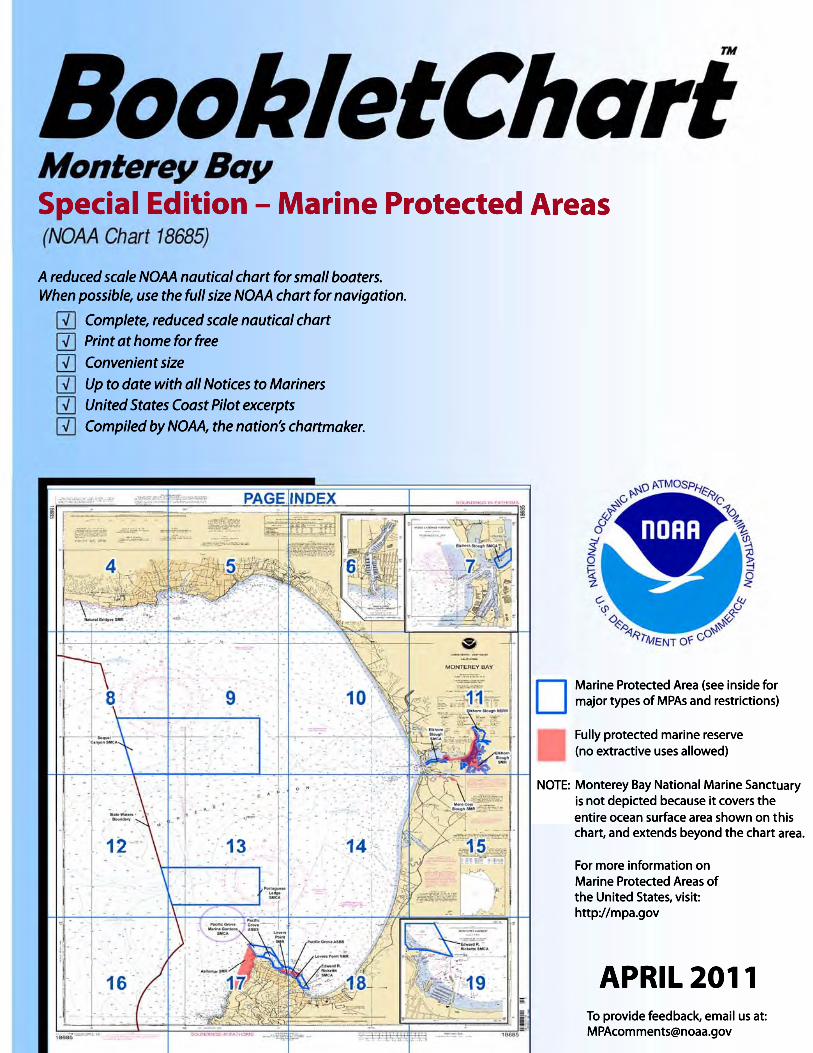
what are nautical charts?
TRANSCRIPT
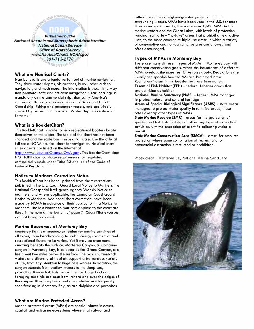
What are Nautical Charts? Nautical charts are a fundamental tool of marine navigation. They show water depths, obstructions, buoys, other aids to navigation, and much more. The information is shown in a way that promotes safe and efficient navigation. Chart carriage is mandatory on the commercial ships that carry America’s commerce. They are also used on every Navy and Coast Guard ship, fishing and passenger vessels, and are widely carried by recreational boaters. Water depths are shown in fathoms What is a BookletChart? This BookletChart is made to help recreational boaters locate themselves on the water. The scale of the chart has not been changed and the scale bar is in original scale. Use the official, full scale NOAA nautical chart for navigation. Nautical chart sales agents are listed on the Internet at http://www.NauticalCharts.NOAA.gov . This BookletChart does NOT fulfill chart carriage requirements for regulated commercial vessels under Titles 33 and 44 of the Code of Federal Regulations. Notice to Mariners Correction Status This BookletChart has been updated from chart corrections published in the U.S. Coast Guard Local Notice to Mariners, the National Geospatial Intelligence Agency Weekly Notice to Mariners, and where applicable, the Canadian Coast Guard Notice to Mariners. Additional chart corrections have been made by NOAA in advance of their publication in a Notice to Mariners. The last Notices to Mariners applied to this chart are listed in the note at the bottom of page 7. Coast Pilot excerpts are not being corrected. Marine Resources of Monterey Bay Monterey Bay is a spectacular setting for marine activities of all types, from beachcombing to scuba diving; commercial and recreational fishing to kayaking. Yet it may be even more amazing beneath the surface. Monterey Canyon, a submarine canyon in Monterey Bay, is as deep as the Grand Canyon, and lies about two miles below the surface. The bay’s nutrient-rich waters and diversity of habitats support a tremendous variety of life, from tiny plankton to huge blue whales. In addition, the canyon extends from shallow waters to the deep sea, providing diverse habitats for marine life. Huge flocks of foraging seabirds are seen both inshore and over the edges of the canyon. Blue, humpback and gray whales are frequently seen feeding in Monterey Bay, as are dolphins and porpoises. What are Marine Protected Areas? Marine protected areas (MPAs) are special places in ocean, coastal, and estuarine ecosystems where vital natural and
cultural resources are given greater protection than in surrounding waters. MPAs have been used in the U.S. for more than a century. Currently, there are over 1,600 MPAs in U.S. marine waters and the Great Lakes, with levels of protection ranging from a few “no-take” areas that prohibit all extractive uses, to the more common multiple use areas in which a variety of consumptive and non-consumptive uses are allowed and often encouraged. Types of MPAs in Monterey Bay There are many different types of MPAs in Monterey Bay with different conservation goals. When the boundaries of different MPAs overlap, the more restrictive rules apply. Regulations are usually site specific. See the “Marine Protected Area Restrictions” chart in this booklet for more information. Essential Fish Habitat (EFH) – federal fisheries areas that protect fisheries habitat National Marine Sanctuary (NMS) – federal MPA managed to protect natural and cultural heritage Areas of Special Biological Significance (ASBS) – state areas managed to protect water quality in sensitive areas; these often overlap other types of MPAs. State Marine Reserve (SMR) - areas for the protection of species and habitats that do not allow any type of extractive activities, with the exception of scientific collecting under a permit State Marine Conservation Area (SMCA) – areas for resource protection where some combination of recreational or commercial extraction is restricted or prohibited. Photo credit: Monterey Bay National Marine Sanctuary

Definitions Natural Heritage: MPAs or zones established and managed to sustain, conserve, restore, and understand the protected area’s natural biodiversity, habitats, and ecosystems. Sustainable Production: MPAs or zones established and managed to support the continued extraction of renewable living resources (fish, shellfish, plants, etc) that live within the MPA, or that are exploited elsewhere but depend upon the protected area’s habitat for essential aspects of their ecology or life history. Uniform Multiple Use: MPAs or zones with a consistent level of protection and allowable activities, including certain extractive uses, across the entire protected area. No-Take: MPAs or zones that totally prohibit the extraction or significant destruction of natural or cultural resource. Coast Pilot 7, Chapter 6 Excerpts From Cypress Point to Point Pinos, the coast trends NE for 4 miles. Numerous small rocks and ledges closely border the shoreline. The land is low, with the height of the cliff decreasing toward Point Joe, a rocky extension of the shoreline where the surf breaks heavily. From this point to Point Pinos, white sand dunes are conspicuous against the dark trees behind them, even in moonlight. Point Pinos, on the S side of Monterey Bay, is low, rocky, and rounding with visible rocks extending offshore for less than 0.3 mile. The point is bare for about 0.2 mile back from the beach, and beyond that is covered with pines. Point Pinos Light (36°38.0'N., 121°56.0'W.), 89 feet above the water, is shown from a 43-foot white tower on a dwelling near the N end of the point. A lighted bell buoy is about 0.7 mile off the point. Monterey Bay, between Point Pinos and Point Santa Cruz, is a broad 20-mile-wide open roadstead. The shores are low with sand beaches backed by dunes or low sandy bluffs. Salinas Valley, the lowland extending E from about the middle of the bay, is prominent from seaward as it forms the break between the Santa Lucia Range S and the high land of the Santa Cruz Mountains N. The bay is free of dangers, the 10-fathom curve lying at an average distance of 0.7 mile offshore. The submarine Monterey Canyon heads near the middle of the bay with a depth of over 50 fathoms about 0.5 mile from the beach near Moss Landing. Shelter from NW winds is afforded at Santa Cruz Anchorage and Soquel Cove, off the N shore of the bay, and from SW winds at Monterey Harbor, off the S shore. The tidal currents are reported to be generally weak except at the Deep-draft Mooring Facility about 0.8 mile NW from Moss Landing harbor entrance. Monterey Harbor, 3 miles SE of Point Pinos, is a compact resort harbor with some commercial activity and fishing. The harbor can accommodate over 800 vessels. Depths of more than 20 feet are available in the outer harbor and entrance, and 10 to 6 feet in the small-boat basin. There are many sport-fishing landings, and the small-craft basin provides good shelter for over 500 boats. There are four public launch ramps available in the harbor. The municipal marina has transient berths available and can provide electricity, pump-out, ice, and marine supplies; a 3-ton and 70-ton lift is available for hull,
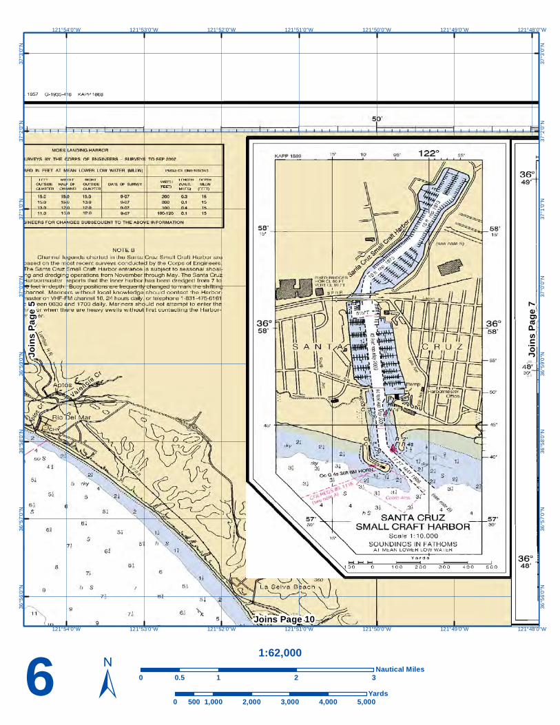
Photo credit: Monterey Bay National Marine Sanctuary engine, and electrical repairs. The marina monitors VHF-FM channels 16 and 5. The boat yard, located just inside the breakwater has a 70-ton travel lift. Moss Landing Harbor, on the E shore of Monterey Bay 12.5 miles NE of Point Pinos and Just N of the small town of Moss Landing, is a good harbor of refuge. The harbor is used by pleasure craft and a fishing fleet of about 300 boats. The harbor has 500 berths. Soquel Cove is in the NE part of Monterey Bay, E of Santa Cruz Anchorage. Fair shelter is afforded in NW weather, but the cove is open to S weather. The best anchorage is SE of the mouth of Soquel Creek in 5 to 6 fathoms, sandy bottom. At Seacliff Beach, 0.5 mile W of Aptos Creek, a concrete ship has been beached and filled with sand. The pleasure pier for sport fishing extends from ship to the shore. A small fishing and pleasure wharf at Capitola, on the NW side of Soquel Cove, has 11 feet alongside the landing at the outer end. There are facilities to hoist out small boats. Houses on the bluffs about 1.5 miles E of Capitola are prominent. Three radio towers 0.6 mile NW of Soquel Point are conspicuous from the E and S. Point Santa Cruz, 20 miles N of Point Pinos and 2.5 miles W of Soquel Point, consists of cliff heads about 40feet above the water. The area back of the point is flat, but rises in terraces to higher land. There are two flat rocks close under the point; the outer one is the higher. Santa Cruz Light (36°57'05"N., 122°01'36"W.), 60 feet above the water, is shown from a 39-foot white lantern house on a square brick tower attached to a brick building near the S extremity of the point. A lighted whistle buoy is 1.1 miles SE of the light. The city of Santa Cruz is on the NW shore of the bay. Seabright, Twin Lakes, and Soquel, suburbs of Santa Cruz, are along the beach to the E. Santa Cruz Anchorage, on the NW shore of Monterey Bay between Point Santa Cruz and Soquel Point, has a municipal pier and small-craft harbor. The Santa Cruz small-craft harbor is just E of Seabright and has slips and end-ties for about 1,200 small craft.

Natural Bridges SMR
122°1'0"W
122°1'0"W
122°2'0"W
122°2'0"W
122°3'0"W
122°3'0"W
122°4'0"W
122°4'0"W
122°5'0"W
122°5'0"W
122°6'0"W
122°6'0"W
122°7'0"W
122°7'0"W
37°3
'0"N
37°3
'0"N
37°2
'0"N
37°2
'0"N
37°1
'0"N
37°1
'0"N
37°0
'0"N
37°0
'0"N
36°5
9'0"
N
36°5
9'0"
N
36°5
8'0"
N
36°5
8'0"
N
36°5
7'0"
N
36°5
7'0"
N
36°5
6'0"
N
36°5
6'0"
N
4 ±1:62,000
0 1 2 30.5Nautical Miles
0 1,000 2,000 3,000 4,000 5,000500Yards
Joins
Pag
e 5
Joins Page 8

121°55'0"W
121°55'0"W
121°56'0"W
121°56'0"W
121°57'0"W
121°57'0"W
121°58'0"W
121°58'0"W
121°59'0"W
121°59'0"W
122°0'0"W
122°0'0"W
122°1'0"W
122°1'0"W
37°3
'0"N
37°3
'0"N
37°2
'0"N
37°2
'0"N
37°1
'0"N
37°1
'0"N
37°0
'0"N
37°0
'0"N
36°5
9'0"
N
36°5
9'0"
N
36°5
8'0"
N
36°5
8'0"
N
36°5
7'0"
N
36°5
7'0"
N
36°5
6'0"
N
36°5
6'0"
N
5 ±1:62,000
0 1 2 30.5Nautical Miles
0 1,000 2,000 3,000 4,000 5,000500Yards
Joins
Pag
e 6
Joins Page 9
Joins
Pag
e 4
121°48'0"W
121°48'0"W
121°49'0"W
121°49'0"W
121°50'0"W
121°50'0"W
121°51'0"W
121°51'0"W
121°52'0"W
121°52'0"W
121°53'0"W
121°53'0"W
121°54'0"W
121°54'0"W
37°3
'0"N
37°3
'0"N
37°2
'0"N
37°2
'0"N
37°1
'0"N
37°1
'0"N
37°0
'0"N
37°0
'0"N
36°5
9'0"
N
36°5
9'0"
N
36°5
8'0"
N
36°5
8'0"
N
36°5
7'0"
N
36°5
7'0"
N
36°5
6'0"
N
36°5
6'0"
N
6 ±1:62,000
0 1 2 30.5Nautical Miles
0 1,000 2,000 3,000 4,000 5,000500Yards
Joins
Pag
e 7
Joins Page 10
Joins
Pag
e 5

121°42'0"W
121°42'0"W
121°43'0"W
121°43'0"W
121°44'0"W
121°44'0"W
121°45'0"W
121°45'0"W
121°46'0"W
121°46'0"W
121°47'0"W
121°47'0"W
121°48'0"W
121°48'0"W
37°3
'0"N
37°3
'0"N
37°2
'0"N
37°2
'0"N
37°1
'0"N
37°1
'0"N
37°0
'0"N
37°0
'0"N
36°5
9'0"
N
36°5
9'0"
N
36°5
8'0"
N
36°5
8'0"
N
36°5
7'0"
N
36°5
7'0"
N
36°5
6'0"
N
36°5
6'0"
N
Elkhorn Slough SMCA
7 ±1:62,000
0 1 2 30.5Nautical Miles
0 1,000 2,000 3,000 4,000 5,000500Yards
Joins Page 11
Joins
Pag
e 6

SoquelCanyon SMCA
122°1'0"W
122°1'0"W
122°2'0"W
122°2'0"W
122°3'0"W
122°3'0"W
122°4'0"W
122°4'0"W
122°5'0"W
122°5'0"W
122°6'0"W
122°6'0"W
122°7'0"W
122°7'0"W
36°5
5'0"
N
36°5
5'0"
N
36°5
4'0"
N
36°5
4'0"
N
36°5
3'0"
N
36°5
3'0"
N
36°5
2'0"
N
36°5
2'0"
N
36°5
1'0"
N
36°5
1'0"
N
36°5
0'0"
N
36°5
0'0"
N
36°4
9'0"
N
36°4
9'0"
N
36°4
8'0"
N
8 ±1:62,000
0 1 2 30.5Nautical Miles
0 1,000 2,000 3,000 4,000 5,000500Yards
Joins Page 12
Joins
Pag
e 9
Joins Page 4

SoquelCanyon SMCA
121°55'0"W
121°55'0"W
121°56'0"W
121°56'0"W
121°57'0"W
121°57'0"W
121°58'0"W
121°58'0"W
121°59'0"W
121°59'0"W
122°0'0"W
122°0'0"W
122°1'0"W
122°1'0"W
36°5
5'0"
N
36°5
5'0"
N
36°5
4'0"
N
36°5
4'0"
N
36°5
3'0"
N
36°5
3'0"
N
36°5
2'0"
N
36°5
2'0"
N
36°5
1'0"
N
36°5
1'0"
N
36°5
0'0"
N
36°5
0'0"
N
36°4
9'0"
N
36°4
9'0"
N36
°48'
0"N
9 ±1:62,000
0 1 2 30.5Nautical Miles
0 1,000 2,000 3,000 4,000 5,000500Yards
Joins Page 13
Joins
Pag
e 10
Joins Page 5Jo
ins P
age 8

121°48'0"W
121°48'0"W
121°49'0"W
121°49'0"W
121°50'0"W
121°50'0"W
121°51'0"W
121°51'0"W
121°52'0"W
121°52'0"W
121°53'0"W
121°53'0"W
121°54'0"W
121°54'0"W
36°5
5'0"
N
36°5
5'0"
N
36°5
4'0"
N
36°5
4'0"
N
36°5
3'0"
N
36°5
3'0"
N
36°5
2'0"
N
36°5
2'0"
N
36°5
1'0"
N
36°5
1'0"
N
36°5
0'0"
N
36°5
0'0"
N
36°4
9'0"
N
36°4
9'0"
N
36°4
8'0"
N
10 ±1:62,000
0 1 2 30.5Nautical Miles
0 1,000 2,000 3,000 4,000 5,000500Yards
Joins Page 14
Joins
Pag
e 11
Joins Page 6Jo
ins P
age 9

ElkhornSloughSMCA
ElkhornSlough
SMR
Elkhorn Slough NERR
121°42'0"W
121°42'0"W
121°43'0"W
121°43'0"W
121°44'0"W
121°44'0"W
121°45'0"W
121°45'0"W
121°46'0"W
121°46'0"W
121°47'0"W
121°47'0"W
121°48'0"W
121°48'0"W
36°5
5'0"
N
36°5
5'0"
N
36°5
4'0"
N
36°5
4'0"
N
36°5
3'0"
N
36°5
3'0"
N
36°5
2'0"
N
36°5
2'0"
N
36°5
1'0"
N
36°5
1'0"
N
36°5
0'0"
N
36°5
0'0"
N
36°4
9'0"
N
36°4
9'0"
N36
°48'
0"N
11 ±1:62,000
0 1 2 30.5Nautical Miles
0 1,000 2,000 3,000 4,000 5,000500Yards
Joins Page 15
Joins Page 7Jo
ins P
age 1
0

PortugueseLedgeSMCA
122°1'0"W
122°1'0"W
122°2'0"W
122°2'0"W
122°3'0"W
122°3'0"W
122°4'0"W
122°4'0"W
122°5'0"W
122°5'0"W
122°6'0"W
122°6'0"W
122°7'0"W
122°7'0"W
36°4
7'0"
N
36°4
7'0"
N
36°4
6'0"
N
36°4
6'0"
N
36°4
5'0"
N
36°4
5'0"
N
36°4
4'0"
N
36°4
4'0"
N
36°4
3'0"
N
36°4
3'0"
N
36°4
2'0"
N
36°4
2'0"
N
36°4
1'0"
N
36°4
1'0"
N
12 ±1:62,000
0 1 2 30.5Nautical Miles
0 1,000 2,000 3,000 4,000 5,000500Yards
Joins Page 16
Joins
Pag
e 13
Joins Page 8

PortugueseLedgeSMCA
121°55'0"W
121°55'0"W
121°56'0"W
121°56'0"W
121°57'0"W
121°57'0"W
121°58'0"W
121°58'0"W
121°59'0"W
121°59'0"W
122°0'0"W
122°0'0"W
122°1'0"W
122°1'0"W
36°4
7'0"
N
36°4
7'0"
N
36°4
6'0"
N
36°4
6'0"
N
36°4
5'0"
N
36°4
5'0"
N
36°4
4'0"
N
36°4
4'0"
N
36°4
3'0"
N
36°4
3'0"
N
36°4
2'0"
N
36°4
2'0"
N
36°4
1'0"
N
36°4
1'0"
N
13 ±1:62,000
0 1 2 30.5Nautical Miles
0 1,000 2,000 3,000 4,000 5,000500Yards
Joins Page 17
Joins
Pag
e 14
Joins Page 9Jo
ins P
age 1
2

PortugueseLedgeSMCA
121°48'0"W
121°48'0"W
121°49'0"W
121°49'0"W
121°50'0"W
121°50'0"W
121°51'0"W
121°51'0"W
121°52'0"W
121°52'0"W
121°53'0"W
121°53'0"W
121°54'0"W
121°54'0"W
36°4
7'0"
N
36°4
7'0"
N
36°4
6'0"
N
36°4
6'0"
N
36°4
5'0"
N
36°4
5'0"
N
36°4
4'0"
N
36°4
4'0"
N
36°4
3'0"
N
36°4
3'0"
N
36°4
2'0"
N
36°4
2'0"
N
36°4
1'0"
N
36°4
1'0"
N
14 ±1:62,000
0 1 2 30.5Nautical Miles
0 1,000 2,000 3,000 4,000 5,000500Yards
Joins Page 18
Joins
Pag
e 15
Joins Page 10Jo
ins P
age 1
3

Moro CojoSlough SMR
121°42'0"W
121°42'0"W
121°43'0"W
121°43'0"W
121°44'0"W
121°44'0"W
121°45'0"W
121°45'0"W
121°46'0"W
121°46'0"W
121°47'0"W
121°47'0"W
121°48'0"W
121°48'0"W
36°4
7'0"
N
36°4
7'0"
N
36°4
6'0"
N
36°4
6'0"
N
36°4
5'0"
N
36°4
5'0"
N
36°4
4'0"
N
36°4
4'0"
N
36°4
3'0"
N
36°4
3'0"
N
36°4
2'0"
N
36°4
2'0"
N
36°4
1'0"
N
36°4
1'0"
N
15 ±1:62,000
0 1 2 30.5Nautical Miles
0 1,000 2,000 3,000 4,000 5,000500Yards
Joins Page 19
Joins Page 11Jo
ins P
age 1
4
122°1'0"W
122°1'0"W
122°2'0"W
122°2'0"W
122°3'0"W
122°3'0"W
122°4'0"W
122°4'0"W
122°5'0"W
122°5'0"W
122°6'0"W
122°6'0"W
122°7'0"W
122°7'0"W
36°4
0'0"
N
36°4
0'0"
N
36°3
9'0"
N
36°3
9'0"
N
36°3
8'0"
N
36°3
8'0"
N
36°3
7'0"
N
36°3
7'0"
N
36°3
6'0"
N
36°3
6'0"
N
36°3
5'0"
N
36°3
5'0"
N
36°3
4'0"
N
36°3
4'0"
N
36°3
3'0"
N
36°3
3'0"
N
16 ±1:62,000
0 1 2 30.5Nautical Miles
0 1,000 2,000 3,000 4,000 5,000500Yards
Joins
Pag
e 17
Joins Page 12

Asilomar SMR
LoversPointSMR
PacificGroveASBS
Pacific GroveMarine Gardens
SMCA
121°55'0"W
121°55'0"W
121°56'0"W
121°56'0"W
121°57'0"W
121°57'0"W
121°58'0"W
121°58'0"W
121°59'0"W
121°59'0"W
122°0'0"W
122°0'0"W
122°1'0"W
122°1'0"W
36°4
0'0"
N
36°4
0'0"
N
36°3
9'0"
N
36°3
9'0"
N
36°3
8'0"
N
36°3
8'0"
N
36°3
7'0"
N
36°3
7'0"
N
36°3
6'0"
N
36°3
6'0"
N
36°3
5'0"
N
36°3
5'0"
N
36°3
4'0"
N
36°3
4'0"
N
36°3
3'0"
N
36°3
3'0"
N
17 ±1:62,000
0 1 2 30.5Nautical Miles
0 1,000 2,000 3,000 4,000 5,000500Yards
Joins
Pag
e 18
Joins Page 13Jo
ins P
age 1
6

Edward R.RickettsSMCA
Lovers Point SMR
Pacific Grove ASBS
121°48'0"W
121°48'0"W
121°49'0"W
121°49'0"W
121°50'0"W
121°50'0"W
121°51'0"W
121°51'0"W
121°52'0"W
121°52'0"W
121°53'0"W
121°53'0"W
121°54'0"W
121°54'0"W
36°4
0'0"
N
36°4
0'0"
N
36°3
9'0"
N
36°3
9'0"
N
36°3
8'0"
N
36°3
8'0"
N
36°3
7'0"
N
36°3
7'0"
N
36°3
6'0"
N
36°3
6'0"
N
36°3
5'0"
N
36°3
5'0"
N
36°3
4'0"
N
36°3
4'0"
N
36°3
3'0"
N
36°3
3'0"
N
18 ±1:62,000
0 1 2 30.5Nautical Miles
0 1,000 2,000 3,000 4,000 5,000500Yards
Joins
Pag
e 19
Joins Page 14Jo
ins P
age 1
7
121°42'0"W
121°42'0"W
121°43'0"W
121°43'0"W
121°44'0"W
121°44'0"W
121°45'0"W
121°45'0"W
121°46'0"W
121°46'0"W
121°47'0"W
121°47'0"W
121°48'0"W
121°48'0"W
36°4
0'0"
N
36°4
0'0"
N
36°3
9'0"
N
36°3
9'0"
N
36°3
8'0"
N
36°3
8'0"
N
36°3
7'0"
N
36°3
7'0"
N
36°3
6'0"
N
36°3
6'0"
N
36°3
5'0"
N
36°3
5'0"
N
36°3
4'0"
N
36°3
4'0"
N
36°3
3'0"
N
36°3
3'0"
N
Edward R.Ricketts SMCA
19 ±1:62,000
0 1 2 30.5Nautical Miles
0 1,000 2,000 3,000 4,000 5,000500Yards
Joins Page 15Jo
ins P
age 1
8
National Marine Fisheries Service Protected AreasMonterey Bay/Canyon Essential Fish Habitat Conservation Area
Essential Fish Habitat Conservation Area (Seaward of the 700-fm (1280-m) contour)
20 ±1:7,500,000
0 80 160 24040Nautical Miles

Marine Protected Areas within Monterey Bay
*Seaward of the 700-fm (1,280m) contour. ** See map 20 for federal fisheries MPAs.
Photo credit: Monterey Bay National Marine Sanctuary
Site Name Level of Protection
Primary Conservation Focus Fishing Restrictions Management Agency
Marine Area (sq km)
Asilomar State Marine Reserve No Take Natural Heritage
Commercial and Recreational Prohibited
California Department of Fish and Game 4
Edward F. Ricketts State Marine Conservation Area
Uniform Multiple Use Natural Heritage
Commercial and Recreational Restricted
California Department of Fish and Game 1
Elkhorn Slough National Estuarine Research Reserve
Uniform Multiple Use Natural Heritage No Restrictions
California Department of Fish and Game 3
Elkhorn Slough State Marine Conservation Area
Uniform Multiple Use Natural Heritage Commercial Prohibited
California Department of Fish and Game <1
Elkhorn Slough State Marine Reserve No Take Natural Heritage
Commercial and Recreational Prohibited
California Department of Fish and Game 4
Essential Fish Habitat Conservation Area*
Uniform Multiple Use
Sustainable Production Commercial Restricted
National Marine Fisheries service 337,216
Lovers Point State Marine Reserve No Take Natural Heritage
Commercial and Recreational Prohibited
California Department of Fish and Game 1
Monterey Bay National Marine Sanctuary
Zoned Multiple Use Natural Heritage No Restrictions
California Department of Fish and Game 15,783
Monterey Bay/ Canyon Essential Fish Habitat Conservation Area**
Uniform Multiple Use
Sustainable Production Commercial Restricted
National Marine Fisheries Service 2,158
Moro Cojo Slough State Marine Reserve No Take Natural Heritage
Commercial and Recreational Prohibited
California Department of Fish and Game <1
Natural Bridges State Marine Reserve No Take Natural Heritage
Commercial and Recreational Prohibited
California Department of Fish and Game 1
Pacific Grove Area of Special Biological Significance State Water Quality Protection Area
Uniform Multiple Use Natural Heritage No Restrictions
California State Water Resources Control Board 2
Portuguese Ledge State Marine Conservation Area
Uniform Multiple Use Natural Heritage
Commercial and Recreational Restricted
California Department of Fish and Game 28
Soquel Canyon State Marine Conservation Area
Uniform Multiple Use Natural Heritage
Commercial and Recreational Restricted
California Department of Fish and Game 60

Marine Protected Area Restrictions
4,5,6,8,9,10,11,12,13,14,15,16,17,18, 19
Monterey Bay National Marine Sanctuary
Exploring for, developing or producing oil, gas or minerals is prohibited. • Except loose jade may be collected along Big Sur from the south end of Sand
Dollar Beach to cape San Martin between mean high tide and a depth of 90 feet.
Drilling, dredging or altering submerged lands; or placing or abandoning structures or matter on or near submerged lands is prohibited.
• Except as is incidental and necessary to anchoring, aquaculture, kelp harvesting, lawful fishing, jade collecting, installing authorized navigation aids, dock/ pier construction or authorized harbor maintenance.
Operating motorized watercraft is prohibited. • Except within the five designated zones and access routes. Operation in Zone
5 at Pilar Point is allowed only when High Surf Warning is in effect for San Mateo County in December, January or February.
Other prohibited activities include: • Discharging or depositing any material or matter within or into the sanctuary
(e.g. pollutants, trash, objects, etc), or from outside the boundaries if it subsequently enters and injures the sanctuary
• Taking, disturbing, injuring or possessing any sanctuary resource below 3,000 feet within the Davidson Seamount Management Zone
• Introducing or releasing introduced species • Attracting any white shark, regardless of intent • Disturbing, taking or possessing any marine mammal, sea turtle or bird within
or above the sanctuary • Moving, removing, injuring or possessing historical resources
Source: Monterey Bay National Marine Sanctuary Summary of Regulations PDF 4 Natural Bridges State
Marine Reserve No take area; Take of all living marine resources is prohibited. http://www.dfg.ca.gov/MLPA/pdfs/ccmpas_guide.pdf
8,9 Soquel Canyon State Marine Conservation Area
Take of all living marine resources is prohibited except the commercial and recreational take of pelagic finfish.* http://www.dfg.ca.gov/mlpa/pdfs/ccmpas_guide.pdf
11
Elkhorn Slough National Estuarine Research Reserve
• All plants, animals, and artifacts are protected. No collecting is allowed. • Kayaking, canoeing, and boating are permitted within the Reserve.
o Boat launching is only allowed at specific sites. Launch sites can be found at www.elkhornslough.org. There are no landing sites within the Reserve. Stay in your boat at all times.
• Entrance into the Reserve is only available during the posted open hours and only through the main gate at 1700 Elkhorn Road.
• Hunting and fishing are prohibited at the Reserve. o Except hunting is allowed in certain parts of the Slough during the
waterfowl season. For full hunting and fishing regulations contact the Monterey Office of the California Department of Fish and Game.
http://www.elkhornslough.org/visitor.htm http://www.elkhornslough.org/esnerr.htm (management plan)
11 Elkhorn Slough State Marine Reserve
No take area; take of all living marine resources is prohibited. http://www.dfg.ca.gov/mlpa/pdfs/ccmpas_guide.pdf
Elkhorn Slough State Marine Conservation Area
Take of all living marine resources is prohibited except the following species, which may be taken recreationally:
• Finfish by hook-and-line only and clams • Clams may only be taken on the north shore of the slough in the area
adjacent to the Moss Landing State Wildlife Area. http://www.dfg.ca.gov/mlpa/pdfs/ccmpas_guide.pdf
12, 13 Portuguese Ledge State Marine Conservation Area
Take of all living marine resources is prohibited except the commercial and recreational take of pelagic finfish*. http://www.dfg.ca.gov/mlpa/pdfs/ccmpas_guide.pdf
15 Moro Cojo Slough State Marine Reserve
No take area; take of all living marine resources is prohibited. http://www.dfg.ca.gov/mlpa/pdfs/ccmpas_guide.pdf
17 Asilomar State Marine Reserve
No take area; take of all living marine resources is prohibited. http://www.dfg.ca.gov/mlpa/pdfs/ccmpas_guide.pdf
Pacific Grove Marine Gardens State Marine
Take of all living marine resources is prohibited except: • The recreational take of finfish is allowed.
Please note: This is not a complete list of regulations. Please consult the specific MPA website or the Code of Federal Regulations for full restrictions and regulations. *northern anchovy (Engraulis mordax), barracudas (Sphyraena spp.) billfishes (family lstiophoriade), dolphinfish (Coryphaena hippurus), Pacific herring (Clupeapallasii), jack mackerel (Trachurus symmetricus), Pacific mackerel (Scomber japonicus), salmon (Oncorhynchus spp.), Pacific sardine (Sardinops sagax), blue shark (Prionace glauca), salmon shark (Lamna ditropis), shortfin mako shark (lsurus oxyrinchus), thresher sharks (Alopias spp.), swordfish (Xiphias gladius), tunas (family Scombridae), and yellowtail (Seriola lalandi) http://www.dfg.ca.gov/MLPA/pdfs/ccmpas_guide.pdf
Conservation Area • The commercial take of giant kelp (Macrocystis pyrifera) and bull kelp (Nereocystis spp.) by hand is allowed under the following
conditions: o A kelp harvester with a valid license issued pursuant to Section 165
may take no more than 44 tons of kelp from the portion of Administrative Kelp Bed 220 within the Pacific Grove Marine Gardens State Marine Conservation Area in any calendar month.
o Duplicate landing records must be kept on board the harvest vessel in accordance with the requirements of Section 165.
http://www.dfg.ca.gov/mlpa/pdfs/ccmpas_guide.pdf
Pacific Grove Area of Special Biological Significance
Areas of Special Biological Significance are protected for water quality and the marine life within these waters and regulated under California's Ocean Plan. It is illegal to discharge waste into ASBS. ASBS stands for Area of Special Biological Significance. These are 34 ocean areas monitored and maintained for water quality by the State Water Resources Control Board. ASBS cover much of the length of California’s coastal waters. They support an unusual variety of aquatic life, and often host unique individual species. ASBS are basic building blocks for a sustainable, resilient coastal environment and economy. http://www.waterboards.ca.gov/water_issues/programs/ocean/asbs.shtml
Lovers Point State Marine Reserve
No take area; take of all living marine resources is prohibited. http://www.dfg.ca.gov/mlpa/ccmpas_list.asp#lovers
Edward R. Ricketts State Marine Conservation Area
Take of all living marine resources is prohibited except: • The recreational take of finfish by hook-and-line is allowed. • The commercial take of giant kelp (Macrocystis pyrifera) and bull kelp
(Nereocystis spp.) is allowed by hand in the area defined by sub-section 165(c)(4)(D) under the following conditions:
o A kelp harvester with a valid license issued pursuant to Section 165 may take no more than 12 tons of kelp from the portion of Administrative Kelp Bed 220 within the Edward F. Ricketts State Marine Conservation Area in any calendar month.
o Duplicate landing records must be kept on board the harvest vessel in accordance with the requirements of Section 165.
http://www.dfg.ca.gov/mlpa/pdfs/ccmpas_guide.pdf 20 Monterey Bay/Canyon
Essential Fish Habitat Conservation Area
No bottom trawling of any kind is allowed in this area. http://www.pcouncil.org/groundfish/gffmp/fmpthru19.pdf http://www.pcouncil.org/groundfish/gffmp/gfa19/EFH_Cons_Areas.pdf
20 Essential Fish Habitat Conservation Area (Seaward of the 700-fm (1280-m) contour)
This is a no bottom trawling area. The West Coast EEZ seaward of a line approximating the 700 fm isobath is closed to bottom trawling to the outer extent of groundfish Essential Fish Habitat (EFH) (3,500 m, see Section 7.2, or the seaward boundary of the EEZ). http://www.pcouncil.org/groundfish/gffmp/fmpthru19.pdf
EMERGENCY INFORMATION VHF Marine Radio Channels for use on the waterways:
Channel 6- Inter-Ship safety communications. Channel 9- Communications between boats and ship-to-coast. Channel 13- Navigation purposes at bridges, locks, and harbors. Channel 16- Emergency, distress, and Safety calls to Coast Guard and others, and to initiate calls to other vessels. Contact the other vessel, agree to another channel, and then switch. Channel 22A- Calls between the Coast Guard and the public. Severe weather warnings, hazards to navigation and safety warnings are broadcast here. Channels 68, 69, 71, 72 & 78A- Recreational boat channels.
Distress Call Procedures
1. Make sure radio is on. 2. Select Channel 16. 3. Press/Hold the transmit button. 4. Clearly say: “MAYDAY, MAYDAY, MAYDAY.” 5. Also give: Vessel Name and/or Description; Position
and/or Location; Nature of Emergency; Number of People on Board.
6. Release transmit button. 7. Wait for 10 seconds- if no response Repeat MAYDAY
Call. HAVE ALL PERSONS PUT ON LIFE JACKETS!! Mobile Phones- Call 911 for water rescue Coast Guard Search & Rescue- 510-437-3700 Coast Guard San Francisco- 415-399-3479 Commercial Vessel Assistance- 1-800-367-8222 NOAA Weather Radio- 162.400 MHz, 162.425 MHz, 162.450 MHz, 162.475 MHz, 162.500 MHz, 162.525 MHz, 162.550 MHz. Getting and Giving Help- Signal other boaters using visual distress signals (flares, orange flag, lights, arm signals); whistles; horns; and your VHF radio. You are required by law to help boaters in trouble. Respond to distress signals, but do not endanger yourself.
About the National Marine Protected Areas Center The National Marine Protected Areas Center works with partners and stakeholders to build an effective national system of marine protected areas that protects the nation’s key natural and cultural resources. This system focuses on enhancing the effectiveness of existing MPAs, and working collaboratively with partners to identify ecologically and
culturally important areas that may need additional protection
through existing federal and state authorities. See www.mpa.gov for more details. We hope this “MPA Pocket Chart” will help you enjoy your time on the water, and appreciate Monterey Bay’s special places and the resources they protect. Tell us what you think, at [email protected]. How You Can Help Protect the Resources of Monterey Bay Help maintain the health of marine species, habitats and ecosystems by observing the following practices. Source: http://montereybay.noaa.gov • Never feed wild animals. It may encourage close contact, begging and the transmission of diseases. Most have special diets and human food is not healthy for them.
• Dispose of your trash properly, so animals and birds do not eat it or get entangled by it.
• Keep a safe distance and don’t approach wildlife too closely. If an animal appears nervous or starts to flee, slowly back away. Touching wildlife is illegal for many species, and can put you and the animal at risk.
• Keep your pets under control so they don’t scare or chase wildlife, Close contact can be dangerous and spread diseases between wild animals and pets.
• If you explore tidepools, step carefully and touch gently so you don’t disturb seashore life. Leave plants, animals, rocks and shells exactly where you find them.
• All plants, animals, rocks and shells in Monterey Bay National Marine Sanctuary are protected by federal and state laws. Collecting them is not allowed without the proper permits.
For More Information • California Department of Fish and Game, (916) 445-0411,
Marine Reserve and Marine Conservation Area boundaries at http://www.dfg.ca.gov/mlpa/ccmpas_list.asp
• Information on regulations at http://www.dfg.ca.gov/mlpa/mpa_regs.asp
• Cal TIP (report poachers and polluters), (888)334-2258 • California State Parks, (800)777-0369,
http://parks.ca.gov/ • NOAA Law Enforcement, (562) 980-4050,
http://www.nmfs.noaa.gov/ole/ • NOAA Monterey Bay Marine Sanctuary, (831) 647-4201,
http://montereybay.noaa.gov/
National Marine Protected Areas Center
www.MPA.gov