what have we learned from the recent 2012-2013 hymex field campaigns? what are the possible hymex...
TRANSCRIPT

What have we learned from the What have we learned from the recent 2012-2013 HyMeX field campaigns?recent 2012-2013 HyMeX field campaigns?
What are the possible HyMeX contributions What are the possible HyMeX contributions to T-NAWDEX 2016? to T-NAWDEX 2016?
V. DucrocqV. Ducrocq(CNRM-GAME, Météo-France & CNRS)(CNRM-GAME, Météo-France & CNRS)
http://www.hymex.org , http://sop.hymex.org

SOP2: Intense air-sea exchanges (dense water formation, strong winds)
1 Feb- 15 March 2013
SOP1: Heavy precipitation and flash-flooding
5 Sept-6 Nov 2012
Regional climate
simulations
2012-2013 : 2 field campaigns in Northwestern Mediterranean
HyMeX Observation Strategy
SOP: Special observing periods of high-impact weather events in selected regions of the EOP target areas (aircraft, R/V, balloons,…): process studies
EOP: Enhanced existing observatories and operational
observing systems in the target areas of high-impact weather events: budgets and process
studies
LOP: Current operational observing system and observatories over the
whole Mediterranean basin: budgets
(data access)
other SOP ?

SOP1- An observation strategy adapted to high-impact weather events
Ducrocq et al (2013)
Events over all the Northwestern Mediterranean
Maximum of 24h rainfall totals registered at each station during SOP1

SOP1- An observation strategy adapted to high-impact weather events
Events spread all over Northwestern Mediterranean and over the 2 months field campaign => The field campaign should cover large domain and large time windows when high-impact (low
frequency) weather events are concerned
16 IOPs dedicated to Heavy Precipitation Events (HPE), with 20 days with at least one station recording more than 100 mm in the SOP1 domain
SOP1/IOP agenda (HPE in red)

The SOP1 domain
~200 instruments deployed during the SOP1 field campaign
HyMeX SOP2 domain

Aircraft 251 Flight hours during SOP1, 78 hours during SOP2: 87 hrs SAFIRE/ATR42 for monitoring the upstream flow during SOP1Payload: WV Leandre II Lidar, aerosols, turbulent air-sea fluxes
69 hrs SAFIRE/F20 within the precipitating systemsPayload: cloud radar, cold microphysics probes45 dropsondes launched over the Sea
95 hrs KIT/DO128 over and offshore Corsicaorographic, diurnal convection, air-sea fluxes
78 hrs SAFIRE/ATR42 for monitoring the marine boundary layer and sea state during strong regional wind events Payload: Wave Kuros radar, turbulent air-sea fluxes
F20-IOP13-Flight#20
Difficulties:- ATR42 should follow the airways within the French civil airspace, more possibilities in the military airspace but only for the French aircraft. The flight plans and take-off time must be decided before 11 LST, day D-1 (D-1 being Friday for flight scheduled Sunday and Monday)-A dedicated French military controller that negociated in real time with the French civil air trafic control for the F20 (upper airspace) : additional cost and mainly for French aircraft- Dropsonde launches were possible for F20 but only over the Sea.

Possible HyMeX contributions to T-NAWDEX 2016
- HyMeX could contribute on the « High-impact weather downstream » research lines as regard heavy precipitation events in Mediterranean
500 hPa ZUpper/mid-troposphere winds
Low-level marine winds
L
H
40-y composite analysis (ERA-40) for HPE over Southern France
from Nuissier et al, 2011
A pattern resulting of Rossby wave breaking at
the end of the North Atlantic storm track
Convection developped within the WCB
September-October is the period favorable for HPE in
Mediterranean

Example of IOP13-14/15 Oct 2012
Monday 15 Oct at 00UTCMCS ahead of the front
Radar reflectivity 14 Oct at 16 UTC
WV Lidar (Leandre II) mixing ratio along the ATR42 flight ATR42 flight track, 14 Oct. 8:20-11:30 UTC

Possible HyMeX contributions to T-NAWDEX
• A future HyMeX SOP dedicated to Heavy Precipitation phased with T-NAWDEX 2016 ?
Candidates for a possible next SOP in the second phase of HyMeX (2016-2020): Adriatic, Northern Africa, Southeastern Mediterranean
but 2016 seems to be too early with respect to funding and exploitation of SOP1-2 measurements • But, HyMeX could contribute
by repeating the data collection effort at the SOP level for operationnal observations ?
by contributing to the T-NAWDEX field campaign operation coordination (forecasts for downstream impacts ?…)?
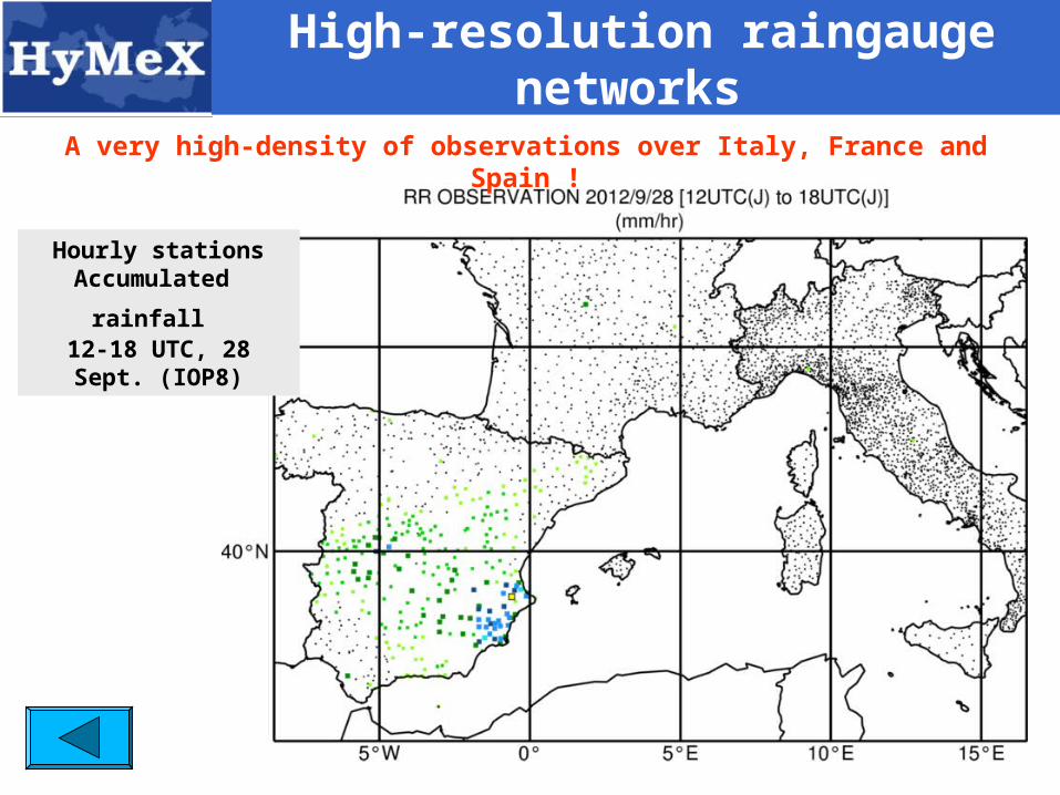
High-resolution raingauge networks
Hourly stationsAccumulated
rainfall 12-18 UTC, 28 Sept.
(IOP8)
A very high-density of observations over Italy, France and Spain !

The field campaign coordination during SOP1
The HyMeX Operation Center was located in La Grande Motte near Montpellier, close to the Freanch research aircraft base and the Candillargues supersite.
- Morning daily briefing 7/7, in visioconference with L’Aquila, Palma, San Guiliano, Mahon and Toulouse
- weather forecast performed by a Météo-France forecaster at HOC + complementary information supplied by AEMET and l’Aquilla secondary centers for Spain and Italy.
- several dedicated NWP systems for the SOP (AROME_WMED over the whole Western Mediterranean, WRF for the Italy,…) : 25 output models available on the SOP website