what is the e cotswold water park? d m lechlade seven ... · burford a417 a417 coln country park...
TRANSCRIPT
Parking...is available FREE at theGateway Centre (walks 1 & 2),Neigh Bridge car park (walks 3 & 4),Waterhay car park (walk 5) Riverside Park(walks 6a & 6b) seasonal charge.
Refreshments...are never far away on any of these walks! On each of the walks the location of the nearestcafé/pub is mentioned.
Countryside code...Be safe, plan ahead and follow any signs.Leave gates and property as you find them.Protect plants and animals and take your litter home.Keep dogs under close control.Consider other people.
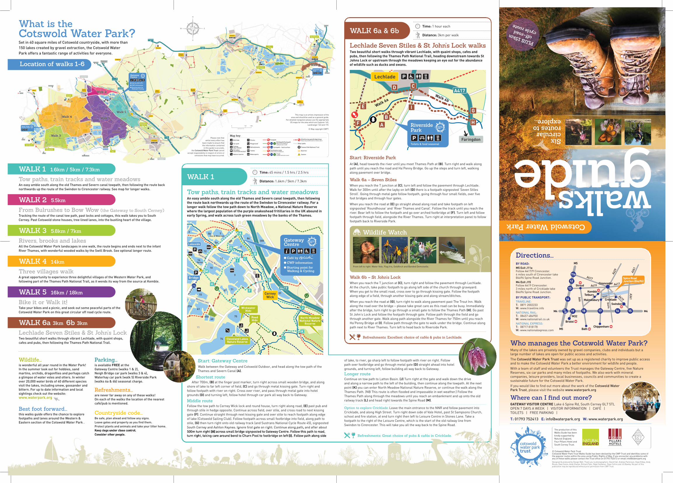
Wildlife Watch
From left to right: Water Vole, Flag Iris, Goldfinch and Banded Demoiselle.
RAF Fairford
131128
129
136
101
104
102 103105
106107
125
126
132
130b
130a
127
114
124112
113
123
115116
120119b
119
122121
118
117
111a
110 110a
111
111b
102
102a
101b
101a
R.Coln
R.Thames
Thames P
ath
Swindon
Glos Wildlife TrustNature Reserve
CastleEaton
UpperInglesham
Kempsford
Whelford
Fairford
Inglesham
Faringdon
(RestrictedHours)
Th
am
es
Pa
th
68a/b
74
33
44
56
63
50a
4950
30
62
2620
21
19
22
15
6123a23b
12
14
86
6
9
7167
10
300
4
35b
5a
7
13
27
3537
70
83
82
68d
68c
75
69
76
66
96
81
47
46/48 58
91
99
36
42
79
95
52
53
53a
54
ManorFarm
Spine Road(East)
Wickwater Lane
Broadway Lane
Station Road
Cerny Wick Lane
Frid
ays H
am
La
ne
Isis & Windrush
Spring
Swill Brook
R. Thames
R. Churn
R. T
ham
es
Thames & Severn Canal(under restoration)
92
39
93
94
A417
97
301
11
Swindon
Cirencester
am
PooleKeynes
CrickladeLeisure Centre
51
88
8979a
84Lakeside
Waterhay
Spine Road(West)
Sustrans Route 45to Cirencester
Swillbrook LakesNature Reserve
Lower Moor FarmNature Reserve
Coke’s PitNature Reserve
ShorncoteReed Bed
WickwaterHide
ReedHide
Dryleaze FarmQuarry
74a
Th
ame
s Path
R. T
ham
es
32
31 Round HouseFarm Quarry
306
0 1 Mile1 Km
43
6577
45
57
4140
64
55
18
16
17
5978b
78a
SomerfordKeynes Cerney
Wick
DownAmpney
AshtonKeynes
SouthCerney
Latton
Ewen
Kemble
Cirencester
Minety
Wootton Bassett
MarstonMeysey
Poulton
Driffield
Cricklade
North MeadowNational Nature
Reserve
Cleveland LakesNature Reserve
Sustrans Route 45to Swindon
WaterhayHide
A419
B4696
Oaksey
Swindon
Cirencester
M5 Cheltenham& Gloucester
Spine RoadJunction
approximate scaleEysey ManorQuarry
87
200
Station RdCerney Wick Lane
Clayhill
Bridge
GatewayCentre
● Café by ● CWP information ● Starting point for Walking & Cycling
Neigh BridgeCountry Park
MeyseyHampton
Burford
A417
A417
ColnCountry Park
Lechlade
A361
A417
RiversidePark
Toilets & food seasonal
Swindon
Lechlade
Whelford PoolsNature Reserve
Cirencester
44
47
46/48 58
42
43
6577
45
57
41
33
30
62
26
3537 9696
91
99
336
88
Spine Road(West)
Coke’s PitNature Reserve
32
31
SomerfordKeynes
AshtonKeynes
B4696
87
Clayhill
6
9
717677
10
11111
WickwaterHide
Reede
CernWick
dCerney Wick Lane
Cerney Wick Lane
rnek
Rd
68a/b
74
2020
21
19
22
15
61223a23b23b
6868d
688c
75
95
Spine Road(East)
Wickwater Lane
Broadway Lane
Frid
ays H
am
La
ne
RHide
74a
18
16
17
Cleveland LakesNature Reserve
Bridge
27
Reide
WH
Reede
WH
Rede
4
3
Walk 1
Walk 3
Walk 4
Walk 6
Walk 5
Walk 2
Walk 1
Walk 3
Walk 4
Walk 6
Walk 5
Walk 2
Back coverWho manages the Cotswold Water Park?Many of the lakes are privately owned by gravel companies, clubs and individuals but alarge number of lakes are open for public access and activities.The Cotswold Water Park Trust was set up as a registered charity to improve public accessand to make the Cotswold Water Park a better environment for wildlife and people.With a team of staff and volunteers the Trust manages the Gateway Centre, five NatureReserves, six car parks and many miles of footpaths. We also work with mineralcompanies, leisure providers, local businesses, councils and communities to create asustainable future for the Cotswold Water Park.If you would like to find out more about the work of the Cotswold WaterPark Trust, please visit the website www.waterpark.org
Where can I find out more?GATEWAY VISITOR CENTRE Lake 6 Spine Rd, South Cerney GL7 5TLOPEN 7 DAYS A WEEK | VISITOR INFORMATION | CAFÉ | TOILETS | FREE PARKING |
T: 01793 752413 E: [email protected] W: www.waterpark.org
11a
12
ChippenhamBath
Bristol
Stroud
KembleTetbury
Malmesbury Cricklade
M4M4
M32
M5
M5
Cirencester
Swindon
Spine RoadJunction (B4696)
A417
13
14
19 18 17 16 151520
A419
B4696
B4040A46
A417
A419
A361
A36
1
A42
9
Directions...BY ROAD:
M5 Exit J11a
Follow A417/9 Cirencester. 4 miles south of Cirencester takeB4696 Spine Road Junction.M4 Exit J15
Follow A419 Cirencester. 3 miles north of Cricklade take B4696 Spine Road Junction.
BY PUBLIC TRANSPORT:
TRAVELINE:T: 0871 2002233W: www.traveline.infoNATIONAL RAIL:T: 08457 484950W: www.nationalrail.co.ukNATIONAL EXPRESS:T: 08717 818178W: www.nationalexpress.com
The production of thisWalks Guide has beenkindly supported byNatural England,Four Pillars Hotel andSouth Cerney Trust.
© Cotswold Water Park Trust Cotswold Water Park Trust Walks Guide has been devised by the CWP Trust and identifies some ofthe popular routes within the area using Public Rights of Way. If you encounter any problems withany of these walks please contact the Trust office on 01793 752413 or email [email protected] & produced by Design Wall. Thank you to photographers: David Hall, Andrew Parkinson, Dave Kilbey, AndyRouse, Dave Soons, Andy Sharpe, Richard Tyler, Nigel Gardener, Dave Collins and Jill Bewley. No part of thispublication may be reproduced without prior permission from CWP Trust.
What is theCotswold Water Park?Set in 40 square miles of Cotswold countryside, with more than 150 lakes created by gravel extraction, the Cotswold Water Park offers a fantastic range of activities for everyone.
Tow paths, train tracks and water meadowsAn easy amble south along the old Thames and Severn canal towpath, then following the route backnorthwards up the route of the Swindon to Cirencester railway. See map for longer walks.
Location of walks 1-6
WALK 1 1.6km / 5km / 7.3km
From Bulrushes to Bow Wow (the Gateway to South Cerney)Tracking the route of the canal tow path, past locks and cottages, this walk takes you to SouthCerney. Past Cotswold stone houses, tree lined lanes, into the bustling heart of the village.
WALK 2 5.5km
Rivers, brooks and lakesAll the Cotswold Water Park landscapes in one walk, the route begins and ends next to the infantRiver Thames, with wonderful wooded walks by the Swill Brook. See optional longer route.
WALK 3 5.8km / 7km
Three villages walkA great opportunity to experience three delightful villages of the Western Water Park, and following part of the Thames Path National Trail, as it wends its way from the source at Kemble.
WALK 4 14km
Bike it or Walk it!Take your bikes and a picnic, and seek out some peaceful parts of theCotswold Water Park on this great circular off road cycle route.
WALK 5 16km / 18km
Lechlade Seven Stiles & St John’s LockTwo beautiful short walks through vibrant Lechlade, with quaint shops,cafes and pubs, then following the Thames Path National Trail.
Wildlife...is wonderful all year round in the Water Park! In the summer look out for hobbies, sandmartins, orchids, dragonflies and perhaps catcha glimpse of water voles and otters. In winterover 20,000 water birds of 40 different speciesvisit the lakes, including smew, goosander andbittern. For up to date information and localsightings check out the website:www.waterpark.org
Best foot forward...this walks guide offers the chance to explorefootpaths and lanes around the Western &Eastern section of the Cotswold Water Park .
WALK 6a 3km 6b 3km
Faringdon
Lechlade
A417
RiversidePark
Toilets & food seasonal
A
BF
E
D C
G
H
IWalk 6aWalk 6b
n
Lechlade Seven Stiles & St John’s Lock walksTwo beautiful short walks through vibrant Lechlade, with quaint shops, cafes and
pubs, then following the Thames Path National Trail, heading downstream towards St
Johns Lock or upstream through the meadows keeping an eye out for the abundance
of wildlife such as ducks and swans.
Start: Riverside ParkAt (A), head towards the river until you meet Thames Path at (B). Turn right and walk alongpath until you reach the road and Ha’Penny Bridge. Go up the steps and turn left, walkingalong pavement over bridge.
Walk 6a – Seven StilesWhen you reach the T junction at (C), turn left and follow the pavement through Lechlade.Walk for 300m until after the layby on left (D) there is a footpath signposted ‘Seven StilesStroll’. Going through metal gate follow footpath, going through four small fields, over fivefoot bridges and through four gates.
When you reach the road at (E) go straight ahead along road and take footpath on leftsignposted ‘Roundhouse’ and ‘River Thames and Canal’. Follow the track until you reach theriver. Bear left to follow the footpath and go over arched footbridge at (F). Turn left and followfootpath through field, alongside the River Thames. Turn right at interpretation panel to followfootpath back to Riverside Park.
WALK 6a & 6b Distance: 3km per walk
Time: 1 hour each
This map is an artists impression of the area and should be used as a general guide.
For detailed navigation please use the appropriate OS maps for the area which are Explorer 169,
Landranger 163 and 173.
© Map copyright CWPT.
68 /b
74
15
61
60a60
23a
12
14
86
6
9
7167
10
300
35b
5a
7
75
95
Wickwater Lane
Station Road
Cerny Wick Lane
Isis & Windrush
Spring
97
301
11
Lakeside
North MeadowNational Nature
Reserve
Cleveland LakesNature Reserve
A419
Cerney Wick Lane
Bridge
GatewayCentre
● Café by ● CWP information ● Starting point for Walking & Cycling
WickwaterHide
ReedHide
CerneyWick
Station Rd
L
K
J
E
F
H
M
D
A
B
CI
G
Start: Gateway CentreWalk between the Gateway and Cotswold Outdoor, and head along the tow path of theThames and Severn Canal (A).
Shortest routeAfter 700m, (B) at the finger post marker, turn right across small wooden bridge, and along
shore of lake to far left corner of field, (C) and go through metal kissing gate. Turn right andfollow footpath with river on right. Cross over river, and pass through metal gate into hotelgrounds (D) and turning left, follow hotel through car park all way back to Gateway.
Middle routeFollow the tow path to Cerney Wick lock and round house, turn right along road, (E) past pub andthrough stile in hedge opposite. Continue across field, over stile, and cross road to next kissinggate (F). Continue straight through next kissing gate and over stile to reach footpath along edgeof lake (Cotswold Sailing Club). Follow footpath across small footbridge into field, along path tostile, (G) then turn right onto old railway track (and Sustrans National Cycle Route 45), signpostedSouth Cerney and Ashton Keynes. Ignore first gate on right. Continue along path, and after about500m turn right (H) across small bridge signposted to Gateway Centre. Follow this path to road,turn right, taking care around bend to Churn Pool to footbridge on left (I). Follow path along side
Map key:
Car park
Refreshments
Bird hide
Fishing(day tickets)
Horsebox(restricted access)
Nature reserve
Picnics
Playground
Toilets
Watersports
Footpath
Bridlepath/Cyclepath(May not be suitable for cycling all year round)
Cyclepath – hard surface
Track(Limited vehicular access)
Permissive route(At discretion of landowner)
Caution
Quarries
Other paths
Stile/kissing gate/bridge/steps(These may present a barrier to some users)
Thames Path National Trail
Please note thatwhilst every effort has
been made to ensure thatthe information contained
in this guide is accurate,the Cotswold Water Park Trust cannot
accept responsibility in respect of errors oromissions that may have occurred.
Tow paths, train tracks and water meadowsAn easy amble south along the old Thames and Severn canal towpath, then following
the route back northwards up the route of the Swindon to Cirencester railway. For a
longer walk follow the tow path down to North Meadow, a National Nature Reserve
where the largest population of the purple snakeshead fritillaries in the UK abound in
early Spring, and walk across lush green meadows by the banks of the Thames.
WALK 1Distance: 1.6km / 5km / 7.3km
Time: 45 mins / 1.5 hrs / 2.5 hrs
of lake, to river, go sharp left to follow footpath with river on right. Followpath over footbridge and go through metal gate (D) straight ahead into hotelgrounds, and turning left, follow building all way back to Gateway.
Longer routeContinue on tow path to Latton Basin. (J) Turn right at the gate and walk down the driveand along a narrow path to the left of the building, then continue along the towpath. At the nextpoint (K) you can enter North Meadow National Nature Reserve, or continue the walk along theThames Path. (NB This route is often flooded and impassable in wet weather.) Follow theThames Path along through the meadows until you reach an embankment and up onto the oldrailway track (L) and head right towards the Spine Road (M).
Option to explore Cricklade: Leave the main entrance to the NNR and follow pavement intoCricklade, and along High Street. Turn right down side of Vale Hotel, past St Sampsons Church,school and fire station, at end turn right then left to Leisure Centre in Stones Lane. Take afootpath to the right of the Leisure Centre, which is the start of the old railway line fromSwindon to Cirencester. This will take you all the way back to the Spine Road.
Cotswold Water Park
Sixcircularroutes toexplore...
PLUS 15km off–road cycle route
Walk 6b – St John’s LockWhen you reach the T junction at (C), turn right and follow the pavement through Lechlade. At the church, take public footpath to go along left side of the church through graveyard.When you get to the small road, cross over to go through kissing gate. Follow the footpathalong edge of a field, through another kissing gate and along stream/ditches.
When you reach the road at (G), turn right to walk along pavement past The Trout Inn. Walkalong the road over the bridge – please take great care as this road can be busy. Immediatelyafter the bridge, turn right to go through a small gate to follow the Thames Path (H). Go pastSt John’s Lock and follow the footpath through gate. Follow path through the field and gothrough another gate. Walk along path alongside the River Thames for 750m until you reachHa’Penny Bridge at (I). Follow path through the gate to walk under the bridge. Continue alongpath next to River Thames. Turn left to head back to Riverside Park.
Refreshments: Excellent choice of cafés & pubs in Lechlade.
Refreshments: Great choice of pubs & cafés in Cricklade.

Wildlife Watch
From left to right: Tufted Duck, Burnet Moth, Downy Emerald and Lapwing.
Wildlife Watch
From left to right: Hobby, Glow Worm, Yellowhammer and Great Crested Grebe.
Wildlife Watch
From left to right: Red Crested Pochard, Nightingale, Kingfisher and Common Blue Butterfly.
Wildlife Watch
From left to right: Tawny Owl Chicks, Black Headed Gull, Cowslips and Noctule Bat.
2620
21
19
25 22
15
23a23b
12
14
6
9
7167
10
4
35b
5a
7
12
13
Wickwater Lane
Broadway Lane
Station Road
Cerny Wick Lane
Isis & Windrush
Spring
Thames & Severn Canal(under restoration)
11
Lakeside
18
16
17
SouthCerney
Station Rd
Bridge
AC
B
FE
D
GatewayCentre
● Café by ● CWP information ● Starting point for Walking & Cycling
From Bulrushes to Bow Wow Tracking the route of the canal tow path, past locks and cottages, this walk takes you
to South Cerney. Past Cotswold stone houses, tree lined lanes, into the bustling heart
of this vibrant village, then back along the old drover's route of Wildmoorway
(pronounced Wilmer) Lane to the Gateway Centre.
Start: Gateway CentreStart at North East corner of Gateway Centre car park (A) turning left along tow path underSpine Road bridge. Continue along canal tow path, and after 1.50km you will reach BoxwellSpring Lock, then a crossroads of track and footpath. Turn left (B) along the tarmac trackleading to Bow Wow with the river Churn and the mill race on either side. At end of lane, (C)
turn left past pubs and Post Office, and at crossroads turn left along main road passing the17th Century cottages on the right. Continue along this road for 750m to (D) and go straightahead up Wildmoorway Lane, where the road rises over a railway bridge.
Follow the lane, which will soon become a track. Cross over the river Churn (E) and follow thepath through the kissing gate. After 800m you will reach Wildmoorway Lower Lock (F). Turnright towards the bridge and the Gateway Centre, passing safely under the Spine Road back tothe car park.
WALK 2Distance: 5.5km
Time: 1.5hrs
The Thames Path is a wonderful 184-mile(294km) walk and one of only 13 National Trails
in England. It follows the River Thames fromits source near Kemble in the Cotswolds to the
Thames Barrier near Greenwich in London,travelling through some of the finest countryside, including right through
the heart of the Cotswold Water Park.
34
44
56
63
50a
4950
30
3537
38
47
46/48 58
99
36
42
Swill Brook
92
Spine Road(West)
Coke’s PitNature Reserve
R. Thames
32
43
6577
45
57
4140
29
Neigh BridgeCountry Park
B
B
CD
EF
G
J
I
KL
H
A
Swillbrook LakesNature Reserve
Rivers, brooks and lakesExperience the various landscapes of the Water Park in one walk. A delightful woodland
trail by the Swill Brook, then across open meadows to the infant River Thames, and
crystal clear lakes. Great wildlife all year round with dragonflies in summer,
nightingales in Spring and a wonderful variety of visiting waterbirds in Winter.
Start: Neigh Bridge Country ParkAt (A) exit from car park to road and turn right, cross over Spine Road and go down MinetyLane opposite for 800m – please proceed with caution as road is narrow with no footpath.Turn through wooden gate at entrance to Swillbrook Lakes Nature Reserve on left oppositesmall layby at (B).
Follow narrow path along lake edge, go through small gate at point (C) and follow footpathwith Swill Brook on right. Continue through wooden gate on right at edge of lake. Follow pathto (D), going over bridge to interpretation panel, then path across field. Route turns away fromlake, with woods on left. At (E), where trees converge, go into next field and take right handpath around field boundary to footbridge over brook, along Otter Corridor towards PikeCorner (F) and turn left at interpretation panel.
Follow path straight on, then with interpretation panel on left at (G), go over stile to joinThames Path.
Shortest routeTurn left along River Thames with river on right, ignoring gateway on right, to metalfootbridge at (H). Over footbridge turn left along lane to meet Spine Road, and left, cross roadto Neigh Bridge.
Longer routeTurn right along River Thames. After 450m, left at
footpath sign over footbridge at (I) and follow path.At junction of paths (J), turn left, follow path (not
gravel track) keeping Lake 37 on right. Walkalong bank for 500m – after metal hut turn leftthrough gap in the hedge (K). Turn right, followpath through scrub. Keep straight ahead togravel track. Turn left then take grasspath immediately on right (L) and follow
to stile in hedgerow onto Spine Road.Cross road, and turn left back to Neigh
Bridge Car Park.
WALK 3Distance: 5.8km / 7km
Time: 2hrs / 2.5hrs
33
34
44
56
63
50a
4950
30
62
2620
19
2527
2828a
3537
38
70
76
66
96
47
46/48 58
91
99
36
42
79
52
Churn
92
39
93
94
88
8979a
84
Spine Road(West)
Swillbrook LakesNature Reserve
Coke’s PitNature Reserve
Th
ame
s Path
R. Thames
32
31
43
6577
45
57
4140
64
29
18
SomerfordKeynes
AshtonKeynes
SouthCerney
B4696
87
Clayhill
H
F
E
D
C
B
A
K
J
I
G
M
N
L
ShorncoteReed Bed
Neigh BridgeCountry Park
Three villages walkA great opportunity to pass through three picturesque villages of the Western Water
Park, all with their own charm and fascinating past. Why not come back and explore
them further another day? The route follows the Thames Path National Trail as it
wends its way from the source at Kemble to London 184 miles downstream.
WALK 4Distance: 14km
Time: Approx 3 hrs
68a/b
74
2
2620
21
19
25 22
15
61
60a60
23a23b
12
14
86
6
9
7167
10
300
4
35b
5a
7
12
13
27
83
82
68d
68c
75
69
76
66
96
81
95
ManorFarm
Spine Road(East)
Wickwater Lane
Broadway Lane
Station Road
Cerny Wick Lane
Frid
ays H
am
La
ne
Isis & Windrush
Spring
R. Thames
R. Churn
Thames & Severn Canal(under restoration)
39
94
97
301
11
Lakeside
Waterhay
74a
4
18
16
17
5978b
78a
72
CerneyWick
AshtonKeynes
SouthCerney
Cleveland LakesNature Reserve
A419
B4696
Spine RoadJunction
200
Station RdCerney Wick Lane
Clayhill
Bridge
A
D
C
E
F
G
IH
K
J
L
N
M
WickwaterHide
ReedHide
B
GatewayCentre
● Café by ● CWP information ● Starting point for Walking & Cycling
Bike it or Walk it!Seek out some of the peaceful parts of the Cotswold Water Park on this great circular
off road cycle ride. If you have time, take a detour to the Reed Hide in the Cleveland
Lakes Nature Reserve. Suitable for competent cyclists – the route can be rough and
around the Thames Path it can be flooded in times of wet weather.
WALK/CYCLE 5Distance: 16km or 18km
Time: 2-3 hrs (cycling)
Start: Neigh Bridge Country ParkFrom the car park entrance right towards the Spine Road, (A) then left on the path to theThames Path signpost, cross road and follow the lane, with lake on left and River Thames onright. Continue to end of lane, over metal bridge, and stay on Thames Path for 1km, until youreach main road. (B) Cross over to wooden gate with care and keep straight on with river onleft. At end of Church Walk, on corner turn left, then immediately right onto Back Street. (C)
At end of road, (D) straight ahead take narrow public footpath past houses. Through twowooden kissing gates, head straight and follow path round between two lakes. Turning left,aim for gap in trees, over stile into Clayhill car park. (E) Leave car park at entrance, crossSpine Road, turn right for 50m, and take path left at signpost and over stile. Cross bridge onleft, short path to the track. (F) Turn right.
Follow track around lake, to grassy path. When track reaches an open area, keep right. (G) At‘T’ junction, right, over small bridge and under trees. At road, left into village, past shop andWar Memorial is ahead of you. Turn left here. Continue along road until you reach the bend,Upper Up Car park is in front of you. (H)
Take path across playing field, exit is in top right-hand corner. Through two gates, and crossroad with extreme caution! Gate opposite, follow raised path. This path goes to Shorncote birdhides, may be flooded following wet weather. (I) Continue past the quarrying and followingpath right to end. When you reach the Country Park, (J) turn immediately right along grasspath inside fence boundary, follow around until paths merge. (K) Keep right at metal gate andthrough woods, to stile.
Then it’s woods-stile-field-stile-field-stile-field-bridge-field-road! Cross over to stile and (L)
go immediately right through path in woods until stile at next road. Turn left along verge andcross over to stile next to gate. Follow edge of field to next stile, cross over road to next stile,then take path diagonally across the field. (M) At junction of paths, turn right and follow paththrough field gateway, then over narrow footbridge to river and join Thames Path, followingriver downstream. Follow path until (N) reach wooden bridge in to northern corner of NeighBridge Country Park, and path to car park.
Start: Gateway CentreCross Spine Road (A) (slightly right) with care from Gateway Centre following National CycleNetwork 45 signs. Left onto cycle path following signs and crossing roads (care) until oppositeBridge car park at 1.2km.
Cross road (B) (care) through arches onto bridleway, crossing over at top of Station Road. (C)
Follow signs NCN45 for 2.3km, under more brick arches, past houses, along embankmentuntil steep slope down to road. (D) Turn left back into South Cerney past pubs & shops. Bearright, turn right then left at memorial cross (Broadway Lane) (E).
(F) At end of houses after The Leaze take bridleway on right (wooden motorcycle barrier).After narrow wooden bridge/400m (G) take immediate left, keep stream on left. Follow grassthen gravel track around lake past Whitefriars Sailing Club then tarmac to road.
Turn left onto road (extreme caution). Next left (Spine Road), join cycle path after 50m, (H)
follow for 800m. Just past Clayhill car park cross road (care) onto bridleway (motorcyclebarrier). (I) Follow track ahead then right along field edges then through gap in hedge(motorcycle barrier), and on permissive bridleway to road. (extreme caution) (J) Cross road onbend to gate and bridleway.
(K) (Wet weather alternative: after 200m, take kissing gate on left (ClevelandLakes), follow cycle track for 2km to rejoin Thames Path (M) throughkissing gate on right).
(L) Main route: pass kissing gate, left at track junction joining ThamesPath following around lakes and river to humped wooden bridge (M).
(Detour here to Reed hide)
Continue Thames Path, left at first T junction, right at second T (ElmleaMeadow) then left onto Old Railway Line (N). Follow to main Spine Road, turnright onto cycle track and retrace route back to Gateway Centre (care road crossings).
Refreshments: A variety in South Cerney, including pubs & takeaways.
Refreshments: White Hart, Ashton Keynes. Royal Oak, South Cerney. Refreshments: Gateway Centre