what’s new ? gdal 2 -...
TRANSCRIPT
GDAL 2.1What’s new ?
Even Rouault - SPATIALYSDmitry Baryshnikov - NextGIS
Ari Jolma
August 25th 2016

GDAL 2.1 - What’s new ?
Plan
● Introduction to GDAL/OGR● Community ● GDAL 2.1 : new features● Future directions

GDAL 2.1 - What’s new ?
GDAL/OGR : Introduction
● GDAL? Geospatial Data Abstraction Library. The swiss army knife for geospatial.
● Raster (GDAL) and Vector (OGR)● Read/write access to more than 200 (mainly) geospatial
formats and protocols.● Widely used (FOSS & proprietary): GRASS, MapServer,
Mapnik, QGIS, gvSIG, PostGIS, OTB, SAGA, FME, ArcGIS, Google Earth…
(> 100 http://trac.osgeo.org/gdal/wiki/SoftwareUsingGdal)
● Started in 1998 by Frank Warmerdam● A project of OSGeo since 2008● MIT/X Open Source license (permissive)● > 1M lines of code for library + utilities, ...● > 150K lines of test in Python

GDAL 2.1 - What’s new ?
Main features
● Format support through drivers implemented a common interface
● Support datasets of arbitrary size with limited resources● C++ library with C API● Multi OS: Linux, Windows, MacOSX/iOS, Android, ...● Language bindings: Python, Perl, C#, Java,...● Utilities for translation,reprojection, subsetting,
mosaicing, interpolating, indexing, tiling…● Can work with local, remote (/vsicurl), compressed
(/vsizip/, /vsigzip/, /vsitar), in-memory (/vsimem) files
GDAL 2.1 - What’s new ?
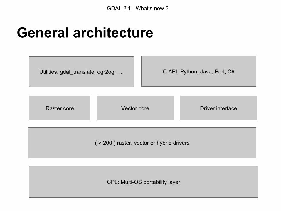
General architecture
CPL: Multi-OS portability layer
Utilities: gdal_translate, ogr2ogr, ...
Raster core Vector core Driver interface
( > 200 ) raster, vector or hybrid drivers
C API, Python, Java, Perl, C#

GDAL 2.1 - What’s new ?
Raster Features
● Efficient support for large images (tiling, overviews)● Several georeferencing methods: affine transform,
ground control points, RPC● Caching of blocks of pixels● Optimized reprojection engine● Algorithms: rasterization, vectorization (polygon and
contour generation), null pixel interpolation, filters

GDAL 2.1 - What’s new ?
Raster formats
● Images: JPEG, PNG, GIF, WebP, BPG ...● Georeferenced images: GeoTIFF, .img, NITF, ...● Wavelets: JPEG 2000, ECW, MrSID, ...● RDBMS: Oracle Raster, PostGIS Raster, Rasdaman● Portable DBs: Rasterlite, MBTiles, GeoPackage● Web Services: WMS, WCS● Radar: CEOS, Envisat● Elevation: DTED, USGS DEM, SRTM HGT● Containers: HDF4, HDF5, NetCDF● Other: Geospatial PDF● GDAL specific: memory, VRT (virtual)
⇒ 148 Formats

GDAL 2.1 - What’s new ?
Vector features
● Feature and geometry model based on OGC/ISO Single Features model
● GEOS library for geometry operations (buffers, intersections, etc..)
● Reprojection engine● SQL capabilities
○ OGR SQL or SQLite for all formats○ SQL pass-through for RDBMS

GDAL 2.1 - What’s new ?
Vector formats
● GIS: Shapefile, MapInfo, ESRI Personal/File Geodatabase● CAD: DXF, DWG, DGN (pre-V8)● RDBMS: PostGIS, Oracle, MySQL, Ingres, MSSQL, ODBC● Portable DBs: SQLite/Spatialite, GeoPackage● Exchange: KML (GDAL 1.11:reference implementation)
GML, GeoJSON● Web Service: WFS, Fusion Tables, CartoDB, CouchDB,
Cloudant, GME● National formats: SDTS, NAS, NTF, TIGER/Line, Interlis,
VFK, Edigeo, SOSI, SXF, MTK GML, RUIAN GML, INSPIRE Cadastral GML
● Non spatial : CSV, XLS, XLSX, ODS● GDAL specific: in-memory, VRT (virtual)
⇒ 87 formats

GDAL 2.1 - What’s new ?
Community activity
● 58 developers with SVN write access○ 19 active in 12 last months + 65 occasional
contributors○ https://www.openhub.net/p/gdal
● 2237 subscribers to gdal-dev. 2538 messages / 12 last months
● ~ 550 tickets created / 12 last months (6500 total). ~600 opened
● 1 student for GSoC in 2015. 2 in 2016

GDAL 2.1 - What’s new ?
GDAL/OGR 2.0 in a nutshell
● V2.0.0: june 2015● 10 RFCs implemented in 2.0 cycle, including:
○ Unification of GDAL and OGR at driver and dataset level○ Bilinear, cubic resampling kernel available for overviews or pixel
operations○ Curve geometries○ 64 bit integer for OGR features
● 11 new drivers including:○ GeoPackage Raster○ Full support for GeoPackage Vector

GDAL 2.1 - What’s new ?
GDAL/OGR 2.1
● Released in May 2016. 2.1.1 release in July● 4461 “commits” (total since 1998: 30689) ● 6 RFCs implemented in 2.1 cycle● 7 new raster drivers
○ CALS Type 1 : read-only. Legacy archiving format○ IBM DB2 : read/write. Tiled rasters○ ISCE : read-only. Used by JPL in their Interferometric SAR Scientific
Computing Environment○ MRF : Meta Raster Format. read/write. Developed par NASA Global
Imagery Browse Services.○ SAFE: read-only. ESA Sentinel-1 (SAR) products.○ SENTINEL2: read-only. ESA Sentinel-2 L1B/L1C/L2A products.○ WMTS : read-only. Client for OGC Web Map Tile Service
GDAL 2.1 - What’s new ?
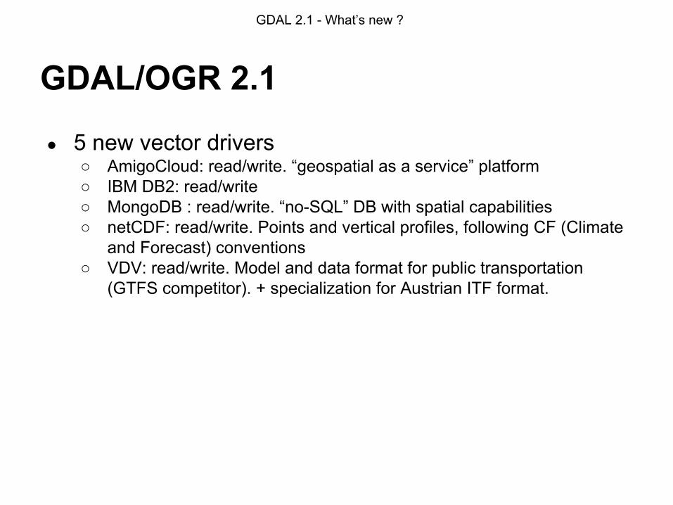
GDAL/OGR 2.1
● 5 new vector drivers○ AmigoCloud: read/write. “geospatial as a service” platform○ IBM DB2: read/write○ MongoDB : read/write. “no-SQL” DB with spatial capabilities○ netCDF: read/write. Points and vertical profiles, following CF (Climate
and Forecast) conventions○ VDV: read/write. Model and data format for public transportation
(GTFS competitor). + specialization for Austrian ITF format.

GDAL 2.1 - What’s new ?
GDAL/OGR 2.1
● Improvements in existing drivers:○ CSV: support for full editing (update & deletion of records, through full
rewriting of the file)○ GeoJSON: full editing+ extensions to core GeoJSON preserved○ ElasticSearch: reading mode added. Support for all geometry types in
reading/writing○ MBTiles: write support added○ PDF: addition of the new PDFium backed (BSD licensed)○ PLScenes: API V1 of Planet Labs added (scene catalog)○ VRT(raster): on-the-fly pansharpening○ GeoTIFF: multi-threaded compression available as an option (useful
for DEFLATE)

GDAL 2.1 - What’s new ?
GNM: the problem

GDAL 2.1 - What’s new ?
GNM: the solutionSet of special network classes in GDAL
Main purposes of these classes:
1. Abstraction for network data2. Provide network functionality for those formats that lack it
The main work was done during GSoC 2014 by Mikhail Gusev
RFC 48: Geographical networks support was adopted and implemented in GDAL 2.1.
Documentation at http://gdal.org – GNM Architecture and GNM Tutorial sections
GDAL 2.1 - What’s new ?
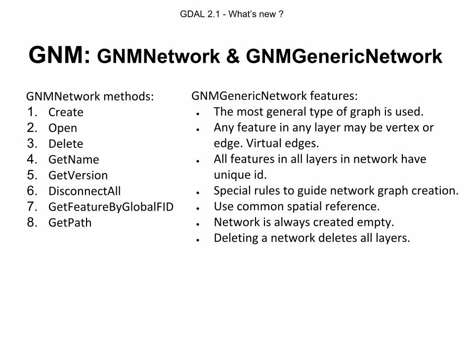
GNM: GNMNetwork & GNMGenericNetwork
GNMGenericNetwork features:● The most general type of graph is used.● Any feature in any layer may be vertex or
edge. Virtual edges.● All features in all layers in network have
unique id.● Special rules to guide network graph creation.● Use common spatial reference.● Network is always created empty.● Deleting a network deletes all layers.
GNMNetwork methods:1. Create2. Open3. Delete4. GetName5. GetVersion6. DisconnectAll7. GetFeatureByGlobalFID8. GetPath

GDAL 2.1 - What’s new ?
GNM: use case QNetwork plugin
http://plugins.qgis.org/plugins/qnetwork/
GDAL 2.1 - What’s new ?
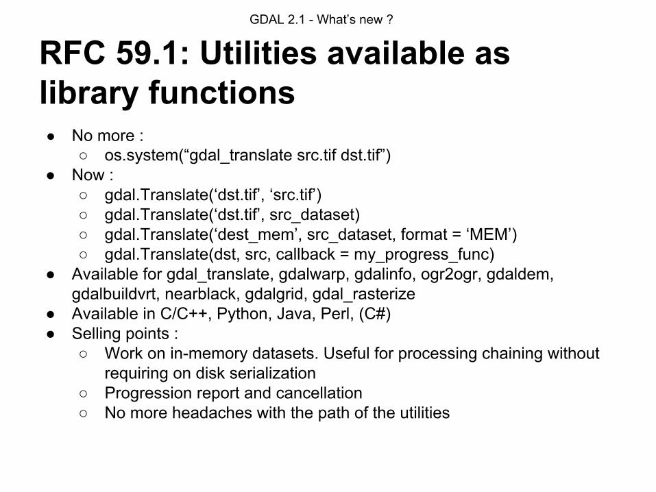
RFC 59.1: Utilities available as library functions● No more :
○ os.system(“gdal_translate src.tif dst.tif”)● Now :
○ gdal.Translate(‘dst.tif’, ‘src.tif’)○ gdal.Translate(‘dst.tif’, src_dataset)○ gdal.Translate(‘dest_mem’, src_dataset, format = ‘MEM’)○ gdal.Translate(dst, src, callback = my_progress_func)
● Available for gdal_translate, gdalwarp, gdalinfo, ogr2ogr, gdaldem, gdalbuildvrt, nearblack, gdalgrid, gdal_rasterize
● Available in C/C++, Python, Java, Perl, (C#)● Selling points :
○ Work on in-memory datasets. Useful for processing chaining without requiring on disk serialization
○ Progression report and cancellation○ No more headaches with the path of the utilities
GDAL 2.1 - What’s new ?
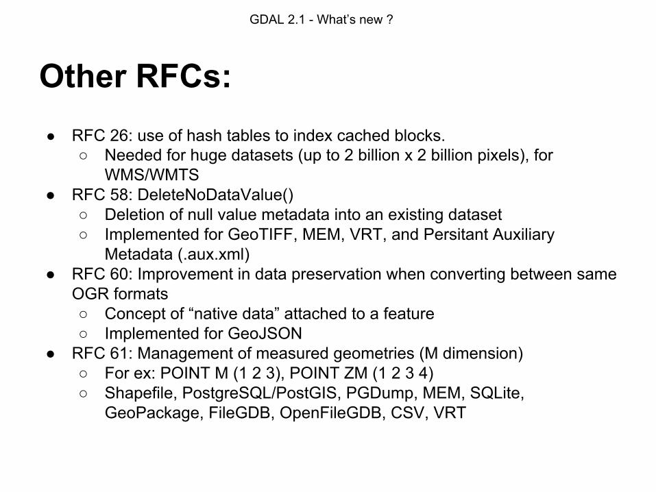
Other RFCs:● RFC 26: use of hash tables to index cached blocks.
○ Needed for huge datasets (up to 2 billion x 2 billion pixels), for WMS/WMTS
● RFC 58: DeleteNoDataValue()○ Deletion of null value metadata into an existing dataset○ Implemented for GeoTIFF, MEM, VRT, and Persitant Auxiliary
Metadata (.aux.xml)● RFC 60: Improvement in data preservation when converting between same
OGR formats○ Concept of “native data” attached to a feature○ Implemented for GeoJSON
● RFC 61: Management of measured geometries (M dimension)○ For ex: POINT M (1 2 3), POINT ZM (1 2 3 4)○ Shapefile, PostgreSQL/PostGIS, PGDump, MEM, SQLite,
GeoPackage, FileGDB, OpenFileGDB, CSV, VRT

GDAL 2.1 - What’s new ?
Other changes● Upgrade to V8.8 of EPSG database● Linear interpolation algorithm (based on libqhull) in gdal_grid (super fast
and “beautiful” results)● New virtual file systems: /vsis3/, /vsis3_streaming/, /vsicrypt/● Bash completion scripts for command line utilities● Internal changes:
○ Huge code cleaning effort,○ No warning compilation,○ Fixing warnings of static code analyzers○ Fixing of numerous security vulnerabilities in dozens of drivers when
dealing with corrupted/hostile files.

GDAL 2.1 - What’s new ?
GSoC 2016
● DWG driver○ Based on a new libopencad library (licence X/MIT)○ Aims at DWG R2000, R13/R14 compatibility○ https://trac.osgeo.org/gdal/wiki/DWG_driver
● Geometry model fully supporting ISO SQL/MM Part 3○ Addition of Triangle, TIN (Triangulated Irregular Networks),
PolyhedralSurface geometry types○ Implemented in Shapefile, PostGIS, GML and DXF○ Used SFCGAL for 3D operations

GDAL 2.1 - What’s new ?
GSoC 2016: CAD driverOpenCAD features:
● Special reader classes.● There are 3 open modes - ALL, FAST and
FASTEST.● When parsing the file, library does not store
any information it does not need. ● Currently library support most (but not all)
objects of CAD files.
GDAL CAD Driver features:● OpenOptions - open mode and some behaviour.● All CAD header mapped to the GDALDataset metadata.● Create OGRLayer for each DWG Layer with objects.● Raster subdatasets are also supported.● Spatial reference extracted from DWG metadata or from
prj file.● CAD block reference attributes mapped to OGRLayer
fields. ● Predefined fields - CAD feature type, color in hex, text,
etc. ● Override reader class using GDAL VSI functions.

GDAL 2.1 - What’s new ?
GDAL 2.2 preview
● Management of GML Complex Features application schemas (INSPIRE dataset): on-going work
● Derived subdatasets to easily compute derived quantities for dataset with complex (real+imaginary) data: amplitude, intensity, log-amplitude, phase, …
● Performance improvements in raster statistics computations
● RFC 63: Sparse dataset improvements

GDAL 2.1 - What’s new ?
Potential future directions
● CMake build system○ Unified build systems for Unix&Windows○ Out-of-tree builds, correct header dependency○ Effort lead by Dmitriy Baryshnikov:
https://github.com/nextgis-borsch/lib_gdal ○ Tomorrow presentation: “Borsch: modern build system for C/C++ GIS
projects” (10h30, room Tunnel)
● Per-dataset raster block cache:○ For lock-less multi-threaded use○ To solve multi-threaded dataset writing○ https://trac.osgeo.org/gdal/wiki/rfc47_dataset_caching (Blake
Thompson)
GDAL 2.1 - What’s new ?
Potential future directions
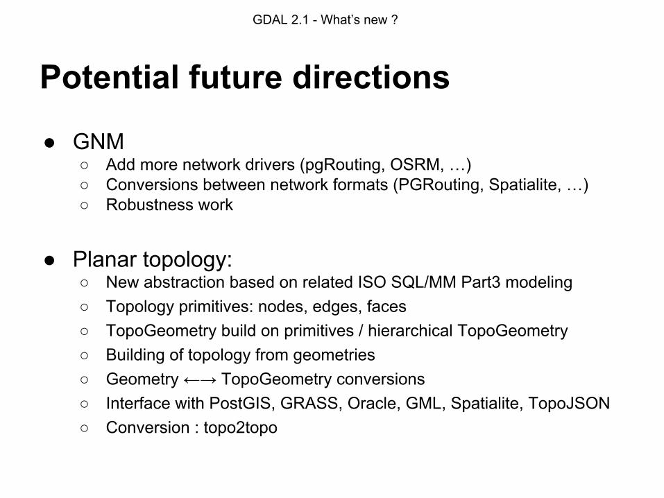
● GNM○ Add more network drivers (pgRouting, OSRM, …)○ Conversions between network formats (PGRouting, Spatialite, …)○ Robustness work
● Planar topology:○ New abstraction based on related ISO SQL/MM Part3 modeling○ Topology primitives: nodes, edges, faces○ TopoGeometry build on primitives / hierarchical TopoGeometry○ Building of topology from geometries○ Geometry ←→ TopoGeometry conversions○ Interface with PostGIS, GRASS, Oracle, GML, Spatialite, TopoJSON○ Conversion : topo2topo

GDAL 2.1 - What’s new ?
Potential future directions
● Raster map algebra● OpenFileGDB write support● OpenFileGDB raster read support● GeoJSON: support for the IETF RFC 7946 revision. (see
Sean Gillies’s talk “GeoJSON and the IETF”, tomorrow 12h00, room Tunnel)
● GeoJSON driver compatible of arbitrary large files on reading
● Improvement in spatial reference system management: guessing of EPSG codes, proposing appropriate datum shifts according to location, …
● CRS WKT 2 / ISO 19162 standard management● Alternative geometry engine : Boost::Geometry● New drivers, performance improvements, ...
GDAL 2.1 - What’s new ?
Questions?
Links: http://www.gdal.org/ https://trac.osgeo.org/gdal/wiki/RfcList
Contacts: [email protected] [email protected] (Dmitry Baryshnikov)