whenua plan. - tmri.maori.nz
TRANSCRIPT

1
Whenua Plan.
A T
hre
e G
ener
atio
n P
lan
.Vo
lum
e 01
.

2
Purpose.
Rangitāne obtained a number of property assets through Te Tiriti o Waitangi settlement process in 2017. Tū Mai Rā Investments (TMRI) was established to receive and manage Te Tiriti settlement assets on behalf of Rangitāne. TMRI’s role is to sustainably grow the assets of Rangitāne in order to achieve the vision it seeks for its people. Some property assets carry particular cultural significance, others allow access to significant natural resources, while others were offered to Rangitāne for their development, lease or sale potential.
TMRI engaged done. to develop a Whenua Plan. The purpose of the plan is to consider options for each of Te Tiriti o Waitangi settlement properties and provide a recommendation for the action which
best responds to the context of each property while growing the social, cultural, environmental and economic health of Rangitāne whenua and whanau. Volume 1 addresses Te Tiriti settlement properties. Subsquent volumes may involve sites owned by Rangitāne Rūnanga or sites of significance that are not yet owned by Rangitāne.
The intention is to build a long-term plan for Rangitāne whenua. When considering the length of time that the plan should consider, the team at done. heard a repeated sentiment from Rangitāne whanau; that any action or inaction would impact themselves, their children and their children’s children. Based upon Aotearoa’s average lifespan (82 years) and average age of having a first child (30 years), this sees the Three Generation Whenua Plan
spanning through to 2132, 112 years from 2020. This exercise has highlighted the timespan which we must consider if we truly are considering ‘our children and children’s children’ in the actions we take today.
This document is provided to the TMRI Board and Rangitāne whanau for consideration and feedback.
‘To consider options for each of Te Tiriti o Waitangi settlement properties and provide a recommendation for the action which best responds to the context of each property while growing the social, cultural, environmental and economic health of Rangitāne whenua and whanau.’

3
2102
82 years old
2132
82 years old
Generation 01.
2020
Generation 02.
Generation 03.
Our Children.
Our Children’s Children.
2072
30 years old 82 years old
2020
0 years old
2050
30 years old
“we’re doing this for our children and our children’s children.”

4
Values & Whetu.
valu
es.
whe
tu.
why
.
Mahi tahi me te korero tahi Working together through honest communication
Kanohi Kite Being present with all people
Whananungatanga Acknowledging connections to whanau and global communities of people
Mana Motuhake Valuing autonomy as Rangitāne and within the rohe of Tamaki Nui ā Rua and Wairarapa
Te Mana Tika Striving for the best outcomes for Rangitāne
Whakapapa • Rangitāne identity is revitalised.• The mana, honour and integrity of Rangitāne is
preserved and enhanced.• Rangitāne reo, tikanga and kawa is revitalised,
preserved and maintained for future generations.
Whenua • The natural environment of Rangitāne is
maintained, preserved and enhanced.• Places of cultural and spiritual significance to
Rangitāne are established and maintained.• The whenua is engaged with, be that through
land management, training, conservation, environmental science or recreation.
Well being• The health and wellbeing of all Rangitāne
people is promoted and enhanced, including rangatahi, the aged or those suffering from mental or physical sickness or disability.
Wealth • The wealth spread amongst Rangitāne comes
from a strong core of growth and sustainability.• The holistic wealth and wellbeing of Rangitāne
is advanced including educational, spiritual, economic, social and cultural forms of wealth.
The purpose of all action by
Tū Mai Rā Investments and
their teams is to operate in
a way that sees people... So that...

5
Methodology & Clarifications.
Methodology.The following steps have been undertaken to develop this draft Volume 1 Whenua Plan:
Options for each site were scoped in collaboration with the General Manager TMRI
A hikoi was undertaken to visit each site; to meet both whenua and whanau
Market research was conducted with local agents
A planning review was undertaken to identify what the Tararua and Combined Wairarapa
District Plans are aiming to achieve for the sites
High level feasibility of development options was considered in collaboration with a Quantity Surveyor and Commercial Manager at Method
Group.
This information was then analysed to arrive at recommendations for each site.
proc
ess.
Clarification.
The recommendations, observations and assessments contained within this report are based on initial planning assessments, market research, high level desktop exercises on current market conditions, assumptions on sellable/leasable values and estimated development costs. We have made a number of assumptions including for example the nature of the groundworks and infrastructure upgrades across the various sites. Actual conditions may vary from those assumed in the report.
This report has been prepared solely to provide Tū Mai Rā Investments (TMRI) with a range of options and recommendations for consideration and engagement with Rangitāne whanau.
Prior to any action being taken (for example, sale of a property) it is strongly recommended that the relevant technical specialists be consulted at the appropriate time (for example a valuer prior to sale).
Due to the high-level nature of this Whenua Plan, Done. Ltd has not undertaken sufficient investigation to accept liability for the result of actions taken without further investigation being undertaken first.

6
The sustainable spread of capital investment over time.
The income generated from various actions / inactions such as land sale and purchase, property development, leasing / rental decisions.
A geographic spread throughout the Rangitāne rohe, ensuring action is shared throughout the region.
01
02
03
Consideration of the different forms of health / wealth which can be built through action, including educational, spiritual, economic, social, and cultural.
The capacity of Rangitāne organisations; build projects require significant engagement with key stakeholders. We need to recognise that Rangitāne organisations have a wide portfolio and areas of interest and responsibility beyond property.
The capacity for key specialists and local contractors to deliver works both on site and in design and planning.
04
05
06
bala
nce.To phase actions in the Whenua Plan,
we need to consider and balance...

7
Whenua Plan Volume 01 Sites.
01. Matua Pā, Masterton.
02. Hillcrest, Dannevirke.
03. 67 Renall Street, Masterton.
04. 8 Mangahao Road, Pahiatua.
05. Wingate 1 - Awa.
06. Wingate 2 - Rural.
07. 95 School Road,Matamau.
first
step
s.
08. Cnr SH2 & Mangaoranga Road,
Eketahuna.

8
Whenua Plan Volume 01 Sites.
01. Matua Pā, Masterton.
02. Hillcrest, Dannevirke.
03. 67 Renall Street, Masterton.
04. 8 Mangahao Road,
Pahiatua.
05. Wingate 1 - Awa.06. Wingate 2 - Rural.
07. 95 School Road, Matamau.
footsteps from maunga to moana.
08. Cnr SH2 & Mangaoranga
Road, Eketahuna.

9
Matua Pā, Masterton.
Address.Cnr Te Ore Ore Road and Blair Street, Masterton
Current Use.Sports fields
Legal Description.Pt Lot 3-6 DP 1361, Lots 7-9 DP 1361 and Pt Sec 101 Masterton Small Farm Settlement, Lot 1 DP 375513 and Sec 194 Masterton Small Farm Settlement contained within Certificates of Title 385714, 385719, 303891 and WN439/239 respectively
Area.Approx 2ha
Value at time of transfer.$838,000
District Plan.Combined Wairarapa District Plan
District Plan Zone.Residential
site
03.
Te Ore Ore Road
Blai
r Str
eet
*Boundary is indicative only

10
site
01.
Built Project Community.
Agreed the Governance and decision making structure:
It was important that we understood Rangitāne’s governance and decision making structure so that we could provide sound advice at the appropriate times in the appropriate formats to allow informed decisions at a governance level.
Established a community network:
Our understanding was that this project would be used as a vehicle to connect and develop the communities within Rangitāne and Masterton. We worked with TMRI to identify the project community and agreed how and when we would engage with that community.
Procured a masterplanning team:
We recognised that draft plans had been prepared for a building to be leased by Masterton Medical and that these plans were developed with a focus on end user requirements. We understood that TMRI wished to explore the site in its entirety through a more holistic Masterplanning exercise. We developed a procurement strategy, recognising TMRI’s desire to work with local and Māori service providers where possible, as well as service providers with proven experience working alongside iwi, designing responsibly with kaitiakitanga as a driving force and translating cultural narrative into design.
Masterplanning.
Site investigation:
We engaged the necessary specialists to undertake site investigation to provide enough information to enable masterplanning. This included Geotechnical, Planning, Surveying, 3 Waters, Power and Communications.
Design:
A Masterplan was developed in response to the design brief, historical and cultural significance of site, surrounding environment, guiding principles and values. The resulting Masterplan provides an overarching plan for the entire site which could be developed as a whole, or phased over time.
Exerpts from the masterplan are included on the following pages.
Quantity Surveyor estimate:
A Quantity Surveyor estimate was undertaken to determine the cost for the development. The estimate is broken down by potential leasee to aid TMRI’s decision making as to the potential phasing of the project and to enable viability to be tested.
Process.
Upon meeting TMRI leadership, we were made aware of the incredible cultural significance of Matua Pā. We heard that Rangitāne had a strong desire to ‘return home’ - reclaiming presence on the whenua.
We also heard that there was interest to re-establish Matua Pā as a place of wānanga, hauora and manaakitanga.
As a means of testing how this vision could be achieved on the site, we undertook the following process:
Set Project Foundations.
Agreed guiding principles and values:
The most important and necessary first step of any project is to explore and then agree, the principles and values which will underpin all future actions and decision making. Understanding cultural and historical significance of Matua Pā was integral to the project.
Agreed frameworks to underpin design:
We understood that kaitiakitanga and sustainable building practices are non-negotiable for Rangitāne. We provided advice on a range of frameworks available and the International Living Future Institute’s CORE framework was adopted to underpin design.
Established a budget strategy:
We worked with TMRI leadership to establish a budget strategy for the masterplanning phase of this project. This involved developing a design brief setting out what is required, conducting initial design work and pricing that design.
Prepare design brief:
We worked with TMRI and TMRT leadership, and potential leasees to capture their project vision and functional requirements. This information was synthesised into a detailed brief which the team used to guide design.
Project Control:
We implemented robust project control from the outset, including Health, Safety and Wellbeing Management, Risk Management, Programming and Financial Management.
Matua Pā, Masterton.

11
Matua Pā, Masterton.
Imagery: Exerpt from Masterplan Report by Tennent Brown Architects & Wraight + Associates.
Masterplan
SCALE @ A3.
MASTERTON MEDICAL
TE ORE ORE RD
COOPER ST
TOTARA ST
BLAIR ST
WAIRARAPA
HOSPITALCAFE
ECOLOGICAL SPINE
HAUORA
LEASE TBC
AMBULANCE
7 8
8a
8b
9
5
6
6
4
3
2
1
DRAFT SITE PLAN
1.
2.
3.
4.
5.
6.
7.
8.
9.
SITE PARKING
142
37

12
Matua Pā, Masterton.
Imagery: Exerpt from Masterplan Report by Tennent Brown Architects & Wraight + Associates.
Masterplan Design Principles.

13
Matua Pā, Masterton.Matua Pā, Masterton.
Imagery: Exerpt from Masterplan Report by Tennent Brown Architects & Wraight + Associates.
Wharekai / Cafe and Mahi TahiWalking from Masterton Medical through existing oak trees
Masterton MedicalWalking from Blair Street
Mahi Tahi workspaceLooking towards break room
14
site
02.
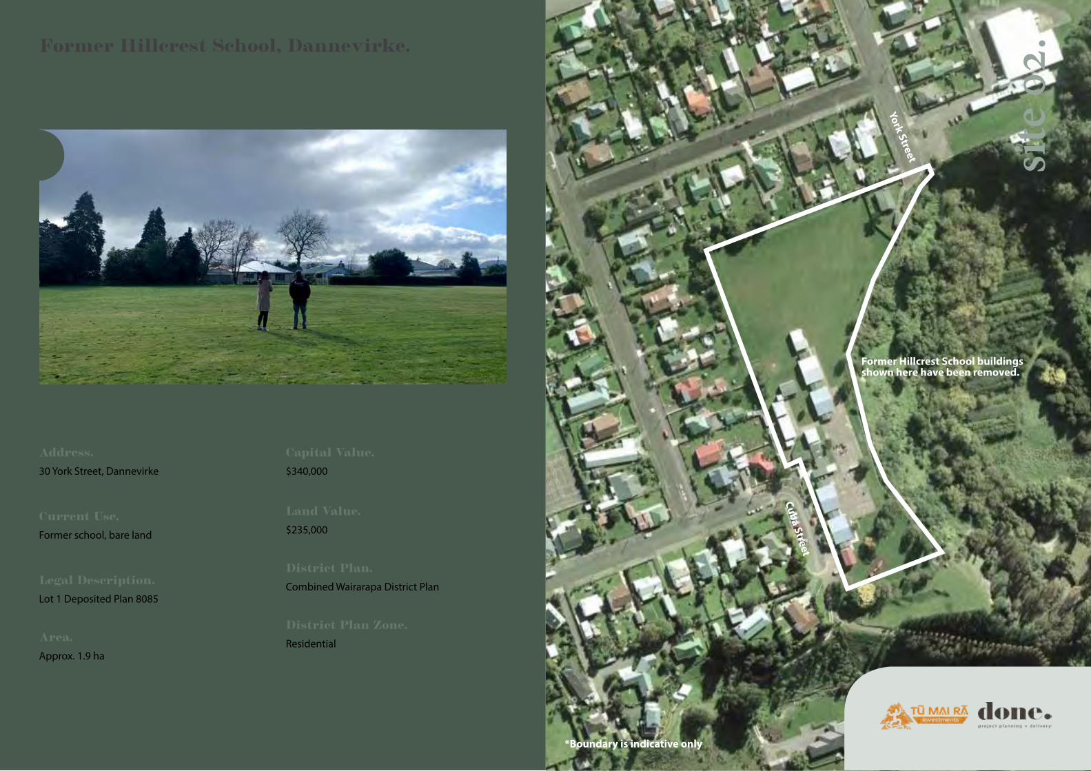
York Street
Cuba Street
*Boundary is indicative only
Former Hillcrest School, Dannevirke.
Address.30 York Street, Dannevirke
Current Use.Former school, bare land
Legal Description.Lot 1 Deposited Plan 8085
Area.Approx. 1.9 ha
Capital Value.$340,000
Land Value.$235,000
District Plan.Combined Wairarapa District Plan
District Plan Zone.Residential
Former Hillcrest School buildings shown here have been removed.

15
site
02.
Next steps.The TMRI board have indicated that they would like the Matua Pā consultant team to work on a Masterplan for Hillcrest. This includes; done. Project Planning + Delivery (Project Manager), Tennent Brown (Architect), Wraight and Associates (Landscape Architect) and Barnes Beagley Doherr (Quantity Surveyor). A development manager is also recommended, as the financial viability of the development will rely on a careful balance between local need and the mix of housing typology and tenure, among other things.
Additional site investigation work will need to be undertaken to inform more detailed design and costing.
Kōrero with organisations like Kāinga Ora has begun and should continue in order to assess potential partnership / co-delivery opportunities.
In order to progress this development, engagement with Rangitāne o Tamaki nui ā Rua is required to understand the needs of Rangitāne whanau in Dannevirke, and any other information of cultural and historical importance about the site and its surrounds.
To aid this engagement, initial layout studies are provided on the following pages to stimulate conversation and help the local community picture what could be possible on the site.
The site.The site is located at the eastern edge of Dannevirke and was once the location of Hillcrest School. Hillcrest School was closed when it merged with Dannevirke North School in 2003 as part of a Ministry of Education review. All school buildings have been demolished or removed, and the only building that remains onsite is the old school house, accessed off York Street. This is currently rented. The address is 30 York Street but there is currently no formal access into the site from York Street. Future possible entry points could be from York Street and / or Cuba Street. The site is largely flat, then slopes away at the southern end with views towards the gully on the south and eastern boundaries.
The opportunity.An initial planning review has been undertaken which identifies that the site is zoned Residential under the Tararua District Plan. Within this zone, Tararua District Council has taken the approach that subdivisions should be assessed on the basis of the suitability of lots for the intended use of the land, having regard to the objectives and policies for development in the area, rather than specifiying minimum lot sizes and other arbitrary standards. Therefore, the yield to be achieved on this site will need to be determined through layout studies and early development feasibilities, taking account of development controls for the zone as well as the mix of housing typology and tenure that is required to meet local demand, and make the development economically viable.
Former Hillcrest School, Dannevirke.
Annecdotal local market research has found that:
• The Dannevirke market is very buoyant and there is a shortage of homes for both sale and rent. It is suggested the buoyant market is driven by low interest rates and a post COVID lockdown exodus from Auckland, Tauranga and Wellington to Dannevirke where sale prices are much cheaper.
• There is currently employment available in industry jobs (such as the freezing works) and it is thought that professional jobs could increase as more people move to town.
• There is a need for good quality new homes as very few new homes have been built in town for years.
• First home buyers are missing out as they can’t compete against multiple cash offers from those who don’t need finance or First Home Buyer grants.
• There is also a real shortage of rentals available, at times resulting in overcrowding.
• A few years ago, a street of state homes was bought by a developer. The developer removed every second home to provide more land and renovated the properties, which were then made available for rent to buy. This meant people who couldn’t normally afford their own home could enter the housing market. It is thought of locally as a successful development.
• It is suggested the median sale price statistics from Core Logic are out of date, simply due to the swift moving market. Suggestion is currently more in the mid $300K area.
Housing need.Initial kōrero has been undertaken with Kāinga Ora, the Ministry of Housing and Urban Development (HUD) and Te Puni Kōkiri to understand local need for social and affordable housing in Dannevirke. We have heard that the Ministry of Social Development currently identifies nearly 30 households in need of support. These Government organisations have also advised that Māori are less likely to register for social housing assistance than other demographic groups in Aoteoroa, and therefore the number of whanau needing housing is likely to be higher than this. Engagement with Rangitāne o Tamaki nui ā Rua will therefore be crucial to understanding the housing needs of Rangitāne whanau in Dannevirke.
A Core Logic report provided by HUD provides some useful context on population and house prices in Dannevirke, including that:
• between 2006 and 2013 a population decline of 4.1% was experienced in the area
• the predominant age group in Dannevirke is 65+, and
• the current median sales price of houses in the area is $256,000.

16
Former Hillcrest School, Dannevirke.
Imagery: Exerpt from Housing Layout Options Report by Tennent Brown Architects.

17
Former Hillcrest School, Dannevirke.
Imagery: Exerpt from Housing Layout Options Report by Tennent Brown Architects.

18
Former Hillcrest School, Dannevirke.
Imagery: Exerpt from Housing Layout Options Report by Tennent Brown Architects.

19
67 Renall Street, Masterton.
Address.67 Renall Street, Masterton
Current Use.Residential dwelling, currently vacant
Legal Description.Lot 1-2 DP 29960
Area.2023 m2
site
03.
Capital Value.$500,000
Land Value.$340,000
District Plan.Combined Wairarapa District Plan
District Plan Zone.Residential
67 Renall Street
Wairarapa College
*Boundary is indicative only

20
67 Renall Street, Masterton.
Option 1.Sell the current house and land as it is
We engaged with local agents and received a market appraisal which finds that if the house and land were to be sold in the current market it could be sold for $475,000 - $640,000.
Option 2.Remove the house and redevelop the site for 5 dwellings
We reviewed the planning restrictions that relate to the site. This showed that a development which provides for up to 5 dwellings could be achieved within the density provisions of the plan.
Early high level feasibility assessment suggests that this will likely result in a negative developers margin. This is largely due to low residential sales values in Masterton relative to build costs. The anticipated rental yield however indicates a fair long term investment.
Option 3.Convert the current house to a care facility
The General Manager of TMRI, Darrin Apanui has raised the potential for the large existing dwelling to be used as a care facility by Oranga Tamariki. At the time of delivering the draft Whenua Plan for the AGM, Darrin is currently in discussion with Oranga Tamariki about what this might look like.
Use of the existing home would likely require renovation to comply with the Government’s Healthy Homes standards, however Oranga Tamariki have indicated interest in funding the capital investment for this work.
site
03.
Option 4.Sell the current house, and develop the remainder of the section for 2 dwellings
The title for 67 Renall Street contains two separate, but held together, pieces of land. The existing house sits entirely within Lot 2 DP 29960. This option considers separating the two lots so that the existing house could be sold on its own title. The remainder of the site is 766m2 and could therefore be developed to contain two dwellings.
Early high level feasibility assessment suggests that this would also likely result in a negative developers margin if developing housing for sale, but a fair rental yield if developing housing for long term rent.
Discussion & Recommendation.
The options considered here suggest that developing the site for housing for sale would not be viable in the current market. Based on the assumptions tested, the same is true even if the development was pushed to a higher density (beyond the zoning allowance).
If TMRI are comfortable with being a long term landlord, the option of developing the site for housing for long term rent may be worth considering.
Further investigation of the site as a care facility option is recommended as a medium term solution (10-15 years). We understand that with ways of working changing and there being less draw to Wellington, demand for housing in Masterton is growing. In 10-15 years, it may then be worth reconsidering whether development for rent or sale achieves a greater return.

21
8 Mangahao Road, Pahiatua.
Address.8 Mangahao Road, Pahiatua
Current Use.Residential dwelling, currently occupied
Legal Description.Part Lot 1 Deposited Plan 11538
Area.939 m2
Capital Value.$120,000
Land Value.$47,000
District Plan.Tararua District Plan
District Plan Zone.Residential and understood to still be still within school designation
site
04.
Pahiatua School
*Boundary is indicative only
8 Mangahao Road

22
site
04.
Option 1.Keep as rental
The house is currently rented.
Option 2.Sell current house and land as it is
We engaged with local agents and received a market appraisal which finds that if the house and land were to be sold in the current market it would likely sell for between $270,000 and $290,000.
Option 3.Relocate house and develop 2 houses
As the existing house is located in the middle of the site, it would not be possible to build one house at the rear. If the existing house was removed the site could be developed for two houses.
Early high level feasibility assessment suggests that this would likely result in a negative developers margin if developing housing for sale, and a low rental yield if developing housing for rent.
Discussion & Recommendation.
If the property was held as a rental, it will likely require upgrades to comply with the Government’s Healthy Homes standards given the age and condition of the dwelling.
High level feasibility assessment suggests that in the current market it is not viable to redevelop the site for housing, either for sale or rent.
As such, the best option of those considered so far indicates the property could be sold as it stands and the capital used to fund other TMRI investments.
8 Mangahao Road, Pahiatua.

23
Awa Site: Wingate Road, Opaki, Masterton.
Address.Wingate Road, Opaki, Masterton
Current Use.Understood to be leased to neighbouring land owner
Legal Description.Part Section 11 Opaki District &
Part Section 11 Block XIII Kopuranga Survey District and Part River Bed Survey Office Plan 15964
Area.
4.1429 ha
Capital Value.$453,000
Land Value.$453,000
District Plan.Combined Wairarapa District Plan
District Plan Zone.Rural - primary production zone and Flood Hazard Area - adjacent to “significant water body”
site
05.
*Boundary is indicative only

24
Rural Site: Wingate Road, Opaki, Masterton.
Address.Wingate Road, Opaki, Masterton
Current Use.Understood to be vacant rural land
Legal Description.Section 1-2 Survey Office Plan 12118
Area.4.7044 ha
Capital Value.$453,000
Land Value.$453,000
District Plan.Combined Wairarapa District Plan
District Plan Zone.Rural - primary production and directly adjacent to railway corridor designation
site
06.
*Boundary is indicative only

25
site
06.Awa Site.
Option 1.Lease to neighbouring farmer (status quo)
The site is understood to be leased to the neighbouring farmer.
Option 2.Horticultural venture
The site is zoned Rural – primary production zone under the Combined Wairarapa District Plan. Primary production activities are provided for as permitted activities in the zone subject to environmental standards necessary to avoid, remedy or mitigate adverse effects. This includes the use of land and accessory buildings (such as greenhouses) for the raising, growing and breeding of animals or vegetative matter and crops, including horticulture, plantation forestry, agriculture, viticulture, floriculture, racing stables, and outdoor pig farming, as well as winemaking, flower packing, and other primary production activities.
As such, there is strong potential for the site to be used for horticulture if there is interest from Rangitāne to do so.
Option 3.Develop as conventional 2 lot rural-residential subdivision but maintain access to awa
The district plan would enable the development of two rural-residential lifestyle blocks on this site, subject to careful location of building platforms to address the flood risk from the awa.
Early high level feasibility assessment suggests that this would likely result in a negative developers margin if developing housing for sale, and a low rental yield if developing housing for rent.
Rural Site.
Option 1.Lease to neighbouring farmer
The site could be leased to the neighbouring farmer.
Option 2.Sell land to neighbouring farmer
The approximate value of the land is $453,000. The land could be sold and the capital used to fund other Rangitāne investments.
Option 3.Develop as conventional 4 lot subdivision
The district plan would enable the development of four rural-residential lifestyle blocks on this site.
Early high level feasibility assessment suggests that this would likely result in a negative developers margin if developing housing for sale, and a low rental yield if developing housing for rent.
site
05.

26
Wingate Road.
*Boundary is indicative only
TMRI owned ‘rural’ site
TMRI owned ‘awa’ site
Potential site to procure
The district plan provides for Papakāinga to be developed in this location beyond the density limits allowed for conventional housing. This option explores the potential of purchasing the parcel of land between the two sites currently owned by TMRI, and developing a Papakāinga in this location.
This would most likely be viable as a long-term rental model and could provide access to affordable housing for Rangitāne whanau.
All things considered, it is recommended that one of the following options are further explored following engagement with Rangitāne o Tamaki nui ā Rua, Rangitāne o Wairarapa and Rangitāne whanau.
• Sell Wingate (Rural) and develop a horticulture venture on Wingate (Awa), or
• Purchase middle site and develop Papakāinga on Wingate road for longterm rent to Rangitāne whanau.
The land could continue to be leased for farming in the interim.
Wingate Discussion &
Recommendation.
Wingate Combined Option.Purchase middle section and develop Papakāinga.

27
95 School Road, Matamau.
Address.95 School Road, Matamau
Current Use.Former school, rural, residential
Legal Description.Section 1 Survey Office Plan 504953
Area.3.047 ha
Capital Value.$275,000
Land Value.$127,000
District Plan.Tararua District Plan
District Plan Zone.Rural
site
07.
*Boundary is indicative only
95 S
choo
l Roa
d
Early Settlers Cemetery
Marker indicating Urupā
SH2
The site is zoned rural under the Tararua District Plan. Many different uses are provided for within the rural zone including dwelling houses, and a range of farming activities. Permitted activities include dwelling houses, farming, goat farming, factory farming, protection and amenity forestry, commercial forestry, home occupations, visitor accommodation, marae, public and private open space, reserves, cemeteries, community businesses, rural selling places, network utilities, temporary activities and accessory buildings.
In terms of residential development, Tararua District Council have taken the approach that subdivisions should be assessed on the basis of the suitability of the lots for the intended use of the land, having regard to the objectives and policies for development in the area, rather than specifying minimum lot sizes.
Aside from disused school buildings the site contains an old school house that is currently rented. It is recommended that this rental is continued while engagement with Rangitāne o Tamaki nui ā Rua is undertaken to scope potential options for the site taking account of the zone provisions described.
Discussion & Recommendation.

28
Cnr SH2 & Mangaoranga Road, Eketahuna.
Address.Cnr SH2 and Mangaoranga Road
Current Use.Bare land
Legal Description.Lot 1 Deposited Plan 87102 and Section 6 Survey Office Plan 506789
Area.2.5611
Capital Value.$40,000
Land Value.$39,000
District Plan.Tararua District Plan
District Plan Zone.Rural and unformed road
We have been advised this site would not be sold to maintain footsteps from mountain to moana within the Rangitāne rohe.
Due to the location and nature of the land, the TMRI GM and Chair have advised that the site would likely be used to locate a billboard (due to adjacency to SH2).
This site could also be considered for food production, horticulture and agriculture if there is local need and interest.
site
08.
*Boundary is indicative only

29
Sum
mar
y o
f R
ecom
men
dat
ion
s.
8 MANGAHAO ROAD, PAHIATUA
If the property was held as a rental, it will likely require upgrades to comply with the Government’s Healthy Homes standards given the age and condition of the dwelling.
High level feasibility assessment suggests that in the current market it is not viable to redevelop the site for housing, either for sale or rent.
As such, the best option of those considered so far indicates the property could be sold as it stands and the capital used to fund other TMRI investments.
WINGATE
All things considered, it is recommended that one of the following options are further explored following engagement with Rangitāne o Tamaki nui ā Rua, Rangitāne o Wairarapa and Rangitāne whanau:
• Sell Wingate (Rural) and develop a horticulture venture on Wingate (Awa), or
• Purchase middle site and develop Papakainga on Wingate road for longterm rent to Rangitāne whanau.
The land could continue to be leased for farming in the interim.
95 SCHOOL ROAD, MATAMAU
The site is zoned rural under the Tararua District Plan. A wide range of different uses are provided for within the rural zone.
In terms of residential development, Tararua District Council have taken the approach that subdivisions should be assessed on the basis of the suitability of the lots for the intended use of the land, having regard to the objectives and policies for development in the area, rather than specifying minimum lot sizes.
Aside from disused school buildings the site contains an old school house that is currently rented. It is recommended that this rental is continued while engagement with Rangitāne o Tamaki nui ā Rua is undertaken to scope potential options for the site taking account of the zone provisions described above.
04
05&06
07
MATUA PĀ
TMRI to determine priorities for phasing of development based on costed Masterplan.
Lease arrangements to be progressed by TMRI.
Design of Phase One to progress into the next stage of design development (Concept).
HILLCREST
Develop masterplan for Hillcrest site, starting with the following first steps:
• Procure consultant team to develop masterplan for the site.
• Commission required site investigation to inform more detailed design and costing.
• Continue kōrero with organisations like Kāinga Ora in order to assess potential partnership / co-delivery opportunities.
• Engage with Rangitāne o Tamaki nui ā Rua to understand the needs of Rangitāne whanau in Dannevirke, and any other information of cultural and historical importance about the site and its surrounds.
67 RENALL STREET
The options considered suggest that developing the site for housing for sale would not be viable in the current market. If TMRI are comfortable with being a long term landlord, the option of developing the site for housing for long term rent may be worth considering.
Further investigation of the site as a care facility option is recommended as a medium term solution (10-15 years). We understand that with ways of working changing and there being less draw to Wellington, demand for housing in Masterton is growing. In 10-15 years, it may then be worth reconsidering whether development for rent or sale achieve a greater return.
01
02
03
95 CNR SH2 & MANGAORANGA ROAD, EKETAHUNA
We have been advised this site would not be sold to maintain footsteps from mountain to moana within the Rangitāne rohe.
Due to the location and nature of the land, the TMRI GM and Chair have advised that the site would likely be used to locate a billboard (due to adjacency to SH2).
This site could also be considered for food production, horticulture and agriculture if there is local need and interest.
08
BY WAY OF EXAMPLE AS TO HOW THE 3 GENERATION PLAN CAN BE UTILISED, A HIGH-LEVEL LONG-TERM TIMEFRAME IS PROPOSED ON THE FOLLOWING PAGE AS IF ALL RECOMMENDATIONS ABOVE WERE ADOPTED.

30
3 Generation Plan.
Generation 01.
Generation 02.
Generation 03.
Matua Pā.
2020 2030 2040 2050 2060 2070 2080 2090 2100 2110 2120
2020- 2022 Design & Construction
Up to 2118
(50-100 year potential building life)
Hillcrest Housing.
2020 - 2022 Design & Construction
67 Renall Street, Masterton.
2020 - 2030
Operate care facility
2030 Reconsider development or sale of property
8 Mangahao Road, Pahiatua.
2021 sell property
Wingate.
Dec 20 - March 2021 Further define direction in response to feedback at AGM
Up to 2118
(50-100 year potential building life)
95 School Road, Matamau.
Dec 20 - March 2021 Further define direction in response to feedback at AGM
Cnr SH2 & Mangaoranga Road, Eketahuna.
March 2021 Billboard design competition

31
Next Steps.
This diagram visually demonstrates the consultation and approval process which done. will follow prior to adoption and action at Whenua Plan sites.
Note that, if agreement in principle is achieved at the AGM for Matua Pā and Hillcrest Housing, each project will directly proceed to the next design stage to maintain momentum and secure the project team. Rangitāne engagement will continue as part of the design process for these two flagship sites. pr
oces
s.
November 16.
Present draft Volume 1 Whenua Plan to TMRI Board for approval to consult at AGM.
November 28 AGM.
Introduce Whenua Plan at AGM.
December 2020 -
February 2021
Rangitāne whanau provide feedback to Volume 1 Whenua Plan, guided by pātai included on the following page. Receive feedback from Rangitāne whanau by end of February 2021.
End March 2021.
Present ‘final’ Volume 1 recommendations to TMRI Board for delivery.
March 2021.
Consolidate and consider feedback received.
June - November.
done. develop Volume 1 Whenua Plan:• Scope options• Market Research• Consider viability• Recommendations
Strategic Planning & Engagement. Delivery.
e.g. sell 8 Mangahao Road
e.g. design Papakāinga at Wingate

32
Pāt
ai. 01
02a
Matua Pā.What do you think of the proposed design for Matua Pā?
Hillcrest.What do you think of the 3 options presented for housing at the former Hillcrest school site?
02b
Hillcrest.What is your understanding of the housing need in Dannevirke? i.e. the town needs kaumatua flats, smaller homes etc.
03 67 Renall Street, Masterton.Do you support TMRI further exploring the use of 67 Renall Street as a care facility? Do you have any further feedback or suggested options not yet explored?
04 8 Mangahao Road, Pahiatua.Do you support TMRI further exploring the sale of 8 Mangahao Road to fund other TMRI investments? Do you have any further feedback or suggested options not yet explored?
0506
07
Wingate.Which option do you prefer; the development of a horticulture venture or Papakāinga at Wingate? What ideas do you have for either option?
Matamau.What ideas do you have for the use of 95 School Road, Matamau?
08 CNR SH2, Eketahuna.What ideas do you have for the use of CHR SH2 and Mangaoranga Road?
09 Anything else?What further feedback or ideas would you like to pass on?
10 Skills & Interest.What skills or expertise could you contribute to any of the projects proposed in this document? What skills / interests would you be interested in developing through these projects?