where igi&s is going - esri€¦ · –financial improvement and audit readiness (fiar)...
TRANSCRIPT

Where IGI&S is Going
The Direction of Installation Geospatial Information
and Services for 2017 and Beyond
Mr. David LaBranche, PE
Geospatial Information Officer
OASD(EI&E)
July 11, 2017

Acquisition, Technology and Logistics
2
Themes
• The OSD Perspective
• Requirements for IGI&S
• Recent Accomplishments
• How IGI&S Relates to the Larger GIS Community
• Data Sensitivity
• The Need for Authoritative Data and Data Quality

Acquisition, Technology and Logistics
3
DoD Authorities for Geospatial Information and
Services (GI&S)
• Geospatial information and services (GI&S)– The collection and use of geodetic,
geomagnetic, imagery, gravimetric, aeronautical, topographic, hydrographic, littoral, cultural, and toponymic data accurately referenced to the Earth
• The National Geospatial-Intelligence Agency (NGA) has lead for all GI&S in DoD– Focus on warfighter support and
intelligence requirements
– Coordinate all GI&S standards within DoD
• Installation geospatial information
and services (IGI&S)
– A subset of GI&S
– The GI&S data and maps tailored
to construction, sustainment,
environmental management, and
test and training range operations
on DoD facilities worldwide
• The USD(AT&L) has lead for all
installation management in DoD
– Includes business systems and
associated data, standards
– IGI&S is under USD(AT&L)
purview (DoDI 8130.01)

Acquisition, Technology and Logistics
4
The Perspective from the Top
• DoDI 8130.01, “Installation Geospatial Information and Services” is two years old implementation expected
• The Office of the Secretary of Defense (OSD) needs IGI&S to be visible, accessible, understandable, trusted, and interoperable
• OSD is using IGI&S for strategic planning and situational awareness
• Often, we simply want to know “where is it?”
• Growing need at enterprise level for IGI&S to support emergency response, homeland defense
• OSD activity does not (and should not) duplicate Components’ capabilities

Acquisition, Technology and Logistics
5
OSD Level Requirements for IGI&S
• Current Requirements
– Business mission planning, Impact analysis of current events
– Financial Improvement and Audit Readiness (FIAR)
– Federal Flood Risk Management Strategy
– GEOINT Visualization Services (GVS) and Map of the World (high side data sources)
– Real property categorization and sustainment cost modeling
• Emerging Requirements
– Mass Warning and Notification
– WebEOC, etc. (common operating picture)
– Explosives Safety Siting (ESS) – web-based system
– Mission Assurance Risk Management System (MARMS)
– Global Force Management Data Initiative (GFM DI)
– Closure and realignment analysis
Acquisition, Technology and Logistics
6
• NDAA FY 2010 Audit Readiness Requirement: DoD implemented the Financial Improvement and Audit Readiness (FIAR) plan to achieve audit readiness by September 30, 2017*
– One of two FIAR Plan priorities: improve controls and processes for “Mission critical asset information” (includes real property information)
• IGI&S plays key role supporting the FIAR goals of establishing “existence and completeness” of real property assets
– Assists in reconciliation of the real property inventory of each Military Department
Use of IGI&S for Audit Readiness and Real
Property Inventory
*Established in NDAA 2010; clarified in NDAA 2014
Acquisition, Technology and Logistics
7
Use of IGI&S for Audit Readiness and Real
Property Inventory (Contd)
• Military Departments use IGI&S to support audit readiness
– Department of the Army
o Three years of proven results reconciling real property data (existence and completeness) with IGI&S data
o Implementing standard process to reconcile fuels and “linear assets” (such as roads, utility systems) with IGI&S data
– Department of the Navy progressively improved its real property inventory over the last three years reconciling real property asset records with IGI&S data
o U.S. Marine Corps process similar to Navy; results fed back as updates to the real property and IGI&S databases
– Department of the Air Force uses IGI&S data to update “linear assets” in real property inventory
o More reconciliation processes in development

Acquisition, Technology and Logistics
8
Accomplishments Since July, 2016
• SDSFIE-R
• SDSFIE-Q
– Main document
– DCS General Guidance
– DCS for each CIP layer
• SDSFIE-M v 2.0 and implementation
• Implementation of SDSFIE-V v 4.0
• Revise Change Management Process
– SDSFIE Governance Plan (R1)
– SDSFIE-V Implementation Guidance (R2)
• ADS Implementation Guidance
DONE
DONE
DONE
UNDERWAY
UNDERWAY
UNDERWAY
DONE
UNDERWAY
UNDERWAY (Draft)
Acquisition, Technology and Logistics
9
• DoDI 8130.01 and FBGB Charter are key references
• Outline of IGG SOP (draft)
– Purpose
– Mission and Scope of the IGG
o IGI&S Portfolio Management
o Standards Governance
o Data Management
– Membership
– Roles and Responsibilities
– Working Groups
– Meetings
– Voting Procedures
– Operations
– Annex A: Current Working Groups
IGG Standard Operating Procedures (SOP)
Draft document
under review now
Acquisition, Technology and Logistics
10
Federal Geographic Data Committee (FGDC)
Coordination
• Federal Geographic Data Committee (FGDC): a US government committee which promotes the coordinated development, use, sharing, and dissemination of geospatial data on a national basis
– Chaired by DOI; OMB is vice-chair
– 32 Federal agency members
• DoD participates at all levels of the FGDC
– Top level (Steering Committee) Representative - NGA
– Second level (Coordination Group) Representatives – NGA, USD(AT&L), and US Army Corps of Engineers
– DoD contributes technical expertise on 11 of 18 subcommittees
– Benefits to DoD: standards development, data sharing, and burden sharing for common GIS requirements

Acquisition, Technology and Logistics
11
IGI&S Standards Coordination
• Aligned with international, federal, and private sector standards where practicable
– DoD requires a combination of external and DoD-specific GIS standards to meet mission needs
• GIS standards in DoD
– NGA coordinates all GIS standards but focus is on warfighting and intelligence
– IGI&S uses many (but not all) NGA-developed GIS standards
– USD(AT&L) develops and maintains three IGI&S standards tailored to our unique uses of GIS for sustaining and operating DoD facilities worldwide
• Applicability of federal GIS standards
– 17 of 31 FGDC standards are applicable to IGI&S missions
– DoD real property and IGI&S data aligns with 12 of 17 applicable FGDC standards and dozens of other international standards

Acquisition, Technology and Logistics
12
Sensitivity of IGI&S Data and Maps
• Increasing precision of IGI&S data has increased its sensitivity in
this high threat environment
– Raw, highly detailed IGI&S data poses greatest sensitivity and risk
– Releasing large GIS datasets (aggregating multiple installations or large
geographic regions) also poses higher security risks
• Some sensitive IGI&S data is shared for official uses, but protected
– US Census Bureau for decennial census
– Homeland security community for emergency response
• Basic IGI&S data and installation maps publicly released after
security review
Acquisition, Technology and Logistics
13
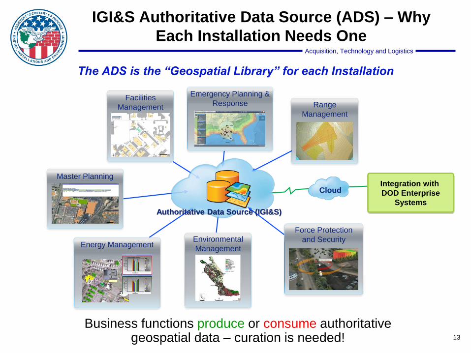
The ADS is the “Geospatial Library” for each Installation
Business functions produce or consume authoritative geospatial data – curation is needed!
Facilities
Management Range
Management
Master Planning
Emergency Planning &
Response
Environmental
Management
Force Protection
and SecurityEnergy Management
Integration with
DOD Enterprise
Systems
Cloud
IGI&S Authoritative Data Source (ADS) – Why
Each Installation Needs One
Authoritative Data Source (IGI&S)

Acquisition, Technology and Logistics
14
FY17 CIP Data Call – Proposed Content
SDSFIE-V v 3.1 Layer Name
AccessControlAirAccidentZone
BridgeBuilding
EnvironmentalRemediationSiteExternalPropertyInterest
FenceFutureProjects
GolfCourse
HistoricDistrict
ImpactAreaInstallationLandParcel
LandUseMilitaryRange
MilitaryTrainingLocationMilQuantityDistance CombinedArc
NatResAcquisitionBoundaryNoiseZoneOutgrant
PavementBranch*PavementSection*
RailSegment**RailTrack**
RecreationAreaRoadCenterline (not in Gold)***
RoadPath***RoadSeg***
SiteTower
VehicleParkingWetland
Layer Justification
ADD: DocksAndWharfs
USN proposed; Census Bureau Request
REMOVE:ExternalPropertyInterest
REPI now collecting this data
Proposed Changes for FY17
Cu
rren
t (F
Y16)
CIP
Layers
Note: DISDI will coordinate a separate data
request for USACE Division/District Offices,
Locks/Dams/Reservoirs/Rec. Areas
Components must also submit a data
quality checklist (14 items) as a “self
evaluation”

Acquisition, Technology and Logistics
15
Useful Public Links
• DoDI 8130.01, Installation Geospatial Information and Services (download on DoD Issuances site http://www.dtic.mil/whs/directives/)
• http://www.acq.osd.mil/eie/BSI/BEI_DISDI.html DISDI Program public page with links to the DoD Components’ IGI&S Program web pages are here
• http://sdsfieonline.org Public registry of IGI&S data standards and related documents (registration required)
• http://www.acq.osd.mil/eie/Downloads/DISDI/installations_ranges.zip Downloadable data set for Military Installations, Ranges, and Training Areas (shapefile)

DISDI Portal (DoD only)
http://disdiportal.osd.mil/

Acquisition, Technology and Logistics
17
Summary
• Policy for IGI&S is driving greater maturity of the capability
– 93% of the 7,382 DoD sites now have basic GIS data
– 83% of 523 major installations have detailed GIS data
– IGI&S standards are mature, aligned to a broad array of missions
• OSD level requirements for high quality IGI&S are growing
• IGI&S community actively contributes to GEOINT and federal forums
• IGI&S standards, while unique, are highly compatible with applicable federal
standards
• DoD continues to make installation maps publicly available, but most
underlying IGI&S raw data is considered too sensitive to release per
national security requirements

Acquisition, Technology and Logistics
18
Our Vision
“To provide authoritative, cost-effective defense installation geospatial information and services for
fact-based decision making across the DoD spectrum of operations.”