wide ore-grade drill results point to substantial ... · pdf filesaracen mineral holdings...
TRANSCRIPT

SARACEN MINERAL HOLDINGS LIMITED ACN: 009 215 347
Wide ore-grade drill results point to substantial increases in inventory and mine
life at Thunderbox and Carosue Dam
Expanded A$42m exploration budget delivers outstanding results, highlighting strong potential for organic growth
Corporate Details: 7th December 2016 ASX code: SAR Corporate Structure: Ordinary shares on issue: 807.1m Unvested employee performance rights: 14.5m Market Capitalisation: A$718m (share price A$0.89) Cash & Bullion (30 September): A$42.5m Debt: Nil Directors: Mr Geoff Clifford Non-Executive Chairman Mr Raleigh Finlayson Managing Director Mr Mark Connelly Non-Executive Mr Martin Reed Non-Executive Ms Samantha Tough Non-Executive Substantial Shareholders: Van Eck Global 17.0% Wroxby 7.0%
Registered Office: Level 4 89 St Georges Terrace Perth WA 6000 Telephone: +61 8 6229 9100 Facsimile: +61 8 6229 9199
For further details contact:
Troy Irvin Telephone +61 8 6229 9100
Key Points
Record FY17 exploration budget delivers strong drilling results which highlight the potential to grow Saracen’s production and mine life
Thunderbox
Drilling confirms the presence of extremely wide zones of mineralisation down-plunge of Thunderbox A Zone. Results include:
52m @ 3.0g/t (including 19m @ 4.8g/t) 47m @ 2.3g/t (including 19m @ 3.2g/t) 28m @ 2.4g/t (including 14m @ 3.3g/t) 25m @ 3.0g/t (including 10m @ 5.8g/t 25m @ 2.4g/t (including 11m @ 4.0g/t) 23m @ 2.4g/t (including 11m @ 3.1g/t)
The AMC-led Thunderbox underground Feasibility Study continues
At King of the Hills, near-mine extensions to the high-grade Lower Kingdom lode include 4.5m @ 23.1g/t, 2.5m @ 22.2g/t and 1.9m @ 17.5g/t
Carosue Dam
At Karari, thick extensional drilling results include:
59.4m @ 3.1g/t (70m north of the Ore Reserve*) 43.3m @ 2.4g/t (50m north of the Ore Reserve) 26.7m @ 4.9g/t (50m below the Ore Reserve) 7.2m @ 9.5g/t (135m below the Ore Reserve)
At Deep South, grade control drilling returns consistent results, including 6.9m @ 10.2g/t, 3.2m @ 9.6g/t, and 8.2m @ 7.0g/t
At Red October, surface drilling has confirmed the continuity of the mineralisation at depth with a high-grade result of 0.8m @ 37.7g/t located ~500m down-plunge of existing workings
Saracen on track to reach 300,000ozpa production rate by June quarter, 2017
Saracen Managing Director Raleigh Finlayson said the A$42m exploration budget had already made substantial inroads towards achieving the goal of growing group production and mine life.
“We see outstanding potential to grow our gold inventory in the coming quarters, laying the foundations for future production growth above the 300,000ozpa production rate we anticipate by the June quarter,” he said.
* Note – The use of “Ore Reserves” in this document refers to information contained in the ASX announcement dated 12th October 2016 and titled “2016 Mineral Resources & Ore Reserves”
2 | P a g e
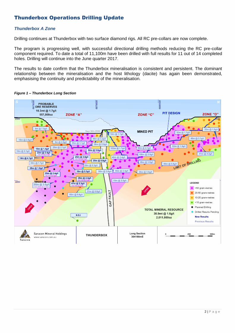
Thunderbox Operations Drilling Update
Thunderbox A Zone Drilling continues at Thunderbox with two surface diamond rigs. All RC pre-collars are now complete. The program is progressing well, with successful directional drilling methods reducing the RC pre-collar component required. To date a total of 11,100m have been drilled with full results for 11 out of 14 completed holes. Drilling will continue into the June quarter 2017. The results to date confirm that the Thunderbox mineralisation is consistent and persistent. The dominant relationship between the mineralisation and the host lithology (dacite) has again been demonstrated, emphasising the continuity and predictability of the mineralisation. Figure 1 – Thunderbox Long Section

3 | P a g e
Significant results from the drilling include:
TBDD0101 – 52m @ 3.0g/t (including 19m @ 4.8g/t)
TBDD0109w1 – 47m @ 2.3g/t (including 19m @ 3.2g/t)
TBDD0109 – 28m @ 2.4g/t (including 14m @ 3.3g/t)
TBDD0107 – 25m @ 3.0g/t (including 10m @ 5.8g/t
TBDD107w1 – 25m @ 2.4g/t (including 11m @ 4.0g/t)
TBDD114w1 – 23m @ 2.4g/t (including 11m @ 3.1g/t)
TBDD125 – 14m @ 4.1g/t
AMC Consultants has continued its work on the Thunderbox underground Feasibility Study, with additional geotechnical data now flowing through from the drill program. The initial results will also assist the selection of an appropriate mining method prior to the updated Resource model being released. The new results are adding to the confidence and scale of the upside opportunity that is present at the Thunderbox operation, which is focused on the thicker, higher grade A and C Zone shoots. Figure 2 – Thunderbox Long Section – Higher grade plunge results
4 | P a g e
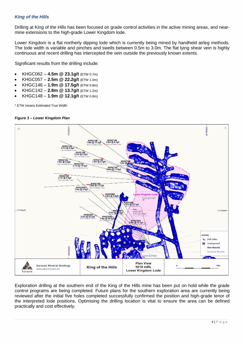
King of the Hills Drilling at King of the Hills has been focused on grade control activities in the active mining areas, and near-mine extensions to the high-grade Lower Kingdom lode. Lower Kingdom is a flat northerly dipping lode which is currently being mined by handheld airleg methods. The lode width is variable and pinches and swells between 0.5m to 3.0m. The flat lying shear vein is highly continuous and recent drilling has intercepted the vein outside the previously known extents. Significant results from the drilling include:
KHGC062 – 4.5m @ 23.1g/t (ETW 0.7m)
KHGC057 – 2.5m @ 22.2g/t (ETW 1.0m)
KHGC146 – 1.9m @ 17.5g/t (ETW 0.8m)
KHGC142 – 2.8m @ 13.7g/t (ETW 1.2m)
KHGC148 – 1.9m @ 12.1g/t (ETW 0.8m)
* ETW means Estimated True Width
Figure 3 – Lower Kingdom Plan
Exploration drilling at the southern end of the King of the Hills mine has been put on hold while the grade control programs are being completed. Future plans for the southern exploration area are currently being reviewed after the initial five holes completed successfully confirmed the position and high-grade tenor of the interpreted lode positions. Optimising the drilling location is vital to ensure the area can be defined practically and cost effectively.

5 | P a g e
Carosue Dam Operations Drilling Update
Karari Underground Drilling at the Karari mine has shifted to the south, following the completion of the southern drill drive late in Q1. The southern drill position is ideally positioned to test the Dhoni Lode. Drilling has been focused on the immediate grade control areas below current mine development, and three extensional holes have been drilled to assist with the positioning of future exploration holes at depth. All three holes were drilled outside the current Ore Reserve, with the deepest (KREX010) returning an outstanding result of 7.2m @ 9.5g/t, 135m below the Ore Reserve. Two holes drilled 50m below the Ore Reserve also returned very solid results. These extensional holes (KRRD129 and KRRD130) returned 27.5m @ 2.4g/t and 26.7m @ 4.9g/t respectively. These results highlight the opportunity for further Ore Reserve growth pending the completion of further drilling over the next two quarters. Prior to the drilling switching to the south of the mine, two additional holes were drilled in the north. These holes returned significant widths and grades (43.3m @ 2.4g/t and 59.4m @ 3.1g/t), resulting in the mineralisation remaining open along strike to the north. A second rig will commence at Karari in the March quarter 2017 to further define the northern margin of the mineralisation. Figure 4 – Karari Long Section - New drill results
6 | P a g e
Significant results include:
KREX010 – 7.2m @ 9.5g/t
KRRD121 – 59.4m @ 3.1g/t (including 28.0m @ 4.4g/t)
KRRD122 – 43.3m @ 2.4g/t (including 28.1m @ 2.7g/t)
KRRD129 – 27.5m @ 2.4g/t
KRRD130 – 26.7m @ 4.9g/t
KRGC339 – 14.2m @ 3.9g/t
KRGC350 – 25.1m @ 3.1g/t
KRGC347 – 15.5m @ 3.5g/t
KRGC332 – 13.0m @ 3.2g/t
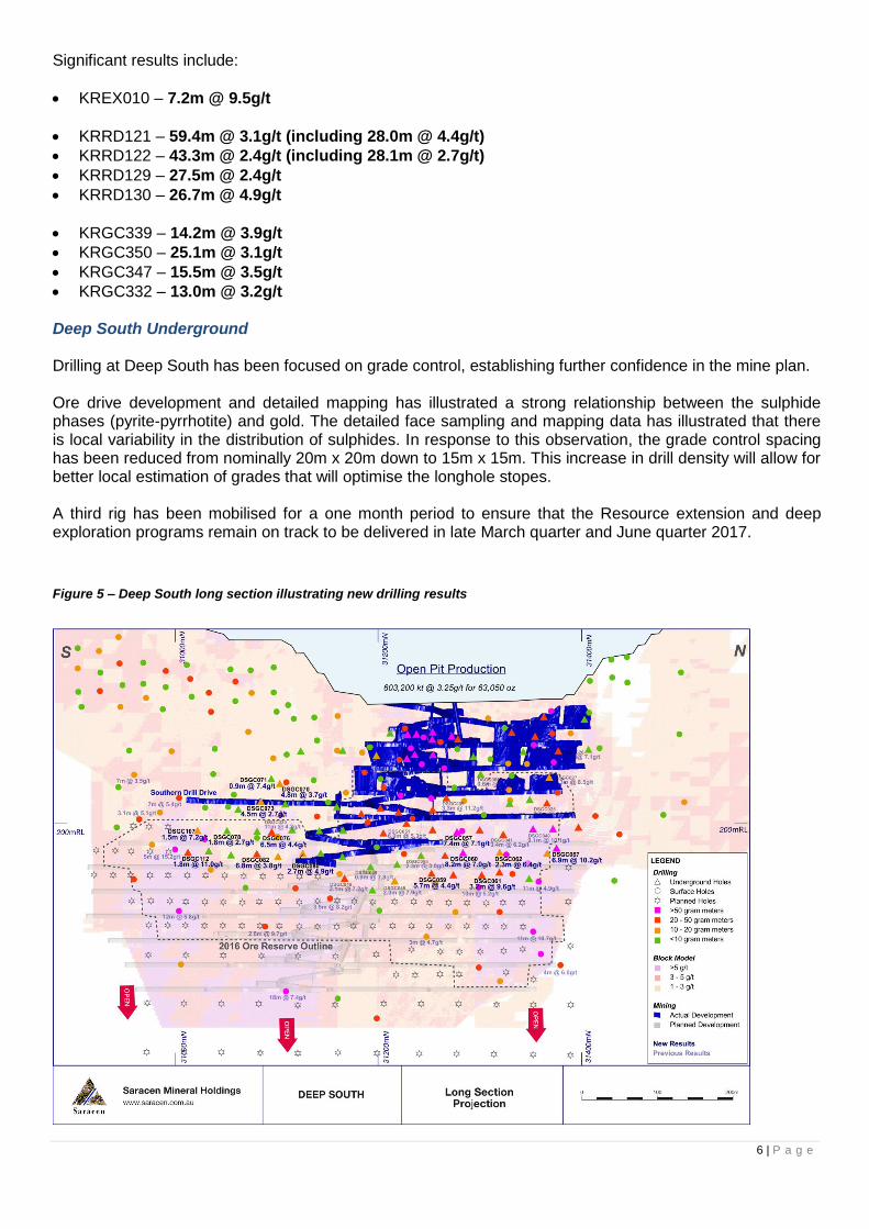
Deep South Underground Drilling at Deep South has been focused on grade control, establishing further confidence in the mine plan. Ore drive development and detailed mapping has illustrated a strong relationship between the sulphide phases (pyrite-pyrrhotite) and gold. The detailed face sampling and mapping data has illustrated that there is local variability in the distribution of sulphides. In response to this observation, the grade control spacing has been reduced from nominally 20m x 20m down to 15m x 15m. This increase in drill density will allow for better local estimation of grades that will optimise the longhole stopes. A third rig has been mobilised for a one month period to ensure that the Resource extension and deep exploration programs remain on track to be delivered in late March quarter and June quarter 2017.
Figure 5 – Deep South long section illustrating new drilling results
7 | P a g e
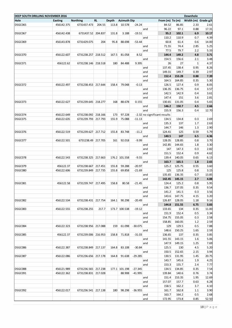
Drilling highlights include:
DSGC067 – 6.9m @ 10.2g/t
DSGC061 – 3.2m @ 9.6g/t
DSGC060 – 8.2m @ 7.0g/t
DSGC057 – 7.4m @ 7.1g/t
DSGC112 – 1.8m @ 11.0g/t
DSGC076 – 6.5m @ 4.4g/t
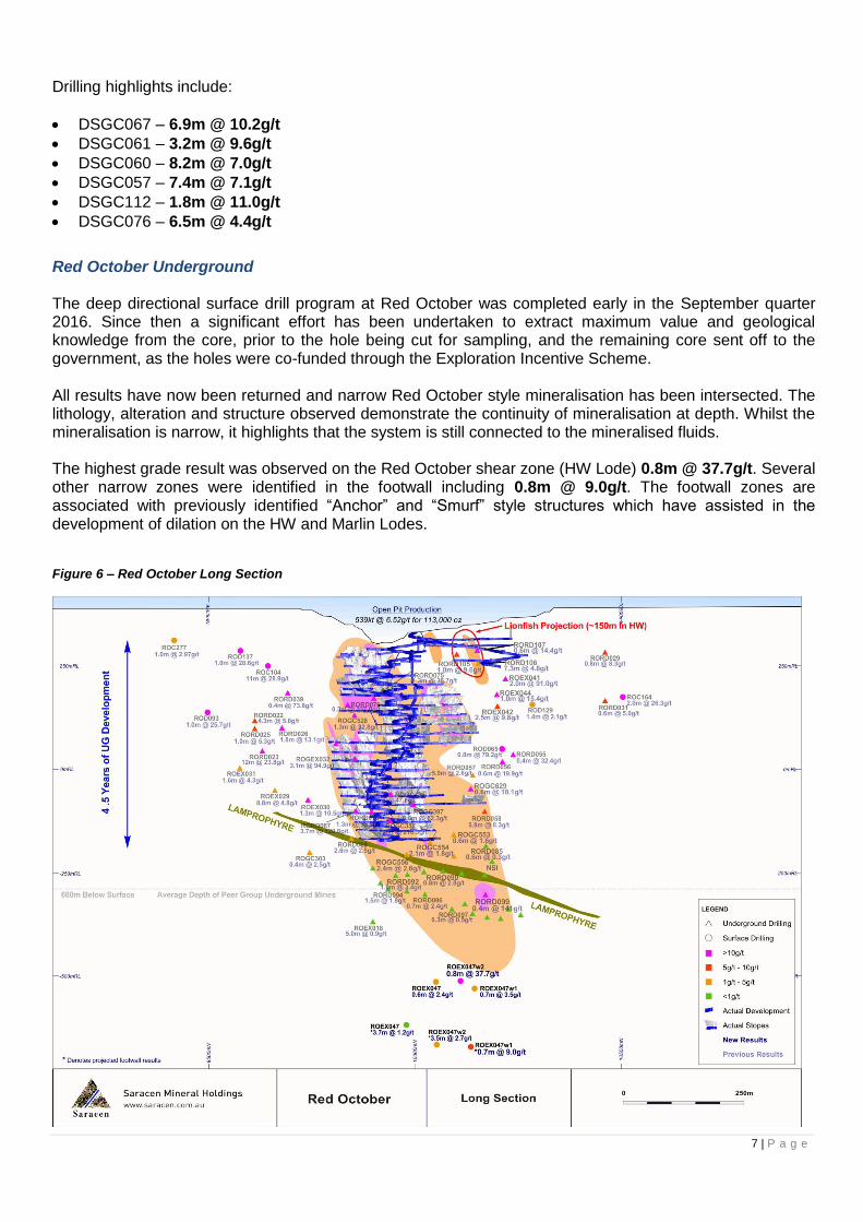
Red October Underground The deep directional surface drill program at Red October was completed early in the September quarter 2016. Since then a significant effort has been undertaken to extract maximum value and geological knowledge from the core, prior to the hole being cut for sampling, and the remaining core sent off to the government, as the holes were co-funded through the Exploration Incentive Scheme. All results have now been returned and narrow Red October style mineralisation has been intersected. The lithology, alteration and structure observed demonstrate the continuity of mineralisation at depth. Whilst the mineralisation is narrow, it highlights that the system is still connected to the mineralised fluids. The highest grade result was observed on the Red October shear zone (HW Lode) 0.8m @ 37.7g/t. Several other narrow zones were identified in the footwall including 0.8m @ 9.0g/t. The footwall zones are associated with previously identified “Anchor” and “Smurf” style structures which have assisted in the development of dilation on the HW and Marlin Lodes. Figure 6 – Red October Long Section
8 | P a g e
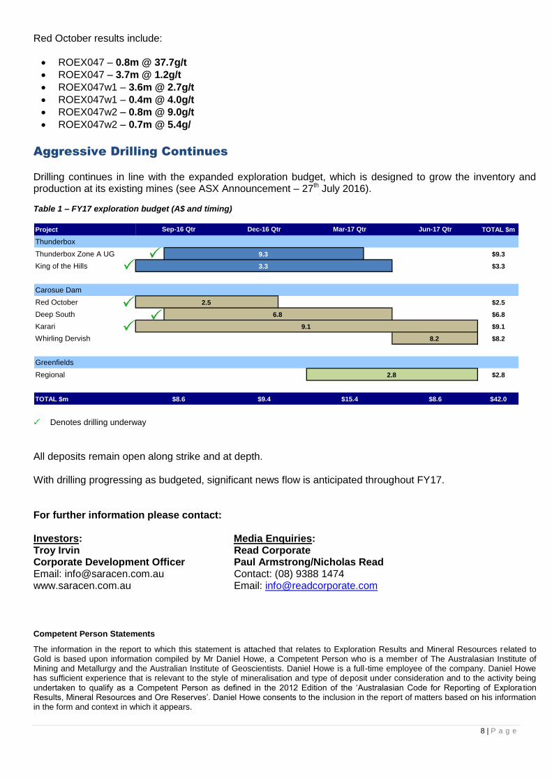
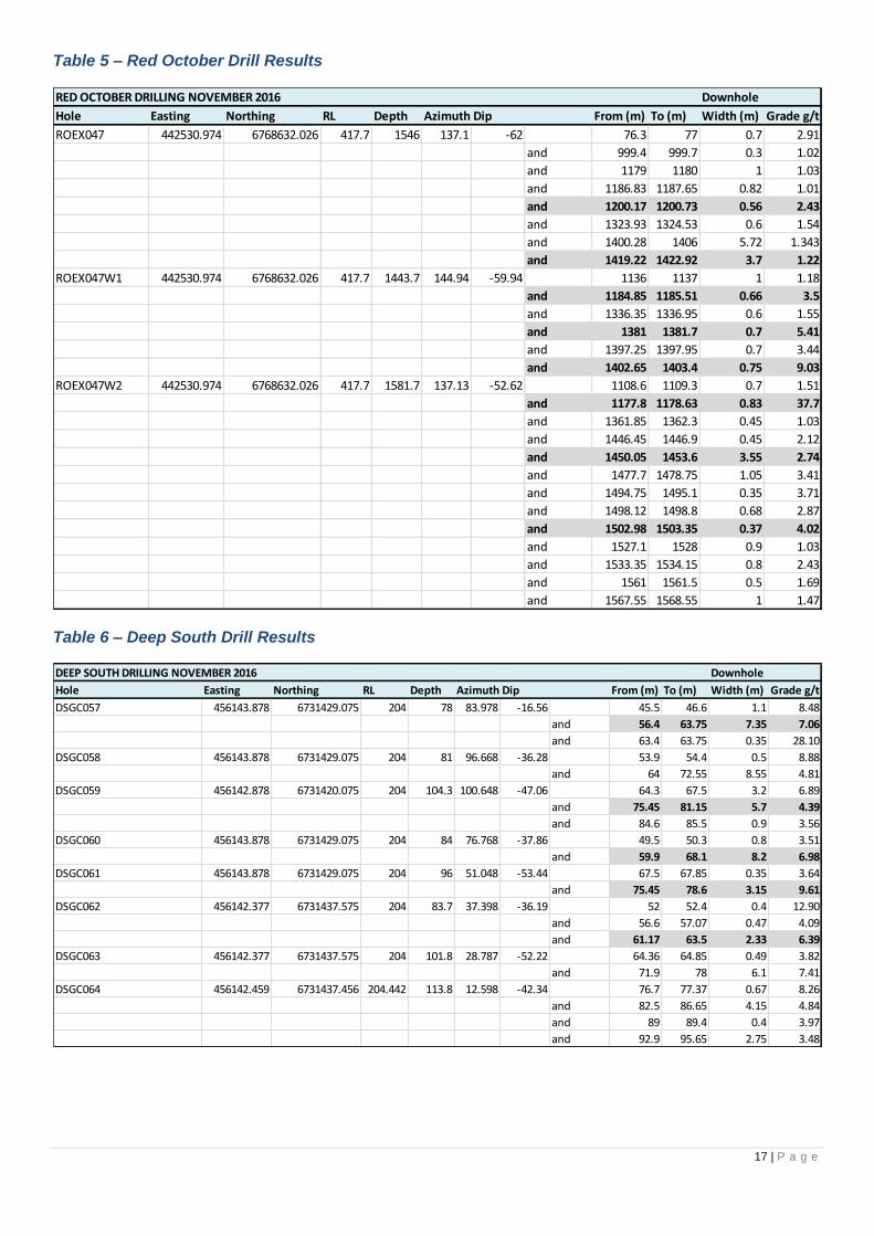
Red October results include:
ROEX047 – 0.8m @ 37.7g/t
ROEX047 – 3.7m @ 1.2g/t
ROEX047w1 – 3.6m @ 2.7g/t
ROEX047w1 – 0.4m @ 4.0g/t
ROEX047w2 – 0.8m @ 9.0g/t
ROEX047w2 – 0.7m @ 5.4g/
Aggressive Drilling Continues
Drilling continues in line with the expanded exploration budget, which is designed to grow the inventory and production at its existing mines (see ASX Announcement – 27th July 2016). Table 1 – FY17 exploration budget (A$ and timing)
Denotes drilling underway
All deposits remain open along strike and at depth. With drilling progressing as budgeted, significant news flow is anticipated throughout FY17. For further information please contact:
Investors: Media Enquiries: Troy Irvin Read Corporate Corporate Development Officer Paul Armstrong/Nicholas Read Email: [email protected] Contact: (08) 9388 1474 www.saracen.com.au Email: [email protected]
Competent Person Statements
The information in the report to which this statement is attached that relates to Exploration Results and Mineral Resources related to Gold is based upon information compiled by Mr Daniel Howe, a Competent Person who is a member of The Australasian Institute of Mining and Metallurgy and the Australian Institute of Geoscientists. Daniel Howe is a full-time employee of the company. Daniel Howe has sufficient experience that is relevant to the style of mineralisation and type of deposit under consideration and to the activity being undertaken to qualify as a Competent Person as defined in the 2012 Edition of the ‘Australasian Code for Reporting of Explora tion Results, Mineral Resources and Ore Reserves’. Daniel Howe consents to the inclusion in the report of matters based on his information in the form and context in which it appears.
Project TOTAL $m
Thunderbox
Thunderbox Zone A UG $9.3
King of the Hills $3.3
Carosue Dam
Red October $2.5
Deep South $6.8
Karari $9.1
Whirling Dervish $8.2
Greenfields
Regional $2.8
TOTAL $m $42.0
9.3
3.3
2.8
Sep-16 Qtr Dec-16 Qtr Mar-17 Qtr Jun-17 Qtr
2.5
9.1
6.8
$8.6 $9.4 $15.4 $8.6
8.2

9 | P a g e
Table 2 – Thunderbox Drill Results
THUNDERBOX DRILLING NOVEMBER 2016 Downhole
Hole Easting Northing RL Depth Azimuth Dip From (m) To (m) Width (m) Grade g/t
TBDD0095 304326.442 6880595.446 498.055 279.6 273.59 -55.06 results pending
TBDD0098 304307.611 6880749.007 498.72 99.3 92.12 -70.61 results pending
TBDD0099 304086.706 6879630.556 496.268 118 90.46 -52.20 results pending
TBDD0101 304091.41 6879561.555 496.189 414.4 97.81 -51.55 260 261.29 1.29 2.49
and 266.47 266.88 0.41 2.26
and 345.48 397.05 51.57 3.02
incl 358.39 377.88 19.49 4.85
TBDD0101W1 304091.41 6879561.555 496.189 103 results pending
TBDD0102 304090.405 6879559.023 496.111 92 93.29 -62.07 results pending
TBDD0103 303945 6879560 498 88 90.56 -58.20 results pending
TBDD0104 304096.817 6879472.424 495.817 154 93.91 -52.81 results pending
TBDD0105 304096.189 6879468.219 495.747 513.9 94.06 -61.70 316.72 317.72 1.00 1.05
and 322.5 323 0.50 1.03
and 435.5 451.67 16.17 2.33
and 470.54 476 5.46 2.47
and 479 480 1.00 1.06
TBDD0105W1 304096.189 6879468.219 495.747 330 87.43 -58.12 315.21 320 4.79 1.47
TBDD0106 303962.024 6879464.472 496.85 94 95.16 -54.50 results pending
TBDD0107 304103.662 6879439.567 495.547 498.8 94.76 -60.50 320 327 7.00 1.80
and 415 439.75 24.57 3.00
incl 426 256.22 10.22 5.80
and 453 455.11 2.11 1.68
TBDD0107W1 304103.662 6879439.567 495.547 550 96.42 -62.54 326 327 1.00 3.91
and 330.53 341 10.47 1.23
and 451 476.27 25.27 2.38
incl 452 463.4 11.40 3.99
and 484 485 1.00 1.36
and 493 494 1.00 1.31
TBDD0107W2 304103.662 6879439.567 495.547 511.5 106.79 -58.70 323.33 324 0.67 19.90
and 330 339.08 9.08 1.85
and 436 464.44 28.44 1.82
and 473 475 2.00 1.99
TBDD0108 304106.918 6879430.14 495.367 62 92.28 -70.28 results pending
TBDD0109 304127.252 6879390.152 494.928 547.1 91.48 -64.80 336.56 337 0.44 1.23
and 342 350 8.00 1.20
and 476.61 483.06 6.45 2.37
and 489 490 1.00 4.63
and 500 528 28.00 2.44
incl 506 520 14.00 3.26
and 525.12 528 2.88 1.70
and 535 536 1.00 2.65
TBDD0109W1 304127.252 6879390.152 494.928 590.07 82.14 -67.88 346 352 6.00 1.21
and 354.81 355.29 0.48 1.67
and 357 358 1.00 2.42
and 495 496 1.00 2.11
and 498.27 500 1.73 1.54
and 520 567.44 47.44 2.29
incl 528 547 19.00 3.18
and 550.43 567.43 17.00 1.63
TBDD0110 303935.763 6879384.642 496.812 720.7 92.41 -55.05 results pending
TBDD0111 304147.172 6879349.824 494.581 118 93.86 -50.70 results pending
TBDD0112 304139.876 6879351.866 494.501 590.06 90.76 -63.90 results pending
TBDD0114 304149.951 6879349.6 494.861 400 92.06 -50.90 278.91 279.6 0.69 1.29
and 286 287 1.00 2.19
and 360 361 1.00 3.91
and 366.46 381 14.54 1.40
and 379 380 1.00 6.50

10 | P a g e
THUNDERBOX DRILLING NOVEMBER 2016 Downhole
Hole Easting Northing RL Depth Azimuth Dip From (m) To (m) Width (m) Grade g/t
TBDD0114W1 304149.951 6879349.6 494.861 435 96.31 -46.60 271.04 274.2 3.16 1.25
and 284.76 288.12 3.36 1.85
and 371 372 1.00 2.35
and 382.24 405 22.76 2.41
incl 386.11 397.5 11.39 3.10
TBDD0115 304146.267 6879319.659 494.194 118 92.06 -62.67 results pending
TBDD0116 304088.413 6879559.015 496.152 500.1 97.08 -62.90 386.41 387 0.59 1.10
and 398 399 1.00 1.93
and 403.52 428.81 25.29 0.82
and 436.91 443.14 6.23 1.53
TBDD0116W1 304088 6879560 495 533.48 91.33 -61.87 results pending
TBDD0117 304002.194 6879305.549 494.976 202 95.01 -56.56 results pending
TBDD0121 304189.785 6879229.968 492.1 97 92.06 -60.00 results pending
TBDD0125 304189.225 6879232.628 492.238 411.9 90.21 -58.33 275.79 276.62 0.83 1.50
and 293.77 294.5 0.73 2.23
and 295.27 298 2.73 2.27
and 388 401.82 13.82 4.12
incl 393.78 398.42 4.64 6.97
TBDD0126 304084.987 6879630.608 496.284 118 90.36 -59.80 results pending
TBDD0127 303965.07 6879464.085 496.924 112 95.06 -53.00 results pending
11 | P a g e
Table 3 – King of the Hills Drill Results
KING OF THE HILL DRILLING NOVEMBER 2016 Downhole
Hole Easting Northing RL Depth Azimuth Dip From (m) To (m) Width (m) Grade g/t
KHEX007 320712.159 6827381.328 189.713 720.18 228.15 1.06 109.67 110 0.33 9.90
and 238 238.42 0.42 22.70
and 255 255.43 0.43 98.70
and 280.3 280.6 0.3 3.69
and 305 306 1 3.35
and 321.58 322.1 0.52 11.30
and 340.56 341 0.44 4.77
and 463.4 463.7 0.3 7.35
and 470 470.3 0.3 11.00
and 485 486 1 2.72
and 492 493 1 2.63
and 676.7 677.24 0.54 3.00
KHGC044 320472.06 6827761.095 192.566 155 39.95 26.89 129 130 1 9.92
and 142.4 142.8 0.4 32.50
and 146 147 1 34.70
KHGC045 320613.247 6827789.973 71.507 44.97 234.00 16.85 30.2 31.61 1.41 9.95
KHGC046 320613.396 6827789.763 70.298 54.84 244.22 -12.615 40.8 43.1 2.3 3.41
KHGC047 320623.71 6827776.935 74.196 45 207.05 15.98 17 17.5 0.5 2.76
and 25.35 25.69 0.34 2.71
and 26.1 26.43 0.33 3.39
KHGC048 320623.428 6827776.987 73.065 51 221.16 -19.32 32.75 38.11 5.36 4.66
and 42.35 43.12 0.77 3.56
KHGC049 320623.661 6827776.689 73.031 66 184.27 -15.635 45 46 1 5.71
49.11 50.1 0.99 4.15
KHGC050 320640.947 6827773.548 75.067 84.1 174.68 -12.42 69.4 70.52 1.12 3.78
KHGC051 320715.201 6827466.195 120.677 77 97.12 13.69 66.15 67.37 1.22 3.64
KHGC052 320714.873 6827466.336 119.678 70 92.05 -0.595 66.23 66.61 0.38 41.10
KHGC053 320715.078 6827466.466 120.345 80.8 79.60 7.445 50.22 50.95 0.73 3.60
and 68.56 69.05 0.49 25.00
and 72.39 72.78 0.39 5.13
KHGC054 320714.727 6827466.474 119.654 79.98 73.39 -8.28 60.44 60.87 0.43 3.41
KHGC055 320714.917 6827466.582 119.948 81.12 64.16 1.545 69.19 69.84 0.65 2.83
KHGC056 320715.067 6827466.583 120.695 65 64.24 17.69 22.44 23 0.56 3.90
and 50.07 51.51 1.44 5.89
and 61.64 62.73 1.09 3.04
KHGC057 320495.974 6828069.701 84.27 119.8 272.29 14.32 21.22 21.7 0.48 85.70
and 90.22 92.74 2.52 22.16
and 109.48 111 1.52 9.34
KHGC058 320495.876 6828069.727 84.071 116.9 280.40 17.46 20 22 2 4.16
and 31 31.4 0.4 5.09
and 62 62.54 0.54 3.25
and 65 67 2 4.57
and 69.4 70.84 1.44 19.98
and 75.75 77.31 1.56 4.18
KHGC059 320496.057 6828069.817 84.009 144 285.33 6.06 60 61 1 3.38
and 108.8 109.74 0.94 3.93
and 124.4 126 1.6 3.78
and 140 141 1 2.67
KHGC060 320495.906 6828069.755 83.984 104.8 288.51 11.26 34 35 1 2.58
and 84.38 86.33 1.95 3.05
and 99 101 2 3.52
KHGC061 320496.107 6828069.783 84.278 89.7 294.31 17.72 14.49 15.47 0.98 20.70
and 32.4 32.7 0.3 39.40
and 56.33 57.38 1.05 3.70
and 65.36 66 0.64 12.30
12 | P a g e
KING OF THE HILL DRILLING NOVEMBER 2016 Downhole
Hole Easting Northing RL Depth Azimuth Dip From (m) To (m) Width (m) Grade g/t
KHGC062 320496.07 6828069.841 84.081 91 300.07 10.68 36 37 1 3.15
and 49 50 1 4.21
and 71.15 75.7 4.55 23.08
KHGC063 320496.146 6828069.803 84.369 62.9 321.00 26.97 34.18 37.01 2.83 13.06
and 41.14 43 1.86 5.89
and 54 54.5 0.5 4.91
KHGC064 320728.429 6827972.262 145.864 40 315.00 35.105 21.69 25 3.31 10.49
and 28 29 1 6.04
and 32.73 33.21 0.48 15.60
and 38 39 1 18.90
KHGC065 320728.753 6827972.093 145.248 41.82 335.14 19.195 1.06 1.48 0.42 7.65
and 9.39 9.78 0.39 3.76
and 14.9 15.38 0.48 11.50
and 26 26.34 0.34 3.10
and 29.6 33.7 4.1 12.26
KHGC066 320728.744 6827972.047 144.328 51 351.19 3.14 32.3 32.62 0.32 12.10
and 46.81 47.3 0.49 6.66
KHGC067 320728.742 6827972.137 145.167 36.15 6.03 30.12 0.84 1.49 0.65 19.60
and 19.45 19.75 0.3 5.30
and 35 35.7 0.7 2.93
KHGC068 320635.118 6828056.784 56.497 85.13 75.96 1.135 19.66 22.64 2.98 3.29
and 37 38 1 2.54
and 43 45 2 7.05
and 48 52.15 4.15 9.33
and 57 58 1 15.00
and 62.06 67 4.94 13.51
and 71 72 1 2.58
KHGC069 320635.161 6828056.978 56.492 65 59.09 2.02 19 19.3 0.3 9.65
and 38 42 4 14.32
and 45 46 1 6.30
and 51 52 1 7.27
KHGC070 320764.232 6827613.633 181.94 19.18 272.02 29.6399 no significant results
KHGC071 320765.577 6827604.48 182.889 12 234.78 53.9543 no significant results
KHGC072 320443.036 6828123.155 89.332 173.8 44.65 -40.165 3.7 5 1.3 3.79
and 11.75 12.4 0.65 5.09
and 99.2 101.45 2.25 13.50
and 108 113.2 5.2 4.34
and 166.5 166.8 0.3 4.03
KHGC073 320442.843 6828123.09 89.546 181 28.08 -35.415 3.18 3.8 0.62 3.53
and 40.86 41.24 0.38 2.76
and 68 69.3 1.3 5.59
and 111.67 112.55 0.88 7.06
and 151.22 151.57 0.35 32.90
KHGC074 320442.662 6828122.988 89.697 279 13.38 -29.585 0 1.75 1.75 3.55
and 10.4 11.5 1.1 3.26
and 56 56.76 0.76 3.80
and 186.5 187.73 1.23 9.68
and 192 192.6 0.6 3.25
and 207 207.3 0.3 9.93
and 209.45 209.84 0.39 5.02
and 223.18 223.92 0.74 3.94
KHGC075 320442.594 6828123.359 89.548 228 6.63 -26.67 1.81 5 3.19 3.48
and 8.7 9.07 0.37 2.65
and 18.86 19.2 0.34 2.95
and 146.44 147.63 1.19 29.89
and 212.26 215 2.74 3.82
and 217.7 218.68 0.98 2.67
KHGC076 320442.926 6828123.154 89.478 126 38.30 -50.29 3 3.5 0.5 3.74
and 107 107.94 0.94 3.63
and 122.95 123.4 0.45 7.42

13 | P a g e
KING OF THE HILL DRILLING NOVEMBER 2016 Downhole
Hole Easting Northing RL Depth Azimuth Dip From (m) To (m) Width (m) Grade g/t
KHGC077 320442.744 6828122.959 89.612 135 25.05 -46.035 36.67 37.32 0.65 35.50
and 105.76 106.15 0.39 8.61
and 111.65 112.08 0.43 3.09
KHGC078 320442.694 6828122.933 89.741 144.2 15.41 -41.625 122.63 123.19 0.56 12.70
KHGC079 320442.675 6828123.162 89.573 156 6.30 -38.475 7.72 8.15 0.43 5.32
and 95.72 96.1 0.38 8.80
KHGC080 320442.412 6828123.172 89.74 188.02 0.52 -34.83 18.17 19.1 0.93 34.90
and 30.62 31 0.38 2.94
and 33.6 34.58 0.98 7.30
and 93.75 94.55 0.8 3.23
and 108.95 109.48 0.53 10.10
and 144 146.5 2.5 3.16
and 155.12 155.51 0.39 2.81
KHGC081 320442.708 6828123.35 89.082 227.91 348.99 -30.675 2.61 3.52 0.91 2.51
and 93 93.43 0.43 24.70
and 114.88 115.25 0.37 11.30
and 182.96 183.34 0.38 4.03
and 188 188.46 0.46 4.27
KHGC082 320442.708 6828123.35 89.082 210 346.45 -44.55 results pending
KHGC083 320510.631 6827723.642 183.7 130 43.98 4.98 no significant results
KHGC084 320510.631 6827723.642 183.7 100 54.02 -9.26 57.45 58 0.55 14.70
KHGC085 320510.285 6827723.43 181.434 101.9 28.92 -40.35 39.9 40.24 0.34 6.60
KHGC086 320510.285 6827723.43 181.434 100 78.99 -39.52 63.42 65.4 1.98 3.86
and 68 68.53 0.53 12.50
KHGC087 320503.714 6827724.1 183.184 110 354.11 -39.89 37.17 37.55 0.38 11.00
KHGC088 320728.89 6827972.078 144.437 42.07 5.82 17.33 34 34.46 0.46 18.90
KHGC089 320729.009 6827972.18 144.558 38.8 23.54 17.6 9.15 9.46 0.31 3.59
and 32.46 34.83 2.37 6.03
KHGC090 320729.138 6827972.235 144.678 38 47.14 17.47 no significant results
KHGC091 320729.113 6827972.168 144.481 44.7 37.32 4.4 29.61 30.5 0.89 16.63
and 32.44 33.03 0.59 3.95
KHGC092 320729.475 6827972.279 144.323 44.9 51.41 -2.235 15.96 16.3 0.34 3.47
KHGC093 320775.506 6827797.065 55.599 9 244.50 45 1.5 2.07 0.57 2.91
and 8.39 9 0.61 23.70
KHGC094 320778.42 6827799.571 57.697 9.09 244.50 90 0 0.46 0.46 3.54
and 7.64 7.98 0.34 3.53
KHGC095 320782.322 6827800.338 54.005 15 64.01 0 no significant results
KHGC096 320770.814 6827816.822 54.929 9.2 258.27 30 3.1 3.5 0.4 3.04
KHGC097 320774.862 6827818.185 58.1 8.95 258.27 90 no significant results
KHGC098 320777.798 6827818.761 55.208 9.1 77.18 21 no significant results
KHGC102 320767.471 6827835.132 56.157 8.96 250.28 45 2.5 2.5 0.3 25.70
KHGC103 320770.06 6827836.689 58.316 9 70.28 90 0 1.6 1.6 48.88
KHGC104 320773.231 6827838.833 56.106 9 70.28 45 no significant results
KHGC105 320623.334 6827776.994 72.4 78 213.42 -34.08 31.58 32.47 0.89 61.30
KHGC106 320640.622 6827773.479 74.402 75.05 208.39 -30.19 60.77 62.82 2.05 3.06
and 66.5 67.15 0.65 3.14
KHGC107 320762.742 6827852.761 58.628 12 334.10 90 3.91 4.66 0.75 2.85
and 8.17 11.5 3.33 6.75
KHGC108 320764.785 6827854.689 55.597 9 64.10 33 5.08 5.62 0.54 31.70
KHGC109 320753.546 6827870.711 58.617 9 61.10 90 8.05 8.45 0.4 7.34
KHGC110 320755.701 6827872.464 55.488 12 61.10 0 5.38 6 0.62 3.87
KHGC111 320753.84 6827874.912 55.176 65.7 345.15 0.83 11.22 11.8 0.58 4.22
KHGC112 320754.787 6827872.584 53.204 110 70.13 -68.865 78 79 1 7.06
KHGC113 320754.74 6827872.968 53.282 110.9 15.12 -35.86 3 4.67 1.67 5.21
and 43 43.51 0.51 12.10
and 55.12 56.6 1.48 23.42
and 64.31 65.5 1.19 50.91
and 85 85.31 0.31 68.00
and 98.1 99.09 0.99 7.39
and 101.16 101.46 0.3 103.00

14 | P a g e
KING OF THE HILL DRILLING NOVEMBER 2016 Downhole
Hole Easting Northing RL Depth Azimuth Dip From (m) To (m) Width (m) Grade g/t
KHGC117 320662.594 6828071.648 56.946 50.16 284.10 20.12 18.78 19.41 0.63 137.24
and 29.5 32.25 2.75 7.87
and 36.86 37.48 0.62 10.10
and 42.29 42.6 0.31 24.80
KHGC118 320662.253 6828071.903 54.628 45 284.17 -9.94 3.68 4 0.32 8.78
and 10.75 11.75 1 2.60
and 15 15.57 0.57 3.41
and 17.08 18.55 1.47 2.55
and 29.05 29.35 0.3 10.20
and 34.51 34.81 0.3 4.10
KHGC119 320663.76 6828065.818 55.233 20.05 127.12 0.725 2 3 1 3.30
and 5.72 6.32 0.6 7.81
and 13.25 13.55 0.3 24.70
and 18.36 18.86 0.5 17.50
KHGC120 320655.715 6828064.748 56.044 50 283.88 20.9 10.6 11.11 0.51 12.40
and 17.75 19 1.25 5.62
and 25.83 26.33 0.5 2.78
and 35.79 40 4.21 49.22
KHGC121 320662.285 6828072 54.984 47.96 313.48 -10.55 1.53 5 3.47 5.61
and 8 11 3 4.28
and 29.56 30.01 0.45 23.60
and 35 36.7 1.7 12.86
KHGC122 320662.594 6828071.648 56.946 51 309.93 19.61 4 5 1 3.21
and 13.68 15.8 2.12 8.60
and 40.92 41.25 0.33 5.16
KHGC123 320662.743 6828071.913 57.006 42 342.55 22.54 5 7.37 2.37 3.50
and 14.3 14.65 0.35 37.00
KHGC124 320655.214 6828064.609 54.553 48.96 275.60 -12.755 10 12.6 2.6 3.19
and 22.61 25.63 3.02 5.13
and 32.26 32.56 0.3 13.50
and 35.2 36 0.8 3.02
and 45.83 46.2 0.37 6.50
KHGC132 320648.24 6828092.4 58.691 75 99.36 9.72 7 8 1 21.00
and 14.7 15.3 0.6 5.64
KHGC133 320646.954 6828092.285 58.728 74.6 119.06 15.425 33.06 33.41 0.35 18.80
and 51.79 54.17 2.38 17.60
KHGC134 320646.634 6828092.228 58.368 35 139.94 15.19 3 4 1 2.87
and 13.38 13.7 0.32 65.80
and 20 21.22 1.22 3.96
and 27.83 28.23 0.4 33.90
KHGC135 320646.714 6828092.221 58.295 40.05 159.19 9.58 11.3 14.18 2.88 15.53
and 26.9 27.2 0.3 10.20
and 35 38.97 3.97 3.89
KHGC136 320714 6828031.122 52.031 9.16 344.10 -45 no significant results
KHGC137 320713.962 6828031.096 53.641 9 344.10 0 5.4 7.24 1.84 2.64
KHGC138 320716.691 6828033.257 53.744 12.05 344.10 0 4.02 7.24 3.22 4.47
KHGC139 320716.751 6828033.309 52.455 9.02 344.10 -45 4 9.02 5.02 3.23
KHGC140 320715.062 6828029.335 52.38 8.91 334.10 -90 1.4 2.08 0.68 40.70
and 4 4.9 0.9 3.48
KHGC141 320457.102 6828152.135 111.876 147 228.31 -5.86 results pending
KHGC142 320457.012 6828152.205 111.871 174.05 238.85 -6.78 85.7 87 1.3 6.72
and 91.9 94.72 2.82 13.65
and 101.23 102 0.77 2.80
KHGC143 320455.45 6828154.521 111.695 143.6 245.88 -10.91 13.71 14.04 0.33 4.49
and 34.97 35.3 0.33 11.60
and 47.65 47.96 0.31 4.57
and 90 91 1 4.87
and 99.15 99.5 0.35 4.64
and 124 126.1 2.1 5.45
15 | P a g e
Table 4 – Karari Drill Results
KING OF THE HILL DRILLING NOVEMBER 2016 Downhole
Hole Easting Northing RL Depth Azimuth Dip From (m) To (m) Width (m) Grade g/t
KHGC144 320455.242 6828154.544 111.429 141.1 257.04 -18.74 30.7 31.12 0.42 5.53
and 37.52 38.16 0.64 2.86
and 67.59 68.2 0.61 9.71
and 75 75.88 0.88 6.49
and 78.23 78.68 0.45 10.00
and 111 112.65 2.65 10.29
and 125.3 127.06 1.76 4.53
and 129.6 130.16 0.56 2.98
KHGC145 320455.218 6828154.574 111.429 85 265.08 -29.135 35.86 36.69 0.83 2.98
and 56.06 58.89 2.83 11.01
KHGC146 320455.39 6828154.613 111.695 150.1 267.11 -17.955 34 34.34 0.34 4.42
and 49.8 51.7 1.9 17.49
and 75 82.83 7.83 4.32
and 82.07 82.83 0.76 29.45
and 86.4 88.03 1.63 5.63
and 111.23 113.56 2.33 9.15
and 121.3 124 2.7 4.19
KHGC147 320455.39 6828154.613 111.695 192 268.11 -14.35 results pending
KHGC148 320455.156 6828154.832 111.415 155.4 282.35 -21.6 44.9 45.36 0.46 56.40
and 89.4 92.42 3.02 8.13
and 96 97.85 1.85 12.10
KHGC149 320646.743 6828097.256 56.399 314.79 310.60 -8.215 results pending
KHGC150 320458.491 6828158.638 111.217 162.06 308.32 -24.945 results pending
KHGC151 320458.656 6828158.68 111.183 159.08 336.87 -30.705 results pending
KARARI DRILLING NOVEMBER 2016 Downhole
Hole Easting Northing RL Depth Azimuth Dip From (m) To (m) Width (m) Grade g/t
KRGC359 438576.128 6663320.247 45.48 128 263.12 -21.265 103.93 117.68 13.75 3.83
KRGC360 438574.283 6663330.657 44.89 147 272.16 -19.345 results pending
KRGC361 438574.32 6663330.601 44.892 147.04 281.4 -19.9 results pending
KRGC362A 438660.55 6663296.485 36.14 240 235.9 17.835 197.39 209 11.61 4.14
KRGC363 438660.653 6663296.418 36.086 213.1 229.3 18.71 199.6 200.93 1.33 3.10
and 206.4 213.1 6.7 10.12
KRGC364 438598.776 6663707.234 70.014 224.47 247.01 9.905 143.66 144.66 1 9.61
and 186.41 196 9.59 2.61
and 198 199 1 2.66
and 204.42 205 0.58 3.23
KRGC365 438598.769 6663707.388 70.043 230 251.5 9.395 155.44 156 0.56 2.88
and 191.33 205 13.67 3.34
KRGC366 438598.792 6663707.292 69.99 248.7 251.5 9.465 147.88 148.6 0.72 2.97
and 184.46 192 7.54 4.51
and 199 203 4 3.67
and 222 223 1 6.11
and 242.25 246 3.75 2.63
KRGC367 438574.297 6663330.506 44.876 131 267 -37.55 45.31 46.23 0.92 2.64
and 95 95.32 0.32 4.29
and 106.51 117 10.49 3.94
KRRD121 438598.961 6663707.176 68.2 241 263.03 -34.265 168.4 169 0.6 2.61
and 161.5 220.9 59.4 3.10
incl 180 208 28 4.40
KRRD122 438598.961 6663707.176 68.2 257.06 268.009 -20.23 140 140.4 0.4 3.47
and 153 154 1 7.90
and 161 165 4 3.15
and 169.4 212.65 43.25 2.36
incl 170.9 199 28.1 2.72
KRRD129 438662.884 6663296.877 33.788 219 198.12 -69.36 144.32 146.27 1.95 4.65
and 154.63 182.1 27.47 2.40
incl 178 182.1 4.1 6.20
KRRD130 438651.27 6663305.194 33.829 239 242.3 -72.75 116.49 117 0.51 5.74
and 154.31 181 26.69 4.91

16 | P a g e
KARARI DRILLING NOVEMBER 2016 Downhole
Hole Easting Northing RL Depth Azimuth Dip From (m) To (m) Width (m) Grade g/t
KREX010 438659.673 6663302.848 33.826 355 331.2 -82.39 205 206 1 3.84
and 225.15 232.36 7.21 9.52
and 244 245 1 3.67
and 264 268 4 2.97
KRGC327 438604.62 6663695.33 67.802 234.1 234.323 -16.55 134.7 141.5 6.8 3.61
and 174 175 1 3.27
and 185 188 3 8.01
and 197.7 201.52 3.82 2.82
and 204 206 2 4.27
KRGC328 438604.471 6663695.346 68.737 227.1 229.151 -16.22 118 119 1 5.01
and 133 136.05 3.05 4.02
and 139.4 144.29 4.89 2.66
and 160.3 164.3 4 2.70
and 165.5 170.6 5.1 4.95
and 173.7 177.4 3.7 3.88
and 181.84 184 2.16 5.97
and 204 205.73 1.73 4.41
KRGC331 438576.054 6663319.942 46.779 164.7 267.07 2.62 135.5 140 4.5 4.62
and 151.1 152.1 1 25.20
KRGC332 438575.939 6663320.602 46.74 163 260 1.465 124 137 13 3.24
KRGC333 438575.979 6663320.592 46.486 143 243.09 2.375 120 131 11 1.00
KRGC334 438576.246 6663319.19 46.73 145.6 226 2.2 118.1 121.2 3.1 8.94
KRGC335 438576.343 6663319.212 47.013 182 220.01 13.26 136.27 140.3 4.03 3.93
KRGC336 438661.299 6663295.882 35.756 197.8 234.21 4.755 93 94 1 3.84
and 166 167 1 5.67
KRGC337 438661.507 6663295.715 35.873 234 218.26 11.33 214 215.6 1.6 7.18
KRGC338 438661.478 6663295.838 35.799 204 221.54 6.615 95.1 96 0.9 4.05
and 165.95 167.3 1.35 3.88
KRGC339 438661.464 6663295.746 36.054 210 215.09 5.955 159.92 174.15 14.23 3.90
KRGC340 438661.693 6663295.668 35.759 222 208.209 5.605 161.09 165.67 4.58 7.36
KRGC341 438576.127 6663320.184 46.139 146 270.2 -9.215 118.9 128.8 9.9 2.57
KRGC342 438576.146 6663319.963 46.251 134.6 253.2 -6.925 111 119 8 3.23
KRGC343 438576.24 6663319.68 46.225 129 237.3 -4.585 114 114.4 0.4 4.81
KRGC344 438576.28 6663319.585 46.187 125.4 229 -7.795 110 112.2 2.2 13.96
KRGC345 438651.872 6663304.363 35.335 204.06 239.54 5.225 162 167.4 5.4 3.02
KRGC346 438651.873 6663304.363 35.335 192.1 243.269 -1.26 159.19 159.95 0.76 5.05
KRGC347 438651.89 6663304.169 35.259 177.1 238.109 -2.2 85 85.65 0.65 3.55
and 146.5 162 15.5 3.54
KRGC348 438660.978 6663296.242 35.409 183 233.51 -0.325 154.3 157 2.7 7.04
KRGC349 438660.993 6663296.181 35.614 182.05 225.39 -2.11 145.8 155.02 9.22 4.82
KRGC350 438661.119 6663296.157 35.384 185.6 216.5 -1.685 136.9 162 25.1 3.09
incl 138.2 144.4 6.2 6.66
KRGC351 438661.1 6663296.11 35.611 194.1 209.7 -3.665 138 140.4 2.4 6.58
and 152.88 153.5 0.62 7.27
KRGC352 438661.551 6663296.097 34.793 197.3 195.56 -11.46 109 109.58 0.58 7.54
and 124.12 126.03 1.91 3.65
and 127.7 128.6 0.9 3.33
and 146 147 1 5.07
and 163.8 167 3.2 3.53
KRGC353 438661.4 6663296.275 34.568 180 206.6 -11.755 122 127 5 2.71
and 140 142 2 10.75
147.5 153 5.5 3.92
KRGC354 438661.122 6663296.332 34.689 165.04 217.06 -14.225 124.69 126.65 1.96 5.02
and 130.55 131.05 0.5 2.84
and 135.05 136.67 1.62 8.96
and 146.79 149.93 3.14 3.04
KRGC355 438660.707 6663296.369 34.594 162.1 232.1 -14.23 130.85 131.9 1.05 8.30
and 137.59 141.22 3.63 2.52
and 144.02 145.22 1.2 3.25
and 149.75 150.4 0.65 2.88
KRGC356 438651.691 6663304.142 34.523 161.1 235.25 -13.56 131 138.6 7.6 6.38
and 144.5 145.5 1 8.22
KRGC357 438576.211 6663319.953 45.431 114 229.09 -24.32 99.65 100.63 0.98 12.40
KRGC358 438576.174 6663320.109 45.418 120.02 251.41 -24.06 97.85 102.65 4.8 6.84
17 | P a g e
Table 5 – Red October Drill Results
Table 6 – Deep South Drill Results
RED OCTOBER DRILLING NOVEMBER 2016 Downhole
Hole Easting Northing RL Depth Azimuth Dip From (m) To (m) Width (m) Grade g/t
ROEX047 442530.974 6768632.026 417.7 1546 137.1 -62 76.3 77 0.7 2.91
and 999.4 999.7 0.3 1.02
and 1179 1180 1 1.03
and 1186.83 1187.65 0.82 1.01
and 1200.17 1200.73 0.56 2.43
and 1323.93 1324.53 0.6 1.54
and 1400.28 1406 5.72 1.343
and 1419.22 1422.92 3.7 1.22
ROEX047W1 442530.974 6768632.026 417.7 1443.7 144.94 -59.94 1136 1137 1 1.18
and 1184.85 1185.51 0.66 3.5
and 1336.35 1336.95 0.6 1.55
and 1381 1381.7 0.7 5.41
and 1397.25 1397.95 0.7 3.44
and 1402.65 1403.4 0.75 9.03
ROEX047W2 442530.974 6768632.026 417.7 1581.7 137.13 -52.62 1108.6 1109.3 0.7 1.51
and 1177.8 1178.63 0.83 37.7
and 1361.85 1362.3 0.45 1.03
and 1446.45 1446.9 0.45 2.12
and 1450.05 1453.6 3.55 2.74
and 1477.7 1478.75 1.05 3.41
and 1494.75 1495.1 0.35 3.71
and 1498.12 1498.8 0.68 2.87
and 1502.98 1503.35 0.37 4.02
and 1527.1 1528 0.9 1.03
and 1533.35 1534.15 0.8 2.43
and 1561 1561.5 0.5 1.69
and 1567.55 1568.55 1 1.47
DEEP SOUTH DRILLING NOVEMBER 2016 Downhole
Hole Easting Northing RL Depth Azimuth Dip From (m) To (m) Width (m) Grade g/t
DSGC057 456143.878 6731429.075 204 78 83.978 -16.56 45.5 46.6 1.1 8.48
and 56.4 63.75 7.35 7.06
and 63.4 63.75 0.35 28.10
DSGC058 456143.878 6731429.075 204 81 96.668 -36.28 53.9 54.4 0.5 8.88
and 64 72.55 8.55 4.81
DSGC059 456142.878 6731420.075 204 104.3 100.648 -47.06 64.3 67.5 3.2 6.89
and 75.45 81.15 5.7 4.39
and 84.6 85.5 0.9 3.56
DSGC060 456143.878 6731429.075 204 84 76.768 -37.86 49.5 50.3 0.8 3.51
and 59.9 68.1 8.2 6.98
DSGC061 456143.878 6731429.075 204 96 51.048 -53.44 67.5 67.85 0.35 3.64
and 75.45 78.6 3.15 9.61
DSGC062 456142.377 6731437.575 204 83.7 37.398 -36.19 52 52.4 0.4 12.90
and 56.6 57.07 0.47 4.09
and 61.17 63.5 2.33 6.39
DSGC063 456142.377 6731437.575 204 101.8 28.787 -52.22 64.36 64.85 0.49 3.82
and 71.9 78 6.1 7.41
DSGC064 456142.459 6731437.456 204.442 113.8 12.598 -42.34 76.7 77.37 0.67 8.26
and 82.5 86.65 4.15 4.84
and 89 89.4 0.4 3.97
and 92.9 95.65 2.75 3.48
18 | P a g e
DEEP SOUTH DRILLING NOVEMBER 2016 Downhole
Hole Easting Northing RL Depth Azimuth Dip From (m) To (m) Width (m) Grade g/t
DSGC065 456142.375 6731437.473 204.55 113.8 10.578 -24.24 84.52 86.85 2.33 2.61
and 96.22 97.1 0.88 17.31
DSGC067 456142.438 6731437.52 204.837 131.8 3.188 -19.51 95.2 102.1 6.9 10.17
and 110.2 110.9 0.7 4.39
DSGC069 456143.878 6731429.075 204 95.8 88.698 -53.44 60.8 61.4 0.6 14.00
and 71.55 74.4 2.85 5.25
and 77.5 79.7 2.2 5.33
DSGC070 456122.607 6731238.257 218.512 167.5 81.058 8.52 144.4 149.2 4.8 3.71
and 154.5 156.6 2.1 3.48
DSGC071 456122.62 6731238.146 218.518 180 84.488 9.395 26 27 1 4.37
and 137.45 138.4 0.95 8.26
and 149.31 149.7 0.39 2.97
and 152.4 153.28 0.88 7.39
and 164.5 164.85 0.35 5.30
DSGC072 456122.497 6731238.453 217.644 158.4 79.048 -0.13 126.5 127.4 0.9 8.05
and 136.35 136.75 0.4 3.57
and 142.5 142.9 0.4 3.61
and 147.4 151 3.6 2.81
DSGC073 456122.627 6731239.645 218.277 168 88.678 0.155 130.65 131.05 0.4 5.65
and 146.2 150.7 4.5 2.66
and 155.9 156.3 0.4 12.70
DSGC074 456122.649 6731238.092 218.166 173 97.228 -2.32 no significant results
DSGC075 456122.635 6731239.793 217.793 155.9 75.088 -11.13 134.5 134.8 0.3 2.69
and 135.3 137 1.7 2.63
and 144.7 146 1.3 2.90
DSGC076 456122.519 6731239.627 217.712 155.8 83.748 -11.2 124.41 125 0.59 5.79
and 140.5 147 6.5 4.36
DSGC077 456122.501 6731238.49 217.705 161 92.018 -9.99 128.05 128.85 0.8 3.70
and 142.85 144.65 1.8 3.30
and 147 147.3 0.3 2.82
and 151.5 152.4 0.9 4.62
DSGC078 456122.543 6731238.325 217.663 176.2 101.558 -9.55 139.4 140.05 0.65 6.13
and 163.7 165.5 1.8 2.65
DSGC079 456122.37 6731238.667 217.451 155.8 59.288 -20.97 125.2 125.75 0.55 3.60
DSGC080 456122.606 6731239.849 217.735 155.8 69.858 -21.69 125 125.8 0.8 3.15
and 135.65 136.35 0.7 13.85
and 142.45 145.15 2.7 4.88
DSGC081 456122.58 6731239.747 217.495 158.8 80.58 -21.45 124.4 125.2 0.8 5.95
and 136.7 137.05 0.35 9.54
and 141.2 141.5 0.3 3.56
and 143.6 147.75 4.15 3.20
DSGC082 456122.534 6731238.431 217.754 164.1 90.298 -20.49 126.87 128.05 1.18 9.16
and 144.8 151.55 6.75 3.83
DSGC083 456122.555 6731238.255 217.7 173.7 100.538 -19.12 133.65 134 0.35 11.00
and 151.9 152.4 0.5 3.34
and 154.75 155.05 0.3 2.58
and 158.85 160.05 1.2 2.59
DSGC084 456122.323 6731238.956 217.088 159 61.098 -30.075 129 129.5 0.5 7.88
and 148.6 150.25 1.65 2.59
DSGC085 456122.37 6731239.006 216.953 158.8 71.818 -31.03 136.65 137 0.35 3.85
and 141.55 143.15 1.6 5.06
and 147.9 149.15 1.25 7.69
DSGC086 456122.387 6731238.849 217.137 164.8 83.108 -30.84 125.5 130 4.5 5.20
and 150.5 152.65 2.15 3.94
DSGC087 456122.086 6731236.656 217.178 164.8 91.638 -29.285 130.5 131.95 1.45 20.75
and 143.7 145.6 1.9 4.25
and 153.3 155.7 2.4 7.77
DSGC088 456121.989 6731236.565 217.238 177.1 101.198 -27.345 134.5 134.85 0.35 7.54
DSGC091 456122.362 6731238.831 217.028 88.908 -41.995 139.84 140.6 0.76 3.74
and 151.4 153.35 1.95 12.69
and 157.07 157.7 0.63 6.28
and 158.5 162.2 3.7 4.10
DSGC092 456122.017 6731236.541 217.138 180 98.298 -36.955 161.7 162.8 1.1 3.90
and 163.7 164.2 0.5 2.68
and 172.95 173.8 0.85 52.50
19 | P a g e
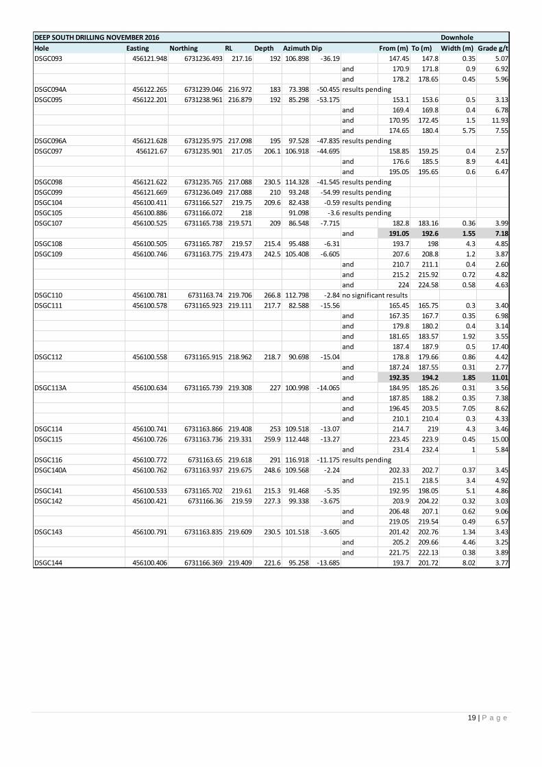
DEEP SOUTH DRILLING NOVEMBER 2016 Downhole
Hole Easting Northing RL Depth Azimuth Dip From (m) To (m) Width (m) Grade g/t
DSGC093 456121.948 6731236.493 217.16 192 106.898 -36.19 147.45 147.8 0.35 5.07
and 170.9 171.8 0.9 6.92
and 178.2 178.65 0.45 5.96
DSGC094A 456122.265 6731239.046 216.972 183 73.398 -50.455 results pending
DSGC095 456122.201 6731238.961 216.879 192 85.298 -53.175 153.1 153.6 0.5 3.13
and 169.4 169.8 0.4 6.78
and 170.95 172.45 1.5 11.93
and 174.65 180.4 5.75 7.55
DSGC096A 456121.628 6731235.975 217.098 195 97.528 -47.835 results pending
DSGC097 456121.67 6731235.901 217.05 206.1 106.918 -44.695 158.85 159.25 0.4 2.57
and 176.6 185.5 8.9 4.41
and 195.05 195.65 0.6 6.47
DSGC098 456121.622 6731235.765 217.088 230.5 114.328 -41.545 results pending
DSGC099 456121.669 6731236.049 217.088 210 93.248 -54.99 results pending
DSGC104 456100.411 6731166.527 219.75 209.6 82.438 -0.59 results pending
DSGC105 456100.886 6731166.072 218 91.098 -3.6 results pending
DSGC107 456100.525 6731165.738 219.571 209 86.548 -7.715 182.8 183.16 0.36 3.99
and 191.05 192.6 1.55 7.18
DSGC108 456100.505 6731165.787 219.57 215.4 95.488 -6.31 193.7 198 4.3 4.85
DSGC109 456100.746 6731163.775 219.473 242.5 105.408 -6.605 207.6 208.8 1.2 3.87
and 210.7 211.1 0.4 2.60
and 215.2 215.92 0.72 4.82
and 224 224.58 0.58 4.63
DSGC110 456100.781 6731163.74 219.706 266.8 112.798 -2.84 no significant results
DSGC111 456100.578 6731165.923 219.111 217.7 82.588 -15.56 165.45 165.75 0.3 3.40
and 167.35 167.7 0.35 6.98
and 179.8 180.2 0.4 3.14
and 181.65 183.57 1.92 3.55
and 187.4 187.9 0.5 17.40
DSGC112 456100.558 6731165.915 218.962 218.7 90.698 -15.04 178.8 179.66 0.86 4.42
and 187.24 187.55 0.31 2.77
and 192.35 194.2 1.85 11.01
DSGC113A 456100.634 6731165.739 219.308 227 100.998 -14.065 184.95 185.26 0.31 3.56
and 187.85 188.2 0.35 7.38
and 196.45 203.5 7.05 8.62
and 210.1 210.4 0.3 4.33
DSGC114 456100.741 6731163.866 219.408 253 109.518 -13.07 214.7 219 4.3 3.46
DSGC115 456100.726 6731163.736 219.331 259.9 112.448 -13.27 223.45 223.9 0.45 15.00
and 231.4 232.4 1 5.84
DSGC116 456100.772 6731163.65 219.618 291 116.918 -11.175 results pending
DSGC140A 456100.762 6731163.937 219.675 248.6 109.568 -2.24 202.33 202.7 0.37 3.45
and 215.1 218.5 3.4 4.92
DSGC141 456100.533 6731165.702 219.61 215.3 91.468 -5.35 192.95 198.05 5.1 4.86
DSGC142 456100.421 6731166.36 219.59 227.3 99.338 -3.675 203.9 204.22 0.32 3.03
and 206.48 207.1 0.62 9.06
and 219.05 219.54 0.49 6.57
DSGC143 456100.791 6731163.835 219.609 230.5 101.518 -3.605 201.42 202.76 1.34 3.43
and 205.2 209.66 4.46 3.25
and 221.75 222.13 0.38 3.89
DSGC144 456100.406 6731166.369 219.409 221.6 95.258 -13.685 193.7 201.72 8.02 3.77
20 | P a g e
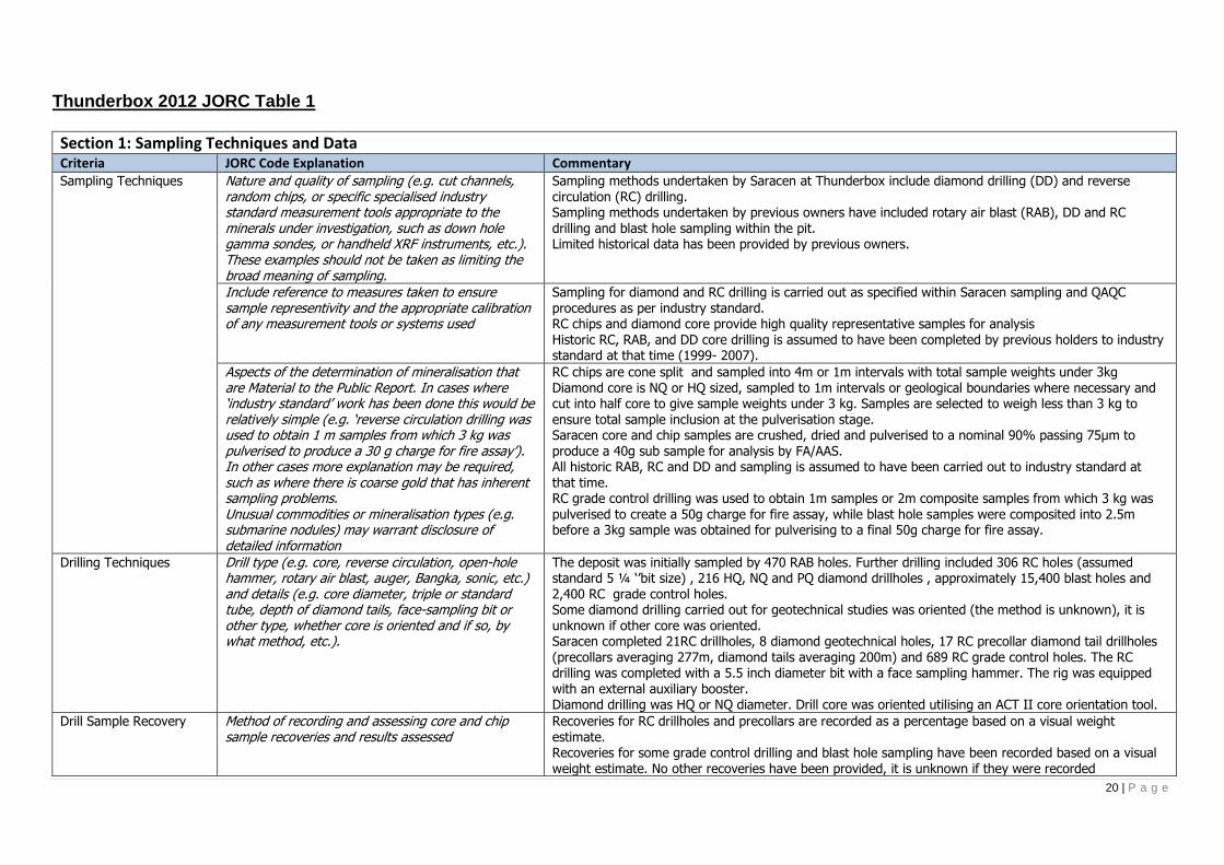
Thunderbox 2012 JORC Table 1
Section 1: Sampling Techniques and Data Criteria JORC Code Explanation Commentary Sampling Techniques
Nature and quality of sampling (e.g. cut channels, random chips, or specific specialised industry standard measurement tools appropriate to the minerals under investigation, such as down hole gamma sondes, or handheld XRF instruments, etc.). These examples should not be taken as limiting the broad meaning of sampling.
Sampling methods undertaken by Saracen at Thunderbox include diamond drilling (DD) and reverse circulation (RC) drilling. Sampling methods undertaken by previous owners have included rotary air blast (RAB), DD and RC drilling and blast hole sampling within the pit. Limited historical data has been provided by previous owners.
Include reference to measures taken to ensure sample representivity and the appropriate calibration of any measurement tools or systems used
Sampling for diamond and RC drilling is carried out as specified within Saracen sampling and QAQC procedures as per industry standard. RC chips and diamond core provide high quality representative samples for analysis Historic RC, RAB, and DD core drilling is assumed to have been completed by previous holders to industry standard at that time (1999- 2007).
Aspects of the determination of mineralisation that are Material to the Public Report. In cases where ‘industry standard’ work has been done this would be relatively simple (e.g. ‘reverse circulation drilling was used to obtain 1 m samples from which 3 kg was pulverised to produce a 30 g charge for fire assay’). In other cases more explanation may be required, such as where there is coarse gold that has inherent sampling problems. Unusual commodities or mineralisation types (e.g. submarine nodules) may warrant disclosure of detailed information
RC chips are cone split and sampled into 4m or 1m intervals with total sample weights under 3kg Diamond core is NQ or HQ sized, sampled to 1m intervals or geological boundaries where necessary and cut into half core to give sample weights under 3 kg. Samples are selected to weigh less than 3 kg to ensure total sample inclusion at the pulverisation stage. Saracen core and chip samples are crushed, dried and pulverised to a nominal 90% passing 75µm to produce a 40g sub sample for analysis by FA/AAS. All historic RAB, RC and DD and sampling is assumed to have been carried out to industry standard at
that time. RC grade control drilling was used to obtain 1m samples or 2m composite samples from which 3 kg was pulverised to create a 50g charge for fire assay, while blast hole samples were composited into 2.5m before a 3kg sample was obtained for pulverising to a final 50g charge for fire assay.
Drilling Techniques Drill type (e.g. core, reverse circulation, open-hole hammer, rotary air blast, auger, Bangka, sonic, etc.) and details (e.g. core diameter, triple or standard tube, depth of diamond tails, face-sampling bit or other type, whether core is oriented and if so, by what method, etc.).
The deposit was initially sampled by 470 RAB holes. Further drilling included 306 RC holes (assumed standard 5 ¼ ‘’bit size) , 216 HQ, NQ and PQ diamond drillholes , approximately 15,400 blast holes and 2,400 RC grade control holes. Some diamond drilling carried out for geotechnical studies was oriented (the method is unknown), it is unknown if other core was oriented. Saracen completed 21RC drillholes, 8 diamond geotechnical holes, 17 RC precollar diamond tail drillholes (precollars averaging 277m, diamond tails averaging 200m) and 689 RC grade control holes. The RC drilling was completed with a 5.5 inch diameter bit with a face sampling hammer. The rig was equipped with an external auxiliary booster. Diamond drilling was HQ or NQ diameter. Drill core was oriented utilising an ACT II core orientation tool.
Drill Sample Recovery Method of recording and assessing core and chip sample recoveries and results assessed
Recoveries for RC drillholes and precollars are recorded as a percentage based on a visual weight estimate. Recoveries for some grade control drilling and blast hole sampling have been recorded based on a visual weight estimate. No other recoveries have been provided, it is unknown if they were recorded

21 | P a g e
Section 1: Sampling Techniques and Data Criteria JORC Code Explanation Commentary
Measures taken to maximise sample recovery andensure representative nature of the samples
During RC drilling daily rig inspections are carried out to check splitter condition, general site and address general issues. Measures were taken to supress groundwater. Diamond core is reconstructed into continuous runs on an angle iron cradle for orientation marking. Depths are checked against depth given on the core blocks. Historical drilling is assumed completed to industry standard at that time
Whether a relationship exists between sample recovery and grade and whether sample bias may have occurred due to preferential loss/gain of fine/coarse material.
There is no known relationship between sample recovery and grade for RC drilling. Diamond drilling has high recoveries meaning loss of material is minimal. Any historical relationship is not known.
Logging Whether core and chip samples have been geologically and geotechnically logged to a level of detail to support appropriate Mineral Resource estimation, mining studies and metallurgical studies. Whether logging is qualitative or quantitative in nature. Core (or costean, channel, etc) photography.
Logging of RC chips and diamond drill core records lithology, mineralogy, texture, mineralisation,
weathering, alteration and veining. Geotechnical and structural logging is carried out on all diamond holes to record recovery, RQD, defect number, type, fill material, shape and roughness and alpha and beta angles. Chips from all RC holes are stored in chip trays for future reference while remaining core is stored in core trays and archived on site. Core is photographed in both dry and wet state. Qualitative and quantitative logging of historic data varies in its completeness.
The total length and percentage of the relevant intersections logged
All drillholes completed by Saracen have been logged in full.
Sub-sampling techniques and sample preparation
If core, whether cut or sawn and whether quarter, half or all core taken.
All drill core is cut in half onsite using an automatic core saw. Duplicate core samples are quarter cored. Samples are always collected from the same side.
If non-core, whether riffled, tube sampled, rotary split, etc and whether sampled wet or dry.
All exploration RC samples are cone split. Occasional wet samples are encountered. The sampling method for historic RAB and RC drilling is unknown. Grade control RC drilling has been cone split while blast hole sampling has been riffle split. Wet drilling was rarely encountered, and extra care was taken to clean the splitter after encountering wet samples. Drillholes in puggy, wet clays were abandoned and redrilled once dewatering of the pit had commenced. Care was taken to adjust the splitter orifice for grade control drilling to ensure the sample weight did not exceed 3kg, meaning no subsampling was needed at the preparation stage.
For all sample types, the nature, quality and appropriateness of the sample preparation technique.
The sample preparation of diamond core and RC chips adhere to industry best practice. It is conducted by a commercial laboratory and involves oven drying, coarse crushing then total grinding to a size of 90% passing 75 microns. The sampling techniques for historic exploration RAB, RC and DD drilling are unknown, best practice is assumed. The sample preparation of RC grade control drilling and blast hole sampling involved oven drying, coarse crushing and total grinding in an LM5.
Quality control procedures adopted for all sub-sampling stages to maximise representivity of samples.
All subsampling activities are carried out by commercial laboratory and are considered to be satisfactory. Best practice is assumed at the time of historic RAB, DD and RC sampling. Procedures adopted to ensure sample representivity for RC grade control and blast hole sampling included weight analysis to determine split ratio (at least 2 holes per program) and sizing analysis of every 25th sample, with an expected return of 90% passing 75um.
Measures taken to ensure that the sampling is representative of the in situ material collected,
RC field duplicate samples are carried out at a rate of 1:20 and are sampled directly from the on-board splitter on the rig. These are submitted for the same assay process as the original samples and the

22 | P a g e
Section 1: Sampling Techniques and Data Criteria JORC Code Explanation Commentary
including for instance results for field duplicate/second half sampling.
laboratory are unaware of such submissions. It is unknown if duplicate sampling was performed on historic exploration RAB, RC and DD drilling. Field duplicates were carried out on RC grade control drilling at a rate of one per hole, collected from the second sample port on the cone splitter. Duplicates were carried out at a rate of 1 in 20 for blast hole sampling.
Whether sample sizes are appropriate to the grain size of the material being sampled.
Analysis of data determined sample sizes were considered to be appropriate.
Quality of assay data and laboratory tests
The nature, quality and appropriateness of the assaying and laboratory procedures used and whether the technique is considered partial or total.
RC chip samples and diamond core are analysed by an external laboratory using a 40g fire assay with AAS finish. This method is considered suitable for determining gold concentrations in rock and is a total digest method.
A 50 gram fire assay with AAS finish was used to determine the gold concentration for all grade control samples. This method is considered suitable for determining gold concentrations in rock and is a total digest method. Methods for exploration RC, RAB and DD drilling included fire assay with AAS finish, BAAS and unknown methods.
For geophysical tools, spectrometers, handheld XRF instruments, etc, the parameters used in determining the analysis including instrument make and model, reading times, calibrations factors applied and their derivation, etc.
The clay mineralogy of the deposit was investigated using PIMA (Portable Infra-red Microscopic Analyser) analysis to assist with geological interpretation. This data was not used in the estimation process.
Nature of quality control procedures adopted (e.g. standards, blanks, duplicates, external laboratory checks) and whether acceptable levels of accuracy (i.e. lack of bias) and precision have been established.
Certified reference material (standards and blanks) with a wide range of values are inserted into every drillhole at a rate of 1:25 for exploration RC and DD. These are not identifiable to the laboratory. QAQC data returned are checked against pass/fail limits with the SQL database and are passed or failed on import. A report is generated and reviewed by the geologist as necessary upon failure to determine further action. QAQC data is reported monthly. Sample preparation checks for fineness are carried out to ensure a grindsize of 90% passing 75 microns. The laboratory performs a number of internal processes including standards, blanks, repeats and checks. QAQC data analysis demonstrates sufficient accuracy and precision. Industry best practice is assumed for previous holders.
Verification of sampling and assaying
The verification of significant intersections by either independent or alternative company personnel.
Significant intercepts are verified by the Geology Manager and corporate personnel
The use of twinned holes. A number of exploration RC holes were drilled to twin original RAB holes and verify results.
Documentation of primary data, data entry procedures, data verification, data storage (physical and electronic) protocols
Primary data is collated in a set of excel templates utilising lookup codes. This data is forwarded to the Database Administrator for entry into a secure acQuire database with inbuilt validation functions. Data from previous owners was taken from a database compilation and validated as much as practicable before entry into the Saracen acQuire database
Discuss any adjustment to assay data. No adjustments have been made to assay data. First gold assay is utilised for resource estimation.
Location of data points Accuracy and quality of surveys used to locate drillholes (collar and down-hole surveys), trenches, mine workings and other locations used in Mineral
Exploration drillholes are located using a Leica 1200 GPS with an accuracy of +/- 10mm. Downhole surveys are carried out using a hired Reflex EZ-gyro by the respective drilling companies on a regular basis, between 10-30m.

23 | P a g e
Section 1: Sampling Techniques and Data Criteria JORC Code Explanation Commentary
Resource estimation. Specification of the grid system used. MGA Zone 51 grid coordinate system is used
Quality and adequacy of topographic control. Kevron Geomatic Services flew and processed aerial photography and provided ortho images at 1:5000 scale over the Thunderbox deposit and environs.
Data spacing and distribution
Data spacing for reporting of Exploration Results. The nominal spacing for drilling is varied from 20mx20m to 40mx40m
Whether the data spacing and distribution is sufficient to establish the degree of geological and grade continuity appropriate for the Mineral Resource and Ore Reserve estimation procedure(s) and classifications applied.
The drilling is distributed and spaced such that geological and grade continuity can be established to estimate the mineral resource and ore reserve appropriately. The mineralisation is continuous over a 2km strike length, therefore the 80m x 80m exploration drill spacing effectively defines the continuity.
Orientation of data in relation to geological structure
Whether sample compositing has been applied.
RC precollar sampling was composted into 4m samples. Historic RAB drilling was sampled with 4m composite samples. Grade control RC drilling was carried out on 2m composite samples, while blast hole sampling was carried out on 2.5m composites.
Whether the orientation of sampling achieves unbiased sampling of possible structures and the extent to which this is known, considering the deposit type.
The bulk of the drilling has been oriented to the east in order to provide the best intersection angles possible for the steeply west dipping orebody.
If the relationship between the drilling orientation and the orientation of key mineralised structures is considered to have introduced a sampling bias, this should be assessed and reported if material.
All drilling from surface has been drilled as close to perpendicular as possible. This has reduced the risk of introducing a sampling bias as far as possible.
Sample security The measures taken to ensure sample security. Samples are prepared on site under supervision of Saracen geological staff. Samples are selected, bagged
into tied numbered calico bags then grouped into secured cages and collected by the laboratory personnel. Sample submissions are documented via laboratory tracking systems and assays are returned via email
Audits or reviews The results of any audits or reviews of sampling techniques and data.
An internal review of companywide sampling methodologies was conducted to create the current sampling and QAQC procedures. No external audits or reviews have been conducted
Section 2: Reporting of Exploration Results Criteria JORC Code Explanation Commentary Mineral tenement and land tenure status
Type, reference name/number, location and ownership including agreements or material issues with third parties such as joint ventures, partnerships, overriding royalties, native title interests, historical sites, wilderness or national park and environmental settings.
M36/504, M36/512 and M36/542 form part of the Thunderbox project and are in good standing. There are no native title claims over the Thunderbox deposit.
A number of heritage surveys have been undertaken with Aboriginal groups with no sites of significance identified. In addition a detailed archaeological survey has been conducted with no sites of significance identified
The security of the tenure held at the time of reporting along with any known impediments to obtaining a licence to operate in the area.
The tenements are in good standing and the license to operate already exists.
24 | P a g e
Section 2: Reporting of Exploration Results Criteria JORC Code Explanation Commentary Exploration done by other parties
Acknowledgment and appraisal of exploration by other parties.
Extensive nickel exploration was undertaken in the area during the 1960s and 1970s. Grassroots gold and PGE exploration was undertaken during and since the 1980s by BHP, Dominion, Dalrymple Resources and Forrestania Gold. Thunderbox was discovered in 1999.
Geology Deposit type, geological setting and style of mineralisation.
Thunderbox is a mesothermal lode gold deposit located at the southern end of the Yandal greenstone belt in an area where several major shear zones converge and join with the Perseverance Fault. The shear zone dips at 30° to 60° WSW, with the exception in the vicinity of the mineralisation, where the shear is vertical to steeply dipping. Mineralisation is hosted by strongly deformed, silicified and carbonate altered albite-quartz porphyry in the hangingwall of the shear zone. The shear juxtaposes foliated basalts and intrusive porphyries in the hangingwall against sedimentary rocks in the footwall. The zone of shearing is over 200m wide. An ultramafic unit occurs within the shear, in the footwall of the deposit and is attenuated along the shear. The main gold related hydrothermal alteration assemblage comprises quartz-ankerite-arsenopyrite-pyrrhotite-galena and gold. This assemblage has been overprinted by a retrograde chlorite-epidote-white mica-biotite-quartz and pyrite assemblage. Syn-mineralisation veins have a continuum of vein textures ranging from laminated to pseudo-breccias.
Drillhole information A summary of all information material to the understanding of the exploration results including a tabulation of the following information for all Material drill holes:
easting and northing of the drill hole collar elevation or RL (Reduced Level – elevation above sea level in metres) of the drill hole
collar dip and azimuth of the hole down hole length and interception depth hole length. If the exclusion of this information is justified
on the basis that the information is not Material and this exclusion does not detract from the understanding of the report, the Competent Person should clearly explain why this is the case.
A total of 458 holes have been used in the mineral resource and are deemed to be material. It is not practical to summarise all of the holes here in this release. Exclusion of the drilling information will not detract from the reader’s view of the report. All material data is periodically released on the ASX: 25/11/2015, 29/04/2015, 23/03/2015
Data aggregation methods
In reporting Exploration Results, weighting averaging techniques, maximum and/or minimum grade truncations (e.g. cutting of high grades) and cut-off grades are usually Material and should be stated.
All significant intercepts have been length weighted with a minimum Au grade of 0.5ppm. No high grade cut off has been applied.
Where aggregate intercepts incorporate short lengths of high grade results and longer lengths of low grade results, the procedure used for such aggregation should be stated and some typical examples of such aggregations should be shown in detail.
Intercepts are aggregated with minimum width of 1m and maximum width of 3m for internal dilution.
25 | P a g e
Section 2: Reporting of Exploration Results Criteria JORC Code Explanation Commentary
The assumptions used for any reporting of metal equivalent values should be clearly stated.
There are no metal equivalents reported in this release.
Relationship between mineralisation widths and intercept lengths
These relationships are particularly important in the reporting of Exploration Results. If the geometry of the mineralisation with respect to the drill hole angle is known, its nature should be reported. If it is not known and only the down hole lengths are reported, there should be a clear statement to this effect (eg ‘down hole length, true width not known’).
This announcement includes sufficient detail to clearly illustrate the geometry of the mineralisation and the recent drilling. All results are reported as downhole lengths. The geometry of the mineralisation is well known and true thickness can be calculated. Drilling intersects the mineralisation perpendicular and at an average intersection angle of 45 degrees.
Diagrams Appropriate maps and sections (with scales) and tabulations of intercepts should be included for any significant discovery being reported These should include, but not be limited to a plan view of drill hole collar locations and appropriate sectional views.
Included in this release is an appropriately orientated longsection of the mineralisation, illustrating the centroids of the intercept point projected to a plane. Included also in this release are cross section views of the mineralisation which provides the visual perspective of the typical drilling angle.
Balanced Reporting Where comprehensive reporting of all Exploration Results are not practicable, representative reporting of both low and high grades and/or widths should be practiced to avoid misleading reporting of Exploration Results.
All results from the recent campaign have been reported, irrespective of success or not.
Other substantive
exploration data
Other exploration data, if meaningful and material, should be reported including (but not limited to): geological observations; geophysical survey results; geochemical survey results; bulk samples – size and method of treatment; metallurgical test results; bulk density, groundwater, geotechnical and rock characteristics; potential deleterious or contaminating substances.
Historic activities have included drilling to obtain samples for metallurgical test work, bulk density analyses
and geotechnical analyses. A number of geophysical surveys including dipole-dipole IP, Gradient array IP and TEM were carried out over known mineralisation to determine effectiveness in delineating mineralisation/alteration. None were deemed effective. An environmental survey investigated the erosional characteristics of the soil, surface hydrology and groundwater and identified no issues. A partial leach soil sampling program carried out over the deposit was deemed effective in identifying anomalous gold values associated with the deposit. A detailed structural review of the mineralisation has been conducted by Model Earth
Further work The nature and scale of planned further work (eg tests for lateral extensions or depth extensions or large-scale step-out drilling). Diagrams clearly highlighting the areas of possible extensions, including the main geological interpretations and future drilling areas, provided this information is not commercially sensitive
Saracen is currently working on establishing exploration opportunities which will extend the known mineralisation at depth. This will primarily focus on understanding the key geological relationships and critical continuity directions to target depth extensions.

26 | P a g e
King of the Hills 2012 JORC Table 1
Section 1: Sampling Techniques and Data Criteria JORC Code Explanation Commentary Sampling Techniques Nature and quality of sampling (e.g. cut channels,
random chips, or specific specialised industry standard measurement tools appropriate to the minerals under investigation, such as down hole gamma sondes, or handheld XRF instruments, etc.). These examples should not be taken as limiting the broad meaning of sampling.
Sampling activities conducted at King of the Hills by Saracen include underground diamond drilling (DD) and underground face chip sampling. Sampling methods undertaken at King of the Hills by previous owners have included rotary air blast (RAB), reverse circulation (RC), aircore (AC) and diamond drillholes (DD).
Include reference to measures taken to ensure sample representivity and the appropriate calibration of any measurement tools or systems used
Sampling for DD and face chip sampling is carried out as specified within Saracen sampling and QAQC procedures as per industry standard. RC, RAB, AC and DD core drilling is assumed to have been completed by previous holders to industry standard at that time (1984- 2014).
Aspects of the determination of mineralisation that are Material to the Public Report. In cases where ‘industry standard’ work has been done this would be relatively simple (e.g. ‘reverse circulation drilling was used to obtain 1 m samples from which 3 kg was pulverised to produce a 30 g charge for fire assay’). In other cases more explanation may be required, such as where there is coarse gold that has inherent sampling problems. Unusual commodities or mineralisation types (e.g. submarine nodules) may warrant disclosure of detailed information
Saracen sampling activities have been carried out to industry standard. Core samples are crushed, dried and pulverised to a nominal 90% passing 75µm to produce a 40g sub sample for analysis by FA/AAS. All historic RAB, RC, AC and DD and sampling is assumed to have been carried out to industry standard at that time. The majority of the recent historic drillholes have been sampled to 1m intervals to provide a 2.5-3 kg sample for analysis via fire assay and atomic absorption spectroscopy. Historical analysis methods include fire assay, aqua regia and unknown methods.
Drilling Techniques Drill type (e.g. core, reverse circulation, open-hole hammer, rotary air blast, auger, Bangka, sonic, etc.) and details (e.g. core diameter, triple or standard tube, depth of diamond tails, face-sampling bit or other type, whether core is oriented and if so, by what method, etc.).
The number of holes intersecting the current resource is 2,072 amounting to 159,956 m. The holes include both RC and Diamond holes. RC drilling is mainly concentrated mainly in the upper parts of the deposit, while diamond drilling is mainly concentrated in the deeper levels. Overall there are 87,989 reverse circulation samples, and 72,049 Diamond core samples. Saracen has completed 42 NQ underground diamond drill holes and sampled 20 underground faces All core is oriented using an Ezi mark tool.
Drill Sample Recovery Method of recording and assessing core and chip sample recoveries and results assessed
Underground diamond core recoveries are recorded as percentages calculated from measured core versus drilled metres, and intervals are logged and recorded in the database. Diamond core recoveries average >90%. It has been noted that recoveries for historic diamond drilling were rarely less than 100% although recovery data has not been provided. Minor core loss was most likely due to drilling conditions and not ground conditions.
Measures taken to maximise sample recovery and ensure representative nature of the samples
Diamond core is reconstructed into continuous runs on an angle iron cradle for orientation marking. Depths are checked against depth given on the core blocks. UG faces are sampled left to right across the face allowing a representative sample to be taken. It is unknown what, if any, measures were taken to ensure sample recovery and representivity with historic sampling.
27 | P a g e
Section 1: Sampling Techniques and Data Criteria JORC Code Explanation Commentary
Whether a relationship exists between sample recovery and grade and whether sample bias may have occurred due to preferential loss/gain of fine/coarse material.
There is no known relationship between sample recovery and grade. Diamond drilling has high recoveries due to the competent nature of the ground meaning loss of material is minimal. Any historical relationship is not known.
Logging Whether core and chip samples have been geologically and geotechnically logged to a level of detail to support appropriate Mineral Resource estimation, mining studies and metallurgical studies. Whether logging is qualitative or quantitative in nature. Core (or costean, channel, etc) photography.
Logging of diamond drill core has recorded lithology, mineralogy, texture, mineralisation, weathering, alteration and veining. Geotechnical and structural logging is carried out on all diamond core holes to record recovery, RQD, defect number, type, fill material, shape and roughness and alpha and beta angles. Core is photographed in both dry and wet state. All faces are photographed and mapped. Qualitative and quantitative logging of historic data varies in its completeness. Some diamond drilling has been geotechnically logged to provide data for geotechnical studies. Some historic diamond core photography has been preserved.
The total length and percentage of the relevant intersections logged
All diamond drillholes are logged in full and all faces are mapped. Historic logging varies in its completeness.
Sub-sampling techniques and sample preparation
If core, whether cut or sawn and whether quarter, half or all core taken.
All diamond core is cut in half onsite using an automatic core saw. Samples are always collected from the same side.
If non-core, whether riffled, tube sampled, rotary split, etc and whether sampled wet or dry.
Various sampling methods for historic RAB, AC and RC drilling have been carried out including scoop, spear, riffle and cyclone split. UG faces are chip sampled using a hammer. It is unknown if wet sampling was carried out.
For all sample types, the nature, quality and appropriateness of the sample preparation technique.
The sample preparation of diamond core and UG face chips adhere to industry best practice. It is conducted by a commercial laboratory and involves oven drying, coarse crushing then total grinding using an LM5 to a grind size of 90% passing 75 microns. Best practice is assumed at the time of historic sampling.
Quality control procedures adopted for all sub-sampling stages to maximise representivity of samples.
All subsampling activities are carried out by commercial laboratory and are considered to be satisfactory. Best practice is assumed at the time of historic RAB, DD, AC and RC sampling.
Measures taken to ensure that the sampling is representative of the in situ material collected, including for instance results for field duplicate/second half sampling.
Some duplicate sampling was performed on historic RAB, RC, AC and DD drilling. No duplicates have been taken of UG diamond core, face samples are duplicated on ore structures.
Whether sample sizes are appropriate to the grain size of the material being sampled.
Analysis of data determined sample sizes were considered to be appropriate.
Quality of assay data and laboratory tests
The nature, quality and appropriateness of the assaying and laboratory procedures used and whether the technique is considered partial or total.
A 40 gram fire assay with AAS finish is used to determine the gold concentration for UG diamond core and face chip samples. This method is considered one of the most suitable for determining gold concentrations in rock and is a total digest method. Historic sampling includes fire assay, aqua regia and unknown methods.
For geophysical tools, spectrometers, handheld XRF instruments, etc, the parameters used in determining the analysis including instrument make and model, reading times, calibrations factors applied and their derivation, etc.
No geophysical tools have been utilised at the King of the Hills project

28 | P a g e
Section 1: Sampling Techniques and Data Criteria JORC Code Explanation Commentary
Nature of quality control procedures adopted (e.g. standards, blanks, duplicates, external laboratory checks) and whether acceptable levels of accuracy (i.e. lack of bias) and precision have been established.
Certified reference material (standards and blanks) with a wide range of values are inserted into diamond drillhole(1 in 30) and UG face job to assess laboratory accuracy and precision and possible contamination. These are not identifiable to the laboratory. Blanks are also included at a rate of 1 in 30 for diamond drill core and one per lab dispatch for face samples. QAQC data returned are checked against pass/fail limits with the SQL database and are passed or failed on import. A report is generated and reviewed by the geologist as necessary upon failure to determine further action. QAQC data is reported monthly and demonstrates sufficient levels of accuracy and precision. Sample preparation checks for fineness are carried out to ensure a grind size of 90% passing 75 microns. The laboratory performs a number of internal processes including standards, blanks, repeats and checks. Industry best practice is assumed for previous holders. Historic QAQC data is stored in the database but not reviewed.
Verification of sampling and assaying
The verification of significant intersections by either independent or alternative company personnel.
Significant intercepts are verified by the Geology Manager and corporate personnel.
The use of twinned holes. No specific twinned holes have been drilled at King of the Hills but underground diamond drilling has confirmed the width and grade of previous exploration drilling.
Documentation of primary data, data entry procedures, data verification, data storage (physical and electronic) protocols
Primary data is collated in a set of excel templates utilising lookup codes. This data is forwarded to the Database Administrator for entry into a secure acQuire database with inbuilt validation functions. Remaining half core is stored in core trays and archived on site Hard copies of face mapping, backs mapping and sampling records are kept on site. Digital scans are also kept on the corporate server. Data from previous owners was taken from a database compilation and was validated as much as practicable before entry into the Saracen acQuire database.
Discuss any adjustment to assay data. No adjustments have been made to assay data. First gold assay is utilised for resource estimation. Reassays carried out due to failed QAQC will replace original results, though both are stored in the database.
Location of data points Accuracy and quality of surveys used to locate drillholes (collar and down-hole surveys), trenches, mine workings and other locations used in Mineral Resource estimation.
All drillhole collars are picked up by company surveyors using a Leica TS15i (total station) with an expected accuracy of +/-2mm. Underground faces are located using a Leica D5 disto with and accuracy of +/- 1mm from a known survey point. Historic drilling was located using mine surveyors and standard survey equipment; more recent surface drilling has been surveyed using a DGPS system. Surveys are carried out every 15-30m downhole during diamond drilling using an Eastman single shot camera, with the entire hole being surveyed using a deviflex tool upon completion. The majority of downhole surveys for historic RAB, RC, AC and DD drilling are estimates only. More recent (post 1990) drilling has been surveyed with downhole survey tools at regular intervals including DEMS, gyroscope and camera.
Specification of the grid system used. A local grid system (King of the Hills) is used. It is rotated 25.89 degrees east of MGA_GDA94. The two point conversion to MGA_GDA94 zone 51 is KOTHEast KOTHNorth RL MGAEast MGANorth RL Point 1 49823.541 9992.582 0 320153.794 6826726.962 0 Point 2 50740.947 10246.724 0 320868.033 6827356.243 0 Historic data is converted to King of the Hills local grid on export from the database.

29 | P a g e
Section 1: Sampling Techniques and Data Criteria JORC Code Explanation Commentary
Quality and adequacy of topographic control. DGPS survey has been used to establish a topographic surface.
Data spacing and distribution
Data spacing for reporting of Exploration Results. Data reported is of variable spacing.
Whether the data spacing and distribution is sufficient to establish the degree of geological and grade continuity appropriate for the Mineral Resource and Ore Reserve estimation procedure(s) and classifications applied.
Historical Data spacing is nominally 20m N-S by 20m E-W in indicated areas of the deposit and sparser in inferred areas of the deposit. 10m N-S by 15m E-W or closer in grade control drilling areas. Current drilling is broadly aiming to match the existing data set.
Orientation of data in relation to geological structure
Whether sample compositing has been applied.
Underground core and faces are sampled to geological intervals; compositing is not applied until the estimation stage. Some historic RAB and AC drilling was sampled with 3-4m composite samples. Anomalous zones were resampled at 1m intervals in some cases; it is unknown at what threshold this occurred.
Whether the orientation of sampling achieves unbiased sampling of possible structures and the extent to which this is known, considering the deposit type.
Sampling has been conducted in most cases perpendicular to the lode orientations where the mineralisation controls are well understood. Some historical drilling in this deposit has not been optimally intersected, given that that not all the mineralisation controls are well understood. Current drilling is aiming to drill perpendicular to the modelled lodes. Various underground drill locations are being used to optimise the drill orientation.
If the relationship between the drilling orientation and the orientation of key mineralised structures is considered to have introduced a sampling bias, this should be assessed and reported if material.
There is no record of any sample bias that has been introduced because of the relationship between the orientation of the drilling and that of the mineralised structures. Estimated true widths of ore intercepts are provided where drilling angles are not representative.
Sample security The measures taken to ensure sample security. Samples are prepared on site under supervision of Saracen geological staff. Samples are selected, bagged into tied numbered calico bags then grouped into larger secured bags and delivered to the laboratory by Saracen personnel.
Audits or reviews The results of any audits or reviews of sampling techniques and data.
An internal review of companywide sampling methodologies was conducted to create the current sampling and QAQC procedures. No external audits or reviews have been conducted.

30 | P a g e
Section 2: Reporting of Exploration Results Criteria JORC Code Explanation Commentary Mineral tenement and land tenure status
Type, reference name/number, location and ownership including agreements or material issues with third parties such as joint ventures, partnerships, overriding royalties, native title interests, historical sites, wilderness or national park and environmental settings.
The King of the Hill pit and near mine exploration are located on M37/67, M37/76, M37/90, M37/201 and M37/248 which expire between 2028 and 2031. All mining leases have a 21 year life and are renewable for a further 21 years on a continuing basis. The mining leases are 100% held and managed by Saracen Metals Pty Limited, a wholly owned subsidiary of Saracen Minerals Holdings Limited. The mining leases are subject to a 1.5% ‘IRC’ royalty. Mining leases M37/67, M37/76, M37/201 and M37/248 are subject to a mortgage with ‘PT Limited’. All production is subject to a Western Australian state government ‘NSR’ royalty of 2.5%. All bonds have been retired across these mining leases and they are all currently subject to the conditions imposed by the MRF. There are currently no native title claims applied for or determined across these mining leases. However, an agreement for Heritage Protection between St Barbara Mines Ltd and the Wutha People still applies. Lodged aboriginal heritage site (Place ID: 1741), which is an Other Heritage Place referred to as the “Lake Raeside/Sullivan Creek” site, is located in M37/90.
The security of the tenure held at the time of reporting along with any known impediments to obtaining a licence to operate in the area.
The tenements are in good standing and the license to operate already exists.
Exploration done by other parties
Acknowledgment and appraisal of exploration by other parties.
The King of the Hills prospect was mined sporadically from 1898-1918. Modern exploration in the Leonora area was triggered by the discovery of the Habour Lights and Tower Hill prospects in the early 1980s, with regional mapping indicating the King of the Hills prospect area was worthy of further investigation. Various companies (Esso, Ananconda, BP Minerals. Kulim) carried out sampling, mapping and drilling activities delineating gold mineralisation. Kulim mined two small open pits in JV with Sons of Gwalia during 1986 and 1987. Arboynne took over Kulim’s interest and outlined a new resource while Mount Edon carried out exploration on the surrounding tenements. Mining commenced but problems lead to Mount Edon acquiring the whole project area from Kulim, leading to the integration of the King of the Hills, KOTH West and KOTH Extended into the Tarmoola Project. Pacmin bought out Mount Edon and were subsequently taken over by Sons of Gwalia. St Barbara acquired the project after taking over Sons of Gwalia in 2005.
Geology Deposit type, geological setting and style of mineralisation.
Gold mineralisation is associated with sheeted quartz vein sets within a hosting granodiorite stock and pervasively carbonate altered ultramafic rocks. Mineralisation is thought to have occurred within a brittle/ductile shear zone with the main thrust shear zone forming the primary conduit for the mineralising fluids. Pre-existing quartz veining and brittle fracturing of the granite created a network of second order conduits for mineralising fluids. Gold appears as free particles or associated with traces of base metals sulphides (galena, chalcopyrite, pyrite) intergrown within quartz along late stage fractures.
Drillhole information A summary of all information material to the understanding of the exploration results including a tabulation of the following information for all Material drill holes:
A total of 2,072 holes have been used in the mineral resource and are deemed to be material. It is not practical to summarise all of the holes here in this release. Future drill hole data will be periodically released or when a results materially change the economic value

31 | P a g e
Section 2: Reporting of Exploration Results Criteria JORC Code Explanation Commentary
- easting and northing of the drill hole collar elevation or RL (Reduced Level – elevation above sea level in metres) of the drill hole collar - dip and azimuth of the hole - down hole length and interception depth - hole length. • If the exclusion of this information is justified on the basis that the information is not Material and this exclusion does not detract from the understanding of the report, the Competent Person should clearly explain why this is the case.
of the project. Exclusion of the drilling information will not detract from the reader’s view of the report.
Data aggregation methods
In reporting Exploration Results, weighting averaging techniques, maximum and/or minimum grade truncations (e.g. cutting of high grades) and cut-off grades are usually Material and should be stated.
All significant intercepts have been length weighted with a lower cut-off Au grade of 2.5ppm. No high grade cut is applied
Where aggregate intercepts incorporate short lengths of high grade results and longer lengths of low grade results, the procedure used for such aggregation should be stated and some typical examples of such aggregations should be shown in detail.
Intercepts are aggregated with minimum width of 0.3m and maximum width of 3m for internal dilution.
The assumptions used for any reporting of metal equivalent values should be clearly stated.
There are no metal equivalents reported in this release.
Relationship between mineralisation widths and intercept lengths
These relationships are particularly important in the reporting of Exploration Results. If the geometry of the mineralisation with respect to the drill hole angle is known, its nature should be reported. If it is not known and only the down hole lengths are reported, there should be a clear statement to this effect (eg ‘down hole length, true width not known’).
Estimated true widths of ore intercepts are provided where drilling angles are not representative. Mineralisation at King of the Hills has been intersected in most cases where mineralisation controls are known, approximately perpendicular to the orientation of the mineralised lodes. Due to the shear abundance of the mineralised structures at King of The Hill, it is unavoidable that some of this mineralisation has not been optimally intersected.
Diagrams Appropriate maps and sections (with scales) and tabulations of intercepts should be included for any significant discovery being reported These should include, but not be limited to a plan view of drill hole collar locations and appropriate sectional views.
Included in this release is an appropriately orientated longsection of the mineralisation, illustrating the centroids of the intercept point projected to a plane. Included also in this release are cross section views of the mineralisation which provides the visual perspective of the typical drilling angle.
Balanced Reporting All results from the recent campaign have been reported, irrespective of success or not.
All results from the recent campaign have been reported, irrespective of success or not.
Other substantive exploration data
Other exploration data, if meaningful and material, should be reported including (but not limited to): geological observations; geophysical survey results; geochemical survey results; bulk samples – size and
Aerial photography, geotechnical drilling, petrological studies, ground magnetics, metallurgical test-work and whole rock geochemistry have been completed by various companies over the history of the deposit. Seismic and gravity surveys were carried out in 2003 and 2004 in an effort to identify controls on the mineralisation. Preliminary results indicated that the Tarmoola granite has a base and that mafics exist

32 | P a g e
Section 2: Reporting of Exploration Results Criteria JORC Code Explanation Commentary
method of treatment; metallurgical test results; bulk density, groundwater, geotechnical and rock characteristics; potential deleterious or contaminating substances.
below this. The reporting was not completed due to Sons of Gwalia entering into administration. St Barbara completed an extended gravity survey from the previous one that was successful in delineating the granite/greenstone contact and mapped poorly tested extensions to known mineralised trends.
Further work The nature and scale of planned further work (eg tests for lateral extensions or depth extensions or large-scale step-out drilling). Diagrams clearly highlighting the areas of possible extensions, including the main geological interpretations and future drilling areas, provided this information is not commercially sensitive
Saracen is currently continuing the exploration drilling to the south of the current mine through underground drilling. Further grade control drilling will be conducted as needed.
33 | P a g e
Karari 2012 JORC Table 1
Section 1: Sampling Techniques and Data Criteria JORC Code Explanation Commentary Sampling Techniques Nature and quality of sampling (e.g. cut channels,
random chips, or specific specialised industry standard measurement tools appropriate to the minerals under investigation, such as down hole gamma sondes, or handheld XRF instruments, etc.). These examples should not be taken as limiting the broad meaning of sampling.
Sampling methods undertaken by Saracen at Karari have included reverse circulation drillholes (RC), diamond drillholes (DD) and RC grade control drilling within the pit, and diamond drilling and face chip sampling underground. Historic sampling methods conducted since 1991 have included aircore (AC), rotary air blast (RAB), reverse circulation and diamond drillholes.
Include reference to measures taken to ensure sample representivity and the appropriate calibration of any measurement tools or systems used
Sampling for diamond and RC drilling and face chip sampling is carried out as specified within Saracen sampling and QAQC procedures as per industry standard. RC chips and diamond core provide high quality representative samples for analysis. RC, RAB, AC and DD core drilling was completed by previous holders to industry standard at that time (1991- 2004).
Aspects of the determination of mineralisation that are Material to the Public Report. In cases where ‘industry standard’ work has been done this would be relatively simple (e.g. ‘reverse circulation drilling was used to obtain 1 m samples from which 3 kg was pulverised to produce a 30 g charge for fire assay’). In other cases more explanation may be required, such as where there is coarse gold that has inherent sampling problems. Unusual commodities or mineralisation types (e.g. submarine nodules) may warrant disclosure of detailed information
RC chips are cone or riffle split and sampled into 1m intervals, diamond core is NQ or HQ sized, sampled to 1m intervals or geological boundaries where necessary and cut into half core and underground faces are chip sampled to geological boundaries (0.2-1m). All methods are used to produce representative sample of less than 3 kg. Samples are selected to weigh less than 3 kg to ensure total sample inclusion at the pulverisation stage. Saracen core and chip samples are crushed, dried and pulverised to a nominal 90% passing 75µm to produce a 40g or 50 g sub sample for analysis by FA/AAS. Some grade control RC chips were analysed in the Saracen on site laboratory using a PAL (pulverise and leach) method. Visible gold is sometimes encountered in underground drillcore and face samples. Historical AC, RAB, RC and diamond sampling was carried out to industry standard at that time. Analysis methods include fire assay and unspecified methods.
Drilling Techniques Drill type (e.g. core, reverse circulation, open-hole hammer, rotary air blast, auger, Bangka, sonic, etc.) and details (e.g. core diameter, triple or standard tube, depth of diamond tails, face-sampling bit or other type, whether core is oriented and if so, by what method, etc.).
The deposit was initially sampled by 11 AC holes, 452 RAB holes, 496 RC holes (assumed standard 5 ¼ ‘’bit size) and 25 surface unknown diameter diamond core holes. Saracen has completed 13 surface RC precollars with HQ and NQ diamond tail drill holes (precollars averaging 287m, diamond tails averaging 168m) , 73 RC holes from both surface and within the pit ( recent drilling utilised a 143mm diameter bit with a face sampling hammer and an external auxiliary booster) and 3052 grade control RC holes within the pit. 298 NQ diamond holes have been drilled underground. 521 underground faces and walls have been chip sampled. Diamond tails were oriented using an Ezi-mark tool. Some historic surface diamond drill core appears to have been oriented by unknown methods.
Drill Sample Recovery Method of recording and assessing core and chip sample recoveries and results assessed
RC sampling recoveries are recorded in the database as a percentage based on a visual weight estimate; no historic recoveries have been recorded. Diamond core recovery percentages calculated from measured core versus drilled intervals are logged and recorded in the database. Recoveries average >90%.
Measures taken to maximise sample recovery and ensure representative nature of the samples
RC drilling daily rig inspections are carried out to check splitter condition, general site and address general issues. Diamond core is reconstructed into continuous runs on an angle iron cradle for orientation marking. Depths are checked against depth given on the core blocks.

34 | P a g e
Section 1: Sampling Techniques and Data Criteria JORC Code Explanation Commentary
UG faces are sampled from left to right across the face at the same height from the floor. During GC campaigns the sample bags weight versus bulk reject weight are compared to ensure adequate and even sample recovery. Historical AC, RAB, RC and diamond drilling to industry standard at that time.
Whether a relationship exists between sample recovery and grade and whether sample bias may have occurred due to preferential loss/gain of fine/coarse material.
There is no known relationship between sample recovery and grade for RC drilling. Diamond drilling has high recoveries due to the competent nature of the ground meaning loss of material is minimal. Any historical relationship is not known.
Logging Whether core and chip samples have been geologically and geotechnically logged to a level of detail to support appropriate Mineral Resource estimation, mining studies and metallurgical studies. Whether logging is qualitative or quantitative in nature. Core (or costean, channel, etc) photography.
Logging of RC chips and diamond drill core records lithology, mineralogy, texture, mineralisation, weathering, alteration and veining. Geotechnical and structural logging is carried out on all diamond holes to record recovery, RQD, defect number, type, fill material, shape and roughness and alpha and beta angles. All faces are photographed and mapped. Chips from all RC holes (exploration and GC) are stored in chip trays for future reference while remaining core is stored in core trays and archived on site. Core is photographed in both dry and wet state. Qualitative and quantitative logging of historic data varies in its completeness.
The total length and percentage of the relevant intersections logged
All RC and diamond drillholes holes are logged in full and all faces are mapped. Every second drill line is logged in grade control programs with infill logging carried out as deemed necessary. Historical logging is approximately 95% complete.
Sub-sampling techniques and sample preparation
If core, whether cut or sawn and whether quarter, half or all core taken.
All drill core is cut in half onsite using an automatic core saw. Samples are always collected from the same side.
If non-core, whether riffled, tube sampled, rotary split, etc and whether sampled wet or dry.
All exploration and grade control RC samples are cone or riffle split. Occasional wet samples are encountered. Underground faces are chip sampled using a hammer. AC, RAB and RC drilling has been sampled using riffle and unknown methods.
For all sample types, the nature, quality and appropriateness of the sample preparation technique.
The sample preparation of diamond core and RC and underground face chips adhere to industry best practice. It is conducted by a commercial laboratory and involves oven drying, coarse crushing then total grinding to a size of 90% passing 75 microns. Best practice is assumed at the time of historic sampling.
Quality control procedures adopted for all sub-sampling stages to maximise representivity of samples.
All subsampling activities are carried out by commercial laboratory and are considered to be satisfactory. Sampling by previous holders assumed to be industry standard at the time.
Measures taken to ensure that the sampling is representative of the in situ material collected, including for instance results for field duplicate/second half sampling.
RC field duplicate samples are carried out at a rate of 1:20 and are sampled directly from the on-board splitter on the rig. These are submitted for the same assay process as the original samples and the laboratory are unaware of such submissions. No duplicates have been taken of underground core or face samples. Sampling by previous holders assumed to be industry standard at the time.
Whether sample sizes are appropriate to the grain size of the material being sampled.
Sample sizes of 3kg are considered to be appropriate given the grain size (90% passing 75 microns) of the material sampled.
Quality of assay data and laboratory tests
The nature, quality and appropriateness of the assaying and laboratory procedures used and
RC chip samples, grade control chip samples, underground face chip samples and diamond core are analysed by external laboratories using a 40g or 50g fire assay with AAS finish. These methods are
35 | P a g e
Section 1: Sampling Techniques and Data Criteria JORC Code Explanation Commentary
whether the technique is considered partial or total. considered suitable for determining gold concentrations in rock and are total digest methods. Some GC samples were analysed in the Saracen onsite laboratory using pulverise and leach method. This method is a partial digest. Historic sampling includes fire assay and unknown methods.
For geophysical tools, spectrometers, handheld XRF instruments, etc, the parameters used in determining the analysis including instrument make and model, reading times, calibrations factors applied and their derivation, etc.
No geophysical tools have been utilised for reporting gold mineralisation.
Nature of quality control procedures adopted (e.g. standards, blanks, duplicates, external laboratory checks) and whether acceptable levels of accuracy (i.e. lack of bias) and precision have been established.
Certified reference material (standards and blanks) with a wide range of values are inserted into every drillhole at a rate of 1:25 for exploration RC and DD, and 1:40 for GC drilling. These are not identifiable to the laboratory. QAQC data returned are checked against pass/fail limits with the SQL database and are passed or failed on import. A report is generated and reviewed by the geologist as necessary upon failure to determine further action. QAQC data is reported monthly. Sample preparation checks for fineness are carried out to ensure a grindsize of 90% passing 75 microns. The laboratory performs a number of internal processes including standards, blanks, repeats and checks. QAQC data analysis demonstrates sufficient accuracy and precision. Industry best practice is assumed for previous holders.
Verification of sampling and assaying
The verification of significant intersections by either independent or alternative company personnel.
Significant intercepts are verified by the Geology Manager and corporate personnel.
The use of twinned holes. No specific twinned holes have been drilled at Karari but grade control drilling and underground diamond drilling has confirmed the width and grade of previous exploration drilling.
Documentation of primary data, data entry procedures, data verification, data storage (physical and electronic) protocols
Primary data is collated in a set of excel templates utilising lookup codes. This data is forwarded to the Database Administrator for entry into a secure acQuire database with inbuilt validation functions. Data from previous owners was taken from a database compilation and validated as much as practicable before entry into the Saracen acQuire database.
Discuss any adjustment to assay data. No adjustments have been made to assay data. First gold assay is utilised for resource estimation.
Location of data points Accuracy and quality of surveys used to locate drillholes (collar and down-hole surveys), trenches, mine workings and other locations used in Mineral Resource estimation.
Exploration drillholes are located using a Leica 1200 GPS with an accuracy of +/- 10mm. Drillhole collars within the pit and immediate surrounds are picked up by company surveyors using a Trimble R8 GNSS (GPS) with an expected accuracy of +/-8mm. All undergournd drillhole collars are picked up by company surveyors using a Leica TS15i (total station) with an expected accuracy of +/-2mm. Underground faces are located using a Leica D5 disto with and accuracy of +/- 1mm from a known survey point. Underground downhole surveys are carried out using a Reflex single shot camera at regular intervals (usually 30m) down the hole. A multishot survey is carried out every 3m upon completion of the drillhole. Surveys are carried out every 30m downhole during RC and surface diamond drilling using an Eastman single shot camera A number of drillholes have also been gyroscopically surveyed. Previous holders’ survey accuracy and quality is unknown
Specification of the grid system used. A local grid system (Karari) is used.
36 | P a g e
Section 1: Sampling Techniques and Data Criteria JORC Code Explanation Commentary
The two point conversion to MGA_GDA94 zone 51 is KAREast KARNorth RL MGAEast MGANorth RL Point 1 4000 8000 0 439359.94 6663787.79 0 Point 2 3000 7400 0 438359.84 6663187.72 0 Historic data is converted to the Karari local grid upon export from the database.
Quality and adequacy of topographic control. Topographic control originally used site based survey pickups in addition to Kevron aerial photogrammetric surveys with +/- 5m resolution. Pre mining, new and more detailed topography has since been captured and will be used in future updates and for subsequent planning purposes.
Data spacing and distribution
Data spacing for reporting of Exploration Results. The nominal spacing for drilling is 25m x 25m.
Whether the data spacing and distribution is sufficient to establish the degree of geological and grade continuity appropriate for the Mineral Resource and Ore Reserve estimation procedure(s) and classifications applied.
Data spacing and distribution are sufficient to establish the degree of geological and grade continuity appropriate for JORC classifications applied.
Orientation of data in relation to geological structure
Whether sample compositing has been applied.
Sample compositing is not applied until the estimation stage. Some historic RAB and RC sampling was composited into 3-4m samples with areas of interest re-sampled to 1m intervals. It is unknown at what threshold this occurred.
Whether the orientation of sampling achieves unbiased sampling of possible structures and the extent to which this is known, considering the deposit type.
The majority of drillholes are positioned to achieve optimum intersection angles to the ore zone as are practicable. Underground diamond drilling is designed to intersect the orebody in the best possible orientation given the constraints of underground drill locations. UG faces are sampled left to right across the face allowing a representative sample to be taken.
If the relationship between the drilling orientation and the orientation of key mineralised structures is considered to have introduced a sampling bias, this should be assessed and reported if material.
No significant sampling bias has been recognised due to orientation of drilling in regards to mineralised structures.
Sample security The measures taken to ensure sample security. Samples are prepared on site under supervision of Saracen geological staff. Samples are selected, bagged into tied numbered calico bags then grouped into secured cages and collected by the laboratory personnel. Sample submissions are documented via laboratory tracking systems and assays are returned via email
Audits or reviews The results of any audits or reviews of sampling techniques and data.
An internal review of companywide sampling methodologies was conducted to create the current sampling and QAQC procedures. No external audits or reviews have been conducted.

37 | P a g e
Section 2: Reporting of Exploration Results Criteria JORC Code Explanation Commentary Mineral tenement and land tenure status
Type, reference name/number, location and ownership including agreements or material issues with third parties such as joint ventures, partnerships, overriding royalties, native title interests, historical sites, wilderness or national park and environmental settings.
The Karari pit is located on M28/166 and M28/167 Mining Leases M28/166 and M28/167 are held 100% by Saracen Gold Mines Pty Ltd a wholly owned subsidiary of Saracen Mineral Holdings Limited. Mining Leases M28/166 and M28/167 have a 21 year life (held until 2020) and are renewable for a further 21 years on a continuing basis. There are no registered Aboriginal Heritage sites within Mining Leases M28/166 and M28/167. Mining Leases M28/166 and M28/167 are subject to two third party royalties payable on the tenements, a bank mortgage (Mortgage 41595) and two caveats (Caveat 51H/067 and 52H/067, respectively). All production is subject to a Western Australian state government NSR royalty of 2.5%. The tenements are subject to the Pinjin Pastoral Compensation Agreement.
The security of the tenure held at the time of reporting along with any known impediments to obtaining a licence to operate in the area.
The tenements are in good standing and the licence to operate already exists
Exploration done by other parties
Acknowledgment and appraisal of exploration by other parties.
The Carosue Dam project area in which the Karari deposit is located has been subjected to extensive gold exploration by numerous companies since 1991. Karari was highlighted as an area of interest following an aeromagnetic survey conducted by CRA Exploration. Auger sampling of the target defined a widespread gold anomaly with follow up RAB drilling intersecting significant gold mineralisation. RC and DD drilling further defined the mineralisation before Aberfoyle entered into a joint venture agreement with CRA. Further drilling by Aberfoyle defined mineralisation over a 600m strike length. Aberfoyle were subject to a hostile takeover by Western Metals with PacMin then purchasing the Carosue Dam project. An intensive resource definition program consisting of both RC and DD drilling was carried out before mining of Karari commenced in 2000.
Geology Deposit type, geological setting and style of mineralisation.
The Karari deposit sits along the regional NNW-trending Keith-Kilkenny fault zone within the eastern edge of the Norseman-Wiluna greenstone belt. The deposit itself is lithologically and structurally controlled and sits within an altered volcaniclastic sandstone unit that has been offset along a series of major faults running NE-SW and NW-SE, as well as intruded by large lamprophyre units post mineralization. Mineralization is dominated by pyrite and hosted in broad hematite altered sandstone units with a central high grade siliceous core light-moderately dipping to the North.
Drillhole information A summary of all information material to the understanding of the exploration results including a tabulation of the following information for all Material drill holes:
easting and northing of the drill hole collar
elevation or RL (Reduced Level – elevation
above sea level in metres) of the drill hole collar
dip and azimuth of the hole
down hole length and interception depth
hole length.
If the exclusion of this information is justified on the basis that the information is not Material and this exclusion does not detract
All material data is periodically released on the ASX: 13/04/2016, 23/02/2016, 10/12/2015, 03/07/2015, 25/05/2015, 05/05/2015, 11/03/2015, 16/01/2014, 14/10/2013, 25/01/2013, 28/07/2011, 03/06/2011, 21/04/2011, 09/02/2011, 03/11/2008
38 | P a g e
Section 2: Reporting of Exploration Results Criteria JORC Code Explanation Commentary
from the understanding of the report, the Competent Person should clearly explain why this is the case.
Data aggregation methods
In reporting Exploration Results, weighting averaging techniques, maximum and/or minimum grade truncations (e.g. cutting of high grades) and cut-off grades are usually Material and should be stated.
All underground diamond drillhole significant intercepts have been length weighted with a minimum Au grade of 2.5ppm. No high grade cut off has been applied.
Where aggregate intercepts incorporate short lengths of high grade results and longer lengths of low grade results, the procedure used for such aggregation should be stated and some typical examples of such aggregations should be shown in detail.
Intercepts are aggregated with minimum width of 0.5m and maximum width of 3m for internal dilution. Where stand out higher grade zone exist with in the broader mineralised zone, the higher grade interval is reported also.
The assumptions used for any reporting of metal equivalent values should be clearly stated.
There are no metal equivalents reported in this release.
Relationship between mineralisation widths and intercept lengths
These relationships are particularly important in the reporting of Exploration Results. If the geometry of the mineralisation with respect to the drill hole angle is known, its nature should be reported. If it is not known and only the down hole lengths are reported, there should be a clear statement to this effect (eg ‘down hole length, true width not known’).
Previous announcements included sufficient detail to clearly illustrate the geometry of the mineralisation and the recent drilling. All results are reported as downhole lengths.
Diagrams Appropriate maps and sections (with scales) and tabulations of intercepts should be included for any significant discovery being reported These should include, but not be limited to a plan view of drill hole collar locations and appropriate sectional views.
Appropriate diagrams are provided in this release, relevant to the reported data.
Balanced Reporting Where comprehensive reporting of all Exploration Results are not practicable, representative reporting of both low and high grades and/or widths should be practiced to avoid misleading reporting of Exploration Results.
All results from previous campaigns have been reported, irrespective of success or not.
Other substantive exploration data
Other exploration data, if meaningful and material, should be reported including (but not limited to): geological observations; geophysical survey results; geochemical survey results; bulk samples – size and method of treatment; metallurgical test results; bulk density, groundwater, geotechnical and rock characteristics; potential deleterious or contaminating substances.
No substantive data acquisition has been completed in recent times.
Further work The nature and scale of planned further work (eg A significant drill program is to be executed over the next 12 months. Regular updates will be provided.

39 | P a g e
Section 2: Reporting of Exploration Results Criteria JORC Code Explanation Commentary
tests for lateral extensions or depth extensions or large-scale step-out drilling). Diagrams clearly highlighting the areas of possible extensions, including the main geological interpretations and future drilling areas, provided this information is not commercially sensitive

40 | P a g e
Red October 2012 JORC Table 1
Section 1: Sampling Techniques and Data Criteria JORC Code Explanation Commentary Sampling Techniques Nature and quality of sampling (e.g. cut channels,
random chips, or specific specialised industry standard measurement tools appropriate to the minerals under investigation, such as down hole gamma sondes, or handheld XRF instruments, etc.). These examples should not be taken as limiting the broad meaning of sampling.
Sampling activities conducted at Red October by Saracen include reverse circulation (RC), surface and underground diamond drilling (DD) and underground face chip sampling. Historic sampling methods conducted since 1989 have included aircore (AC), rotary air blast (RAB), RC and surface and underground DD holes.
Include reference to measures taken to ensure sample representivity and the appropriate calibration of any measurement tools or systems used
Sampling for RC, DD and face chip sampling is carried out as specified within Saracen sampling and QAQC procedures as per industry standard. RC chips and NQ diamond core provide high quality representative samples for analysis. RC, RAB, AC and surface DD drilling completed by previous holders is assumed to adhere to industry standard at that time (1989- 2004).
Aspects of the determination of mineralisation that are Material to the Public Report. In cases where ‘industry standard’ work has been done this would be relatively simple (e.g. ‘reverse circulation drilling was used to obtain 1 m samples from which 3 kg was pulverised to produce a 30 g charge for fire assay’). In other cases more explanation may be required, such as where there is coarse gold that has inherent sampling problems. Unusual commodities or mineralisation types (e.g. submarine nodules) may warrant disclosure of detailed information
Saracen sampling activities have been carried out to industry standard. Reverse circulation drilling is used to obtain 1m samples, diamond core is sampled to geological intervals (0.2m to 1.2m) and cut into half core and UG faces are chip sampled to geological intervals (0.2 to 1m), with all methods producing representative samples weighing less than 3kg. Samples are selected to weigh less than 3 kg to ensure total sample inclusion at the pulverisation stage. Saracen core and chip samples are crushed, dried and pulverised to a nominal 90% passing 75µm to produce a 40 g sub sample for analysis by FA/AAS. Visible gold is occasionally encountered in drillcore and face samples. Historical AC, RAB, RC and diamond sampling is assumed to have been carried out to industry standard at that time. Analysis methods include fire assay, aqua regia and unspecified methods.
Drilling Techniques
Drill type (e.g. core, reverse circulation, open-hole hammer, rotary air blast, auger, Bangka, sonic, etc.) and details (e.g. core diameter, triple or standard tube, depth of diamond tails, face-sampling bit or other type, whether core is oriented and if so, by what method, etc.).
The deposit was initially sampled by 495 AC holes, 73 RAB holes, 391 RC holes (assumed standard 5 ¼‘’ bit size) and 159 surface diamond NQ and HQ core holes. 5 RC holes were drilled using a 143mm diameter bit with a face sampling hammer. The rig was equipped with an external auxiliary/ booster. Saracen has previously completed 6 reverse circulation drillholes, 9 surface HQ and NQ diamond drillholes, 791 underground NQ diamond drill holes and sampled 2418 underground faces. Diamond drill core has been oriented using several different methods which include Ezi-Mark, ACT, and more recently Ori-Finder. Some historic surface diamond drill core appears to have been oriented by unknown methods.
Drill Sample Recovery Method of recording and assessing core and chip sample recoveries and results assessed
RC chip recoveries are recorded in the database as a percentage based on a visual weight estimate. Underground and surface diamond core recoveries are recorded as percentages calculated from measured core versus drilled metres, and intervals are logged and recorded in the database. Diamond core recoveries average >90%. Limited historic surface sampling and surface diamond recoveries have been recorded.
Measures taken to maximise sample recovery and ensure representative nature of the samples
During RC drilling daily rig inspections are carried out to check splitter condition, general site and address general issues. Ground condition concerns led to extensive hole conditioning meaning contamination was

41 | P a g e
Section 1: Sampling Techniques and Data Criteria JORC Code Explanation Commentary
minimised and particular attention was paid to sample recovery. Diamond core is reconstructed into continuous runs on an angle iron cradle for orientation marking. Depths are checked against depth given on the core blocks. UG faces are sampled left to right across the face allowing a representative sample to be taken due to the vertical nature of the orebody. Historical AC, RAB, RC and diamond drilling to industry standard at that time.
Whether a relationship exists between sample recovery and grade and whether sample bias may have occurred due to preferential loss/gain of fine/coarse material.
There is no known relationship between sample recovery and grade for RC drilling. Diamond drilling has high recoveries due to the competent nature of the ground meaning loss of material is minimal. Any historical relationship is not known.
Logging Whether core and chip samples have been geologically and geotechnically logged to a level of detail to support appropriate Mineral Resource estimation, mining studies and metallurgical studies. Whether logging is qualitative or quantitative in nature. Core (or costean, channel, etc) photography.
Logging of all RC chips and diamond drill core is carried out. Logging records lithology, mineralogy, texture, mineralisation, weathering, alteration and veining. Logging is both qualitative and quantitative in nature. Geotechnical and structural logging is carried out on all diamond core holes to record recovery, RQD, defect number, type, fill material, shape and roughness and alpha and beta angles. Core is photographed in both dry and wet state. All faces are photographed and mapped. Qualitative and quantitative logging of historic data varies in its completeness. Some surface diamond drill photography has been preserved.
The total length and percentage of the relevant intersections logged
All RC and diamond drillholes are logged in full and all faces are mapped. Historical logging is approximately 95% complete, some AC, RAB and RC pre-collar information is unavailable.
Sub-sampling techniques and sample preparation
If core, whether cut or sawn and whether quarter, half or all core taken.
All diamond core is cut in half onsite using an automatic core saw. Samples are always collected from the same side.
If non-core, whether riffled, tube sampled, rotary split, etc and whether sampled wet or dry.
RC drilling has been cone split and was dry sampled. UG faces are chip sampled using a hammer. AC, RAB and RC drilling has been sampled using spear, grab, riffle and unknown methods.
For all sample types, the nature, quality and appropriateness of the sample preparation technique.
The sample preparation of RC chips, diamond core and UG face chips adhere to industry best practice. It is conducted by a commercial laboratory and involves oven drying, coarse crushing then total grinding using an LM5 to a grind size of 90% passing 75 microns. Best practice is assumed at the time of historic sampling.
Quality control procedures adopted for all sub-sampling stages to maximise representivity of samples.
All subsampling activities are carried out by commercial laboratory and are considered to be satisfactory. Sampling by previous holders is assumed to adhere to industry standard at the time.
Measures taken to ensure that the sampling is representative of the in situ material collected, including for instance results for field duplicate/second half sampling.
RC field duplicate samples are carried out at a rate of 1:20 and are sampled directly from the on-board splitter on the rig. These are submitted for the same assay process as the original samples and the laboratory are unaware of such submissions. No duplicates have been taken of UG diamond core , face samples are duplicated on ore structures. Sampling by previous holders assumed to be industry standard at the time.
Whether sample sizes are appropriate to the grain size of the material being sampled.
Sample sizes of 3kg are considered to be appropriate given the grain size (90% passing 75 microns) of the material sampled.
Quality of assay data and The nature, quality and appropriateness of the A 40 gram fire assay with AAS finish is used to determine the gold concentration for RC chip, UG diamond
42 | P a g e
Section 1: Sampling Techniques and Data Criteria JORC Code Explanation Commentary laboratory tests assaying and laboratory procedures used and
whether the technique is considered partial or total. core and face chip samples. This method is considered one of the most suitable for determining gold concentrations in rock and is a total digest method. Historic sampling includes fire assay, aqua regia and unknown methods.
For geophysical tools, spectrometers, handheld XRF instruments, etc, the parameters used in determining the analysis including instrument make and model, reading times, calibrations factors applied and their derivation, etc.
No geophysical tools were utilised for reporting gold mineralisation.
Nature of quality control procedures adopted (e.g. standards, blanks, duplicates, external laboratory checks) and whether acceptable levels of accuracy (i.e. lack of bias) and precision have been established.
Certified reference material (standards and blanks) with a wide range of values are inserted into every RC, diamond drillhole(1 in 30) and UG face jobs to assess laboratory accuracy and precision and possible contamination. These are not identifiable to the laboratory. Blanks are also included at a rate of 1 in 30 for diamond drill core and one per lab dispatch for face samples. Feldspar flush samples are requested after each sample with visible gold, or estimated high grade. QAQC data returned are checked against pass/fail limits with the SQL database and are passed or failed on import. A report is generated and reviewed by the geologist as necessary upon failure to determine further action. QAQC data is reported monthly and demonstrates sufficient levels of accuracy and precision. Sample preparation checks for fineness are carried out to ensure a grind size of 90% passing 75 microns. The laboratory performs a number of internal processes including standards, blanks, repeats and checks. Industry best practice is assumed for previous holders. Historic QAQC data is stored in the database but not reviewed.
Verification of sampling and assaying
The verification of significant intersections by either independent or alternative company personnel.
Significant intercepts are verified by the Geology Manager and corporate personnel.
The use of twinned holes. No specific twinned holes have been drilled at Red October but underground diamond drilling has confirmed the width and grade of previous exploration drilling.
Documentation of primary data, data entry procedures, data verification, data storage (physical and electronic) protocols
Primary data is collated in a set of excel templates utilising lookup codes. This data is forwarded to the Database Administrator for entry into a secure acQuire database with inbuilt validation functions. Chips from RC drillholes are stored in chip trays for future reference. Remaining half core is stored in core trays and archived on site Hard copies of face mapping, backs mapping and sampling records are kept on site. Digital scans are also kept on the corporate server. Data from previous owners was taken from a database compilation and was validated as much as practicable before entry into the Saracen acQuire database.
Discuss any adjustment to assay data. No adjustments have been made to assay data. First gold assay is utilised for resource estimation. Reassays carried out due to failed QAQC will replace original results, though both are stored in the database.
Location of data points Accuracy and quality of surveys used to locate drillholes (collar and down-hole surveys), trenches, mine workings and other locations used in Mineral Resource estimation.
All drillhole collars are picked up by company surveyors using a Leica TS15i (total station) with an expected accuracy of +/-2mm. Underground faces are located using a Leica D5 disto with and accuracy of +/- 1mm from a known survey point. Exploration RC holes have been gyroscopically downhole surveyed by ABIMS where possible once drilling is completed. Surveys are carried out every 30m downhole during RC and diamond drilling using an Eastman single shot camera.

43 | P a g e
Section 1: Sampling Techniques and Data Criteria JORC Code Explanation Commentary
Previous holders’ survey accuracy and quality is generally unknown.
Specification of the grid system used. A local grid system (Red October) is used. It is rotated 44.19 degrees east of MGA_GDA94. The two point conversion to MGA_GDA94 zone 51 is ROEast RONorth RL MGAEast MGANorth RL Point 1 5890.71 10826.86 0 444223.25 6767834.66 0 Point 2 3969.83 9946.71 0 442233.31 6768542.17 0 Historic data is converted to Red October local grid on export from the database.
Quality and adequacy of topographic control. DGPS survey has been used to establish a topographic surface.
Data spacing and distribution
Data spacing for reporting of Exploration Results. The nominal spacing for the reported results are not uniform and therefore a definitive drill spacing will not be quoted
Whether the data spacing and distribution is sufficient to establish the degree of geological and grade continuity appropriate for the Mineral Resource and Ore Reserve estimation procedure(s) and classifications applied.
Not all data reported meets the required continuity measures to be considered for inclusion in a resource estimate. Holes reported inside or within 40m of the resource will be incorporated into the resource model, or if sufficient density of data confirms continuity, it will be considered for inclusion in the resource.
Orientation of data in relation to geological structure
Whether sample compositing has been applied.
RC drillholes are sampled to 1m intervals and underground core and faces are sampled to geological intervals; compositing is not applied until the estimation stage. Some historic RAB and RC sampling was composited into 3-4m samples with areas of interest re-sampled to 1m intervals. It is unknown at what threshold this occurred.
Whether the orientation of sampling achieves unbiased sampling of possible structures and the extent to which this is known, considering the deposit type.
RC drilling was carried out at the most appropriate angle possible. The mineralisation is intersected at closely as possible to perpendicular. The steeply dipping nature of the mineralisation means that most holes pass through mineralisation at lower angles than ideal. Production reconciliation and underground observations indicate that there is limited sampling bias. Underground diamond drilling is designed to intersect the orebody in the best possible orientation given the constraints of underground drill locations. UG faces are sampled left to right across the face allowing a representative sample to be taken due to the vertical nature of the orebody
If the relationship between the drilling orientation and the orientation of key mineralised structures is considered to have introduced a sampling bias, this should be assessed and reported if material.
No significant sampling bias has been recognised due to orientation of drilling in regards to mineralised structures
Sample security The measures taken to ensure sample security. Samples are prepared on site under supervision of Saracen geological staff. Samples are selected, bagged into tied numbered calico bags then grouped into larger secured bags and delivered to the laboratory by Saracen personnel.
Audits or reviews The results of any audits or reviews of sampling techniques and data.
An internal review of companywide sampling methodologies was conducted to create the current sampling and QAQC procedures. No external audits or reviews have been conducted.
44 | P a g e
Section 2: Reporting of Exploration Results Criteria JORC Code Explanation Commentary Mineral tenement and land tenure status
Type, reference name/number, location and ownership including agreements or material issues with third parties such as joint ventures, partnerships, overriding royalties, native title interests, historical sites, wilderness or national park and environmental settings.
Red October is wholly located within Mining Lease M39/412. Mining Lease M39/412 is held 100% by Saracen Gold Mines Pty Ltd a wholly owned subsidiary of Saracen Mineral Holdings Limited. Mining Lease M39/412 has a 21 year life (held until 2019) and is renewable for a further 21 years on a continuing basis. There is one Registered Native Title Claim over M39/412 for the Kurrku group (WC10/18), lodged December 2010. Mining Lease M39/412 was granted prior to registration of the Claim and is not affected by the Claim. Aboriginal Heritage sites within the tenement (Site Numbers WO 2442, 2447, 2448, 2451, 2452 and 2457) are not affected by current mining practices. Third party royalties are payable on the tenement: • A Royalty is payable under Royalty Deed M39/411, 412, 413 based on a percentage of deemed revenue (minus allowable costs) on gold produced in excess of 160,000 ounces • A Royalty is payable based on a percentage of proceeds of sale or percentage of mineral value. All production is subject to a Western Australian state government NSR royalty of 2.5%.
The security of the tenure held at the time of reporting along with any known impediments to obtaining a licence to operate in the area.
The tenement is in good standing and the licence to operate already exists.
Exploration done by other parties
Acknowledgment and appraisal of exploration by other parties.
Mount Martin carried out exploration including RAB and RC drilling in 1989. This along with ground magnetics was used to delineate a number of anomalies on islands to the immediate north and south of Red October. Mount Burgess Gold Mining identified a north east trending magnetic anomaly on Lake Carey between the islands considered analogous to Sunrise Dam in 1993. Aircore and RC drilling was carried out to define what would become the Red October pit. Sons of Gwalia entered into a joint venture with Mount Burgess, carrying out RC and diamond drilling to define a pittable reserve before purchasing Mount Burgess’ remaining equity. Extension RC and diamond drilling from within and around the pit defined the potential underground resource.
Geology Deposit type, geological setting and style of mineralisation.
Red October gold mine is situated within an Archaean greenstone belt of the Laverton Tectonic Zone. The stratigraphic sequence consists of footwall tholeiitic basalts, mineralised shale (containing ductile textures defined by pyrite mineralisation) and a hangingwall dominated by ultramafic flows interbedded with high-Mg basalts. Prehnite- pumpellyite facies are evident within both the tholeiitic basalts and komatiite flows. Sulphide mineralisation is hypothesised to have been caused from interaction with an auriferous quartz vein, which has caused the intense pyrite-defined ductile textures of the shale in the upper levels. The fluid is believed to have been sourced from the intruding granitoid to the south of the deposit
Drillhole information A summary of all information material to the understanding of the exploration results including a tabulation of the following information for all Material drill holes:
easting and northing of the drill hole collar
elevation or RL (Reduced Level – elevation
above sea level in metres) of the drill hole collar
dip and azimuth of the hole
down hole length and interception depth
hole length.
All material data is periodically released on the ASX: 11/05/2016, 25/05/2015, 10/03/2015,25/05/2015.16/01/2014, 14/10/2013, 23/07/2013, 17/04/2013, 25/01/2013, 14/06/2012, 27/04/2012, 28/07/2011, 03/06/2011
45 | P a g e
Section 2: Reporting of Exploration Results Criteria JORC Code Explanation Commentary
If the exclusion of this information is justified on the basis that the information is not Material and this exclusion does not detract from the understanding of the report, the Competent Person should clearly explain why this is the case.
Data aggregation methods
In reporting Exploration Results, weighting averaging techniques, maximum and/or minimum grade truncations (e.g. cutting of high grades) and cut-off grades are usually Material and should be stated.
All significant intercepts have been length weighted with a lower cut-off Au grade of 2.5ppm. No high grade cut is applied
Where aggregate intercepts incorporate short lengths of high grade results and longer lengths of low grade results, the procedure used for such aggregation should be stated and some typical examples of such aggregations should be shown in detail.
Intercepts are aggregated with minimum width of 1m and maximum width of 3m for internal dilution. Where stand out higher grade zone exist with in the broader mineralised zone, the higher grade interval is reported also.
The assumptions used for any reporting of metal equivalent values should be clearly stated.
No metal equivalents are reported
Relationship between mineralisation widths and intercept lengths
These relationships are particularly important in the reporting of Exploration Results. If the geometry of the mineralisation with respect to the drill hole angle is known, its nature should be reported. If it is not known and only the down hole lengths are reported, there should be a clear statement to this effect (eg ‘down hole length, true width not known’).
The geometry of the mineralisation is highly variable and the complex nature of the ore bodies makes the definitive calculation of true thickness difficult. Drilling has been orientated to intersect the various ore bodies at most optimum angle where possible. This has not always been achieved. Where holes have drilled parallel to or within a lode, additional holes have been drilled at a more suitable orientation to account for the poor angle.
Diagrams Appropriate maps and sections (with scales) and tabulations of intercepts should be included for any significant discovery being reported These should include, but not be limited to a plan view of drill hole collar locations and appropriate sectional views.
Appropriate diagrams are provided in this release, relevant to the reported data.
Balanced Reporting Where comprehensive reporting of all Exploration Results are not practicable, representative reporting of both low and high grades and/or widths should be practiced to avoid misleading reporting of Exploration Results.
All results from the recent campaign have been reported.
Other substantive exploration data
Other exploration data, if meaningful and material, should be reported including (but not limited to): geological observations; geophysical survey results; geochemical survey results; bulk samples – size and method of treatment; metallurgical test results; bulk density, groundwater, geotechnical and rock
Dr John McLellan from GMEX Pty Ltd was contracted to carry out a stress modelling study on the Red October deposit. A data set of structural observations from core and field mapping was compiled and used to create a three dimensional mesh of the deposit. A series of regional scale stress fields of varying deformational stages and strengths were applied to the mesh to predict the behaviour of the Red October deposit and highlight areas of increased stress and strain and thus likely mineralisation. Two targets were drilled in the recent RC campaign with results supporting John’s findings. Model Earth Pty was engaged
46 | P a g e
Section 2: Reporting of Exploration Results Criteria JORC Code Explanation Commentary
characteristics; potential deleterious or contaminating substances.
to conduct a structural review of the Red October camp area in May 2015. Several local and regional scale targets were identified for follow-up.
Further work The nature and scale of planned further work (eg tests for lateral extensions or depth extensions or large-scale step-out drilling). Diagrams clearly highlighting the areas of possible extensions, including the main geological interpretations and future drilling areas, provided this information is not commercially sensitive
The exploration effort continues at Red October. The current focus is on the deep exploration holes and the Lionfish hangingwall opportunity.
47 | P a g e
Deep South 2012 JORC Table 1
Section 1: Sampling Techniques and Data Criteria JORC Code Explanation Commentary Sampling Techniques Nature and quality of sampling (e.g. cut channels,
random chips, or specific specialised industry standard measurement tools appropriate to the minerals under investigation, such as down hole gamma sondes, or handheld XRF instruments, etc.). These examples should not be taken as limiting the broad meaning of sampling.
Saracen has recently completed a biogeochemical sampling program at Deep South involving the sampling of new leaf growth on established Acacia trees on a 100m x 800m spacing. Other sampling methods undertaken by Saracen at Deep South previously have included reverse circulation drillholes (RC), diamond drillholes (DD) and RC grade control drilling within the pit. Historic sampling methods conducted since 1983 have included rotary air blast (RAB), reverse circulation and diamond drillholes.
Include reference to measures taken to ensure sample representivity and the appropriate calibration of any measurement tools or systems used
Samples were collected from trees of a consistent species and height. Sampling for diamond and RC drilling is carried out as specified within Saracen sampling and QAQC procedures as per industry standard. RC chips and diamond core provide high quality representative samples for analysis. RC, RAB and DD core drilling was completed by previous holders to industry standard at that time (1983- 2004).
Aspects of the determination of mineralisation that are Material to the Public Report. In cases where ‘industry standard’ work has been done this would be relatively simple (e.g. ‘reverse circulation drilling was used to obtain 1 m samples from which 3 kg was pulverised to produce a 30 g charge for fire assay’). In other cases more explanation may be required, such as where there is coarse gold that has inherent sampling problems. Unusual commodities or mineralisation types (e.g. submarine nodules) may warrant disclosure of detailed information
The biogeochemical program was an orientation survey only and results will not be used in any calculation of mineralisation. The leaves were washed, dried and pulverised followed by an aqua regia digest for multielement determination. RC chips are cone or riffle split and sampled into 1m intervals with total sample weights under 3kg Diamond core is NQ sized, sampled to 1m intervals or geological boundaries where necessary and cut into half core to give sample weights under 3 kg. Samples are selected to weigh less than 3 kg to ensure total sample inclusion at the pulverisation stage.
Saracen core and chip samples are crushed, dried and pulverised to a nominal 90% passing 75µm to produce a 40g or 50 g sub sample for analysis by FA/AAS. Some grade control RC chips were analysed in the Saracen on site laboratory using a PAL (pulverise and leach) method. Historical RAB, RC and diamond sampling was carried out to industry standard at that time. Analysis methods include fire assay, aqua regia, atomic absorption spectroscopy and unspecified methods.
Drilling Techniques Drill type (e.g. core, reverse circulation, open-hole hammer, rotary air blast, auger, Bangka, sonic, etc.) and details (e.g. core diameter, triple or standard tube, depth of diamond tails, face-sampling bit or other type, whether core is oriented and if so, by what method, etc.).
The deposit was initially sampled by 114 RAB holes, 211 RC holes (assumed standard 5 ¼ ‘’bit size) and 29 surface HQ and unknown diameter diamond core holes. Saracen has previously completed 12 surface RC precollars with NQ diamond tail drill holes (precollars averaging 185m, diamond tails averaging 140m) , 3 geotechnical surface diamond NQ drillholes, 57 RC holes from surface and 107 grade control RC holes within the pit. Diamond tails were oriented using an Ezi-mark tool. A limited amount of historic surface diamond drill core appears to have been oriented by unknown methods.
Drill Sample Recovery Method of recording and assessing core and chip sample recoveries and results assessed
RC sampling recoveries are recorded in the database as a percentage based on a visual weight estimate; limited historic recoveries have been recorded. Diamond core recovery percentages calculated from measured core versus drilled intervals are logged and recorded in the database. Recoveries average >98%.
48 | P a g e
Section 1: Sampling Techniques and Data Criteria JORC Code Explanation Commentary
Limited historic diamond recoveries have been recorded.
Measures taken to maximise sample recovery and ensure representative nature of the samples
During RC drilling daily rig inspections are carried out to check splitter condition, general site and address general issues. Diamond core is reconstructed into continuous runs on an angle iron cradle for orientation marking. Depths are checked against depth given on the core blocks. During GC campaigns the sample bags weight versus bulk reject weight are compared to ensure adequate and even sample recovery. Historical RAB, RC and diamond drilling to industry standard at that time.
Whether a relationship exists between sample recovery and grade and whether sample bias may have occurred due to preferential loss/gain of fine/coarse material.
There is no known relationship between sample recovery and grade for RC drilling. Diamond drilling has high recoveries meaning loss of material is minimal.
Any historical relationship is not known.
Logging Whether core and chip samples have been geologically and geotechnically logged to a level of detail to support appropriate Mineral Resource estimation, mining studies and metallurgical studies. Whether logging is qualitative or quantitative in nature. Core (or costean, channel, etc) photography.
Logging of RC chips and diamond drill core records lithology, mineralogy, texture, mineralisation, weathering, alteration and veining. Geotechnical and structural logging is carried out on all diamond holes to record recovery, RQD, defect number, type, fill material, shape and roughness and alpha and beta angles. Chips from all RC holes (exploration and GC) are stored in chip trays for future reference while remaining core is stored in core trays and archived on site. Core is photographed in both dry and wet state. Qualitative and quantitative logging of historic data varies in its completeness.
The total length and percentage of the relevant intersections logged
All RC and diamond drillholes and grade control holes are logged in full. Historical logging is complete.
Sub-sampling techniques and sample preparation
If core, whether cut or sawn and whether quarter, half or all core taken.
All drill core is cut in half onsite using an automatic core saw. Samples are always collected from the same side. Some historic drillcore was half core sampled, or sampled via unknown methods.
If non-core, whether riffled, tube sampled, rotary split, etc and whether sampled wet or dry.
All exploration and grade control RC samples are cone or riffle split. Occasional wet samples are encountered; increased air capacity is routinely used to aid in keeping the sample dry when water is encountered. Historic RAB and RC drilling was sampled using riffle and unknown methods.
For all sample types, the nature, quality and appropriateness of the sample preparation technique.
The sample preparation of diamond core and RC chips adhere to industry best practice. It is conducted by a commercial laboratory or onsite laboratory and involves oven drying, coarse crushing then total grinding to a size of 90% passing 75 microns. Best practice is assumed at the time of historic sampling.
Quality control procedures adopted for all sub-sampling stages to maximise representivity of samples.
All subsampling activities are carried out by commercial laboratory or onsite laboratory and are considered to be satisfactory. Sampling by previous holders assumed to be industry standard at the time.
Measures taken to ensure that the sampling is representative of the in situ material collected, including for instance results for field duplicate/second half sampling.
RC field duplicate samples are carried out at a rate of 1:20 and are sampled directly from the on-board splitter on the rig. These are submitted for the same assay process as the original samples and the laboratory are unaware of such submissions. Sampling by previous holders assumed to be industry standard at the time.
Whether sample sizes are appropriate to the grain Sample sizes of 3kg are considered to be appropriate given the grain size (90% passing 75 microns) of
49 | P a g e
Section 1: Sampling Techniques and Data Criteria JORC Code Explanation Commentary
size of the material being sampled. the material sampled.
Quality of assay data and laboratory tests
The nature, quality and appropriateness of the assaying and laboratory procedures used and whether the technique is considered partial or total.
RC chip samples and diamond core are analysed by external laboratories using a 50g fire assay with AAS finish. This method is considered suitable for determining gold concentrations in rock and is a total digest method. GC samples were analysed in the Saracen onsite laboratory using a pulverise and leach method. This method is a partial digest. Historic sampling includes fire assay, aqua regia, atomic absorption spectroscopy and unspecified methods.
For geophysical tools, spectrometers, handheld XRF instruments, etc, the parameters used in determining the analysis including instrument make and model, reading times, calibrations factors applied and their derivation, etc.
No geophysical tools have been utilised for reporting gold mineralisation.
Nature of quality control procedures adopted (e.g. standards, blanks, duplicates, external laboratory checks) and whether acceptable levels of accuracy (i.e. lack of bias) and precision have been established.
Certified reference material (standards and blanks) with a wide range of values are inserted into every drillhole at a rate of 1:25 for exploration RC and DD, and 1:40 for GC drilling. These are not identifiable to the laboratory. QAQC data returned are checked against pass/fail limits with the SQL database and are passed or failed on import. A report is generated and reviewed by the geologist as necessary upon failure to determine further action. QAQC data is reported monthly. Sample preparation checks for fineness are carried out to ensure a grindsize of 90% passing 75 microns. The laboratory performs a number of internal processes including standards, blanks, repeats and checks. QAQC data analysis demonstrates sufficient accuracy and precision. Industry best practice is assumed for previous holders.
Verification of sampling and assaying
The verification of significant intersections by either independent or alternative company personnel.
Significant intercepts are verified by the Geology Manager and corporate personnel.
The use of twinned holes. No specific twinned holes have been drilled at Deep South but grade control drilling has confirmed the width and grade of previous exploration drilling.
Documentation of primary data, data entry procedures, data verification, data storage (physical and electronic) protocols
Primary data is collated in a set of excel templates utilising lookup codes. This data is forwarded to the Database Administrator for entry into a secure acQuire database with inbuilt validation functions. Data from previous owners was taken from a database compilation and validated as much as practicable before entry into the Saracen acQuire database.
Discuss any adjustment to assay data. No adjustments have been made to assay data. First gold assay is utilised for resource estimation.
Location of data points Accuracy and quality of surveys used to locate drillholes (collar and down-hole surveys), trenches, mine workings and other locations used in Mineral Resource estimation.
Exploration drillholes are located using a Leica 1200 GPS with an accuracy of +/- 10mm. Drillhole collars within the pit and immediate surrounds are picked up by company surveyors using a Trimble R8 GNSS (GPS) with an expected accuracy of +/-8mm. Downhole surveys are carried out on RC and diamond drillholes using an Eastman single shot camera at regular intervals (usually 30m). A number of drillholes have also been gyroscopically surveyed. Grade control drilling was not downhole surveyed due to short hole lengths. Previous holders’ survey accuracy and quality is unknown
Specification of the grid system used. A local grid system (Safari Bore) is used at Deep South.
50 | P a g e
Section 1: Sampling Techniques and Data Criteria JORC Code Explanation Commentary
The two point conversion to MGA_GDA94 zone 51 is: SBEast SBNorth RL MGAEast MGANorth RL Point 1 51000 34000 0 451137.753 6734157.921 0 Point 2 51000 30000 0 451137.896 6730157.896 0 Historic data is converted to the Safari Bore local grid upon export from the database.
Quality and adequacy of topographic control. Topographic control originally used site based survey pickups in addition to Kevron aerial photogrammetric surveys with +/- 5m resolution. Pre mining, new and more detailed topography has since been captured and will be used in future updates and for subsequent planning purposes.
Data spacing and
distribution
Data spacing for reporting of Exploration Results. The nominal spacing for drilling is 20m x 40m and 40m x 40m
Whether the data spacing and distribution is sufficient to establish the degree of geological and grade continuity appropriate for the Mineral Resource and Ore Reserve estimation procedure(s) and classifications applied.
Data spacing and distribution are sufficient to establish the degree of geological and grade continuity appropriate for JORC classifications applied.
Orientation of data in relation to geological structure
Whether sample compositing has been applied.
Sample compositing is not applied until the estimation stage. Some historic RAB and RC sampling was composited into 3-4m samples with areas of interest re-sampled to 1m intervals. It is unknown at what threshold this occurred.
Whether the orientation of sampling achieves unbiased sampling of possible structures and the extent to which this is known, considering the deposit type.
The majority of drillholes are positioned to achieve optimum intersection angles to the ore zone as are practicable.
If the relationship between the drilling orientation and the orientation of key mineralised structures is considered to have introduced a sampling bias, this should be assessed and reported if material.
No significant sampling bias has been recognised due to orientation of drilling in regards to mineralised structures.
Sample security The measures taken to ensure sample security. Samples are prepared on site under supervision of Saracen geological staff. Samples are selected, bagged into tied numbered calico bags then grouped into secured cages and collected by the laboratory personnel. Sample submissions are documented via laboratory tracking systems and assays are returned via email
Audits or reviews The results of any audits or reviews of sampling techniques and data.
An internal review of companywide sampling methodologies was conducted to create the current sampling and QAQC procedures. No external audits or reviews have been conducted.
51 | P a g e
Section 2: Reporting of Exploration Results Criteria JORC Code Explanation Commentary Mineral tenement and land tenure status
Type, reference name/number, location and ownership including agreements or material issues with third parties such as joint ventures, partnerships, overriding royalties, native title interests, historical sites, wilderness or national park and environmental settings.
The Deep South pit is located on M39/740. The tenement is held 100% by Saracen Gold Mines Pty Ltd, a wholly owned subsidiary of Saracen Mineral Holdings Limited. Mining Lease M39/740 has a 21 year life (held until 2024) and is renewable for a further 21 years on a continuing basis. Mining Lease M39/740 is subject to one royalty agreement, one caveat (151H/067) and a bank mortgage (415495). All production is subject to a Western Australian state government NSR royalty of 2.5%. Mining Lease M39/740 is subject to the Edjudina Pastoral Compensation Agreement. There are no registered Aboriginal Heritage sites within Mining Lease M39/740.
The security of the tenure held at the time of reporting along with any known impediments to obtaining a licence to operate in the area.
The tenement is in good standing and the licence to operate already exists
Exploration done by other parties
Acknowledgment and appraisal of exploration by other parties.
Exploration in the vicinity of Deep South commenced in the 1980’s with drilling around the historic Deep Well workings 500m north of Deep South, as well as regional RC drilling carried out by Western Mining Corporation. Initial auger sampling carried out over Deep South by Pancontinental Mining in 1994 failed to detect mineralisation due to the transported material overlying the deposit. Wide spaced east angled RAB drilling carried out by Goldfields in 1999 intersected mineralisation, but results were not repeated in further drilling and the project area was sold to Sons of Gwalia. Sons of Gwalia completed extensive RC and diamond drilling to define the Deep South resource, with mining operations undertaken in 2004 before their collapse and takeover by St Barbara.
Geology Deposit type, geological setting and style of mineralisation.
Deep South lies on the eastern margin of the Norseman – Wiluna greenstone belt. This belt is differentiated into numerous structural-stratigraphic domains separated by major regional structures, with Deep South located within the narrow NNW trending Linden Domain. The lithology comprises metasedimentary and felsic volcaniclastic rocks with an ultramafic and high magnesium basalt layer. Mineralisation occurs in two loads concordant to geology, the Butler and Scarlett lodes, and is confined between layered metasedimentary and felsic volcaniclastic units on both the hangingwall and footwall. The two lodes are separated by a high magnesium basalt and an ultramafic unit. The Butler lode is located in the hangingwall and is strongly silica and pyrrhotite-pyrite altered, and well laminated (appearing like a BIF within the oxidise portion). The contrasting physical properties of this unit to the surrounding unit have created fluid pathways and traps, as well as the high iron content of the unit providing a chemical trap, for gold deposition The Scarlett lode is strongly weathered in the upper oxide portion to a gossanous material comprising hematite, goethite and quartz fragments. Weathering at Deep South has been preferential along Scarlett lode due to its high carbonate content. Where fresh, the lode is a fine grained banded carbonate unit with variable pyrrhotite, pyrite and magnetite. It is weakly foliated in line with the regional foliation.
Drillhole information A summary of all information material to the understanding of the exploration results including a tabulation of the following information for all Material drill holes: easting and northing of the drill hole collar elevation or RL (Reduced Level – elevation above sea level in metres) of the drill hole
collar
All material data is periodically released on the ASX:
23/07/2013, 10/10/2012, 31/07/2012, 03/06/2011, 29/07/2010 Future drill hole data will be periodically released or when a results materially change the economic value of the project. Exclusion of the drilling information will not detract from the reader’s view of the report.
52 | P a g e
Section 2: Reporting of Exploration Results Criteria JORC Code Explanation Commentary
dip and azimuth of the hole down hole length and interception depth hole length. If the exclusion of this information is justified
on the basis that the information is not Material and this exclusion does not detract from the understanding of the report, the Competent Person should clearly explain why this is the case.
Data aggregation
methods
In reporting Exploration Results, weighting averaging techniques, maximum and/or minimum grade truncations (e.g. cutting of high grades) and cut-off grades are usually Material and should be stated.
All significant intercepts have been length weighted with a minimum Au grade of 1ppm. No high grade cut
off has been applied.
Where aggregate intercepts incorporate short lengths of high grade results and longer lengths of low grade results, the procedure used for such aggregation should be stated and some typical examples of such aggregations should be shown in detail.
Intercepts are aggregated with minimum width of 1m and maximum width of 3m for internal dilution. Where stand out higher grade zone exist with in the broader mineralised zone, the higher grade interval is reported also.
The assumptions used for any reporting of metal equivalent values should be clearly stated.
There are no metal equivalents reported in this release.
Relationship between mineralisation widths and intercept lengths
These relationships are particularly important in the reporting of Exploration Results. If the geometry of the mineralisation with respect to the drill hole angle is known, its nature should be reported. If it is not known and only the down hole lengths are reported, there should be a clear statement to this effect (eg ‘down hole length, true width not known’).
Previous announcement included sufficient detail to clearly illustrate the geometry of the mineralisation and the recent drilling. All results are reported as downhole lengths. This remains consistent with other announcements.
Diagrams Appropriate maps and sections (with scales) and tabulations of intercepts should be included for any significant discovery being reported These should include, but not be limited to a plan view of drill hole collar locations and appropriate sectional views.
All significant exploration results released by Saracen are accompanied by the appropriate diagrams and maps at the time of the release.
Balanced Reporting Where comprehensive reporting of all Exploration Results are not practicable, representative reporting of both low and high grades and/or widths should be practiced to avoid misleading reporting of Exploration Results.
All results from the recent campaign have been reported, irrespective of success or not.
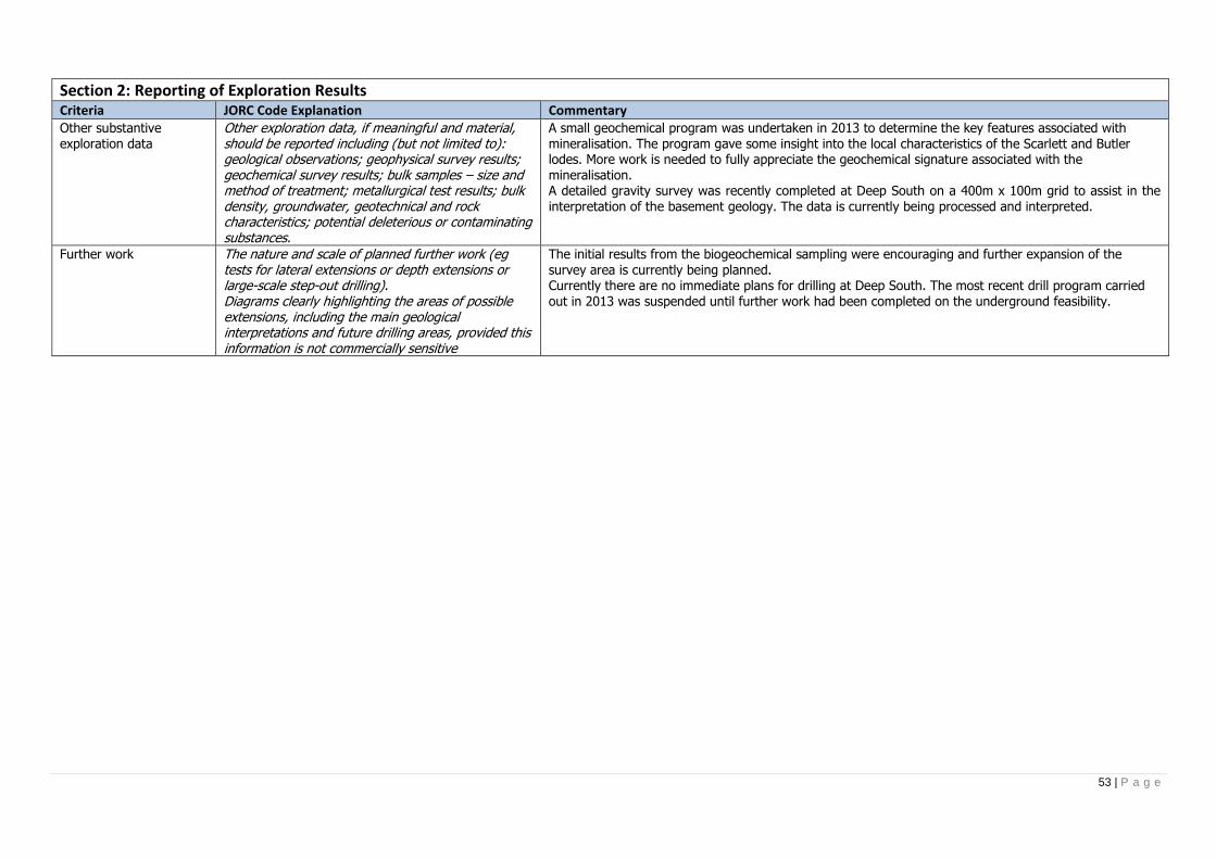
53 | P a g e
Section 2: Reporting of Exploration Results Criteria JORC Code Explanation Commentary Other substantive exploration data
Other exploration data, if meaningful and material, should be reported including (but not limited to): geological observations; geophysical survey results; geochemical survey results; bulk samples – size and method of treatment; metallurgical test results; bulk density, groundwater, geotechnical and rock characteristics; potential deleterious or contaminating substances.
A small geochemical program was undertaken in 2013 to determine the key features associated with mineralisation. The program gave some insight into the local characteristics of the Scarlett and Butler lodes. More work is needed to fully appreciate the geochemical signature associated with the mineralisation. A detailed gravity survey was recently completed at Deep South on a 400m x 100m grid to assist in the interpretation of the basement geology. The data is currently being processed and interpreted.
Further work The nature and scale of planned further work (eg tests for lateral extensions or depth extensions or large-scale step-out drilling). Diagrams clearly highlighting the areas of possible extensions, including the main geological interpretations and future drilling areas, provided this information is not commercially sensitive
The initial results from the biogeochemical sampling were encouraging and further expansion of the survey area is currently being planned. Currently there are no immediate plans for drilling at Deep South. The most recent drill program carried out in 2013 was suspended until further work had been completed on the underground feasibility.