wiedmann, florian and salama, ashraf m. (2013) from … · during the first decades of the 20th...
TRANSCRIPT

Wiedmann, Florian and Salama, Ashraf M. (2013) From pre-oil settlement
to post-oil hub : the urban transformation of Doha. ArchNet-IJAR:
International Journal of Architectural Research, 7 (2). pp. 146-159. ISSN
1938-7806 ,
This version is available at https://strathprints.strath.ac.uk/49925/
Strathprints is designed to allow users to access the research output of the University of
Strathclyde. Unless otherwise explicitly stated on the manuscript, Copyright © and Moral Rights
for the papers on this site are retained by the individual authors and/or other copyright owners.
Please check the manuscript for details of any other licences that may have been applied. You
may not engage in further distribution of the material for any profitmaking activities or any
commercial gain. You may freely distribute both the url (https://strathprints.strath.ac.uk/) and the
content of this paper for research or private study, educational, or not-for-profit purposes without
prior permission or charge.
Any correspondence concerning this service should be sent to the Strathprints administrator:
The Strathprints institutional repository (https://strathprints.strath.ac.uk) is a digital archive of University of Strathclyde research
outputs. It has been developed to disseminate open access research outputs, expose data about those outputs, and enable the
management and persistent access to Strathclyde's intellectual output.

International Journal of Architectural Research Florian Wiedmann and Ashraf M. Salama
Archnet-IJAR, Volume 7 - Issue 2 – July 2013 - (146-159) – Selected Papers
Copyright © 2013 Archnet-IJAR, International Journal of Architectural Research
146
FROM PRE-OIL SETTLEMENT TO POST-OIL HUB: THE URBAN
TRANSFORMATION OF DOHA
Florian Wiedmann
Qatar University, Doha, Qatar
Ashraf M. Salama
Qatar University, Doha, Qatar
Abstract
Since oil production commenced in the middle of the 20th century Qatar's capital Doha witnessed a rapid urbanisation period. Today, new development strategies, which have been implemented to diversify Qatar's economy, have led to a new urban transformation process with the vision to establish Doha as hub within global networks. Economic transformation processes in Qatar have always caused new structures within its society, which in turn affected urban developments. After decades of urbanisation based on the export of oil, the introduction of a hub vision at the end of the 1990s marked a new process that has been re-thinking urbanism in Qatar. Although current developments have attracted worldwide attention, there has been rather little scientific reflection as to how current urbanism in the Gulf should be understood in relation to its past and projected future. Therefore, this paper seeks to investigate the various factors impacting Doha's urban environment during economic transformation processes. Each economic transformation has had a large impact on the structure of the city’s society as well as its built environment. The current transformation process can still be considered at its beginning. In order to understand the impact of contemporary economic diversification strategies, the city’s past urbanisation stages and their spatial development factors had to be analysed. All in all four distinct phases of urbanism can be distinguished in the case of Doha: The pre-oil settlement, the modernisation period, the oil city and the globalised hub.
Keywords: Doha; urbanisation; oil boom; economic transformation; hub city.
INTRODUCTION
The Gulf region has witnessed a rather rapid modern urbanization during the 2nd half of the 20th
century. Before oil was found most settlements were small fishing villages and only a few of them
could develop to small cities with more than 10,000 inhabitants during the peak of pearl trade at the end of the 19th century (Scholz, 1999). These larger settlements were the home of major
tribes, who resettled from inland oases to the coast in order to benefit from the emerging trade.
Although the region was never colonialized as other regions in the Middle East, several
protectorates were installed by the British in order to prevent any conflicts between tribes and the British East India Company and its trading routes. These protectorates gained another dimension
of importance when oil was found in the beginning of the 20th century. The large-scale production
of oil commenced after World War Two leading to the first period of modern urbanization. And after the declaration of national independence in the late 1960s and beginning of 1970s the small
Gulf States witnessed exponential urban growth during the oil boom.
After the oil boom new economic strategies were introduced at the end of the 20th century in order to stimulate the transformation of Gulf cities from rentier state structures to international
service hubs. Based on a fortunate geopolitical location between Asia, Europe and Africa, many
governments recognized a potential to enter regional and global trading networks by investing in
extensive and state-of-the-art harbors and airports (Scholz, 1999, p. 82). This general strategy

International Journal of Architectural Research Florian Wiedmann and Ashraf M. Salama
Archnet-IJAR, Volume 7 - Issue 2 – July 2013 - (146-159) – Selected Papers
Copyright © 2013 Archnet-IJAR, International Journal of Architectural Research
147
was accompanied by different types of investments in order to accelerate urban growth.
Subsequently, new economic sectors were introduced by joint ventures between public and private sectors, which meant a new era of urban governance in the Gulf. Subsequently,
privatization and decentralization have been integrated to stimulate and accelerate investment in
order to realize the vision of becoming global centers. Although the wealth of fossil fuels can currently still be considered as the main basis of recent expectations for growth, Gulf cities have
entered a fierce competition to transform outdated structures in order to accommodate new post-
oil economies (Davidson, 2009, p. 182).
In the following the paper seeks to investigate the urban evolution of Doha by analyzing its four distinct phases of development. Each phase is analyzed according to historic events and
circumstances leading to new economic developments and thus a transforming urban structure.
In all four cases the analyses focus on urban governance, the socio-economic context as well as the urban images produced by each urbanization phase in order to provide insights into the
contexts of the resulting built environment.
THE PRE-OIL SETTLEMENT DOHA
During the 18th century the Al Maadhid tribe and its leading family clan Al Thani moved from
central Arabia to settle on the northern coast of Qatar, where they resided in the area around Zubara. As a consequence of tribal conflicts with the Al Khalifa tribe the Al Maadhid tribe under
the leadership of Sheikh Mohammed bin Thani resettled on the eastern coast of the Peninsula in
1847, where its clans founded the settlement of Al Bidaa at the location of an old fishing village (Adham, 2008, p. 221). The choice of location was based on the water source Wadi Sail and the
fortunate shape of the coastline, which protected the settlement from sea attacks. At the end of
the 19th century Ottoman troops built a fort in Al Bidaa, which became the area containing the
largest settlements on the eastern coast at this time, in order to restore their interests in the region. After the withdrawal of Turkish troops the British Resident in the Gulf signed a protection
treaty in 1916, transforming Qatar into an official British protectorate (Scholz 1999, p. 184).
During the first decades of the 20th century Al Bidaa and its eight settlements grew to around 12,000 inhabitants due to the flourishing pearl trade. However, its population rapidly decreased
during the 30s, when Qatar’s entire population dropped from 27,000 to less than 16,000
inhabitants because of the collapse of pearl fishing caused by the invention of cultured pearls in
Japan (Al Buainain, 1999, p. 149). The development of Al Bidaa into eight distinct settlements along the shoreline, which
together occupied an area of around 1.23 sq. km (Fig. 1) (Hasan, 1994), was caused by the need
for access to the sea, land distribution to tribal clans and the location of water sources. Al Bidaa was later renamed Doha, which either refers to a big tree standing at the coast or to the circular
shape of the coastline (Al Buainain, 1999, p. 181). Each social group lived segregated in their
own areas and the main centers of social interaction were the harbor, market and mosque (Al Buainain, 1999, p. 190). Due to the socio-economic importance of the market and harbor area
each neighborhood was directly linked via roads. However, the road network was in general not a
result of conscious planning but rather the consequence of the collective building efforts of each
family. The ruler’s function concerning the administration of the settlement development was limited to incentives regarding where to build his palace and mosque in addition to a macro-
distribution of land regarding markets and new residential districts. Furthermore, within the tribal
structure he was seen as the leading sheikh and thus as executor of Islamic law, which also covered building violations. However, most construction concerns were dealt with at lower levels
within tribal clans and their majlis and thus it can be stated that Doha’s settlement development
was mainly governed by bottom-up rather than top-down decision-making.

International Journal of Architectural Research Florian Wiedmann and Ashraf M. Salama
Archnet-IJAR, Volume 7 - Issue 2 – July 2013 - (146-159) – Selected Papers
Copyright © 2013 Archnet-IJAR, International Journal of Architectural Research
148
Figure 1: Doha’s pre-oil settlements in 1947 (Source: Authors).
Figure 2: Aerial picture of Doha in 1947 (Source: MMUP).
Doha’s traditional urban form remained intact until the middle of the 20th century when modern
urbanization began. Its vernacular structure and architecture were the result of direct human
interaction and participation within the building process. Climate and culture had thus shaped a
built environment reflecting not only how its spaces were used from a functional point of view but also how these spaces expressed the inner world of a society that was highly dependent on its
natural environment and tribal affiliations. The former was reflected in structural aspects of the
local architecture that were adapted to the desert climate while the latter was reflected in

International Journal of Architectural Research Florian Wiedmann and Ashraf M. Salama
Archnet-IJAR, Volume 7 - Issue 2 – July 2013 - (146-159) – Selected Papers
Copyright © 2013 Archnet-IJAR, International Journal of Architectural Research
149
decorative elements such as plant images or geometric patterns on walls and doors indicative of
the people’s tribal origins (Jaidah and Bourenane, 2009, p. 23). Both advanced building techniques and the conservation of traditional façade decoration convey the old roots of Doha’s
historic built structures. Thus, although the settlement was founded as a small fishing village at
the beginning of the 19th century and thus looks back on a rather short history, its urban and architectural forms are thousands of years old (Al Buainain, 1999, p. 186). Inherited knowledge
and traditions have built this space by following no planning or centralized regulations. Despite
the allocation of land by tribal rulers, land was generally free to use and build on. Thus, organic
settlement patterns evolved based on the principle of a cell, in this case the courtyard house, multiplying into clusters to form neighborhoods that connected to the central backbone of the
settlement – the market, port and mosque (Fig. 2). Doha’s pre-oil settlement is to a large extent
the product of the collective efforts of its inhabitants, their habits and their intuition. Capitalist incentives caused by the pearl trade or the interaction with colonial powers had not yet led to
centralized planning and state regulations impacting Doha’s vernacular structure.
MODERN URBANIZATION AS A RESULT OF THE FIRST OIL PRODUCTION
Although oil had already been found by Petroleum Development Qatar Ltd. in Dukhan in the west
of the country in 1937, oil production in Qatar began after World War II (Scholz, 1999, p. 188).
The first revenues made from oil were mainly invested in the development of infrastructure such as the construction of a regional road connecting the Dukhan field with Doha and the first airport,
which was built in the east of the city. Due to the location of the residence of the ruling Al Thani
family, Doha became the centre of modern urbanization in Qatar. From the 1950s to 1970 Doha’s population grew from around just 14,000 inhabitants to over 83,000, with foreign immigrants
constituting about 67% (Al Buainain, 1999, p. 217). Almost 90% of the working population was
non-Qatari in 1970 due to a lack of educated workforce among the indigenous population and the
introduction of subsidies, which turned Qatar into a classic welfare state reliant on its fossil resources. Nation-wide only about 25% of around 30,000 Qataris were counted as workforce by a
census in 1970 and most were engaged in the newly established public administration in Doha
(Al Buainain, 1999, p. 168). The private sector was run by immigrants from South Asia and other Arab countries, who mainly worked in the expanding trade businesses or as employees in the
lower service sector.
During the 1950s and 1960s settlement patterns were determined by the development of modern infrastructure such as roads and the supply of fresh water and electricity. The modern
administration, which was distributed among various buildings all over the city, was just in its
infancy and despite the introduction of the first public housing law in 1964, planning and
regulations still had limited impact on the general development (Al Buainain, 1999, p. 192). Yet, a major impact was made on the urban form by imported goods, particularly cars and air
conditioning, and the vast immigration. Subsequently, roads were widened in central areas to
provide access by car and the old courtyard buildings were replaced by modern building blocks made of cement stones. Furthermore, new housing areas were constructed in a rather
uncoordinated manner around the former city boundaries in order to accommodate expatriate
labor as well as Qataris moving from other parts of the country to Doha. Subsequently, the city
grew in all directions with development mainly concentrated in the west because of the road to Al Dukhan and south-east toward the airport (Fig. 3). Due to the rapidly growing trade of imported
goods many informal shopping areas grew along the periphery of the city center and in proximity
to the old market area (Scholz, 1999, p. 201).

International Journal of Architectural Research Florian Wiedmann and Ashraf M. Salama
Archnet-IJAR, Volume 7 - Issue 2 – July 2013 - (146-159) – Selected Papers
Copyright © 2013 Archnet-IJAR, International Journal of Architectural Research
150
Figure 3: The settlement areas in 1947 and 1971 (Source: Authors).
Figure 4: The centre of Doha in 1970 (Source: Authors).
In this first period of Doha’s urban transformation developments were generally rather
uncoordinated. However, incentives such as the reclamation of an area at Doha’s port or the construction of the Al-Corniche Road would become elements that defined later urban
developments. Rectangular settlement patterns and modern cement buildings added a
fragmented belt around the old center and its harbor, which in turn were gradually replaced by modern urbanization (Fig. 4). Thus, Doha’s traditional urban environment faced its rapid end,

International Journal of Architectural Research Florian Wiedmann and Ashraf M. Salama
Archnet-IJAR, Volume 7 - Issue 2 – July 2013 - (146-159) – Selected Papers
Copyright © 2013 Archnet-IJAR, International Journal of Architectural Research
151
caused by the first investments in modern infrastructure and the increasing purchasing power of
its population. Subsequently, cars and air conditioning enabled the emergence of a new urban structure with low built densities, extensive road grids and cement block architecture.
THE INTRODUCTION OF CENTRAL PLANNING DURING THE OIL BOOM
While an initial public administration already existed in the 1950s and grew during the 1960s
when the first municipality was founded in 1963, it was only after the declaration of Qatar’s
independence as a state in 1971 and, perhaps even more significantly, when Sheikh Khalifa Bin
Hamad Al Thani took over as ruler in 1972 that an efficient central administration came into being (Zahlan, 1979). This administration included several ministries that dealt with Qatar’s
urbanization, the most important of which was the Ministry of Municipal Affairs and Agriculture
(MMAA) with its town planning section established in 1974 (Al Buainain, 1999, p. 207). It was later followed by the creation of several ministries that dealt with infrastructural development such
as the Ministry of Public Works (MPW). The centralization of governance enabled petrodollars to
be efficiently invested in the urbanization process, leading to rapid urban growth during the 1970s
and 1980s when oil prices reached new heights. During this period, many Western consultants were involved in the first phase of urban
planning in Doha. In 1974 the British consultant Llewelyn Davis was appointed by the new town
planning authority within the Ministry of Municipal Affairs and Agriculture to design the first master plan of Doha for 1990. His plan was based on a ring concept with a clear definition and a
functional distribution of land uses regarding each ring. Based on this initial zoning plan and
newly introduced land policies a new city center was created consisting of commercial developments, services and multi-storey housing for guest workers. During the 1970s all old
Qatari neighborhoods were replaced and the indigenous population moved to new suburban
developments such as Al Rayyan, Medinat Khalifa or Al Gharrafa in the northwest of the city. This
was made possible by the land policies, which included the free replacement of properties with allocated plots of land measuring 30 × 30 meters and the provision of interest-free loans for the
construction of housing or financial compensation, which usually exceeded the market price of
real estate at that time (Naqy, 1997). Subsequently, the 1970s witnessed increasing land speculation within the city center and
its surrounding areas. Until 1991 the Planning Department of the MMAA was in charge of
subdividing land into parcels while public housing programs were the domain of the Ministry of Labor and Social Affairs as well as the Ministry of Public Works. These superposed
responsibilities led to coordination problems, which were further exacerbated by the fact that
high-profile projects were usually under the supervision of the Emiri Diwan and thus not part of
the general legalization process within ministries (Al Buainain, 1999, p. 203). Despite these debilitating factors the main elements of Doha’s first master plan were implemented and its
proposed land reclamation of 630 hectares in the north of the city center, which included the
development of a circular Corniche, was completed at the end of the 1970s (Scholz, 1999, p. 202). The main objective of the plan was, however, to establish a modern city center. For this
purpose, informal commercial building was no longer possible and traditional buildings were
replaced in order to make space for access roads and multi-storey developments.
In 1975 the American planning consultancy William L. Pereira Associates was commissioned to develop in parallel a new master plan for an extension area in the north, known
as North District of Doha (NDOD) or West Bay (Adham, 2008, p. 233). The plan included the
development of Qatar University and housing for its staff as well as residential districts toward inland. With regard to coastal development at the northern end of the Corniche, it proposed a
large hotel development for conferences, a diplomatic and ministries area and a new business
district surrounded by a large park (Naqy, 2000, p. 137). While the hotel development and several embassies were completed during the beginning of the 1980s, the commercial centers remained
to a large extent unbuilt due to the focus of commercial activities in and around the city center.

International Journal of Architectural Research Florian Wiedmann and Ashraf M. Salama
Archnet-IJAR, Volume 7 - Issue 2 – July 2013 - (146-159) – Selected Papers
Copyright © 2013 Archnet-IJAR, International Journal of Architectural Research
152
While in the transition period during the 1950s and 1960s old traditional structures were
gradually replaced by a rather uncoordinated process of modernization, the implementation of a first master plan and the city extension via land reclamation were decisive steps in Doha’s
modern urbanization, carried out by a newly established public administration during the 1970s.
Subsequently, the population of Doha’s metropolitan area grew from 89,000 inhabitants in 1970 to over 434,000 in 1997. In addition to this rapid growth, land policies and real-estate speculation
caused the total urban area to increase exponentially from around just 130 hectares in the middle
of the 20th century to over 7,100 hectares in the 1990s (Fig. 5) (Al Buainain, 1999, p. 407). The
urban sprawl during the oil boom led to a scattered urban landscape with low densities, caused by the prevalence of suburban typologies and a large percentage of unbuilt land due to
speculation (MMAA, 1997). While the two-storey housing areas in the outskirts became the
residence of Qataris as well as high-income guest workers, the central areas became the residence of foreign labor. This led to a reduction in investments and subsequently to
deterioration in urban qualities in Doha’s center.
Figure 5: The settlement expansion between 1971 and 1988 (Source: Authors).
Doha’s transformation from a vernacular pre-oil settlement to an expanding oil city was sudden
and as precipitous as the oil boom that instigated it. The modernization of the city was rapidly and
simply executed by importing the expertise and labor necessary. This transition to modernity was reflected in the architecture and urban design of the period, which broke away abruptly from the
vernacular to principles imposed by the state. This can be seen best in the replacement of the
traditional neighborhoods of the indigenous population, consisting of courtyard houses and
winding streets, with modern suburban dwellings that stood on equally sized rectangular plots accessed by an orthogonal grid of roads. The Western consultants who advised this process
during the post-war decades applied their Western understanding of modern space to the
modernization of Doha, which at that time considered the car to be the main means of transport.
International Journal of Architectural Research Florian Wiedmann and Ashraf M. Salama
Archnet-IJAR, Volume 7 - Issue 2 – July 2013 - (146-159) – Selected Papers
Copyright © 2013 Archnet-IJAR, International Journal of Architectural Research
153
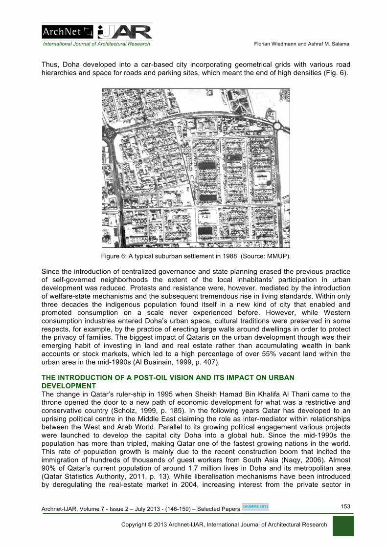
Thus, Doha developed into a car-based city incorporating geometrical grids with various road
hierarchies and space for roads and parking sites, which meant the end of high densities (Fig. 6).
Figure 6: A typical suburban settlement in 1988 (Source: MMUP).
Since the introduction of centralized governance and state planning erased the previous practice of self-governed neighborhoods the extent of the local inhabitants’ participation in urban
development was reduced. Protests and resistance were, however, mediated by the introduction
of welfare-state mechanisms and the subsequent tremendous rise in living standards. Within only
three decades the indigenous population found itself in a new kind of city that enabled and promoted consumption on a scale never experienced before. However, while Western
consumption industries entered Doha’s urban space, cultural traditions were preserved in some
respects, for example, by the practice of erecting large walls around dwellings in order to protect the privacy of families. The biggest impact of Qataris on the urban development though was their
emerging habit of investing in land and real estate rather than accumulating wealth in bank
accounts or stock markets, which led to a high percentage of over 55% vacant land within the
urban area in the mid-1990s (Al Buainain, 1999, p. 407).
THE INTRODUCTION OF A POST-OIL VISION AND ITS IMPACT ON URBAN
DEVELOPMENT
The change in Qatar’s ruler-ship in 1995 when Sheikh Hamad Bin Khalifa Al Thani came to the throne opened the door to a new path of economic development for what was a restrictive and
conservative country (Scholz, 1999, p. 185). In the following years Qatar has developed to an
uprising political centre in the Middle East claiming the role as inter-mediator within relationships between the West and Arab World. Parallel to its growing political engagement various projects
were launched to develop the capital city Doha into a global hub. Since the mid-1990s the
population has more than tripled, making Qatar one of the fastest growing nations in the world. This rate of population growth is mainly due to the recent construction boom that incited the
immigration of hundreds of thousands of guest workers from South Asia (Naqy, 2006). Almost
90% of Qatar’s current population of around 1.7 million lives in Doha and its metropolitan area
(Qatar Statistics Authority, 2011, p. 13). While liberalisation mechanisms have been introduced by deregulating the real-estate market in 2004, increasing interest from the private sector in

International Journal of Architectural Research Florian Wiedmann and Ashraf M. Salama
Archnet-IJAR, Volume 7 - Issue 2 – July 2013 - (146-159) – Selected Papers
Copyright © 2013 Archnet-IJAR, International Journal of Architectural Research
154
investing in Qatar was mainly ignited by direct investments of oil and gas revenues, which can be
categorized in terms of media, real estate, infrastructure and services, culture and sports as well as education and science.
The founding of Al Jazeera in 1996 changed the world's perception of Qatar due to its role
as a news provider from the Middle East. Despite the fact that the initial funds of USD 137 million were provided by the Emir, Al Jazeera has always claimed that it maintains an independent
editorial policy (Sakr, 2001, p. 58). This liberalised news network has influenced an
understanding of Qatar as a progressive and politically engaged country in the Gulf. Despite the
still open question of the extent to which Al Jazeera can be considered independent, it has had a major impact on the development of the media in the Middle East as the voice of the people
instead of simply a reflection of political agendas (Rinnawi, 2006, p. 23).
After the successful introduction of a new image of Doha major public real-estate investments have been made by the Qatar Investment Authority and its subsidiary Qatari Diar
Real Estate Investment Company, which was founded in 2004 (QIA, 2012). In addition to Qatari
Diar’s function of founding master developers such as Lusail Real Estate Development Company
to carry out projects, it holds 45% of the shares in Barwa, the largest listed real-estate company in Qatar (Barwa, 2011). Further public real-estate investments are made by the Qatar Foundation
and its subsidiaries. In order to become a global hub large investments were made to expand the
existing airport and harbour as well as to develop new facilities. A new airport development was launched in 2004, with estimated funds of over USD 11 billion, on a reclaimed area of 890
hectares to the east of the existing runways (NDIA, 2012). Parallel to this, Qatar Airways, one of
the fastest growing airlines in the world, is directly funded by the state with the aim of turning it into one of the world’s leading aviation providers (CAPA, 2011). These investments have made
Qatar a serious future competitor as a transit hub for passengers and cargo beyond the Gulf
region itself.
In addition, several efforts were made to attract international sport events to Qatar such as the Qatar Tennis Open and the 2006 Asian Games. While large investments in sport events led
to the recent successful bid for the 2022 FIFA World Cup, the development of cultural landmark
projects has also been important in attracting tourists. The first project in this regard was the redevelopment of the traditional market area, known as Souq Waqif, followed by the Museum of
Islamic Art. Since the 1990s Qatar's rulers initiated the development of educational and research
facilities in order to build a foundation for a more diversified economy. Thus, in 1995 the Qatar Foundation was introduced as a non-profit organisation to develop a basis for new economies by
focusing on three pillars, namely, education, science and community development (OBG, 2009,
p. 23). Its first project was Education City, the development of which was launched in the north-
west of the city in the late 1990s (Adham, 2008, p. 243). In order to attract high-profile universities various investments were made such as the USD 759 million that was invested in Cornell
University in order to open a faculty in Doha (Miles, 2005, p. 21). Science and research are
promoted by the subsidiaries of the Qatar Foundation, namely, the Qatar National Research Fund and the Qatar Science and Technology Park.
Recent investment strategies have mainly focused on stimulating urban growth by
launching large-scale projects and by creating a new city image. According to a series of face-to-
face interviews with ten planners at the Ministry of Municipalities and Urban Planning (MMUP) the most decisive public investments transforming the urban structure of Doha have been within the
real-estate sector. The subsequent construction boom has shaped contemporary Doha not only
morphologically but also socio-economically due to the businesses and foreign workers that have moved there as a result. While economic visions are being put into place by investment in various
strategies and liberalisation policies, urban planning has faced the challenge of guiding the recent
construction boom toward the creation of a functioning metropolis. The idea of developing Doha into an international service hub resulted in large-scale developments and a new form of
decision-making in physical planning. The last comprehensive master plan, known as the
Physical Development Plan (PDP), was prepared during the 1990s. Although it is still used as the
International Journal of Architectural Research Florian Wiedmann and Ashraf M. Salama
Archnet-IJAR, Volume 7 - Issue 2 – July 2013 - (146-159) – Selected Papers
Copyright © 2013 Archnet-IJAR, International Journal of Architectural Research
155
basis for general land-use policies its implementation in 1997 has had a rather limited impact on
Doha’s urban development because of the increasing influence of new public authorities and public-private partnerships (Adham, 2008, p. 237). This merge of the public and private sectors
was a direct consequence of expanding investments and the liberalisation of markets. The new
urban development strategies at the end of the 1990s and the subsequent investment pressure challenged a public administration that was not able to manage urban growth on this scale and of
this nature. The limited staff capacity did not permit the urban planning department to coordinate
urban developments with the implementation of new plans or the adjustment of existing plans,
which led to the decentralization of governance. Due to the new situation of unprecedented amounts of investment being made in Doha’s
urban development, existing zoning plans that were developed on the basis of the PDP have
quickly become outdated. Furthermore, zoning plans have lost the status of legally binding documents and have been treated in many cases as technical recommendations rather than
development regulations. The most prominent example of this is the construction of high-rise
buildings in the Diplomatic District (West Bay) on land, which was previously zoned for
developments with low to medium density. In addition to the fact that initial zoning plans have been bypassed in many cases, another phenomenon that decentralised governance was the rise
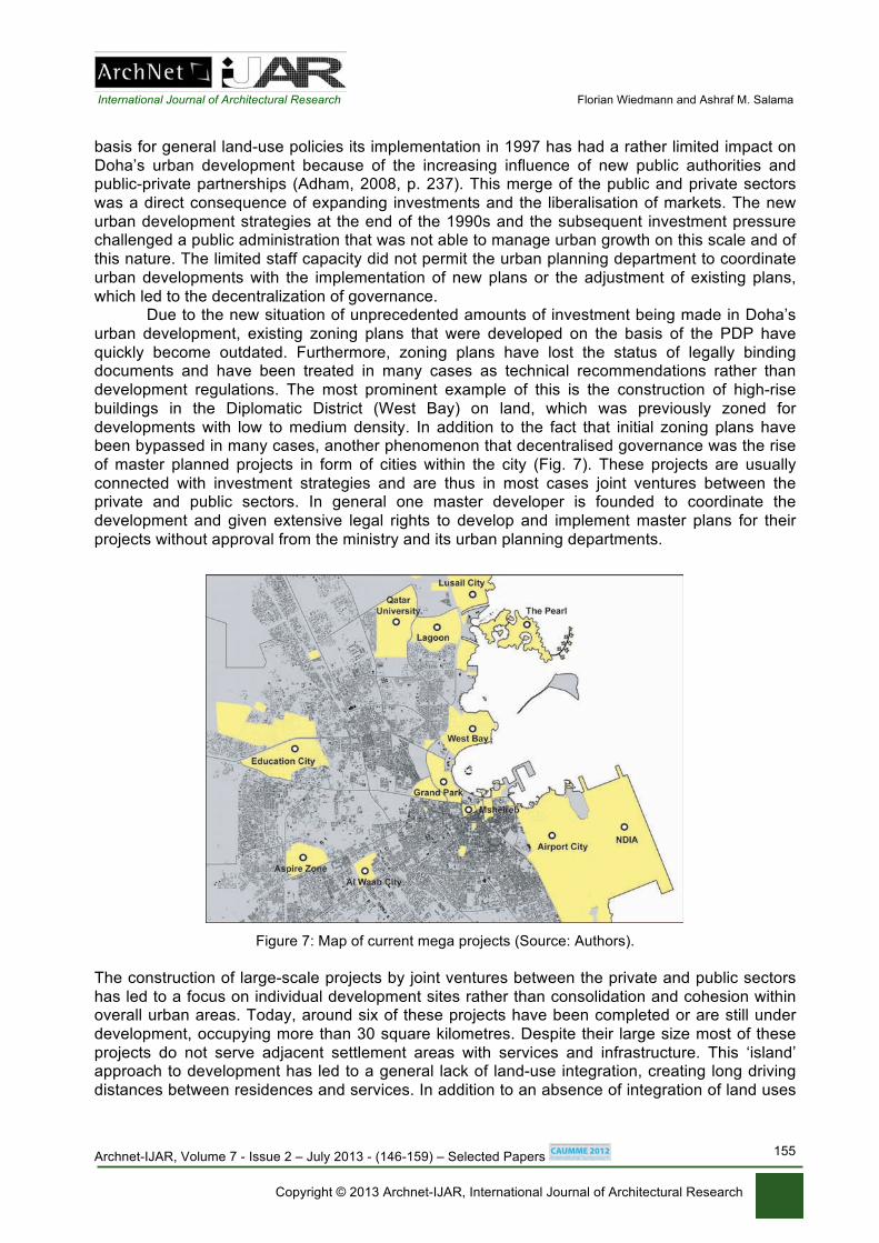
of master planned projects in form of cities within the city (Fig. 7). These projects are usually
connected with investment strategies and are thus in most cases joint ventures between the private and public sectors. In general one master developer is founded to coordinate the
development and given extensive legal rights to develop and implement master plans for their
projects without approval from the ministry and its urban planning departments.
Figure 7: Map of current mega projects (Source: Authors).
The construction of large-scale projects by joint ventures between the private and public sectors
has led to a focus on individual development sites rather than consolidation and cohesion within overall urban areas. Today, around six of these projects have been completed or are still under
development, occupying more than 30 square kilometres. Despite their large size most of these
projects do not serve adjacent settlement areas with services and infrastructure. This ‘island’ approach to development has led to a general lack of land-use integration, creating long driving
distances between residences and services. In addition to an absence of integration of land uses

International Journal of Architectural Research Florian Wiedmann and Ashraf M. Salama
Archnet-IJAR, Volume 7 - Issue 2 – July 2013 - (146-159) – Selected Papers
Copyright © 2013 Archnet-IJAR, International Journal of Architectural Research
156
projects have been built without taking into account their surrounding built environment or future
urban areas under construction. The main reason for this lack of integration is the decision-making process itself, wherein the master plans of individual projects are approved without
regulations of a central strategic plan regarding overall urban developments. The overall result is
a rather fragmented structure of developments leading to a pattern of urban patchworks instead of cohesive and integrated urban areas.
Another aspect of contemporary urbanism in Doha is the lack of a defined urban structure
consisting of centers and sub centers. This circumstance is rooted in the fact that Doha’s urban
area has been growing exponentially toward the outskirts over the last decades without the guidance of plans for developing sub centers. The establishment of ‘decentralised centralisation’
has been further complicated due to a lack of public transport networks and thus no major
junctions that would enable higher densities of residential and commercial use. In addition, the old city centre’s previous function as a centre for commercial and public activities has been
increasingly undermined by new shopping mall developments and business districts along the
urban periphery. Despite redevelopments of the historic centre, large parts of Doha’s central
urban area are occupied by high-density residential districts for low-income groups. In general, it can be observed that the lack of public transport and extensive social segregation between
income groups have caused an urban structure of sprawling peripheries served by shopping
malls and a high-density mixed-use down town area for low income groups. Another characteristic of Doha’s contemporary urbanism is the increasing privatisation of
many urban areas due to large-scale developments by the private sector. In this regard, the
Education City and Pearl developments are prominent examples of gated developments with limited public access. The privatisation of urban space is rooted in the nature of many recent
projects to be exclusive entities that set themselves apart from other urban areas in order to
attract attention and thus investment. The Katara Cultural Village is another example of a
controversial development that has introduced the first ‘public’ beach in Doha, which again is only accessible by entering gates and paying entrance fees (Fig. 8). Public space has become
commercialised and thus filtered and limited in its function to invite all social groups to interact.
The Souq Waqif, one of the most prestigious developments in Doha, appears to be a public space but is actually managed like an open-air mall (NZZ, 2011). Today, the Corniche can be
considered to be the main public space in traditional terms as it constitutes an accessible central
area to be used by anyone at any time.
Figure 8: Katara – Cultural Village (Source: Authors).
In addition to the fact that the privatisation of urban governance has led to the privatisation of
urban areas, the previous urban morphology has been changed by higher building heights. The most prominent example is the Diplomatic District in West Bay, where more than 50 high-rise
buildings have been built, of which 18 have a height of over 150 metres. This high-rise
agglomeration has changed the morphology of contemporary Doha from a rather simplistic structure of a medium-high urban centre surrounded by low-rise suburbs to vertical developments
with a new emphasis on the waterfront (Fig. 9). The high-rise waterfront at West Bay is to a large
extent the product of public incentives that provided private investors with the prospective of

International Journal of Architectural Research Florian Wiedmann and Ashraf M. Salama
Archnet-IJAR, Volume 7 - Issue 2 – July 2013 - (146-159) – Selected Papers
Copyright © 2013 Archnet-IJAR, International Journal of Architectural Research
157
ministries and other public or semi-public organisations occupying commercial high-rises as
tenants in the future. Along the coast to the north, however, many high-rise and medium-rise developments arose out of speculation in the growing freehold-property market and the potential
for selling seafront properties at higher prices.
Figure 9: High rise waterfront in West Bay (Source: Authors).
Another characteristic result of the recent construction boom in Doha is the high contrast between
masses of poorly designed projects and exceptional quality in a small number of representative buildings. This concerns both construction and design and has three main causes, namely, a
need for a rapid supply in order to accommodate the fast rate of growth, a lack of restrictions and
deficient standards within the construction industry itself. One phenomenon is therefore catalogue designed residential and commercial typologies, mainly introduced by South-Asian and Chinese
contractors, made of cement pre-fabricated elements, assembled in a few weeks by poorly
educated construction workers with limited supervision. A generic appearance and the need for a
high level of maintenance due to low-quality finishing and utilities are two main resulting characteristics. A further problem is the common practice of choosing one major contractor and
architectural consultant for the entire development, which can lead to monotonous and repetitive
designs (Fig. 10). Today, the contrast between the mass production of buildings and the state-of-the-art design of individual landmarks has become a reflection of a segregated and fragmented
urban development that is undergoing a continuous struggle to integrate quality within quantities.
Figure 10: Residential High rise at the Pearl development (Source: Authors).
CONCLUSION
The urban evolution of Doha can be summarised in the four previously analysed phases. While its urban environment was first a product of the direct interaction of residents and their
surroundings, the introduction of modern infrastructure followed by the establishment of central
planning fundamentally led to a new type of city. At the beginning modern developments existed
in parallel with traditional settlements and the urban structure was incoherent and scattered without following any central plan. Subsequently, the 1970s led to a new urban era, not only
because of the development of the Corniche, which is still considered to be the signature image
of modern Doha, but particularly due to the establishment of central planning. In the following

International Journal of Architectural Research Florian Wiedmann and Ashraf M. Salama
Archnet-IJAR, Volume 7 - Issue 2 – July 2013 - (146-159) – Selected Papers
Copyright © 2013 Archnet-IJAR, International Journal of Architectural Research
158
decades Doha's urbanism was regulated by land-use plans and a clear system of land
distribution using equally sized plots. The new urban form followed the Western idea at that time of a car-based city and urban sprawl, which was exacerbated by speculative interests, was the
foreseeable consequence.
During the 1990s a new urban transformation period began when Doha was no longer seen by decision-makers as limited to its role as the administrative capital of an oil-wealthy nation
and began to be regarded as a hub that could provide an opportunity to enter global networks.
This new urban vision has led to the introduction of several investment strategies and the
liberalisation of urban governance. Consequently, large-scale projects based on case-by-case decision making and speculative interests began to reshape Doha's urban morphology. While the
introduction of new typologies and urban designs diversified certain areas and created a new city
image, the overall result of this period can be best described as fragmented clustering with increasing infrastructural deficits. Thus, urban governance is currently facing the major challenge
of implementing development strategies based on a holistic vision that integrates social,
economic and environmental aspects in order to guide urban growth. This vision, known as Qatar
National Vision, was introduced in 2009 and implemented in the form of the Qatar National Development Strategy in 2011. Thus, Doha is making a new evolutionary step in its development,
defining its future between continued event urbanism and enhanced urban consolidation.
ACKNOWLEDGEMENT
This study is developed as part of a comprehensive funded research project of the National
Priorities Research Program, QNRF-Qatar National Research Fund (NPRP 09 - 1083 - 6 – 023).
REFERENCES Adham, K. (2008). Rediscovering the Island: Doha`s Urbanity from Pearls to Spectacle, In Y. Elsheshtawy, (Ed.), The Evolving Arab City. New York: Routledge. Al Buainain, F. (1999). Urbanisation in Qatar: A Study of the Residential and Commercial Land Development in Doha City. Salford: University of Salford. Barwa (2011). About us. Retrieved November 17, 2011 from http://www.barwa.com.qa/barwa-group/about-us/our-
beginning.aspx. CAPA – Centre for Aviation (2011). Qatar Airways. Retrieved November 17, 2011 from http://www.centreforaviation.com/profiles/airlines/qatar-airways-qr. Hasan, A. (1994). Urban Planning in Qatar. Doha: Dar Al-Oloum. Jaidah, I. and Bourennane, M. (2009). The History of Qatari Architecture. Milan: Skira.
Miles, H. (2005). Al Jazeera. New York: Grove Press. Naqy, S. (1997). Social and Spatial Process: An Ethnographic Study of Housing in Qatar. Pennsylvania: University of Pennsylvania. Naqy, S. (2000). Dressing up Downtown: Urban development and government public image in Qatar. City & Society, 12 (1), 125 – 47. Naqy, S. (2006). Making Room for Migrants, Making Sense of Difference: Spatial and Ideological Expression of Social
Diversity in Urban Qatar. Urban Studies Journal Limited, 43, 119 – 37. NDIA – New Doha International Airport (2011). Vision. Retrieved November 17, 2011 from http://www.ndiaproject.com. NZZ – Neue Zuericher Zeitung, (30.12.2011). Deutscher Stahl und dunkle Schnuere. OBG – Oxford Business Group (2009). The Report – Qatar 2009. Oxford: OBG. Qatar Statistics Authority (2011). Qatar in Figures 2011. Retrieved November 17, 2011 from
http://www.qsa.gov.qa/eng/publication/qif/2011/qatar_in_figures_2011_English.pdf .

International Journal of Architectural Research Florian Wiedmann and Ashraf M. Salama
Archnet-IJAR, Volume 7 - Issue 2 – July 2013 - (146-159) – Selected Papers
Copyright © 2013 Archnet-IJAR, International Journal of Architectural Research
159
QIA – Qatar Investment Fund (2012). About us. Retrieved January 8, 2012 from http://www.qia.qa/about.html. Rinnawi, K. (2006). Instant Nationalism. McArabism, Al Jazeera and Transnational Media in the Arab World. Lanham: University Press of America.
Sakr, N. (2001). Satellite Realms. Transnational Television. Globalization and the Middle East,. London: I.B.Tauris. Scholz, F. (1999). Die kleinen Golfstaaten. Gotha: Justus Perthes Verlag Gotha GmbH. Zahlan, R. (1979). The Creation of Qatar. London: Croom Helm.
________________ Authors:
Florian Wiedmann, Ph.D.
Post-Doctoral Researcher
Department of Architecture and Urban Planning, Qatar University, Doha, Qatar.
Ashraf M. Salama, Ph.D.
Professor of Architecture Department of Architecture and Urban Planning,
Qatar University, Doha, Qatar.