wind-driven ageostrophic transport in the north …jsprintall/pub_dir/sprintall_ef345.pdfwind-driven...
TRANSCRIPT

Wind-driven Ageostrophic Transport in the North Equatorial
Counter Current of the Eastern Pacific at 95°W.
Janet Sprintall+, Sean Kennan*,Yoo Yin Kim+ and Peter Niiler+
+Scripps Institution of Oceanography, UCSD, La Jolla, CA, USA
*National Institute for Water and Atmospheric Research, Wellington, New Zealand.
9 February 2009
Manuscript Number: JPO EF-345
Revision for Journal of Physical Oceanography
(corresponding author: Janet Sprintall, [email protected])

1
Abstract
Observations of horizontal velocity from two shipboard Acoustic Doppler Current Profilers
(ADCPs), along with wind, temperature and salinity observations from a cruise during June-July
2001 are used to compute a simplified mean meridional momentum balance of the North
Equatorial Counter Current (NECC) at 95ºW. The terms that are retained in the momentum
balance and derived using the measurements are the Coriolis and pressure gradient forces, and
the vertical divergence of the turbulent stress. All terms were vertically-integrated over the
surface turbulent layer. The KPP-prescribed Richardson number (Ri) is used to determine the
depth of the turbulent boundary layer, h, at which the turbulent stress and its gradient vanish. At
the time of the cruise, surface drifters and altimeter data show the flow structure of the NECC
was complicated by the presence of Tropical Instability Waves to the south and a strong Costa
Rica Dome to the north. Nonetheless, a consistent, simplified momentum balance for the surface
layer was achieved from the time mean of 19-days of repeat transects along 95ºW on a 0.5º
latitude resolution. The best agreement between the ageostrophic transport determined from the
near-surface cruise measurements and the wind-derived Ekman transport was obtained for an Ri
of 0.23±0.05. The corresponding h ranges from ~55 m at 4°N to ~30 m within the NECC core
(4.5°N to 6°N) and shoaling to just 15 m at 7°N. In general, the mean agesotrophic and Ekman
transports decreased from south to north along the 95°W transect, although within the core of the
NECC both transports were relatively strong and steady. This study underscores the importance
of the southerly wind-driven eastward Ekman transport in the turbulent boundary layer before
the NECC becomes fully developed later in the year through indirect forcing from the wind
stress curl.

2
1. Introduction
In the eastern tropical Pacific Ocean, positive wind stress curl associated with the
Intertropical Convergence Zone (ITCZ) drives the eastward flowing North Equatorial Counter
Current (NECC) (Sverdrup 1947). As such, the seasonal strength and path of the NECC is
strongly tied to the seasonal migration of the upwelling curl of the ITCZ: in May the NECC is
relatively weak, strengthens during July-October as the ITCZ moves north, and is strongest in
November when the ITCZ is most northerly and the curl consequently increases the thermocline
slope across the NECC. On average, the NECC shifts poleward as it flows from west to east
across the tropical Pacific (Donguy and Meyers 1996; Johnson et al. 2002), bounded by
westward flows to the north in the North Equatorial Current (NEC) and to the south by the South
Equatorial Current (SEC). In the eastern tropical Pacific, the mean velocity field from over 27
years of surface-drogued drifters shows strong surface flow of ~30 cm s-1 in the NECC between
4.5°N to 7.5°N (Fig. 1a). The near-zonal path of the NECC is interrupted in the far eastern
Pacific when the ITCZ interacts with the wind jets that blow through mountain gaps in the
Central American cordillera (Kessler 2002, 2006). These mountain-gap winds produce strong
zonal gradients of wind stress curl that can change the thermocline slope of the upper ocean
acting to weaken and strengthen the ridge-trough system that supports the NEC and the NECC,
and set-up the cyclonic flow around the Costa Rica Dome (~ 9°N, 87°W in Fig. 1a).
The presence of Tropical Instability Waves (TIWs) and their associated westward
propagating anticyclonic eddies (Kennan and Flament, 2000) further complicates the flow of the
NECC in the eastern tropical Pacific. The TIWs are characterized by cusp-shaped wave patterns
of SST along the equatorial cold tongue and typically occur during July to November when the
cold tongue is most developed. This pattern results in well-defined, large cross-equatorial fronts

3
that are clearly visible in remotely-sensed images of SST and ocean color. On average, the TIWs
have periods of 20-40 days, wavelengths of 1000-2000 km, and westward phase speeds of ~0.5
m s-1 (Qiao and Weisberg 1995; Contreras 2002). As such, the presence of the eddies and the
meridional excursions of the TIWs directly act to perturb the flow within and along the southern
border of the NECC. Both the TIWs and their eddies are thought to be generated by a barotropic
instability associated with the strong velocity shear between the westward flowing SEC and the
eastward flowing NECC and/or the Equatorial Undercurrent (EUC) (Philander 1978; Contreras
2002; Willet et al. 2006). In this paper, we will show that flow within the NECC in the eastern
Pacific Ocean was directly influenced by the presence of TIWs and a strong Costa Rica Dome
during the time of a field campaign in June-July 2001.
Attempts in the past to observe a geostrophic balance of the NECC in the eastern Pacific
have largely failed (Knauss 1961; Johnson et al. 1988), with hydrographic observations typically
yielding geostrophic flows of O(10 cm s-1) (Montgomery and Stroup 1962; Tsuchiya 1974). The
observed discrepancy from a geostrophic balance may result from the inadequate spatial
resolution of the hydrography, a dominantly ageostrophic NECC flow, or a combination of both.
Even with a 50-km resolution synoptic survey along 110ºW, Leetma and Molinari (1984) found
that geostrophic velocities and the Acoustic Doppler Current Profiler (ADCP) directly measured
surface velocities differed by up to 20 cms-1. The top-most bin resolved by their ADCP
measurements was at ~30 m depth, and they were possibly missing much of the surface-trapped
ageostrophic or Ekman contributions.
To date, simultaneous direct observations of the vertical structure of mixed layer currents
and density gradients in the eastern tropical Pacific have been unavailable to investigate the near-
surface momentum balance. Of critical importance to adequately resolve the momentum terms is

4
that the in situ observations, must resolve the fine scales of the property gradients in the upper
most layer. In this study we investigate a simplified vertically-integrated meridional momentum
balance of the near surface turbulent boundary layer using direct observations from a 19-day
repeat north-south transect at 95ºW across the NECC in the eastern tropical Pacific during
June–July 2001. In the simplified balance, the only momentum terms of importance that are
retained are the Coriolis and pressure gradient forces, and the vertical divergence of the turbulent
stress. A time-mean of each of these momentum balance terms is explicitly calculated along
95°W using the available current, density and wind measurements. The velocity measurements
were made from two ADCP systems that highly resolved the currents from the very near surface
layer at 6 m to 250 m depth. The shallow velocity measurements provide fundamental and
unprecedented means for adequately resolving the Ekman contribution to the near-surface
momentum balance in the eastern Pacific.
A major challenge to closing the momentum balance in the ocean surface layer is the
determination of the no-stress level, which is commonly considered to be the depth where
boundary layer mixing due to turbulence is suppressed by dissipation and a stabilizing buoyancy
gradient. The turbulence is driven primarily by the surface wind stress and buoyancy fluxes.
Various algorithms have been proposed for a vertical mixing scheme that adequately describes
the oceanic boundary layer physics and determines the boundary layer depth (see Large et al.
1994, for a complete discussion of these schemes). In fact, Large et al. (1994) developed their
own parameterization of the oceanic boundary layer mixing, referred to as the “K-profile
parameterization” (KPP). KPP directly predicts the no-stress level in the boundary layer to be the
minimum depth at which a bulk Richardson number (Ri), a measure of the relative importance of
stabilizing stratification to destabilizing shear, is equal to a critical value (Ric). Large et al.

5
(1994) used various modeling and upper ocean observational studies to suggest that the value of
Ric should lie between 0.25 and 0.50, with the range of values largely reflecting the chosen
vertical resolution. These values are consistent with laboratory experiments that show shear
stratified flow becomes unstable when the Ri decreases to a value below a Ric of 0.25 (Turner
1973).
There have also been attempts to close the momentum budget without appealing to a
mixing model. Stommel (1960) tried to apply the Ekman (1905) balance equations across the
equator, integrating in both the meridional and vertical, using the Equatorial Undercurrent (EUC)
as a no stress boundary condition. In the western equatorial Pacific, Kennan and Niiler (2003)
also used the fact that the turbulent dissipation disappears at the EUC core to close the
momentum flux budget on the equator. However, these approaches require prior knowledge of
the depth of the no-stress level such as in the EUC core.
In this paper, we take an alternative approach that indirectly diagnoses the no-stress level
from the simplified momentum balance of the near surface turbulence layer using the KPP
prescribed Ri. Essentially we ask the question: At what value of Ric can we best achieve closure
of the momentum balance within the near surface turbulence layer? An independent
measurement of the wind-forced Ekman transport using ship-based wind data is compared to the
ageostrophic transport estimated from the cruise density and velocity data. We will show that
agreement between these independent estimates is best achieved for Ric of 0.2 to 0.3,
corresponding to no-stress depth levels from ~50 m at 4ºN to ~15 m at 7ºN.
The outline of this paper is as follows. The data sets and the simplified meridional
momentum balance are described in Section 2. In Section 3 we describe the large-scale
horizontal circulation observed in the eastern tropical Pacific during the June-July 2001 cruise.

6
In Section 4 we estimate the time-mean vertically-averaged near-surface meridional momentum
balance along 95°W using the observed shipboard data. The latitudinal variation and balance of
the momentum budget terms for each of the diagnosed no-stress levels that correspond to the
KPP prescribed Ri are discussed. Conclusions follow in Section 5.
2. Data and Methods
2.1 Data
The primary hydrographic data sets used in this analysis were collected as part of a field
campaign in the eastern Pacific Ocean aboard the R/V Roger Revelle from 13 June through 28
July 2001. Repeat meridional transects were made along 105°W, 100°W, 95°W, 90°W and
85°W, crossing the anticipated axis of the NECC at each longitude between ~3°N and ~8°N.
Measurements along each transect included standard shipboard meteorological observations, the
release of surface drifters, and shipboard underway ADCP and SeaSoar CTD transects. In this
manuscript, we focus on the repeat transects along 95°W.
a. Shipboard ADCP
Velocity measurements of the surface layer were made using two underway shipboard
ADCP systems. The R/V Revelle is normally equipped with a hull-mounted 150 kHz narrowband
ADCP manufactured by RD Instruments. This unit was configured to sample at ~ 1 Hz and
averaged every 300 seconds using an 8-m vertical bin and an 8-m pulse length. The shallowest
bin of currents resolved by this ADCP-150 kHz was centered at 17 m. In order to capture the
expected strong surface shear of the NECC above the working range of the ADCP-150 kHz, we
also installed a 600 kHz Workhorse ADCP in a second well in the hull of the Revelle for the

7
June-July 2001 cruise. This higher-frequency ADCP sampled 1 m bins beginning at 6 m depth.
Although the depth range of the 600 kHz ADCP was nominally 60 m, consistently good data
returns were obtained to only 45 m depth.
Over the depth range of 17 m to 45 m for which both ADCPs sampled, the two data sets
were compared by resampling the 600 kHz data, using a triangular filter, to the 8 m depths
comparable to the sampling characteristics of the 150 kHz ADCP. The resulting data differed in
the mean by less than 1 cm s-1. Possible ship hull effects on the shallowest measured flow were
also investigated by comparing the measured currents from both ADCPs in the direction of, and
normal to, the velocity of the ship. While no significant correlation was found between the
observed velocity and the ship speed, there was an effect on the observed vertical shear. At
depths above 17 m (corresponding to the shallowest bin of the 150 kHz ADCP), there was a
weak correlation between negative shear (i.e., drag by the ship) and ship velocity (Fig. 2).
Although the correlation was less than 0.08, the resulting shear bias exceeded –4x10⁻⁴ m-1 in the
shallowest bin (6 m) of the 600 kHz ADCP for flow that is parallel to the ship heading (Fig. 2a).
A small effect of only –1x10⁻⁴ m-1 was also found in the shallowest bin (17 m) of the 150 kHz
ADCP. The shear bias was much smaller for flow that is normal to the ship heading (Fig. 2b).
Since the ship heading was primarily north-south along 95°W, this suggests that the bias is less
significant for the normal or cross-flow component (i.e. the NECC) that is the focus of our study.
Nonetheless, the trend toward a ship drag on the flow is clear, and we wish to avoid any bias
from ship heading. Hence, a subjective decision was made to correct only the five shallowest
bins of the 600 kHz data, although the correction is small and accounts for only about 1% of the
variance (the correlation between shear and ship speed was less than 0.1). On the other hand,
such a procedure is not common, so the deeper data, including the 150 kHz data were not

8
adjusted. The corrected shears were then integrated from the shallowest good bin (17 m) to the
surface and then transformed back into the zonal velocity components.
For both ADCP systems, absolute currents were calculated by subtracting the ship
velocity over the ground, determined using Global Positioning System (GPS) satellite position
fixes, from the ship-relative current measured by the ADCP. Single-fix accuracy for the dual
frequency P(Y) code (military or precision) GPS receiver on the Revelle is typically ~5 m
(Chereskin et al. 1997). Heading corrections were made using an Ashtech GPS attitude-sensing
array (King and Cooper 1993). Errors in the GPS position or due to instrumental errors in the
absolute velocity computed from the ensemble-averaged data are expected to be of O(1 cm s-1)
(Chereskin et al. 1997; Chereskin and Harding 1993). Both the 150 kHz and the 600 kHz ADCP
data were processed using the University of Hawaii CODAS3 data processing routines. Post-
process hand-editing of the data also excluded excessively noisy data, particularly at the bottom
of the velocity profiles. Velocity artifacts from the ship turning at the end of each transect are
known to introduce larger errors from the GPS position, and hence the ADCP velocities here
were also eliminated. The ADCP data were then ensemble averaged over 5 minutes (equivalent
to ~0.02 degrees in space). Velocity profiles were formed from ~ 6 m to 250 m depth by
interpolating to 4 m depth bins using a piece-wise spline.
For this study, we use the repeat ADCP sections along 95ºW to determine the oceanic
vertical shear for the parameterization of the Ri, and in the momentum balance of the near-
surface layer in the eastern tropical Pacific. In both these calculations, missing data in the
surface to 6 m depth range is assumed to be equal to the existing velocity measurement at 6 m
for each velocity profile. The 95°W line was surveyed 12 times (6 transects between ~4°N and
~8°N, and 6 transects between 5.33°N and 6.83°N) over a 19-day period, from 28 June to 16 July

9
2001. Since the inertial period ranges from 3-6 days between 4°N and 8°N, the survey sampled
approximately 4 periods and thus aliasing at this frequency is not expected to be a problem.
b. Underway SeaSoar CTD
Underway measurements of temperature, conductivity (salinity), fluorometry and
pressure were obtained by towing a SeaSoar profiler, consisting of a modified Chelsea Seasoar
body and hydraulic power pack. The SeaSoar was equipped with a Sea-Bird SBE911plus CTD
with redundant temperature and conductivity sensors, a Wetlabs flurometer, and attitude sensors
for pitch, roll, propeller speed and wing angle. The SeaSoar was typically flown along a
sawtooth pattern, maintaining a uniform cycling period of ~6 minutes between 10 m and 250 m.
The data were collected at a frequency of 24 kHz. The SeaSoar data were processed as in
Rudnick and Martin (2002), which uses various procedures to minimize salinity spiking (e.g.
Lueck and Picklo 1990). The processed temperature and salinity data were binned with a
vertical resolution of 4 m, and a temporal resolution of 10 minutes, which is equivalent to an
along-track distance resolution of 0.05 degrees.
The repeat SeaSoar CTD sections along 95°W (12 transects concurrent with the ADCP
measurements) are used to determine the oceanic buoyancy in the parameterization of the Ri, and
the geostrophic contribution to the momentum balance of the near-surface layer in the eastern
tropical Pacific. In both these calculations the missing data in the surface layer was assumed to
be equal to the temperature and salinity data at the shallowest depth (typically 10 m) of each
CTD profile.
c. Wind Stress
During the cruise on the Revelle, underway ocean winds were measured using an R.M.
Young anemometer mounted at 10 m above the reference water line on the science mast at the

10
bow of the ship. The wind speed and direction are recorded every 30 seconds. The shipboard
wind measurements along 95°W were converted to stress using the COARE3.0 bulk formula
(Fairall et al., 2003), and averaged in 0.5° latitude bands between 4°N and 8°N.
These wind stress data will be used to compute the wind-driven Ekman transport in the
simplified momentum balance. Errors in the wind stress data can be ascribed to bias in the
shipboard bow-mounted anemometer measurements when the winds were from the stern; and
errors in the bulk formulation of the wind stress due to differences in air-sea conditions, fetch,
wave field etc. It is difficult to quantify any of these errors. Nonetheless, as we will show, the
Ekman transport estimated using the shipboard winds is found to be consistent with ageostrophic
transport estimated from the shipboard ADCP and CTD data. Ekman transports calculated from a
‘relative’ wind referenced to the surface currents from the ADCP measurements (e.g. Fairall et
al., 2003) were within the error bars of those estimated from the ‘unreferenced’ shipboard wind
observations. Hence, for brevity, in the following only the latter estimates of Ekman transport
will be discussed.
d. Ancillary Data
A number of other publicly available data sets are used primarily to provide context for
the large-scale conditions in the eastern Pacific during the time of the June-July 2001 cruise
described in Section 3. Surface trajectories were obtained from over 100 drifting buoys deployed
during the field campaign. The drifters were Surface Velocity Program (SVP) buoys, which track
the water motion at 15 m depth, and typically have an accuracy of 1 cm s-1 in 10 m s-1 winds
(Niiler et al. 1995; Niiler 2001). The raw ARGOS position data from the drifters were processed
and interpolated by Krieging to 6-hourly locations. Wind-slip corrections, generally less than 3
cm s-1, were also applied following Niiler et al. (1995). Estimates of SSH anomalies were

11
obtained from the French satellite processing facility AVISO, and are a merged product of all the
available satellite data. We used the processed delayed mode (DT-REF) 7-day fields on a 1/3º
Mercator grid. Ocean surface winds from a space and time blend of QuikSCAT-KU2000
scatterometer observations and NCEP analyses (Chin et al, 1998) were used to describe the
larger-scale conditions during the field campaign. The 6-hourly surface wind data, on a 0.5ºx0.5º
grid, were converted to stress using the COARE3.0 bulk formulae (Fairall et al., 2003).
2.2 A Simplified Meridional Momentum Budget
Our goal is to determine an appropriate momentum balance that describes the
ageostrophic wind-driven transport in the near-surface turbulent boundary layer across the
zonally-flowing NECC at 95°W in the eastern tropical Pacific. Thus, in the momentum budget,
our focus is on the meridional momentum equation
€
dvdt + fu = − 1ρ
∂p∂y + 1ρ
∂τ∂z +υ∇2v (1)
including the acceleration (local acceleration plus the advective terms) and the Coriolis force on
the left-hand side, and the pressure gradient force, vertical divergence of the turbulent stress and
the viscosity terms on the right-hand side. We will assume that acceleration and other higher
order terms, such as the turbulent diffusion of horizontal momentum and viscosity, to be
negligible. This is a reasonable first approach and in fact, we computed the northward local
acceleration term from the SVP drifter data (Fig 1) and found it to be much smaller than the
Coriolis force retained in [1]. Thus, in our simplified linear momentum balance of the
ageostrophic near-surface transport, the terms of importance in the meridional momentum
equation [1] are the Coriolis force, the pressure gradient force and the vertical divergence of the
turbulent stress,

12
€
fu = − 1ρ∂p∂y + 1ρ
∂τ y
∂z (2)
where f is the Coriolis parameter, u is zonal velocity, p is pressure, and
€
τ y is the meridional wind
stress with a value of
€
τoy at the surface.
The ageostrophic transports are expected to be surface trapped. Hence, for our simplified
meridional momentum balance, we vertically-integrate equation (2) to the depth (h) at which the
turbulent stress vanishes and apply the Boussinesq assumption,
€
f udz = − 1ρo−h
0
∫ ∂p∂y
−h
0
∫ dz + τoy
ρo (3)
where oρ is the background water density. Below the near-surface turbulent boundary layer (h),
we assume a hydrostatic and geostrophic balance such that:
where
€
σ = (ρ − ρo) /ρo), ρ is the depth-dependent water density, and
€
ho is a depth or layer where
the flow is assumed to be in geostrophic balance, or analogously, that the ageostrophic flow has
vanished. In this case we assume a layer depth for ho, between 200-250 m, which is the
maximum depth of our ADCP and hydrographic data, where the flow is assumed to be
geostrophic. Thus, uG is the geostrophic component of the zonal velocity estimated from the
SeaSoar hydrographic data that is referenced to the ADCP observed zonal velocity (uADCP)
averaged between 200 m and 250 m depth. The difference between the ADCP velocity (which
measures both the ageostrophic and gesotrophic components) and the geostrophic velocity from
the hydrographic data will be the ageostrophic velocity (see also Chereskin and Roemmich,
1991). Therefore, our simplified vertically-integrated meridional momentum equation [2] then
becomes,
€
fuG = fuADCP(−ho) + g ∂σ∂y dz'
−ho
z
∫

13
€
uADCP − uADCP −h( )[ ]−h
0
∫ dz − uG − uG −h( )[ ]−h
0
∫ dz =τ oy
ρo f (4)
where the left-hand side of (4) represents the ageostrophic transport within the turbulent
boundary surface layer, and the right-hand side is the locally wind-driven transport within the
boundary layer, which is the classical Ekman transport.
To close the near-surface linear momentum balance of equation [4] we need to determine
the depth (h) at which the turbulent stress vanishes. The depth of the near-surface turbulent
boundary layer is dependent on the surface forcing and its effect on the ocean buoyancy and
shear profiles. The KPP prescribed Richardson Number (Ri),
∫
∫
∫
∫≡
∂∂
+
∂∂
∂∂
−
=
−
−0
2
02
0 22
0
1
1
1)(
-h
-h
h
h
dzSh
dzNh
dzzv
zu
h
zó
hg
h,y,tRi (5)
parameterizes the relative importance of the stabilizing stratification (defined by the buoyancy
frequency N) to the destabilizing velocity shear (S). As suggested by Large et al (1994), here we
compute the depth-integrated values for both the buoyancy frequency N and the velocity shear S
over the turbulent surface layer. In this way, the determined Richardson number is not dependent
on, and less sensitive to, the vertical resolution of the data. Equation [5] thus offers a potential
scheme for determining the boundary layer depth h. The depth (h) is equal to the shallowest
depth at which the Ri defined by equation [5] equals the Ric (Large et al., 1994). Below h, the
flow is essentially geostrophic. Large et al. (1994) suggest that in the near-surface layer, the
turbulent stress should vanish for a critical Ri between 0.2 and 0.5. Our approach then, is to
determine the boundary layer depth h from equation [5] using the shipboard buoyancy and
velocity profiles, for a similar range of specified Ri. An alternative approach would be to

14
compute the depth h at which the ageostrophic transport is equal to the Ekman transport from
equation [4], and then compute the Ri from equation [5] for that water column. In practice, we
found there is little difference between the two approaches and hence for brevity, we only
present the first methodology.
3. Conditions in the Tropical Eastern Pacific Ocean, June-July 2001
In general, during June-July the ITCZ shifts northward. During June-July 2001, the
meridional wind stress between 3°N and 9°N along 95ºW shows a wide latitudinal variation in
the strength of the winds (Fig. 3). For the most part, the winds were primarily southerly and
stronger at lower latitudes, becoming more northerly at northern latitudes. This is consistent with
Mitchell et al (1989) who noted that winds in the eastern tropical Pacific are characterized by a
strong southerly component that turns eastward after crossing the equator and converges with the
northeast tradewinds near 10°N in the ITCZ. During the period of the cruise along 95°W (black
box in Fig. 3) there is strong variability in the meridional wind stress. The northerlies extended
as far south as 5.5°N during 7-8 July 2001, only to reverse from 9-12 July 2001 to the strongest
southerlies observed over the whole time series.
The historical drifter data for the long-term average June-July period show an eastward
flow between 4ºN-8ºN and a westward flow between the equator and 4ºN (Fig. 1b). These zonal
flows appear to make up the northern and southern limbs of an anticyclonic gyre centered at 4ºN,
95ºW, which is not strongly apparent in the annual surface velocity (Fig. 1a). The June-July
period also coincides with the annual western expansion and intensification of the Costa Rica
Dome (Kessler, 2006) which is centered at 9°N, 90°W (Fig. 1b).

15
The drifter data and SSH anomalies during the field campaign show the expected strong
zonal flows but equally strong meridional flows (Fig. 4). The low sea level in the Costa Rica
Dome is well developed and extends from 105°W to 90°W between 7°-10°N. In fact the
strongest eastward flows in the drifters are clearly associated with the southern limb of this
cyclonic circulation (Fig. 4) marked by the negative sealevel gradient between 5°N-8°N during
the field campaign (Fig. 5). South of 5°N, the sea level and its gradient (Fig. 5) are broken up by
a series of mesoscale features and no coherent zonal flow can be deduced (Fig. 4). Drifters
deployed along 95°W and earlier along 105°W are entrained equatorward moving
anticyclonically about the anomalous SSH highs (Fig. 4). These anticyclonic motions are clearly
associated with TIW eddies which were also evident in satellite SST images, and SeaSoar
fluorometer and temperature sections taken along 95°W during the cruise (not shown). The
implied circulation during the cruise derived from the sea level maps and drifter trajectories
(Figs. 4; 5) confirm the historical drifter patterns during June-July (Fig. 1b): east of 95°W the
eastward extension of the anticyclonic circulation is closer to the equator, while west of 95°W
the flow appears to be broken up by a number of mesoscale TIW features. The only zonally
contiguous flow structure in the drifter data that can be labeled the NECC, is the strong eastward
flow associated with the southern limb of the Costa Rica Dome.
The vertical section of the measured (ADCP) mean zonal current at 95ºW shows strong
eastward flow of more than 60 cm s-1 within the upper 50 m between 5°N and 7.3°N (Fig. 6a).
Below this upper layer, the eastward velocities steadily decrease with depth and narrow in
latitudinal range. At 200 m depth, the eastward flow is ~15 cm s-1 and confined between 5.4°N
and 6.1°N. Fig. 6a suggests that most of the eastward flow that might be attributed to the NECC
has been resolved by the ADCP surveys in both depth and latitude range. Mean densities from
16
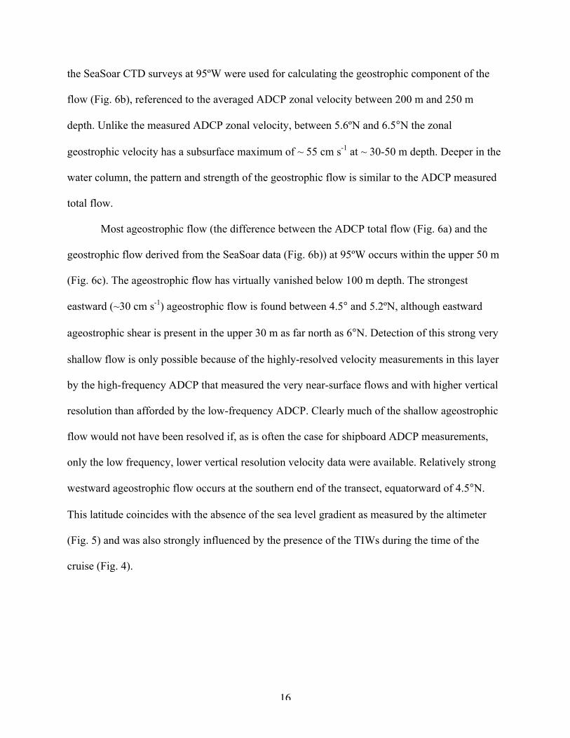
the SeaSoar CTD surveys at 95ºW were used for calculating the geostrophic component of the
flow (Fig. 6b), referenced to the averaged ADCP zonal velocity between 200 m and 250 m
depth. Unlike the measured ADCP zonal velocity, between 5.6ºN and 6.5°N the zonal
geostrophic velocity has a subsurface maximum of ~ 55 cm s-1 at ~ 30-50 m depth. Deeper in the
water column, the pattern and strength of the geostrophic flow is similar to the ADCP measured
total flow.
Most ageostrophic flow (the difference between the ADCP total flow (Fig. 6a) and the
geostrophic flow derived from the SeaSoar data (Fig. 6b)) at 95ºW occurs within the upper 50 m
(Fig. 6c). The ageostrophic flow has virtually vanished below 100 m depth. The strongest
eastward (~30 cm s-1) ageostrophic flow is found between 4.5° and 5.2ºN, although eastward
ageostrophic shear is present in the upper 30 m as far north as 6°N. Detection of this strong very
shallow flow is only possible because of the highly-resolved velocity measurements in this layer
by the high-frequency ADCP that measured the very near-surface flows and with higher vertical
resolution than afforded by the low-frequency ADCP. Clearly much of the shallow ageostrophic
flow would not have been resolved if, as is often the case for shipboard ADCP measurements,
only the low frequency, lower vertical resolution velocity data were available. Relatively strong
westward ageostrophic flow occurs at the southern end of the transect, equatorward of 4.5°N.
This latitude coincides with the absence of the sea level gradient as measured by the altimeter
(Fig. 5) and was also strongly influenced by the presence of the TIWs during the time of the
cruise (Fig. 4).

17
4. Time-Mean, Simplified Momentum Balance along 95ºW
To evaluate the Richardson number (equation [5]) at the time of the cruise along 95°W,
the buoyancy frequency is calculated from the mean density profiles of the SeaSoar CTD data
(Fig. 7a), and the mean vertical shear is calculated from the horizontal velocity as measured by
the ADCP (Fig. 7b). Fig. 7c shows the shallowest depth at which the Ri, defined by equation [5],
equals the Ric of 0.2 to 0.7 (at 0.1 intervals). This depth (h) therefore coincides with the depth of
the turbulent boundary layer for each of these choices of Ric.
For Ric of 0.2 and 0.3 the patterns are similar, with the boundary layer depths shoaling
northwards from 4° to 6.5°N (Fig. 7c). This pattern is related to the elevated values in the
buoyancy frequency as the thermocline shoals northward along the 95°W transect (Fig. 7a). In
the shear profiles (Fig. 7b), the shoaling pattern is still evident but is not as gradual or distinct.
This may imply that there is relatively little momentum transport below this relatively shallow
layer. In the tropics and equatorial region, small-scale night-time convective turbulence and
internal waves are known to penetrate into the stratified top of the main thermocline (Dillon et
al., 1989; Wijesekera and Dillon, 1991). However, it is not clear whether these processes carry
any horizontal momentum deeper into the ocean (Moum et al., 1992; Johnson and Luther, 1994).
Boundary layer depths of ~55 m for Ric=0.2 occur south of 5°N due to the influence of the
stronger shear at this latitude and depth range (Fig. 7b). Depths of ~30-40 m for Ric=0.2 are
found in the core of the NECC between 5.2 to 6.5°N (Fig. 6). Here, the buoyancy frequency is
relatively low and so the depth of the boundary layer is largely determined by the depth variation
of the shear profile. North of 6.5°N, transect maxima in both buoyancy (Fig. 7a) and shear (Fig.
7b) are found, and the boundary layer depth for Ric=0.2 and 0.3 outcrop at the surface north of
7°N.

18
For increasing values of Ri (Fig. 7c), the depth of the boundary layer increases by more
than a third (~20 m), because of the influence of larger buoyancy and smaller shear (Fig. 7a,b)
over these depth ranges. South of 5°N, an increase in shear coincides with elevated values of the
buoyancy frequency at depth. These high values of the buoyancy frequency at ~70-80 m depth
are likely related to the cold, relatively deep surface layers associated with the TIWs. The TIWs
result in the abrupt change in the boundary layer depth near 5°N for all Ri. Between 5.5°N and
6.5°N for higher values of Ric, the boundary layer depth is determined by the buoyancy profile.
b. The Ekman Transport
The simplified momentum balance within the surface layer can now be diagnosed
following equation [4], from a time mean of the meridional density and velocity transects
collected along 95ºW during the cruise, and the turbulent boundary layer depths (h) defined by
the prescribed KPP Richardson numbers. The zonal ageostrophic transport in the near-surface
turbulent layer from the left-hand side of equation [4] is obtained by differencing the geostrophic
transport from the total transport (Fig. 6c). For the depth integration limit, we used the local
value of h as determined for the range of KPP Ri shown in Fig. 7c. The mean ageostrophic
transport per unit distance (m2s-1) estimated from the along-track cruise data is shown in Fig. 8
for each 0.5° latitude band along 95°W. The Ekman transport on the right-hand side of equation
[4] is estimated from the meridional wind stress from the shipboard winds (Fig. 8). For clarity, in
Fig. 8 we only show results of the ageostrophic calculation for the turbulent boundary layer
depths determined for Ric of 0.2 and 0.3, as these give the most comparable values to wind-
estimated Ekman transports. The 95% confidence intervals for both the ageostrophic and Ekman
calculations (Fig. 8) were estimated using a standard student t-test, with the degrees of freedom
for each 0.5° latitude band given in Table 1.

19
The Ekman transport estimated from the shipboard wind stress decreases with increasing
latitude from ~2.6 m2s-1 at 4°N to ~0.4 m2s-1 at 7.5°N. In the core of the NECC from 4.5°N to
6°N, the Ekman transport is fairly steady at ~2.0 m2s-1, and largely falls between the two
ageostrophic transport estimates (Fig. 8). In this latitude band, the winds along 95°W are
primarily southerly (Fig. 3) and drive eastward Ekman mass transport in the surface boundary
layer during the June-July 2001 field campaign (Fig. 8). North of 6°N, the winds are weaker and
more variable (Fig. 3), the turbulent boundary layer depth is very shallow (Fig. 7c) and the
Ekman transport reduced (Fig. 8). The flow here is primarily geostrophic (Fig. 6b) and related to
the relatively strong flow in the southern limb of the Costa Rica Dome. South of 4.5°N, the
southerly winds (Fig. 3) would also drive eastward wind-driven flow, although the ageostrophic
flow derived from the cruise data in this region is westward (Fig. 6c). This may indicate
cyclostrophic effects associated with the westward propagating TIWs and their anticyclonic
eddies (Fig. 4). The strong variability of the agesotrophic transport at 4°N reflects the transient
presence of the TIWs. For higher critical Richardson numbers at 4°N, the deeper h (Fig. 7c)
results in transect maximum transports ranging from 6.8 m2s-1 for Ri=0.4 to 8.6 m2s-1 for Ri=0.6
and also exhibit strong variability (not shown).
It is worth pointing out that the Ekman transport derived from the wind field has no
information of the vertical structure of the flow and its relation to the mixed layer. Thus we could
have expected significant differences between the depth-integrated ageostrophic transport and
the Ekman transport estimates, even when no particular adjustment of the critical Ri number is
made. In the main, the Ekman transport estimated from the shipboard wind stress shows quite
good agreement with the ageostrophic transport estimated for Ric of 0.2 and 0.3 (Fig. 8). A mean
value of Ric= 0.23±0.05 was determined to give the best agreement by minimizing the root-mean

20
square differences between the ageostrophic and Ekman transport estimates at each latitude (Fig.
8; the error bar is the standard deviation of this estimate). Within the core of the NECC, the
ageostrophic transport estimate calculated using the mean value of Ric= 0.23 agrees within the
error bars of the Ekman transport (Fig. 8). This good agreement suggests that, at least to first
approximation, the simplified momentum balance described by equation (2) provides a relatively
good model describing the flow in the NECC over the 19-day cruise period at 95°W. The
differences could be attributed to the neglect of other terms in the simplified balance. Processes
such as internal wave variability, and cyclostrophic effects associated with the TIWs south of
4.5°S are not accounted for in our simplified model.
5. Conclusions
In this paper we used a suite of observations collected during a field campaign in June-
July 2001 of the eastward flowing NECC in the eastern tropical Pacific to investigate and
quantify the time-mean, vertically-averaged, near-surface momentum balance subject to
simplifications and classical assumptions. The presence of the TIWs and their anticyclonic
eddies, along with the strongly developed Costa Rica Dome at the time of our survey clearly
complicated the surface circulation pattern over relatively short time scales in relation to our
repeat survey periods along 95°W. Bounding to the north of the survey area was a westward-
elongated Costa Rica Dome. The drifter trajectories show strong eastward surface flow
associated with the southern limb of the cyclonic gyre associated with this feature. In the annual
mean, Kessler (2002) suggested that the flow around the Costa Rica Dome is not just an
eastward extension of the NECC but instead is fed largely from the north. However the drifter

21
velocities and trajectories clearly suggest that, at least during this June-July time frame, the flow
on the southern side of the Costa Rica Dome is indeed fed from the NECC.
Despite the complex circulation patterns evident in individual transects, by averaging
over the repeat sections taken along 95°W over the 19-day period, a NECC can be identified that
is relatively strong in the upper 50 m between 4.5°N to 6°N, decreases in speed, and narrows in
latitude with depth (Fig. 6a). Subtracting the geostrophic velocity estimate from the ADCP
velocities, we find that most of the ageostrophic flow and vertical shear is confined to the upper
50 m between 4.5°N to 6°N (Fig. 6c). Detecting this surface wind-driven flow was only possible
because of the repeat high-vertical resolution velocity observations obtained in the rarely
measured near surface layer. These direct velocity measurements in the upper 50 m were crucial
in allowing us to determine the vertical distribution of the ageostrophic zonal currents, used to
estimate the vertically integrated ageostrophic transport with confidence. The ageostrophic
transport was largely explained by the surface wind-driven flow that is trapped within the
turbulent boundary layer. Our results confirm the importance of resolving the fine-scale
gradients of the near-surface layer in order to successfully separate the wind-driven from the
geostrophic components of the flow.
The depth of the boundary layer where the turbulent stress vanishes was determined
using the KPP prescribed Richardson number - the ratio of buoyancy production to the
destabilizing shear (equation [5]). The corresponding depth of the turbulent boundary layer
ranges from ~50 m at 4°N, to ~ 30 m within the NECC core, and shoaling to the near-surface at
7°N (Fig. 7c). Again, resolving these relatively shallow boundary layer depths was only possible
because of the shallower velocity measurements from the high-frequency ADCP. For the
simplified surface momentum balance, we found the best agreement of the ageostrophic flow

22
with an independent estimate of the Ekman transport from the shipboard winds was obtained for
Ric of 0.23±0.05. This is in relatively good agreement with other modeling, experimental and
upper ocean observational studies that suggest Ri should lie between 0.25 and 0.5 (Large et al
1994). The mean Ekman transport decreased from south to north along the 95°W transect during
the June-July 2001 cruise. Although within the core of the NECC, the Ekman transport was
relatively strong and steady. This study underscores the importance of the southerly wind-driven
eastward Ekman transport in the relatively shallow turbulent surface layer before the NECC
becomes fully established later in the year by the wind stress curl.
Acknowledgements. We thank the crew and the captain of the R/V Roger Revelle for their good
seamanship, and enabling us to collect the valuable data set used in this scientific analysis. This
work was supported by the National Science Foundation through award OCE000-02886. ADCP
data were processed using the University of Hawaii CODAS3 data processing routines
(http://currents.soest.hawaii.edu/software/codas3). The QSCAT data used in this study were
obtained from http://dss.ucar.edu/datasets/ds744.4 and the AVISO SSH data were obtained from
http://www-aviso.cnes.fr.

23
REFERENCES
Chereskin, T.K., and D. Roemmich, 1991: A comparison of measured and wind-derived Ekman
transport at 11°N in the Atlantic Ocean. J. Phys. Oceanogr., 21, 869-878.
Chereskin, T. K., and A. J. Harding, 1993: Modeling the performance of an acoustic doppler
current profiler. J. Atmos. and Oceanic Technol., 10, 41-63.
Chereskin, T. K., W. D. Wilson, H. L. Bryden, A. Ffield, and J. Morrison, 1997: Observations of
the Ekman balance at 8 degrees 30' N in the Arabian Sea during the 1995 southwest
monsoon. Geophys. Res. Lett., 24, 2541-2544.
Chin, T. M., R. F. Milliff, and W. G. Large, 1998: Basin-scale, high-wavenumber sea surface
wind fields from a multi resolution analysis of scatterometer data. J. Atmos. and Oceanic
Technol., 15, 741-763.
Contreras, R.F., 2002: Long term observations of instability waves. J. Phys. Oceanogr., 32,
2715-2722.
Dillon, T.M., J.N. Moum, T.K. Chereskin, and D.R. Caldwell, 1989: Zonal momentum balance
at the equator. J. Phys. Oceanogr., 19, 561-570.
Donguy, R-D., and G. Meyers, 1996: Mean annual variation of transport of major currents in the
tropical Pacific Ocean. Progr. Oceanogr., 43, 1105–1122.
Ekman, V.W., 1905: On the influence of the earth’s rotation on ocean-currents. Ark. Mat.
Astron., Fys., 2, 1-52.
Fairall, C. W., E. F. Bradley, J. E. Hare, A. A. Grachev, and J. B. Edson, 2003: Bulk
parameterization of air-sea fluxes: Updates and verification for the COARE algorithm, J.
Climate, 16, 571-591.

24
Johnson, E. S., L. A. Regier, and R. A. Knox, 1988: A study of geostrophy in tropical Pacific
Ocean currents during the NORPAX Tahiti Shuttle using a shipboard Doppler acoustic
current profiler. J. Phys. Oceanogr., 18, 708-723.
Johnson, E.S. and D.S. Luther, 1994: Mean zonal momentum balance in the upper and central
equatorial Pacific Ocean. J. Geophys. Res., 99, 7689-7705.
Johnson, G. C., B. M. Sloyan, W. S. Kessler, and K. E. McTaggart, 2002: Direct measurements
of upper ocean currents and water properties across the tropical Pacific during the 1990s.
Progress in Oceanogr., 52, 31-61.
Kennan, S.C., and P.J. Flament, 2000: Observations of a tropical instability vortex. J. Phys.
Oceanogr. 30, 2277-2301.
Kennan, S.C., and P.P. Niiler, 2003: Estimating sea level slope on the equator. J. Phys.
Oceanogr., 33, 2627-2642.
Kessler, W. S., 2002: Mean three-dimensional circulation in the northeast tropical Pacific. J.
Phys. Oceanogr., 32, 2457-2471.
Kessler, W. S., 2006: The circulation of the eastern tropical Pacific: A review. Prog. Oceanogr.,
69, 181-217.
King B. A., and E. B. Cooper, 1993: Comparison of ships heading determines from an array of
GPS antennas with heading from conventional gyrocompass measurements. Deep-Sea
Res., 40, 2207-2216.
Knauss, J. A., 1961: The structure of the Pacific Equatorial Countercurrent. J. Geophys. Res., 66,
143-155.
Large, W. G., J. C. McWilliams, and S. C. Doney, 1994: Oceanic vertical mixing: a review and a
model with a nonlocal boundary layer parameterization. Rev. Geophys., 32(4), 363-403.

25
Leetma, A., and R. L. Molinari, 1984: Two cross-equatorial sections at 110ºW. J. Phys.
Oceanogr., 14, 255-263.
Lueck, R. G., and J. J. Picklo, 1990: Thermal inertia of conductivity cells: observations with a
Sea-Bird cell. J. Atmos. Oceanic Technol., 7, 756-768.
Mitchell, T. P., C. Deser, and J. M. Wallace, 1989: The influence of sea surface temperature on
surface wind in the eastern equatorial Pacific: Seasonal and interannual variability. J.
Climate, 2, 1500-1506.
Montgomery, R. B., and E. D. Stroup, 1962: Equatorial Waters and Currents at 150ºW in July-
August 1952, volume 1 of The Johns Hopkins Oceanographic Studies. The Johns
Hopkins Press, Baltimore.
Moum, J.N., M.J. McPhaden, D. Hebert, H. Peters, C.A. Paulson, and D.R. Caldwell, 1992:
Internal waves, dynamic instabilities, and turbulence in the equatorial thermocline. J.
Phys. Oceanogr., 22, 1357-1359.
Niiler, P. P., A. S. Sybrandy, K. Bi, P.-M. Poulain, and D. Bitterman, 1995: Measurements of the
water-following capability of holey-sock and TRISTAR drifters. Deep-Sea Res., 42,
1951-1964.
Niiler, P. P., 2001: The world ocean surface circulation. In Siedler, G., J. Church, and J. Gould,
editors, Ocean Circulation and Climate, Int. Geophysics Series, vol. 77, pages 193-204.
Academic Press, San Diego.
Philander, S, G. H., 1978: Instabilities of zonal equatorial currents, Part 2. J. Geophys. Res., 83,
3679-3682.
Rudnick D. L., and J. P. Martin, 2002: On the horizontal density ratio in the upper ocean. Dyn.
Atmos. and Oceans, 36, 3-21.

26
Qiao, L., and R. H. Weisberg, 1995: Tropical instability wave kinematics: Observations from the
Tropical Instability Wave Experiment. J. Geophys. Res., 100, 8677-8693.
Stommel, H., 1960: Wind-drift near the equator. Deep-Sea Res., 6, 298-302.
Sverdrup, H. A., 1947: Wind-driven currents in a baroclinic ocean; with application to the
equatorial currents of the eastern Pacific. Proc. Nat. Acad. Sci., 33, 318-326.
Tsuchiya, M., 1974: Variation of the surface geostrophic flow in the eastern intertropical Pacifc
Ocean. Fishery Bull., 72, 1075-1086.
Turner, J. S., 1973: Buoyancy Effects in Fluids, 368pp., Cambridge University Press, New York,
1973.
Willett, C.S., R.R. Leben, and M.F. Lavin, 2006: Eddies and tropical instability waves in the
eastern tropical Pacific: A review. Prog. Oceanogr., 69, 218-238.
Wijesekera, H.W. and T.M. Dillon, 1991: Internal waves and missing in the upper equatorial
Pacific Ocean. J. Geophys. Res., 96, 7115-7125.

27
Figure Captions
Fig. 1: Mean surface velocity (m s-1) from 6-hour drifting buoy data in the eastern tropical
Pacific Ocean averaged over 1979-2006 for a) the entire period and b) June-July. The scale
velocity vector is found in the upper right hand corner. Drifter velocities were interpolated by
Krieging to 6-hourly locations then vector averaged in 0.5° latitude by longitude bins. The
location of the cruise track along 95°W is shown by the solid line.
Fig. 2: Slope (10-4 m-1) from a linear regression of the vertical shear versus ship speed in the a)
tangential and b) normal direction to the ship heading for the 1-m vertical resolution 600 kHz
ADCP velocity data (*), and the 8-m vertical resolution 150 kHz ADCP velocity data (o).
Fig. 3: Time series of blended QSCAT meridional wind stress along 95ºW (dynes cm-2). The
black box encloses the 19-day period and the latitudinal track (black line) of the cruise
observations undertaken at 95ºW.
Fig. 4: Sea surface height anomaly (cm) (shaded) on 14 July 2001 and the surface drifter track
trajectories (black dots indicate initial deployment location and lines their subsequent
trajectories) from 1-16 July 2001 in the eastern tropical Pacific Ocean during the repeat transects
along 95°W (green line).
Fig. 5: Time series of the sea surface height anomaly (cm; shaded) and its meridional gradient
(10-5 cm; contoured) during 23 June to 28 July 2001 at 95ºW. The green box encloses the 19-day
period and the latitudinal track (green line) of the cruise observations undertaken at 95ºW.
28
Fig. 6: Average vertical sections at 95°W of (a) mean zonal velocity determined from the ADCP
measurements; (b) mean geostrophic zonal velocity calculated from the SeaSoar CTD density
measurements and referenced to the average (200-250 m) ADCP velocity; and (c) the
ageostrophic velocity calculated as the difference between (a) and (b). Units are cm s-1.
Westward velocity is shaded blue and eastward velocity is red.
Fig. 7: Variation of a) buoyancy frequency (s) and b) vertical shear (s) with depth and latitude
along 95ºW. Note the different scale between panels a) and b). c). The depth below which the
KPP prescribed Richardson numbers (Ri = 0.2 to 0.7) are equaled or exceeded with latitude
along 95°W. A 3-point moving average filter has been applied.
Fig. 8: Transport per unit distance (m2 s-1) at 95ºW obtained from the momentum balance
achieved over depths defined from the prescribed KPP Richardson Numbers of 0.2 (black
dotted), 0.3 (blue dotted) and the shipboard observed winds (red dotted). The best agreement
with the Ekman transport derived from the shipboard winds is given for a Richardson number of
0.23 (green line). The vertical lines on each curve marks the 95% confidence intervals with
degrees of freedom given in Table 1. In the curve legend, u is the zonal ADCP velocity at the sea
surface, uh is the zonal ADCP velocity at depth h, uG is the zonal geostrophic velocity at the sea
surface, and uGh is the zonal geostrophic velocity at depth h. The meridional wind stress is τy.

29
Table 1. Number of observations used to compute the degrees of freedom in each 0.5º latitude
band along 95ºW for the ADCP, SeaSoar and shipboard wind stress cruise data (CRUISE). The
latitude represents the center latitude of each 0.5º latitudinal band.
Latitude 4.0ºN 4.5ºN 5.0ºN 5.5ºN 6.0ºN 6.5ºN 7.0 ºN 7.5ºN 8.0ºN
CRUISE 40 55 55 98 105 99 63 51 22

30
Fig. 1: Mean surface velocity (m s-1) from 6-hour drifting buoy data in the eastern tropical
Pacific Ocean averaged over 1979-2006 for a) the entire period and b) June-July. The scale
velocity vector is found in the upper right hand corner. Drifter velocities were interpolated by
Krieging to 6-hourly locations then vector averaged in 0.5° latitude by longitude bins. The
location of the cruise track along 95°W is shown by the solid line.

31
Fig. 2: Slope (10-4 m-1) from a linear regression of the vertical shear versus ship speed in the a)
tangential and b) normal direction to the ship heading for the 1-m vertical resolution 600 kHz
ADCP velocity data (*), and the 8-m vertical resolution 150 kHz ADCP velocity data (o).

32
Fig. 3: Time series of blended QSCAT meridional wind stress along 95ºW (dynes cm-2). The
black box encloses the 19-day period and the latitudinal track (black line) of the cruise
observations undertaken at 95ºW.

33
Fig. 4: Sea surface height anomaly (cm) (shaded) on 14 July 2001 and the surface drifter track
trajectories (black dots indicate initial deployment location and lines their subsequent
trajectories) from 1-16 July 2001 in the eastern tropical Pacific Ocean during the repeat transects
along 95°W (green line).

34
Fig. 5: Time series of the sea surface height anomaly (cm; shaded) and its meridional gradient
(10-5 cm; contoured) during 23 June to 28 July 2001 at 95ºW. The green box encloses the 19-day
period and the latitudinal track (green line) of the cruise observations undertaken at 95ºW.

35
Fig. 6: Average vertical sections at 95°W of (a) mean zonal velocity determined from the ADCP
measurements; (b) mean geostrophic zonal velocity calculated from the SeaSoar CTD density
measurements and referenced to the average (200-250 m) ADCP velocity; and (c) the
ageostrophic velocity calculated as the difference between (a) and (b). Units are cm s-1.
Westward velocity is shaded blue and eastward velocity is red.

36
Fig. 7: Variation of a) buoyancy frequency (s-1) and b) vertical shear (s-1) with depth and latitude
along 95ºW. c). The depth below which the KPP prescribed Richardson numbers (Ri = 0.2 to
0.7) are equaled or exceeded with latitude along 95°W. Note the different scale between panels
a) and b). A 3-point moving average filter has been applied to all data.

37
Fig. 8: Transport per unit distance (m2 s-1) at 95ºW obtained from the momentum balance
achieved over depths defined from the prescribed KPP Richardson Numbers of 0.2 (black
dotted), 0.3 (blue dotted) and the shipboard observed winds (red dotted). The best agreement
with the Ekman transport derived from the shipboard winds is given for a Richardson number of
0.23 (green line). The vertical lines on each curve marks the 95% confidence intervals with
degrees of freedom given in Table 1. In the curve legend, u is the zonal ADCP velocity at the sea
surface, uh is the zonal ADCP velocity at depth h, uG is the zonal geostrophic velocity at the sea
surface, and uGh is the zonal geostrophic velocity at depth h. The meridional wind stress is τy.