wip stream restoration - washington, d.c. stream restoration appendix b: stream restoration sites...
TRANSCRIPT

Rock Creek Watershed Implementation Plan January 15, 2010 449
WIP Stream Restoration
Appendix B: Stream Restoration Sites
Rock Creek Watershed Implementation Plan January 15, 2010 450
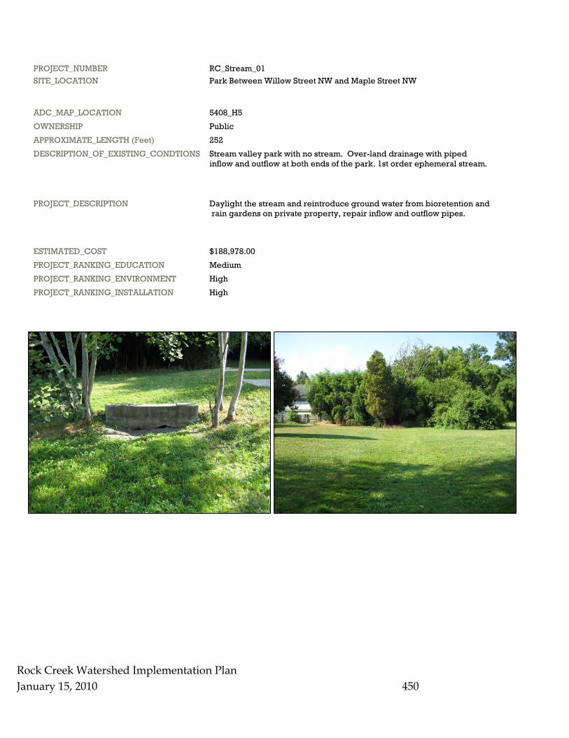
PROJECT_NUMBER RC_Stream_01 SITE_LOCATION Park Between Willow Street NW and Maple Street NW
ADC_MAP_LOCATION 5408_H5 OWNERSHIP Public APPROXIMATE_LENGTH (Feet) 252 DESCRIPTION_OF_EXISTING_CONDTIONS Stream valley park with no stream. Over-land drainage with piped inflow and outflow at both ends of the park. 1st order ephemeral stream.
PROJECT_DESCRIPTION Daylight the stream and reintroduce ground water from bioretention and rain gardens on private property, repair inflow and outflow pipes.
ESTIMATED_COST $188,978.00 PROJECT_RANKING_EDUCATION Medium PROJECT_RANKING_ENVIRONMENT High PROJECT_RANKING_INSTALLATION High
Rock Creek Watershed Implementation Plan January 15, 2010 451
PROJECT_NUMBER RC_Stream_02 SITE_LOCATION Lowell School - 1640 Kalmia Street NW
ADC_MAP_LOCATION 5408_D3 OWNERSHIP Private APPROXIMATE_LENGTH (Feet) 1009 DESCRIPTION_OF_EXISTING_CONDTIONS Natural spring on school grounds. The school daylighted an underground pipe to create a low flow stream. The school planted some trees along the spring, but there are still open areas and exposed banks. Piped at 17th Street NW to Rock Creek.
PROJECT_DESCRIPTION Stream bank stabilization. Riparian forest buffer planting. Planting of herbaceous emergents along stream banks. Daylighting of lower portion of stream.
ESTIMATED_COST $756,690.00 PROJECT_RANKING_EDUCATION High PROJECT_RANKING_ENVIRONMENT Medium PROJECT_RANKING_INSTALLATION Medium
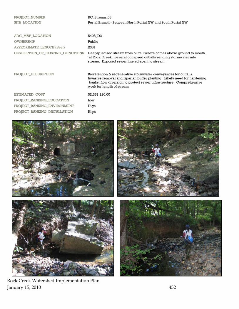
PROJECT_NUMBER RC_Stream_03 SITE_LOCATION Portal Branch - Between North Portal NW and South Portal NW
ADC_MAP_LOCATION 5408_D2 OWNERSHIP Public APPROXIMATE_LENGTH (Feet) 2351 DESCRIPTION_OF_EXISTING_CONDTIONS Deeply incised stream from outfall where comes above ground to mouth at Rock Creek. Several collapsed outfalls sending stormwater into stream. Exposed sewer line adjacent to stream.
PROJECT_DESCRIPTION Bioretention & regenerative stormwater conveyances for outfalls. Invasive removal and riparian buffer planting. Likely need for hardening banks, flow diversion to protect sewer infrastructure. Comprehensive work for length of stream.
ESTIMATED_COST $2,351,120.00 PROJECT_RANKING_EDUCATION Low PROJECT_RANKING_ENVIRONMENT High PROJECT_RANKING_INSTALLATION High
Rock Creek Watershed Implementation Plan January 15, 2010
452
Rock Creek
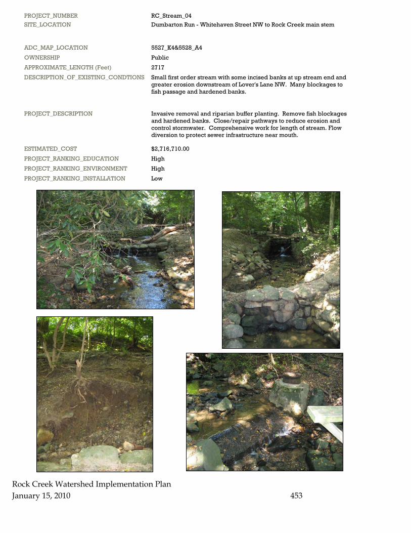
PROJECT_NUMBER RC_Stream_04 SITE_LOCATION Dumbarton Run - Whitehaven Street NW to Rock Creek main stem
ADC_MAP_LOCATION 5527_K4&5528_A4 OWNERSHIP Public APPROXIMATE_LENGTH (Feet) 2717 DESCRIPTION_OF_EXISTING_CONDTIONS Small first order stream with some incised banks at up stream end and greater erosion downstream of Lover's Lane NW. Many blockages to fish passage and hardened banks.
PROJECT_DESCRIPTION Invasive removal and riparian buffer planting. Remove fish blockages and hardened banks. Close/repair pathways to reduce erosion and control stormwater. Comprehensive work for length of stream. Flow diversion to protect sewer infrastructure near mouth.
ESTIMATED_COST $2,716,710.00 PROJECT_RANKING_EDUCATION High PROJECT_RANKING_ENVIRONMENT High PROJECT_RANKING_INSTALLATION Low
Watershed Implementation Plan January 15, 2010
453
Rock Creek Watershed Implementation Plan January 15, 2010 454
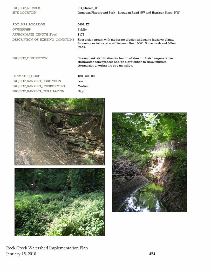
PROJECT_NUMBER RC_Stream_05 SITE_LOCATION Linnaean Playground Park - Linnaean Road NW and Harrison Street NW
ADC_MAP_LOCATION 5407_K7 OWNERSHIP Public APPROXIMATE_LENGTH (Feet) 1178 DESCRIPTION_OF_EXISTING_CONDTIONS First order stream with moderate erosion and many invasive plants. Stream goes into a pipe at Linnaean Road NW. Some trash and fallen trees.
PROJECT_DESCRIPTION Stream bank stabilization for length of stream. Install regenerative stormwater conveyances and/or bioretention to slow/infiltrate stormwater entering the stream valley.
ESTIMATED_COST $883,500.00 PROJECT_RANKING_EDUCATION Low PROJECT_RANKING_ENVIRONMENT Medium PROJECT_RANKING_INSTALLATION High
Rock Creek Watershed Implementation Plan January 15, 2010 455
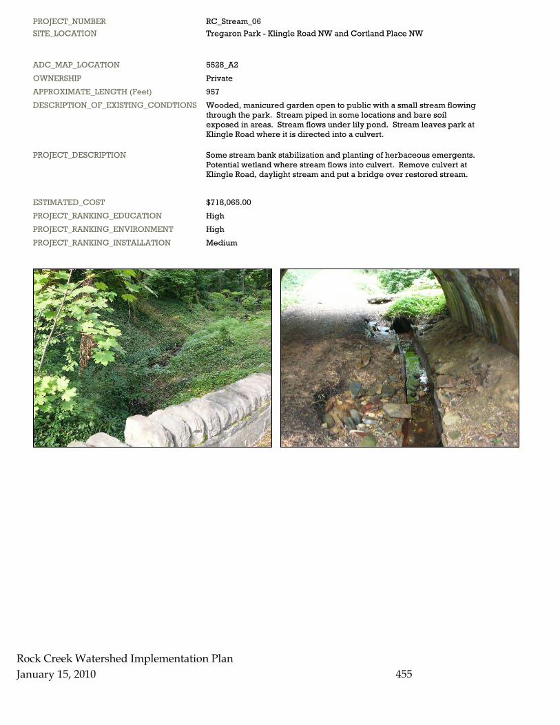
PROJECT_NUMBER RC_Stream_06 SITE_LOCATION Tregaron Park - Klingle Road NW and Cortland Place NW
ADC_MAP_LOCATION 5528_A2 OWNERSHIP Private APPROXIMATE_LENGTH (Feet) 957 DESCRIPTION_OF_EXISTING_CONDTIONS Wooded, manicured garden open to public with a small stream flowing through the park. Stream piped in some locations and bare soil exposed in areas. Stream flows under lily pond. Stream leaves park at Klingle Road where it is directed into a culvert.
PROJECT_DESCRIPTION Some stream bank stabilization and planting of herbaceous emergents. Potential wetland where stream flows into culvert. Remove culvert at Klingle Road, daylight stream and put a bridge over restored stream.
ESTIMATED_COST $718,065.00 PROJECT_RANKING_EDUCATION High PROJECT_RANKING_ENVIRONMENT High PROJECT_RANKING_INSTALLATION Medium
Rock Creek Watershed Implementation Plan January 15, 2010
456
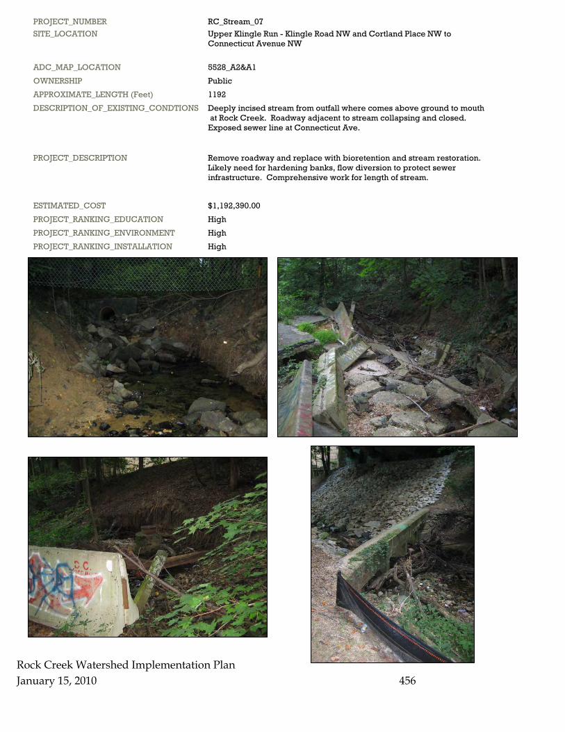
PROJECT_NUMBER RC_Stream_07 SITE_LOCATION Upper Klingle Run - Klingle Road NW and Cortland Place NW to Connecticut Avenue NW
ADC_MAP_LOCATION 5528_A2&A1 OWNERSHIP Public APPROXIMATE_LENGTH (Feet) 1192 DESCRIPTION_OF_EXISTING_CONDTIONS Deeply incised stream from outfall where comes above ground to mouth at Rock Creek. Roadway adjacent to stream collapsing and closed. Exposed sewer line at Connecticut Ave.
PROJECT_DESCRIPTION Remove roadway and replace with bioretention and stream restoration. Likely need for hardening banks, flow diversion to protect sewer infrastructure. Comprehensive work for length of stream.
ESTIMATED_COST $1,192,390.00 PROJECT_RANKING_EDUCATION High PROJECT_RANKING_ENVIRONMENT High PROJECT_RANKING_INSTALLATION High
Rock Creek Watershed Implementation Plan January 15, 2010 457
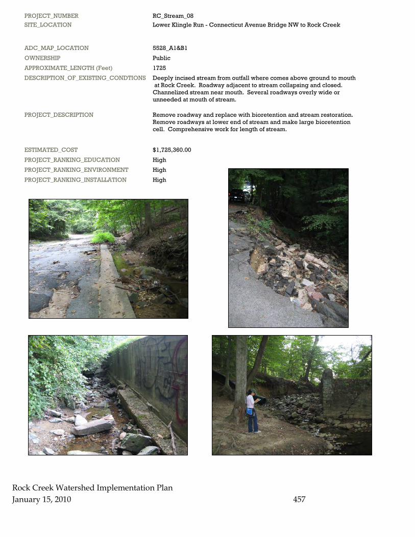
PROJECT_NUMBER RC_Stream_08 SITE_LOCATION Lower Klingle Run - Connecticut Avenue Bridge NW to Rock Creek
ADC_MAP_LOCATION 5528_A1&B1 OWNERSHIP Public APPROXIMATE_LENGTH (Feet) 1725 DESCRIPTION_OF_EXISTING_CONDTIONS Deeply incised stream from outfall where comes above ground to mouth at Rock Creek. Roadway adjacent to stream collapsing and closed. Channelized stream near mouth. Several roadways overly wide or unneeded at mouth of stream.
PROJECT_DESCRIPTION Remove roadway and replace with bioretention and stream restoration. Remove roadways at lower end of stream and make large bioretention cell. Comprehensive work for length of stream.
ESTIMATED_COST $1,725,360.00 PROJECT_RANKING_EDUCATION High PROJECT_RANKING_ENVIRONMENT High PROJECT_RANKING_INSTALLATION High
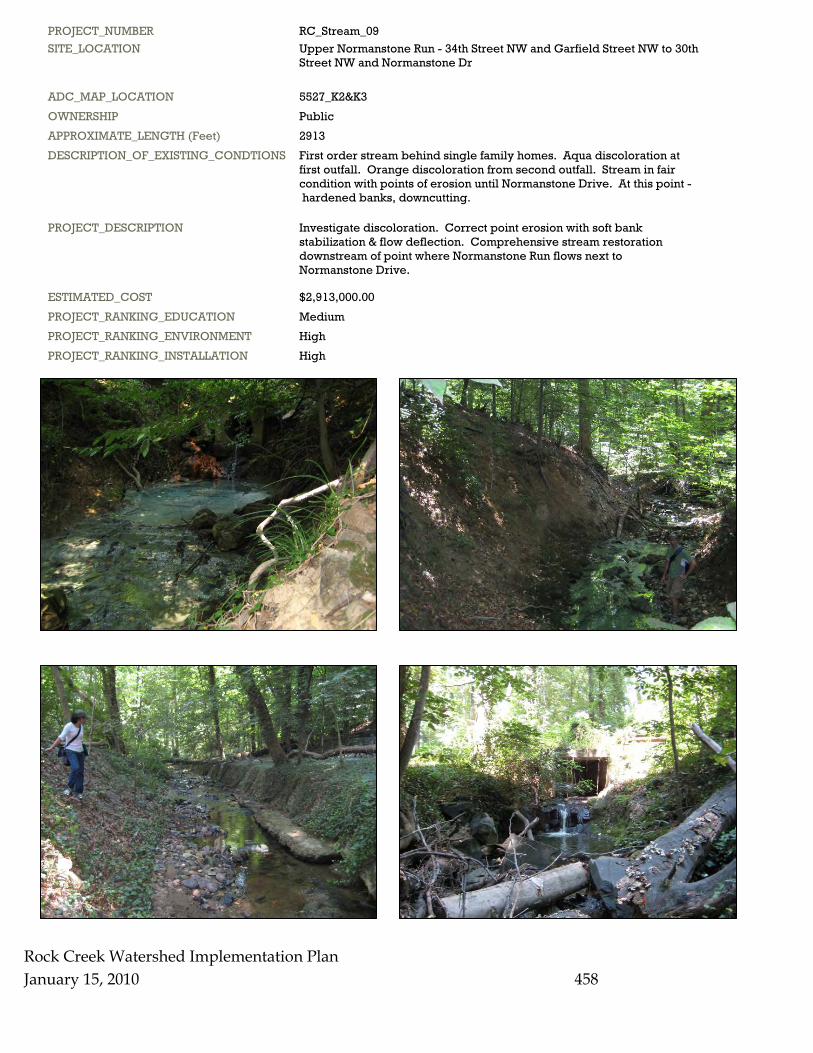
PROJECT_NUMBER RC_Stream_09 SITE_LOCATION Upper Normanstone Run - 34th Street NW and Garfield Street NW to 30th Street NW and Normanstone Dr
ADC_MAP_LOCATION 5527_K2&K3 OWNERSHIP Public APPROXIMATE_LENGTH (Feet) 2913 DESCRIPTION_OF_EXISTING_CONDTIONS First order stream behind single family homes. Aqua discoloration at first outfall. Orange discoloration from second outfall. Stream in fair condition with points of erosion until Normanstone Drive. At this point - hardened banks, downcutting.
PROJECT_DESCRIPTION Investigate discoloration. Correct point erosion with soft bank stabilization & flow deflection. Comprehensive stream restoration downstream of point where Normanstone Run flows next to Normanstone Drive.
ESTIMATED_COST $2,913,000.00 PROJECT_RANKING_EDUCATION Medium PROJECT_RANKING_ENVIRONMENT High PROJECT_RANKING_INSTALLATION High
Rock Creek Watershed Implementation Plan January 15, 2010
458
Rock Creek Watershed Implementation Plan January 15, 2010 459
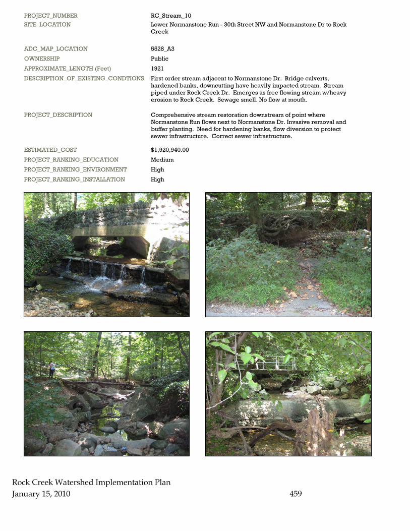
PROJECT_NUMBER RC_Stream_10 SITE_LOCATION Lower Normanstone Run - 30th Street NW and Normanstone Dr to Rock Creek
ADC_MAP_LOCATION 5528_A3 OWNERSHIP Public APPROXIMATE_LENGTH (Feet) 1921 DESCRIPTION_OF_EXISTING_CONDTIONS First order stream adjacent to Normanstone Dr. Bridge culverts, hardened banks, downcutting have heavily impacted stream. Stream piped under Rock Creek Dr. Emerges as free flowing stream w/heavy erosion to Rock Creek. Sewage smell. No flow at mouth.
PROJECT_DESCRIPTION Comprehensive stream restoration downstream of point where Normanstone Run flows next to Normanstone Dr. Invasive removal and buffer planting. Need for hardening banks, flow diversion to protect sewer infrastructure. Correct sewer infrastructure.
ESTIMATED_COST $1,920,940.00 PROJECT_RANKING_EDUCATION Medium PROJECT_RANKING_ENVIRONMENT High PROJECT_RANKING_INSTALLATION High
Rock Creek Watershed Implementation Plan January 15, 2010 460
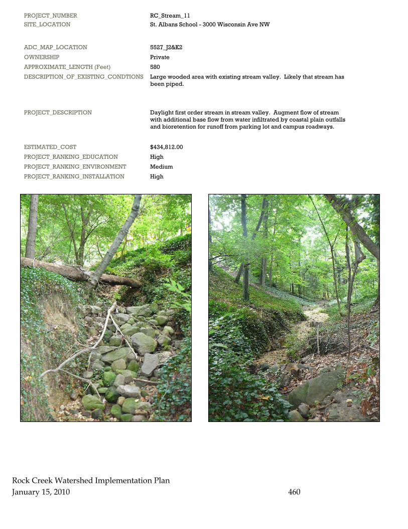
PROJECT_NUMBER RC_Stream_11 SITE_LOCATION St. Albans School - 3000 Wisconsin Ave NW
ADC_MAP_LOCATION 5527_J2&K2 OWNERSHIP Private APPROXIMATE_LENGTH (Feet) 580 DESCRIPTION_OF_EXISTING_CONDTIONS Large wooded area with existing stream valley. Likely that stream has been piped.
PROJECT_DESCRIPTION Daylight first order stream in stream valley. Augment flow of stream with additional base flow from water infiltrated by coastal plain outfalls and bioretention for runoff from parking lot and campus roadways.
ESTIMATED_COST $434,812.00 PROJECT_RANKING_EDUCATION High PROJECT_RANKING_ENVIRONMENT Medium PROJECT_RANKING_INSTALLATION High
Rock Creek January 15, 2010
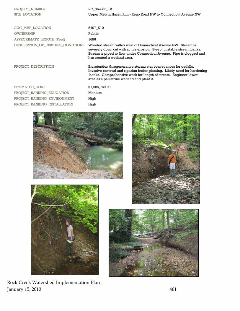
PROJECT_NUMBER RC_Stream_12 SITE_LOCATION Upper Melvin Hazen Run - Reno Road NW to Connecticut Avenue NW
ADC_MAP_LOCATION 5407_K10 OWNERSHIP Public APPROXIMATE_LENGTH (Feet) 1686 DESCRIPTION_OF_EXISTING_CONDTIONS Wooded stream valley west of Connecticut Avenue NW. Stream is severely down cut with active erosion. Steep, unstable stream banks. Stream is piped to flow under Connecticut Avenue. Pipe is clogged and has created a wetland area.
PROJECT_DESCRIPTION Bioretention & regenerative stormwater conveyances for outfalls. Invasive removal and riparian buffer planting. Likely need for hardening banks. Comprehensive work for length of stream. Engineer lower area as a palustrine wetland and plant it.
ESTIMATED_COST $1,685,760.00 PROJECT_RANKING_EDUCATION Medium PROJECT_RANKING_ENVIRONMENT High PROJECT_RANKING_INSTALLATION High
Watershed Implementation Plan
461
Rock Creek Watershed Implementation Plan January 15, 2010 462
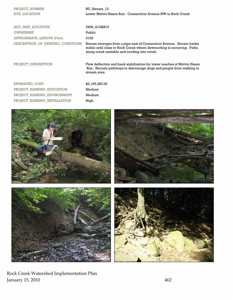
PROJECT_NUMBER RC_Stream_13 SITE_LOCATION Lower Melvin Hazen Run - Connecticut Avenue NW to Rock Creek
ADC_MAP_LOCATION 5408_A10&B10 OWNERSHIP Public APPROXIMATE_LENGTH (Feet) 3165 DESCRIPTION_OF_EXISTING_CONDTIONS Stream emerges from a pipe east of Connecticut Avenue. Stream banks stable until close to Rock Creek where downcutting is occurring. Paths along creek unstable and eroding into creek.
PROJECT_DESCRIPTION Flow deflection and bank stabilization for lower reaches of Melvin Hazen Run. Reroute pathways to discourage dogs and people from walking in stream area.
ESTIMATED_COST $3,165,380.00 PROJECT_RANKING_EDUCATION Medium PROJECT_RANKING_ENVIRONMENT Medium PROJECT_RANKING_INSTALLATION High
Rock Creek Watershed Implementation Plan January 15, 2010 463
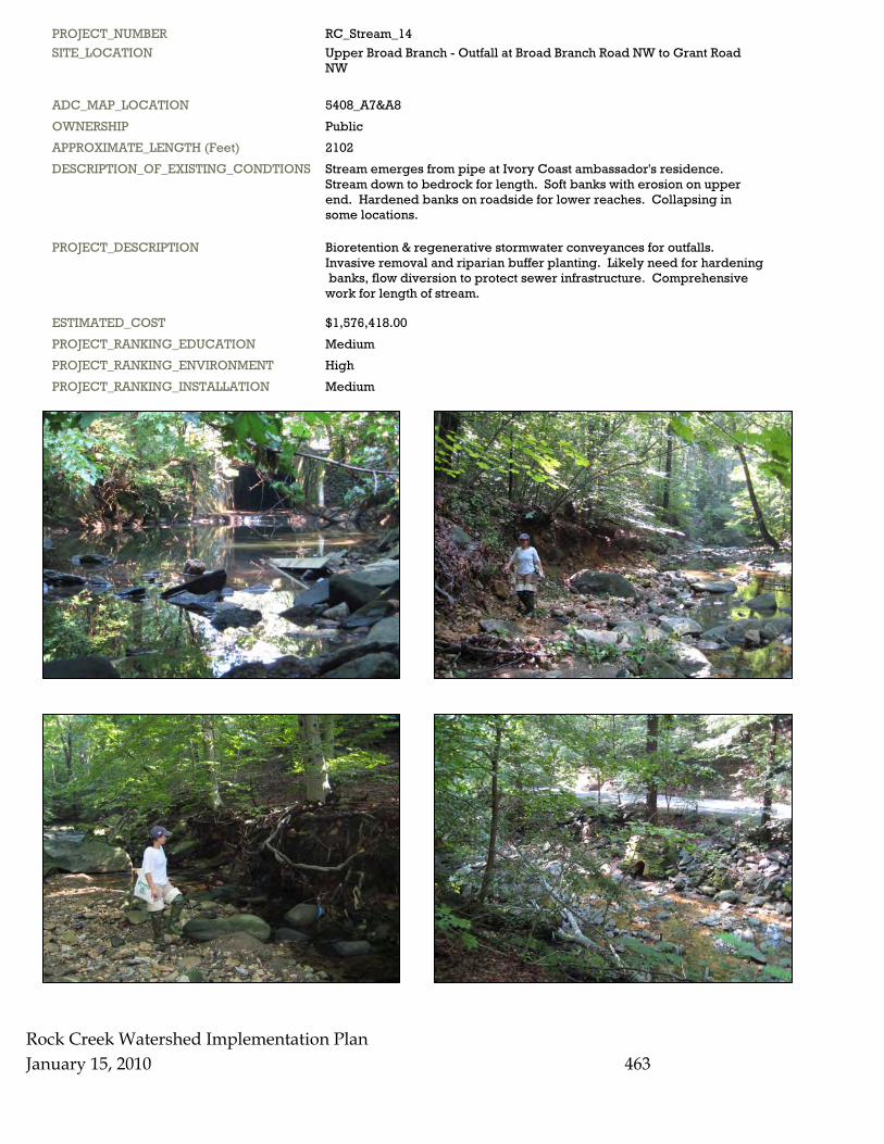
PROJECT_NUMBER RC_Stream_14 SITE_LOCATION Upper Broad Branch - Outfall at Broad Branch Road NW to Grant Road NW
ADC_MAP_LOCATION 5408_A7&A8 OWNERSHIP Public APPROXIMATE_LENGTH (Feet) 2102 DESCRIPTION_OF_EXISTING_CONDTIONS Stream emerges from pipe at Ivory Coast ambassador's residence. Stream down to bedrock for length. Soft banks with erosion on upper end. Hardened banks on roadside for lower reaches. Collapsing in some locations.
PROJECT_DESCRIPTION Bioretention & regenerative stormwater conveyances for outfalls. Invasive removal and riparian buffer planting. Likely need for hardening banks, flow diversion to protect sewer infrastructure. Comprehensive work for length of stream.
ESTIMATED_COST $1,576,418.00 PROJECT_RANKING_EDUCATION Medium PROJECT_RANKING_ENVIRONMENT High PROJECT_RANKING_INSTALLATION Medium
Rock Creek Watershed Implementation Plan January 15, 2010 464
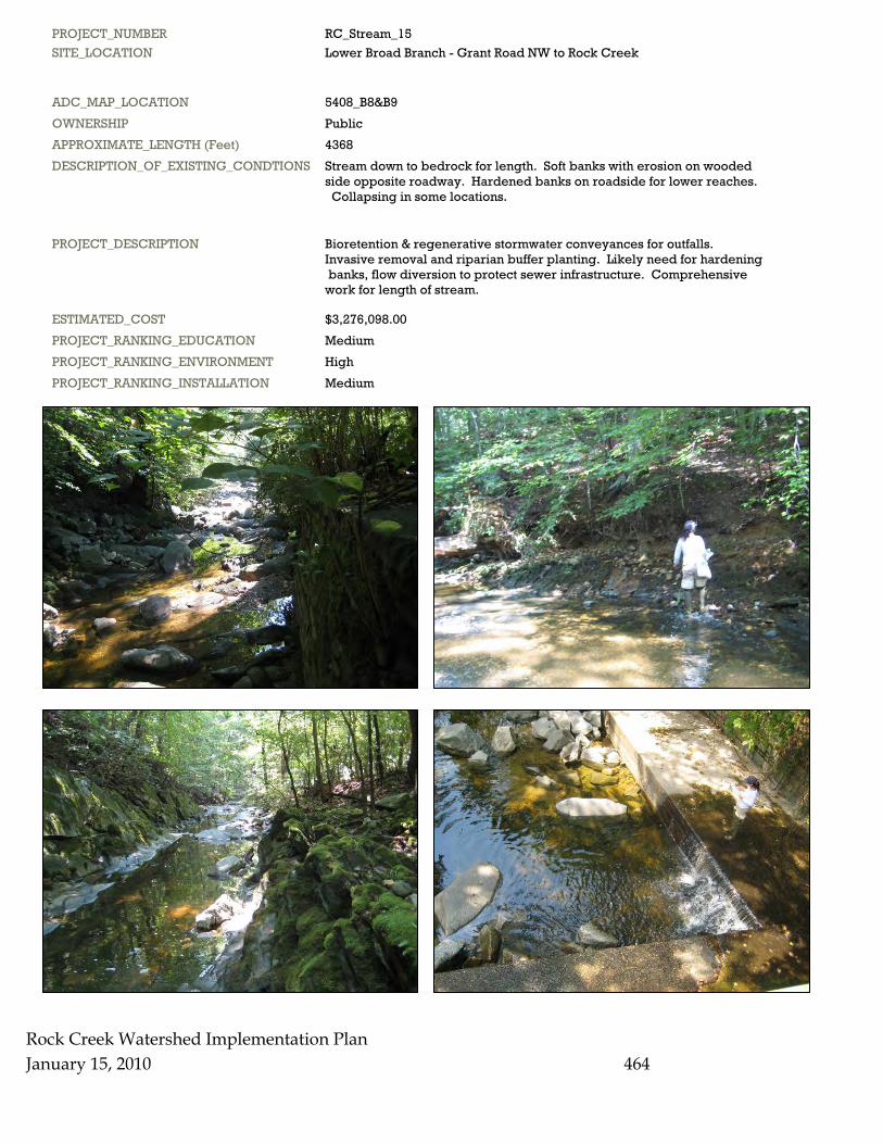
PROJECT_NUMBER RC_Stream_15 SITE_LOCATION Lower Broad Branch - Grant Road NW to Rock Creek
ADC_MAP_LOCATION 5408_B8&B9 OWNERSHIP Public APPROXIMATE_LENGTH (Feet) 4368 DESCRIPTION_OF_EXISTING_CONDTIONS Stream down to bedrock for length. Soft banks with erosion on wooded side opposite roadway. Hardened banks on roadside for lower reaches. Collapsing in some locations.
PROJECT_DESCRIPTION Bioretention & regenerative stormwater conveyances for outfalls. Invasive removal and riparian buffer planting. Likely need for hardening banks, flow diversion to protect sewer infrastructure. Comprehensive work for length of stream.
ESTIMATED_COST $3,276,098.00 PROJECT_RANKING_EDUCATION Medium PROJECT_RANKING_ENVIRONMENT High PROJECT_RANKING_INSTALLATION Medium
Rock Creek Watershed Implementation Plan January 15, 2010 465
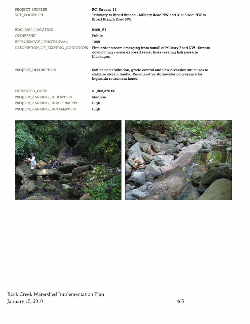
PROJECT_NUMBER RC_Stream_16 SITE_LOCATION Tributary to Broad Branch - Military Road NW and 31st Street NW to Broad Branch Road NW
ADC_MAP_LOCATION 5408_A7 OWNERSHIP Public APPROXIMATE_LENGTH (Feet) 1208 DESCRIPTION_OF_EXISTING_CONDTIONS First order stream emerging from outfall of Military Road NW. Stream downcutting - some exposed sewer lines creating fish passage blockages.
PROJECT_DESCRIPTION Soft bank stabilization, grade control and flow diversion structures to stabilize stream banks. Regenerative stormwater conveyance for Ingleside retirement home.
ESTIMATED_COST $1,208,370.00 PROJECT_RANKING_EDUCATION Medium PROJECT_RANKING_ENVIRONMENT High PROJECT_RANKING_INSTALLATION High

Rock CreekJanuary 15, 2010
PROJECT_NUMBER RC_Stream_17 SITE_LOCATION Soapstone Creek - Connecticut Avenue NW and Albemarle Street NW to Broad Branch
ADC_MAP_LOCATION 5407_K9&5408_A9&B9 OWNERSHIP Public APPROXIMATE_LENGTH (Feet) 4532 DESCRIPTION_OF_EXISTING_CONDTIONS Wooded stream valley east of Connecticut Avenue NW near Van Ness. Most densely developed area with a lot of stormwater. Stream is severely down cut with active erosion. Steep, unstable stream banks. Sewage smell at outfall.
PROJECT_DESCRIPTION Bioretention & regenerative stormwater conveyances for outfalls. Likely need for some hardening of banks & flow deflection devices to protect sewer infrastructure. Comprehensive work for length of stream. Correct sewage leaks.
ESTIMATED_COST $4,532,300.00 PROJECT_RANKING_EDUCATION High PROJECT_RANKING_ENVIRONMENT High PROJECT_RANKING_INSTALLATION High
Watershed Implementation Plan
466
Rock Creek Watershed Implementation Plan 467
January 15, 2010
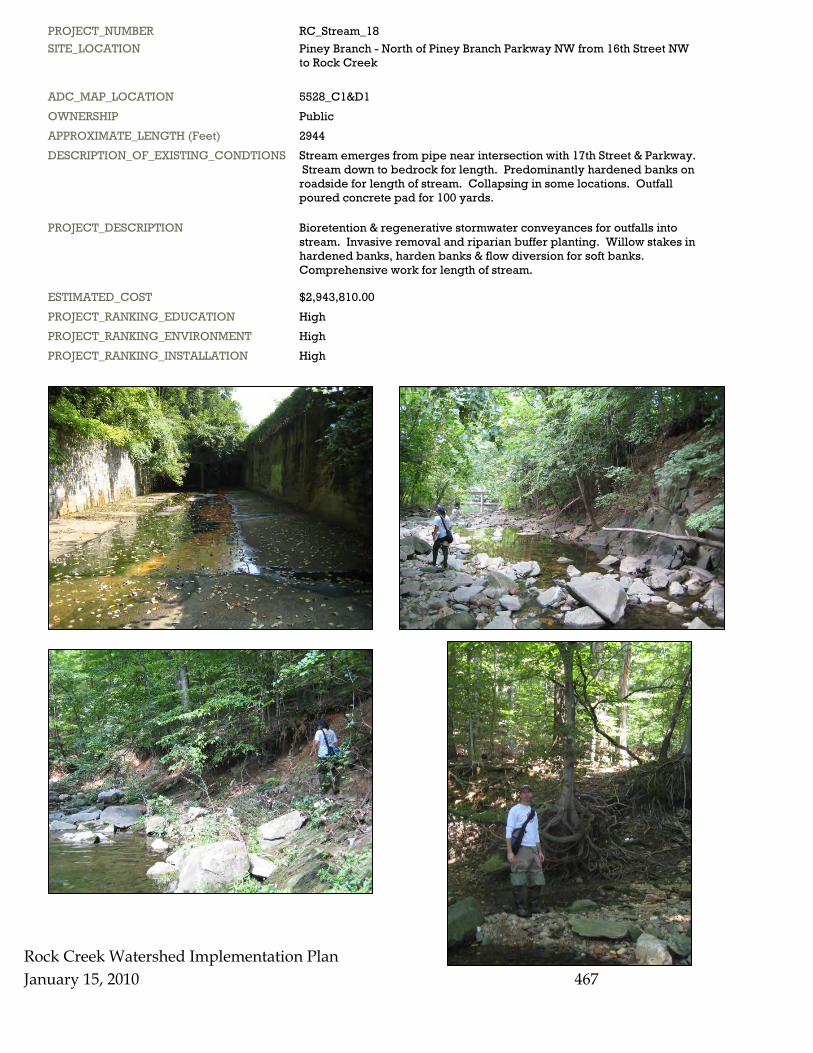
PROJECT_NUMBER RC_Stream_18 SITE_LOCATION Piney Branch - North of Piney Branch Parkway NW from 16th Street NW to Rock Creek
ADC_MAP_LOCATION 5528_C1&D1 OWNERSHIP Public APPROXIMATE_LENGTH (Feet) 2944 DESCRIPTION_OF_EXISTING_CONDTIONS Stream emerges from pipe near intersection with 17th Street & Parkway. Stream down to bedrock for length. Predominantly hardened banks on roadside for length of stream. Collapsing in some locations. Outfall poured concrete pad for 100 yards.
PROJECT_DESCRIPTION Bioretention & regenerative stormwater conveyances for outfalls into stream. Invasive removal and riparian buffer planting. Willow stakes in hardened banks, harden banks & flow diversion for soft banks. Comprehensive work for length of stream.
ESTIMATED_COST $2,943,810.00 PROJECT_RANKING_EDUCATION High PROJECT_RANKING_ENVIRONMENT High PROJECT_RANKING_INSTALLATION High
Rock Creek Watershed Implementation Plan January 15, 2010 468
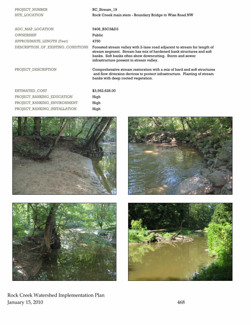
PROJECT_NUMBER RC_Stream_19 SITE_LOCATION Rock Creek main stem - Boundary Bridge to Wise Road NW
ADC_MAP_LOCATION 5408_B3C3&D3 OWNERSHIP Public APPROXIMATE_LENGTH (Feet) 4750 DESCRIPTION_OF_EXISTING_CONDTIONS Forested stream valley with 2-lane road adjacent to stream for length of stream segment. Stream has mix of hardened bank structures and soft banks. Soft banks often show downcutting. Storm and sewer infrastructure present in stream valley.
PROJECT_DESCRIPTION Comprehensive stream restoration with a mix of hard and soft structures and flow diversion devices to protect infrastructure. Planting of stream banks with deep rooted vegetation.
ESTIMATED_COST $3,562,628.00 PROJECT_RANKING_EDUCATION High PROJECT_RANKING_ENVIRONMENT High PROJECT_RANKING_INSTALLATION High
Rock Creek Watershed Implementation Plan January 15, 2010 469
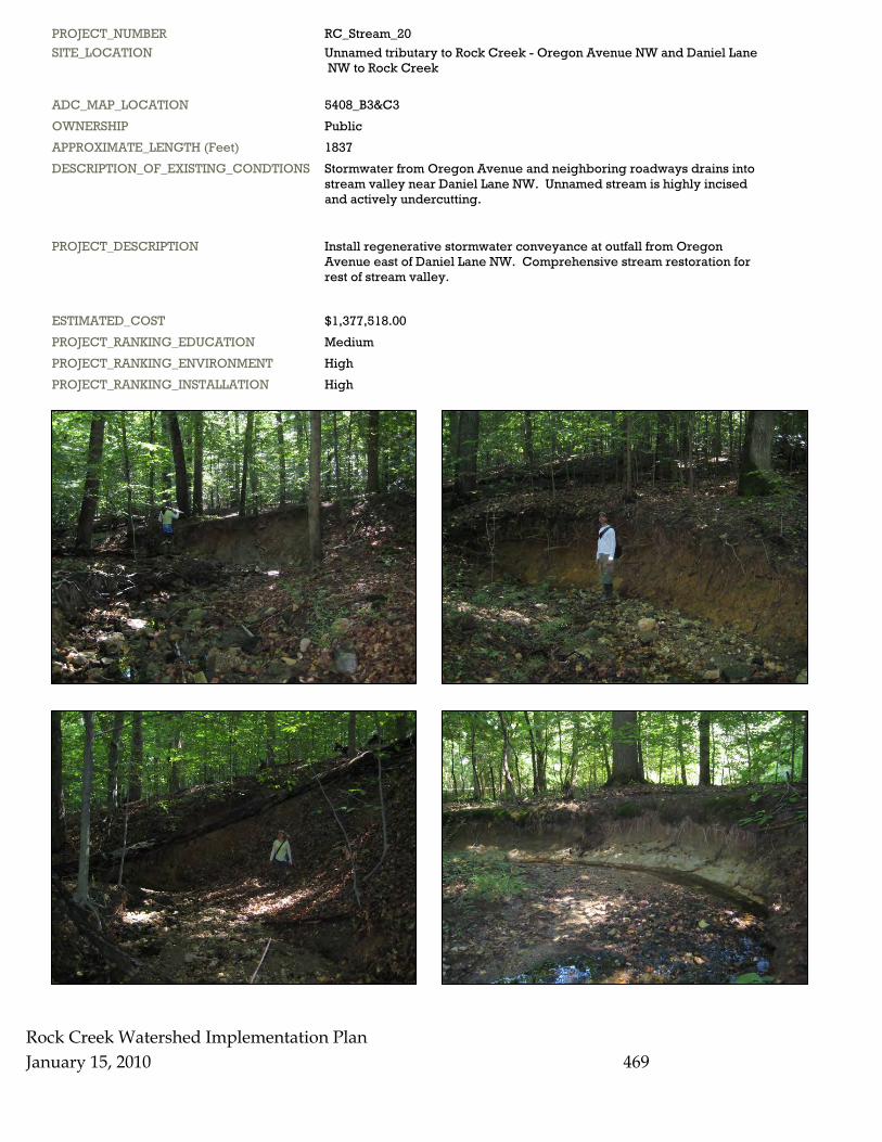
PROJECT_NUMBER RC_Stream_20 SITE_LOCATION Unnamed tributary to Rock Creek - Oregon Avenue NW and Daniel Lane NW to Rock Creek
ADC_MAP_LOCATION 5408_B3&C3 OWNERSHIP Public APPROXIMATE_LENGTH (Feet) 1837 DESCRIPTION_OF_EXISTING_CONDTIONS Stormwater from Oregon Avenue and neighboring roadways drains into stream valley near Daniel Lane NW. Unnamed stream is highly incised and actively undercutting.
PROJECT_DESCRIPTION Install regenerative stormwater conveyance at outfall from Oregon Avenue east of Daniel Lane NW. Comprehensive stream restoration for rest of stream valley.
ESTIMATED_COST $1,377,518.00 PROJECT_RANKING_EDUCATION Medium PROJECT_RANKING_ENVIRONMENT High PROJECT_RANKING_INSTALLATION High
Rock Creek Watershed Implementation Plan January 15, 2010 470
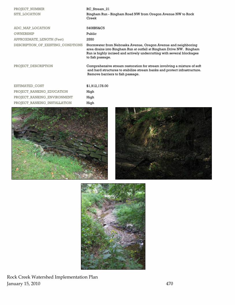
PROJECT_NUMBER RC_Stream_21 SITE_LOCATION Bingham Run - Bingham Road NW from Oregon Avenue NW to Rock Creek
ADC_MAP_LOCATION 5408B5&C5 OWNERSHIP Public APPROXIMATE_LENGTH (Feet) 2550 DESCRIPTION_OF_EXISTING_CONDTIONS Stormwater from Nebraska Avenue, Oregon Avenue and neighboring area drains into Bingham Run at outfall at Bingham Drive NW. Bingham Run is highly incised and actively undercutting with several blockages to fish passage.
PROJECT_DESCRIPTION Comprehensive stream restoration for stream involving a mixture of soft and hard structures to stabilize stream banks and protect infrastructure. Remove barriers to fish passage.
ESTIMATED_COST $1,912,178.00 PROJECT_RANKING_EDUCATION High PROJECT_RANKING_ENVIRONMENT High PROJECT_RANKING_INSTALLATION High
Rock Creek Watershed Implementation Plan January 15, 2010 471
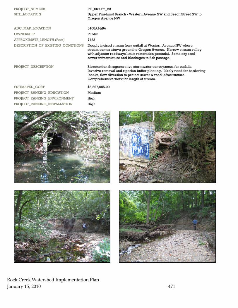
PROJECT_NUMBER RC_Stream_22 SITE_LOCATION Upper Pinehurst Branch - Western Avenue NW and Beech Street NW to Oregon Avenue NW
ADC_MAP_LOCATION 5408A4&B4 OWNERSHIP Public APPROXIMATE_LENGTH (Feet) 7423 DESCRIPTION_OF_EXISTING_CONDTIONS Deeply incised stream from outfall at Western Avenue NW where stream comes above ground to Oregon Avenue. Narrow stream valley with adjacent roadways limits restoration potential. Some exposed sewer infrastructure and blockages to fish passage.
PROJECT_DESCRIPTION Bioretention & regenerative stormwater conveyances for outfalls. Invasive removal and riparian buffer planting. Likely need for hardening banks, flow diversion to protect sewer & road infrastructure. Comprehensive work for length of stream.
ESTIMATED_COST $5,567,085.00 PROJECT_RANKING_EDUCATION Medium PROJECT_RANKING_ENVIRONMENT High PROJECT_RANKING_INSTALLATION High
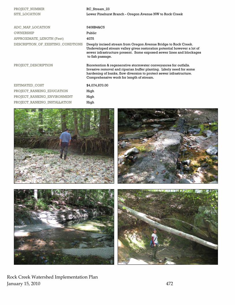
PROJECT_NUMBER RC_Stream_23 SITE_LOCATION Lower Pinehurst Branch - Oregon Avenue NW to Rock Creek
ADC_MAP_LOCATION 5408B4&C5 OWNERSHIP Public APPROXIMATE_LENGTH (Feet) 4075 DESCRIPTION_OF_EXISTING_CONDTIONS Deeply incised stream from Oregon Avenue Bridge to Rock Creek. Undeveloped stream valley gives restoration potential however a lot of sewer infrastructure present. Some exposed sewer lines and blockages to fish passage.
PROJECT_DESCRIPTION Bioretention & regenerative stormwater conveyances for outfalls. Invasive removal and riparian buffer planting. Likely need for some hardening of banks, flow diversion to protect sewer infrastructure. Comprehensive work for length of stream.
ESTIMATED_COST $4,074,870.00 PROJECT_RANKING_EDUCATION High PROJECT_RANKING_ENVIRONMENT High PROJECT_RANKING_INSTALLATION High
Rock Creek Watershed Implementation Plan January 15, 2010
472
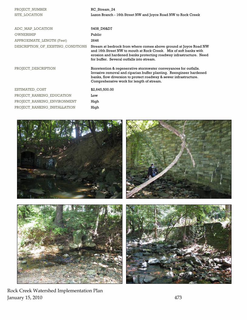
PROJECT_NUMBER RC_Stream_24 SITE_LOCATION Luzon Branch - 16th Street NW and Joyce Road NW to Rock Creek
ADC_MAP_LOCATION 5408_D6&D7 OWNERSHIP Public APPROXIMATE_LENGTH (Feet) 2646 DESCRIPTION_OF_EXISTING_CONDTIONS Stream at bedrock from where comes above ground at Joyce Road NW and 16th Street NW to mouth at Rock Creek. Mix of soft banks with erosion and hardened banks protecting roadway infrastructure. Need for buffer. Several outfalls into stream.
PROJECT_DESCRIPTION Bioretention & regenerative stormwater conveyances for outfalls. Invasive removal and riparian buffer planting. Reengineer hardened banks, flow diversion to protect roadway & sewer infrastructure. Comprehensive work for length of stream.
ESTIMATED_COST $2,645,500.00 PROJECT_RANKING_EDUCATION Low PROJECT_RANKING_ENVIRONMENT High PROJECT_RANKING_INSTALLATION High
Rock Creek Watershed Implementation Plan January 15, 2010
473
Rock Creek Watershed Implementation Plan January 15, 2010 474
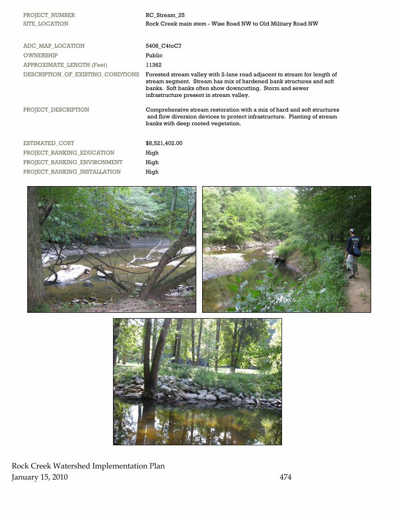
PROJECT_NUMBER RC_Stream_25 SITE_LOCATION Rock Creek main stem - Wise Road NW to Old Military Road NW
ADC_MAP_LOCATION 5408_C4toC7 OWNERSHIP Public APPROXIMATE_LENGTH (Feet) 11362 DESCRIPTION_OF_EXISTING_CONDTIONS Forested stream valley with 2-lane road adjacent to stream for length of stream segment. Stream has mix of hardened bank structures and soft banks. Soft banks often show downcutting. Storm and sewer infrastructure present in stream valley.
PROJECT_DESCRIPTION Comprehensive stream restoration with a mix of hard and soft structures and flow diversion devices to protect infrastructure. Planting of stream banks with deep rooted vegetation.
ESTIMATED_COST $8,521,402.00 PROJECT_RANKING_EDUCATION High PROJECT_RANKING_ENVIRONMENT High PROJECT_RANKING_INSTALLATION High
Rock Creek Watershed Implementation Plan January 15, 2010 475
PROJECT_NUMBER RC_Stream_26 SITE_LOCATION Rock Creek main stem - Old Military Road NW to Broad Branch Road
ADC_MAP_LOCATION 5408_D7toC9 OWNERSHIP Public APPROXIMATE_LENGTH (Feet) 8947 DESCRIPTION_OF_EXISTING_CONDTIONS Forested stream valley with 2-lane road adjacent to stream for length of stream segment. Stream has mix of hardened bank structures and soft banks. Soft banks often show downcutting. Storm and sewer infrastructure present in stream valley.
PROJECT_DESCRIPTION Comprehensive stream restoration with a mix of hard and soft structures and flow diversion devices to protect infrastructure. Planting of stream banks with deep rooted vegetation.
ESTIMATED_COST $6,710,168.00 PROJECT_RANKING_EDUCATION High PROJECT_RANKING_ENVIRONMENT High PROJECT_RANKING_INSTALLATION High
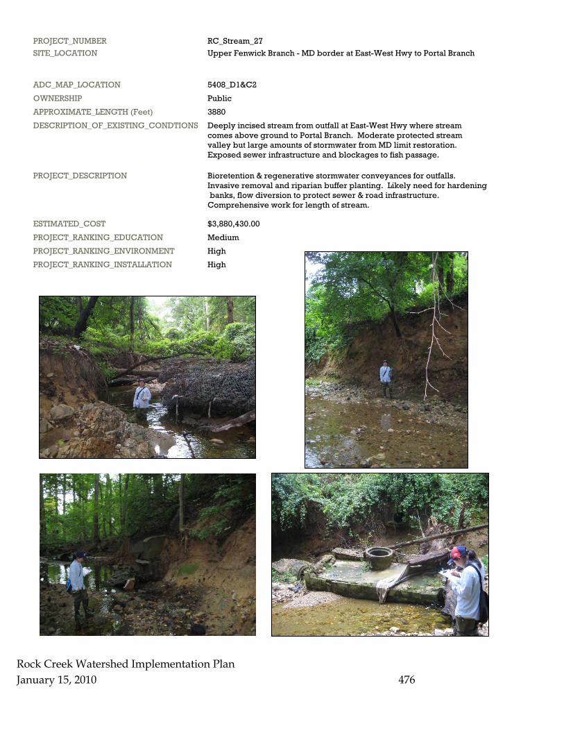
PROJECT_NUMBER RC_Stream_27 SITE_LOCATION Upper Fenwick Branch - MD border at East-West Hwy to Portal Branch
ADC_MAP_LOCATION 5408_D1&C2 OWNERSHIP Public APPROXIMATE_LENGTH (Feet) 3880 DESCRIPTION_OF_EXISTING_CONDTIONS Deeply incised stream from outfall at East-West Hwy where stream comes above ground to Portal Branch. Moderate protected stream valley but large amounts of stormwater from MD limit restoration. Exposed sewer infrastructure and blockages to fish passage.
PROJECT_DESCRIPTION Bioretention & regenerative stormwater conveyances for outfalls. Invasive removal and riparian buffer planting. Likely need for hardening banks, flow diversion to protect sewer & road infrastructure. Comprehensive work for length of stream.
ESTIMATED_COST $3,880,430.00 PROJECT_RANKING_EDUCATION Medium PROJECT_RANKING_ENVIRONMENT High PROJECT_RANKING_INSTALLATION High
Rock Creek Watershed Implementation Plan January 15, 2010
476
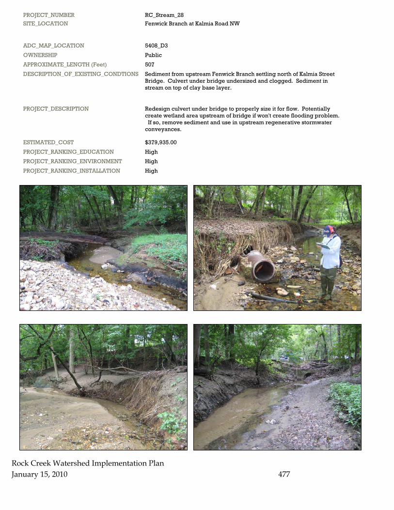
PROJECT_NUMBER RC_Stream_28 SITE_LOCATION Fenwick Branch at Kalmia Road NW
ADC_MAP_LOCATION 5408_D3 OWNERSHIP Public APPROXIMATE_LENGTH (Feet) 507 DESCRIPTION_OF_EXISTING_CONDTIONS Sediment from upstream Fenwick Branch settling north of Kalmia Street Bridge. Culvert under bridge undersized and clogged. Sediment in stream on top of clay base layer.
PROJECT_DESCRIPTION Redesign culvert under bridge to properly size it for flow. Potentially create wetland area upstream of bridge if won't create flooding problem. If so, remove sediment and use in upstream regenerative stormwater conveyances.
ESTIMATED_COST $379,935.00 PROJECT_RANKING_EDUCATION High PROJECT_RANKING_ENVIRONMENT High PROJECT_RANKING_INSTALLATION High
Rock Creek Watershed Implementation Plan January 15, 2010
477
Rock Creek Watershed Implementation Plan January 15, 2010 478
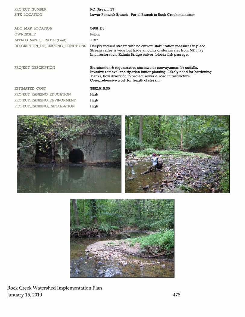
PROJECT_NUMBER RC_Stream_29 SITE_LOCATION Lower Fenwick Branch - Portal Branch to Rock Creek main stem
ADC_MAP_LOCATION 5408_D3 OWNERSHIP Public APPROXIMATE_LENGTH (Feet) 1137 DESCRIPTION_OF_EXISTING_CONDTIONS Deeply incised stream with no current stabilization measures in place. Stream valley is wide but large amounts of stormwater from MD may limit restoration. Kalmia Bridge culvert blocks fish passage.
PROJECT_DESCRIPTION Bioretention & regenerative stormwater conveyances for outfalls. Invasive removal and riparian buffer planting. Likely need for hardening banks, flow diversion to protect sewer & road infrastructure. Comprehensive work for length of stream.
ESTIMATED_COST $852,915.00 PROJECT_RANKING_EDUCATION High PROJECT_RANKING_ENVIRONMENT High PROJECT_RANKING_INSTALLATION High
Rock Creek Watershed Implementation Plan January 15, 2010 479
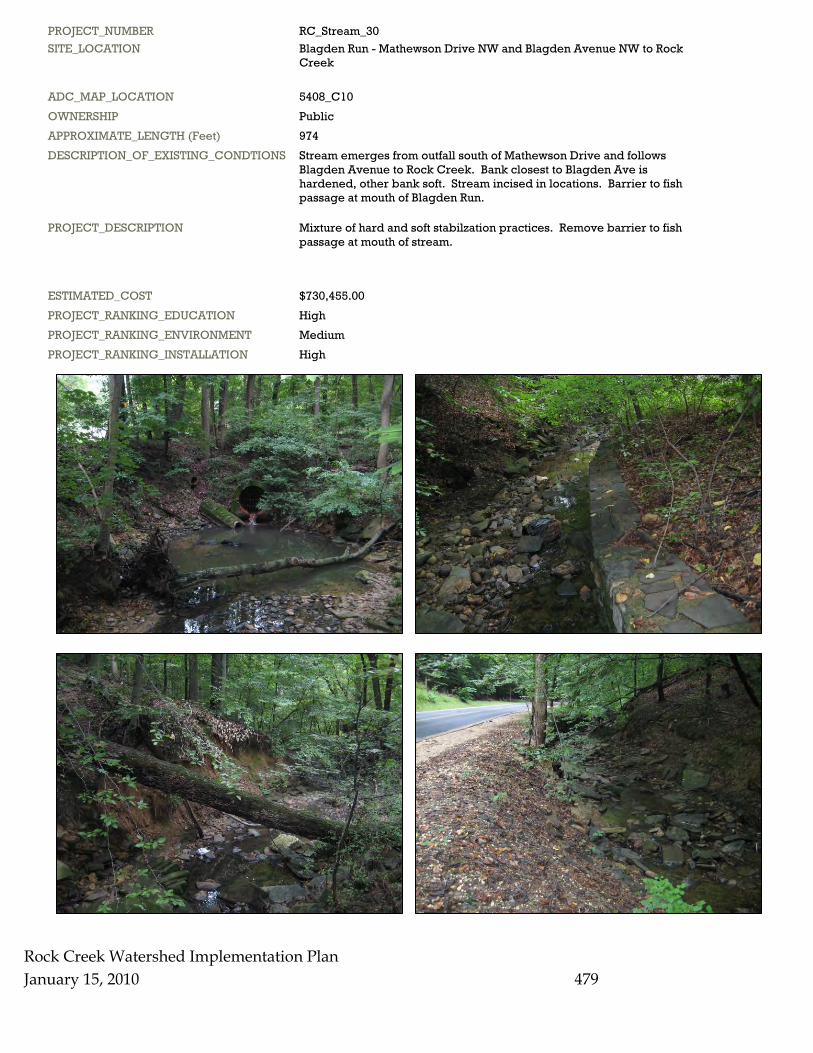
PROJECT_NUMBER RC_Stream_30 SITE_LOCATION Blagden Run - Mathewson Drive NW and Blagden Avenue NW to Rock Creek
ADC_MAP_LOCATION 5408_C10 OWNERSHIP Public APPROXIMATE_LENGTH (Feet) 974 DESCRIPTION_OF_EXISTING_CONDTIONS Stream emerges from outfall south of Mathewson Drive and follows Blagden Avenue to Rock Creek. Bank closest to Blagden Ave is hardened, other bank soft. Stream incised in locations. Barrier to fish passage at mouth of Blagden Run.
PROJECT_DESCRIPTION Mixture of hard and soft stabilzation practices. Remove barrier to fish passage at mouth of stream.
ESTIMATED_COST $730,455.00 PROJECT_RANKING_EDUCATION High PROJECT_RANKING_ENVIRONMENT Medium PROJECT_RANKING_INSTALLATION High

PROJECT_NUMBER RC_Stream_31 SITE_LOCATION Rock Creek main stem - Broad Branch Road to Klingle Run
ADC_MAP_LOCATION 5408_C9&B10 OWNERSHIP Public APPROXIMATE_LENGTH (Feet) 5624 DESCRIPTION_OF_EXISTING_CONDTIONS Forested stream valley with 2-lane road adjacent to stream for length of stream segment. Stream has mix of hardened bank structures and soft banks. Soft banks sometimes show downcutting. Storm and sewer infrastructure present in stream valley.
PROJECT_DESCRIPTION Predominantly installation of soft structures and planting of stream banks with deep rooted vegetation. Some bank hardening and flow diversion devices to protect infrastructure.
ESTIMATED_COST $4,217,678.00 PROJECT_RANKING_EDUCATION High PROJECT_RANKING_ENVIRONMENT High PROJECT_RANKING_INSTALLATION High
Rock Creek Watershed Implementation Plan January 15, 2010
480
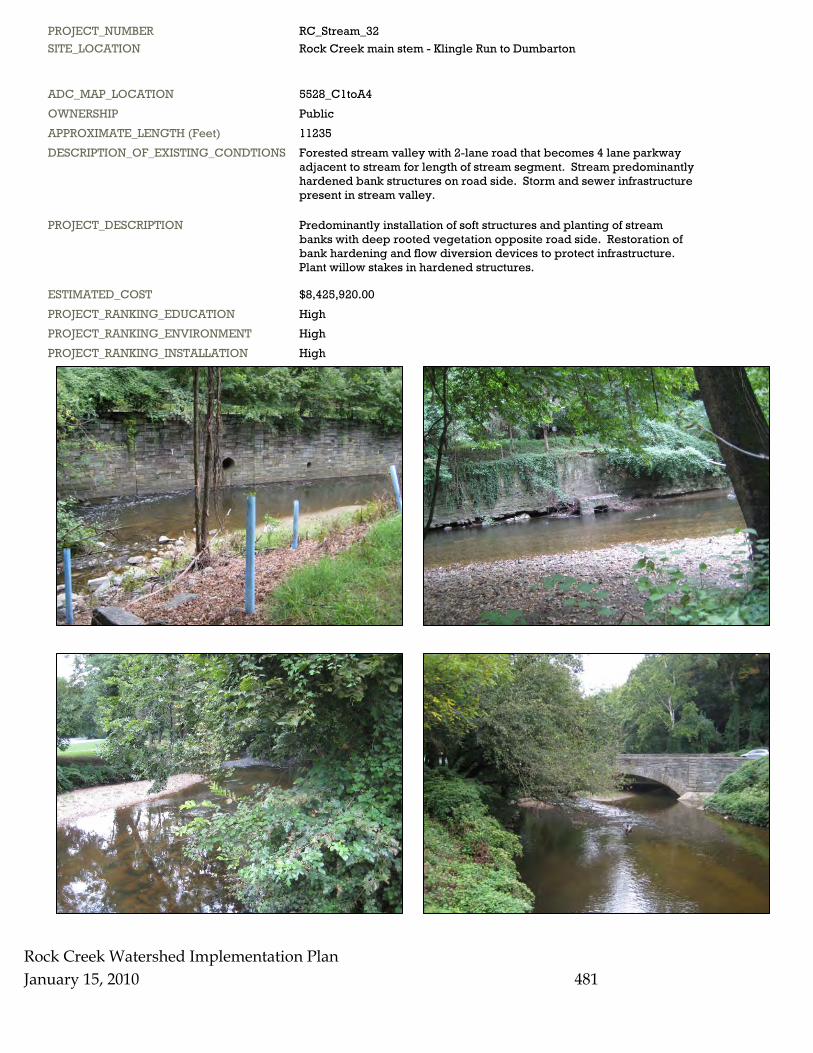
PROJECT_NUMBER RC_Stream_32 SITE_LOCATION Rock Creek main stem - Klingle Run to Dumbarton
ADC_MAP_LOCATION 5528_C1toA4 OWNERSHIP Public APPROXIMATE_LENGTH (Feet) 11235 DESCRIPTION_OF_EXISTING_CONDTIONS Forested stream valley with 2-lane road that becomes 4 lane parkway adjacent to stream for length of stream segment. Stream predominantly hardened bank structures on road side. Storm and sewer infrastructure present in stream valley.
PROJECT_DESCRIPTION Predominantly installation of soft structures and planting of stream banks with deep rooted vegetation opposite road side. Restoration of bank hardening and flow diversion devices to protect infrastructure. Plant willow stakes in hardened structures.
ESTIMATED_COST $8,425,920.00 PROJECT_RANKING_EDUCATION High PROJECT_RANKING_ENVIRONMENT High PROJECT_RANKING_INSTALLATION High
Rock Creek Watershed Implementation Plan January 15, 2010
481
Rock Creek Watershed Implementation Plan January 15, 2010 482
PROJECT_NUMBER RC_Stream_33 SITE_LOCATION NPS land adjacent to Broad Branch Road - Broad Branch Road NW from 36th Street NW to 27th Street NW
ADC_MAP_LOCATION 5408_A7 OWNERSHIP Public APPROXIMATE_LENGTH (Feet) 3609 DESCRIPTION_OF_EXISTING_CONDTIONS Stream valley park with a small first order stream that goes into a pipe at 36th Street. Stream valley intact with no stream. Stream valley mix of DDOT/NPS lands that are primarily forested.
PROJECT_DESCRIPTION Daylight the stream and reintroduce ground water from bioretention from roadways to increase baseflow.
ESTIMATED_COST $2,706,652.00 PROJECT_RANKING_EDUCATION High PROJECT_RANKING_ENVIRONMENT High PROJECT_RANKING_INSTALLATION High
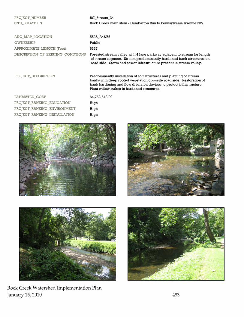
PROJECT_NUMBER RC_Stream_34 SITE_LOCATION Rock Creek main stem - Dumbarton Run to Pennsylvania Avenue NW
ADC_MAP_LOCATION 5528_A4&B5 OWNERSHIP Public APPROXIMATE_LENGTH (Feet) 6337 DESCRIPTION_OF_EXISTING_CONDTIONS Forested stream valley with 4 lane parkway adjacent to stream for length of stream segment. Stream predominantly hardened bank structures on road side. Storm and sewer infrastructure present in stream valley.
PROJECT_DESCRIPTION Predominantly installation of soft structures and planting of stream banks with deep rooted vegetation opposite road side. Restoration of bank hardening and flow diversion devices to protect infrastructure. Plant willow stakes in hardened structures.
ESTIMATED_COST $4,752,548.00 PROJECT_RANKING_EDUCATION High PROJECT_RANKING_ENVIRONMENT High PROJECT_RANKING_INSTALLATION High
Rock Creek Watershed Implementation Plan January 15, 2010
483
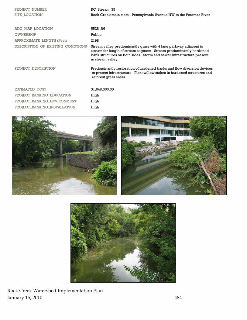
Rock Creek Watershed Implementation Plan January 15, 2010 484
PROJECT_NUMBER RC_Stream_35 SITE_LOCATION Rock Creek main stem - Pennsylvania Avenue NW to the Potomac River
ADC_MAP_LOCATION 5528_A6 OWNERSHIP Public APPROXIMATE_LENGTH (Feet) 2198 DESCRIPTION_OF_EXISTING_CONDTIONS Stream valley predominantly grass with 4 lane parkway adjacent to stream for length of stream segment. Stream predominantly hardened bank structures on both sides. Storm and sewer infrastructure present in stream valley.
PROJECT_DESCRIPTION Predominantly restoration of hardened banks and flow diversion devices to protect infrastructure. Plant willow stakes in hardened structures and reforest grass areas.
ESTIMATED_COST $1,648,560.00 PROJECT_RANKING_EDUCATION High PROJECT_RANKING_ENVIRONMENT High PROJECT_RANKING_INSTALLATION High