wireless technologies for isolated rural communities in … · · 2017-04-24in this scenario, the...
TRANSCRIPT

ICT-601102 STP TUCAN3G
Wireless technologies for isolated rural communities in developing countries based on cellular 3G femtocell deployments
D61
Situation report of the deployment area, sensitization results and state of transport networks
Abstract:
This document presents information and activities carried out to ensure the provision of the required conditions for a successful deployment of the proposed platform in WP6. These activities have been carried out in the areas of intervention that had been chosen in agreement with the deliverable D21. This document presents a summary of the legal framework and regulation norms applicable to the project, as well as a description of the current situation in the area of intervention. It also contains a detailed description of the sensitization activities in each area. The document also provides a detailed report of the state of the target networks defined by testing technical capabilities and through the input and feedback of the users.
Keyword list: sensitization; transport network; situation report,
Contractual Date of Delivery to the CE: 1 Oct 2013
Actual Date of Delivery to the CEC: 8 Mar 2014
Author(s): Juan Paco, César Córdova, Leopoldo Liñán, River Quispe, Darwin Auccapuri (PUCP), Ernesto Sánchez (FITEL), Ignacio Prieto (EHAS)
Participant(s): PUCP, EHAS, FITEL
Workpackage: 6
Est. person months: 4.5
Security: Public
Dissemination Level: PU
Version: d
Total number of pages: 77
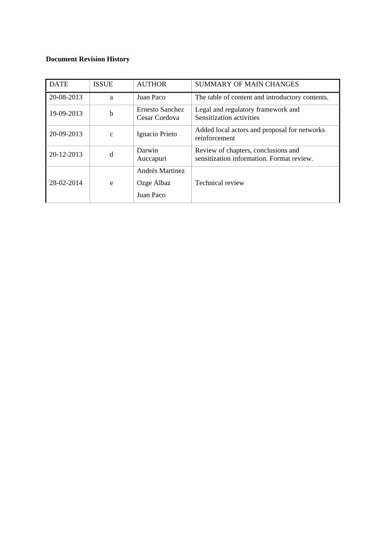
Document Revision History
DATE ISSUE AUTHOR SUMMARY OF MAIN CHANGES
20-08-2013 a Juan Paco The table of content and introductory contents.
19-09-2013 b Ernesto Sanchez Cesar Cordova
Legal and regulatory framework and Sensitization activities
20-09-2013 c Ignacio Prieto Added local actors and proposal for networks reinforcement
20-12-2013 d Darwin Auccapuri
Review of chapters, conclusions and sensitization information. Format review.
28-02-2014 e
Andrés Martinez
Ozge Albaz
Juan Paco
Technical review

ICT-601102 STP Document number: D61 Title of deliverable: Situation report of the deployment area, sensitization results and…
TUCAN3G_D61PUCPe_.doc.doc 2
Executive Summary
In order to reach the objectives of the TUCAN3G project, it is required to validate a set of solutions obtained as a result of the achieved research study. In this framework it has been proposed to carry out deployments in rural environments in Peru where there is a network deployed by PUCP. Following this point it has been necessary to do a list of previous activities oriented mainly to assure the accomplishment of the right conditions towards a successful implementation of the demonstration platform. This assurance has multiple aspects to be attended and those are addressed in the sections of this report.
This document introduces a review of the legal framework and regulatory norms applicable to the demonstrative platform as well as its implementation implying the availability of a public service of mobile telephony and usage of free frequency bands and licensed bands.
Following up, this document introduces a report of the situation of populations in the basin of the Napo River and the Paranapura River, which offers more specific information than the deliverable report D21. Also, this document contributes to frame the environment of implementation of the demonstrative pilot program and conducted tests.
In order to ensure the technical feasibility of the scenarios for implementation of the pilot program, there are a number of activities and coordination procedures done with the local and regional authorities. As a result, the formal approval has been obtained. These activities are described on the third section of this document. Also, there is a description of the sensitization activities carried out in the same communities where objectives and vision of the project has been socialized. In this scenario, the physical and legal condition of the places where towers and telecommunications equipment are installed have been reviewed. It has been also considered the need for renewal and formalization of current authorizations such as the procedures towards clarification of their physical- legal condition.
Finally, the report presents the current situation of the transport networks existing in Balsapuerto and Napo, and provides detail of the state of the networks and implemented services based on technical testing and considering the input of its users. At the end, conclusions are presented.

DISCLAIMER
The work associated with this report has been carried out in accordance with the highest technical standards and the TUCAN3G partners have endeavored to achieve the degree of accuracy and reliability appropriate to the work in question. However since the partners have no control over the use to which the information contained within the report is to be put by any other party, any other such party shall be deemed to have satisfied itself as to the suitability and reliability of the information in relation to any particular use, purpose or application.
Under no circumstances will any of the partners, their servants, employees or agents accept any liability whatsoever arising out of any error or inaccuracy contained in this report (or any further consolidation, summary, publication or dissemination of the information contained within this report) and/or the connected work and disclaim all liability for any loss, damage, expenses, claims or infringement of third party rights.

ICT-601102 STP Document number: D61 Title of deliverable: Situation report of the deployment area, sensitization results and…
TUCAN3G_D61PUCPe_.doc.doc 4
Table of Contents
1 INTRODUCTION ............................................................................................................. 8
2 LEGAL AND REGULATORY FRAMEWORK ........................................................... 9
2.1 AUTHORITIES AND REGULATORY INSTITUTIONS IN PERU .................................................... 9 2.2 ROLE OF FITEL IN TELECOMMUNICATIONS SECTOR ........................................................... 9 2.3 MODE OF FITEL ON FINANCING TUCAN 3G ...................................................................... 10 2.4 LEGISLATION APPLICABLE TO MOBILE SERVICES ............................................................... 10
2.4.1 About Public Teleservices ................................................................................................ 10 2.4.2 From the General Interconnection of Telecommunication Network Services .................. 11 2.4.3 Services Market ................................................................................................................ 12
2.5 REGULATIONS APPLICABLE TO PRIVATE NETWORKS IN ISM BANDS ................................. 12 2.5.1 Regarding to the No Licensed Bands (NLB) ..................................................................... 12 2.5.2 Regarding to the Identification of NLB ............................................................................ 13 2.5.3 Regarding to the Operating Conditions of the Services for specific bands ...................... 14
2.5.3.1 Technical characteristics of the Operations .................................................................. 14 2.5.3.2 Homologation ............................................................................................................... 15 2.5.3.3 Authorization ................................................................................................................ 15
2.6 REGULATIONS APPLICABLE TO VSAT SATELLITE SYSTEMS ............................................... 15
3 CURRENT STATE OF THE DEPLOYMENT AREA ............................................... 17
3.1 GENERAL INFORMATION ....................................................................................................... 17 3.1.1 Local actors ...................................................................................................................... 19
3.2 BASIN OF THE NAPO RIVER ................................................................................................... 21 3.2.1 Characteristics of the geography ..................................................................................... 21 3.2.2 Socio-economic characteristics ........................................................................................ 23 3.2.3 Specific local actors .......................................................................................................... 25
3.3 BALSAPUERTO DISTRICT ....................................................................................................... 26 3.3.1 Characteristics of the geography ..................................................................................... 27 3.3.2 Socio-economic characteristics ........................................................................................ 28
3.3.2.1 San Gabriel de Varadero ............................................................................................... 30 3.3.2.2 San Juan de Armanayacu .............................................................................................. 31
3.3.3 Specific local actors .......................................................................................................... 32
4 SENSITIZATION ACTIVITIES ................................................................................... 33
4.1 OBJECTIVES ............................................................................................................................ 33 4.2 ACTIVITIES .............................................................................................................................. 33
4.2.1 Napo Network ................................................................................................................... 33 4.2.1.1 Tuta Pishco (Nueva Libertad) ....................................................................................... 33 4.2.1.2 Negro Urco .................................................................................................................... 34 4.2.1.3 Santa Clotilde ................................................................................................................ 36
4.2.2 Balsapuerto Network ........................................................................................................ 36 4.2.2.1 Yurimaguas ................................................................................................................... 37 4.2.2.2 San Gabriel de Varadero ............................................................................................... 37 4.2.2.3 San Juan de Armanayacu .............................................................................................. 38
4.3 RESULTS .................................................................................................................................. 39
5 CURRENT STATE OF TRANSPORT NETWORKS ................................................ 41
5.1 NAPO NETWORK ..................................................................................................................... 41 5.1.1 Perception from users ....................................................................................................... 41

5.1.2 Description and characteristics of the implemented services in relation with the epidemiological surveillance system and the economic resources control ..................................... 42
5.1.2.1 Videoconference system ............................................................................................... 43 5.1.2.2 Tele microscopy system ................................................................................................ 43 5.1.2.3 Tele-stethoscopy system ............................................................................................... 43 5.1.2.4 Tele-ultrasound system ................................................................................................. 44
5.2 BALSAPUERTO NETWORK ...................................................................................................... 44 5.2.1 Perception of users ........................................................................................................... 44 5.2.2 Description and characteristics of the implemented services .......................................... 44
5.3 STATE OF THE NETWORKS OF TELECOMMUNICATIONS ..................................................... 45 5.3.1 The current situation of Napo Wireless Network. ............................................................ 45 5.3.2 The current situation of Balsapuerto Wireless Network: ................................................. 54
5.4 PROPOSAL FOR ADAPTATION OF THE TARGET NETWORKS ................................................ 62 5.4.1 Napo Network ................................................................................................................... 62 5.4.2 Balsapuerto Network ........................................................................................................ 63
6 CONCLUSIONS .............................................................................................................. 64
7 ANNEXES ........................................................................................................................ 65

ICT-601102 STP Document number: D61 Title of deliverable: Situation report of the deployment area, sensitization results and…
TUCAN3G_D61PUCPe_.doc.doc 6
References
[GTR - PUCP] Gerson Araujo, Luis Camacho, David Chávez, César Córdova, Jeffry Cornejo, David Espinoza, Leopoldo Liñán, Jesús Margarito, Andrés Martínez, Pablo Osuna, Yuri Pacheco, Juan Paco, Yvanna Quijandria, River Quispe, Carlos Rey, Sandra Salmerón, Arnau Sánchez, Paola Sanoni, Joaquín Seoane, Javier Simó y Jaime Vera. “Redes inalámbricas para zonas Rurales”, Febrero 2011. ISBN: 978-612-4057-35-9
[TUCAN 3G D21] A. García (EHAS), I. Prieto (EHAS), E. Sánchez (FITEL), O. Muñoz (UPC), J. Vidal (UPC), A. Agustín (UPC), A. Pascual (UPC), J. Simó (URJC), J. Paco (PUCP), Y. Castillo (CREP), G. Ramírez (UCAU), O. Tupayachi (TdP). “Socio-economic scenarios, technical specifications and architecture for the proof of concept”, Mayo 2013.
[WILD] Luis Camacho, River Quispe, César Córdova, Leopoldo Liñán, David Chávez. “WILD WiFi Based Long Distance”. Primera edición: Agosto 2009. ISBN: 978-9972-659-93-5

List of abbreviations & symbols
APAFA Association of the Household Heads (parents)
AWGN Additive White Gaussian Noise
CEPLAN National Center of Strategic Planning
D21 Report of socio-economic scenarios, technical specifications and architecture for the proof of concept
DAR Rights, Environment and Natural Resources
DGE National Direction of Epidemiology
DIRESA Direction of Health of Loreto Region
DIREMID Medicines and Drugs Executive Direction
EAP Economic Active Population
FITEL Telecommunications Investment Fund
GOREL Regional Government of Loreto
HR Regional Hospital
IEEE Institute of Electrical and Electronics Engineering
INEI National Institute of Statistics and Informatics
ISM Industrial, Scientific and Medical (Radiofrequency bands)
JUNTOS National Program for Direct Support for the poor (Social Program)
MINSA Ministry of Health
MIDIS Ministry of development and social inclusion
MINEDU Ministry of Education
MINTRA Ministry of Work
MTC Ministry of Transport and Communication
OSIPTEL Supervisor Organism of Private Investment in Telecommunications
RSAA Alto Amazonas Health Network
SIS Integral Health Insurance
WAP Working-age population

ICT-601102 STP Document number: D61 Title of deliverable: Situation report of the deployment area, sensitization results and…
TUCAN3G_D61PUCPe_.doc.doc 8
1 INTRODUCTION An essential part of this project is the implementation of a demonstration platform to validate technically, at least, a part of the obtained conclusions and results in detailed research of the correspondent work packages WP3, WP4, WP5. To ensure an accurate implementation and stability in the functionality of the system during the validation period of the project, it is required to do a list of previous activities related to the situation of the network in context, technical design, sensitization campaign and coordination with the local actors such as the Regional Directorate of Healthcare (DIRESA), Regional Government (GOREL), Vicariate of San Jose Del Amazonas, Health centers, Health stalls and posts. These actors had supported previous projects and they gave their approval through the appropriate legal frames to install continuous, safe and functional equipment and services.
Additionally, it was necessary to know on detail the situation of the target networks in Balsapuerto and Napo Health Telecommunication facilities. The final objective is to have sufficient information to define the required modifications on the current networks with basic health services which will be the basis of the pilot program implementation to give 3G mobile services to the complete population. In this compilation of information, it was included feedback and input given by the current users of these networks. The networks now are used by workers of the Health Centers in the corresponding rural areas of Balsapuerto and Napo River Basin.
From the information contained in D21 and test results of the current network, an adaptation proposal for each network has been prepared as a previous step towards the definition of such required modifications.
Finally, this document will introduce a list of conclusions that together with the rest of the collected information, which is given in detail here, will become essential for the implementation of the demonstration platform.

2 LEGAL AND REGULATORY FRAMEWORK 2.1 Authorities and Regulatory Institutions in Peru
The highest level of hierarchy in policy and regulation of telephony, mobile telephony, cable, radio or aerial communication services and telecommunications in Peru is the Ministry of Transport and Communications (MTC). In this context, mobile telecommunications, land line service (residential and commercial services) and all services related with radio frequency are regulated by law and in charge of the MTC. As telecommunication services grew on demand, the government privatized the only state telecommunication company by the sale of Telecommunications Enterprise of Peru (ENTEL Peru), declaring privatized the telephony service for the entire nation on the 90’s. This service has been given by the spanish corporation “Telefonica del Peru” since then, with certain conditions expressed in a contract of concession related to improve the access to the telephony and data services. The idea of this concession was to get foreign capitals to invest on expanding the telecommunication network in order to increase the reach of these services nationwide in the country, which enables the inclusion of the population (especially who live in the rural and semi-urban areas) into the governability, development and participation of the country as a decentralized administration, and opening of the economy of the country. Therefore, the initial policies were regarding employment creation and establish commitments to promote the development of rural areas by connecting them over telephony services and Internet access. In this context, the Peruvian Government promotes the creation of the OSIPTEL (Supervisor Organism of Private Investment in Telecommunications) in order to regulate and monitor the market for public telecommunications services, regardless of the operating companies. OSIPTEL began operations in January 1994. On the other hand, FITEL (Telecommunications Investment Fund) was created within MTC in 1993, with the specific mission of promoting the access and use of telecommunications services in rural areas and places of preferential social interest, contributing to the socioeconomic development of the country. At the end of that concession with Telefonica del Peru, other local and foreign companies started to offer telephony services. Massive service competition started with the inclusion of mobile telephony and telephony market evolved to its current state, where most of inhabitants in urban areas can afford to use at least one telecommunication service (land line, mobile or internet access) while rural and remote areas still remain unattended. As for the purpose of this study and at this stage of implementation, major goals are technical, looking for business solutions for providing infrastructure and services in underserved areas, the role of FITEL aligns to this objective.
2.2 Role of FITEL in Telecommunications sector
FITEL is a national fund for the provision of universal access as such access to a set of essential telecommunications services capable of transmitting voice and data. FITEL reports to the Ministry of Transport and Communications, acting as a Technical Secretariat.

ICT-601102 STP Document number: D61 Title of deliverable: Situation report of the deployment area, sensitization results and…
TUCAN3G_D61PUCPe_.doc.doc 10
2.2.1 Vision
FITEL presents itself as a public organization which aims to promote nation-wide connectivity by combining high quality telecommunications services with sustainability components.
2.2.2 Mission
FITEL presents its mission as to promote access to and usage of telecommunications services in rural areas and places of social interest, contributing to the socioeconomic development of the country. To this end, the main purpose is planning, preparing, co-financing and overseeing new projects in its field of operation, articulating and disseminating new policies in order to achieve this objective.
2.2.3 Objectives
Develop programs and projects for the provision of telecommunications services in rural areas or in
areas of social interest, as well as studies on infrastructure and telecommunications services to ensure access.
Promote private sector participation in the provision of telecommunications services in rural areas and places of social interest.
Finance programs and projects involving the provision of telecommunications services in rural areas or in areas of social interest.
Perform coordination and strategic alliances with companies in the private sector; national and international public institutions, as well as universities, research centers, among others, so that they commit themselves to design or implement activities that contribute to the sustainability of the projects or programs financed by FITEL.
2.3 Mode of FITEL on financing TUCAN 3G
The co-financing of TUCAN3G Project by FITEL will take place through the signing of a contract between FITEL and the European Union for the validation of the technical and business solutions defined in the project.
2.4 Legislation applicable to mobile services
According to the "Text of the General Regulation of the Telecommunications Law", approved by Supreme Decree Nº 06-94-TCC, and as a result of the next modifications and amendments: Supreme Decrees Nº 015-97-MTC, 005-98-MTC, 022-98-MTC, 002-99-MTC, 003-99-MTC, 043-2000-MTC, 029-2001-MTC, 029-2002-MTC, 015-2003-MTC and 012-2004-MTC, the Telecommunications Investment Fund (FITEL) in the name of the Ministry of Transport and Communications of Peru (MTC) have established the following points in relation to mobile services.
2.4.1 About Public Teleservices
According to the current regulation mentioned before:
Article 56º Definition of mobile telephony service A mobile phone service is one that is provided through the radio medium in the bands specifically determined by the Transport and Communications Ministry, using mobile terminals that can be transported from one place to another within the operator's service area which is defined as cells.

Article 57º Scope of the telephony service concession The concession of telephony service may authorize the concessionaire to provide the service through third party subcontractors, in the form of payphones, community and public phone booths. Article 59º Types of telephony services Telephony services are provided by the following ways: 1. Subscribers 2. By fixed or mobile payphones, telephone stations, fixed or mobile terminals, public booths or
payphones. Article 65º Contract with the subscriber The telephony service is regulated by a contract to be signed by the concessionaire and the subscriber, according to general contract clauses approved by OSIPTEL and published in the subscriber directory. Article 66º Integrated services Telephony services oriented to the user should operate as an integrated system of services, regardless of whether there is more than one operator supplying the services.
2.4.2 From the General Interconnection of Telecommunication Network Services
Article 103º Obliged to provide interconnection The network interconnection of public telecommunications services is of public and social interest and, therefore, is mandatory. Interconnection is a prerequisite of the concession. Article 104º Integrated Services Digital Network The concessionaires are obliged to provide public telecommunications services and are required to apply the designs open network architecture oriented towards establishing of integrated digital network services and systems to facilitate the interconnection. There are also other obligations for concessions, detailed in the norm as follows. Article 130º Obligations of the concessionaire The obligations of the concessionaire are mainly:
1. Install, operate and manage the service according to the terms, conditions and limits
laid down in the concession contract. 2. Install the required infrastructure to provide the service that is given in the concession
contract, in compliance with local regulations or of other government agencies, which may not constitute barriers to market access.
3. Provide the service without interruption, unless unforeseeable and unavoidable circumstances, in which the priority is given to the emergency communications.
4. Provide assurance that requires the Transport and Communications Ministry to fulfill the contract, the law and regulations in a manner given in the contract details.
5. Establish an expedited process to meet the demands of users in the terms and deadlines set by OSIPTEL.

ICT-601102 STP Document number: D61 Title of deliverable: Situation report of the deployment area, sensitization results and…
TUCAN3G_D61PUCPe_.doc.doc 12
6. Pay the duties, taxes, fees and other obligations that are part of the concession contract on time.
7. Provide the information requested by the Transport and Communication Ministry and OSIPTEL and, in general, facilitate their work during the inspections and verification of work.
8. Comply with article 13 about inviolability and privacy of the telecommunications. 9. Inform OSIPTEL of any changes or modifications concerning to user agreements,
interconnection conditions or fees. 10. Inform stakeholders about discounts to retailers and other concessionaires by notifying
the Transport and Communications Ministry and OSIPTEL when requested. 11. Comply with other obligations agreed in the concession contract, in the law or any
other regulations.
2.4.3 Services Market
Article 247º Election of telecommunications service operator OSIPTEL establishes specific conditions for the right of users, which are defined in the article 73 of the telecommunications law, to choose the telecommunications service operator. Article 248º Regime of free competition Telecommunications services are provided in a regime of free competition in which OSIPTEL is in charged of overseeing the market and to take actions to correct market failures which must be mandatorily applied by the market actors. Article 249º Quality of Public Services In order to promote the quality of public services provided to the end-user, OSIPTEL issues regulations which do not impose any production pattern or rate.
2.5 Regulations applicable to private networks in ISM bands
2.5.1 Regarding to the No Licensed Bands (NLB)
The Article 28 of the "General Regulation of the Telecommunications Law", approved by Supreme Decree No. 020-2007-MTC and amended by Supreme Decree No. 006-2013-MTC, provides:
Telecommunications services installed within a building that do not use the radio spectrum and have no connection to external networks are exempt from the classification of services of the Law the Regulation and the Specific Regulations to be issued.
The services listed below are also exempted from the concession agreement (except the cases explained in the 4th and 5th paragraphs); the spectrum allocation; authorization; license for telecommunications services provision and the services classification defined in the Law, Regulation and the Specific Regulations.
1. The services whose equipment, using the radio spectrum, transmit with power not
exceeding ten miliwatts (10 mW) on the air (effective radiated power). These services

cannot operate in the frequency bands allocated to the public telecommunications except in the frequency bands from 2400 to 2483.5 MHz and 5725-5850 MHz
2. The services whose equipment, using a channel set in the band 462, 550-462, 725 MHz and 467, 550-467, 725 MHz, transmit with a power not exceeding five hundred mill watts (500 mW) in antenna (effective radiated power). This equipment may not be used for the provision of public telecommunications services.
3. The services whose equipment, using the bands 902-928 MHz, 2400 to 2483.5 MHz, 5150-5250 MHz and 5725-5850 MHz, transmit with a power not exceeding one hundred miliwatts (100 mW) in antenna (effective radiated power) and are not used to provide the information in open spaces. These services shall not cause interference to licensees of public telecommunications services.
4. The services whose equipment, using the bands 916-928 MHz, 2400 to 2483.5 MHz and 5725-5850 MHz, transmit with a power not exceeding four watts (4 W) or 36 dBm at antenna (effective radiated power) in open space. In addition, the services which equipment , using the band 915-928 MHz, transmit with a power not exceeding one watt (1 W) or 30 dBm at antenna (effective radiated power ) .
5. The services whose equipment, using the band 5250 - 5350 MHz, transmit with a power not exceeding one watt (1 W) or 30 dBm at antenna ( effective radiated power ), in open space. This equipment shall not be used for the establishment of private telecommunications services.
In the case of using equipment under the conditions specified in paragraphs 4 and 5, respective concession has to be obtained before public telecommunication service provisioning. In this case, the concessionaires of public telecommunications services use such equipment will not be enforced to have neither installation and operation permits, nor the radio spectrum assignment.
Those who make use of the frequencies listed above must comply with the issued technical standards, without prejudice to the indicated in this article.
2.5.2 Regarding to the Identification of NLB
The Supreme Decree No. 024 -2008- MTC (amended by Supreme Decree No. 006-2013 – MTC) modifies the "General Regulation of the Telecommunications Law" and indicates (Article 22) the following: 22.1 For the provision of public telecommunications services in rural areas and / or places of social interest, it is not required to have spectrum allocation, installation permit or license to operate in the following frequency bands:
i. 915 - 928 MHz while the maximum EIRP should not exceed 30 dBm (1W). ii. 916 – 928 MHz, 2400 - 2483.5 MHz and 5725 - 5850 MHz, as long as the maximum
output power of a transmitter do not exceed 24 dBm. iii. 5250-5350 MHz and 5470-5725 MHz, as long as the maximum output power of a
transmitter does not exceed 24 dBm. 22.2 Additionally, restrictions on the antenna gain do not apply, except for the band 916-928 MHz, in this case it must comply with the operation conditions defined by Ministerial Resolution No. 777-2005-MTC/03 and its amendments. Furthermore, the equipment must have required homologation certificate.
ICT-601102 STP Document number: D61 Title of deliverable: Situation report of the deployment area, sensitization results and…
TUCAN3G_D61PUCPe_.doc.doc 14
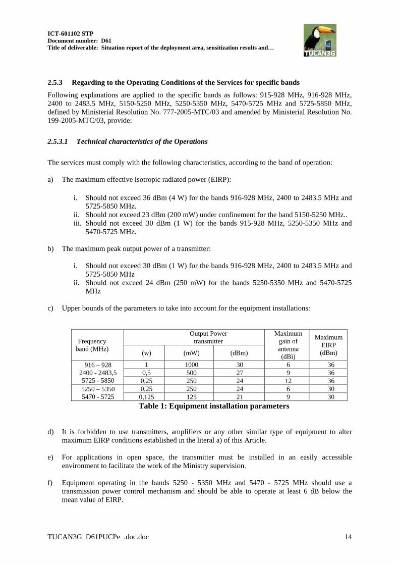
2.5.3 Regarding to the Operating Conditions of the Services for specific bands
Following explanations are applied to the specific bands as follows: 915-928 MHz, 916-928 MHz, 2400 to 2483.5 MHz, 5150-5250 MHz, 5250-5350 MHz, 5470-5725 MHz and 5725-5850 MHz, defined by Ministerial Resolution No. 777-2005-MTC/03 and amended by Ministerial Resolution No. 199-2005-MTC/03, provide:
2.5.3.1 Technical characteristics of the Operations
The services must comply with the following characteristics, according to the band of operation: a) The maximum effective isotropic radiated power (EIRP):
i. Should not exceed 36 dBm (4 W) for the bands 916-928 MHz, 2400 to 2483.5 MHz and 5725-5850 MHz.
ii. Should not exceed 23 dBm (200 mW) under confinement for the band 5150-5250 MHz.. iii. Should not exceed 30 dBm (1 W) for the bands 915-928 MHz, 5250-5350 MHz and
5470-5725 MHz. b) The maximum peak output power of a transmitter:
i. Should not exceed 30 dBm (1 W) for the bands 916-928 MHz, 2400 to 2483.5 MHz and 5725-5850 MHz
ii. Should not exceed 24 dBm (250 mW) for the bands 5250-5350 MHz and 5470-5725 MHz
c) Upper bounds of the parameters to take into account for the equipment installations:
Frequency band (MHz)
Output Power transmitter
Maximum gain of antenna (dBi)
Maximum EIRP (dBm) (w) (mW) (dBm)
916 – 928 2400 - 2483,5 5725 - 5850
1 1000 30 6 36 0,5 500 27 9 36
0,25 250 24 12 36 5250 – 5350 5470 - 5725
0,25 250 24 6 30 0,125 125 21 9 30
Table 1: Equipment installation parameters
d) It is forbidden to use transmitters, amplifiers or any other similar type of equipment to alter maximum EIRP conditions established in the literal a) of this Article.
e) For applications in open space, the transmitter must be installed in an easily accessible
environment to facilitate the work of the Ministry supervision.
f) Equipment operating in the bands 5250 - 5350 MHz and 5470 - 5725 MHz should use a transmission power control mechanism and should be able to operate at least 6 dB below the mean value of EIRP.

g) Equipment operating in the bands 5250 - 5350 MHz and 5470 - 5725 MHz should use a radar detection mechanism for dynamic frequency selection. The detection threshold for devices with an EIRP of 200 mW to 1 W is -64 dBm.
h) For point-to-multipoint links, antennas should be configured:
- With sectorial lobe width equal to 90 in urban areas (not allowed for private service in
the province of Lima and Callao). - With no restrictions in rural areas and in places considered of social interest. However,
as an exception, the equipment operating in the band 916-928 MHz, which must meet the maximum antenna gains given in Table 1.
i) For confined space applications, there are no restrictions on antennas, however, for the open or
closed type applications operating in the band 916-928 MHz, the compliance of maximum antenna gains given in Table 1 should be guaranteed.
2.5.3.2 Homologation
a) The equipment operating under the scope of this technical standard, for marketing and operational
purposes, should have the appropriate Certificate of Homologation, subject to the applicable standard.
b) Services whose equipment use radio spectrum and transmit with a power not exceeding 10 milliwatts (10 mW) on the air are exempted from request the concession for spectrum allocation. These services should not operate in the bands allocated to public services.
c) When dealing with equipment and / or telecommunication devices operating in the 915-928 MHz and 916-928 MHz bands, and are from domestic manufacture, is required, as a prerequisite for applying for approval, they have a "Compliance Label”. General Directorate of Control and Supervision of Communications is the entity responsible of issuing the certificate of homologation
2.5.3.3 Authorization
Devices or equipment which transmit with an antenna power (effective radiated power) not exceeding the value defined in Article 28 of the Consolidated Text of the General Regulations the Telecommunications Law are exempted from the obligation of concession spectrum allocation, authorization, permit or license. IMPORTANT: Additionally, it is permitted to operate equipment in the bands 2400 to 2483.5 MHz,
5250-5350 MHz, 5470-5725 MHz and 5725-5850 MHz, using higher gain antennas to overcome the respective EIRP values indicated in the TECHNICAL SPECIFICATIONS OF OPERATION only for the delivery and / or installation of services in rural areas and in places considered of social interest, after obtaining the concession, authorization, spectrum allocation, permit or license.
2.6 Regulations applicable to VSAT satellite systems
Regarding the regulation applicable to VSAT satellite systems, general provisions are described in the "Text of the General Regulation of the Telecommunications Law", approved by Supreme Decree No. 020-2007 -MTC. There are particular cases which are also defined in law such is Article 127º that

ICT-601102 STP Document number: D61 Title of deliverable: Situation report of the deployment area, sensitization results and…
TUCAN3G_D61PUCPe_.doc.doc 16
refers to cases in which it is not required to obtain permits for the installation and operation of equipment including the VSAT service: It is not required to apply for permits to install and operate telecommunications equipment for public service provision granted in the case of:
1. Radio stations that are assigned to a specific band for exclusive use in a given area. 2. Radio stations installed on the client (end-user) side, which includes, among others, local
carrier service terminal stations in point-to- multipoint applications, point to point radio stations using a specific band for exclusive use and remote stations and VSAT systems or similar technologies.

3 CURRENT STATE OF THE DEPLOYMENT AREA Following the criteria defined in the deliverable D21, for the demo platform were chosen two rural areas, both located in the Amazon jungle of the Loreto region were chosen for the demo platform. This section presents an overview of the socio-economic situation of the Loreto Region and then, specific information about the district of Balsapuerto and the Napo River Basin, especially in relation with local actors whose roles may be of interest for the project.
3.1 General Information
Loreto is the largest department of Peru, located in the northeastern part of the country, with an extension of 369,000 square kilometers of Amazonian territory. It is a flat area, where rivers from the Andes Mountains run through it: the Marañon, the Amazonas and the Napo are some of the extended navigable rivers which run in this region (in Peru). This region is surrounded in the north west by the provinces of Sucumbios; Napo; Pastaza and Morona-Santiago (Ecuador), in the northeast by the departments of Putumayo and Amazonas (Colombia), in the east by the state of Amazonas and Acre (Brasil). The limits reach on the south to Ucayali Region and on the west with San Martin and Amazonas regions. Regarding to the economic activity in the region, according to the report called "Sustainable Loreto toward 2021" prepared by the institution of Right, Environment and Natural Resources (DAR) the contribution of the Loreto region to the peruvian GDP (gross domestic product) reaches only 1.7%. Although the main source of resources of Regional Government of Loreto (GOREL) is the oil, this resource only represents 5% of GDP in the region. Loreto’s annual regional growth has been significantly lower comparing with the average of the rest of the departments according to the report of INEI (National Institute of Statistics and Informatics) with data obtained in 2010. Public services were the most important item on the contribution of the GDP in Loreto. It's followed by other items like commerce and businesses with renewable natural resources such as agriculture, forests extraction for timber processing, hunting and fishing. However, forestry, agriculture and fishing sectors are expected to have greater contributions in the near future. In 2007, the working-age population (WAP) in the city of Iquitos was 283,886 inhabitants, however only 59.3% of WAP was considered in EAP (economically-active population). From this group, the 93.2% of people were employed. For the same year, 27.9% were working on sales, 14.9% were artisan manufacturers, 14.4% were technical/professional personnel and 14.1% were service workers, according to the data from the Ministry of Labor and Promotion of Employment (MINTRA). These groups of workers all together represent the 71.3% of the EAP occupied. Labor indicators for 2008 showed that 50.1% of Loreto’s population was appropriately employed, sub-employment was about 46.7% and finally unemployment rate was 3.2%. Among those, 69.7% working in general jobs. If non-EAP (which was 175,694 people) was taking into account, 62% of occupied population was independent individuals that are not qualified and workers in the family business and were not paid according to CEPLAN1 (2010). The second group of common employment was manufacture workers (13.2%) and public employees (9.7%). The average monthly income of EAP in 2008 was 1,045 nuevos soles (About 320 USD or 270 €, according to exchange rates for 2013). When it comes to 2013, the EAP in Loreto is accounted by 437,313 inhabitants, while the unemployed population reaches to 14,223 people.
1 CEPLAN stands for National Center of Strategic Planning.

ICT-601102 STP Document number: D61 Title of deliverable: Situation report of the deployment area, sensitization results and…
TUCAN3G_D61PUCPe_.doc.doc 18
Respect to health conditions Loreto Region is affected with Malaria and Dengue as endemic diseases, having the highest level of incidence in the country according to the official data evidenced by the Ministry of Health.
Type Dx (Type of Malaria) 2008 2009 2010 2011 2012
P. Vivax 20565 21972 9208 9306 21184 P. Falciparum 4489 3878 2238 2473 3965 M. Mix. 109 77 58 14 0 Reported 25163 25927 11504 11793 25149
Table 2: Cases of Malaria by species and years. Loreto 2008 – 20122 .
In a general overview, Loreto is the region that holds the areas with the highest risk of Malaria infection. Details are given in Figures 1 and 2 as follows.
50.00 or more (Very high risk)
10.00‐49.99 (High risk)
1.00‐9.99 (Middle risk)
0.01‐0.99 (Low risk)
Without risk
Figure 1: Risk map of Malaria for P. Vivax, Peru 2013. 1
2 Source: National Network of Epidemiology, MINSA

Figure 2: Risk map of Malaria for P. Vivax, Loreto 2013. 3
Regarding the telecommunications sector, Loreto has the second lowest level on penetration of the mobile telephony services as shown in Figure-3 provided by OSIPTEL.
Figure 3: Density of mobile telephony per department of Peru. 4
3.1.1 Local actors
This section will describe the local participants involved with the operation of the existing networks. These networks are mainly used to provide services to the public health system, so most of the participants belong to the public health sector. GOREL is responsible for providing public services such as education, healthcare and others to the population in this state. In the specific case of Napo river basin, GOREL is responsible for providing maintenance and support for the network as EHAS and PUCP done the transfer of the network to the
3 Source: National Network of Epidemiology DGE, MINSA. 4 Source: OSIPTEL, Number of land lines per every 100 inhabitants as September 2012.

ICT-601102 STP Document number: D61 Title of deliverable: Situation report of the deployment area, sensitization results and…
TUCAN3G_D61PUCPe_.doc.doc 20
GOREL several years ago. In this network, usage rights have been given to the healthcare directorate (DIRESA), which is the healthcare division inside the GOREL. Although the formal transfer of the Balsapuerto Network to DIRESA from IEEE (Institute of Electrical and Electronics Engineers, the institution that funded the deployment of this telecommunications project) and PUCP has not been realized, the Healthcare Network of the province of Alto Amazonas (RSAA) is responsible of its usage and maintenance. The Healthcare Department depends both on the Regional Government and the Ministry of Healthcare (MINSA): it gets funds from the Regional Government and from the MINSA; it implements the policies defined by the MINSA; and its general director is appointed by the GOREL. However, it is an institution independent that works in an area of 1 million inhabitants and is divided into different divisions. The most important health actors are the ones that are currently using the telecommunications infrastructure:
Statistics and Informatics Office. It collects epidemiological and healthcare information from the different healthcare facilities. It is also in charge of managing the informatics resources of DIRESA, including the communication networks.
Integral Health Office. The Integral Health Insurance (SIS) covers the healthcare of the most vulnerable population (people with low income or indigenous communities). The Integral Health Office collects information about the provided services under this insurance and reimburses its costs.
Executive Office of Medicines and Drugs (DIREMID) provides medicines to the regional healthcare facilities. It also collects information about inventory of medicines in each facility, and then sends the medicines that are required.
Healthcare micro-networks. Health care is divided into healthcare micro-networks to be able to provide the healthcare service in fairly small areas. The healthcare micro-network is composed by several health posts (usually run by a healthcare technician) and a health center that is run by a doctor and acts as reference center for the group. The cases that cannot be attended in the health posts are referred to the health center.
For the Napo network, the Regional Hospital of Loreto (HRL) is the reference hospital for the health centers, where specialized healthcare (pediatric, cardiology, gynecology, etc.) is available. For Balsapuerto network, the Santa Gema Hospital in Yurimaguas is the reference hospital.
Reference Laboratory. It is the head of the public laboratories in the Loreto Region, and the rest of public laboratories are under its supervision. Regional hospitals, health centers and some health posts also have their own laboratories. The Reference Laboratory provides training to the laboratory technicians of the Loreto region, focusing on diagnosis of malaria, dengue and tuberculosis. Moreover, it also supervises the work of the technicians collecting samples from the rest of laboratories and evaluating the performed diagnosis.
The different divisions of DIRESA make a heavy use of the telecommunication networks to coordinate handling healthcare emergencies, collect information, support healthcare technicians, etc. Specific services that are in use will be explained in section 5.2.3. Finally, Peruvian Navy also started to collaborate with DIRESA in the Napo network. The Navy has designed a program to build 12 hospital ships to travel along the different rivers to provide healthcare services to remote isolated communities where many of them do not have a health post. In this plan, Peruvian Navy provides the ships and DIRESA Loreto the healthcare personnel. The Navy aims to increase security by improving life quality in these areas. On the other hand, DIRESA Loreto wants to organize healthcare campaigns in hospital ships instead of in army ships in order to improve working conditions of healthcare personnel. It is necessary to consider that rivers in the jungle are a really hard environment for healthcare workers due to the lack of infrastructure and the poor living conditions in

those areas. In addition to this program, it is interesting to note that the navy is working on another program where the BAP Pastaza (Peruvian Navy Ship) travels along Napo River to facilitate civil actions for Government. The influence of this program on TUCAN3G project is that these ships will carry people from Iquitos, people who have mobile smart phones with Internet connection capacity, so it is expected to have a significant traffic increase on those particular base stations.
3.2 Basin of the Napo River
3.2.1 Characteristics of the geography
The TUCAN 3G project is planning to set part of the deployments in the district of Napo, specifically in the communities of Tuta Pishco, Negro Urco and Santa Clotilde. This district is located at the North West of the province of Maynas, in the region Loreto. The capital of the district of Napo is the community of Santa Clotilde.
Figure 4: Districts of the province of Maynas.
Figure 5: Provinces of Loreto Department.

ICT-601102 STP Document number: D61 Title of deliverable: Situation report of the deployment area, sensitization results and…
TUCAN3G_D61PUCPe_.doc.doc 22
Figure 6: Geographic Location of Santa Clotilde, Negro Urco and Tuta Pishco.
Location Coordinates High
(masl) Tuta Pishco 3°06'31.40"S 73°08'17.50"O 108m
Negro Urco 3°01'23.10"S 73°23'31.50"O 106m
Santa Clotilde 2°29'22.40"S 73° 40'40.70"O 132m
Table 3: Coordinates of geographical location of Napo Basin communities.
The main available transportation is by boat along the rivers. Traveling from the city of Iquitos to the communities included in this initiative is possible by the Itaya, Amazonas and Napo Rivers. Actually, there is a commercial transportation service that runs every day on the routes Iquitos-Varadero and Mazán-Santa Clotilde. First route goes between the Itaya and Amazonas Rivers and takes about 45 minutes. The route Mazán-Santa Clotilde goes through Napo River and takes between 5 or 5.5 hours in average. The prize of this travel is 80 nuevos soles (28 USD) Travel duration depends on to the type of boat used for the transportation. For example, a boat with an engine traveling 60km/h along the Napo River may have the following travel duration:
Mazán – Tuta Pishco: 1 h. 45 min. Tuta Pishco – Negro Urco: 1 h. 15 min. Negro Urco – Santa Clotilde: 2 h. 30 min.
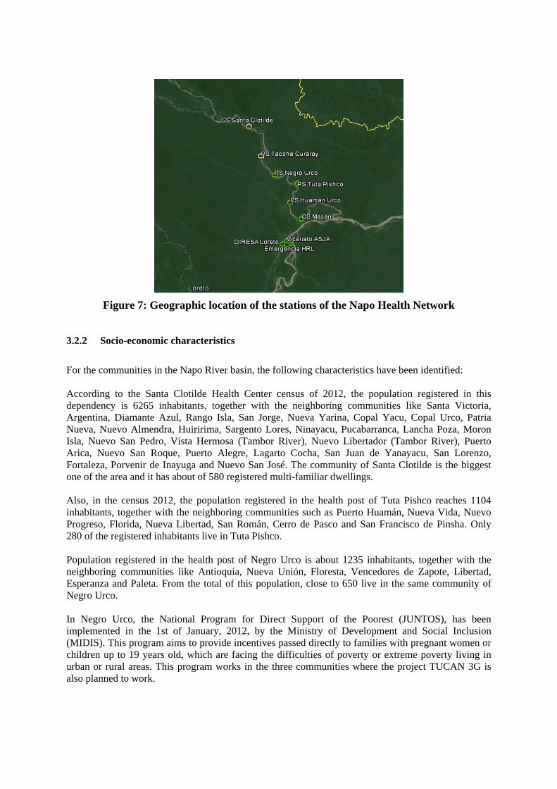
Figure 7: Geographic location of the stations of the Napo Health Network
3.2.2 Socio-economic characteristics
For the communities in the Napo River basin, the following characteristics have been identified: According to the Santa Clotilde Health Center census of 2012, the population registered in this dependency is 6265 inhabitants, together with the neighboring communities like Santa Victoria, Argentina, Diamante Azul, Rango Isla, San Jorge, Nueva Yarina, Copal Yacu, Copal Urco, Patria Nueva, Nuevo Almendra, Huiririma, Sargento Lores, Ninayacu, Pucabarranca, Lancha Poza, Moron Isla, Nuevo San Pedro, Vista Hermosa (Tambor River), Nuevo Libertador (Tambor River), Puerto Arica, Nuevo San Roque, Puerto Alegre, Lagarto Cocha, San Juan de Yanayacu, San Lorenzo, Fortaleza, Porvenir de Inayuga and Nuevo San José. The community of Santa Clotilde is the biggest one of the area and it has about of 580 registered multi-familiar dwellings. Also, in the census 2012, the population registered in the health post of Tuta Pishco reaches 1104 inhabitants, together with the neighboring communities such as Puerto Huamán, Nueva Vida, Nuevo Progreso, Florida, Nueva Libertad, San Román, Cerro de Pasco and San Francisco de Pinsha. Only 280 of the registered inhabitants live in Tuta Pishco. Population registered in the health post of Negro Urco is about 1235 inhabitants, together with the neighboring communities like Antioquía, Nueva Unión, Floresta, Vencedores de Zapote, Libertad, Esperanza and Paleta. From the total of this population, close to 650 live in the same community of Negro Urco. In Negro Urco, the National Program for Direct Support of the Poorest (JUNTOS), has been implemented in the 1st of January, 2012, by the Ministry of Development and Social Inclusion (MIDIS). This program aims to provide incentives passed directly to families with pregnant women or children up to 19 years old, which are facing the difficulties of poverty or extreme poverty living in urban or rural areas. This program works in the three communities where the project TUCAN 3G is also planned to work.

ICT-601102 STP Document number: D61 Title of deliverable: Situation report of the deployment area, sensitization results and…
TUCAN3G_D61PUCPe_.doc.doc 24
According to the census 2012, the available information for Loreto Department, Maynas province, Napo district and Peru in total, regarding of EAP is given in Table-4.
Indicators Peru Loreto Maynas Napo
Total Population, 2012(5) 30.135.875 1.006.953 550.031 16.221Male (4) 15.103.003 525.658 282.919 8.694Female (4) 15.032.873 481.295 267.112 7.527Rural Population (%) 2007 (6) 24,1 34,4 20,2 82,0Index of Vulnerability and Alimentary Insecurity MIDIS 2011 (7) 0,2304 0,3124 0,1731 0,6815Population in process of inclusion MIDIS 2012 (8) 15,4 17,3 7,4 37,8Total Poverty (%) 2012 (9) 25,8 41,8 36,6 79,6Extreme Poverty (%) 2012 (8) 6,0 13,4 14,6 40,1Rate of infant malnutrition 2012 (%) (10) 18,1 32,3 30,6 31,9
Table 4: General Characteristics of Population - Napo11
Electricity service is available in Santa Clotilde through a power line feed from a generator only in the following hours:
Monday to Friday: 5:30 a.m. – 6:00 a.m./6:00 p. m. -11:00 p.m. Saturday: 6:00 p.m. – 12:00 p.m. Sunday: 3:00 p.m. – 11:00 p.m.
Electricity service is available in Tuta Pishco through a power line feed from a diesel generator daily 3 hours only from 6:00 until 9:00 PM. However shortages are very common. The situation is similar in Negro Urco, that the electricity service is available only 3 hours daily (average) from 6:00 until 9:00 PM and shortages are very common. Regarding economic activities in the area, there are oil companies such as PERENCO and REPSOL which operate in Alto Curaray and Alto Napo areas. These companies had increased the public services and the commerce in Napo River basin, especially in Santa Clotilde where both companies have coordination offices. Other important economic activity is the forestry extraction. At this moment, new species are available especially in the accessible areas by river borders where the fine timbers became scarce long time ago.
5 Source: Report of the National Institute of Statistics and Informatics (INEI). “Peru: Estimations and Projections of Population by sex, department and districts 2000-2015. 6 Census of Population and Dwellings 2007 - INEI 7 Index of Vulnerability and Alimentary Insecurity (2011): This index is estimated with the media of the components of Alimentary security (a,b,c) and express the level of vulnerability to alimentary security at the level of districts, provinces and departments. Value of this index oscillates between 0 (none) and 1. (a) Availability: it is referred the quantity of food available in the area of calculation and is related to the sufficiency of supplies towards the requirements of population. It depends of local/regional/districts production or the quantity of imported food. (b) Access: it is the possibility of inhabitants to reach accurate quantity, quality and sustainable feeding. This factor corresponds to the food that a family/community can buy and the origin of these goods. (c) Consumption: related to the food that is preferred and consumed by the inhabitants of a community and is more related to their preferences, attitudes and cultural practices. 8 Population in process of inclusion defined as population living in dwellings with 3 or more circumstances associated with processes of exclusion: a. Residence environment (rural); b. Ethnicity (Quechua, Aymara, Native); c. Education of the mother (head of household qualifications: primary school complete/incomplete or less); d. Socio-economic level of the household (first fifth of the total income) MIDIS 2012. 9 From "Poverty and chronic malnutrition” report (department level) Source: ENAHO 2012 (National Homes Survey) INEI. National and district levels estimated by INEI 2009. 10 From: “Peru: Demographic and family health survey 2012” – INEI. National and district levels estimated by INEI 2009. 11 Elaboration with data from: MIDIS - DGSE- updated May 2013. Source: http://www.midis.gob.pe/mapas/website2013/

3.2.3 Specific local actors
As aforementioned, the primary healthcare service is provided by health posts and health centers organized in micro healthcare networks. The micro-network that works in the Napo River is called the Napo Healthcare Micro-network. It has two health centers, where one (Cabo Pantoja Health Centre) is located at the edge of the network (in the border with Ecuador) and the other one is close to the center of the network (Santa Clotilde Health Centre). Santa Clotilde health center is the reference center for 9 healthcare facilities, which are spread along the river. The Napo Health Micro-network is managed by the Vicariate of San José del Amazonas. This institution has an agreement with DIRESA to manage this healthcare micro-network, using the resources provided by DIRESA (funds, personnel, etc.) and funds coming from international donations. On the other hand, in the Napo River there are some secondary schools (in the larger communities) that are interested in Internet access. Moreover, in most of the communities with health posts there is a primary school that could require Internet services. Santa Clotilde: Here a list of the institutions and companies in the community of Santa Clotilde:
City County of the Napo District. (http://www.peru.gob.pe/Nuevo_Portal_Municipal/portales/Municipalidades/1455/pm_inicio.asp) Santa Clotilde community is the capital of the Napo District. The city county (municipality) needs to have Internet connection to allow the development of their administrative processes in an efficient manner. Actually, limited satellite internet access is available but it is not enough. The contact person is the Mayor of the city Mr. Manolo Piñan.
Sub-Region of Napo City (http://www.regionloreto.gob.pe/Pag/GerSubRegNapo.aspx) The administrative offices of the Sub-Region Napo City are located in the community of Santa Clotilde. These offices do not have any internet access. Contact person is Mr. Jose Montalvan Benavides.
Civil Association PANGO (http://www.pango.pe/ ). PANGO is a non-profit civil association constituted with the goal of promoting and maintaining the level of health care services in the Santa Clotilde Health Center and its reference Health stalls in the basin of the Napo River. This non-profit organization aims to find opportunities for the participation and training of national and foreigners healthcare workers and also to generate strategic partnership for the promotion and support of their objectives. Contact person is priest-doctor Jack MacCarthy [email protected]
Santa Clotilde Health Center, which is the reference center at the top of the micro network in the basin of the Napo River.
Private and public elementary, high and kindergarten schools and boarding schools, in some of these, Catholic Church takes the management responsibility.
National Police Station (PNP). There is a police station in the community.
PERENCO (http://www.perenco-peru.com/es.html ) is an oil extraction company with administrative offices in the community of Santa Clotilde. This enterprise has a daily traffic of at least 60 workers. This year, they are initiating the extraction of crude oil, which will increase their need of internet access. Contact person is Dr. Marco Tulio Vargas Cabrera [email protected]

ICT-601102 STP Document number: D61 Title of deliverable: Situation report of the deployment area, sensitization results and…
TUCAN3G_D61PUCPe_.doc.doc 26
REPSOL (http://www.repsol.com/pe_es/ ) is an oil extraction and trade company with
activities in the exploitation and exploration in the area of Alto Napo. This enterprise wants to have an office branch in Santa Clotilde due to its strategic location for personnel supply and transport facility and it needs Internet access for its operations.
Tuta Pishco: The following institutions are located in this community:
One health post run by two health personnel. One kindergarten (18 students), one elementary (42 students) and one high school (32
students). Negro Urco: Institutions in this community are the following:
One health post run by four healthcare personnel. One elementary and one high school.
In addition to the existing institutions, there are other institutions which operate from Iquitos and have a great importance in the development of these communities:
Apostolic Vicariate of San Jose del Amazonas ( http://www.sanjosedelamazonas.org/ ) From 1986, the Vicariate had established agreements with the Ministry of Healthcare represented by the Directorate of Healthcare of Loreto (DIRESA), taking care of the operation of the Santa Clotilde Health Center under the supervision of the Vicariate. Contact Person is Mons. Miguel Olaortua Laspra, OSA Apostolic Administrator.
Regional Directorate of Healthcare of Loreto- DIRESA (http://www.diresaloreto.gob.pe/portal/) DIRESA has been working with the authorities of GOREL (Regional Government of Loreto) and it is the main authority regarding to healthcare norms and programs. It also provides essential support for materials, medicines, prescriptions, vaccination and personnel payroll. It is responsible to provide internet and telephony services in the Napo healthcare micro-network. Contact person is Eng. Fernando Tulumba Tuesta [email protected]
PEDICP (http://www.pedicp.gob.pe/) is the Special Project of Comprehensive Development of the Putumayo River Basin. This project aims to take care and support the population who live on the Putumayo River basin as well as the biodiversity of its resources and conservation. Its work is based on a branch office in Santa Clotilde. Contact person is Eng. Javier Shupingahua.
3.3 Balsapuerto District
Balsapuerto is one of the 6 districts in the province of Alto Amazonas (see figure 5) in the Loreto Department. The capital of this district is the town of Balsapuerto. It has two main transportation ways, by river and air. As a result, there is lack of affordable public transportation.

The main rivers in the district are Paranapura, Cachiyacu, Armanayacu and Yanayacu Rivers where two of them are used for transportation: Paranapura River facilitates the transportation from Yurimaguas city to San Gabriel de Varadero town in the north. On the other hand, Cachiyacu River provides transportation from Varadero to Balsapuerto where the trip takes about 4 hours using an engine operated boat and depends on the river water level. The air transportation is based on demand (only when there are travelers requesting the service) and runs from the city of Yurimaguas to the town of Balsapuerto, capital of the district in 40 minutes with a single engine plane. The prize of the ticket is 150 nuevos soles (53 USD). As a third choice, the existing road transportation from Yurimaguas to Nuevo Arica community can be considered (about 1 hour road in motorized vehicle) however, a difficult path must be followed from this town to Balsapuerto, this trip can take from 7 hours to several days, depending on the road conditions. In July 2013, there was a campaign and process to vacate the Mayor of the district Mr. Alfredo Torres Rucoba who was removed from his position. The new Mayor of the city is Mrs. Pascuala Chanchari Tamani.
3.3.1 Characteristics of the geography
The district of Balsapuerto is located on top on a plain area connected to the Oriental Andean Mountains. The weather corresponds to a tropical forest. Capital city has the following coordinates: 05° 41’ 05’’ South Latitude and 76° 35’ 30’’ West Longitude. Altitude is 220 meters above the sea level. Territorial extension of the district of Balsapuerto is about 2,839.69 km2, with the following border lines: North with Jeberos District; South with San Martin Region; East with Yurimaguas District and West with Cahuapanas District.

ICT-601102 STP Document number: D61 Title of deliverable: Situation report of the deployment area, sensitization results and…
TUCAN3G_D61PUCPe_.doc.doc 28
Figure 8: Map of Balsapuerto District.
3.3.2 Socio-economic characteristics
The population of Balsapuerto is around 16,409 inhabitants and the population density is about 5.78 ppl/km² 12. According to the National Institute of Statistics and Informatics of Perú (INEI), Balsapuerto is one of the poorest and least developed districts of Peru. Population of Balsapuerto is predominantly from the ethnicity Chayahuita (90%) and the rest of population (10%) has mixed ethnic origin. The agricultural production represents the sustainability, marginalization and welfare inherent to the Chayahuita character, making their limitations on healthcare, nutrition, education and mystic believes an issue surrounding their development. The potentialities of the district are fundamentally found in the field of biodiversity and geographical location, which enhances the chances of development. The main characteristics of the district are the scarcity of basic services such as availability of drinking water, electricity, education, access to healthcare services, and difficulties on access to the capital of the district.
12 The initials ppl/km2 stands for ‘people per square kilometer’.

Indicators Peru Loreto Alto
Amazonas Balsapuerto
Total Population, 2012(13) 30.135.875 1.006.953 117.163 16.409Male (4) 15.103.003 525.658 60.965 8.490Female (4) 15.032.873 481.295 56.198 7.919Rural Population (%) 2007 (14) 24,1 34,4 40,1 95,3Index of Vulnerability and Alimentary Insecurity MIDIS 2011 (15) 0,2304 0,3124 0,4611 0,9271Population in process of inclusion MIDIS 2012 (16) 15,4 17,3 29,4 92,1Total Poverty (%) 2012 (17) 25,8 41,8 59,0 58,4Extreme Poverty (%) 2012 (8) 6,0 13,4 31,5 44,3Rate of infant malnutrition 2012 (%) (18) 18,1 32,3 31,5 32,2
Table 5: Characteristics of the population of Balsapuerto19
Situation of access to basic services in Balsapuerto district:
Running/drinking water is not available.
Most of communities do not have access to electricity as utility services. Some of them have electricity a few hours per day, provided by diesel generators. Recently, power line has established to provide the electricity 24 hours a day from Yurimaguas to San Gabriel de Varadero. This power line is in testing stage.
According to 2012 statistics of the Ministry of Education, there are about 130 educational
institutions working with 6434 students and 265 teachers.
According to healthcare indicators, there are 15 healthcare facilities where 35 healthcare professionals (medical doctors, midwives, nurses and technical nurses) are currently working.
Main subsistence economic activities are agriculture, livestock in small scale (cattle),
forest extraction, fishing, and tourism in small scale.
There is at least one public phone provided by the companies Telefonica of Peru and Gilat in 12 communities. Mobile telephony provided by Telefonica del Peru is available only in 4 communities. According to FITEL up to May 2013, Internet access is not available.
In the framework of the international cooperation projects developed by PUCP in this area, installation of 3 wireless network nodes was completed in 2011. The geographic locations of the stations that are part of this network are included in the project TUCAN 3G and shown in Table 6.
13 Source: Report of the INEI. “Peru: Estimations and Projections of Population by sex, department and districts 2000-2015. 14 Census of Population and Dwellings 2007 - INEI 15 Index of Vulnerability and Alimentary Insecurity (2011): This index is estimated with the media of the components of alimentary security (a,b,c) and express the level of vulnerability to alimentary security at the level of districts, provinces and departments. Value of this index oscillates between 0 (none) and 1. 16 Population in process of inclusion defined as population living in dwellings with 3 or more circumstances associated with processes of exclusion. 17 From the report” Poverty and chronic malnutrition” (department level) Source: ENAHO 2012 (National Homes Survey) INEI. National and district levels estimated by INEI 2009. 18 From: “ Peru: Demographic and family health survey 2012” – INEI. National and district levels estimated by INEI 2009. 19 Elaborate by MIDIS - DGSE- actualized a mayo de 2013. Fuente: http://www.midis.gob.pe/mapas/website2013/

ICT-601102 STP Document number: D61 Title of deliverable: Situation report of the deployment area, sensitization results and…
TUCAN3G_D61PUCPe_.doc.doc 30
Station number
Name of the location (place)
Coordinates Altitude High of the
tower
01 Tower PS Varadero 5°42'49.99"S
76°24'39.59"O 167 m 60 m
02 Tower San Juan 5°52'35.13"S
76°21'21.73"O 159 m 60 m
03 Hospital Santa Gema
Yurimaguas 5°53'38.30"S 76° 6'24.19"O
167 m 42 m
Table 6: Coordinates of geographic location of the repeaters In the following subsection,complementary information will be provided about the two communities included in the project (San Gabriel de Varadero and San Juan).
3.3.2.1 San Gabriel de Varadero
According to the census 2012, the population of San Gabriel de Varadero is around 790 inhabitants. The estimation provided by the healthcare stall indicates that by the end of this year, population may reach 1000 inhabitants. Main activities are small scale agriculture, livestock (cattle), fishing and commerce. There is no access to basic utility services such as running water and sewage. In addition, electricity is limited to few hours per day using a diesel generator. As mentioned before, in the last months, new power lines were installed from the Yurimaguas city, which will allow electricity service to run 24 hours a day. The installation is still in the trial period. In the following figure is possible to see the current power line of the area.
Figure 9: New power line in the community of San Gabriel de Varadero.
This community is considered as very strategic due to being a mandatory passing point for the travelers along the Paranapura, Cachiyacu and other rivers of the area, which all allow to access to Yurimaguas city.
The closest communities to San Gabriel de Varadero are about 3 Km away, which are Lomalinda (40 min. walk), Irapay (40 min. walk) and Nuevo Chazuta (30 min. walk).

Figure 10: Communities near of the project area in Balsapuerto.
3.3.2.2 San Juan de Armanayacu
This community has a population of 98 people, mainly from the Chayahuita ethnic origin and they are dedicated to self-consumption agriculture and timber extraction. Unfortunately, the people does not have access to basic utilities neither drinking water, sewage nor electricity. San Juan de Armanayacu is located between the road that enables access to Yurimaguas and the border of the Armanayacu River. The closest communities to this small town are located between 1 and 3 km of distance: San Carlos is about 1 km away (15 minutes walking), Paraiso is about 1.5 km away (20 minutes walking), San Lorenzo is about 2 km away (30 minutes walking) and San Isidro is about 3 km away (45 minutes walking).
Figure 11: Partial view of the population of San Juan de Armanayacu

ICT-601102 STP Document number: D61 Title of deliverable: Situation report of the deployment area, sensitization results and…
TUCAN3G_D61PUCPe_.doc.doc 32
3.3.3 Specific local actors
The local actors in the area of the Balsapuerto district are the following: San Gabriel de Varadero:
One healthcare facility with 14 professional personnel. Educational institutions: One kindergarten with 60 students, one elementary school with 195
students and one high school with 125 students. 80% of those 380 students belong to the Chayahuita ethnic group. The classes are bilingual (Spanish and native language). There are about 30 teachers working on this institutions.
Two private educational institutions managed by the Catholic Church (boarding schools for male and female secondary school students coming from nearby communities).
Part of the Municipality of Balsapuerto and a representative of the Civil Registry.
San Juan de Armanayacu:
Health post where 1 nursing technician is working. One elementary school with 30 students and one kindergarten with 15 students with one
teacher for each. Yurimaguas: Considering that the existing WiFi network deployed by PUCP and IEEE reaches Yurimaguas and that this city is where the interconnection between the project demonstrative platform and the operator network will be made. This is a very important city with relevant local actors as following:
Provincial Municipality of Alto Amazonas. Sub-regional management of Alto Amazonas (dependent of Regional Government GOREL). Santa Gema Hospital from Yurimaguas. Alto Amazonas Health Network.

4 SENSITIZATION ACTIVITIES
4.1 Objectives
Main objectives to be accomplished were formulated as follows:
Introduce and explain the characteristics and scope of the project to the future involved groups in order to receive their input, feedback and acceptance of it.
Receive a commitment from the local actors to facilitate the fulfilling of the project, especially on the subject of use of lands (aligned to the physical and legal framework ) and authorization to develop preliminary work in the communities.
In the case of local institutions, especially the healthcare dependencies that are currently using the deployed networks, the project administration has been in the search of a formal commitment to support (a formal agreement document) signed by authorized representatives. In general, the highest goal of the coordination and actions of sensitization are intended to achieve a collaborative sense for the project, in order to to reach the proposed results.
4.2 Activities
4.2.1 Napo Network
4.2.1.1 Tuta Pishco (Nueva Libertad)
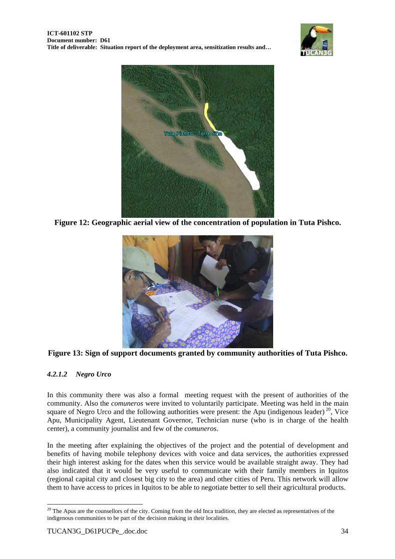
In this community there was a formal meeting request which received massive positive response from the current authorities during the visit to this community. Additionally, a number of comuneros (civil leaders of the community) were invited if they were willing to voluntarily participate. The meeting was held in the healthcare stall where the community president, lieutenant governor and technical nurse in charge of health establishment were present. In this meeting, our engineers and technicians explained the objectives and scope of the project and showed the potential of development when having a mobile device with voice and data communication services. Authorities expressed immediately their interest and their appreciation for the selection of their community as a beneficiary of the project TUCAN 3G. In this town, there is a braced telecommunications tower of 56 meters high for the implementation of the project TUCAN 3G. As a result of this meeting, a letter for use of the land where the tower had been built was signed by the community authorities: Community President Mr. Romeo Ruíz Góngora, and Tenant Governor Mr. Romeo Ruíz Aspajo. For further details, please refer to Annex I. A tour around the town was conducted in order to identify the institutions present in the community and to determine the area of higher concentration of population. Figure 12 shows the approximate population distribution, the white areas indicate highest rates of population density in Tuta Pishco. Yellow areas indicate low level of concentration or high dispersion on dwellings.
ICT-601102 STP Document number: D61 Title of deliverable: Situation report of the deployment area, sensitization results and…
TUCAN3G_D61PUCPe_.doc.doc 34
Figure 12: Geographic aerial view of the concentration of population in Tuta Pishco.
Figure 13: Sign of support documents granted by community authorities of Tuta Pishco.
4.2.1.2 Negro Urco
In this community there was also a formal meeting request with the present of authorities of the community. Also the comuneros were invited to voluntarily participate. Meeting was held in the main square of Negro Urco and the following authorities were present: the Apu (indigenous leader) 20, Vice Apu, Municipality Agent, Lieutenant Governor, Technician nurse (who is in charge of the health center), a community journalist and few of the comuneros. In the meeting after explaining the objectives of the project and the potential of development and benefits of having mobile telephony devices with voice and data services, the authorities expressed their high interest asking for the dates when this service would be available straight away. They had also indicated that it would be very useful to communicate with their family members in Iquitos (regional capital city and closest big city to the area) and other cities of Peru. This network will allow them to have access to prices in Iquitos to be able to negotiate better to sell their agricultural products.
20 The Apus are the counsellors of the city. Coming from the old Inca tradition, they are elected as representatives of the indigenous communities to be part of the decision making in their localities.
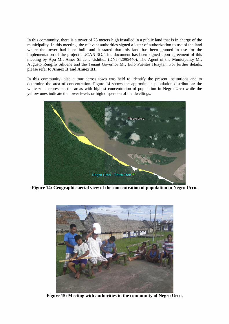
In this community, there is a tower of 75 meters high installed in a public land that is in charge of the municipality. In this meeting, the relevant authorities signed a letter of authorization to use of the land where the tower had been built and it stated that this land has been granted in use for the implementation of the project TUCAN 3G. This document has been signed upon agreement of this meeting by Apu Mr. Ainer Sihuene Ushihua (DNI 42095440), The Agent of the Municipality Mr. Augusto Rengifo Sihuene and the Tenant Governor Mr. Eulo Puentes Huaytan. For further details, please refer to Annex II and Annex III. In this community, also a tour across town was held to identify the present institutions and to determine the area of concentration. Figure 14 shows the approximate population distribution: the white zone represents the areas with highest concentration of population in Negro Urco while the yellow ones indicate the lower levels or high dispersion of the dwellings.
Figure 14: Geographic aerial view of the concentration of population in Negro Urco.
Figure 15: Meeting with authorities in the community of Negro Urco.

ICT-601102 STP Document number: D61 Title of deliverable: Situation report of the deployment area, sensitization results and…
TUCAN3G_D61PUCPe_.doc.doc 36
4.2.1.3 Santa Clotilde
In Santa Clotilde there was a meeting with the participation of the Mayor of the city Mr. Manolo Piñán, the sheriff Mr. Wuerner Saavedra Gonzales, the Coordinator of National Defense Mr. Robin Vásquez López, the Medical Doctor and Manager of the Health Center of Santa Clotilde (CSSC) Dr. Juan Jon Rabines and finally the Medical Doctor and also Director of the NGO PANGO, Dr. John MacCarthy. In the meeting there was an explanation of the objectives with the scope of the project and the possibilities of development by having the mobile telephony service with voice and data services. The Mayor of the city showed his appreciation and interest to collaborate with the project to have a replicable model for other communities on his charge. Also, the sheriff mentioned that the implementation of this network will facilitate the work of National Police of Peru in the zone. In the case of doctors, they considered the project very important to have an alternative service to the Rural Network of Telemedicine from the Napo River basin. In the case of Santa Clotilde, the tower of 72 meters high had already built on a land that belongs to the Apostolic Vicariate of San Jose del Amazonas. Therefore, a request was sent to the Bishop Monsignor Miguel Olaortua Laspra, who has granted of the required permission. For further details, please refer to Annex IV. Moreover, a tour across town was realized to identify the present institutions and to determine the area of concentration. Figure 16 shows the approximate distribution of population: the white zone represents the area with highest concentration and the yellow zones the lowest or more disperse dwellings.
Figure 16: Geographical area of the town of Santa Clotilde.
4.2.2 Balsapuerto Network
Sensitization activities have been carried out on the intervention areas (Yurimaguas as the capital of Alto Amazonas province, San Juan del Armanayacu and San Gabriel de Varadero), with the participation of the local authorities and people from the communities involved in the project.

4.2.2.1 Yurimaguas
In this city, there was a formal meeting request and the results were as follows: Meetings and informative conversations with the Healthcare Network of Alto Amazonas (RSAA)
has been realized. The RSAA administrates the Telecommunications network of Balsapuerto, they also have received recently documents explaining the scope of the project (TUCAN3G) and relevant information.
Director of RSAA and technical personnel in charge of the telecommunication network participated in the meetings and conversations.
Also, the Director of RSAA has given his support for the use of the installed infrastructure which connects the Santa Gema Hospital and the offices of the RSAA to the health center of Balsapuerto and the health stalls of Varadero and San Juan del Armanayacu.
On the other side, the informative document has been sent to the directors of the Santa Gema Support Hospital and to the Mayor of Alto Amazonas province. However, due to the political removal process to the authorities and municipality of Balsapuerto, it was not possible to accomplish any activity with the current officers.
4.2.2.2 San Gabriel de Varadero
The Healthcare facility has been visited, and representatives of the community and local authorities reunited in the community hall. Representatives of the community such as the municipality agent, teachers, healthcare personnel and other people from the community attended to the meeting. The scope of the project, the possibilities of implementation of a telephony system through the use of femtocells 3G has been explained to them during this meeting. Also, a tour has been carried out through the locality to identify the current institutions and to determine the area of population concentration using a GPS. Figure 17 shows the approximate distribution of the population: the white zone represents the area with higher concentration of population, while the yellow zone represents the lowest density level or isolated dwellings.
Figure 17: Geographic aerial view from of San Gabriel de Varadero.

ICT-601102 STP Document number: D61 Title of deliverable: Situation report of the deployment area, sensitization results and…
TUCAN3G_D61PUCPe_.doc.doc 38
People of these communities seem to be very interested to have a mobile telephone service, as a matter of fact, representatives referred that they had sent three letters of intention to operators to request implementation of mobile service for their communities as shown on Annex V of this document. People also said that the deployment of a mobile telephone service and internet access will be a great benefit especially for local institutions because they need to be connected (list of assistance to the workshop of this project in shows in Annex VI). This community, San Gabriel de Varadero, is a strategic place due to its location as a mandatory passing point for travelers from Alto Paranapura and small towns in the basin of the Cachiyacu River to Yurimaguas.
Figure 18: Meeting with authorities and people from the community of San Gabriel de
Varadero.
4.2.2.3 San Juan de Armanayacu
In this community, a formal meeting was held with authorities such as the Apu of the town, municipality officers, healthcare technical personnel, president of the APAFA21 and people interested to participate in the healthcare stall. Brief explanation was given for the scope of the project and the potential of the deployment of a telephone service using femtocells 3G. Also, there was a walking tour in the town to identify the present institutions and to determine the area of concentration of the population. Figure 19 shows the estimated distribution of the population: the white area represents the highest concentration area of population.
21 APAFA stands for Association of Households Heads, which is civil non-profit organization where all the parents of children at school congregates to make decisions towards improvements for the school and children’s education.

Figure 19: Geographic aerial view of the concentration of population in San Juan.
People in the area expressed their interest to have a mobile telephone service because they need to be communicated with other areas. The healthcare technician of the stall declared that they were in the search for information about how to request the service installation by using the existing tower (San Juan). Inhabitants of San Juan del Armanayacu belong to Chayahuita ethnic group. For further details, please refer to Annex VII.
Figure 20: Meeting with authorities in the community of San Juan de Armanayacu.
4.3 Results
In conclusion, in the area of Balsapuerto, the Director of RSAA has granted his approval for the project and given a letter with his favorable opinion. Inhabitants from the community said that the deployment of mobile telephone service and internet access would be very beneficial for them due to their need to have better communication with other regions. For further details, please see Annex VIII.
ICT-601102 STP Document number: D61 Title of deliverable: Situation report of the deployment area, sensitization results and…
TUCAN3G_D61PUCPe_.doc.doc 40
Regarding to the Napo Network, the President of the Loreto Region, Mr. Yvan Vásquez Valera, and the health general director, in Loreto region, Dr. Hugo Rodríguez Ferrucci, have expressed their favorable opinion to the project TUCAN 3G. They agreed upon the fact that the project aligns with the policy of on-going projects, which are in search for promoting integration and social, economic and cultural development of Region Loreto as a whole. In Annex IX and Annex X, formal letters expressing the favorable opinion of the authorities towards the implementation of the project are given. Similarly, the local authorities and population in general from the localities of Tuta Pishco, Negro Urco and Santa Clotilde have given their approval and confirmed their interest on the project since they consider it as an important advancement for their communities to have the opportunity of accessing the mobile telephone and internet services.

5 CURRENT STATE OF TRANSPORT NETWORKS
5.1 Napo Network
5.1.1 Perception from users
According to the manifest of Dr. Juan Jon Rabines (medical doctor and manager of the healthcare of the micro network in the Napo River basin), the rural telemedicine network has achieved the following points:
Improvements on emergency and references management, successful evacuation of priority I and II emergencies to Santa Clotilde’s center of reference where 20% of these emergencies were prenatal care according to 2012’s statistics. As the year goes by, 26% is still registered in the same area with positive outcomes.
Enhancement on the network interaction with specialists from local and international universities such as Loyola (U.S) and British Colombia (Canada) in order to promote the primary attention in the area and offer an improved attention to native and indigenous populations in the area.
Significant decrease on maternal mortality and prenatal care index due to RADAR which facilitates the administrative process of communication between each point of the micro network
Facilitate coordination between public (DIRESA Loreto) and private (local and international) institutions to provide on-site training sessions (in each community) for technical personnel, promoters and midwives to decrease the morbidity index in the area.
Projects with institutions such as PUCP have been developed for the transmission of information about the prevention of prevalent diseases of the area (RADIO SALUD- NAPO).
Enhanced continuous interaction had been achieved within the health posts in order to avoid
unnecessary transportation in the management of emergencies and ambulatory patients.
Reduction of personnel transports expenses with presence training.
Reduction on the number of relocations and personnel's absence period in the health posts and centres due to the systems about the assistance delivery and managerial reports.
Access to inscription system on SIS to speed up the processing of the funds for health
establishments.
Improvement of medication procedure and drug provisions to provide the access to medications despite the lack of pharmacies in the rural areas
Facilitation and promotion of the communication between the personnel to reduce the
isolation sensation on the healthcare personnel and to increase the possibilities of online professional specialization.
Furthermore, here a list of the lessons learnt:
Despite the inevitable isolation and high mortality and morbidity rates, telecommunications is a very useful tool to support the personnel and to facilitate closing the gaping in the healthcare

ICT-601102 STP Document number: D61 Title of deliverable: Situation report of the deployment area, sensitization results and…
TUCAN3G_D61PUCPe_.doc.doc 42
sector. Especially in the rural areas, it provides the capability of a quick response in emergency cases.
Due to support of telecommunication systems, primary healthcare has a significant improvement in the rural areas because it promotes the on-line communication between the personnel, especially the ones with basic technical knowledge, supporting their contribution.
Telecommunications reduces the expenses generated by the transportation of the patients, supplies, etc. and finally supports the national economy.
This project helps to maintain the interest of the people and institutions in the national and international sphere about the activities of health center and the network welcoming the foreign professionals and promoting the accomplishment for the inhabitants of the area.
Dr. Juan Jon Rabines expressed the importance of the TUCAN 3G project for the empowerment and enforcement on accessing of the voice and data services.
5.1.2 Description and characteristics of the implemented services in relation with the epidemiological surveillance system and the economic resources control
The purpose of the national epidemiological surveillance system is to guarantee the quality and continuity of the collection, analysis and data interpretation processes. This information is very important as it shows trends and evolution over time of major diseases, the most damaged regions or demographic groups and the national health situation in a general manner. The surveillance system is based on three stages: notification, analysis and interpretation. MINSA have a national wide application to manage epidemiological information. This desktop tool, called NotiSP, facilitates data collection, quality control and report generation. With the new system, health post workers are in charge of loading the collected data on the computer. Once the data is added to NotiSP, the health workers generates the database files, which is later sent, using the WiLD network, to their reference center by email or any videoconference system. The direction of this data transfer is from health post to health center or from health center to DIRESA Loreto. Reference center worker who is in charge of data loading, is also responsible to verify the validity of the data introduced by the health post workers and also keep loading the data belongs to their own establishment. If a mistake is found, reference center workers will report it by email, VoIP or videoconference and will communicate the way to correct it. Once the health post files have been debugged, information will be packed and sent to DIRESA Loreto. Economic resources control: Integrated Health Insurance (SIS) assumes the costs related with population health care in the Napo River which is very low due to their low incomes. Now, health posts can access the Ministry of Health SIS Platform through a web browser. It enables workers to check the patient’s medical insurance, register new patients in the SIS and fill the Unique Attention Form (FUA - Formulario Unico de Atención). As a result, patients without a health insurance are now covered, and all medical attentions are recorded. This service does not require a high bandwidth (about 150Kbps), but real time applications need a reliable connection. The use of the system is translated in the reimbursement of the cost of the healthcare for the rural facilities. The most important tele-services installed in the Napo network are:

5.1.2.1 Videoconference system
Currently, two videoconference systems are implemented: Spontania and Skype. Spontania characteristics:
Proprietary software. A license has been given to this project free of cost. It is only installed in a server situated in Iquitos. Client hosts connect to the server by a web
browser. Then the application runs through a plug-in downloaded from the browser. No Internet connection is needed as it runs over intranet as a LAN service. It is possible to configure the application bandwidth manually in order to fit the available
network resources. As the application run through the server, traffic has to flow over Iquitos for every connection.
That's why the video conferences increases the network traffic. Skype characteristics:
Proprietary software with a free version. It requires an Internet connection to establish the communication. Voice and video traffic is sent directly to destination host. Application bandwidth is managed by Skype and it cannot be set manually. The application
provides the best quality possible; however it deteriorates the other services.
Both applications were installed in order to perform a technical evaluation and measure the acceptance degree. Spontania server was implemented within Napo network (Iquitos), so it could be used as a LAN application. Iquitos is located in an edge of the network and all videoconference traffic will have to reach the server, so this situation increases the overall network traffic. But there was no choice because Iquitos is the only point in the network with a reliable power source.
5.1.2.2 Tele microscopy system
A microscope and the equipment to prepare a sample of intestinal parasites is given in every health post. Health post technicians are capable of analyzing malaria samples with these tools, however specialists are needed for more complicated cases. Therefore, a real time process is required due to the importance of choosing the right fields to evaluate. Besides, being in real time allows that both technician and specialist analyze the same sample at the same time, which becomes an on-site training for technicians. Microscopy image was shared by screen sharing tools provided by Spontania or Skype. Since microscopy images are quite static, the service requires a low bandwidth, about 400Kbps. The system is tolerant to delay variations.
5.1.2.3 Tele-stethoscopy system
Tele-stethoscopy service is based on the use of digital stethoscopes which send the auscultation signal from health posts to health centers or regional hospitals. This allows the doctor to auscultate the patient and get a right diagnosis. The tele-stethoscopy is connected to a computer and it has an application which requires a bandwidth of 200Kbps and a constant delay. Sound is sent directly from source host to destination host, so it is not necessary to use a server. Usually Skype videoconference is used as a complement, so the doctor can see the patient while auscultation process is taking place.

ICT-601102 STP Document number: D61 Title of deliverable: Situation report of the deployment area, sensitization results and…
TUCAN3G_D61PUCPe_.doc.doc 44
5.1.2.4 Tele-ultrasound system
Tele-ultrasound system allows sharing ultrasound images in real time, so both health post technician and specialist can see the same images. Skype screen sharing tool is used to share ultrasound images. As mentioned before, configuring the video bit rate is not allowed (400Kbps are needed to get the minimum required quality) therefore it is really important to have a constant delay to have a proper diagnosis.
5.2 Balsapuerto Network
5.2.1 Perception of users
The users involved in the initial operational period of the system evalueted very well to enhance the connectivity of the communities and the institutions with a fast, effective, costless high quality communication. Involved institutions are health centers of Balsapuerto, Varadero, San Juan, Hospital San Gema de Yurimaguas and the Health Network of Alto Amazonas. According to the users, the system also allowed them to make remote consultation, coordination for the logistics of the medical material and medicines, coordination for the transportation of patients in emergency cases, delivery of information in digital format and online training by video conference for administrative, technical and medical health personnel. The most used services were IP telephony and internet access. Despite the good implementation, the system started to show some problems such as interruptions of communication and partial cuts on the service (mainly between 7 p.m. and 9 a.m.) starting from 2012. From January to June in 2013, communication had continued to get interruptions due to lack of maintenance. In Yurimaguas there is a technician responsible for the maintenance, but needs more training; also there are funding limitations for maintenance. On the other side, personnel from health stalls usually work only some months and then, they are moved to another places or replaced with new personnel without required training on basic operation. During the visit on June 2013, the health personnel, the users of the system had expressed their interest for reestablishing the network services to recover its benefits. Later, in August, the reactivation of the network services was realized with the participation of a representative from IEEE and health personnel engaged with the project as beneficiaries of the systems and with the support of the Group of Rural Telecommunications (GTR-PUCP).
5.2.2 Description and characteristics of the implemented services
This network is a communication platform which allows communications among three isolated communities with local services of Santa Gema Hospital in Yurimaguas and the administrative offices of the health network in Alto Amazonas which provides the following services:
Telephony services: An Asterisk server is provided to make IP voice calls (VoIP) 24 hours free without additional cost among Santa Gema Hospital inYurimaguas, the health stalls, health centers and administrative offices of the Health Center of Alto Amazonas.
Videoconference: Two video-conference systems are implemented using Softphones for free use: Linphone and Skype.
o Linphone is a high-resolution system that enhances the point-to-point videoconference quality using high resolution webcams. Internet connection is not required as it works in the intranet.

o Skype is free software which requires internet access. The video has the best possible quality depending on the available bandwidth. In addition, it allows to make a multi-point videoconference with a premium account.
There is a file-sharing system controlled by a central server located in Hospital Santa Gema of Yurimaguas.
Internet service: the establishments involved in this project have access to Internet through a gateway (client of the Health Network) which has an ADSL connection from Telefonica and contracted by the Health Network. All the nodes in the network can access to the internet through this equipment.
Economic resources control: Integrated Health Insurance (SIS) assumes the costs on population health care in Balsapuerto network, which is very low due to their low incomes. Currently, three healthcare facilities can access the Ministry of Health SIS Platform through a web browser. This platform enables workers to check the patient medical insurance records, register new patients in the SIS and fill the Unique Attention Form (FUA - Formulario Unico de Atención). As a result, patients without a health insurance are now covered, and all medical attentions are recorded. This service does not require a high bandwidth (about 150Kbps), but real time applications need a reliable connection.
It is also important to mention that all equipment which are located out of Yurimaguas city (including computers), are working with solar energy, as conventional energy is not available out of the city.
5.3 State of the Networks of Telecommunications
5.3.1 The current situation of Napo Wireless Network.
This section shows the current situation of the Napo Network considering only the locations in which TUCAN 3G is planned to be deployed. Additionally, it should be noted that the study is conducted only on long distance links. The involved nodes are the following:
Santa Clotilde (SC) Tacsha Curaray (TC) Negro Urco (NU) Tuta Pishco (TP)
Figure 21: Napo Wireless Network Scheme

ICT-601102 STP Document number: D61 Title of deliverable: Situation report of the deployment area, sensitization results and…
TUCAN3G_D61PUCPe_.doc.doc 46
5.3.1.1 Equipment The equipment to implement the long distance radio links basically consists of Mikrotik equipment. The diagram of the equipment used in the repeater nodes, central node, common client node, DIRESA node are given in fig.23, fig.24, fig.25 and fig.26 respectively. In addition, further details about the equipment are provided in Table 7, 8 and 9.
Figure 22: Diagram of the equipment in the repeater nodes.
Figure 23: Diagram of the equipment in the node of Regional Hospital of Iquitos

Figure 24: Diagram of the equipment in a client node.
Figure 25: Diagram of the equipment in the DIRESA client node.
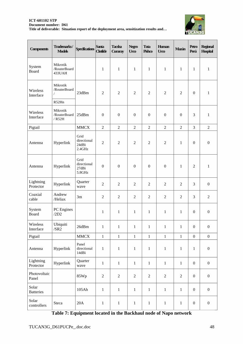
ICT-601102 STP Document number: D61 Title of deliverable: Situation report of the deployment area, sensitization results and…
TUCAN3G_D61PUCPe_.doc.doc 48
Components Trademarks /
Models Specifications
Santa Clotilde
Tacsha Curaray
Negro Urco
Tuta Pishco
Human Urco
Mazán Petro Perú
Regional Hospital
System Board
Mikrotik /RouterBoard 433UAH
1 1 1 1 1 1 1 1
Wireless Interface
Mikrotik /RouterBoard / 23dBm 2 2 2 2 2 2 0 1
R52Hn
Wireless Interface
Mikrotik /RouterBoard/ R52H
25dBm 0 0 0 0 0 0 3 1
Pigtail MMCX 2 2 2 2 2 2 3 2
Antenna Hyperlink
Grid directional 24dBi 2.4GHz
2 2 2 2 2 1 0 0
Antenna Hyperlink
Grid directional 27dBi 5.8GHz
0 0 0 0 0 1 2 1
Lightning Protector
Hyperlink Quarter wave
2 2 2 2 2 2 3 0
Coaxial cable
Andrew /Heliax
3m 2 2 2 2 2 2 3 2
System Board
PC Engines /2D2
1 1 1 1 1 1 0 0
Wireless Interface
Ubiquiti /SR2
26dBm 1 1 1 1 1 1 0 0
Pigtail MMCX 1 1 1 1 1 1 0 0
Antenna Hyperlink Panel directional 14dBi
1 1 1 1 1 1 1 0
Lightning Protector
Hyperlink Quarter wave
1 1 1 1 1 1 0 0
Photovoltaic Panel
85Wp 2 2 2 2 2 2 0 0
Solar Batteries
105Ah 1 1 1 1 1 1 0 0
Solar controllers
Steca 20A 1 1 1 1 1 1 0 0
Table 7: Equipment located in the Backhaul node of Napo network

Components Trademarks /
Models Specifications
Santa Clotilde Health Center
Tacsha Curaray Health Post
Negro Urco
Health Post
Tuta Pishco Health Post
Human Urco
Health Post
Mazán Health Center
Vicariate Hospital ER
System Board
PC Engines /2D2
1 1 1 1 1 1 1 0
System Board
Mikrotik /RouterBoard 433GAH
0 0 0 0 1
Wireless Interface
Ubiquiti /SR2 26dBm 1 1 1 1 1 1 1 1
Wireless Interface
Mikrotik /RouterBoard /R52Hn
23dBm 0 0 0 0 1
Pigtail MMCX 1 1 1 1 1 1 1 1
Antenna Hyperlink
Panel directional 14dBi 2.4GHz
1 1 1 1 1 1 1 1
Lightning Protector
Hyperlink Quarter wave
1 1 1 1 1 1 1 1
Switch Ethernet
Encore 8 ports 1 1 1 1 1 1 1 0
Analog Telephone Adaptors
Grandstream / Handy Tone 502
2 FXS ports 4 1 1 1 1 1 1 1
Analog Telephone
Panasonics 8 2 2 2 2 2 2 2
PC User Compatible PC
Windows 7 0 0 0 0 0 1 1 0
Laptop User DELL Windows 7 1 1 1 1 1 1 0 0
PC Health Center
10 1 1 1 1 4 0 0
Photovoltaic Panel
85Wp 4 4 4 4 4 4 0 0
Solar Batteries
105Ah 3 3 3 3 3 3 0 0
Solar-controllers
Steca 30A 1 1 1 1 1 1 0 0
Table 8: Equipment located in the Client node

ICT-601102 STP Document number: D61 Title of deliverable: Situation report of the deployment area, sensitization results and…
TUCAN3G_D61PUCPe_.doc.doc 50
Components Trademarks / Models Specifications DIRESA Hospital Iquitos
Regional Hospital
System Board Mikrotik /RouterBoard 493GAH
1 0
Wireless Interface Mikrotik /RouterBoard /R52Hn
23dBm 1 0
Pigtail MMCX 1 0
Antenna Hyperlink Panel directional 14dBi 2.4GHz
1 0
Lightning Protector Hyperlink Quarter wave 1 0
Switch Ethernet Encore 8 ports 0 0
Analog Telephone Adaptors
Grandstream / Handy Tone 502
2 FXS ports 1 1
Analog Telephone Panasonics 2 2
Laptop DELL Windows 7 0 0
Analog Telephone Adaptors
Grandstream / Handy Tone 503
1 FXO port 1 0
1 FXS port
Video conferencing server
Spontania Server Video conferencing using UDP
1 1
WSN Server PC CELA Project 1
VoIP Server Asterisk Server PC Engines
1 0 ALIX 2D2
Table 9: Equipment located in the access Internet node
5.3.1.2 Configuration The following tables show the network configuration in WiLD wireless backhaul and WiFi access network in the Napo network.
Santa Clotilde –
Tacsha Curaray
Tacsha Curaray –
Negro Urco
Negro Urco – Tuta
Pishco
Tuta Pishco – Human
Urco
Human Urco – Mazan
Mazan – Petro Peru
Petro Peru –
Regional Hospital
SSID EHAS17 EHAS18 EHAS19 EHAS20 EHAS21 EHAS22 EHAS23
Wireless technology
802.11n 802.11n 802.11n 802.11n 802.11n 802.11a 802.11a
Band / Frequency
2.4GHz / 2437GHz
2.4GHz / 2462GHz
2.4GHz / 2437GHz
2.4GHz / 2462GHz
2.4GHz / 2437GHz
5.8GHz / 2745GHz
5.8GHz / 5785GHz
Security WPA-PSK WPA-PSK WPA-PSK WPA-PSK WPA-PSK WPA-PSK WPA-PSK
Max. Rate Mcs-3 Mcs-3 Mcs-3 Mcs-3 Mcs-3 18Mbps 18Mbps
Channel Width
20MHz 20MHz 20MHz 20MHz 20MHz 20MHz 20MHz
Table 10: Configuration in wireless backhaul network in Napo

Santa
Clotilde Tacsha
Curaray Negro Urco
Tuta Pishco
Human Urco
Mazan Vicariate DIRESA
SSID NAPO1 NAPO17 NAPO18 NAPO19 NAPO20 NAPO21 NAPO22 NAPO30
Wireless technology
802.11g 802.11g 802.11g 802.11g 802.11g 802.11g 802.11g 802.11n
Band / Frequency
2.4GHz / 2412 GHz
2.4GHz / 2412GHz
2.4GHz / 2412GHz
2.4GHz / 2412GHz
2.4GHz / 2412GHz
2.4GHz / 2412GHz
2.4GHz / 2412GHz
2.4GHz / 2462GHz
Security WPA-PSK
WPA-PSK
WPA-PSK
WPA-PSK
WPA-PSK
WPA-PSK
WPA-PSK
WPA-PSK
Max. Rate 18Mbps 18Mbps 18Mbps 18Mbps 18Mbps 18Mbps 18Mbps Mcs-3
Channel Width
20MHz 20MHz 20MHz 20MHz 20MHz 20MHz 20MHz 20MHz
Table 11: Configuration in wireless access network in Napo
5.3.1.3 Distance, Throughput and Signal level. The following tables show the distance, throughput and signal levels in WiLD wireless backhaul and WiFi access networks in the Napo network.
Santa Clotilde –
Tacsha Curaray
Tacsha Curaray –
Negro Urco
Negro Urco – Tuta
Pishco
Tuta Pishco – Human
Urco
Human Urco – Mazan
Mazan – Petro Peru
Petro Peru –
Hospital Regional
Distance (Km) 39.0 29.50 29.60 24.90 24.60 30.30 29.60
Throughput (Mbps)
6.0 5.5 6.0 6.0 5.3 4.0 11.0
Signal level (dBm)
-71 -71 -60 -63 -63 -60 -60 -59 -63 -64 -68 -69 -54 -57
Table 12: Distance, throughput and signal level in wireless backhaul network in Napo
Santa Clotilde Health Center
Tacsha Curaray Health
stall
Negro Urco
Health Center
Tuta Pishco Health
stall
Human Urco
Health Center
Mazan Health Center
Vicariate DIRESA
Distance (Km)
Short distance
Short distance
Short distance
Short distance
Short distance
Short distance
Short distance
Short distance
Throughput (Mbps)
13.0 13.0 13.0 13.0 13.5 11.5 3.0 9.0
Signal level (dBm)
-69 -52 -57 -62 -62 -66 -53 -62 -41 -61 -67 -58 -59 -40 -60 -55
Table 13: Distance, throughput and signal level in wireless access network
Throughput obtained after testing the connection between Santa Clotilde and Regional Hospital was 2.5 Mbps.

ICT-601102 STP Document number: D61 Title of deliverable: Situation report of the deployment area, sensitization results and…
TUCAN3G_D61PUCPe_.doc.doc 52
5.3.1.4 IP diagram of Napo Network. The IP diagram of the Napo River network is provided in following figures.
Figure 26: IP diagram of Napo network (1)
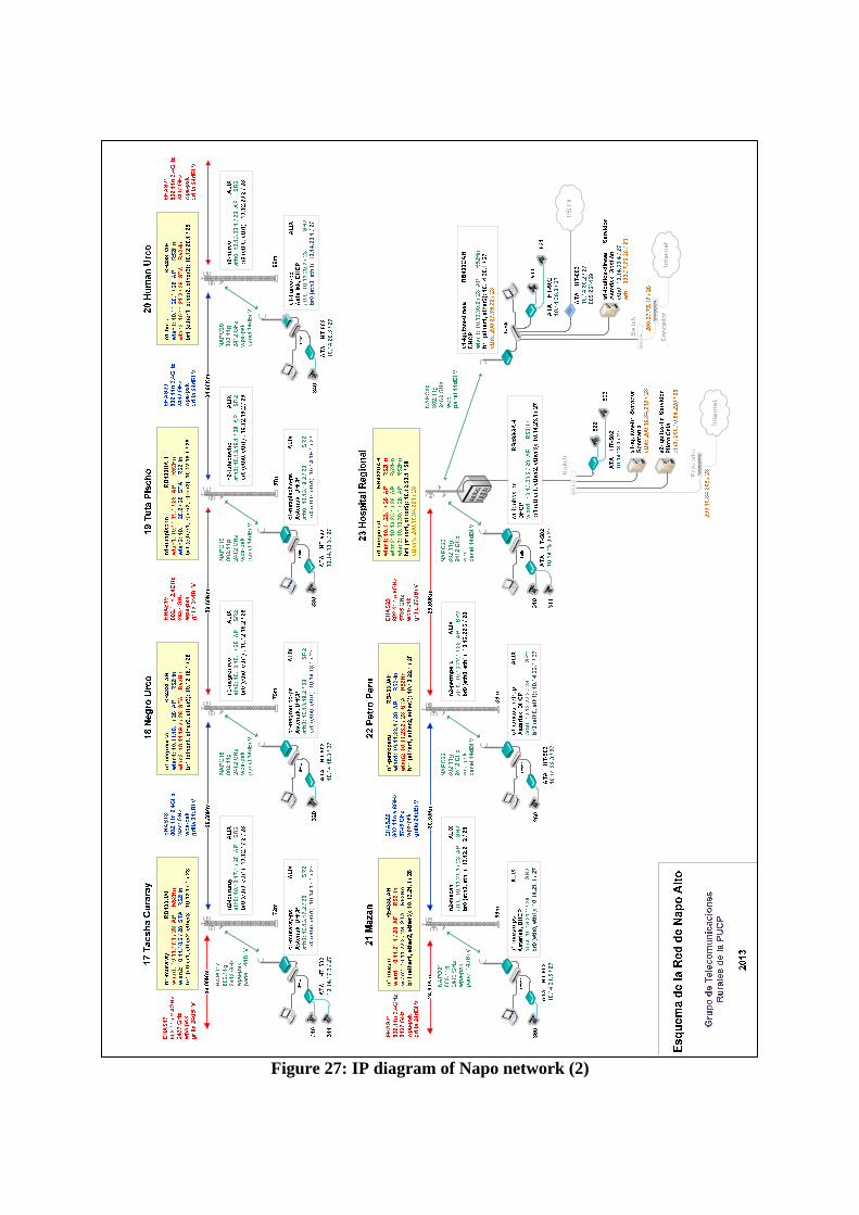
Figure 27: IP diagram of Napo network (2)

ICT-601102 STP Document number: D61 Title of deliverable: Situation report of the deployment area, sensitization results and…
TUCAN3G_D61PUCPe_.doc.doc 54
5.3.2 The current situation of Balsapuerto Wireless Network: This section shows the current situation of the Balsapuerto Network considering only the locations in where the TUCAN 3G project is going to be deployed. Additionally, it should be noted that the study is done only on the long distance radio links. The involved nodes are:
Hospital Santa Gema (HG) San Juan (SJ) Varadero (VD) Balsapuerto (BP)
Figure 28: Scheme of Balsapuerto Wireless Network
5.3.2.1 Equipment The equipment to implement the long distance links basically consists of Mikrotik equipment. The schemes of the equipment used in the repeater nodes, central node and common client node are given in figures 29; 30; 31 and 32 respectively. In addition, further details about the equipment are provided in Tables 14, 15 and 16.
Figure 29: Diagram of equipment in the Varadero node.

Figure 30: Diagram of the equipment in the San Juan node.
Figure 31: Diagram of the equipment in the Santa Gema Hospital node.
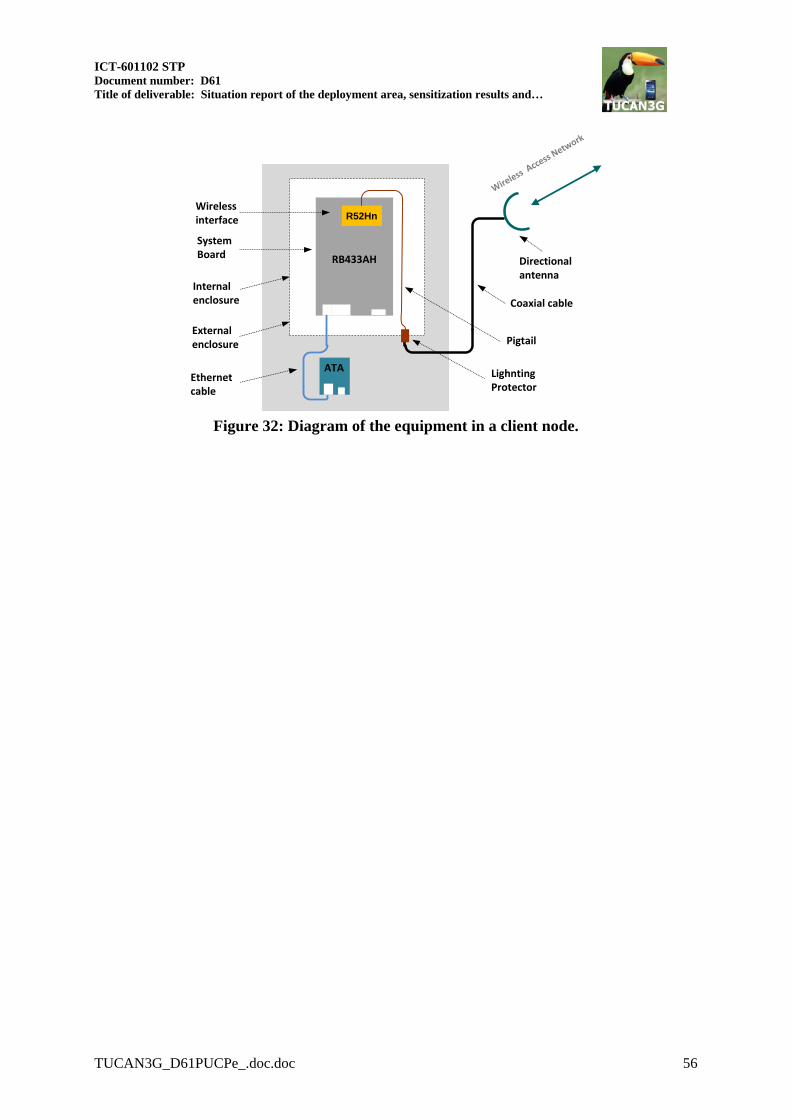
ICT-601102 STP Document number: D61 Title of deliverable: Situation report of the deployment area, sensitization results and…
TUCAN3G_D61PUCPe_.doc.doc 56
Pigtail
System Board
Wireless interface
Coaxial cable
External enclosure
Lighnting Protector
Directional antenna
Internal enclosure
R52Hn
RB433AH
Wireless A
ccess Network
Ethernet cable
ATA
Figure 32: Diagram of the equipment in a client node.

Components Trademarks
/ Models Specifications Balsapuerto Varadero
San Juan
Santa Gema
Hospital
System Board
Mikrotik / 1 2 2 1 RouterBoard
433AH
Wireless Interface
Mikrotik /
23dBm 2 3 3 2 RouterBoard /
R52Hn
Pigtail MMCX 2 4 5 3
Antenna Hyperlink Grid directional 27dBi 5.8GHz
1 1 0 0
Antenna Hyperlink
Parabolic directional 29dBi 5.8GHz dual polarity
0 1 2 1
Antenna Hyperlink Panel directional 14dBi 5.8GHz
0 1 1 0
Antenna Hyperlink Omnidirectional 11dBi 5.8GHz
1 0 0 1
Lightning Protector
Hyperlink Quarter wave 2 4 5 3
Coaxial cable
Andrew / 3m 2 4 5 3
Heliax Photovoltaic Panel
85Wp 1 2 2 0
Solar Batteries
105Ah 1 1D 1 D22 0
Solar controllers
Steca 20A 1 1 1 0
Table 14: Equipment located in the Backhaul node
22 D: Defective

ICT-601102 STP Document number: D61 Title of deliverable: Situation report of the deployment area, sensitization results and…
TUCAN3G_D61PUCPe_.doc.doc 58
Components Trademarks
/ Models Specifications
Balsapuerto Health Center
Varadero Health
Post
San Juan
Health Post
Hospital Santa Gema
System Board
Mikrotik /
1 1 1 0 RouterBoard 433AH
Wireless Interface
Mikrotik /
23dBm 1 1 1 0 RouterBoard /R52HN
Pigtail MMCX 1 1 1 0
Antenna Hyperlink Panel directional 14dBi 2.4GHz
1 1 1 0
Lightning Protector
Hyperlink Quarter wave 1 1 1 0
Switch Encore 8 ports 0 0 0 1
Ethernet Analog Telephone Adaptors
Grandstream / Handy Tone 502
2 FXS ports 1 1D 1D 1D
Analog Telephone
Panasonics 1 1D 1 1
PC User Lenovo Windows 7 1 D 1 1D 1 Laptop User DELL Windows 7 0 0 0 0 PC Health Center
1 1 1 0
VoIP Server Asterisk Server
PC Engines 0 1 0 0
ALIX 2D2
Photovoltaic Panel
85Wp 5 - 1D23 6 6 0
Solar Batteries
105Ah 5 4 - 1D 4D 0
Solar controllers
Steca 30A 1 1 1 0
Table 15: Equipment located in the Client node
23 D: Defective

Components Trademarks / Models Specifications RSAA
System Board Mikrotik / RouterBoard 433UAH
1
Wireless Interface Mikrotik / RouterBoard / R52Hn
23dBm 1
Pigtail MMCX 1
Antenna Hyperlink Panel directional 14dBi 2.4GHz
1
Lightning Protector Hyperlink Quarter wave 1 Switch Ethernet
Encore 8 ports 1
Analog Telephone Adaptors
Grandstream / Handy Tone 502
2 FXS ports 1
Analog Telephone Panasonics 1 PC User Lenovo Windows 7 1 Laptop User DELL Windows 7 0 PC Health Center 0
VoIP Server Asterisk Server PC Engines ALIX 2D2
0
Table 16: Equipment located in the access Internet node. RSAA
5.3.2.2 Configuration. The following tables show the configuration by wireless link.
Balsapuerto -
Varadero Varadero - San Juan
San Juan - Hospital Santa Gema
SSID EHAS17 BALSA7 BALSA5
Wireless technology 802.11n 802.11n 2x2 802.11n 2x2
Band / Frequency 5.8GHz / 5180GHz 5.8GHz / 5745GHz 5.8GHz / 5765GHz
Security None None None
Max. Rate Mcs-3 Mcs-8 Mcs-15 Mcs-15
Channel Width 20MHz 20MHz 20MHz
Table 17: Configuration in wireless backhaul network
Balsapuerto Varadero San Juan RSAA
SSID PUERTO17 PUERTO7 PUERTO5 PUERTO1
Wireless technology
802.11n 802.11n 802.11n 802.11a
Band / Frequency 5.8GHz / 5745GHz 5.8GHz / 5765GHz 5.8GHz / 5785GHz 5300GHz
Security WPA-PSK WPA-PSK None WPA-PSK
Max. Rate Mcs-3
Mcs-15 Mcs-3 Mcs-7 18Mbps
Channel Width 20MHz 20MHz 20MHz 20MHz
Table 18: Configuration in wireless access network

ICT-601102 STP Document number: D61 Title of deliverable: Situation report of the deployment area, sensitization results and…
TUCAN3G_D61PUCPe_.doc.doc 60
5.3.2.3 Distance, Throughput and Signal level The following tables show the distance, throughput and signal level.
Balsapuerto – Varadero Varadero – San Juan San Juan –
Hospital Santa Gema
Distance (Km) 21.26 29.50 29.60
Throughput (Mbps) 15.5 36.5 34.0
Signal level (dBm)
-74 -69 -72 -74 -62 -65
Table 19: Distance, throughput and signal level in wireless backhaul network
Balsapuerto
tower - Health Center
Varadero tower -
Health Post
San Juan tower -
Health Post
Yurimaguas tower - RSAA
Distance (Km) < 1 < 1 < 1 2
Throughput (Mbps) 24.0 2.4 46.0 13.0
Signal level (dBm) -57 -64 -90 -89 -40 -40 -79 -70
Table 20: Throughput and signal level in wireless access network
Throughput obtained between Balsapuerto health post and RSAA was 12.7 Mbps.

5.3.2.4 IP addressing scheme of Balsapuerto Network
IP addressing scheme of Balsapuerto network is given in following figures:
Figure 33: IP diagram of Balsapuerto network

ICT-601102 STP Document number: D61 Title of deliverable: Situation report of the deployment area, sensitization results and…
TUCAN3G_D61PUCPe_.doc.doc 62
5.4 Proposal for Adaptation of the target Networks
5.4.1 Napo Network
As explained in D21 “Socio-economic scenarios, technical specifications and architecture for the proof of concept”, the Napo Network is currently saturated and there is no more bandwidth available. Therefore, a network enhancement and upgrade is required. In the same deliverable, a basic network enhancement proposal was presented for the Napo network. This section will provide deeper analysis on the advantages and the disadvantages of this proposal. The two main options to solve the saturated network problem are the following: 1) to upgrade the communication equipment and install a modern technology capable of providing a higher bandwidth, or 2) to deploy a completely new parallel network and keep the current one untouched. Advantages of the parallel deployment versus the equipment upgrading:
The parallel deployment does not interfere with the current use of the Napo network, which is being used in a very intense way for health care purposes.
It allows to do test with a heterogeneous network combining WiLD and WiMAX technologies, On the other hand, the equipment upgrading would let to use only of WILD
As it is used for the healthcare purposes, it should be very stable and reliable. Acceptance tests and protocols used in TUCAN3G should be very strict in order to avoid serious interferences in the network performance in case of not using the parallel deployment. This would make experiments more complex.
Mixing the traffic of the health network with the TUCAN3G traffic (while guaranteeing the quality of both services) would require a complex managing system in order to correctly operate with both types of traffic. Moreover, TUCAN3G is going to work in a small segment of the network but not in the whole network. In this case, performing TUCAN3G tests in the equipment upgrading option would require to change the routing configuration of the whole network to manage these traffics together.
TUCAN3G is a research project, and mixing it with an operative healthcare network might create a risk on the operation of the health services.
Disadvantages of a parallel deployment versus an equipment upgrading:
It is more expensive to install a parallel network because it requires deploying autonomous power systems (based on solar energy and batteries), antennas, outdoor cases, etc.
A more rigorous design is needed in order to avoid radio interferences between both networks. A scenario with other traffic sources would be more complex and would also provide more
interesting results. Considering the comparison of these two options, their advantages and disadvantages, deploying a parallel network seems the most suitable option in this case as the proposal in D21.

5.4.2 Balsapuerto Network
The options to enhance the Balsapuerto Network are basically the same two options explained for the Napo Network case. The list of advantages and disadvantages of both options is also quite similar. However, it is important to highlight some differences:
As explained in D21, Balsapuerto network has enough available bandwidth because it uses modern IEEE 802.11n devices. Therefore upgrading the equipment is not required and the cost of this option would be smaller than the implementation of a parallel network. However it is necessary to enhance the photovoltaic energy system on Varadero and San Juan, because there is just one autonomy day. A trip to maintain the equipment and improve the configuration would still be necessary.
Currently, Balsapuerto network use is not as critical as the Napo network use, so the consequences of a failure would be far less critical.
In this case of Balsapuerto, the whole network is going to be used as it is smaller than Napo network. It has only 4 nodes, where Napo Network has 15 nodes in total.
Test with WiFi-WiMAX backhaul technologies will be performed in Napo Networks, so in this case a sole technology can be selected.
It would be very interesting to try TUCAN3G solutions in a network with other sources of real traffic (different from 3G traffic). Besides, deploying parallel networks in both cases would imply a high cost that was not considered in the project budget. Considering all this information, reinforcing the existing network in Balsapuerto would be highly recommended to compensate the disadvantages of installing a parallel network in the Napo River. To interconnect the femtocells backhaul to operator´s core network through Yurimaguas, there are two options:
i. Link from repeater situated in the Hospital Santa Gema to Telefonica central office in Yurimaguas. In this case we need a short distance point to point link.
ii. Link from San Juan repeater to Telefonica repeater situated in La Loma (Yurimaguas). In this case we need a long distance point to point link from San Juan to La Loma (in Yurimaguas). The advantage of establishing a link directly from San Juan repeater to the core network in Yurimaguas is to reduce the traffic interference from the Hospital. Also the energy system in repeater La Loma is more reliable (they have backup energy systems).
The final option will be decided with the operator. Finally, it is necessary to be noted that Yurimaguas city is connected to the national network of Telefonica del Peru by a fiber optic link. This will allow "direct" interconnection between the femtocell controller with the femtocells to be installed in Varadero San Gabriel and San Juan. As noted above, in the Napo River Basin does not exist this type of connectivity so the only alternative is the use of a VSAT satellite system, being precisely this diversity of conditions that were proposed to test all the technologies backhaul specified in the initial project proposal.

ICT-601102 STP Document number: D61 Title of deliverable: Situation report of the deployment area, sensitization results and…
TUCAN3G_D61PUCPe_.doc.doc 64
6 CONCLUSIONS Based on the indicated in this document, it is possible to establish the following conclusions:
The telecommunication platforms for the basin of Napo River and the county of Balsapuerto are operative and available for the deployment of the TUCAN 3G project. However, it is necessary to perform a series of activities to improve the performance of these networks or to adapt for the purpose of the project. These enhancements and modifications are already defined generally and will be presented in further documents with details.
There is great interest on the part of the people and institutions in these communities, to use
telecommunication services such as mobile telephony and Internet access and in some cases, communities have sent formal requests to operators.
In relation to public administration, the greatest need for communication is of public employees who work in the health and education sectors.
The sensitization plan has been achieved in the beneficiary communities with positive and
encouraging results. The documents required to support the deployment and acceptance of the TUCAN 3G project has been obtained due to the high positive expectations of the population on the results of the project.
7 ANNEXES Annex I: Official Communication sent to Telefonica, San Gabriel de Varadero. Annex II: List of participants, San Gabriel de Varadero. Annex III: List of participants San Juan. Annex IV: Favorable Opinion for usage of the land, Tuta Pishco. Annex V: Favorable Opinion for usage of the land, Negro Urco. Annex VI: List of participants, Santa Clotilde; Negro Urco and Tuta Pishco Annex VII: Favorable opinion for usage of the land in Santa Clotilde, signed by the Bishop. Annex VIII: Favorable opinion from Alto Amazonas Health Network (RSAA) Annex IX: Favorable opinion from Regional Government of Loreto, National Direction of Health (DIRESA) Annex X: Favorable opinion from Regional Government of Loreto (GOREL)

ICT-601102 STP Document number: D61 Title of deliverable: Situation report of the deployment area, sensitization results and…
TUCAN3G_D61PUCPe_.doc.doc 66
Annex I: Favorable Opinion for usage of the land, Tuta Pishco.

Annex II: Favorable Opinion for usage of the land, Negro Urco.

ICT-601102 STP Document number: D61 Title of deliverable: Situation report of the deployment area, sensitization results and…
TUCAN3G_D61PUCPe_.doc.doc 68
Annex III: List of participants, Santa Clotilde; Negro Urco and Tuta Pishco


ICT-601102 STP Document number: D61 Title of deliverable: Situation report of the deployment area, sensitization results and…
TUCAN3G_D61PUCPe_.doc.doc 70
Annex IV: Favorable opinion for usage of the land in Santa Clotilde, signed by the Bishop.

Annex V: Official Communication sent to Telefonica, San Gabriel de Varadero

ICT-601102 STP Document number: D61 Title of deliverable: Situation report of the deployment area, sensitization results and…
TUCAN3G_D61PUCPe_.doc.doc 72
Annex VI: List of participants, San Gabriel de Varadero.
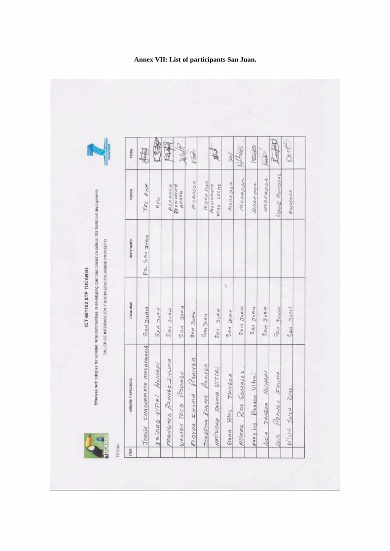
Annex VII: List of participants San Juan.

ICT-601102 STP Document number: D61 Title of deliverable: Situation report of the deployment area, sensitization results and…
TUCAN3G_D61PUCPe_.doc.doc 74
Annex VIII: Favorable opinion from Alto Amazonas Health Network (RSAA)

Annex IX: Favorable opinion from Regional Government of Loreto, National Direction of Health (DIRESA)

ICT-601102 STP Document number: D61 Title of deliverable: Situation report of the deployment area, sensitization results and…
TUCAN3G_D61PUCPe_.doc.doc 76
Annex X: Favorable opinion from Regional Government of Loreto (GOREL)