working group on the effects of extraction of marine
TRANSCRIPT
International Council for the Exploration of the Sea
Conseil International pour l�Exploration de la Mer
Palægade 2�4 DK�1261 Copenhagen K Denmark
Marine Habitat Committee ICES CM 2001/E:06 Ref.: ACME
REPORT OF THE
WORKING GROUP ON THE EFFECTS OF EXTRACTION OF MARINE SEDIMENTS ON THE MARINE ECOSYSTEM
Stromness, Orkney, Scotland 3–6 April 2001
This report is not to be quoted without prior consultation with the General Secretary. The document is a report of an expert group under the auspices of the International Council for the Exploration of the Sea and does not necessarily represent the views of the Council.


TABLE OF CONTENTS
Section Page
i
1 INTRODUCTION......................................................................................................................................................1 2 TERMS OF REFERENCE .........................................................................................................................................1
2.1 Supporting Information ...................................................................................................................................2 2.2 Relation to Strategic Plan ................................................................................................................................3
3 REVIEW OF NATIONAL MARINE AGGREGATE EXTRACTION ACTIVITIES..............................................3 3.1 Belgium ...........................................................................................................................................................4 3.2 Canada.............................................................................................................................................................5 3.3 Denmark ..........................................................................................................................................................6 3.4 Finland.............................................................................................................................................................7 3.5 France ..............................................................................................................................................................8
3.5.1 Current licence position in France - Summary..................................................................................8 3.6 Germany ..........................................................................................................................................................9
3.6.1 Current licence position in Germany - Summary ............................................................................10 3.7 Ireland............................................................................................................................................................10
3.7.1 Summary of current licence position and forecasts for future exploitation of marine aggregates...11 3.8 The Netherlands ............................................................................................................................................11
3.8.1 Sand extraction in 2000...................................................................................................................11 3.8.2 Gravel extraction 2000 ....................................................................................................................12 3.8.3 Shell extraction 1999.......................................................................................................................12
3.9 Norway ..........................................................................................................................................................13 3.10 Poland............................................................................................................................................................13 3.11 Sweden ..........................................................................................................................................................15 3.12 United Kingdom............................................................................................................................................15 3.13 United States of America...............................................................................................................................18
4 REVIEW OF NATIONAL SEABED RESOURCE MAPPING PROGRAMMES .................................................18 4.1 Belgium .........................................................................................................................................................18 4.2 Canada...........................................................................................................................................................19 4.3 Denmark ........................................................................................................................................................19 4.4 Finland...........................................................................................................................................................21
4.4.1 References .......................................................................................................................................21 4.5 France ............................................................................................................................................................21
4.5.1 Surficial seabed maps published in 2000 ........................................................................................21 4.6 Germany ........................................................................................................................................................22
4.6.1 Seabed resource maps published in 2000........................................................................................22 4.6.2 Future marine resource mapping programmes ................................................................................22
4.7 Ireland............................................................................................................................................................22 4.7.1 Future marine resource mapping programmes ................................................................................22
4.8 The Netherlands ............................................................................................................................................24 4.8.1 1:250,000 geological reconnaissance map series ............................................................................24 4.8.2 1:100,000 geology and resource map series ....................................................................................25 4.8.3 Status of published seabed resource maps in 2000/2001.................................................................27 4.8.4 Future marine resource mapping programmes ................................................................................27 4.8.5 Applied and other geological investigations in 2000 ......................................................................27
4.9 Norway ..........................................................................................................................................................28 4.10 Sweden ..........................................................................................................................................................28 4.11 United States of America...............................................................................................................................29 4.12 European Meta-databases ..............................................................................................................................29
5 REVIEW OF DEVELOPMENTS IN NATIONAL AUTHORISATION AND ADMINISTRATIVE FRAMEWORK AND PROCEDURES....................................................................................................................30 5.1 Canada...........................................................................................................................................................30 5.2 Denmark ........................................................................................................................................................30 5.3 France ............................................................................................................................................................31 5.4 Germany ........................................................................................................................................................32 5.5 Ireland............................................................................................................................................................32 5.6 The Netherlands ............................................................................................................................................32
5.6.1 References .......................................................................................................................................33 5.7 United Kingdom............................................................................................................................................33
5.7.1 Draft policy guidance on aggregate extraction from English waters...............................................33 5.8 United States of America...............................................................................................................................33

2001 WGEXT Report ii
6 REVIEW OF APPROACHES TO ENVIRONMENTAL IMPACT ASSESSMENT AND RELATED ENVIRONMENTAL RESEARCH..........................................................................................................................34 6.1 Canada...........................................................................................................................................................34 6.2 Denmark ........................................................................................................................................................35
6.2.1 Recent environmental impact studies ..............................................................................................35 6.2.1.1 Øresund Link..................................................................................................................35 6.2.1.2 The Harbour of Århus ....................................................................................................35 6.2.1.3 Stigsnæs..........................................................................................................................35 6.2.1.4 North Sea........................................................................................................................36 6.2.1.5 Marine windmill parks ...................................................................................................36
6.2.2 Research projects.............................................................................................................................36 6.2.2.1 Emissions from dredgers ................................................................................................36 6.2.2.2 Statistics .........................................................................................................................36 6.2.2.3 Impact from dredge spill on benthos ..............................................................................36 6.2.2.4 Environmental effects of dredging in the North Sea ......................................................36 6.2.2.5 Autonomous Underwater Vehicle (AUV) ......................................................................37 6.2.2.6 References ......................................................................................................................37
6.3 France ............................................................................................................................................................38 6.3.1 Recent environmental impact studies ..............................................................................................38 6.3.2 Research projects.............................................................................................................................38
6.3.2.1 Dieppe regional project ..................................................................................................38 6.3.2.2 Proposed European project on �impact on fisheries of large scale extraction projects�.38
6.4 Germany ........................................................................................................................................................39 6.4.1 Regeneration of sediment extraction sites in the North and Baltic Seas .........................................39
6.5 Ireland............................................................................................................................................................39 6.6 The Netherlands ............................................................................................................................................39
6.6.1 Research projects.............................................................................................................................40 6.6.1.1 Physical effects of large-scale sand extraction ...............................................................40 6.6.1.2 PUTMOR Project. Physical monitoring of a deep sand extraction pit ...........................40 6.6.1.3 Ecomorphodynamics of the North Sea ...........................................................................40 6.6.1.4 Flyland programme ........................................................................................................40 6.6.1.5 Questionnaire on large-scale dredging ...........................................................................40 6.6.1.6 Ecotope mapping............................................................................................................40 6.6.1.7 PUNAISE 3 ....................................................................................................................40
6.6.2 References .......................................................................................................................................41 6.7 United Kingdom............................................................................................................................................41
6.7.1 Inshore seabed characterisation in the inshore zone � Thames Estuary ..........................................41 6.7.2 Assessment of rehabilitation of the seabed following marine aggregate dredging..........................41 6.7.3 Procedural guidelines for the conduct of benthic studies at aggregate dredging sites.....................42 6.7.4 Scoping the assessment of sediment plumes from dredging ...........................................................42 6.7.5 Southern North Sea Sediment Transport Study Phase 2 .................................................................42 6.7.6 Marine Life Information Network (MarLIN)..................................................................................42
6.8 Cumulative Impact Studies............................................................................................................................42 6.9 Mapping of Gravel Biotopes and an Examination of the Factors Controlling the Distribution, Type and
Diversity of Their Biological Communities ..................................................................................................43 6.9.1 Broadscale mapping � development of techniques .........................................................................43
7 REVIEW OF THE PRODUCTION OF NATIONAL REPORTS AND THE DEVELOPMENT OF A MORE STANDARDISED FORMAT ..................................................................................................................................43
8 DRAFT ICES GUIDELINES FOR THE MANAGEMENT OF MARINE SEDIMENT EXTRACTION..............44 8.1 References .....................................................................................................................................................44
9 DEVELOPMENT OF CRITERIA FOR THE SELECTION, DESIGN AND OPERATION OF TEST RANGES IN OFFSHORE AREAS...........................................................................................................................................44 9.1 Regional Geologic Synthesis of the United States Coastal and Marine Areas: Designing a Template
Workshop ......................................................................................................................................................44 9.2 Discussion on the Use of Acoustic Ground Discrimination Systems (AGDS) .............................................45
9.2.1 Summary of the initial working group report to the meeting ..........................................................45 9.2.2 White board points for discussion around the table.........................................................................46 9.2.3 Summary of the around table discussions with respect to the points made above ..........................46 9.2.4 A summary of recommendations reached from this discussion were: ............................................47
9.3 AGDS: The Need for Test Ranges ................................................................................................................47

Section Page
iii
9.4 Acoustic Seabed Survey Techniques For Monitoring Marine Sacs: A Trial Of Three Systems � October 2000...............................................................................................................................................................48 9.4.1 Summary .........................................................................................................................................48
10 METHODS TO ASSESS LOCALISED IMPACTS OF AGGREGATE EXTRACTION ON FISHERIES AND THE MEANS TO ADEQUATELY PROTECT HERRING SPAWNING AREAS IN THE VICINITY OF EXTRACTION OPERATIONS...............................................................................................................................48
11 REVIEW OF REFERENCE SITE DATA SETS USED IN THE MONITORING OF, AND IN RESEARCH ON, THE EFFECTS OF AGGREGATE EXTRACTION ...............................................................................................49
12 REVIEW CONCLUSIONS DRAWN FROM THE MONITORING OF THE ØRESUND FIXED LINK.............49 12.1 Background ...................................................................................................................................................49 12.2 Conclusions ...................................................................................................................................................50 12.3 References .....................................................................................................................................................50
13 CONTRIBUTE TO THE VERIFICATION OF THE EUNIS CLASSIFICATION, TOGETHER WITH SGMHM AND BEWG.............................................................................................................................................................51
14 REVIEW OF THE OUTCOME OF THE WORKSHOP ON DEEP-SEABED SURVEY TECHNOLOGIES (WKDSST) ...............................................................................................................................................................51
15 RECOMMENDATIONS AND DRAFT COUNCIL RESOLUTIONS ...................................................................51 15.1 Future Meeting of WGEXT...........................................................................................................................51
16 CLOSE OF MEETING.............................................................................................................................................53 ANNEX 1: LIST OF CONTRIBUTORS TO THE 2001REPORT ..................................................................................54 ANNEX 2: DRAFT ICES GUIDELINES FOR THE MANAGEMENT OF MARINE SEDIMENT EXTRACTION ...59 ANNEX 3: USING GIS TO ASSESS THE REGIONAL SENSITIVITY OF FISHERIES TO HUMAN IMPACT ......66 ANNEX 4: AN OVERVIEW OF THE CONTINENTAL SHELF MAPPING AND MONITORING PROJECT
DEVELOPED BY THE FUND FOR SAND EXTRACTION, ADMINISTRATION QUALITY AND SAFETY, MINISTRY OF ECONOMIC AFFAIRS .................................................................................................................70
ANNEX 5: HIGH-RESOLUTION MAPPING OF SEABED BIOTOPES IN UK COASTAL WATERS......................76 @#


2001 WGEXT Report 1
1 INTRODUCTION
The Working Group on the Effects of Extraction of Marine Sediments on the Marine Ecosystem (WGEXT) was welcomed to Stromness by Professor Jon Side. Prof. Jon Side (Chair) then duly opened the 2001 meeting and the terms of reference (see below) were adopted. Dr Siân Boyd was appointed as Rapporteur for the meeting. Prof. Side provided feedback to the Group on the 2000 ICES Annual Science Conference. The scientific paper produced by WGEXT and presented by Dr Andrew Kenny was well received during Theme Session T.
It was also noted that there had been no progress with the publication of the ICES Cooperative Research Report �Report on the effects of extraction of marine sediments on the marine ecosystem�. The Working Group asked that the annual report makes specific reference to its dismay at the continued delays to the publication of this report. They expressed particular concern that the information in the report is becoming increasingly out of date significantly reducing its usefulness. To expedite publication, the Working Group recommended that the report be made available at the earliest opportunity on the WGEXT web site.
Prof. Side thanked WGEXT members for providing their national reports in advance of the meeting.
A number of regular contributors to the annual meeting had sent apologies for not attending. These included Professor H. Bokuniewicz (USA), Dr Szymon Uscinowicz and Dr Eugeniusz Andrulewicz (Poland), Dr John Breslin and Dr John Costello (Ireland), Dr Claude Augris (France), Dr Karel Essink and Dr Bas de Groot (The Netherlands), Dr Andrew Kenny (United Kingdom), Dr Dag Ottesen (Norway), and Dr Heiko Leuchs (Germany). Participants and contributors are listed in Annex 1.
2 TERMS OF REFERENCE
The terms of reference were adopted as ICES C. Res. 2001/2E07.
The Working Group on the Effects of Extraction of Marine Sediments on the Marine Ecosystem [WGEXT] (Chair for 2001 Meeting: Prof. J. Side, UK) will meet in Copenhagen, Denmark1 from 3�6 April 2001 to:
a) review data on marine extraction activities, developments in marine resource mapping, information on changes to the legal regime (and associated environmental impact assessment requirements) governing marine aggregate extraction, and review scientific programmes and research projects relevant to the assessment of environmental effects of the extraction of marine sediments;
b) review the production of national reports and consider the development of a more standardised format so that a full picture of the total amounts extracted in each Member Country can be obtained; consider also whether a means of storing this information electronically is needed;
c) continue work (taking into account relevant work under and requirements of OSPAR and HELCOM) on the updating of: i) the ICES Code of Practice for the Commercial Extraction of Marine Sediments (including minerals and
aggregates), produced in 1992, ii) guidelines for the preparation of an Environmental Impact Assessment evaluating the effects of seabed
aggregate extraction on the marine environment, including as appropriate guidelines on monitoring and standardised procedures, reviewed most recently in 1998 for inclusion in the forthcoming ICES Cooperative Research Report. In taking forward the production of draft ICES guidelines, WGEXT will review draft guidelines tabled at the last meeting by the UK, Denmark and, once available, Belgium (to be circulated), HELCOM work and other guidelines being developed by other ICES Members Countries. WGEXT will endeavour to produce a draft set of revised ICES guidelines at this meeting;
d) commence work on developing criteria for the selection, design, and operation of a series of test ranges in offshore areas in order to:
i) assess the capability of Acoustic Ground Discrimination Systems (AGDS) for detecting and delineating biological communities,
1 Note from ICES Secretariat: The Council Resolution stated that the meeting was to be held in Copenhagen, but owing to lack of communication it was ultimately held in Stromness, Orkney, Scotland.

2001 WGEXT Report 2
ii) compare and contrast the relative resolution and capability of AGDS with conventional side-scan sonar, multi-beam and high resolution seismic reflection methods,
iii) determine the relative resolution and operational parameters of AGDS and conventional mapping systems in a variety of water depths and substrate types, primarily focusing on habitats relevant to aggregate extraction activity,
iv) determine the need for testing/intercalibration ranges in ICES Member Countries taking into account the role of the manufacturers in testing their equipment;
e) examine the methods that might be used to assess localised impacts from aggregate extraction on fisheries, and the means to adequately protect known herring spawning beds in the vicinity of extraction operations;
f) undertake a review of reference site data sets used in the monitoring of, and research on, the effects of aggregate extraction in order to establish their usefulness in determining the degree of natural variability in biotopes;
g) review conclusions drawn from the completion of biological monitoring of the Øresund fixed link with a view to applying this knowledge to other large-scale extraction projects;
h) contribute to the verification of the EUNIS classification, together with SGMHM and BEWG; i) review the outcome of the Workshop on Deep-Seabed Survey Technologies.
2.1 Supporting Information
Priority:
The current activities of WGEXT are concerned with developing the understanding necessary to ensure that marine sand and gravel extraction is managed in a sustainable manner, and that any ecosystem effects of this activity are better understood so that mitigative measures can be adopted where appropriate. These activities are considered to have a very high priority.
Scientific Justification:
a) An increasing number of ICES Member Countries undertake sand and gravel extraction activities, while others are looking at the potential for future exploitation, e.g., Ireland and Canada. Each year WGEXT reviews relevant developments under these headings and includes a summary of them in its report. This provides a forum for information exchange. In order to maximise time spent discussing other topics, this is conducted in advance and circulated as a draft prior to the meeting. National reports to be provided electronically no later than 16 March 2001.
b) This is a request from ACME following its review of the 2000 WGEXT report during which it was noted that incomplete information on extraction activities was provided for some Member Countries. The ACME would like WGEXT to provide more complete information.
c) This is a response by WGEXT to a number of recent requests and the recognition that these documents should take into account Annex V of the 1992 (OSPAR) Convention on the Protection of the Marine Environment of the North-East Atlantic, and other developments, for example, in strategic environmental assessment.
d) WGEXT has been reviewing new technologies and techniques for the study of seabed sediments and benthic habitats in relation to its core focus on marine sediment extraction. While it has an interest in marine habitat classification and mapping more generally, this work is concentrating on scientific applications to assessment of environmental effects (and determination of vulnerable habitats) associated with marine sediment extraction. Discussions at WGEXT 2000 identified that several countries are conducting studies to establish the scope and limitations of AGDS in comparison with more conventional acoustic techniques. This would be a timely review of a rapidly developing subject.
e) While in recent years much effort has been directed to the observation of effects on the marine benthos, WGEXT has on several occasions examined effects at higher trophic levels and on fisheries. Discussion at WGEXT 2000 focused on identifying means to identify herring spawning habitats. However during the meeting the means to adequately protect such habitats from localised effects of aggregate extraction was raised as a subject worthy of further attention. Additionally, there were several requests to examine the methodologies used to assess localised impacts of extraction operations on fisheries more generally.
f) Many monitoring studies and research projects being conducted by ICES Member Countries have been undertaken to identify the impacts of sand and gravel extraction on the seabed. The reference site data from these studies in some cases show little variation year on year, in other cases significant changes have been detected. These data

2001 WGEXT Report 3
may be useful in assessing natural variability in some marine biotopes, and hence in the design of future environmental monitoring programmes for marine sediment extraction.
g) The completion of biological monitoring on this project enables a critical review of such data in relation to other proposed large-scale extraction projects. Reports were not available to WGEXT 2000 but will be published very shortly and hence WGEXT wishes to carry this term of reference over to its next meeting.
h) This is in order to have as broad a review of the EUNIS classification as possible.
2.2 Relation to Strategic Plan
The principal focus of WGEXT work is in relation to Objective 2(c), but other terms of reference also relate to Objectives 1(a),1(c),1(e), and 4(a).
Resource Requirements:
Most countries routinely collect data and information on their extraction activities which will be collated and contribute to term of reference a).
The UK and Denmark have recently developed guidelines and Belgium is currently developing guidelines (to be circulated in advance of the meeting). Resources have already been committed to develop such guidelines. The research programmes that provide the main input to term of reference d) are currently under way and resources already committed.
Participants:
WGEXT is normally attended by 20�25 members and guests.
Secretariat Facilities:
ICIT at Heriot-Watt University for the meeting
Financial:
No additional financial implications.
Linkages to Advisory Committees:
ACME
Linkages to other Committees or Groups:
BEWG, SGMHM
Linkages to other Organisations:
Work is of direct interest to OSPAR and HELCOM.

2001 WGEXT Report 4
3 REVIEW OF NATIONAL MARINE AGGREGATE EXTRACTION ACTIVITIES
A detailed breakdown of each country�s dredging activities is provided below.
3.1 Belgium
Marine aggregate (sand and gravel) extraction figures for Belgium in 2000:
Dredging area Amount (m³)
Zone 1 and 2 (see map) 1,901,000
In 2000 a total of 1,901,000 m³ of sand was extracted, predominantly from extraction zone 2 on the Belgian continental shelf and, from the end of 2000, from extraction zone 1. This is an increase of approximately 12% from 1999. Sixteen licensees are currently involved, with a total licensed amount of 6,350,000 m³. As in previous years, most of the sand was extracted from the northern part of the Kwintebank. Three further applications are under consideration. Note that until the end of 2000, only zone 2 was licensed.
Amount of material extracted for beach replenishment projects for 2000:
Dredging area Material Amount (m³) Beach
De Poortjes (Access channel to port of Oostende
sand 260,000 De Haan
Zone 1
Zone 2

2001 WGEXT Report 5
Figure 3.1. Marine aggregate extraction in Belgian waters between 1979 and 2000.
Historic patterns of maintenance dredging for beach replenishment projects:
Dredging area Material Amount (m³) Year
De Haan � central sand 794,000 1992
De Haan � west sand 1,440,000 1994�1995
De Haan � east sand 1,002,000 1996
Blankenberge sand 486,000 1998�1999
Knokke sand 486,500 1999
De Poortjes sand 260,000 2000
Historic patterns of material extracted from offshore banks used for beach nourishment:
Dredging area Material Amount (m³) Year
De Haan � central sand 662,000 1991�1992
De Haan � west sand 649,000 1993�1995
De Haan � east sand 471,500 1996�1998
De Haan sand 95,000 1998�1999
3.2 Canada
The extraction of marine minerals does not take place in the Canadian offshore. The Canadian federal government, under the leadership of Natural Resources Canada, continues to move forward in assessing the potential for the development of a framework to permit and control marine mining through a project termed OMMI (Offshore Minerals Management Initiative) which began in 1998. The Provinces of British Columbia, Nova Scotia and Newfoundland continue to express a strong interest in furthering this activity. Government advisory groups have been established and meetings have been conducted on the east and west coasts of Canada. Documents have been prepared on the socio-
Amount ( 106 m³)
0
0.5
1
1.5
2
2.5
3
3.5
4
4.5
1979
1980
1981
1982
1983
1984
1985
1986
1987
1988
1989
1990
1991
1992
1993
1994
1995
1996
1997
1998
1999
2000

2001 WGEXT Report 6
economic implications, technological assessment, a public consultation and communication strategy, and a strategic environmental assessment.
Consultations are planned with focus groups in the late spring to early summer of 2001. These will be conducted through web-based technologies and designed to receive feedback on risks and opportunities associated with marine mining. Factual background information on environmental, socio-economic and technical resource aspects will be made available to assist participants in discussions.
The marine mineral extraction industry continues to express interest in mining for offshore placers and aggregates, but the absence of a legislative framework remains as a deterrent to further investment and investigation. Preliminary marine mineral assessment projects have been completed for areas off the east coast of Canada on the Scotian Shelf and Grand Banks of Newfoundland which have identified potential resources. These have been co-sponsored by the federal government and the provincial governments of Nova Scotia and Newfoundland.
3.3 Denmark
The extraction of marine sand and gravel represents 10�20 % of the total production of materials for construction and reclamation.
Figure 3.3.1. Production of sand and gravel 1978 � 2000. *The figures from 2000 are preliminary.
The production of construction aggregates has remained stable over the last 5 years. However, the production of coarse aggregates has been decreasing slightly. The dredging of sand fill for land reclamation has increased markedly over the last 10 years to meet the demand from several large construction works in coastal areas (Figure 3.3.1).
Between 1989 and 1993 more than 9 Mm3 of sand fill and till were dredged for the construction of the Great Belt Bridge and tunnel project.
0
2000000
4000000
6000000
8000000
10000000
12000000
1978
1979
1980
1981
1982
1983
1984
1985
1986
1987
1988
1989
1990
1991
1992
1993
1994
1995
1996
1997
1998
1999
*200
0
m³
Sand Fine Gravel Coarse Gravel Sand fill Misc.

2001 WGEXT Report 7
During the construction of the fixed link between Denmark and Sweden 1.3 M m³ were dredged, with losses from the dredger spillways of only 2.8 %. In the same period, 7 M m³ dredged materials of glacial till and limestone were reused for reclamation and as hydraulic fill in ramps for the bridge and tunnel.
A major enlargement of the harbour of Århus required more than 8 Mm³ of sand fill. The construction works started in the autumn of 1998 and were completed in 2000. A total of 8 Mm³ were dredged from two areas in Århus Bight. The spill from the dredging operations was 3.7 %.
The consumption of sand for beach nourishment at the West Coast of Jutland increased significantly from 40,000 m³ in 1980 to more than 3.5 Mm³ in 1998 (Figure 3.3.2). Consumption in the coming years is forecast to be 2.5 Mm³/year.
Figure 3.3.2 Production of sand for beach nourishment and reclamation. *The figures from 2000 are preliminary.
No detailed forecast for the future extraction of sand has been prepared. In general, it can be noted that the extraction varies in line with the development of the national economy. Several major construction works have increased the demand for sand fill considerably since 1995. These projects finished during 2000 and the demand is expected to decrease. However, a further enlargement of the Århus Harbour is expected to take place from 2002 and will require up to 7 Mm³ of sand fill. A project for the construction of a major container terminal near Stigsnæs, southern Sjælland, is in preparation. The project will require 5.5 Mm³ of sand fill from areas in the vicinity of the construction area. The construction start is waiting the necessary financing.
It is expected that the total marine extraction of construction aggregates will remain at the current level over the next 5 years, perhaps with a slight decrease in the dredging of coarse aggregates due to an expected slow decline in the construction industry.
3.4 Finland
Sand and gravel extraction from Finnish coastal areas has been negligible in recent years. Since 1996 no major marine sand or gravel extraction activities have been reported. However, the Harbour of Helsinki has permission from the Water Rights Court to extract 8 million m3 of gravel off Helsinki for harbour construction purposes but the extraction has not yet started. The Forest and Park Service, manager of State-owned sea areas, has applied for permission to extract sand off Helsinki for another 8 million m3. The Environmental Impact Assessment of this application is under
0
1000000
2000000
3000000
4000000
5000000
6000000
7000000
8000000
1978
1979
1980
1981
1982
1983
1984
1985
1986
1987
1988
1989
1990
1991
1992
1993
1994
1995
1996
1997
1998
1999
*200
0
m³
Beach Nourishment Reclamation

2001 WGEXT Report 8
way. The Forest and Park Service, in cooperation with the Geological Survey of Finland, has surveyed six other possible areas for future use.
3.5 France
Marine aggregate extraction (sand and gravel) figures for France in 2000:
Dredging area Amount
Normandy 444,000 m3
Britanny 38,000 m3
Atlantic coast 1,945,000 m3
Total 2,427,000 m3
Siliceous aggregate : 1.6 t m-3
The amount of aggregate extraction has remained stable in France for many years.
For the period 1991�1998, the production (excluding maintenance dredging of navigation channels) was (in Mm3):
Year 1991 1992 1993 1994 1995 1996 1997 1998
2 1.9 1.9 2.5 2.5 2.3 2.6 2.6
(Data: National Organisation of Aggregates Industries)
Shell and maerl extraction in France in 2000:
Dredging area Material Amount
North Britanny maerl 215,000 m3
North Britanny shelly sands 143,000 m3
West Britanny maerl 2,700 m3
West Britanny shelly sands 26,700 m3
South Britanny maerl 82,000 m3
total 469,400 m3
Note that for calcareous aggregate a conversion rate of 1.3 t m-3 has been used.
3.5.1 Current licence position in France - Summary
� 12 sites are currently being exploited; � 2 licences for exploitation are under consideration; � 2 licences for research purposes are under consideration.

2001 WGEXT Report 9
3.6 Germany
Marine aggregate extraction (sand and gravel) figures for Germany in 2000:
Dredging area Amount
North Sea 1,673,723 m³
Baltic Sea 1,296,986 m³
Amount of material extracted in Germany for beach replenishment projects in 2000:
Dredging area MateriaL Amount
Westerland II Sand 1,673,723 m³
Baltic Sea Sand 1,110,719 m³
Historic patterns of marine aggregate extraction in Germany (in Mm3):
Extraction Area 1990 1991 1992 1993 1994 1995 1996 1997 1998 1999 2000 Total 1990–2000
NORTH SEA
Westerland II 2.456 2.017 2.082 1.370 0 1.013 1.111 0.581 0 0.706 1.674 13.010
Salzsand 0 0 0 0.840 0 0.536 0 1.376
Theeknobssand 1.020 0 0 0 0 0 0 1.020
Europipe 1 8.808 8.808
BALTIC SEA
Landtief 0 0 0.002 0.111 0.112 0 0.225
Tromper Wiek 1 0 0 0.003 0.007 0.007 0.086 0.030 0.025 0.158
Tromper Wiek 2 0 0 0.019 0.086 0.021 0 0.049 0.049
Tromper Wiek 3 0 0 0 0 0.026 0.026
Kühlungsborn 0.076 0.047 0.098 0.146 0.275 0.090 0.154 0.054 0.041 0.981
Greifswalder Bodden
0 0.045 0.021 0.068 0.157 0.090 0.127 0.112 0.051 0.671
Markgrafenheide 0.039 0.047 0.022 0.054 0.046 0.003 0.006 0.022 0.239
Plantagenetgrund 0.090 0.011 0.033 0.004 0 0.006 0.006 0.006
Plantagenetgrund NW
0 0 0 0.003 0.001 0 0.000 0.004
Adlergrund NE 0 0.001 0.004 0.058 0.090 0.026 0.257 0.141 0.001 0.578
Darßer Schwelle 0 0.177 0.006 0.002 0 0 0.185
Adlergrund N 0 0 0.009 0.093 0.007 0.038 0.016 0.012 0.012
Adlergrund SW 0.205 0.328 0.536 0.632 0.779 0.355 2.835
Hiddensee 0.138 0.191 0.329
Wismarbucht 0.258 0.258
Graal-Müritz 0.057 0.116 0.442 0.259 0.310 0.362 0.672

2001 WGEXT Report 10
Extraction Area 1990 1991 1992 1993 1994 1995 1996 1997 1998 1999 2000 Total 1990–2000
Koserow 0.258 0.936 0.242 0.242
Prorer Wiek 0.036 0.397 0.192 0.192
Trollegrund 0.244 0.244
Wustrow 0.600 0.523 0.523
Plantagenetgrund SE 0.028 0.737 0.765
Mönchsgut Ost 0.206 0.206
Heiligendamm 0.115 0.115
Tromper Wiek Ost 0.111 0.111
3.6.1 Current licence position in Germany - Summary
North Sea:
• one application for sand extraction within the 12-mile zone has been issued by Oberbergamt Clausthal-Zellerfeld.
Baltic Sea:
• 13 applications for sediment extraction within the 12-mile zone off Mecklenburg-Vorpommern have been issued by
Bergamt Stralsund.
3.7 Ireland
a) Non-aggregate (e.g., shell, maerl, boulders, etc.) extraction figures for 2000/2001.
Dredging area Material Amount
Bantry Bay Maerl 16,000 t
Dingle Bay Broken Rock 45,000 t
Kilmore Quay Broken Rock 12,900 t
Foynes Broken Rock 46,000 t
� A licence to extract 5,000 tonnes per annum of �dead� Lithothamnion shell (maerl) was first issued in 1994. In January 2000 a ten-year licence to extract up to 16,000 tonnes per annum was granted.
� Dingle Harbour Commissioners dredged 6,000 tonnes of silt/sand and 45,000 tonnes of broken rock, which was stored underwater to be reused. There are approx. 1,300 tonnes of rock remaining to be dredged.
� The Department of the Marine (Engineering Section) disposed of 4,780 tonnes of sand/silt, and 12,900 tonnes of broken rock at sea from dredging at Kilmore Quay.
� Shannon Foynes Port Company dredged and disposed of 685,000 tonnes of silt, 82,000 tonnes of clay/gravel and stored 46,000 tonnes of rock underwater to be reused.

2001 WGEXT Report 11
Amount of material extracted for beach replenishment projects in 2000/2001:
Dredging area MAterial Amount
Codling Bank, Irish Sea Gravel 234,767 m3
Dingle, Co. Kerry Broken Rock
Description of beach replenishment schemes in 2000/2001:
Extraction for 2000/2001 for Ireland was confined to gravel from the Codling Bank for coastal protection works at Bray, Co. Wicklow.
Historic patterns of marine aggregate extraction:
Extraction Area
1991 1992 1993 1994 1995 1996 1997 1998 1999 2000 2001 Total 1990–2001
Codling Bank
0 0 0 0 0 0 0 0 0 51,267 m3 183,500 m3 234,767 m3
Bantry Bay 0 0 0 5,000 t 5,000 t 5,000 t 5,000 t 7,500 t - 8,000 t 11,000 t 46,500 t
3.7.1 Summary of current licence position and forecasts for future exploitation of marine aggregates
Currently there are no Irish licences for the commercial extraction of marine aggregates, although one �pilot� licence for commercial extraction will be considered in the near future. Currently only extraction for coastal protection/beach nourishment is allowed. Beach nourishment/coastal protection cases are dealt with on a case-by-case basis. At present there is growing interest in offshore sand and gravel reserves, which has resulted in two applications for exploratory aggregate extraction licences in the Irish Sea.
3.8 The Netherlands
3.8.1 Sand extraction in 2000
The amount of sand extracted from the Dutch sector of the North Sea in 2000 was as follows:
Euro-/Maas access-channel to Rotterdam 6.8 Mm3 IJ-access-channel to Amsterdam 4.8 Mm3 Dutch Continental Shelf 13.8 Mm3 Total sand extraction in 1999 25.4 Mm3
The main uses for the extracted sand are for beach nourishment and for land fill. In 2000 approximately 7.6 Mm3 was used for beach nourishment and approximately 17.8 Mm3 was used mainly for land fill and a small quantity was used by the concrete and building industries in Belgium and the south-west Netherlands.

2001 WGEXT Report 12
-5.000.00010.000.00015.000.00020.000.00025.000.00030.000.000
1974 1976 1978 1980 1982 1984 1986 1988 1990 1992 1994 1996 1998 2000
year
m³
IJ-, Maas-/Euro-channel
Dutch Continental Shelf
Total
3.8.2 Gravel extraction 2000
In 2000 there was no extraction of gravel in the Dutch part of the North Sea. The Dutch policy on the extraction of surface minerals, as written down in the Structure Plan (Major Rivers Delta Plan) for Surface Minerals, precludes extraction on the Claever Bank until gravel extraction carried out to lower the winter bed of the River Maas has ceased. This policy is expected to result in a peak in the extraction of gravel in the southeast of the Netherlands (Limburg).
3.8.3 Shell extraction 1999
On the basis of the National Policy Note and EIA for shell extraction (15 December 1998) there are maximum permissible amounts defined from 1999 onwards.
The total amount (in m³) of shells extracted from the Wadden Sea, North Sea and Internal Waters between 1994 and 2000 was as follows:
Table 3.8.3.1 Total amount of shells extracted from the Wadden Sea and sea-inlets of the North Sea.
1994 1995 1996 1997 1998 1999* 2000*
Wadden Sea 125,755 102,503 93,670 64,938 107,933 104,255 97,706
Sea-inlets 79,715 68,666 55,025 70,998 52,007 102,787 114,790
Total 205,470 171,169 148,695 135,936 160,000 207,042 212,496
*from 1999 the permissible amounts are: 90,000 m³ for the Wadden Sea, 120,000 m³ for the sea-inlets, 210,000 m³ total.

2001 WGEXT Report 13
Table 3.8.3.2. Total amount of shells extracted from Zeeland and the North Sea (in Mm3).
1994 1995 1996 1997 1998 1999** 2000**
Eastern Scheldt 5,575 300 750 0 0 0 0
Western Scheldt 4,158 26,850 21,025 28,340 16,600 3,250 13,750
Voordelta 6,750 20,505 22,500 48,415 55,285 31,075 31,875
Rest of the North Sea 0 0 0 0 0 47,550 27,043
Total 16,483 47,655 44,275 76,755 71,885 81,875 72,668
** from 1999 the permissible amounts are 0 m³ for the Eastern Scheldt; 40,000 m³ for the Western Scheldt; 40,000 m³ for the Voordelta and unlimited for the rest of the Dutch sector of the North Sea.
3.9 Norway
No sand and gravel extraction took place on the Norwegian shelf in 2000. Carbonate sand extraction in 2000 remained similar to previous years at around 80,000 tonnes.
3.10 Poland
Marine aggregate (sand and gravel) extraction figures for Poland in 2000:
Dredging area Amount
Slupsk Bank 280,000 m3
Jastarnia field 167,000 m3
Rozewie field 74,000 m3
Wladyslawowo fairway 126,000 m3
Vistula Lagoon, Krynica Morska and Kadyny pits 172,400 m3
Slupsk Bank � extraction of gravel for export to Germany
Jastarnia and Rozewie fields (open sea north of Hel Peninsula) � extraction of medium-grained sand for beach nourishment Wladyslawowo fairway � fine-grained sand from fairway used for beach nourishment
Vistula Lagoon (Krynica Morska and Kadyny pits) � fine sand, slightly clayey used for land reclamation
No extraction activity in Polish EEZ of the Baltic Sea.
Exports of marine aggregate from Poland in 2000:
Port (landing) Amount
Rostock, Greifswald 280,000 m3

2001 WGEXT Report 14
Amount of material extracted in Poland for beach replenishment projects in 2000:
Dredging area Material Amount
Rozewiefield medium sand 74,000 m3
Jastarnia field medium sand 167,000 m3
Wladyslawowo fairway fine sand 126,000 m3
Historic patterns of marine aggregate extraction in Poland (m3):
Extraction Area
1990 1991 1992 1993 1994 1995 1996 1997 1998 1999 2000 Total1990–2000
Slupsk Bank 0 0 54,400 0 6,400 0 0 3,200 0 73,000 280,000 417,000
Kuznica field (open sea)
0 0 0 0 0 0 134,000 60,000 0 0 194,000
Jastarnia field (open sea)
0 0 42,600 246,810 0 0 0 187,310 88,870 375,860 941,450
Jastarnia II field (open sea)
0 0 0 0 0 90,200 0 0 0 0 167,000 257,200
Rozewie field (open sea) - - - - - - - - - - 74000 74,000
Wladyslawowo fairway 180,000 78,700 573,480 311,700 401,020 278,980 418,350 340,000 419,310 146,030 126,000 3,272 570
Chalupy pit (Puck Lagoon)
290,785 105,215 383,308 68,908 0 0 0 0 0 0 848,216
Kuznica II pit (Puck Lagoon) 755,573 615,535 134,852 379,200 166,290 60,580 0 0 0 0 2,112,030
Jastarnia pit (Puck Bay)
0 457,00 256,296 279,880 85,120 129,940 0 0 0 0 796,936
Jastarnia fairway (Puck Bay)
0 0 0 0 0 0 0 0 0 35,900 35,900
Tolkmicko pit (Vistula Lagoon)
69,088 80,304 0 0 0 0 0 0 0 82,000 231,392
Vistula Lagoon field 24.3�25.3
0 0 0 0 0 0 0 0 82,900 0 82,900
Vistula Lagoon field 59.5�60.5
0 0 0 0 79,620 0 0 0 0 0 79,620
Vistula Lagoon field 61.8�62.7
0 0 0 0 0 0 366,800 0 0 0 366,800
Vistula Lagoon field 62.7�63.8
0 0 0 0 0 0 300,000 0 0 0 300,000
Vistula Lagoon field 63.8�64.5
0 0 0 0 0 248,870 0 0 0 0 248,870
Vistula Lagoon field 64.5�65.5
0 0 0 0 0 0 0 0 96,000 0 96,000
Grochowo pit (Vistula Lagoon)
51,600 68,420 137,697 61,718 0 0 0 0 0 0 322,435
Piaski pit (Vistula Lagoon)
0 0 0 0 0 0 0 0 0 26,630 26,630
Krynica Morska and Kadyny pits (Vistula Lagoon)
- - - - - - - - - - 172,400 172,400
TOTAL 1,347,046 993874 1,582,633 1,348,216 738,450 808,570 852,350 957,310 687,080 739,420 819,400 10,874,349

2001 WGEXT Report 15
3.11 Sweden
There have been no permits for marine extraction in Sweden since 1995. The last permission was for the dredging of new stretches of part of the Flint shipping channel between Saltholm Island and the coast of Scania in connection with the building of the Øresund Link between Sweden and Denmark. All the material dredged was used for the construction of artificial islands south of Saltholm Island on the Danish side of the Sound. The amount extracted within the Swedish EEZ was 2,500,000 m3.
The Swedish Geological Survey (SGU) is still considering one application for marine extraction off the coast of Scania in the southwestern Baltic. The city of Ystad has applied for a 10-year permission to dredge 500,000 m3 of sand from the Sandhammaren bank. All the material will be used for beach nourishment. The coast of Scania is subject to serious erosion.
Table 3.11.1. Extraction of marine aggregate (m3) in Sweden 1990 � 2000.
Extraction Area 1990 1991 1992 1993–1997
1998 1999–2000
1990–2000
Disken 0
Sandflyttan 1,692 423 2,115
Vastra Haken 31,302 33,840 52,739 117,881
L. Middelgrund 0
S. Middelgrund 138,776 82,534 221,310
Faro 0
Øresund Link 2,500,000 2,500,000
TOTAL 171,770 116,797 52,739 0 2,500,000 0 2,841,306
3.12 United Kingdom
Marine aggregate (sand and gravel) extraction figures for the UK in 2000:
(Includes aggregate and material for beach replenishment and fill contract)
Dredging area Amount (tonnes)
Humber 3,811,044
East Coast 10,541,378
Thames 854,483
South Coast 5,694,002
South West Coast 1,793,768
North West Coast 316,090
Rivers and Miscellaneous 46,120
TOTAL 23,056,885
Note that the conversion factors used are 1.66�1.73 tonnes/m-3 for aggregate, and 1.5 tonnes/m-3 for sand.
Licences especially for fill contracts and beach replenishment were as follows:
• Contract fill 213,471 tonnes

2001 WGEXT Report 16
• Beach replenishment 2,159,074 tonnes
Non-aggregate (e.g., shell, maerl, boulders, etc.) extraction figures for the UK in 2000
There was no calcareous seaweed (i.e., maerl) extracted from Crown Estate licences during 2000.
Exports of marine aggregate from the U.K. in 2000:
Port (landing) Amount (tonnes)
Amsterdam 2,136,231
Antwerp 868,677
Brugge 502,349
Calais 144,656
Dunkirk 649,572
Fecamp 53,370
Flushing 954,681
Harlingen 355,769
Honfleur 90,644
Nieupoort 205,340
Ostend 478,373
Roscoff 61,604
Rotterdam 331,801
Treguier 27,962
Vatteville 49,135
Zeebrugge 404,649
Total 7,314,813
Amount of material extracted in the U.K. for beach replenishment projects in 2000:
Dredging area Material Amount (tonnes)
Happisburgh Sand 1,411,743
Pevensey Bay Shingle 62,988
Skegness Sand 684,343
Total 2,159,074

2001 WGEXT Report 17
Historic patterns of marine aggregate extraction in the UK (tonnes, excluding beach replenishment and fill contracts.)
ExtractionArea 1990 1991 1992 1993 1994 1995 1996 1997 1998 1999 2000 Total
Humber 0 0 0 0 1,910,064 1,788,452 1,903,678 2,351,233 2,694,977 2,840,261 3,122,080 16,610,745
East Coast 10,897,217 9,220,517 10,255,813 9,812,236 9,384,860 10,497,352 9,306,920 9,397,705 8,923,562 9,131,512 9,129,635 105,957,329
Thames 2,101,910 1,505,111 1,504,471 1,223,190 2,001,208 1,661,324 1,115,597 1,125,921 862,834 971,960 854,483 14,928,009
South Coast 6,186,726 5,280,685 4,794,290 4,361,796 4,932,372 4,428,357 4,738,402 4,733,825 5,821,701 5,885,332 5,613,538 56,777,024
South West Coast 3,252,892 2,065,841 2,388,148 2,172,576 2,259,046 2,285,899 2,019,305 2,048,014 1,886,289 1,719,803 1,602,394 23,700,207
North West Coast 490,812 305,654 310,782 380,336 290,846 278,126 287,251 284,497 275,590 355,044 316,090 3,575,028
Rivers & Misc. 97,171 40,236 17,998 12,651 14,491 14,114 21,784 18,587 6,238 6,273 46,120 295,663
Yearly Total 23,026,728 18,418,044 19,271,492 17,962,785 20,792,887 20,953,624 19,392,937 19,959,782 20,471,191 20,910,185 20,684,340 221,844,005
17

2001 WGEXT Report 18
Summary of current licence position and forecasts for future exploitation of marine aggregates in the UK:
� 72 extraction licences (as at 01/01/2001) containing approximately 280 million tonnes of marine sand and gravel; � 27 applications in the Government View Procedure containing approximately 344 million tonnes of marine sand
and gravel; � 9 historical prospecting licences; � 13 current prospecting licences.
3.13 United States of America
Marine aggregate (sand and gravel) extraction figures for 2000:
Dredging area Amount
New York Harbor 1,100,000 m3
The only commercial marine sand mining operation is currently extracting material from the main shipping channel into New York Harbor (the Ambrose Channel). This sand is fairly fine-grained. It is mixed with crushed rock to provide a suitable aggregate used primarily for highway construction.
Amount of material extracted for beach replenishment projects in 2000:
Dredging area Material Amount
New Jersey Continental sand 360,125 m3 Shelf
New York Continental sand 1,848,000 m3 Shelf
Maryland Continental sand 1,340,340 m3 Shelf
Description of beach replenishment schemes in 1999/2000
In the northeast Atlantic coast of the United States (above 37° N), about 3.5 million cubic metres of marine sand was dredged for beach replenishment in 2000.
Historic patterns of marine aggregate extraction (Mm3):
Extraction area
1989 1990 1991 1992 1993 1994 1995 1996 1997 1998 1999 2000 Total
New York NA c.0.2 0.8 0.8 1.5 1.7 1.4 c.1.4 c.1.4 c.1.3 1.3 1.1 12.9
4 REVIEW OF NATIONAL SEABED RESOURCE MAPPING PROGRAMMES
4.1 Belgium
A Kongsberg Simrad EM1002S multibeam echosounder was installed onboard the federal research vessel �Belgica� during the summer of 1999. This was financed by the fund for sand extraction and by the Management Unit of

2001 WGEXT Report 19
Mathematical Models of the North Sea (MUMM). In order to investigate possible changes in the general morphology of the sandbanks due to sand dredging, frequent surveys (at least twice a year) must be done.
The survey started at the Kwintebank as it is the most heavily dredged area. A detailed report can be found in Annex 4.
4.2 Canada
Marine geoscience mapping is the responsibility of the Geological Survey of Canada (GSC), with projects on the Atlantic, Pacific and Arctic coasts. Surveys are conducted in the nearshore, on the continental shelf, and slope. As a result of changes to the scientific project definition and selection process of the Geological Survey of Canada in 1999, projects of seabed resource assessment and regional mapping continue to be curtailed. Mapping programmes are presently focusing on the southern areas of Canada where societal pressures are the greatest and partners exist. These include programmes for habitat mapping on offshore banks and scallop fishing grounds; in deep water areas where potential exists for hydrocarbon development; studies associated with seabed hazard characterisation; and in newly declared marine protected areas for habitat and terrain characterisation.
A first round of federal and provincial cooperative efforts in preliminary aggregate and placer gold assessment in offshore Atlantic Canada has been completed. These studies have delineated vast quantities of aggregate at a regional level on the shallow offshore banks and in other areas of the inner, central and outer Scotian Shelf. The suitability of the materials for varied industrial uses has been investigated. The sea level history is regionally understood and specific placers have been identified in a few areas.
The collection of multibeam bathymetric data is considered the most important first step in seabed resource mapping. Cooperative survey efforts are in place with the Canadian Hydrographic Service to collect this information. Recently mapped areas of the continental shelf in 2000 include areas of the Gulf of Maine, Prince Edward Island, the south coast of Newfoundland, The Gully submarine canyon, and the continental slope of the Scotian Shelf. Additional surveys are planned for 2001�2002.
Other projects regarding seabed habitat characterisation will continue in the Gulf of Maine. Many in the fishing community have embraced the new seafloor mapping technologies as essential tools for a sustainable fishery and to maximise their operations for efficient and safe fishing practices.
A proposal for a Canadian regional systematic multibeam mapping project called �SeaMap� remains in preparation. The proposal document is intended to be presented to government for approval in 2001. If implemented, Canada will establish a new long-term seabed mapping programme to serve a multitude of users. It will include the production of multibeam bathymetric, backscatter and slope seabed assessments as well as geological interpretative products of sediment distribution, habitat, seabed dynamics and hazards.
4.3 Denmark
Mapping of the seabed is an integrated part of the systematic reconnaissance resource mapping programme in Danish waters.
The mapping programme continues and is concentrated in the North Sea, Kattegat and the Baltic. Since 1991, mapping programmes have been carried out on Jutland Bank and Horns Reef in the North Sea and in Femer Belt, Adler Ground, Rønne Banke and Kriegers Flak in the Baltic. Maps at a scale of 1:100,000 of surface sediments, Quaternary geology and sand and gravel resources have been prepared. At present, between 80 % and 90 % of potential resource areas in the Inner Danish Waters have been mapped (Figures 4.3.1 and 4.3.2).
In 1999 and 2000, reconnaissance mapping was carried out in greater water depths in the central part of Kattegat and in the North Sea. The preliminary results indicate the presence of potential resources in the deeper parts of the Kattegat area.
Detailed resource mapping programmes have been carried out in some regional extraction areas with materials of high quality and in areas licensed for bridge and tunnel projects. In 1997 detailed seabed mapping was carried out for a possible fixed link between Germany and Denmark in the Femer Belt between Putgarten and Rødby.

2001 WGEXT Report 20
Figure 4.3.1. Mapping programme in Danish waters. Dark shaded areas indicate where surface sediment maps have been prepared during the reconnaissance mapping programme (unpublished and published data).
Figure 4.3.2. Seismic surveys in the North Sea and the Baltic, January 2001. The figure shows the coverage with seismic data collected during resource mapping and scientific projects. Recent data from the Skagerrak have not been processed.

2001 WGEXT Report 21
A surface sediment map from Jutland Bank, North Sea will be published in 2001.
In 2000, detailed seabed mapping programmes were carried out in relation to applications for dredging permits, e.g., in the Bay of Århus, the Kattegat, the Great Belt and the North Sea.
On Horns Rev, west of Jutland, GEUS is carrying out a major sediment transport study commissioned by the Danish Coastal Authority (DCA). The study is based on seismic surveys, sampling and coring.
Some of the most important stone reefs in Danish waters were mapped between 1990�1996 using shallow seismic equipment, side-scan sonar, SCUBA-diving and sampling. The project was a cooperative programme between the National Forest and Nature Agency, the Geological Survey of Denmark and the University of Copenhagen. Two reports have been published so far. The reports include surface sediment maps, gravel and stone concentration maps and descriptions of the biology of the areas.
The existing map �Bottom Sediments around Denmark and Western Sweden� has been updated with results from the recent mapping projects and has been published on a CD-ROM. The CD-ROM is available from GEUS.
The Geological Survey of Denmark produced a map in 2000 indicating the distribution of different habitats. This identifies 1110 sandbanks which are slightly covered by sea water all the time, 1140 mudflats and sandflats which are not covered by sea water at low tide, and 1170 reefs.
4.4 Finland
A study of marine geology by the Geological Survey of Finland (GTK) concerning late-Quaternary deposits on the seabed is being conducted using acoustic and seismic methods: echo sounders, single-channel seismics and side-scan sonar. Investigations are supplemented with seabed sampling and visual observations. The basic scope of the study is to acquire data on the distribution and thickness of various types of sediments and information on stratigraphy, mineralogy and geochemistry of the deposits. The annual goal of seabed survey is about 400�500 km2. Some information on survey methods and data processing can be found from http://www.gtk.fi/marine.html.
4.4.1 References
Hakkinen, Ami 1990. Saaristomeren vedenalaisten maa-ainesvarojen artoitus Gullkronan selalla 1989. Summary: Seafloor sand and gravel investigations in Gullkrona Fjarden, the Archipelago Sea, 1989. Turku: Varsinais-Suomen Seutukaavaliitto. 58 p. + 14 app. (In Finnish, English summary)
Hakkinen, Ami; Aker, Karita 1991. Kotkan, Pyhtaan ja Vehkalahden merenpohjan maalajikerrostumat. Summary: Quaternary seafloor deposits offshore from Kotka, Pyhtaa and Vehkalahti. Tutkimusraportti. Report of Investigation, 109. (In Finnish, English summary)
Rantataro, Jyrki 1992. Paakaupunkiseudun edustan vedenalaisten maa-ainesvarojen kartoitus. Summary (p. 71�75): Mapping of sea floor deposits offshore Helsinki region. Helsingin seutukaavaliiton julkaisuja C 31. 84 p. + 23 app. Pages, 6 app. Maps. (In Finnish, English summary)
4.5 France
IFREMER (Marine Geosciences Department) has undertaken seabed mapping programmes in 2000. The general survey methods employed include side-scan sonar, multibeam bathymetry, echo sounder, high-resolution seismics, grabs, corers and video techniques.
4.5.1 Surficial seabed maps published in 2000
� North Britanny: Cap Fréhel-St Malo (scale 1:20,000) � Mauritania, Senegal, Gambia (Africa) (synthetic map, scale 1:500,000) � Martinique (West Indies): scale 1:25,000.

2001 WGEXT Report 22
More information on seabed mapping programmes can be obtained from the following web address:
http://www.ifremer.fr/drogm/Realisation/Bathy_Carto/Plateau/index.html
Future mapping programmes will be carried out in areas off the Atlantic Coast.
4.6 Germany
The Federal Maritime and Hydrographic Agency, Hamburg (BSH), and the Institute for Baltic Sea Research, Warnemünde (IOW) have been carrying out mapping programmes in Germany. The survey methods employed include coring, diving observations and seismics. Both existing and new data are used for the production of maps.
Areas: sheet �Arkona�, scale = 1:100,000.
4.6.1 Seabed resource maps published in 2000
Zeiler M., Schulz-Ohlberg J., and Figge K. 2000. Sediment Inventory Along the German North Sea Coast (in German). i.e., Küste, 62, 53�86.
Zeiler M., Schulz-Ohlberg J., and Figge K. 2000. Mobile sand deposits and shoreface sediment dynamics in the inner German Bight (North Sea). Marine Geology, 170, 363�380.
4.6.2 Future marine resource mapping programmes
German sector of the Baltic Sea by IOW: sheets �Arkona�, Mecklenburg Bight, Kiel Bight, Rügen-Usedom, Adlergrund, Pommersche Bucht scale = 1: 100,000
4.7 Ireland
The Government of Ireland announced £21 million of funding for a National Seabed Mapping Project to survey the entire Irish maritime area. It is a seven-year project comprising a five-year data acquisition phase which started in 2000. The project is to be managed by the Geological Survey of Ireland, Department of Public Enterprise, in conjunction with the Marine Institute.
The project envisages acquisition of multibeam echo sounding (including backscatter), gravity, magnetic and sub-bottom profiler data as primary data, and water temperature and salinity as ancillary/secondary data. In a separate phase, it is also proposed to conduct deep seismic surveys and to collect sediment samples for ground-truthing, in selected areas. The Geological Survey of Ireland, Department of Public Enterprise and the Marine Institute is undertaking the mapping.
Survey Areas: The attached maps show the areas surveyed in 2000 (Figure 4.7.1) and those to be surveyed in Zone 3 (Figure 4.7.2).
Preliminary bathymetry maps, both contoured and shaded relief, at 1:250,000 scale for the areas surveyed during 2000 are available.
� Preliminary gravity and magnetic anomaly maps based on data collected during 2000 in the National Seabed Mapping Project will be available during the second quarter of 2001.
� A meta-database of samples from the EU marine waters, EUMARSIN, was successfully completed by the end of 2000. For further information please visit the website http://www.eu-seased.net.
4.7.1 Future marine resource mapping programmes
� The National Seabed Mapping Project is a seven-year project to survey zones 3 and 2, i.e., the entire Irish maritime area in excess of 50 m water depth.

2001 WGEXT Report 23
� An EU-funded meta-database project, EUROSEISMIC, is expected to commence late in the summer of 2001. It will be a three-year project.
Figure 4.7.1. Areas in the Irish maritime region surveyed in 2000.

2001 WGEXT Report 24
Figure 4.7.2. Areas in the Irish maritime region subject to survey during 2000�2002.
4.8 The Netherlands
Resource mapping is the responsibility of the national geological survey. The survey is a component body of the national applied science and technology conglomerate TNO, named �Netherlands Institute of Applied Geoscience TNO, � national geological survey�.
A review of progress in seabed resource mapping in 2000/2001 is presented below including corresponding maps that show the advancement of the mapping programmes.
4.8.1 1:250,000 geological reconnaissance map series
This map series (Figure 4.8.1.1) consists amongst others of a surface geology (seabed sediments) sheet which includes a main map in UTM (ED 50) at a scale of 1:250,000 showing the uppermost 10 cm of the seabed following the Folk classification system with various subsidiary maps. These maps at a scale of 1:1,000,000 include the seismic line grid, thickness of Holocene sediments, depth to the base of the Holocene sediments, distribution of (older) Holocene formations, mean grain size, biogenic and lithic gravel content and/or carbonate content of sand fraction, geochemistry of surface sediments (Oyster Grounds map), a key to colours and symbols and a short description. Each mapped area covers 1° latitude and 2° longitude.

2001 WGEXT Report 25
All the sheets of the six mapped areas are now available in digital format. A seabed sediment map of Terschelling Bank (53°�54ºN, 4°�6ºE) is in preparation.
Figure 4.8.1.1. Map of the Dutch sector of the North Sea with the 1:250,000 map sheet subdivision and the progress of this mapping programme.
4.8.2 1:100,000 geology and resource map series
This map series (Figure 4.8.2.1) consists of digital map sheets with both geological and resource information.
The geological component includes a fence diagram showing the geological structure of the younger layers (1:100,000), a bathymetric map at 1:150,000, 1:250,000 maps on geomorphology, the occurrence of Holocene formations, thickness of Holocene and Pleistocene deposits, a fence diagram of older sediments, nature and depth of the top Pleistocene and of the top Tertiary, and a short description of the stratigraphic units.

2001 WGEXT Report 26
The resource component includes a map of the mean grain size and mud content of the uppermost metres at a scale of 1:100,000, a similar map of the metre below at a scale of 1:150,000, and 1:250,000 maps on the carbonate content in the first and second metre, on lithic and biogenic gravel content in the first and second metres, and on interfering (clayey) layers in the first and in the second metres and a short note on methodology, sediment classification and the availability of further information. Digital grain size information is also available at intervals of 2�3 m and 3�4 m below the seabed.
The map sheets for Rabsbank (51°20��51°40�N, 3°�3°40�E) and Buitenbanken (51º 40��52ºN, 3°�3º 40�E) have been published as well (in 1992 and 1996 respectively). Schouwenbank (51º 40��52ºN, 3º 40��4º 30�E) was the first sheet to become available in digital form only. The Indusbank (52°�52º 20�N, 3º 50��4º 30�E) and IJmuiden Ground (52º 20��52º 40�N, 4°�4º 40�E) sheets are in various states of progress. Work on the Indus Bank sheet has almost been completed, the digital resource maps have been finalised. Data acquisition on the next sheets to the north, i.e., Egmond Gronden (52°40��53° 00�N, 3° 50��4°30�E) as well as the offshore part of the adjoining Fransche Bank sheet (52° 40��53° 00�N, 4° 30��5° 10�E) have been completed; the inshore part of the latter sheet remains to be done. The Keysersplaat sheet (53° 00�53° 20�N, 4° 20��5° 00�E) survey programme is currently under way. This sheet covers the marine areas around Texel Island. A geophysical survey programme has started in areas of all map sheets immediately north of the Frisian Islands.
The survey methods employed in the data acquisition phase of the mapping programme include sampling and coring devices such as the Hamon grab (for sand and gravel down to 0.2 m), electric and hydraulic vibrocorers (for short cores 1 m and 4�5 m in length, respectively), and Geodoff and Roflush counter-flush sampling systems (for disturbed sub-seabed samples down to 12 m and 25 m, respectively). Seabed and sub-seabed information is obtained by conventional echo sounders and multibeam (bathymetry), side-scan sonar and various sub-bottom profilers (the uppermost few tens of metres maximum) and sleeve guns (the Quaternary succession reaching a thickness of many hundreds of metres). Figure 4.8.2.1. Map of the Dutch sector of the North Sea with the 1:100,000 map sheet subdivisions.

2001 WGEXT Report 27
4.8.3 Status of published seabed resource maps in 2000/2001
As stated above, six sheets of the 1:250,000 series have been published since 1984, a seventh sheet is currently in preparation. Only the first two sheets of the 1:100,000 series have been printed, in 1992 and 1996, respectively. These and all further sheets are or will be available in digital format. Based on the institute�s digital database, a specific map of any part of the (sub)seabed can be produced.
4.8.4 Future marine resource mapping programmes
A few research initiatives are being carried out that focus on seabed dynamics and so have a direct relation to survey techniques, resource mapping, extraction policies and environmental monitoring.
In 1999, a 4-year research project was started to investigate the grain size variability in space and time in relation to crest stability of a particular North Sea sandwave. TNO-NITG and Rijkswaterstaat North Sea Directorate are surveying twice a year to establish the grain size at and near the surface and the nature and evolution of the various bedforms present. The outcome of this study will be useful for the development of detailed extraction policies in areas with sandwaves and/or other bedforms.
In the past year preliminary results were presented in:
Schüttenhelm, R.T.E. 2000. Grain size variability and crest stability of a North Sea sand wave in space and time. Proc. Intern. Workshop on Marine Sandwave Dynamics, Lille, 23�25 of March, 2000, ISBN 2�11�088263�8; pp. 189�192.
Koster, A.R.J. 2000. Korrelgrootte, Morfologie en Sedimentologie van een zandgolf in het vak S2 in de Zuidelijke Noordzee � Een onderzoek naar variatie in ruimte en tijd. (Grain size, morphology and sedimentology of a sandwave in block S2 in the southern North Sea � Research on variability in space and time). MSc thesis, Utrecht University, and TNO-NITG, 41pp.
In 2000, a research project started on the relation between seabed morphodynamics, sediment transport and seabed sediment classification (systems). Study areas include (part of) the toe of the shoreface and part of a shoreface-connected ridge.
4.8.5 Applied and other geological investigations in 2000
A number of studies have been carried out in the past year to evaluate subsoil conditions and potential deep and surface extraction sites for major infrastructural plans.
Several were related to the National Offshore Airport study project such as:
Kok, P.T.J. 2000. Inventarisatie bestaande bodemgegevens t.b.v. ONL, deelprojekt 1 Toekenning formaties aan lithologie boringen. (Inventory of existing soil data for the National Offshore Airport Study, part 1 Lithostratigraphic interpretation of bore hole and core lithologies) Rept. NITG 00�81-C (in Dutch), 12 p. + appendices.
Rijsdijk, K.F. and P.T.J. Kok 2000. Idem, deelprojekt 2 Bodemopbouw aan de hand van geologische formaties. (Same, part 2 Sediment succession and distribution based on geological formations) Rept. NITG 00�156-C (in Dutch), 42 p. + appendices.
Kok, P.T.J. 2000. Idem, deelproject 3, Korrelgroottegegevens (Same, part 3 Grain size data) Rept. NITG 00�231-C (in Dutch), 15 p. + appendices.
Kok, P.T.J. 2000. Idem, deelproject 4, Aanleveren basisgegevens (Same, part 4 The supply of basic data) Rept. NITG 00�239-C (in Dutch), 8 p. + appendices.

2001 WGEXT Report 28
Kok, P.T.J. 2000. Idem, deelproject 5, Eindverslag incl. aanbevelingen evt. verder onderzoek (Same, part 5 Final report including recommendations) Rept. NITG 00�264-C (in Dutch), 10 p. + appendices.
Other studies focused on extraction areas:
Frantsen, P.J. and K.F. Rijsdijk 2000. Geologisch dossier zandwingebieden in de Westerschelde en het concessieblok S7 (Geological data base sand extraction area in the Western Scheldt and in concession block S7) Rept NITG 00�252-C (in Dutch), 10 p + appendices.
Kok, P.T.J. 2000. Onderzoek potentieel zandwingebied S7H (A study of the potential extraction area S7H) Rept. NITG 00�284-C (in Dutch), 14 p. + appendices.
Laban, C., P.C.M. van der Klugt, P.T.J. Kok and P.J. Frantsen 2000. Geologisch onderzoek t.b.v.het project �Vervolgonderzoek Schelpenwinning� (Geological research for the continuation of the shell extraction research project) Rept. NITG 00�202-C (in Dutch), 12 p. + appendices.
Some further work was carried out investigating the intercomparison between sampling methods and grain size analyses, the results of which are reported in:
Kok, P.T.J. 2000. Vergelijking boor- en korrelgrootteanalyse methoden (Comparison of coring/drilling and grain size analysis methods) Rept. NITG 00�150-C (in Dutch), 13 p. + appendices.
A study on image analysis of sand grains continued in 2000. The aim was to establish and validate parameters for grain shape and grain roundness analysis. A report is nearing completion. Potential applications include provenance and sediment transport studies and normalization of sand grain properties.
Geochemical distribution graphs of surface sediments, as outlined in an earlier ICES progress report, are being prepared for the 1:250,000 Terschelling Bank sheet and now also for the southern half of the Dutch sector. The aim is to have reliable information on natural background values and their variation and as well as human-induced changes. Occasionally longer cores are being investigated as well. In doing so, the thickness of the mobile layer (mobile since the start of the industrial revolution) might be estimated as well.
4.9 Norway
No new resource mapping work was carried out in 2000.
4.10 Sweden
Marine geological mapping of the Swedish EEZ is the responsibility of the Geological Survey of Sweden (SGU). The Geological Survey is the national authority, under the auspices of the Ministry of Industry and Commerce, responsible for matters concerning Sweden�s geological character and the handling of minerals. According to a new plan the investigations of the SGU are oriented towards acquiring digital data covering the entire nation including the Swedish EEZ by 2008. Since no more money will be allocated to the mapping programme, the new decision of the Ministry involves future mapping of the country based on a less dense grid than previous mapping. However, in densely populated areas more detailed mapping will be carried out.
As a consequence of this decision, the marine geological mapping programme of Sweden has, with a few exceptions, changed from detailed mapping at the 1:100,000 scale to a regional mapping programme designed to produce overview maps at the 1:500,000 scale. The new marine mapping programme started in 2000 when the Swedish part of the Skagerrak was mapped. Part of the Swedish Skagerrak coast area between Gothenburg and Kungshamn was mapped according to the previous dense grid system. Both maps will be published in 2003.
Between 1996 and 1999 the Survey mapped the Stockholm Archipelago located in the western Baltic. The size of the area is about 14,000 km2 and it contains about 20,000 islands. The results will be published in six maps at a scale of 1:100,000. Two of them are ready for printing. Two new areas will be mapped in 2001. One is at the coast of Norrköping, western Baltic, the other is the Lake Mälaren, west of Stockholm.

2001 WGEXT Report 29
The survey includes investigations with shallow seismic (air gun), sub-bottom profiler (7 kHz), complete coverage with chirp side-scan sonar (90�110 kHz), followed by vibrohammer coring, piston coring, gravity coring and grab sampling. Each site is examined with underwater video techniques before coring and sampling. In selected depositional areas, 1-m gravity cores are taken and x-rayed onboard the survey vessel with the recently developed digital sediment-scanner INTRAX. The cores are then sub-sampled and analysed for 137Cs-activity, 57 elements of the periodic table and about 40 organic contaminants such as PCBs, DDTs PAHs, etc. The physical and geochemical data are stored in databases. The agrochemical data, now containing more than 50,000 analyses, have been used to develop Swedish Quality Criteria for sediments.
Meta-data of all samples and corings carried out by SGU are now stored in the EU-SEASED meta-database (http://www.eu-seased.net). This is an internet database of meta-data on seafloor sediment samples held at European Institutions.
4.11 United States of America
The U.S. Geological Survey has a continuing programme to evaluate sand resources on the Northeast U.S. Continental Shelf (e.g., Poppe, L.J. and C.F. Polloni (eds.) 2000, U.S. Geological Survey East-Coast Sediment Analysis: Procedures, Database and Georeferenced Displays. U.S. Geological Survey Open-File Report 00�358). This effort is primarily to identify sources of sand for beach replenishment. Side-scan sonar and multibeam surveys are conducted. Examples are found at:
http: //woodshole.er.usgs.gov/epubs/openfiles/ofr00�243 and �/ofr00�295
The Minerals Management Service is also involved in the assessment of offshore sand reserves, in part, in cooperation with the U.S. Army Corps of Engineers and the U.S. Geological Survey. Information on this programme can be found at:
http://coast-enviro.er.usg.gov/sediment/
The Minerals Management Service also has contracts with the geological surveys of several states to conduct inventories of offshore sand using seismic reflection, side-scan sonar and vibrocores. Details may be found at:
http://www.mms.gov/intermar/marineac-htm
4.12 European Meta-databases
Dr Cato informed WGEXT about a recently established searchable Internet meta-database of seabed samples and maps (EU-SEASED; European Sea Sediments Meta-Database, website: www.eu-seased.net) from the ocean basins and European continental waters, held by European institutions, universities, marine stations and industrial companies. The database has been developed by the Geological Surveys of the EU countries and Norway. The work was carried out as two projects, EUMARSIN and EUROCORE, both of which were funded within the framework of MAST-III Supporting Initiatives (Concerted Actions). The objective of the meta-database is to improve the exchange and accessibility of information amongst users in the field of sedimentology.
The EU-SEASED meta-database format has partly been based on the Meta-Data Format GEIXS Project (Catalogue of European Geological Data) and the Meta-Data Format Marine Core Curator�s Database of NOAA (Index to Marine Geological Samples).
The EU-SEASED internet database consists of various tables:
� A library table containing all keywords; � An organisation table containing all information about data source holders and partners; � A meta-table on map information; � A meta-table on sample/core information.
2001 WGEXT Report 30
At present, the EU-SEASED database contains meta-data information on more than 250,000 cores and sea-bottom surface samples and about 100 seabed maps. Furthermore, the EU-SEASED website contains an information site �Seabed News�. This has about 40,000 visitors every month. The meta-database is maintained by MARIS in the Netherlands. Updating of the database is carried out by the dataholders directly via the internet.
Recently, the EU has decided to fund a similar project, EUROSEISMIC, to establish a website-based meta-database of hydroacoustic lines (seismic, sub-bottom profiler and side-scan sonar lines) held at European institutions, universities, marine stations and industrial companies. This meta-database will also be developed by the Geological Surveys of EU countries and Norway.
5 REVIEW OF DEVELOPMENTS IN NATIONAL AUTHORISATION AND ADMINISTRATIVE FRAMEWORK AND PROCEDURES
5.1 Canada
Canada proclaimed the Oceans Act in 1997 which recognises in domestic law Canada�s jurisdiction over its maritime zones. It establishes authorities and responsibilities required to support Canada�s new oceans management regime. Under the Act, the Department of Fisheries and Oceans (DFO) is to lead the development and implementation of Canada�s Ocean Strategy (COS) with the cooperation and collaboration of the 23 federal departments and agencies with oceans-related responsibilities. Based on three principles, precautionary approach, sustainable development and integrated management, COS will become a coordinated policy and decision-making process for oceans management.
Although some elements of the COS (e.g., Marine Protected Areas Program) have commenced, DFO, has yet to conduct a national consultation on the strategy. If approved by Cabinet in early May 2001, �higher-level� consultations with provincial and territorial governments, Aboriginal groups, industry and other ocean stakeholders will begin.
The Oceans Act will integrate all activities and the maintenance of ecosystem health will be paramount in decision making. Special areas termed �marine protected areas� (MPAs) will be given protection in the Act. Overall the objective is to strike a balance between maintaining sustainable marine ecosystems and development of marine resources. The Oceans Act provides the context within which existing and future activities in, or affecting, marine ecosystems will occur. An offshore minerals industry is identified as an emerging oceans technology industry.
Initiatives regarding marine mining will be assessed according to the guidelines and principles of the Oceans Act. Under the OMMI initiative, the department of Natural Resources Canada plans to assess the potential for marine mining using a web-based contact initiative.
5.2 Denmark
The Forest and Nature Agency is responsible for the administration of marine aggregate extraction in territorial waters and on the continental shelf. A new Raw Materials Act came into force on 1 January 1997 (Consolidated Act No. 569 of June 30, 1997). From this date all dredging activities will take place in permitted areas (Figure 5.2.1). A 10-year transitional period is allowed for dredging in existing areas.

2001 WGEXT Report 31
Figure 5.2.1. Dredging areas in Danish waters, January 2001.
New dredging areas are subjected to a Government View procedure which involves public and private participation. The applicant is requested to provide sufficient documentation about the volume and quality of the resources in the area and to carry out an environmental impact assessment (Executive Order No. 1167 of 16 December 1996). Permits are granted for a period of up to 10 years.
Besides permits for dredging in specific areas, dredgers must have an authorisation to dredge in Danish waters. In order to maintain a sustainable and environmentally acceptable dredging activity the total tonnage of the dredging fleet will be held at the present level.
Extraction activities, which can be assumed to have a significant impact on the environment, may be granted only on the basis of an assessment of the environmental consequences in accordance with the EC directive 85/337. The procedure is laid down in Executive Order No. 126 of 4 March 1999. Dredging of more than 1 Mm3 a year or 5 Mm³ in total for a specific project or in a single area will always be subjected to this procedure.
The Danish Government has implemented the Århus Convention of 1998 on �Access to Information, Public Participation in Environmental Decision-making and Access to Justice in Environmental Matters� in the administration of marine extraction (Executive Order No. 835 of 4 September 2000). The Executive Order widens the public access to complain about decisions made by the authorities in accordance with the Raw Materials Act.
5.3 France
Since 1997, the extraction of calcareous and siliceous aggregates is controlled under the same legal regulations. Applications are beginning to be made. Legislation is being revised by the Ministry of Industry which has requested a report on the work being done by the WGEXT to update the ICES Code of Practice and the guidelines for the preparation of Environmental Impact Assessments.

2001 WGEXT Report 32
5.4 Germany
Organisations responsible for administering marine sand and gravel extraction include:
North Sea (12-mile zone): Waterways and Shipping Authorities North Sea EEZ: Oberbergamt Clausthal-Zellerfeld and Bundesamt für Seeschifffahrt und Hydrographie Baltic Sea (12-mile zone): Bergamt Stralsund Baltic Sea EEZ: Bergamt Stralsund and Bundesamt für Seeschifffahrt und Hydrographie
Organisations responsible for administering procedures relating to the extraction of other marine minerals include:
North Sea (12-mile zone): Bergamt Meppen, Federal Waterways and Shipping Authorities North Sea EEZ: Oberbergamt Clausthal-Zellerfeld and Bundesamt für Seeschifffahrt und Hydrographie (BSH) Baltic Sea (12-mile zone): Bergamt Stralsund, Federal Waterways and Shipping Authorities Baltic Sea EEZ: Bergamt Stralsund and Bundesamt für Seeschifffahrt und Hydrographie (BSH)
5.5 Ireland
The Department of the Marine and Natural Resources is currently developing policy regarding the issue of licences for the commercial extraction of marine aggregates. Current legislation (Foreshore Act 1993, as amended) is adequate for extraction within the 12-mile Exclusive Economic Zone (EEZ). Environmental impact assessments have been carried out for licences to extract sand, gravel and maerl in Irish waters. The EIAs were carried out within the framework of the European Community�s Directive on Environmental Impact Assessment (85/337/EEC), guidelines from the ICES Working Group on Marine Sediment Extraction and consultation with the Department of the Marine and Natural Resources.
5.6 The Netherlands
The policy on extraction of marine sediments is given in two documents: the Regional Extraction Plan for the North Sea and the National Policy Plan for Shell Extraction. The National Policy Plan for Shell Extraction was published in 1998 and will be updated in 2001.
The new Regional Extraction Plan for the North Sea (RON 2) was published for public consultation in April 2001. The Ministry of Transport, Public Works and Water Management, Directorate North Sea will be responsible for administering the new legislation. The affected area is the Netherlands Continental Shelf and Territorial Waters. A major issue in this new plan will be the difference in approach to small- and large-scale extraction of marine sands. For the small-scale regular extraction of marine sand (< 10 million cubic metres), the management policy in the Netherlands is already in place. The maximum extraction depth for such extraction will remain at 2 metres.
For the large-scale extraction of sand (> 10 million cubic metres) for land reclamation and concrete, the general policy will be revised to allow dredging to a greater maximum extraction depth under certain conditions. Studies taking into account the pit design in relation to local conditions concerning the hydrodynamic, sedimentological and ecological settings must identify an acceptable maximum extraction depth for a limited area. Instead of the physical 20-m depth contour, a smoothed 20-m depth contour will be used as the landward boundary for extraction of marine sediments.
The use of temporary borrow pits for beach nourishment will be allowed on condition that the pits should refill with marine sand within one month in the winter season and two months in the summer season.
Due to an expected shortage on land there is an increasing demand for concrete sands out of the North Sea. Therefore a large effort is being given to geological investigations to locate useful sediments. An intensive coring programme is being undertaken in the area off the coast of the province of Zuid-Holland. By January 2001, 90 contra-flush cores have

2001 WGEXT Report 33
been taken to an average depth of about 20 metres. Another 80 cores are planned to start in May 2001. The programme will be continued in autumn 2001 and in 2002.
For the same reason the possibilities of extraction of concrete sand from the Cleaverbank area are being studied. The intention is to start the licensing procedure for the extraction by preparing an EIA for the extraction of concrete sand from the area.
5.6.1 References
Rijkswaterstaat 1998. National Policy Plan for Shell Extraction. Ministry of Transport, Public Works and Water Management, Den Haag. (in Dutch)
Rijkswaterstaat 2001. Regional Extraction Plan North Sea 2. Ministry of Transport, Public Works and Water Management, Directorate North Sea, Rijswijk (in Dutch)
5.7 United Kingdom
5.7.1 Draft policy guidance on aggregate extraction from English waters
In February 2001, DETR (The Department of the Environment, Transport and the Regions) published its consultation paper �Guidance on the Extraction by Dredging of Sand, Gravel and Other Materials from the English Seabed�. This provides draft policy guidance on marine aggregate dredging, and will support the statutory procedures to be introduced shortly.
The proposed policy objectives are to provide the dredging industry with sufficient access to suitable long-term resources to meet its varied and fluctuating markets, so as to provide the industry with sufficient confidence to invest in new ships and wharves, while ensuring that the extraction of the mineral does not have an unacceptable impact on the marine or coastal environment, or on other legitimate uses of the sea.
It is considered that these objectives can be achieved by:
� the careful location of new dredging areas; � considering new applications for Dredging Permissions in relation to the findings of an Environmental Impact
Assessment (EIA); � minimising the overall impact of dredging; � controlling dredging operations through the use of legally enforceable conditions attached to Dredging
Permissions; and � requiring operators to monitor, as appropriate, the environmental impacts of their activities during, and on
completion of, dredging.
Guidance is also provided on the procedural steps to be taken when undertaking EIAs as part of the application process for new permissions. A copy of this guidance was made available to the sub-group in 2000 (see Annex VI to the 2000 report).
The document is available on the DETR website at www.planning.detr.gov.uk/conindex.htm.
5.8 United States of America
In the United States, the Outer Continental Shelf Lands Act (1983, amended 1994) allows leasing of areas of the shelf for sand and gravel extraction. In 2000, the National Transportation Board undertook a study of �dredging windows� which are the annual time periods during which dredging can be done in order to avoid impacts on biological resources. These are also referred to as �work windows� or �environmental windows�. A report is expected in the fall of 2001.

2001 WGEXT Report 34
The decision of the U.S. Minerals Management Service has been not to proceed with the designation and leasing of offshore areas for marine aggregate mining, although the exploration, designation and use of offshore borrow areas for beach nourishment continues on the strength of the public benefits incurred by beach restoration.
6 REVIEW OF APPROACHES TO ENVIRONMENTAL IMPACT ASSESSMENT AND RELATED ENVIRONMENTAL RESEARCH
6.1 Canada
Although no marine mining presently takes place in Canadian waters, harbour dredging and port maintenance are a major activity. A large research project has been undertaken to assess the effects of dredge spoil disposal in the Bay of Fundy off St. John, New Brunswick. A variety of high-resolution seismic, side-scan, and multibeam tools have been used and have identified periodic slumping of the dredged muddy sediments into deeper water. Measurements of contaminants and sediment transport have determined net movements of material to the west.
Cooperative projects to assess the effects of seabed trawling and clam dredging on seabed habitat are in the final stages of data assessment, conclusions and write-up. Some of these results can be applied to potential seabed mining activities as the technology is similar to that applied in seabed mining. These projects are being conducted jointly between Fisheries and Oceans Canada and the Geological Survey of Canada. Results of these surveys will be a quantitative and qualitative assessment of the effects of bottom fishing gear on seabed alteration, biodiversity, community complexity and ecosystem reoccupation and recovery.
In order to effectively manage living marine resources in a sustainable fashion, a need exists to understand broader natural links between the habitat and fisheries. In the case of demersal fish, it is essential to understand how different life stages utilise benthic habitats and associated epibenthic organisms; what kinds of habitat are required to support them; how these habitats are spatially distributed; how much of these habitats is required to support sustainable fish communities, and how vulnerable these habitats or species associations are to human disturbance.
A new project will be initiated in 2001 to define and map essential fish habitat on the Scotian Shelf within the Eastern Scotian Shelf Integrated Management (ESSIM) area, primarily within the boundaries of an area closed to mobile groundfish gear since 1987 and in adjacent fished areas. This is a pilot study year of a potential 4-year project. The dominant demersal fish species in this area is haddock, but cod and various flatfish species are also abundant. Upon completion of the 2001 pilot study, a formal proposal for continued funding will be sought.
This long-term programme would address four basic hypotheses:
1) The physical and biological characteristics of benthic habitat display pronounced spatial variability on the Scotian Shelf;
2) Anthropogenically undisturbed benthic habitat plays an essential role in the life histories of demersal fish; 3) The characteristics of essential fish habitat for different species of demersal fish can be defined, measured and
mapped; 4) Essential fish habitat needs protection from human disturbance in order to maintain the biodiversity and productive
capacity of marine ecosystems and sustainable fisheries.
This longer-term study will be conducted by a multidisciplinary team of geologists, engineers, benthic ecologists, fisheries ecologists and ecosystem modellers, all of whom are members or partners of this one-year proposal.
The proposed research for this one-year spinup proposal includes the following steps: A QTC (Quester Tangent Corporation) seabed acoustic characterisation system and high-resolution fisheries acoustic systems will be integrated with side-scan sonar, bottom samples and video and tested at numerous locations on the Scotian Shelf, in The Gully canyon and along the continental slope. Stations will be selected to represent a wide range of benthic habitats (e.g., mud, sand, gravel, boulder, bedrock, steep slope, etc.).
One of the important experiments will be to evaluate the ability of the QTC seabed acoustic characterisation system to characterise and distinguish the different kinds of benthic habitats in comparison with high-resolution side-scan sonar data. This is still a matter of debate between marine biologists and geologists for low-relief continental shelf habitats. The evaluation will include processing ground-truth data, either already available or collected during the cruise. The

2001 WGEXT Report 35
third step in data analysis will be to examine the relationship between the two acoustic data sets to determine if there is any association between the abundance of juvenile demersal fish and the type of benthic habitat.
6.2 Denmark
In Denmark, the National Forest and Nature Agency is responsible for administration of marine aggregate dredging. All new licensed areas are subjected to a Government View Procedure including public and private involvement.
6.2.1 Recent environmental impact studies
6.2.1.1 Øresund Link
The construction of the Øresund link began in 1995 and was completed on 1 July 2000. A total amount of 14.2 Mm³ was dredged during the project with an average spill of 4.1 %.
Only minor effects were demonstrated during the construction works. A final report on the environmental impact was published in 2000 (Øresundskonsortiet, 2000). The report compares environmental objectives and criteria defined by the authorities with the actual environmental status in the area. The observed effects are in accordance with the forecasts and within the acceptable environmental limits set up by the authorities. The conclusions from monitoring programmes and the documentation for the fulfilment of the so-called Zero Solution for the water exchange between Kattegat and the Baltic is summarised in the 10th Semi-Annual Report from the Authorities (Ministry of the Environment and Energy, 2000).
The amount of sand fill required for the construction of the Link was dredged from Kriegers Flak in the Baltic. Before commencement of the project, a detailed resource assessment and an environmental impact assessment of dredging of sandfill was carried out on Kriegers Flak in the Baltic by the Øresund Consortium. The assessment was prepared in accordance with the EC Directive 85/337.
During the project 1.3 Mm³ of sand fill was dredged from Kriegers Flak with a spill of 2.8 % (Water Consult, 1997; Øresundskonsortiet, 2000). Sediment spill and the environmental impact of the dredging activities were monitored in detail during the dredging operation, and a final report on the findings was finished in April 2000. The results show, in accordance with the EIA, that there were no environmental impacts outside 1000 m from the dredging area (Øresundskonsortiet, 2000).
6.2.1.2 The Harbour of Århus
A major enlargement of the Harbour of Århus has required dredging of 8 Mm³ of sand fill. Based on prospecting carried out by the Harbour, two areas in Århus Bight were selected for dredging. Due to the size of the project, the Harbour was requested to carry out an environmental impact assessment in accordance with the EC Directive 85/337 as part of the application. Based on the assessments, acceptable spill limits were set at 6 % and 7 %, respectively. The spill should be measured for every tenth cargo. Besides that, the Harbour has set up a monitoring programme to ensure that the environmental impact is within the limits stated in the permission.
Results from monitoring of the bottom fauna after dredging of approximately 8 Mm³ of sand show that the changes outside the dredging areas are very small and of the same magnitude as in the reference area. The results in both the impact area and the reference area document a significant and parallel increase in the number and abundance of species (Århus Havn, 2000).
The Harbour of Århus is preparing a new EIA for dredging up to 7 Mm³ of sand fill for a further enlargement of the harbour. The sand fill will be dredged from three areas in the Bay of Århus. Two of the areas have been used in the first part of the project. The EIA will be published during 2001.
6.2.1.3 Stigsnæs
An Environmental Impact Assessment undertaken in accordance with the EC Directive 85/337 was carried out in 2000 for a proposal to construct a Container Terminal Hub near Stigsnæs, Western Zealand. The project includes dredging of 5.6 Mm³ of sand fill in a very environmentally sensitive area. To fulfil the environmental requirements, direct pumping

2001 WGEXT Report 36
from the dredging site and use of sedimentation basins is expected to be necessary (The Baltic Gate Terminal A/S, 2000). It is expected that permission will be given during 2001.
6.2.1.4 North Sea
The Danish Coastal Authority (DCA) has applied for 4 new dredging areas in the North Sea to be used for dredging of sand for beach nourishment in the next 10 years. The application covers dredging of up to 30 Mm³. The application is based on an Environmental Impact Assessment in accordance with the EC Directive 85/337 (Kystinspektoratet, 2000).
During 2001 DCA will publish a separate Environmental Impact Assessment for both onshore and nearshore nourishment.
6.2.1.5 Marine windmill parks
Environmental Impact Assessments for dredging operations necessary for the construction of marine windmill parks have been carried out for parks on Horns Rev in the North Sea, south of the island of Læsø and in Femer Belt.
6.2.2 Research projects
6.2.2.1 Emissions from dredgers
A report (in Danish) of the energy consumption and emissions from dredging and transport of marine and land-based resources was finished in 2000.
6.2.2.2 Statistics
The National Forest and Nature Agency has recently completed a study on the use of statistical analyses in environmental monitoring of dredging spill. The study describes the theoretical background and gives a number of examples of the use of statistics for setting up administrative requirements and for evaluation of the necessary number of measurements for obtaining a specified uncertainty/variation of the considered parameter (Skov- og Naturstyrelsen, 1999).
6.2.2.3 Impact from dredge spill on benthos
The Forest and Nature Agency has initiated a research project on the impact of dredge spill on benthos in cooperation with the National Environmental Research Institute.
A detailed study of the ecological consequences of dredging in coarse sediments was started in May 1996. The effects on the benthic flora and fauna on surrounding stone reefs, in particular, will be evaluated (National Forest and Nature Agency, 2000).
6.2.2.4 Environmental effects of dredging in the North Sea
The Forest and Nature Agency and the Coastal Protection Agency have initiated a monitoring programme off the West Coast of Jutland to study the effects of dredging of sand for beach protection.
The study is based on a comparison with simultaneous changes in a reference area. The post-nourishment temporal development is analysed using the BACI concept (B(efore) A(fter) C(omparison) I(impact)). A complete quantitative recovery including the number of species, the abundance and the biomass of the bottom has occurred in less than one year after the sand extraction. However, the predominance of a supposed opportunistic species of polychaete (Spio filicornis) in the borrow area may indicate a pioneer recolonisation. The impact of sand extraction on the predator populations is limited due to a patchy exploitation pattern leaving plenty of food in 70 % of the (undisturbed) bottom and a recovery of the benthic biomass in less than one year.

2001 WGEXT Report 37
6.2.2.5 Autonomous Underwater Vehicle (AUV)
Together with Maridan, the National Forest and Nature Agency will test the ability of Maridan�s AUV for monitoring the environmental conditions in existing and future dredging areas. The AUV is equipped with side-scan sonar, sub-bottom profiler and video camera and is able to find the survey area, perform the survey and return to base without any connection to the base during the survey. The purpose of the test is to verify the performance of the AUV and the quality of the collected data. The system is expected to reduce survey costs by 50 % and may be a realistic alternative to some of the traditional surveys and diving operations.
6.2.2.6 References
The Baltic Gate Terminal A/S, 2000. Environmental Impact Assessment for Dredging of Sand for The Baltic Gate Terminal. Report prepared for The Baltic Gate Terminal A/S by GEUS in cooperation with Carl Bro A/S and Bioconsult A/S. (in Danish).
GEUS, 1999. Treasures hiding in the Sea. Marine raw material and Nature Interests. An evaluation by GEUS and The National Forest and Nature Agency. Geological Survey of Denmark and Greenland, 1999, 20 pp.
GEUS, 2000. Digital Sea Bottom Sediment Map around Denmark. The Geological Survey of Denmark and Greenland, 2000/68.
Kystinspektoratet (Danish Coastal Authority), 2000. Environmental Impact Assessment for dredging areas for sand on the West Coast, November 2000. (In Danish).
Ministry of the Environment and Energy, 2000. 10th Semi-Annual Report on the Environment and the Øresund Fixed Link�s Coast to Coast Installation. 2000.
Ministry of the Environment and Energy, 2000. Executive Order No. 835 of 4 September 2000 on the Information of legitimate complainants on decisions in cases about marine extraction.
National Forest and Nature Agency, 2000. Effects of excavations for natural resources on Benthic Epifauna. National Environmental Research Institute, 2000 (in prep.).
Skov- og Naturstyrelsen, 1999. Måleomfang og usikkerhed � tilfældige fejl. Rapport udarbejdet for Skov- og Naturstyrelsen af Rambøl. English abstract: Statistic � a Tool to Control Requirements. Prepared for National Forest and Nature Agency by Christensen, C. F., Rambøll, 2000.
Skov- og Naturstyrelsen, 2000. Extraction of aggregates, Energy consumption and Emission. http://www.sns.dk/raastof/baeredygtig.htm. (In Danish).
Water Consult, 1997. The Fixed Link across Øresund. Spill Monitoring at Reclamation of Sand at Kriegers Flak for use at the Fixed Link across Øresund. Report prepared for National Forest and Nature Agency and Øresundskonsortiet by Water Consult.
Øresundskonsortiet, 2000. Dredging on Kriegers Flak. Sediment spill. Final report, March 2000. Report prepared for Øresundskonsortiet by WaterConsult. (In Danish).
Øresundskonsortiet, 2000. Environmental Impact of the Construction of the Øresund Fixed Link. May 2000.
Århus Havn, 2000. Marinbiologiske undersøgelser. Råstofindvinding, Århus Havn 1999. (Abstract in English: Marine Biological Investigations, Dredging of Sand).

2001 WGEXT Report 38
6.3 France
IFREMER commenced a research project in 2001 designed to investigate the effects of marine aggregate extraction on coastal stability. The research project is due to run for five years and will include sediment transport studies and morphodynamic modelling.
6.3.1 Recent environmental impact studies
The study of sand deposition continued in Dieppe in 2000 to determine the maximum distance at which the impact of oversanding could be detected in the direction of prevailing currents (eastwards). Samples collected from 5 stations, located between 500 m and 2500 m from the dredging site, did not show any evidence of impact (neither negative or positive), in contrast to the situation observed in 1999 where a negative impact was detected eastwards and a positive one northwards and westwards (cf. report 2000, annex 7).
6.3.2 Research projects
6.3.2.1 Dieppe regional project
A project, funded by the Government, the Region of Haute-Normandy, local dredging companies and their regional organisation, was set up in late 2000 to get a global overview of the marine environment in and around the dredging site off Dieppe.
The main research topics for the next 3 years (2001�2003) are:
� links between regional morpho-sedimentary mapping (IFREMER) and benthic monitoring of the former and present dredging sites;
� study of fish presence and of benthic communities inside and outside the extraction site (impact area); � study of trophic relationships between the benthos and demersal fish populations through analysis of stomach
contents; � study of the restoration process (in terms of topography, sediment, benthic and fish communities) in the former
dredging site (exploited until 1994).
6.3.2.2 Proposed European project on “impact on fisheries of large scale extraction projects”
A preliminary meeting took place in France in late 2000 with representatives of IFREMER, CEFAS, MES and GEMEL.
Several main objectives were identified:
1. Physical environment ◊ morphological and sedimentological mapping of the seabed, with particular attention to its stability; ◊ modelling of dispersion of sands from overflow and screening;
2. Benthic communities ◊ cumulative impact of dredging activity inside and outside the extraction sites; ◊ recolonisation rate of extraction sites and surrounding deposition areas according to dredging strategy (zoning
or continuous extraction); 3. Fish and fisheries
◊ inventory of fish communities and fishing activities; ◊ impact of dredging activity on spawning and nursery areas, and on shellfish areas; ◊ impact of dredging activity on fish presence and on prey-predator relationships;
4. Global impact and policy ◊ establishment of a Biological Sensitivity Index (including both benthic and fish values and restoration
capacity) for potential dredging areas;

2001 WGEXT Report 39
◊ elaboration of a European standardised methodology for monitoring of large-scale extraction areas.
6.4 Germany
6.4.1 Regeneration of sediment extraction sites in the North and Baltic Seas
In March 1999, the Federal Maritime and Hydrographic Agency (BSH) initiated a 3-year research project on the sedimentological processes which control the refilling of sediment extraction sites along the North Sea and Baltic Sea coasts. Four extraction sites within coastal waters of the North Sea and Baltic Sea are being investigated. The project is being funded by the Federal Ministry of Education and Research (BMBF).
Westerland II is a sand extraction site used for coastal protection off the island of Sylt. The Tertiary sands and gravels are extracted by anchor dredging from 10�12 m deep pits in a water depth of 15 m. Since the beginning of the extraction in 1984, the site has been regularly echo-sounded and these data are used to evaluate the behaviour of the adjacent sea floor. The pits act as a sediment trap for fine-grained material which accumulates in their deeper parts. A single sediment extraction was performed in 1994 near the island of Pellworm (Wadden Sea) for a dike protection in 1 m water depth. The pit was stable for several years and has almost completely refilled since 1999.
There is huge activity along the Baltic Sea coast of Mecklenburg-Vorpommern to extract sand and gravel from shallow waters for coastal protection and industrial use, respectively. At Graal-Müritz one sand extraction took place in 2000 for coastal protection of a near-coastal section. Trailer dredgers extracted 362,000 m³ of mobile sands from an area which is characterised by a sand thickness of 2�4 m.
In the Tromper Wiek both gravely sands for industrial use and sands for coastal protection are extracted from water depths of 10�20 m. Gravely sands are sieved on board the anchor dredgers and the sandy fraction is returned to the sea with the overflow. The behaviour of this mobile sediment and the stability of the pits are of major interest at this site. The main aims of the project are:
� to evaluate the influence of shore-parallel and shore-normal sediment transport on the physical refilling of extraction sites;
� to estimate the duration of refilling in shallow waters (10�20 m water depth); and � to estimate the size of seabed areas involved in the sediment delivery.
6.5 Ireland
Approaches and guidelines to Environmental Impact Assessment are currently under review and will be developed in line with future policy regarding the issue of licences for aggregate extraction.
6.6 The Netherlands
The Ministry of Transport, Public Works and Water Management carried out an Environmental Impact Assessment for an area off the coast of the province of Zuid-Holland to support the policy on deep extraction for concrete sand. The EIA will be published in April 2001 for public consultation. This study has a general character and focuses on the environmental impact of the extraction of sand for concrete (to a maximum of 40 million tonnes) from a depth of 5 metres to 30 metres below the seabed. Particular attention has been given to the handling of the cover layer of lower quality sand. The results of the environmental impact assessment suggest either a refill of the pit with the sand from the cover layer, or a combination of extraction for concrete sand with extraction of fill-sand for land reclamation projects. Proposals for large-scale extraction (> 10 million cubic metres) or deep extraction (> 2 metres) to gain concrete sand must be accompanied by an EIA that is more specific than the general EIA mentioned before.
An EIA for land reclamation in relation to the enlargement of Rotterdam harbour will be completed in 2001. The EIA considers the effects of extraction of about 400 million cubic metres of fill-sand. This EIA is a general one to support the decision-making process for the land reclamation scheme. A general area was chosen for the sand extraction. A more specific EIA will be undertaken to consider the definitive detailed proposals.
An EIA will be undertaken in 2001 to support a licence application for the extraction of concrete sand from the Cleaverbank area.

2001 WGEXT Report 40
6.6.1 Research projects
6.6.1.1 Physical effects of large-scale sand extraction
An overview was published of the conclusions of modelling studies and field measurements carried out in the Netherlands on the morphological behaviour of sand extraction pits and their influence on water movement and sediment transport.
6.6.1.2 PUTMOR Project. Physical monitoring of a deep sand extraction pit
The Ministry of Transport, Public Works and Water Management, Directorate North Sea and the National Institute for Coastal and Marine Management carried out field measurements in and near an extraction pit with a depth of 10 metres in a water depth of 22 metres. The pit was left open from 1 October 1999 to 1 April 2000. After that period it was filled in with harbour mud.
The aim of the study is to determine changes in physical parameters due to the presence of the extraction pit. The physical parameters are important to qualify and quantify the morphological and ecological effects of sand extraction pits. The field study can also be used for the validation of models on hydrodynamics and morphology. The report on the execution of the field measurements has been published. Reports of the validation, analysis and interpretation of the measurements will follow in 2001. A complete set of data will be available on CD-ROM in 2002.
6.6.1.3 Ecomorphodynamics of the North Sea
The project was started in 2000 and will be annually reviewed. The aim is to consider the relationship between seabed characteristics (morphology, sedimentology), dynamics and benthic life (including benthic fish) using different techniques, including side-scan sonar, multibeam bathymetry, and bottom samples.
6.6.1.4 Flyland programme
The Dutch government initiated a 5-year research programme called Flyland to investigate all aspects involved in the future development of an artificial airport island off the Dutch coast. The object is to reduce the main uncertainties and unknowns surrounding an artificial island option.
Within this programme, morphology and ecology are considered in a sub-programme (MARE). This programme will produce information (GIS mapping) on the distribution and density of benthos and fish. Sand extraction is not singly addressed but is dealt with the different sub-programmes.
6.6.1.5 Questionnaire on large-scale dredging
The North Sea Directorate commissioned consultants to produce and circulate a questionnaire to international experts in order to obtain views on the ecological effects of large-scale dredging in relation to extraction depth. A report with the conclusions is available.
6.6.1.6 Ecotope mapping
A new project was started in 2001 to produce detailed ecotope maps of the Dutch Continental Shelf at a scale useful for users of the sea floor as well as regulating authorities. The information has to be applicable for detailed EIA studies. The project aims to integrate the present knowledge with the development of site-specific information needed to understand the possible impacts of different uses. The project focused in particular on the interaction between morphodynamics and benthic communities.
6.6.1.7 PUNAISE 3
A third survey will be undertaken in 2001 to investigate the long-term recovery of the benthic community at a former temporary borrow pit off the Netherlands coast. This survey is a follow up to a study started in 1996 called PUNAISE*2 which ended in 1998. A report will be available at the end of 2001.

2001 WGEXT Report 41
6.6.2 References
Hoogewoning, S. 2000. PUTMOR-Field measurements. A six-months measuring campaign at a lowered dumping pit near Hoek van Holland (The Netherlands). Work document RIKZ/OS-2000.132x. National Institute for Coastal and Marine Management (RIKZ), Den Haag, 27 p.
Hoogewoning, S. 2001. Physical effects of large scale sand extraction. Ministry of Transport, Public Works and Water Management, National Institute for Coastal and Marine Management (RIKZ), Den Haag. (in Dutch)
Rijkswaterstaat 2001. Environmental Impact Assessment Study on Extraction of Construction Sand from the North Sea Ministry of Transport, Public Works and Water Management, National Institute for Coastal and Marine Management (RIKZ), Den Haag. (in Dutch)
Van Dalfsen, J.A. 2000. Ecological effects of marine sand extraction. Report no. 2000�16. Koeman and Bijkerk, Haren.
Van Dalfsen, J.A. and F. Heinis 2001. Ecological effects of large scale dredging in relation to extraction depth. An international experts panel�s view. Argo Consultancy / HWE Consultancy, 48 p.
6.7 United Kingdom
6.7.1 Inshore seabed characterisation in the inshore zone – Thames Estuary
Work on bringing together into a common digital format, information on the seabed characterisation of the Outer Thames Estuary (from the Deben Estuary to Dungeness) was completed in 2000 and the report will be published shortly. The aim of the work has been to:
� Collate information on coastal processes and coastal change within the sector; � Provide an overview of sediment transport processes across the sector; � Provide the geoscientific information in a format accessible to a wide range of users; and � Collate information on the marine aggregate resources of the sector.
The majority of the information is held on digital maps, which were digitised in Microstation and translated into MapInfo for wider usage.
The second theme has been to consider briefly the various habitat classification systems being developed and to examine the use and application of geological data, maps and interpretation to the assessment and mapping of marine habitats. This has involved close consultation between BGS and CEFAS.
BGS is carrying out a detailed geological interpretation of an area of seabed in the eastern English Channel off Shoreham. This area of seabed has been intensively studied by CEFAS under the MAFF-funded project AE0908 (Mapping of gravel biotopes and an examination of the factors controlling the distribution, type and diversity of their biological communities).
CEFAS has collected a wide range of data sets from this area, including acoustic, biological and video data, and from this information has produced biotope maps of the region (seabed habitats and associated communities). BGS is currently re-interpreting the side-scan sonar data, collected by CEFAS during this work, and combining this information with other acoustic data sets they hold. The final geological interpretation will be compared with the biotope maps produced by CEFAS to establish how useful a detailed understanding of the geology of a region is for mapping and understanding the spatial distributions of benthic communities. A final report is expected later this year.
6.7.2 Assessment of rehabilitation of the seabed following marine aggregate dredging
This four-year field-based study seeks to enhance the understanding of the processes leading to the physical and biological recovery of the seabed following dredging. As indicated in the 2000 report, the work is being undertaken by CEFAS in collaboration with Hydraulics Research Wallingford and the British Geological Survey.

2001 WGEXT Report 42
The project is now in its second year. In accordance with the work programme (see the 2000 report), CEFAS have produced a draft literature review which will be discussed by the project�s steering committee when it meets in May. Pilot surveys at a number of licensed dredging areas were undertaken in 2000 as a basis for the development of an action plan for future survey work.
6.7.3 Procedural guidelines for the conduct of benthic studies at aggregate dredging sites
This one-year project is being undertaken by CEFAS on behalf of DETR. It will provide guidelines for undertaking benthic studies in relation to EIAs associated with applications for Dredging Permissions or as part of a programme to monitor the effects of dredging. A summary of the topics to be covered was provided in the 2000 report. The guidelines will be published later in 2001.
6.7.4 Scoping the assessment of sediment plumes from dredging
The report from the CIRIA project on �Scoping the assessment of sediment plumes arising from dredging�, produced by Posford Duvivier Environment, HR Wallingford and CEFAS was published in 2000. Its bibliographic reference is:
John, S A, Challinor, S L., Simpson, M, Burt, T N and Spearman, J 2000. Scoping the assessment of sediment plumes from dredging. CIRIA publication C547. ISBN 0 86017 547: 2.
6.7.5 Southern North Sea Sediment Transport Study Phase 2
This two-year research project commenced in June 2000 and is being funded by the Ministry of Agriculture, Fisheries and Food, English Nature, Anglian Coastal Authority Group (ACAG), Humber Estuary Coastal Authority (HECAG), The Crown Estate and BMAPA.
The purpose of this research is to improve understanding of the southern North Sea sediment transport system and its impact on the eastern English coastline between Flamborough Head and the River Thames. Information to be obtained includes sediment sources, transport pathways, volume of sediment, areas of deposition and offshore features.
Phase I of the project was completed in 1996. It included a literature review, the creation of a database and the creation of a concept for a sediment transport model. Phase II will address the gaps in information identified in Phase I. It will update the database and amend the transport model to take account of further information provided since Phase I. The contract is due to be completed by summer 2002.
6.7.6 Marine Life Information Network (MarLIN)
This is a three-year research project being conducted by the Marine Biological Association of the UK (MBA) on behalf of ABP Research & Consultancy, Countryside Council for Wales (CCW), Joint Nature Conservancy Council (JNCC), the Department of Environment, Transport and the Regions (DETR), English Nature, The Environment Agency, Scottish Natural Heritage and The Crown Estate. The objectives of the study include:
� the identification of sources of marine biological data and to access, grade and use that data to identify distributions of biotopes and species;
� the development of a network of data access for collaborators in the programme.
Progress has been made on the main objectives, particularly for the Seabed Data Acquisition and Interpretation Biology and Sensitivity Key Information Sub-Programmes. An operational phase is now being developed for the next three years which aims to build on the current achievements and develop the information resource and web-based tools to meet the needs of the users of MarLIN.
6.8 Cumulative Impact Studies
This is a four-year study being conducted by CEFAS on behalf of the Ministry of Agriculture, Fisheries and Food and The Crown Estate. The objective of the study is to distinguish natural changes from dredging-induced changes to allow scientific evaluation to be made regarding multiple extraction activities.

2001 WGEXT Report 43
The programme has involved biological and environmental sampling of dredging sites to allow predictions of the cumulative impacts of future dredging projects. The desk-based portion of the study has so far involved the collection of data on the relevant licensed areas, Electronic Monitoring System (EMS) data, the analysis of aerial surveillance data and consultation with relevant organisations. Field investigations have also been carried out on active licence areas. Further steps will include the establishment of referenced stations for further monitoring and further investigation of fisheries data.
6.9 Mapping of Gravel Biotopes and an Examination of the Factors Controlling the Distribution, Type and Diversity of Their Biological Communities
This was a 3-year project which commenced in 1998. A range of acoustic techniques were evaluated in the first year of the project, and side-scan sonar was selected as the main acoustic mapping system for use in subsequent surveys. In addition, two acoustic ground discrimination systems (AGDS), RoxAnn and QTC-View, were also chosen for use alongside the side-scan sonar system. Four sites were selected in the eastern English Channel to develop the mapping techniques.
Each site was intensively surveyed using a digital side-scan sonar system. A mosaic of the side-scan sonar data was produced to provide 100 % spatial coverage maps at each location. This was then divided into acoustically distinct regions which, following ground-truthing using underwater video, were found to relate to discrete habitat types. Each region was sampled using a suite of physical sampling and visual techniques to characterise the benthic communities and sediment characteristics within each region. Relationships between acoustic regions, physical habitat characteristics and assemblages were then investigated using a range of univariate and multivariate techniques. Results from these analyses were used to identify discrete biotopes (physical habitats and associated communities) at each site, and to establish which factors were responsible for the distribution, type and diversity of communities within each region. In most acoustic regions, particularly where there was a high degree of sediment homogeneity within discrete habitat boundaries, statistically distinct assemblages were identified.
The report concludes that the methods developed during this study for mapping seabed habitats are suitable for use over regions of coarse seabed deposits, such as those targeted for the extraction of sand and gravel. The integrated approach using a combination of techniques provides comprehensive and spatially continuous data concerning the seabed ecosystem, and such data would be of immense value for environmental management of anthropogenic activities, such as dredging, which have an impact on benthic habitats/communities.
6.9.1 Broadscale mapping – development of techniques
This is a one-year research project which commenced in the summer of 2000. The work is being carried out by the SeaMap Research Group of the University of Newcastle, and CEFAS. It aims to review existing methodology and technology used in Broad Scale Mapping with a view to establishing their effectiveness in assessing potential dredging areas. The review will consist of analysis of both CEFAS and SeaMap data sets and a comparison with existing biological, particle size and side-scan sonar data collected from the survey area.
7 REVIEW OF THE PRODUCTION OF NATIONAL REPORTS AND THE DEVELOPMENT OF A MORE STANDARDISED FORMAT
The Working Group discussed the need for a more standardised format for the collation of information for the national reports. The following fields for reporting national data were agreed:
Country: country where extraction took place Sea Area: Sea area where the extraction took place Extraction Region: sub-area for extraction Year: year of aggregate extraction Type: type of aggregate (sand, gravel, sand & gravel, rocks & boulders, maerl or shelly sands) P.M.: primary (and/or reported) measure (M=m³, T=Tonnes) Amount (m³): calculated and rounded (to 1000 m³) amount of extracted aggregate Reported (m³): reported amount in m³ (if this number is reported then the next two fields are not used) Reported (T): reported amount in Tonnes (if m³ is not used) Factor: conversion factor from Tonnes to m³ Use: Use of the aggregate (Construction, Export, Land fill or Replenishment)

2001 WGEXT Report 44
The records obtained can then be processed with pivot tables or exported to a dedicated database programme (e.g., Access).
Further information concerning licences and applications should be entered in a (linked) second table, containing the following fields:
Country Year Licences Applications Licensed area Licensed amount % License used EMS
The table enumerates licences, applications, and the use of EMS (electronic monitoring systems).
It was agreed that this template would be used as a trial in reporting national data to WGEXT 2002 and revised as necessary.
8 DRAFT ICES GUIDELINES FOR THE MANAGEMENT OF MARINE SEDIMENT EXTRACTION
WGEXT has previously produced guidance for environmental assessment of the extraction of sand and gravel (ICES, 1989, 1992, 1993). Since then OSPAR included an assessment of sand and gravel in the Action Plan for Annex V to the 1992 OSPAR Convention on the �Protection and Conservation of the Ecosystems and Biological Diversity of the Maritime Area�. An informal sub-group of the ICES WGEXT was invited by Denmark (as the lead country within OSPAR on exploitation of marine sand and gravel) to produce draft guidelines for the management of marine sediment extraction. The sub-group met 26�27 October 2000 in Copenhagen and produced a draft outline of guidelines to put to WGEXT for discussion in April 2001. This was taken as the basis for discussion at this meeting and was further developed.
In preparing these draft guidelines, this group has taken into account the previously published work by ICES (ICES, 1989, 1992, 1993) and the more recent guidance by HELCOM (HELCOM Recommendation 19/1). The guidelines are found in Annex 2, and are designed to be an update to BOTH the previous code of practice and guidelines on EIA.
8.1 References
ICES. 1989. Code of practice on the effect of extraction of marine minerals on fisheries. pp 48�50 in ICES (1992), see below.
ICES. 1992. Report of the ICES Working Group on the Effects of Extraction of Marine Sediments on Fisheries. Coop. Res. Rep. 182, 78 pp.
ICES. 1993 Draft Guidance on Environmental Assessment for Marine Aggregates Dredging Proposals, pp. 18�27 in the Report of the Working Group on the Effects of Extraction of Marine Sediments on Fisheries, May 1993. ICES CM 1993/E:7.
9 DEVELOPMENT OF CRITERIA FOR THE SELECTION, DESIGN AND OPERATION OF TEST RANGES IN OFFSHORE AREAS
9.1 Regional Geologic Synthesis of the United States Coastal and Marine Areas: Designing a Template Workshop
The USGS (United States Geological Survey) Coastal and Marine Geology program (CMGP) (http://marine.usgs.gov/) has amassed a valuable base of earth science knowledge and data since the 1970s oil and gas assessments and environmental impact studies, the 1980s explorations of their EEZ, and the 1990s studies on coastal hazards, pollution and environmental issues. Traditional bound volumes in support of energy resource needs, as well as other similar products and atlases have been produced.
These products do not, however, cover the coasts comprehensively or completely. This was a conclusion of a recent review of the programmes by the National Research Council (NRC) (whose report can be found at http://www.nap.edu/books/0309065844/html/) that urged an undertaking of three �Grand Challenges,� the first of which was to: �establish the geologic framework of the US coastal and marine regions.� The NRC identified 8 regions,

2001 WGEXT Report 45
recommending that the CMPG �immediately begin planning for a long-term, integrated and comprehensive assessment of the nation�s coastal and marine regions.�
In response, an internal CMGP committee recommended that in 2001, the Program constitute an external advisory group to identify needs and products, and to initiate several regional syntheses as part of a �report to the nation.� A project to formulate a template for syntheses and assessments of large sectors of the US continental margins began with a workshop in December 2000. For this effort to succeed, the widest and best-informed audience of opinions was sought from those outside the USGS. Pertinent questions were proposed:
� What issues should be addressed in syntheses/assessments? � What should be the geographic extent (and scale) of �regions?� � What standard formats for regional and national reports/maps should we use? � What should be the priority given to the different regions? � How should regional synthesis/assessment build toward a national geologic framework?
In addition to defining necessary products from the nation�s earth science agency, it was decided that the outcome from the deliberations might prove useful to scientists from other agencies and institutions in broadening their horizons regarding the products of marine science.
Many agencies were invited to present their views and experience, including federal agencies with coastal and marine responsibilities (EPA, NOAA/NOS, NOAA/NMFS, USACE, FEMA), representatives from New England Aquarium, Coastal States Organisation, Geological Society of America, Canadian Geological Survey, and the academic research community.
Results of the meeting have been formulated into a national report that can be accessed at the USGS website. Some key recommendations from the workshop that relate to ICES activities in WGEXT, including the application of new mapping technologies, are:
1) the synthesis should be digital and web-based, 2) interpreted layers in a GIS format should include, but not be limited to: morphology, surface geology, geologic
framework, benthic habitats, coastal features, human/cultural features, coastal vulnerability, geologic hazards, sediment budgets and predictive models, sediment contamination and sand resources.
It was reiterated that the development of standards for both data and maps is vital in order to establish a foundation for the work to proceed. Specific comments from external agencies are also included in the report, many of which focus on a need for research on geologic controls on biologic habitats and ecosystem structure and function.
9.2 Discussion on the Use of Acoustic Ground Discrimination Systems (AGDS)
9.2.1 Summary of the initial working group report to the meeting
The following points were made with regard to a discussion on AGDS and the perceived need for developing criteria for the selection, design and operation of test ranges.
AGDS are being adopted, in significant numbers, by a number of international organisations, as one �tool� for use in seabed mapping and biological characterisation. There is some concern expressed in the validity of the information provided by these systems. Care has to be taken when using such systems as:
� The typical footprints are of the orders of many metres diameter � dependent on transducer design (often transducers of opportunity) and hydrographic properties (water depth, stratification, sound speed profiles).
� The systems have a range of operating frequencies � high frequency giving no penetration (classifying the surface), whilst low frequencies can involve significant (a few metres) penetration.
� Many biologists and fisheries scientists are using these tools (sometimes exclusively), but the question remains what are they seeing in the data and how are these data being interpreted?
� Data reproducibility is in question with AGDS.

2001 WGEXT Report 46
� There appears to be little �science� behind the acoustic return data and the interpretation of the biology. � Test ranges are seen as a recommendation to resolve some of these issues. Such ranges should be fully ground
truthed and it is recommended that all systems be tested out on such a range prior to application. No such ranges are currently in use.
� There is a concern that strategic decisions are being made by nations on the basis of maps constructed using only (in some cases) AGDS results.
� In Canada (for instance), in 2001, tests using combinations of side-scan and multibeam systems and AGDS will be carried out. The results of these trials will be important to the marine mapping community. In the UK similar tests may also be carried out.
� If test ranges are a good idea, then WGEXT recommends ICES to assist in their implementation.
9.2.2 White board points for discussion around the table
� What is AGDS and what information do these systems provide on seabed biology and geology? � Is AGDS based on �science�? What are the reproducible issues? � Can we make AGDS systems have a fundamental scientific base with respect to biology? � Test tanks or trial sites, are they a good idea? � What quality standards are required? � Is there a need to register a cautionary note: after all, these systems are already in active use and are resulting in
maps and information on which political, conservation and resource decisions are being made!
9.2.3 Summary of the around table discussions with respect to the points made above
� A brief description of the RoxAnn, QTC and other similar systems was given. � The point was made about the importance of acoustic frequency when using AGDSs. The effects of penetration of
the sediment was (possibly) not always realised by the users of such equipment. � The question was asked, �what do we wish to find on the seabed � and can we achieve this with AGDS�? It was
felt that given the size of the acoustic footprint the information could be of limited value. It appeared to give good results in homogeneous regions, but in areas of complex biology and geology the results are not always reproducible.
� Do we have quality data? The answer is not possible for all situations and all data collection scenarios. � It was unanimously felt that no seabed assessment should use only AGDS. In most cases AGDS would have to be
backed up by side-scan or bathymetric or multibeam systems and ground-truth methods. However even in the literature (a review is recommended) there seems to be some degree of uncertainty as to a conclusive comparison between the different imaging systems and AGDS.
� Fishermen, however, are known to have a high degree of confidence about AGDS systems. They have been proved to work for their requirements. Though what precisely the AGDS are actually detecting (the presence of shellfish or their effect on the property of the associated sediments) is in some doubt.
� Reproducibility is the key factor that is of concern with AGDS. We are aware of reported inconsistency in outputs from AGDS systems in situations where areas have been re-surveyed.
� It appears that with certain users of AGDS there is a high degree of �faith� in the results obtained. Such �faith� however seems to have little or no relationship to any scientifically backed up ground truth results.
� There is the suggestion that AGDS will be appropriate in situations relating to shellfish distribution on the sea floor. However there is concern as to how such systems behave when dealing with soft-bodied animals, which are acoustically very similar in nature to the water column. In such situations density changes in the water could �trigger� false results.
� There is a belief that we do not understand the very basics of acoustic target strengths and associated �signatures� for most benthic organisms. The basic science appears to be missing, and this lack of fundamental knowledge is a barrier to our understanding of how AGDS can discriminate different species/ground types. Even if we had data on ten or so different biotopes this would be adequate for many applications. Such data could be collected from laboratory experiments and later verified in real world situations.

2001 WGEXT Report 47
� For example, in detecting large kelp, side-scan was known to be effective. Field experiments in areas of large kelp could provide a useful comparison of side-scan versus AGDS. Frequency of operation is clearly a key parameter in such areas.
� Test Ranges: it was agreed that a small working party would produce a brief note on requirements for such test facilities. See section d.
� Quality Standards: in most situations where acoustic monitoring equipment is in use there is a requirement for a minimum level of QS. There does not appear to be similar documentation for AGDS. Testing is needed to calibrate AGDS systems to ensure QS.
� Policy Drives: many AGDS are in use and many will be purchased within the next few years. It seems appropriate to �advise� users to be cautious of the results of such systems. There is, in particular, a need to ensure that �policy makers� are aware of the possible limitations of AGDS. They should be advised not to entirely �trust� data collected exclusively by AGDS systems, but preferably to rely more on data/maps acquired from the results from the use of AGDS combined with side-scan data/results or other imaging systems and associated ground truthing.
9.2.4 A summary of recommendations reached from this discussion were:
� We need to undertake further �science� to document the utility and application of the use of AGDS. � Decisions should only be made in cases where the data used were proved to have been of appropriate quality. � There is a need to ensure that proper documentation of procedures for the operation of AGDS systems is made
available. � AGDS systems should preferably be used with other existing acoustic imaging systems and not in isolation. � In 2001 there are to be a number of trials where AGDS and side-scan/multibeam systems are to be used together. It
would be appropriate if the results of these documented trials could be made available at the next WGEXT meeting in 2002.
� We would encourage AGDS companies to be participants in such future trials.
9.3 AGDS: The Need for Test Ranges
The sub-group asked to look into the needs for Test Ranges has come up with the following conclusions:
It was unanimously agreed that the establishment of a number of appropriate test ranges is essential to understand the validity of the knowledge and its limitation that can be gained from using AGDS systems.
The following list covers the required criteria for the design and field operation of such test ranges:
� Variety of habitats, geological attributes (sediment types, dynamic conditions, morphodynamics and slopes) and water depths. This could be best achieved through the selection of broad transects.
� It is recommended that an accessible site containing large areas of clearly defined properties with both sharp and gradational contacts be preferred to complex, patchy areas.
� The area selected should be easily ground-truthed and should have a water quality suitable for visual techniques. This area has to be typical of continental shelf open ocean conditions.
� The selection of a site will be based on existing data and knowledge obtained via the marine scientific community. � The participation of industry/end users in this test range project is desirable. � This range should be used with a variety of other survey systems including: side-scan, bathymetric and multibeam,
etc. � All data collected from such an area will require GIS integration and all observations and ground truth should be
geo-referenced. � The experiment has to be conducted under a variety of operational conditions which include both environmental
parameters such as sea state, wave height, sound speed profile, and operational conditions such as tow speed and direction of tow and track alignment/overlap. The equipment�s operational settings should be run in a variety of modes for comparison purposes. All operational settings need to be logged either manually or automatically.
� A track within the test range should be bottom- and water- column instrumented such that equipment calibration procedures can be carried out on all the acoustic equipment deployed.

2001 WGEXT Report 48
� The scientific and engineering control of this range should be the responsibility of a test range manager. There is a need for a common display, data logging and dissemination for all data.
An example of a comparative study of acoustic seabed survey techniques provided by Dr Andrew Kenny is given below. In this case the purpose of the study related to the monitoring of marine SACs. A further example is provided in the UK national reports (see Section 6.9 and Annex 5).
9.4 Acoustic Seabed Survey Techniques For Monitoring Marine Sacs: A Trial Of Three Systems – October 2000
9.4.1 Summary
Three acoustic seabed mapping systems were tested by English Nature in Plymouth Sound to determine their effectiveness in identifying and spatially discriminating marine benthic biotopes. The three systems were: 1) a dual frequency side-scan sonar (EG&G 272), 2) a swath-sounding interferometer (Submetrix 2000), and, 3) a normal beam acoustic ground discrimination system (AGDS, RoxAnn).
The study established a calibration area that was surveyed by each system on more than one occasion. In comparing the data sets:
� It may be concluded that no single system tested offers the ability to reliably map the full range of biotope complexes with the accuracy or resolution required for monitoring purposes;
� The classified bathymetric data were the most spatially �consistent� data obtained, but the data do not easily lend themselves to habitat complex classification;
� The AGDS was able to discriminate and identify the greatest number of habitat and biotope complexes, but their spatial extent was subject to significant variation between surveys;
� The side-scan sonar provided the highest resolution data of seabed features, but the sonograph required careful interpretation in order to produce a classified map of habitat complexes;
� Of the systems tested the most appropriate (cost-effective) method for broad-scale seabed habitat mapping is a combination of the side-scan sonar (providing information on habitat complexes) and swath-sounding interferometer (providing quantitative bathymetric data);
� Within habitat complex features defined by the swath systems, the application of AGDS would appear to offer the most effective means of mapping more subtle variations associated with biotope complexes.
The principal recommendation of the study is that in order to establish the true cost-effectiveness of each system (or any combination of systems) in monitoring marine biotopes (biodiversity), it is essential that an area of seabed is accurately mapped in terms of its habitat and associated biological community (epifauna and infauna). This may be achieved by selecting a 500 m by 500 m calibration box (as in the present study) and intensively ground truthing the area with underwater video cameras, SCUBA and grab sampling techniques. Whilst some ground truth sampling was undertaken in the present study it was insufficient to fully define the extent of biological variation within the calibration box. Ultimately there is a need to quantify the extent to which the acoustic mapping systems underestimate the biological variation within any acoustically recognisable habitat and this should be the primary objective of any future study. The present study achieves the first step toward achieving this objective by quantifying the ability and repeatability of acoustic systems to detect habitat features.
10 METHODS TO ASSESS LOCALISED IMPACTS OF AGGREGATE EXTRACTION ON FISHERIES AND THE MEANS TO ADEQUATELY PROTECT HERRING SPAWNING AREAS IN THE VICINITY OF EXTRACTION OPERATIONS
Chris Vivian reported on some recent work at CEFAS on using GIS to assess the regional sensitivity of fisheries to human impact.
There is an increasing need to assess the broad-scale impacts of human activity on the marine environment. The recent development of the Strategic Environmental Assessment process in the offshore oil and gas industry, and the continuing concerns over the �in-combination� effects of marine aggregate extraction licences on commercial fisheries, highlight the need to describe resource vulnerability on the scale of regional seas.

2001 WGEXT Report 49
Environmental assessments for marine aggregate extraction licences require the applicant to assess the site-specific environmental impact of dredging, with reference to any nearby biological resources that may be at risk. For fisheries this involves detailed descriptions of the distribution of nursery areas, spawning areas and any migration routes in the vicinity of the application, and an assessment of the likely contribution that the area makes to the catch of commercial fisheries which operate in the region. Evaluating the potential effects of several dredging applications in the same region will, however, require a broad-scale approach that uses similar information but covering a wider area. The techniques that need to be adopted for this type of analysis are not yet clearly described.
The working paper at Annex 3 describes how Geographic Information Systems (GIS) can be used to analyse spatially referenced data to answer specific questions about the regional distribution of fisheries resources. Mapping systems such as GIS provide efficient electronic data storage and retrieval facilities that allow information to be routinely updated and predictions modified in the light of new information. The techniques described can be applied to other spatially referenced data such as habitat structure and distribution of invertebrate assemblages.
The Working Group felt that further discussion on Term of Reference (e) would be best postponed until further results of Irish studies on the monitoring of herring spawning grounds were available and asked that this be included as a recommendation for next year�s meeting.
11 REVIEW OF REFERENCE SITE DATA SETS USED IN THE MONITORING OF, AND IN RESEARCH ON, THE EFFECTS OF AGGREGATE EXTRACTION
Long-term data sets (in some cases for the last 20 years) of benthic community parameters exist for subtidal sediments in several European countries. These programmes cover different types of sediments (e.g., muddy sands with Abra in France, coarse sands in Belgium, sands and muddy sands in the Netherlands, all sediment types from the UK). The possible existence of general trends in physical and biological characteristics in these data sets needs further investigation.
Biological monitoring of reference areas used specifically for the investigation of the effects of aggregate extraction started only recently for most countries with the development of impact studies and experimental research programmes (e.g., the RIACON project in Belgium, Denmark, Germany and the Netherlands and the Norfolk experiment in the United Kingdom).
In France, preliminary analysis of data from the extraction area off Dieppe (1996�1998) showed a great stability in sediment and benthic communities (gravely sands). In contrast, in the Baie de Seine, a general trend between 1993 and 1998 of increasing siltation was observed with a corresponding change in benthic community structure. In the Netherlands a natural change in the benthic community structure of the reference area was observed during the five-year period of the RIACON project (1993�1997).
Whilst long-term national data sets can be used to verify the results from the short-term, site-specific studies carried out in relation to marine sediment extraction activities, a better understanding is needed of the natural variation of benthic communities in undisturbed sediments.
It is therefore recommended that the ICES Benthos Ecology Working Group (BEWG) should review appropriate national data sets for general trends and make the results of this exercise available to WGEXT.
12 REVIEW CONCLUSIONS DRAWN FROM THE MONITORING OF THE ØRESUND FIXED LINK
12.1 Background
The construction of the Øresund Fixed Link started in 1995 and ended with the opening of the Link on 1 July 2000. During the construction 7.5 million m3 of limestone and glacial till was dredged with an average sediment spill of approximately 4 %. It is based on a treaty between Sweden and Denmark stating that the final design of the link must be selected with due consideration to what is �ecologically motivated, technically feasible and economically reasonable in order to prevent detrimental impact on the environment.� The treaty also stated that the restriction of the water flow through the Sound between Sweden and Denmark should be less than 2.5 % and that the spill from the dredging and reclamation operations should be less than 5 %.

2001 WGEXT Report 50
The Swedish and Danish Authorities defined a number of environmental criteria for the protection of the marine environment that had to be met during and after the construction of the Link. These included requirements for, e.g., maximum changes of hydrographic conditions, water quality, benthic vegetation, benthic fauna, fish, birds, mammals and coastal morphology.
The owner, Øresundskonsortiet, decided to optimise the design of the link to obtain a so-called zero solution, which means that the restriction to water flow should be eliminated by compensatory dredging in Øresund.
An environmental impact assessment (EIA) showed that the largest impacts from the construction works would be due to the dispersal of spilled sediment. Recognising this, all dredging operations were based on individual �Dredging Instructions� with detailed requirements to the distribution of spill both in time and space. The contractors were obliged to execute all dredging and reclamation activities according to these instructions.
To control the marine biological effects the owner had developed a highly sophisticated Feedback Monitoring programme designed to integrate environmental impact predictions of planned works with intensive monitoring of actual impact from the works.
12.2 Conclusions
Now that the monitoring and evaluation of the ecological effects of the construction of the Fixed Link have been completed, the following conclusions can be drawn:
� The documentation for the Zero Solution, based on two independent three-dimensional models, shows that a zero solution for water throughflow and salt exchange is reached within the defined acceptance level. An appointed International Advisory Expert Panel has accepted the documentation.
� The results of the calculations of the actual spill from the dredging and reclamation operations shows the criterion for spill has been fulfilled and that the uncertainty of the spill percentage has been met with a very good margin.
� The distribution of eelgrass (Zostera marina), which is a very important ecological component of the benthic community in Øresund, has been intensely monitored. Impacts due to shading from spill have been identified west of the island of Saltholm, but the overall criterion for the distribution has been met.
� The large populations of common mussels (Mytilus edulis) have not been affected by the dredging or the spill. � There has been no long-term restriction to the migration of southern Baltic herring because of the dredging
activities and the protective criteria for fish migrations were met. � There were only a few incidents of displacement of birds south of Saltholm because of the construction. Changes
in the population of eiders (Somateria mollissima), mute swan (Cygnus dor) and grey lag geese (Anser anser) were not caused by construction works, but are due to factors outside Øresund.
� The impact of the development on the coastal morphology was insignificant.
The temporary biological impacts during construction of the Øresund Fixed Link have generally been very small and even less than predicted in the environmental impact assessment. This resulted from the careful planning and strict environmental management during the construction. The introduction of dredging instructions with forecast simulations and impact assessment combined with detailed spill monitoring and feedback monitoring of sensitive environmental indicators have proved to be very useful.
12.3 References
Danish Ministry of the Environment and Energy, Ministry of Transport, The Contro and Steering Group for the Öresund Fixed Link, 2000. 10th Semi-Annual report on the Environment and the Øresund fixed Link�s Coast to Coast Installation. February 2001.
Danish Ministry of the Environment and Energy, Ministry of Transport, The Contro and Steering Group for the Öresund Fixed Link, 2000. 11th Semi-Annual report on the Environment and the Øresund fixed Link�s Coast to Coast Installation. June 2001, in press.
Fiskeriverket, Kustlaboratoriet, 1999. Fiskeriundersökninger i Öresund 1998.

2001 WGEXT Report 51
Ministry of Transport and Ministry of Environment & Energy, 1995. Objectives and Criteria and the Environmental Authorities� Requirements for the Overall Control and Monitoring Programme for the Øresund Fixed Link Coast-to-Coast Facility, January 1995.
Ministry of Environment and Energy, 1995. Extraction Permit in the Alignment Zone. 17. October 1995.
NERI, 2000. Monitoring of migrating waterfowl on Saltholm 1993�1998.
Swedish Water Rights Court, 1995. Permission for the Construction of the Swedish part of the Öresund Fixed Link. 13 July 1995, VA 45/92.
Øresundskonsortiet, 1998, The Øresund Link. Assessment of the Impacts on the Marine Environment of the Øresund Link. Update.
Øresundskonsortiet, 1999. Proceedings, Øresund Link. Dredging & Reclamation Conference, May 1999.
Øresundskonsortiet, 2000. Environmental impact of the Construction of the Øresund Fixed Link, May 2000.
Øresundskonsortiet, 2000. The fixed Link across Øresund. Main documentation Report on Achievement of the Zero Solution.
Øresundskonsortiet, 2000. Environmental Impact of the Construction of the Øresund Fixed Link, May 2000.
13 CONTRIBUTE TO THE VERIFICATION OF THE EUNIS CLASSIFICATION, TOGETHER WITH SGMHM AND BEWG
The Working Group observed that the EUNIS Classification System to level 3 offered a useful way of progressing the matter of the classification of marine biotopes. It reiterated however that the proposed classification system to level 3 required some alteration to make it consistent with our present understanding of geological environments, processes and seabed dynamics, and current terminology in use by the geological community. EUNIS guidelines indicate that any classification system adopted should be clear and easily understood. WGEXT recommends to ICES that agreement be sought on the nomenclature to be used at level 3, and that following this ICES Working Groups (BEWG, WGMHM, etc.) should concentrate on the task of prioritising biotopes that are rare (e.g., bioherms) or under threat (e.g., herring spawning beds) under the level 3 classification rather than just commenting on any proposed complete and cohesive classification system at the more detailed levels. WGEXT also recommends that ICES BEWG give consideration to the validation of identified biotopes within the proposed classification system.
14 REVIEW OF THE OUTCOME OF THE WORKSHOP ON DEEP-SEABED SURVEY TECHNOLOGIES (WKDSST)
WGEXT members had an opportunity to review the February 2001 draft of the WKDSST report on the 31 January�02 February meeting in Bergen which had been supported by ICES ACME and SGMHM.
It was noted that in this draft some of the observations and recommendations were ambiguous and in particular different recommendations may apply for deep-sea, shelf and coastal waters. The scope of the meeting appeared rather broader than the title of the meeting suggested. WGEXT welcomed this initiative and requested to be kept informed of further developments regarding this from discussions at the 2001 meeting of the Working Group on Marine Habitat Mapping (WGMHM).
15 RECOMMENDATIONS AND DRAFT COUNCIL RESOLUTIONS
15.1 Future Meeting of WGEXT
The Working Group on the Effects of Extraction of Marine Sediments on the Marine Ecosystem [WGEXT] (Prof. J. Side, UK) will meet in Boulogne-sur-mer, France from 9�13 April 2002 as guests of IFREMER in order to:

2001 WGEXT Report 52
a) review data on marine extraction activities, developments in marine resource mapping, information on changes to the legal regime (and associated environmental impact assessment requirements) governing marine aggregate extraction, and review scientific programmes and research projects relevant to the assessment of environmental effects of the extraction of marine sediments. National reports to be provided electronically no later than 16 March 2002;
b) review the electronic template for collating national reports that was adopted during WGEXT 2001; c) finalise ICES guidelines for the management of marine sediment extraction taking into account any comments
from ACME; d) continue to examine the methods that might be used to assess localised impacts from aggregate extraction on
fisheries, and the means to adequately protect known areas sensitive for fisheries resources, e.g., herring spawning beds in the vicinity of extraction operations;
e) review the application of risk assessment methods as a tool for the management of marine sediment extraction. [It is anticipated that some members of the working group will meet intersessionally to initiate work to prepare a draft review for discussion at WGEXT 2002];
f) review the procedures for dealing with international transboundary issues arising from the extraction of marine aggregate;
g) establish a list of research/management/policy initiatives [on WGEXT website] for marine sediment extraction [This information to be provided in advance of the meeting];
h) review the results of comparative trials with AGDS and other associated mapping systems with a view to determining the potential for such systems to define and map geological environments and biological habitats;
i) following the publication of the cooperative report, commence work on scoping the necessary coverage and content of a new WGEXT report.
Scientific Justification: a) An increasing number of ICES Member Countries undertake sand and gravel extraction activities and others (e.g., Canada) are looking at the potential for future exploitation. Each year relevant developments under these headings are reviewed and summarised. This provides a useful forum for information exchange and discussion. National reports are to be submitted electronically prior to the meeting and in 2001 a new electronic reporting format has been adopted. National Report to be submitted, using the new reporting template, no later than 16 March 2002. b) This request was made by ACME and a reporting format was adopted at WGEXT 2001. It will be tested for data returns in the coming year and reviewed at WGEXT 2002. c) The new draft guidelines (produced at WGEXT 2001) incorporate both guidance on EIA for aggregate extraction activities and guidance contained in the previous ICES Code of Practice on sand and gravel extraction. Any comments or feedback from ICES ACME and Member Countries will be reviewed and any necessary changes incorporated in the final version. d) This work is ongoing, having examined in particular studies on herring spawning grounds and on sensitivity analysis in relation to fish spawning areas generally. The means of protecting such habitats from localised effects needs further discussion, and recent work which correlates benthic data with fish occurrence will be examined as part of this. One aim is to review and develop methods for assessing the localised impact of extraction operations on fisheries. e) Risk assessment is being used in a number of ICES Member Countries for the examination of effects of, in particular, large-scale extraction projects. Its function, however, can be different in different contexts for aggregate extraction. WGEXT 2001 expressed a desire to review the uses of risk assessment methods in the management of marine sediment extraction. Members most involved in these risk assessments will meet inter-session to prepare a summary for WGEXT 2002. . It is anticipated that some members of the working group will meet intersessionally to initiate work to prepare a draft review for discussion at WGEXT 2002

2001 WGEXT Report 53
f) Following discussions on the new draft guidelines (item c), above) WGEXT noted that there may be agreed procedures in some ICES Member Countries for dealing with transboundary aspects of scientific research studies and EIA (under the Espoo Convention for example). WGEXT felt it was important to establish what these arrangements were, if any, before finalising the new guidance (see item c) above). g) This information is to be provided and collated in advance of the meeting and reviewed in relation to item a). h) Following the WGEXT 2001 work on this subject, it was noted that results from a number of research studies which have employed comparative trials will be available for review. Some of these examine the applicability for geological and biological mapping. Results of this review to be exchanged with BEWG and WGMHM. i) Noting that there have been some significant developments in recent years, particularly in research on the recovery of dredged areas and in the use of a variety of acoustic techniques in monitoring studies, WGEXT felt that it was time to begin scoping the appropriate coverage and content for a follow on to the existing cooperative research report.
Relation to Strategic Plan The principal focus of WGEXT work is in relation to Objective 2(c), but other terms of reference also relate to Objectives 1(a),1(c),1(e), and 4(a).
Resource Requirements: Most countries collect data and information routinely on aggregate extraction activities. The additional work in presenting these data in a standardised form for the new electronic template is considered small, but will be reviewed.
Reviews of research activity are of programmes that are already under way and have resources committed.
Participants: WGEXT is normally attended by 20�25 members and guests.
Secretariat Facilities: WGEXT 2002 will be hosted by IFREMER in France.
Financial: No additional financial implications
Linkages to Advisory Committees: ACME
Linkages to other Committees or Groups:
BEWG and WGMHM
Linkages to other Organisations: Work is of direct interest to OSPAR and HELCOM.
Cost share ICES 100%
16 CLOSE OF MEETING
The Working Group re-elected Prof. Jon Side as Chair of WGEXT. Prof. Side expressed his thanks to those that had worked between meetings on the development of the draft guidelines for the management of marine aggregate extraction. He also thanked all those who had sent in reports in advance of the meeting. Finally, he expressed his sadness that Dr Bas de Groot had been unable to attend the meeting and indicated that he hoped to see him at WGEXT 2002.

2001 WGEXT Report 54
ANNEX 1: LIST OF CONTRIBUTORS TO THE 2001 REPORT
Dr Claude Augris Département Géosciences Marines (by correspondence) Technopôle Brest-Iroise BP 70- 29280 Plouzané France TEL 33 (0) 2 98 22 42 42 FAX 33 (0) 2 98 22 45 70 [email protected] Prof. Henry Bokuniewicz State University of New York (by correspondence) Stony Brook New York 11794�5000 USA TEL + 1 516 632 8701 FAX + 1 516 632 8820 Dr John Breslin Seabed Surveys International Ltd (by correspondence) The Marina Crosshaven Cork Ireland TEL 00 353 21 505212 FAX 00 353 21 831747 [email protected] Dr Siân Boyd CEFAS Burnham Laboratory (Rapporteur) Remembrance Avenue Burnham-on-Crouch Essex CMO 8HA United Kingdom TEL + 44 1621 787200/245 FAX + 44 1621 784989 E-MAIL [email protected] Dr Craig Brown CEFAS Burnham Laboratory (by correspondence) Remembrance Avenue Burnham-on-Crouch Essex CMO 8HA United Kingdom TEL + 44 1621 787200/232 FAX + 44 1621 784989 E-MAIL [email protected] Dr Ingemar Cato Geological Survey of Sweden Division of Marine Geology Box 670 S-751 28 Uppsala Sweden TEL + 46 18 179 188 FAX + 46 18 179 420/179 210 E-MAIL [email protected]

2001 WGEXT Report 55
Mr Jan van Dalfsen TNO Environment, Energy and Process Innovation Department for Ecological Risk Studies Ambachtsweg 8a P.O. Box 57 1700 AB Den Helder The Netherlands TEL + 31 223 638808 FAX + 31 223 63 0607 E-MAIL [email protected] Dr Michel Desprez GEMEL Stn d'Etude en Baie de Somme Quai Jeanne d'Arc 80230 St Valery-s/Somme France TEL + 33 322 26 85 25 FAX + 33 322 26 87 74 E-MAIL [email protected] Mr Chris Dijkshoorn Ministry of Transport, Public Works and Water Management North Sea Directorate PO Box 5807 2280 HV Rijswijk The Netherlands Tel + 31 70 3366642 FAX + 31 70 3900691 and 31 70 3194238 E-MAIL [email protected] Dr Gordon Fader Geological Survey of Canada Bedford Institute of Oceanography PO Box 1006 Dartmouth, N.S. B2Y 4A2 Canada TEL + 902 426 2159 FAX + 903 426 4104 E-MAIL [email protected] Dr Steven Freeman CEFAS (by correspondence) Lowestoft Laboratory Pakefield Road Lowestoft Suffolk NR33 OHT United Kingdom Tel + 44 (0)1502 562244 FAX + + 44 (0)1502 513865 E-MAIL [email protected] Dr Bas de Groot Netherlands Institute for Fisheries (by correspondence) Research (RIVO-DLO) PO Box 68 NL-1870 AB IJmuiden The Netherlands TEL + 31 703 366642 FAX + 31 703 900691 E-MAIL [email protected]

2001 WGEXT Report 56
Mr Stig Helmig Marine and Raw Material Division National Forest and Nature Agency Haraldsgade 53 DK-2100 Copenhagen O Denmark TEL + 45 39472265 FAX + 45 39279899 E-MAIL [email protected] Mr Hans Hillewaert Sea Fisheries Department, Agricultural Research Centre Ankerstraat 1 B-8400 Oostende Belgium Tel + 32 59 342259 FAX + 32 59 330629 E-MAIL [email protected] Dr Andrew Kenny CEFAS Burnham Laboratory (by correspondence) Remembrance Avenue Burnham-on-Crouch Essex CMO 8HA United Kingdom TEL + 44 1621 787200/258 FAX + 44 1621 784989 E-MAIL [email protected] Ms Brigitte Lauwaert Prime Minister Services Management Unit of the North Sea Mathematical Models (MUMM) Gulledelle 100 1200 Brussels Belgium TEL + 32 2 773 21 20 FAX + 32 2 770 69 72 E-MAIL [email protected] Mr Ron McHugh Heriot-Watt University Department of Computing and Electrical Engineering Riccarton Campus Edinburgh Scotland, EH1H 4AS United Kingdom TEL + 44 131 451 3355 FAX + 44 131 451 3327 E-MAIL [email protected] Dr Tony Murray The Crown Estate 16 Carlton House Terrace London SW1Y 5AH United Kingdom TEL +44 0207 210 4323 E-MAIL [email protected]

2001 WGEXT Report 57
Dr Poul Erik Nielsen Marine and Raw Material Division National Forest and Nature Agency Haraldsgade 53 DK-2100 Copenhagen O Denmark TEL + 45 39 472252 FAX + 45 39 279899 E-MAIL [email protected] Dr Dag Ottesen Geological Survey of Norway (by correspondence) Leiv Erikssons vei 39 N-7040 Trondheim Norway TEL + 47 73 904000 FAX + 47 73 921620 E-MAIL [email protected] Dr Jouko Rissanen Finnish Environment Institute (by correspondence) Impacts Research Division Kesakatu 6 00260 Helsinki Finland TEL + 358�9�40300357 FAX + 358�9�40300390 E-MAIL [email protected] Dr Stuart Rogers CEFAS (by correspondence) Lowestoft Laboratory Pakefield Road Lowestoft Suffolk NR33 OHT United Kingdom Tel + 44 (0)1502 562244 FAX + 44 (0)1502 513865 E-MAIL [email protected] Mr Mark Russell BMAPA 25A Astral Gardens Hamble Southampton SO31 4RQ United Kingdom Tel + 44 (0) 2380 458710 FAX + 44 (0) 2380 457705 E-MAIL [email protected] Dr Ruud Schüttenhelm Netherlands Institute of Applied Geosience TNO Geo- Marine and Coast Department PO Box 80015 NL-3508 TA Utrecht The Netherlands Tel + 31 30 2564559/4550 FAX + 31 30 2564555 E-MAIL [email protected]

2001 WGEXT Report 58
Mr Ad Stolk Ministry of Transport, Public Works and Water Management Koopmansstraat 1 P. O. Box 5807 2280 HV Rijswijk The Netherlands Tel +31 70 3366787 FAX +31 70 3900691 E-MAIL [email protected] Prof. Jon Side ICIT Heriot-Watt University (Chair) Old Academy Back Road Strommness, Orkney KW16 3AW United Kingdom TEL +44 1856 850 605 FAX + 44 1856 851 349 E-MAIL [email protected] Dr Tom Simpson Department of the Environment, Transport and the Regions Zone 4/A2 Eland House Bressenden Place London SW1E 5DU United Kingdom TEL + 44 020 7944 3868 FAX + 44 020 7944 3859 E-MAIL [email protected] Dr Szymon Uscinowicz (by correspondence) Polish Geological Institute Branch of Marine Geology St. Koscierska 5 80�328 Gdansk Poland TEL +48 58 554 2909/321 FAX + 48 58 554 2910 E-MAIL suscinowicz@ pgi.pl Dr Chris Vivian CEFAS Burnham Laboratory Remembrance Avenue Burnham-on-Crouch Essex CMO 8HA United Kingdom TEL + 44 1621 787200/253 FAX + 44 1621 784989 E-MAIL [email protected] Dr Manfred Zeiler Bundesamt für Seeschifffahrt und Hydrographie Bernhard-Nocht-Str. 78 D-203 59 Hamburg Germany TEL + 49 40 31903282 FAX + 49 40 31905000 E-Mail [email protected]

2001 WGEXT Report 59
ANNEX 2: DRAFT ICES GUIDELINES FOR THE MANAGEMENT OF MARINE SEDIMENT EXTRACTION
Introduction
In many countries sand and gravel 2dredged from the seabed make an important contribution to the national demand for aggregates, directly replacing materials extracted from land-based sources. This reduces the pressure to work land of agricultural importance or environmental and hydrological value, and where materials can be landed close to the point of use, there can be additional benefits of avoiding long-distance over-land transport. Marine dredged sand and gravel are also increasingly used in flood and coastal defence, and land reclamation schemes. For beach replenishment, marine materials are usually preferred from an amenity point of view, and are generally considered to be the most appropriate economically, technically and environmentally.
However, these benefits need to be balanced against the potential negative impacts of dredging. Dredging activity, if not carefully controlled, can cause significant damage to the seabed and its associated biota, to commercial fisheries and to the adjacent coastlines, as well as creating conflict with other users of the sea. In addition, current knowledge of the resource indicates that while there are extensive supplies of some types of marine sand, there appear to be more limited resources of gravel suitable, for example, to meet current concrete specifications and for beach nourishment.
Against the background of utilising a finite resource, with the associated environmental impacts, it is recommended that regulators develop and work within a strategic framework which provides a system for examining and reconciling the conflicting claims on land and at sea. Decisions on individual applications can then be made within the context of the strategic framework.
General principles for the sustainable management of all mineral resources overall include:
� conserving minerals as far as possible, whilst ensuring that there are adequate supplies to meet the demands of society;
� encouraging their efficient use (and where appropriate re-use), minimising wastage and avoiding the use of higher quality materials where lower grade materials would suffice;
� ensuring that methods of extraction minimise the adverse effects on the environment, and preserve the overall quality of the environment once extraction has ceased;
� protecting sensitive areas and industries, including fisheries, important habitats (such as marine conservation areas) and the interests of other legitimate users of the sea; and
� preventing unnecessary sterilisation of mineral resources by other forms of development.
The implementation of these principles requires a knowledge of the resource, an understanding of the potential impacts of its extraction and of the extent to which rehabilitation of the seabed is likely to take place. The production of an Environmental Statement, developed along the lines suggested below, should provide a basis for determining the potential effects and identifying possible mitigating measures. There will be cases where the environment is too sensitive to disturbance to justify the extraction of aggregate, and unless the environmental and coastal issues can be satisfactorily resolved, extraction should not normally be allowed.
It should also be recognised that improvements in technology may enable exploitation of marine resources from areas of the seabed which are not currently considered as reserves, while development of technical specifications for concrete, etc., may in the future enable lower quality materials to be used for a wider range of applications. In the shorter term, continuation of programmes of resource mapping may also identify additional sources of coarser aggregates.
2 It is recognised that other materials are also extracted from the seabed, such as stone shell and maerl, and similar considerations should apply to them.
2001 WGEXT Report 60
Scope
It is recognised that sand and gravel extraction, if undertaken in an inappropriate way, may cause significant harm to the marine and coastal environment. There are a number of international and regional initiatives that should be taken into account when developing national frameworks and guidelines. These include the Convention on Biodiversity (CBD), EU Directives (particularly those on birds, EIA and habitats) and other regional conventions/agreements, in particular the OSPAR and Helsinki Conventions, and initiatives pursued under them. This subject, for example, has recently been included in the Action Plan for Annex V to the 1992 OSPAR Convention on the �Protection and Conservation of the Ecosystems and Biological Diversity of the Maritime Area� as a human activity requiring assessment.
Administrative framework
It is recommended that countries have an appropriate framework for the management of sand and gravel extraction and that they define and implement their own administrative framework with due regard to these guidelines. There should be a designated authority to issue permits having fully considered the potential environmental effects, and be responsible for compliance monitoring and the framework for monitoring and enforcing conditions.
Environmental impact assessment
The extraction of sand and gravel from the seabed can have significant physical and biological effects on the marine and coastal environment. The significance and extent of the environmental effects will depend upon a range of factors including the location of the licensed area, the nature of the surface and underlying sediment, coastal processes, the design, method, rate, amount and intensity of extraction, and the sensitivity of habitats, fisheries and other uses in the locality. These factors are considered in more detail below. Particular consideration should be given to sites designated under international, european, national and local legislation, in order to avoid unacceptable disturbance or deterioration of these areas for the habitats, species and other designated features.
To enable the organisation(s) responsible for licensing extraction to evaluate the nature and scale of the effects and to decide whether a proposal can proceed, it is necessary that an adequate assessment of the environmental effects is carried out. It is important, for example, to determine whether the application is likely to have an effect on the coastline, or have potential impact on fisheries and the marine environment.
The Baltic Marine Environment Protection Commission (Helsinki Commission) adopted HELCOM Recommendation 19/1 on 26 March 1998. This recommends to the Governments of Contracting Parties that an EIA be undertaken in all cases before an extraction permit is issued. For EU member states, the extraction of minerals from the seabed falls within Annex II of the �Directive on the Environmental Impact Assessment for certain public and private projects� (85/337/EEC). As an Annex II activity, an EIA is required if the member state takes the view that one is necessary. It is at the discretion of the individual member states to define the criteria and/or threshold values that need to be met to require an EIA. The Directive was amended in March 1997 by Directive 97/11/EC. Member states are obliged to transpose the requirements of the Directive into national legislation by March 1999.
It is recommended that the approach adopted within the EU is followed. Member states [contracting parties] should therefore set their own thresholds for deciding whether and when an EIA is required.
Where an EIA is considered appropriate, the level of detail required to identify the potential impacts on the environment should be carefully considered and identified on a site-specific basis. An EIA should normally be prepared for each extraction area, but in cases where multiple operations in the same area are proposed, a single impact assessment for the whole area may be more appropriate, which takes account of the potential for any cumulative impacts. In such cases, consideration should be given to the need for a strategic environmental assessment.
Consultation is central to the EIA process. The framework for the content of the EIA should be established by early consultation with the licensing authority, statutory consultees, and other interested parties. Where there are potential transboundary issues, it will be important to undertake consultation with the other countries likely to be affected.
As a general guide, it is likely that the following topics considered below will need to be addressed.

2001 WGEXT Report 61
Description of the physical setting
The proposed extraction area should be identified by geographical location, and described in terms of:
a) the bathymetry and topography of the general area; b) the distance from the nearest coastlines; c) the geological history of the deposit, including
i) the source of the material, ii) type of material, iii) sediment particle size distribution, iv) extent and volume of the deposit, v) the stability and/or natural mobility of the deposit, vi) thickness of the deposit and evenness over the proposed extraction area, vii) the nature of the underlying deposit, and any overburden;
d) local hydrography including tidal and residual water movements; e) wind and wave characteristics; f) average number of storm days per year; g) estimate of bed-load sediment transport (quantity, grain size, direction); h) topography of the seabed, including occurrence of bedforms; i) existence of contaminated sediment and their chemical characteristics; j) natural (background) suspended sediment load under both tidal currents and wave action.
Description of the biological setting
The biological setting of the proposed extraction site and adjacent areas should be described in terms of:
a) the flora and fauna within the area likely to be affected by dredging (e.g., pelagic and benthic community structure), taking into account temporal and spatial variability;
b) information on the fishery and shellfishery resources including spawning areas with particular regard to benthic spawning fish, nursery areas, over-wintering grounds for ovigerous crustaceans and known routes of migration;
c) predator/prey relationships between the benthos and demersal fish populations (e.g., by stomach content investigations);
d) presence of any areas of special scientific or biological interest in or adjacent to the proposed extraction area, such as sites designated under local, national or international regulations (e.g., Ramsar sites, the UNEP �Man and the Biosphere� Reserves, World Heritage sites, Marine Protection Areas (MPAs) Marine Nature Reserves, Special Protection Areas (Birds Directive) or the Special Areas of Conservation (Habitats Directive).
Description of the proposed dredging activity
The assessment should include, where appropriate, information on:
a) the total volume to be extracted; b) proposed maximum annual extraction rates and dredging intensity; c) expected lifetime of the resource and proposed duration of dredging; d) dredging equipment to be used; e) spatial design and configuration of dredging (i.e., the maximum depth of deposit removal, the shape and area of
resulting depression); f) substrate composition on cessation of dredging; g) proposals to phase (zone) operations; h) whether on-board screening (i.e., rejection of fine or coarse fractions) will be carried out; i) number of dredgers operating at a time; j) routes to be taken by dredgers to and from the proposed extraction area; k) time required for dredgers to complete loading; l) number of days per year on which dredging will occur;

2001 WGEXT Report 62
m) whether dredging will be restricted to particular times of the year or parts of the tidal cycle; n) direction of dredging (e.g., with or across tide).
While not directly related to environmental impacts, it may be appropriate when known to also include details of the following:
• energy consumption and gaseous emissions; • ports for landing materials; • servicing ports; • on-shore processing and onward movement; • project related employment.
Information required for physical impact assessment
To assess the physical impacts, the following should be considered:
a) implications of extraction for coastal and offshore processes, including possible effects on beach draw down, changes to sediment supply and transport pathways, changes to wave and tidal climate;
b) changes to the seabed topography and sediment type; c) exposure of different substrates; d) changes to the behaviour of bedforms within the extraction and adjacent areas; e) potential risk of release of contaminants by dredging, and exposure of potentially toxic natural substances; f) transport and settlement of fine sediment disturbed by the dredging equipment on the seabed, and from hopper
overflow or on-board processing and its impact on normal and maximum suspended load; g) the effects on water quality mainly through increases in the amount of fine material in suspension; h) implications for local water circulation resulting from removal or creation of topographic features on the seabed; i) timescale for potential physical �recovery� of the seabed.
Information required for biological impact assessment
To assess the biological impact, the following information should be considered:
a) changes to the benthic community structure; b) effects of dredging on pelagic biota; c) effects on the fishery and shellfishery resources including spawning areas with particular regard to benthic
spawning fish, nursery areas, over-wintering grounds for ovigerous crustaceans and known routes of migration; d) effects on predator/prey relationships between the benthos and dermersal fish populations; e) effects on sites designated under local, national or international regulations (see above); f) predicted rate and mode of re-colonisation, taking into account initial community structure, natural temporal
changes, local hydrodynamics and any predicted change of sediment type; g) effects on marine flora and fauna including seabirds and mammals; h) effects on the ecology of boulder fields/stone reefs.
Interference with other legitimate uses of the sea
The assessment should consider the following in relation to the proposed programme of extraction:
a) commercial fisheries; b) shipping and navigation lanes; c) military exclusion zones; d) offshore oil and gas activities; e) engineering uses of the seabed (e.g., adjacent extraction activities, undersea cables and pipelines including
associated safety and exclusion zones); f) areas designated for the disposal of dredged or other materials; g) location in relation to existing or proposed licensed aggregate extraction areas; h) location of wrecks and war-graves in the area and general vicinity; i) wind farms;

2001 WGEXT Report 63
j) areas of heritage, nature conservation, archaeological and geological importance; k) recreational uses; l) general planning policies for the area (international, national and local).
Evaluation of impacts
When evaluating the overall impact, it is necessary to identify and quantify the marine and coastal environmental consequences of the proposal. The EIA should evaluate the extent to which the proposed extraction operation is likely to affect other interests of acknowledged importance. Consideration should also be given to the assessment of the potential for cumulative impacts on the marine environment. In this context cumulative impacts might occur as a result of aggregate dredging at a single site over time, from multiple sites in close proximity or in combination with effects from other human activities (e.g., fishing and disposal of harbour dredgings).
It is recommended that a risk assessment be undertaken. This should include consideration of worst-case scenarios, and indicate uncertainties and assumptions used in their evaluation.
The environmental consequences should be summarised as an impact hypothesis. The assessment of some of the potential impacts requires predictive techniques, and it will be necessary to use appropriate mathematical models. Where such models are used, there should be sufficient explanation of the nature of the model, including its data requirements, its limitations and any assumptions made in the calculations, to enable assessment of its suitability for the particular modelling exercise.
Mitigation measures
The impact hypothesis should include consideration of the steps that might be taken to mitigate the effects of extraction activities. These may include:
1) the selection of dredging equipment and timing of dredging operations to limit impact upon the biota (such as birds, benthic communities and fish resources);
2) modification of the depth and design of dredging operations to limit changes to hydrodynamics and sediment transport and to minimise the effects on fishing;
3) spatial and temporal zoning of the area to be licensed or scheduling extraction to protect sensitive fisheries or to respect access to traditional fisheries;
4) preventing on-board screening or minimising material passing through spillways when outside the dredging area to reduce the spread of the sediment plume;
5) agreeing exclusion areas to provide refuges for important habitats or species, or other sensitive areas.
Evaluation of the potential impacts of the dredging proposal, taking into account any mitigating measures, should enable a decision to be taken on whether or not the application should proceed. In some cases it will be appropriate to monitor certain effects as the dredging proceeds. The EIA should form the basis for the monitoring plan.
Environmental Monitoring
Sand and gravel extraction inevitably disturbs the marine environment. The extent of the disturbance and its environmental significance will depend on a number of factors. In many cases it will not be possible to predict, in full, the environmental effects at the outset, and a programme of monitoring may be needed to demonstrate the validity of the EIA's predictions, the effectiveness of any conditions imposed on the permit, and therefore the absence of unacceptable impacts on the marine environment.
The level of monitoring should depend on the relative importance and sensitivity of the surrounding area. Monitoring requirements should be site specific, and should be based, wherever possible, on the findings of the EIA. To be cost effective, monitoring programmes should have clearly defined objectives derived from the impact hypothesis developed during the EIA process. The results should be reviewed at regular intervals against the stated objectives, and the monitoring exercise should then be continued, revised, or even terminated.
It is also important that the baseline and subsequent monitoring surveys take account of natural variability. This can be achieved by comparing the physical and biological status of the areas of interest with suitable reference sites located

2001 WGEXT Report 64
away from the influence of the dredging effects, and of other anthropogenic disturbance. Suitable locations should be identified as part of the EIA's impact hypothesis.
A monitoring programme may include assessment of a number of effects. When developing the programme a number of questions should be addressed to include:
� what are the environmental concerns that the monitoring programme seeks to address; � what measurements are necessary to identify the significance of a particular effect; � what are the most appropriate locations at which to take samples or observations for assessment; � how many measurements are required to produce a statistically sound programme; � what is the appropriate frequency and duration of monitoring.
The permitting authority is encouraged to take account of relevant research information in the design and modification of monitoring programmes.
The spatial extent of sampling should take account of the area designated for extraction and areas outside which may be affected. In some cases, it may be appropriate to monitor more distant locations where there is some question about a predicted nil effect. The frequency and duration of monitoring may depend upon the scale of the extraction activities and the anticipated period of consequential environmental changes which may extend beyond the cessation of extraction activities.
As information on the effects of marine dredging becomes more available and a better understanding of impacts is gained, it may be possible to reduce the level of monitoring necessary. It is therefore in the interest of all concerned that monitoring data is made widely available. Reports should detail the measurements made, results obtained, their interpretation and how these data relate to the monitoring objectives.
Monitoring compliance with licence conditions
An essential requirement for the effective control of marine aggregate extraction is monitoring on a continuous basis of all dredging activity to provide a permanent record. This can be achieved in several ways, e.g., an Electronic Monitoring System or Black Box. The information provided will allow the regulatory authority to monitor the activities of dredging vessels to ensure compliance with particular conditions in the permission.
The information collected and stored will depend on the requirements of the individual authorities and the regulatory regime under which the permission is granted, e.g., EIA, Habitats, Birds Directives of the EU.
The minimum requirements for the monitoring system should include:
1) an automatic record of the date, time and position of all dredging activity; 2) position to be recorded to within a minimum of 100 metres in latitude and longitude or other agreed coordinates
using a satellite-based navigation system; 3) there should be an appropriate level of security; 4) the frequency of recording of position should be appropriate to the status of the vessel, i.e., less frequent records
when the vessel is in harbour or in transit to the dredging area, e.g., every 30 minutes and more frequent when dredging e.g., every 30 seconds.
The above are considered to be reasonable minimum requirements to enable the regulatory authority to monitor the operation of the licence in accordance with any conditions attached. Individual countries may require additional information for compliance monitoring at their own discretion.
The records can also be used by the dredging company to improve utilisation of the resources. The information is also an essential input into the design and development of appropriate environmental monitoring programmes and research into the physical and biological effects of dredging, including combined/cumulative impacts (see Section above)

2001 WGEXT Report 65
Reporting Framework
It is recommended that the national statistics on dredging activity continued to be collated annually by ICES WGEXT. A draft reporting format for this purpose can be found in Section 7 of the body of this report.

2001 WGEXT Report 66
ANNEX 3: USING GIS TO ASSESS THE REGIONAL SENSITIVITY OF FISHERIES TO HUMAN IMPACT
Richard Stocks, Steven Freeman and Stuart Rogers.
Centre for Environment, Fisheries and Aquaculture Science (CEFAS), Lowestoft Laboratory, Pakefield Road, Lowestoft, Suffolk, NR33 0HT, UK.
Introduction
There is an increasing need to assess the broad-scale impacts of human activity on the marine environment. The recent development of the Strategic Environmental Assessment process in the offshore oil and gas industry, and the continuing concerns over the �in-combination� effects of marine aggregate extraction licences on commercial fisheries, highlight the need to describe resource vulnerability on the scale of regional seas. This working paper describes how Geographic Information Systems (GIS) can be used to analyse spatially referenced data to answer specific questions about the regional distribution of fisheries resources. Mapping systems such as GIS provide efficient electronic data storage and retrieval facilities that allow information to be routinely updated and predictions modified in the light of new information. They also provide a framework for understanding the more complex mechanisms which are responsible for structuring marine communities (Ligdas, 1996; Meaden, 1996; Rubec et al., 1998). While our interests here relate only to demersal fish resources and their commercial exploitation, the techniques described can be applied to other spatially referenced data such as habitat structure and distribution of invertebrate assemblages.
Licences for marine aggregate extraction require the applicant to assess the site-specific environmental impact of dredging, with reference to any nearby biological resources that may be at risk. For fisheries this involves detailed descriptions of the distribution of nursery areas, spawning areas and any migration routes in the vicinity of the application, and an assessment of the likely contribution that the area makes to the catch of commercial fisheries which operate in the area. Evaluating the potential effects of several dredging applications in the same region will, however, require a broad-scale approach which uses similar information but covering a wider area. The techniques that need to be adopted for this type of analysis are not yet clearly described. This paper outlines a method which uses GIS to identify and quantify the spatial extent of areas that are intensively used by fish for spawning, and which may therefore be considered potentially sensitive to marine aggregate extraction.
Methods
The GIS software MapInfo was used to build a database of individual maps which describe the known spawning areas of commercially exploited fish species, and the distribution of some shellfish species, around the coastal waters of the British Isles. These maps were based on existing information obtained from a range of sources over many years, but were based heavily on the charts published in Coull et al. (1998). Although the primary areas of concern are within the UK 200-mile limit, the charts include most of the North Sea and Celtic Sea.
Maps of spawning areas for 16 different species (Table A3.1) were digitised in a vector format. This format stores the outline of a mapped spawning area as a series of joined x and y coordinates. The digitising process creates electronic maps of geographically referenced polygons from paper map references. Any information concerning the polygon, such as the species it represents, timing of the spawning season, is stored in an attribute table. This table also stores data describing the importance of each area in terms of spawning intensity. In this example, the attribute table contains a value of zero (to describe the absence of spawning) or 1 (to describe the presence of spawning). This is useful in more advanced analyses because it provides a method for comparing spawning areas of different intensity, and allows different levels of sensitivity to be allocated to different species.
Before these vector plots can be overlaid to assess the combined distribution of fish spawning, they must be converted to a raster or grid-file format. This process converts a vector plot to a grid by dividing the area up into many small cells. Each cell in these new grid-files has a numeric value taken from the attribute table (i.e., 0 or 1), depending on whether the species is present or absent from that position.
A derivative map is produced from the combination of several such grid-files describing the spawning distribution of fish species. Each cell in the derivative map describes the combined total of species which spawn within that cell. A stylised illustration showing the principle behind this is shown in Figure A3.1. The value of overlaying and combining maps using GIS in this way is that the same cell in each �layer� can be queried to show which species contribute to the total spawning intensity at that position (Figure A3.2).

2001 WGEXT Report 67
Discussion
The example shown in Figure A3.2 is a preliminary output from this process for the Eastern Channel. The areas of greatest intensity of shading represent those locations that support the most fish and shellfish species. Although our example uses only a small range of benthic species, the GIS user can choose which species to include based on their vulnerability to specific activities, the timing and duration of sensitive periods and the relative importance of species in terms of their economic or conservation value. The degree of overlap between these intensively used zones and individual licensed aggregate areas, or any other type of human impact, can be used to assess the potential impact of individual site-specific activities on sensitive areas. On a regional scale, the total vulnerability of these intensively used zones can also be assessed, since the GIS process allows the user to calculate their total area and the proportion of each aggregate extraction licence or application area which encroaches sensitive regions. Knowing how much of a particular resource coincides with aggregate licences is the first step towards evaluating whether dredging will adversely affect the resource.
Future developments of this technique at CEFAS will explore the potential conflict of interest between fishing fleets and marine aggregate extraction. There is often a perception by fishers that they are excluded from their traditional fishing grounds where these coincide with aggregate extraction activities, either because of the disturbance caused during dredging, or perhaps by secondary effects on the habitat. Where a number of licences occur in the same region, the combined effects of this �exclusion� can cause considerable local concern. Although of importance in offshore waters, this effect can be more marked in local inshore waters where fleets are composed of small day boats with limited range.
It is important to remember that these techniques rely entirely on good quality data describing the distribution of fish spawning grounds, or the seasonal distribution of fisheries. Obtaining and updating these data is being undertaken in parallel with further developments in our GIS approach. References
Coull, K.A., Johnstone, R. and Rogers, S.I. 1998. Fisheries Sensitivity Maps in British Waters. Published and distributed by UKOOA Ltd, 9 Albyn Terrace, Aberdeen. 58 pp.
Ligdas, C.N.A. 1996. The study of coastal processes in the north east of England using a GIS. In Tausik, J and Mitchell, J (Eds). Partnership in the Coastal Zone (European Coastal Association for Science and Technology/Samara Publications): 515�524.
Meaden, G.J. 1996. Potential for geographical information systems (GIS) in fisheries management. Computers in Fisheries Research. pp. 41�79.
Rubec, P.J., Coyne, M.S., McMichael, R.H. and Monaco, M.E. 1998. Spatial methods being developed in Florida to determine essential fish habitat. Fisheries, 23:21�25.

2001 WGEXT Report 68
Table A3.1. List of species currently available in GIS format, and whether the maps refer to spawning or nursery grounds, or species presence.
SPECIES Spawning Nurseries Presence 1. Bass (Dicentrarchus labrax) ✔ ✔ 2. Black bream (Spondyliosoma cantharus) ✔ ✔ 3. Cod (Gadus morhua) ✔ ✔ 4. Edible Crab (Cancer pagarus) ✔ 5. Haddock (Melanogrammus aeglefinus) 6. Herring (Clupea harengus) ✔ ✔ 7. Lemon Sole (Microstomus kitt) ✔ ✔ 8. Mackerel (Scomber scombrus) ✔ ✔ 9. Nephrops (Nephrops norvegicus) ✔ 10. Plaice (Pleuronectes platessa) ✔ ✔ 11. Sandeel (Ammodytes marinus) ✔ ✔ 12. Scallops (Pecten maximus) ✔ 13. Sole (Solea solea) ✔ ✔ 14. Sprat (Sprattus sprattus) ✔ ✔ 15. Turbot (Psetta maxima) ✔ 16. Whiting (Merlangius merlangus) ✔ ✔
Figure A3.1. Stylised illustration of the derivative mapping technique using GIS. Regional cumulative sensitivity maps can be produced by combining overlying cell values from individual species grid files.
Derivative mapping
A: Herring spawning B: Plaice spawning C: Cod spawning
A
+
B
Cumulative sensitivity

2001 WGEXT Report 69
Figure A3.2. A cumulative sensitivity map of the eastern English Channel. Shaded areas show sensitivity from low (light grey) to high (dark grey) derived from the number of species spawning in the area. The white polygon represents a hypothetical dredging licence application area and the cursor (white cross) is used to retrieve information at chosen geographical coordinates. Selecting a location produces a �Grid Info� dialogue box that gives information about the top spawning sensitivity layer and the species contributing to the total sensitivity. Individual species information comes from spatially co-occurring cells in data layers positioned beneath the visible spawning sensitivity map.
++

2001 WGEXT Report 70
ANNEX 4: AN OVERVIEW OF THE CONTINENTAL SHELF MAPPING AND MONITORING PROJECT DEVELOPED BY THE FUND FOR SAND EXTRACTION, ADMINISTRATION QUALITY AND SAFETY,
MINISTRY OF ECONOMIC AFFAIRS
Marc Roche, April 2001 Fund for Sand Extraction - Geological Survey of Belgium
13 rue Jenner, 1000 Bruxelles [email protected]
The Fund for Sand Extraction is a section of the Administration Quality and Safety, Ministry of Economic Affairs, Belgium, which duties can be summarised as:
� supervision of the exploration and exploitation of mineral and other non-living resources on the Continental Shelf of Belgium;
� research on the effective and possible consequences of these activities on the environment.
In this framework, a detailed survey and monitoring of the dredged area have been carried out for about one year.
Multibeam echo sounder is certainly the most appropriate tool for such project:
• provide 2 kinds of data : ��bathymetry; ��backscatter (reflected acoustic energy,
function of seafloor type); • quantitative and accurate; • digital format; • large-scale spectra from 1/1000 to 1/100,000; • �relatively� user friendly technology.
Financed by the Fund for Sand Extraction and by the Management Unit of Mathematical Modelling of the North Sea (MUMM), a Kongsberg Simrad EM1002S multibeam echo sounder was installed on-board the federal research vessel �Belgica� during the summer of 1999.
This multibeam echo sounder provides 111 individual soundings with a 2° beam width allowing an angular coverage up to 150°. It works at a frequency of 92�98 KHz with a pulse length of 2 ms and a high ping rate of 10 Hz. A swath up to 7.4 times the water depth can be surveyed in a single pass.

2001 WGEXT Report 71
The multibeam echo sounder Kongsberg Simrad EM1002S on-board the RV �Belgica�:

2001 WGEXT Report 72
Sand is extracted from tidal sandbanks which reach a thickness ranging between about 10 m to 20 m and showing sand dunes ranging in wavelength from 10 m to 100 m and in height from several decimetres to 5 m.
Dredging concessions on the Belgian continental shelf :
Impact of dredging on sandbanks ? A view of the most dredged area (Zone 2) and the positions of dredging ships
during the dredging phase recorded by the black boxes (MUMM data) for 1996 to 1999.
Since 1991, around 1.5 million cubic meters have been dredged each year, mainly in this area and mainly on the outer east bank, the Kwintebank.
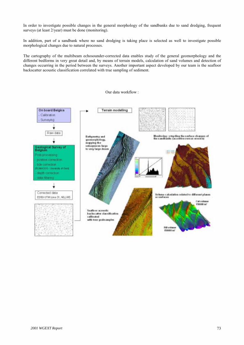
2001 WGEXT Report 73
In order to investigate possible changes in the general morphology of the sandbanks due to sand dredging, frequent surveys (at least 2/year) must be done (monitoring).
In addition, part of a sandbank where no sand dredging is taking place is selected as well to investigate possible morphological changes due to natural processes.
The cartography of the multibeam echosounder-corrected data enables study of the general geomorphology and the different bedforms in very great detail and, by means of terrain models, calculation of sand volumes and detection of changes occurring in the period between the surveys. Another important aspect developed by our team is the seafloor backscatter acoustic classification correlated with true sampling of sediment.
Our data workflow :

2001 WGEXT Report 74
First results:
The Kwintebank bathymetry, geomorphology and backscatter acoustic classification maps (see posters).
Because the Kwintebank is the most heavily exploited sand dredged area (1,300,000 m3/year) we have started our project by surveying this bank.
The Digital Elevation Model of the Kwintebank is the final result of a first post-processing and mapping of the multibeam data recorded with the new multibeam echo sounder Kongsberg Simrad 1002S installed on-board the RV �Belgica�.
SURVEYS:
The data were acquired on-board the RV Belgica during 3 surveys :
99/25 November 1999
00/01 January 2000
00/08 March 2000
Map of the surveys:
SURVEY 99/25SURVEY 99/25SURVEY 99/25SURVEY 99/25SURVEY 99/25SURVEY 99/25SURVEY 99/25SURVEY 99/25SURVEY 99/25NOVEMBER 1999NOVEMBER 1999NOVEMBER 1999NOVEMBER 1999NOVEMBER 1999NOVEMBER 1999NOVEMBER 1999NOVEMBER 1999NOVEMBER 1999
SURVEY 00/01SURVEY 00/01SURVEY 00/01SURVEY 00/01SURVEY 00/01SURVEY 00/01SURVEY 00/01SURVEY 00/01SURVEY 00/01JANUARY 2000 JANUARY 2000 JANUARY 2000 JANUARY 2000 JANUARY 2000 JANUARY 2000 JANUARY 2000 JANUARY 2000 JANUARY 2000
SURVEY 00/08SURVEY 00/08SURVEY 00/08SURVEY 00/08SURVEY 00/08SURVEY 00/08SURVEY 00/08SURVEY 00/08SURVEY 00/08MARCH 2000 MARCH 2000 MARCH 2000 MARCH 2000 MARCH 2000 MARCH 2000 MARCH 2000 MARCH 2000 MARCH 2000

2001 WGEXT Report 75
POST-PROCESSING:
The multibeam echo sounder raw data have been post-processed at the Geological Survey of Belgium with the post-processing software Neptune from Kongsberg Simrad.
Tide correction files have been established by the Research Unit for Marine and Coastal Geomorphology, Ghent University.
The median values for each cell of a 2.5 m × 2.5 m grid have been used to produce a final terrain model of 5 m × 5 m resolution. This model is presented on the posters.
Seafloor backscatter acoustic classification has been processed using Triton from Kongsberg Simrad. A total of 8 acoustic classes have been defined for the studied area. IN PROGRESS:
Detailed report including all the surveys and post-processing parameters; Interpretation of data in terms of geology-sedimentology;
Integration of previous single-beam data and following multibeam surveys for studying the impact of dredging;
Correlation true grab samples - acoustic backscatter classes.
For more information please contact the Fund for Sand Extraction - Geological Survey of Belgium – Continental Shelf Team:
Koen Degrendele ([email protected]), Marc Roche ([email protected]) and Patrik Schotte ([email protected]).

2001 WGEXT Report 76
ANNEX 5: HIGH-RESOLUTION MAPPING OF SEABED BIOTOPES IN UK COASTAL WATERS
Craig J. Brown et al. CEFAS, UK
An overview of progress in the habitat mapping project was given �Mapping of gravel biotopes and an examination of the factors controlling the distribution, type and diversity of their biological communities (project A0908)�. A summary of the project aims and details of the presentation are provided below.
Date project commenced: April 1998 Duration of project: 3 years Organisation(s) undertaking research project: The Centre for Environment, Fisheries and Aquaculture Science
Collaboration with: SeaMap, University of Newcastle upon Tyne and British Geological Survey.
Funding body: MAFF
INTRODUCTION
Much of the seabed surface around the England and Wales coastline is comprised of coarse material. Where these deposits are present in sufficient quantity, are of the right consistency, and are accessible to commercial dredgers, they may be exploited as a source of aggregate for the construction industry, to supplement land-based sources and as a source of material for beach nourishment. It is likely that the demand for marine-won aggregate will further increase in the near future (especially to meet coastal defence needs), and construction companies are already prospecting on a much wider geographical scale for new sources of material. In timely anticipation of this increased demand for marine aggregate, this project was established to evaluate the utility of seabed mapping techniques for surveying habitats and also to evaluate the fundamental role of superficial coarse deposits in the coastal marine ecosystem.
Recent advances in acoustic technologies are offering new insights and opportunities to explore and map seabed habitats. Benthic studies have traditionally used grabs and/or dredges to quantify the invertebrate fauna of the sea floor. The data generated from such techniques provide single, geographically separated points of data across the area of seabed under investigation. In order to produce biotope maps (physical habitats and their associated biological assemblages) from such sources of data it is necessary to interpolate between these data points. However, interpolation has the potential to overlook discrete seabed features and/or biological assemblages, which may lie between sample stations. For this reason the use of acoustic techniques to assist in mapping the geographical distribution of biotopes can be seen to have many potential advantages, including the prospect of 100 % coverage of the seabed as resources allow or priorities dictate.
The production of high-resolution biotope maps of the seabed will assist in future site-specific environmental assessments of potential aggregate dredging areas, and would be of value during any subsequent environmental monitoring activities. The issue of extraction licences by the Crown Estate is subject to a favourable Government View, with MAFF being an influential contributor. The development and then evaluation of the utility of mapping techniques are considered essential to ensure that the best scientific advice is available to underpin the fisheries and marine environmental concerns that are MAFF�s policy remit.
Research aims
� Establish the utility of seabed mapping techniques for surveying habitats to provide an essential underpinning to future site-specific environmental assessments of potential dredging areas.
� Fill fundamental gaps in knowledge by elucidating the major factors that operate over various scales (km2 to m2) and are responsible for determining the character of the gravel biotope. Such factors include substrate composition and bathymetry coupled with dynamic features of the water column. This will provide a greater understanding of the sources of ecological variation and supplement knowledge regarding the functional significance of the gravel biotope to fisheries and as an environmental resource.
A major challenge for the work was to sample at relevant scales. This was achieved by deployment of state-of-the-art seabed mapping tools, closely linked with physical and biological sampling, to derive descriptions of the nature and extent of the habitat.

2001 WGEXT Report 77
Objectives
The main objective of this work was to assess the utility of seabed mapping techniques for surveying habitats and examine the environmental influences affecting gravel biotope communities.
There were seven scientific objectives:
Objective 1: To characterise the seabed in an area of the eastern English Channel using various physical and geophysical techniques.
Objective 2: To incorporate biological, sedimentological and hydrographic information along with existing environmental and fisheries data into a geographic information system, in order to evaluate the functional role and importance of the gravel biotope relative to other substrate types, and for use in licensing procedures for the area surveyed.
Objective 3: To determine the causes of biological variation and of observed patchiness and to devise appropriate sampling strategies to allow for this variation. This work will take particular account of dynamic aspects of the environment within which the benthic communities have developed.
Objective 4: To establish the utility of seabed mapping techniques for surveying habitats.
Objective 5: To examine broad-scale fishery-independent beam trawl survey data from the eastern English Channel. Describe the range of assemblages sampled using dominance of commercially important fish and macro-epibenthic invertebrate by-catch, and where possible explain the ecological rationale for observed patterns in species affinities.
Objective 6: To evaluate the susceptibility of gravel biotope benthic communities to anthropogenic disturbances in contrasting areas, particularly by dredging. This will involve the testing of established and novel methods for describing and quantifying biological status and sensitivity.
Objective7: To report on the significance of the findings for the management of aggregate extraction activities
Summary of the project
A range of acoustic techniques were evaluated in the first year of the project, and side-scan sonar was selected as the main acoustic mapping system for use in subsequent surveys. In addition, two acoustic ground discrimination systems (AGDS), RoxAnn and QTC-View, were also chosen for use alongside the side-scan sonar system. Four sites were selected in the eastern English Channel to develop the mapping techniques (Figure A5.1). The main site for study was offshore from Shoreham (28 km × 12 km in area). The site was selected as it offered a range of sediment types which were relatively homogeneous in their distribution, and would therefore offer an environment in which the relationship between acoustic output, physical habitat type and biological assemblage structure could be investigated. The other three sites, at Hastings, the eastern Isle of Wight and Dungeness (all 12 km × 4 km in area), were chosen to offer a wider range of substrata of varying degrees of spatial complexity (sediment patchiness) over which the techniques developed at Shoreham could be tested.
Each site was intensively surveyed using a digital side-scan sonar system. A mosaic of the side-scan sonar data was produced to provide 100 % spatial coverage maps at each location. This was then divided into acoustically distinct regions which, following ground-truthing using underwater video, were found to relate to discrete habitat types. Each region was sampled using a suite of physical sampling and visual techniques. The main sampling tools were a 0.1m2 Hamon grab fitted with a video camera and light (all sites) and a heavy duty 2-m beam trawl (Shoreham and Hastings) which were used to characterise the benthic communities and sediment characteristics within each region. Relationships between acoustic regions, physical habitat characteristics and assemblages were then investigated using a range of univariate and multivariate techniques. Results from these analyses were used to identify discrete biotopes (physical habitats and associated communities) at each site, and to establish which factors were responsible for the distribution, type and diversity of communities within each region.
In most acoustic regions, particularly where there was a high degree of sediment homogeneity within discrete habitat boundaries, statistically distinct assemblages were identified. The situation was less clear where the seabed consisted of a complex arrangement of sediment types, such as to the east of the Isle of Wight. Nonetheless, discrete assemblages were still detected, although it was more difficult to ascertain natural boundaries between neighbouring habitats/assemblages. Sediment properties (granulometry) and seabed morphology appeared to be the main factors

2001 WGEXT Report 78
controlling the distribution of communities at each site. Hydrographic factors (tidal velocities, suspended loads, water temperatures, etc.) were also considered, but at the scale of the individual sites these factors appeared to have less influence on assemblage structure.
At each site, data derived from the analysis of the acoustic, biological, sedimentological and visual data sets were used to identify and define biotopes. Discrete biotopes often existed within the boundaries of acoustically distinct regions. This was not always the case, however, and the physical habitat and biological assemblages were sometimes similar over a number of acoustic regions, and were therefore classed as one type of biotope in these situations. Twelve biotopes were identified and described from the study sites at Shoreham, Hastings and the Isle of Wight.
Work has started on the development of a Geographic Information System (GIS) to hold and manipulate a wide range of data types collected during seabed mapping surveys (acoustic, biological, geological, hydrographical, etc.). The system is designed to act as a data repository, and will ultimately be capable of carrying out detailed geographical queries to examine the relationship between the various data layers. This will be of particular importance when comparing the factors controlling the distribution of biotopes over larger geographical/biogeographical regions. Despite progress in the development of such a system, additional work is required before the system is capable of carrying out all the functions which are required to allow comprehensive assessment of the relationships between the various data types/layers.
The AGDS data were analysed in collaboration with the SeaMap Group, University of Newcastle upon Tyne. A number of image analysis methods were used to process the data collected at the site off Hastings. Habitat maps from these analyses were produced, and results were compared to the habitat maps derived from the side-scan sonar data. There was general agreement between the two types of system, although this was very dependent on the post-processing methods applied to the AGDS data sets. The swathe coverage of the side-scan sonar system proved, unsurprisingly, more accurate at identifying habitats than the single-beam AGDS systems.
A number of project reports will be available by the end of April 2001, and the work will also be presented in St. Johns, May 2001 (Brown et al. and James et al.). Peer-reviewed publications are also in progress.
Funding has just been issued by MAFF to continue this work for a further 4 years under a new project entitled �Role of seabed mapping techniques in environmental monitoring and management�.
Figure A5.1. Location of the four survey sites, eastern English Channel.
Shoreham28km x 12km
Isle of Wight12km x 4km
Hastings12km x 4km
Dungeness12km x 4km
English Channel
S.E. England