workshop report information and analysis of trees · pdf fileinformation and analysis of trees...
TRANSCRIPT

EUROPEAN COMMISSIONDIRECTORATE-GENERALDEVELOPMENT
Information and Analysis for Sustainable Forest Management:Linking National and International Efforts in
South and Southeast Asia
EC-FAO PARTNERSHIP PROGRAMME (2000-2002)Tropical Forestry Budget Line B7-6201/1B/98/0531
PROJECT GCP/RAS/173/EC
WORKSHOP REPORT
INFORMATION AND ANALYSIS OFTREES OUTSIDE FORESTS IN INDIA
(31 January – 2 February 2001)
by:
Ram PrasadP.C. KotwalC.S. Rathore
Yogesh D. Jadhav
INDIAN INSTITUTE OF FOREST MANAGEMENTNEHRU NAGAR, P.O. 357, BHOPAL – 462 003 (M.P.)
August 2001
The EC-FAO Partnership Programme on Information and Analysis for Sustainable Forest Management:Linking National and International Efforts in South Asia and Southeast Asia is designed to enhancecountry capacities to collect and analyze relevant data, and to disseminate and up-to-date information onforestry, and to make this information more readily available for strategic decision making. Thirteencountries in South and Southeast Asia (Bangladesh, Bhutan, Cambodia, India, Indonesia, Laos, Malaysia,Nepal, Pakistan, Philippines, Sri Lanka, Thailand and Viet Nam) participate in the Programme. Operatingunder the guidance of the Asia-Pacific Forestry Commission (APFC) Working Group on Statistics andInformation, the initiative is implemented by the Food and Agriculture Organization of the UnitedNations in close partnership with experts from participating countries. It draws on experience gainedfrom similar EC-FAO efforts in Africa, and the Caribbean and Latin America and is funded by theEuropean Commission.
Cover Design:Tan Lay Cheng
For copies write to:Patrick B. DurstSenior Forestry OfficerFAO Regional Office for Asia and the Pacific39 Phra Atit RoadBangkok 10200Thailand
Printed and published in Bangkok, Thailand
© FAO 2001ISBN 974-7946-11-4
The designations employed and the presentation of the material in this publication do not imply theexpression of any opinion whatsoever on the part of the Food and Agriculture Organization of theUnited Nations concerning the legal status of any country, territory, city or area or of itsauthorities, or concerning the delimitation of its frontiers or boundaries. The word “countries”appearing in the text refers to countries, territories and areas without distinction. The designations“developed” and “developing” countries are intended for statistical convenience and do notnecessarily express a judgement about the stage reached by a particular country or area in thedevelopment process. The opinions expressed in the articles by contributing authors are notnecessarily those of FAO.

FOREWORD
Tree planting is an entrenched part of the cultural, economic and ecological traditions of India. Treesoutside forests (TOF) grow on a variety of landscapes and include a unique range of species that arespecific to the local environmental and socio-cultural conditions. TOF are an important source of woodand non-wood products, and they have a great influence on the extent, health and productivity of publicforests. Unfortunately, their importance has not been properly assessed or recognized by the mainstreampolicies of land management.
In view of the growing emphasis on sustainable forest management (SFM), tree resources outside publicand private forests have been receiving attention from the Food and Agriculture Organization of theUnited Nations (FAO) and other international organizations. At the national level, the Forest Survey ofIndia (FSI), Dehradun has been actively engaged in the national assessment of TOF since 1991, and theexercise has spread across several states. Such efforts require substantial resources and manpower. As thenational node for SFM, the Indian Institute of Forest Management (IIFM) started networking withdifferent public institutions, non-governmental organizations (NGOs) and scientists who are interested inSFM and assessment of TOF.
Apart from FSI Dehradun, Dr. Ravindranath from Indian Institute of Science (IISc), Bangalore and Prof.K.C. Malhotra have been involved in TOF research, focusing on the socio-economic aspects of urbandwellers of Calcutta. I would like to acknowledge the motivation and technical guidance provided byProf. Malhotra who has been instrumental in organizing the first workshop on the assessment of TOF inIndia, held from 5-6 June 2000 in Bhopal. His extensive NGO network has been instrumental inrecruiting the participation of 30 NGOs for the workshop.
Following that workshop, FAO (Bangkok) supported IIFM’s efforts by providing technical and financialsupport for a three-day workshop at IIFM to consolidate and extend work on TOF. This valuableopportunity and financial assistance made it possible for us to network with other institutions andindividuals, who are working on the same theme. I would like to thank Dr. Thomas Enters and Ms. MaQiang, both from FAO, for their expert guidance and support on the subject.
Furthermore, I would like to acknowledge the cooperation of our sister organizations like FSI, NaturalRemote Sensing Agency, Hyderabad, Dr. Govil (FAO), and all the participants whose valuable inputshave contributed to the outcome of the exercise.
Profs. Kotwal, P. Bhattacharya, R.K. Singh, M.D. Omprakash, C.S. Rathore, and D.N. Pandey, andresearch staff like Dr. M. Mishra, Dr. D. Dugaya, Dr. S.K.S. Rathore, and Mr. Y.D. Jadhav at IIFM havealso extended their cooperation in organizing the workshop.
Dr. Ram PrasadDirector, IIFM
EXECUTIVE SUMMARY
Trees are valuable, and previously looked upon as an inexhaustible, resource of timber and non-timberproducts. However, people came to realize that the existing stock of trees would last only for a fixedduration, unless commensurate efforts are made to replace the harvested ones through continuingreforestation. Thus emerged the concept of planting trees outside forests on community lands, privatelands and in urban areas to meet the needs of society. The environmental services provided by treesoutside forests, in rural and urban areas, include protection of soil and water resources, conservation ofbiological diversity, support to agricultural productivity and sustainability, buffering of desertificationand resource degradation processes in arid and semi-arid zones, carbon sequestration, amenity andrecreation, and maintenance and improvement of sustained livelihoods.
Cities and human settlements face several environmental problems such as shortage of water, airpollution and sewage management. Deforestation and changes in land use in ever-widening circlesaround cities are particularly accentuated in arid and semi-arid zones. Indeed, consumption patterns andbasic needs of the urban population for products such as fuelwood and construction material areimportant causes of forest and land degradation. This results in the degradation of soil fertility and thediminution of the tree cover, and contributes to the erosion of the diverse gene pool. The negative impactof forest resource degradation on the nutrition and livelihood of poor urban dwellers is often overlookedin urban development.
Despite all these factors, an inventory and operational management plans for TOF generally is lacking.Such a gap is especially significant when India is an agricultural country where vast stretches of land arecapable of supporting a variety of plant species. This three-day workshop was an attempt to bringtogether specialists with diverse backgrounds to formulate a plan to assess the potential of TOF, generateinformation and raise awareness of TOF as a valuable resource. Based on various studies, IIFM has triedto provide a platform for the exchange of ideas and fruitful consultation for the assessment of TOF toensure a systematic documentation and policy framework for TOF and their management. A proposedpilot study involving remote sensing technique and ground survey is the best option for carrying out anational assessment of TOF. Large-scale assessments can be conducted based on the pilot study once theresults are tested and the methodology is modified to suit local conditions.
INTRODUCTION
The importance of trees can be seen from many aspects and in terms of services they deliver. Trees arenot just confined to forests but exist outside the forests also. Trees outside forests (TOF) are of significantimportance and perform a number of ecological, economic and socio-cultural functions.
In India, TOF are an important source of wood and non-wood products, and environmental services. Suchtrees include roadside plantings, woodlots, scattered trees in the landscape, trees in fields, homesteadsand orchards. They not only play a very important role in meeting rural people's needs but are alsoincreasingly significant in supplying the commercial sector, especially the wood-based industries, withmuch needed raw material. Depending on prevalent land-use patterns (ecological and economic) andlandscape attributes, TOF may also play a role in carbon sequestration, biodiversity conservationhydrological functions, and erosion control.
A systematic inventory of TOF can help provide a ready reference for policy makers and planners inmeeting people’s needs. Despite being an important biological resource, however, TOF have not beengiven due attention in the national forest statistics of India. Information on the status and extent of TOF isscanty and not easily accessible. Sound inventories and databases on TOF have not been appropriatelyorganized. One reason for this deficiency is the lack of cost-effective and practical inventory andassessment techniques, and an absence of clear classification systems. Although, various case studieshave emphasized their importance to farms, households and the rural economy, inventories for large areasare generally unavailable. Large-scale inventories and assessments are a high priority for developingmanagement strategies to help sustain tree cover and to design supportive policies that provide incentivesto landholders to maintain or increase the number of trees on their land.
The Forest Survey of India (FSI) took a lead in assessing TOF in Haryana, Uttar Pradesh, Rajasthan,Gujarat, Karnataka and West Bengal (FSI, 2000). While FSI has completed the study in Haryana, theassessment in the other states is continuing. Similar efforts on a smaller scale were also attempted byother institutions. The Kerala Forest Research Institute, Indian Institute of Forest Management (IIFM),Indian Institute of Science (IISc), and recently the Tata Energy Research Institute (TERI) have useddifferent approaches and assessment methodologies, which complicates comparisons and hinders thedevelopment of a national overview and database.
The potential to coordinate the efforts of the different institutions for speedy assessments of TOF isimmense. There is also a need to develop a common methodology by drawing on the strengths ofdifferent approaches used. Time requirements for assessing TOF based on conventional ground-basedsurveys is a cause of concern. It is therefore necessary to test the efficacy of alternative methodologies formore rapid large-scale appraisals, especially the use of remote sensing (RS). The various institutionsagree that a concerted effort based on a review of existing knowledge would result in a more effectiveapproach for assessing TOF.
In a first workshop on the national assessment of TOF that was held at IIFM in June 2000, it wasestimated that there are 24 billion TOF in India (Prasad et al., 2000). Participants were from a vast arrayof institutions engaged in this work. As a follow-up, IIFM organized a three-day workshop bringingspecialists from diverse backgrounds to review and develop an action plan.
Objectives and outputs of the workshop
The five main objectives of the workshop were as follows:
� review the status and existing survey methodologies of TOF in India;� identify priority areas/topics for assessment;

TOF Workshop report - IIFM, Bhopal
� identify potential for inter-institutional partnership for assessment of TOF in India;� develop terms of reference (TOR) for an exploratory study on the potential of using RS data for
assessing TOF; and� agree on an action plan and identify topics for further studies if necessary.
The workshop achieved the following outputs (contained in this report):
� Workshop report comparing different methods used for ground-based assessment of TOF, andconsiderations of other methodologies that can be used
� List of potential users of data collected for TOF� List of institutions with relevant data� Identified parameters and criteria and indicators for TOF assessments� TOR for exploratory study of the cost-effective use of RS in TOF assessments� Action plan for standardization of TOF assessment methodologies� Identification of further studies

TOF Workshop report - IIFM, Bhopal
DIFFERENT METHODS FOR GROUND-BASED ASSESSMENT OF TREESOUTSIDE FORESTS
During the workshop, the participants deliberated on various issues related to the ground-basedassessment of TOF. Various preferential rating scales were designed and discussed (see section on“Parameters, criteria and indicators”). A review of methodologies for TOF assessment is given below fora quick reference.
Review of methodologies for assessment of TOF
Assessment of TOF in Haryana in North India by Chaturvedi (1990)
Chaturvedi (1990) classified trees planted on non-forested lands as (i) homestead planting (ii)commercial tree planting, and (iii) tree planting on farmlands.
In homestead planting, all trees with breast girth of 15 cm or more were enumerated. Plants of lowerdimensions were ignored. Measurement of girth at breast height was carried out by semi-skilledenumerators. The distribution in girth classes was very wide. No method of sampling could, therefore,deliver accurate results with acceptable limits. Since the trees were concentrated in a small area, it wasconvenient to carry out total enumeration rather than sampling. Apart from number of trees, thisassessment provided data on growing stock in cubic meters, which was quite useful for planning rawmaterial supply to industries, village artisans, etc.
Commercial tree planting was not found in the study site at Dhanawas, but 10 planting units wereobserved in Berka Alimuddin. The areas of these sites varied from 0.05 ha to 2.12 ha. Therefore, a totalcount of trees by girth classes was carried out.
Sampling of tree planting on farmlands was based on three independent samples of 30 drawn fromrandom numbers taken from the Fisher and Yates Tables (1963).
This was reportedly the first study of its kind where three villages in Haryana State in North India wereselected for assessment of TOF in three types of landscapes. However, the criteria used to select the threevillages out of a total of 6,988 villages were not described. In India where there are over 650 000 villages,total enumeration may not be feasible, as it would require a great amount of time and resources tocomplete the work. This study also did not consider other landscapes such as sides of roads, canals,drains, railways, ponds, and other community areas with substantial tree cover. Thus, poor representationof all landscapes is a major weakness in this study. The classification may be applicable on a small scalebut not for a national-level measure of TOF.
Study of TOF by Kerala Forest Research Institute
Krishnankutty (1992) adopted a stratified three-stage sampling procedure. The percentage of dry landarea under agricultural use to the total area under agricultural use and population density was calculatedfrom the data available from the State Land-use Board and the 1981 census report, respectively. In all, 15strata were formed on the basis of five classes of percent dry land area under agriculture use and threepopulation density classes. The villages were then classified under the different strata accordingly.Revenue villages in each stratum were treated as first stage units of sampling. The villages in eachstratum were chosen at random.
Although the study recorded the precise number of trees in homesteads, it failed to acknowledge theimportance of trees planted on roadsides and those growing on barren lands. Furthermore, trees on
TOF Workshop report - IIFM, Bhopal
lakesides and backwaters were also not included in the assessment. However, this was reportedly the firstsuch effort to systematically enumerate wood resources in the homegardens of Kerala. This studyprovided the background of methodology and accorded adequate importance to the tree resourcesgrowing in the homegardens outside the public forests. This assessment provided good account of thecontribution of homestead gardens in meeting domestic requirements of fuelwood, small timber, andsome inexpensive construction material for households. Thus, the study not only enumerated trees, butalso calculated the volume from recorded tree dimensions. This information on raw material availabilitycan have significant influence in planning sustainable management of natural forests. It is also relevantfor estimating the potential of homestead gardens for domestic use of timber and non-timber products andcash income in the event of emergency such as marriage of children and other ceremonies.
The Karnataka experience of Dr Ravindranath and Dr Somasekhar (Indian Institute of Science,Bangalore)
Ravindranath and Somasekhar (1995) adopted methodologies to appraise the distribution of tree specieson various farm sizes in a semi-arid Ungra in Tumkur District of Karnataka. They studied tree diversityand density on farms, the location-specific nature of the tree species, the rationale for the choice ofspecies and the possible end-uses. To investigate the impact of landholding size and economic status ontree-growing practices, a stratified random sample of 30 households was selected to include 6 farmers ineach of the following categories: landless, marginal (<1 ha), small-scale (1.01 to 2 ha), medium size (2.01to 3 ha), and large-scale (>3 ha).
This methodology gives a better sampling technique to enumerate TOF in rural settings. However, urbanareas and the inventory of urban trees are excluded. In addition, the methodology does not considerrailway and roadside trees, which are also important TOF resources in India.
The emphasis of this study was mainly on tree diversity and density in terms of species and number oftrees. The study did not collect information on height, girth, and therefore, did not assess the volume oftrees on farmlands.
The FSI Experience
The FSI began a regular inventory of TOF in 1991 based on stratified random sampling. A district (or agroup of districts) in a state was treated as a stratum and villages as a final sampling unit. The number ofsample villages to be surveyed in a state was decided by a pilot study. The boundary and area of each ofthe randomly selected villages were obtained from the Revenue Department and all trees standing in theselected villages were physically counted and measured. The team leader was provided with the list ofsample villages to be inventoried, along with maps of their locations (at 1:50 000 scale). The entirevillage was divided into suitable angular quadrants in such a way that the inventory of each quadrantcould be completed in one working day. Generally, living trees above 10 cm in diameter were measuredand counted but in some states trees up to 5 cm in diameter were also measured. In Haryana State, out ofa total of 7 000 villages, 290 villages were selected for TOF inventory.
The inventory would have taken four years to complete. To accelerate the process, the methodology wasmodified in 1999. Analysis of the completed inventory of non-forested areas gave significant positivecorrelation between village area and number of trees and also between the population size of villages andnumber of trees. This relationship has been utilized to fix the sample size of other states and dispensewith the additional task of conducting a pilot survey. States are being divided into agro-ecological zonesand each zone is being treated as a stratum. The number of sample villages in each zone is decided on thebasis of proportional allocation. The precision level is slightly reduced because of reduction in the samplesize. Further, the proportion of trees enumerated in a village was also reduced by 50, 25 and 10 percent iftheir number exceeded 2 000 and lies between 2 000 to 5 000, 5 000 to 10 000 and more than 10 000,

TOF Workshop report - IIFM, Bhopal
respectively. With the modification, the inventory in four states – Andhra Pradesh in the south, Gujarat,and Rajasthan in the west and West Bengal in the east – is nearing completion. The number of villagesselected in these states were 110, 142, 141 and 167 out of a total of 27 999, 18 509, 39 810 and 40 890villages, respectively.
This sampling method covers a wide array of landscapes and tree types, but the information on theinventory and sampling method for urban areas needs further elaboration. The amount of time taken forthe exercise is also a constraint. Ground verification is needed as the trees in rural areas might already beharvested for fuel and fodder by the time the survey took place in the village. It is virtually impossible forone agency to enumerate the TOF in the whole of India. The size of the country and time constraint arethe biggest hurdles for large-scale inventories.
This study has been more elaborate than other studies reported in terms of sampling intensity, areacoverage, and number of the tree units per village.
Study of TOF from the socio-ecological point of view by Malhotra and Kumar (1987)Malhotra and Kumar (1987) studied the socio-ecological aspects of the avenue trees in Calcutta,particularly tree density, species diversity and associated human activities. The methodology involved theselection of a 4.6 km stretch of road in Calcutta and a complete census (species and number of trees andthe related human activity) of all the planted trees separately on both sides of the road. The humanactivities associated with each tree were also recorded. The authors found that the avenue trees in urbancenters not only performed important ecological role, but also played significant socio-economic andreligious roles in the lives of the urban dwellers. Several hawkers/vendors set up their stalls selling fruits,vegetables, sweetmeat, etc. under the shade of trees growing in the urban areas. The authors emphasizedthe need for a systematic collection of data on trees along the roads, parks and residential areas in othercities also.
The study stresses on the social aspect of the avenue trees only, and fails to extend the inventory toinclude an array of sites and urban landscapes apart from roadsides (such as trees on institutional landsand household trees). Therefore, the method that has been tested on roadside trees cannot be adequatelyapplied to trees on farm bunds and plantations. Moreover, the study focused on the socio-ecologicalfunctions of the TOF and therefore has restricted value for its replicability. The study does not providethe total volume of trees as present along the roads.
Assessment of TOF through sampling and secondary information by the Indian Institute of Forest Management
The IIFM started the work on a national assessment of TOF as a collaborative project with over 30 NGOsfrom across the country in June 2000, based on secondary information and sample field survey. It wasconsidered desirable in view of limitation of resources and lack of well-defined methodology forsampling. These NGOs and partner institutions were selected on the basis of their fieldwork on thesubject in the respective areas.
Secondary information was collected from the following sources:� Land Record Office� District Statistical Office� District Rural Development Agency (DRDA) offices� District Collectorate� Municipal Corporation offices (parks superintendent)� Research institutions in the area� Village-level interviews� Tourism Department (for maps)

TOF Workshop report - IIFM, Bhopal
� Various plantation companies� Public sector coal companies who raised compensatory afforestation� NGOs engaged in tree plantation and watershed works� District Forestry Office (social forestry/research and extension)
Field surveys were conducted to collect primary data on TOF in the State of Madhya Pradesh, as detailedbelow.1. The State of Madhya Pradesh was broadly divided into three categories: urban, semi-urban (including
district headquarters and small towns), and rural areas.2. The State was divided into five main zones: North, East, West, Central, and Southeast.3. Five major cities in the urban areas were chosen from each of the following zones: Gwalior (North),
Jabalpur (East), Indore (West), Bhopal (Central), Bilaspur (Southeast).4. One district headquarter in the semi-urban areas (near the selected city, i.e. the nearest possible semi-
urban area was taken irrespective of the distance) was selected for each zone.5. Four villages within 10 km from the district urban center, one each in the North, East, South and
West of the district urban center, were selected in each zone.
TOF assessment by the Cardinal Grid Method (CGM©) in urban areas
The target urban area is divided into four main categories depending on the ownership pattern as follows:� Landscapes were broadly divided into residential, institutional, roadside, and
garden/pond/park/temple.� Zones: 4 quadrants were laid in each zone of the selected city, i.e. East, West, North, South,
Central.� Data collected include number of trees, species, girth classes, and height classes.
The distribution of the sample areas is further differentiated as shown below:
a. Residential
Sample plot size: 100x100 m quadrant was taken in each zone of the city, and the trees were totallyenumerated in the selected quadrant along with an estimate of the number of households.
b. Institutional
1. If an institution has an area of less than 3 ha, total enumeration was to be carried out.2. In institutions with more than 3 ha, 20x5 m quadrants were laid in the institutions’ precincts where
the trees were planted.3. Zonal criteria: 3 institutions in each zone (total of 15 in a city) i.e. East, West, North, South, Central.
Critical analysis of Cardinal Grid Method (CGM©)
The Cardinal Grid Method (CGM©) was applied and tested in Gwalior City, which was divided in threezones, namely Gwalior City, Lashkar and Murar. The method was discussed at length during abrainstorming session.
The study appeared to be based on systematic sampling, which could give rise to biased results.Extrapolation of results should be considered. Participants emphasized the need for random sampling inthe initial stage to minimize potential errors. The selected grids were based on the spatial layout of

TOF Workshop report - IIFM, Bhopal
Gwalior, and are interchangeable. The city was divided into directional grids, the center being the densestpopulated area. The importance of selection of samples through the ring method by giving examplesleading to extrapolation of the number of trees was discussed. The relationship could be assessed througha semi-variogram model. The proposed CGM© method needed to be further refined based on the fieldexperiences and suggestions of the participants.
Garden/pond/parks/temple side
These were selected on a case-by-case basis depending on the occurrence of trees.
Sampling unit: 20x5 m, four quadrants per hectare of the target land
Striplands
Table 1. Available striplands in IndiaLand category Potential (million km)
Roads 1.2Railway lines 0.6Drains 0.2Canals 1.5Around cultivated lands on bunds and boundaries 60.0
Source: Govt of India, 1982 .
Roads and rails
Four transects of 10x100 running meters were laid in each direction (North, East, West, South) on bothsides of the city’s state highway roads.
Canals
One transect of 10x100 running meters were laid every 3 km length on both sides of the canal.
In rural areas, there are a number of unclassified landscapes with trees. The procedure to inventory thiskind of vegetation is important, but is not included here. The CGM© is applicable only to urban areas.
Analysis of the methodologies
The methodologies provide various ways for assessing the TOF resources. The first method justifies thestratification of landscapes but fails to include the roadside and railside trees. Each of the methodologiesdescribed above provides a unique dimension to the enumeration process. Malhotra and Kumarconsidered roadside trees but not trees on farmlands. The FSI methodology suggested total enumerationof trees in the study area, although it is clearly not feasible to inventory a diverse and vast country likeIndia completely. Therefore the ideal method for TOF assessment would be a judicious mixture ofmethodologies that would cover both urban and rural areas, be representative enough to reduce errors,and be cost and time effective.

TOF Workshop report - IIFM, Bhopal
LIST OF POTENTIAL USERS OF DATA COLLECTED FOR TREES OUTSIDEFORESTS
Several potential users of this important but largely unrecorded information include academic institutionssuch as IIFM, TERI, Indian Council of Forestry Research and Education (ICFRE), universities, as well asindustries that face the difficulty in procuring raw material within their industrial catchments. Policymakers (state and central government), donors (World Bank, ITTO), NGOs, United Nationsorganizations (FAO, UNDP) and civil society may be other stakeholders (Table 2).
Table 2. Potential users of TOF databaseUsers Variables of interest PurposeNational usersForest-based industries(NTFPs includingmedicinal plants)
species, annual production raw material supply
Wood-based industries(sawmills, plywood,paper, etc.)
volume, species, size raw material supply
Woodfuel-basedindustries (brick, kilns,tiles)
volume fuel supply
Forest DevelopmentCorporations
species, volume planning and marketing
Watershed Department extent, number, species soil and water conservationPlanning Board extent, volume, use pattern,
economic and social valuesresource planning at district and statelevels
Revenue DepartmentPolicy makers:- MoEF- Planning Commission- Economic and Planning
Committees
extent, species, distribution,biomass cover, biodiversity,social and economiccontribution at the macrolevel
policy planning, capacity building, socio-economic development, administrativeand legal frameworks, budget allocation
Other developmentalagencies such asDRDA/PWD/CDA, etc.
extent, volume, species energy planning, avenue plantations, etc.
International agenciesFAO cover, extent, volume,
species, ownership,biomass, economic andsocial contributions, etc.
development of global and regionalpolicy and planning, capacity building,sustainable forest management, carbonsequestration and climate changemanagement
UNFF cover, extent, volume,species, ownership,biomass, economic andsocial contributions, etc.
development of global and regionalpolicy and planning, capacity building,sustainable forest management, carbonsequestration and climate changemanagement
GEF biodiversity statusconservation andmanagement
biodiversity and climate changemanagement
Banks/donorsNABARD species, growth, value extending loans, cost of cultivationWorld Bank, ADB, etc extent, cover, volume,
species, growth, GNP, GDPsustainable socio-economic development
Bilateral donor agencies(ITTO, DFID, USAID,SIDA, CIDA)
TOF Workshop report - IIFM, Bhopal
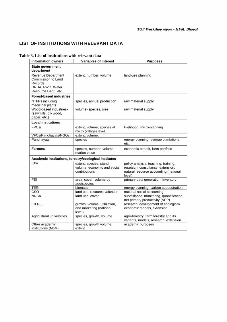
LIST OF INSTITUTIONS WITH RELEVANT DATA
Table 3. List of institutions with relevant dataInformation owners Variables of interest PurposesState governmentdepartmentRevenue DepartmentCommission to LandRecordsDRDA, PWD, WaterResource Dept., etc.
extent, number, volume land-use planning
Forest-based industriesNTFPs includingmedicinal plants
species, annual production raw material supply
Wood-based industries-(sawmills, ply wood,paper, etc.)
volume- species, size raw material supply
Local institutionsFPCs/ extent, volume, species at
micro (village) levellivelihood, micro-planning
VFCs/Panchayats/NGOs extent, volume,Panchayats species energy planning, avenue plantations,
etc.Farmers species, number, volume,
market valueeconomic benefit, farm portfolio
Academic institutions, forestry/ecological institutesIIFM extent, species, stand,
volume, economic and socialcontributions
policy analysis, teaching, training,research, consultancy, extension,natural resource accounting (nationallevel)
FSI area, cover, volume byage/species
primary data generation, Inventory
TERI biomass energy planning, carbon sequestrationCSO land use, resource valuation national social accountingNRSA land use, cover surveillance, monitoring, quantification,
net primary productivity (NPP)ICFRE growth, volume, utilization,
and marketing (nationallevel)
research, development of ecological/economic models, extension
Agricultural universities species, growth, volume agro-forestry, farm forestry and itsvariants, models, research, extension
Other academicinstitutions (MoM)
species, growth volume,extent
academic purposes

TOF Workshop report - IIFM, Bhopal
PARAMETERS, CRITERIA AND INDICATORS FOR ASSESSMENT OF TREESOUTSIDE FORESTS
Any method for assessment has several positive and negative aspects that make the method suitable orunsuitable under a given set of conditions and resources. These may be the factors such as costs , time,technical manpower availability, and so on. These aspects can be assessed systematically to derive a setof criteria and the corresponding indicators. Criteria are the basis against which a resource is to beassessed. The indicator is the proof of the occurrence or non-occurrence of the resource/methodology andis judged accordingly. Thus, the criteria and indicators(C&I) are the basis on which the utility of aresource or a system can be judged. These C&I, when selected properly and administered judiciously, canprovide a better picture of the utility of a system or method. The broad set of C&I for TOF assessment isshown in Table 4.
Table 4. Criteria and indicators for the assessment of trees outside forestsAttributes/criteria for assessment IndicatorsPrecision Standard errorTime Time per districtCost Cost per districtRobustness/practicability - Training person-days
- Training costsReplicability Applicability to varying situations (macro-level
applications)
These C&I can be modified and elaborated according to the specific need(s) of the site. The observationsthus obtained can be rated, as shown in the example below. The rating scale is a flexible tool and can bestandardized accordingly.
Table 5. Scoring schemeMethodologies (scores)Groundsampling
Aerialphotography
Remotesensing
Remote sensing +ground survey
Secondaryinformation
Indicator
1 2 3 4 5Precision 8 9 5 8 3Time 4 6 7 7 8Cost 5 3 4 1 8Robustness 3 5 6 9 2Replicability 2 2 5 9 2Total score 22 25 27 34 23
*The rating scale is a preferential scale, ranging from 1 to 10 in this case.
� Precision: a high value indicates a higher preference� Time: a higher value indicates greater preference.� Cost: a lower value indicates higher costs and thus lesser preference.� Robustness: a higher value indicates greater robustness.� Replicability: a higher value indicates more replicability (e.g. ground sampling (score 2)
indicates that the method is less replicable over a period of time because the time required forground sampling is lengthy and during that period the vegetation changes substantially.)
TOF Workshop report - IIFM, Bhopal
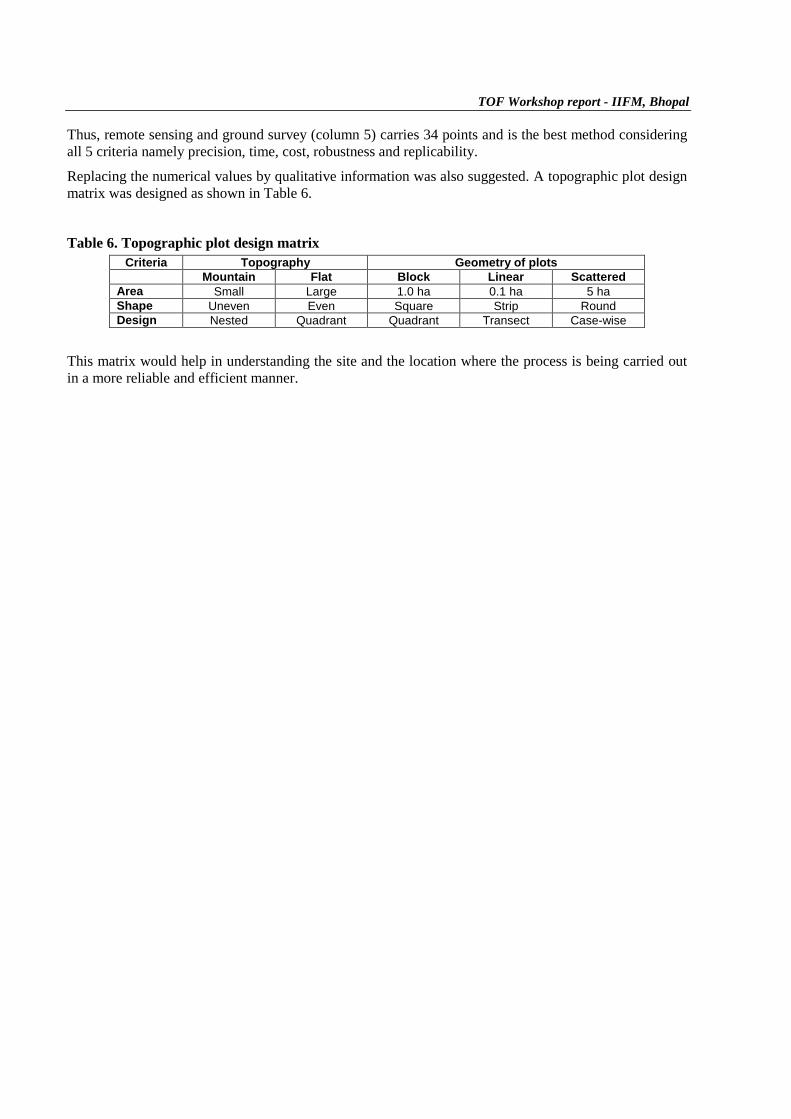
Thus, remote sensing and ground survey (column 5) carries 34 points and is the best method consideringall 5 criteria namely precision, time, cost, robustness and replicability.
Replacing the numerical values by qualitative information was also suggested. A topographic plot designmatrix was designed as shown in Table 6.
Table 6. Topographic plot design matrixCriteria Topography Geometry of plots
Mountain Flat Block Linear ScatteredArea Small Large 1.0 ha 0.1 ha 5 haShape Uneven Even Square Strip RoundDesign Nested Quadrant Quadrant Transect Case-wise
This matrix would help in understanding the site and the location where the process is being carried outin a more reliable and efficient manner.
TOF Workshop report - IIFM, Bhopal
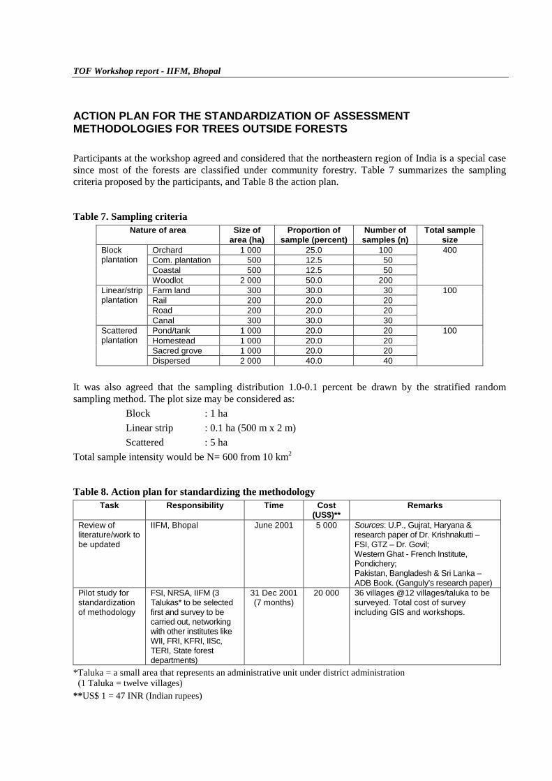
ACTION PLAN FOR THE STANDARDIZATION OF ASSESSMENTMETHODOLOGIES FOR TREES OUTSIDE FORESTS
Participants at the workshop agreed and considered that the northeastern region of India is a special casesince most of the forests are classified under community forestry. Table 7 summarizes the samplingcriteria proposed by the participants, and Table 8 the action plan.
Table 7. Sampling criteriaNature of area Size of
area (ha)Proportion of
sample (percent)Number of
samples (n)Total sample
sizeOrchard 1 000 25.0 100Com. plantation 500 12.5 50Coastal 500 12.5 50
Blockplantation
Woodlot 2 000 50.0 200
400
Farm land 300 30.0 30Rail 200 20.0 20Road 200 20.0 20
Linear/stripplantation
Canal 300 30.0 30
100
Pond/tank 1 000 20.0 20Homestead 1 000 20.0 20Sacred grove 1 000 20.0 20
Scatteredplantation
Dispersed 2 000 40.0 40
100
It was also agreed that the sampling distribution 1.0-0.1 percent be drawn by the stratified randomsampling method. The plot size may be considered as:
Block : 1 haLinear strip : 0.1 ha (500 m x 2 m)Scattered : 5 ha
Total sample intensity would be N= 600 from 10 km2
Table 8. Action plan for standardizing the methodologyTask Responsibility Time Cost
(US$)**Remarks
Review ofliterature/work tobe updated
IIFM, Bhopal June 2001 5 000 Sources: U.P., Gujrat, Haryana &research paper of Dr. Krishnakutti –FSI, GTZ – Dr. Govil;Western Ghat - French Institute,Pondichery;Pakistan, Bangladesh & Sri Lanka –ADB Book. (Ganguly’s research paper)
Pilot study forstandardizationof methodology
FSI, NRSA, IIFM (3Talukas* to be selectedfirst and survey to becarried out, networkingwith other institutes likeWII, FRI, KFRI, IISc,TERI, State forestdepartments)
31 Dec 2001(7 months)
20 000 36 villages @12 villages/taluka to besurveyed. Total cost of surveyincluding GIS and workshops.
*Taluka = a small area that represents an administrative unit under district administration (1 Taluka = twelve villages)**US$ 1 = 47 INR (Indian rupees)
TOF Workshop report - IIFM, Bhopal
TERMS OF REFERENCE FOR EXPLORATORY STUDY OF THE COST-EFFECTIVEUSE OF REMOTE SENSING IN THE ASSESSMENT OF TOF AND IDENTIFICATIONOF FURTHER STUDIES
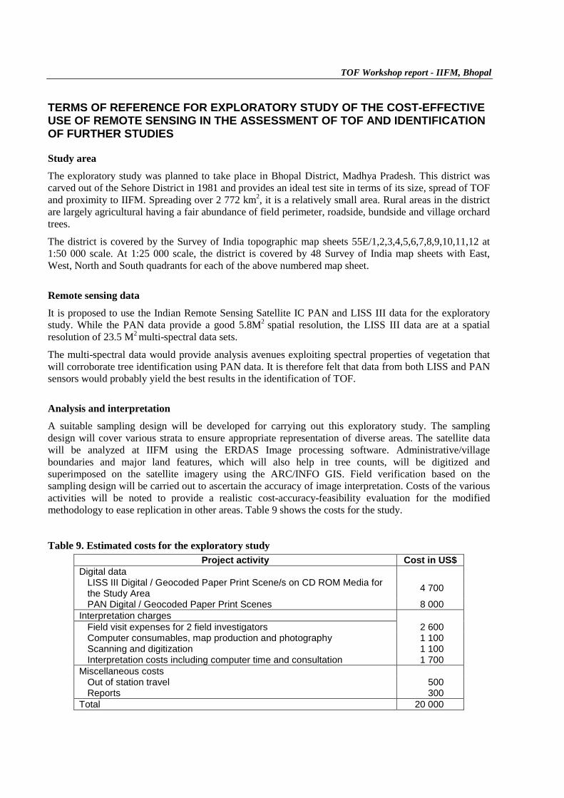
Study areaThe exploratory study was planned to take place in Bhopal District, Madhya Pradesh. This district wascarved out of the Sehore District in 1981 and provides an ideal test site in terms of its size, spread of TOFand proximity to IIFM. Spreading over 2 772 km2, it is a relatively small area. Rural areas in the districtare largely agricultural having a fair abundance of field perimeter, roadside, bundside and village orchardtrees.
The district is covered by the Survey of India topographic map sheets 55E/1,2,3,4,5,6,7,8,9,10,11,12 at1:50 000 scale. At 1:25 000 scale, the district is covered by 48 Survey of India map sheets with East,West, North and South quadrants for each of the above numbered map sheet.
Remote sensing dataIt is proposed to use the Indian Remote Sensing Satellite IC PAN and LISS III data for the exploratorystudy. While the PAN data provide a good 5.8M2 spatial resolution, the LISS III data are at a spatialresolution of 23.5 M2 multi-spectral data sets.
The multi-spectral data would provide analysis avenues exploiting spectral properties of vegetation thatwill corroborate tree identification using PAN data. It is therefore felt that data from both LISS and PANsensors would probably yield the best results in the identification of TOF.
Analysis and interpretationA suitable sampling design will be developed for carrying out this exploratory study. The samplingdesign will cover various strata to ensure appropriate representation of diverse areas. The satellite datawill be analyzed at IIFM using the ERDAS Image processing software. Administrative/villageboundaries and major land features, which will also help in tree counts, will be digitized andsuperimposed on the satellite imagery using the ARC/INFO GIS. Field verification based on thesampling design will be carried out to ascertain the accuracy of image interpretation. Costs of the variousactivities will be noted to provide a realistic cost-accuracy-feasibility evaluation for the modifiedmethodology to ease replication in other areas. Table 9 shows the costs for the study.
Table 9. Estimated costs for the exploratory studyProject activity Cost in US$
Digital dataLISS III Digital / Geocoded Paper Print Scene/s on CD ROM Media forthe Study Area 4 700
PAN Digital / Geocoded Paper Print Scenes 8 000Interpretation charges
Field visit expenses for 2 field investigators 2 600Computer consumables, map production and photography 1 100Scanning and digitization 1 100Interpretation costs including computer time and consultation 1 700
Miscellaneous costsOut of station travel 500Reports 300
Total 20 000
TOF Workshop report - IIFM, Bhopal
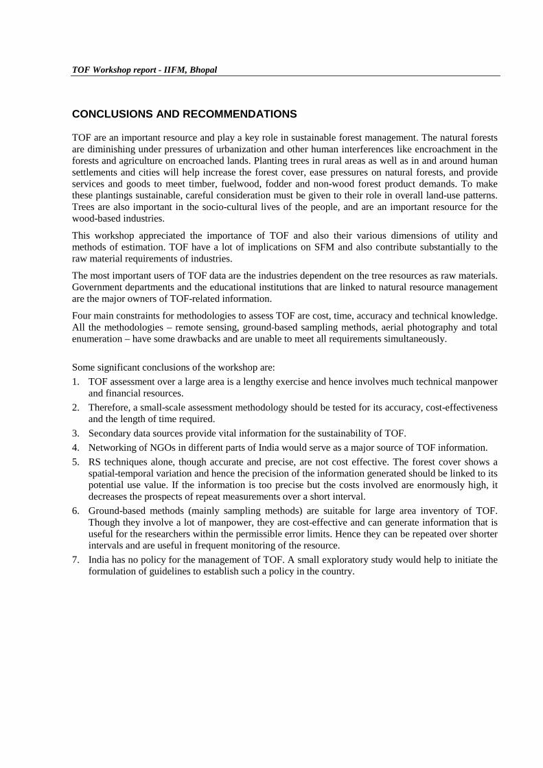
CONCLUSIONS AND RECOMMENDATIONS
TOF are an important resource and play a key role in sustainable forest management. The natural forestsare diminishing under pressures of urbanization and other human interferences like encroachment in theforests and agriculture on encroached lands. Planting trees in rural areas as well as in and around humansettlements and cities will help increase the forest cover, ease pressures on natural forests, and provideservices and goods to meet timber, fuelwood, fodder and non-wood forest product demands. To makethese plantings sustainable, careful consideration must be given to their role in overall land-use patterns.Trees are also important in the socio-cultural lives of the people, and are an important resource for thewood-based industries.
This workshop appreciated the importance of TOF and also their various dimensions of utility andmethods of estimation. TOF have a lot of implications on SFM and also contribute substantially to theraw material requirements of industries.
The most important users of TOF data are the industries dependent on the tree resources as raw materials.Government departments and the educational institutions that are linked to natural resource managementare the major owners of TOF-related information.
Four main constraints for methodologies to assess TOF are cost, time, accuracy and technical knowledge.All the methodologies – remote sensing, ground-based sampling methods, aerial photography and totalenumeration – have some drawbacks and are unable to meet all requirements simultaneously.
Some significant conclusions of the workshop are:1. TOF assessment over a large area is a lengthy exercise and hence involves much technical manpower
and financial resources.2. Therefore, a small-scale assessment methodology should be tested for its accuracy, cost-effectiveness
and the length of time required.3. Secondary data sources provide vital information for the sustainability of TOF.4. Networking of NGOs in different parts of India would serve as a major source of TOF information.5. RS techniques alone, though accurate and precise, are not cost effective. The forest cover shows a
spatial-temporal variation and hence the precision of the information generated should be linked to itspotential use value. If the information is too precise but the costs involved are enormously high, itdecreases the prospects of repeat measurements over a short interval.
6. Ground-based methods (mainly sampling methods) are suitable for large area inventory of TOF.Though they involve a lot of manpower, they are cost-effective and can generate information that isuseful for the researchers within the permissible error limits. Hence they can be repeated over shorterintervals and are useful in frequent monitoring of the resource.
7. India has no policy for the management of TOF. A small exploratory study would help to initiate theformulation of guidelines to establish such a policy in the country.

TOF Workshop report - IIFM, Bhopal
References
Chaturvedi, A.N. 1990. Trees and fuelwood from non-forest lands. A methodology for assessment. FieldDocument No 23. Bangkok, Food and Agriculture Organization of the United Nations.
FSI. 2000. Valuation and evaluation of trees outside forests of India. Regional special study for Asia andPacific for FRA-2000. Dehradun, Forest Survey of India.
Govt of India, 1982. Report of the fuelwood study committee. Planning Commission, Government ofIndia, New Delhi.
Krishnankutty, C.N. 1992. The price of forests. In Anil Agrawal (ed.), Proceedings on the economics ofsustainable use of forest resources. New Delhi, Centre for Science and Environment.
Malhotra, K.C & M. Vijay Kumar. 1987. A socio-ecological study of the avenue trees in Calcutta. InPramod Singh (ed.), Ecology of urban India. Vol II, pp.144-168. New Delhi, Ashish PublishingHouse.
Prasad R., Kotwal, P.C. & Pandey, D. 2000. Trees outside forests in India: a national assessment. (Papermimeo. submitted for publication).
Ravindranath, N.H. & Somasekhar, H.I. 1995. Distribution of tree species on different sized farms in asemi-arid village. In N.C Saxena & Vallabh (eds.), Farm forestry in South Asia, pp. 157-165. NewDelhi, Sage.
TOF Workshop report - IIFM, Bhopal
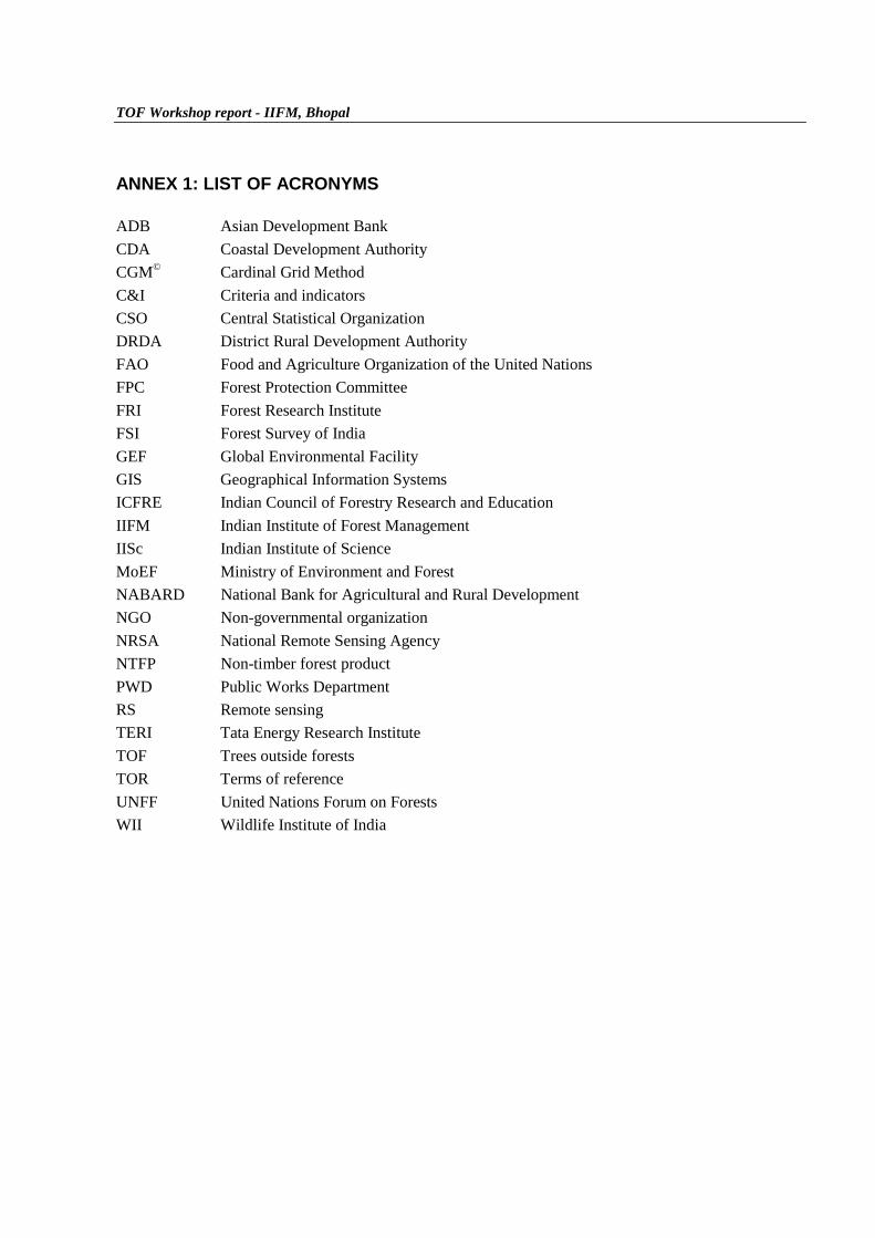
ANNEX 1: LIST OF ACRONYMS
ADB Asian Development BankCDA Coastal Development AuthorityCGM© Cardinal Grid MethodC&I Criteria and indicatorsCSO Central Statistical OrganizationDRDA District Rural Development AuthorityFAO Food and Agriculture Organization of the United NationsFPC Forest Protection CommitteeFRI Forest Research InstituteFSI Forest Survey of IndiaGEF Global Environmental FacilityGIS Geographical Information SystemsICFRE Indian Council of Forestry Research and EducationIIFM Indian Institute of Forest ManagementIISc Indian Institute of ScienceMoEF Ministry of Environment and ForestNABARD National Bank for Agricultural and Rural DevelopmentNGO Non-governmental organizationNRSA National Remote Sensing AgencyNTFP Non-timber forest productPWD Public Works DepartmentRS Remote sensingTERI Tata Energy Research InstituteTOF Trees outside forestsTOR Terms of referenceUNFF United Nations Forum on ForestsWII Wildlife Institute of India
TOF Workshop report - IIFM, Bhopal
ANNEX 2: LIST OF PARTICIPANTS
1. Anoop Kumar Phone: 135-755042Dy. Director (M.U) (Res): 135-773034Forest Survey of IndiaDehradun 248195
2. Rajesh Kumar Phone: 135-755042Deputy Director (MDMU) (Res): 135-757021 Ext. 4663Forest Survey of India Email: [email protected] 248195
3. A.K. Bhardwaj Phone: 135-640111 to 640115 Ext. 260Faculty Scientist (Res): 135-640111 to 640115 Ext. 329Wildlife Institute of India (Direct): 135-642793Post Box No.18, Chandrabani Fax: 135-640117Dehradun 248001 Email: [email protected]
4. C.B.S. Dutt Phone: 40-3878842Head Forestry & Ecology Division (Res): 40-7765363National Remote Sensing Agency Fax: 40-3879677Balanagar Email: [email protected] 500036
5. Pankaj Srivastava Phone: 755-551334Dy. C. F. (Lok Vaniki) (Res): 755-552452M.P. Forest Department Email: [email protected]
6. Shivendu K. Srivastava Phone: 135-758606Head, Extension Division (Res): 135-757729Forest Research Institute Email: [email protected] New ForestDehradun 248006
7. Kailash C. Govil Phone: 135-752872Regional Project Coordinator Fax: 135-752873(ECP/RAS/162/JPN), FAO Email: [email protected] No.109, ICFRE BuildingFRI ComplexDehradun 248006
8. D.P. Singh Phone (Res): 755-424051, 755-424049Forestry Advisor to Govt. of M.P.F-1, Janaki EnclaveKolar RoadBhopal 426016

TOF Workshop report - IIFM, Bhopal
9. L.N. Sharma Phone: 755-542873Deputy Commissioner (Res): 755-557976Land RecordPari BazarBhopal
10. K.S. Bhadoria Phone: 751-341584Dy. Commissioner Land Fax: 751-324811Records and SettlementsGwaliorMadhya Pradesh
11. Sunil B. Banubakode Phone: 135-640112 Ext. 238c/o Director Fax: 135-640117Wildlife Institute of IndiaPost Bag No.18ChandrabaniDehradun 642008
List of participants from IIFM, Bhopal (Phone : 91-755-775716; Fax: 91-755-772878)
12. Ram Prasad ([email protected])13. P.C. Kotwal ([email protected])14. Vijay Kumar ([email protected])15. R.K. Singh ([email protected])16. C.S. Rathore ([email protected])17. S. Raghavan ([email protected])18. Suprava Patnaik ([email protected])19. Manish Mishra ([email protected])
IIFM Rapporteurs
1. S.K.S. Rathore ([email protected])2. S.P. Singh ([email protected])3. B.R. Phukan ([email protected])4. M.D. Omprakash ([email protected])5. Dharmendra Dugaya ([email protected])6. Yogesh D. Jadhav ([email protected])
TOF Workshop report - IIFM, Bhopal
ANNEX 3: SUMMARY OF PAPERS PRESENTED DURING THE WORKSHOP
Remote sensing based non-forest timber resource assessment.
Dr. C.B.S. Dutt (NRSA)
In the presentation various methods for assessing TOF were highlighted which are given as under:� Complete enumeration of TOF� Estimation through aerial photo interpretation� Multi-stage sampling� Remote sensing stratified segment sampling� Stratified random sampling� Stratified systematic sampling� Multistage segment sampling
He highlighted the effectiveness of every method and their utility along with level of accuracy and costeffectiveness. The aggregation was explained through statistical equation and cumulative estimation withthe help of icon distribution curve.
The cost and time involved in the exercise along with the accuracy level for estimation of TOF for adistrict was discussed. The presenter informed the house that the cost would be roughly Rs.10-12 lakhsper district. The comparative cost involved in carrying out the exercise manually was also given athought. The issue of the getting industrial finance to meet the exorbitant cost was discussed. This wouldultimately lead to less dependency on forest resources. The issue of sensitivity involved in the data and itscollection through remote sensing was highlighted.
Presentation 2:Shri Anup Kumar (FSI) presented his paper titled “Tree resources outside forest.”
It included the following objectives:� Assess extent of plantation raised under different forest schemes by different agencies and
individuals� Estimate growing stock and species wise number of trees available in TOF
The presentation described the definition of TOF and elaborated the tree resources in the non-forestedarea which are as under:1. Farm forestry2. Village woodlots3. Block plantation4. Road side plantation5. Ponds side plantation6. Railway side plantation7. Canal side plantation

TOF Workshop report - IIFM, Bhopal
8. Others
The presentation further highlighted the zone wise division of the study area. The study area was dividedinto:� Agro-climatic zone( First stage strata),� Districts ( Second stage strata), and� Villages (Sampling Units).
Estimation of the sample size for the study area was done by mean and standard deviation methods.
The examples of Rajasthan, M.P vis-a-vis TOF assessment were discussed. It was agreed that the timeconsumed in carrying out the exercise would be too high. The need of technical expertise for thecollection of data was emphasized as also the issue of collecting the information for district level. RajeshKumar, FSI, informed that their study was based on different agro-climatic zones and more accurate atState level. It was informed that total of 219 villages was covered and trees of more than 10cm diameterwere counted in the FSI study. In reply to a question asked by Director, IIFM, it was informed that fieldteam consists of 4 people and taken 6–8 months (depending upon the size/area of the village) time tocover one village. On an average the field team counted 800 trees per day in the FSI study.