world bank document€¦ · · 2016-07-14the world bank jakarta stock exchange building, tower...
TRANSCRIPT
Mayors’ Task Force On Climate Change, Disaster Risk & The Urban Poor
JAKARTAUrban Challenges in a Changing Climate
Pub
lic D
iscl
osur
e A
utho
rized
Pub
lic D
iscl
osur
e A
utho
rized
Pub
lic D
iscl
osur
e A
utho
rized
Pub
lic D
iscl
osur
e A
utho
rized
Pub
lic D
iscl
osur
e A
utho
rized
Pub
lic D
iscl
osur
e A
utho
rized
Pub
lic D
iscl
osur
e A
utho
rized
Pub
lic D
iscl
osur
e A
utho
rized
Mayors’ Task Force On Climate Change, Disaster Risk & The Urban Poor
JAKARTAThe World BankJakarta Stock Exchange Building, Tower II, 12th FloorJl, Jenderal Sudirman Kav, 52-53Jakarta 12190 IndonesiaTel: +62-21 5299 3000Fax: +62-21 5299 3111www.worldbank.org/id
Disclaimer: The document summarizes some, not all of the initiatives relating to climate change by the government of DKI Jakarta and other actors and stakehold-ers. The analyses and data were collected by consultants and academics in consultation of the World Bank and government of DKI Jakarta agencies. The views and statements expressed do not necessarily reflect the official positions of the government of DKI Jakarta. The material presented here is to stimulate discussion and increase awareness about the many impacts of climate change on the city of Jakarta and steps to develop resilience.
Photo Credits: Olivia Stinson (2011), Paavo Perttula (2010) and Kabar Media (2010) for the World Bank; Photos of Kamal Muara: Institute for Essential Services Reform, 2010.
ii iiiJAKARTA | Urban Challenges in a Changing Climate
Mayors’ Task Force On Climate Change, Disaster Risk & The Urban Poor
ForewordAcknowledgementsThe Jakarta: Urban Challenges in a Changing Climate case study was conducted under the Mayors’ Task Force on Climate Change, Disaster Risk and the Urban Poor and developed by the World Bank in partnership with the government of DKI Jakarta. Pak Tauchid Tjakra Amidjaja, Assistant to the Secretary for Development and Environment, Ibu Sarwo Handayani of BAPPEDA and her staff, and Ibu Peni Susanti and the staff of BPLHD provided invaluable guidance and information. Ibu Sjaane Ellen Kasono Nasution and Pak Marzon Hermansyah of BPN, and the staff of the Kotamadya land use offices of Jakarta helped with data collection for the maps.
Preparation of this publication involved a team comprised of staff from the World Bank office in Jakarta and the Urban and Local Government Unit of the World Bank in Washington, DC. Olivia Stinson and Marcus Lee acted as the core writing team with World Bank colleagues Iwan Gunawan, Arlan Rahman, and Micah Fisher. Organizational and administrative support was provided by Suriani Burhan, Ummi Kaltsum and Vivian Cherian. Technical material used in this study was prepared by Rudy Tambunan and Syarifah Syaukat of Universitas Indonesia, and Yani Witjaksono of Bronzeoak. Useful comments were received from peer reviewers Sri Probo Sudarmo, Maria Catalina Ochoa, and Arish Dastur. Thanks also go to Franz Drees-Gross, Abha Joshi-Ghani, Judy Baker, and Peter Ellis for guidance and leadership. Finally, thank you to the citizens of Jakarta for sharing your lives, stories and struggles.
The Global Facility for Disaster Reduction and Recovery (GFDRR) provided the financial support that enabled this work to be undertaken for Jakarta.
Jakarta today is a vibrant political, economic and social metropolis that embodies both the benefits and challenges of globalization and urbanization. Jakarta’s unprecedented growth presents significant opportunities for sustainable urban development, poverty reduction and resilience. Still, the city faces a range of challenges across sectors such as transportation, housing, water supply and sanitation, and solid waste management. Climate change poses additional threats, and the city is increasingly vulnerable to disasters such as flooding and other extreme weather events.
DKI Jakarta is developing important policies and plans focused on climate change, and is actively engaged with international urban networks in East Asia and the Pacific, and beyond. Within the framework of Jakarta’s ongoing sustainable development, as laid out in plans such as the RTRW 2030, increased investments and improved service delivery are essential for addressing obstacles to Jakarta’s continued growth and success. In support of this agenda, the World Bank, along with partners in national and other regional governments and other bilateral and multilateral organizations is fostering an evolving partnership with DKI Jakarta to support the objective of strengthening institutions in Indonesia. This support
Fauzi BowoGovernor
Government of DKI Jakarta
Stefan G. KoeberleCountry Director, Indonesia
The World Bank
includes investment and analytical activities within the thematic areas of infrastructure, environmental sustainability, poverty alleviation and disaster mitigation. The case study is part of the work program of the Mayors’ Task Force on Climate Change, Disaster Risk, and the Urban Poor, an important initiative that emerged from the Mayors Summit at the UNFCCC COP-15 in Copenhagen in December, 2009. It brings Jakarta together with three other cities from across the global South – Dar es Salaam, Mexico City and Sao Paulo – to increase understanding of the links among climate change, disasters and urban poverty. With a work program supported by the World Bank, the Task Force provides the opportunity for shared learning and knowledge exchange among cities, with a particular focus on the perspectives and vulnerabilities of the poor and long term planning for climate change resilience in the world’s mega-cities.
This case study examines how all the communities of Jakarta are affected by climate change and natural hazards – and why. Jakarta: Urban Challenges in a Changing Climate provides a basis for strengthening DKI Jakarta’s engagement on climate change and disaster issues. Supporting a global understanding of these issues ensures a sustainable future for all Jakarta’s citizens.
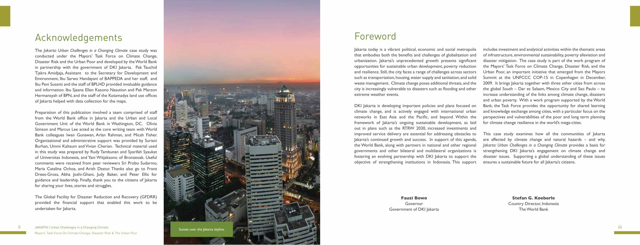
Sunset over the Jakarta skyline.

iv vJAKARTA | Urban Challenges in a Changing Climate
Mayors’ Task Force On Climate Change, Disaster Risk & The Urban Poor
Table of Contents
Acknowledgements iiForeword iiiExecutive Summary 1Introduction to the Mayors’ Task Force and this Case Study 3Background on Jakarta, a Global Megacity 5Climate Change Hazards and Vulnerability 11Climate Change and the Urban Poor 19Actions to Address Climate and Disaster Risks 28Steps Towards Resilience 40Resources 44
FiguresFigure 1: DKI Jakarta’s Administrative boundaries 5Figure 2: Land Use Change in Jakarta: 1970 - 2000 8Figure 3: Land Elevations in Jakarta 11Figure 4: Jakarta Land Use and Flood in 2007 13Figure 5: Land Subsidence and Sea Level Rise 15Figure 6: Global Sea Level Rise 17Figure 7: Effects of Sea Level Rise on North Jakarta in year 2050 17Figure 8: Mean Surface Temperature Jakarta 18Figure 9: Dengue Cases in Jakarta 18Figure 10: Slum Areas and Slum Area with Flood Map overlay 20Figure 11: Percentage of Unregistered Parcels by kelurahan 22Figure 12: Spatial Land Patterns Plan map in the RTRW 2030 plan for DKI Jakarta. 36
TablesTable 1: Population Growth in DKI Jakarta 6Table 2: World Cities Populations 6Table 3: City, Regional and National Population Densities 7Table 4: Jakarta’s Vehicles 10Table 5: Area of Jakarta Affected by Flooding 12Table 6: Rainfall during Last Two Major Flood Events 16Table 7: Flooded Areas in 2007 by Municipality 21Table 8: Roles and functions of key DKI government agencies related to climate change and disaster risk management. 28Table 9: Mitigation Activities in Jakarta 31Table 10: Adaptation Programs and Projects by DKI Jakarta 33Table 11: Adaptation Actions by Communities 33Table 12: Climate Change Projects by International Organizations 34Table 13: Poverty Alleviation Programs by DKI in 2010 35Table 14: Policies and Articles for Climate Change in the Mid- and Long-Term Spatial Plans 37
BoxesBox 1. Kampung Melayu 26Box 2. Kamal Muara 27
1
Executive Summary
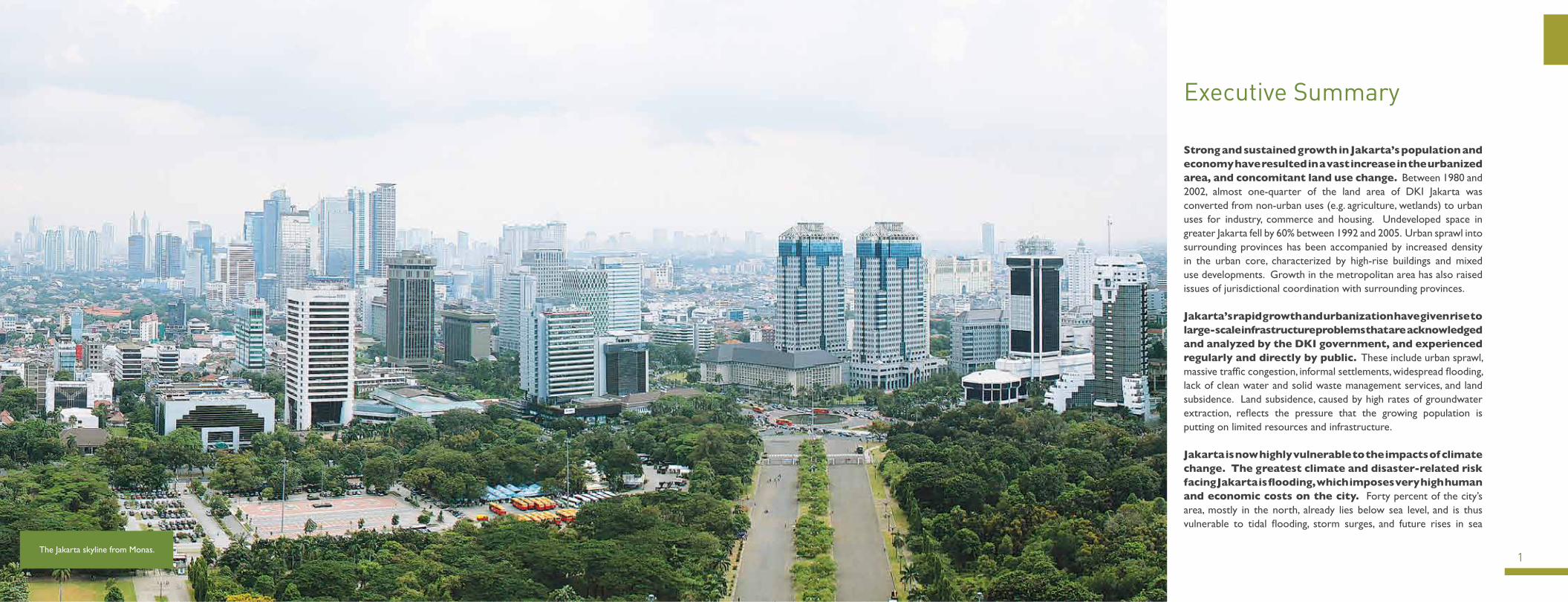
Strong and sustained growth in Jakarta’s population and economy have resulted in a vast increase in the urbanized area, and concomitant land use change. Between 1980 and 2002, almost one-quarter of the land area of DKI Jakarta was converted from non-urban uses (e.g. agriculture, wetlands) to urban uses for industry, commerce and housing. Undeveloped space in greater Jakarta fell by 60% between 1992 and 2005. Urban sprawl into surrounding provinces has been accompanied by increased density in the urban core, characterized by high-rise buildings and mixed use developments. Growth in the metropolitan area has also raised issues of jurisdictional coordination with surrounding provinces.
Jakarta’s rapid growth and urbanization have given rise to large-scale infrastructure problems that are acknowledged and analyzed by the DKI government, and experienced regularly and directly by public. These include urban sprawl, massive traffic congestion, informal settlements, widespread flooding, lack of clean water and solid waste management services, and land subsidence. Land subsidence, caused by high rates of groundwater extraction, reflects the pressure that the growing population is putting on limited resources and infrastructure.
Jakarta is now highly vulnerable to the impacts of climate change. The greatest climate and disaster-related risk facing Jakarta is flooding, which imposes very high human and economic costs on the city. Forty percent of the city’s area, mostly in the north, already lies below sea level, and is thus vulnerable to tidal flooding, storm surges, and future rises in sea
The Jakarta skyline from Monas.
2 3JAKARTA | Urban Challenges in a Changing Climate
Mayors’ Task Force On Climate Change, Disaster Risk & The Urban Poor
Along waterways, the encroachment of physical structures and the disposal of solid waste reduces drainage capacity and contributes to flooding. Any sustainable solution to flooding in Jakarta will need to address these issues with the active cooperation of local communities.
The government of DKI Jakarta has started taking action on climate change, but much remains to be done to mainstream climate change across all sectors for the long-term. Most actions so far have been related to mitigation, focusing on transportation, solid waste management and energy efficiency in buildings, with the Governor’s stated commitment to reduce emissions by 30% by 2030. Major infrastructure investments to reduce vulnerability include large flood canals and sea walls along the coast. There is a great deal more to be done in terms of planning for the future and preparing for climate-related disasters within communities and improving and updating government policies.
A few basic principles can guide the way forward for addressing climate change, disaster risk and urban poverty in Jakarta. First, climate change adaptation should be not so much an additional challenge to be layered onto existing policies and planning priorities, but rather an opportunity for the DKI government and key partners to gather their focus and priorities for the future. Given limited resources, the initial focus should be on addressing existing shortfalls in infrastructure investment and basic services, particularly in drainage, piped water supply, housing, and transportation. Policies and investments should be based on improved information, including quantitative data and an understanding of community-level actions and adaptive capacities. Finally, enhanced collaboration – with the administrations of neighboring provinces, as well as with the local communities as active participants and partners – is crucial to the success of long-term action.
Introduction to the Mayors’ Task Force and this Case Study
The impacts of climate change and natural disasters pose risks to cities due to the high concentration of people and economic assets, particularly in the hazard-prone locations of coastal and deltaic areas. Within cities, the impacts of climate change and disasters are distributed unevenly among different populations – there are often high concentrations of poor households living in locations that are more exposed to hazards such as landslides, floods and tidal surges. The adaptive capacity of households and communities, in the face of disasters and changes in climate, is also uneven. Low-income urban residents have less information and fewer safety nets, limiting their awareness and choices for responding to extreme weather events, and making them reluctant or unable to leave their homes and assets even when advised to do so. Yet, poor populations have also developed mechanisms and strategies to reduce their vulnerability in high-risk urban areas like Jakarta.
At the Mayors’ Summit in Copenhagen in December 2009, World Bank President Robert Zoellick and a number of mayors welcomed the formation of a Mayors’ Task Force on Urban Poverty and Climate Change. Subsequently, at the Global Dialogue for Mayors in January 2010, mayors from Dar es Salaam, Jakarta, Mexico City and São Paulo, together with global city networks, decided on the main elements of the Task Force’s work program. As part of this work program, case
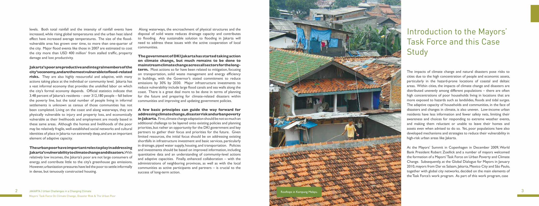
Rooftops in Kampung Melayu.
levels. Both total rainfall and the intensity of rainfall events have increased, while rising global temperatures and the urban heat island effect have increased average temperatures. The size of the flood-vulnerable area has grown over time, to more than one-quarter of the city. Major flood events like those in 2007 are estimated to cost the city more than USD 400 million1 from stalled traffic, property damage and lost productivity.
Jakarta’s poor are productive and integral members of the city’s economy, and are the most vulnerable to flood-related risks. They are also highly resourceful and adaptive, with many actions taking place at the individual or community level. Jakarta has a vast informal economy that provides the unskilled labor on which the city’s formal economy depends. Official statistics indicate that 3.48 percent of Jakarta’s residents – over 312,180 people – fall below the poverty line, but the total number of people living in informal settlements is unknown as census of those communities has not been completed. Living on the coast and along waterways, they are physically vulnerable to injury and property loss, and economically vulnerable as their livelihoods and employment are mostly based in these same areas. Although the homes and livelihoods of the poor may be relatively fragile, well-established social networks and cultural identities of place in Jakarta run extremely deep, and are an important element of adaptive capacity.
The urban poor have important roles to play in addressing Jakarta’s vulnerability to climate change and disasters. With relatively low incomes, the Jakarta’s poor are not large consumers of energy, and contribute little to the city’s greenhouse gas emissions. However, urbanization pressures have led the poor to settle informally in dense, but tenuously constructed housing.
4 5JAKARTA | Urban Challenges in a Changing Climate
Mayors’ Task Force On Climate Change, Disaster Risk & The Urban Poor
Introduction to the Mayors’
studies in the four participating cities were undertaken to better understand the links among urban poverty, climate change and disaster risk management and to share good practices in advancing climate-resilient programs to support the urban poor.
The World Bank, in close consultation with the Provincial Government of the Special Capital District (DKI) of Jakarta, and other stakeholders and partners, has prepared this case study of Jakarta. Key DKI government agencies, such as the departments responsible for development planning (BAPPEDA), environment (BPLHD), and spatial planning (Biro Tata Ruang) discussed existing city strategies and policies related to climate change. DKI Jakarta also hosted a stakeholder consultation workshop in December 2010, to review and strengthen the findings of this case study through conversations with different city officials and NGOs.
The approach used in this case study is based on the Urban Risk Assessment framework developed by the World Bank2. Accordingly, it includes an assessment of the hazards, socioeconomic vulnerabilities and institutional aspects related to climate change and disasters in Jakarta. With a focus on the urban poor, this study considers how poor communities are affected by climate change and natural hazards, examines approaches that have been taken to address these challenges, and identifies priorities and options for further action in Jakarta. This study draws on a number of other existing reports and resources on disasters and climate change issues in Jakarta, as well as on interviews and discussions with government officials, local NGOs, and community leaders.
Background on Jakarta, a Global Megacity
Jakarta is one of the biggest cities in Southeast Asia, and also the capital of one of its newest democracies. The city has been an active harbor area since the fourth century, and became a port city formally planned by the Dutch beginning in the 17th century. The province of DKI Jakarta is administered by a governor, and is comprised of five municipalities – North, South, East, West and Central Jakarta, each with their own mayor. DKI Jakarta also includes the regency of the Thousand Islands (Kepulauan Seribu), a collection of 105 small islands in the Java Sea (see Figure 1 for a map of Jakarta’s administrative boundaries).
Jakarta proper grew at a fairly steady rate through the middle of the 20th century and national independence in 1945. However, beginning in the early 1960s, intense growth and urbanization began and has continued to the present, resulting in the sprawling capital that is Jakarta today. Table 1 shows the strong increases in population that Jakarta has experienced over the past 50 years, growing at an average of 2.4% per year. In 1961, Jakarta’s population was 2.9 million, and by 2010 there were almost 9.6 million inhabitants. During the workweek, the population swells to over 12 million people due to people commuting into the city each day. In terms of world cities, Jakarta ranks 10th by population size (see Table 2).
Figure 1: DKI Jakarta’s Administrative boundaries
Source: DKI Jakarta.
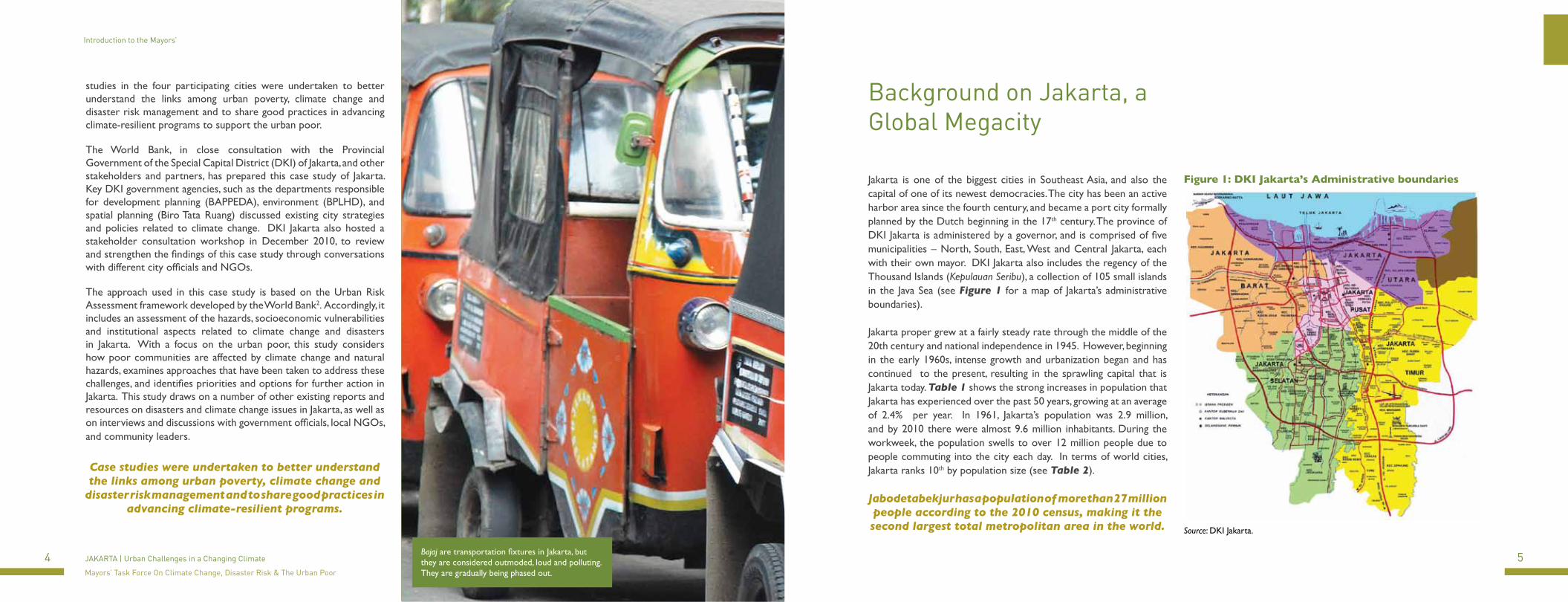
Bajaj are transportation fixtures in Jakarta, but they are considered outmoded, loud and polluting. They are gradually being phased out.
Case studies were undertaken to better understand the links among urban poverty, climate change and
disaster risk management and to share good practices in advancing climate-resilient programs.
Jabodetabekjur has a population of more than 27 million people according to the 2010 census, making it the second largest total metropolitan area in the world.
7
Background on Jakarta, a Global Megacity
6 JAKARTA | Urban Challenges in a Changing Climate
Mayors’ Task Force On Climate Change, Disaster Risk & The Urban Poor
Background on Jakarta, a Global Megacity
Table 1: Population Growth in DKI Jakarta
Year Population Increase over previous decade
1961 2,906,500 28%
1971 4,546,500 56%1980 6,503,400 43%1990 8,259,300 27%2000 8,385,600 2%2010 9,588,200 14%
Source: Badan Pusat Statistik Provinsi DKI Jakarta, 2009.
As a metropolitan region, the urban agglomeration is commonly referred to as Jabodetabekjur (derived from the names of the city and surrounding provinces – Jakarta, Bogor, Depok, Tangerang, Bekasi and Cianjur), and has a population of more than 27 million people according to the 2010 census, making it the second largest total metropolitan area in the world.3 DKI Jakarta itself is extremely densely populated relative to Jabodetabekjur and the rest of Indonesia (see Table 3). From a regional planning standpoint, the water management, solid waste, transportation and other policies of the neighboring provinces profoundly affect Jakarta.
Table 2: World Cities Populations
Rank City Country Population Definition Area (km²) Population density (/km²)
1 Shanghai China 13,831,900 Core districts + inner suburbs 1,928 7,1742 Mumbai India 13,830,884 Municipal Corporation 603 22,9373 Karachi Pakistan 12,991,000 City District 3,527 3,6834 Delhi India 12,565,900 Municipal Corporation 431 29,1495 Istanbul Turkey 12,517,664 Metropolitan Municipality 1,831 6,2116 São Paulo Brazil 11,244,369 Municipality 1,523 7,3837 Moscow Russia 10,508,971 City proper (incl. Zelenograd) 1,081 9,7228 Seoul South Korea 10,464,051 Special City 605 17,2889 Beijing China 10,123,000 Core districts + inner suburbs 1,368 7,40010 Jakarta Indonesia 9,588,200 Special capital district 662 14,48311 Tokyo Japan 8,887,608 23 Special Wards 617 14,40012 Mexico City Mexico 8,873,017 Federal District 1,485 5,97313 Kinshasa D.R. Congo 8,754,000 City-Province 2,016 4,34214 New York City United States 8,363,710 City proper 789 10,45215 Lagos Nigeria 7,937,932 Statistical Area 1,000 7,938
Source: Various municipal data agencies and reports, (see end note 3).
Table 3: City, Regional and National Population Densities
DKI JakartaMetropolitan
AreaRepublic of Indonesia
Land area (km²) 662 7,297 1,919,440 Population 9,588,200 27,067,133 238,000,000 Population Density/km²
14,483 3,462 134
Source: Badan Pusat Statistik Provinsi DKI Jakarta, 2009.
Beyond the size of its population, Jakarta has singular importance as the economic hub of Indonesia, the world’s fourth most populous country and largest Muslim nation. Jakarta’s economic output in third quarter of 2010 was IDR 220.5 trillion4 (USD 24.4 billion), indicating that annual economic output is now in the range of USD 100 billion, based on current nominal exchange rates. The city therefore accounts for close to one-fifth of Indonesia’s GDP, and its current per capita income of USD 10,582 is more than four times greater than the 2009 national average of USD 2,329.5
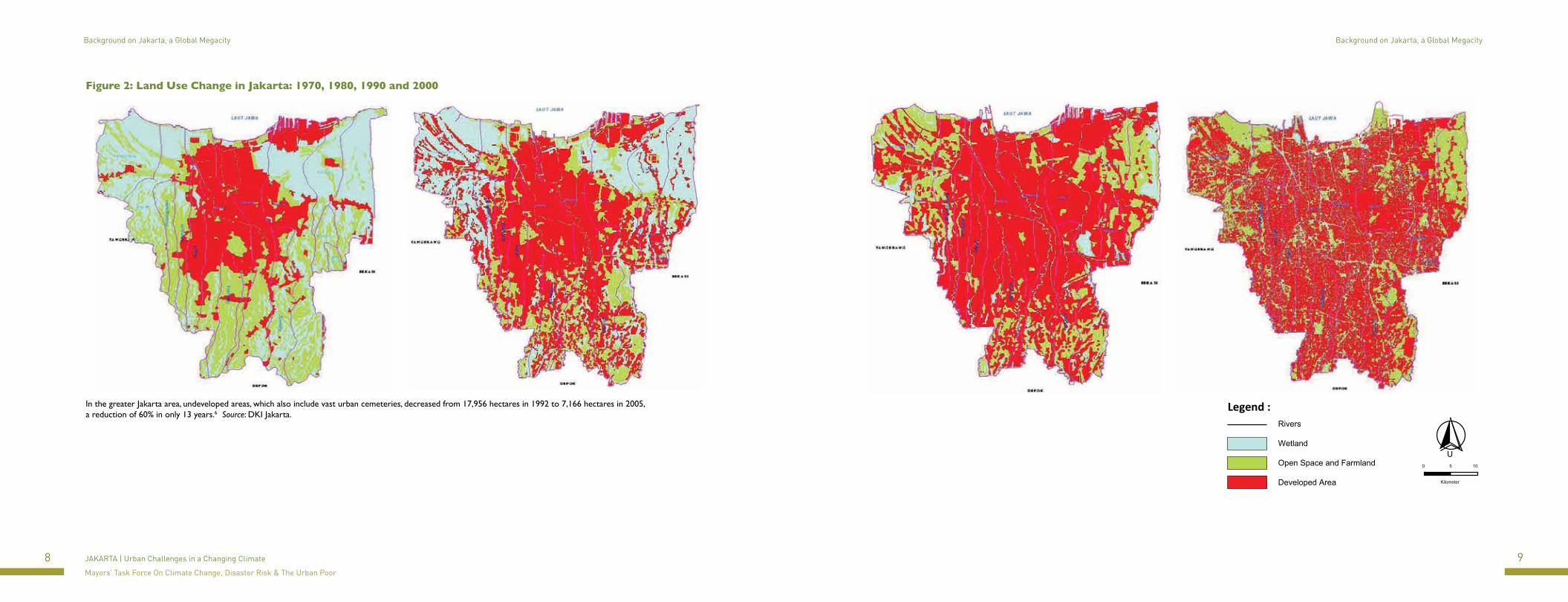
The strong and sustained growth in Jakarta’s population and economy has resulted in a vast increase in the urbanized area and concomitant land use change. Urbanization in Jakarta is characterized in terms of both densely organized sprawl as well as vertical growth of hundreds of towers and mixed-use developments. During a period of just over two decades from 1980 to 2002, almost one-quarter of all land in DKI Jakarta was converted from non-urban uses for agriculture or wetlands and water, to urban uses for industry, commerce and housing. The high economic value of land under urban use, as reflected in ever-increasing market prices and rents for land and property, continues to put pressure on remaining green space, which is crucial for absorbing run-off from rainfall and for replenishing the water table. Figure 2 illustrates this land use change from 1970 to 2000.
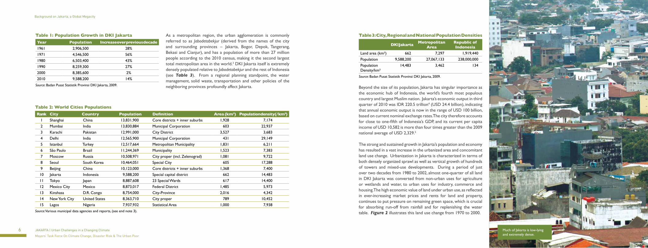
Much of Jakarta is low-lying and extremely dense.
8 9JAKARTA | Urban Challenges in a Changing Climate
Mayors’ Task Force On Climate Change, Disaster Risk & The Urban Poor
Background on Jakarta, a Global Megacity Background on Jakarta, a Global Megacity
Figure 2: Land Use Change in Jakarta: 1970, 1980, 1990 and 2000
In the greater Jakarta area, undeveloped areas, which also include vast urban cemeteries, decreased from 17,956 hectares in 1992 to 7,166 hectares in 2005, a reduction of 60% in only 13 years.6 Source: DKI Jakarta.
U0 5 10
Kilometer
Legend :Rivers
Wetland
Open Space and Farmland
Developed Area
10 11JAKARTA | Urban Challenges in a Changing Climate
Mayors’ Task Force On Climate Change, Disaster Risk & The Urban Poor
Background on Jakarta, a Global Megacity
Jakarta faces a range of serious physical challenges - largely related to infrastructure and planning - that both result from, and define, its urban character. These challenges are complex, interrelated, and mostly already well understood by the DKI government and the community at large. Infrastructure investments and basic service delivery like sewers, water, road construction and solid waste management have not kept pace with demand. This has resulted in problems such as massive traffic congestion, illness, informal settlements which are concentrated pockets of poverty, widespread flooding, and land subsidence. The city has a reputation for having some of the worst traffic jams in Southeast Asia, and for its densely populated kampungs (low-lying neighborhoods that are often characterized by a mix of formal and informal settlements). It is estimated that there are currently almost 12 million vehicles clogging Jakarta’s streets, of which almost 73% are motorcycles (see Table 4).
Jakarta also has institutional concerns that are critical for addressing infrastructure development and service delivery. The DKI government grapples with financial and technical capacity constraints in delivering services and responding to the wide range of needs. Administration costs are a large part of local government expenditure, while spending on basic services and infrastructure is lagging.7 Although many issues require integrated regional approaches and solutions for the entire greater Jakarta area, implementation and coordination are hampered by jurisdictional boundaries between DKI and surrounding provinces. Quantitative information on Jakarta’s poor population, the rate of in-migration, and the city’s large and important informal economy, are also inadequate. The impacts of climate change on the city have been difficult for the provincial government to quantify, and integrating climate change considerations into spatial planning and disaster prevention is largely new for the city government.
Climate Change Hazards and Vulnerability
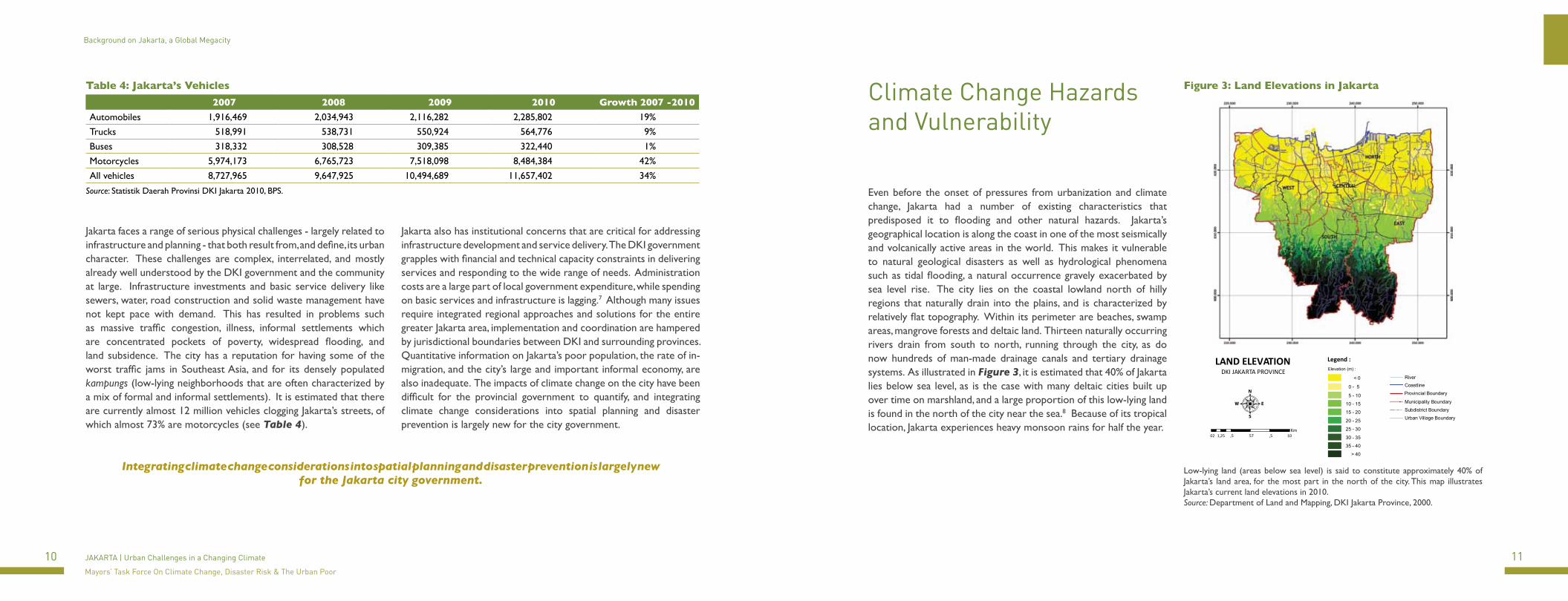
Even before the onset of pressures from urbanization and climate change, Jakarta had a number of existing characteristics that predisposed it to flooding and other natural hazards. Jakarta’s geographical location is along the coast in one of the most seismically and volcanically active areas in the world. This makes it vulnerable to natural geological disasters as well as hydrological phenomena such as tidal flooding, a natural occurrence gravely exacerbated by sea level rise. The city lies on the coastal lowland north of hilly regions that naturally drain into the plains, and is characterized by relatively flat topography. Within its perimeter are beaches, swamp areas, mangrove forests and deltaic land. Thirteen naturally occurring rivers drain from south to north, running through the city, as do now hundreds of man-made drainage canals and tertiary drainage systems. As illustrated in Figure 3, it is estimated that 40% of Jakarta lies below sea level, as is the case with many deltaic cities built up over time on marshland, and a large proportion of this low-lying land is found in the north of the city near the sea.8 Because of its tropical location, Jakarta experiences heavy monsoon rains for half the year.
Figure 3: Land Elevations in Jakarta
Legend :LAND ELEVATIONDKI JAKARTA PROVINCE
02 ,5 57 ,5 101,25Km
Elevation (m) :
< 0
0 - 5
5 - 10
10 - 15
15 - 20
20 - 25
25 - 30
30 - 35
35 - 40
> 40
CoastlineRiver
Municipality Boundary
Subdistrict Boundary
Urban Village Boundary
Provincial Boundary
Low-lying land (areas below sea level) is said to constitute approximately 40% of Jakarta’s land area, for the most part in the north of the city. This map illustrates Jakarta’s current land elevations in 2010. Source: Department of Land and Mapping, DKI Jakarta Province, 2000.
Table 4: Jakarta’s Vehicles
2007 2008 2009 2010 Growth 2007 -2010
Automobiles 1,916,469 2,034,943 2,116,282 2,285,802 19%Trucks 518,991 538,731 550,924 564,776 9%Buses 318,332 308,528 309,385 322,440 1%Motorcycles 5,974,173 6,765,723 7,518,098 8,484,384 42%All vehicles 8,727,965 9,647,925 10,494,689 11,657,402 34%
Source: Statistik Daerah Provinsi DKI Jakarta 2010, BPS.
Integrating climate change considerations into spatial planning and disaster prevention is largely new for the Jakarta city government.
12 13JAKARTA | Urban Challenges in a Changing Climate
Mayors’ Task Force On Climate Change, Disaster Risk & The Urban Poor
Climate Change Hazards and Vulnerability Climate Change Hazards and Vulnerability
Table 5: Area of Jakarta Affected by Flooding
Area (Ha)
1980 1996 2002 2007770 2,259 16,778 23,832
Source: Pengolahan Data Peta Wilayah Banjir, DPP DKI Jakarta,
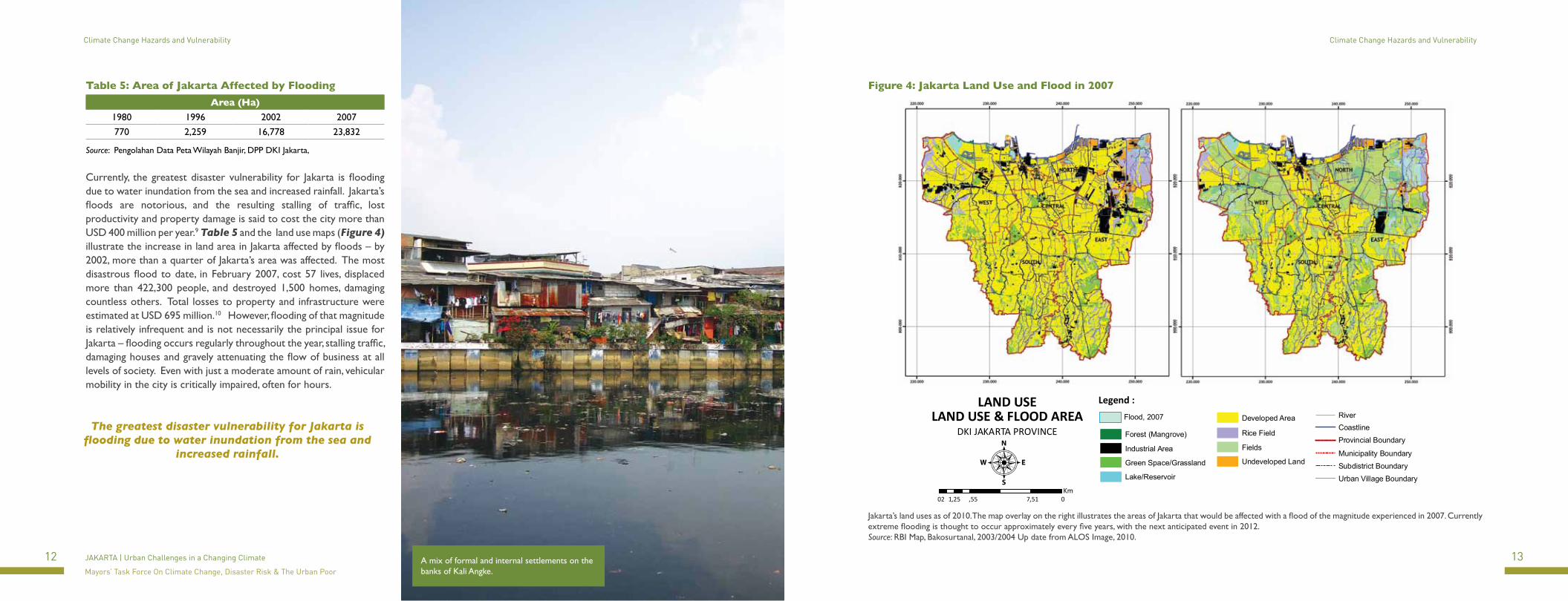
Currently, the greatest disaster vulnerability for Jakarta is flooding due to water inundation from the sea and increased rainfall. Jakarta’s floods are notorious, and the resulting stalling of traffic, lost productivity and property damage is said to cost the city more than USD 400 million per year.9 Table 5 and the land use maps (Figure 4) illustrate the increase in land area in Jakarta affected by floods – by 2002, more than a quarter of Jakarta’s area was affected. The most disastrous flood to date, in February 2007, cost 57 lives, displaced more than 422,300 people, and destroyed 1,500 homes, damaging countless others. Total losses to property and infrastructure were estimated at USD 695 million.10 However, flooding of that magnitude is relatively infrequent and is not necessarily the principal issue for Jakarta – flooding occurs regularly throughout the year, stalling traffic, damaging houses and gravely attenuating the flow of business at all levels of society. Even with just a moderate amount of rain, vehicular mobility in the city is critically impaired, often for hours.
Figure 4: Jakarta Land Use and Flood in 2007
02 ,55 7,51 01,25Km
LAND USELAND USE & FLOOD AREA
DKI JAKARTA PROVINCE
Legend :
Rice Field
Fields
Undeveloped Land
Developed AreaFlood, 2007
Forest (Mangrove)
Industrial Area
Green Space/Grassland
Lake/Reservoir
CoastlineRiver
Municipality Boundary
Subdistrict Boundary
Urban Village Boundary
Provincial Boundary
Jakarta’s land uses as of 2010. The map overlay on the right illustrates the areas of Jakarta that would be affected with a flood of the magnitude experienced in 2007. Currently extreme flooding is thought to occur approximately every five years, with the next anticipated event in 2012. Source: RBI Map, Bakosurtanal, 2003/2004 Up date from ALOS Image, 2010.
The greatest disaster vulnerability for Jakarta is flooding due to water inundation from the sea and
increased rainfall.
A mix of formal and internal settlements on the banks of Kali Angke.
14 15JAKARTA | Urban Challenges in a Changing Climate
Mayors’ Task Force On Climate Change, Disaster Risk & The Urban Poor
Climate Change Hazards and Vulnerability Climate Change Hazards and Vulnerability
Flood impacts are aggravated by human action (or inaction) in organizing and maintaining the built urban environment and infrastructure. Jakarta’s location in a major delta has required the development of an intricate and vast drainage network more than 14,000 km long. Yet, the entire system may be inadequate even if the pumps and canals were functioning at their optimum levels. These canals and drains are often clogged with garbage and debris that prevents their proper operation. Informal settlements along the canal banks also contribute to causing these blockages. Sediment build-up within the drainage system is ongoing, due lack of maintenance plans and weak regulation of solid waste disposal and service provision.
Land Subsidence
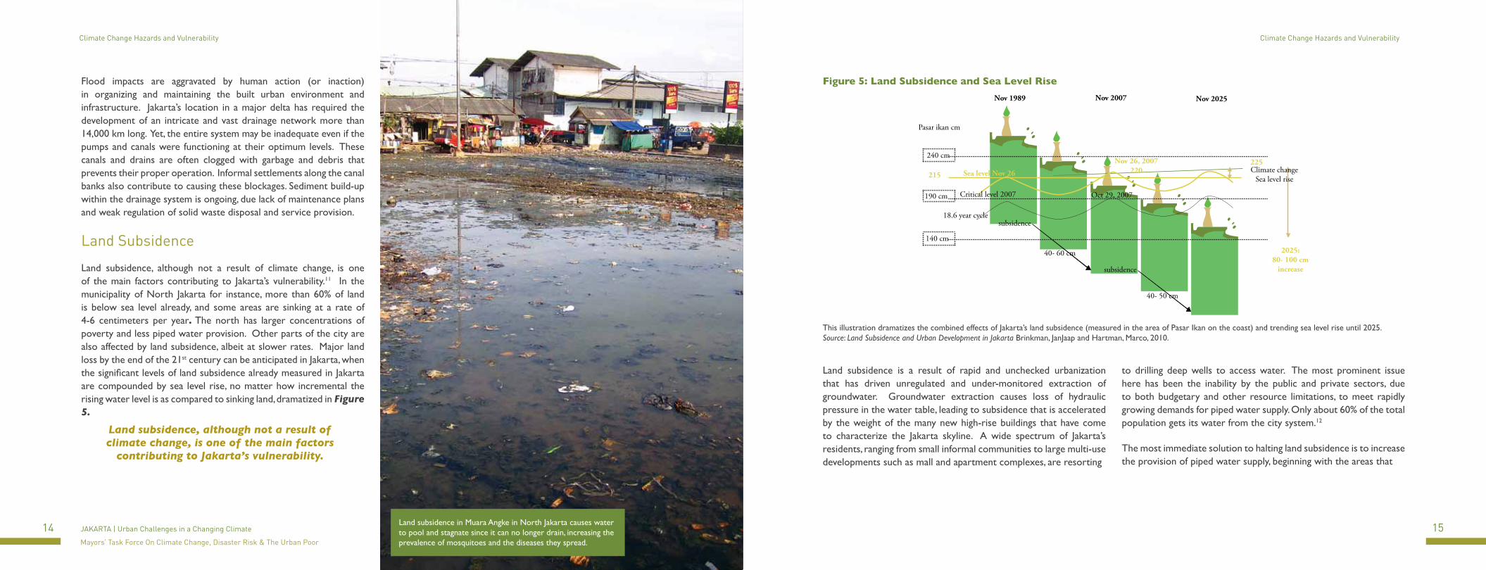
Land subsidence, although not a result of climate change, is one of the main factors contributing to Jakarta’s vulnerability.11 In the municipality of North Jakarta for instance, more than 60% of land is below sea level already, and some areas are sinking at a rate of 4-6 centimeters per year. The north has larger concentrations of poverty and less piped water provision. Other parts of the city are also affected by land subsidence, albeit at slower rates. Major land loss by the end of the 21st century can be anticipated in Jakarta, when the significant levels of land subsidence already measured in Jakarta are compounded by sea level rise, no matter how incremental the rising water level is as compared to sinking land, dramatized in Figure 5.
Figure 5: Land Subsidence and Sea Level Rise
Nov 1989 Nov 2007 Nov 2025
Pasar ikan cm
240 cm
140 cm
190 cm
215 Sea level Nov 26
Nov 26, 2007220
225
2025:80- 100 cm
increase
18.6 year cycle
Critical level 2007 Oct 29, 2007
subsidence
40- 60 cm
subsidence
40- 50 cm
Climate changeSea level rise
This illustration dramatizes the combined effects of Jakarta’s land subsidence (measured in the area of Pasar Ikan on the coast) and trending sea level rise until 2025. Source: Land Subsidence and Urban Development in Jakarta Brinkman, JanJaap and Hartman, Marco, 2010.
Land subsidence is a result of rapid and unchecked urbanization that has driven unregulated and under-monitored extraction of groundwater. Groundwater extraction causes loss of hydraulic pressure in the water table, leading to subsidence that is accelerated by the weight of the many new high-rise buildings that have come to characterize the Jakarta skyline. A wide spectrum of Jakarta’s residents, ranging from small informal communities to large multi-use developments such as mall and apartment complexes, are resorting
to drilling deep wells to access water. The most prominent issue here has been the inability by the public and private sectors, due to both budgetary and other resource limitations, to meet rapidly growing demands for piped water supply. Only about 60% of the total population gets its water from the city system.12
The most immediate solution to halting land subsidence is to increase the provision of piped water supply, beginning with the areas that
Land subsidence in Muara Angke in North Jakarta causes water to pool and stagnate since it can no longer drain, increasing the prevalence of mosquitoes and the diseases they spread.
Land subsidence, although not a result of climate change, is one of the main factors
contributing to Jakarta’s vulnerability.

16 17JAKARTA | Urban Challenges in a Changing Climate
Mayors’ Task Force On Climate Change, Disaster Risk & The Urban Poor
Climate Change Hazards and Vulnerability Climate Change Hazards and Vulnerability
are experiencing the greatest subsidence. Increasing the coverage of clean water supply also has the important benefit of improving the health and well being of many communities. Currently many of the poor in Jakarta rely on well water that is consistently non-potable, and so are also forced to purchase and carry expensive drinking and cooking water. Many of their other activities such as washing, bathing and toilet activities take place in the rivers and canals, contributing to pollution and spreading disease. The search for water and the high percentage of time and money spent finding and transporting it are a tremendous physical and economic burden for the poor. Women are particularly burdened, as the responsibility for finding water usually falls to them. In the longer-term, a broader and more holistic approach to urban planning and development can help to address land subsidence in an integrated manner.
Increased RainfallThere have been a number of studies on rainfall and weather anomalies for Indonesia, so data is available for the country as a whole. In terms of the region, Jakarta and the area of West Java have seen an increase in rainfall.13 Besides the increase in total rainfall, the intensity of rainfall events has also increased, in terms of both maximum daily rainfall and average daily rainfall. Table 6 shows the increase in total rainfall, and the increase in intensity, during Jakarta’s two most recent periods of flooding in 2001-2002 and 2006-2007. Although mean annual precipitation in Jakarta is projected to increase by only 2% in the period 2030-2049 over 1980-199914, the intensity of rainfall events, and overall variability, can be expected to increase further.
Table 6: Rainfall during Last Two Major Flood Events
2001-2002
2006-2007
Total rainfall for five stations (mm) 7,100.0 7,483.9Maximum rainfall upstream (mm/day) 168.1 247.0Maximum rainfall downstream (mm/day) 172.0 234.7Average rainfall intensity (mm/day) 21.1 25.8Average rainfall intensity upstream (mm/day) 20.6 24.8Average rainfall intensity downstream (mm/day) 21.9 27.3Percentage of days with rainfall 69.9 67.0Duration of event (days) 121.0 88.0Water level at Manggarai (cm) 1,050.0 1,061.0Flood level at Bukit Duri (m) 2.3 3.4
Source: Badan Meterologi dan Geofisika, Ciliwung Cisadane Project and Tempo (2007). Adapted from Pauline Texier, (2008) “Floods in Jakarta: when the extreme reveals daily structural constraints and mismanagement”, Disaster Prevention and Management,Vol. 17 Iss: 3.
The increase in the intensity and frequency of rainfall is also exacerbating the existing drainage problems and flooding across the city. Urbanization and changes in land use have diminished the amount of permeable surface area that allows for the natural absorption of rainwater into the ground. Heavy rainfall on impermeable surfaces generates increased run-off into the rivers and canals, which are already stressed to capacity, increasing flooding in streets and neighborhoods.
Sea Level Rise
Rising sea levels are a long-term climate change challenge for Jakarta. Figure 6 illustrates the anticipated rise in global sea level until the year 2100 due to thermal expansion of the oceans and melting of polar ice caps and glaciers. In addition to rising sea levels, climate change is also expected to increase the frequency and severity of extreme events such as storm surges and violent tides, a burgeoning trend in the region as a whole.15
Figure 6: Global Sea Level Rise
Additional contributionsfrom potential ice-sheetdynamic processes
Modelprojections
Sea
leve
l (m
)
Sea
leve
l (m
)
Year
Year
1.0
0.8
0.6
0.4
0.2
0.01990 2000 2010 2020 2030 2040 2050 2060 2070 2080 2090 2100
1990 1995 2000 2005
0.06
0.04
0.02
0.00
Source: World Climate Research Programme; Credit: J. Church et al. 2007.16
North Jakarta, which borders the Java Sea and is home to a wide range of income levels, and business, industry and port activities, is especially susceptible. Figure 7 depicts the effect of sea level rise on Jakarta until 2050.
Figure 7: Effects of Sea Level Rise on North Jakarta in year 2050
Blue=inundation due to sea level rise at 1 cm/yr
This illustration depicts the level of inundation Jakarta will experience in its coastal areas by the year 2050 if no interventions are carried out. An assumption of a sea level rise of 1cm/year is assumed in this model. While it is not pinpointed on the map, Jakarta’s historic ports, main industrial areas and airport will be underwater under this scenario. Source: Bandung Institute of Technology, 2007.
Rising Temperature
Jakarta is also vulnerable to a combination of rising global temperatures and the urban heat island effect. Figure 8 graphs the records of average surface temperature in Jakarta from 1881-1991, showing a steady increase of more than 1.5 degrees Celcius over this hundred-year period. The effect of global warming is expected to increase average temperatures in Jakarta by 1 degree Celsius by 2030, and by as much as 3 degrees by 2100.17 Compounding global warming across the globe is the more localized phenomenon of the urban heat island effect, resulting from the amount of heat created and absorbed in a highly dense urban environment.
Urbanization and changes in land use have diminished the amount of permeable surface area that allows for the natural absorption of rainwater into the ground.
18 19JAKARTA | Urban Challenges in a Changing Climate
Mayors’ Task Force On Climate Change, Disaster Risk & The Urban Poor
Climate Change Hazards and Vulnerability
Temperatures are generally higher in cities because concrete, asphalt and other dark, non-reflective surfaces absorb radiant heat, while energy expenditure, air-conditioning and traffic generate heat. Lack of green space also contributes to the heat island effect. This has also resulted in increased consumption of energy for air-conditioning to cool buildings, which in turn contributes to higher ambient temperatures in the city.
Figure 8: Mean Surface Temperature Jakarta
Jakarta/Obser (6.2 S,106.8E)
Annu
al M
ean
Tem
pera
ture
s (˚C
)
29.0
28.5
29.0
28.0
27.5
27.0
26.5
26.0
25.51880 1900 1920 1940 1960 1980 2000 2020
50.967450000 : KM
Graph of mean surface temperature in Jakarta, years 1880 to 1990, with 2000 and 2010 as projections. Source: Goddard Institute for Space Studies, NASA.
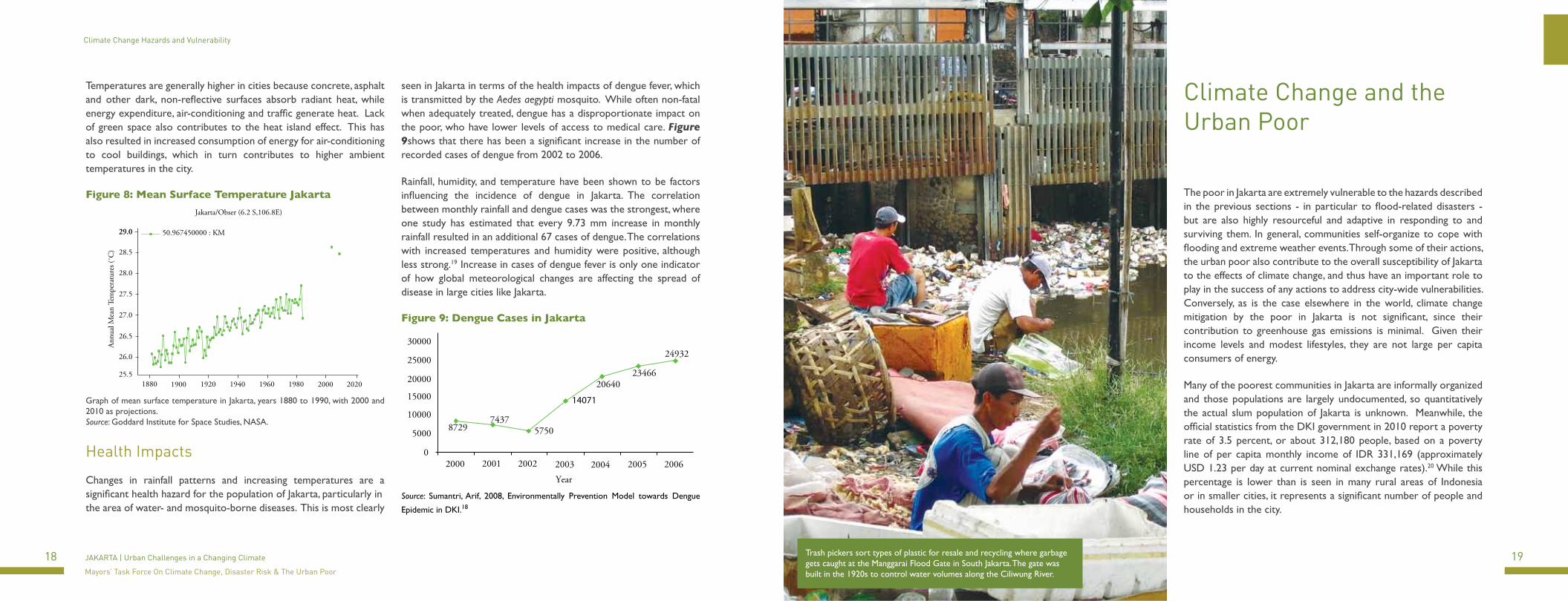
Health Impacts
Changes in rainfall patterns and increasing temperatures are a significant health hazard for the population of Jakarta, particularly in the area of water- and mosquito-borne diseases. This is most clearly
seen in Jakarta in terms of the health impacts of dengue fever, which is transmitted by the Aedes aegypti mosquito. While often non-fatal when adequately treated, dengue has a disproportionate impact on the poor, who have lower levels of access to medical care. Figure 9shows that there has been a significant increase in the number of recorded cases of dengue from 2002 to 2006.
Rainfall, humidity, and temperature have been shown to be factors influencing the incidence of dengue in Jakarta. The correlation between monthly rainfall and dengue cases was the strongest, where one study has estimated that every 9.73 mm increase in monthly rainfall resulted in an additional 67 cases of dengue. The correlations with increased temperatures and humidity were positive, although less strong.19 Increase in cases of dengue fever is only one indicator of how global meteorological changes are affecting the spread of disease in large cities like Jakarta.
Figure 9: Dengue Cases in Jakarta
Year
30000
25000
20000
10000
15000
5000
02000 2001 2002 2003 2004 2005 2006
87297437
5750
14071
2064023466
24932
Source: Sumantri, Arif, 2008, Environmentally Prevention Model towards Dengue
Epidemic in DKI.18
Climate Change and the Urban Poor
The poor in Jakarta are extremely vulnerable to the hazards described in the previous sections - in particular to flood-related disasters - but are also highly resourceful and adaptive in responding to and surviving them. In general, communities self-organize to cope with flooding and extreme weather events. Through some of their actions, the urban poor also contribute to the overall susceptibility of Jakarta to the effects of climate change, and thus have an important role to play in the success of any actions to address city-wide vulnerabilities. Conversely, as is the case elsewhere in the world, climate change mitigation by the poor in Jakarta is not significant, since their contribution to greenhouse gas emissions is minimal. Given their income levels and modest lifestyles, they are not large per capita consumers of energy.
Many of the poorest communities in Jakarta are informally organized and those populations are largely undocumented, so quantitatively the actual slum population of Jakarta is unknown. Meanwhile, the official statistics from the DKI government in 2010 report a poverty rate of 3.5 percent, or about 312,180 people, based on a poverty line of per capita monthly income of IDR 331,169 (approximately USD 1.23 per day at current nominal exchange rates).20 While this percentage is lower than is seen in many rural areas of Indonesia or in smaller cities, it represents a significant number of people and households in the city.
Trash pickers sort types of plastic for resale and recycling where garbage gets caught at the Manggarai Flood Gate in South Jakarta. The gate was built in the 1920s to control water volumes along the Ciliwung River.
20 21JAKARTA | Urban Challenges in a Changing Climate
Mayors’ Task Force On Climate Change, Disaster Risk & The Urban Poor
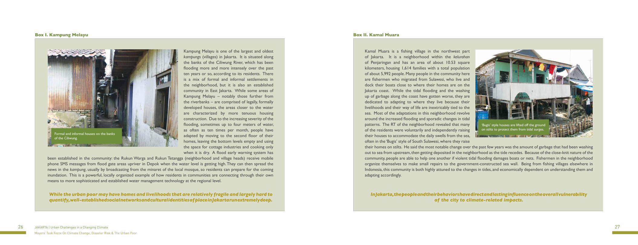
Figure 10: Slum Areas and Slum Area with Flood Map overlay
02 ,5 57 ,5 101,25Km
SLUM AREASSLUM AREAS & FLOOD
DKI JAKARTA PROVINCE
CoastlineRiver
Municipality Boundary
Subdistrict BoundaryUrban Village Boundary
Provincial Boundary
Legend :
Flood, 2007
Heavy Slum
Slum
Light Slum
Non Slum
Jakarta’s slum areas with overlay of 2007 flood. Data for slums was only available from 2000, as the 2010 data collection has not been tabulated and made available. Slum level is determined through weights and rankings established by BPS using the Delphi method. Source: Department of Land and Mapping, DKI Jakarta Province, 2000
For the purposes of describing communities that are considered the urban poor in Jakarta, this case study uses the Indonesian government’s definition of the poverty line. “Poverty is measured by the poverty line, which is the amount of money required to meet the minimum needs of food and non food necesssities for survival. In 2010, the amount was IDR 331,169 (about USD $39 in mid 2011 conversion rates) per capita per month.”21 However, many informal communities may be subsisting on far less. Unmonitored immigration into the city also accounts for the growth of this population, at a rate that is not fully measured or understood.
The map in Figure 10 shows the areas of Jakarta that are considered to be slum areas. The grade of slum is based upon a ranking system by the Bureau of Statistics measuring the number of houses unfit for habitation, the quality of water and sewer services, population density, the use of streams as toilets and water sources, and how marginal of a location it is found in. Table 7 shows the numbers of urban poor broken down by municipality (kotamadya). The greatest concentrations by far are in North Jakarta. For example, the massive informal settlement at Waduk Pluit in North Jakarta is said to be comprised of more than 70,000 people.22
Pressures from migration into the city, the lack of provision of healthy and legal housing options, and the weak or illegal management of squatters on vacant land have caused the establishment and growth of these large informal communities.
The poorest communities in Jakarta live in self-constructed settlements, usually on land without formal legal title, and working in informal jobs. In some instances, illegal and undocumented land leasing and landlord-tenant contracting is practiced. These systems are nuanced and sophisticated, but again remain barely quantified and largely anecdotal. Jakarta has a long history of large informal settlements, such as those in Kampung Melayu and Kamal Muara (see text boxes later) and many others. In many of these areas, some individuals and families have lived in what could be considered as ‘slums’, for decades. So while the urban poor may have homes and livelihoods that are relatively fragile and largely hard to quantify, well-established social networks and cultural identities of place in Jakarta run extremely deep. These informal social and economic networks are also one of the adaptive strengths of Jakarta’s urban poor – but fully appreciating, harnessing, and formalizing these networks is one of DKI’s Jakarta’s biggest challenges. Figure 11 shows the percentages of land tenure across Jakarta’s kelurahans. In a large percentage of the city more than 50% of the land parcels are unregistered with the government and do not have title.
Table 7: Flooded Areas in 2007 by MunicipalityMunicipality Population Total Population in informal
settlements% population in
informal settlementsArea (km2) Area affected by 2007
floods (km2)% total area
affected by floodsNorth 1,452,285 167,920 11.56% 139.88 71.22 50.92%
West 2,130,696 20,409 0.96% 125.32 50.02 39.91%Central 891,788 3,912 0.44% 48.66 24.76 50.88%East 2,413,875 20,292 0.84% 186.32 20.1 10.79%South 2,053,684 17,114 0.83% 145.32 16.73 11.51%
TOTAL JAKARTA 8,942,328 229,647 2.57% 645.5 182.83 28.32%
While the population numbers vary slightly from 2010 data, this analysis is included to demonstrate the correlation between a high percentage of informal settlements and amount of flooded area in Jakarta, with North Jakarta being the most affected, followed by West Jakarta. Source: Mercy Corps Indonesia. Data from 2004.

22 23JAKARTA | Urban Challenges in a Changing Climate
Mayors’ Task Force On Climate Change, Disaster Risk & The Urban Poor
Figure 11: Percentage of Unregistered Parcels by kelurahan
0 2,5 5 7,5 101,25Km
Note :
Legend :UNREGISTERED LAND
UNREGISTERED LAND & FLOOD AREA DKI JAKARTA PROVINCE
Percentage of Unregistered Land :
50 - 60 %
60 - 70 %
70 - 80 %
80 - 90 %
0 - 10 %
10 - 20 %
20 - 30 %
30 - 40 %
40 - 50 %
Flood, 2007
CoastlineRiver
Municipality BoundarySubdistrict BoundaryUrban Village Boundary
Provincial Boundary
Land tenure (registered versus unregistered parcels of land) is one of the main challenges to housing development in Jakarta. For graphic simplicity and clarity, percentages of unregistered land were mapped at the kelurahan level for the purposes of this study. Source: BPN Departments of North, South, East, West and Central Jakarta Municipalities
A full-scale study on the vulnerability and adaptive capacity of the urban poor in Jakarta – and for Jakarta as a whole – has yet to be carried out. This case study is therefore an initial step towards such a comprehensive understanding, based on the Intergovernmental Panel on Climate Change’s definition of vulnerability: “The degree to which a system is susceptible to, and unable to cope with, adverse effects of climate change, including climate variability and extremes.”23 Climate change vulnerability mapping has been undertaken for Southeast Asia, based on assessments of exposure to hazards, the location of populations, and adaptive capacity. Indices for these factors have been developed based on quantitative measures of vulnerability. Analyses of this type have been carried out for a number of smaller cities in Indonesia, to understand the adaptive capacity of poor communities. These approaches are available and would be useful for DKI Jakarta since they are based on standardized measurements and help to identify areas of extreme vulnerability – and strong adaptive capacity.
Jakarta’s poor face the greatest flood-related risks
The urban poor in Jakarta are extremely vulnerable to disasters and climate change impacts, because they tend to settle near bodies of water like rivers, canals and reservoirs, and along the coast where the land is mostly low-lying. This results in a high degree of exposure to flooding and related hazards due to rains and tidal floods (locally referred to as rob), described in the previous sections. The combination of these hazards and the economic and physical fragility of the poor puts them at high risk for loss of property, illness, economic disenfranchisement, social disruption and displacement. Although many of these high-risk areas are legally meant to remain
vacant, weak enforcement by the public sector and informal subletting by the private sector have allowed these settlements to grow over the years.
In Jakarta, the vulnerability of the urban poor in relation to climate change is two-fold. They are physically vulnerable to injury and loss of property because of where they live. They are socio-economically vulnerable as their livelihoods are also often tied to those areas that are at risk, such as for fishermen or at the port and industrial centers located near the coast. In many cases, their adaptive capacity is limited, due to the low level of access to basic services like fresh water, health care, and education. North Jakarta experiences the highest rates of poverty concentration, industry and flooded area. In some communities like Kampung Melayu and Bukit Duri there are regular evacuations of neighborhoods. On the coast, communal wells are affected by saline intrusion, while further inland, garbage and sewage dumped further upstream results in the spread of illness because of water pollution.
The urban poor also contribute to Jakarta’s overall vulnerability.
In Jakarta, the people and their behaviors have direct and lasting influence on the overall vulnerability of the city to climate-related impacts. Weak government regulation of where people are allowed to actually live is compounded by the lack of provision of basic services such as adequate housing, clean water and garbage collection. The development of physical structures that encroach into the waterways and block the drainage capacity of the canals and rivers has caused major issues for the already taxed system. Communities also tend
Although many of these high-risk areas are legally meant to remain vacant, weak enforcement by the public sector and informal subletting by the private sector have allowed these settlements
to grow over the years.

24 25JAKARTA | Urban Challenges in a Changing Climate
Mayors’ Task Force On Climate Change, Disaster Risk & The Urban Poor
The urban poor are highly adaptive, but remain vulnerable.
Adaptations plan in poor communities is coordinated by Bappeda, while its implementation is coordinated by Asisten Pembangunan danLingkungan Hidup Sekda Provinsi DKI Jakarta for Infrastructure projects and Asisten Kesejahteraan Masyarakat for Community Empowerment projects, particularly Program Pemberdayaan Masyarakat Kelurahan (PPMK). This program takes place at the individual or community level. See Table 13 for poverty alleviation programs carried out by DKI Jakarta in 2010. Yet, the urban poor are often extremely resourceful and organized in making their situation work for them, and learning to survive. In some cases, these communities manage to stay where they are and live with conditions as they change. They are constantly adapting - by raising their homes, or in some instances changing the manner in which they live, even abandoning the bottom level of two-storey houses due to frequency of floods. In other cases people change livelihoods or locations.
Community spirit and organization are very often strong, and people help one another through community savings programs, early warning systems, informal professional unions for women artisans and small-scale environmental clean-ups like clearing smaller drains. Gotong-royong is a traditional community practice of communal action where the entire community contributes resources and participates in a project or activity that benefits the community at large or specific members. For example, groups that are ethnically tied together due to shared livelihoods like fishermen (see text box on Kamal Muara) have a kind of social security through powerful social and familial networks that are of tremendous benefit. This high level of communication and cooperation through organic existing social networks may be the most useful and powerful means for climate change adaptation that a city can have.
The urban poor are productive and integral members of the city economy.
The residents of Jakarta’s informal settlements contribute to the vast informal economy of the city, and also support the functioning of the formal economy. While the actual numbers remain hard to accurately measure, up to 38% of Jakarta’s economy is considered informal. 25 In most areas of Jakarta, the residents of informal settlements work as maids, janitors, satpams (security guards), parking attendants and also run small local businesses such as food stalls and small tokos (retail kiosks). In coastal settlements, the fishermen are key to providing larger companies with supplies of fish to sell across the city.
As a large urban agglomeration, Jakarta offers the economic opportunities that attract many new residents from elsewhere. As an example, annual migration into Jakarta has been estimated at between 200,000 and 250,000 during the period 2002-2004.26 This in-migration, and natural population growth of the city needs to be planned for and managed adequately, in order for Jakarta to realize the full potential of growth, agglomeration economies and competitiveness, as demonstrated in the World Development Report 2009. 27 The alternative would be for informal settlements to continue to grow, exacerbating the risks and vulnerabilities discussed above – both in terms of climate change and pressure on infrastructure in all sectors, from transportation to housing to water provision and solid waste management.
Clean water (air bersih) is sold near a port in North Jakarta. Land subsidence and tidal floods have contributed to the salination of ground water from the sea.
This high level of communication and cooperation through organic existing social networks may be the most useful and powerful means for climate change adaptation that a city can have.
to use the rivers for the disposal of their solid waste, notably plastic bags and other refuse. As in the case of limited coverage of the piped water system in Jakarta, solid waste disposal options are also inadequate or non-existent. The urban poor thus have a crucial role to play in addressing issues of vulnerability in Jakarta, and in particular with respect to the government’s ability to implement city-wide spatial planning initiatives and flood alleviation interventions.
Addressing the linkages among climate change, disaster risk and the urban poor in Jakarta is thus one of the most complex socioeconomic, human rights and logistical issues faced by the DKI government, and also one of the city’s most urgent problems. Many housing, land use and zoning laws exist, but they remain largely unenforced which allows for the proliferation of informal settlements. For example, many of the waterways are owned and controlled by either the city or the central government. Although these laws require vacant easements of about ten to 15 meters along waterways, these are precisely the areas where informal settlements tend to establish themselves. One way of managing informal settlements has been through an eviction policy and the demolition of structures after three public warnings to move. There has been outcry from NGOs, community organizations and other civil rights groups over the eviction methods currently practiced by the government. Communities are generally moved into apartment blocks in the relative vicinity of their informal settlements for a very low cost, but many do not remain for long – within a matter of years, informal housing reappears on the under-regulated easements along the waterways, populated by new immigrants or returning residents.24
26 27JAKARTA | Urban Challenges in a Changing Climate
Mayors’ Task Force On Climate Change, Disaster Risk & The Urban Poor
Box I. Kampung Melayu Box II. Kamal Muara
Kamal Muara is a fishing village in the northwest part of Jakarta. It is a neighborhood within the kelurahan of Penjaringan and has an area of about 10.53 square kilometers, housing 1,614 families with a total population of about 5,992 people. Many people in the community here are fishermen who migrated from Sulawesi, who live and dock their boats close to where their homes are on the Jakarta coast. While the tidal flooding and the washing up of garbage along the coast have gotten worse, they are dedicated to adapting to where they live because their livelihoods and their way of life are inextricably tied to the sea. Most of the adaptations in this neighborhood revolve around the increased flooding and sporadic changes in tidal patterns. The RT of the neighborhood revealed that many of the residents were voluntarily and independently raising their houses to accommodate the daily swells from the sea, often in the ‘Bugis’ style of South Sulawesi, where they raise their homes on stilts. He said the most notable change over the past few years was the amount of garbage that had been washing out to sea from upstream, then getting deposited in the neighborhood as the tide recedes. Because of the close-knit nature of the community, people are able to help one another if violent tidal flooding damages boats or nets. Fishermen in the neighborhood organize themselves to make small repairs to the government-constructed sea wall. Being from fishing villages elsewhere in Indonesia, this community is both highly attuned to the changes in tides, and economically dependent on understanding them and adapting accordingly.
In Jakarta, the people and their behaviors have direct and lasting influence on the overall vulnerability of the city to climate-related impacts.
While the urban poor may have homes and livelihoods that are relatively fragile and largely hard to quantify, well-established social networks and cultural identities of place in Jakarta run extremely deep.
Kampung Melayu is one of the largest and oldest kampungs (villages) in Jakarta. It is situated along the banks of the Ciliwung River, which has been flooding more and more intensely over the past ten years or so, according to its residents. There is a mix of formal and informal settlements in the neighborhood, but it is also an established community in East Jakarta. While some areas of Kampung Melayu – notably those further from the riverbanks – are comprised of legally, formally developed houses, the areas closer to the water are characterized by more tenuous housing construction. Due to the increasing severity of the flooding, sometimes up to four meters of water, as often as ten times per month, people have adapted by moving to the second floor of their homes, leaving the bottom levels empty and using the space for cottage industries and cooking only when it is dry. A flood early warning system has
been established in the community: the Rukun Warga and Rukun Tetangga (neighborhood and village heads) receive mobile phone SMS messages from flood gate areas upriver in Depok when the water level is getting high. They can then spread the news in the kampung, usually by broadcasting from the minaret of the local mosque, so residents can prepare for the coming inundation. This is a powerful, locally organized example of how residents in communities are connecting through their own means to more sophisticated and established water management technology at the regional level.
‘Bugis’ style houses are lifted off the ground on stilts to protect them from tidal surges.
Formal and informal houses on the banks of the Ciliwung.
28 29JAKARTA | Urban Challenges in a Changing Climate
Mayors’ Task Force On Climate Change, Disaster Risk & The Urban Poor
Actions to Address Climate and Disaster Risks
Actions to Address Climate and Disaster Risks
Institutional Aspects in DKI Jakarta
The key government agencies in DKI Jakarta responsible for coordinated efforts on climate change adaptation and disaster risk management are the province’s environmental agency, Badan Pengelolaan Lingkungan Hidup Daerah (BPLHD); the development planning agency, Badan Perencanaan Pembangunan Daerah (BAPPEDA); the disaster management agency, Badan Penanggulangan Bencana Daerah (BPBD); and the Assistant to the Secretary for Development and Environment (Assisten Pembangunan dan Lingkungan Hidup). Their roles and functions are summarized in Table 8 below.
Table 8: Roles and functions of key DKI government agencies related to climate change and disaster risk management.
Assisten Pembangunan dan Lingkungan Hidup is the office for the department of spatial planning and the bureau of city infrastructure. Its function is to coordinate the implementation of all physical, infrastructural and environmental projects. Consistent with these plans are specific laws and regulations addressing climate change adaptation and mitigation actions as well as disaster risk management. This body also handles coordination of development projects between BAPPEDA and other departments such as solid waste management, transportation, etc.
BAPPEDA is the development planning agency for Jakarta, managing the budget allocation for development. This includes large infrastructure projects such as the sea wall construction in North Jakarta, the building of floodgates along rivers, and the East and West Flood Canals. BAPPEDA is coordinating all development plans including those related to infrastructure, the environment, social welfare, economy, and governance
BPLHD is responsible for technical and social aspects of environmental programs, including key governmental efforts on climate change. It is involved in a number of greenhouse gas abatement programs in Jakarta, and is managing the development of a greenhouse gas emissions baseline, to be completed in 2011. BPLHD also manages a number of community-level adaptation initiatives and studies in partnership with NGOs and donor organizations like those enumerated in Table 12.
BPBD was established as the city-wide agency for disaster risk management only at the end of 2010. Previously, disaster response was handled by SATKORLAK, a national ad-hoc committee based largely in the fire department. The formal empowerment and role of BPBD has yet to be fully developed, integrated and made widely known among the public.
Department of Public Works (Pekerjaan Umum) is the national public works agency responsible for the development of major large infrastructure projects in Jakarta such as the East and West Flood Canals, and will be involved with large-scale adaptation interventions in the future. Much of Jakarta’s infrastructure is financed in part through the national government. The agency is also responsible for infrastructure maintenance.
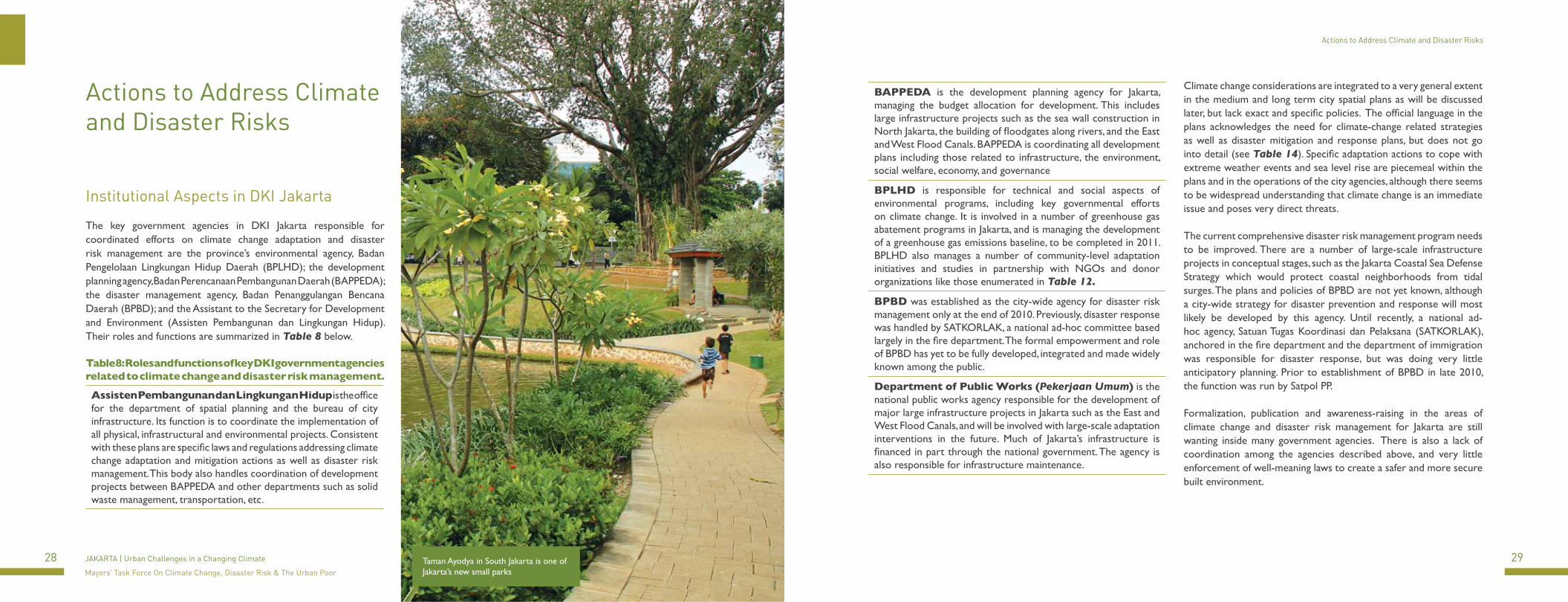
Taman Ayodya in South Jakarta is one of Jakarta’s new small parks
Climate change considerations are integrated to a very general extent in the medium and long term city spatial plans as will be discussed later, but lack exact and specific policies. The official language in the plans acknowledges the need for climate-change related strategies as well as disaster mitigation and response plans, but does not go into detail (see Table 14). Specific adaptation actions to cope with extreme weather events and sea level rise are piecemeal within the plans and in the operations of the city agencies, although there seems to be widespread understanding that climate change is an immediate issue and poses very direct threats.
The current comprehensive disaster risk management program needs to be improved. There are a number of large-scale infrastructure projects in conceptual stages, such as the Jakarta Coastal Sea Defense Strategy which would protect coastal neighborhoods from tidal surges. The plans and policies of BPBD are not yet known, although a city-wide strategy for disaster prevention and response will most likely be developed by this agency. Until recently, a national ad-hoc agency, Satuan Tugas Koordinasi dan Pelaksana (SATKORLAK), anchored in the fire department and the department of immigration was responsible for disaster response, but was doing very little anticipatory planning. Prior to establishment of BPBD in late 2010, the function was run by Satpol PP.
Formalization, publication and awareness-raising in the areas of climate change and disaster risk management for Jakarta are still wanting inside many government agencies. There is also a lack of coordination among the agencies described above, and very little enforcement of well-meaning laws to create a safer and more secure built environment.
30 31JAKARTA | Urban Challenges in a Changing Climate
Mayors’ Task Force On Climate Change, Disaster Risk & The Urban Poor
Actions to Address Climate and Disaster Risks Actions to Address Climate and Disaster Risks
Table 9: Mitigation Activities in JakartaAction Sector DescriptionGHG Emission Baseline Count Transportation / Solid Waste Collaboration between DKI government and local NGOs to measure and document a
GHG emissions baseline starting in 2005. TransJakarta Busway Transportation Ongoing development of massive public transportation system of grade-level dedicated
buslanesPrivate Vehicle Emissions Counts
Transportation Required regulation and checking of emissions of private vehicles.
Car Free Day Transportation Twice a month restriction of cars on major Jakarta thoroughfares to provide space for bicycling, walking and jogging.
Kerosene to LPG Conversion Energy/Economy Conversion of all kerosene gas canisters to liquified petroleum gas.Blue Bajaj Transportation/Economy Creation of blue bajaj which run on compressed natural gas rather than diesel. Energy Effciency Building Retrofit
Energy/Economy Retrofits and upgrading for government buildings in Jakarta to increase energy efficiency, including low wattage bulbs and urgraded HVAC systems.
Green Building Inventory Construction and real estate development/management
Study about the feasibility of building methods and construction retrofits for private real estate development in Jakarta.
Carbon Finance Capacity Building
Energy/Economic Development
Traning and education within government for the development and management of carbon finance in Jakarta.
NGOs and other donor organizations also play important roles currently in supporting communities and local community-level government actors to educate and prepare individual citizens, families and community leaders for damaging events such as floods from extreme rainfall or tidal flooding. However, these actions are piecemeal across the city and are not mainstreamed. These actions are also narrowly targeted at extremely poor communities, so do not necessarily take into account vulnerable communities at other income levels.
Climate Change Mitigation and the Environment
At the national level, the government of Indonesia has launched a climate change program through the Ministry of Environment, the agency responsible for formulating a National Action Plan28 to address climate change. Due to the high rate of deforestation and land use change across the archipelago, Indonesia comes in as the country with third-highest emissions of greenhouse gases globally.29 Indonesia is thus under considerable pressure to curb deforestation by the international community and local environmentalists.
Jakarta, although highly industrialized, is only responsible for a fraction of Indonesia’s total national emissions, but the city has already undertaken a number of actions to understand and to reduce them. A greenhouse gas emissions inventory for DKI Jakarta is being prepared. The DKI government has been ramping up its mitigation policies and programs, mostly with foundation partners. Governor Fauzi Bowo has made public announcements that the province will reduce its emissions by 30% by the year 2030, although the baseline year from which to benchmark this reduction is in the process of being defined. The sectors most directly engaged in efforts to reduce greenhouse gas emissions thus far are infrastructure, solid waste management and transportation. Table 9 lists the current initiatives by the government to reducet emissions through transportation and energy efficiency initiatives.
Jakarta, although highly industrialized, is only responsible a fraction of Indonesia’s total national emissions, but the city has already undertaken a number of actions to
understand and to reduce them.
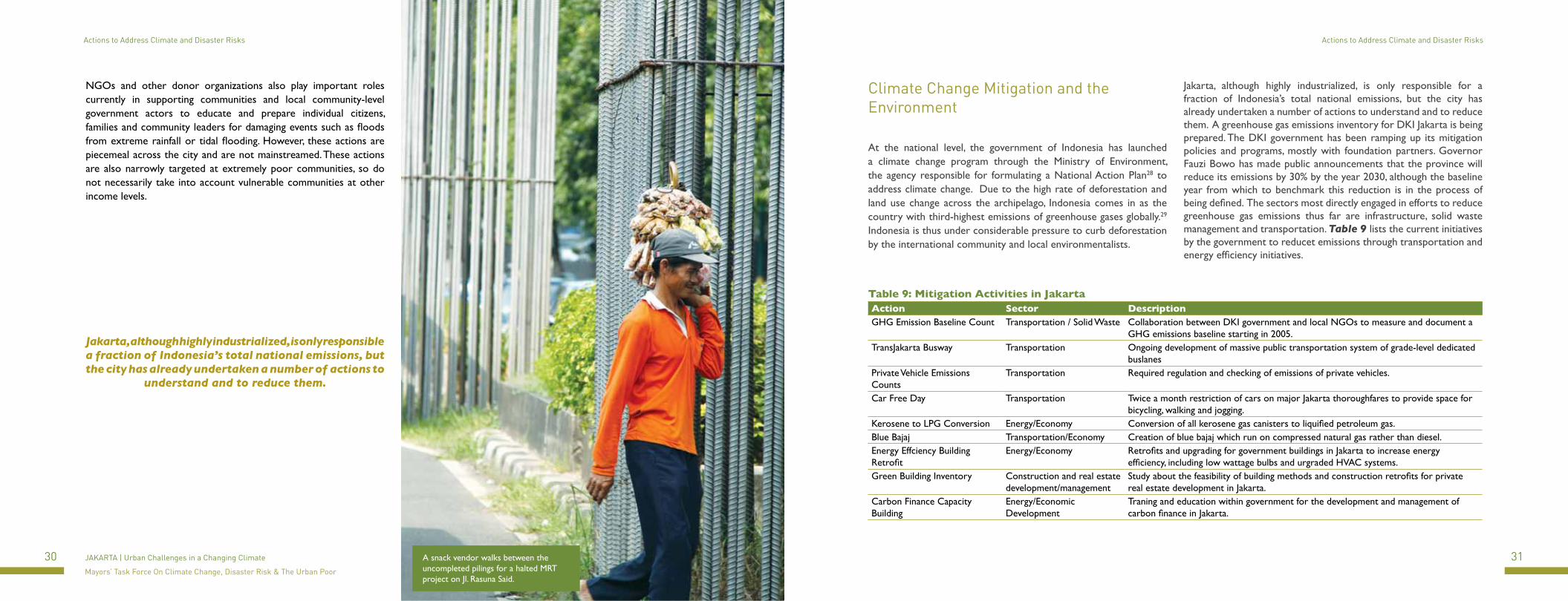
A snack vendor walks between the uncompleted pilings for a halted MRT project on Jl. Rasuna Said.
32 33JAKARTA | Urban Challenges in a Changing Climate
Mayors’ Task Force On Climate Change, Disaster Risk & The Urban Poor
Actions to Address Climate and Disaster Risks Actions to Address Climate and Disaster Risks
Climate Change Adaptation at All Levels
At the community level, NGOs and other institutions are working with the government and in neighborhoods on adaptation strategies and education on how climate change is affecting residents and actions that can be taken in response to climate-related impacts (see also section above). Table 12 outlines some of the most recent activities by NGOs and bilateral and multilateral organizations and their existing projects relating to climate change adaptation and the urban poor in Jakarta. What becomes clear, however, is the lack of programmatic investment in understanding how communities are adapting and how the government can support them at the local level. Based on the experiences and coping capacity of poor communities in Jakarta, there is a vast mismatch between the ongoing sustainability of the adaptation measures taken, and the magnitude of potential future disasters.
Tables 10 and 11 list some of the community and government-led adaptation actions, both in terms of large structural initiatives as well as incremental, responsive community-organized actions. Most of these efforts address larger water and infrastructural problems. The Jakarta provincial government has undertaken two major infrastructure developments, the East Flood Canal, which began in 2003 and is now finished, and West Flood Canal, completed in 2008 but is still undergoing improvements.30 With the completion of the East Flood Canal, flooding has been reduced approximately 30 percent in East and North Jakarta. Approximately two million people have benefited from this major infrastructure investment. Construction of the development of the East Flood Canal alone has cost USD 515 million, and while it has reduced the severity of flooding for many communities, it has not been an answer to increasing frequency of flooding in other areas of the city.
Table 10: Adaptation Programs and Projects by DKI JakartaAction Sector CC area DescriptionSea Wall Construction Infrastructure Sea level rise, tidal
floodsConstruction of several sea walls in North Jakarta where the increase in volume and frequency of tidal flooding is increasing
Mangrove Planting Environment/Community/Private
Sea level rise, tidal floods
DKI government and other local community groups planting mangrove trees in North Jakarta
Informal Settlements Housing/Land Use Canal and river flooding/ tidal floods
Demolition of informal settlements along river banks whose presence is interfering with drainage. Also, these communities are extremely susceptible to floods.
Waste Management Solid Waste/Sanitation
Canal and river flooding/mitigation of GHG emissions
Effort by the provincial government to develop waste management programs throughout the city.
Online Warning System for water height at Bogor
Meteorological/ Canal and river flooding
Website and measurement system for upstream water heights that drain through Jakarta.
East and West Flood Canal Construction
Infrastructure/Water and Sanitation
Canal and river flooding
Construction of two new major drainage canals for Jakarta.
Green Space Protection and Development
Environment/land use
Runoff absorption and carbon sinks
Protection and maintenance of existing green space, clearance of illegal settlements to return to green-space.
Working groups on adaptation and mitigation at national level
Advocacy, Education and Governance
Adaptation/Poverty alleviation/Education/Mitigation
Working groups, policy advocacy, education
Table 11: Adaptation Actions by Communities
Action Entity Sector CC area Description
Elevated house construction
Local communities/individuals Community/private
Sea level rise, tidal floods
Local communities are building their houses up higher and on stilts to accommodate regular flood inundations. Kampung Melayu, Kamal Muara, Bukit Duri.
SMS early warning system
Community organizations and RT/RW
Community/private
Canal and river flooding from rain
Communities at the RT and RW levels are organizing themselves by getting alerts from Bogor when flood is imminent
Community Dredging in East Jakarta
Community organizations and RT/RW
Infrastructure/Community/Solid Waste
Canal and river flooding
Some RW have taken matters into their own hands and solicited community funds to pay for the dredging of local canals.
Move to second floor of house
Community behavioral adaptation
Community/private
Canal and river flooding/rain/ sea level rise
Families in flood-prone kampungs are moving to second floor of homes to live as floods occur more than 10 times per month.
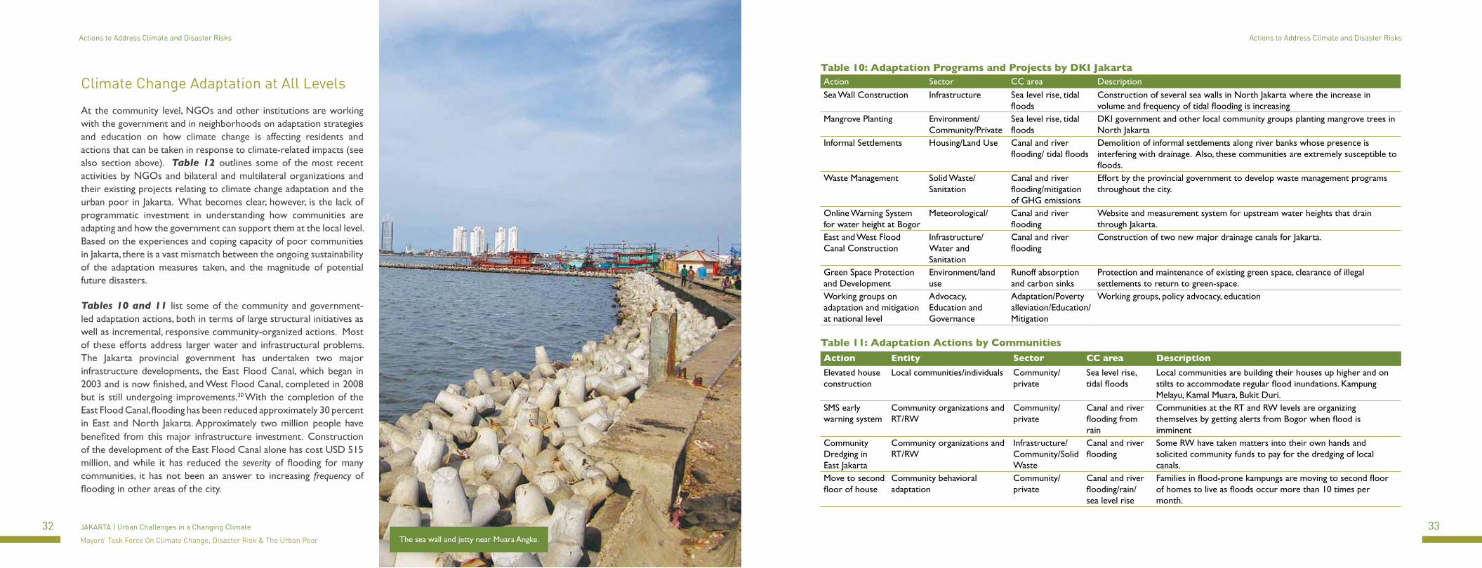
The sea wall and jetty near Muara Angke.
34 35JAKARTA | Urban Challenges in a Changing Climate
Mayors’ Task Force On Climate Change, Disaster Risk & The Urban Poor
Actions to Address Climate and Disaster Risks Actions to Address Climate and Disaster Risks
Program Org/Partnership Type Area of Focus Year
Kelurahan Empowerment Initiative World Bank and Mercy Corps
Pilot Projects and Community Development
Education and evaluation of climate change resilience working closely with the lurah of three kelurahan in North Jakarta. Four-month study relates to community preparedness and budgetary allocation at the kelurahan level.
2011
SCALE Resilience Project USAID and Mercy Corps
Pilot Projects and Community Development
Two year program and education with very poor, flood-vulnerable communities in West Jakarta. Focus on climate change resilience and capacity building at the local level.
2011
Urban Climate Change: Vulnerability Assessment of Jakarta and Java Island
Institute for Essential Service Reform
Participatory Program and Report
Community based program for poor community in Kamal Muara in North Jakarta. Based on a participatory planning model, education was carried out on climate change adaptations and the health impacts of flooding and climate change impacts.
2010
Adaptation Working Group: Ongoing studies on Jakarta’s vulnerability to climate change impacts and urbanization issues
National Council on Climate Change
Advocacy and education
Staffed by multi-disciplinary expersts, the organization works around Indonesia on mitigation and adaptation activies in both urban and rural areas.
2010
Urban Resilience Assessment World Bank and AusAID
Study and report Demonstrate a scalable methodology to increase the resilience of urban infrastructure that can be mainstreamed into city-level investment decisions relating to spatial planning and investment.
2011
Greenhouse gas emissions of Jakarta Swisscontact and National Council on Climate Change
Study and report Greenhouse gas emissions measurement and baseline development for Jakarta, coordinated by Swisscontact and DNPI in close partnership with Environmental Agency of Jakarta.
2009-2011
Jakarta Climate Change Adaptation Tools The Delta Alliance/Royal Haskoning
Advocacy and education
Sponsorship of two Indonesian PhD students to work closely with the Jakarta city government on how to integrate spatial planning adaptation actions
2011
Climate Risks and Adaption in Asian Coastal Megacities: Jakarta Study
Japan International Cooperation Agency
Study and report A Jakarata-specific study based on the recent WorldBank/JICA/ADB publication “Climate Risks and Adaptation in Asian Coastal Megacities” released in 2010.
2011
Mayor’s Task Force: Climate Change Adaptation, Disaster Risk Management and the Urban Poor
The World Bank Study and report Jakarta-specific survey of climate change adaptations, analysis and recommendations.
2011
Jakarta Urban Flood Mitigation Project The World Bank Infrastructure Maintenance Project
Large-scale dredging of canals, drins and rivers across Jakarta to improve drainage and improve functioning of flood management system.
2009 - ongoing
Giant Seawall and Polder The Government of Rotterdam
Infrastructure Construction
Design and development of major sea-wall to block tidal surges into North Jakarta
2010 -
Carbon Finance Capacity Building World Bank Institute
Capacity Building and Training
Preparation of DKI government officials to develop and carry out Carbon Finance project using CDM in Jakarta
2009 - 2011
Table 12: Climate Change Projects by International Organizations
Table 13: Poverty Alleviation Programs by DKI in 2010Sector Program Benefit
Education Free tuition for high school students
7,041 students
Health Health care centers, Disaster victim support and recovery, Dengue patient treatment
2.5 million cases
Housing and Services
Kampung Improvement Programs in 401 RW
Community Empowerment
Revolving Fund for Cooperative Financial Services
Disbursement of $16,298,579
Community Empowerment
Social Activities Disbursement of $5,155,260
Community Empowerment
Small scale infrastructure improvements
Disbursement of $5,155,260
Source: Dinas Kesehatan DKI Jakarta
Kelurahan office staff pot plants for sale in North Jakarta.
Based on the experiences and coping capacity of poor communities in Jakarta, there is a mismatch between the sustainability of adaptation measures taken, and the
magnitude of potential future disasters.
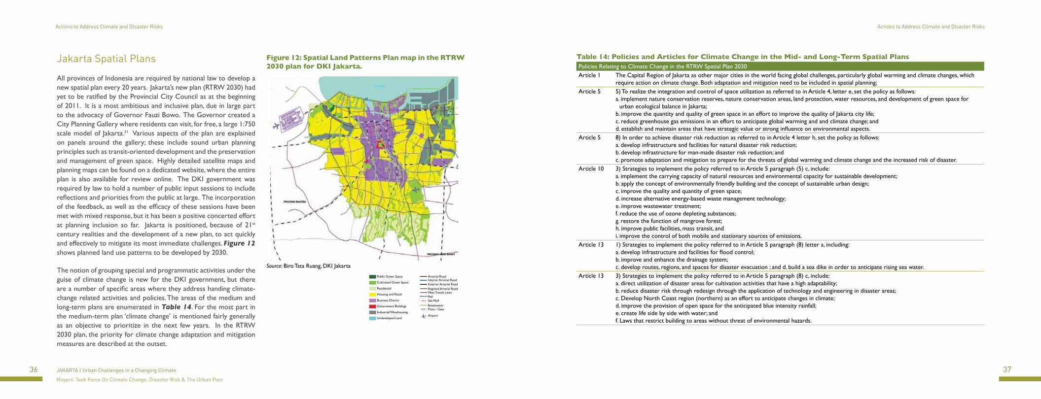
36 37JAKARTA | Urban Challenges in a Changing Climate
Mayors’ Task Force On Climate Change, Disaster Risk & The Urban Poor
Actions to Address Climate and Disaster Risks Actions to Address Climate and Disaster Risks
Jakarta Spatial Plans
All provinces of Indonesia are required by national law to develop a new spatial plan every 20 years. Jakarta’s new plan (RTRW 2030) had yet to be ratified by the Provincial City Council as at the beginning of 2011. It is a most ambitious and inclusive plan, due in large part to the advocacy of Governor Fauzi Bowo. The Governor created a City Planning Gallery where residents can visit, for free, a large 1:750 scale model of Jakarta.31 Various aspects of the plan are explained on panels around the gallery; these include sound urban planning principles such as transit-oriented development and the preservation and management of green space. Highly detailed satellite maps and planning maps can be found on a dedicated website, where the entire plan is also available for review online. The DKI government was required by law to hold a number of public input sessions to include reflections and priorities from the public at large. The incorporation of the feedback, as well as the efficacy of these sessions have been met with mixed response, but it has been a positive concerted effort at planning inclusion so far. Jakarta is positioned, because of 21st century realities and the development of a new plan, to act quickly and effectively to mitigate its most immediate challenges. Figure 12 shows planned land use patterns to be developed by 2030.
The notion of grouping special and programmatic activities under the guise of climate change is new for the DKI government, but there are a number of specific areas where they address handing climate-change related activities and policies. The areas of the medium and long-term plans are enumerated in Table 14. For the most part in the medium-term plan ‘climate change’ is mentioned fairly generally as an objective to prioritize in the next few years. In the RTRW 2030 plan, the priority for climate change adaptation and mitigation measures are described at the outset.
Figure 12: Spatial Land Patterns Plan map in the RTRW 2030 plan for DKI Jakarta.
Source: Biro Tata Ruang, DKI Jakarta
Table 14: Policies and Articles for Climate Change in the Mid- and Long-Term Spatial PlansPolicies Relating to Climate Change in the RTRW Spatial Plan 2030Article 1 The Capital Region of Jakarta as other major cities in the world facing global challenges, particularly global warming and climate changes, which
require action on climate change. Both adaptation and mitigation need to be included in spatial planning;Article 5 5) To realize the integration and control of space utilization as referred to in Article 4, letter e, set the policy as follows:
a. implement nature conservation reserves, nature conservation areas, land protection, water resources, and development of green space for urban ecological balance in Jakarta;
b. improve the quantity and quality of green space in an effort to improve the quality of Jakarta city life;c. reduce greenhouse gas emissions in an effort to anticipate global warming and and climate change; andd. establish and maintain areas that have strategic value or strong influence on environmental aspects.
Article 5 8) In order to achieve disaster risk reduction as referred to in Article 4 letter h, set the policy as follows: a. develop infrastructure and facilities for natural disaster risk reduction; b. develop infrastructure for man-made disaster risk reduction; and c. promote adaptation and mitigation to prepare for the threats of global warming and climate change and the increased risk of disaster.
Article 10 3) Strategies to implement the policy referred to in Article 5 paragraph (5) c, include: a. implement the carrying capacity of natural resources and environmental capacity for sustainable development; b. apply the concept of environmentally friendly building and the concept of sustainable urban design; c. improve the quality and quantity of green space; d. increase alternative energy-based waste management technology; e. improve wastewater treatment; f. reduce the use of ozone depleting substances; g. restore the function of mangrove forest; h. improve public facilities, mass transit, and i. improve the control of both mobile and stationary sources of emissions.
Article 13 1) Strategies to implement the policy referred to in Article 5 paragraph (8) letter a, including: a. develop infrastructure and facilities for flood control; b. improve and enhance the drainage system; c. develop routes, regions, and spaces for disaster evacuation ; and d. build a sea dike in order to anticipate rising sea water.
Article 13 3) Strategies to implement the policy referred to in Article 5 paragraph (8) c, include: a. direct utilization of disaster areas for cultivation activities that have a high adaptability; b. reduce disaster risk through redesign through the application of technology and engineering in disaster areas; c. Develop North Coast region (northern) as an effort to anticipate changes in climate; d. improve the provision of open space for the anticipated blue intensity rainfall; e. create life side by side with water; and f. Laws that restrict building to areas without threat of environmental hazards.
Public Green Space
Cultivated Green Space
Residential
Housing and Retail
Business District
Government Buildings
Industrial/Warehousing
Undeveloped Land
Arterial RoadInterior Arterial RoadExterior Arterial RoadRegional Arterial RoadMass Transit LinesRailSea WallBreakwaterPintu / Gate
Airport
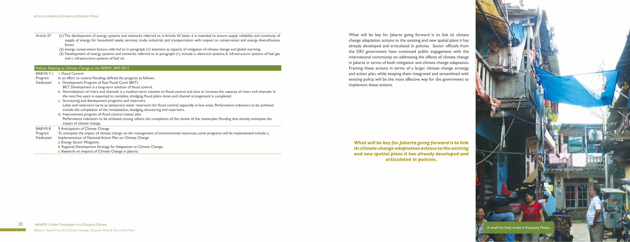
38 39JAKARTA | Urban Challenges in a Changing Climate
Mayors’ Task Force On Climate Change, Disaster Risk & The Urban Poor
Actions to Address Climate and Disaster Risks Actions to Address Climate and Disaster Risks
Article 57 (1) The development of energy systems and networks referred to in Article 45 letter d is intended to ensure supply reliability and continuity of supply of energy for household needs, services, trade, industrial, and transportation with respect to conservation and energy diversification factor.
(2) energy conservation factors referred to in paragraph (1) attention to aspects of mitigation of climate change and global warming.(3) Development of energy systems and networks referred to in paragraph (1), include: a. electrical systems; b. infrastructure systems of fuel gas
and c. infrastructure systems of fuel oil.
Policies Relating to Climate Change in the RPJMD 2007-2012BAB VII; 7.1 Program Dedicated
1. Flood Control In an effort to control flooding, defined the program as follows: a. Development Program of East Flood Canal (BKT) BKT Development is a long-term solution of flood control.b. Normalization of rivers and channels is a medium-term solution to flood control and aims to increase the capacity of rivers and channels. In
the next five years is expected to revitalize, dredging, flood plains times and channel arrangement is completed.c. Structuring and development programs and reservoirs Lakes and reservoirs serve as temporary water reservoirs for flood control, especially in low areas. Performance indicators to be achieved
include the completion of the revitalization, dredging, structuring and reservoirs.d. Improvement program of flood control master plan Performance indicators to be achieved, among others, the completion of the review of the masterplan flooding that already anticipate the
impact of climate change.BAB VII; 8 Program Dedicated
9. Anticipation of Climate Change To anticipate the impact of climate change on the management of environmental resources, some programs will be implemented include: a. Implementation of National Action Plan on Climate Change. a. Energy Sector Mitigation. b. Regional Development Strategy for Adaptation to Climate Change. c. Research on Impacts of Climate Change in Jakarta.
What will be key for Jakarta going forward is to link its climate change adaptation actions to the existing and new spatial plans it has already developed and articulated in policies. Senior officials from the DKI government have continued public engagement with the international community on addressing the effects of climate change in Jakarta in terms of both mitigation and climate change adaptation. Framing these actions in terms of a larger climate change strategy and action plan, while keeping them integrated and streamlined with existing policy, will be the most effective way for the government to implement these actions.
A small but lively street in Kampung Melayu.
What will be key for Jakarta going forward is to link its climate change adaptation actions to the existing and new spatial plans it has already developed and
articulated in policies.

40 41JAKARTA | Urban Challenges in a Changing Climate
Mayors’ Task Force On Climate Change, Disaster Risk & The Urban Poor
Steps Towards Resilience
This case study of Jakarta has outlined the various policies and actions of the DKI government and other stakeholders and community members to address and adapt to the effects of disasters and climate change in Jakarta. The principal hazard faced by Jakarta is the increased frequency of flooding due to rising sea levels and rob (tidal floods), and an increase in the volume of water needing to be managed by the city from increased and erratic rainfall. Both impose extreme pressures on Jakarta’s already taxed, and under-maintained water management system. Land subsidence - a result of urbanization and the extraction of groundwater rather than climate change - remains a most urgent issue for Jakarta, and is a source of major structural threats for existing buildings. Subsidence also increases the city’s vulnerability to the effects of climate change, including increased susceptibility to tidal flooding and potential damage to infrastructure as the land becomes unstable.
The overall purpose of climate change adaptation is to recognize that it is not a marginal, external challenge to be layered onto existing planning and policy priorities; it is simply a way for a city government and its partners and key institutions to gather their focus, and priorities, for future climate scenarios. This report has helped outline existing climate change impacts on Jakarta and particularly on the urban poor. Now, it is key to make some decisions about where to focus limited resources. In principle, what may be identified as good adaptation actions include simple, integrated planning mechanisms and infrastructure upgrading and maintenance. Understanding how climate change will affect Jakarta, and taking action to address existing infrastructure and planning challenges is of utmost urgency.
The empowerment of the urban poor to protect the assets they have and eventually lift themselves out of poverty is essential for a healthy and economically strong future for all of Jakarta’s residents. The urban poor are integral to the wider economy of Jakarta, but they are also active participants in the city’s adaptive capacity, in terms of both their ability to adapt and vulnerabilities caused by informal settlements. Focusing on the challenges and coping mechanisms of the urban poor, and ensuring that communities are active partners in addressing climate change, are essential for enduring resilience.
What follows below are some recommendations and options for actions to support and improve climate change adaptation in Jakarta. These are based on an acknowledged sense of urgency, and that the intersection of climate change impacts, urbanization, spatial planning and political management are all crucial for the future development of Jakarta and the well being of its residents.
CLIMATE ACTION PLANDevelop an integrated Climate Action Plan for Jakarta that will be consistent and harmonized with the RTRW 2030 spatial plan, and other programs and policies in DKI, including health and education programs. To write and implement this plan, establish a dedicated Climate Change Task Force of representatives from different government agencies. This Task Force will be the principal stewards of climate change adaptation and mitigation projects and policies for the city. Identify feasible projects that can address both mitigation and adaptation activities (i.e. those offering significant co-benefits), and start with those that are manageable and viable. Look to other cities in Indonesia and the world for successful examples and apply those processes to Jakarta’s sectors. There are many resources and precedents, both locally and internationally that the government of Jakarta can rely on and apply.
Jalan Sudirman is one of Jakarta’s main arteries with key businesses, the TransJakarta Busway and plenty of new construction.
Strategy: Nominate a Chairperson for the Task Force and nominate/assign dedicated government officials from pertinent agencies to act as representatives and communicators for climate change in Jakarta (both mitigation and adaptation). Form a working level task force to report to the Chairperson and keep track of activities and climate change initiatives. This will ease coordination between agencies and with stakeholders and other constituents, and the task force will be the mouthpiece and centralizing body for all climate change related policy for Jakarta.
QUANTITATIVE MEASUREMENTGain a quantitative understanding of vulnerability in the urban context. Better geospatial mapping, analysis of community economies and adaptation actions, data collection and measurement for relevant indicators in all parts of the city – in particular the areas that are least understood and accounted for like informal settlements and slums – will allow for the city to prioritize key areas of intervention both in the long-term and the short-term. The development, maintenance and dissemination of such data is a high priority, especially in urban poor communities whose circumstances and assets are not well understood at a citywide scale.
Strategy: Work with lurah, RT/RW to take stock of existing datasets, maps and studies pertinent to climate change in their neighborhoods. Develop a logical, systematic plan to begin gathering population and household information from the RW offices. Identify which agencies are suffering from lack of investment and upgrading in their computer systems and necessary database systems. Evaluate which are the resources digitized and backed up electronically and where the gaps are. Develop a plan to make the data available online at the lurah level. The agencies that would benefit from this immediately are those related to the land use, housing, solid waste and transportation sectors. All this data will aid in shaping priorities for DKI government decisions.
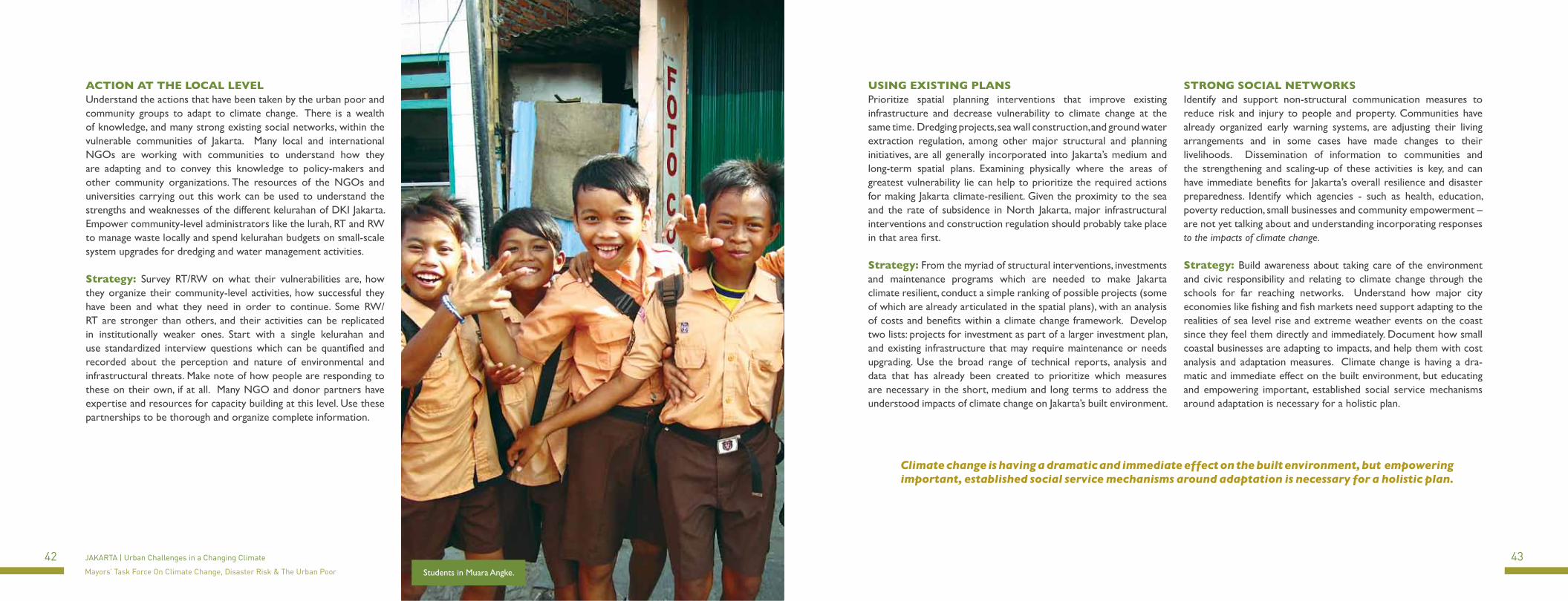
42 43JAKARTA | Urban Challenges in a Changing Climate
Mayors’ Task Force On Climate Change, Disaster Risk & The Urban Poor
USING EXISTING PLANSPrioritize spatial planning interventions that improve existing infrastructure and decrease vulnerability to climate change at the same time. Dredging projects, sea wall construction, and ground water extraction regulation, among other major structural and planning initiatives, are all generally incorporated into Jakarta’s medium and long-term spatial plans. Examining physically where the areas of greatest vulnerability lie can help to prioritize the required actions for making Jakarta climate-resilient. Given the proximity to the sea and the rate of subsidence in North Jakarta, major infrastructural interventions and construction regulation should probably take place in that area first.
Strategy: From the myriad of structural interventions, investments and maintenance programs which are needed to make Jakarta climate resilient, conduct a simple ranking of possible projects (some of which are already articulated in the spatial plans), with an analysis of costs and benefits within a climate change framework. Develop two lists: projects for investment as part of a larger investment plan, and existing infrastructure that may require maintenance or needs upgrading. Use the broad range of technical reports, analysis and data that has already been created to prioritize which measures are necessary in the short, medium and long terms to address the understood impacts of climate change on Jakarta’s built environment.
ACTION AT THE LOCAL LEVELUnderstand the actions that have been taken by the urban poor and community groups to adapt to climate change. There is a wealth of knowledge, and many strong existing social networks, within the vulnerable communities of Jakarta. Many local and international NGOs are working with communities to understand how they are adapting and to convey this knowledge to policy-makers and other community organizations. The resources of the NGOs and universities carrying out this work can be used to understand the strengths and weaknesses of the different kelurahan of DKI Jakarta. Empower community-level administrators like the lurah, RT and RW to manage waste locally and spend kelurahan budgets on small-scale system upgrades for dredging and water management activities.
Strategy: Survey RT/RW on what their vulnerabilities are, how they organize their community-level activities, how successful they have been and what they need in order to continue. Some RW/RT are stronger than others, and their activities can be replicated in institutionally weaker ones. Start with a single kelurahan and use standardized interview questions which can be quantified and recorded about the perception and nature of environmental and infrastructural threats. Make note of how people are responding to these on their own, if at all. Many NGO and donor partners have expertise and resources for capacity building at this level. Use these partnerships to be thorough and organize complete information.
Students in Muara Angke.
STRONG SOCIAL NETWORKSIdentify and support non-structural communication measures to reduce risk and injury to people and property. Communities have already organized early warning systems, are adjusting their living arrangements and in some cases have made changes to their livelihoods. Dissemination of information to communities and the strengthening and scaling-up of these activities is key, and can have immediate benefits for Jakarta’s overall resilience and disaster preparedness. Identify which agencies - such as health, education, poverty reduction, small businesses and community empowerment – are not yet talking about and understanding incorporating responses to the impacts of climate change.
Strategy: Build awareness about taking care of the environment and civic responsibility and relating to climate change through the schools for far reaching networks. Understand how major city economies like fishing and fish markets need support adapting to the realities of sea level rise and extreme weather events on the coast since they feel them directly and immediately. Document how small coastal businesses are adapting to impacts, and help them with cost analysis and adaptation measures. Climate change is having a dra-matic and immediate effect on the built environment, but educating and empowering important, established social service mechanisms around adaptation is necessary for a holistic plan.
Climate change is having a dramatic and immediate effect on the built environment, but empowering important, established social service mechanisms around adaptation is necessary for a holistic plan.

44 45JAKARTA | Urban Challenges in a Changing Climate
Mayors’ Task Force On Climate Change, Disaster Risk & The Urban Poor
Resources
In addressing climate change for a city, the most important approach a government and its partners can take is anticipating changes in impacts, rather than reacting to them. DKI has a great deal of experts and resources available to help understand what the urbanization and climate change trends are going to look like over at least the next 50 years. Below is a list of the major technical research publications (in English) on the topics of flood mitigation, land subsidence mitigation and other reports that include technical information and methodologies for evaluating both risk and paths towards climate change resilience.
Climate Risks and Adaptation in Asian Coastal Megacities: A Synthesis Report. 2010. The World Bank, Asian Development Bank and Japan International Cooperation Agency.
Investing in a More Sustainable Indonesia: Country Environmental Analysis. The World Bank. 2009.
Climate Resilient Cities: A Primer on Reducing Vulnerabilities to Disasters. The World Bank, 2009.
ADB Climate Change Programs: Facilitating Integrated Solutions in Asia and the Pacific. Asian Development Bank, 2010.
Cities At Risk: Asia’s Coastal Cities in An Age of Climate Change. Roland J. Fuchs, East-West Center, University of Hawaii. 2010.
Climate Change Vulnerability Mapping for Southeast Asia by Arief Anshory Yusuf and Herminia Francisco; Economy and Environment Program for Southeast Asia, January 2009.
Jakarta City Report: Information Relating to Climate Change in Jakarta City. Indra M. Surbakti, Izhar C. Idroes, Hendricus A. Simarmata and Tommy Firman. 2010.
The Other Half of Climate Change: Why Indonesia Must Adapt to Protect its Poorest People. United Nations Development Programme Indonesia. 2007.
Eco2 Cities: Ecological Cities as Economic Cities. The World Bank. 2009.
Jakarta Flood Hazard Mapping Framework Brinkman, JanJaap (Deltares) and Hartman, Marco (HKV consultants) for The World Bank Office Jakarta. 2009.
Land Subsidence and Urban Development in Jakarta (Indonesia). Hasanuddin Z. Abidin, Heri Andreas, Irwan Gumilar and Mohammad Gamal, Indonesia, Yoichi Fukuda and T. Deguchi, Japan. 2009.
Understanding Urban Risk: An Approach For Assessing Disaster and Climate Risk in Cities. The World Bank, 2010.
1 http://www.dredgingtoday.com/2010/07/23/indonesia-problems-with-flooding-in-jakarta-continues/2 The Urban Risk Assessment Framework is in its final stages of completion by the World Bank, and will be available online shortly. 3 Primary sources adapted from www.citymayors.com and www.wikipedia.com.4 Berita Resmi Statistik Provinsi DKI Jakarta No. 39/11/31/Th. XII, 5 November 20105 World Bank, World Development Indicators.6 IPB, 2007, Jabodetabek Metropolitan Study7 Public Expenditure Review, World Bank, 20078 Why Are There Floods In Jakarta? Flood Control by the Government of the Province of Jakarta, PT Mirah Sakethi, 20109 http://www.dredgingtoday.com/2010/07/23/indonesia-problems-with-flooding-in-jakarta-continues/10 Why Are There Floods In Jakarta? Flood Control by the Government of the Province of Jakarta, PT Mirah Sakethi, 201011 Climate Risks and Adaptation in Asian Coastal Megacities: A Synthesis Report. The World Bank, Asian Development Bank and Japan International Cooperation Agency; September 201012 Koran Tempo, Jul 20, 2010; see http://www.jakartawater.org/index.php?option=com_content&view=article&id=284:operator-air-cuma-layani-44-persen-penduduk&catid=59:berita&Itemid=1
&lang=en13 Indonesia and Climate Change: Current Status and Policies. The World Bank, DFID, PEACE. 2007. 14 World Bank Climate Change Knowledge Portal, based on IPCC GCMs. http://sdwebx.worldbank.org/climateportal/15 Climate Change Vulnerability Mapping for Southeast Asia by Arief Anshory Yusuf and Herminia Francisco; Economy and Environment Program for Southeast Asia, January 2009. 16 Jakarta City Report: Information Relating to Climate Change in Jakarta City. Indra M. Surbakti, Izhar C. Idroes, Hendricus A. Simarmata and Tommy Firman. 2010. 17 World Bank Climate Change Knowledge Portal, based on IPCC GCMs and Japanese High Resolution GCM. http://sdwebx.worldbank.org/climateportal/18 Sumantri, Arif, 2008, Environmentally Prevention Model towards Dengue Epidemic in DKI Jakarta (in Bahasa Indonesia), doctoral dissertation submitted to Institute of Agriculture Bogor.19 Ibid20 Berita Resmi Statistik Provinsi DKI Jakarta No. 21/07/31/Th. XII, 1 Juli 201021 Urban Poverty: A Global View. Judy L. Baker, The World Bank. 22 “Project Sites, Urgent Maintenance Dredging” presentation by Hongjoo Hahm, World Bank Office Jakarta, 2010. 23 Intergovernmental Panel on Climate Change www.ipcc.ch.24 Housing Finance Mechanisms in Indonesia, UN-HABITAT from the Human Settlements Finance System series, Nairobi, 2008.25 Sakernas 2010.26 Registrasi Penduduk DKI Jakarta, 2004, cited in: Haning Romdiati and Mita Noveria (2004). “Mobilitas Penduduk Antar Daerah Dalam Rangka Tertib Pengendalian Migrasi Masuk ke DKI
Jakarta.” Paper presented at workshop on urbanization in Jakarta, August 5, 2004, PPK-LIPI. Available at: www.ppk.lipi.go.id/file/publikasi/Sem-DKI,04.rtf (accessed March 9, 2011).27 World Bank, 2009. Reshaping Economic Geography. World Development Report 2009. Washington, DC: World Bank.28 Dewan Nasional Perubahan Iklim – National Council on Climate Change www.dnpi.go.id29 Investing in a More Sustainable Indonesia: Country Environmental Report, 2009. The World Bank. 30 Why Are There Floods in Jakarta? Flood Control by the Government of the Province of DKI Jakarta. PT Mirah Sakethi, 2010. 31 The gallery is located on Jl. Abdul Muis No. 66, 3rd floor, Jakarta Pusat. RTRW 2030 Plan website is www.tatakota-jakartaku.net.

A Jakarta sunset over the Jalan Sudirman skyline.