ws0-0000-hes-rpt-cvx-000-00001-00 ... - australia.chevron… · proposal description chevron...
TRANSCRIPT

© Chevron Australia Pty Ltd
Document No: WS0-0000-HES-RPT-CVX-000-00001-00 Revision: 1
Revision Date: 16th September 2008 Copy No:
IP Security: Public
Wheatstone Development Referral of Proposed Action Environmental Protection Act


Wheatstone Development Document No: WS0-0000-HES-RPT-CVX-000-00001-00 Referral of Proposed Action. Environmental Protection Act Revision: 1 Revision Date: 16th September 2008
© Chevron Australia Pty Ltd Public Page iii Printed Date: 16/9/2008 Uncontrolled when printed
Document Distribution
Copy No COMPANY / Department Name / Position
O (Original) Chevron Australia Pty Ltd Wheatstone Document Control
1 Geoff Strong General Manager 2 Jerry Albers Development Manager 3 Laurie Sasko Commercial Manager 4 Schellie Jayne Price Senior Legal Counsel 5 Graeme Harman PGPA Manager 6 Charles Coarsey Technical Services Manager 7 Rhonda Redwine Downstream Manager 8 David Kempkes Upstream Manager

Additional Approval Page Document Information
Document Number WS0-0000-HES-RPT-CVX-000-00001-00
DMS ID
Endorsed by (if required)
Name / Title Company Signature Date
Legal Wheatstone Technical
Services Manager
Industrial Relations
Business Services
Contract Owner
Responsible Engineer Dept Team Leader /
Manager
Subsurface Team Leader
Contracts
Additional Approvals (if required)
Name / Title Company Signature Date
Development Manager
PGPA Manager
Commercial Manager
Marketing Manager
Operations Manager
General Manager – Wheatstone Area

Wheatstone Development Document No: WS0-0000-HES-RPT-CVX-000-00001-00 Referral of Proposed Action. Environmental Protection Act Revision: 1 Revision Date: 16th September 2008
© Chevron Australia Pty Ltd Public Page 1 Printed Date: 16/9/2008 Uncontrolled when printed
TABLE OF CONTENTS
1.0 PART A - PROPONENT AND PROPOSAL INFORMATION ...................... 1 1.1. PROPONENT DETAILS, PROPOSAL DESCRIPTION AND
LOCATION ........................................................................................ 1 1.1.1. Proponent information ............................................................ 1
1.2. Proposal Description ............................................................................ 4 1.3. Location Information ......................................................................... 8
2.0 PART B - ENVIRONMENTAL IMPACTS AND MANAGEMENT COMMITMENTS................................................................................................... 9
2.1. ENVIRONMENTAL IMPACTS............................................................. 9 2.1.1. Flora and Vegetation ............................................................... 9 2.1.2. Fauna ...................................................................................... 11 2.1.3. Rivers, Creeks, Wetlands and Estuaries ............................. 12
2.2. Significant Areas and/ or Land Features ....................................... 14 2.3. Coastal Zone Areas (Coastal Dunes and Beaches) ...................... 15
2.3.1. Marine Areas and Biota......................................................... 16 2.3.2. Water Supply and Drainage Catchments............................. 17 2.3.3. Pollution ................................................................................. 19
2.4. Greenhouse Gas Emissions ........................................................... 23 2.4.1. Contamination ....................................................................... 23 2.4.2. Social Surroundings ............................................................. 24
2.5. Risk ................................................................................................... 24 3.0 MANAGEMENT ......................................................................................... 26
3.1. Principles of Environmental Protection ......................................... 26 3.2. Management Commitments ............................................................ 26 3.3. Consultation ..................................................................................... 27
4.0 REFERENCES........................................................................................... 28 4.1. Checklist and Declaration ............................................................... 29
APPENDICES
APPENDIX A: FIGURES Figure 1: Wheatstone Project Area of Development Interest............................................... Figure 2: Existing Environment of the Proposal Area .......................................................... Figure 3: Conceptual Design of Upstream Components......................................................
APPENDIX B: EPBC ACT PROTECTED MATTERS REPORT APPENDIX C: PRELIMARY DESKTOP SCREENING OF POTENTIAL IMPACTS AND MITIGATION MEASURES FOR THE WHEATSTONE DEVELOPMENT
Wheatstone Development Document No: WS0-0000-HES-RPT-CVX-000-00001-00 Referral of Proposed Action. Environmental Protection Act Revision: 1 Revision Date: 16th September 2008
© Chevron Australia Pty Ltd Public Page 1 Printed Date: 16/9/2008 Uncontrolled when printed
1.0 PART A - PROPONENT AND PROPOSAL INFORMATION
1.1. PROPONENT DETAILS, PROPOSAL DESCRIPTION AND LOCATION 1.1.1. Proponent information
♦ Proposal title Wheatstone Development
♦ Name of the Shire in which the proposal is located The Shire of Ashburton or the Shire of Roebourne (depending on site selection)
♦ Name of proponent (Person or entity proposing to implement the proposal) Chevron Australia Pty Ltd (Chevron)
♦ Names of Joint Venture entities (if applicable) Chevron (TAPL) Pty Ltd
♦ Address of proponent Chevron Australia Pty Ltd
QV1, 250 St Georges Terrace
Perth, Western Australia, 6000
♦ Key contact for the proposal Gerard Albers
Development Manager, Wheatstone
QV1, 250 St Georges Terrace
Perth, Western Australia, 6000
Phone +61 8 9216 4977
Fax +61 8 9216 5088
Does the proponent own the land on which the proposal is to be established? If not, what other arrangements have been established to access the land? Chevron, the proponent of the Wheatstone Development, is proposing the development of an onshore LNG and domestic gas processing plant on the Pilbara coast. This will process hydrocarbons from offshore gas fields, initially from Permits WA-253-P and WA-17-R in commonwealth waters. Chevron is currently undertaking a site evaluation and selection process to identify the most suitable location for the construction and operation of an onshore LNG and domestic gas processing plant and associated infrastructure. In summary, the site evaluation and selection process comprises three main steps: Site screening Site screening studies for an onshore processing plant and supporting infrastructure. This will narrow possible sites to a subset of technically preferred locations that offer the least environmental and social constraints. This is an internal process by Chevron to narrow options to technically viable sites. The initial internal site screening exercise has been completed. This has targeted a broad area on the Pilbara coast extending from the Burrup Peninsula in the north to

Wheatstone Development Document No: WS0-0000-HES-RPT-CVX-000-00001-00 Referral of Proposed Action. Environmental Protection Act Revision: 1 Revision Date: 16th September 2008
© Chevron Australia Pty Ltd Public Page 2 Printed Date: 16/9/2008 Uncontrolled when printed
Tubridgi Point in the south (Appendix A, Figure 1). Potential locations were identified in this broad area and were screened against a possible set of environmental, social and technical criteria. An initial six locations were identified: ♦ Ashburton North ♦ Onslow Strategic Industrial Area (Onslow expanded SIA) ♦ Cape Preston ♦ Onslow North Coolgra ♦ Onslow North ♦ Onslow Beadon Creek Analyses using the screening criteria indicate that Ashburton North, Cape Preston and Onslow expanded SIA are the most suitable locations. Stakeholder engagement External stakeholders will be invited to participate in the site evaluation and selection process with the view to both seeking input on the suitability of the preferred location and identify issues that need to be considered both in site selection and in the development of the project. Site selection A preferred site will be selected and negotiations will take place to secure long term access to the site. The preferred site will have the capacity to share infrastructure (for example access roads to the beach, shared marine access channels) with other industrial users. To support the assessment process and test the findings of the internal screening process, Chevron will undertake further engineering, environmental and social studies. Chevron does not own any land in the locations under consideration for the development. Temporary access agreements are expected to be required in order to undertake such studies. On completion of the site selection process Chevron will work with key stakeholders including the Department of Industry and Resources and the office of the Minister for State Development to secure long-term tenure to the preferred site. The preferred site will be the subject of the formal environmental impact assessment process. Is rezoning of any land required before the proposal can be implemented?
X Yes
No
If yes, please provide details.
Various approvals may be sought from the following agencies as appropriate when the site has been selected, including: ♦ Shire of Ashburton; ♦ Shire of Roebourne; ♦ WA Department of Industry and Resources (DoIR); ♦ WA Department for Planning and Infrastructure (DPI); ♦ WA Department of Environment and Conservation (DEC); ♦ WA Department of Indigenous Affairs (DIA); ♦ Commonwealth Department of Environment, Water, Heritage and the Arts (DEWHA); ♦ Commonwealth Department of Resources, Energy and Tourism (DRET); and

Wheatstone Development Document No: WS0-0000-HES-RPT-CVX-000-00001-00 Referral of Proposed Action. Environmental Protection Act Revision: 1 Revision Date: 16th September 2008
© Chevron Australia Pty Ltd Public Page 3 Printed Date: 16/9/2008 Uncontrolled when printed
♦ Commonwealth Department of Infrastructure, Transport, Regional Development and Local Government.
If yes above, have you lodged any of the necessary applications or have you discussed the proposal with any person(s) at the Agency or Local Authority?
X Yes
No If yes, name all Agencies and Local Authorities for which applications have been submitted or with whom the proposal has been discussed.
The proposed development has so far been discussed with: ♦ Shire of Ashburton; ♦ Shire of Roebourne; ♦ WA Department of Industry and Resources (DoIR); ♦ WA Environment Protection Authority Service Unit (EPASU); ♦ WA Department of Environment and Conservation (DEC); ♦ Commonwealth Department of Environment, Water, Heritage and the Arts (DEWHA); ♦ Commonwealth Department of Resources, Energy and Tourism (RET); ♦ WA Office of Development Approvals Coordination (ODAC); and An application has been made to undertake vegetation clearing activities for a small investigative works programme at the Ashburton North site, aimed at providing geotechnical and geophysical information that will support the site evaluation and selection process. What is the current land use on the property, and the extent (area in hectares) of the property? Potential site locations and their current land uses are identified as follows. Anticipated maximum ‘footprint’ at possible onshore sites is described in section 2.1.
Location Current Land use: Zoning (source WA Planning Commission),Tenements and Tenure within potential site boundaries
Ashburton North Zoning – rural Tenement – Polaris Metals NL; Onslow salt; Heritage Council WA Place No HWA/03444 Tenure – BHP CL330-1967; State of WA LR3315-585
Cape Preston Zoning –rural; also part conservation recreation and natural landscapes reserve Tenement – mineralogy Tenure – Unallocated Crown Land
Onslow Expanded SIA Zoning – rural and within Strategic Industrial buffer Tenement – Onslow Salt; Christopher Anthony Evans Tenure – State of WA CTLR-3152106
Location Current Land use: Zoning (source WA Planning Commission),Tenements and Tenure within potential site boundaries
Onshore Domgas Export pipeline
Land likely to be traversed is principally used for pastoral purposes
Offshore Development Petroleum lease, Permits WA-253-P and WA-17-R

Wheatstone Development Document No: WS0-0000-HES-RPT-CVX-000-00001-00 Referral of Proposed Action. Environmental Protection Act Revision: 1 Revision Date: 16th September 2008
© Chevron Australia Pty Ltd Public Page 4 Printed Date: 16/9/2008 Uncontrolled when printed
1.2. Proposal Description Chevron proposes to construct and operate a multi train Liquefied Natural Gas (LNG) and domestic gas (Domgas) plant to be located at a suitable location on the Pilbara Coast. The development will produce up to 25 million tonnes of LNG per annum (MTPA) with the initial development expected to consist of two LNG processing trains with a nominal capacity of 5 MTPA per train. However approval is sought for the maximum capacity of the plant of 25 MTPA. A separate but co-located Domgas plant will form part of the development. This plant will have an initial capacity of 250 MMSCFD which corresponds to 15 percent of LNG sales of 5 million tonnes per year. The volumes of gas available to the domestic markets will increase as LNG production increases. Gas and condensate for the initial 10 MTPA development will be provided from the Permits WA-253-P and WA-17-R. The gas with the condensate will be piped to shore for processing. The resultant LNG and condensate will be exported to worldwide markets, and Domgas will be sold into the domestic market. Additional gas resources will supply feed gas to the additional LNG Trains. These resources are expected to come from other suitable gas fields in the region. These may be tied into the offshore gas gathering facilities installed as part of the initial Wheatstone Development or may require new facilities. Future offshore extractions and tie-ins will be the subject of separate assessments and approvals where required. The Wheatstone Development will require the installation of gas gathering, export and processing facilities in Commonwealth and State Waters and on land. A description of the key development components and concepts that are under consideration and which will require formal assessment and approval under State and Commonwealth legislation are presented below. Offshore (Upstream) - Key Infrastructure Upstream facilities will be installed to access the gas and gas condensate reserves and transport these reserves to an onshore processing plant. These upstream facilities will be located in Commonwealth waters in water depths ranging from 70m-200m. A number of options are currently being evaluated for the upstream concept. Engineering studies are ongoing to evaluate these options with the view to selecting a concept that provides the best technical, environmental, safety and economic performance. A number of activities and infrastructure will be required regardless of the chosen upstream concept. These common features comprise the following: ♦ The drilling of wells in Permit WA-253-P (ranging from 8 to 12 wells) and Permit 17-R
(ranging from 4 to 6 wells). Wells will either be drilled from a drilling platform or a mobile drilling rig.
♦ The installation and operation of a subsea gathering system. This system will comprise a number of gas flowlines, manifolds, and injection lines used to supply chemical treatments to the wellheads, as well as control / power umbilical lines.
♦ The installation and operation of gas processing and wellhead platforms. These facilities are likely to include equipment that removes some of the produced formation water, so as to prevent gas hydrate formation and to maintain hydrocarbon flows. This water will be managed either by reinjection or by treatment and overboard

Wheatstone Development Document No: WS0-0000-HES-RPT-CVX-000-00001-00 Referral of Proposed Action. Environmental Protection Act Revision: 1 Revision Date: 16th September 2008
© Chevron Australia Pty Ltd Public Page 5 Printed Date: 16/9/2008 Uncontrolled when printed
discharge. The platform will require a flare to manage excess gas during emergencies and upset conditions.
♦ It is anticipated that offshore compression equipment will be required during the later stages of field life.
♦ The installation and operation of two export pipelines to transport gas, gas condensate and remaining produced water from the gas fields to the onshore plant. The first of these lines will be approximately 0.86 m (34 inches) in diameter and will be approximately 220 km long (exact length will depend on the final location of the onshore facilities). The second pipeline will be laid to allow future tie-ins from other gas fields. It will be laid from the LNG plant and extend past the depth required for stabilisation. The corridor for these pipelines will also depend on the location selected for the onshore processing facilities. In shallower waters the pipelines are likely to require some form of stabilisation for protection. This is expected to be achieved through trenching and/or rock armouring.
An illustration of the current preferred concept is presented in Appendix A, Figure 3. Onshore LNG Plant (Downstream) - Key Components Once onshore, the gas, condensate and water will enter the main processing plant where the gas and condensate will be processed for export. Locations for the key components for processing and export will comprise: ♦ Processing of the reservoir fluid to separate the hydrocarbon gas, hydrocarbon liquid,
and water streams. ♦ Pre-treatment of the gas stream to remove acid gases (such as carbon dioxide),
water and other contaminants. ♦ LNG trains to liquefy the gas to produce liquefied natural gas. ♦ A Nitrogen Rejection Unit for removal of nitrogen from the raw liquefied natural gas
product. ♦ LNG storage and loading facilities. ♦ Domestic Gas plant to treat the gas to meet domestic gas specifications in deliveries
through pipelines to the existing domestic gas network and/or directly to local users via dedicated gas pipelines.
♦ Water management. ♦ Condensate stabilization and storage. ♦ LNG and condensate tanks and facilities including loading lines either over a jetty or
by a subsea lines to an offshore loading facility. ♦ Port facilities including; Jetties to cater for LNG and condensate tankers, material
offloading facilities (MOF) to cater for LNG and condensate tankers, construction materials and support vessels. The MOF will be either constructed as an inland harbor or as part of the offshore harbor. The MOF will allow for the offloading of materials, equipment and modules from cargo ships for the construction of the plant and may provide a cyclone proof safe haven for marine service craft such as tugboats and other support craft during operations. The inland harbor MOF will be constructed by excavating and dredging an area onshore to create a port with required water depth that is protected from the wave climate while providing access to and from the open ocean by ships and service craft. If constructed as an offshore harbor, it will be built by installing rubble mound breakwaters in an area offshore to create a port with proper water depth that is protected from the wave climate while providing access to and from the open ocean.
♦ Navigational channel and turning basin to allow for safe access to the loading jetty for condensate and LNG tankers. This channel will require dredging. The volumes to

Wheatstone Development Document No: WS0-0000-HES-RPT-CVX-000-00001-00 Referral of Proposed Action. Environmental Protection Act Revision: 1 Revision Date: 16th September 2008
© Chevron Australia Pty Ltd Public Page 6 Printed Date: 16/9/2008 Uncontrolled when printed
be dredged will depend on the available water depths at the selected location. Initial screening studies indicate the volumes to be dredged may range between 28-35 million cubic metres.
Facilities and activities required to support construction and operation of the plant include: ♦ Airport or the upgrade of existing airports; ♦ Access roads; ♦ Supply base to service the offshore operations; ♦ Construction camp; ♦ Drainage and waste water treatment; ♦ Solid waste management facilities; ♦ Temporary lay-down areas for construction; ♦ Accommodation blocks for operations personnel; ♦ Utilities such as power and water supply, which may include desalination; ♦ Storage facilities for chemicals, fuel, and materials etc; ♦ Use of rock for site preparation and pipeline stabilisation; ♦ Fill for the plant site. Fill material may be directly excavated from within the
Development Area of Interest, sourced from third party quarries,, sourced from dredged material, or a combination of the above.
Some facilities are expected to be temporary and will be required only during the construction phase, and others will be required during both the construction and operational phases of the development. The details of these facilities including locations, types and schedules for construction will be driven by the characteristics and location of the site selected for the onshore processing facility. Alternatives Consideration The Wheatstone Development is a proposal for a new multi-train onshore LNG and domestic gas facility to enable the development of up to 25 MTPA of LNG from the West Carnarvan Basin. In the consideration of potential sites for developing the Wheatstone and other potential gas fields in the Basin, the use of existing or currently proposed developments in the region were discounted as they would be restricted in their capacity to process this volume of gas. What is the proposed ultimate extent (area in hectares) of the activity? The following table provides estimated sizes of the onshore footprint for the key components of the development should these components be required. It is not anticipated that all of this land would be cleared of vegetation. Current estimates are that approximately 30% of this total is unlikely to be disturbed or readily rehabilitated post construction. .
Key Component Estimated extent of operational footprint (Hectares)
Port facilities 30 Onshore processing facilities including lay down areas
550
Camp & potential borrow pit areas 230 Onshore Domgas pipeline 250 TOTAL 1060

Wheatstone Development Document No: WS0-0000-HES-RPT-CVX-000-00001-00 Referral of Proposed Action. Environmental Protection Act Revision: 1 Revision Date: 16th September 2008
© Chevron Australia Pty Ltd Public Page 7 Printed Date: 16/9/2008 Uncontrolled when printed
A large dredging program will be required to create a shipping channel that will run approximately 17 kilometres from the shore to 13 metre depth. Preliminary engineering estimates that dredge volumes may be up to 35 million cubic metres. Provide the timeframe in which the activity or development is proposed to occur. (Include start and finish dates where applicable)
Activity Start Date Finish Date Final Site Selection Q3 2008 Q2 2009 Environmental Assessment & Approval
Q3 2008 Q2 2010
Final Investment Decision Q3 2010 Project Execution 2010 2015 Domgas Production 2015 LNG Production 2015 Decommissioning No earlier than 2035
Provide details of any staging of the proposal. This proposal covers an LNG processing plant with a total processing capacity of up to 25 MTPA. The initial development is expected to include LNG processing capacity up to 10 MTPA and domestic gas production capacity of 250 mmscfd. The additional LNG processing capacity of the plant will increase to 25 MTPA over the life of the project. Domestic gas production will increase as LNG production increases. The actual fields to provide the reserves beyond the initial development, their order and timing of development will be subject to the proposed development timeframes for those fields and specific commercial agreements The activities required to develop these additional reserves are not included in this referral and will require separate approvals.

Wheatstone Development Document No: WS0-0000-HES-RPT-CVX-000-00001-00 Referral of Proposed Action. Environmental Protection Act Revision: 1 Revision Date: 16th September 2008
© Chevron Australia Pty Ltd Public Page 8 Printed Date: 16/9/2008 Uncontrolled when printed
Indicate whether, and in what way, the proposal is related to other proposals in the region. Chevron is the titleholder of a number of petroleum titles in the region and operates petroleum production facilities on Barrow and Thevenard Islands. This proposed action is not part of other actions or proposals in the region. 1.3. Location Information The offshore Permit areas are located 145km offshore from the WA Coast, 100km north of Barrow Island and 200km north on Onslow in water depths between 100m and 250m. Appendix A, Figure 1 presents the location of the offshore permit areas and potential export pipeline corridors. The proposed plant and associated infrastructure will be located at one of three locations under consideration, namely Ashburton North, Cape Preston, and Onslow Expanded SIA. The location and coordinates of potential sites and corridors for supporting infrastructure are also presented in Appendix A, Figure 1.

Wheatstone Development Document No: WS0-0000-HES-RPT-CVX-000-00001-00 Referral of Proposed Action. Environmental Protection Act Revision: 1 Revision Date: 16th September 2008
© Chevron Australia Pty Ltd Public Page 9 Printed Date: 16/9/2008 Uncontrolled when printed
2.0 PART B - ENVIRONMENTAL IMPACTS AND MANAGEMENT COMMITMENTS
2.1. ENVIRONMENTAL IMPACTS The environmental and social setting is presented in Appendix A, Figure 2. Potential environmental impacts from the proposed development are presented in Appendix C. This also summarises some anticipated mitigation measures. This is a preliminary and high level identification of issues. This will be expanded on and developed during the EIA process. 2.1.1. Flora and Vegetation Do you propose to clear any native flora and vegetation as a part of this proposal?
X Yes If yes, complete the rest of this section
No If no, go to the next section
How much vegetation are you proposing to clear (in hectares)? Preliminary engineering indicates that the LNG and Domgas facility and supporting infrastructure is expected to require approximately 800 hectares of land. However approximately 30% of this total is unlikely to require complete clearing or will be readily rehabilitated post construction. Vegetation along the onshore Domgas pipeline corridor will also require clearing of approximately 250 ha during construction. Much of this vegetation will be rehabilitated after construction of the Domgas pipeline. Have you submitted an application to clear native vegetation to the DEC (unless you are exempt from such a requirement)?
X Yes No If yes, on what date and to which office was the application submitted of the DEC?
An application to clear native vegetation was submitted by Chevron to DEC on 8th August 2008 to clear a maximum of 3.5 hectares of native vegetation at the Ashburton North site. This is to support early geotechnical surveys that will be undertaken as part of the site evaluation and selection process. Are you aware of any recent flora surveys carried out over the area to be disturbed by this proposal?
X Yes No If yes, please attach a copy of any related survey reports and provide the date and name of persons / companies involved in the survey/s. (If no, please do not arrange to have any biological surveys conducted prior to consulting with the DEC.)
To support the permit to clear native vegetation at Ashburton North, a Level 2 flora and vegetation survey has been undertaken by Onshore Environmental Consultants Pty Ltd. The report is currently being finalised. Chevron is not aware of any other recent flora surveys carried out over the areas of potential development. Comprehensive flora surveys will be conducted as part of the

Wheatstone Development Document No: WS0-0000-HES-RPT-CVX-000-00001-00 Referral of Proposed Action. Environmental Protection Act Revision: 1 Revision Date: 16th September 2008
© Chevron Australia Pty Ltd Public Page 10 Printed Date: 16/9/2008 Uncontrolled when printed
environmental impact assessment process in accordance with relevant EPA Guidance Statements. Has a search of DEC records for known occurrences of rare or priority flora or threatened ecological communities been conducted for the site?
X Yes
No
If you are proposing to clear native vegetation for any part of your proposal, a search of DEC records of known occurrences of rare or priority flora and threatened ecological communities will be required. Please contact DEC for more information.
Preliminary DEC database searches within the areas of potential development interest have indicated that there are no known occurrences of Rare or Priority Flora or Threatened Ecological Communities present at the development sites under consideration. The closest recorded Threatened Ecological Community from any area of potential development is Camerons Cave Troglobitic Community (Exmouth), more than 94km west of Ashburton North. Are there any known occurrences of rare or priority flora or threatened ecological communities on the site?
Yes
X No
If yes, please indicate which species or communities are involved and provide copies of any correspondence with DEC regarding these matters.
Appendix A Figure 1 depicts indicative offshore pipeline routes that include islands designated as Environmentally Sensitive Areas (ESAs) which support rare or priority flora. The Wheatstone Development offshore pipelines will be laid on the seabed and will not impact these locations. If located within the Perth Metropolitan Region, is the proposed development within or adjacent to a listed Bush Forever Site? (You will need to contact the Bush Forever Office, at the Department for Planning and Infrastructure)
Yes
X No
If yes, please indicate which Bush Forever site is affected (site number and name of site where appropriate).
What is the condition of the vegetation at the site? The area interest is characteristic of the Carnarvon Interim Biogeographic Regionalisation of Australia (IBRA) subregion, with low species diversity. The area has generally been disturbed by pastoral and industrial activity and has weed proliferation and feral animals. Flora surveys will be conducted to identify the level of degradation and the condition of vegetation at the selected project site. These will include surveys along the proposed pipeline corridors to document vegetation communities along pipeline routes. Vegetation at each of the potential onshore locations is summarised as follows: Ashburton North

Wheatstone Development Document No: WS0-0000-HES-RPT-CVX-000-00001-00 Referral of Proposed Action. Environmental Protection Act Revision: 1 Revision Date: 16th September 2008
© Chevron Australia Pty Ltd Public Page 11 Printed Date: 16/9/2008 Uncontrolled when printed
The Ashburton North site and its surroundings consists of low areas subject to inundation, tidal creeks, salt flats, clay pans and dune systems which are widespread habitats along the Pilbara coastline. Vegetation found at the site includes chenopod and samphire shrublands, hummock grasslands and mangroves. The site neighbours the Ashburton River Delta stand of regionally significant mangroves. Cape Preston The Cape Preston site is located on a low rock headland dominated by intertidal mudflats and clay plans which support a range of marine benthic types. Extensive grassland and mangrove habitats are present. Onslow Expanded SIA The Onslow SIA site consists of elevated sand dunes. The habitats found on the site are widespread in the region and have been degraded by past pastoral activity. The Onslow expanded SIA site is recognised as having low habitat conservation value. Vegetation found at the site includes chenopod and samphire shrublands, hummock grasslands. 2.1.2. Fauna Do you expect that any fauna or fauna habitat will be impacted by the proposal?
X Yes If yes, complete the rest of this section
No If no, go to the next section
Describe the nature and extent of the expected impact. Impacts are expected to result from vegetation clearing and disturbance due to noise, light and increased human presence. These impacts are expected to be minor at a population scale. A preliminary assessment has been undertaken to identify potential impacts from the proposed development and assist in early identification of suitable mitigation measures (Appendix C). This will be developed and refined during the assessment process and presented in the environmental approvals documentation. Are you aware of any recent fauna surveys carried out over the area to be disturbed by this proposal?
Yes X No If yes, please attach a copy of any related survey reports and provide the date and name of persons / companies involved in the survey/s. (If no, please do not arrange to have any biological surveys conducted prior to consulting with the DEC.)
Chevron is not aware of any recent fauna surveys carried out over the area. Comprehensive fauna surveys in accordance with relevant EPA Guidance Statements will be conducted as part of the environmental impact assessment process

Wheatstone Development Document No: WS0-0000-HES-RPT-CVX-000-00001-00 Referral of Proposed Action. Environmental Protection Act Revision: 1 Revision Date: 16th September 2008
© Chevron Australia Pty Ltd Public Page 12 Printed Date: 16/9/2008 Uncontrolled when printed
Has a search of DEC records for known occurrences of Specially Protected (Threatened) fauna been conducted for the site?
X Yes
No
(please tick)
A search of DEC records has indicated that there are no known occurrences of Specially Protected fauna within the potential development sites. Sporadic occurrences of Threatened bird, reptile and mammal species are recorded along the Pilbara coast including within the corridor areas for potential supporting infrastructure. These records refer to nesting sea turtles, seabirds and marsupials on island refuges. Using the EPBC interactive search tool (accessed 24 July 2008), Chevron has identified 14 EPBC Listed Threatened Species and 31 Migratory Species that may inhabit or traverse through the area. The automatic report generated by the Protected Matters Search Tool is attached as Appendix B and relevant information is referred to in the following section. Are there any known occurrences of Specially Protected (Threatened) fauna on the site?
Yes
X No
If yes, please indicate which species or communities are involved and provide copies of any correspondence with DEC regarding these matters.
Currently there are no known occurrences of Specially Protected fauna present within the Wheatstone Development areas of interest. The following summarises the Threatened fauna that may be present within this areas of interest. Terrestrial fauna Terrestrial EPBC listed species that may be present include olive python, Pilbara leaf-nosed bat, mulgara, northern quoll and a number of migratory and residential bird species. There is a potential for subterranean fauna (stygofauna and troglofauna) to be present. Marine fauna Green and flatback turtles are known to nest along the Pilbara coastline. The EPBC search result displayed six species of marine turtle that may be present within the Wheatstone Development area of interest. The EPBC search result also suggested that dugongs may migrate through the area. A number of threatened seabirds may migrate through or inhabit the area. EPBC search results indicated that whale shark and nine species of migratory cetaceans may occur in the area. 2.1.3. Rivers, Creeks, Wetlands and Estuaries Will the development occur within 200m of a river, creek, wetland or estuary?
X Yes
If yes, complete the rest of this section
No If no, go to the next section
At all three potential plant sites, development will occur within 200m of ephemeral creeks and wetland (claypan) area. Reclamation of some intertidal areas will be required. At this

Wheatstone Development Document No: WS0-0000-HES-RPT-CVX-000-00001-00 Referral of Proposed Action. Environmental Protection Act Revision: 1 Revision Date: 16th September 2008
© Chevron Australia Pty Ltd Public Page 13 Printed Date: 16/9/2008 Uncontrolled when printed
stage, the total extent of infilling is not known. There are no wetlands of National or IBRA subregional significance within the development area. The proposed Ashburton North site is situated approximately 1.5 km from the Ashburton River. The proposed Cape Preston site is located 15km from the Fortescue River, on low lying plains, comprising floodplain channels and rivers and creeks. Several tidal creeks, mangroves, and salt flats occur along the shoreline of Cape Preston. The proposed Onslow Expanded SIA site is situated on low lying plains, approximately 5km from Beadon Creek. Will the development result in the clearing of vegetation within the 200 m zone?
X Yes
No
If yes, please describe the extent of the expected impact.
It is expected that some clearing will need to occur within 200m zone for all three potential sites under consideration. The EIA process will consider the measures which could be taken to reduce the amount of vegetation that requires clearing. Will the development result in the filling or excavation of a river, creek, wetland or estuary?
X Yes
No
If yes, please describe the extent of the expected impact.
It is expected that, depending on the selected plant site there may be impact on ephemeral creeks and wetland (claypan) area. The extent of this is highly dependent on the site selected and detailed planning at that selected site. This will be addressed in the environmental impact assessment process Will the development result in the impoundment of a river, creek, wetland or estuary?
Yes
X No
If yes, please describe the extent of the expected impact.
Will the development result in draining to a river, creek, wetland or estuary?
Yes
X No
If yes, please describe the extent of the expected impact.

Wheatstone Development Document No: WS0-0000-HES-RPT-CVX-000-00001-00 Referral of Proposed Action. Environmental Protection Act Revision: 1 Revision Date: 16th September 2008
© Chevron Australia Pty Ltd Public Page 14 Printed Date: 16/9/2008 Uncontrolled when printed
Are you aware if the proposal will impact on a river, creek, wetland or estuary (or its buffer) within one of the following categories? (please tick)
Conservation Category Wetland Yes X No Unsure
Draft Environmental Protection (Swan Coastal Plain Wetlands) Policy 2004 Yes X No Unsure
Environmental Protection (South West Agricultural Zone Wetlands) Policy 1998 Yes X No Unsure
Perth’s Bush Forever site Yes X No Unsure
Environmental Protection (Swan & Canning Rivers) Policy 1998 Yes X No Unsure
The management area as defined in s4(1) of the Swan River Trust Act 1988 Yes X No Unsure
Which is subject to an international agreement, because of the importance of the wetland for waterbirds and waterbird habitats (e.g. Ramsar, JAMBA, CAMBA) #
Yes X No Unsure
The closest Ramsar wetland from any area of the proposed development areas is Millstream Pools Proposed Ramsar addition, over 110km south east of Cape Preston. The closest wetland of importance as listed by a DEC database search from any area of development is ‘Exmouth Gulf East’ over 25km southwest from Ashburton North. 2.2. Significant Areas and/ or Land Features Is the proposed development located within or adjacent to an existing or proposed National Park or Nature Reserve?
Yes X No If yes, please provide details.
The nearest National Park from Ashburton North and Onslow SIA is the Cape Range National Park, approximately 100km southwest of the proposed sites. The nearest Nature Reserve is Thevenard Island Class C Nature Reserve, approximately 25km north of the proposed development area. The nearest National Park from Cape Preston is Millstream-Chichester National Park, approximately 88km south east. The nearest Nature Reserve from Cape Preston is Great Sandy Island Class B Nature Reserve 6km north west. Are you aware of any Environmentally Sensitive Areas (as declared by the Minister under section 51B of the EP Act) that will be impacted by the proposed development?
Yes X No If yes, please provide details.
Several Environmentally Sensitive Areas are shown to occur within the broad corridor shown as ‘potential areas supporting infrastructure’ Appendix A, Figure 2. This relates to islands within the area for potential pipeline corridors. However pipelines will be laid on the seabed and will not impact upon these areas.

Wheatstone Development Document No: WS0-0000-HES-RPT-CVX-000-00001-00 Referral of Proposed Action. Environmental Protection Act Revision: 1 Revision Date: 16th September 2008
© Chevron Australia Pty Ltd Public Page 15 Printed Date: 16/9/2008 Uncontrolled when printed
Are you aware of any significant natural land features (e.g. caves, ranges etc) that will be impacted by the proposed development?
Yes X No If yes, please provide details.
There are no known natural land features of significance that would be impacted upon by the proposal. The most notable natural features are the low elevated sand dunes and areas of inundation found at all three of the potential plant sites, including the claypans at Ashburton North and the mudflats of Cape Preston. The nearest GeoHeritage site to any area of potential development is the Dampier GeoHeritage site 32km northwest of Cape Preston. 2.3. Coastal Zone Areas (Coastal Dunes and Beaches) Will the development occur within 300m of a coastal area?
X Yes If yes, complete the rest of this section
No If no, go to the next section
What is the expected setback of the development from the high tide level and from the primary dune? Components of the development will be positioned within 300m of the coastal area, these include shore crossing and LNG load out lines. To avoid impacts from sea level rise and storm surges the main processing plant needs to be approximately 7.5 metres above mean sea level depending on the site selected. This requirement will influence the set back from the coast. Will the development impact on coastal areas with significant landforms including beach ridge plain, cuspate headland, coastal dunes or karst?
X Yes No If yes, please describe the extent of the expected impact.
Ashburton North The site is in a coastal area, however there are no known coastal features of significance in the project area. The area is underlain by limestone, but at this stage the presence of karst is not known. Cape Preston This site is located within a prominent landform. Development at this site will have an impact on the surrounding coastal areas. Onslow expanded SIA It is anticipated that the development at this site will not impact significant landforms and coastal areas.

Wheatstone Development Document No: WS0-0000-HES-RPT-CVX-000-00001-00 Referral of Proposed Action. Environmental Protection Act Revision: 1 Revision Date: 16th September 2008
© Chevron Australia Pty Ltd Public Page 16 Printed Date: 16/9/2008 Uncontrolled when printed
Is the development likely to impact on mangroves?
X Yes No If yes, please describe the extent of the expected impact.
The Pilbara coast contains extensive areas of mangroves. The Ashburton North site neighbours the ‘Ashburton River Delta’ strand of regionally significant mangroves. The potential site at Cape Preston is within the 'Fortescue River Delta' regionally significant mangroves, both mangal communities are listed under Guideline One in the EPA Guidance for Protection of Tropical Mangroves along the Pilbara Coast. Although mangroves have been reported to occur in the area surrounding Onslow SIA, this site is a significant distance from any mangal communities listed in the EPA Guidance. The site is 12km east from the Ashburton River Delta stand and 12 km west of the site Coolgra Point mangrove stand. Survey work is required to identify the extent of the mangal communities in relation to the proposed development. To date, site screening work has identified locations where direct impacts to mangroves can be avoided or reduced to low levels. Design and management measures will continue to work toward these objectives. 2.3.1. Marine Areas and Biota Is the development likely to impact on an area of sensitive benthic communities, such as seagrasses, coral reefs or mangroves?
X Yes No If yes, please describe the extent of the expected impact.
As above for potential impacts on mangroves. Appendix C provides details on potential impacts on benthic communities and potential means to manage these impacts. Is the development likely to impact on marine conservation reserves or areas recommended for reservation (as described in A Representative Marine Reserve System for Western Australia, CALM, 1994)?
X Yes No If yes, please describe the extent of the expected impact.
There are no Marine Protected Areas within or around the three potential LNG and domgas plant sites or area for supporting infrastructure. The potential Cape Preston site is within a proposed Marine Management Area and the proposed Dampier Archipelago Marine Park is located approximately 85 km north-eastwards. The proximity of a Cape Preston potential development site to the proposed Marine Management Area would require detailed assessment to ensure the values of the marine area are not impacted should the development proceed at that location. The other two potential sites would not result in impacts on such areas.

Wheatstone Development Document No: WS0-0000-HES-RPT-CVX-000-00001-00 Referral of Proposed Action. Environmental Protection Act Revision: 1 Revision Date: 16th September 2008
© Chevron Australia Pty Ltd Public Page 17 Printed Date: 16/9/2008 Uncontrolled when printed
Is the development likely to impact on marine areas used extensively for recreation or for commercial fishing activities?
X Yes No If yes, please describe the extent of the expected impact, and provide any written advice from relevant agencies (e.g. Fisheries WA).
Recreational and commercial fishing are conducted in the Pilbara and are significant in the Onslow area. The coastal waters are used for recreational fishing. The following Western Australian Fisheries operate in the area: ♦ Onslow Prawn Managed Fishery (effort mostly concentrated in shallower waters); ♦ Pilbara Fish Trawl (Interim) Managed Fishery ♦ Pilbara Trap Managed Fishery ♦ Mackerel (Interim) Managed Fishery (Area 2) ♦ WA North Coast Shark Fishery ♦ Specimen Shell Managed Fishery ♦ Nickol Bay Prawn Managed Fishery ♦ Marine Aquarium Managed Fishery ♦ Deep Water Wet Line Fishery ♦ West Coast Deep Sea Crab Fishery ♦ Southern Bluefin Tuna Fishery The potential development area overlap with the following Commonwealth managed fisheries zones; ♦ Western Tuna and Billfish Fishery ♦ North West Slope Trawl Fishery ♦ Western Deepwater Trawl Fishery ♦ Skipjack Tuna Fishery Disturbance to fishing activity, both commercial and recreational, and the potential for fishing activity to co-exist with the development will be addressed in the assessment process. 2.3.2. Water Supply and Drainage Catchments Are you in a proclaimed or proposed groundwater or surface water protection area? (You may need to contact the Department of Water (DoW) for more information on the requirements for your location, including the requirement for licences for water abstraction. Also, refer to the DoW website)
Yes
X No
If yes, please describe what category of area.

Wheatstone Development Document No: WS0-0000-HES-RPT-CVX-000-00001-00 Referral of Proposed Action. Environmental Protection Act Revision: 1 Revision Date: 16th September 2008
© Chevron Australia Pty Ltd Public Page 18 Printed Date: 16/9/2008 Uncontrolled when printed
Are you in an existing or proposed Underground Water Supply and Pollution Control area? (You may need to contact the DoW for more information on the requirements for your location, including the requirement for licences for water abstraction. Also, refer to the DoW website)
Yes
X No
If yes, please describe what category of area.
Are you in a Public Drinking Water Supply Area (PDWSA)? (You may need to contact the DoW for more information or refer to the DoW website. A proposal to clear vegetation within a PDWSA requires approval from DoW.)
Yes
X No
If yes, please describe what category of area.
Is there sufficient water available for the proposal? (Please consult with the DoW as to whether approvals are required to source water as you propose. Where necessary, please provide a letter of intent from the DoW)
X Yes
No
(please tick)
The availability of the water is being studied and the impacts from water use will be assessed as part of the impact assessment process. The LNG plant will primarily be air cooled hence it is expected that large quantities of water are not required for the operation of the plant. Depending on the selected site, it is anticipated that the source of water will be either from groundwater or desalination plant. Will the proposal require drainage of the land?
X Yes
No
If yes, how is the site to be drained and will the drainage be connected to an existing Local Authority or Water Corporation drainage system? Please provide details.
Run-off from the plant site will be collected, and managed appropriately. Storm water drainage that flows through the proposed site is anticipated to be routed around the plant and managed to ensure water quality requirements are met and to reduce potential for erosion. The drainage is not expected to be connected to an existing Local Authority or Water Corporation Drainage system. Impacts will be evaluated as part of the impact assessment process. Is there a water requirement for the construction and/ or operation of this proposal?
X Yes
If yes, complete the rest of this section
No If no, go to the next section
What is the water requirement for the construction and operation of this proposal, in kl/year?

Wheatstone Development Document No: WS0-0000-HES-RPT-CVX-000-00001-00 Referral of Proposed Action. Environmental Protection Act Revision: 1 Revision Date: 16th September 2008
© Chevron Australia Pty Ltd Public Page 19 Printed Date: 16/9/2008 Uncontrolled when printed
Water will be required during the construction and commissioning as well as operation of the onshore facilities. Activities requiring water will include: ♦ Hydrotesting of pipelines and storage tanks and vessels ♦ Wash down water ♦ Fire water supply ♦ Potable water for domestic use The volume of water required is being assessed and is likely to range between 1 and 2 Gl annually. Approaches to water management will focus on reduction and reuse wherever practicable. Treated seawater will be used where practicable for hydrotesting. What is the proposed source of water for the proposal? (eg dam, bore, surface water etc.) It is anticipated that the source of water to support the facilities will include groundwater and desalination. 2.3.3. Pollution Is there likely to be any discharge of pollutants from this development, such as noise, vibration, gaseous emissions, dust, liquid effluent, solid waste or other pollutants?
X Yes
If yes, complete the rest of this section
No If no, go to the next section
Emissions, effluents, wastes and other potential sources of impact (e.g. light and noise) will occur during the construction, commissioning, operation, maintenance and decommissioning of the proposed development. A comprehensive identification of activities that have the potential for environmental impact and their management will be carried out as part of the environmental impact assessment. The facilities will be designed, constructed and operated to ensure that applicable environmental requirements are complied with and environmental impacts are reduced as far as practicable. A high level summary of the key emissions, discharges and waste streams together with other potential disturbances follows. Atmospheric Emissions Atmospheric emissions will be generated from a range of activities during construction, commissioning and operation of the proposed facilities and will include greenhouse gases, combustion products and waste gases. Emissions are predicted from LNG processing, domestic gas processing, infrastructure support and offshore facilities. These include: ♦ Power generation emissions from plant site and upstream facilities ♦ Reservoir CO2 removed from the gas stream prior to cooling ♦ Gas flaring during cooling of LNG storage tanks, during emergency flaring and pilot
flares ♦ Fugitive emissions ♦ Construction and operational support: flights, vehicles, marine vessels The development will utilize the currently applied best practice technologies and assessment against EPA Guidelines to manage emissions to the lowest levels practicable.

Wheatstone Development Document No: WS0-0000-HES-RPT-CVX-000-00001-00 Referral of Proposed Action. Environmental Protection Act Revision: 1 Revision Date: 16th September 2008
© Chevron Australia Pty Ltd Public Page 20 Printed Date: 16/9/2008 Uncontrolled when printed
Liquid Effluents and Wastes A range of liquid wastes will be associated with the proposed development and include: ♦ Produced water from the gas fields along with additives such as corrosion inhibitor,
produced water will be reinjected or disposed overboard offshore, water removed from processing facilities at the gas plant will require treatment before disposal,
♦ Ballast water discharged from condensate and LNG tankers, ♦ Drilling fluids, which are likely to be a combination of water based and non-aqueous
based fluids, will be of low toxicity and will involve some overboard discharge along with drilling cuttings,
♦ Drainage water from drill rigs, dredges, tankers and support vessels offshore that will require management to avoid contaminants discharge to ocean. Onshore a wastewater treatment system will be designed to protect soil, groundwater and the marine environment from contamination,
♦ Treated water from hydrotesting pipelines which will require management and disposal,
♦ Dredging will release spoil into the marine environment, dredge spoil may be disposed at designated sites and/or utilised as fill for the plant site,
♦ Desalination brine from discharge of saline water from water making both onshore and offshore,
♦ Water based subsea control fluid. Solid Waste Solid hazardous wastes which will be generated include sand, scale, filters, molecular sieves, waste oil and mercury removal absorbent. Non-hazardous solid waste will typically include plastics, packaging, scrap metal, food waste, tyres, concrete, and general domestic waste. Waste management plans will be developed to manage and dispose of waste from the facilities and operations. Light Lighting associated with construction and operation of the plant has the potential to affect fauna, in particular marine fauna such as turtles and some seabirds. Measures to manage potential impacts from lighting will be addressed as part of the environmental impact assessment process Noise Construction and operational activities from the plant site and offshore facilities have the potential to cause disturbance to the community in addition to the potential to disturb fauna. Noise assessment will be carried out to determine predicted noise levels from the development and appropriate measures to manage noise to acceptable levels will be addressed during the impact assessment process. Accidental Spills to the Environment Design, construction and operations standards will be applied to minimise the chance of hydrocarbon and chemical spillage from the development. Detailed risk assessment will be carried out to identify potential for spills and minimise the risk of occurrence. Spill scenarios will be identified to plan for worst case scenarios and develop Oil Spill Contingency arrangements. Is the proposal a prescribed premise, under the Environmental Protection Regulations? (Refer to the EPA General Guide for Referral of Proposals to the EPA under section 38(1) of the EP Act 1986 for more information)

Wheatstone Development Document No: WS0-0000-HES-RPT-CVX-000-00001-00 Referral of Proposed Action. Environmental Protection Act Revision: 1 Revision Date: 16th September 2008
© Chevron Australia Pty Ltd Public Page 21 Printed Date: 16/9/2008 Uncontrolled when printed
X Yes
No
If yes, please describe what category of prescribed premise.
The proposed processing facility will be prescribed as Category 34-oil and gas. Will the proposal result in gaseous emissions to air?
X Yes No If yes, please briefly describe.
As noted in previous section, the facilities and operations will result in gaseous emissions to air both from the gas processing plant and from offshore facilities. Section 2.9 provides summary details of greenhouse gas emissions. Have you done any modelling or analysis to demonstrate that air quality standards will be met, including consideration of cumulative impacts from other emission sources?
Yes
X No
If yes, please briefly describe.
Modelling and analysis of air emissions from the project will be undertaken as part of the environmental impact assessment and Chevron will ensure that statutory air quality standards and will be met as a minimum. Will the proposal result in liquid effluent discharge?
X Yes
No
If yes, please briefly describe the nature, concentrations and receiving environment.
See section 2.8 If there is likely to be discharges to a watercourse or marine environment, has any analysis been done to demonstrate that the State Water Quality Management Strategy or other appropriate standards will be able to be met?
Yes
X No
If yes, please describe.
There will be discharges to the marine environment and possibly into onshore watercourses as part of the development. Measures to address how discharges will meet water quality standards will be outlined in the EIA for the development.

Wheatstone Development Document No: WS0-0000-HES-RPT-CVX-000-00001-00 Referral of Proposed Action. Environmental Protection Act Revision: 1 Revision Date: 16th September 2008
© Chevron Australia Pty Ltd Public Page 22 Printed Date: 16/9/2008 Uncontrolled when printed
Will the proposal produce or result in solid wastes?
X Yes
No
If yes, please briefly describe the nature, concentrations and disposal location/ method.
See section 2.8. The proposal will result in solid wastes that will be managed through a waste management plan Will the proposal result in significant off-site noise emissions?
X Yes
No
If yes, please briefly describe.
See section 2.8. The proposal does have the potential to result in off-site noise emissions during both construction and operational phase. No analysis has been undertaken as yet, however impacts from noise on local communities is a consideration for the site screening process. As a minimum, noise levels from the development will comply with levels prescribed by legislation. Will the development be subject to the Environmental Protection (Noise) Regulations?
X Yes
No
If yes, has any analysis been carried out to demonstrate that the proposal will comply with the Regulations?
Please attach the analysis.
The Environmental Protection (Noise) Regulations will apply to the development. No analysis has been undertaken as yet. Does the proposal have the potential to generate off-site, air quality impacts, dust, odour or another pollutant that may affect the amenity of residents and other “sensitive premises” such as schools and hospitals (proposals in this category may include intensive agriculture, aquaculture, marinas, mines and quarries etc.)?
X Yes
No
If yes, please describe and provide the distance to residences and other “sensitive premises”.
The proposal does have the potential to generate air quality impacts through release of combustion emissions, dust and other pollutants. Chevron will undertake studies and emissions modeling to ensure that emissions are reduced to as low as reasonably practicable. The design of the plant will include technology to reduce emissions of nitrogen and sulphur oxides (NOx and SOx). If the proposal has a residential component or involves “sensitive premises”, is it located near a land use that may discharge a pollutant?
X Yes
No
Not Applicable If yes, please describe and
provide the distance to the potential pollution source
The location of the accommodation for the operations work force is still under consideration. A construction camp will be established close to the selected site to cater for a peak workforce of approximately 3000 to 4000 personnel. A construction workforce is likely be present in the long term given the nature of the development.

Wheatstone Development Document No: WS0-0000-HES-RPT-CVX-000-00001-00 Referral of Proposed Action. Environmental Protection Act Revision: 1 Revision Date: 16th September 2008
© Chevron Australia Pty Ltd Public Page 23 Printed Date: 16/9/2008 Uncontrolled when printed
2.4. Greenhouse Gas Emissions Is this proposal likely to result in substantial greenhouse gas emissions (greater than 100 000 tonnes per annum of carbon dioxide equivalent emissions)?
X Yes
No
If yes, please provide an estimate of the annual gross emissions in absolute and in carbon dioxide equivalent figures.
The Wheatstone Development will result in greenhouse gas emissions greater than 100,000 tonnes of CO2 equivalent per annum. The main greenhouse gas characteristics of the development are: ♦ Permits WA-253-P and WA-17-R have a CO2 content of between 2-3% ♦ Fields used for future tie-ins are likely to have CO2 content ranging between
approximately 2-7% ♦ The initial capacity of the plant will be 10 MTPA which will result in approximately 4
MTPA of CO2 ♦ Less than 2 MTPA of the above figure is from venting of the CO2 in the natural gas.
The balance comes almost exclusively from fuel gas combustion at the LNG plant. ♦ The final capacity of the plant of 25 MTPA will produce approximately 15 million
tonnes of CO2 per annum (allowing for potentially higher CO2 content of future gas fields).
The greenhouse gas efficiency of the project will be addressed in the design of the project. 2.4.1. Contamination Has the property on which the proposal is to be located been used in the past for activities which may have caused soil or groundwater contamination?
Yes
No
X Unsure If yes, please describe.
An investigative programme will be undertaken to assess the risk of contamination and identify management measures should these be required. There is a contaminated site at Beadon Creek which may be utilised as a supply base for offshore operations. This site is currently undergoing remediation by Chevron. Has any assessment been done for soil or groundwater contamination on the site?
Yes
X No
If yes, please describe.
Has the site been registered as a contaminated site under the Contaminated Sites Act 2003? (on finalisation of the CS Regulations and proclamation of the CS Act)
Yes
X No
If yes, please describe.

Wheatstone Development Document No: WS0-0000-HES-RPT-CVX-000-00001-00 Referral of Proposed Action. Environmental Protection Act Revision: 1 Revision Date: 16th September 2008
© Chevron Australia Pty Ltd Public Page 24 Printed Date: 16/9/2008 Uncontrolled when printed
2.4.2. Social Surroundings Is the proposal on a property which contains or is near a site of Aboriginal ethnographic or archaeological significance that may be disturbed?
Yes
No
X Unsure If yes, please describe.
Chevron is committed to engagement with the indigenous community and to reducing adverse impacts to cultural heritage. Cultural heritage and archaeological surveys will be carried out as part of the impact assessment. Is the proposal on a property which contains or is near a site of high public interest (for example, a major recreation area or natural scenic feature)?
Yes
X No
If yes, please describe.
The proposed Ashburton North and Onslow expanded SIA sites are respectively approximately 4km and 14 km from the ‘Old Onslow Townsite’ (Heritage Council of WA Place 03444) which contains various ruins including a gaol, cemetery and hospital and may be of archaeological interest. The site of the old jetty (also part of HWA/03444) may be within the development area. The local beachfront is used by local fishermen and tourists for recreational pursuits including fishing, 4WD and camping. Due to its remote location, the proposed Cape Preston site is away from any major fishing grounds and navigation channels. No intensive recreational use of Cape Preston has been reported, however local residents are known to use the area for recreational fishing at sea or from the beach. 40 Mile Beach, located to the east of Cape Preston, is more heavily used and the Shire is considering improvements to amenities to develop tourism further in the area. This could result in Cape Preston being more intensively used. Will the proposal result in or require substantial transport of goods, which may affect the amenity of the local area?
X Yes
No
If yes, please describe.
During both construction and operational phases there will be substantial heavy goods traffic to and from the proposed sites, via road, air and sea. This traffic will be assessed and measures identified to reduce impacts on amenity will be identified as part of the impact assessment process. 2.5. Risk Is the proposal located near a hazardous industrial plant or high-pressure gas pipeline?
Yes
X No
If yes, please describe.
The nearest hazardous industrial plant from the proposed sites is in Dampier, to the north, along the Pilbara coast. This is approximately 53km from Cape Preston site and approximately 200 km from Ashburton North and the Onslow Expanded SIA sites. The nearest high-pressure gas pipeline is the ‘Roller A Pipeline’, located more than 10km to the south-west from Ashburton North. Other high pressure gas pipeline in the area include Thevenard Gas pipeline and Griffin Gas Pipeline and a small diameter gas

Wheatstone Development Document No: WS0-0000-HES-RPT-CVX-000-00001-00 Referral of Proposed Action. Environmental Protection Act Revision: 1 Revision Date: 16th September 2008
© Chevron Australia Pty Ltd Public Page 25 Printed Date: 16/9/2008 Uncontrolled when printed
line from Tubridgi to the Onslow Power station that runs within 3 km of the Ashburton North site. Does the proposal have the potential to generate off-site risk?
X Yes
No
If yes, will the proposal be a major hazardous facility regulated under the Explosives and Dangerous Goods Act?
At all three potential sites, the proposal will be a major hazardous facility under the Dangerous Goods Safety Act and as such will require Chevron to hold a Dangerous Goods licence.

Wheatstone Development Document No: WS0-0000-HES-RPT-CVX-000-00001-00 Referral of Proposed Action. Environmental Protection Act Revision: 1 Revision Date: 16th September 2008
© Chevron Australia Pty Ltd Public Page 26 Printed Date: 16/9/2008 Uncontrolled when printed
3.0 MANAGEMENT
3.1. Principles of Environmental Protection Have you considered how your project gives attention to the following Principles, as set out in section 4A of the EP Act? (For information on the Principles of Environmental Protection, please see EPA Position Statement No. 7, available on the EPA web.)
1. The precautionary principle. X Yes No
2. The principle of intergenerational equity. X Yes No
3. The principle of the conservation of biological diversity and ecological integrity.
X Yes No
4. Principles relating to improved valuation, pricing and incentive mechanisms.
X Yes No
5. The principle of waste minimisation. X Yes No
Chevron have reviewed and considered the Principles and will continue to consider them in the course of project development. These Principles will be addressed fully in the course of the impact assessment for the project. Is the proposal consistent with the EPA’s Position Statements (available on the EPA web)?
X Yes
No
Chevron have reviewed the requirements of these Position Statements and these will be addressed fully in the course of the impact assessment for the project 3.2. Management Commitments How has the proposal been developed to avoid, minimise and manage potential impacts? Please describe any specific commitments you make as the proponent to minimising the potential environmental impacts of this development. The proposal is at an early stage of development and will be subject to the process of impact assessment to reduce and manage potential environmental, social and community health impacts. Chevron will comply with all legislative requirements and internal environmental performance standards as a minimum and will design and operate all facilities in a manner consistent with relevant government policies. Operational Excellence Chevron’s principles of design are to meet or exceed applicable standards and to have the lowest practicable impact. Chevron’s Operational Excellence Management System will guide design, and management decision making. This management system integrates the management of health, safety and environmental management along with reliability and efficiency considerations into the decision making process.

Wheatstone Development Document No: WS0-0000-HES-RPT-CVX-000-00001-00 Referral of Proposed Action. Environmental Protection Act Revision: 1 Revision Date: 16th September 2008
© Chevron Australia Pty Ltd Public Page 27 Printed Date: 16/9/2008 Uncontrolled when printed
Site Evaluation and Selection Process The site evaluation and selection process which is being progressed by Chevron is part of the impact assessment process and considers environmental and social factors along with technical, commercial and stakeholder considerations. This will continue to be progressed through the approval process. 3.3. Consultation Has public consultation taken place (such as with other government agencies, community groups or neighbours), or is it intended that consultation shall take place?
X Yes
No
If yes, please list those consulted and attach comments or summarise response on a separate sheet.
Stakeholder engagement is an integral part of Chevron’s business and plays a significant role in internal requirements around impact assessment. Stakeholder engagement is considered an ongoing process from early project development through into the long term operation of a development. A Community Reference Group (CRG) has been established in Onslow and will provide a valuable forum for engaging the community regarding the Wheatstone Development. The CRG has been engaged on the nature of the project and will be involved in a broader community consultation and feedback process to gather community views on the site evaluation and the proposed operations. The project has been discussed with the Ashburton Shire. The Roebourne Shire and the Pilbara Industry Community Council have also been engaged on the about the project. Communication has begun with relevant government agencies regarding the proposal. These include WA EPA, WA DEC, WA DoIR, WA DIA, WA DoF, the Commonwealth DEWHA and DRET, and DITRDLG. Local industry, non-Government Organisations, the indigenous community and the general public will also be consulted as part of an ongoing and comprehensive stakeholder engagement program.

Wheatstone Development Document No: WS0-0000-HES-RPT-CVX-000-00001-00 Referral of Proposed Action. Environmental Protection Act Revision: 1 Revision Date: 16th September 2008
© Chevron Australia Pty Ltd Public Page 28 Printed Date: 16/9/2008 Uncontrolled when printed
4.0 REFERENCES
CALM (2002). A biodiversity audit of Western Australia’s 53 Biogeographical Subregions in 2002. Department of Conservation and Land Management, Perth.
CALM (2002). Bioregional Summary of the 2002 Biodiversity Audit for Western Australia
– Carnarvon Bioregion: Cape Range Sub-region (CAR1). Department of Conservation and Land Management, Perth.
CALM (2002). Bioregional Summary of the 2002 Biodiversity Audit for Western Australia
– Pilbara Bioregion: Roebourne Sub-region (PIL 4). Department of Conservation and Land Management, Perth.
DEWHA (2008). EPBC Search Tool, accessed 24 July 2008
<http://www.deh.gov.au/erin/ert/epbc/index.html /> DoIR (2003). Location and Estimated Period of Humpback Whale Activity in Western Australia. Western Australian Department of Industry and Resources, Perth, Western Australia. IMCRA Technical Group (1998). Interim Marine and Coastal Regionalisation for
Australia: An ecosystem-based classification for marine and coastal environments. Version 3.3. Environment Australia, Canberra.
Heritage Council of Western Australia (2008). Heritage Council of Western Australia
‘Places Database’, accessed August 2008. <http://register.heritage.wa.gov.au/viewplace.html?place_seq=3444&offset=1&view=description>
Information regarding fisheries was obtained spatially from the Western Australian Department of Fisheries. Information regarding other environmental values was obtained spatially from the Western Australian Department of Environment and Conservation (DEC) and Western Australian Department of Fisheries.

Wheatstone Development Document No: WS0-0000-HES-RPT-CVX-000-00001-00 Referral of Proposed Action. Environmental Protection Act Revision: 1 Revision Date: 16th September 2008
© Chevron Australia Pty Ltd Public Page 29 Printed Date: 16/9/2008 Uncontrolled when printed
4.1. Checklist and Declaration
Before you submit this form, have you: YES NO
Completed all the questions on this form?
Have you attached any extra information, such as:
Site plans?
Detailed explanations?
Comments obtained during consultation?
Have you included any electronic information, such as:
A CD of the referral and documentation, in PDF format, excluding any confidential information?
A CD of the spatial data?
Any other relevant information?
Following a review of the information presented in this form, please consider the following question. (Your response is Optional)
DO YOU CONSIDER THE PROPOSAL REQUIRES FORMAL ENVIRONMENTAL IMPACT ASSESSMENT? (Information on the levels of environmental impact assessment is available on the EPA website at www.epa.wa.gov.au)
YES NO NOT SURE
IF YES, WHAT LEVEL OF ASSESSMENT?
ASSESSMENT ON REFERRAL INFORMATION
ENVIRONMENTAL PROTECTION STATEMENT
PUBLIC ENVIRONMENTAL REVIEW
ENVIRONMENTAL REVIEW AND MANAGEMENT PROGRAMME
STRATEGIC ENVIRONMENTAL ASSESSMENT
I, Gerard Albers declare that I have completed all of the questions in this form and attached the requested information and declare that the information contained in this form is, to my knowledge, true and not misleading.
Signature
Name Gerard Albers
Position Development Manager
Date

Wheatstone Development Document No: WS0-0000-HES-RPT-CVX-000-00001-00 Referral of Proposed Action. Environmental Protection Act Revision: 1 Revision Date: 16th September 2008
© Chevron Australia Pty Ltd Public Page 30 Printed Date: 16/9/2008 Uncontrolled when printed
APPENDICES APPENDIX A: Figures Figure 1: Wheatstone Project Area of Development Interest Figure 2: Existing Environment of the Proposal Area Figure 3: Conceptual Design of Upstream Components
APPENDIX B: EPBC Act Protected Matters Report APPENDIX C: Prelimary Desktop Screening of Potential Impacts and Mitigation Measures for the Wheatstone LNG Development

")
")
!(
!(!(
!(!(!(
`
`
`
`
`
`
`
`
`
`
`
`
BarrowIsland
Montebello Islands
Noth WestShelf
Ashburton NorthOnslow Extended SIA
Onslow North - Beaden CkOnslow North - Coolgra Pt
Onslow North
Cape Preston
Dam
pier
Bun
bury
Nat
ural G
as P
ipelin
e
Tubridgi Pipeline
Rolle
r A
IAGO
IO/JANSZ
WHEATSTONE
GORGON
Onslow
Dampier
114.93E, -21.201S
115.344E, -20.06S
116.285E, -21.13S
115.319E, -19.649S
114.821E, -20.426S
114.709E, -21.494S
115.181E, -22.634S
115.475E, -22.123S
115.077E, -20.559S
115.838E, -20.375S
116.447E, -20.908S
116.012E, -20.149S
Legend
!( Potential LNG Plant Site
!( Area Considered for Plant Site
") Population Centre
Existing PipelineBoundary of State WatersGas FieldWheatstone LNG DevelopmentPotential Area for Supporting Infrastructure
IBRA SubregionCape RangeChichesterHamersleyRoebourne
!(!(
!(
!(WesternAustralia
Exmouth
Geraldton
Perth
Figure 1: Wheatstone ProjectArea of Development Interest
Chevron Australia Pty LtdAUSTRALASIAN STRATEGIC BUSINESS UNIT
WHEATSTONE
IAGO
WA-253-P (1)
WA-17-R
WS_ENV_002A_Rev11
Datum : GDA94
Projection : MGA94 Zone 50
±0 10 20 30
Kilometres

!(!(!(
#*
BarrowIsland
Ashburton NorthOnslow Expanded SIA
Onslow North - Beaden CkOnslow North - Coolgra Pt
Onslow North
Cape Preston
Dam
pier
Bun
bury
Nat
ural
Gas
Pip
elin
e
Barrow IslandMarine Park
Montebello IslandsMarine Park
Barrow Island MarineManagement Area
Muiron Is.Marine
ManagementArea
Old OnlslowHeritage Site
Tubridgi Pipeline
IAGO
WHEATSTONE
Karratha
Onslow
Dampier
NORTH WEST COASTAL HIGHWAY
NANUTARRA WITTENOOM ROAD
Legend
!( Area Considered for Plant Site
!( Potential LNG Plant Site
") Population Centre
WatercourseMajor RoadLimit of State WatersExisting PipelineAboriginal Sites Register (2008)DEC Schedule One Areas (July 2008)DEC Environmentally SensitiveAreas (July 2008)Wheatstone LNG DevelopmentPotential Area for Supporting Infrastructure
DEC Marine Reserves (2008)Marine Management AreaMarine Park
Figure 2: Existing Environment of the Proposal AreaChevron Australia Pty LtdAUSTRALASIAN STRATEGIC BUSINESS UNIT
WS_ENV_002J_Rev3
Datum : GDA94
Projection : MGA94 Zone 50
±0 10 20 30
Kilometres

Figure 3: Preferred U
pstream D
esign Concept

Protected Matters Search Tool
You are here: Environment Home > EPBC Act > Search
EPBC Act Protected Matters Report24 July 2008 16:58
This report provides general guidance on matters of national environmental significance and other matters protected by the EPBC Act in the area you have selected. Information on the coverage of this report and qualifications on data supporting this report are contained in the caveat at the end of the report.
You may wish to print this report for reference before moving to other pages or websites.
The Australian Natural Resources Atlas at http://www.environment.gov.au/atlas may provide further environmental information relevant to your selected area. Information about the EPBC Act including significance guidelines, forms and application process details can be found at http://www.environment.gov.au/epbc/assessmentsapprovals/index.html
This map may contain data which are © Commonwealth of Australia (Geoscience Australia) © 2007 MapData Sciences Pty Ltd, PSMA
Search Type: Area
Buffer: 0 km
Coordinates: -19.77669,115.49609, -20.14905,116.01211, -20.72516,116.3405, -20.72627,116.34114, -20.85464,116.41431, -20.90781,116.44687, -21.13037,116.28453, -20.98739,116.19403, -20.37467,115.83846, -20.06023,115.34421, -20.55888,115.07711, -21.20063,114.93048, -22.12306,115.47546, -22.63429,115.18066, -21.49386,114.70886, -20.4256,114.82083, -19.64861,115.31859
Report Contents: Summary Details
Matters of NES Other matters protected by the
EPBC Act
Page 1 of 13EPBC Act Protected Matters Report
24/07/2008http://www.environment.gov.au/cgi-bin/erin/ert/epbc/epbc_report.pl?searchtype=area;...

Extra Information Caveat Acknowledgments
Summary
Matters of National Environmental Significance This part of the report summarises the matters of national environmental significance that may occur in, or may relate to, the area you nominated. Further information is available in the detail part of the report, which can be accessed by scrolling or following the links below. If you are proposing to undertake an activity that may have a significant impact on one or more matters of national environmental significance then you should consider the Administrative Guidelines on Significance - see http://www.environment.gov.au/epbc/assessmentsapprovals/guidelines/index.html.
World Heritage Properties: None
National Heritage Places: None
Wetlands of International Significance: (Ramsar Sites)
None
Commonwealth Marine Areas: Relevant
Threatened Ecological Communities: None
Threatened Species: 14
Migratory Species: 31
Other Matters Protected by the EPBC Act This part of the report summarises other matters protected under the Act that may relate to the area you nominated. Approval may be required for a proposed activity that significantly affects the environment on Commonwealth land, when the action is outside the Commonwealth land, or the environment anywhere when the action is taken on Commonwealth land. Approval may also be required for the Commonwealth or Commonwealth agencies proposing to take an action that is likely to have a significant impact on the environment anywhere. The EPBC Act protects the environment on Commonwealth land, the environment from the actions taken on Commonwealth land, and the environment from actions taken by Commonwealth agencies. As heritage values of a place are part of the 'environment', these aspects of the EPBC Act protect the Commonwealth Heritage values of a Commonwealth Heritage place and the heritage values of a place on the Register of the National Estate. Information on the new heritage laws can be found at http://www.environment.gov.au/heritage/index.html. Please note that the current dataset on Commonwealth land is not complete. Further information on Commonwealth land would need to be obtained from relevant sources including Commonwealth agencies, local agencies, and land tenure maps. A permit may be required for activities in or on a Commonwealth area that may affect a member of a listed threatened species or ecological community, a member of a listed migratory species, whales and other cetaceans, or a member of a listed marine species. Information on EPBC Act permit requirements and application forms can be found at http://www.environment.gov.au/epbc/permits/index.html.
Commonwealth Lands: 1
Page 2 of 13EPBC Act Protected Matters Report
24/07/2008http://www.environment.gov.au/cgi-bin/erin/ert/epbc/epbc_report.pl?searchtype=area;...

Details
Matters of National Environmental Significance
Commonwealth Heritage Places: None
Places on the RNE: 3
Listed Marine Species: 75
Whales and Other Cetaceans: 27
Critical Habitats: None
Commonwealth Reserves: None
Extra Information
This part of the report provides information that may also be relevant to the area you have nominated.
State and Territory Reserves: 4
Other Commonwealth Reserves: None
Regional Forest Agreements: None
Commonwealth Marine Areas [ Dataset Information ]
Approval may be required for a proposed activity that is likely to have a significant impact on the environment in a Commonwealth Marine Area, when the action is outside the Commonwealth Marine Area, or the environment anywhere when the action is taken within the Commonwealth Marine Area. Generally the Commonwealth Marine Area stretches from three nautical miles to two hundred nautical miles from the coast.
EEZ and Territorial Sea Threatened Species [ Dataset Information ] Status Type of Presence
BirdsMacronectes giganteus Southern Giant-Petrel
Endangered Species or species habitat may occur within area
MammalsBalaenoptera musculus Blue Whale
Endangered Species or species habitat may occur within area
Dasycercus cristicauda Mulgara
Vulnerable Species or species habitat likely to occur within area
Dasyurus hallucatus Northern Quoll
Endangered Species or species habitat may occur within area
Eubalaena australis Southern Right Whale
Endangered Species or species habitat may occur within area
Megaptera novaeangliae Humpback Whale
Vulnerable Congregation or aggregation known to occur within area
Rhinonicteris aurantius (Pilbara form) Pilbara Leaf-nosed Bat
Vulnerable Community likely to occur within area
Reptiles
Page 3 of 13EPBC Act Protected Matters Report
24/07/2008http://www.environment.gov.au/cgi-bin/erin/ert/epbc/epbc_report.pl?searchtype=area;...
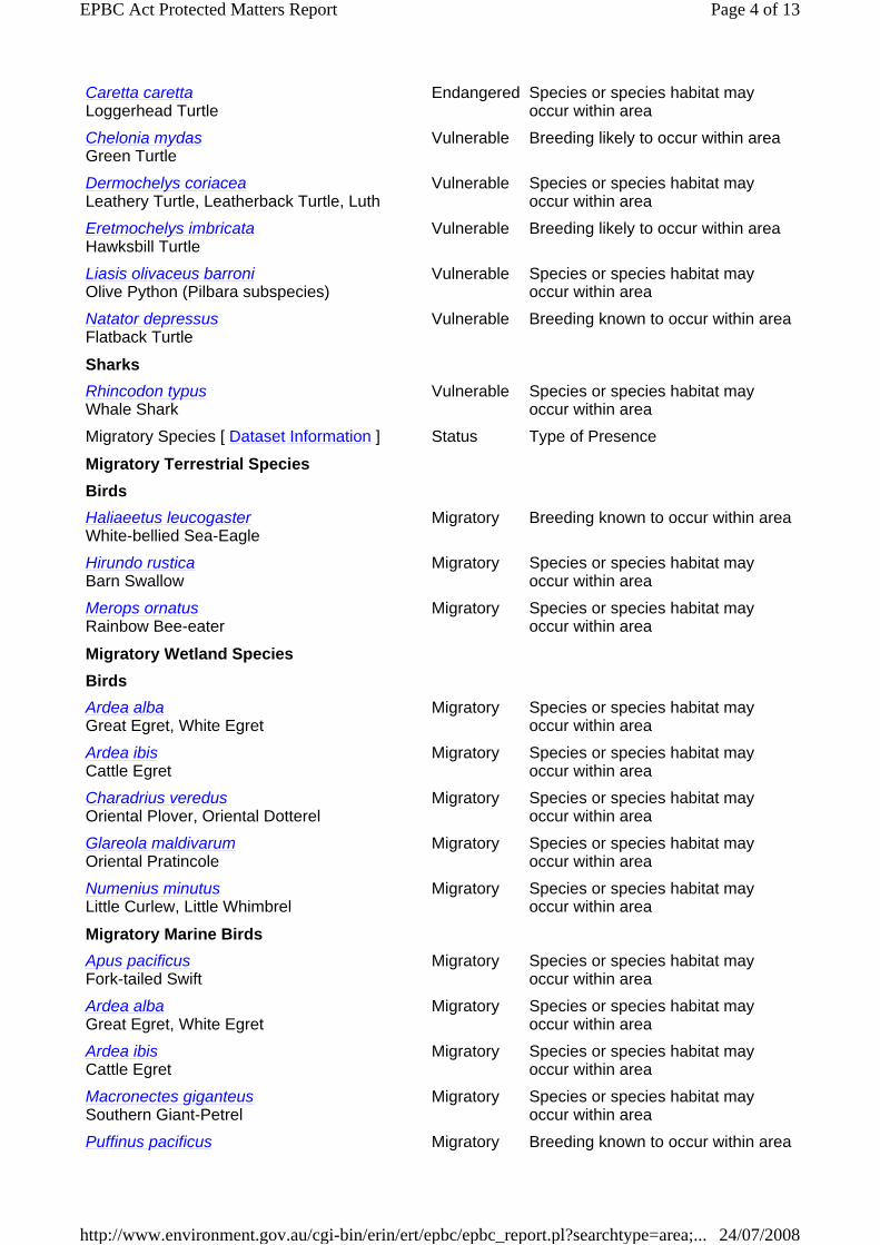
Caretta caretta Loggerhead Turtle
Endangered Species or species habitat may occur within area
Chelonia mydas Green Turtle
Vulnerable Breeding likely to occur within area
Dermochelys coriacea Leathery Turtle, Leatherback Turtle, Luth
Vulnerable Species or species habitat may occur within area
Eretmochelys imbricata Hawksbill Turtle
Vulnerable Breeding likely to occur within area
Liasis olivaceus barroni Olive Python (Pilbara subspecies)
Vulnerable Species or species habitat may occur within area
Natator depressus Flatback Turtle
Vulnerable Breeding known to occur within area
SharksRhincodon typus Whale Shark
Vulnerable Species or species habitat may occur within area
Migratory Species [ Dataset Information ] Status Type of Presence
Migratory Terrestrial SpeciesBirdsHaliaeetus leucogaster White-bellied Sea-Eagle
Migratory Breeding known to occur within area
Hirundo rustica Barn Swallow
Migratory Species or species habitat may occur within area
Merops ornatus Rainbow Bee-eater
Migratory Species or species habitat may occur within area
Migratory Wetland SpeciesBirdsArdea alba Great Egret, White Egret
Migratory Species or species habitat may occur within area
Ardea ibis Cattle Egret
Migratory Species or species habitat may occur within area
Charadrius veredus Oriental Plover, Oriental Dotterel
Migratory Species or species habitat may occur within area
Glareola maldivarum Oriental Pratincole
Migratory Species or species habitat may occur within area
Numenius minutus Little Curlew, Little Whimbrel
Migratory Species or species habitat may occur within area
Migratory Marine BirdsApus pacificus Fork-tailed Swift
Migratory Species or species habitat may occur within area
Ardea alba Great Egret, White Egret
Migratory Species or species habitat may occur within area
Ardea ibis Cattle Egret
Migratory Species or species habitat may occur within area
Macronectes giganteus Southern Giant-Petrel
Migratory Species or species habitat may occur within area
Puffinus pacificus Migratory Breeding known to occur within area
Page 4 of 13EPBC Act Protected Matters Report
24/07/2008http://www.environment.gov.au/cgi-bin/erin/ert/epbc/epbc_report.pl?searchtype=area;...

Other Matters Protected by the EPBC Act
Wedge-tailed Shearwater
Sterna anaethetus Bridled Tern
Migratory Breeding known to occur within area
Sterna caspia Caspian Tern
Migratory Breeding known to occur within area
Migratory Marine SpeciesMammalsBalaenoptera bonaerensis Antarctic Minke Whale, Dark-shoulder Minke Whale
Migratory Species or species habitat may occur within area
Balaenoptera edeni Bryde's Whale
Migratory Species or species habitat may occur within area
Balaenoptera musculus Blue Whale
Migratory Species or species habitat may occur within area
Dugong dugon Dugong
Migratory Species or species habitat likely to occur within area
Eubalaena australis Southern Right Whale
Migratory Species or species habitat may occur within area
Megaptera novaeangliae Humpback Whale
Migratory Congregation or aggregation known to occur within area
Orcinus orca Killer Whale, Orca
Migratory Species or species habitat may occur within area
Physeter macrocephalus Sperm Whale
Migratory Species or species habitat may occur within area
Sousa chinensis Indo-Pacific Humpback Dolphin
Migratory Species or species habitat may occur within area
Tursiops aduncus (Arafura/Timor Sea populations) Spotted Bottlenose Dolphin (Arafura/Timor Sea populations)
Migratory Species or species habitat likely to occur within area
ReptilesCaretta caretta Loggerhead Turtle
Migratory Species or species habitat may occur within area
Chelonia mydas Green Turtle
Migratory Breeding likely to occur within area
Dermochelys coriacea Leathery Turtle, Leatherback Turtle, Luth
Migratory Species or species habitat may occur within area
Eretmochelys imbricata Hawksbill Turtle
Migratory Breeding likely to occur within area
Natator depressus Flatback Turtle
Migratory Breeding known to occur within area
SharksRhincodon typus Whale Shark
Migratory Species or species habitat may occur within area
Listed Marine Species [ Dataset Information ] Status Type of Presence
Birds
Page 5 of 13EPBC Act Protected Matters Report
24/07/2008http://www.environment.gov.au/cgi-bin/erin/ert/epbc/epbc_report.pl?searchtype=area;...

Apus pacificus Fork-tailed Swift
Listed - overfly marine area
Species or species habitat may occur within area
Ardea alba Great Egret, White Egret
Listed - overfly marine area
Species or species habitat may occur within area
Ardea ibis Cattle Egret
Listed - overfly marine area
Species or species habitat may occur within area
Charadrius veredus Oriental Plover, Oriental Dotterel
Listed - overfly marine area
Species or species habitat may occur within area
Glareola maldivarum Oriental Pratincole
Listed - overfly marine area
Species or species habitat may occur within area
Haliaeetus leucogaster White-bellied Sea-Eagle
Listed Breeding known to occur within area
Hirundo rustica Barn Swallow
Listed - overfly marine area
Species or species habitat may occur within area
Larus novaehollandiae Silver Gull
Listed Breeding known to occur within area
Macronectes giganteus Southern Giant-Petrel
Listed Species or species habitat may occur within area
Merops ornatus Rainbow Bee-eater
Listed - overfly marine area
Species or species habitat may occur within area
Numenius minutus Little Curlew, Little Whimbrel
Listed - overfly marine area
Species or species habitat may occur within area
Pandion haliaetus Osprey
Listed Breeding known to occur within area
Puffinus pacificus Wedge-tailed Shearwater
Listed Breeding known to occur within area
Sterna anaethetus Bridled Tern
Listed Breeding known to occur within area
Sterna bergii Crested Tern
Listed Breeding known to occur within area
Sterna caspia Caspian Tern
Listed Breeding known to occur within area
Sterna fuscata Sooty Tern
Listed Breeding known to occur within area
Page 6 of 13EPBC Act Protected Matters Report
24/07/2008http://www.environment.gov.au/cgi-bin/erin/ert/epbc/epbc_report.pl?searchtype=area;...

Sterna nereis Fairy Tern
Listed Breeding known to occur within area
MammalsDugong dugon Dugong
Listed Species or species habitat likely to occur within area
Ray-finned fishesAcentronura larsonae Helen's Pygmy Pipehorse
Listed Species or species habitat may occur within area
Bulbonaricus brauni Braun's Pughead Pipefish, Pug-headed Pipefish
Listed Species or species habitat may occur within area
Campichthys tricarinatus Three-keel Pipefish
Listed Species or species habitat may occur within area
Choeroichthys brachysoma Pacific Short-bodied Pipefish, Short-bodied Pipefish
Listed Species or species habitat may occur within area
Choeroichthys latispinosus Muiron Island Pipefish
Listed Species or species habitat may occur within area
Choeroichthys suillus Pig-snouted Pipefish
Listed Species or species habitat may occur within area
Corythoichthys flavofasciatus Yellow-banded Pipefish, Network Pipefish
Listed Species or species habitat may occur within area
Cosmocampus banneri Roughridge Pipefish
Listed Species or species habitat may occur within area
Doryrhamphus dactyliophorus Ringed Pipefish
Listed Species or species habitat may occur within area
Doryrhamphus excisus Indian Blue-stripe Pipefish, Blue-stripe Pipefish
Listed Species or species habitat may occur within area
Doryrhamphus janssi Cleaner Pipefish, Janss' Pipefish
Listed Species or species habitat may occur within area
Doryrhamphus multiannulatus Many-banded Pipefish
Listed Species or species habitat may occur within area
Doryrhamphus negrosensis Flagtail Pipefish, Negros Pipefish
Listed Species or species habitat may occur within area
Festucalex scalaris Ladder Pipefish
Listed Species or species habitat may occur within area
Filicampus tigris Tiger Pipefish
Listed Species or species habitat may occur within area
Halicampus brocki Brock's Pipefish
Listed Species or species habitat may occur within area
Halicampus grayi Mud Pipefish, Gray's Pipefish
Listed Species or species habitat may occur within area
Halicampus nitidus Glittering Pipefish
Listed Species or species habitat may occur within area
Halicampus spinirostris Spiny-snout Pipefish
Listed Species or species habitat may occur within area
Haliichthys taeniophorus Listed Species or species habitat may occur
Page 7 of 13EPBC Act Protected Matters Report
24/07/2008http://www.environment.gov.au/cgi-bin/erin/ert/epbc/epbc_report.pl?searchtype=area;...

Ribboned Seadragon, Ribboned Pipefish within area
Hippichthys penicillus Beady Pipefish, Steep-nosed Pipefish
Listed Species or species habitat may occur within area
Hippocampus angustus Western Spiny Seahorse, Narrow-bellied Seahorse
Listed Species or species habitat may occur within area
Hippocampus histrix Spiny Seahorse
Listed Species or species habitat may occur within area
Hippocampus kuda Spotted Seahorse, Yellow Seahorse
Listed Species or species habitat may occur within area
Hippocampus planifrons Flat-face Seahorse
Listed Species or species habitat may occur within area
Hippocampus spinosissimus Hedgehog Seahorse
Listed Species or species habitat may occur within area
Micrognathus micronotopterus Tidepool Pipefish
Listed Species or species habitat may occur within area
Phoxocampus belcheri Rock Pipefish
Listed Species or species habitat may occur within area
Solegnathus hardwickii Pipehorse
Listed Species or species habitat may occur within area
Solegnathus lettiensis Indonesian Pipefish, Gunther's Pipehorse
Listed Species or species habitat may occur within area
Solenostomus cyanopterus Blue-finned Ghost Pipefish, Robust Ghost Pipefish
Listed Species or species habitat may occur within area
Syngnathoides biaculeatus Double-ended Pipehorse, Alligator Pipefish
Listed Species or species habitat may occur within area
Trachyrhamphus bicoarctatus Bend Stick Pipefish, Short-tailed Pipefish
Listed Species or species habitat may occur within area
Trachyrhamphus longirostris Long-nosed Pipefish, Straight Stick Pipefish
Listed Species or species habitat may occur within area
ReptilesAcalyptophis peronii Horned Seasnake
Listed Species or species habitat may occur within area
Aipysurus apraefrontalis Short-nosed Seasnake
Listed Species or species habitat may occur within area
Aipysurus duboisii Dubois' Seasnake
Listed Species or species habitat may occur within area
Aipysurus eydouxii Spine-tailed Seasnake
Listed Species or species habitat may occur within area
Aipysurus laevis Olive Seasnake
Listed Species or species habitat may occur within area
Aipysurus tenuis Brown-lined Seasnake
Listed Species or species habitat may occur within area
Astrotia stokesii Stokes' Seasnake
Listed Species or species habitat may occur within area
Caretta caretta Listed Species or species habitat may occur
Page 8 of 13EPBC Act Protected Matters Report
24/07/2008http://www.environment.gov.au/cgi-bin/erin/ert/epbc/epbc_report.pl?searchtype=area;...

Loggerhead Turtle within area
Chelonia mydas Green Turtle
Listed Breeding likely to occur within area
Dermochelys coriacea Leathery Turtle, Leatherback Turtle, Luth
Listed Species or species habitat may occur within area
Disteira kingii Spectacled Seasnake
Listed Species or species habitat may occur within area
Disteira major Olive-headed Seasnake
Listed Species or species habitat may occur within area
Emydocephalus annulatus Turtle-headed Seasnake
Listed Species or species habitat may occur within area
Ephalophis greyi North-western Mangrove Seasnake
Listed Species or species habitat may occur within area
Eretmochelys imbricata Hawksbill Turtle
Listed Breeding likely to occur within area
Hydrelaps darwiniensis Black-ringed Seasnake
Listed Species or species habitat may occur within area
Hydrophis czeblukovi Fine-spined Seasnake
Listed Species or species habitat may occur within area
Hydrophis elegans Elegant Seasnake
Listed Species or species habitat may occur within area
Hydrophis mcdowelli Listed Species or species habitat may occur within area
Hydrophis ornatus a seasnake
Listed Species or species habitat may occur within area
Natator depressus Flatback Turtle
Listed Breeding known to occur within area
Pelamis platurus Yellow-bellied Seasnake
Listed Species or species habitat may occur within area
Whales and Other Cetaceans [ Dataset Information ] Status Type of Presence
Balaenoptera acutorostrata Minke Whale
Cetacean Species or species habitat may occur within area
Balaenoptera bonaerensis Antarctic Minke Whale, Dark-shoulder Minke Whale
Cetacean Species or species habitat may occur within area
Balaenoptera edeni Bryde's Whale
Cetacean Species or species habitat may occur within area
Balaenoptera musculus Blue Whale
Cetacean Species or species habitat may occur within area
Delphinus delphis Common Dolphin
Cetacean Species or species habitat may occur within area
Eubalaena australis Southern Right Whale
Cetacean Species or species habitat may occur within area
Feresa attenuata Pygmy Killer Whale
Cetacean Species or species habitat may occur within area
Globicephala macrorhynchus Cetacean Species or species habitat may occur
Page 9 of 13EPBC Act Protected Matters Report
24/07/2008http://www.environment.gov.au/cgi-bin/erin/ert/epbc/epbc_report.pl?searchtype=area;...

Short-finned Pilot Whale within area
Grampus griseus Risso's Dolphin, Grampus
Cetacean Species or species habitat may occur within area
Kogia breviceps Pygmy Sperm Whale
Cetacean Species or species habitat may occur within area
Kogia simus Dwarf Sperm Whale
Cetacean Species or species habitat may occur within area
Lagenodelphis hosei Fraser's Dolphin, Sarawak Dolphin
Cetacean Species or species habitat may occur within area
Megaptera novaeangliae Humpback Whale
Cetacean Congregation or aggregation known to occur within area
Mesoplodon densirostris Blainville's Beaked Whale, Dense-beaked Whale
Cetacean Species or species habitat may occur within area
Orcinus orca Killer Whale, Orca
Cetacean Species or species habitat may occur within area
Peponocephala electra Melon-headed Whale
Cetacean Species or species habitat may occur within area
Physeter macrocephalus Sperm Whale
Cetacean Species or species habitat may occur within area
Pseudorca crassidens False Killer Whale
Cetacean Species or species habitat may occur within area
Sousa chinensis Indo-Pacific Humpback Dolphin
Cetacean Species or species habitat may occur within area
Stenella attenuata Spotted Dolphin, Pantropical Spotted Dolphin
Cetacean Species or species habitat may occur within area
Stenella coeruleoalba Striped Dolphin, Euphrosyne Dolphin
Cetacean Species or species habitat may occur within area
Stenella longirostris Long-snouted Spinner Dolphin
Cetacean Species or species habitat may occur within area
Steno bredanensis Rough-toothed Dolphin
Cetacean Species or species habitat may occur within area
Tursiops aduncus (Arafura/Timor Sea populations) Spotted Bottlenose Dolphin (Arafura/Timor Sea populations)
Cetacean Species or species habitat likely to occur within area
Tursiops aduncus Indian Ocean Bottlenose Dolphin, Spotted Bottlenose Dolphin
Cetacean Species or species habitat likely to occur within area
Tursiops truncatus s. str. Bottlenose Dolphin
Cetacean Species or species habitat may occur within area
Ziphius cavirostris Cuvier's Beaked Whale, Goose-beaked Whale
Cetacean Species or species habitat may occur within area
Commonwealth Lands [ Dataset Information ]
Unknown Places on the RNE [ Dataset Information ] Note that not all Indigenous sites may be listed.
Page 10 of 13EPBC Act Protected Matters Report
24/07/2008http://www.environment.gov.au/cgi-bin/erin/ert/epbc/epbc_report.pl?searchtype=area;...

Extra Information
Caveat The information presented in this report has been provided by a range of data sources as acknowledged at the end of the report.
This report is designed to assist in identifying the locations of places which may be relevant in determining obligations under the Environment Protection and Biodiversity Conservation Act 1999. It holds mapped locations of World Heritage and Register of National Estate properties, Wetlands ofInternational Importance, Commonwealth and State/Territory reserves, listed threatened, migratory and marine species and listed threatened ecological communities. Mapping of Commonwealth land is not complete at this stage. Maps have been collated from a range of sources at various resolutions.
Not all species listed under the EPBC Act have been mapped (see below) and therefore a report is a general guide only. Where available data supports mapping, the type of presence that can be determined from the data is indicated in general terms. People using this information in making a referral may need to consider the qualifications below and may need to seek and consider other information sources.
For threatened ecological communities where the distribution is well known, maps are derived from recovery plans, State vegetation maps, remote sensing imagery and other sources. Where threatened ecological community distributions are less well known, existing vegetation maps and point location data are used to produce indicative distribution maps.
For species where the distributions are well known, maps are digitised from sources such as recovery plans and detailed habitat studies. Where appropriate, core breeding, foraging and roosting areas are indicated under "type of presence". For species whose distributions are less well known, point locations are collated from government wildlife authorities, museums, and non-government organisations; bioclimatic distribution models are generated and these validated by experts. In some cases, the distribution maps are based solely on expert knowledge.
Only selected species covered by the migratory and marine provisions of the Act have been mapped.
The following species and ecological communities have not been mapped and do not appear in reports produced from this database:
threatened species listed as extinct or considered as vagrants some species and ecological communities that have only recently been listed
HistoricBessieres Island Lighthouse WA
NaturalCoastal Islands Mary Anne to Regnard WAIslands Exmouth Gulf and Rowley Shelf WA
State and Territory Reserves [ Dataset Information ]
Bessieres Island Nature Reserve, WA
Cane River Conservation Park, WA
Great Sandy Island Nature Reserve, WAThevenard Island Nature Reserve, WA
Page 11 of 13EPBC Act Protected Matters Report
24/07/2008http://www.environment.gov.au/cgi-bin/erin/ert/epbc/epbc_report.pl?searchtype=area;...

some terrestrial species that overfly the Commonwealth marine area migratory species that are very widespread, vagrant, or only occur in small numbers.
The following groups have been mapped, but may not cover the complete distribution of the species:
non-threatened seabirds which have only been mapped for recorded breeding sites; seals which have only been mapped for breeding sites near the Australian continent.
Such breeding sites may be important for the protection of the Commonwealth Marine environment.
Acknowledgments This database has been compiled from a range of data sources. The Department acknowledges the following custodians who have contributed valuable data and advice:
New South Wales National Parks and Wildlife Service Department of Sustainability and Environment, Victoria Department of Primary Industries, Water and Environment, Tasmania Department of Environment and Heritage, South Australia Planning SA Parks and Wildlife Commission of the Northern Territory Environmental Protection Agency, Queensland Birds Australia Australian Bird and Bat Banding Scheme Australian National Wildlife Collection Natural history museums of Australia Queensland Herbarium National Herbarium of NSW Royal Botanic Gardens and National Herbarium of Victoria Tasmanian Herbarium State Herbarium of South Australia Northern Territory Herbarium Western Australian Herbarium Australian National Herbarium, Atherton and Canberra University of New England Other groups and individuals
ANUCliM Version 1.8, Centre for Resource and Environmental Studies, Australian National University was used extensively for the production of draft maps of species distribution. Environment Australia is extremely grateful to the many organisations and individuals who provided expert advice and information on numerous draft distributions.
Department of the Environment, Water, Heritage and the Arts GPO Box 787 Canberra ACT 2601 Australia
Last updated: Monday, 21-Jul-2008 10:56:50 EST
Page 12 of 13EPBC Act Protected Matters Report
24/07/2008http://www.environment.gov.au/cgi-bin/erin/ert/epbc/epbc_report.pl?searchtype=area;...

Telephone: +61 (0)2 6274 1111
© Commonwealth of Australia 2004
Page 13 of 13EPBC Act Protected Matters Report
24/07/2008http://www.environment.gov.au/cgi-bin/erin/ert/epbc/epbc_report.pl?searchtype=area;...
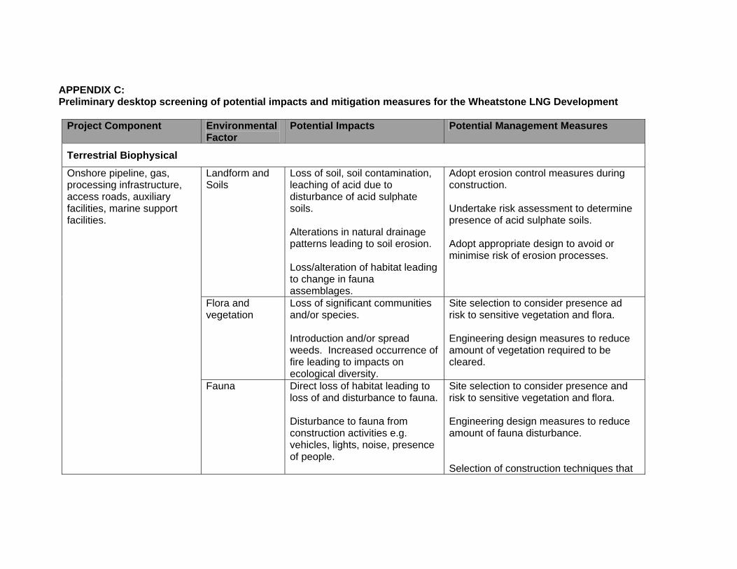
APPENDIX C: Preliminary desktop screening of potential impacts and mitigation measures for the Wheatstone LNG Development
Project Component Environmental
Factor Potential Impacts Potential Management Measures
Terrestrial Biophysical
Landform and Soils
Loss of soil, soil contamination, leaching of acid due to disturbance of acid sulphate soils. Alterations in natural drainage patterns leading to soil erosion. Loss/alteration of habitat leading to change in fauna assemblages.
Adopt erosion control measures during construction. Undertake risk assessment to determine presence of acid sulphate soils. Adopt appropriate design to avoid or minimise risk of erosion processes.
Flora and vegetation
Loss of significant communities and/or species. Introduction and/or spread weeds. Increased occurrence of fire leading to impacts on ecological diversity.
Site selection to consider presence ad risk to sensitive vegetation and flora. Engineering design measures to reduce amount of vegetation required to be cleared.
Onshore pipeline, gas, processing infrastructure, access roads, auxiliary facilities, marine support facilities.
Fauna
Direct loss of habitat leading to loss of and disturbance to fauna. Disturbance to fauna from construction activities e.g. vehicles, lights, noise, presence of people.
Site selection to consider presence and risk to sensitive vegetation and flora. Engineering design measures to reduce amount of fauna disturbance. Selection of construction techniques that

Project Component Environmental Factor
Potential Impacts Potential Management Measures
Fauna cont.
Permanent loss of fauna due to disturbance from operating plant. Fauna mortality during onshore pipeline construction. Introduction of feral animals that compete with native fauna.
result in least disturbance to fauna during construction.
Hydrology and hydrogeology
Contamination of ground and surface water due to change in drainage patterns or from spill and leaks. Reduction in water volumes and quality due to over abstraction. Loss or degradation to water dependent ecosystems, and habitats as a result of impact on hydrology and hydrogeology.
Appropriate drainage design to reduce negative impacts on drainage and water dependent ecosystems. Design plant for efficient water usage. Consider alternative sources of water such as desalination where practical.

Project Component Environmental
Factor Potential Impacts Potential Management Measures
Marine Biophysical
Pipeline shore crossing, port facilities (MOF and jetty), navigational channel, site preparation.
Coastal process Coastal process cont.
Changes to sediment transport process leading to changes in sediment accretion and deposition rates and locations. Changes to geomorphic process which could lead to changes in ecological processes. Alteration to local currents due to the presence of marine infrastructure such as jetties, breakwaters and seabed pipelines.
Develop detailed understanding of coastal process and interaction with ecological process. Model coastal process to understand potential direct and indirect impacts. Design of infrastructure reduces the impact on coastal processes as far as practical.
Water quality Increased turbidity and decreased light attenuation due to dredging and pipelay operations. Reduction in water quality due to spills and routine discharges.
Design facilities to reduce risk of non routine discharges and accidental spills. Locate facilities away from sensitive marine habitats as far as practical. Undertake detailed fate and trajectory modelling of planned and accidental discharges. Prepare effective emergency response plans to reduce impacts from spills and non routine discharges.
Offshore facilities, pipeline shore crossing, port facilities, gas processing infrastructure, and navigational channel. As above
Flora
Loss of habitat due to disturbance to sea bed from seabed preparation activities such as dredging.
Minimise impacts on flora by avoiding sensitive habitats where practical. Develop robust dispersion models to

Project Component Environmental Factor
Potential Impacts Potential Management Measures
Marine Biophysical
Flora cont.
Loss of habitat due to spills and reduction in water quality Introduction of exotic marine organisms that compete with native flora.
understand and manage impacts from activities such as dredging.
Pipeline shore crossing, port facilities, coastal infrastructure, navigational channels, offshore facilities deepwater infrastructure.
Fauna Disturbance to migratory marine mammals from shipping movements and noise. Disturbance to breeding fauna such as turtles from light spill, noise and shipping movements. Disturbance to migratory seabeds due to lights spill, and loss of habitat.
Reduce impacts on fauna by avoiding sensitive habitats where practical. Understand presence, extent and seasonal variations in fauna. Design facilities for reduced light spill and noise levels.

Project Component Environmental
Factor Potential Impacts Potential Management Measures
Social impacts and community
Gas processing infrastructure, onshore construction, shipping activities
Air Quality Atmospheric releases such as NOx SOx H2S, smoke, dust and odours resulting in temporary and/or long term reduction in air quality.
Model atmospheric emissions dispersion and reduce atmospheric emissions that result in reduction in air quality. Ensure atmospheric emissions are within air quality standards
Onshore and offshore construction activities. Gas processing facilities and shipping movements.
Noise and Vibration
Reduced amenity for local residents both during the construction period and operations.
Where practical position facilities away from sensitive receptors. Reduce noise levels as far as practical. Meet regulatory noise limits as a minimum.
Processing facilities, release of reservoir greenhouse gas.
Greenhouse Gases
Contribution to climate change. Maximise energy efficiency in design. Develop greenhouse gas management plan in accordance with regulatory requirements and Chevron’s policy on greenhouse gas management
Near shore and onshore facilities associated with the development
Aboriginal Heritage
Loss of or disturbance to, sites, features and species of cultural significance.
Work with indigenous groups to identify cultural values and maximise protection of these values.
Offshore and onshore facilities associated with the development.
European Heritage
Loss or disturbance to sites of cultural significance
Consult stakeholders to ensure cultural sites are identified and protected as far as practical.

Project Component Environmental Factor
Potential Impacts Potential Management Measures
Operation of near and onshore facilities and associated constructions activities.
Community health and safety
Risk to local community and work force from operations of the facilities and short term risks during construction activities.
Undertake risk assessment to understand and support management of potential risks. Undertake community consultation to understand risk and risk mitigation measures.
Near and onshore facilities associated with the development.
Recreation Loss of or reduced access to recreational areas including recreational fishing areas. Reduced access to recreational coastal areas due to presence of port facilities and tanker movements.
Consult with the community to identify important recreational areas and identify mitigation measures. Construct and operate the facilities to reduce the risk of impacts on recreational areas.
Onshore construction and operations
Traffic Increase traffic resulting in increased noise levels, and the risk of accidents.
Ensure road system has the capacity to cater for increased traffic. Consult with community to gain an understanding of the potential impacts on the community from increase traffic. Implement traffic control measures to minimise the impact from traffic loads.
Near shore and onshore facilities.
Visual amenity Temporary or permanent loss of visual amenity due to construction activities and operations
Undertake a detailed visual assessment to reduce impacts on visual amenity. Rehabilitate areas that have been