ws3 project realities
TRANSCRIPT

PROJECT REALITIESUNION SQUARE WORKSHOP #3
FEBRUARY 18, 2015
2
Our Mission
Collaborate to create a viable and vitaldevelopment plan that realizes SomerVision’s goals
for the Union Square neighborhood

D1
D5
D6
D7
D3
D2
D4
We will engage, listen, synthesize and create

4
AGENDA
1 Infrastructure Considerations
2 Brownfield Considerations
3 Transportation

Placemaking, Retail, Public Realm, ArtFebruary 4
Creating an Employment Center in Union SquareFebruary 11
Project RealitiesFebruary 18
Giving Shape to D2/D3March 25
1234
WORKSHOPSDevelopment Opportunities and Realities

• Effective infrastructure and transportation are fundamental to the future of Union Square
• Infrastructure and transportation systems are underperforming
• Industrial history has redevelopment implications
• Redevelopment will add new users
• City has proactively developed solutions
• Redevelopment and the resulting economic impact will be critical to implementing solution
• Collaboration to optimize solutions is critical
Why discuss transportation, infrastructure and brownfields?

1. INFRASTRUCTURE CONSIDERATIONS

Conceptual Drainage Improvements

Sewer Improvements

Water Main Improvements

Conceptual Fiber Optic Line Improvements

D2 and D3 Conceptual Utility Connections

Rain Garden

Underground Stormwater Storage Tank

Green Roofs

Green Roofs

• Significant amount of infrastructure improvements happening around Union Square, lead by PB
• Stormwater management is a big part of the works being planned, that will mitigate, but may not eliminate the potential for flooding
• Individual development will contribute by incorporating stormwater management features to reduce the rate of runoff from the project sites
Summary

2. BROWNFIELD CONSIDERATIONS
Today
1. Guiding Principles2. Area Use Background3. Approach4. Mitigation Tools and Measures5. Next Steps

Guiding Principles
• Realizing Community Goals• Urban Revitalization• Environmental Stewardship• Feasible Economic Development• Resiliency & Sustainability

AREA USE BACKGROUND

Sources• Walkthrough• MassDEP Records• Past Environmental Investigations• Sanborn Fire Insurance Maps• City Directories• Aerial Photographs• Environmental & Building Databases

Findings• Environmental impacts due to historic uses• Commercial & Industrial Activities, Residential• Environmental Records Review of findings• Land Use Limitations• Future Environmental Requirements• Adaptive Creativity in Design

APPROACH

Integrated Approach
Least Risk, Least Cost, Maximum Public Benefit
Remediation Land Use/Design

1. Cost of mitigating environmental impact
2. Applicability of public funds
3. Land use consistent with environmental conditions
4. Long-term operation & maintenance
5. Status of regulatory reviews & reporting
6. Phasing development to accommodate improvement of site conditions
7. Developable areas vs. public amenities, easements & R/W
Factors to Consider

Develop Parcel-Specific Profile
Examplea. SB 1888: Repair shop, water works, shed, tool house. SB
1900: Veteran Fireman Association, Somerville Sewer Dept., Shed, tool house (carpenter?). SB 1933: Same. SB 1950: Unmarked. SB 1989: Parking. SB 1991: Parking
b. Brownfield grant (City of Somerville). Phase I ESA completed (Redevelopment authority)
Profile:Industrial, impacted, some cleanup work completed, remaining impact being assessed. Possible waste pits & vessels

Develop Parcel-Specific Approach
1. Assess soil, groundwater and soil vapor
2. Employ Risk-Based analysis following regulatory process
3. Satisfy regulatory requirements
4. Mitigation of hazards from past industrial operations
5. Establish cost-benefit development model
6. Optimize land use for public benefit

Mitigation Tools & Measures

1. Activity and Use Limitations (AUL) as a notice of Deed Restriction (Institutional Controls)
2. Engineering controls integrated with design elements
3. Vapor intrusion mitigation
4. Soil handling (cut/fill), off-property soil disposal
5. Groundwater quality improvements
6. Waste area cleanup
7. Subsurface features (USTs, etc.)
Under Consideration

Next Steps

Assessment:Soil, groundwater and vapor
Planning: Community input, zoning, land use, massing, roadways, utilities, open space, subterranean floors
Design: Foundation types, pad elevations, utilities, stormwater
Regulatory:Land use conformity, cleanup goals, restrictions
Coordination:Phasing, remediation, infrastructure, sustainability

• Union Square industrial past is still very much influencing the way we will develop the area, impacting project cost, land use, and design
• Mitigating contaminated soils & groundwater are expensive & complex, requiring additional funding support and a creative approach to allow maximum development value
• We will continue to work with all stakeholders to achieve an optimum development
Summary
QUESTIONS?

3. TRANSPORTATION

TRANSPORTATION INTRODUCTION

Transportation is Changing Nationally
On-Street Pricing
Car-SharingUnbundled Parking
MBTA Passes Bike Sharing
Taxi Rides Home
Rideshare Matching
Plus:
•On-Site Showers•Employee Marketing•On-Site Concierge•Bicycle Lockers•Bike Racks•Parking CashOut
Employee Shuttles

Somerville is Changing too…

Somerville is Changing too…Draft Zoning Ordinance Updates:
Draft Zoning Ordinance• Urban Square and TOD area
TDM Plan • Mobility Management Plan is required as part of permitting• Mandates TDM Programs• Requires annual reporting
Parking•No minimum parking requirements only maximums •Unbundled parking/off‐site parking permitted•Higher densities require parking underground or in a structure
Bicycle Parking•Bicycle parking requirements for new buildings

Credit: Union Square Main Streets
Union Square Can Get Back to Multimodal Roots
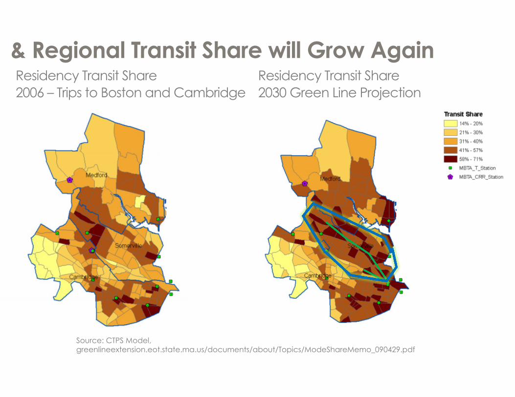
Source: CTPS Model, greenlineextension.eot.state.ma.us/documents/about/Topics/ModeShareMemo_090429.pdf
& Regional Transit Share will Grow AgainResidency Transit Share2006 – Trips to Boston and Cambridge
Residency Transit Share2030 Green Line Projection

STUDY AREA & CONTEXT
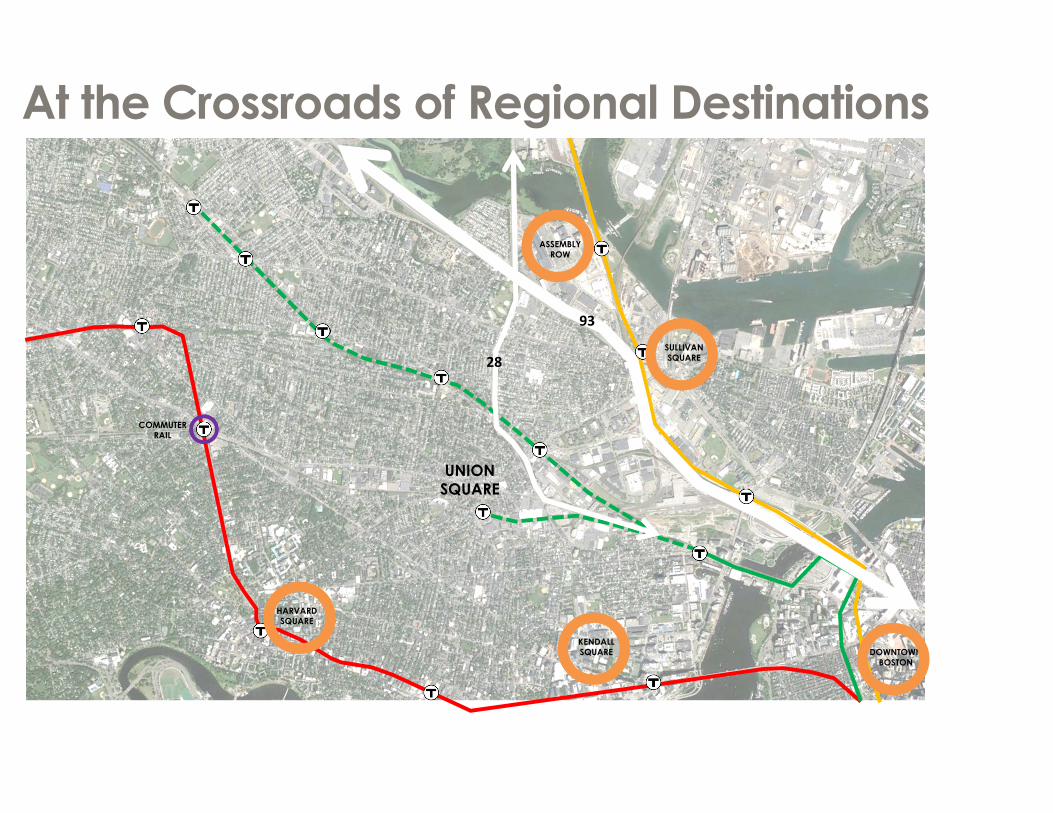
At the Crossroads of Regional Destinations
UNION SQUARE
DOWNTOWN BOSTON
93
28
COMMUTERRAIL
KENDALL SQUARE
SULLIVAN SQUARE
ASSEMBLYROW
HARVARDSQUARE

Hosts a Mix of Uses

Accessed by a Mix of ModesUnion Square
Data: American Community Survey 2006-2010, Extracted through CTPP
Bicycle3%
Drove alone62%
Carpool/ Vanpool8%
Walked8%
Transit14%
Other5%
Those Who Work in Union SquareUnion Square Residents
Data: American Community Survey 2013 5-year estimates

People Travel through Union Square on a Variety of RoutesInput from February 4th Placemaking Workshop

VEHICLE MOVEMENT
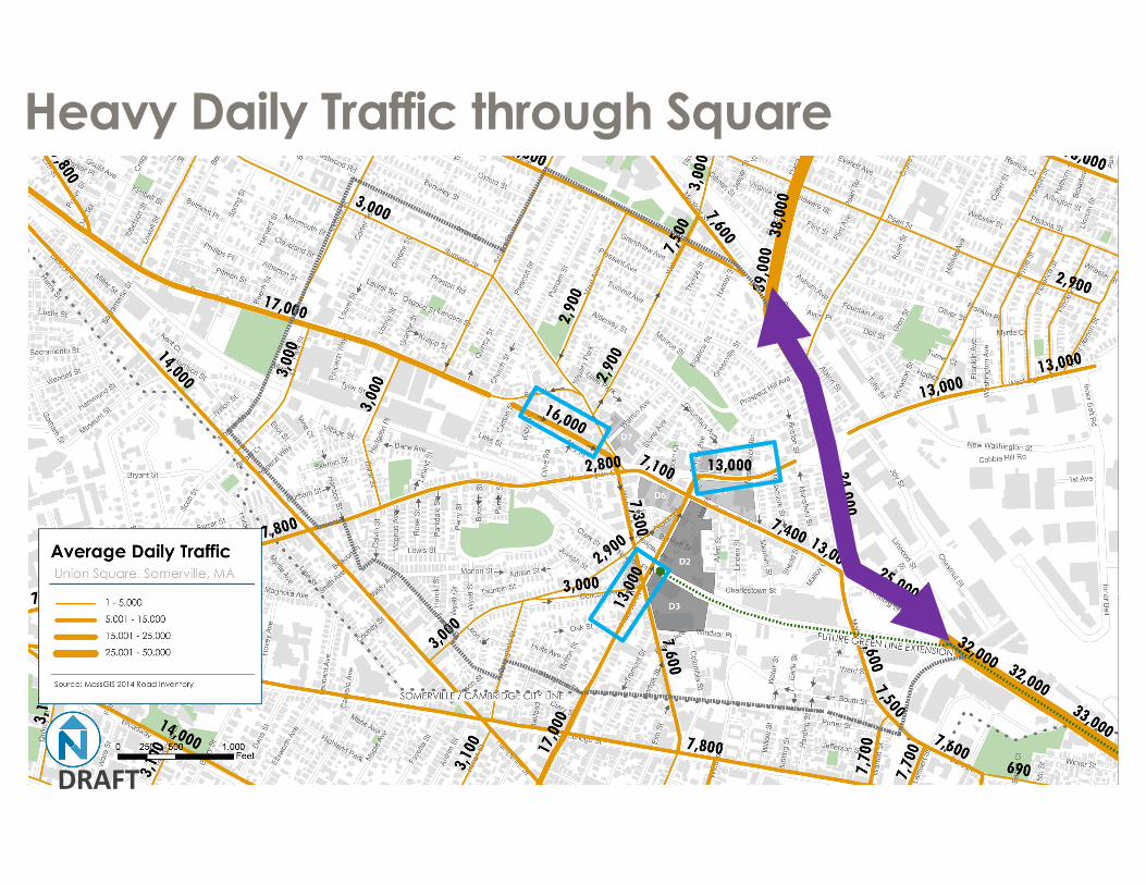
Heavy Daily Traffic through Square
DRAFT

Demand through Square AM

Demand through Square PM

One Ways Dictate Movement to/through the Square
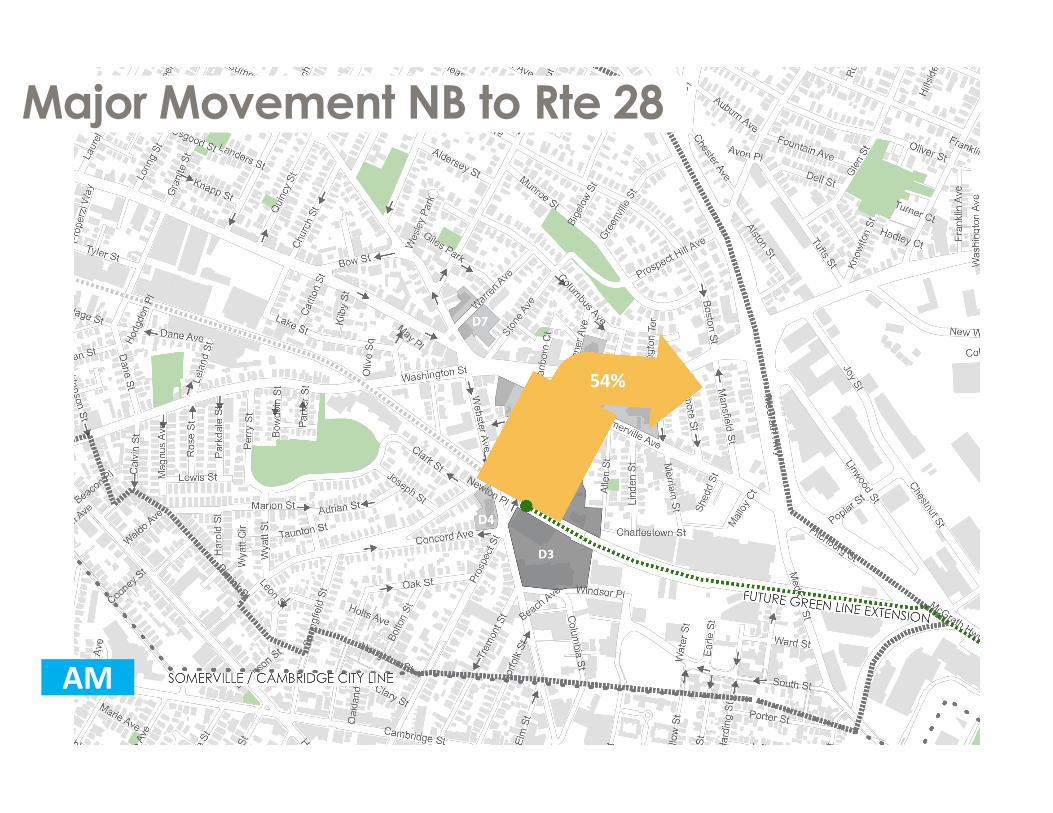
Major Movement NB to Rte 28
54%
AM

SB Traffic Forced through Square
61%
AM
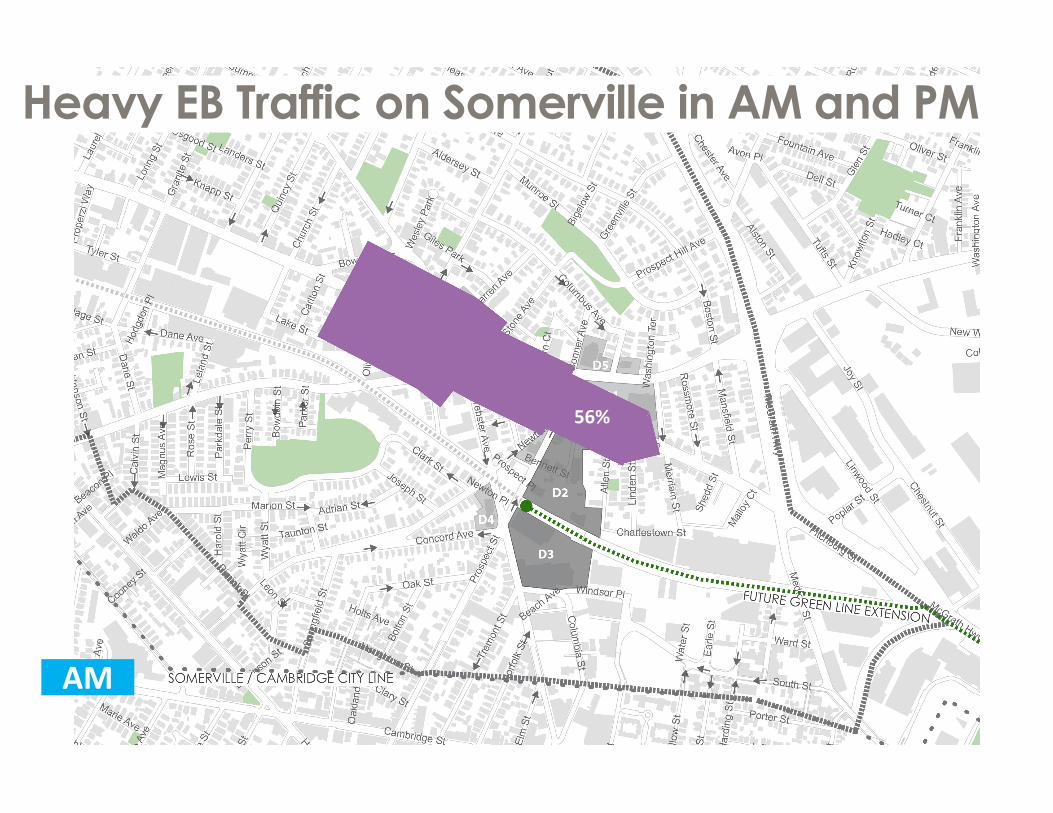
Heavy EB Traffic on Somerville in AM and PM
56%
AM

CHANGES TO STREET NETWORK

One-Ways Route Congestion through the Core
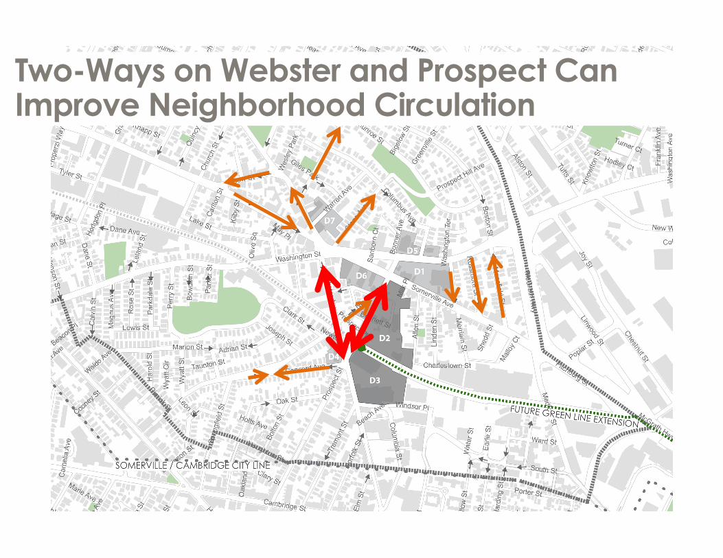
Two-Ways on Webster and Prospect Can Improve Neighborhood Circulation

Two-Way Slightly Improves LOS and Greatly Improves Area Access
EXISTING INTERIM IMPROVEMENTS
AM (PM)

PARKING

Complex Existing Parking Regulations
TYPE # SPACES ON‐STREET
# SPACESOFF‐STREET
Total 989 2,113
TYPE PUBLIC PRIVATE
Total 1,106 1,996

2009: 8 am 2009: 8 pm
2009 Parking Utilization shows Availability

Use SizeApartments 1,367 unitsAuto Repair 168,155 SFBank 33,059 SFBar 7,671 SFChurch 51,322 SFCondo 44 unitsConvenience Market 15,743 SFDonut/Coffee Shop 18,471 SFFast Food 11,381 SFFurniture Store 7,318 SFGallery 76,364 SFGrocery Store 37,262 SFHigh-Turnover Sit Down Restaurant 50,296 SFLight Manufacturing 173,953 SFMedical Office 115,442 SFOffice 200,505 SFQuality Restaurant 43,085 SFSchool - 1100 k-12 57,200 SFSchool - 555 students 110,000 SFTarget Store 130,947 SFWarehouse 229,549 SFCleaners 3,555 SFGovernment Office 127,702 SFResidential in Mixed Use 72,824 SFHealth/Fitness Club 6,065 SFRecreation Center 13,464 SFShopping Center 23,507 SFGeneral Shopping Center 35,678 SFTOTAL 1,800,000 SF + 1,400 HU
Mixed Land Use Mitigates Parking Demand

Unshared SupplyResidential (1000 units):
Real Demand
2 am
Shared Parking Concept in a Mixed Use Environment

Shared Uses:Real Demand
38% Less
Office
Restaurant
Residential
Restaurant
Residential
Unshared Supply
Office
Shared Parking Concept in a Mixed Use Environment

National Standards Suggest 7,000+ Spaces
EXISTING SUPPLY: 3,000
UNSHARED: 7,800

With Different Uses, Fewer Cars may be Parked
EXISTING SUPPLY: 3,000
UNSHARED: 7,800
PEAK DEMAND: 5,280

Union Square Likely Requires Even Less Parking
EXISTING SUPPLY: 3,000
UNSHARED: 7,800
PEAK DEMAND: 3,296

District Parking Intercepts Auto Traffic

District Parking Keeps Auto Traffic Out of Square
P P
P
P

BICYCLE MOVEMENT

Biking Today: Class 2 Bike Lanes and Sharrows� Gaps in lane network � No protected infrastructure�McGrath barrier� One ways force cyclists to follow circuitous routes through square
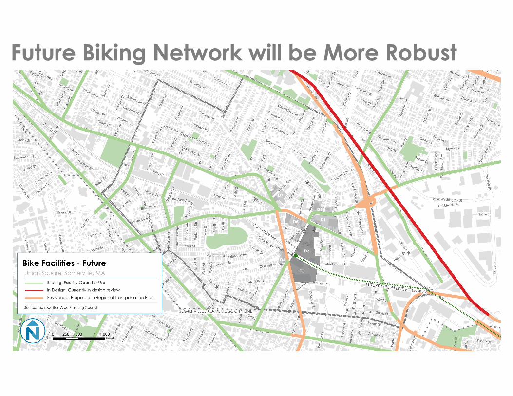
Future Biking Network will be More Robust

Bike lane both sides
Northbound bike laneSouthbound sharrow
Southbound bike laneNorthbound sharrow
North and southbound bike
lanes
Interim Biking Network – Early Action
Early Action Source: Union Square Utility and Streetscape Improvements Study
2‐way sharrows
Bike boxes/ accommodations
through intersection
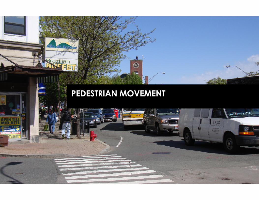
PEDESTRIAN MOVEMENT
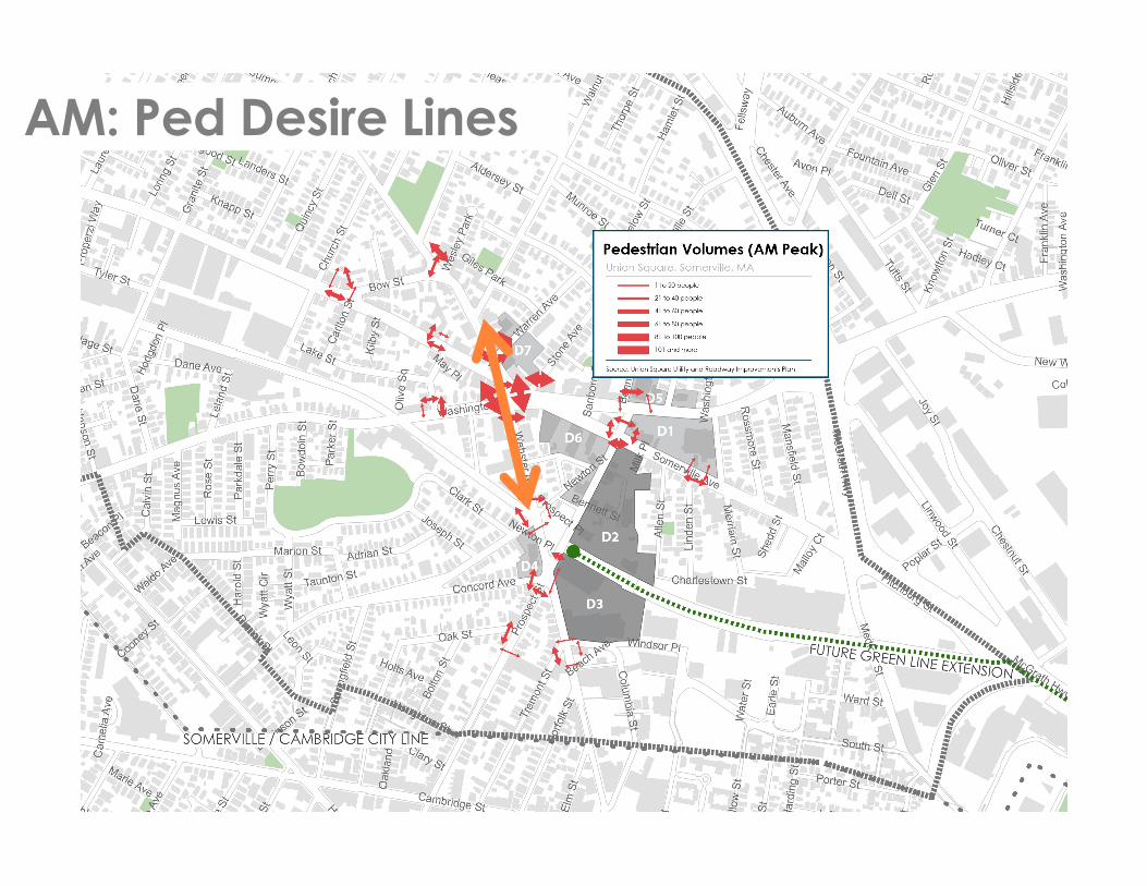
AM: Ped Desire Lines

PM: Ped Desire Lines

Sidewalk Coverage is Good
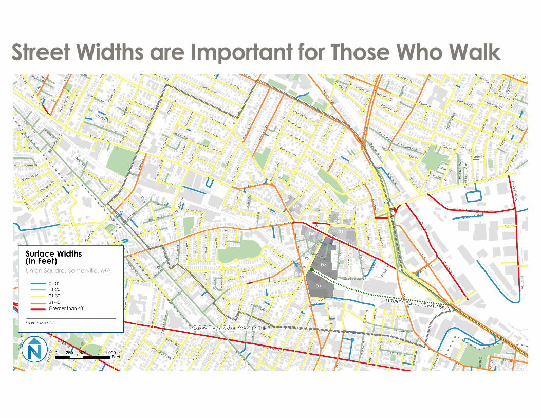
Street Widths are Important for Those Who Walk

Sample Street Widths: Prospect, Webster, & Somerville
PROSPECT STREET – 35’
WEBSTER STREET – 33’
SOMERVILLE AVE ‐ 60’ IN SQUARE

Interim Plans from Streetscape StudyProspect Street, looking North
Source: Union Square Utility and Streetscape Improvements Study
PROSPECT STREET – 35’

MASS TRANSIT

Union Square is a Bus Hub

Ridership is Highest within the Square

East West Bus Service is More Frequent than North-South

Bus Route Origin-Destination Weekday Peak Headway (minutes)
Weekday Midday Headway (minutes)
Weekday Evening Headway (minutes)
Weekend Headway (minutes)
CT2 Sullivan Station - Ruggles Station via Kendall/MIT 20 30 - 35 -- --
69 Harvard/Holyoke Gate - Lechmere Station via Cambridge Street 10-20 25 40 20-40
80 Arlington Center - Lechmere Station via Medford Hillside 20 25-35 60 30-60
83 Rindge Ave - Central Square Station via Porter 20 30 60 25-60
85 Spring Hill - Kendall/MIT Station via Summer Street & Union Square 40 40 -- --
86 Sullivan Station - Reservoir (Cleveland Circle) via Harvard 8-18 20 28-45 30-60
87 Arlington Center/Clarendon Hill - Lechmere Station via Somerville Avenue 20-22 30 30-35 30-40
88 Clarendon Hill - Lechmere Station via Highland Avenue 8-18 30 35 20-40
90 Davis Square Station - Wellington Station via Sullivan Square Station and Assembly Mall 40 40-55 65 70
91 Sullivan Square Station - Central Square Station via Washington Street 25-30 25-30 60-65 20-60
KEY: Route Runs Directly Thorough Union SquareRoute Runs Within 1/2 Mile of Union Square
Currently: Frequent Connections to Harvard, Sullivan, and Lechmere

NEW T STATION IMPACT

Green Line Extension Will Increase Transit Accessibility
Credit: MassDOT
85/CT2 Buses
Future Connections between Red and Green Line?

Projected to have over 3,500 Boardings Daily
•Green Line Extension projected to have 49,000 Riders (Credit: 2012 Factsheet)
•Union Square Station Projected to be 3rd busiest Green Line Station north of the Charles in 2030 (Out of all 10 Stations) Credit: 2012 Ridership Estimates
STATION TODAY PROJECTED 2030Union Square ‐‐‐ 3,570
Gilman Square ‐‐‐ 3,930
Lechmere Station 6,400 8,820
Credit: 2012 Ridership Estimates, MBTA Blue Book

D2/D3 CONSIDERATIONS

The D2/D3 Context

The D2/D3 Context

D2/D3 Transportation Issues
Long vehicle queues
• Narrow sidewalk• Hill/Grade changes•Parking access
Barrier
• Nstarequipment• Poor street environment
•60 ft wide•(15 secs to cross on foot)
The RIDE access
Narrow Streets

D2/D3 Transportation Opportunities
Two‐way cyclist travel
Align bus access; connect to red line?; multimodal transfers
Streamline curb cuts ; added retail frontage
Added on‐street parking?

SUMMARY/NEXT STEPS

What We’ve Heard: February 4 WorkshopFEBURARY 4th WORKSHOP TRANSPORTATION
IDEAS:• Bikers live in US on purpose – affordable!• Increase bike path connections to Boston,
water, Red Line, etc.• Bike path along tracks
• Trees, courtyards, nice walking streets• Road diet on Webster Ave• Somerville Ave is a place for people, not
cars• Create connection across Green Line tracks• Connect to Target from Inman/Cambridge• Create alternate walking path from
Somerville along Everett Street to Prospect• Continuous retail to promote walking• Increase connections in street grid• Create a parking/green area on D-7• Re-route traffic pattern so you don’t have
to drive through US

What We’ve Heard: Somerville Bike Committee
SOMERVILLE BICYCLE COMMITTEE IDEAS:• Ground level-bike access• Sharing ramps w/cars = bad• Park bikes closer to door than vehicles
• “Separate and better rather than separate but equal”
• In Union Square area, good bike parking expected
• 15% - target bike mode share• Awnings along Prospect would provide a
covered connection Green Line – US• Promote bike friendliness as part of
development identity

Transportation Exercise

APPENDIX

Projected Green Line Ridership
Credit: 2012 Ridership Estimates
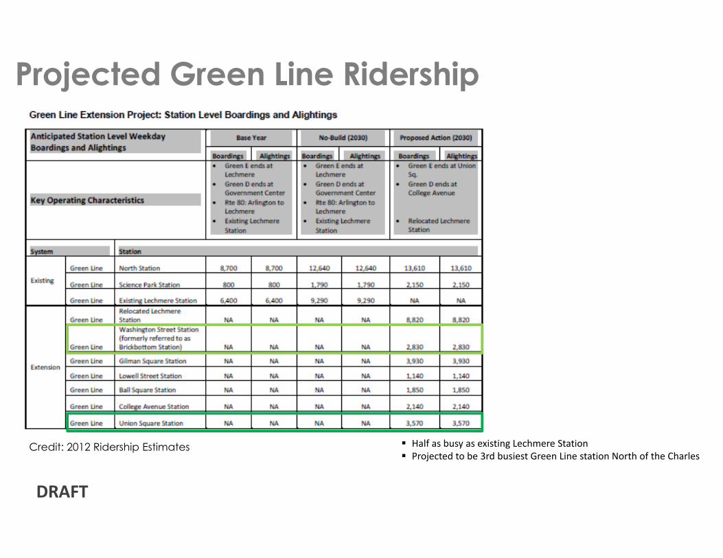
Projected Green Line Ridership
Credit: 2012 Ridership Estimates � Half as busy as existing Lechmere Station� Projected to be 3rd busiest Green Line station North of the Charles
DRAFT

http://www.mbta.com/uploadedfiles/documents/2014%20BLUEBOOK%2014th%20Edition.pdf

Existing Turning Movements Counts
DRAFT

AM: NB on Prospect
DRAFT
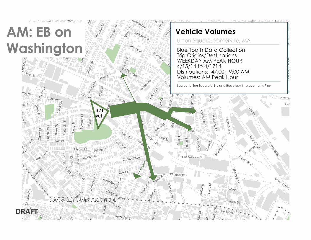
AM: EB on Washington
DRAFT

AM: EB on Somerville
DRAFT

AM: WB on Washington
DRAFT

AM: WB on Somerville
DRAFT

PM: NB on Prospect
DRAFT

PM: EB on Washington
DRAFT

PM: EB on Somerville
DRAFT

PM: WB on Washington
DRAFT

PM: WB on Somerville
DRAFT