www.crs4.it an integrated system for the forecasting of wildfire behavior based on cloud and...
TRANSCRIPT

www.crs4.it
An integrated system for the forecasting of wildfire behavior An integrated system for the forecasting of wildfire behavior
based on cloud and virtualization technologiesbased on cloud and virtualization technologies
Antioco VargiuAntioco Vargiu11 M. Maroccu1, L. Massidda1, M. Cabianca1, C. Impagliazzo1 L. Carrogu2, E.
Usai2
1. CRS4 srl, Pula (Ca), 1. NICE srl, Pula (Ca) Project Project ““Cloud for Remote ViewingCloud for Remote Viewing””
funded by the Autonomous Region of Sardinia, action “Pacchetti Integrati di Agevolazioni "Industria, Artigianato e Servizi"
(Annualita' 2010), Programmazione Unitaria 2007/2013 P.O. FESR 2007/2013

CRS4
2
TopicsTopics
Scheme of the Presentation:Scheme of the Presentation:
• Introduction to the WildFire Cloud ServiceIntroduction to the WildFire Cloud Service
• Data and Methods of the WildFire Cloud ServiceData and Methods of the WildFire Cloud Service
• Test on relevant wildfire cases in SardiniaTest on relevant wildfire cases in Sardinia
• Conclusions and future developmentsConclusions and future developments
Keywords:Keywords:
Rothermel's fire modeling, mass-consistent wind downscaling, cloud computing

CRS4
33
Fire Behavior Modeling Fire Behavior Modeling
PBLmodelig
Meteorology
1m
10m
100m
1km
10km
100km
1000km
Land modeling
Forest fire
Principal issue: Principal issue: fire development and spread is driven by fire development and spread is driven by physical processes taking place at physical processes taking place at different scales.different scales.
In order to run wildfire simulations In order to run wildfire simulations is required the modeling (at the landscape is required the modeling (at the landscape scale) of: scale) of: • Surface Weather Conditions (PBL).Surface Weather Conditions (PBL).• Topography. Topography. • Land Cover and Fuel Representation. Land Cover and Fuel Representation.
To obtain realtime wildfire simulations, Rothermel’s semi-To obtain realtime wildfire simulations, Rothermel’s semi-empirical model is empirical model is the most common approachthe most common approach..
CRS4
44
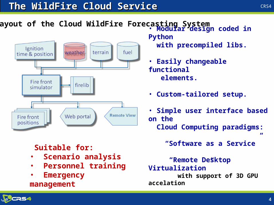
Layout of the Cloud WildFire Forecasting System
• Modular design coded in Python with precompiled libs.
• Easily changeable functional elements.
• Custom-tailored setup.
• Simple user interface based on the Cloud Computing paradigms:
“Software as a Service” “Remote Desktop Virtualization” with support of 3D GPU accelation
Suitable for: • Scenario analysis• Personnel training• Emergency management
The WildFire Cloud ServiceThe WildFire Cloud Service
CRS4
5
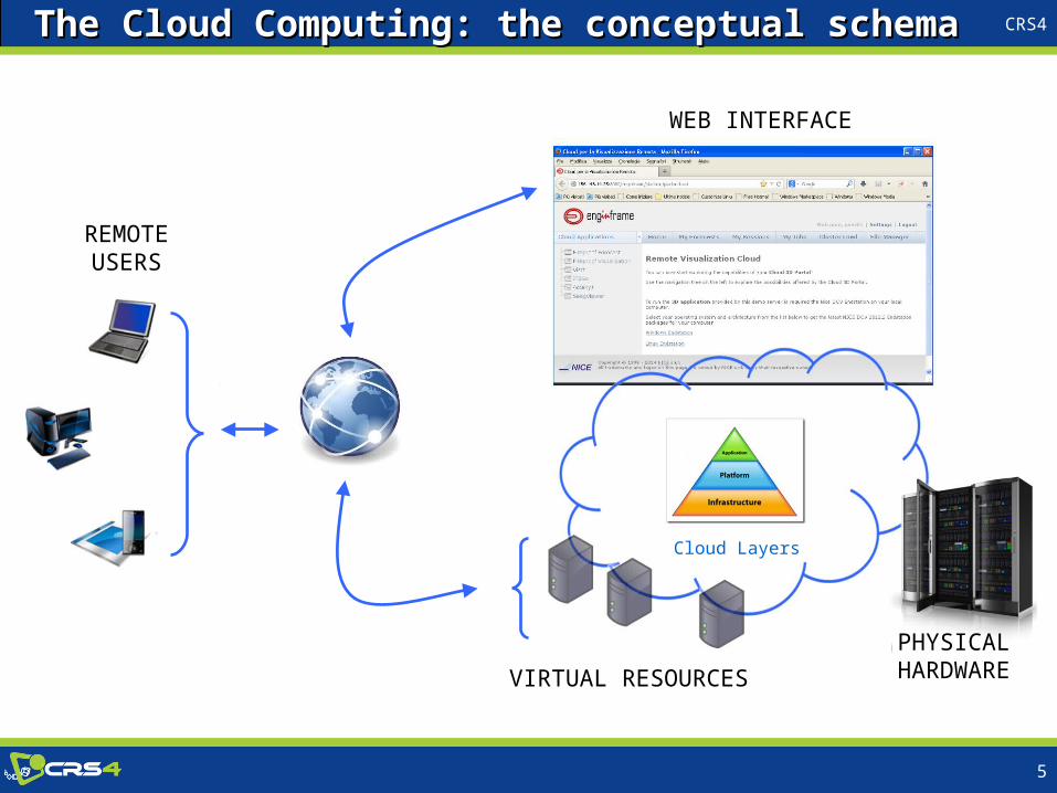
REMOTEUSERS
WEB INTERFACE
VIRTUAL RESOURCES PHYSICAL
HARDWARE
Cloud Layers
The Cloud Computing: the conceptual schemaThe Cloud Computing: the conceptual schema
CRS4
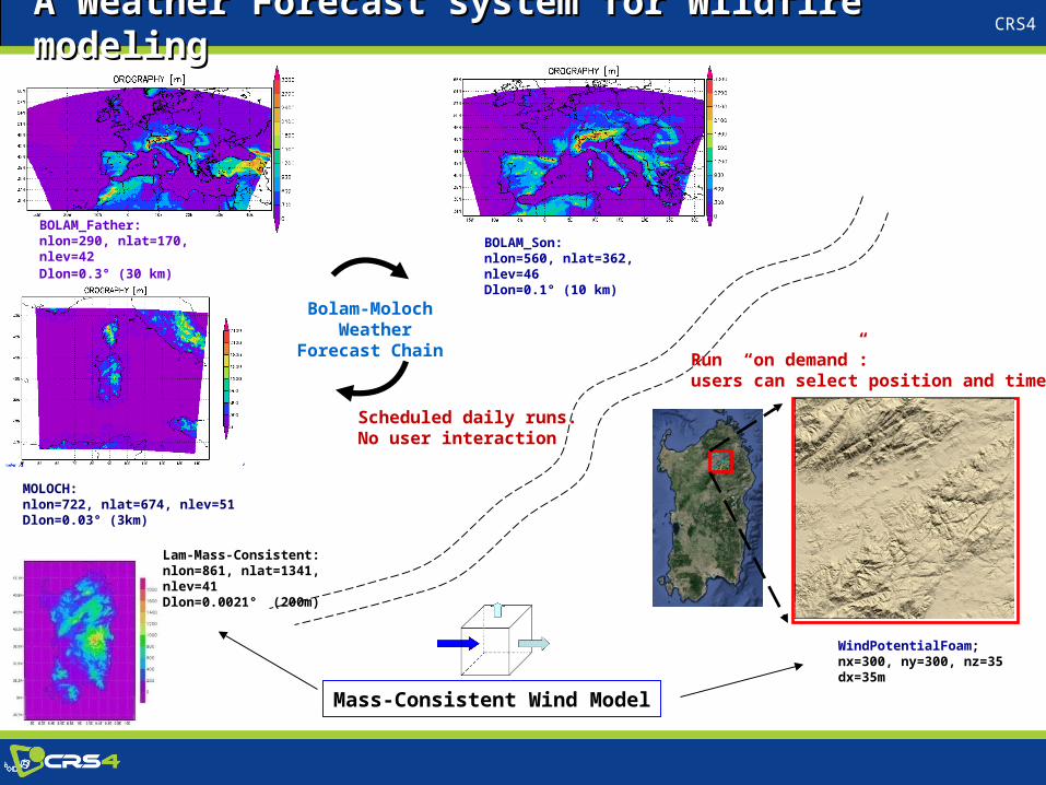
BOLAM_Father:nlon=290, nlat=170, nlev=42 Dlon=0.3° (30 km)
MOLOCH:nlon=722, nlat=674, nlev=51 Dlon=0.03° (3km)
BOLAM_Son:nlon=560, nlat=362, nlev=46 Dlon=0.1° (10 km)
Bolam-Moloch Weather Forecast
Chain
Scheduled daily runs.No user interaction
WindPotentialFoam;nx=300, ny=300, nz=35dx=35m
Run “on demand”: users can select position and time.
Lam-Mass-Consistent:nlon=861, nlat=1341, nlev=41 Dlon=0.0021° (200m)
A Weather Forecast system for Wildfire modeling A Weather Forecast system for Wildfire modeling
Mass-Consistent Wind Model

CRS4
7
WindPotentialFoam,WindPotentialFoam, a Mass-Consistent Wind Modela Mass-Consistent Wind Modelbased on the CFD software package OpenFOAM
ν0
202
0,
v
v n v
Lagrange Multiplier Approach
λ→ Scalar Potential Field 2
0
0
( )
( ) min( ( ))
s
s s
s
v
E v v v dxdydz
E v E v
Variational Formulation
1
20v = v + λ
Physically adjusted wind
ν
Issue: interpolated winds field show a flat unrealistic behavior near the terrain.
Effective solution: MCM enforces a "divergence free” flow, computing an optimal mass-correction.
A more realistic flow is obtained near the surface.
Very High Resolution Wind Modeling Very High Resolution Wind Modeling Wind is one of the environmental variables which greatly influence the spread and intensity of wildland fires (Rothermel, 1972).
Equations soved on aTerrain-Following Mesh

CRS4
8
PROS
Fast Wind Model, suitable for real-time applications
Vertical corrections linked to the atmosphere stability
Build in an advanced open source CFD platform.
Very High Resolution Wind Modeling Very High Resolution Wind Modeling
CONS
Diagnostic Model: Steady State, No dynamics, No turbulence
Slight deviations from the initial wind V0
openFoam: some libraries and/or tools too much resource-hungry, “ad hoc” modifications are required to speed-up realtime applications.
WindPotentialFoam,WindPotentialFoam, a Mass-Consistent Wind Modela Mass-Consistent Wind Modelbased on the CFD software package OpenFOAM

CRS4
9
DTM
Raster resolution=10m
Wildfire modeling: Land Dataset Wildfire modeling: Land Dataset
Corine Land Cover 2006Raster resolution=20m
Land Cover
Alternative Global Dataset:
SRTM Digital Elevation Database v4.1 ESA GlobCover2009 resolution: 3-arc seconds (~ 90m at the equator) 10-arc seconds (~ 300m)
Landscape Dataset (from www.sardegnageoportale.it)

CRS4
10
Scott, Joe H. and Burgan, Robert E. (2005) Standard fire behavior fuel models: a comprehensive set for use with Rothermel’s surface fire spread model.General Technical Report RMRS-GTR-153. USDA Forest Service, Rocky Mountain Research Station, Fort Collins,
Wildfire modeling: Fuel ModelsWildfire modeling: Fuel Models
Assessment of the Fuel Moisture Content Assessment of the Fuel Moisture Content
• Fine Fuel Moisture (1h) evaluated with the Viney model (Viney 1991).Fine Fuel Moisture (1h) evaluated with the Viney model (Viney 1991).
• Moisture Scenario for Thicker Fuel, (according to Scott 2005),Moisture Scenario for Thicker Fuel, (according to Scott 2005), scenario chosen by means of the 1h value.scenario chosen by means of the 1h value.
• Seasonal adjustment factor for live and dead fuel.Seasonal adjustment factor for live and dead fuel.
• 13 NFFL standard fuel models
• A custom model for the Mediterranean Maquis (Arca 2007)
Rothermel's fuel
Arca B, Duce P, Laconi M, Pellizzaro G, Salis M, Spano D, 2007. Evaluation of FARSITE simulator in Mediterranean maquis. International Journal of Wildland Fire 16, 563–572
Viney (1991), A Review of Fine Fuel Moisture Modelling, International Journal of Wildland Fire 1(4) 215 - 234
CRS4
11
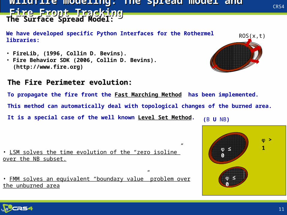
The Fire Perimeter evolution:The Fire Perimeter evolution:
To propagate the fire front the Fast Marching Method has been implemented.
This method can automatically deal with topological changes of the burned area.
It is a special case of the well known Level Set Method.
Wildfire modeling: The spread model and Fire Front TrackingWildfire modeling: The spread model and Fire Front Tracking
• LSM solves the time evolution of the “zero isoline” over the NB subset.
• FMM solves an equivalent “boundary value” problem over the unburned area
≤ 0 > 1
≤ 0
(B U NB)
The Surface Spread Model:The Surface Spread Model:
We have developed specific Python Interfaces for the Rothermel libraries: • FireLib, (1996, Collin D. Bevins).• Fire Behavior SDK (2006, Collin D. Bevins). (http://www.fire.org)
ROS(x,t)

CRS4
12
Fast Marching MethodFast Marching Method
Optimal “One-Shot” method to compute the front evolution.
The “Arrival Time” of the fire is estimated solving an linearized Eikonal equation over the unburned area (NB):
Wildfire modeling: Fire Front TrackingWildfire modeling: Fire Front Tracking
with V(x) ≥0: Rate Of Spread T(x): Arrival Time (or Travel Time) and auxiliary variable : (x)=0, →T(x)=0: Initial Burned area, B (x)=1,: Unburned area, NB
NBxxT
NBx
xTxV
,0
1|)(|)(
T > 3
T = 1
T = 3
T = 0
T = 2
(B U NB)
In order to update B.C. and correct nonlinear terms, the FMM is called inside a specific time loop. In order to update B.C. and correct nonlinear terms, the FMM is called inside a specific time loop.
CRS4
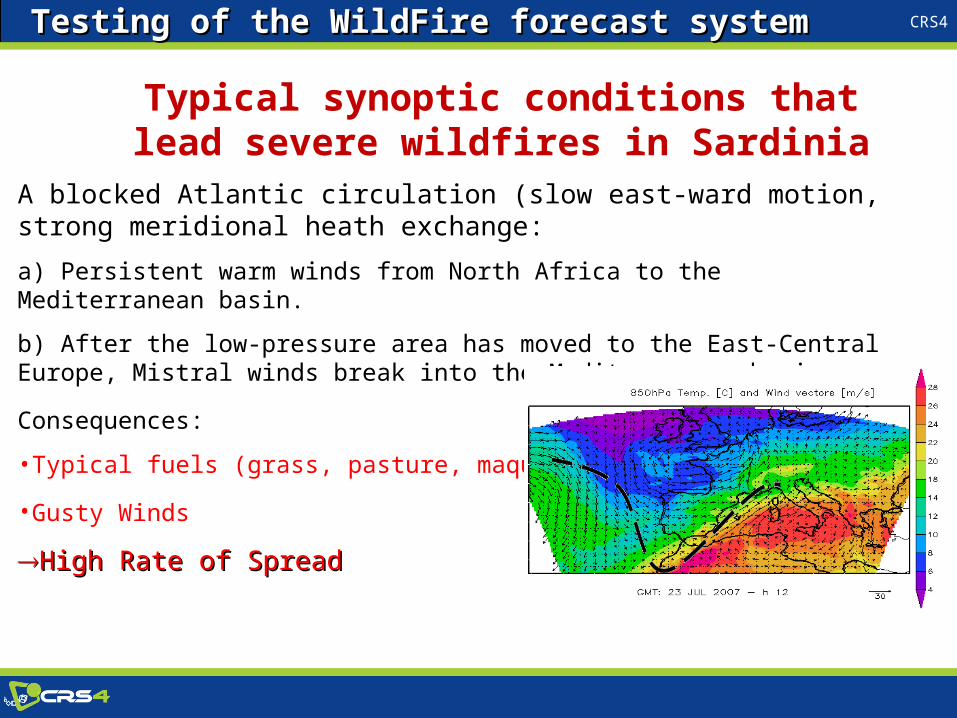
Typical synoptic conditions that lead severe wildfires in Sardinia
A blocked Atlantic circulation (slow east-ward motion, strong meridional heath exchange:
a) Persistent warm winds from North Africa to the Mediterranean basin.
b) After the low-pressure area has moved to the East-Central Europe, Mistral winds break into the Mediterranean basin.
Consequences:
•Typical fuels (grass, pasture, maquis) almost dry.
•Gusty Winds
High Rate of SpreadHigh Rate of Spread
Testing of the WildFire forecast systemTesting of the WildFire forecast system

CRS4
14
Ignition Point Oniferi (Nu), at ~ 10.00 A.M. (GMT) The wildfire lasted longer than 15 hrBurned area: > 9000 ha
SIGRI, Progetto Pilota Protezione Civile dagli Incendi Boschivi:Workshop Finale 6 Novembre 2012, Roma.
Grid 447*447, dx=35mFire Front plotted over 9hr, dt=1h
Weather forcing from the Moloch Model + WPF,conditions updated from 10.00 A.M. to 9.00 P.M
! Fire fighting actions not simulated !
Performance of the WildFire forecast systemPerformance of the WildFire forecast system
Test Case Nuoro 2007-07-23Test Case Nuoro 2007-07-23

CRS4
15
Test Case Lochiri 2011-07-13Test Case Lochiri 2011-07-13
Grid 1001*1001, dx=30mFire Front plotted over 9hr, dt=1h
Weather forcing from the Bolam Model +WPF,with fixed conditions (frozen time) at 10.00 A.M.Land Cover: Corine
Grid 395*395, dx=30mFire Front plotted over 9hr, dt=1h
Weather forcing from the Moloch Model +WPF,conditions updated from 10.00 A.M. to 8.00 P.M.Land Cover: GlobCover2009
Ignition Point Lochiri (OT)Burned area ~2500 ha, from 10.45 to 17.30 GMT;
Gusty winds from the west and dry fuel have determinated a fast front spread towards the territory of Berchidda and Monti.
Four helicopters of the Forest Service and a Elitanker were used to fight the wildfire.
! The black line is the real perimeter. Fire fighting actions not simulated !
Performance of the WildFire forecast systemPerformance of the WildFire forecast system

CRS4
16
In this project we developed and tested a Cloud Service for the modeling of wildfire on Sardinia’s vegetation.
The Cloud Service consists of: • a Virtual HPC session dedicated to the numerical modeling.• a Remote Visualization session with full 3D GPU acceleration.
Conclusions and future developments
Virtualization technologies are mature enough to be used effectively in environmental applications, but with some limitations on massive computational task.

CRS4
17
Our WildFire Cloud Service has proved to be adequately realistic and fast in simulating the general behavior of a wildfire propagation.
The system can be widely improved, with (e.g.):
1) A new weather forecast chain with a final resolution under 1km.
2) A more sophisticated solver for the wind downscaling.
3) A better classification of fuel models.
4) A better assessment of fuel moisture.
5) Models optimization and validation with well documented cases.
6) Ensemble simulations to handle uncertainties.
7) A more interactive user interface.
Conclusions and future developments

CRS4
18
RAS (Sardinian Regional Authority)
CNR-IBIMET, Institute of Biometeorology, Sassari, Italy
UNISS (UNIVERSITY OF SASSARI)
Forest Guard Cagliari, Civil Protection Rome
Acknowledgements and Credits
Credits to: CNR-ISAC Institute Bologna openFoam (www.openfoam.com)Corine Land Cover, European Environment AgencyGlobCover 2009 ProjectFirelib project (C. D. Bevins)