wyoming department of environmental qualitydeq.wyoming.gov/media/attachments/water quality/public...
TRANSCRIPT
Wyoming Department of Environmental Quality Water Quality Division
WYPDES Program
STATEMENT OF BASIS
MAJOR MODIFICATION
APPLICANT NAME: MEGA Engergy, LLC MAILING ADDRESS: 1206 Jack Plane Ln.
Gillette, WY 82716 FACILITY LOCATION: Innes Fee Wells, which is located in the NESW and NWSW of
Section 8, the SWSW of Section 22 the SESE of Section 23, the SESW of Section 25, the NENE of Section 33, the SENW of Section 29, the SESW of Section 32 and the SENW of Section 31, all in Township 46 North, Range 75 West in Campbell County. The produced water will be discharged to the Powder River (2ABWW) via Pumpkin Creek (3B) via North Prong Pumpkin Creek (3B) and Middle Prong Pumpkin Creek (3B) via unnamed ephemeral tributaries (3B), via on-channel reservoirs (3B). This permit requires that discharge produced at this facility originate from the Big George coal seam.
NUMBER: WY0095389 At the request of the permittee, this permit is hereby modified as follows:
1) Add seven outfalls (003 - 009). All other conditions and provisions of this permit shall remain unchanged, and in full force and effect.
General Facility Description This facility is a typical coal bed methane production facility in which groundwater is pumped from a coal bearing formation resulting in the release of methane from the coal bed. The permit authorizes the discharge to the surface of groundwater produced in this way provided the effluent quality is in compliance with effluent limits that are established by this permit. In developing effluent limits, all federal and state regulations and standards have been considered and the most stringent requirements incorporated into the permit. The effluent limits established in this permit are based upon Chapters 1 and 2 of the Wyoming Water Quality Rules and Regulations and other evaluations conducted by WDEQ related to this industry. This permit does not cover activities associated with discharges of drilling fluids, acids, stimulation waters or other fluids derived from the drilling or completion of the wells.
WY0095389 Major Modification 12-12-2014
Statement of Basis - Page 2
Facility Description The permittee has chosen option 2 of the coal bed methane permitting options. Under this permitting option, the produced water is immediately discharged to a class 2 or 3 receiving stream which is eventually tributary to a class 2AB perennial water of the state. The permit establishes effluent limits for the end of pipe, which are protective of all the designated uses defined in Chapter 1 of Wyoming Water Quality Rules and Regulations. This may include drinking water, game and non-game fish, fish consumption, aquatic life other than fish, recreation, agriculture, wildlife, industry and scenic value. The permittee is required to contain all effluent in the on-channel reservoir(s) associated with the outfalls, unless prior written authorization is granted by the WYPDES program for a reservoir release, in association with use of assimilative capacity credits for the Powder River Basin. In the event that such an authorization for release is granted for this facility, the authorization letter will specify the release volume, duration and individual reservoir(s) covered. In the absence of such written authorization for release, the following containment requirements will apply at the reservoir(s): The permittee will be required to contain all produced water within the reservoir(s) during “dry” operating conditions, and discharge of effluent from the reservoir(s), except during periods of time in which natural precipitation causes the reservoir(s) to overtop and spill, is prohibited. Intentional or draw-down type releases from the reservoir(s) will constitute a violation of this permit. Discharge from the reservoir(s) associated with any of the outfalls authorized to discharge under this permit is limited by the permit to natural overtopping and shall not extend beyond a 48 hour period following commencement of natural overtopping. It is the responsibility of the permittee to adequately demonstrate the circumstances in which reservoir discharges occurred, if requested to do so by the WYPDES Program.
Effluent Limits Technology Limits: The EPA Effluent Guidelines and Standards for Oil and Gas Extraction Point Source Category (Part 435, Subpart E) predate the development of coal bed methane extraction technology; however the technology is similar enough to conventional gas extraction that, in the professional judgment of the WDEQ, this effluent limit guideline is appropriately applied to coal bed methane gas production. In addition to the federal effluent limitation guideline, Chapter 2, Appendix H of the Wyoming Water Quality Rules and Regulations contains the following limits applicable to coal bed methane discharges: Chlorides 2,000 mg/l Sulfates 3,000 mg/l Total Dissolved Solids 5,000 mg/l Specific Conductance 7,500 micromhos/cm pH 6.5 – 9.0 standard units
WY0095389 Major Modification 12-12-2014
Statement of Basis - Page 3
Water Quality Based Effluent Limits: Permit effluent limits are based on federal and state regulations and are effective as of the date of issuance. We have evaluated potential technology and water quality based effluent limits for this facility. Where the calculated water quality based effluent limit is more stringent than the applicable technology limit, the water quality based effluent limit is applied. The pH must remain within 6.5 and 9.0 standard units. This limit is based upon Wyoming Water Quality Rules and Regulations, Chapter 2. The permit also establishes a total recoverable barium limit of 1800 µg/l and a total arsenic limit of 8.4 µg/l. These limits are based on Water Quality Criteria as established in the Wyoming Water Quality Rules and Regulations, Chapter 1, for Human Health values. In addition, the permit establishes a dissolved iron limit of 1000 µg/l, which is intended for protection of the class 3B receiving stream. The limits established in this permit for metals and chlorides reflect the application of the anti-degradation provisions required under the Wyoming Water Quality Rules and Regulations, Chapter 1. Because WDEQ has determined through review of past CBM discharge data that sulfates occur in the effluent at concentrations well below the Chapter 2 limit of 3,000 mg/l, the permit does not include an effluent limit for sulfates. All limits described in this section are intended to protect for the above listed designated uses, on both the immediate receiving water and the perennial mainstem, and apply at the end of pipe.
Whole Effluent Toxicity (WET) Testing WDEQ has determined that discharges from this facility have a reasonable potential to exert a toxic effect on aquatic life in the receiving stream(s). Therefore, in accordance with 40 CFR 122.44(d)(1), the permit contains a requirement to conduct annual static replacement toxicity tests on a grab sample of the discharge from the end of pipe. Each year during the life of this permit, a minimum of 20% of the discharging outfalls are to be sampled and tested for toxicity as described in Part I of the permit below. Since the discharge from this facility is not expected to reach a perennial water body (Powder River) on a frequent or continual basis, WDEQ has determined that only acute toxicity testing is needed to characterize the impact that this discharge may have on aquatic life in the receiving waters.
Acute WET Testing: The permittee will conduct acute 48-hour static tests using Daphnia magna (water flea) and acute 96-hour static tests using Pimephales promelas (fathead minnow). The acute whole effluent toxicity tests will be conducted in accordance with the latest procedures set forth in 40 CFR 136.3 and the “Region VIII EPA NPDES Acute Test Conditions – Static Renewal Whole Effluent Toxicity Tests”. In the case of conflicts in method, 40 CFR 136.3 will prevail. If the results of two consecutive annual reports indicate no acute toxicity (as defined in part I of the permit below), the permittee may reduce the monitoring to annual acute toxicity testing on only one species on an alternating basis. The test procedures for alternating species shall be the same as specified above. Agricultural Protection: In accordance with Chapter 1, Section 20 of the Wyoming Water Quality Rules and Regulations, this permit establishes conditions for the protection of agricultural water supplies. Agricultural uses of Wyoming surface waters include livestock watering and irrigation of crops.
WY0095389 Major Modification 12-12-2014
Statement of Basis - Page 4
Livestock Watering Protection: All surface waters in Wyoming are designated and protected as potential livestock watering supplies. Therefore this permit establishes effluent limits on certain pollutants in order to ensure that water in the receiving streams remains suitable for livestock watering. Pursuant to Chapter 2, Appendix H of the Water Quality Rules and Regulations, the permit establishes an effluent limit of 6.5 – 9.0 for pH, and a Specific Conductance (EC) limit of 7,500 micromhos/cm, intended to be equivalent to a Total Dissolved Solids (TDS) limit of 5,000 mg/L. Irrigation Use Protection: The irrigation use within the downstream drainage includes passive overbank flooding and sub-irrigation of hay meadows along North Prong Pumpkin Creek (below outfalls 001, 002 only). The lowermost irrigation below this facility is located in the NWSE of Section 12, Township 46 North, Range 76 West. This is based on a site investigation conducted by WDEQ in 2011. The most salt-sensitive crop irrigated downstream has been identified as Western Wheatgrass. The USDA salt tolerance database characterizes Western Wheatgrass as “moderately tolerant” to soil salinity. In 2009, WDEQ received technical recommendations from several experts (Dr. Ginger Paige, University of Wyoming; Dr. Larry Munn, University of Wyoming; Dr. Jan Hendrickx, New Mexico Tech; Dr. Bruce Buchanan, Farmington, NM) regarding the relationship between irrigated soil salinity and the salinity of applied irrigation water. Their general conclusion was that no direct or unique relationship exists between irrigated soil salinity and the salinity of the applied irrigation water. Their net recommendation was that water management and effective monitoring were more relevant to crop protection than controlling salt and sodium levels at permitted outfalls (WDEQ’s previous practice). During 2010, WDEQ received specific technical recommendations from a Technical Advisory Team, assembled in conjunction with a stakeholder workgroup for CBM discharges in the Powder River Basin. The Technical Advisory Team (Dr. George Vance, University of Wyoming Soil Scientist; Dr. Gerald Schuman, USDA/ARS Soil Scientist Retired; Dr. William Schafer, Environmental Geochemist) developed a report entitled, “Strategies, Monitoring and Data Needs for Preventing Impacts from Coal Bed Methane Produced Water to Crop and Forage Production in Wyoming” (2010). This report elaborated on the concepts put forth by the earlier experts, specifically in the areas of water management strategies for CBM discharges, data collection and evaluation, plus thresholds and corrective actions for various monitored locations within each drainage. Based on the above expert recommendations, WDEQ has developed watershed-specific conditions which are reflected in this individual permit and others for neighboring facilities. The above experts advise that WDEQ can most effectively prevent damage to crop production through effective water management, along with expanded monitoring and definitive action thresholds within the affected receiving drainage. Because the permit regulates discharge of pollutants from a coalbed methane facility, and cannot control downstream irrigation activities, any controls on water management established in this permit must relate directly to the discharge facility itself. Monitoring requirements, however, can be established throughout the downstream drainage as a condition of this permit, pursuant to Section 35-11-110(a) of the Wyoming Environmental Quality Act. Accordingly, the permit establishes in Part I.A.1, specific conditions for water management at this facility and in Parts I.A.2.c through I.A.2.g, specific requirements for ongoing monitoring of instream surface water, groundwater, soils, crops and receiving reservoirs downstream of the outfalls at this facility. In addition, the permit establishes thresholds and associated corrective actions for the above monitoring sites as outlined below:
WY0095389 Major Modification 12-12-2014
Statement of Basis - Page 5
Containment Requirements: The permittee is required to contain all effluent in the lowermost on-channel reservoir(s) at this facility, unless prior written authorization is granted by the WYPDES program for a reservoir release, in association with use of assimilative capacity credits for the Powder River Basin. In the event that such an authorization for release is granted for this facility, the authorization letter will specify the release volume, duration and individual reservoir(s) covered. In the absence of such written authorization for release, the following containment requirements will apply at the reservoir(s): The permittee will be required to contain all produced water within the lowermost reservoir(s) during “dry” operating conditions, and discharge of effluent from the lowermost reservoir(s), except during periods of time in which natural precipitation causes the reservoir(s) to overtop and spill, is prohibited. Intentional or draw-down type releases from the lowermost reservoir(s) will constitute a violation of this permit. Discharge from the lowermost reservoir(s) associated with any of the outfalls authorized to discharge under this permit is limited by the permit to natural overtopping and shall not extend beyond a 48 hour period following commencement of natural overtopping. It is the responsibility of the permittee to adequately demonstrate the circumstances in which discharges from the lowermost reservoirs occurred, if requested to do so by the WYPDES Program. This permit does allow the operator to intentionally flow water from the upper reservoirs in any reservoir series, to the lowermost reservoirs as long as the above containment requirement is met at the lowermost reservoirs. Conditions for Managed Reservoir Release: The USDA salt tolerance database characterizes Western Wheatgrass (the most salt-sensitive crop or forage species in the downstream irrigated fields) as estimated to be “moderately tolerant” to soil salinity. Irrigated plants which are moderately tolerant to soil salinity are susceptible to yield loss at a soil EC range beginning at 3,000 µmhos/cm to 6,000 µmhos/cm (Ayers and Westcot FAO Paper 29, Figure 11; 1985). Taking the mid-point of this range results in an expected soil EC threshold of 4,500 µmhos/cm for Western Wheatgrass. A soil EC threshold of 4,500 µmhos/cm results in a default discharge water threshold of 3,000 µmhos/cm from the reservoirs, assuming a conservative leaching fraction of approximately 15% in the downstream irrigated areas (Ayers and Westcott FAO Paper 29, Figure 7 Guideline). WDEQ thus concludes that water intentionally released from a reservoir to an irrigated area must not exceed 3,000 micromhos/cm within this watershed. Therefore the permittee will be prohibited from intentionally releasing any water from the reservoirs that exceeds 3,000 micromhos/cm in the reservoir. In addition, the permit establishes a threshold for sodium adsorption ratio (SAR) as a condition for intentional reservoir releases. WDEQ will not authorize any intentional reservoir release at this facility unless the water in the reservoir conforms with SAR recommendations in Agricultural Salinity and Drainage (Hanson, 2006, Figure 4). Deriving from this reference, the equation below is a mathematical representation of the plotted threshold to achieve ‘no reduction in infiltration’ of irrigated soils. This is the appropriate threshold for preventing a decrease in crop production where CBM water may come into contact with irrigated fields by means of a reservoir release: *SAR < 6.67 x EC – 3.33 * where “SAR” represents sodium adsorption ratio, and “EC” represents specific conductance of the reservoir water sample in dS/m. 1 dS/m = 1,000 micromhos/cm. Exceptions to the above threshold for SAR: 1) In cases where EC of the reservoir sample is below 1 dS/m, SAR shall not exceed 3.
WY0095389 Major Modification 12-12-2014
Statement of Basis - Page 6
2) Maximum SAR shall not exceed 10, regardless of EC level. While some of the above cited experts advise that salinity of the irrigation water is effectively unrelated to root zone salinity of the irrigated soils, WDEQ finds it appropriate to include these water quality thresholds as conditions of any intentional reservoir release. This requirement is more stringent than recommended by Hendrickx and Buchanan (they do not recommend regulating EC levels for protection of irrigation water); However, this permit condition is intended to serve as an added measure of water quality precaution in the event of managed releases. In addition to the above conditions for reservoir release, the permittee is also subject to restrictions established under WDEQ’s Powder River Assimilative Capacity Allocation and Control Process. This policy requires a permittee to possess adequate salt and sodium credits in order to conduct CBM effluent releases to the Powder River or its tributaries. In the event of an authorized reservoir release as described above, the permittee is required to notify in writing at the time of submitting a reservoir release request to WDEQ, all downstream landowners along the flow path of the released water, between the reservoir(s) and the Powder River. In addition, this permit requires the permittee to control any authorized reservoir release such that the release does not cause flooding to occur within irrigated areas. Any authorized reservoir release flows are required to be kept within the stream channel. Downstream Surface Water: The permit establishes a stream monitoring point (STR1) located downstream of the reservoirs within the irrigated drainage. The permit requires daily measurement of flow at the stream monitoring point, and monthly sampling for EC, SAR, bicarbonate, pH, sulfates and dissolved inorganic carbon when flow is present at the stream monitoring point. See Part I.A.2.c of the permit below. Stream thresholds and corrective actions: Due to the inherent variability of water quality in ephemeral stream channels, the Technical Advisory Team providing recommendations to WDEQ does not advise establishing thresholds or corrective actions for stream flows sampled at the various stream monitoring points. The data collected from the stream monitoring points will be used to track contribution of produced water from CBM facilities to downstream irrigated areas, and to assess surface hydrology conditions within the drainage. Electronic results for stream monitoring shall be submitted quarterly to WDEQ, within 45 days of the completed sampling quarter. Any of the above requirements for stream monitoring may be modified administratively by WDEQ, and such modification shall constitute a minor modification, pursuant to Chapter 2, Section 12(h) of the Wyoming Water Quality Rules and Regulations. Stream monitoring requirements are subject to private land access restrictions. For any site(s) that cannot be accessed due to private property restrictions, the permittee shall consult with WDEQ on establishing alternate sites and/or remote means for monitoring. Down-Gradient Groundwater: In addition to any groundwater monitoring required for aquifer protection at the reservoir sites, this permit requires groundwater monitoring downstream of the discharge facility, in order to evaluate potential impacts to irrigated lands. Monitoring well sites have been selected by WDEQ (MW1 – MW3), which are located in and above the downstream irrigated lands. The permittee is required to sample for the constituents listed in Part I.A.2.d of the permit below, at the indicated frequencies.
WY0095389 Major Modification 12-12-2014
Statement of Basis - Page 7
Groundwater thresholds and corrective actions (for monitoring wells placed within irrigated fields): In the event that a monitoring well placed within an irrigated field indicates a depth to groundwater of 6 feet or less, the permit requires the permittee to report the finding to WDEQ within 5 days of measurement, and initiate intensified groundwater monitoring at that location. Intensified groundwater monitoring will include, at a minimum, monthly monitoring for the routine constituents outlined above, plus monthly sampling for sulfate, potassium, bicarbonate, chlorides and dissolved inorganic carbon. In the event that sampling data indicates contribution of CBM effluent to the elevated groundwater, WDEQ may also modify permit administratively to include additional monitoring wells, in order to track extent of elevated water as well as contributing facility(ies). In the event that intensified groundwater monitoring is required, the permittee is required to continue intensified monitoring until written authorization is provided by WDEQ for resumption of routine monitoring only. If depth to groundwater reaches 3 feet or less within an irrigated field, and the groundwater has a confirmed CBM water contribution, as evidenced by connecting hydrology as well as analytical results for one or more of bicarbonate, dissolved inorganic carbon isotopes and/or other chemical evidence, then the contributing CBM discharge(s) shall be ceased.
Electronic results for groundwater monitoring shall be submitted quarterly to WDEQ, within 45 days of the completed sampling quarter. The above monitoring wells must be permitted, installed and instrumented in accordance with site-specific requirements set forth by the Groundwater Section of the Water Quality Division. Any of the above wells which are drilled and verified by WDEQ to be dry, shall be maintained and monitored quarterly for presence or absence of groundwater. In the absence of groundwater, sampling requirements do not apply. If groundwater becomes present in a previously dry well, then sampling shall be conducted according to the requirements of Part I.A.2.d of the permit. Any of the above requirements for groundwater monitoring may be modified administratively by WDEQ, and such modification shall constitute a minor modification, pursuant to Chapter 2, Section 12(h) of the Wyoming Water Quality Rules and Regulations. Groundwater monitoring requirements are subject to private land access restrictions. For any site(s) that cannot be accessed due to private property restrictions, the permittee shall consult with WDEQ on establishing alternate sites and/or remote means for monitoring. Downstream Irrigated Soils: The permit requires annual soil sampling for the constituents listed in Part I.A.2.e of the permit below, within the same fields or field complexes as the established monitoring well locations. Soil sampling shall occur at a minimum density of 5 sub-samples and a maximum density of 15 sub-samples per field segment. For the purposes of soil investigation under this permit, a field segment is an area within an irrigated field comprised of relatively homogeneous soil characteristics or depth to groundwater. Soil samples are to be taken to a total depth of four feet in grass fields and six feet in fields with alfalfa. Sampling depth increments shall be 0-6 inches and 6-12 inches at the surface, then at one foot increments to depth. For routine annual soil sampling, the permit authorizes compositing of same-depth sub-samples within a field segment. However, during the first year of sampling, analysis for Specific Conductance and pH must be conducted and reported on individual sub-sample locations, rather than composites. All lab analyses for soil samples collected under the requirements of this permit shall be conducted in accordance with the latest methods in “USDA - NRCS Soil Survey Laboratory Methods Manual, Report No. 42.” In the event that a field site is dominated by smectitic clays within the root zone (having more than 50% smectite measured within the clay fraction), monitoring may be increased or modified in the smectite locations in order to address the added risks to the soil. Prior to initiating full soil sampling in accordance with the requirements of this permit, permittee is required to conduct a preliminary site investigation and confer with WDEQ on precise soil sampling locations and layout.
WY0095389 Major Modification 12-12-2014
Statement of Basis - Page 8
Soil thresholds and corrective actions: In the event that soil specific conductance or sodium adsorption ratio values indicate a statistically significant increase of greater than 15% over the course of two years or more, or 40% in any single year; or in the event that soil specific conductance becomes greater than 4,000 micromhos/cm at any time (in the 0-12” depth); or in the event that soil exchangeable sodium percentage (ESP) is found to be greater than 10% (in the 0-12” depth), the following corrective actions are required: Increase soil sampling to twice per year (spring/fall) within the affected field(s). Permittee is then required initiate a detailed study to identify the cause of any increased salinity and/or sodicity in the affected field(s). Study is subject to WDEQ approval and modification. If elevated soil salinity and/or sodicity in the affected field(s) are expected to impair crop or forage production, and the elevated salinity and/or sodicity are due to CBM discharges, then permit requires the permittee to correct the problem, employing one or more of the following actions: reduce or eliminate contributing discharges, modify discharge locations and/or water management at discharge facility, provide improved drainage to affected field(s), and/or provide chemical amendments to affected field(s). Results of the above soil analyses shall be summarized in an annual electronic report to WDEQ, to be submitted by February 15 each year. The report shall also include a map of sample locations along with a table of latitude and longitude coordinates for each sub-sample location, notes on observations relating to depth of observed rooting at the sample sites, depth to any groundwater encountered, as well as surface flow conditions in the nearby stream channel at the time of sampling. Any of the above requirements for soil monitoring may be modified administratively by WDEQ, and such modification shall constitute a minor modification, pursuant to Chapter 2, Section 12(h) of the Wyoming Water Quality Rules and Regulations. Soil monitoring requirements are subject to private land access restrictions. For any site(s) that cannot be accessed due to private property restrictions, the permittee shall consult with WDEQ on establishing alternate sites and/or remote means for monitoring. Downstream Crops: The permit establishes a requirement for annual crop and/or forage monitoring in the fields where soil sampling is also occurring. The permittee is required to sample crops and analyze for the constituents listed in Part I.A.2.f of the permit below. Crop sampling shall be done from hay stacks or bales if hay was cut, or by using 1 square meter ground clippings if no hay was cut. If taking 1 square meter ground clippings, the permit requires a minimum of 5 crop samples per soil field segment. Ground clipping locations for crops shall be sited in representative locations across each field segment, and at a minimum of 50 feet apart from one another. Crop thresholds and corrective actions: In the event that the above monitoring indicates a statistically significant decrease in yield or quality that correlates with verified adverse impacts on soils, surface water or groundwater from CBM discharges, then the permittee is required to cease any contributing discharges and reclaim any damaged fields. Results of the above crop analyses shall be summarized in an annual electronic report to WDEQ, to be submitted by February 15 each year. The report shall also include a map of sample locations along with a table of latitude and longitude coordinates for each sample location, notes on any recent grazing activity prior to the time of sampling, notes on any recent irrigation activity including timing and quantity of water applied, any observed stress on the vegetation, as well as surface flow conditions in the nearby stream channel at the time of sampling. Any of the above requirements for crop monitoring may be modified administratively by WDEQ, and such modification shall constitute a minor modification, pursuant to Chapter 2, Section 12(h) of the Wyoming Water Quality Rules and Regulations. Crop monitoring requirements are subject to private land access restrictions. For any
WY0095389 Major Modification 12-12-2014
Statement of Basis - Page 9
site(s) that cannot be accessed due to private property restrictions, the permittee shall consult with WDEQ on establishing alternate sites and/or remote means for monitoring. Reservoirs Containing CBM Produced Water: The permit establishes a reservoir monitoring point (R01) located within the CBM reservoir at this facility. Water quality samples taken from reservoirs shall be taken a minimum of five (5) feet from the shoreline at the time of sampling, and a minimum of fifty (50) feet from the point where CBM effluent meets the current water surface within the reservoir. See Part I.A.2.g of the permit below. Reservoir thresholds and corrective actions: In the event that water from a reservoir resurfaces in the downstream channel, causing flow, the permit requires the permittee to cease discharge into the reservoir and then either repair the reservoir or discontinue further use of the outfall. In the event that specific conductance measured within a reservoir exceeds 150% of the specific conductance measured at the outfall discharging into the reservoir, the permit requires monthly follow-up sampling within the reservoir for 12 months. If the 12 monthly samples still indicate that the specific conductance within the reservoir is, on average, 150% of the outfall specific conductance or higher, the outfall will be terminated from the permit by WDEQ or the permit may be modified to include more stringent containment requirements (50-yr storm containment) for the affected reservoir(s). An exception will be made where the permittee has demonstrated through their own stream sampling above the reservoir that the elevated EC within the reservoir is due to natural water quality conditions upstream. The burden of such demonstration shall be on the permittee and shall be made before the end of the 12-month reservoir sampling period referenced above. Electronic results for the above reservoir monitoring shall be submitted annually to WDEQ, by February 15 each year. Any of the above requirements for reservoir monitoring may be modified administratively by WDEQ, and such modification shall constitute a minor modification, pursuant to Chapter 2, Section 12(h) of the Wyoming Water Quality Rules and Regulations. Other Permit Requirements Documentation submitted in support of this permit by the permittee was based upon water quality representative of water quality from the targeted coal seams. Therefore, the permit requires that the produced water being discharged by this facility originate in one or more of the following formations: the Big George and/or Wyodak coal seams. There shall be no discharge of floating solids or visible foam in other than trace amounts, nor shall the discharge cause formation of visible deposits of iron, hydrocarbons or any other constituent on the bottom or shoreline of the receiving water. In addition, erosion control measures will be implemented to prevent significant damage to or erosion of the receiving water channel at the point of discharge. The discharge of wastewater and the effluent limits that are established in this permit have been reviewed to ensure that the levels of water quality necessary to protect the designated uses of the receiving waters are maintained and protected. An antidegradation review has been conducted and verifies that the permit conditions, including the effluent limitations established, provide a level of
WY0095389 Major Modification 12-12-2014
Statement of Basis - Page 10
protection to the receiving water consistent with the antidegradation provisions of Wyoming surface water quality standards. Self monitoring of effluent quality and quantity is required on a regular basis with reporting of results as outlined in the permit. The permit is scheduled to expire on March 31, 2019. Major Modification Drafted: Jason Thomas Water Quality Division Department of Environmental Quality December 12, 2014
WY0095389 Major Modification 12-12-2014
Page 1
MODIFICATION OF AUTHORIZATION TO DISCHARGE UNDER THE
WYOMING POLLUTANT DISCHARGE ELIMINATION SYSTEM
In compliance with the provisions of the Federal Water Pollution Control Act, (hereinafter referred to as "the Act"), and the Wyoming Environmental Quality Act,
MEGA Engergy, LLC is authorized to discharge from the wastewater treatment facilities serving the Innes Fee Wells located in
NESW and NWSW of Section 8, the SWSW of Section 22 the SESE of Section 23, the SESW of Section 25, the NENE of Section 33, the SENW of Section 29, the SESW of Section 32 and the SENW of Section 31, all in Township 46 North, Range 75 West in Campbell County,
to receiving waters named
Powder River (2ABWW) via Pumpkin Creek (3B) via North Prong Pumpkin Creek (3B) and Middle Prong Pumpkin Creek (3B) via unnamed ephemeral tributaries (3B), via on-channel reservoirs (3B),
in accordance with effluent limitations, monitoring requirements and other conditions set forth in Parts I, II and III hereof. This permit modification shall become effective on the date of issuance below. This permit and the authorization to discharge shall expire at midnight March 31, 2019. Kevin Frederick, Administrator Todd Parfitt, Director Water Quality Division Department of Environmental Quality Date of Issuance: __________________________
WY0095389 Major Modification 12-12-2014
Page 2
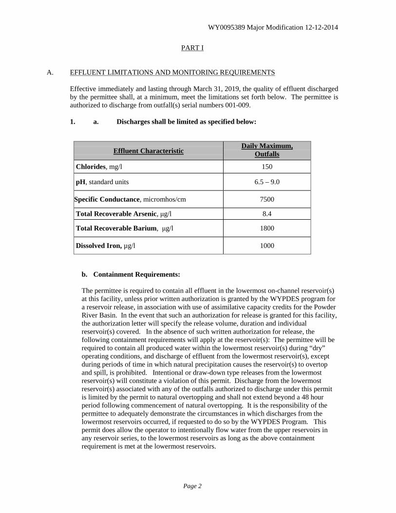
PART I A. EFFLUENT LIMITATIONS AND MONITORING REQUIREMENTS
Effective immediately and lasting through March 31, 2019, the quality of effluent discharged by the permittee shall, at a minimum, meet the limitations set forth below. The permittee is authorized to discharge from outfall(s) serial numbers 001-009.
1. a. Discharges shall be limited as specified below:
Effluent Characteristic Daily Maximum,
Outfalls Chlorides, mg/l 150
pH, standard units 6.5 – 9.0
Specific Conductance, micromhos/cm 7500
Total Recoverable Arsenic, μg/l 8.4
Total Recoverable Barium, μg/l 1800
Dissolved Iron, µg/l 1000
b. Containment Requirements:
The permittee is required to contain all effluent in the lowermost on-channel reservoir(s) at this facility, unless prior written authorization is granted by the WYPDES program for a reservoir release, in association with use of assimilative capacity credits for the Powder River Basin. In the event that such an authorization for release is granted for this facility, the authorization letter will specify the release volume, duration and individual reservoir(s) covered. In the absence of such written authorization for release, the following containment requirements will apply at the reservoir(s): The permittee will be required to contain all produced water within the lowermost reservoir(s) during “dry” operating conditions, and discharge of effluent from the lowermost reservoir(s), except during periods of time in which natural precipitation causes the reservoir(s) to overtop and spill, is prohibited. Intentional or draw-down type releases from the lowermost reservoir(s) will constitute a violation of this permit. Discharge from the lowermost reservoir(s) associated with any of the outfalls authorized to discharge under this permit is limited by the permit to natural overtopping and shall not extend beyond a 48 hour period following commencement of natural overtopping. It is the responsibility of the permittee to adequately demonstrate the circumstances in which discharges from the lowermost reservoirs occurred, if requested to do so by the WYPDES Program. This permit does allow the operator to intentionally flow water from the upper reservoirs in any reservoir series, to the lowermost reservoirs as long as the above containment requirement is met at the lowermost reservoirs.
WY0095389 Major Modification 12-12-2014
Page 3
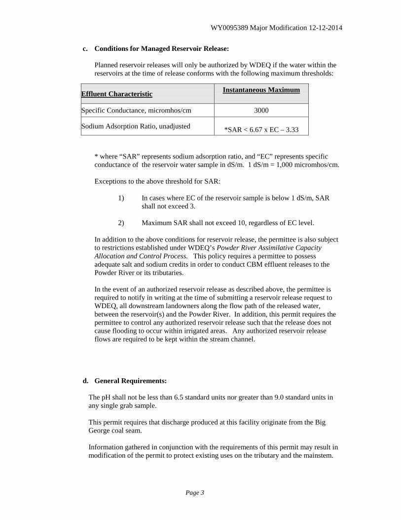
c. Conditions for Managed Reservoir Release:
Planned reservoir releases will only be authorized by WDEQ if the water within the reservoirs at the time of release conforms with the following maximum thresholds:
* where “SAR” represents sodium adsorption ratio, and “EC” represents specific conductance of the reservoir water sample in dS/m. 1 dS/m = 1,000 micromhos/cm. Exceptions to the above threshold for SAR:
1) In cases where EC of the reservoir sample is below 1 dS/m, SAR
shall not exceed 3.
2) Maximum SAR shall not exceed 10, regardless of EC level. In addition to the above conditions for reservoir release, the permittee is also subject to restrictions established under WDEQ’s Powder River Assimilative Capacity Allocation and Control Process. This policy requires a permittee to possess adequate salt and sodium credits in order to conduct CBM effluent releases to the Powder River or its tributaries. In the event of an authorized reservoir release as described above, the permittee is required to notify in writing at the time of submitting a reservoir release request to WDEQ, all downstream landowners along the flow path of the released water, between the reservoir(s) and the Powder River. In addition, this permit requires the permittee to control any authorized reservoir release such that the release does not cause flooding to occur within irrigated areas. Any authorized reservoir release flows are required to be kept within the stream channel.
d. General Requirements:
The pH shall not be less than 6.5 standard units nor greater than 9.0 standard units in any single grab sample. This permit requires that discharge produced at this facility originate from the Big George coal seam. Information gathered in conjunction with the requirements of this permit may result in modification of the permit to protect existing uses on the tributary and the mainstem.
Effluent Characteristic Instantaneous Maximum
Specific Conductance, micromhos/cm 3000
Sodium Adsorption Ratio, unadjusted
*SAR < 6.67 x EC – 3.33
WY0095389 Major Modification 12-12-2014
Page 4
All waters shall be discharged in a manner to prevent erosion, scouring, or damage to stream banks, stream beds, ditches, or other waters of the state at the point of discharge. There shall be no discharge of floating solids or visible foam in other than trace amounts, nor shall the discharge cause formation of a visible sheen or visible hydrocarbon deposits on the bottom or shoreline of the receiving water. There shall be no deposition of substances in quantities which could result in significant aesthetic degradation, or degradation of habitat for aquatic life, plant life or wildlife; or which could adversely affect public water supplies or those intended for agricultural or industrial use.
2. Discharges shall be monitored by the permittee as specified below:
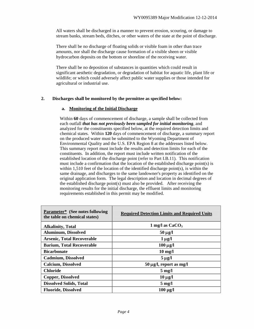
a. Monitoring of the Initial Discharge
Within 60 days of commencement of discharge, a sample shall be collected from each outfall that has not previously been sampled for initial monitoring, and analyzed for the constituents specified below, at the required detection limits and chemical states. Within 120 days of commencement of discharge, a summary report on the produced water must be submitted to the Wyoming Department of Environmental Quality and the U.S. EPA Region 8 at the addresses listed below. This summary report must include the results and detection limits for each of the constituents. In addition, the report must include written notification of the established location of the discharge point (refer to Part I.B.11). This notification must include a confirmation that the location of the established discharge point(s) is within 1,510 feet of the location of the identified discharge point(s), is within the same drainage, and discharges to the same landowner's property as identified on the original application form. The legal description and location in decimal degrees of the established discharge point(s) must also be provided. After receiving the monitoring results for the initial discharge, the effluent limits and monitoring requirements established in this permit may be modified.
Parameter* (See notes following the table on chemical states)
Required Detection Limits and Required Units
Alkalinity, Total 1 mg/l as CaCO3 Aluminum, Dissolved 50 µg/l Arsenic, Total Recoverable 1 µg/l Barium, Total Recoverable 100 µg/l Bicarbonate 10 mg/l Cadmium, Dissolved 5 µg/l Calcium, Dissolved 50 µg/l, report as mg/l Chloride 5 mg/l Copper, Dissolved 10 µg/l Dissolved Solids, Total 5 mg/l Fluoride, Dissolved 100 µg/l
WY0095389 Major Modification 12-12-2014
Page 5
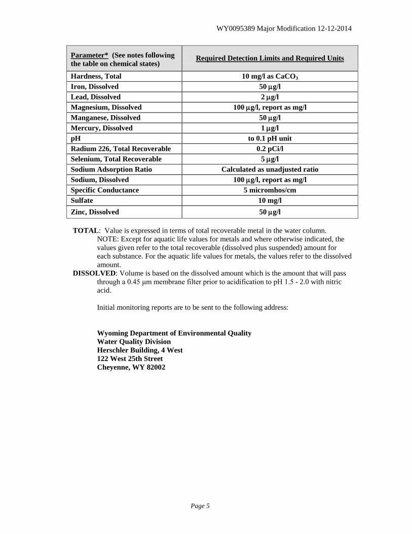
Parameter* (See notes following the table on chemical states)
Required Detection Limits and Required Units
Hardness, Total 10 mg/l as CaCO3
Iron, Dissolved 50 µg/l Lead, Dissolved 2 µg/l Magnesium, Dissolved 100 µg/l, report as mg/l Manganese, Dissolved 50 µg/l Mercury, Dissolved 1 µg/l pH to 0.1 pH unit Radium 226, Total Recoverable 0.2 pCi/l Selenium, Total Recoverable 5 µg/l Sodium Adsorption Ratio Calculated as unadjusted ratio Sodium, Dissolved 100 µg/l, report as mg/l Specific Conductance 5 micromhos/cm Sulfate 10 mg/l Zinc, Dissolved 50 µg/l TOTAL: Value is expressed in terms of total recoverable metal in the water column.
NOTE: Except for aquatic life values for metals and where otherwise indicated, the values given refer to the total recoverable (dissolved plus suspended) amount for each substance. For the aquatic life values for metals, the values refer to the dissolved amount.
DISSOLVED: Volume is based on the dissolved amount which is the amount that will pass through a 0.45 μm membrane filter prior to acidification to pH 1.5 - 2.0 with nitric acid.
Initial monitoring reports are to be sent to the following address:
Wyoming Department of Environmental Quality Water Quality Division Herschler Building, 4 West 122 West 25th Street Cheyenne, WY 82002
WY0095389 Major Modification 12-12-2014
Page 6
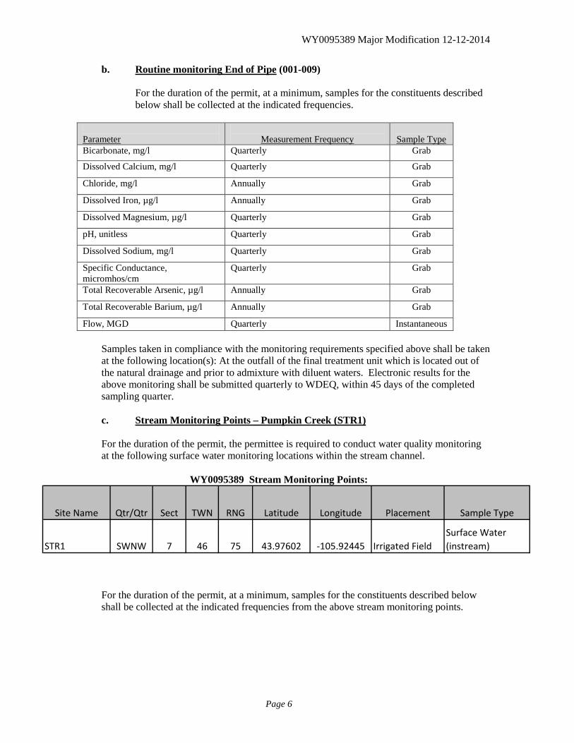
b. Routine monitoring End of Pipe (001-009)
For the duration of the permit, at a minimum, samples for the constituents described below shall be collected at the indicated frequencies.
Parameter
Measurement Frequency
Sample Type
Bicarbonate, mg/l Quarterly Grab
Dissolved Calcium, mg/l Quarterly Grab
Chloride, mg/l Annually Grab
Dissolved Iron, µg/l Annually Grab
Dissolved Magnesium, µg/l Quarterly Grab
pH, unitless Quarterly Grab
Dissolved Sodium, mg/l Quarterly Grab
Specific Conductance, micromhos/cm
Quarterly Grab
Total Recoverable Arsenic, µg/l Annually Grab
Total Recoverable Barium, µg/l Annually Grab
Flow, MGD Quarterly Instantaneous Samples taken in compliance with the monitoring requirements specified above shall be taken at the following location(s): At the outfall of the final treatment unit which is located out of the natural drainage and prior to admixture with diluent waters. Electronic results for the above monitoring shall be submitted quarterly to WDEQ, within 45 days of the completed sampling quarter.
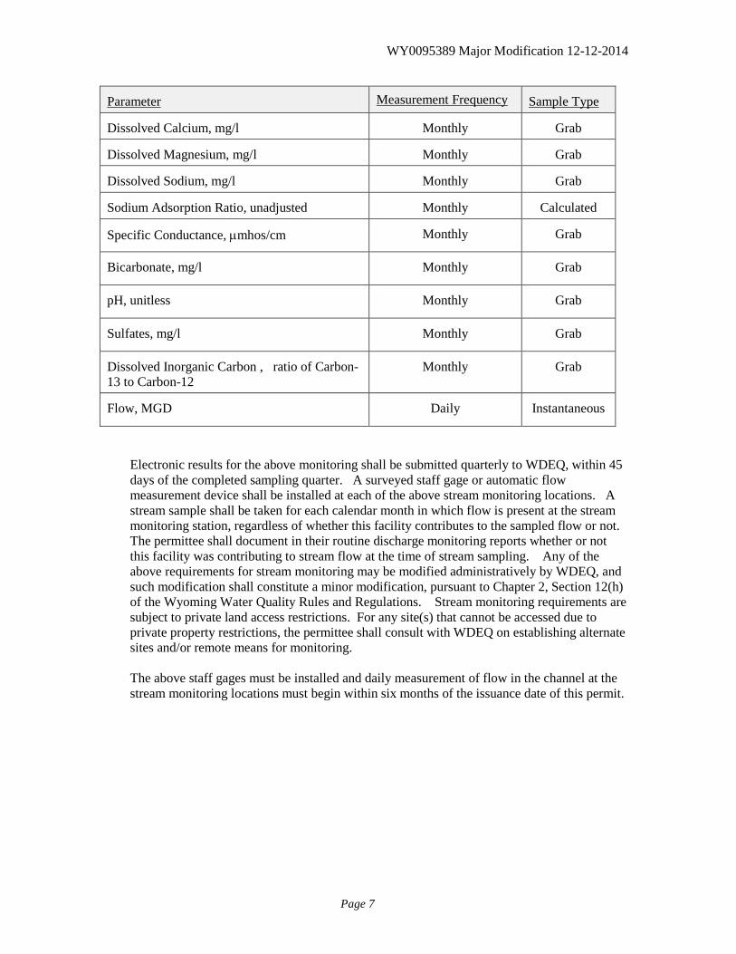
c. Stream Monitoring Points – Pumpkin Creek (STR1) For the duration of the permit, the permittee is required to conduct water quality monitoring at the following surface water monitoring locations within the stream channel.
WY0095389 Stream Monitoring Points:
Site Name Qtr/Qtr Sect TWN RNG Latitude Longitude Placement Sample Type
STR1 SWNW 7 46 75 43.97602 -105.92445 Irrigated FieldSurface Water (instream)
For the duration of the permit, at a minimum, samples for the constituents described below shall be collected at the indicated frequencies from the above stream monitoring points.
WY0095389 Major Modification 12-12-2014
Page 7
Electronic results for the above monitoring shall be submitted quarterly to WDEQ, within 45 days of the completed sampling quarter. A surveyed staff gage or automatic flow measurement device shall be installed at each of the above stream monitoring locations. A stream sample shall be taken for each calendar month in which flow is present at the stream monitoring station, regardless of whether this facility contributes to the sampled flow or not. The permittee shall document in their routine discharge monitoring reports whether or not this facility was contributing to stream flow at the time of stream sampling. Any of the above requirements for stream monitoring may be modified administratively by WDEQ, and such modification shall constitute a minor modification, pursuant to Chapter 2, Section 12(h) of the Wyoming Water Quality Rules and Regulations. Stream monitoring requirements are subject to private land access restrictions. For any site(s) that cannot be accessed due to private property restrictions, the permittee shall consult with WDEQ on establishing alternate sites and/or remote means for monitoring. The above staff gages must be installed and daily measurement of flow in the channel at the stream monitoring locations must begin within six months of the issuance date of this permit.
Parameter Measurement Frequency Sample Type
Dissolved Calcium, mg/l Monthly Grab
Dissolved Magnesium, mg/l Monthly Grab
Dissolved Sodium, mg/l Monthly Grab
Sodium Adsorption Ratio, unadjusted Monthly Calculated
Specific Conductance, µmhos/cm Monthly Grab
Bicarbonate, mg/l Monthly Grab
pH, unitless Monthly Grab
Sulfates, mg/l Monthly Grab
Dissolved Inorganic Carbon , ratio of Carbon-13 to Carbon-12
Monthly Grab
Flow, MGD Daily Instantaneous
WY0095389 Major Modification 12-12-2014
Page 8
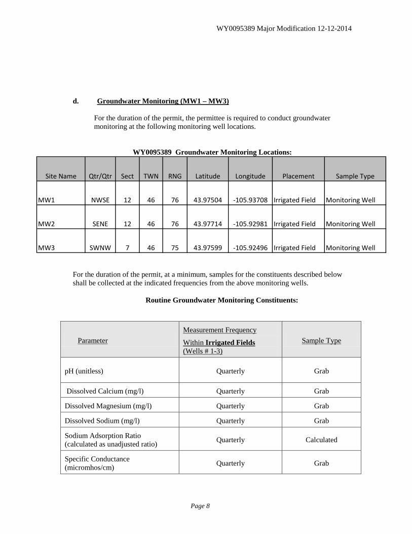
d. Groundwater Monitoring (MW1 – MW3)
For the duration of the permit, the permittee is required to conduct groundwater monitoring at the following monitoring well locations.
WY0095389 Groundwater Monitoring Locations:
Site Name Qtr/Qtr Sect TWN RNG Latitude Longitude Placement Sample Type
MW1 NWSE 12 46 76 43.97504 -105.93708 Irrigated Field Monitoring Well
MW2 SENE 12 46 76 43.97714 -105.92981 Irrigated Field Monitoring Well
MW3 SWNW 7 46 75 43.97599 -105.92496 Irrigated Field Monitoring Well
For the duration of the permit, at a minimum, samples for the constituents described below shall be collected at the indicated frequencies from the above monitoring wells.
Routine Groundwater Monitoring Constituents:
Parameter Measurement Frequency
Within Irrigated Fields (Wells # 1-3)
Sample Type
pH (unitless) Quarterly Grab
Dissolved Calcium (mg/l) Quarterly Grab
Dissolved Magnesium (mg/l) Quarterly Grab
Dissolved Sodium (mg/l) Quarterly Grab
Sodium Adsorption Ratio (calculated as unadjusted ratio) Quarterly Calculated
Specific Conductance (micromhos/cm) Quarterly Grab
WY0095389 Major Modification 12-12-2014
Page 9
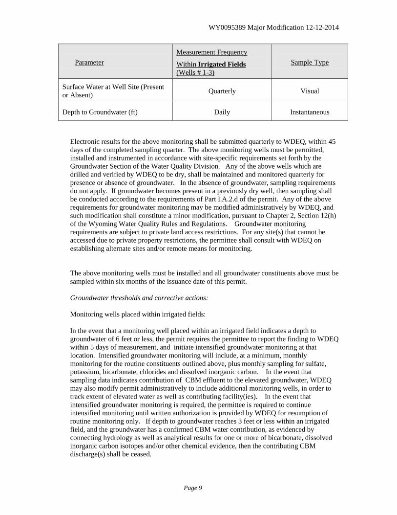
Parameter Measurement Frequency
Within Irrigated Fields (Wells # 1-3)
Sample Type
Surface Water at Well Site (Present or Absent) Quarterly Visual
Depth to Groundwater (ft) Daily Instantaneous
Electronic results for the above monitoring shall be submitted quarterly to WDEQ, within 45 days of the completed sampling quarter. The above monitoring wells must be permitted, installed and instrumented in accordance with site-specific requirements set forth by the Groundwater Section of the Water Quality Division. Any of the above wells which are drilled and verified by WDEQ to be dry, shall be maintained and monitored quarterly for presence or absence of groundwater. In the absence of groundwater, sampling requirements do not apply. If groundwater becomes present in a previously dry well, then sampling shall be conducted according to the requirements of Part I.A.2.d of the permit. Any of the above requirements for groundwater monitoring may be modified administratively by WDEQ, and such modification shall constitute a minor modification, pursuant to Chapter 2, Section 12(h) of the Wyoming Water Quality Rules and Regulations. Groundwater monitoring requirements are subject to private land access restrictions. For any site(s) that cannot be accessed due to private property restrictions, the permittee shall consult with WDEQ on establishing alternate sites and/or remote means for monitoring. The above monitoring wells must be installed and all groundwater constituents above must be sampled within six months of the issuance date of this permit. Groundwater thresholds and corrective actions: Monitoring wells placed within irrigated fields: In the event that a monitoring well placed within an irrigated field indicates a depth to groundwater of 6 feet or less, the permit requires the permittee to report the finding to WDEQ within 5 days of measurement, and initiate intensified groundwater monitoring at that location. Intensified groundwater monitoring will include, at a minimum, monthly monitoring for the routine constituents outlined above, plus monthly sampling for sulfate, potassium, bicarbonate, chlorides and dissolved inorganic carbon. In the event that sampling data indicates contribution of CBM effluent to the elevated groundwater, WDEQ may also modify permit administratively to include additional monitoring wells, in order to track extent of elevated water as well as contributing facility(ies). In the event that intensified groundwater monitoring is required, the permittee is required to continue intensified monitoring until written authorization is provided by WDEQ for resumption of routine monitoring only. If depth to groundwater reaches 3 feet or less within an irrigated field, and the groundwater has a confirmed CBM water contribution, as evidenced by connecting hydrology as well as analytical results for one or more of bicarbonate, dissolved inorganic carbon isotopes and/or other chemical evidence, then the contributing CBM discharge(s) shall be ceased.
WY0095389 Major Modification 12-12-2014
Page 10
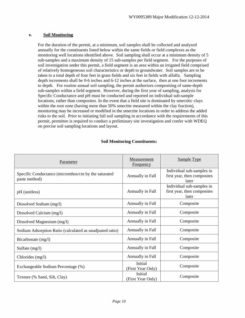
e. Soil Monitoring
For the duration of the permit, at a minimum, soil samples shall be collected and analyzed annually for the constituents listed below within the same fields or field complexes as the monitoring well locations identified above. Soil sampling shall occur at a minimum density of 5 sub-samples and a maximum density of 15 sub-samples per field segment. For the purposes of soil investigation under this permit, a field segment is an area within an irrigated field comprised of relatively homogeneous soil characteristics or depth to groundwater. Soil samples are to be taken to a total depth of four feet in grass fields and six feet in fields with alfalfa. Sampling depth increments shall be 0-6 inches and 6-12 inches at the surface, then at one foot increments to depth. For routine annual soil sampling, the permit authorizes compositing of same-depth sub-samples within a field segment. However, during the first year of sampling, analysis for Specific Conductance and pH must be conducted and reported on individual sub-sample locations, rather than composites. In the event that a field site is dominated by smectitic clays within the root zone (having more than 50% smectite measured within the clay fraction), monitoring may be increased or modified in the smectite locations in order to address the added risks to the soil. Prior to initiating full soil sampling in accordance with the requirements of this permit, permittee is required to conduct a preliminary site investigation and confer with WDEQ on precise soil sampling locations and layout.
Soil Monitoring Constituents:
Parameter Measurement Frequency
Sample Type
Specific Conductance (micromhos/cm by the saturated paste method)
Annually in Fall Individual sub-samples in first year, then composites
later
pH (unitless) Annually in Fall Individual sub-samples in first year, then composites
later
Dissolved Sodium (mg/l) Annually in Fall Composite
Dissolved Calcium (mg/l) Annually in Fall Composite
Dissolved Magnesium (mg/l) Annually in Fall Composite
Sodium Adsorption Ratio (calculated as unadjusted ratio) Annually in Fall Composite
Bicarbonate (mg/l) Annually in Fall Composite
Sulfate (mg/l) Annually in Fall Composite
Chlorides (mg/l) Annually in Fall Composite
Exchangeable Sodium Percentage (%) Initial
(First Year Only) Composite
Texture (% Sand, Silt, Clay) Initial
(First Year Only) Composite
WY0095389 Major Modification 12-12-2014
Page 11
Parameter Measurement Frequency
Sample Type
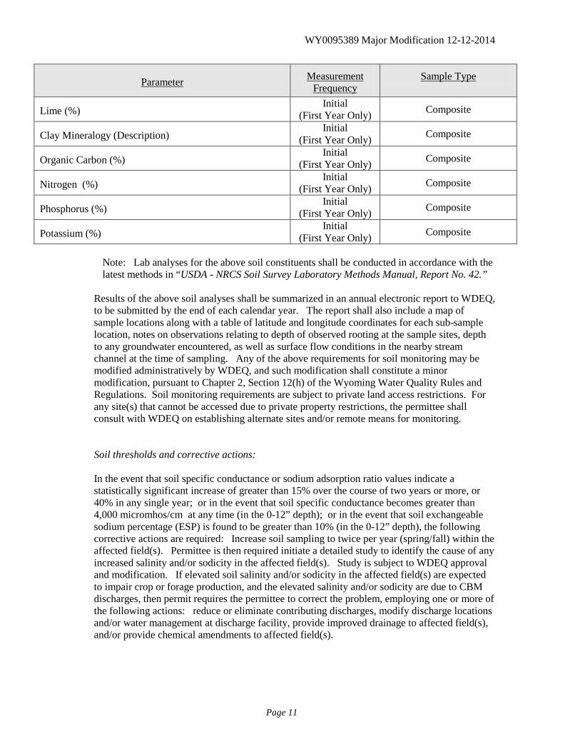
Lime (%) Initial
(First Year Only) Composite
Clay Mineralogy (Description) Initial
(First Year Only) Composite
Organic Carbon (%) Initial
(First Year Only) Composite
Nitrogen (%) Initial
(First Year Only) Composite
Phosphorus (%) Initial
(First Year Only) Composite
Potassium (%) Initial
(First Year Only) Composite Note: Lab analyses for the above soil constituents shall be conducted in accordance with the latest methods in “USDA - NRCS Soil Survey Laboratory Methods Manual, Report No. 42.”
Results of the above soil analyses shall be summarized in an annual electronic report to WDEQ, to be submitted by the end of each calendar year. The report shall also include a map of sample locations along with a table of latitude and longitude coordinates for each sub-sample location, notes on observations relating to depth of observed rooting at the sample sites, depth to any groundwater encountered, as well as surface flow conditions in the nearby stream channel at the time of sampling. Any of the above requirements for soil monitoring may be modified administratively by WDEQ, and such modification shall constitute a minor modification, pursuant to Chapter 2, Section 12(h) of the Wyoming Water Quality Rules and Regulations. Soil monitoring requirements are subject to private land access restrictions. For any site(s) that cannot be accessed due to private property restrictions, the permittee shall consult with WDEQ on establishing alternate sites and/or remote means for monitoring.
Soil thresholds and corrective actions: In the event that soil specific conductance or sodium adsorption ratio values indicate a statistically significant increase of greater than 15% over the course of two years or more, or 40% in any single year; or in the event that soil specific conductance becomes greater than 4,000 micromhos/cm at any time (in the 0-12” depth); or in the event that soil exchangeable sodium percentage (ESP) is found to be greater than 10% (in the 0-12” depth), the following corrective actions are required: Increase soil sampling to twice per year (spring/fall) within the affected field(s). Permittee is then required initiate a detailed study to identify the cause of any increased salinity and/or sodicity in the affected field(s). Study is subject to WDEQ approval and modification. If elevated soil salinity and/or sodicity in the affected field(s) are expected to impair crop or forage production, and the elevated salinity and/or sodicity are due to CBM discharges, then permit requires the permittee to correct the problem, employing one or more of the following actions: reduce or eliminate contributing discharges, modify discharge locations and/or water management at discharge facility, provide improved drainage to affected field(s), and/or provide chemical amendments to affected field(s).
WY0095389 Major Modification 12-12-2014
Page 12
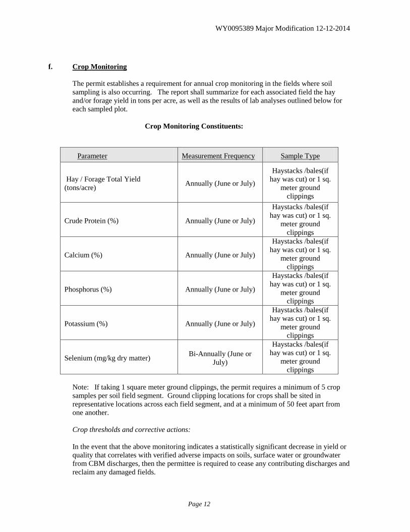
f. Crop Monitoring The permit establishes a requirement for annual crop monitoring in the fields where soil sampling is also occurring. The report shall summarize for each associated field the hay and/or forage yield in tons per acre, as well as the results of lab analyses outlined below for each sampled plot.
Crop Monitoring Constituents:
Parameter Measurement Frequency Sample Type
Hay / Forage Total Yield (tons/acre) Annually (June or July)
Haystacks /bales(if hay was cut) or 1 sq.
meter ground clippings
Crude Protein (%) Annually (June or July)
Haystacks /bales(if hay was cut) or 1 sq.
meter ground clippings
Calcium (%) Annually (June or July)
Haystacks /bales(if hay was cut) or 1 sq.
meter ground clippings
Phosphorus (%) Annually (June or July)
Haystacks /bales(if hay was cut) or 1 sq.
meter ground clippings
Potassium (%) Annually (June or July)
Haystacks /bales(if hay was cut) or 1 sq.
meter ground clippings
Selenium (mg/kg dry matter) Bi-Annually (June or July)
Haystacks /bales(if hay was cut) or 1 sq.
meter ground clippings
Note: If taking 1 square meter ground clippings, the permit requires a minimum of 5 crop samples per soil field segment. Ground clipping locations for crops shall be sited in representative locations across each field segment, and at a minimum of 50 feet apart from one another.
Crop thresholds and corrective actions: In the event that the above monitoring indicates a statistically significant decrease in yield or
quality that correlates with verified adverse impacts on soils, surface water or groundwater from CBM discharges, then the permittee is required to cease any contributing discharges and reclaim any damaged fields.
WY0095389 Major Modification 12-12-2014
Page 13
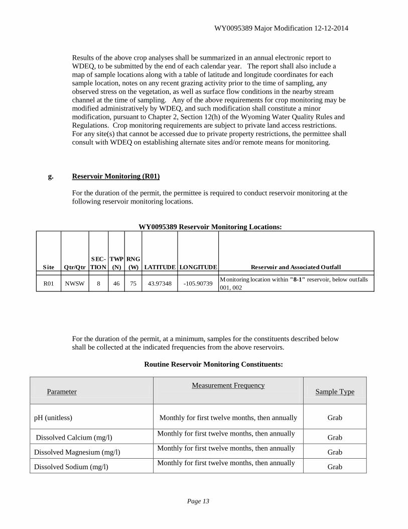
Results of the above crop analyses shall be summarized in an annual electronic report to
WDEQ, to be submitted by the end of each calendar year. The report shall also include a map of sample locations along with a table of latitude and longitude coordinates for each sample location, notes on any recent grazing activity prior to the time of sampling, any observed stress on the vegetation, as well as surface flow conditions in the nearby stream channel at the time of sampling. Any of the above requirements for crop monitoring may be modified administratively by WDEQ, and such modification shall constitute a minor modification, pursuant to Chapter 2, Section 12(h) of the Wyoming Water Quality Rules and Regulations. Crop monitoring requirements are subject to private land access restrictions. For any site(s) that cannot be accessed due to private property restrictions, the permittee shall consult with WDEQ on establishing alternate sites and/or remote means for monitoring.
g. Reservoir Monitoring (R01)
For the duration of the permit, the permittee is required to conduct reservoir monitoring at the following reservoir monitoring locations.
WY0095389 Reservoir Monitoring Locations:
Site Qtr/QtrSEC-TION
TWP (N)
RNG (W) LATITUDE LONGITUDE Reservoir and Associated Outfall
R01 NWSW 8 46 75 43.97348 -105.90739Monitoring location within "8-1" reservoir, below outfalls 001, 002
For the duration of the permit, at a minimum, samples for the constituents described below shall be collected at the indicated frequencies from the above reservoirs.
Routine Reservoir Monitoring Constituents:
Parameter Measurement Frequency
Sample Type
pH (unitless) Monthly for first twelve months, then annually Grab
Dissolved Calcium (mg/l) Monthly for first twelve months, then annually Grab
Dissolved Magnesium (mg/l) Monthly for first twelve months, then annually Grab
Dissolved Sodium (mg/l) Monthly for first twelve months, then annually Grab
WY0095389 Major Modification 12-12-2014
Page 14
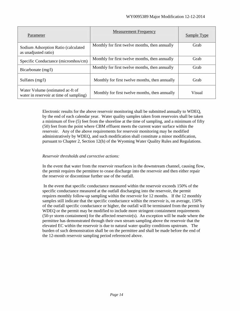
Parameter Measurement Frequency
Sample Type
Sodium Adsorption Ratio (calculated as unadjusted ratio)
Monthly for first twelve months, then annually Grab
Specific Conductance (micromhos/cm) Monthly for first twelve months, then annually Grab
Bicarbonate (mg/l) Monthly for first twelve months, then annually Grab
Sulfates (mg/l) Monthly for first twelve months, then annually Grab
Water Volume (estimated ac-ft of water in reservoir at time of sampling) Monthly for first twelve months, then annually Visual
Electronic results for the above reservoir monitoring shall be submitted annually to WDEQ, by the end of each calendar year. Water quality samples taken from reservoirs shall be taken a minimum of five (5) feet from the shoreline at the time of sampling, and a minimum of fifty (50) feet from the point where CBM effluent meets the current water surface within the reservoir. Any of the above requirements for reservoir monitoring may be modified administratively by WDEQ, and such modification shall constitute a minor modification, pursuant to Chapter 2, Section 12(h) of the Wyoming Water Quality Rules and Regulations. Reservoir thresholds and corrective actions: In the event that water from the reservoir resurfaces in the downstream channel, causing flow, the permit requires the permittee to cease discharge into the reservoir and then either repair the reservoir or discontinue further use of the outfall. In the event that specific conductance measured within the reservoir exceeds 150% of the specific conductance measured at the outfall discharging into the reservoir, the permit requires monthly follow-up sampling within the reservoir for 12 months. If the 12 monthly samples still indicate that the specific conductance within the reservoir is, on average, 150% of the outfall specific conductance or higher, the outfall will be terminated from the permit by WDEQ or the permit may be modified to include more stringent containment requirements (50-yr storm containment) for the affected reservoir(s). An exception will be made where the permittee has demonstrated through their own stream sampling above the reservoir that the elevated EC within the reservoir is due to natural water quality conditions upstream. The burden of such demonstration shall be on the permittee and shall be made before the end of the 12-month reservoir sampling period referenced above.
WY0095389 Major Modification 12-12-2014
Page 15
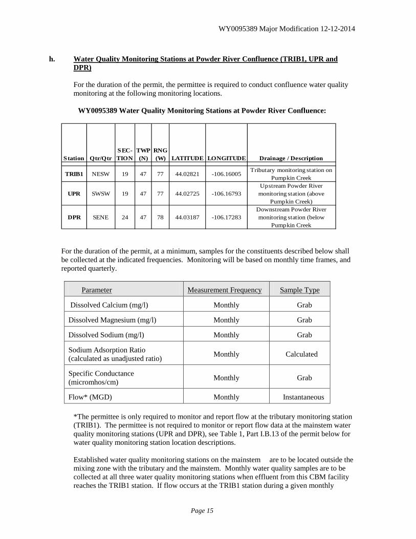
h. Water Quality Monitoring Stations at Powder River Confluence (TRIB1, UPR and
DPR)
For the duration of the permit, the permittee is required to conduct confluence water quality monitoring at the following monitoring locations.
WY0095389 Water Quality Monitoring Stations at Powder River Confluence:
Station Qtr/QtrSEC-TION
TWP (N)
RNG (W) LATITUDE LONGITUDE Drainage / Description
TRIB1 NESW 19 47 77 44.02821 -106.16005Tributary monitoring station on
Pumpkin Creek
UPR SWSW 19 47 77 44.02725 -106.16793Upstream Powder River
monitoring station (above Pumpkin Creek)
DPR SENE 24 47 78 44.03187 -106.17283Downstream Powder River monitoring station (below
Pumpkin Creek For the duration of the permit, at a minimum, samples for the constituents described below shall be collected at the indicated frequencies. Monitoring will be based on monthly time frames, and reported quarterly.
Parameter Measurement Frequency Sample Type
Dissolved Calcium (mg/l) Monthly Grab
Dissolved Magnesium (mg/l) Monthly Grab
Dissolved Sodium (mg/l) Monthly Grab
Sodium Adsorption Ratio (calculated as unadjusted ratio) Monthly Calculated
Specific Conductance (micromhos/cm) Monthly Grab
Flow* (MGD) Monthly Instantaneous *The permittee is only required to monitor and report flow at the tributary monitoring station (TRIB1). The permittee is not required to monitor or report flow data at the mainstem water quality monitoring stations (UPR and DPR), see Table 1, Part I.B.13 of the permit below for water quality monitoring station location descriptions.
Established water quality monitoring stations on the mainstem are to be located outside the mixing zone with the tributary and the mainstem. Monthly water quality samples are to be collected at all three water quality monitoring stations when effluent from this CBM facility reaches the TRIB1 station. If flow occurs at the TRIB1 station during a given monthly
WY0095389 Major Modification 12-12-2014
Page 16
monitoring period, but this CBM facility did not contribute to that flow, the permittee will report “did not contribute” in the discharge monitoring reports for that monthly monitoring period. Under such circumstances, sampling is not required at the three water quality monitoring stations, and it will be the responsibility of the permittee to demonstrate that the effluent from this facility did not contribute to the flow occurring at the TRIB1 station. If no flow at all occurs at the TRIB1 station for an entire monthly monitoring period, then “no flow” is to be reported and samples need not be collected at the three water quality monitoring stations for that monthly monitoring period.
Electronic results for the above monitoring shall be submitted quarterly to WDEQ, within 45 days of the completed sampling quarter. Information gathered from the water quality monitoring stations may result in modification of the permit to protect existing uses on the tributary and mainstem.
i. Effluent Limitations (Toxic Pollutants)
Effective immediately upon issuance of this permit modification, there shall be no acute or chronic toxicity occurring in the effluent from this facility.
j. Whole Effluent Testing (Acute)
Upon issuance of this permit, the permittee shall, at least once annually, conduct acute static replacement toxicity tests on a grab sample of the discharge. If initial monitoring of the effluent is required for this permit (within 60 days of commencement of discharge), then the first annual acute toxicity test is to be conducted at that time. At a minimum, 20 percent of all discharging outfalls that immediately flow to Class 3 waters and 20 percent of all discharging outfalls that immediately flow to Class 2 waters are to be sampled and tested annually for acute whole effluent toxicity (WET). Each year, a different 20 percent minimum portion of the discharging outfalls is to be sampled and tested for acute whole effluent toxicity. Consecutive yearly samples may not be collected from an identical outfall unless the outfall is the only discharging outfall that complies with the criteria listed above. The permittee may select the outfall(s) that will be sampled each year unless the permit issuing authority specifically identifies which outfalls must be sampled. The permittee must also provide written notification to the permit issuing authority at least two weeks prior to WET-related sampling. The written notification will specify which outfall(s) are discharging and which outfalls will be selected and sampled for the WET test. The replacement static toxicity tests shall be conducted in accordance with the procedures set forth in 40 CFR 136.3 and the “Region VIII EPA NPDES Acute Test Conditions – Static Renewal Whole Effluent Toxicity Tests”. In the case of conflicts in method, 40 CFR 136.3 will prevail. The permittee shall conduct an acute 48-hour static toxicity test using Daphnia magna and an acute 96-hour static toxicity test using Pimephales promelas. All tests will be conducted utilizing a multi-dilution series consisting of at least five (5) concentrations and a control as defined below: 100% effluent 85% effluent 67% effluent
WY0095389 Major Modification 12-12-2014
Page 17
50% effluent 25% effluent control (or 0% effluent) All tests will be conducted utilizing a minimum of 5 replicates for each test. In the event of inconclusive test results, the WDEQ reserves the right to require the permittee to perform additional tests at alternate dilutions and/or replicates. The WDEQ also reserves the right to require the submission of all information regarding all initiated tests, regardless of whether the tests were carried to completion or not.
Acute toxicity occurs when 50 percent or more mortality is observed for either species at any effluent concentration at any outfall. If acute toxicity occurs at any outfall during a sampling period, then WDEQ will assume that all outfalls, which have not yet been sampled, exhibit similar acute toxicity characteristics as well. If more than 10 percent control mortality occurs, the test is not valid. The test shall be repeated until satisfactory control survival is achieved.
If acute toxicity occurs, an additional test on the failing outfall(s) shall be initiated within two (2) weeks of the date of when the permittee learned of the test failure. If only one species fails, retesting may be limited to this species. Should acute toxicity occur in the second test, the Toxicity Identification Evaluation (TIE) and Toxicity Reduction Evaluation (TRE) process described below shall be implemented on a schedule established by the DEQ.
Annual test results shall be reported on a Discharge Monitoring Report (DMR) that must be submitted by February 15th of each year. The format for the report shall be consistent with the latest revision of the "Region VIII Guidance for Acute Whole Effluent Reporting", and shall include all chemical and physical data as specified.
If the results of two consecutive annual reports indicate no acute toxicity for all
sampled outfalls, the permittee may reduce the monitoring to annual acute toxicity testing on only one species on an alternating basis. The test procedures for alternating species shall be the same as specified above.
k. Toxicity Identification Evaluation (TIE) and Toxicity Reduction Evaluation (TRE)
Should toxicity be detected in the permittee’s discharge, a TIE-TRE shall be undertaken by the permittee to establish the cause of the toxicity, locate the source(s) of the toxicity, and develop control of, or treatment for the toxicity. Failure to initiate, or conduct an adequate TIE-TRE, or delays in the conduct of such test, shall not be considered a justification for noncompliance with the whole effluent toxicity limits contained in this permit. A TRE plan needs to be submitted to the permitting authority within 45 days after confirmation of the continuance of effluent toxicity.
If acceptable to the permit issuing authority, and if in conformance with current regulations, this permit may be reopened and modified to incorporate TRE conclusions relating to additional numerical limitations, a modified compliance schedule, and\or modified whole effluent protocol.
WY0095389 Major Modification 12-12-2014
Page 18
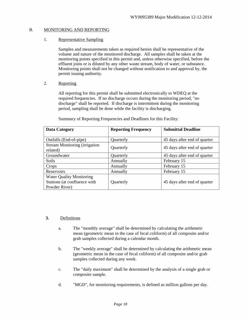
B. MONITORING AND REPORTING 1. Representative Sampling
Samples and measurements taken as required herein shall be representative of the volume and nature of the monitored discharge. All samples shall be taken at the monitoring points specified in this permit and, unless otherwise specified, before the effluent joins or is diluted by any other waste stream, body of water, or substance. Monitoring points shall not be changed without notification to and approval by, the permit issuing authority.
2. Reporting
All reporting for this permit shall be submitted electronically to WDEQ at the required frequencies. If no discharge occurs during the monitoring period, "no discharge" shall be reported. If discharge is intermittent during the monitoring period, sampling shall be done while the facility is discharging. Summary of Reporting Frequencies and Deadlines for this Facility:
Data Category Reporting Frequency Submittal Deadline
Outfalls (End-of-pipe) Quarterly 45 days after end of quarter Stream Monitoring (irrigation related) Quarterly 45 days after end of quarter
Groundwater Quarterly 45 days after end of quarter Soils Annually February 15 Crops Annually February 15 Reservoirs Annually February 15 Water Quality Monitoring Stations (at confluence with Powder River)
Quarterly 45 days after end of quarter
3. Definitions
a. The "monthly average" shall be determined by calculating the arithmetic
mean (geometric mean in the case of fecal coliform) of all composite and/or grab samples collected during a calendar month.
b. The "weekly average" shall be determined by calculating the arithmetic mean
(geometric mean in the case of fecal coliform) of all composite and/or grab samples collected during any week.
c. The "daily maximum" shall be determined by the analysis of a single grab or
composite sample.
d. "MGD", for monitoring requirements, is defined as million gallons per day.
WY0095389 Major Modification 12-12-2014
Page 19
e. "Net" value, if noted under Effluent Characteristics, is calculated on the basis
of the net increase of the individual parameter over the quantity of that same parameter present in the intake water measured prior to any contamination or use in the process of this facility. Any contaminants contained in any intake water obtained from underground wells shall not be adjusted for as described above and, therefore, shall be considered as process input to the final effluent. Limitations in which "net" is not noted are calculated on the basis of gross measurements of each parameter in the discharge, irrespective of the quantity of those parameters in the intake waters.
f. A "composite" sample, for monitoring requirements, is defined as a
minimum of four grab samples collected at equally spaced two hour intervals and proportioned according to flow.
g. An "instantaneous" measurement for monitoring requirements is defined as a
single reading, measurement, or observation. h. A "pollutant" is any substance or substances which, if allowed to enter
surface waters of the state, causes or threatens to cause pollution as defined in the Wyoming Environmental Quality Act, Section 35-11-103.
i. "Total Flow" is the total volume of water discharged, measured on a
continuous basis and reported as a total volume for each month during a reporting period. The accuracy of flow measurement must comply with Part III.A.1.
4. Test Procedures
Test procedures for the analysis of pollutants, collection of samples, sample containers, sample preservation, and holding times, shall conform to regulations published pursuant to 40 CFR, Part 136, unless other test procedures have been specified in this permit.
5. Recording of Results
For each measurement or sample taken pursuant to the requirements of this permit, the permittee shall record the following information: a. The exact place, date and time of sampling; b. The dates and times the analyses were performed; c. The person(s) who performed the analyses and collected the samples; d. The analytical techniques or methods used; and e. The results of all required analyses including the bench sheets, instrument
readouts, computer disks or tapes, etc., used to determine the results.
WY0095389 Major Modification 12-12-2014
Page 20
6. Additional Monitoring by Permittee
If the permittee monitors any pollutant at the location(s) designated herein more frequently than required by this permit, using approved analytical methods as specified above, the results of such monitoring shall be included in the calculation and reporting of the values required in the Discharge Monitoring Report Form. Such increased frequency shall also be indicated.
7. Records Retention The permittee shall retain records of all monitoring information, including all calibration and maintenance records and all original strip chart recordings for continuous monitoring instrumentation, copies of all reports required by this permit, and records of all data used to complete the application for this permit, for a period of at least three years from the date of the sample, measurement, report or application. This period may be extended by request of the administrator at any time. Data collected on site, copies of Discharge Monitoring Reports and a copy of this WYPDES permit must be maintained on site during the duration of activity at the permitted location.
8. Penalties for Tampering The Act provides that any person who falsifies, tampers with or knowingly renders inaccurate, any monitoring device or method required to be maintained under this permit shall, upon conviction, be punished by a fine of not more than $10,000 per violation, or by imprisonment for not more than two years per violation, or both.
9. Compliance Schedules Reports of compliance or noncompliance with, or any progress reports on interim and final requirements contained in any Compliance Schedule of this permit shall be submitted no later than 14 days following each schedule date.
10. Facility Identification
All facilities discharging produced water shall be clearly identified with an all-weather sign posted at each outfall, and at the outlet of each receiving reservoir listed in Table 1 below. This sign shall, at a minimum, convey the following information:
a. The name of the company, corporation, person(s) who holds the discharge
permit, and the WYPDES permit number;
b. The contact name and phone number of the person responsible for the records associated with the permit;
c. The name of the facility (as identified in this WYPDES permit). In addition,
all outfall signs will include the outfall number. Reservoir signs are separate from the outfall signs, and are to be located at the outlet of the reservoir. Reservoir signs must include the information listed in items a and b above, in addition to the reservoir name, as identified in Table 1 below.
WY0095389 Major Modification 12-12-2014
Page 21
11. Identification and Establishment of Discharge Points
According to 40 CFR 122.21(k)(1), the permittee shall identify the expected location of each discharge point on the appropriate WYPDES permit application form. The location of the discharge point must be identified to within an accuracy of 15 seconds. This equates to a distance of 1,510 feet.
In order for the permit not to be subjected to additional public notice, the location of the established discharge point must be within 1,510 feet of the location of the discharge point originally identified on the permit application. In addition, the discharge must be within the same drainage and must discharge to the same landowner's property as identified on the original application form. If the three previously stated requirements are not satisfied, modification of the discharge point location(s) constitutes a major modification of the permit as defined in Part I.B.12. The permittee shall provide written notification of the establishment of each discharge point in accordance with Part I.A.2.a above.
12. Location of Discharge Points
As of the date of permit issuance, authorized points of discharge were as follows:
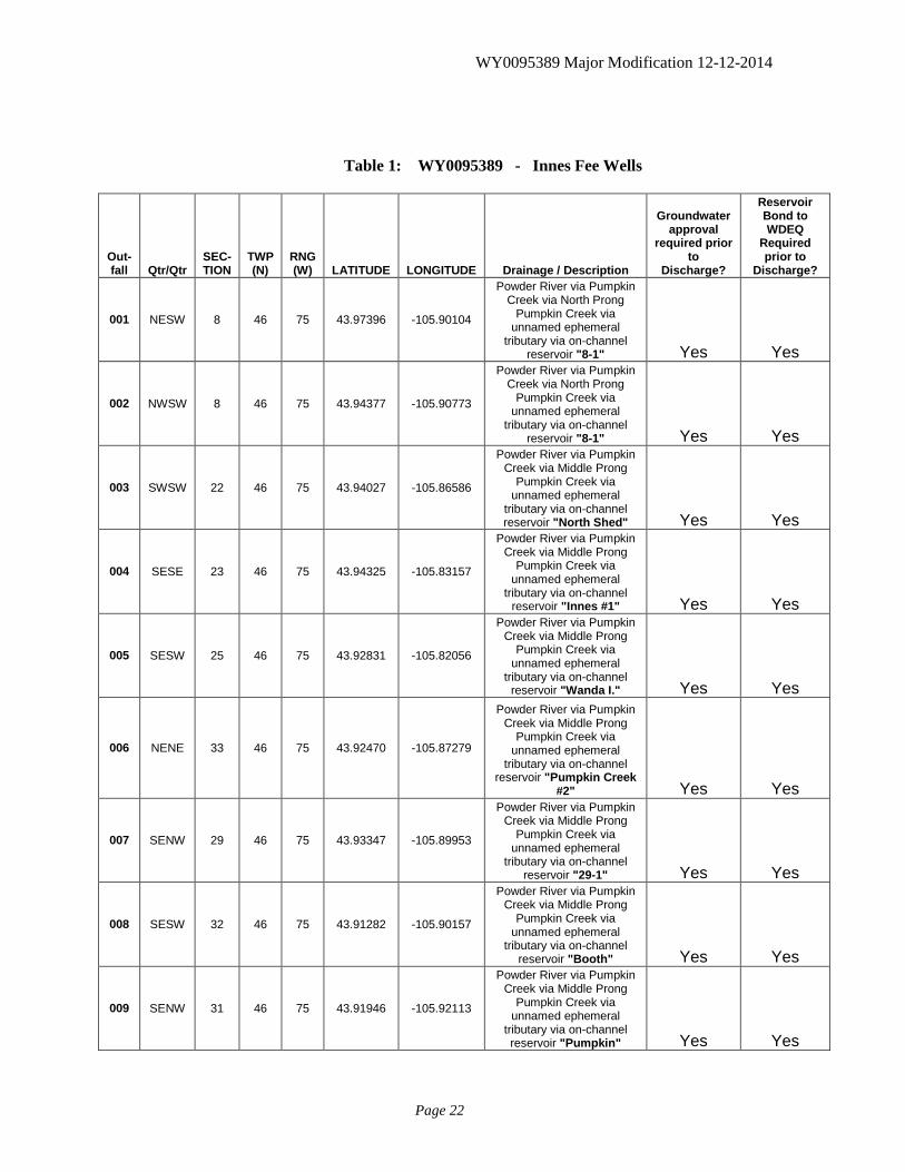
WY0095389 Major Modification 12-12-2014
Page 22
Table 1: WY0095389 - Innes Fee Wells
Out- fall Qtr/Qtr
SEC-TION
TWP (N)
RNG (W) LATITUDE LONGITUDE Drainage / Description
Groundwater approval
required prior to
Discharge?
Reservoir Bond to WDEQ
Required prior to
Discharge?
001 NESW 8 46 75 43.97396 -105.90104
Powder River via Pumpkin Creek via North Prong
Pumpkin Creek via unnamed ephemeral
tributary via on-channel reservoir "8-1" Yes Yes
002 NWSW 8 46 75 43.94377 -105.90773
Powder River via Pumpkin Creek via North Prong
Pumpkin Creek via unnamed ephemeral
tributary via on-channel reservoir "8-1" Yes Yes
003 SWSW 22 46 75 43.94027 -105.86586
Powder River via Pumpkin Creek via Middle Prong
Pumpkin Creek via unnamed ephemeral
tributary via on-channel reservoir "North Shed" Yes Yes
004 SESE 23 46 75 43.94325 -105.83157
Powder River via Pumpkin Creek via Middle Prong
Pumpkin Creek via unnamed ephemeral
tributary via on-channel reservoir "Innes #1" Yes Yes
005 SESW 25 46 75 43.92831 -105.82056
Powder River via Pumpkin Creek via Middle Prong
Pumpkin Creek via unnamed ephemeral
tributary via on-channel reservoir "Wanda I." Yes Yes
006 NENE 33 46 75 43.92470 -105.87279
Powder River via Pumpkin Creek via Middle Prong
Pumpkin Creek via unnamed ephemeral
tributary via on-channel reservoir "Pumpkin Creek
#2" Yes Yes
007 SENW 29 46 75 43.93347 -105.89953
Powder River via Pumpkin Creek via Middle Prong
Pumpkin Creek via unnamed ephemeral
tributary via on-channel reservoir "29-1" Yes Yes
008 SESW 32 46 75 43.91282 -105.90157
Powder River via Pumpkin Creek via Middle Prong
Pumpkin Creek via unnamed ephemeral
tributary via on-channel reservoir "Booth" Yes Yes
009 SENW 31 46 75 43.91946 -105.92113
Powder River via Pumpkin Creek via Middle Prong
Pumpkin Creek via unnamed ephemeral
tributary via on-channel reservoir "Pumpkin" Yes Yes
WY0095389 Major Modification 12-12-2014
Page 23
Requests for modification of the above list will be processed as follows. If the requested modification satisfies the definition of a minor permit modification as defined in 40 CFR 122.63 modifications will not be required to be advertised in a public notice. A minor modification constitutes a correction of a typographical error, increase in monitoring and/or reporting, revision to an interim compliance schedule date, change in ownership, revision of a construction schedule for a new source discharger, deletion of permitted outfalls, and/or the incorporation of an approved local pretreatment program.
A request for a minor modification must be initiated by the permittee by completing the form titled National Pollutant Discharge Elimination System Permit Modification Application For Coal Bed Methane. Incomplete application forms will be returned to the applicant. The outfalls listed in Table 1 (Part I.B.12) may be moved from the established location without submittal of a permit modification application provided all of the following conditions are satisfied:
1. The new outfall location is within 2640 feet of the established outfall location.
2. The new outfall location is within the same drainage or immediate permitted receiving waterbody.
3. There is no change in the affected landowners. 4. Notification of the change in outfall location must be provided to the WYPDES
Permits Section on a form provided by the WQD Administrator within 10 days of the outfall location change. The form must be provided in duplicate and legible maps showing the previous and new outfall location must be attached to the form.
Moving an outfall location without satisfying the four above listed conditions will be considered a violation of this permit and subject to full enforcement authority of the WQD. An outfall relocation as described above will not be allowed if the new outfall location is less than one mile from the confluence of a Class 2 waterbody and the dissolved iron and/or total radium 226 effluent limits established in the permit for the outfall are based upon Class 3 standards.
C. RESERVOIR / IMPOUNDMENT REQUIREMENTS
1. Groundwater Monitoring Beneath Impoundments:
Table 1 of the permit above identifies which outfalls (if any) are designed to discharge into impoundments that are subject to groundwater monitoring requirements established in the latest version of the Water Quality Division guideline “Compliance Monitoring for Groundwater Protection Beneath Unlined Coalbed Methane Produced Water Impoundments.” These specified outfalls are not authorized to discharge until a written groundwater compliance approval has been granted by the Groundwater Pollution Control Program of the Water Quality Division. A groundwater compliance approval will consist of either a final approved groundwater compliance monitoring plan, or written authorization for an exemption thereof. Once an impoundment has been granted a written groundwater compliance approval, the contributing outfall(s) to that reservoir may commence discharge.
WY0095389 Major Modification 12-12-2014
Page 24
2. Reclamation Performance Bonds for On-Channel Reservoirs:
Table 1 of the permit above also identifies which outfalls (if any) are designed to discharge into impoundments that are subject to WDEQ bonding requirements, as set forth in the latest version of the Water Quality Division guideline “Implementation Guidance for Reclamation and Bonding of On-Channel Reservoirs That Store Coalbed Natural Gas Produced Water.” These specified outfalls are not authorized to discharge until the associated reservoir reclamation bond is approved by WDEQ. Once the reservoir reclamation bond is approved by WDEQ, the contributing outfall(s) to that reservoir may commence discharge. Any discharge into an above-listed impoundment which has not been secured by the required WDEQ-approved bond, or which has not been granted the required groundwater compliance approval, will constitute a violation of this permit, and may result in enforcement action from the Water Quality Division.
WY0095389 Major Modification 12-12-2014
Page 25
PART II A. MANAGEMENT REQUIREMENTS
1. Changes
The permittee shall give notice to the administrator of the Water Quality Division as soon as possible of any physical alterations or additions to the permitted facility. Notice is required when:
a. The alteration or addition to a permitted facility may meet one of the criteria
for determining whether a facility is a new source as determined in 40 CFR 122.29 (b); or
b. The alteration or addition could change the nature or increase the quantity of
pollutants discharged.
2. Noncompliance Notification
a. The permittee shall give advance notice of any planned changes in the permitted facility or activity which may result in noncompliance with permit requirements.
b. The permittee shall report any noncompliance which may endanger health or
the environment as soon as possible, but no later than 24 hours from the time the permittee first became aware of the circumstances. The report shall be made to the Water Quality Division, Wyoming Department of Environmental Quality at (307) 777-7781.
c. For any incidence of noncompliance, including noncompliance related to
non-toxic pollutants or non-hazardous substances, a written submission shall be provided within five (5) days of the time that the permittee becomes aware of the noncompliance circumstance.
The written submission shall contain:
(1) A description of the noncompliance and its cause;
(2) The period of noncompliance, including exact dates and times;
(3) The estimated time noncompliance is expected to continue if it has
not been corrected; and
(4) Steps taken or planned to reduce, eliminate and prevent reoccurrence of the noncompliance.
d. The following occurrences of unanticipated noncompliance shall be reported
by telephone to the Water Quality Division, Watershed Management Section, WYPDES Program (307) 777-7781 as soon as possible, but no later than 24 hours from the time the permittee first became aware of the circumstances.
WY0095389 Major Modification 12-12-2014
Page 26
(1) Any unanticipated bypass which exceeds any effluent limitation in
the permit;
(2) Any upset which exceeds any effluent limitation in the permit; or
(3) Violation of a maximum daily discharge limitation for any toxic pollutants or hazardous substances, or any pollutants specifically identified as the method to control a toxic pollutant or hazardous substance listed in the permit.
e. The administrator of the Water Quality Division may waive the written
report on a case-by-case basis if the oral report has been received within 24 hours by the Water Quality Division, WYPDES Program (307) 777-7781.
f. Reports shall be submitted to the Wyoming Department of Environmental
Quality at the address in Part I under Reporting and to the Planning.
g. The permittee shall report all instances of noncompliance that have not been specifically addressed in any part of this permit at the time the monitoring reports are due.
3. Facilities Operation
The permittee shall, at all times, properly operate and maintain all facilities and systems of treatment and control (and related appurtenances) which are installed or used by the permittee to achieve compliance with the conditions of this permit. Proper operation and maintenance also includes adequate laboratory controls and appropriate quality assurance procedures. This provision requires the operation of back-up or auxiliary facilities or similar systems which are installed by the permittee only when the operation is necessary to achieve compliance with the conditions of the permit. However, the permittee shall operate, as a minimum, one complete set of each main line unit treatment process whether or not this process is needed to achieve permit effluent compliance.
4. Adverse Impact
The permittee shall take all reasonable steps to minimize any adverse impact to waters of the state resulting from noncompliance with any effluent limitations specified in this permit, including such accelerated or additional monitoring as necessary to determine the nature and impact of the noncomplying discharge.
5. Bypass of Treatment Facilities
a. Bypass means the intentional diversion of waste streams from any portion of
a treatment facility.
b. The permittee may allow any bypass to occur which does not cause effluent limitations to be exceeded, but only if it is for essential maintenance to assure efficient operation. These bypasses are not subject to the provisions of paragraphs c. and d. of this section. Return of removed substances to the
WY0095389 Major Modification 12-12-2014
Page 27
discharge stream shall not be considered a bypass under the provisions of this paragraph.
c. Notice:
(1) Anticipated bypass. If the permittee knows in advance of the need
for a bypass, it shall submit prior notice at least 60 days before the date of the bypass.
(2) Unanticipated bypass. The permittee shall submit notice of an
unanticipated bypass as required under Part II.A.2.
d. Prohibition of bypass.
(1) Bypass is prohibited and the administrator of the Water Quality Division may take enforcement action against a permittee for a bypass, unless:
(a) The bypass was unavoidable to prevent loss of life, personal
injury or severe property damage;
(b) There were no feasible alternatives to the bypass, such as the use of auxiliary treatment facilities, retention of untreated wastes or maintenance during normal periods of equipment downtime. This condition is not satisfied if adequate back-up equipment should have been installed to prevent a bypass which occurred during normal periods of equipment downtime or preventive maintenance; and
(c) The permittee submitted notices as required under paragraph
c. of this section.
e. The administrator of the Water Quality Division may approve an anticipated bypass, after considering its adverse effects, if the administrator determines that it will meet the three conditions listed above in paragraph d. (l) of this section.
6. Upset Conditions
a. Upset means an exceptional incident in which there is unintentional and
temporary noncompliance with technology based permit effluent limitations because of factors beyond the reasonable control of the permittee. An upset does not include noncompliance to the extent caused by operational error, improper designed treatment facilities, inadequate treatment facilities, lack of preventive maintenance, or careless or improper operation.
b. An upset constitutes an affirmative defense to an action brought for
noncompliance with technology based permit effluent limitations if the requirements of paragraph c. of this section are met.
c. A permittee who wishes to establish the affirmative defense of upset shall
WY0095389 Major Modification 12-12-2014
Page 28
demonstrate, through properly signed, contemporaneous operating logs or other relevant evidence that:
(1) An upset occurred and that the permittee can identify the cause(s) of
the upset;
(2) The permitted facility was at the time being properly operated;
(3) The permittee submitted notice of the upset as required under Part II.A.2; and
(4) The permittee complied with any remedial measures required under
Part II.A.4.
d. Burden of proof. In any enforcement proceeding, the permittee seeking to establish the occurrence of an upset has the burden of proof.
7. Removed Substances
Solids, sludges, filter backwash or other pollutants removed in the course of treatment or control of wastewaters or intake waters shall be disposed of in a manner such as to prevent any pollutant from such materials from entering waters of the state.
8. Power Failures
In order to maintain compliance with the effluent limitations and prohibitions of this permit, the permittee shall either:
a. In accordance with a schedule of compliance contained in Part I, provide an
alternative power source sufficient to operate the wastewater control facilities; or
b. If such alternative power source as described in paragraph a. above is not in
existence and no date for its implementation appears in Part I, take such precautions as are necessary to maintain and operate the facility under its control in a manner that will minimize upsets and insure stable operation until power is restored.
9. Duty to Comply
The permittee must comply with all conditions of this permit. Any permit noncompliance constitutes a violation of the federal act and the Wyoming Environmental Quality Act and is grounds for enforcement action; for permit termination, revocation and reissuance, or modification; or for denial of a permit renewal application. The permittee shall give the administrator of the Water Quality Division advance notice of any planned changes at the permitted facility or of any activity which may result in permit noncompliance.
10. Duty to Mitigate
The permittee shall take all reasonable steps to minimize or prevent any discharge in
WY0095389 Major Modification 12-12-2014
Page 29
violation of this permit which has a reasonable likelihood of adversely affecting human health or the environment.
11. Signatory Requirements
All applications, reports or information submitted to the administrator of the Water Quality Division shall be signed and certified.
a. All permit applications shall be signed as follows:
(1) For a corporation: by a responsible corporate officer;
(2) For a partnership or sole proprietorship: by a general partner or the
proprietor, respectively;
(3) For a municipality, state, federal or other public agency: by either a principal executive officer or ranking elected official.
b. All reports required by the permit and other information requested by the
administrator of the Water Quality Division shall be signed by a person described above or by a duly authorized representative of that person. A person is a duly authorized representative only if:
(1) The authorization is made in writing by a person described above
and submitted to the administrator of the Water Quality Division; and
(2) The authorization specified either an individual or a position having
responsibility for the overall operation of the regulated facility or activity, such as the position of plant manager, operator of a well or a well field, superintendent, position of equivalent responsibility or an individual or position having overall responsibility for environmental matters for the company. A duly authorized representative may thus be either a named individual or any individual occupying a named position.
c. If an authorization under paragraph II.A.11.b. is no longer accurate because a
different individual or position has responsibility for the overall operation of the facility, a new authorization satisfying the requirements of paragraph II.A.11.b must be submitted to the administrator of the Water Quality Division prior to or together with any reports, information or applications to be signed by an authorized representative.
d. Any person signing a document under this section shall make the following
certification:
"I certify, under penalty of law, that this document and all attachments were prepared under my direction or supervision in accordance with a system designed to assure that qualified personnel properly gather and evaluate the information submitted. Based on my inquiry of the person or persons who manage the system or those persons directly responsible for gathering the
WY0095389 Major Modification 12-12-2014
Page 30
information, the information submitted is, to the best of my knowledge and belief, true, accurate and complete. I am aware that there are significant penalties for submitting false information, including the possibility of fine and imprisonment for knowing violations."
B. RESPONSIBILITIES
1. Inspection and Entry
If requested, the permittee shall provide written certification from the surface landowner(s), if different than the permittee, that the administrator or the administrator’s authorized agent has access to all physical locations associated with this permit including well heads, discharge points, reservoirs, monitoring locations, and any waters of the state.
The permittee shall allow the administrator of the Water Quality Division or an authorized representative, upon the presentation of credentials and other documents as may be required by law, to:
a. Enter upon the permittee's premises where a regulated facility or activity is
located or conducted or where records must be kept under the conditions of this permit;
b. Have access to and copy, at reasonable times, any records that must be kept
under the conditions of this permit;
c. Inspect, at reasonable times, any facilities, equipment (including monitoring and control equipment), practices or operations regulated or required under this permit; and
d. Sample or monitor, at reasonable times, for the purpose of assuring permit
compliance or as otherwise authorized by the federal act, any substances or parameters at any location.
2. Transfer of Ownership or Control
In the event of any change in control or ownership of facilities from which the authorized discharges emanate, the permittee shall notify the succeeding owner or controller of the existence of this permit by letter, a copy of which shall be forwarded to the regional administrator of the Environmental Protection Agency and the administrator of the Water Quality Division. The administrator of the Water Quality Division shall then provide written notification to the new owner or controller of the date in which they assume legal responsibility of the permit. The permit may be modified or revoked and reissued to change the name of the permittee and incorporate such other requirements as described in the federal act.
3. Availability of Reports
Except for data determined to be confidential under Section 308 of the federal act, all reports prepared in accordance with the terms of this permit shall be available for public inspection at the offices of the Wyoming Department of Environmental
WY0095389 Major Modification 12-12-2014
Page 31
Quality and the regional administrator of the Environmental Protection Agency. As required by the federal act, effluent data shall not be considered confidential. Knowingly making any false statement on any such report may result in the imposition of criminal penalties as provided for in Section 309 of the federal act.
4. Toxic Pollutants
The permittee shall comply with effluent standards or prohibitions established under Section 307 (a) of the federal act for toxic pollutants within the time provided in the regulations that establish those standards or prohibitions, even if the permit has not yet been modified to incorporate the requirement.
5. Changes in Discharge of Toxic Substances
Notification shall be provided to the administrator of the Water Quality Division as soon as the permittee knows of, or has reason to believe:
a. That any activity has occurred or will occur which would result in the
discharge, on a routine or frequent basis, of any toxic pollutant which is not limited in the permit, if that discharge will exceed the highest of the following "notification levels":
(1) One hundred micrograms per liter (100 μg/l);
(2) Two hundred micrograms per liter (200 μg/l) for acrolein and
acrylonitrile; five hundred micrograms per liter (500 μg/l) for 2,4-dinitrophenol and for 2-methyl-4,6-dinitrophenol; and one milligram per liter (1 mg/1) for antimony;
(3) Five (5) times the maximum concentration value reported for that
pollutant in the permit application in accordance with 40 CFR 122.21 (g) (7); or
(4) The level established by the director of the Environmental Protection
Agency in accordance with 40 CFR 122.44 (f).
b. That any activity has occurred or will occur which would result in any discharge, on a non-routine or infrequent basis, of a toxic pollutant which is not limited in the permit, if that discharge will exceed the highest of the following "notification levels":
(1) Five hundred micrograms per liter (500 μg/l);
(2) One milligram per liter (1 mg/1) for antimony;
(3) Ten (10) times the maximum concentration value reported for that
pollutant in the permit application in accordance with 40 CFR 122.21 (g) (7); or
(4) The level established by the director of the Environmental Protection Agency in accordance with 40 CFR 122.44 (f).
WY0095389 Major Modification 12-12-2014
Page 32
6. Civil and Criminal Liability
Nothing in this permit shall be construed to relieve the permittee from civil or criminal penalties for noncompliance. As long as the conditions related to the provisions of "Bypass of Treatment Facilities" (Part II.A.5), "Upset Conditions" (Part II.A.6), and "Power Failures" (Part II.A.8) are satisfied then they shall not be considered as noncompliance.
7. Need to Halt or Reduce Activity not a Defense
It shall not be a defense for a permittee in an enforcement action that it would have been necessary to halt or reduce the permitted activity in order to maintain compliance with the conditions of this permit.
8. Oil and Hazardous Substance Liability
Nothing in this permit shall be construed to preclude the institution of any legal action or relieve the permittee from any responsibilities, liabilities or penalties to which the permittee is or may be subject under Section 311 of the federal act.
9. State Laws
Nothing in this permit shall be construed to preclude the institution of any legal action or relieve the permittee from any responsibilities, liabilities or penalties established pursuant to any applicable state or federal law or regulation. In addition, issuance of this permit does not substitute for any other permits required under the Clean Water Act or any other federal, state, or local law.
10. Property Rights
The issuance of this permit does not convey any property rights in either real or personal property, or any exclusive privileges, nor does it authorize any injury to private property or any invasion of personal rights nor any infringement of federal, state or local laws or regulations.
11. Duty to Reapply
If the permittee wishes to continue an activity regulated by this permit after the expiration date of this permit, the permittee must apply for and obtain a new permit. The application should be submitted at least 180 days before the expiration date of this permit.
12. Duty to Provide Information
The permittee shall furnish to the administrator of the Water Quality Division, within a reasonable time, any information which the administrator may request to determine whether cause exists for modifying, revoking and reissuing or terminating this permit or to determine compliance with this permit. The permittee shall also furnish to the administrator, upon request, copies of records required by this permit to be kept.
WY0095389 Major Modification 12-12-2014
Page 33
13. Other Information
When the permittee becomes aware that it failed to submit any relevant facts in a permit application or submitted incorrect information in a permit application or any report to the administrator of the Water Quality Division, it shall promptly submit such facts or information.
14. Permit Action
This permit may be modified, revoked and reissued, or terminated for cause. The filing of a request by the permittee for a permit modification, revocation and reissuance, or termination, or a notification of planned changes or anticipated noncompliance does not stay any permit condition.
15. Permit Fees
Once this permit has been issued, the permittee will be assessed a $100.00 per-year permit fee by the Water Quality Division. The fee year runs from January 1st through December 31st. This permit fee will continue to be assessed for as long as the permit is active, regardless of whether discharge actually occurs. This fee is not pro-rated. If the permit is active during any portion of the fee year, the full fee will be billed to the permittee for that fee year. In the event that this permit is transferred from one permittee to another, each party will be billed the full permit fee for the fee year in which the permit transfer was finalized.
WY0095389 Major Modification 12-12-2014
Page 34
PART III A. OTHER REQUIREMENTS 1. Flow Measurement
At the request of the administrator of the Water Quality Division, the permittee must be able to show proof of the accuracy of any flow measuring device used in obtaining data submitted in the monitoring report. The flow measuring device must indicate values of within plus or minus ten (10) percent of the actual flow being measured.
2. 208(b) Plans
This permit may be modified, suspended or revoked to comply with the provisions of any 208(b) plan certified by the Governor of the State of Wyoming.
3. Reopener Provision
This permit may be reopened and modified (following proper administrative procedures) to include the appropriate effluent limitations (and compliance schedule, if necessary) or other appropriate requirements if one or more of the following events occurs:
a. The state water quality standards of the receiving water(s) to which the
permittee discharges are modified in such a manner as to require different effluent limits than contained in this permit;
b. A total maximum daily load (TMDL) and/or watershed management plan is
developed and approved by the state and/or the Environmental Protection Agency which specifies a wasteload allocation for incorporation in this permit;
c. A revision to the current water quality management plan is approved and
adopted which calls for different effluent limitations than contained in this permit;
d. Downstream impairment is observed and the permitted facility is
contributing to the impairment; e. The limits established by the permit no longer attain and/or maintain
applicable water quality standards; f. The permit does not control or limit a pollutant that has the potential to cause
or contribute to a violation of a state water quality standard. g. If new applicable effluent guidelines and/or standards have been promulgated
and the standards are more stringent than the effluent limits established by the permit.
WY0095389 Major Modification 12-12-2014
Page 35
h. In order to protect water quality standards in neighboring states, effluent limits may be incorporated into this permit or existing limits may be modified to ensure that the appropriate criteria, water quality standards and assimilative capacity are attained.
i. If new, additional or more stringent permit conditions are necessary for
control of erosion downstream of the discharges to ensure protection of water quality standards.
4. Permit Modification
After notice and opportunity for a hearing, this permit may be modified, suspended or revoked in whole or in part during its term for cause including, but not limited to, the following:
a. Violation of any terms or conditions of this permit;
b. Obtaining this permit by misrepresentation or failure to disclose fully all
relevant facts;
c. A change in any condition that requires either a temporary or permanent reduction or elimination of the authorized discharge; or
d. If necessary to comply with any applicable effluent standard or limitation
issued or approved under Sections 301(b) (2) (C) and (D), 304 (b) (2) and 307 (a) (2) of the federal act, if the effluent standard or limitation so issued or approved:
(1) Contains different conditions or is otherwise more stringent than any
effluent limitation in the permit; or (2) Controls any pollutant not limited in the permit. 5. Toxicity Limitation - Reopener Provision
This permit may be reopened and modified (following proper administrative procedures) to include a new compliance date, additional or modified numerical limitations, a new or different compliance schedule, a change in the whole effluent protocol or any other conditions related to the control of toxicants if one or more of the following events occur:
a. Toxicity was detected late in the life of the permit near or past the deadline
for compliance;
b. The TRE results indicate that compliance with the toxic limits will require an implementation schedule past the date for compliance and the permit issuing authority agrees with the conclusion;
c. The TRE results indicate that the toxicant(s) represent pollutant(s) that may
be controlled with specific numerical limits and the permit issuing authority agrees that numerical controls are the most appropriate course of action;
WY0095389 Major Modification 12-12-2014
Page 36
d. Following the implementation of numerical controls on toxicants, the permit
issuing authority agrees that a modified whole effluent protocol is necessary to compensate for those toxicants that are controlled numerically;
e. The TRE reveals other unique conditions or characteristics which, in the
opinion of the permit issuing authority, justify the incorporation of unanticipated special conditions in the permit.
6. Severability
The provisions of this permit are severable and if any provision of this permit, or the application of any provision of this permit to any circumstance is held invalid, the application of such provision to other circumstances and the remainder of this permit, shall not be affected thereby.
7. Penalties for Falsification of Reports
The federal act provides that any person who knowingly makes any false statement, representation or certification in any record or other document submitted or required to be maintained under this permit, including monitoring reports or reports of compliance or noncompliance shall, upon conviction, be punished by a fine of not more than $10,000 per violation or by imprisonment for not more than two years per violation or both.