wyoming state wetland program summary · wyoming state wetland program summary ... outdoor...
TRANSCRIPT

Wyoming State Wetland Program Summary
Photo Caption: Alkai Lake Wetland in Wyoming Photo credit: Wyoming Partners for Fish and Wildlife Section A. Quick View
Description of Wyoming’s Wetlands Palustrine wetlands occur throughout Wyoming and include emergent wetlands such as seasonally flooded basins or flats, fresh marshes, fresh meadows, saline marshes, and playas; forested wetlands such as swamps; scrub-shrub wetlands such as shrub swamps and bogs; unconsolidated bottom wetlands such as small stock ponds. Lacustrine wetlands are limited to the shallows of reservoirs and naturally occurring lakes. Riverine wetlands associated with high-gradient streams are concentrated in the mountainous areas, whereas wetlands associated with low-gradient streams and intermittent streams are more prevalent in basins and plains.
State Definition of Wetlands
Wyoming does not specifically define wetlands. Wyoming defines “waters of the state” as “all surface and groundwater, including waters associated with wetlands, within Wyoming. Wyoming Water Quality Rules and Regulations define wetlands as “those areas in Wyoming having all of the following characteristics: (A) hydrophytic vegetation; (B) hydric soils; and (C) wetland hydrology.” Wetlands fall under a general water classification scheme that assigns waters to one of four categories of varying quality. Wetlands adjacent to classified waters are classified in the same category as the adjacent water. Historic Wetland Loss/Gain in Wyoming
Original Wetland Acreage Remaining Wetland Acreage Acreage Lost % Lost
2,003,192 1,251,835 751,835 38%
Source: US Fish and Wildlife Service (Dahl, 1989)
Click Here to Skip to
Wyoming’s Information about wetland:
Regulation
Monitoring & Assessment
Water Quality Standards
Voluntary Restoration
Education and Outreach
Integration with Other Programs

Wetland Program Plan
Wyoming does not have a formal EPA-approved state wetland program plan at this time. However, the state does have a Wyoming Wetland Conservation Strategy which was submitted to EPA. The strategy document can be found at: https://wgfd.wyo.gov/web2011/Departments/Wildlife/pdfs/HABITAT_WYWETLANDSCONSERVATION0000332.pdf. As some elements were missing, it was not formally approved by EPA as a state wetland program plan, but it does continue to guide work on wetlands in the state.
Primary State Wetland Web Pages
Several state agencies, federal agencies, and non-governmental organizations are partners in the Wyoming Bird Habitat Conservation Partnership. Their website directs the public to different activities by partners working on wetland efforts: http://iwjv.org/partner-state/wyoming-bird-habitat-conservation-partnership State Resources for Wetland Work
Core Element 1: Regulation
Core Element 2: Monitoring & Assessment
Core Element 3: Wetland Water Quality Standards
Core Element 4: Voluntary Restoration
State Agency DEQ DEQ None Game and Fish Sources Information
unavailable Information unavailable
Information unavailable
Information unavailable
Amount Information unavailable
Information unavailable
Information unavailable
Information unavailable
Staffing < 0.5 FTE for 401 Certification
~0.10 FTE for special projects
Information unavailable
No dedicated positions; ~1 FTE cumulative across staff related to habitat access and wildlife
State Agency The Nature Conservancy (Subcontractor of the state)
Sources Grant funds Amount Information
unavailable
Staffing 1 FTE for NWCA wetland assessments

Description: There is almost no money designated for wetland work at the state level and any funding is ad hoc. Funding sources for wetlands conservation are federal programs. Wyoming Wildlife and Natural Resources Trust (WWNRT) supports work related to wetlands and riparian enhancement. For more information on funded projects, go to: https://sites.google.com/a/wyo.gov/wwnrt/projects-funded
Wetland Permit Fees
Yes/No YES Amount $100 State Agency WDEQ
Innovative Features and New Programs/Initiatives
• Priority Wetland Complexes with Baseline Profiles: EPA Wetland Program Development Grants have been used to determine nine priority wetland complexes within the state and to perform baseline profiles for those complexes. Baseline wetland inventories and condition assessments are in various stages of completion for the following wetland complexes: Upper Green River basin, Laramie Plains, the Goshen Holes, and the Little Snake/Muddy Creek and Red Desert/Great Divide Areas.
Models and Templates
The Nature Conservancy has adapted other wetland assessment methods (USA RAM, Colorado Ecological Integrity Assessment, Avian Richness Evaluation Method) for use in Wyoming.
No Net Loss/Net Gain Goal
There is not a no net loss goal in statute, but is the basic premise for the state’s wetland bank.
REGULATION
Wetland protection in Wyoming is primarily provided by under the state’s water quality rules and regulations and the Wyoming Wetlands Act (WWA). The Wyoming Department of Environmental Quality (WDEQ) administers both of these programs, with Section 401 certification being the primary form of state-level wetland regulation. Water Quality Rules and Regulations (Chapter 1, Section 12) also protect wetlands from point and nonpoint sources of pollution, unless mitigation is approved. WQRR (Chapter 2, Section 7) describes the mitigation requirements for disturbing more than one (1) acre of wetlands. These regulations inform conditions for 401 certifications. The Corps does not enforce 401 Certifications. Wyoming Wetlands Act. The Wyoming Wetlands Act is a notification program for draining wetlands over five acres. It applies to any “naturally occurring or man-made wetland, or any series thereof, which has an area comprising five acres or more.” The act requires that a party wishing to drain a wetland submit the appropriate paperwork to WDEQ. There is no application or approval process. The act also

established a mitigation banking program. If a party fails to comply with the notification requirement, he or she may not take advantage of the banking program (WS 35-11-301 to WS 35-11-313. State notification program for draining wetlands over 5 acres). In WY Statute # 89-849 to 89-862, Wyoming identifies areas of critical concern; local governments must adopt regulations consistent with state guidelines for these areas or the state may adopt a land use plan for the area. Wyoming Game and Fish Department (WGFD) and the Wyoming Division of State Parks and Historic Sites have developed a Statewide Comprehensive Outdoor Recreation Plan that includes a chapter on state wetlands acquisition priorities.
Wetland Delineation
Delineation Guidance YES NO Detail State has own delineation guidance X Use Corps’ 1987 Manual and Regional Supplements
X The Corps conducts delineations for the state; occasionally the DOT does a delineation and uses this manual when it does.
Other X
Evaluation Methodology
Wyoming Department of Transportation (WYDOT) delineates wetlands for road projects and performs functional assessments as well, using the Montana DOT Assessment Method. Condition assessment monitoring performed by The Nature Conservancy (TNC) has utilized and adapted the USA RAM and the Colorado Ecological Integrity Assessment.
Exempted Activities
Exemptions are comparable to federal. There is an exemption for disturbances of isolated wetlands resulting from mining operations conducted pursuant to mining permits issued by WDEQ. However, these exemptions are not more restrictive than the Surface Mining Control and Reclamation Act of 1977 (SMCRA).
Wyoming Water Quality Rules and Regulations (Chapter 1, Section 12) exempts protection of wetlands for those created by point or non-point sources.
Special Provisions for Agriculture and Forestry
Same as federal.

Penalties and Enforcement
Violations of water quality regulations can be assessed up to $10,000/day. The penalty has not been enforced for wetlands to date. Enforcement is conducted by the DEQ Water Quality Division Enforcement Section.
Permit Tracking
The state doesn't issue permits. All enforcement to date is by the U.S. Environmental Protection Agency and U.S. Army Corps of Engineers (404 program).
State General Permit for 404 (statewide vs. regional coverage) Permit Coverage YES NO Detail (Type of Permit)
Regional General Permit X
Statewide General Permit X A state general permit has been established to cover isolated wetlands, and a mitigation requirement is included in this general permit (WQRR Chapter 2, Section 7 - (http://spswy.state.wy.us/Rules/RULES/5680.pdf)
Assumption of Section 404 Powers
Status YES NO Detail
Received Assumption X
Applied for Assumption X
Explored Assumption X Rejected in 1981 and 1991 by state legislature
Joint Permitting
Joint 401/401 application and public notice procedures are implemented in the state. Public notice only applies to individual permits. The State of Wyoming has a separate public notice for impacts on Class 1 waters.
Special Area Management Plans and Advanced Identification Plans
Regional Step-down plans have been completed for seven of the nine priority wetland complexes identified in the Wyoming Wetlands Conservation Strategy and one additional complex. The regional plans describe wetland resources and identify threats and conservation needs on a more focused, regional scale; The plans will be posted on the WY Game and Fish and Intermountain Quest Joint

Venture websites in the new future. Final plans have been completed for the following wetland complexes: Goshen, Laramie Basin, Little Snake, Red Desert, Upper Green Basin, Bear River, Snake River, and Salt River. Plans are under construction for the Wind River Basin and Little Missouri/Belle Fourche complex.
Buffer Protection
The state does not have any regulations associated with the protection or mitigation of buffer zones.
Mitigation Policy
All 404 Program enforcement to date is by the U.S. Environmental Protection Agency and U.S. Army Corps of Engineers. Wyoming Water Quality Rules and Regulations (Chapter 2, Section 7) requires mitigation for losses greater than one acre of isolated wetlands. General standards for the program are included in the water quality rules and regulations and in guidelines published by WDEQ. WDEQ considers functions and values of impacted wetlands when determining adequate mitigation and allows for the option of wetland banking. The Wyoming Wetlands Act also established Wyoming’s mitigation banking program. As described in WDEQ’s banking guidelines, Wyoming uses the “open banking concept,” i.e., anyone who voluntarily undertakes a wetland creation, restoration, or enhancement project can receive state credit. Credits are tied to the property. Currently there are only federal mitigation banks in the state.
Mitigation Database
The state does not have a wetland mitigation database. The Corps uses the federal RIBITS database. WATER QUALITY STANDARDS
Wetland Water Quality Standards (This information may not be complete; please contact the state for the most current status on wetland water quality standards)
Type None* Use Existing WQ Standards
In Process Adopted Future Direction
Wetland-specific Designated Uses
X
Narrative criteria in the standards to protect designated wetland uses
X

Numeric criteria in the standards based on wetland type and location to protect the designated uses
X
Anti-degradation policy includes wetlands
X
Description: • Although the state relies on existing water quality standards, these standards were written
anticipating the application of the standards to wetlands. • The only water quality regulations that officially relate to wetlands in Wyoming include: 1) WS 35-
11-301 to WS 35-11-313. State notification program for draining wetlands over 5 acres and 2) WY Stat. ## 89-849 to 89-862, in which the State identifies areas of critical concern; local governments must adopt regulations consistent with state guidelines for these areas or the state may adopt a land use plan for the area.
• Wyoming’s narrative standard, combined with the isolated water rule in the Wyoming Water Quality Rules and Regulations, give WDEQ the authority to regulate activities on wetlands that fall outside the jurisdiction of the Corps. The isolated water rule requires parties who intend to fill a naturally occurring isolated wetland over one acre in size to apply for a permit. A state general permit has been established to cover isolated wetlands, and a mitigation requirement is included in this general permit.
Monitoring and Assessment
Agency Responsible for Wetland Monitoring and Assessment The state does not have a formal wetland monitoring and assessment program. Although the state would like to develop one, there are not currently the resources available to make this possible. The Wyoming Department of Environmental Quality does grant-funded, project-based wetland monitoring and other water resource monitoring and assessment. WDEQ has a stream monitoring program in place and also manages the state’s 319 program.

Wyoming’s wetland monitoring and assessment program has the following characteristics:
Level None Level 1 Level 2 Level 3
Wyoming X One-time Only One-time Only One-time Only
Detail: There have been one-time projects conducted by The Nature Conservancy and sponsored by WGFD that have worked on Level 1, Level 2 and some Level 3 monitoring. Currently, working on project(s) to go back and conduct Level 2 monitoring with a representative sample. Type None IBI Conditional Functional
Wyoming X X (Buffer analysis and
vulnerability assessment for
impairment)
X (Wildlife functional
integrity assessment)
Detail: There have been one-time projects conducted by The Nature Conservancy and sponsored by WGFD that have used USRAM and Colorado Ecological Integrity assessment tools. Frequency None Project Specific Ongoing Wyoming X Detail: The state has completed projects to provide a one-time snapshot of three of nine priority wetland complexes. National Wetland Condition Assessment (NWCA) Participation
NWCA Study Type Yes No National Study X State Intensification Study X Detail: The EPA contracted the Colorado Natural Heritage Program to conduct sampling in the state for the NWCA. The Wyoming Natural Diversity Database (WYNDD) plans to participate in the 2015 NWCA.
Mapping /Inventory
The National Wetland Inventory (NWI) is complete for the state. Additionally, the University of Wyoming has done some GIS mapping of wetlands.

Public Access Portal for Wetland Maps
The Wyoming Geographic Information Science Center (WYGISC) through the University of Wyoming is a clearinghouse for geospatial data in Wyoming, including NWI coverage, wetland complex coverages produced by The Nature Conservancy, and other wetland information. To access the site, go to: http://www.uwyo.edu/wygisc/
Also available is the Wyoming Interagency Spatial Database and Online Management Tool (WISDOM), which can be accessed by going to: http://wisdom.wygisc.org
Wetland Classification and Assessment
• Baseline wetland inventories and condition assessments are in various stages of completion for the following wetland complexes: Upper Green River basin, Laramie Plains, the Goshen Holes, and the Little Snake/Muddy Creek and Red Desert/Great Divide areas.
• The Cowardin classification system was used for stratification in analysis of the Upper Green River basin wetlands. The HGM classification system was used to stratify the Laramie Plains wetlands and Goshen Holes Wetlands.
• The USA RAM was used for condition assessment in the Upper Green River basin. The Colorado Ecological Integrity Assessment was used for condition assessment on the Laramie Plains and Goshen Holes wetlands.
Overall Wetland Gain and Loss Tracking System
The state does not have a tracking system in place, but does conduct small, basic assessments of riparian habitat during stream monitoring. The following reference is used for the basic statewide statistic: Dahl, T.E. (1990). Wetland losses in the United States 1780s to 1980s. US Department of the Interior, Fish and Wildlife Service, Washington, DC.
Voluntary Wetland Restoration
Type of Work Yes No Description Fund Wetland Restoration (may include easement arrangements)
~X Through WGFD, 319 funding for projects that include wetland restoration; WWNRT is an independent fund that the state legislature set up that operates off corpus interest and contributions
Private land restoration X Public land restoration X NGO and Private Only Technical assistance X WWNRT; on an ad hoc basis from WGFD Tax incentives X Other

Program Description
The WGFD funds wetland construction projects through its Habitat Grant Program. Project proposals are assessed on a case-by-case basis. The department can also fund construction projects by applying for moneys from the Wyoming Wildlife and Natural Resource Trust Account, which reserves a portion of the state’s mineral royalties for wildlife habitat improvement. This is a general funding program to which state agencies, conservation organizations, and private landowners may apply, and it could be used for wetland projects. The primary purpose of both these programs is to maintain wildlife habitat. Effort (Wildlife and Natural Resource Trust)
Nothing in the Works
Planning In Progress Complete
Program has a set of restoration goals
X
Coordinate with relevant agencies that outline restoration/protection goals and strategies and timeframes
X
Develop multi-agency body to coordinate restoration/ protection efforts
X
Set restoration goals based on agency objectives and available information
X
Detail: The Wyoming Wildlife and Natural Resource Trust (WWNRT) has a very broad mission, but no specific goals. Projects are ranked on their own merit through a competitive process and include a wide variety of projects approved for their contributions to public benefit. Application process identifies types of projects that are qualified. The board of WWNRT is not made up of representatives of state agencies, but rather appointed representatives by geography. Goals for Restoration Projects For more information about The Wildlife and Natural Resource Trust (WNRT), please contact Bob Budd, Director of WNRT.
Goal Yes No Description NPS TMDLs Habitat Coastal Protection Floodwater Storage Groundwater Detail: Much of the voluntary wetland restoration work being done in Wyoming involves groups that are not state agencies, such as Wyoming Partners for Fish and Wildlife – U.S. Fish and Wildlife Service, Natural Resources Conservation Service, Ducks Unlimited, and other local interest groups interested in habitat improvement.
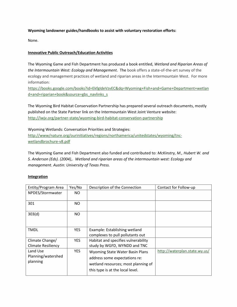
Wyoming landowner guides/handbooks to assist with voluntary restoration efforts:
None.
Innovative Public Outreach/Education Activities
The Wyoming Game and Fish Department has produced a book entitled, Wetland and Riparian Areas of the Intermountain West: Ecology and Management. The book offers a state-of-the-art survey of the ecology and management practices of wetland and riparian areas in the Intermountain West. For more information: https://books.google.com/books?id=EkfgIdeVzvEC&dq=Wyoming+Fish+and+Game+Department+wetland+and+riparian+book&source=gbs_navlinks_s
The Wyoming Bird Habitat Conservation Partnership has prepared several outreach documents, mostly published on the State Partner link on the Intermountain West Joint Venture website: http://iwjv.org/partner-state/wyoming-bird-habitat-conservation-partnership
Wyoming Wetlands: Conversation Priorities and Strategies: http://www/nature.org/ourinitiatives/regions/northamerica/unitedstates/wyoming/tnc-wetlandbrochure-v8.pdf
The Wyoming Game and Fish Department also funded and contributed to: McKinstry, M., Hubert W. and S. Anderson (Eds). (2004),. Wetland and riparian areas of the intermountain west: Ecology and management. Austin: University of Texas Press.
Integration
Entity/Program Area Yes/No Description of the Connection Contact for Follow-up NPDES/Stormwater
NO
301
NO
303(d)
NO
TMDL
YES Example: Establishing wetland complexes to pull pollutants out
Climate Change/ Climate Resiliency
YES Habitat and specifies vulnerability study by WGFD, WYNDD and TNC
Land Use Planning/watershed planning
YES Wyoming State Water Basin Plans address some expectations re: wetland resources; most planning of this type is at the local level.
http://waterplan.state.wy.us/

Flood/Hazard Mitigation
NO
Coastal Work
NO
Wildlife Action Plan YES The State’s Wildlife Action Plan is based on a wetland strategy
Written by Wyoming Department of Game and Fish
Statewide Comprehensive Outdoor Recreation Plan (SCORP)
YES Working with the Wyoming Department of Game and Fish to develop a SCORP
Other (Specify)
NO
Climate Change and Wetlands Work in Wyoming
Wyoming does not typically work on climate change issues at the state level. However, the Regional Step Down Plan in the Goshen Region includes subjective assessment of climate vulnerability. The Nature Conservancy, in partnership with the WGFD and the WYNDD published a document studying the effects of climate change on terrestrial wildlife habitats (including wetlands) and priority areas, as well as its effect on sensitive species within Wyoming. The report can be downloaded from: http://www.nature.org/ourinitiatives/regions/northamerica/unitedstates/wyoming/science/wyoming-wildlife-vulnerability-assessment-summary.pdf Adaptation Planning (Not Part of Climate Change Work) Southeast Wyoming has areas with significant wetlands that are vulnerable to long-term drought. The state is looking at supplemental water sources to provide these wetlands with water. Wyoming Game and Fish Department is looking at some drought-related issues.

State Wetland Program Development Continuum
Continuum Stage
Core Element 1: Regulation
Core Element 2: Monitoring & Assessment
Core Element 3: Wetland Water Quality Standards
Core Element 4: Voluntary Restoration
Mature Stage High 401 Certification Program
+ state permit program for non-
CWA wetlands greater than 1
acre in size
Implementation Stage
Development Stage Early Stage Low
X (small scale, basin-
by-basin efforts)
X (One narrative
standard)
X (State does not
have a program; relies on WWRNT
and Others)
Special Considerations:
Excessive selenium and mercury concentrations occur in some areas. Water development, changes in irrigation efficiency, regulated stream flows that alter floodplain access, degraded riparian areas, and coal mining impact wetlands. There is pressure to develop in Teton County.
Contact Person(s)
Chad Rieger (General Contact) Natural Resources Analyst Wyoming Department of Environmental Quality 2100 West 5th Street Sheridan, WY 82801 (307) 675-5637 [email protected] Eric Hargett (401 Permitting) Wyoming Department of Environmental Quality Hershler Building 4-W, 122 W. 25th Street Cheyenne, WA 82992 (307) 777-6701 [email protected]

Jeremy Zumberge Watershed Monitoring Program Supervisor Wyoming Department of Environmental Quality 2100 W. Fifth Street Sheridan, WY 82801 (307) 675-5638 [email protected] Steve Tessmann Wyoming Game and Fish Department 5400 Bishop Boulevard Cheyenne, WY 82006 (307) 777-4584 [email protected] Holly Copeland The Nature Conservancy 258 Main Street Lander, WY 82520 (307) 335-2129 [email protected] Additional Useful Websites
State Government Programs
1. Game & Fish Department a) Wyoming Wetlands Conservation Strategy
http://wgfd.wyo.gov/web2011/Departments/Wildlife/pdfs/HABITAT_WYWETLANDSCONSERVATION0000332.pdf
a) Riparian Information http://wgfd.wyo.gov/web2011/wildlife-1000395.aspx
2. Department of Transportation a) Wetlands Protection
http://www.dot.state.wy.us/home/engineering_technical_programs/environmental_services/wetlands.html
3. Department of Environmental Quality: Water Quality Division http://deq.state.wy.us/wqd/
a) Groundwater Pollution Control http://deq.state.wy.us/wqd/groundwater/index.asp
b) Watershed Protection Program http://deq.state.wy.us/wqd/watershed/index.asp
i. Water Quality Surface Standards

http://deq.state.wy.us/wqd/watershed/surfacestandards/index.asp ii. Nonpoint Source Program
http://deq.state.wy.us/wqd/watershed/nps/NPS.htm iii. Water Quality Assessment & TMDL Information
http://deq.state.wy.us/wqd/watershed/WyomingMethods_13_0352.pdf iv. Water Quality Certification: Clean Water Act Section 401
http://deq.state.wy.us/wqd/watershed/Downloads/401/401%20brochure%20final%202013.pdf
v. Statewide Wetland Mitigation Bank http://deq.state.wy.us/wqd/watershed/Downloads/Wetlands/wet_guidelines.pdf
vi. Monitoring Program http://deq.state.wy.us/wqd/watershed/Downloads/Monitoring/WY_strategy2010_final.pdf
4. State Engineers Office The Wyoming Constitution defines that all natural waters within the boundaries of the state are declared to be the property of the state. The Wyoming State Engineer's Office is charged with the regulation and administration of the water resources in Wyoming.
a) Groundwater Division https://sites.google.com/a/wyo.gov/seo/ground-water
b) Surface Water Division https://sites.google.com/a/wyo.gov/seo/surface-water
c) Interstate Streams Division https://sites.google.com/a/wyo.gov/seo/interstate-streams
5. Wyoming Landscape Conservation Initiative a) Aquatic Enhancement Projects
http://www.wlci.gov/habitat-projects/aquatic b) Riparian Enhancement Projects
http://www.wlci.gov/habitat-projects/riparian 6. Wyoming Natural Diversity Database – University of Wyoming
http://www.uwyo.edu/wyndd/
Federal Government Programs
1. USDA Natural Resources Conservation Service Wetlands Reserve Program Authorizations for the Wetlands Reserve Program (WRP) expired Sept. 30, 2012. No new applications for these programs can be accepted. We will continue to service prior-year contracts. http://www.nrcs.usda.gov/wps/portal/nrcs/main/wy/programs/easements/wetlands/
2. Wyoming Partners for Fish and Wildlife – US Fish and Wildlife Service http://www.fws.gov/mountain-prairie/pfw/wy/

Other Organization Wetland Programs
1. Wyoming Association of Conservation Districts http://www.conservewy.com/
a) Natural Resources & Policy Division i. Water Resources
http://www.conservewy.com/WATER.html 2. Wyoming Wetlands Society
http://wyomingwetlandssociety.org/ 3. University of Wyoming
Water Resources Data System http://www.wrds.uwyo.edu/