xlc section 508 vpat template - us forest service · web viewthis template shows how cms ilc...
TRANSCRIPT

United States Department of Agriculture US Forest Service
Natural Resource Manager (NRM)
FSVeg Common Stand Exam User Guide
Region 9 AppendicesVersion: 2.12.6
March 2015

TABLE OF CONTENTS
Appendix A: Administrative and Proclaimed Forest Codes 3 Appendix B: District Codes 4 Appendix C: State Codes 6 Appendix D: County Codes 7 Appendix E: Existing Vegetation References & Codes 14 Appendix F: Potential Vegetation references 25 Appendix G: Potential Vegetation Codes 26 Appendix H: Fuel Photo References & Codes 49
Fuel Photo Codes......................................................................................50Appendix I: Fixed Radius Plot 53
Method 1...................................................................................................54Method 2...................................................................................................57
Example 1........................................................................................58
Example 2........................................................................................58
Appendix J: Variable Radius Plot 62 Introduction...............................................................................................62Measurement of Borderline Trees to Determine “In or Out” Status..........63
Measuring “In” or “Out” Down Trees...............................................64
Appendix K: Damage Categories, Agents, Severity Ratings, and Tree Parts 81
Damage Categories..................................................................................81Damage Agents........................................................................................82Damage Severity Ratings.......................................................................100Tree Parts................................................................................................109
FSVeg Common Stand Exam User Guide i Region 9 Appendices

Appendix L: Accuracy Standards 109 Appendix M: Glossary of Terms 118 Appendix N: Fuel Models 123
FSVeg Common Stand Exam User Guide ii Region 9 Appendices

APPENDIX A: ADMINISTRATIVE AND PROCLAIMED FOREST CODES
Table 1: Region 9 codes
Admin Number
Administrative Forest Name
Proclaimed Number
Proclaimed Forest Name
03 Chippewa 03 Chippewa
04 Huron – Manistee 04 Huron
04 Huron – Manistee 24 Manistee
05 Mark Twain 05 Mark Twain
07 Ottawa 07 Ottawa
08 Shawnee 08 Shawnee
09 Superior 09 Superior
10 Hiawatha 10 Hiawatha
12 Hoosier 12 Hoosier
13 Chequamegon/Nicolet 02 Chequamegon
13 Chequamegon/Nicolet 06 Nicolet
14 Wayne 14 Wayne
15 Midewin National Tallgrass Prairie
15 Midewin National Tallgrass Prairie
19 Allegheny 19 Allegheny
20 Green Mountain–Finger Lakes 20 Green Mountain
20 Green Mountain-Finger Lakes 30 Finger Lakes
21 Monongahela 21 Monomgahela
22 White Mountain 22 White Mountain
FSVeg Common Stand Exam User Guide 3 Region 9 Appendices

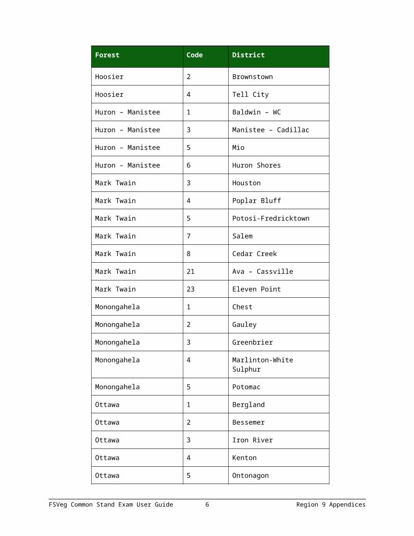
APPENDIX B: DISTRICT CODES
Table 2: Region 8 codes
Forest Code District
Allegheny 2 Marienville
Allegheny 3 Bradford
Chequamegon – Nicolet 1 Medford-Park Falls
Chequamegon – Nicolet 2 Great Divide
Chequamegon – Nicolet 3 Eagle River – Florence
Chequamegon – Nicolet 4 Lakewood – Laona
Chequamegon – Nicolet 5 Washburn
Chippewa 1 Blackduck
Chippewa 3 Deer River
Choppewa 5 Walker
Green Mountain 1 Middlebury
Green Mountain 2 Manchester
Green Mountain 3 Hector
Green Mountain 5 Rochester
Hiawatha 1 Rapid River
Hiawatha 2 Manistique
Hiawatha 3 Munising
Hiawatha 4 Sault Ste. Marie
Hiawatha 5 St. Ignace
Hoosier 2 Brownstown
Hoosier 4 Tell City
Huron – Manistee 1 Baldwin – WC
Huron – Manistee 3 Manistee – Cadillac
Huron – Manistee 5 Mio
FSVeg Common Stand Exam User Guide 4 Region 9 Appendices

Forest Code District
Huron – Manistee 6 Huron Shores
Mark Twain 3 Houston
Mark Twain 4 Poplar Bluff
Mark Twain 5 Potosi-Fredricktown
Mark Twain 7 Salem
Mark Twain 8 Cedar Creek
Mark Twain 21 Ava – Cassville
Mark Twain 23 Eleven Point
Monongahela 1 Chest
Monongahela 2 Gauley
Monongahela 3 Greenbrier
Monongahela 4 Marlinton-White Sulphur
Monongahela 5 Potomac
Ottawa 1 Bergland
Ottawa 2 Bessemer
Ottawa 3 Iron River
Ottawa 4 Kenton
Ottawa 5 Ontonagon
Ottawa 6 Watersmeet
Shawnee 2 Mississippi Bluffs
Shawnee 4 Hidden Springs
Superior 1 Laurentian
Superior 2 Gunflint
Superior 5 Kawishiwi
Superior 6 Lacroix
Superior 7 Tofte
FSVeg Common Stand Exam User Guide 5 Region 9 Appendices
Forest Code District
Wayne 1 Athens
Wayne 3 Ironton
White Mountain 1 Ammonoosuc
White Mountain 2 Androscoggin
White Mountain 3 Evans Notch
White Mountain 4 Pemigewasset
White Mountain 5 Saco
White Mountain 6 Massabesic Exp. Forest
APPENDIX C: STATE CODES
Table 3: Region 9 codes
Code State
IL Illinois
IN Indiana
ME Maine
MI Michigan
MN Minnesota
MO Missouri
NH New Hampshire
NY New York
OH Ohio
PA Pennsylvania
VT Vermont
WV West Virginia
WI Wisconsin
FSVeg Common Stand Exam User Guide 6 Region 9 Appendices

APPENDIX D: COUNTY CODES
Table 4: Illinois County codes
Code County
3 Alexander
59 Gallatin
69 Hardin
77 Jackson
87 Johnson
127 Massac
151 Pope
165 Saline
181 Union
199 Williamson
Table 5: Indiana county codes
Code County
5 Bartholomew
13 Brown
25 Crawford
37 Dubois
71 Jackson
81 Johnson
93 Lawrence
101 Martin
105 Monroe
117 Orange
123 Perry
FSVeg Common Stand Exam User Guide 7 Region 9 Appendices

Table 6: Maine county codes
Code County
17 Oxford
Table 7: Michigan county codes
Code County
1 Alcona
3 Alger
13 Baraga
33 Chippewa
39 Crawford
41 Delta
53 Gogebic
61 Houghton
69 Iosco
71 Iron
85 Lake
97 Mackinac
101 Manistee
102 Marquette
103 Mason
107 Mecosta
117 Montcalm
121 Muskegon
123 Newaygo
127 Oceana
129 Ogemaw
FSVeg Common Stand Exam User Guide 8 Region 9 Appendices

Code County
131 Ontonagon
135 Oscoda
153 Schoolcraft
165 Wexford
Table 8: Minnesota county codes
Code County
7 Beltrami
21 Cass
31 Cook
61 Itasca
75 Lake
137 St. Louis
Table 9: Missouri county codes
Code County
9 Barry
17 Bollinger
19 Boone
23 Butler
27 Callaway
35 Carter
43 Christian
55 Crawford
65 Dent
67 Douglas
FSVeg Common Stand Exam User Guide 9 Region 9 Appendices

Code County
91 Howell
93 Iron
105 Leclede
123 Madison
149 Oregon
153 Ozark
157 Perry
161 Phelps
169 Pulaski
179 Reynolds
181 Ripley
186 St. Genevieve
187 St. Francois
203 Shannon
209 Stone
213 Taney
215 Texas
221 Washington
223 Wayne
229 Wright
Table 10: New Hampshire county codes
Code County
3 Carroll
7 Coos
9 Grafton
FSVeg Common Stand Exam User Guide 10 Region 9 Appendices

Table 11: New York county codes
Code County
97 Schuyler
99 Seneca
Table 12: Ohio county codes
Code County
9 Athens
53 Gallia
75 Hocking
79 Jackson
87 Lawrence
111 Monroe
115 Morgan
121 Noble
127 Perry
131 Pike
141 Ross
145 Scioto
163 Vinton
167 Washington
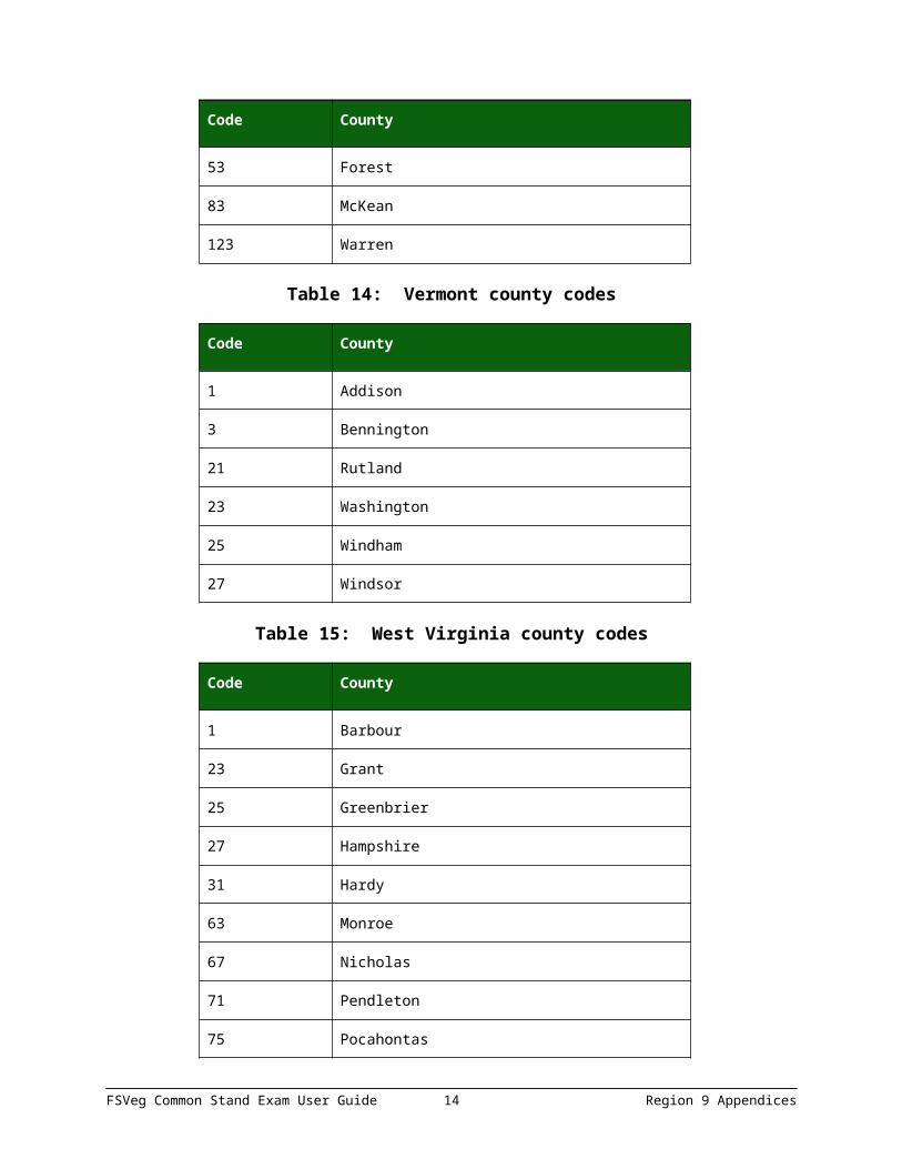
Table 13: Pennsylvania county codes
Code County
47 Elk
53 Forest
83 McKean
FSVeg Common Stand Exam User Guide 11 Region 9 Appendices

Code County
123 Warren
Table 14: Vermont county codes
Code County
1 Addison
3 Bennington
21 Rutland
23 Washington
25 Windham
27 Windsor
Table 15: West Virginia county codes
Code County
1 Barbour
23 Grant
25 Greenbrier
27 Hampshire
31 Hardy
63 Monroe
67 Nicholas
71 Pendleton
75 Pocahontas
77 Preston
83 Randolph
93 Tucker
101 Webster
FSVeg Common Stand Exam User Guide 12 Region 9 Appendices

Table 16: Wisconsin county codes
Code County
3 Ashland
7 Bayfield
37 Florence
41 Forest
67 Langlade
83 Oconto
85 Oneida
99 Price
113 Sawyer
119 Taylor
125 Vilas
APPENDIX E: EXISTING VEGETATION REFERENCES & CODES
Table 17: Existing Vegetation References
Code Name Author
FSHR9 Forest Service Handbook. Milwaukee, WI. FSH2409.21d-R9. Compartment Prescription Handbook, FSH 6/84. Amendment 20, April 1974. pp. 260.2-2.
USDA Forest Service
FIAD8 The Forest Inventory and Analysis Database: Database Description and Users Manual. Version 1.0 Gen. Tech. Rep NC-218, St. Paul, MN: U.S.D.A., Forest Service, North Central Research Station, 130pp.
U.S. Dept. of Agriculture
Table 18: Existing FSHR9 Vegetation codes
Code Description
1 Jack pine
2 Red pine
FSVeg Common Stand Exam User Guide 13 Region 9 Appendices
Code Description
3 Eastern white pine
4 Eastern white pine – hemlock
5 Hemlock
6 Scotch pine
7 Norway spruce
8 White spruce
9 Conifers (Allegheny)
10 Spruce
11 Balsam fir – aspen/paper birch
12 Black spruce
14 Red spruce – balsam fir
15 Tamarack
16 White spruce – balsam fir
17 Upland black spruce
18 Mixed swamp conifers
19 Northern white cedar – aspen/paper birch
20 Northern hardwoods – hemlock
21 Mixed northern hardwoods
22 Upland northern white cedar
23 White spruce – balsam fir – aspen
24 Balsam fir
30 Mixed pines
31 Loblolly pine
32 Shortleaf pine
33 Virginia pine
35 Eastern red cedar
FSVeg Common Stand Exam User Guide 14 Region 9 Appendices

Code Description
38 Pitch pine
41 Eastern white pine – northern red oak/white ash
42 Eastern red cedar – hardwood
43 Oak – eastern white pine
44 Shortleaf pine – oak
45 Virginia pine – hardwoods
46 Oak – shortleaf pine
47 Oak – aspen
48 Jack pine – oak
49 Red pine – oak
50 Pin oak
51 Post oak/blackjack oak
52 Chestnut oak
53 Black oak/scarlet oak/hickory
54 White oak
55 Northern red oak
56 Yellow poplar/white oak/northern red oak
57 Scarlet oak (Mark Twain)
58 Sweetgum – yellow poplar
59 Mixed oaks
60 Oak – hardwoods
61 Swamp chestnut oak/cherrybark oak/pin oak
62 Sweetgum – Nuttall oak/willow oak
63 Northern pin oak
67 Baldcypress/water tupelo
FSVeg Common Stand Exam User Guide 15 Region 9 Appendices

Code Description
70 Sugar maple – black cherry
71 Black ash – American elm/red maple
72 River birch/sycamore
73 Cottonwood
74 White ash
75 Sycamore – pecan/American elm
76 Red maple (wet site)
77 Green ash
78 Black walnut
79 Mixed lowland hardwoods
80 Sugar maple – northern red oak
81 Sugar maple – beech/yellow birch
82 Sugar maple – basswood
83 Black cherry – white ash/yellow poplar
84 Red maple (dry site)
85 Sugar maple
86 Beech
87 Sugar maple – beech – yellow birch/red spruce
88 Black locust
89 Mixed upland hardwoods
90 Sugar maple – beech/basswood
91 Quaking aspen
92 Paper birch
93 Bigtooth aspen
94 Balsam poplar
FSVeg Common Stand Exam User Guide 16 Region 9 Appendices

Code Description
95 Aspen – white spruce/balsam fir
96 Birch
97 Lowland shrubs
98 Upland shrubs
99 Open
100 Reserved for Midewin Tall Grass Prairie
101 Reserved for Midewin Tall Grass Prairie
102 Reserved for Midewin Tall Grass Prairie
103 Reserved for Midewin Tall Grass Prairie
104 Reserved for Midewin Tall Grass Prairie
105 Reserved for Midewin Tall Grass Prairie
106 Reserved for Midewin Tall Grass Prairie
107 Reserved for Midewin Tall Grass Prairie
108 Reserved for Midewin Tall Grass Prairie
109 Reserved for Midewin Tall Grass Prairie
Table 19: Existing FIADB Vegetation codes
Code Description
100 White/Red/Jack Pine Group
101 Jack pine
102 Red pine
103 Eastern white pine
104 White pine/hemlock
105 Eastern hemlock
120 Spruce/Fir Group
121 Balsam fir
FSVeg Common Stand Exam User Guide 17 Region 9 Appendices

Code Description
122 White spruce
123 Red spruce
124 Red spruce/balsam fir
125 Black spruce
126 Tamarack
127 Northern white-cedar
140 Longleaf/Slash Pine Group
141 Longleaf pine
142 Slash pine
160 Loblolly/Shortleaf Pine Group
161 Loblolly pine
162 Shortleaf pine
163 Virginia pine
164 Sand pine
165 Table-mountain pine
166 Pond pine
167 Pitch pine
168 Spruce pine
180 Pinyon/Juniper Group
181 Eastern redcedar
182 Rocky Mountain cedar
183 Western juniper
184 Juniper woodland
185 Pinyon juniper woodland
200 Douglas-fir Group
201 Douglas-fir
FSVeg Common Stand Exam User Guide 18 Region 9 Appendices

Code Description
202 Port-Orchard-fir
220 Ponderosa Pine Group
221 Ponderosa pine
222 Incense cedar
223 Jeffrey pine/Coulter pine/Bigcone Douglas-fir
224 Sugar pine
225 Jeffrey pine
226 Coulter pine
240 Western White Pine Group
241 Western white pine
260 Fir/Spruce/Mountain Hemlock Group
261 White fir
262 Red fir
263 Noble fir
264 Pacific silver fir
265 Engelmann spruce
266 Engelmann spruce/subalpine fir
267 Grand fir
268 Subalpine fir
269 Blue spruce
270 Mountain hemlock
271 Alaska-yellow-cedar
280 Lodgepole Pine Group
281 Lodgepole pine
300 Hemlock/Sitka Spruce Group
301 Western hemlock
FSVeg Common Stand Exam User Guide 19 Region 9 Appendices

Code Description
304 Western redcedar
305 Sitka spruce
320 Western Larch Group
321 Western larch
340 Redwood Group
341 Redwood
342 Giant sequoia
360 Other Western Softwoods Group
361 Knobcone pine
362 Southwest white pine
363 Bishop pine
364 Monterey pine
365 Foxtail pine/bristlecone pine
366 Limber pine
367 Whitebark pine
368 Misc. western softwoods
370 California Mixed Conifer Group
371 California mixed conifer
380 Exotic Softwoods Group
381 Scotch pine
382 Australian pine
383 Other exotic softwoods
384 Norway spruce
385 Introduced larch
390 Western cypress group
400 Oak/Pine group
FSVeg Common Stand Exam User Guide 20 Region 9 Appendices

Code Description
401 White pine/red oak/white ash
402 Eastern redcedar/hardwood
403 Longleaf pine/oak
404 Shortleaf pine/oak
405 Virginia pine/southern red oak
406 Loblolly pine/hardwood
407 Slash pine/hardwood
409 Other pine/hardwood
500 Oak/Hickory Group
501 Post oak/blackjack oak
502 Chestnut oak
503 White oak/red oak/hickory
504 White oak
505 Northern red oak
506 Yellow-poplar/white oak/red oak
507 Sassafras/persimmon
508 Sweetgum/yellow-poplar
509 Bur oak
510 Scarlet oak
511 Yellow-poplar
512 Black walnut
513 Black locust
514 Southern scrub oak
515 Chestnut oak/black oak/scarlet oak
519 Red maple/oak
520 Mixed upland hardwoods
FSVeg Common Stand Exam User Guide 21 Region 9 Appendices

Code Description
600 Oak/Gum/Cypress Group
601 Swamp chestnut oak/cherrybark oak
602 Sweetgum/Nuttall oak/willow oak
605 Overcup oak/water hickory
606 Atlantic white-cedar
607 Baldcypress/water tupelo
608 Sweetbay/swamp tupelo/red maple
700 Elm/Ash/Cottonwood Group
701 Black ash/American elm/red maple
702 River birch/sycamore
703 Cottonwood
704 Willow
705 Sycamore/pecan/American elm
706 Sugarberry/hackberry/elm/green ash
707 Silver maple/American elm
708 Red maple/lowland
709 Cottonwood/willow
722 Oregon ash
800 Maple/Beech/Birch Group
801 Sugar maple/beech/yellow-birch
802 Black cherry
803 Cherry/ash/yellow-poplar
805 Hard maple/basswood
807 Elm/ash/locust
809 Red maple/upland
900 Aspen/Birch Group
FSVeg Common Stand Exam User Guide 22 Region 9 Appendices

Code Description
901 Aspen
902 Paper birch
904 Balsam poplar
910 Alder/Maple Group
911 Red alder
912 Bigleaf maple
920 Western Oak Group
921 Gray pine
922 California black oak
923 Oregon white oak
924 Blue oak
925 Deciduous oak woodland
926 Evergreen oak woodland
931 Coast live oak
932 Canyon live oak/interior live oak
940 Tanoak/Laurel Group
941 Tanoak
942 California laurel
943 Giant chinkapin
950 Other Western Hardwoods Group
951 Pacific madrone
952 Mesquite woodland
953 Cercocarpus woodland
954 Intermountain maple woodland
955 Misc. western hardwood woodlands
960 Western woody shrublands-chaparral
FSVeg Common Stand Exam User Guide 23 Region 9 Appendices

Code Description
980 Tropical Hardwoods Group
981 Sable palm
982 Mangrove
989 Other tropical
990 Exotic Hardwoods Group
991 Paulownia
992 Melaluca
993 Eucalyptus
995 Other exotic hardwoods
999 Non stocked
APPENDIX F: POTENTIAL VEGETATION REFERENCES
Table 20: Potential Vegetation References
Code Name Author
901 Habitat Classification System Field Guide for Upper Peninsula of Michigan and Northeastern Wisconsin. CRPFS; School of Forestry and Wood Products, Michigan Technological University, Houghton, MI. 49931.
Michael S. Coffman, et. al. 1984
902 Field Guide to Ecological Classification and Inventory Systems of the Huron-Manistee National Forests. USDA Forest Service, Michigan State University, and the North Central Experiment Station.
USDA Forest Service
903 Wayne National Forest Ecological Classification Handbook. USDA Forest Service, Wayne National Forest.
Jeffery N. Pearcy, David M. Hix, and James R. McClenahen
904 Field Guide to the Native Plant Communities of Minnesota; the Lautentian Mixed Forest Province. 2003.
Minnesota Department of Natural Resources
FSVeg Common Stand Exam User Guide 24 Region 9 Appendices

Code Name Author
905 A Field Guide to Forest Communities and Habitat Types of Northern Wisconsin. Department of Ecology and Management, University of Wisconsin-Madison. 2002.
Kotar, John, J.A. Kovach, and T.L. Burger
906 A Field Guide to Forest Communities and Habitat Types of Central and Southern Wisconsin. Department of Ecology and Management, University of Wisconsin-Madison. 1996.
Kotar, John, and Timothy L. Burger
APPENDIX G: POTENTIAL VEGETATION CODES
Table 21: Reference Code 901
PV_CODE COMMON_NAME SCIENTIFIC_NAME
AOC Maple/sweetroot-cohosh ACER/OSMOR-CAULO
AQVac Maple-oak/blueberry ACER-QUERC/VACCI
AQVib Maple-oak/viburnum ACER-QUERC/VIBUR
ATD Maple-hemlock/woodfern ACER-TSUGA/DRYOP
AVO Maple/violet-sweetroot ACER/VIOLA-OSMOR
FE Ash/thoroughwort FRAXI/EUPAT
FI Ash/touch-me-not FRAXI/IMPAT
FMC Ash/mint/sedge FRAXI/MENTH/CAREX
PCS Spruce/leatherleaf/sphagnum PICEA/CHAMA5/SPHAG2
PO Spruce/osmunda PICEA/OSMUN
PVC Pine/blueberry/sedge PINUS/VACCI/CAREX
PVD Pine/blueberry/hairgrass PINUS/VACCI/DESCH
QAE Oak-maple/trailing arbutus QUERC-ACER/EPIGA
FSVeg Common Stand Exam User Guide 25 Region 9 Appendices

TAM Hemlock-maple/mitchella TSUGA-ACER/MITCH
TM Hemlock/mayflower TSUGA/MAIAN
TMC Hemlock/mayflower-goldthread TSUGA/MAIAN-COPTI
TMV Hemlock/mayflower-blueberry TSUGA/MAIAN-VACCI
TTL Hemlock-red cedar/honeysuckle TSUGA-THUJA/LONIC
TTM Hemlock-red cedar/miterwort TSUGA-THUJA/MITEL
TTP Hemlock-red cedar/butterbur TSUGA-THUJA/PETAS
TTS Hemlock-red cedar/sphagnum TSUGA-THUJA/SPHAG2
Table 22: Reference Code 902
PV_CODE COMMON_NAME SCIENTIFIC_NAME
62 Mixed oak-red maple/vaccinium (poorly drained, acidic sands)
QUERC-ACRU/VACCI
63 Northern red oak-red maple-paper birch/mayflower
QURU-ACRU-BEPA/MAIAN
64 White ash-American basswood/violet FRAM2-TIAM/VIOLA
72 Red maple-paper birch/wintergreen ACRU-BEPA/PYROL
73 Red maple-paper birch/bunchberry dogwood ACRU-BEPA/COCA13
74 Black ash-American basswood/violet FRNI-TIAM/VIOLA
80 Sedge (cattails and open water) CAREX
81 Acid organics (stagnant drainages) n/a
82 Non-acid organics (floodplains) n/a
DSH Mixed oak-red maple/starflower (dry ice-contact and sand hills)
QUERC-ACRU/TRIEN
HPM Sugar maple-beech/mayflower (herb poor ACSA3-FAGUS/MAIAN
FSVeg Common Stand Exam User Guide 26 Region 9 Appendices

moraines)
HPM42 Sugar maple/mayflower ACSA3/MAIAN
HPM43 Sugar maple-northern red oak/mayflower ACSA3-QURU/MAIAN
HRM Sugar maple-white ash/sweetroot (herb rich moraines)
ACSA3-FRAM2/OSMOR
HRM47 Sugar maple-white ash/cohosh ACSA3-FRAM2/CAULO
MSH Northern red oak-red maple/viburnum (mesic ice-contact sand hills)
QURU-ACRU/VIBUR
MSH37 Northern red oak-red maple/ticktrefoil QURU-ACRU/DESMO
OWP Black oak-white oak/blueberry (outwash plains) QUVE-QUAL/VACCI
OWP1 Northern pin oak-white oak/hairgrass QUEL-QUAL/DESCH
Table 23: Reference Code 903
PV_CODE COMMON_NAME SCIENTIFIC_NAME
10 chestnut oak-white oak/upright carrionflower QUPR2-QUAL/SMEC
11 tuliptree-sugar maple/woodland stonecrop-Canadian woodnettle
LITU-ACSA3/SETE3-LACA3
110 scarlet oak-chestnut oak/blueberry QUCO2-QUPR2/VACCI
120 shagbark hickory-pignut hickory/smooth Solomon’s seal-American pokeweed
CAOV2-CAGL8/POBI2-PHAM4
21 chestnut oak/wreath goldenrod-upright carrionflower
QUPR2/SOCA4-SMEC
211 chestnut oak-scarlet oak/smooth yellow false foxglove/poverty oatgrass
QUPR2-QUCO2/AUFL/DASP2
212 red maple-northern red oak-white oak/Canada lily/sedge
ACRU-QURU-QUAL/LICA3/CAREX
22 chestnut oak-white oak/nakedflower ticktrefoil- QUPR2-QUAL/DENU4-
FSVeg Common Stand Exam User Guide 27 Region 9 Appendices

PV_CODE COMMON_NAME SCIENTIFIC_NAME
wreath goldenrod SOCA4
221 scarlet oak-chestnut oak-white oak/whorled yellow loosestrife
QUCO2-QUPR2-QUAL/LYQU2
222 white oak-black cherry-red maple/early bluegrass-sedge
QUAL-PRSE2-ACRU/POCU4-CAREX
23 white oak/viburnum-blueberry QUAL/VIBUR-VACCI
230 white oak-black oak-sugar maple-northern red oak/Indianpipe-Bosc’s panicgrass
QUAL-QUVE-ACSA3-QURU/MOUN3-DIBO2
24 white oak/azure bluet-rue anemone QUAL/HOCA4-THTH2
31 oak/Christmas fern QUERC/POAC4
311 white oak-black oak-blackgum QUAL-QUVE-NYSY
312 northern red oak-sugar maple-American beech/hairy Solomon’s seal-lanceleaf wild licorice
QURU-ACSA3-FAGR/POPU4-GALA3
32 tuliptree-sugar maple/Canadian clearweed-Clayton’s sweetroot
LITU-ACSA3/PIPU2-OSCL
321 white oak-black oak-hickory/nakedflower ticktrefoil-American alumroot
QUAL-QUVE-CARYA/DENU4-HEAM6
322 northern red oak-sugar maple-American beech/hairy skullcap-sedge
QURU-ACSA3-FAGR/SCEL-CAREX
33 mixed hardwoods/northern spicebush-bigleaf aster
2TD/LIBE3-EUMA27
330 white oak-northern red oak-ash/nakedflower ticktrefoil-white avens
QUAL-QURU-FRAXI/DENU4-GECA7
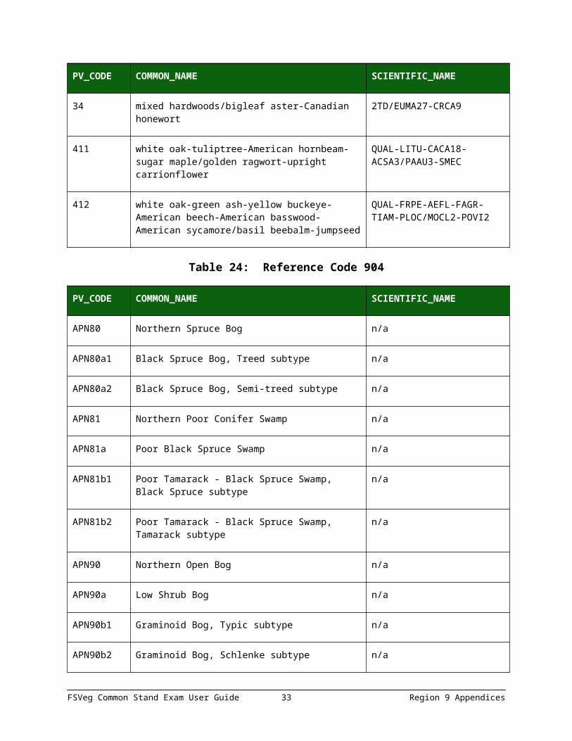
34 mixed hardwoods/bigleaf aster-Canadian honewort
2TD/EUMA27-CRCA9
411 white oak-tuliptree-American hornbeam-sugar maple/golden ragwort-upright carrionflower
QUAL-LITU-CACA18-ACSA3/PAAU3-SMEC
FSVeg Common Stand Exam User Guide 28 Region 9 Appendices

PV_CODE COMMON_NAME SCIENTIFIC_NAME
412 white oak-green ash-yellow buckeye-American beech-American basswood-American sycamore/basil beebalm-jumpseed
QUAL-FRPE-AEFL-FAGR-TIAM-PLOC/MOCL2-POVI2
Table 24: Reference Code 904
PV_CODE COMMON_NAME SCIENTIFIC_NAME
APN80 Northern Spruce Bog n/a
APN80a1 Black Spruce Bog, Treed subtype n/a
APN80a2 Black Spruce Bog, Semi-treed subtype n/a
APN81 Northern Poor Conifer Swamp n/a
APN81a Poor Black Spruce Swamp n/a
APN81b1 Poor Tamarack - Black Spruce Swamp, Black Spruce subtype
n/a
APN81b2 Poor Tamarack - Black Spruce Swamp, Tamarack subtype
n/a
APN90 Northern Open Bog n/a
APN90a Low Shrub Bog n/a
APN90b1 Graminoid Bog, Typic subtype n/a
APN90b2 Graminoid Bog, Schlenke subtype n/a
APN91 Northern Poor Fen n/a
APN91a Low Shrub Poor Fen n/a
APN91b Graminoid Poor Fen n/a
APN91c1 Graminoid Poor Fen (Water track), Featureless Water Track subtype
n/a
APN91c2 Graminoid Poor Fen (Water track), Flark n/a
FSVeg Common Stand Exam User Guide 29 Region 9 Appendices

PV_CODE COMMON_NAME SCIENTIFIC_NAME
subtype
CTN11 Northern Dry Cliff n/a
CTN11a Dry Mafic Cliff (Northern) n/a
CTN11b Dry Mafic Cliff (Northern) n/a
CTN11c Dry Thomson Cliff (Northern) n/a
CTN11d Dry Felsic Cliff (Northern) n/a
CTN11e Dry Sandstone Cliff (Northern) n/a
CTN12 Northern Open Talus n/a
CTN12a Dry Open Talus (Northern) n/a
CTN12b Mesic Open Talus (Northern) n/a
CTN24 Northern Scrub Talus n/a
CTN24a Dry Scrub Talus (Northern) n/a
CTN24b Mesic Scrub Talus (Northern) n/a
CTN32 Northern Mesic Cliff n/a
CTN32a Masic Mafic Cliff (Northern) n/a
CTN32b Mesic Rove Cliff (Northern) n/a
CTN32c Mesic Thomson Cliff (Northern) n/a
CTN32d Mesic Felsic Cliff (Northern) n/a
CTN32e Mesic Sandstone Cliff (Northern) n/a
CTN42 Northern wet Cliff n/a
CTN42a Wet Mafic Cliff (Northern) n/a
FSVeg Common Stand Exam User Guide 30 Region 9 Appendices

PV_CODE COMMON_NAME SCIENTIFIC_NAME
CTN42b Wet Rove Cliff (Northern) n/a
CTN42c Wet Felsic Cliff (Northern) n/a
CTN42d Wet Sandstone Cliff (Northern) n/a
CTU22 Lake Superior Cliff n/a
CTU22a Exposed Mafic Cliff (Lake Superior) n/a
CTU22b Exposed Felsic Cliff (Lake Superior) n/a
CTU22c Sheltered Mafic Cliff (Lake Superior) n/a
FDN12 Northern Dry-Sand Pine Woodland n/a
FDN12a Jack Pine Woodland (Sand) n/a
FDN12b Red Pine Woodland (Sand) n/a
FDN22 Northern Dry-Bedrock Pine (oak) Woodland n/a
FDN22a JackPine Woodland (Bedrock) n/a
FDN22b Red Pine - White Pine Woodland (Northeastern Bedrock)
n/a
FDN22c Pin Oak woodland (Bedrock) n/a
FDN22d Red Pine - White Pine Woodland (Eastcentral Bedrock)
n/a
FDN32 Northern Poor Dry-Mesic Mixed Woodland n/a
FDN32a Red Pine - White Pine Woodland (Canadian Shield)
n/a
FDN32b Red Pine - white Pine Woodland (Minnesota Point)
n/a
FDN32c1 Black Spruce - Jack Pine Woodland, Jack Pine - Balsam Fir
n/a
FSVeg Common Stand Exam User Guide 31 Region 9 Appendices

PV_CODE COMMON_NAME SCIENTIFIC_NAME
FDN32c2 Black Spruce - Jack Pine Woodland, Black Spruce - Feathermoss subtype
n/a
FDN32c3 Black Spruce - Jack Pine Woodland, Jack Pine - Balack Spruce - Aspen subtype
n/a
FDN32d Jack Pine - Black Spruce Woodland (Sand) n/a
FDN32e Spruce - Fir woodland (North Shore) n/a
FDN33 Northern Dry-Mesic Mixed Woodland n/a
FDN33a1 Red Pine - White Pine Woodland, Balsam Fir subtype
n/a
FDN33a2 Red Pine - White Pine Woodland, Mountain Maple subtype
n/a
FDN33b Aspen - Birch Woodland n/a
FDN33c Black Spruce Woodland n/a
FDN43 Northern Mesic Mixed Forest n/a
FDN43a White Pine - Red Pine Forest n/a
FDN43b1 Aspen - Birch Forest, Balsam Fir subtype n/a
FDN43b2 Aspen - Birch Forest, Hardwood subtype n/a
FDN43c Upland white Cedar Forest n/a
FDC12 Central Poor Dry Pine Woodland n/a
FDC12a Jack Pine - (Bearberry) woodland n/a
FDC23 Central Dry Pine Woodland n/a
FDC23a1 Jack Pine - (Yarrow) Woodland, Ericaceous Shrub subtype
n/a
FDC23a2 Jack Pine - (Yarrow) Woodland, Bur Oak - Aspen n/a
FSVeg Common Stand Exam User Guide 32 Region 9 Appendices
PV_CODE COMMON_NAME SCIENTIFIC_NAME
subtype
FDC24 Central Rich Dry Pine Woodland n/a
FDC24a1 Jack Pine - (Bush Honeysuckle) Woodland, Bracken subtype
n/a
FDC24a2 Jack Pine - (Bush Honeysuckle) Woodland, Bur Oak - Aspen subtype
n/a
FDC25 Central Dry Oak-Aspen (Pine) Woodland n/a
FDC25a Jack Pine - Oak Woodland n/a
FDC25b Oak - Aspen Woodland n/a
FDC34 Cebtral Dry-Mesic Pine-Hardwood Forest n/a
FDC34a Red Pine - White Pine Forest n/a
FDC34b Oak - Aspen Forest n/a
FFN57 Northern Terrace Forest n/a
FFN57a Black Ash - Silver Maple Terrace Forest n/a
FFN67 Northern Floodplain Forest n/a
FFN67a Silver Maple - (Sensitive Fern) Floodplain Forest n/a
FFS59 Southern Terrace Forest n/a
FFS59a Silver Maple - Green Ash - Cottonwood Terrace Forest
n/a
FFS59b Swamp White Oak Terrace Forest n/a
FFS59c Elm - Ash - Basswood Terrace Forest n/a
FPN62 Northern Rich Spruce Swamp (Basin) n/a
FPN62a Rich Black Spruce Swamp (Basin) n/a
FSVeg Common Stand Exam User Guide 33 Region 9 Appendices

PV_CODE COMMON_NAME SCIENTIFIC_NAME
FPN63 Northern Cedar Swamp n/a
FPN63a White Cedar Swamp (Northeastern) n/a
FPN63b White Cedar Swamp (Northcentral) n/a
FPN63c White Cedar Swamp (Northwestern) n/a
FPN71 Northern Rich Spruce Swamp (Water Track) n/a
FPN71a Rich Black Spruce Swamp (Water Track) n/a
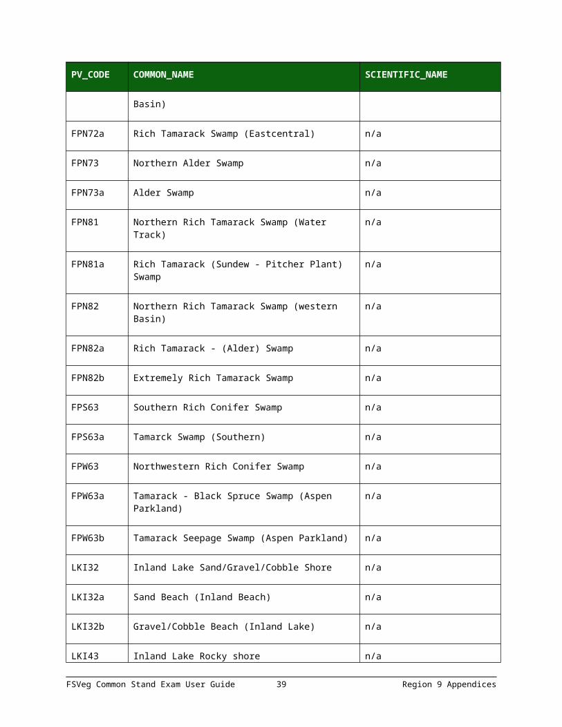
FPN72 Northern Rich Tamarack Swamp (Eastern Basin)
n/a
FPN72a Rich Tamarack Swamp (Eastcentral) n/a
FPN73 Northern Alder Swamp n/a
FPN73a Alder Swamp n/a
FPN81 Northern Rich Tamarack Swamp (Water Track) n/a
FPN81a Rich Tamarack (Sundew - Pitcher Plant) Swamp n/a
FPN82 Northern Rich Tamarack Swamp (western Basin)
n/a
FPN82a Rich Tamarack - (Alder) Swamp n/a
FPN82b Extremely Rich Tamarack Swamp n/a
FPS63 Southern Rich Conifer Swamp n/a
FPS63a Tamarck Swamp (Southern) n/a
FPW63 Northwestern Rich Conifer Swamp n/a
FPW63a Tamarack - Black Spruce Swamp (Aspen n/a
FSVeg Common Stand Exam User Guide 34 Region 9 Appendices

PV_CODE COMMON_NAME SCIENTIFIC_NAME
Parkland)
FPW63b Tamarack Seepage Swamp (Aspen Parkland) n/a
LKI32 Inland Lake Sand/Gravel/Cobble Shore n/a
LKI32a Sand Beach (Inland Beach) n/a
LKI32b Gravel/Cobble Beach (Inland Lake) n/a
LKI43 Inland Lake Rocky shore n/a
LKI43a Boulder Shore (Inland Lake) n/a
LKI43b Bedrock Shore (Inland Lake) n/a
LKI54 Linland Lake Clay/Mud Shore n/a
LKI54a Clay/Mud Shore (Inland Lake) n/a
LKI54b1 Mud Flat (Inland Lake), Saline subtype n/a
LKI54b2 Mud Flat (Inland Lake), Non-Saline subtype n/a
LKU32 Lake Superior Sand/Gravel/Cobbel Shore n/a
LKU32a Beachgrass Dune (Lake Superior) n/a
LKU32b Juniper Dune Shrubland (Lake Superior) n/a
LKU32c Sand Beach Shrubland (Lake Superior) n/a
LKU32d Beach Ridge Shrubland (Lake Superior) n/a
LKU32e Gravel/Cobble Beach (Lake Superior) n/a
LKU43 Lake Superior Rocky Shore n/a
LKU43a Dry Bedrock Shore (Lake Superior) n/a
LKU43b1 Wet Rocky Shore (Lake Superior), Cobble n/a
FSVeg Common Stand Exam User Guide 35 Region 9 Appendices

PV_CODE COMMON_NAME SCIENTIFIC_NAME
subtype
LKU43b2 Wet Rocky Shore (Lake Superior), Bedrock subtype
n/a
MHN35 Northern Mesic Hardwood Forest n/a
MHN35a Aspen - Birch - Basswood Forest n/a
MHN35b Red Oak - Sugar Maple - Basswood - (Bluebead Lily) Forest
n/a
MHN44 Northern wet-Mesic Boreal Hardwood-Conifer Forest
n/a
MHN44a Aspen - Birch - Red Maple Forest n/a
MHN44b White Pine - White Spruce - Paper Birch Forest n/a
MHN44c Aspen - Fir Forest n/a
MHN44d Aspen - Birch - Fir Forest n/a
MHN45 Northern Mesic Hardwood (Cedar) Forest n/a
MHN45a Paper Birch - Sugar Maple Forest (North Shore) n/a
MHN45b White Cedar - Yellow Birch Forest n/a
MHN45c Sugar Maple Forest (North Shore) n/a
MHN46 Northern Wet-Mesic Hardwood Forest n/a
MHN46a Aspen - Ash Forest n/a
MHN46b Black Ash - Basswood Forest n/a
MHN47 Northern Rich Mesic Hardwood Forest n/a
MHN47a Sugar Maple - Basswood - (Bluebead Lily) Forest
n/a
MHN47b Sugar Maple - Basswood - (Horsetail) Forest n/aFSVeg Common Stand Exam User Guide 36 Region 9 Appendices

PV_CODE COMMON_NAME SCIENTIFIC_NAME
MHC26 Central Dry-Mesic-Oak-Aspen Forest n/a
MHC26a Oak - Aspen - Red Maple Forest n/a
MHC26b Red Oak - Sugar Maple - Basswood - (Large-Flowered Trillium) Forest
n/a
MHC36 Central Mesic Hardwood Forest (Eastern) n/a
MHC36a Red Oak - Basswood Forest (Noncalcareous Till) n/a
MHC36b Red Oak - Basswood Forest (Calcareous Till) n/a
MHC37 Central Mesic Hardwood Forest (Western) n/a
MHC37a Aspen - (Sugar Maple -Basswood) Forest n/a
MHC37b Sugar Maple - Basswood - (Aspen) Forest n/a
MHC47 Central Wet-Mesic Hardwood Forest n/a
MHC47a Basswood - Black Ash Forest n/a
MRN83 Northern Mixed Cattail Marsh n/a
MRN83a Cattail - Sedge Marsh (Northern) n/a
MRN83b Cattail Marsh (Northern) n/a
MRN93 Northern Bulrush-Spikerush Marsh n/a
MRN93a Bulrush Marsh (Northern) n/a
MRN93b Spikerush - Bur Reed Marsh (Northern) n/a
MRU94 Lake Superior Coastal Marsh n/a
MRU94a Estuary Marsh (Lake Superior) n/a
OPN81 Northern Shrub Shore Fen n/a
FSVeg Common Stand Exam User Guide 37 Region 9 Appendices

PV_CODE COMMON_NAME SCIENTIFIC_NAME
OPN81a Bog Birch - Alder Shore Fen n/a
OPN81b Bog Birch - Alder Shore Fen n/a
OPN91 Northern Rich Fen (Water Track) n/a
OPN91a Shrub Rich Fen (water Track) n/a
OPN91b1 Graminoid Rich Fen (Water Track), Featureless Water Track subtype
n/a
OPN91b2 Graminoid Rich Fen (Water Track), Flark subtype
n/a
OPN92 Northern Rich Fen (Basin) n/a
OPN92a Graminoid Rich Fen (Basin) n/a
OPN92b Graminoid - Sphagnum Rich Fen (Basin) n/a
OPN93 Northern Extremely Rich Fen n/a
OPN93a Spring Fen n/a
RON12 Northern Bedrock Outcrop n/a
RON12a Sandstone Outcrop (Northern) n/a
RON12b Crystalline Bedrock Outcrop (Northern) n/a
RON23 Northern Bedrock Shrubland n/a
RON23a Bedrock Shrubland (Inland) n/a
RON23b Bedrock Shrubland (Lake Superior) n/a
RVX32 Sand/Gravel/Cobble River Shore n/a
RVX32a Willow Sandbar Shrubland (River) n/a
FSVeg Common Stand Exam User Guide 38 Region 9 Appendices
PV_CODE COMMON_NAME SCIENTIFIC_NAME
RVX32b1 Sand Beach/Sandbar (River), Intermittent Streambed subtype
n/a
RVX32b2 Sand Beach/Sandbar (River), Permanent Stream subtype
n/a
RVX32c1 Gravel/Cobble Beach (River), Intermittent Streambed subtype
n/a
RVX32c2 Gravel/Cobble Beach (River), Permanent Stream subtype
n/a
RVX43 Rocky River Shore n/a
RVX43a1 Bedrock/Boulder Shore (River), Intermittent Streambed subtype
n/a
RVX43a2 Bedrock/Boulder Shore (River), Permanent Stream subtype
n/a
RVX54 Clay/Mud River Shore n/a
RVX54a Slumping Clay/Mud Slope (River) n/a
RVX54b1 Clay/Mud Shore (River), Intermittent Streambed subtype
n/a
RVX54b2 Clay/Mud Shore (River), Permanent Stream subtype
n/a
WFN53 Northern Wet Cedar Forest n/a
WFN53a Lowland White Cedar Forest (North Shore) n/a
WFN53b Lowland White Cedar Forest (Northern) n/a
WFN55 Northern Wet Ash Swamp n/a
WFN55a Black Ash - Aspen - Balsam Poplar Swamp (Northeastern)
n/a
WFN55b Black Ash - Yellow Birch - Red Maple - Basswood Swamp (Eastcentral)
n/a
FSVeg Common Stand Exam User Guide 39 Region 9 Appendices

PV_CODE COMMON_NAME SCIENTIFIC_NAME
WFN55c Black Ash - Mountain Maple Swamp (Northern) n/a
WFN64 Northern Very Wet Ash Swamp n/a
WFN64a Black Ash - Conifer Swamp (Northeastern) n/a
WFN64b Black Ash - Yellow Birch - Red Maple - Alder Swamp (Eastcentral)
n/a
WFN64c Black Ash - Alder Swamp (Northern) n/a
WFS57 Southern Wet Ash Swamp n/a
WFS57a Black Ash - (Red Maple) Seepage Swamp n/a
WFS57b Black Ash - Sugar Maple - Basswood - (Blue Beech) Seepage Swamp
n/a
WFS57c Black Ash - Basswood Seepage Swamp n/a
WFW54 Northwestern Wet Aspen Forest n/a
WFW54a Lowland Black Ash - Aspen - Balsam Poplar Forest
n/a
WMN82 Northern Wet Meadow/Carr n/a
WMN82a Willow - Dogwood Shrub Swamp n/a
WMN82b1 Sedge Meadow, Bluejoint subtype n/a
WMN82b2 Sedge Meadow, Tussock Sedge subtype n/a
WMN82b3 Sedge Meadow, Beaked Sedge subtype n/a
WMN82b4 Sedge Meadow, Lake Sedge subtype n/a
Table 25: Reference Code 905
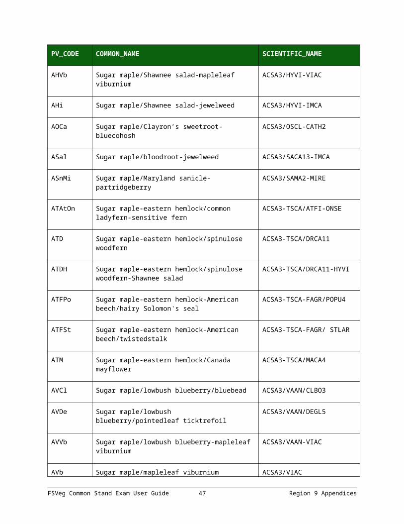
PV_CODE COMMON_NAME SCIENTIFIC_NAME
AAs Sugar maple/Jack in the pulpit ACSA3/ARTRT3
FSVeg Common Stand Exam User Guide 40 Region 9 Appendices

PV_CODE COMMON_NAME SCIENTIFIC_NAME
AAt Sugar maple/common ladyfern ACSA3/ATFI
AAtRp Sugar maple/common ladyfern-dwarf red blackberry
ACSA3/ATFI-RUPU
ACaCi Sugar maple/blue cohosh-broadleaf enchanter’s nightshade
ACSA3/CATH2-CILUC
ACal Sugar maple/blue cohosh-jewelweed ACSA3/CATH2-IMCA
ACl Sugar maple/bluebead ACSA3/CLBO3
AFAd Sugar maple-American beech/northern maidenhair
ACSA3-FAGR/ADPE
AFAl Sugar maple-American beech/wild leek ACSA3-FAGR/ALTR3
AFTD Sugarmaple-eastern henlock-American beech/spinulose woodfern
ACSA3-TSCA-FAGR/DRCA11
AFVb Sugar maple-American beech/mapleleaf viburnium
ACSA3-FAGR/VIAC
AH Sugar maple/Shawnee salad ACSA3/HYVI
AHVb Sugar maple/Shawnee salad-mapleleaf viburnium
ACSA3/HYVI-VIAC
AHi Sugar maple/Shawnee salad-jewelweed ACSA3/HYVI-IMCA
AOCa Sugar maple/Clayron’s sweetroot-bluecohosh ACSA3/OSCL-CATH2
ASal Sugar maple/bloodroot-jewelweed ACSA3/SACA13-IMCA
ASnMi Sugar maple/Maryland sanicle-partridgeberry ACSA3/SAMA2-MIRE
ATAtOn Sugar maple-eastern hemlock/common ladyfern-sensitive fern
ACSA3-TSCA/ATFI-ONSE
ATD Sugar maple-eastern hemlock/spinulose woodfern
ACSA3-TSCA/DRCA11
FSVeg Common Stand Exam User Guide 41 Region 9 Appendices

PV_CODE COMMON_NAME SCIENTIFIC_NAME
ATDH Sugar maple-eastern hemlock/spinulose woodfern-Shawnee salad
ACSA3-TSCA/DRCA11-HYVI
ATFPo Sugar maple-eastern hemlock-American beech/hairy Solomon's seal
ACSA3-TSCA-FAGR/POPU4
ATFSt Sugar maple-eastern hemlock-American beech/twistedstalk
ACSA3-TSCA-FAGR/ STLAR
ATM Sugar maple-eastern hemlock/Canada mayflower
ACSA3-TSCA/MACA4
AVCl Sugar maple/lowbush blueberry/bluebead ACSA3/VAAN/CLBO3
AVDe Sugar maple/lowbush blueberry/pointedleaf ticktrefoil
ACSA3/VAAN/DEGL5
AVVb Sugar maple/lowbush blueberry-mapleleaf viburnium
ACSA3/VAAN-VIAC
AVb Sugar maple/mapleleaf viburnium ACSA3/VIAC
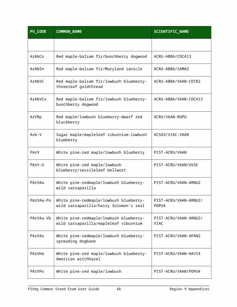
ArAbCo Red maple-balsam fir/bunchberry dogwood ACRU-ABBA/COCA13
ArAbSn Red maple-balsam fir/Maryland sanicle ACRU-ABBA/SAMA2
ArAbVC Red maple-balsam fir/lowbush blueberry-threeleaf goldthread
ACRU-ABBA/VAAN-COTR2
ArAbVCo Red maple-balsam fir/lowbush blueberry-bunchberry dogwood
ACRU-ABBA/VAAN-COCA13
ArVRp Red maple/lowbush blueberry-dwarf red blackberry
ACRU/VAAN-RUPU
Avb-V Sugar maple/mapleleaf viburnium-lowbush blueberry
ACSA3/VIAC-VAAN
PArV White pine-red maple/lowbush blueberry PIST-ACRU/VAAN
PArV-U White pine-red maple/lowbush blueberry/sessileleaf bellwort
PIST-ACRU/VAAN/UVSE
PArVAa White pine-redmaple/lowbush blueberry-wild PIST-ACRU/VAAN-ARNU2
FSVeg Common Stand Exam User Guide 42 Region 9 Appendices

PV_CODE COMMON_NAME SCIENTIFIC_NAME
sarsaparilla
PArVAa-Po White pine-redmaple/lowbush blueberry-wild sarsaparilla/hairy Solomon's seal
PIST-ACRU/VAAN-ARNU2/POPU4
PArVAa-Vb White pine-redmaple/lowbush blueberry-wild sarsaparilla/mapleleaf viburnium
PIST-ACRU/VAAN-ARNU2/VIAC
PArVAo White pine-redmaple/lowbush blueberry-spreading dogbane
PIST-ACRU/VAAN-APAN2
PArVHa White pine-red maple/lowbush blueberry-American witchhazel
PIST-ACRU/VAAN-HAVI4
PArVPo White pine-red maple/lowbush blueberry/hairy Solomon's seal
PIST-ACRU/VAAN/POPU4
PArVRh Eastern white pine-red maple/lowbush blueberry-bristly dewbwrry
PIST-ACRU/VAAN-RUHI
PQE White pine-northern red oak/trailing arbutus PIST-QURU/EPRE2
PQG White pine-oak/eastern teaberry PIST-QUERC/GAPR2
PQGCe White pine-oak/eastern teaberry-New Jersey tea
PIST-QUERC/GAPR2-CEAM
Par/Vam White pine-red maple/lowbush blueberry-American hogpeanut
PIST-ACRU/VAAN-AMPR2
Qap White oak-oak/leadplant QUAL-QUERC/AMCA6
TFAa Eastern hemlock-American beech/wild sarsaparilla
TSCA-FAGR/ARNU2
TMC Eastern hemlock/Canada mayflower-threeleaf goldthread
TSCA/MACA4-COTR2
Table 26: Reference Code 906
PV_CODE COMMON_NAME SCIENTIFIC_NAME
AArL Sugar maple-red maple/fourflower yellow ACSA3-ACRU/LYQU
FSVeg Common Stand Exam User Guide 43 Region 9 Appendices

PV_CODE COMMON_NAME SCIENTIFIC_NAME
loosestrife
AArVb Sugar maple-red maple/mapleleaf viburnium ACSA3-ACRU/VIAC
AFAs Sugar maple-American beech/Jack in the pulpit ACSA3-FAGR/ARISA
AFAs-O Sugar maple-American beech/Jack in the pulpit-sweetroot
ACSA3-FAGR/ARISA-OSMOR
AFH Sugar maple-American beech/waterleaf ACSA3-FAGR/HYDRO4
AFTD Sugar maple-American beech-hemlock/spinulose woodfern
ACSA3-FAGR-TSUGA/DRCA11
AFrDe Sugar maple-white ash/pointedleaf ticktrefoil ACSA3-FRAM2/DEGL5
AFrDe-O Sugar maple-white ash/pointedleaf ticktrefoil-sweetroot
ACSA3-FRAM2/DEGL5-OSMOR
AFrDe-Vb Sugar maple-white ash/ticktrefoil-viburnium ACSA3-FRAM2/DESMO-VIBUR
AQVb-Gr Sugar maple-oak/mapleleaf viburnum-spotted geranium
ACSA3-QUERC/VIAC-GEMA
ATDe Sugar maple-basswood/ticktrefoil ACSA3-TILIA/DESMO
ATDe-Pr Sugarmaple-basswood/ticktrefoil-black cherry ACSA3-TILIA/DESMO-PRSE2
ATiAs-De Sugar maple-basswood/Jack in the pulpit-ticktrefoil
ACSA3-TILIA/ARISA-DESMO
ATiCa Sugar maple-basswood/blue cohosh-laportea ACSA3-TILIA/CATH2
ATiCa-Al Sugar maple-basswood/blue cohosh-onion ACSA3-TILIA/CATH2-ALLIU
ATiCa-La Sugar maple-basswood/blue cohosh-laportea ACSA3-TILIA/CATH2-LAPOR
ATiCr-As Sugar maple-basswood/gray dogwood-Jack in the pulpit
ACSA3-TILIA/CORA6-ARISA
ATiCr-O Sugar maple-basswood/gray dogwood-sweetroot
ACSA3-TILIA/CORA6-OSMOR
FSVeg Common Stand Exam User Guide 44 Region 9 Appendices

PV_CODE COMMON_NAME SCIENTIFIC_NAME
ATiDe-As Sugar maple-basswood/ticktrefoil-Jack in the pulpit
ACSA3-TILIA/DESMO-ARISA
ATiDe-Ha Sugar maple-basswood/ticktrefoil-witchhazel ACSA3-TILIA/DESMO-HAMAM
ATiFrCa Sugar maple-basswood-whiteash/blue cohosh ACSA3-TILIA-FRAM2/CATH2
ATiFrCa-O Sugar maple-basswood-white ash/blue cohosh-sweetroot
ACSA3-TILIA-FRAM2/CATH2-OSMOR
ATiFrCi Sugar maple-basswood-white ash/broadleaf enchanter’s nightshade
ACSA3-TILIA-FRAM2/CILUC
ATiFrVb Sugar maple-basswood-white ash/viburnium ACSA3-TILIA-FRAM2/VIBUR
ATiFrVb-Cr Sugar maple-basswood-white ash/viburnium-gray dogwood
ACSA3-TILIA-FRAM2/VIBUR-CORA6
ATiH Sugar maple-basswood/waterleaf ACSA3-TILIA/HYDRO4
ATiSa Sugar maple-basswood/bloodroot ACSA3-TILIA/SACA13
ATiSa-De Sugar maple-basswood/bloodroot-ticktrefoil ACSA3-TILIA/SACA13-DESMO
ATiTr Sugar maple-hemlock/starflower ACSA3-TSUGA/TRIEN
ArCi Red maple/enchanter’s nightshade ARCU/CIRCA
ArCi-Ph Red maple/enchanter’s nightshade-phrym ARCU/CIRCA-PHRYM
ArDe Red maple/ticktrefoil ACRU/DESMO
ArDe-V Red maple/ticktrefoil-blueberry ACRU/DESMO-VACCI
PEu Eastern white pine/flowering spurge PIST/EUCO10
PVCr Eastern white pine/blueberry-gray dogwood PIST/VACCI-CORA6
PVGy Eastern white pine/blueberry-huckleberry PIST/VACCI-GAYLU
PVHa Eastern white pine/blueberry-witchhazel PIST/VACCI-HAMAM
FSVeg Common Stand Exam User Guide 45 Region 9 Appendices

PV_CODE COMMON_NAME SCIENTIFIC_NAME
PVRh Eastern white pine/blueberry-bristly dewberry PIST/VACCI-RUHI
PVg Eastern white pine/blueberry-snowberry PIST/VACCU-GAULT
Table 27: Reference Code 907
PV_CODE COMMON_NAME SCIENTIFIC_NAME
PVDc Eastern white pine/lowbush blueberry-wavy hairgrass
PIST/VAAN-DEFL
PVCx Eastern white pine/lowbush blueberry-sedge PIST/VAAN-CAREX
PQE Eastern white pine-northern red oak/trailing arbutus
PIST-QURU/EPRE2
PArV Eastern white pine-red maple/lowbush blueberry
PIST-ACRU/VAAN
PArVw Eastern white pine-red maple/lowbush blueberry (Wisconsin variant)
PIST-ACRU/VAAN (Wisconsin variant)
PArVAa Eastern white pine-red maple/lowbush blueberry-wild sarsaparilla
PIST-ACRU/VAAN-ARNU2
PArVAaw Eastern white pine-red maple/lowbush blueberry-wild sarsaparilla (Wisconsin variant)
PIST-ACRU/VAAN-ARNU2 (Wisconsin variant)
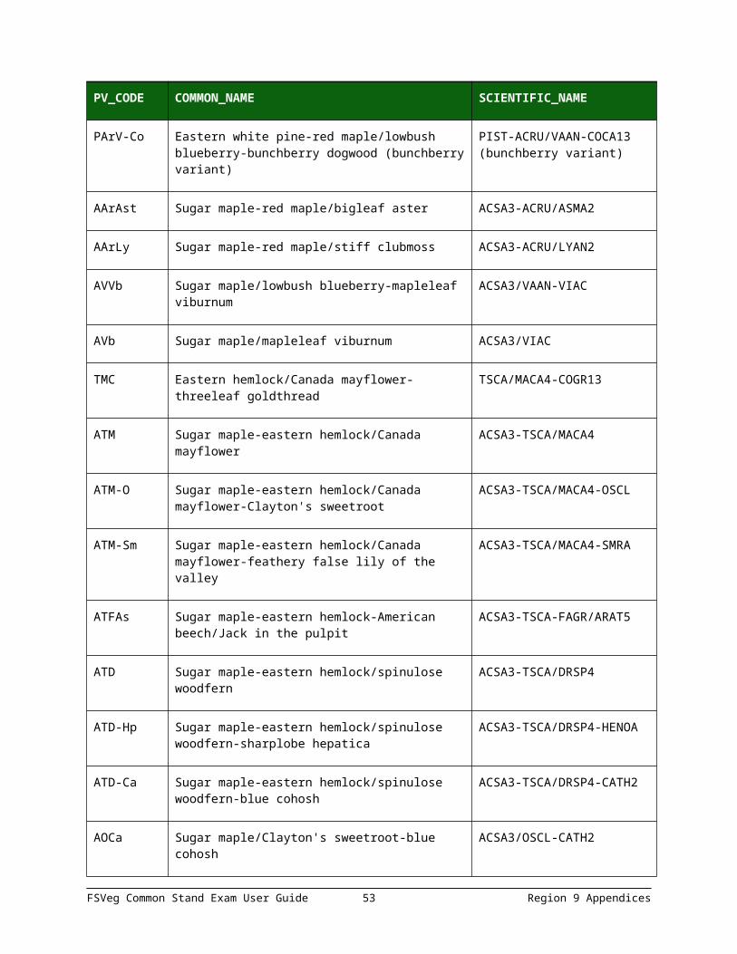
PArV-Co Eastern white pine-red maple/lowbush blueberry-bunchberry dogwood (bunchberry variant)
PIST-ACRU/VAAN-COCA13 (bunchberry variant)
AArAst Sugar maple-red maple/bigleaf aster ACSA3-ACRU/ASMA2
AArLy Sugar maple-red maple/stiff clubmoss ACSA3-ACRU/LYAN2
AVVb Sugar maple/lowbush blueberry-mapleleaf viburnum
ACSA3/VAAN-VIAC
AVb Sugar maple/mapleleaf viburnum ACSA3/VIAC
FSVeg Common Stand Exam User Guide 46 Region 9 Appendices
PV_CODE COMMON_NAME SCIENTIFIC_NAME
TMC Eastern hemlock/Canada mayflower-threeleaf goldthread
TSCA/MACA4-COGR13
ATM Sugar maple-eastern hemlock/Canada mayflower
ACSA3-TSCA/MACA4
ATM-O Sugar maple-eastern hemlock/Canada mayflower-Clayton's sweetroot
ACSA3-TSCA/MACA4-OSCL
ATM-Sm Sugar maple-eastern hemlock/Canada mayflower-feathery false lily of the valley
ACSA3-TSCA/MACA4-SMRA
ATFAs Sugar maple-eastern hemlock-American beech/Jack in the pulpit
ACSA3-TSCA-FAGR/ARAT5
ATD Sugar maple-eastern hemlock/spinulose woodfern
ACSA3-TSCA/DRSP4
ATD-Hp Sugar maple-eastern hemlock/spinulose woodfern-sharplobe hepatica
ACSA3-TSCA/DRSP4-HENOA
ATD-Ca Sugar maple-eastern hemlock/spinulose woodfern-blue cohosh
ACSA3-TSCA/DRSP4-CATH2
AOCa Sugar maple/Clayton's sweetroot-blue cohosh ACSA3/OSCL-CATH2
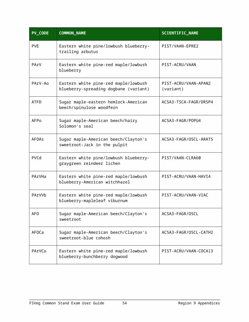
PVE Eastern white pine/lowbush blueberry-trailing arbutus
PIST/VAAN-EPRE2
PArV Eastern white pine-red maple/lowbush blueberry
PIST-ACRU/VAAN
PArV-Ao Eastern white pine-red maple/lowbush blueberry-spreading dogbane (variant)
PIST-ACRU/VAAN-APAN2 (variant)
ATFD Sugar maple-eastern hemlock-American beech/spinulose woodfern
ACSA3-TSCA-FAGR/DRSP4
AFPo Sugar maple-American beech/hairy Solomon's seal
ACSA3-FAGR/POPU4
AFOAs Sugar maple-American beech/Clayton's sweetroot-Jack in the pulpit
ACSA3-FAGR/OSCL-ARAT5
PVCd Eastern white pine/lowbush blueberry- PIST/VAAN-CLRA60
FSVeg Common Stand Exam User Guide 47 Region 9 Appendices
PV_CODE COMMON_NAME SCIENTIFIC_NAME
graygreen reindeer lichen
PArVHa Eastern white pine-red maple/lowbush blueberry-American witchhazel
PIST-ACRU/VAAN-HAVI4
PArVVb Eastern white pine-red maple/lowbush blueberry-mapleleaf viburnum
PIST-ACRU/VAAN-VIAC
AFO Sugar maple-American beech/Clayton's sweetroot
ACSA3-FAGR/OSCL
AFOCa Sugar maple-American beech/Clayton's sweetroot-blue cohosh
ACSA3-FAGR/OSCL-CATH2
PArVCo Eastern white pine-red maple/lowbush blueberry-bunchberry dogwood
PIST-ACRU/VAAN-COCA13
APPENDIX H: FUEL PHOTO REFERENCES & CODES
Table 28: Fuel Photo References
Code Reference
18 Ottmar, Roger D. and R.E. Vihnanek. 1999. Stereo Photo Series for Quantifying Natural Fuels. Volume V: Midwest Red and White Pine, Northern Tallgrass Prairie, and Mixed Oak Types in the Central Lake States. PMS 834. Boise, ID: National Wildfire Coordinating Group, National Interagency Fire Center. 99 p. 1999. (includes Volume Va: Jack Pine in the Lake States)
25 Frederick Wilcox, John McCarty and Barry Bungard. 1982. Photo Series for Quantifying Residues in the: Northern Hardwood Type and Oak-Hickory Type. USDA Forest Service, NA-FR-22.
31 Richard W. Blank. 1982. Stereo Photos for Evaluating Jack Pine Slash Fuels. Gen. Tech. Rep. NC-77, St. Paul, MN: U.S. Dept. of Ag., Forest Service, North Central Forest Experiment Station; 23 p.
FSVeg Common Stand Exam User Guide 48 Region 9 Appendices

FUEL PHOTO CODES
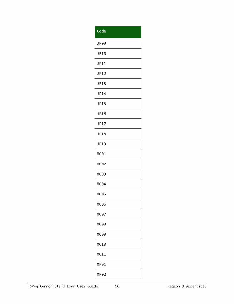
Table 29: Fuel Photo Codes for Reference 18
Code
JP01
JP02
JP03
JP04
JP05
JP06
JP07
JP08
JP09
JP10
JP11
JP12
JP13
JP14
JP15
JP16
JP17
JP18
JP19
MO01
MO02
MO03
MO04
MO05
FSVeg Common Stand Exam User Guide 49 Region 9 Appendices

Code
MO06
MO07
MO08
MO09
MO10
MO11
MP01
MP02
MP03
MP04
MP05
MP06
MP07
MP08
MP09
MP10
MP11
MP12
MP13
TP01
TP02
TP03
TP04
TP05
TP06
TP07
FSVeg Common Stand Exam User Guide 50 Region 9 Appendices

Code
TP08
TP09
TP10
TP11
TP12
TP13
TP14
TP15
TP16
TP17
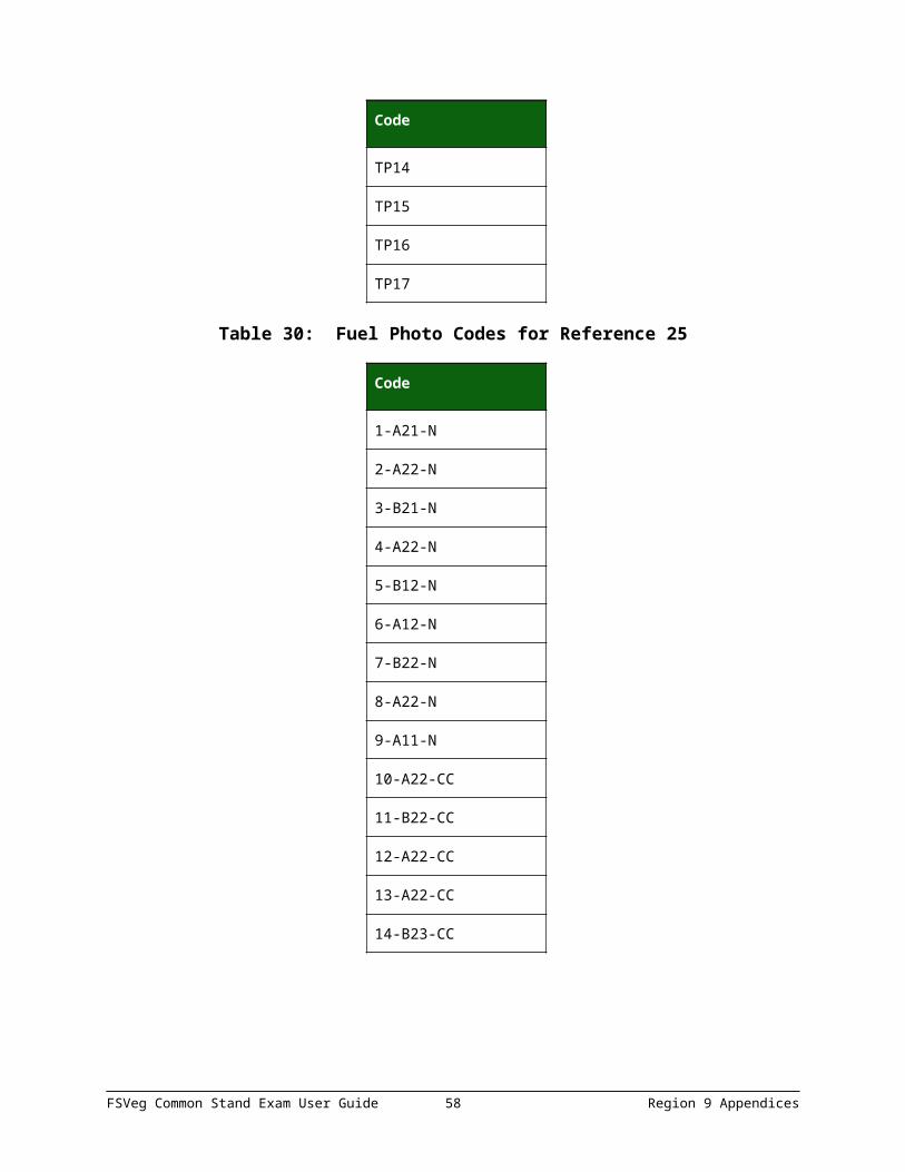
Table 30: Fuel Photo Codes for Reference 25
Code
1-A21-N
2-A22-N
3-B21-N
4-A22-N
5-B12-N
6-A12-N
7-B22-N
8-A22-N
9-A11-N
10-A22-CC
11-B22-CC
12-A22-CC
13-A22-CC
FSVeg Common Stand Exam User Guide 51 Region 9 Appendices

Code
14-B23-CC
Table 31: Fuel Photo Codes for Reference 31
Code
1
2
3
4
5
6
7
8
9
10
APPENDIX I: FIXED RADIUS PLOT
A fixed radius plot is used to sample trees that are less than the specified breakpoint diameter. These sample trees are determined to be “in” or “out” at ground line. If the measured distance from plot center to the central axis of the tree at ground line is equal to or less than the fixed plot radius the tree is tallied as a sample tree. If this distance is greater than the fixed plot radius, the tree is not tallied.
Figure 1: Trees “in” and “out” of fixed radius plot
FSVeg Common Stand Exam User Guide 52 Region 9 Appendices
On level ground, the fixed plot radius is determined by holding the measuring tape or pole in a horizontal position from plot center to the central axis of the sample tree. On slopes greater than 9 percent, if a measuring tape or pole cannot be horizontally from plot center to the central axis of the sample tree, the fixed plot radius is corrected for the slope percent by using one of the following methods.
METHOD 1
Correct the fixed plot radius for slope percent using the “Circular Plot Radii Corrected for Slope” table and then measuring distances parallel to the ground line. This method always results in a circular plot on the slope. Example – 1/300 acre fixed plot on 50 percent slope. Corrected fixed plot radius is 7.2 feet.
Figure 2: Correcting the fixed plot radius for slope percent
Table 32: Circular Plot Radii Corrected for Slope; plot size in acres
Slope % 1/300 1/100 1/50 1/20 1/10 1/5
0-9 6.8 11.8 16.7 26.3 37.2 52.7
10-17 6.8 11.8 16.7 26.5 37.4 52.9
18-22 6.9 11.9 16.8 26.6 37.6 53.2
23-26 6.9 12.0 16.9 26.7 37.8 53.4
27-30 6.9 12.0 17.0 26.9 38.0 53.7
31-33 7.0 12.1 17.1 27.0 38.2 54.0
34-36 7.0 12.1 17.1 27.1 38.3 54.2
37-39 7.0 12.2 17.2 27.2 38.5 54.5
40-42 7.1 12.2 17.3 27.4 38.7 54.7
43-44 7.1 12.3 17.4 27.5 38.9 55.0
FSVeg Common Stand Exam User Guide 53 Region 9 Appendices
Slope % 1/300 1/100 1/50 1/20 1/10 1/5
45-47 7.1 12.3 17.5 27.6 39.1 55.2
48-49 7.2 12.4 17.5 27.7 39.2 55.5
50-51 7.2 12.5 17.6 27.9 39.4 55.7
52-53 7.2 12.5 17.7 28.0 39.6 56.0
54-55 7.3 12.6 17.8 28.1 39.8 56.2
56-57 7.3 12.6 17.9 28.2 39.9 56.5
58-59 7.3 12.7 17.9 28.4 40.1 56.7
60-61 7.4 12.7 18.0 28.5 40.3 57.0
62-63 7.4 12.8 18.1 28.6 40.4 57.2
64-65 7.4 12.8 18.2 28.7 40.6 57.4
66-67 7.4 12.9 18.2 28.8 40.8 57.7
68-69 7.5 13.0 18.3 29.0 41.0 57.9
70 7.5 13.0 18.4 29.1 41.1 58.2
71-72 7.5 13.1 18.5 29.2 41.3 58.4
73-74 7.6 13.1 18.5 29.3 41.5 58.6
75 7.6 13.2 18.6 29.4 41.6 58.7
76-77 7.6 13.2 18.7 29.6 41.8 59.1
78-79 7.7 13.3 18.8 29.7 42.0 59.3
80 7.7 13.3 18.8 29.8 42.1 59.6
81-82 7.7 13.4 18.9 29.9 42.3 59.8
83 7.8 13.4 19.0 30.0 42.5 60.0
84-85 7.8 13.5 19.1 30.1 42.6 60.3
86 7.8 13.5 19.1 30.3 42.8 60.5
87-88 7.8 13.6 19.2 30.4 42.9 60.7
89 7.9 13.6 19.3 30.5 43.1 61.0
90-91 7.9 13.7 19.3 30.6 43.3 61.2
FSVeg Common Stand Exam User Guide 54 Region 9 Appendices

Slope % 1/300 1/100 1/50 1/20 1/10 1/5
92 7.9 13.7 19.4 30.7 43.4 61.4
93-94 8.0 13.8 19.5 30.8 43.6 61.6
95 8.0 13.8 19.6 30.9 43.7 61.9
96-97 8.0 13.9 19.6 31.0 43.9 62.1
98 8.0 13.9 19.7 31.2 44.1 62.3
99-100 8.1 14.0 19.8 31.3 44.2 62.5
101 8.1 14.0 19.8 31.4 44.4 62.8
102 8.1 14.1 19.9 31.5 44.5 63.0
103-104 8.2 14.1 20.0 31.6 44.7 63.2
105 8.2 14.2 20.1 31.7 44.8 63.4
106-107 8.2 14.2 20.1 31.8 45.0 63.6
108 8.2 14.3 20.2 31.9 45.1 63.8
109 8.3 14.3 20.3 32.0 45.3 64.1
110-111 8.3 14.4 20.3 32.1 45.5 64.3
112 8.3 14.4 20.4 32.2 45.6 64.5
113 8.4 14.5 20.5 32.4 45.8 64.7
114-115 8.4 14.5 20.5 32.5 45.9 64.9
116 8.4 14.6 20.6 32.6 46.1 65.1
117 8.4 14.6 20.7 32.7 46.2 65.3
118-119 8.5 14.7 20.7 32.8 46.4 65.6
120 8.5 14.7 20.8 32.9 46.5 65.8
121 8.5 14.8 20.9 33.0 46.7 66.0
122 8.5 14.8 20.9 33.1 46.8 66.2
123-124 8.6 14.8 21.0 33.2 47.0 66.4
125 8.6 14.9 21.1 33.3 47.1 66.6
130 8.7 15.1 21.3 33.7 47.7 67.4
FSVeg Common Stand Exam User Guide 55 Region 9 Appendices
Slope % 1/300 1/100 1/50 1/20 1/10 1/5
135 8.8 15.3 21.6 34.1 48.3 68.3
140 8.9 15.4 21.8 34.5 48.8 69.1
145 9.0 15.6 22.1 34.9 49.4 69.9
150 9.1 15.8 22.3 35.3 50.0 70.0
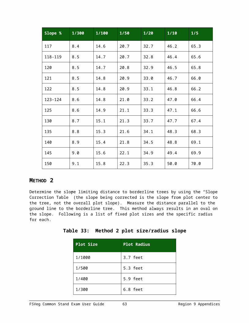
METHOD 2
Determine the slope limiting distance to borderline trees by using the “Slope Correction Table” (the slope being corrected is the slope from plot center to the tree, not the overall plot slope). Measure the distance parallel to the ground line to the borderline tree. This method always results in an oval on the slope. Following is a list of fixed plot sizes and the specific radius for each.
Table 33: Method 2 plot size/radius slope
Plot Size Plot Radius
1/1000 3.7 feet
1/500 5.3 feet
1/400 5.9 feet
1/300 6.8 feet
1/250 7.4 feet
1/200 8.3 feet
1/150 9.6 feet
1/100 11.8 feet
1/50 16.7 feet
1/20 26.3 feet
1/10 37.2 feet
1/5 52.7 feet
1/4 58.9 feet
1/3 68.0 feet
1/2 83.3 feet
FSVeg Common Stand Exam User Guide 56 Region 9 Appendices

Plot Size Plot Radius
1 117.8 feet
To determine the slope limiting distance, multiply the plot radius for the appropriate plot size by the appropriate slope correction factor.
Example 11/300 acre fixed plot with a borderline tree on a 45 percent slope. A 1/300-acre plot equals a 6.8-foot radius and the slope correction factor for a 45 percent slope is 1.10. 6.8 x 1.10 = 7.48; thus, a tree on a 1/300 acre fixed plot at a 45 percent slope can be 7.5 feet from plot center.
Example 2The same plot has another borderline tree on a 25 percent slope. The slope correction factor for a 25 percent slope is 1.03. 6.8 x 1.03 = 7.0; thus, a tree on a 1/300 acre fixed plot at a 25 percent slope can be 7.0 feet from plot center.
Figure 3: Plot size radius slope
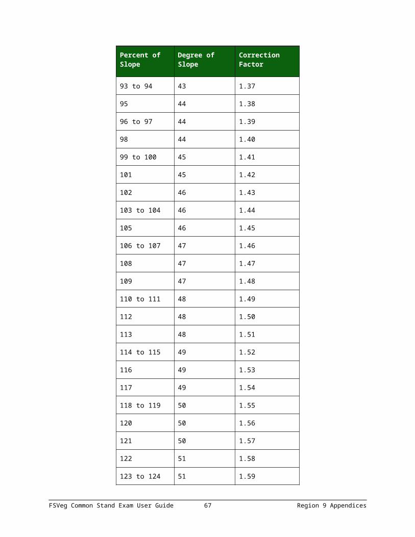
Table 34: Slope Correction Table
Percent of Slope
Degree of Slope
Correction Factor
0 to 9 0-6 1.00
10 to 17 7-10 1.01
18 to 22 11-12 1.02
23 to 26 13-14 1.03
27 to 30 15-17 1.04
31 to 33 18 1.05
FSVeg Common Stand Exam User Guide 57 Region 9 Appendices
Percent of Slope
Degree of Slope
Correction Factor
34 to 36 19-20 1.06
37 to 39 21 1.07
40 to 42 22 1.08
43 to 44 23 1.09
45 to 47 24 1.10
48 to 49 25-26 1.11
50 to 51 27 1.12
52 to 53 28 1.13
54 to 55 29 1.14
56 to 57 29 1.15
58 to 59 30 1.16
60 to 61 31 1.17
62 to 63 32 1.18
64 to 65 33 1.19
66 to 67 34 1.20
68 to 69 34 1.21
70 35 1.22
71 to 72 36 1.23
73 to 74 37 1.24
75 37 1.25
76 to 77 38 1.26
78 to 79 38 1.27
80 39 1.28
81 to 82 39 1.29
83 40 1.30
FSVeg Common Stand Exam User Guide 58 Region 9 Appendices

Percent of Slope
Degree of Slope
Correction Factor
84 to 85 40 1.31
86 41 1.32
87 to 88 41 1.33
89 42 1.34
90 to 91 42 1.35
92 43 1.36
93 to 94 43 1.37
95 44 1.38
96 to 97 44 1.39
98 44 1.40
99 to 100 45 1.41
101 45 1.42
102 46 1.43
103 to 104 46 1.44
105 46 1.45
106 to 107 47 1.46
108 47 1.47
109 47 1.48
110 to 111 48 1.49
112 48 1.50
113 48 1.51
114 to 115 49 1.52
116 49 1.53
117 49 1.54
118 to 119 50 1.55
FSVeg Common Stand Exam User Guide 59 Region 9 Appendices

Percent of Slope
Degree of Slope
Correction Factor
120 50 1.56
121 50 1.57
122 51 1.58
123 to 124 51 1.59
125 51 1.60
126 52 1.61
127 to 128 52 1.62
129 52 1.63
130 52 1.64
131 53 1.65
132 to 133 53 1.66
134 53 1.67
135 53 1.68
136 54 1.69
137 to 138 54 1.70
139 54 1.71
140 54 1.72
141 55 1.73
142 to 143 55 1.74
144 55 1.75
145 55 1.76
146 56 1.77
147 56 1.78
148 to 149 56 1.79
150 56 1.80
FSVeg Common Stand Exam User Guide 60 Region 9 Appendices

APPENDIX J: VARIABLE RADIUS PLOT
INTRODUCTION
In or our determination is made at the DBH or DRC of each tree. For information on the theory and mathematics of variable plot cruising, and formulas for determining the plot radius factor for any given BAF, the reader is referred to Log Scaling and Timber Cruising, 1973, J.R. Dilworth. OSU Book Stores, Inc., Corvallis, Oregon.
The experienced field person using a wedge prism, angle gauge, or relaskop can quickly tell in which case trees are “in” or “out” on the variable plot. However, there are certain trees that are questionable (borderline) for tally because they are located at the outer limits of the variable plot radius. This narrative deals with the procedures needed to ascertain if these borderline trees should be tallied: the mechanics of using plot radius tables in the field, the associated measurements, and corrections of variable plot radii for slope.
MEASUREMENT OF BORDERLINE TREES TO DETERMINE “IN OR OUT” STATUS
In variable plot sampling, the plot radius varies according to the DBH or DRC of each tree. To determine whether a tree is to be sampled requires measurement of its DBH or DRC and its distance from plot center. Table 35, , Table 37, Table 38, Table 39, Table 40, and Table 41 display limiting distances (the maximum horizontal distance from plot center to the face of the tree at breast height for a tree to be considered “in”) for various tree diameters and commonly used basal area factors (BAF).
Once the DBH or DRC of the borderline tree is taken, the limiting distance is found by entering the table appropriate for the specified BAF. This limiting distance is then compared to the horizontal distance between plot center and the nearest face of the tree at breast height. If the measured horizontal distance from plot center is less than or equal to the limiting distance from the table, the tree in question is “in” and is tallied as a sample tree. However, if measured horizontal distance from plot center is greater than the limiting distance, then the tree in question is “out” and is not tallied.
1. Measure the diameter to the nearest tenth of an inch2. Measure the percent slope from the face of the tree at DBH or DRC to plot center
If the slope is less than ten percent look up limiting distance in Tables 1 through 5 or use the BAF correction factors listed in Table 41 below.
Table 35: BAF correction factors
Type Correction Factors
BAF 10 15 20 25 30 35 40 50 60
Plot Radius Factor* 27.08 2.203 1.902 1.697 1.546 1.428 1.333 1.188 1.081
* This is a corrected plot radius factor, corrected for determining the limiting distance to the face of the tree. A standard plot radius factor was used to determine limiting distance to the center of a tree, and is computed by 8.696/SQR(BAF). A corrected PRF subtracts 1/24 (0.041666) from the standard plot radius factor.
Example:
FSVeg Common Stand Exam User Guide 61 Region 9 Appendices

BAF = 40; DBH = 20.9 inches; Slope = 5%
Limiting Distance = Plot Radius Factor * DBH, 1.333 * 20.9 = 27.9 feet
3. If the slope is greater than ten percent, first determine the slope correction factor. The slope correction factor and the slope corrected plot radius factor can be obtained by using the formula below or by referring to Table 40. Then, multiply the slope correction factor by the plot radius factor identified in step #3 above to obtain the slope corrected plot radius factor. Finally, multiply the slope corrected plot radius factor by the diameter to obtain the limiting distance.Example:
BAF = 40; DBH = 20.9 inches; Slope = 20%
Slope Correction Factor = SQR (1 + (slope/100)2) = SQR (1 + (20/100)2) = 1.0198
Slope Corrected Plot Radius Factor = Slope Correction Factor * Plot Radius Factor = 1.0198 * 1.333 = 1.359
Limiting Distance = Slope Corrected Plot Radius Factor * DBH = 1.359 * 20.9 = 28.4 feet
4. Measure the distance from plot center to the face of the tree, nearest plot center, at DBH or DRC. Both the slope measurement and distance measurement must be taken at plot center. If the measured distance is less than the limiting distance, the tree is “in.”
Figure 4: Determining limiting distance on a slope
Example:
BAF = 40; DBH = 15.0; Slope = 50%; Slope Distance = 21.0 feet
Referring to Table 40, the Combined Factor for a slope of 50% with a 4- BAF is 1.490.
Limiting Distance = DBH * Combined Factor = 15.0 * 1.490 = 22.35
FSVeg Common Stand Exam User Guide 62 Region 9 Appendices
Since 21.0 is less than or equal to the limiting distance of 22.35 feet, the tree is “in” and is tallied as a sample tree.
Measuring “In” or “Out” Down TreesDown trees are “in” or “out” of the variable plot radius based on where the DBH or DRC now lies, not on where the tree once stood. The distance measurement is taken from plot center to the nearest face of the tree at breast height.
FSVeg Common Stand Exam User Guide 63 Region 9 Appendices

Table 36: BAF 10 Plot Radii in Feet and Tenths of Feet from Plot Center to Face of Tree at DBH for 0% Slope
Inches 0 0.1 0.2 0.3 0.4 0.5 0.6 0.7 0.8 0.9
5 13.5 13.8 14.1 14.4 14.6 14.9 15.2 15.4 15.7 16.0
6 16.2 16.5 16.8 17.1 17.3 17.6 17.9 18.1 18.4 18.7
7 19.0 19.2 19.5 19.8 20.0 20.3 20.6 20.9 21.1 21.4
8 21.7 21.9 22.2 22.5 22.7 23.0 23.3 23.6 23.8 24.1
9 24.4 24.6 24.9 25.2 25.5 25.7 26.0 26.3 26.5 26.8
10 27.1 27.4 27.6 27.9 28.2 28.4 28.7 29.0 29.2 29.5
11 29.8 30.1 30.3 30.6 30.9 31.1 31.4 31.7 32.0 32.2
12 32.5 32.8 38.5 38.7 39.0 39.3 39.5 39.8 40.1 40.3
13 35.2 35.5 35.7 36.0 36.3 36.6 36.8 37.1 37.4 37.6
14 37.9 38.2 38.5 38.7 39.0 39.3 39.5 39.8 40.1 40.3
15 40.6 40.9 41.2 41.4 41.7 42.0 42.2 42.5 42.8 43.1
16 43.3 43.6 43.9 44.1 44.4 44.7 45.0 45.2 45.5 45.8
17 46.0 46.3 46.6 46.8 47.1 47.4 47.7 47.9 48.2 48.5
18 48.7 49.0 49.3 49.6 49.8 50.1 50.4 50.6 50.9 51.2
19 51.5 51.7 52.0 52.3 52.5 52.8 53.1 53.3 53.6 53.9
20 54.2 54.4 54.7 55.0 55.2 55.5 55.8 56.1 56.3 56.6
21 56.9 57.1 57.4 57.7 58.0 58.2 58.5 58.8 59.0 59.3
22 59.6 57.1 57.4 57.7 58.0 58.2 58.5 58.8 59.0 59.3
23 62.3 62.6 62.8 63.1 63.4 63.6 63.9 64.2 64.5 64.7
24 65.0 65.3 65.5 65.8 66.1 66.3 66.6 66.9 67.2 67.4
25 67.7 68.0 68.2 63.1 63.4 63.6 63.9 64.2 64.5 64.7
26 70.4 70.7 70.9 71.2 71.5 71.8 72.0 72.3 72.6 72.8
27 73.1 73.4 73.7 73.9 74.2 74.5 74.7 75.0 75.3 75.6
28 75.8 76.1 76.4 76.6 76.9 77.2 77.4 77.7 78.00 78.3
FSVeg Common Stand Exam User Guide 64 Region 9 Appendices

Inches 0 0.1 0.2 0.3 0.4 0.5 0.6 0.7 0.8 0.9
29 78.5 78.8 79.1 79.3 79.6 79.9 80.2 80.4 80.7 81.0
30 81.2 81.5 81.8 82.1 82.3 82.6 82.9 83.1 83.4 83.7
31 83.9 84.2 84.5 84.8 85.0 85.3 85.6 85.8 86.1 86.4
32 86.7 86.9 87.2 87.5 87.7 88.0 88.3 88.6 88.8 89.1
33 89.4 89.6 89.9 90.2 90.4 90.7 91.0 91.3 91.5 91.8
34 92.1 92.3 92.6 92.9 93.2 93.4 93.7 94.0 94.2 94.5
35 94.8 95.1 95.3 95.6 95.9 96.1 96.4 96.7 96.9 97.2
36 97.5 97.8 98.0 98.3 98.6 98.8 99.1 99.4 99.7 99.9
37 100.2 100.5 100.7 101.0 101.3 101.6 101.8 102.1 102.4 102.6
38 102.9 103.2 103.4 103.7 104.0 104.3 104.5 104.8 105.1 105.3
39 105.6 105.9 106.2 106.4 106.7 107.0 107.2 107.5 107.8 108.0
40 108.3 108.6 108.9 109.1 109.4 109.7 109.9 110.2 110.5 110.8
41 111.0 111.3 111.6 111.8 112.1 112.4 112.7 112.9 113.2 113.5
42 113.7 114.0 114.3 114.5 114.8 115.1 115.4 115.6 115.9 116.2
43 116.4 116.7 117.0 117.3 117.5 117.8 118.1 118.3 118.6 118.9
44 119.2 119.4 119.7 120.0 120.2 120.5 120.8 121.0 121.3 121.6
45 121.9 122.1 122.4 122.7 122.9 120.2 123.5 123.8 124.0 124.3
46 124.6 124.8 125.1 125.4 125.7 125.9 126.2 126.5 126.7 127.0
47 127.3 127.5 127.8 128.1 128.4 128.6 128.9 129.2 129.4 129.7
48 130.0 130.3 130.5 130.8 131.1 131.3 131.6 131.9 132.2 132.4
49 132.7 133.0 133.2 133.5 133.8 134.0 134.3 134.6 134.9 135.1
50 135.4 135.7 135.9 136.2 136.5 136.8 137.0 137.3 137.6 137.8
Prepared by multiplying the BAF 10 Plot Radius Factor 2.708 * DBH. For example, if DBH = 14.3 inches, then 14.3 * 2.708 = 38.
FSVeg Common Stand Exam User Guide 65 Region 9 Appendices

Table 37: BAF 20 Plot Radii in Feet and Tenths of Feet from Plot Center to Face of Tree at DBH for 0% Slope
Inches 0 0.1 0.2 0.3 0.4 0.5 0.6 0.7 0.8 0.9
5 9.5 9.7 9.9 10.1 10.3 10.5 10.7 10.8 11.0 11.2
6 11.4 11.6 11.8 12.0 12.2 12.4 12.6 12.8 12.9 13.1
7 13.3 13.5 13.7 13.9 14.1 14.3 14.5 14.7 14.8 15.0
8 15.2 15.4 15.6 15.8 16.0 16.2 16.4 16.6 16.8 16.9
9 17.1 17.3 17.5 17.7 17.9 18.1 18.3 18.5 18.6 18.8
10 19.0 19.2 19.4 19.6 19.8 20.0 20.2 20.4 20.6 20.7
11 20.9 21.1 21.3 21.5 21.7 21.9 22.1 22.3 22.5 22.6
12 22.8 23.0 23.2 23.4 23.6 23.8 24.0 24.2 24.4 24.5
13 24.7 24.9 25.1 25.3 25.5 25.7 25.9 26.1 26.3 26.5
14 26.6 26.8 27.0 27.2 27.4 27.6 27.8 28.0 28.2 28.4
15 28.5 28.7 28.9 29.1 29.3 29.5 29.7 29.9 30.1 30.3
16 30.4 30.6 30.8 31.0 31.2 31.4 31.6 31.8 32.0 32.2
17 32.4 32.5 32.7 32.9 33.1 33.3 33.5 33.7 33.9 34.1
18 34.3 34.4 34.6 34.8 35.0 35.2 35.4 35.6 35.8 36.0
19 36.2 36.3 36.5 36.7 36.9 37.1 37.3 37.5 37.7 37.9
20 38.1 38.3 38.4 38.6 38.8 39.0 39.2 39.4 39.6 39.8
21 40.0 40.2 40.3 40.5 40.7 40.9 41.1 41.3 41.5 41.7
22 41.9 42.1 42.2 42.4 42.6 42.8 43.0 43.2 43.4 43.6
23 43.8 44.0 44.1 44.3 44.5 44.7 44.9 45.1 45.3 45.5
24 45.7 45.9 46.1 46.2 46.4 46.6 46.8 47.0 47.2 47.4
25 47.6 47.8 48.0 48.1 48.3 48.5 48.7 48.9 49.1 49.3
26 49.5 49.7 49.9 50.0 50.2 50.4 50.6 50.8 51.0 51.2
27 51.4 51.6 51.8 52.0 52.1 52.3 52.5 52.7 52.9 53.1
28 53.3 53.5 53.7 53.9 54.0 54.2 54.4 54.6 54.8 55.0
FSVeg Common Stand Exam User Guide 66 Region 9 Appendices
Inches 0 0.1 0.2 0.3 0.4 0.5 0.6 0.7 0.8 0.9
29 55.2 55.4 55.6 55.8 55.9 56.1 56.3 56.5 56.7 56.9
30 57.1 57.3 57.5 57.7 57.9 58.0 58.2 58.4 58.6 58.8
31 59.0 59.2 59.4 59.6 59.8 59.9 60.1 60.3 60.5 60.7
32 60.9 61.1 61.3 61.5 61.7 61.8 62.0 62.2 62.4 62.6
33 62.8 63.0 63.2 63.4 63.6 63.8 63.9 64.1 64.3 64.5
34 64.7 64.9 65.1 65.3 65.5 65.7 65.8 6.0 66.2 66.4
35 66.6 66.8 67.0 67.2 67.4 67.6 67.7 67.9 68.1 68.3
36 68.5 68.7 68.9 69.1 69.3 69.5 69.6 69.8 70.0 70.2
37 70.4 70.6 70.8 71.0 71.2 71.4 71.6 71.7 71.9 72.1
38 72.3 72.5 72.7 72.9 73.1 73.3 73.5 73.6 73.8 74.0
39 74.2 74.4 74.6 74.8 75.0 75.2 75.4 75.5 75.7 75.9
40 76.1 76.3 76.5 76.7 76.9 77.1 77.3 77.5 77.6 77.8
41 78.0 78.2 78.4 78.6 78.8 79.0 79.2 79.4 79.5 79.7
42 79.9 80.1 80.3 80.5 80.7 80.9 81.1 81.3 81.4 81.6
43 81.8 82.0 82.2 82.4 82.6 82.8 83.0 83.2 83.4 83.5
44 83.7 83.9 84.1 84.3 84.5 84.7 84.9 85.1 85.3 85.4
45 85.6 85.8 86.0 86.2 86.4 86.6 86.8 87.0 87.2 87.3
46 87.5 87.7 87.9 88.1 88.3 88.5 88.7 88.9 89.1 89.3
47 89.4 89.6 89.8 90.0 90.2 90.4 90.6 90.8 91.0 91.2
48 91.3 91.5 91.7 91.9 92.1 92.3 92.5 92.7 92.9 93.1
49 93.2 93.4 93.6 93.8 94.0 94.2 94.4 94.6 94.8 95.0
50 95.2 95.3 95.5 95.7 95.9 96.1 96.3 96.5 96.7 96.9
Prepared by multiplying the BAF 20 Plot Radius Factor 1.902 * DBH. For example, if DBH = 14.3 inches, then 14.3 * 1.903 = 27.
FSVeg Common Stand Exam User Guide 67 Region 9 Appendices

Table 38: BAF 30 Plot Radii in Feet and Tenths of Feet from Plot Center to Face of Tree at DBH for 0% Slope
Inches 0 0.1 0.2 0.3 0.4 0.5 0.6 0.7 0.8 0.9
5 7.7 7.9 8.0 8.2 8.3 8.5 8.7 8.8 9.0 9.1
6 9.3 9.4 9.6 9.7 9.9 10.0 10.2 10.4 10.5 10.7
7 10.8 11.0 11.1 11.3 11.4 11.6 11.7 11.9 12.1 12.2
8 12.4 12.5 12.7 12.8 13.0 13.1 13.3 13.5 13.6 13.8
9 13.9 14.1 14.2 14.4 14.5 14.7 14.8 15.0 15.2 15.3
10 15.5 15.6 15.8 15.9 16.1 16.2 16.4 16.5 16.7 16.9
11 17.0 17.2 17.3 17.5 17.6 17.8 17.9 18.1 18.2 18.4
12 18.6 18.7 18.9 19.0 19.2 19.3 19.5 19.6 19.8 19.9
13 20.1 20.3 20.4 20.6 20.7 20.9 21.0 21.2 21.3 21.5
14 21.6 21.8 22.0 22.1 22.3 22.4 22.6 22.7 22.9 23.0
15 23.2 23.3 23.5 23.7 23.8 24.0 24.1 24.3 24.4 24.6
16 24.7 24.9 25.0 25.2 25.4 25.5 25.7 25.8 26.0 26.1
17 26.3 26.4 26.6 26.7 26.9 27.1 27.2 27.4 27.5 27.7
18 27.8 28.0 28.1 28.3 28.4 28.6 28.8 28.9 29.1 29.2
19 29.4 29.5 29.7 29.8 30.0 30.1 30.3 30.5 30.6 30.8
20 30.9 31.1 31.2 31.4 31.5 31.7 31.8 32.0 32.2 32.3
21 32.5 32.6 32.8 32.9 33.1 33.2 33.4 33.5 33.7 33.9
22 34.0 34.2 34.3 34.5 34.6 34.8 34.9 35.1 35.2 35.4
23 35.6 35.7 35.9 36.0 36.2 36.3 36.5 36.6 36.8 36.9
24 37.1 37.3 37.4 37.6 37.7 37.9 38.0 38.2 38.3 38.5
25 38.7 38.8 39.0 39.1 39.3 39.4 39.6 39.7 39.9 40.00
26 40.2 40.4 40.5 40.7 40.8 41.0 41.1 41.3 41.4 41.6
27 41.7 41.9 42.1 42.2 42.4 42.5 42.7 42.8 43.0 43.1
28 43.3 43.4 43.6 43.8 43.9 44.1 44.2 44.4 44.5 44.7
FSVeg Common Stand Exam User Guide 68 Region 9 Appendices

Inches 0 0.1 0.2 0.3 0.4 0.5 0.6 0.7 0.8 0.9
29 44.8 45.0 45.1 45.3 45.5 45.6 45.8 45.9 46.1 46.2
30 46.4 46.5 46.7 46.8 47.0 47.2 47.3 47.5 47.6 47.8
31 47.9 48.1 48.2 48.4 48.5 48.7 48.9 49.0 49.2 49.3
32 49.5 49.6 49.8 49.9 50.1 50.2 50.4 50.6 50.7 50.9
33 51.0 51.2 51.3 51.5 51.6 51.8 51.9 52.1 52.3 52.4
34 52.6 52.7 52.9 53.0 53.2 53.3 53.5 53.6 53.8 54.0
35 54.1 54.3 54.4 54.6 54.7 54.9 55.0 55.2 55.3 55.5
36 55.7 55.8 56.0 56.1 56.3 56.4 56.6 56.7 56.9 57.0
37 57.2 57.4 57.5 57.7 57.8 58.0 58.1 58.3 58.4 58.6
38 58.7 58.9 59.1 59.2 59.4 59.5 59.7 59.8 60.0 60.1
39 60.3 60.4 60.6 60.8 60.9 61.1 61.2 61.4 61.5 61.7
40 61.8 62.0 62.1 62.3 62.5 62.6 62.8 62.9 63.1 63.2
41 63.4 63.5 63.7 63.8 64.0 64.2 64.3 64.5 64.3 64.8
42 64.9 65.1 65.2 65.4 65.6 65.7 65.9 66.0 66.2 66.3
43 66.5 66.6 66.8 66.9 67.1 67.3 67.4 67.6 67.7 67.9
44 68.0 68.2 68.3 68.5 68.6 68.8 69.0 69.1 69.3 69.4
45 69.6 69.7 69.9 70.0 70.2 70.3 70.5 70.7 70.8 71.0
46 71.1 71.3 71.4 71.6 71.7 71.9 72.0 72.2 72.4 72.5
47 72.7 72.8 73.0 73.1 73.3 73.4 73.6 73.7 73.9 74.1
48 74.2 74.4 74.5 74.7 74.8 75.0 75.1 75.3 75.4 75.6
49 75.8 75.9 76.1 76.2 76.4 76.5 76.7 76.8 77.0 77.1
50 77.3 77.5 77.6 77.8 77.9 78.1 78.2 78.4 78.5 78.7
Prepared by multiplying the BAF 30 Plot Radius Factor 1.546 * DBH. For example, if DBH = 14.3 inches, then 14.3 * 1.546 = 22.
FSVeg Common Stand Exam User Guide 69 Region 9 Appendices

Table 39: BAF 40 Plot Radii in Feet and Tenths of Feet from Plot Center to Face of Tree at DBH for 0% Slope
Inches 0 0.1 0.2 0.3 0.4 0.5 0.6 0.7 0.8 0.9
5 6.7 6.8 6.9 7.1 7.2 7.3 7.5 7.6 7.7 7.9
6 8.0 8.1 8.3 8.4 8.5 8.7 8.8 8.9 9.1 9.2
7 9.3 9.5 9.6 9.7 9.9 10.0 10.1 10.3 10.4 10.5
8 10.7 10.8 10.9 11.1 11.2 11.3 11.5 11.6 11.7 11.9
9 12.0 12.1 12.3 12.4 12.5 12.7 12.8 12.9 13.1 13.2
10 13.3 13.5 13.6 13.7 13.9 14.0 14.1 14.3 14.4 14.5
11 14.7 14.8 14.9 15.1 15.2 15.3 15.5 15.6 15.7 15.9
12 16.0 16.1 16.3 16.4 16.5 16.7 16.8 16.9 17.1 17.2
13 17.3 17.5 17.6 17.7 17.9 18.0 18.1 18.3 18.4 18.5
14 18.7 18.8 18.9 19.1 19.2 19.3 19.5 19.6 19.7 19.9
15 20.0 20.1 20.3 20.4 20.5 20.7 20.8 20.9 21.1 21.2
16 21.3 21.5 21.6 21.7 21.9 22.0 22.1 22.3 22.4 22.5
17 22.7 22.8 22.9 23.1 23.2 23.3 23.5 23.6 23.7 23.9
18 24.0 24.1 24.3 24.4 24.5 24.7 24.8 24.9 25.1 25.2
19 25.3 25.5 25.6 25.7 25.9 26.0 26.1 26.3 26.4 26.5
20 26.7 26.8 26.9 27.1 27.2 27.3 27.5 27.6 27.7 27.9
21 28.0 28.1 28.3 28.4 28.5 28.7 28.8 28.9 29.1 29.2
22 29.3 29.5 29.6 29.7 29.9 30.0 30.1 30.3 30.4 30.5
23 30.7 30.8 30.9 31.1 31.2 31.3 31.5 31.6 31.7 31.9
24 32.0 32.1 32.3 32.4 32.5 32.7 32.8 32.9 33.1 33.2
25 33.3 33.5 33.6 33.7 33.9 34.0 34.1 34.3 34.4 34.5
26 34.7 34.8 34.9 35.1 35.2 35.3 35.5 35.6 35.7 35.9
27 36.0 36.1 36.3 36.4 36.5 36.7 36.8 36.9 37.1 37.2
28 37.3 37.5 37.6 37.7 37.9 38.0 38.1 38.3 38.4 38.5
FSVeg Common Stand Exam User Guide 70 Region 9 Appendices

Inches 0 0.1 0.2 0.3 0.4 0.5 0.6 0.7 0.8 0.9
29 38.7 34.8 34.9 35.1 35.2 35.3 35.5 35.6 35.7 35.9
30 40.0 40.1 40.3 40.4 40.5 40.7 40.8 40.9 41.1 41.2
31 41.3 41.5 41.6 41.7 41.9 42.0 42.1 42.3 42.4 42.5
32 42.7 42.8 42.9 43.1 43.2 43.3 43.5 43.6 43.7 43.9
33 44.0 44.1 44.3 44.4 44.5 44.7 44.8 44.9 45.1 45.2
34 45.3 45.5 45.6 45.7 45.9 46.0 46.1 46.3 46.4 46.5
35 46.7 46.8 46.9 47.1 47.2 47.3 47.5 47.6 47.7 47.9
36 48.0 48.1 48.2 48.4 48.5 48.7 48. 48.9 49.1 49.2
37 49.3 49.5 49.6 49.7 49.9 50.0 50.1 50.3 50.4 50.5
38 50.7 50.8 50.9 51.1 51.2 51.3 51.5 51.6 51.7 51.9
39 52.0 52.1 52.2 52.4 52.5 52.7 52.8 52.9 53.1 53.2
40 53.3 53.5 53.6 53.7 53.9 54.0 54.1 54.3 54.4 54.5
41 54.7 54.8 54.9 55.1 55.2 55.3 55.5 55.6 55.7 55.9
42 56.0 56.1 56.2 56.4 56.5 56.7 56.8 56.9 57.1 57.2
43 57.3 57.5 57.6 57.7 57.9 58.0 58.1 58.3 58.4 58.5
44 58.7 58.8 58.9 59.1 59.2 59.3 59.5 59.6 59.7 59.9
45 60.0 60.1 60.2 60.4 60.5 60.7 60.8 60.9 61.1 61.2
46 61.3 61.5 61.6 61.7 61.9 62.0 62.1 62.3 62.4 62.5
47 62.7 62.8 62.9 63.1 63.2 63.3 63.5 63.6 63.7 63.9
48 64.0 64.1 64.2 64.4 64.5 64.7 64.8 64.9 65.1 65.2
49 65.3 65.5 65.6 65.7 65.9 66.0 66.1 66.3 66.4 66.5
50 66.7 66.8 66.9 67.0 67.2 67.3 67.4 67.6 67.7 67.8
Prepared by multiplying the BAF 40 Plot Radius Factor 1.333 * DBH. For example, if DBH = 14.3 inches, then 14.3 * 1.333 = 19.1 feet.
FSVeg Common Stand Exam User Guide 71 Region 9 Appendices

Table 40: BAF 60 Plot Radii in Feet and Tenths of Feet from Plot Center to Face of Tree at DBH for 0% Slope
Inches 0 0.1 0.2 0.3 0.4 0.5 0.6 0.7 0.8 0.9
5 5.4 5.5 5.6 5.7 5.8 5.9 6.1 6.2 6.3 6.4
6 6.5 6.6 6.7 6.8 6.9 7.0 7.1 7.2 7.4 7.5
7 7.6 7.7 7.8 7.9 8.0 8.1 8.2 8.3 8.4 8.5
8 8.6 8.8 8.9 9.0 9.1 9.2 9.3 9.4 9.5 9.6
9 9.7 9.8 9.9 10.1 10.2 10.3 10.4 10.5 10.6 10.7
10 10.8 10.9 11.0 11.1 11.2 11.4 11.5 11.6 11.7 11.8
11 11.9 12.0 12.1 12.2 12.3 12.4 12.5 12.6 12.8 12.9
12 13.0 13.1 13.2 13.3 13.4 13.5 13.6 13.7 13.8 13.9
13 14.1 14.2 14.3 14.4 14.5 14.6 14.7 14.8 14.9 15.0
14 15.1 15.2 15.4 15.5 15.6 15.7 15.8 15.9 16.0 16.1
15 16.2 16.3 16.4 16.5 16.6 16.7 16.9 17.0 17.1 17.2
16 17.3 17.4 17.5 17.6 17.7 17.8 17.9 18.1 18.2 18.3
17 18.4 18.5 18.6 18.7 18.8 18.9 19.0 19.1 19.2 19.3
18 19.5 19.6 19.7 19.8 19.9 20.0 20.1 20.2 20.3 20.4
19 20.5 20.6 20.8 20.9 21.0 21.1 21.2 21.3 21.4 21.5
20 21.6 21.7 21.8 21.9 22.1 22.2 22.3 22.4 22.5 22.6
21 22.7 22.8 22.9 23.0 23.1 23.2 23.3 23.5 23.6 23.7
22 23.8 23.9 24.0 24.1 24.2 24.3 24.4 24.5 24.6 24.8
23 24.9 25.0 25.1 25.2 25.3 25.4 25.5 25.6 25.7 25.8
24 25.9 26.1 26.2 26.3 26.4 26.5 26.6 26.7 26.8 26.9
25 27.0 27.1 27.2 27.3 27.5 27.6 27.7 27.8 27.9 28.0
26 28.1 28.2 28.3 28.4 28.5 28.6 28.8 28.9 29.0 29.1
27 29.2 29.3 29.4 29.5 29.6 29.7 29.8 29.9 30.1 30.2
28 30.3 30.4 30.5 30.6 30.7 30.8 30.9 31.0 31.1 31.2
FSVeg Common Stand Exam User Guide 72 Region 9 Appendices
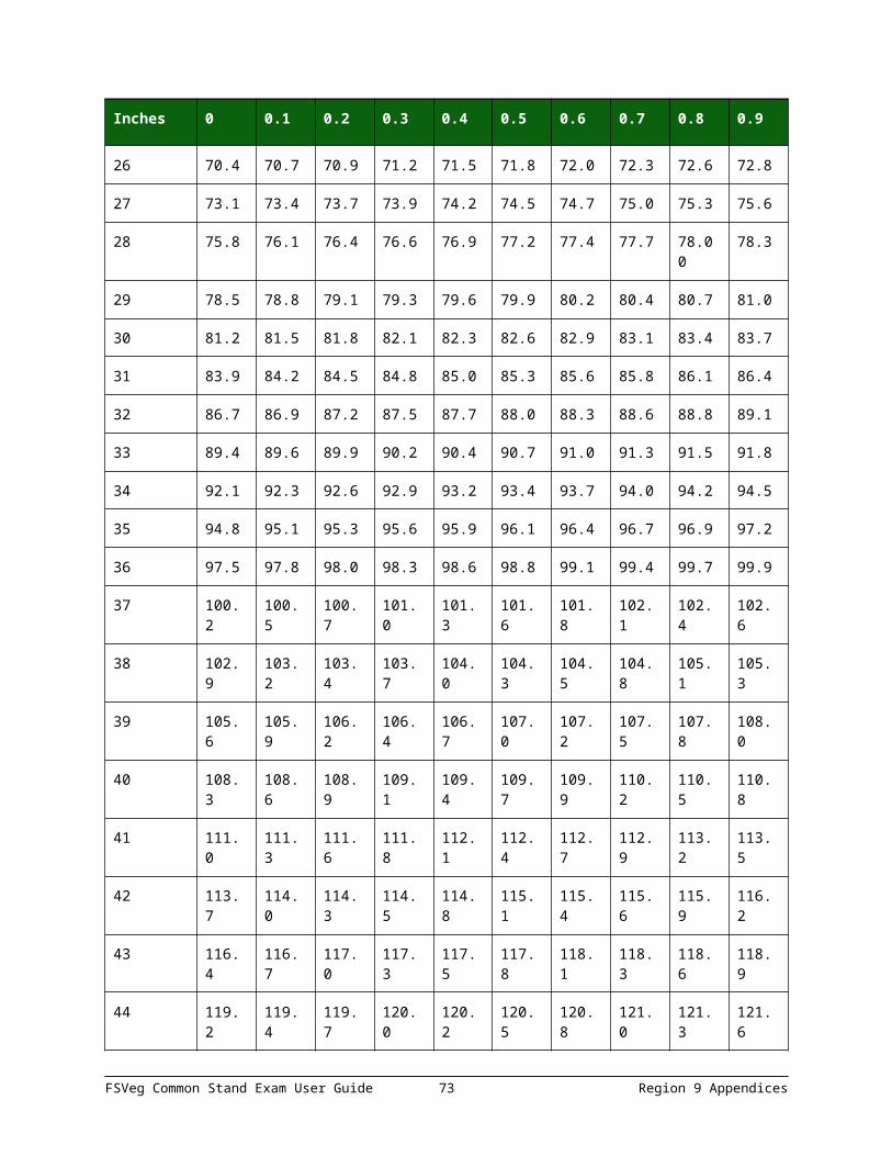
Inches 0 0.1 0.2 0.3 0.4 0.5 0.6 0.7 0.8 0.9
29 31.3 31.5 31.6 31.7 31.8 31.9 32.0 32.1 32.2 32.3
30 32.4 32.5 32.6 32.8 32.9 33.0 33.1 33.2 33.3 33.4
31 33.5 33.6 33.7 33.8 33.9 34.1 34.2 34.3 34.4 34.5
32 35.7 35.8 35.9 36.0 36.1 36.2 36.3 36.4 36.5 36.6
33 35.7 35.8 35.9 36.0 36.1 36.2 36.3 36.4 36.5 36.6
34 36.8 36.9 37.0 37.1 37.2 37.3 37.4 37.5 37.6 37.7
35 37.8 37.9 38.1 38.2 38.3 38.4 38.5 38.6 38.7 38.8
36 38.9 39.0 39.1 39.2 39.3 39.5 39.6 39.7 39.8 39.9
37 40.0 40.1 40.2 40.3 40.4 40.5 40.6 40.8 40.9 41.0
38 41.1 41.2 41.3 41.4 41.5 41.6 41.7 41.8 41.9 42.1
39 42.2 42.3 42.4 42.5 42.6 42.7 42.8 42.9 43.0 43.1
40 43.2 43.3 43.5 43.6 43.7 43.8 43.9 44.0 44.1 44.2
41 44.3 44.4 44.5 44.6 44.8 44.9 45.0 45.1 45.2 45.3
42 45.4 45.5 45.6 45.7 45.8 45.9 46.1 46.2 46.3 46.4
43 46.5 46.6 46.7 46.8 46.9 47.0 47.1 47.2 47.3 47.5
44 47.6 47.7 47.8 47.9 48.0 48.1 48.2 48.3 48.4 48.5
45 48.6 48.8 48.9 49.0 49.1 49.2 49.3 49.4 49.5 49.6
46 49.7 49.8 49.9 50.1 50.2 50.3 50.4 50.5 50.6 50.7
47 50.8 50.9 51.0 51.1 51.2 51.3 51.5 51.6 51.7 51.8
48 51.9 52.0 52.1 52.2 52.3 52.4 52.5 52.6 52.8 52.9
49 53.0 53.1 53.2 53.3 53.4 53.5 53.6 53.7 53.8 53.9
50 54.1 54.2 54.3 54.4 54.5 54.6 54.7 54.8 54.9 55.0
Prepared by multiplying the BAF 60 Plot Radius Factor 1.081 * DBH. For example, if DBH = 14.3 inches, then 14.3 * 10.81 = 15.5 feet.
Table 41: Limiting Distances to Face of Tree and Slope Correction Factors for Various Basal Area Factors
This table provides an expanded list of slope correction factors to the face of the tree for use with various basal area factors. To use the table, measure the slope and distance from plot-
FSVeg Common Stand Exam User Guide 73 Region 9 Appendices
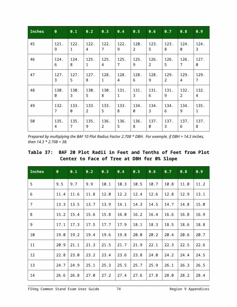
center to the face of the tree at DBH. To obtain the corrected limiting distance to a tree, multiply the tree’s DBH by the “combined factor” shown under the appropriate BAF heading.
Slope Factor 5 BAF 10 BAF 15 BAF 20 BAF 30 BF 40 BAF
1 1.00000 3.847 2.708 2.203 1.902 1.546 1.333
2 1.00020 3.848 2.709 2.203 1.902 1.546 1.333
3 1.00045 3.489 2.709 2.204 1.903 1.547 1.334
4 1.00080 3.850 2.710 2.205 1.904 1.547 1.334
5 1.00125 3.852 2.711 2.206 1.904 1.548 1.335
6 1.00180 3.854 2.713 2.207 1.905 1.549 1.335
7 1.00245 2.856 2.715 2.208 1.907 1.550 1.336
8 1.00319 3.859 2.717 2.210 1.908 1.551 1.337
9 1.00404 3.863 2.719 2.212 1.910 1.552 1.338
10 1.00499 3.866 2.722 2.214 1.911 1.554 1.340
11 1.00603 3.870 2.724 2.216 1.912 1.555 1.341
12 1.00717 3.875 2.727 2.219 1.916 1.557 1.341
13 1.00841 3.879 2.731 2.222 1.918 1.559 1.344
14 1.00975 3.884 2.734 2.224 1.921 1.567 1.346
15 1.01119 3.890 2.738 2.228 1.923 1.563 1/348
16 1.01272 3.896 2.742 2.231 1.926 1.566 1.350
17 1.01435 3.902 2.747 2.235 1.921 1.568 1.352
18 1.01607 3.909 2.752 2.238 1.933 1.571 1.354
19 1.01789 3.916 2.756 2.245 1.936 1.574 1.357
20 1.01980 3.923 2.762 2.245 1.940 1.577 1.359
21 1.02181 3.931 2.767 2.251 1.943 1.580 1.362
22 1.02391 3.939 2.773 2.256 1.947 1.583 1.365
23 1.02611 3.947 2.779 2.261 1.952 1.586 1.368
24 1.02840 3.956 2.785 2.266 1.956 1.590 1.371
FSVeg Common Stand Exam User Guide 74 Region 9 Appendices

Slope Factor 5 BAF 10 BAF 15 BAF 20 BAF 30 BF 40 BAF
25 1.03078 3.965 2.791 2.271 1.967 1.594 1.374
26 1.03325 3.975 2.798 2.276 1.965 1.597 1.377
27 1.03581 3.985 2.805 2.282 1.970 1.601 1.381
28 1.03846 3.995 2.812 2.288 1.975 1.605 1.384
29 1.04120 4.005 2.820 2.294 1.980 1.610 1.388
30 1.04403 4.016 2.827 2.300 1.986 1.614 1.392
31 1.04695 4.028 2.835 2.306 1.991 1.619 1.396
32 1.04995 4.039 2.843 2.313 1.997 1.623 1.400
33 1.05304 4.051 2.852 2.320 2.003 1.628 1.404
34 1.05622 4.063 2.960 2.327 2.009 1.633 1.408
35 1.05948 4.076 2.869 2.334 2.015 1.638 1.412
36 1.06283 4.089 2.878 2.341 2.022 1.643 1.417
37 1.06626 4.102 2.887 2.349 2.028 1.648 4.421
38 1.06977 4.115 2.897 2.357 2.035 1.654 1.426
39 1.07336 4.129 2.907 2.365 2.042 1.659 1.431
40 1.07703 4.143 2.917 2.373 2.049 1.665 1.436
41 1.08079 4.158 2.927 2.381 2.056 1.671 1.441
42 1.08462 4.173 2.937 2.389 2.063 1.677 1.446
43 1.08853 4.188 2.948 2.398 2.070 1.683 1.451
44 1.09252 4.203 2.959 2.407 2.078 1.689 1.456
45 1.09659 4.219 2.970 2.416 2.086 1.695 1.462
46 1.10073 4.235 2.981 2.425 2.094 1.702 1.467
47 1.10494 4.251 2.992 2.434 2.102 1.708 1.473
48 1.10923 4.267 3.004 2.444 2.110 1.715 1.479
49 1.11360 4.284 3.016 2.453 2.118 1.723 1.484
50 1.11803 4.301 3.028 2.463 2.126 1.728 1.490
FSVeg Common Stand Exam User Guide 75 Region 9 Appendices

Slope Factor 5 BAF 10 BAF 15 BAF 20 BAF 30 BF 40 BAF
51 1.12254 4.318 3.040 2.473 2135 1.735 1.496
52 1.12712 4.336 3.052 2.483 2.144 1.743 1.502
53 1.13177 4.354 3.065 2.493 2.153 1.750 1.509
54 1.13649 4.372 3.078 2.504 2.162 1.757 1.515
55 1.14127 4.390 3.091 2.514 2.171 1.764 1.521
56 1.14612 4.409 3.104 2.525 2.180 1.772 1.528
57 1.15104 4.428 3.117 2.536 2.189 1.780 1.534
58 1.15603 4.447 3.131 2.547 2.199 1.788 1.541
59 1.16108 4.467 3.144 2.558 2.208 1.795 1.548
60 1.16619 4.486 3.158 2.569 2.218 1.803 1.555
61 1.17137 4.506 3.172 2.581 2.228 1.811 1.561
62 1.17661 4.526 3.186 2.592 2.238 1.819 1.568
63 1.18191 4.547 3.201 2.604 2.248 1.827 1.575
64 1.18727 4.567 3.215 2.616 2.258 1.836 1.583
65 1.19269 4.588 3.230 2.627 2.268 1.844 1.590
66 1.19817 4.609 3.245 2.640 2.279 1.852 1.597
67 1.20370 4.631 3.260 2.652 2.289 1.861 1.605
68 1.20930 4.652 3.275 2.664 2.300 1.870 1.612
69 1.21949 4.691 3.302 2.687 2.319 1.885 1.626
70 1.22066 4.696 3.306 2.689 2.322 1.887 1.627
71 1.22642 4.718 3.321 2.702 2.333 1.896 1.635
72 1.23223 4.740 3.337 2.715 2.344 1.905 1.643
73 1.23810 4.763 3.353 2.728 2.355 1.914 1.650
74 1.24403 4.786 3.369 2.741 2.366 1.923 1.658
75 1.25000 4.809 3.385 2.754 2.378 1.933 1.666
76 1.25603 4.832 3.401 2.767 2.389 1.942 1.674
FSVeg Common Stand Exam User Guide 76 Region 9 Appendices

Slope Factor 5 BAF 10 BAF 15 BAF 20 BAF 30 BF 40 BAF
77 1.26210 4.855 3.418 2.780 2.401 1.951 1.682
78 1.26823 4.879 3.434 2.794 2.412 1.961 1.691
79 1.27440 4.903 3.451 2.808 2.424 1.970 1.699
80 1.28062 4.927 3.468 2.821 2.436 1.980 1.707
81 1.28690 4.951 3.485 2.835 2.448 1.990 1.715
82 1.29321 4.975 3.502 2.849 2.460 1.999 1.724
83 1.29958 4.999 3.519 2.863 2.472 2.009 1.732
84 1.30599 5.024 3.537 2.877 2.484 2.019 1.741
85 1.31244 5.049 3.554 2.891 2.496 2.029 1.749
86 1.31894 5.074 3.572 2.906 2.509 2.039 1.758
87 1.32548 5.099 3.589 2.920 2.521 2.049 1.767
88 1.33207 5.124 3.607 2.935 2.534 2.059 1.776
89 1.33870 5.150 3.625 2.949 2.546 2.070 1.784
90 1.34536 5.176 3.643 2.964 2.559 2.080 1.793
91 1.35207 5.201 3.661 2.979 2.572 2.090 1.802
92 1.35882 5.227 3.680 2.993 2.584 2.101 1.811
93 1.36561 5.254 3.698 3.008 2.597 2.111 1.820
94 1.37244 5.280 3.717 3.023 2.610 2.122 1.829
95 1.37931 5.306 3.735 3.039 2.623 2.132 1.839
96 1.38622 5.333 3.754 3.054 2.637 2.143 1.848
97 1.39316 5.359 3.773 3.069 2.650 2.154 1.875
98 1.40014 5.386 3.792 3.085 2.663 2.165 1.866
99 1.40716 5.413 3.811 3.100 2.676 2.175 1.876
100 1.41421 5.440 3.830 3.116 2.690 2.186 1.885
102 1.42843 5.495 3.868 3.147 2.717 2.208 1.904
103 1.43558 5.523 3.888 3.163 5.730 2.219 1.914
FSVeg Common Stand Exam User Guide 77 Region 9 Appendices

Slope Factor 5 BAF 10 BAF 15 BAF 20 BAF 30 BF 40 BAF
104 1.44278 5.550 3.907 3.178 2.744 2.231 1.923
105 1.45000 5.578 3.927 3.194 2.758 2.242 1.933
106 1.45726 5.606 3.946 3.210 2.772 2.253 1.943
107 1.46455 5.634 3.966 3.226 2.876 2.264 1.952
108 1.47187 5.662 3.986 3.243 2.799 2.276 1.962
109 1.47922 5.691 4.006 3.259 2.813 2.287 1.972
110 1.48661 5.719 4.026 3.275 2.828 2.298 1.982
111 1.49402 5.747 4.046 3.291 2.842 2.310 1.992
112 1.50147 5.776 4.066 3.308 2.856 2.321 2.001
113 1.50894 5.805 4.086 3.324 2.870 2.333 2.011
114 1.51644 5.834 4.107 3.341 2.884 2.344 2.021
115 1.52498 5.863 4.127 3.357 2.899 2.356 2.031
116 1.53154 5.892 4.147 3.374 2.913 2.368 2.042
117 1.53912 5.921 4.168 3.391 2.927 2.379 2.052
118 1.54674 5.950 4.189 3.407 2.942 2.391 2.062
119 1.55438 5.980 4.209 3.424 2.956 2.403 2.072
120 1.56205 6.000 4.230 3.441 2.971 2.415 2.082
121 1.56975 6.039 4.251 3.458 2.985 2.427 2.092
122 1.57747 6.069 4.272 3.475 3.000 2.439 2.103
123 1.58521 6.098 4.293 3.492 3.015 2.451 2.113
124 1.59298 6.128 4.314 3.509 3.030 2.463 2.123
125 1.60078 6.158 4.335 3.527 3.045 2.475 2.134
126 1.60860 6.188 4.356 3.544 3.060 2.487 2.144
127 1.61645 6.218 4.377 3.561 3.074 2.499 2.155
128 1.62432 6.249 4.399 3.578 3.089 2.511 2.165
129 1.63221 6.279 4.420 3.595 3.104 2.523 2.176
FSVeg Common Stand Exam User Guide 78 Region 9 Appendices
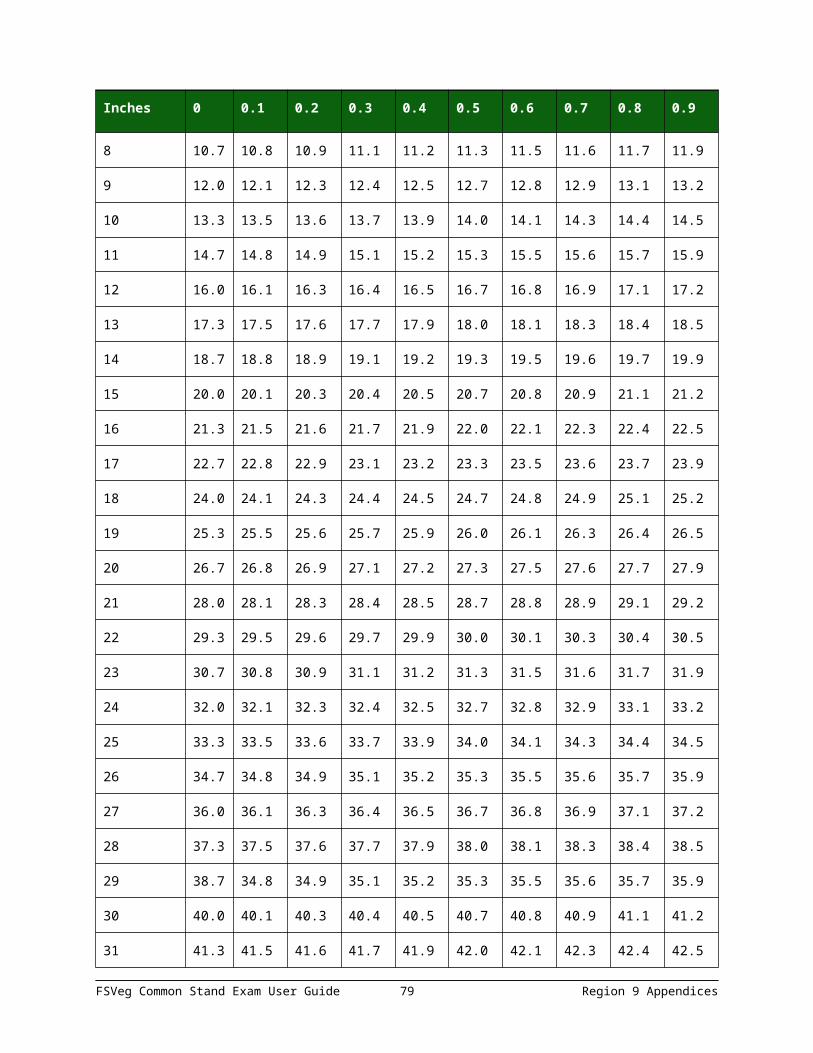
Slope Factor 5 BAF 10 BAF 15 BAF 20 BAF 30 BF 40 BAF
130 1.64012 6.310 4.441 3.613 3.120 2.536 2/186
131 1.64806 6.340 4.463 3.631 3.135 2.546 2.197
132 1.65602 6.370 4.485 3.648 3.150 2.560 2.207
133 1.66400 6.401 4.506 3.666 3.165 2.573 2.218
134 1.67200 6.432 4.528 3.683 3.180 2.585 2.229
135 1.68003 6.463 4.550 3.701 3.195 2.597 2.239
136 1.68808 6.494 4.571 3.719 3.211 2.261 2.250
137 1.69614 6.525 4.593 3.737 3.226 2.622 2.261
138 1.70423 6.556 4.615 3.754 3.241 2.635 2.272
139 1.71234 6.587 4.637 3.772 3.257 2.647 2.283
140 1.72047 6.619 4.659 3.790 3.272 2.660 2.293
141 1.72861 6.650 4.681 3.808 3.288 2.672 2.304
142 1.73678 6.681 4.703 3.826 3.303 2.685 2.315
143 1.74497 6.713 4.725 3.844 3.319 2.698 2.326
144 1.75317 6.744 4.748 3.862 3.335 2.710 2.337
145 1.76139 6.776 4.770 3.880 3.350 2.723 2.348
146 1.76963 6.808 4.792 3.898 3.366 2.736 2.359
147 1.77789 6.840 4.815 3.917 3.382 2.749 2.370
148 1.78617 6.871 4.837 3.935 3.397 2.761 2.381
149 1.79446 6.903 4.859 3.953 3.413 2.774 2.392
APPENDIX K: DAMAGE CATEGORIES, AGENTS, SEVERITY RATINGS, AND TREE PARTS
DAMAGE CATEGORIES
Detailed descriptions and examples of the content in these tables is available using the Insect & Disease Codes links on the FSVeg Documentation web page.
FSVeg Common Stand Exam User Guide 79 Region 9 Appendices

Table 42: Damage category codes
Code Description
10 General Insects
11 Bark Beetles
12 Defoliators
13 Chewing Insects
14 Sucking Insects
15 Boring Insects
16 Seed/Cone/Flower/Fruit Insects
17 Gallmaker Insects
18 Insect Predators
19 General Diseases
20 Biotic Damage
21 Root/Butt Diseases
22 Stem Decays/Cankers
23 Parasitic/Epiphytic Plants
24 Decline Complexes/Dieback/Wilts
25 Foliage Diseases
26 Stem Rusts
27 Broom Rusts
30 Fire
40 Animal Damage, Source Unknown
41 Wild Animals
42 Domestic Animals
50 Abiotic Damage
60 Competition
70 Human Activities
FSVeg Common Stand Exam User Guide 80 Region 9 Appendices

Code Description
71 Harvest
80 Multi-Damage (Insect-Disease)
90 Unknown
99 Physical Effects
DAMAGE AGENTS
Detailed descriptions and examples of the content in these tables is available using the Insect & Disease Codes links on the FSVeg Documentation web page.
Table 43: Damage agent codes
Category Agent Common Name Scientific Name
10 000 General insects n/a
10 001 Thrips n/a
10 002 Tip moth n/a
10 003 Wasp n/a
10 007 Clerid beetle Cleridae
10 008 Weevil Curculionidae
10 011 Ant Formicidae
10 017 Bagworm moth Psychidae
10 019 Scarab Scarabaeidae
10 023 Wood wasps Siricidae spp.
11 000 Bark beetles n/a
11 001 Roundheaded pine beetle Dendroctonus adjunctus
11 002 Western pine beetle Dendroctonus brevicomis
11 004 Jeffrey pine beetle Dendroctonus jeffreyi
11 005 Lodgepole pine beetle Dendroctonus murrayanae
11 006 Mountain pine beetle Dendroctonus ponderosae
FSVeg Common Stand Exam User Guide 81 Region 9 Appendices

Category Agent Common Name Scientific Name
11 007 Douglas-fir beetle Dendroctonus pseudotsugae
11 009 Spruce beetle Dendroctonus rufipennis
11 012 Red turpentine beetle Dendroctonus valens
11 015 Western balsam bark beetle Dryocoetes confuses
11 016 Unknown Dryocoetes sechelti
11 019 Pinon ips Ips confuses
11 021 Sixspined ips Ips calligraphus
11 022 Emarginated ips Ips emarginatus
11 025 Arizona five-spined ips Ips lecontei
11 029 Pine engraver Ips pini
11 030 Ips engraver beetles Ips spp/
11 031 Unknown Ips tridens
11 032 Western ash bark beetle Leperisinus californicus
11 035 Cedar bark beetle Phloeosinus spp.
11 036 Western cedar bark beetle Phloeosinus punctatus
11 037 Tip beetles Pityogenes spp.
11 038 Douglas-fir twig beetle Pityophthorus pseudotsugae
11 039 Twig beetles Pityophthorus spp.
11 040 Four-eyed spruce beetle Polygraphus rufipennis
11 041 Fir root bark beetle Pseudohylesinum granulates
11 043 Douglas-fir pole beetle Pseudohylesinus nebulosus
11 045 Small European elm bark beetle Scolytus multistriatus
11 046 Spruce engraver Scolytus piceae
11 048 True fir bark beetle Scolytus spp.
11 049 Douglas-fir engraver Scolytus unispinosus
11 050 Fir engraver Scolytus ventralis
FSVeg Common Stand Exam User Guide 82 Region 9 Appendices
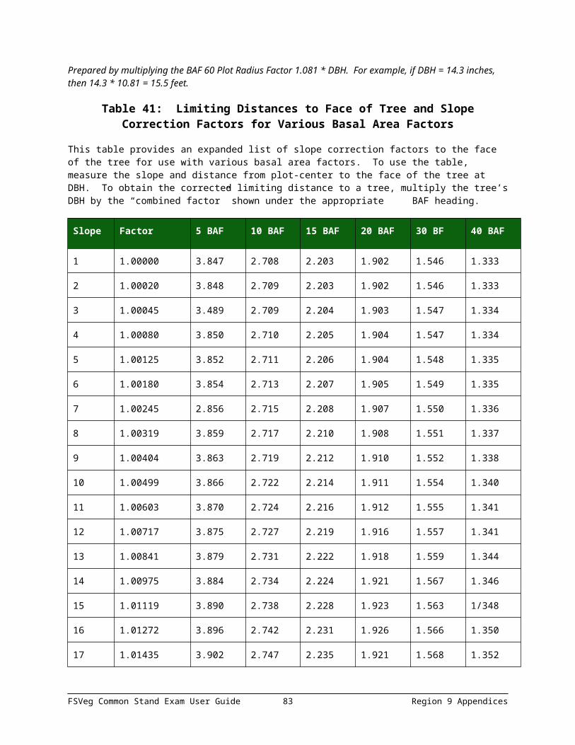
Category Agent Common Name Scientific Name
11 055 Spruce ips Ips pilifrons
11 056 Mexican pine beetle Dendroctonus mexicanus
12 000 Defoliators n/a
12 001 Casebearer n/a
12 002 Leaftier n/a
12 003 Looper n/a
12 004 Needleminer n/a
12 005 Sawfly n/a
12 006 Skeletonizer n/a
12 009 Webworm n/a
12 011 Western blackheaded budworm Acleris gloverana
12 013 Whitefly Aleyrodoidae
12 014 Fall cankerworm Alsophila pometaria
12 016 Mountain mahogany looper Anacamptodes clivinaria profanata
12 020 Western larch sawfly Anoplonyx occidens
12 023 Boxelder defoliator Archips negundanus
12 024 Oak leafroller Archips semiferana
12 025 Birch sawfly Arge pectoralis
12 033 Boxelder leafroller Caloptilia negundella
12 037 Large aspen tortrix Choristoneura conflictana
12 039 Sugar pine tortrix Choristoneura lambertiana
12 040 Western spruce budworm Choristoneura occidentalis
12 043 Aspen leaf beetle Chrysomela crotchi
12 044 Cottonwood leaf beetle Chrysomela scripta
12 045 Leafhopper Cicadellidae
FSVeg Common Stand Exam User Guide 83 Region 9 Appendices

Category Agent Common Name Scientific Name
12 047 Larch casebearer Coleophora laricella
12 049 Lodgepole needleminer Coleotechnites milleri
12 050 Ponderosa needleminer Coleotechnites spp.
12 052 Pandora moth Coloradia Pandora
12 056 Dusky birch sawfly Croesus latitarus
12 060 Spruce coneworm Dioryctria reniculelloides
12 066 White fir needleminer Epinotia meritana
12 069 Pine needleminer Exoteleia pinifoliella
12 072 Geometrid moth Geometridae
12 073 Leafblotch miner Gracillariidae
12 074 Spotted tussock moth Halisidota maculate
12 077 Brown day moth Hemileuca eglanterina
12 082 Fall webworm Hyphantria cunea
12 084 Unknown Lambdina punctate
12 087 Willow leafblotch miner Lithocolletis spp.
12 089 Gypsy moth Lymantria dispar
12 094 Western tent caterpillar Malacosoma californicum
12 096 Forest tent caterpillar Malacosoma disstria
12 099 Blister beetle Meloidae
12 116 Pine butterfly Neophasia menapia
12 121 Rusty tussock moth Orgyia antiqua
12 123 Douglas-fir tussock moth Orgyia pseudotsugata
12 124 Western tussock moth Orgyia vetusta
12 125 Spring cankerworm Paleacrita vernata
12 128 Pine tussock moth Parorygia grisefacta
12 135 Aspen leafminer Phyllocnistis populiella
FSVeg Common Stand Exam User Guide 84 Region 9 Appendices
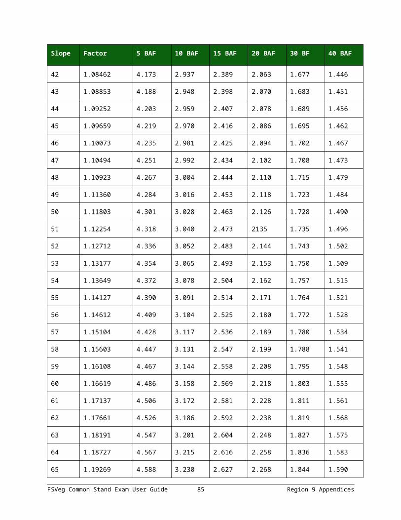
Category Agent Common Name Scientific Name
12 139 Larch sawfly Pristiphora erichsonii
12 140 Mountain-ash sawfly Pristiphora geniculate
12 141 Elm leaf beetle Prrhalta luetola
12 143 Giant silkworm moth Saturniidae
12 144 Redhumped caterpillar Schizura concinna
12 150 Spruce needleminer (west) Taniva albolineana
12 155 Leafroller/seed moth Torticidae
12 156 Willow defoliation Tortricidae
12 160 Pine needle sheathminer Zelleria haimbachi
12 178 Western oak looper Lambdina discellaria somniaria
12 181 Tent Ceterpillar Malacosoma spp.
12 190 Hickory tussock moth Halisidota caryae
12 191 Pin oak sawfly Caliroa lineata
12 192 Palmerworm Dichomeris ligulella
12 193 Pitch pine looper Lambdina athasaria pellucidaria
12 194 Red pine sawfly Neodiprion annulus annulus
12 195 Pine tip moth Argyrotaenia pinatubana
12 196 Baldcypress leafroller Archips goyerana
12 197 Winter moth Operophtera
12 198 Basswood thrip Neohydatothrips
12 199 Noctuid moth Xylomyges simplex (walker)
12 200 Pyralid moth Palpita magniferalis
13 000 Chewing insects n/a
13 001 Grasshopper n/a
13 006 Cicadas Cicadidae
FSVeg Common Stand Exam User Guide 85 Region 9 Appendices

Category Agent Common Name Scientific Name
13 008 Cutworms Euxoa excellens
13 021 Ponderosa pine tip moth Rhyacionia zozana
13 022 Pine needle weevil Scythropus spp.
13 030 Adana tip moth Rhyacionia adana
14 000 Sucking insects n/a
14 001 Scale insect n/a
14 002 Western larch wooly aphid Adelges oregonensis
14 003 Balsam woolly adelgid Adelges piceae
14 006 Aphid Aphididae
14 008 Western pine spittlebug Aphrophora permutata
14 012 Pine needle scale Chionaspis pinifoliae
14 014 Giant conifer aphid Cinara spp.
14 017 Spruce aphid Elatobium anetinum
14 018 Woolly apple aphid Eriosoma lanigerum
14 024 Honeysuckle aphid Hyadaphis tataricae
14 026 Lecanium scale Lecanium spp.
14 028 Oystershell scale Lepidosaphes ulmi
14 029 Pinyon needle scale Matsucoccus acalyptus
14 035 Treehoppers Membracidae
14 039 Black pineleaf scale Nuculaspis California
14 040 Spruce spider mite Oligonychus ununquis
14 043 Maple aphid Periphyllus spp.
14 050 Mealybug Pseudococcidae
14 054 Spruce mealybug Puto sandini
14 069 Elm scurfy scale Chionaspis Americana
15 000 Boring insects n/a
FSVeg Common Stand Exam User Guide 86 Region 9 Appendices

Category Agent Common Name Scientific Name
15 001 Shoot borer n/a
15 002 Termite n/a
15 003 Ponderosa pine bark borer Acanthocinus princeps
15 004 Bronze birch borer Agrilus anxius
15 006 Bronze poplar borer Agrilus liragus
15 007 Carpenter bees Apidae
15 008 Flatheaded borer Buprestidae
15 009 Golden buprestid Buprestis aurulenta
15 010 Carpenter ants Camponotus spp.
15 011 Gouty pitch midge Cecidomyia piniinopis
15 013 Roundheaded borer Cermbycidae
15 018 Carpenterworm moth Cossidae
15 019 Poplar and willow borer Cryptorphynchus lapathi
15 021 Douglas-fir twig weevil Cylindrocopturus furnissi
15 027 Ponderous borer Ergates spiculatus
15 029 Western pine shoot borer Eucosma sonomana
15 030 Eucosma species Eucosma spp.
15 035 Powderpost beetle Lyctidae
15 039 Locust borer Megacycllene robiniae
15 041 Flatheaded fir borer Melanophila drummondi
15 042 Whitespotted sawyer Monochamus scutellatus
15 044 Western ash borer Neoclytus conjunctus
15 050 White pine weevil Pissodes radiatae
15 051 Lodgepole terminal weevil Pissodes terminalis
15 052 Ambrosia beetles Platypus spp.
15 057 Lilac borer Podosesia syringae
FSVeg Common Stand Exam User Guide 87 Region 9 Appendices

Category Agent Common Name Scientific Name
15 060 Western subterranean termite Reticulitermes Hesperus
15 064 Western pine tip moth Rhyacionia bushnelli
15 068 Poplar borer Saperda calcarata
15 070 Saperda shoot borer Saperda spp.
15 071 Clearwing moths Sesiidae
15 073 Roundheaded fir borer Tetropium abietis
15 076 Douglas-fir pitch moth Vespamima novaroensis
15 077 Sequoia pitch moth Vespamima sequoia
15 087 Emerald ash borer Agrilus planipennis
16 000 Seed/Cone/Flower/Fruit Insects
n/a
16 001 Douglas-fir cone moth Barbara colfaxiana
16 002 Lodgepole cone beetle Conophthorus contortae
16 003 Limber pine cone beetle Conophthorus flexilis
16 004 Mountain pine cone beetle Conophthorus monticolae
16 005 Ponderosa pine cone beetle Conophthorus ponderosae
16 010 Douglas-fir cone midge Contarinia oregonesis
16 015 Fir coneworm Dioryctria abietivorella
16 017 Pine cone worm Dioryctria merkeli
16 019 Ponderosa twig moth Dioryctria ponderosae
16 020 Unknown Dioryctria pseudotsugella
16 021 Dioryctria moths Dioryctria spp.
16 022 Lodgepole cone moth Eucosma rescissoriana
16 023 Seed chalcid Eurytomidae
16 025 Cone maggot Hylemya anthracina
16 027 Ponderosa pine seed worm/moth Laspeyresia piperana
FSVeg Common Stand Exam User Guide 88 Region 9 Appendices

Category Agent Common Name Scientific Name
16 028 Spruce seed moth Laspeyresia youngana
16 029 Boxelder bug Leptocoris trivittatus
16 031 Western conifer seed bug Leptoglossus occidentalis
16 034 Spruce seed chalcid Magastigmus piceae
16 035 Ponderosa pine seed chalcid Megastigmus albifrons
16 036 Fir seed chalcid Megastigmus pinus
16 037 Douglas-fir seed chalcid Megastigmus spermotrophs
16 042 Coneworm Phycitidae
16 043 Harvester ants Pogonomyrmex spp.
16 049 Prairie tent caterpillar Malacosoma lutescens
16 050 Jack pine tip beetle Conophthorus banksianae
17 000 Gallmarker insects n/a
17 003 Cooley spruce gall adelgid Adelges cooleyi
17 007 Douglas-fir needle gall midge Contarinia pseudotsugae
17 010 Hackberry nipplegall maker Pachypsylla celtidismamma
17 013 Gall aphid Phylloxeridae
17 018 Gouty pitch midge Cedidomyia piniinopsis
17 019 Spider mites Oligonychus spp.
18 000 Insect predators n/a
18 001 Lacewing n/a
18 002 Blackbellied clerid Enoclerus lecontei
18 003 Redbellied clerid Enoclerus sphegeus
18 004 Unknown Formica rufa
18 005 Western yellowjacket Vespula pennsylvanica
19 000 General diseases n/a
20 000 Biotic damage n/a
FSVeg Common Stand Exam User Guide 89 Region 9 Appendices

Category Agent Common Name Scientific Name
20 001 Damping off n/a
20 002 Gray mold Botrytis cinerea
21 000 Root/butt diseases n/a
21 001 Armillaria root disease Amillaria spp.
21 004 Brown crumbly rot Fomitopsis pinicola
21 007 White mottled rot Ganoderma applanatum
21 008 Ganoderma rot of hardwoods Ganoderma lucidum
21 009 Ganoderma rot of conifers Ganoderma tsugae
21 010 Annosus root disease Heterobasidian annosum
21 012 Tomentosus root disease Inonotus tomentosus
21 013 Charcoal root rot Macrophomina phaseolina
21 014 Black stain root disease Ophiostoma wageneri
21 015 Schweinitzii butt rot Phaeolus schweinitzii
21 018 Phytophthora root rot Phytophthora cinnamomi
21 022 Pythium root rot Pythium spp.
21 024 Crown gall Agrobacterium timefaciens
21 027 Brown cubical rot Laetiporus sulphureus
22 000 Stem decays/cankers n/a
22 006 Black knot of cherry Apiosporina morbosa
22 007 Atropellis canker Atropellis piniphila
22 012 Black canker of aspen Ceratocystis fimbriata
22 025 Cryptosphaeria canker of aspen Cryptosphaeria populina
22 026 Cytospora canker of fir Cytospora abietis
22 028 Rust-red stringy rot Echinodontium tinctorium
22 029 Sooty-bark canker Encoelia pruinosa
22 034 Scleroderris canker Gremmeniella abietina
FSVeg Common Stand Exam User Guide 90 Region 9 Appendices
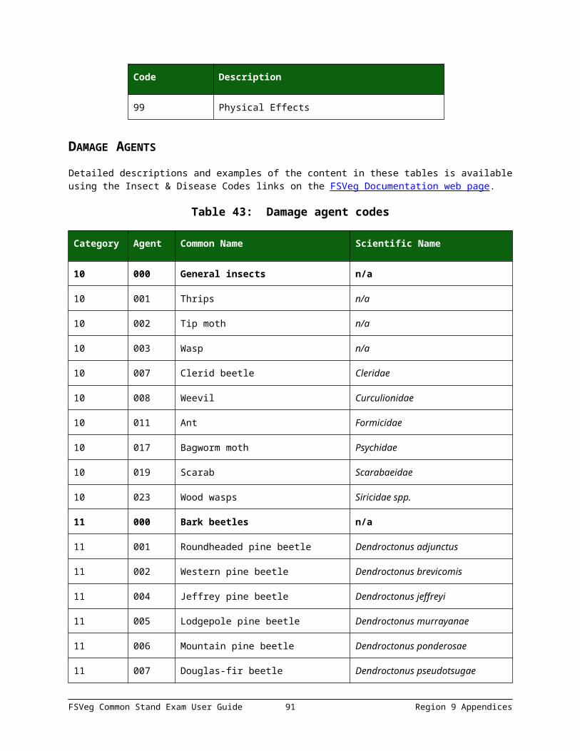
Category Agent Common Name Scientific Name
22 035 Amelanchier rust Gymnosporangium harknessianum
22 036 Cedar apple rust Gymnosporangium juniper-virginianae
22 038 Hypoxylon canker of aspen Hypoxylon mammatum
22 047 Red ring rot Phellinus pini
22 048 Aspen trunk rot Phellinus tremulae
22 057 Cytospora canker of aspen Cytospora chrysosperma
22 058 Dothichiza canker Dothichiza populae
22 059 Red belt fungus Fomitopsis pinicola
22 060 Leucocytospora canker of spruce Leucocytospora kunzei
22 061 Sooty bark canker Phibalis singular
22 064 Tinder fungus Fomes formntarius
22 066 Pinyon black stain Leptographium wagnerii
22 068 False tinder fungus Phellinus igniarius
22 071 Oyster mushroom Pleurotus ostreatus
22 074 Cedar brown pocket rot Poria serceomollis
22 075 Lachnellula canker Lachnellula flavovirens
22 076 Strumella canker Strumella coryneoidea
22 077 Phomopsis blight Phomopsis juniperovora
22 078 Fusarium canker of yellow poplar Fusarium solani
22 079 Sterile conk of maple and beech Inonotus glomeratus
22 080 Canker of spruce Aleurodiscus spp.
22 081 Birch conk Piptoporus betulinusai
22 082 Canker Discocainia treleasei
23 000 Parasitic Epiphytic plants
FSVeg Common Stand Exam User Guide 91 Region 9 Appendices

Category Agent Common Name Scientific Name
23 005 White fir dwarf mistletoe Arceuthobium abietinum f. sp. Concoloris
23 006 Lodgepole pine dwarf mistletoe Arceuthobium americanum
23 008 Western dwarf mistletoe Arceuthobium compylopodum
23 009 Limber pine dwarf mistletoe Arceuthobium cyanocarpum
23 010 Pinyon dwarf mistletoe Arceuthobium divaricatum
23 011 Douglas-fir dwarf mistletoe Arceuthobium douglasii
23 013 Larch dwarf mistletoe Arceuthobium laricis
23 017 Southwestern dwarf mistletoe Arceuthobium vaginatum subsp. Crytopodum
23 021 Red fir dwarf mistletoe Arceuthobium abietinum f. sp. Pauciflorum
23 022 Juniper true mistletoe Phoradendron junipeum
24 000 Decline complexes/ dieback/wilts
n/a
24 004 Ash decline/yellows n/a
24 011 Larch decline n/a
24 017 True fir pest complex n/a
24 018 Western X disease n/a
24 019 Pinewood nematode Bursaphelenchus xylophilus
24 030 Elm phloem necrosis Mycoplasma
25 000 Foliage diseases n/a
25 009 True fir needlecast n/a
25 011 Cercospora blight of juniper Cercospora sequoia
25 014 Ink spot of aspen Ciborinia whetzelii
25 015 Pine needle rust Coleosporium spp.
25 022 Elytroderma disease Elytroderma deformans
25 027 Brown felt blight Herpotrichia juniper
FSVeg Common Stand Exam User Guide 92 Region 9 Appendices
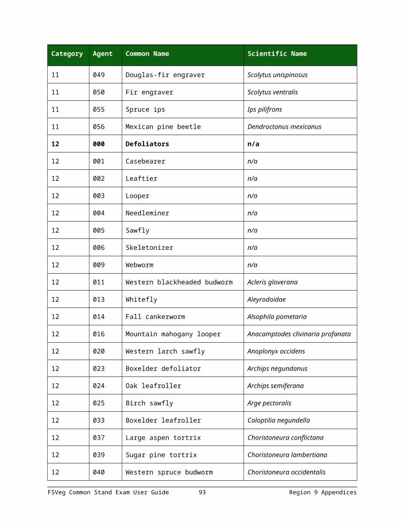
Category Agent Common Name Scientific Name
25 029 Hardwood anthracnose Kabatiella apocrypta
25 031 Spruce needle cast Lirula macrospora
25 033 White pine needle cast Lophodermella arcuata
25 034 Lophodermella needle cast Lophodermella spp.
25 035 Lophodermium needle cast Lophodermium spp.
25 036 Marssonina blight Marssonia populi
25 037 Melampsora rusts Melampsora medusa
25 039 Larch needle cast Meria laricis
25 040 Dothistroma needle blight Mycosphaerella pini
25 041 Brown felt blight of pines Neopeckia coulteri
25 042 Snow blight Phacidum abietis
25 050 Douglas-fir needle cast Rhabdocline spp.
25 055 Septoria leaf spot Septoria alnifolia
25 056 Septoria leaf spot and canker Septoria musiva
25 057 Sirococcus tip blight Sirococcus conigenus
25 058 Diplodia blight Sphaeropsis sapinea
25 059 Leaf blister of oak Taphrina caerulescens
25 060 Venturia leaf blight of maple Venturia acerina
25 061 Shepherd’s crook Venturia tremulae
25 062 Dothistroma needle blight Dothistroma septospora
25 064 Broom rust Chrysomyxa arctostaphyli
25 065 Spruce needle rust Lophodermium picea
25 067 Spruce needle cast Lophodermium picea
25 068 Hardwood leaf rust Rhizosphaera pini
25 071 Spruce needle cast Rhizosphaera pini
25 073 Shepards crook Ventirua populina
FSVeg Common Stand Exam User Guide 93 Region 9 Appendices

Category Agent Common Name Scientific Name
25 074 Delphinella shoot blight Delphinella abietis
25 075 Tar spot Rhytisma acerinum
26 000 Stem rusts n/a
26 001 White pine blister rust Cronartium ribicola
26 002 Western gall rust Peridermium harknessii
26 003 Stalactiform blister rust Cronartium coleosporioides
26 004 Comandra blister rust Cronartium comandrae
26 005 Pinyon blister rust Cronartium occidentale
26 011 Bethuli rust Peridermium bethuli
26 012 Limb rust Peridermium filamentosum
26 013 Southern cone rust Cronartium strobilinum
27 000 Broom rusts n/a
27 001 Spruce broom rust Chrysomyxa arctostaphyll
27 002 Incense cedar broom rust Gymnosporangium libocedri
27 003 Juniper broom rust Gymnosporangium nidus-avis
27 004 Fir broom rust Melampsorella caryophyllacearum
30 000 Fire n/a
30 031 Wild-fire n/a
30 032 Human caused fire n/a
30 033 Crown fire damage n/a
30 034 Ground fire damage n/a
40 000 Animal damage, source unknown
n/a
41 000 Wild animals n/a
41 001 Bear n/a
41 002 Beaver n/a
FSVeg Common Stand Exam User Guide 94 Region 9 Appendices

Category Agent Common Name Scientific Name
41 003 Big game (deer) n/a
41 004 Mice or voles n/a
41 005 Pocket gophers n/a
41 006 Porcupines n/a
41 007 Rabbits or hares n/a
41 008 Sapsucker n/a
41 009 Squirrels n/a
41 010 Woodpeckers n/a
41 011 Moose n/a
41 012 Elk n/a
41 013 Deer n/a
41 014 Feral pigs n/a
41 015 Mountain beaver n/a
41 016 Deer or elk n/a
41 017 Earthworm Lumbricidae
42 000 Domestic animals n/a
42 001 Cattle n/a
42 002 Goats n/a
42 003 Horses n/a
42 004 Sheep n/a
50 000 Abiotic damage n/a
50 001 Air pollutants n/a
50 002 Chemical n/a
50 003 Drought n/a
50 004 Flooding/high water n/a
50 005 Frost n/a
FSVeg Common Stand Exam User Guide 95 Region 9 Appendices

Category Agent Common Name Scientific Name
50 006 Hail n/a
50 007 Heat n/a
50 008 Lightning n/a
50 009 Nutrient imbalances n/a
50 010 Radiation n/a
50 011 Snow/ice n/a
50 013 Wind-tornado n/a
50 014 Winter injury n/a
50 015 Avalanche n/a
50 016 Mud-land slide n/a
50 017 Volcano n/a
50 018 Other geologic events n/a
50 019 Mechanical (non-human caused) n/a
60 000 Competition n/a
70 000 Human activities n/a
70 001 Herbicides n/a
70 003 Imbedded objects n/a
70 004 Improper planting technique n/a
70 005 Land clearing n/a
70 006 Land use conversion n/a
70 007 Logging damage n/a
70 008 Mechanical n/a
70 009 Pesticides n/a
70 010 Roads n/a
70 011 Soil compaction n/a
70 012 Suppression n/a
FSVeg Common Stand Exam User Guide 96 Region 9 Appendices

Category Agent Common Name Scientific Name
70 013 Vehicle damage n/a
70 014 Road salt n/a
71 000 Harvest n/a
80 000 Multi-damage (insect/disease) n/a
80 001 Aspen defoliation n/a
80 002 Subalpine fir mortality n/a
80 004 Pinion pine decline n/a
90 000 Unknown n/a
99 000 Physical effects n/a
99 001 Broken or top missing n/a
99 002 Dead top n/a
99 003 Limby (large limbs top to ground) n/a
99 004 Forked top n/a
99 005 Forked below merch top n/a
99 006 Crook or sweep n/a
99 007 Checks, bole cracks n/a
99 008 Foliage discoloration n/a
99 009 Mortality (for plantation surveys only)
n/a
99 010 Lack of seed source or dieback (for plantation surveys only)
n/a
99 011 Pour planting stock (for plantation surveys only)
n/a
99 012 Poor growth/fading/foliage is yellowing and loss of needles is occurring
n/a
99 013 Total board foot volume loss n/a
99 014 Total cubic foot volume loss n/a
FSVeg Common Stand Exam User Guide 97 Region 9 Appendices
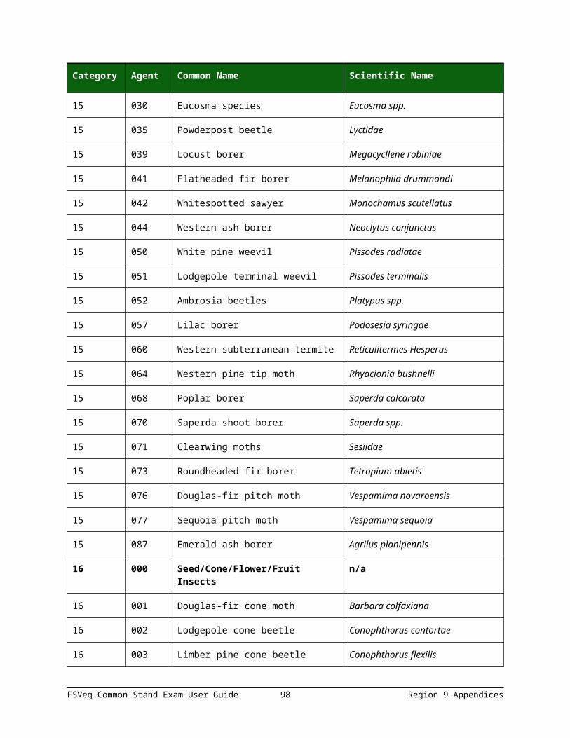
Category Agent Common Name Scientific Name
99 015 Bark removal n/a
99 016 Foliage loss n/a
99 017 Sunscald n/a
99 018 Uproot n/a
99 019 Scorched foliage n/a
99 020 Scorched bark n/a
99 021 Dieback (for plantation surveys only)
n/a
99 022 Poor crown form n/a
99 023 Severe forking n/a
99 026 Open wound n/a
99 031 Broken or dead branches n/a
99 033 Damaged shoots, buds, or foliage (for plantation surveys only)
n/a
99 034 Excessively deformed sapling n/a
99 036 Fire scar n/a
99 037 Leaning tree >15% and self-supporting
99 038 Charred bark Not recorded unless cambium is killed from heating
DAMAGE SEVERITY RATINGS
Table 44: Damage severity rating codes
Category Severity Description
10 n/a General insects
10 1 Minor: bottlebrush or shortened leaders, 0-2 forks on stem, OR <20% of branches affected, OR <50% of bole with visible larval galleries
FSVeg Common Stand Exam User Guide 98 Region 9 Appendices
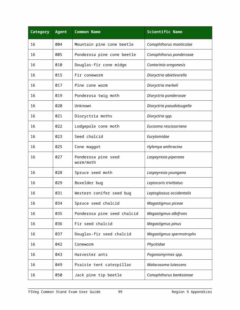
Category Severity Description
10 2 Severe: 3 or more forks on bole, OR 20% or more branches affected, OR terminal leader dead, OR 50% or more of bole with visible larval galleries
11 n/a Bark beetles
11 1 Unsuccessful bole attach: pitchout and beetle brood absent
11 2 Strip attacks: galleries and brood present
11 3 Successful current bole attack
11 4 Topkill
11 5 Successful attack last year
11 6 Older dead
12 n/a Defoliators
12 1 Light defoliation (1-25%), no topkill
12 2 Light defoliation (1-25%), topkill ≤10%
12 3 Light defoliation (1-25%), topkill >10%
12 4 Moderate defoliation (26-75%), no topkill
12 5 Moderate defoliation (26-75%), topkill ≤10%
12 6 Moderate defoliation (26-75%), topkill >10%
12 7 Heavy defoliation (76-100%), no topkill
12 8 Heavy defoliation (76-100%), topkill ≤10%
12 9 Heavy defoliation (76-100%), topkill >10%
13 n/a Chewing insects
13 1 Minor: bottlebrush or shortened leaders, 0-2 forks on stem, OR <20% of branches affected
13 2 Severe: 3 or more forks on bole, OR 20% or more branches affected, OR terminal leader dead
14 n/a Sucking insects
FSVeg Common Stand Exam User Guide 99 Region 9 Appendices

Category Severity Description
14 1 Minor: bottlebrush or shortened leaders, 0-2 forks on stem, OR <20% of branches affected
14 2 Severe: 3 or more forks on bole, OR 20% or more branches affected, OR terminal leader dead
15 n/a Boring insects
15 1 Minor: bottlebrush or shortened leaders, 0-2 forks on stem, OR <20% of branches affected
15 2 Severe: 3 or more forks on bole, OR 20% or more branches affected, OR terminal leader dead
16 n/a Seed/cone/flower/fruit insects
16 1 Minor
16 2 Severe
17 n/a Gallmaker insects
17 1 Minor
17 2 Severe
18 n/a Insect predators
18 1 Minor
18 2 Severe
19 n/a General diseases
19 1 Minor
19 2 Severe
20 n/a Biotic damage
20 1 Minor
20 2 Severe
21 n/a Root/butt diseases
FSVeg Common Stand Exam User Guide 100 Region 9 Appendices
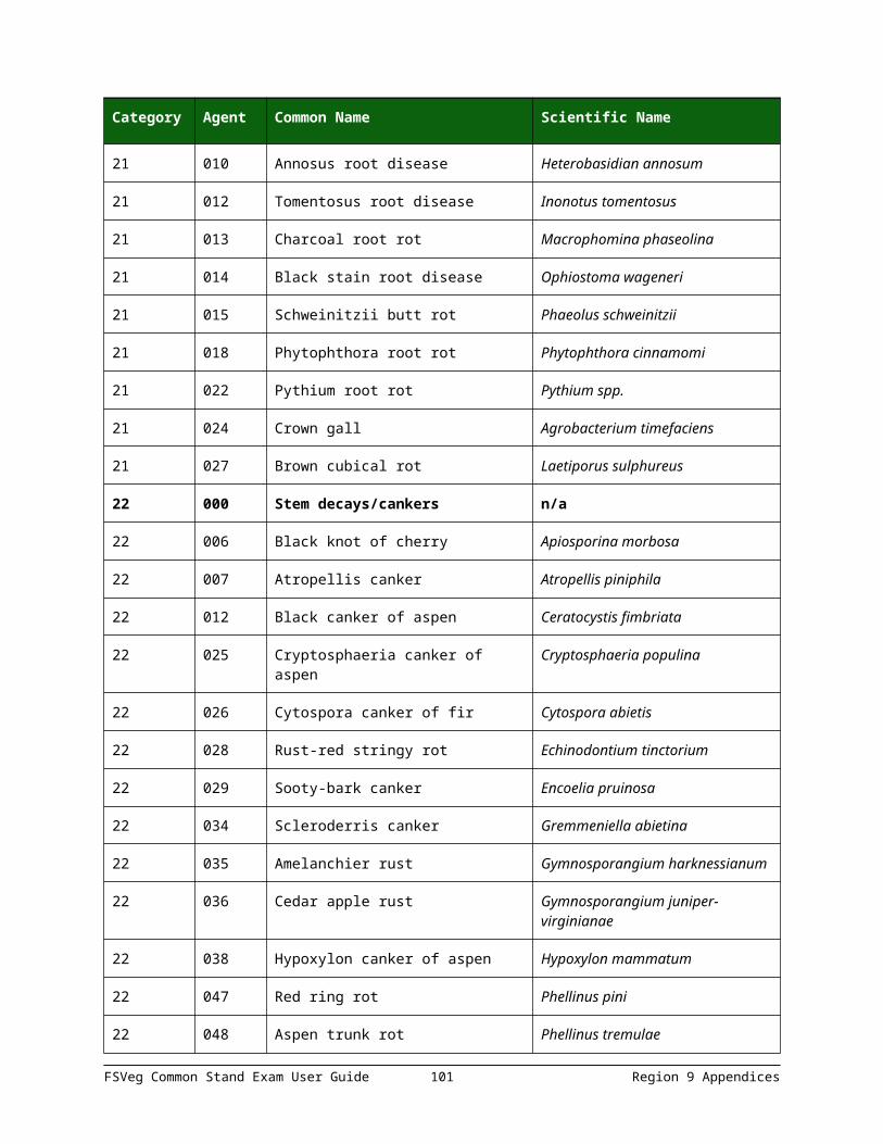
Category Severity Description
21 1 (for individual trees) Tree within 30 feet of tree with deteriorating crown, tree with diagnostic symptoms or signs, or tree killed by root disease
21 2 (for individual trees) Pathogen (sign) or diagnostic symptom detected – no crown deterioration
21 3 (for individual trees) Crown deterioration detected – no diagnostic symptom or signs
21 4 (for individual trees) Both crown deterioration and diagnostic signs symptoms detected
21 5 (for individual trees) Bleeding present on bole
21 6 (for individual trees) Bleeding present on bole and adjacent mortality present
21 7 (for individual trees) Laboratory confirmed Sudden Oak Death
21 G2 (for setting level) Minor evidence of RDS on plot
21 G3 (for setting level) RDS present, canopy reduction less than 20%
21 G4 (for setting level) RDS present, canopy reduction 20-30%
21 G5 (for setting level) RDS present, canopy reduction 30-50%
21 G6 (for setting level) RDS present, canopy reduction 50-75%, most ground area infested
21 G7 (for setting level) RDS present, 76+% canopy reduction
21 G8 (for setting level) Entire area infested with RDS, one or very few susceptible overstory trees
21 G9 (for setting level) Entire area infested with RDA, no susceptible overstory trees present
22 n/a Stem decay/canker
22 0 0-4% rotten
22 1 5-15% rotten
22 2 16-25% rotten
FSVeg Common Stand Exam User Guide 101 Region 9 Appendices

Category Severity Description
22 3 26-35% rotten
22 4 36-45% rotten
22 5 46-55% rotten
22 6 56-65% rotten
22 7 66-75% rotten
22 8 76-85% rotten
22 9 86-100% rotten
23 n/a Parasitic/epiphytic plants
23 1 Hawksworth tree DMR rating = 1; light infection
23 2 Hawksworth tree DMR rating = 2; light infection
23 3 Hawksworth tree DMR rating = 3; medium infection
23 4 Hawksworth tree DMR rating = 4; medium infection
23 5 Hawksworth tree DMR rating = 5; heavy infection
23 6 Hawksworth tree DMR rating = 6; heavy infection
23 7 Vine damage: less than 50% of crown involved
23 8 Vine damage: 50% or more of crown involved
24 n/a Decline complexes/diebacks/wilts
24 1 Minor: minor crown symptoms
24 2 Severe: severe crown symptoms
25 n/a Foliage diseases
25 1 Minor: <20% of foliage affected or <20% of crown in brooms
25 2 Severe: >20% of foliage affected or >20% of crown in brooms
26 n/a Rust Stems
FSVeg Common Stand Exam User Guide 102 Region 9 Appendices

Category Severity Description
26 1 Branch infections located greater than 2 feet from tree bole
26 2 Branch infections located between 6 inches and 2 feet from tree bole
26 3 Bole infections or branch infections located within 6 inches of bole
26 4 Topkill
27 n/a Broom rusts
27 1 Minor: <20% of crown in brooms
27 2 Severe: >20% of crown in brooms
30 n/a Fire
30 1 Minor: <20% of crown affected
30 2 Severe: >20% of crown affected or any damage to the bole
40 n/a Animal damage, source unknown
40 1 Minor
40 2 Severe
41 n/a Wild animals
41 1 Minor: <20% of crown affected, bole damage is <50% circumference
41 2 Severe: >20% of crown affected, bole damage is >50% circumference, upper 1/3 of crown is killed
41 5 Earthworms are present
41 6 Earthworms are absent
50 n/a Abiotic damage
50 1 Minor: <20% of crown affected, bole damage is <50% circumference
50 2 Severe: >20% of crown affected, bole damage is >50% circumference, upper 1/3 of crown is killed
FSVeg Common Stand Exam User Guide 103 Region 9 Appendices

Category Severity Description
60 n/a Competition
60 1 Minor: tree slightly deformed and has some lie, terminal growth
60 2 Severe: tree extremely deformed or has no live terminal, growth severely reduced relative to neighbors
70 n/a Human activities
70 1 Minor
70 2 Severe
71 n/a Harvest
71 1 Minor
71 2 Severe
80 n/a Multi-damage (insect/disease)
80 1 Minor
80 2 Severe
90 n/a Unknown
90 0 0 – 9% affected
90 1 10 – 19% affected
90 2 20 – 29% affected
90 3 30 – 39% affected
90 4 40 – 49% affected
90 5 50 – 59% affected
90 6 60 – 69% affected
90 7 70 – 79% affected
90 8 80 – 89% affected
90 9 90 – 100% affected
FSVeg Common Stand Exam User Guide 104 Region 9 Appendices

Category Severity Description
99 n/a Physical effects
99 001 Broken top
99 002 Dead top
Table 45: Category 99 damage severity rating codes
Category Severity Description Actual percent of tree affected
99 n/a Physical effects n/a
99 001 Broken top % of original height that is missing; for example, if a tree was originally 100 feet high, but 15 feet of the top is broken or missing; enter “15” in the severity code
99 002 Dead top % of total tree height that is dead
99 003 Limby (large limbs top to bottom)
% of total tree height with many limbs/knots
99 004 Forked top % of total tree height above fork
99 005 Forked below merch top % of the total length of the bole affected
99 006 Crook or sweep % of total tree height, which contains the crook or sweep
99 007 Checks, bole cracks % of total tree height, which contains a crack or check
99 008 Foliage discoloration % of foliage discolored
99 009 Mortality 1 = dead tree
99 010 Lack of seed source If present, 100%
99 011 Poor planting stock source If present, 100%
99 012 Poor growth 1 = minor (reduced growth); 2 = severe (affecting survival)
99 013 Total board foot volume loss
%of total board foot volume loss
FSVeg Common Stand Exam User Guide 105 Region 9 Appendices

Category Severity Description Actual percent of tree affected
99 014 Total cubic foot volume loss
% of total cubic foot volume loss
99 015 Bark removal % of tree circumference missing bark
99 016 Foliage loss 1 = minor; 2 = severe
99 017 Sunscald 1 = minor; 2 = severe
99 018 Uproot 1 = uprooted
99 019 Scorched foliage % of foliage scorched
99 020 Scorched bark % of bark scorched
99 021 Dieback source 1 = minor; 2 = severe
99 022 Poor crown form 1 = minor; 2 = severe
99 023 Severe forking % of bole with forks
99 026 Open wound % of bole or trunk affected using the height and width of the wound; for example, if a tree is 100 feet tall and the wound covers 15 feet of the bole, enter a value of ”15”
99 031 Broken or dead branches % of branches broken or dead
99 033 Damage shoots, buds, or foliage source
1 = minor; 2 = severe
99 034 Excessively deformed sapling
% of sapling deformed
99 036 Fire scar % of bole covered by fire scar
99 037 Leaning tree % lean from vertical
99 038 Charred bark Not recorded unless cambium is killed from heating
FSVeg Common Stand Exam User Guide 106 Region 9 Appendices

TREE PARTS
Table 46: Tree part codes
Code Description
UN Unspecified
TO Top
FO Foliar (crown)
LI Limb
BO Bole, other than Top or Base
BA Base
RO Roots
WT Whole tree
TT Top third of crown
MT Middle third of crown
BT Bottom third of crown
APPENDIX L: ACCURACY STANDARDS
Table 47: Settings Measurements
Field Tolerance
Project Name No errors
Region No errors
Proclaimed Forest No errors
District No errors
Location No errors
Stand Number No errors
Ownership No errors
State No errors
FSVeg Common Stand Exam User Guide 107 Region 9 Appendices
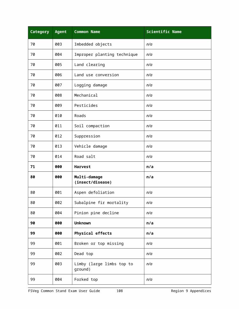
Field Tolerance
County No errors
Administrative Forest No errors
Date No errors
Photo ID No errors
Exam Level No errors
Exam Purpose No errors
Stratum No errors
Existing Vegetation Composition Type No errors
Potential Vegetation Reference No errors
Potential Vegetation No errors
Structure No errors
Capable Growing Area ± 10 percent
Fuel Model No errors
Elevation ± 2 contour intervals
Aspect ± 45 degrees
Slope ± 10 percent
Slope Position ± 1 class
Acres No errors
Radial Growth Interval No errors
Radial Growth Interval #2 No errors
Height Growth Interval No errors
Fuel Photo Reference No errors
Precision Protocol No errors
Examiner No errors
Stand Remarks No errors
FSVeg Common Stand Exam User Guide 108 Region 9 Appendices

Field Tolerance
Damage Category No errors
Damage Agent No errors
Damage Severity No errors
Species of Management Interest No errors
Sketch Map and Traverse Notes n/a
Table 48: Sample Design Criteria
Field Tolerance
Form Type n/a
Selection Method Type No errors
Sample Expansion Factor No errors
Plots Installed No errors
Sub-population Filter No errors
Starting Azimuth No errors
Sample Design Remarks No errors
Selection Criteria Number No errors
Sub-pop Variable No errors
Sub-pop Minimum Value No errors
Sub-pop Maximum Value No errors
Table 49: Plot Data
Field Tolerance
Plot Number No errors
Plot Latitude No errors
Plot Longitude No errors
Capable Grow Area ± 10 percent
FSVeg Common Stand Exam User Guide 109 Region 9 Appendices
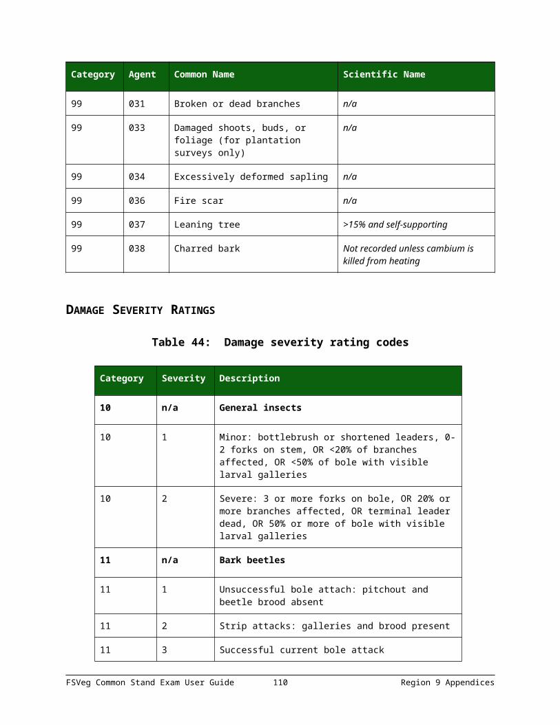
Field Tolerance
Plot Aspect ± 45
Plot Scope ± 10 percent
Slope Position ± 1 class
Slope Horizontal Shape ± 1 class
Slope Vertical Shape ± 1 class
Plot Elevation ± 2 contour intervals
Existing Vegetation No errors
Potential Vegetation Accurate to series understory union and phases
Plot History No errors
Plot History Date Year required in field 12 is other than code 10 or blank
Fuel Model No errors
Residual Descriptive Code No errors
Distance to Seed Wall ± 100 feet
Plot Remarks n/a
Table 50: Tree Data
Field Tolerance
Plot Number No errors
Tag ID Number No errors
Tree Status No errors allowed in recognizing and coding down trees
Site/Growth Trees No errors
Tree Species No errors
Tree Count See specifics in Table 51
Number Stems No errors
FSVeg Common Stand Exam User Guide 110 Region 9 Appendices

Field Tolerance
DBH/DRC Intensive Exam
See specifics in Table 52
DBH/DRC Extensive Exam
See specifics in Table 53
DBH/DRC Quick Exam
See specifics in Table 54
Height 10 percent
Height to Crown 10 percent
Radial Growth 1/20th inch
Radial Growth #2 1/20th inch
Height Growth See specifics in Table 55
Tree Age 10 percent (based on actual tree ring count at breast height for trees ≥ 3.0” DBH otherwise based on total age recorded)
Crown Ratio 10 percent
Crown Class No errors
Crown Width No errors
Wildlife Use No errors
Log/Snag Decay No errors
Cone Seronity No errors
Damage Category No errors, specifics listed in Table 56
Damage Agent No errors
Damage Part No errors
Damage Severity No errors
Tree Remarks n/a
FSVeg Common Stand Exam User Guide 111 Region 9 Appendices
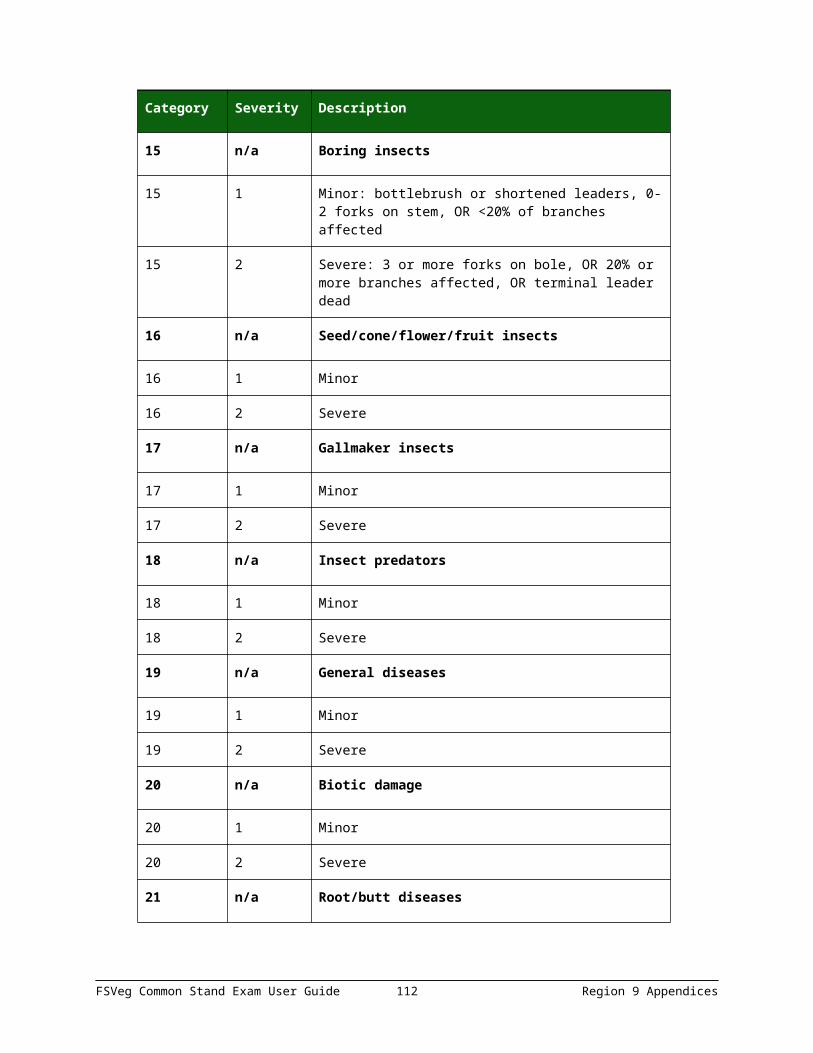
Table 51: Tree Data, Tree Count
Height Range
Diameter Range Trees on Point Tolerance
*All All 0 0 trees
≤ 0.5 feet All 1-5 ± 2 trees
≤ 0.5 feet All 6+ ± 50 percent
> 0.5 feet < 0.5 in. 1-5 ± 1 tree
> 0.5 feet < 0.5 in. 6+ ± 20 percent
All .5” – breakpoint DBH 1-5 ± 1 tree
All .5” – breakpoint DBH 6+ ± 10 percent
All Breakpoint DBH + 1+ 0 trees
* There is no tolerance for recording a tree when none are actually present in any of the above size classes. The recording of a fixed plot tree when none are present will result in a single discrepancy. The recording of a variable plot tree when none are present will result in an unacceptable unit.
Group criteria are standardized to facilitate stand exam contract inspection and payment. However, distinguishing characteristics other than tree class, species, and size class may warrant individual tree recording or more refined grouping criteria. Such characteristics include: age, crown ratio, crown class, or incident of damage.
Table 52: Tree Data, DBH/DRC Intensive Exam
Tolerance Diameter
No errors <.5 inch
± .1 inch .5 inch – 13.9 inches
± .2 inch 14.0 inches – 23.9 inches
± .3 inch 24.0 inches – 34.9 inches
± .5 inch 35.0 inches +
± .1 inch Borderline variable plot trees
± .1 inch Estimated DRC
FSVeg Common Stand Exam User Guide 112 Region 9 Appendices

Table 53: Tree Data, DBH/DRC Extensive Exam
Tolerance Diameter
± 1 inch ≤ 20 inches
± 5% of diameter > 20 inches
Table 54: Tree Data, DBH/DRC Quick Exam
Tolerance Diameter
± 2 inches ≤ 20 inches
± 10% of diameter > 20 inches
Table 55: Tree Data, Height Growth
Tolerance Diameter
± 1 foot Trees > 6 feet
± 0.1 foot Trees ≤ 6 feet
Table 56: Tree Data, Damage Category
Damage Category
Damage Category Description
Tolerance
11 Bark Beetles No misses on live trees with a severity of 2 or greater
12 Defoliators No misses on live trees with a severity of 3 or greater
13-17 Other Insects No misses of shoot moths or weevils on live trees
21 Root/Butt Diseases No misses on live trees with a severity of 2 or greater
22 Stem Decays/Cankers No misses on live trees with a severity of 3 or greater
25 Foliage Diseases No misses on Elytroderma on live trees
41-42 Animal Damage No misses on live trees with terminal leader damage or with greater than ¼ of bole circumference affected
FSVeg Common Stand Exam User Guide 113 Region 9 Appendices

Damage Category
Damage Category Description
Tolerance
50 Abiotic Damage No misses on wind, snow, or ice bending, breakage, or bole cracks and frost damage to shoots on trees less than 1-inch diameter and lightning
70 Human Damage No misses on live trees for logging damage or fire if the damage affects greater than ¼ of the bole circumference or if an open wound is in contact with the ground
Table 57: Ground Surface Cover
Field Tolerance
Plot Number No errors
Cover Type No errors
Cover Percent ± 10 percent
Table 58: Vegetation Composition
Field Tolerance
Plot Number No errors
Live/Dead No errors
Layer No errors
Life form No errors
Species No error in species-level identification for dominant, common, or community type indicator plants; no plant name can be repeated within a layer
Minimum Height ± 10 percent of height
Average Height ± 10 percent of height
Maximum Height ± 10 percent of height
Canopy Cover ± 10 percent
FSVeg Common Stand Exam User Guide 114 Region 9 Appendices

Field Tolerance
Average Diameter No errors
Maturity No errors
Cover Remarks n/a
User Field n/a
Table 59: Down Woody
Field Tolerance
Plot Number No errors
First Duff ± ½ inch
Second Duff ± ½ inch
Fuel Depth No errors
Twigs 0 – .24 ± 40 percent
Twigs .25 - .99 ± 30 percent
Twigs 1.0 – 2.99 ± 20 percent
Volume 1 n/a
Weight 1 n/a
Volume 2 n/a
Weight 2 n/a
Volume 3 n/a
Weight 3 n/a
Volume 4 n/a
Weight 4 n/a
Piece Count No missed pieces
Decay Class No errors
Diameter ± 1 inch on measurements
Piece Length No errors
FSVeg Common Stand Exam User Guide 115 Region 9 Appendices

APPENDIX M: GLOSSARY OF TERMS
Table 60: Glossary
Term Definition
Aspect A position facing or commanding a given direction; exposure. Aspect is the compass direction of the prevailing slope with respect to true north.
Azimuth A horizontal angular measure from true north to an object of interest.
Basal Area The cross-sectional area of the stem or stems of a plant or of all plants in a stand; generally expressed as square units per unit area. For trees, measured at 4.5 feet above ground; forbs and grasses are measure at the root crown
Bole Length The straight-line distance measured parallel to the main bole of a tree, from its base to its tip.
Breast Height A point located on the uphill side of the main stem, by measuring 4.5 feet along the uphill side of the bole from ground level or the predominant root collar. Preclude slight, non-compacted litter accumulations when establishing breast height.
CALVEG Classification and Assessment with LANDSAT of Visible Ecological Groupings. It is a California-wide system for classifying vegetative and non-vegetative cover types. The primary cover type relates to life form and uses a 3-character alpha code.
Canopy Cover The percent of a fixed area covered by the crown of an individual plant species or delimited by the vertical projection of its outermost perimeter; small openings in the crown are included.
Compacted Live Crown Ratio
The percent of the total height of the tree that supports a full, live crown. For trees that have uneven length crowns, occularly transfer lower branches to fill holes in the upper portions of the crown, until a full, even crown is created.
Compartment A land area, usually between 3,000 and 8,000 acres, easily identified on the ground by physical features. A compartment tis comparable in size to a sub-watershed, or landscape management unit. It is used as a convenience for maintaining stand records and planning vegetation management projects.
Crown Class The relative position of the tree or shrub crown with respect to the competing vegetation around it. Crown
FSVeg Common Stand Exam User Guide 116 Region 9 Appendices

Term Definition
class for each tree or shrub is judged in the context of its immediate environment, that is those trees or shrubs which are competing for sunlight with the subject tree or shrub.
Crown Length The vertical distance from the top of the leader to the base of the crown, measured to the lowest live branch-whorl with live branches in at least three quadrants, and continuous with the main crown.
Crown Ratio The ratio of compacted live crown length to bole length. Lengths are measured parallel to the bole from the base of the tree to the tip.
DEM Digital Elevation Model. USGS geographic elevation data distributed in raster form. Digital representation of the shape of the earth’s surface. Typically, digital elevation data consists of arrays of values that represent topographic elevations measured at equal intervals on the Earth’s surface.
Diameter The length of a straight-line segment passing through the center of an item and terminating at its periphery.
Diameter at Breast Height (DBH)
A measure at breast height (4.5 feet), outside bark, of the tree bole, perpendicular to the tree bole.
Diameter at Root Collar (DRC)
The straight line passing through the center of a cross section of a bole measured at the root collar of a shrub or tree.
Down Log Stem material (conifer or hardwood) that is lying on the ground. If a stem material is leaning more than 45 degrees from vertical, is not self-supporting, and/or in contact with the ground, it is considered a down log.
Down Woody Material Woody pieces of trees and shrubs that have been uprooted (no longer supporting growth) or severed from their root system, not self-supporting, and are lying on the ground.
Duff Layer Duff is the fermentation and humus layer of the forest floor. It does not include the freshly cast material in the litter layer. The top of the duff is where needles, leaves, and other cast-off vegetative material have noticeably begun to decompose. Individual particles usually will be bound by fungi mycelium. When moss is present, the top of the duff is just below the green portion of the moss. The bottom of the duff is the start of the soil (“A” horizon).
Elevation Vertical distance from a datum, usually mean sea level, to a point or object on the earth’s surface. Not to be
FSVeg Common Stand Exam User Guide 117 Region 9 Appendices

Term Definition
confused with altitude, this refers to points above the earth’s surface.
Fuel Bed The fuel bed is accumulation of dead, woody residue on the forest floor. It begins at the top of the duff layer and above. It includes litter, dead limb wood, and bole wood from tree species, as well as dead material from shrub, herbaceous, and grass species.
Fuel Model Mathematical descriptions of fuel properties (e.g., fuel load and fuel depth) that are used as inputs to calculations of fire danger indices and fire behavior potential.
GPS Global Positioning System. A network of radio-emitting satellites deployed by the U.S. Department of Defense. Ground-based GPS receivers can automatically derive accurate surface coordinates for all kinds of GIS, mapping, and surveying data collection.
Ground Level The forest floor, made up by soil and duff layer. It does not include unincorporated woody debris that may rise above the ground line. In reference to a point of measure, it is the highest point of the ground touching the bae of the object being referenced.
Group Tally A count of one or more items of the same type or species and recorded as a single line entry.
Growth A measure of the increase in growth layers for a specified time frame.
Height Growth The increase in height over a set period of time.
Intersect Diameter Measurement of diameter at a point where the sampling plane intersects the geometric center of the object being tallied. No adjustment is made for stem irregularities at the point of intersection.
Lean (Tree) The deflection from vertical, > 15 degrees of a straight line passing through the geometric center of the base and top of the main stem.
Length The measurement of the extent of something along its greatest dimension.
Life Form Species and individuals that are grouped into classes on the basis of their similarities in structure and function. A growth form that displays an obvious relationship to important environmental factors.
Limiting Distance A comparative measurement between the subplot radius and the distance from the subplot center to the center of
FSVeg Common Stand Exam User Guide 118 Region 9 Appendices

Term Definition
the object. The comparison is used to determine whether the object is in or out of the fixed area subplot.The object is “IN” if the measured distance is equal to or less than the subplot radius.The object is “OUT” if the measured distance is greater than the subplot radius.
Live Crown Length The straight-line distance measured parallel to the main bole of a tree, from the top of the live crown to the base of the live crown.
Ownership The identification of the legal owner/administrator on both the surface and subsurface estates.
Plant Species The major subdivision of a genus or subgenus of a plant being described or measured.
Plot Configuration The size and shape of the sampling unit (plot) and the spatial arrangement of subplots within that unit.
Plot A sub-sample of a plot or stand exam. This is the unit on which data are recorded to individual trees, snags, logs, understory vegetation, and fuels. Data can be collected on either a fixed area or variable radius area.
Proclaimed Forest Units of the National Forest System as originally proclaimed or designated by Congress.
Quadratic Mean Diameter
The diameter of the tree of average basal area.
Radial Growth Increment
The increase in tree radius over a period of time at breast height, or occasionally at the base.
Random Sample Any method of sample selection based on the theory of probability (degree of certainty). At any stage of the operation of selection, the probability of any set of units being selected must be known. It is the only method that can provide a measure of precision of the estimate.
Reconciliation Code A code used to reflect the status of an individually tallied item with regards to previous surveys.
Slope A deviation from the horizontal.
Species A code that represents a fundamental category of taxonomic classification of an organism.
Stand A spatially continuous group of trees and associated vegetation having similar structures and growing under similar soil and climatic conditions.
FSVeg Common Stand Exam User Guide 119 Region 9 Appendices

Term Definition
Stand Exam Grid Basic data collection method for stand exams. It consists of a set of plots, separated by equal distances on a grid pattern. The lines of the grid (transects) are oriented in cardinal directions. There is a predetermined distance between plots. The number of transects and grid plots will vary depending upon the size and shape of the stand.
Stratified Sample A method of sampling forest resources where stands or polygons of similar properties are lumped into strata. This improves the efficiency of an inventory by reducing the variability within a given population. The less variability there is within a strata, the fewer samples will need to be taken to achieve a statistically valid result.
Stratum A group of stands within a condition class; similar characteristics such as forest type, tree size class, and canopy density.
Stump The woody base of a tree remaining in contact with the soil after the trunk or main stem has been severed at a point less than 4.5 feet above ground height (measured on the uphill side).
Tree A woody perennial plant, typically large, with a single well-defined stem carrying a more or less definite crown.
Tree Age Total age of the above-ground stem of a tree (not age of the root stock or the total age from seed). Total age is usually the annual ring count to the pith of the tree at breast height plus an estimate of the number of years it took the tree to reach breast height.
APPENDIX N: FUEL MODELS
The original 13 fuel models are from “Aids to Determining Fuel Models for Estimating Fire Behavior,” Hal E. Anderson, INT-122, 1982. The remaining fuel models are from “Standard Fire Behavior Fuel Models: A Comprehensive Set for Use with Rothermel’s Surface Fire Spread Model” by Joe H. Scott and Robert E. Burgan. RMRS – GTR-153. June 2005.
Table 61: Fuel Models
Fuel Model
Fuel Model Code
Fuel Model Name
Fuel Type Model Set
Fuel 1-hr
Fuel 10-hr
Fuel 100-hr
Fuel Bed Depth
1 n/a Short grass (1 foot)
Grass and grass-dominated
Original 13
0.74 0 0 1
FSVeg Common Stand Exam User Guide 120 Region 9 Appendices

Fuel Model
Fuel Model Code
Fuel Model Name
Fuel Type Model Set
Fuel 1-hr
Fuel 10-hr
Fuel 100-hr
Fuel Bed Depth
2 n/a Timber (grass and understory)
Grass and grass-dominated
Original 13
2 1 0.500 1
3 n/a Tall grass (2.5 feet)
Grass and grass-dominated
Original 13
3.01 0 0 2.50
4 n/a Chaparral (6 feet)
Chaparral and shrub fields
Original 13
5.01 4.010 2 6
5 n/a Brush (2 feet) Chaparral and shrub fields
Original 13
1 0.500 0 2
6 n/a Dormant brush, hardwood slash
Chaparral and shrub fields
Original 13
1.50 2.500 2 2.50
7 n/a Southern rough Chaparral and shrub fields
Original 13
1.13 1.870 1.500 2.50
8 n/a Closed timber litter
Timber litter
Original 13
1.50 1 2.500 0.20
9 n/a Hardwood litter Timber litter
Original 13
2.92 0.410 0.150 0.20
10 n/a Timber (litter and understory)
Timber litter
Original 13
3.01 2 5.010 1
11 n/a Light logging slash
Slash Original 13
1.50 4.51 5.510 1
12 n/a Medium logging slash
Slash Original 13
4.01 14.03 16.53 2.30
13 n/a Heavy logging slash
Slash Original 13
7.01 23.04 28.05 3
91 NB1 Urban/ Developed
Non-burnable
Scott and Burgan
0 0 0 0
92 NB2 Snow/Ice Non-burnable
Scott and Burgan
0 0 0 0
FSVeg Common Stand Exam User Guide 121 Region 9 Appendices

Fuel Model
Fuel Model Code
Fuel Model Name
Fuel Type Model Set
Fuel 1-hr
Fuel 10-hr
Fuel 100-hr
Fuel Bed Depth
93 NB3 Agricultural Non-burnable
Scott and Burgan
0 0 0 0
98 NB4 Open Water Non-burnable
Scott and Burgan
0 0 0 0
99 NB5 Bare Ground Non-burnable
Scott and Burgan
0 0 0 0
101 GR1 Short, Sparse Dry Climate Grass (Dynamic)
Grass Scott and Burgan
0.10 0 0 0.40
102 GR2 Low Load, Dry Climate (Dynamic)
Grass Scott and Burgan
0.10 0 0 1
103 GR3 Low Load, Very Coarse, Humid Climate Grass (Dynamic)
Grass Scott and Burgan
0.10 0.40 0 2
104 GR4 Moderate Load, Dry Climate Grass (Dynamic)
Grass Scott and Burgan
0.25 0 0 2
105 GR5 Low Load, Humid Climate Grass (Dynamic)
Grass Scott and Burgan
0.40 0 0 1.50
106 GR6 Moderate Load, Humid Climate Grass (Dynamic)
Grass Scott and Burgan
0.10 0 0 1.50
107 GR7 High Load, Dry Climate Grass (Dynamic)
Grass Scott and Burgan
1 0 0 3
108 GR8 High Load, Very Coarse, Humid Climate Grass (Dynamic)
Grass Scott and Burgan
0.50 1 0 4
109 GR9 Very High Load, Humid Climate Grass (Dynamic)
Grass Scott and Burgan
1 1 0 5
FSVeg Common Stand Exam User Guide 122 Region 9 Appendices

Fuel Model
Fuel Model Code
Fuel Model Name
Fuel Type Model Set
Fuel 1-hr
Fuel 10-hr
Fuel 100-hr
Fuel Bed Depth
121 GS1 Low Load, Dry Climate Grass-Shrub (Dynamic)
Grass-Shrub
Scott and Burgan
0.20 0 0 0.90
122 GS2 Moderate load, Dry Climate Grass-Shrub (Dynamic)
Grass-Shrub
Scott and Burgan
0.50 0.500 0 1.50
123 GS3 Moderate Load, Humid Climate Grass-Shrub (Dynamic)
Grass-Shrub
Scott and Burgan
0.30 0.250 0 1.80
124 GS4 High Load, Humid Climate Grass-Shrub (Dynamic)
Grass-Shrub
Scott and Burgan
1.90 0.300 0.100 2.10
141 SH1 Low Load, Dry Climate Shrub (Dynamic)
Shrub Scott and Burgan
0.25 0.250 0 1
142 SH2 Moderate Load, Dry Climate Shrub
Shrub Scott and Burgan
1.35 2.400 0.750 1
143 SH3 Moderate Load, Humid Climate Shrub
Shrub Scott and Burgan
0.45 3 0 2.40
144 SH4 Low Load, Humid Climate Timber-Shrub
Shrub Scott and Burgan
0.85 1.150 0.200 3
145 SH5 High Load, Dry Climate Shrub
Shrub Scott and Burgan
3.60 2.100 0 6
146 SH6 Low Load, Humid Climate Shrub
Shrub Scott and Burgan
2.90 1.450 0 2
147 SH7 Very High Load, Dry Climate Shrub
Shrub Scott and Burgan
3.5 5.300 2.200 6
FSVeg Common Stand Exam User Guide 123 Region 9 Appendices

Fuel Model
Fuel Model Code
Fuel Model Name
Fuel Type Model Set
Fuel 1-hr
Fuel 10-hr
Fuel 100-hr
Fuel Bed Depth
148 SH8 High Load, Humid Climate Shrub
Shrub Scott and Burgan
2.05 3.400 0.850 3
149 SH9 Very High Load, Humid Climate Shrub (Dynamic)
Shrub Scott and Burgan
4.50 2.450 0 4.40
161 TU1 Low Load, Dry Climate Timber-Grass-Shrub (Dynamic)
Timber - Understory
Scott and Burgan
0.20 0.900 1.500 0.60
162 TU2 Moderate Load, Humid Climate Timber-Grass-Shrub (Dynamic)
Timber - Understory
Scott and Burgan
0.95 1.800 1.250 1
163 TU3 Moderate Load, Humid Climate Timber-Grass-Shrub (Dynamic)
Timber – Understory
Scott and Burgan
1.10 0.150 0.250 1.30
164 TU4 Dwarf Conifer with Understory
Timber – Understory
Scott and Burgan
4.50 0 0 0.50
165 TU5 Very High Load, Dry Climate Timber-Shrub
Timber – Understory
Scott and Burgan
4 4 3 1
181 TL1 Low Load Compact Conifer Litter
Timber Litter
Scott and Burgan
1 2.200 3.600 0.20
182 TL2 Low Load Broadleaf Litter
Timber Litter
Scott and Burgan
1.40 2.300 2.200 0.200
183 TL3 Moderate Load Conifer Litter
Timber Litter
Scott and Burgan
0.50 2.200 2.800 0.30
184 TL4 Small Downed Logs
Timber Litter
Scott and Burgan
0.50 1.500 4.200 0.40
FSVeg Common Stand Exam User Guide 124 Region 9 Appendices

Fuel Model
Fuel Model Code
Fuel Model Name
Fuel Type Model Set
Fuel 1-hr
Fuel 10-hr
Fuel 100-hr
Fuel Bed Depth
185 TL5 High Load Conifer Litter
Timber Litter
Scott and Burgan
1.15 2.500 4.400 0.60
186 TL6 Moderate Load Broadleaf Litter
Timber Litter
Scott and Burgan
2.40 1.200 1.200 0.30
187 TL7 Large Downed Logs
Timber Litter
Scott and Burgan
0.30 1.400 8.100 0.40
188 TL8 Long-Needle Litter
Timber Litter
Scott and Burgan
5.80 1.400 1.100 0.30
189 TL9 Very High Load Broadleaf Litter
Timber Litter
Scott and Burgan
6.65 3.300 4.150 0.60
201 SB1 Low Load Activity Fuel
Slash-Blowdown
Scott and Burgan
1.50 3 11 1
202 SB2 High Load Activity Fuel or Moderate Load Blowdown
Slash-Blowdown
Scott and Burgan
4.50 4.250 4 1
203 SB3 High Load Activity Fuel or Moderate Load Blowdown
Slash-Blowdown
Scott and Burgan
5.50 2.750 3 1.20
204 SB4 High Load Blowdown
Slash-Blowdown
Scott and Burgan
5.25 3.500 5.250 2.70
Table 62: Detailed Descriptions of the Fuel Models
Code Detailed Description
1 Contains fine, very porous, and continuous herbaceous fuels that have cured or are nearly cured. Generally less than one-third of the area contains shrubs or timber. Grasslands and savanna are represented along with stubble, grass-tundra, and grass-shrub combinations. Annual and perennial grasses are included in this fuel model.
FSVeg Common Stand Exam User Guide 125 Region 9 Appendices

Code Detailed Description
2 Herbaceous material with litter and dead-down stem wood from the open shrub or timber overstory. Open shrub lands and pine stands or scrub oak stands that cover one-third to two-thirds of the area. Stand many include clumps and may include pinyon-juniper.
3 Stands are tall, averaging about three feet, but considerable variation may occur. Approximately one-third or more of the stand is considered dead and cured. May include cultivated grains that have not been harvested, tall prairie, and marshland grasses.
4 Stands of mature shrubs, 6 feet or more tall such as California mixed chaparral, the high pocosin along the east coast, the pine barrens of New Jersey, or the closed jack pine stands of the north-central states. Besides flammable foliage, stand may contain dead woody material. May contains a deep litter layer.
5 Shrubs are young with little dead material, and the foliage contains little volatile material. Usually shrubs are short and almost totally cover the area. Young, green stands with no dead wood qualify: laurel, vine maple, alder, or even chaparral, manzanita, or chamise.
6 The shrubs are older, but not as tall as model 4, nor do they contain as much fuel as model 4. This model covers a broad range of shrub conditions: intermediate stands of chamise, chaparral, oak brush, low pocosin, Alaskan spruce taiga, and shrub tundra. May include hardwood slash that has been cured. Pinyon-juniper shrub lands may be represented.
7 Stands of shrubs are generally between 2 and 6 feet high. Palmetto-galliberry understory, with a pine overstory are typical. Low pocosin may be represented. Black spruce shrub combinations in Alaska may also be represented.
8 Contains closed canopy stands of short needle conifers or hardwoods that have leafed out. The compact litter layer is mainly needles, leaves, and occasionally twigs because little undergrowth is present. Representative conifer types are white pine, lodgepole pine, spruce, fir, and larch.
9 Both long-needle conifer stands and hardwood stands, especially the oak-hickory types, are typical. Closed stands of long-needled pine like ponderosa, Jeffrey, red pines, or southern pine plantations are grouped in this model. May contain concentrations of dead-down woody material.
10 Dead-down fuels include quantities of 3-inch or larger limb wood resulting from over maturity or natural events that create a large load of dead material on the forest floor. Any forest type may be considered if heavy down material is present; examples are insect- or disease-ridden stands, wind thrown stands, over-mature situations with deadfall, and aged light thinning or partial cut slash.
FSVeg Common Stand Exam User Guide 126 Region 9 Appendices

Code Detailed Description
11 Contains slash and herbaceous material intermixed with slash. Light partial cuts or thinning operations in mixed conifer stands, hardwood stands, and southern pine harvests are considered. Clearcuts generally produce more slash than represented here. The less than 3-inch material load is less than 12 tons per acre. The greater than 3 inch is represented by not more than 10 pieces, 4 inches in diameter, along a 60 foot transect.
12 The visual impression is dominated by slash and much of it is less than 3 inches in diameter. The fuels are well distributed. Heavily thinned conifer stands, clearcuts, and medium or heavy partial cuts are represented. The material larger than 3 inches is represented by encountering 11 pieces, 6 inches in diameter along a 50 foot transect.
13 There is a continuous layer of slash. Large quantities of material larger than 3 inches are present. Clearcuts and heavy partial cuts in mature and over-mature stands are depicted where the slash load is dominated by the greater than 3 inch diameter material. Fuels less than 3 inches are generally only 10 percent of the total load. May include situations where the slash still has “red” needles attached.
91 Land covered by urban and suburban development. The area must not support wildland fire spread. In some cases the area may experience structural fire losses during a wildland fire incident; however, structure ignition in those cases is either house-to-house or by firebrands, neither of which is directly modeled using fire behavior fuel models. If sufficient vegetation surrounds structures such that wildland fire spread is possible, then choose a fuel model appropriate for the wildland vegetation.
92 Land covered by permanent snow and ice. Areas covered by seasonal snow and ice can be mapped to two different fuel models.
93 Agricultural land maintained in a non-burnable condition, examples include irrigated annual crops, mowed or tilled orchards, and so forth. However, there are many agricultural areas that are not kept in a non-burnable condition. For example, grass is often allowed to grow beneath vines or orchard trees, and wheat and similar crops are allowed to cure before harvest; in those cases use a different fuel model.
98 Land covered by open bodies of water such as lakes, rivers, and oceans.
99 Land devoid of enough fuel to support wildland fire spread. Such areas include: gravel pits, arid deserts with little vegetation, sand dunes, rock outcroppings, beaches, and so forth.
101 The primary carrier of fire in sparse grass, though small amounts of fine fuel may be present. The grass is generally short, either naturally or by grazing, and may be sparse or discontinuous. The moisture extraction is indicative of a dry climate fuelbed, but may also be applied in high-extinction moisture fuelbeds because in both cases predicted spread rate and flame length are low compared to other grass models.
FSVeg Common Stand Exam User Guide 127 Region 9 Appendices

Code Detailed Description
102 The primary carrier of fire is grass, though small amounts of fine dead fuel may be present. Load is greater than 101, and fuelbed may be more continuous. Shrubs, if present, do not affect fire behavior.
103 The primary carrier of fire is continuous, coarse, humid-climate grass. Grass and herb fuel load is relatively light; fuelbed depth is about 2 feet. Shrubs are not present in significant quantity to affect fire behavior.
104 The primary carrier of fire is continuous, dry-climate grass. Load and depth are greater than 102; fuelbed depth is about 2 feet.
105 The primary carrier of fire is humid-climate grass. Load is greater than 103 but depth is lower, about 1-2 feet.
106 The primary carrier of fire is continuous humid-climate grass. Load is greater than 105 but depth is about the same. Grass is less coarse than 105.
107 The primary carrier of fire is continuous dry-climate grass. Load and depth are greater than 104. Grass is about 3 feet tall.
108 The primary carrier of fire is continuous, very coarse, humid-climate grass. Load and depth are greater than 106. Spread rate and flame length can be extreme if grass is fully cured.
109 The primary carrier of fire is dense, tall, humid-climate grass. Load and depth are greater than 108, about 6 feet tall. Spread rate and flame length can be extreme if grass is fully more mostly cured.
121 The primary carrier of fire is grass and shrubs combined. Shrubs are about 1 foot height, grass load is low. Spread rate is moderate; flame length is low. Moisture of extinction is low.
122 The primary carrier of fire is grass and shrubs combined. Shrubs are 1 to 3 feet high, grass load is moderate. Spread rate is high; flame length moderate. Moisture of extinction is low.
123 The primary carrier of fire is grass and shrubs combined. Moderate grass/shrub load, average grass/shrub depth less than 2 feet. Spread rate is high; flame length moderate. Moisture of extinction is high.
124 The primary carrier of fire is grass and shrubs combined. Heavy grass/shrub load, depth greater than 2 feet. Spread rate high; flame length very high. Moisture of extinction is high.
141 The primary carrier of fire is woody shrubs and shrub litter. Low shrub fuel load, fuelbed about 1 foot; some grass may be present. Spread rate is very low; flame length very low.
142 The primary carrier of fire is woody shrubs and shrub litter. Moderate shrub fuel load (higher than 141), depth about 1 foot, no grass fuel present. Spread rate is very low; flame length low.
FSVeg Common Stand Exam User Guide 128 Region 9 Appendices

Code Detailed Description
143 The primary carrier of fire is woody shrubs and shrub litter. Moderate shrub load, possibly with pine overstory or herbaceous fuel, fuel bed depth 2 to 3 feet. Spread rate is low; flame length low.
144 The primary carrier of fire is woody shrubs and shrub litter. Low to moderate shrub and litter load, possibly with pine overstory, fuel bed depth about 3 feet. Spread rate is high; flame length moderate.
145 The primary carrier of fire is woody shrubs and shrub litter. Heavy shrub load, depth 4-6 feet. Spread rate is very high; flame length very high. Moisture of extinction is high.
146 The primary carrier of fire is woody shrubs and shrub litter. Dense shrubs, little or no herbaceous fuel, fuelbed depth about 2 feet. Spread rate is high; flame length high.
147 The primary carrier of fire is woody shrubs and shrub litter. Very heave shrub load, depth 4 to 6 feet. Spread rate lower than 146, but flame length similar. Spread rate is high, flame length is very high.
148 The primary carrier of fire is woody shrubs and shrub litter. Dense shrubs, little or no herbaceous fuel, fuelbed depth about 3 feet. Spread rate is high; flame length high.
149 The primary carrier of fire is woody shrubs and shrub litter. Dense, finely branched shrubs with significant fine dead fuel, about 4 to 6 feet tall; some herbaceous fuel may be present. Spread rate is high; flame length is very high.
161 The primary carrier of furl is low load of grass and/or shrub with litter. Spread rate is low; flame length is low.
162 The primary carrier of fire is moderate litter load with shrub component. High extinction moisture. Spread rate is moderate; flame length is low.
163 The primary carrier of fire is moderate forest litter High extinction moisture. Spread rate is high; flame length is moderate.
164 The primary carrier of fire is short conifer trees with grass or moss understory. Spread rate is moderate; flame length is moderate.
165 The primary carrier of fire is heavy forest litter with a shrub or small tree understory. Spread rate is moderate; flame length is moderate.
181 The primary carrier of fire is compact forest litter. Light to moderate loads, fuels 1 to 2 inches deep. May be used to represent a recently burned forest. Spread rate is very low; flame length is very low.
182 The primary carrier of fire is broadleaf (hardwood) litter. Low load, compact broadleaf litter. Spread rate is very low; flame length is very low.
FSVeg Common Stand Exam User Guide 129 Region 9 Appendices

Code Detailed Description
183 The primary carrier of fire is moderate load conifer litter, light load of coarse fuels. Spread rate is very low; flame length low.
184 The primary carrier of fire is moderate load of fine litter and coarse fuels. Includes small diameter downed logs. Spread rate is low; flame length low.
185 The primary carrier of fire is high load of fine litter; light slash or mortality fuel. Spread rate is low; flame length low.
186 The primary carrier of fire is moderate load broadleaf litter, less compact than 182. Spread rate is very moderate; flame length is low.
187 The primary carrier of fire is heavy load of forest litter, includes large diameter downed logs. Spread rate is low; flame length low.
188 The primary carrier of fire is moderate load long-needle pine litter, may include small amount of herbaceous load. Spread rate is moderate; flame length low.
189 The primary carrier of fire is very high load, fluffy broadleaf litter. This can also be used to represent heavy needle-drape. Spread rate is very moderate; flame length moderate.
201 The primary carrier of fire is light dead and down activity fuel. Fine fuel load is 10 to 20 t/ac weighted towards fuels 1 to 3 inch diameter class; depth is less than 1 foot. Spread rate is moderate; flame length moderate.
202 The primary carrier of fire is moderate dead and downed activity fuel or light blowdown. Fine fuel load is 7 to 12 t/ac, evenly distributed across 0 to 0.25, 0.25 to 1, and 1 to 3 inch diameter classes, depth is about 1 foot. Blowdown is scattered, with many trees still standing. Spread rate is moderate; flame length moderate.
203 The primary carrier of fire is heavy dead and down activity fuel or moderate blowdown. Fine fuel load is 7 to 12 t/ac, weighted toward 0 to 0.25 inch diameter class, depth is more than 1 foot. Blowdown is moderate; trees compacted to near the ground. Spread rate is high; flame length high.
204 The primary carrier of fire is heavy blowdown fuel. Blowdown is total, fuelbed is not compacted, most foliage and fine fuel still attached to blowdown. Spread rate is very high; flame length very high.
FSVeg Common Stand Exam User Guide 130 Region 9 Appendices