xrigin and character of oesslike silt in … and character of oesslike silt in unglaciated iberia,...
TRANSCRIPT
XRIGIN AND CHARACTER OF OESSLIKE SILT IN UNGLACIATED
IBERIA, U.S.S.R.
GEOLOGICAL SURVEY PROFESSIONAL PAPER 1262

Origin and Character of
Loesslike Silt in Unglaciated
South-Central Yakutia, Siberia, U.S.S.R.By TROY L. PEWE and ANDRE JOURNAUX
GEOLOGICAL SURVEY PROFESSIONAL PAPER 1262
UNITED STATES GOVERNMENT PRINTING OFFICE, WASHINGTON: 1983

UNITED STATES DEPARTMENT OF THE INTERIOR
JAMES G. WATT, Secretary
GEOLOGICAL SURVEY
Dallas L. Peck, Director
Library of Congress Cataloging in Publication Data
Pewe, Troy Lewis, 1918-
Origin and character of loesslike silt in unglaciated south-central Yakutia, Siberia, U.S.S.R.
(Geological Survey Professional Paper; 1262) Bibliography: p. 43-46.
^\ *^
1. Loess Russian S.F.S.R. lAkutskaia A.S.S.R. I. Journaux, Andre. II. Title. III. Series. QE579.P48 1983________552' .5________82-21022
For sale by the Distribution Branch, U.S. Geological Survey, 604 South Pickett Street, Alexandria, VA 22304
CONTENTS
PageAbstract ________________________________ iIntroduction _____________________________ 1Acknowledgments __________________________ 3Physical setting ___________________________ 3
Physiography and general geology ______________ 3Climate ___________________________ 6Permafrost __________________________ 7Geomorphology ________________________ H
Distribution and thickness of upland silt _____________ 17Color and texture _______________________ 20Mineral and chemical composition _______________ 29Field relations _________________________ 31
Fossils Origin
Page
_ 33 _ 34
Marine and estuarine hypotheses _________ ___ 34Weathering hypothesis ______________ ___ 34Lacustrine and fluviatile hypotheses ___________ 35Eolian hypothesis _______________________ 37
Field relations ________________________ 38Mechanical composition ________________ 39Petrographic character _______________ 39
Age and correlation _____________________ 40Summary ______________________________ 43References cited ________________________ 43
ILLUSTRATIONS
Page
FIGURE 1. Index map of Yakutia, U.S.S.R __________________________________________________ 22. Map of central Yakutian lowland ______________________________________________ 33. Physiographic diagram of the region of the Lena, lower Aldan, and lower Amga Rivers, central Yakutia ___ __ 44. Map showing generalized extent of glaciers in Yakutia during middle Pleistocene time ___________ _ __ _ _ 75. Graphs showing climatic data for Yakutsk, Yakutia ______________________________________ 10
6-10. Photographs showing:6. Ice wedge in silt of Tyungyulyu Terrace at Syrdakh Lake ______________________-___ __ 127. Satellite images of the Lena-Amga area, south-central Yakutia ____________________ 138. Alas of Tyungyulyu in loess on Tyungyulyu Terrace ____________________________ 149. Eastern half of Olong-Erien alas with large closed-system pingo in loess, 75 km east of Yakutsk on Abalakh
Terrace ____________________________________________________ 1510. Baydjarakhs, pyramid-shaped forms remaining after thawing of ice wedges, left bank Aldan River _ 16
11. Diagrammatic section of loess-capped sand terraces near Mamontova Gora along the Aldan River, Yakutia __ 1712. Photograph showing Lena River valley from atop "Pillars of Lena," 255 km upstream from Yakutsk ____ __ 1813. Sketch of loess-covered terrace of Ilanskjo Village on Cambrian dolomitic limestone, 70 km upstream from Pokrovsk 1914. Diagrammatic sketch of upland silt mantling terraces west of Pokrovsk showing location of silt samples 20
15-21. Graphs showing cumulative-frequency grain-size curves for:15. Loess from edge of alases on Tyungyulyu Terrace, 40 km west of Yakutsk 2216. Twenty-seven samples of upland silt on high terraces in central Yakutia _______________ 2317. Loess blanketing terraces along the lower Aldan River, Yakutia _______ 2418. Loess mantling Tyungyulyu Terrace west of Lena River, central Yakutia __ _ 2519. Upland loess near sandy terraces and sandy flood plains along Lena River, central Yakutia _____ ___ 2620. Reworked upland loess and B soil horizon, illustrating relatively high clay content _____________ 2721. Retransported upland loess at various depths in section, illustrating vertical uniformity of texture _ 28
22. Sketch showing location of sample of upland silt mantling dolomitic limestone on right limit of Lena River, 12 kmupstream from Pokrovsk ________________________________________________ 29
23. Cumulative-frequency grain-size curves for upland loess at various distances from Lena River _________ 3024. Sketch map showing location of loess samples along Lena River and lower Aldan River analyzed for heavy-mineral
content ________________________________________________ 3225. Photograph of late Quaternary silt containing ice wedges, Mamontova Gora, left limit of Aldan River ___ 36
26-29. Graphs showing cumulative-frequency grain-size curves for:26. Sand from Lena-Aldan Rivers area ______________________________________ 3727. Silt from Yakutia ______________________________________________________ 3928. Upland silt from near Yakutsk, volcanic ash from Fairbanks, Alaska, and modern wind-deposited dust from
Germany, Kansas, and Tempe, Ariz _______________________________ ___ 4029. Upland silt from central Yakutia and loess from Czechoslovakia, Alaska, Illinois, China, New Zealand, France,
and Uzbekistan _____________________________________________ 4130. Diagrammatic stratigraphic section of perennially frozen late Quaternary silt in the exposure of the 50-m-high terrace at
Mamontova Gora _____________________________________________________ 42
in

IV CONTENTS
TABLES
Page
TABLE 1. Data on Quaternary sediment samples collected in central Yakutia, Siberia, U.S.S.R ________________ 82. Thickness of silt in central Yakutia, Siberia, U.S.S.R ______________________________________ 193. Mechanical properties of sand and loesslike silt from central Yakutia and loess and ash from other parts of the world 214. Percentage distribution of heavy minerals in sediments from central Yakutia, Siberia, U.S.S.R ___ __________ 305. Average grain-size values of samples of upland silt along the Lena and Aldan Rivers in south-central Yakutia, U.S.S.R.,
analyzed for heavy-mineral content ____________________________________ 326. Chemical analysis of Quaternary loess from central Yakutia, Siberia, U.S.S.R _______________________ 337. CaCO3 in Quaternary sediments from central Yakutia, Siberia, U.S.S.R __________________________ 33
ORIGIN AND CHARACTER OF LOESSLIKE SILT IN UNGLACIATED SOUTH-CENTRAL YAKUTIA, SIBERIA, U.S.S.R.
By TROY L. PEWE and ANDRE JouRNAux1
ABSTRACT
Loesslike silt mantles upland terraces and low plateaus through out unglaciated south-central Yakutia but is thickest along the south side of the lower Aldan River valley and the east side of the Lena River valley. The silt is probably loess deposited during glacial advances by winds blowing southward from the Verkhoyansk Range and eastward across the broad vegetation-free flood plain of the braided Lena River.
The well-sorted uniform tan silt is well displayed along the Aldan and Lena Rivers; the thickest exposure measured, more than 60 m, is on the Tyungyulyu Terrace on the east side of the Lena River. On the west side of the valley, it is 10-25 m thick but thins rapidly to a featheredge west of Yakutsk. Almost all scarps along the south side of the Aldan River are capped by 10-35 m of silt.
The texture and mineral composition of the loesslike silt are uni form throughout south-central Yakutia, whether it overlies lime stone, poorly consolidated sandstone, alluvium, and glacial outwash. All silt samples examined contained a high percentage of quartz and feldspar. The silt stands in sheer cliffs and is massive, with little or no stratification.
The origin of the loesslike silt has been ascribed to disintegration in place of country rock by a marine, estuarine, lacustrine, fluvial, re sidual, or eolian source, or to a combination of these processes. The marine and estuarine hypotheses have never had strong support, but the lacustrine, fluvial, and residual hypotheses have been advanced by many Soviet workers.
The most widely accepted explanation of the origin of the upland silt is that it is a combination of lacustrine and alluvial deposits formed on great flood plains and marshy plains. This origin is unlikely, however, because there are no shorelines, wave-cut beaches, deltas, mudcracks, or ripple marks. Neither distinct stratification nor an appreciable amount of clay exists in the silt. Moreover, there is no definite upper boundary to the deposits, as would be expected of lacustrine deposits.
The loesslike silt has also been described as a residual deposit formed by the breakdown, by freezing and thawing, of the underlying rocks. The silt bears no chemical, mineralogic, or textural relation to the underlying strata, however, and it is too thick to represent only breakdown of rocks in place.
The widespread mantle of uniform loesslike silt is here considered to be windblown, derived from glacial outwash in braided streams and on broad plains, because: (1) it occurs as a surficial mantle; (2) it is lithologically independent of the underlying material; (3) it is stratified indistinctly or not at all, except in retransported material; (4) it is associated with sand dunes; (5) it contains fossils of land animals; (6) its sorting and texture are similar to that of loess and windblown dust from many places elsewhere in the world; (7) its grains are angular and relatively unweathered.
'Centre de Geomophologie du Centre National de le Recherche Scientific, Caen, France.
INTRODUCTION
A well-sorted uniform tan loesslike silt mantles the river terraces and low rolling uplands of much of the unglaciated part of Siberia, especially in south-central Yakutia (fig. 1), where it forms a blanket a few centime ters to many meters thick. The silt of central Yakutia, referred to in the Russian literature as clay loam, loesslike loam, dusty loam, glacial loam and, rarely, as loess, has been mentioned since before the turn of the century. During the past 75 years, workers in Yakutia have been concerned with its origin. It has been classified as a fluviatile, marine, estuarine, lacustrine, residual, and eolian deposit, and a combination of these.
Throughout this report, we shall refer to the upland sediments of central Yakutia as "loess-like silt," or "upland silt," and sometimes for brevity, as "silt."
We believe that the widespread silt on the terraces and uplands is loess and was mostly deposited during periods of glacial advance by winds blowing across out- wash plains and valley trains in broad valleys. The tan silt on the ridges and hill slopes interfingers with layers of gray-to-black perennially frozen silt in drainageways and small valley bottoms. This black, frozen silt has been retransported from the hill slopes by rill wash, creep, solifluction, incorporating much organic debris, including many vertebrate remains. In a few places, two or more stratigraphic units can be recognized in the silt, but as we saw relatively few good stratigraphic expo sures, it has not been possible to subdivide the silt stratigraphically; consequently the silt is treated as a single unit in this discussion.
This report is in part the result of a cooperative project proposed by Pewe to the Academy of Sciences of the U.S.S.R. and the National Academy of Sciences of the U.S.A. Pewe and Journaux visited the Lena-Aldan area in 1969 while participating in the excursion of the Periglacial Commission of the International Geograph ical Union. Because of the striking similarity of the distribution, character, and stratigraphy of the loesslike silt exposed in central Yakutia to the perenni ally frozen Quaternary silt exposed in unglaciated cen-

ORIGIN AND CHARACTER OF LOESSLIKE SILT, YAKUTIA, SIBERIA
500 KILOMETERS
FIGURE 1. Index map of Yakutia, U.S.S.R. Area of field research near Yakutsk (shaded area) represented in physographic diagramof figure 3.
PHYSICAL SETTING
tral Alaska (Pewe 1955, 1975a,b), Pewe returned in 1973 to make further observations and to collect silt, paleontological, and radiocarbon samples. The 1973 visit was in part made in connection with the Second International Conference on Permafrost (Pewe, 1973a,b,c). In order to understand more fully the origin, distribution, and characteristics of the silt, the expo sures examined by Pewe and Journaux in 1969 were revisited and more samples collected. In addition, ob servations were made and samples collected west of Yakutsk and as far as 100 km east and northeast of Yakutsk. Field work was conducted along the Lena River upstream from Yakutsk for a distance of 250 km. For comparison with the Yakutian silt, loess deposits were examined in western and southwestern U.S.S.R., central Europe, New Zealand, and North America.
ACKNOWLEDGMENTS
The authors deeply appreciated the cooperation and aid of the many persons in various countries who made this study possible. P. I. Melnikov, corresponding member of the Academy of Sciences, U.S.S.R., arranged the cooperation of the Academy and offered the use of the facilities of the Permafrost Institute of the Siberian Division of the Academy in Yakutsk, of which he is Director. Felix Are and E. M. Katasonov, of the Perma frost Institute, graciously aided in many of the logistics problems in the field and vigorously discussed the origin hypotheses both in the field and in the office. Robert M. Dillon, formerly of the Building and Research Advisory Board of United States National Academy of Sciences, aided in preliminary arrangements. Pewe's visit in 1973 was in part funded by the U.S. National Academy of Sciences as chief United States delegate to the Second International Conference on Permafrost. Part of his participation in the study was funded by a grant (No. GA38598) from the National Science Foundation of the United States. Katasonov collected silt samples U and V from Churapacha. Duwayne Anderson, formerly of the U.S. National Science Foundation, kindly provided satellite imagery for the region, and the late R. J. E. Brown of the National Research Council in Canada provided some Soviet literature and translations. George Soleimani, U.S. Geological Survey, helped translate the Russian literature. Jaromir Demek, former Director of the Institute of Geography of the Czechoslovakian Academy of Sciences (C.S.S.R.), kindly had the Pleistocene mollusks identified. J. Pelle- rin, Deputy Director of the Centre de Geomorphologie (C.N.R.S.), Caen, France, guided the mechanical, mineralogical, and chemical analyses of the silt sam ples, made at the Centre de Geomorphologie under the direction of Andre Journaux. Radiocarbon analyses of
samples collected by Pewe were made at the Smithso- nian Institution Radiation Biology Laboratory under the direction of Robert Stuckenrath. James T. Bales, under the direction of Roger Slatt, formerly Professor of Geology at Arizona State University, calculated the statistical parameters of the sediment samples.
Finally, the authors appreciate the helpful sug gestions of D. M. Hopkins, U.S. Geological Survey, and A. L. Washburn, former Director, Quaternary Research Center, University of Washington, Seattle, Wash., U.S.A., both of whom visited central Yakutia in 1969; Oscar J. Ferrians Jr., U.S. Geological Survey, who visited central Yakutia in 1973,1975, and 1976; and the late Roger J. E. Brown, of the National Research Coun cil, Ottawa, Canada, who visited central Yakutia in 1966 and 1973.
PHYSICAL SETTING
PHYSIOGRAPHY AND GENERAL GEOLOGY
Unglaciated south-central Yakutia lies almost 200 km south of the Arctic Circle in the largest Siberian republic and, with an area of 3,077,900 km2, is the second republic in the entire U.S.S.R. The area under consideration lies in the central Yakutian lowland, at an elevation of 50-400 m (fig. 2); it is drained by the Vilyuy, Lena, Amga, and Aldan Rivers. To the south, the lowland grades into the Prelensko Plateau; to the north, it is bounded by the towering Verkhoyansk Range. The mountains, sculptured by past glaciers, reach 2,295 m above sea level; small glaciers still exist in the east end. Crescentic terminal moraines lie on the sloping outwash plain that extends from the mountains southward to the Aldan River (fig. 3).
0 100 200 KILOMETERSi____i____I
FIGURE 2. Central Yakutian lowland (shaded area), a region of well-developed alases, thaw depressions that form in areas of thick ice-rich silt deposits. From Solov'ev (1959, fig. 1).

ORIGIN AND CHARACTER OF LOESSLIKE SILT, YAKUTIA, SIBERIA
129° 130° 131° 132°
64
FIGURE 3. Physiographic diagram of the region of the Lena, lower Aldan, and lower Amga Rivers, central T., Tyungyulyu; A, Abalakh; M, Magan. Lettered triangles mark sediment sample locations (see table 1). table 2). Basic physiographic data south of Aldan River are from Solov'ev (1959, fig. 9); north of river from
133° 134° 135°
PHYSICAL SETTING
136°
100 KILOMETERS
64°
63°
62°
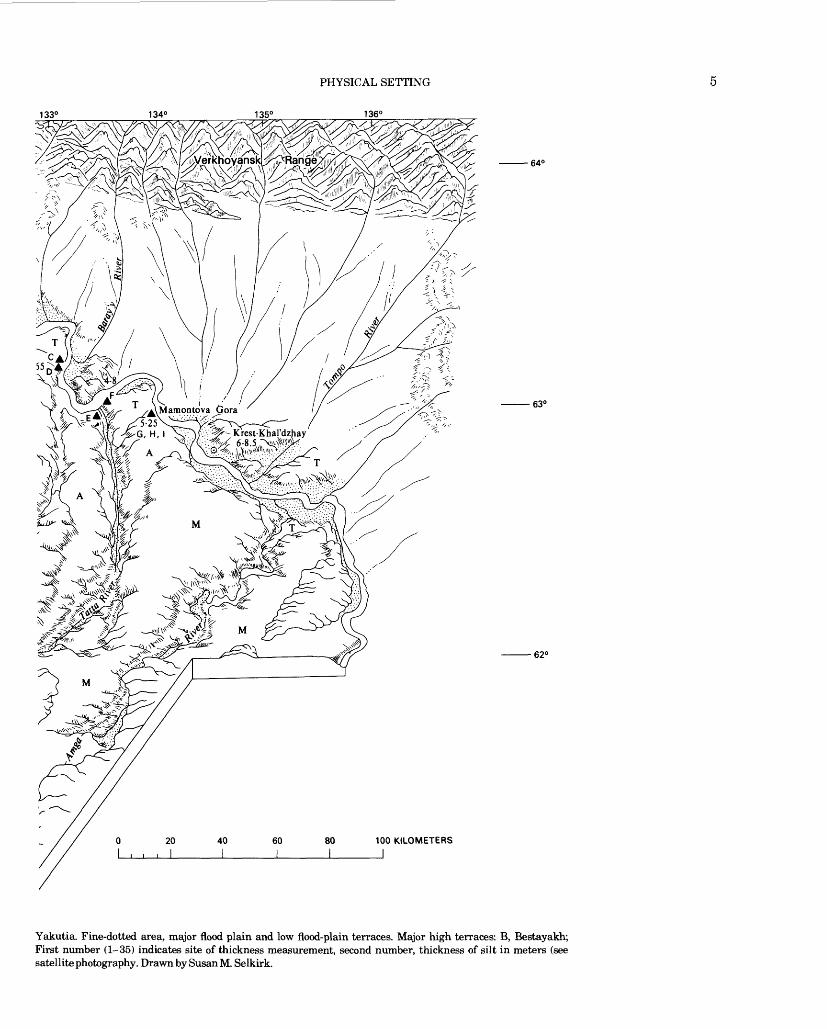
Yakutia. Fine-dotted area, major flood plain and low flood-plain terraces. Major high terraces: B, Bestayakh; First number (1-35) indicates site of thickness measurement, second number, thickness of silt in meters (see satellite photography. Drawn by Susan M. Selkirk.

ORIGIN AND CHARACTER OF LOESSLIKE SILT, YAKUTIA, SIBERIA
The study area is bounded by the Lena, Aldan, and Amga Rivers (fig. 3). The greatest part of the area con sists of four silt-covered terraces 50-300 m above the major rivers: the Bestyakh, Tyungyulyu, Abalakh, and Magan Terraces, from lowest to highest. The Emilsk Terrace, separately mapped in other reports, is here combined with the Magan Terrace, The type localities of all four terraces lie within 50 km of Yakutsk and are described in detail by Solov'ev (1959). They are under lain by Cenozoic rocks to the north, Mesozoic rocks in the south-central part of the study area, and by Paleozoic rocks at the southernmost edge. Besides these high-level terraces, four low flood-plain terraces bound the Lena and Aldan Rivers.
The Bestyakh Terrace, the lowest of the upper ter races, is the most restricted in area and extent. In the study area, it occurs on the east side (right limit) of the Lena River extending northward from the vicinity of Pokrovsk to the mouth of the Aldan River (fig. 3). It is 1-10 km wide and 55-75 m above the river and has a maximum relief of 30 m. The terrace is underlain by 60-115 m of cross-bedded homogeneous clean well-sort ed sand (table 1, sample P). The surface exhibits windblown ridges 2-10 m high and small merged parabolic sand dunes. The silt cover, widespread on the higher terraces (fig. 3), is not present on this terrace nor on the modern flood-plain terraces. The scarp is cut by precipitous active gullies 20-30 m deep, some eroded by spring sapping.
The Tyungyulyu Terrace is widespread in the area but occurs mainly adjacent to the Bestyakh Terrace east of the Lena River. It is as much as 40 km wide and 65-100 m above the river; it has a maximum relief of 70 m. It is blanketed by a well-sorted silt as much as 60 m thick, and characterized by a vast complex of ice wedges and well-developed thermokarst topography This to pography is characterized by a multitude of alases and steep-walled valleys. Lowering of as much as 30-50 percent of the terrace surface by melting of the ground- ice leaves interalas areas as ridges and connected smooth areas 5-10 m high.
The Abalakh Terrace occupies a large area in the central Yakutia lowland and is 115-135 m above river level. It is blanketed with a thick silt layer, in places 65 m thick. The thermokarst relief is the same as on the Tyungyulyu Terrace, but it is more dissected and has a higher density of alases.
The Magan Terrace, a gently undulating plain, covers many hundreds of square kilometers, but in some areas consists of relatively narrow remnants between drainageways (fig. 3). The terrace is 155-175 m above major rivers. Valleys 80-100 m deep penetrate the Magan Terrace. In some valleys cut into the Magan Terrace there have been formed small strips of Tyun
gyulyu and Abalakh Terraces with alas relief. The silt cover on the Magan Terrace is 6 15 m thick, and alas development is very poor.
The study area is underlain by the lower Aldan depres sion (Alekseev, 1961), an asymmetrical basin trending east with its axis along the lower Aldan River. The south flank dips gently northward, and the north flank, which crops out in the Verkhoyansk Range, is near vertical (Solov'ev, 1959; Alekseev, 1961, fig. 20; Katasonov and Solov'ev, 1969). Dolomitized Cambrian limestone crops out along the Lena River in the south ern part of the area (fig. 3), where it is overlain by sandy shale and conglomerate of Late Jurassic age; and the limestone in turn is overlain by sandstones and shales of Early Cretaceous age. The axis of the downwarp con tains Oligocene, Miocene, and Pliocene deposits, and early Pleistocene fossiliferous sediments (Vangengeim, 1961) exposed under the silt-covered terrace surfaces along the rivers. The stratigraphy is particularly well exposed at Mamontova Gora (Vangengeim, 1961; Giterman, 1963; Boyarskaya and Malayeva, 1967; Rosanov, 1968; Sudakova, 1969; Markov, 1973; Baranova and others, 1975; Pewe and others, 1977) on the Aldan River, 310 km upstream from its junction with the Lena River (fig. 3).
Much of central Yakutia has not been glaciated (fig. 4) (Giterman, 1963; Baranova, and others, 1968; Kind, 1972,1975) but it was almost entirely rimmed by glacial ice in middle Pleistocene time. Glacier-clad mountains stood to the north, east, and south, and the front of the continental ice sheet was in northwest Yakutia. Glaciers probably approached to within 140 km of Yakutsk. During glacial advances, all the major rivers drained glaciated terrain and were heavily laden with sediment, filling the wide valleys with glacial outwash. Except in the Verkhoyansk Range, the extent of glacia- tion in Yakutia is highly controversial. Figure 4 shows one of the larger estimates of the extent of middle Pleis tocene glaciation. Late Pleistocene glaciation was much less extensive, but its extent is also controversial.
CLIMATE
The central Yakutia area has an extreme continental climate characterized by a great range between summer and winter temperatures (fig. 5). The absolute mini mum temperature recorded at Yakutsk is -60°C, the absolute maximum is 38°C. Oymyakon, on the north east edge of the area, is noted as, with the exception of Antarctica, the coldest spot on Earth; -67.7°C was reli ably recorded there in February 1933 (Filippovich, 1974). The mean annual number of days of freezing temperatures at Yakutsk is 205, and freezing tempera tures have been reported for every month of the year (Gavrilova, 1973).

PHYSICAL SETTING
The mean annual precipitation is 246 mm (fig. 5). Thunderstorms occur during the summer, but most pre cipitation falls in light showers. Sixty-five percent of the annual precipitation falls between May and September.
Wind patterns in central Yakutia include a long, rela tively calm winter period from September to May and a short, slightly windy summer period from June to August. A 75-year record at Yakutsk (Gavrilova, 1973) indicates that the average wind velocity in winter is about 2.2 m/s and in summer about 3.0 m/s. The mean annual wind velocity at Yakutsk is 2.4 m/s. High winds are uncommon. During the winter 49 percent of all days are calm, and during the summer, 16 percent. Cyclones
move across Yakutia from west to east, and are the most common circulation process except in winter when the Siberian anticyclone spreads in a northeastern direc tion. Little is known about the general wind pattern between the Aldan River and the Verkhoyansk Range, but local winds may spread south from the mountains.
PERMAFROST
Central Yakutia lies in an area of widespread per mafrost. Permafrost, or perennially frozen ground, is naturally occurring material that has been at a tempera ture of 0°C or colder continuously for 2 or more years. Permafrost is defined on the basis of temperature alone
700°
200 400 600 KILOMETERS
FIGURE 4. Generalized extent of glaciers in Yakutia during middle Pleistocene time (Samarov Glaciation). Boundary of Yakutia indicated by dotted pattern. Extent of mountain glaciers from Baranova and others (1968, fig. 24); extent of continental ice sheet from Soviet Ministrov SSSR (1969, p. 72).

TABL
E 1
. D
ata
on Q
uate
rnar
y se
dim
ent
sam
ples
col
lect
ed i
n ce
ntra
l Y
akut
ia,
Sibe
ria,
U.S
.S.R
.I A
ll sa
mpl
es c
olle
cted
by
Tro
y L.
Pew
e, e
xcep
t w
here
ind
icat
ed]
00
Sed
imen
t T
hick
ness
sa
mpl
e si
te n
o.
Lab
(f
ig.3
) (f
ig.3
) N
o.
A _ .
B _
____
_
C
____
.
D _
____
_
E _
____
_
F __
__.
jj I __
___
J K
____
_
L __
___
N
___.
.
P
____
.
Q
..__.
R
__._
.
S __
__._ _
___
2 13
15-2
. ___ _3
13
15-3
. __ 3
1 84
1-1
. __ _
8 13
15-8
. __ _
7 13
15-7
._ _
32
84
1-2
. _ _
_4
1315
-4.
_ _
_5
1315
-5._
_ _
_6
1315
-6
. _
_ 1
2 13
16-2
_ ___ 1
1 13
16-1
_ __
10
13
15-1
0
. ___ 9
13
15-9
......29
1317
-9
_ __
_ 1
1315
-1
.___
_. 3
4 84
1-4
. ___ 1
3 13
16-3
. ___ 3
3 84
1-3
._ _
14
1316
-4
Dat
e M
ater
ial
colle
cted
Sand
y lo
ess
Loe
ss
. __ 7
/21/
73
__
7/2
1/73
. __ 7
/22/
69
_ 7/
23/7
3
San
dy-s
ilty
ri
ver
allu
vi
um _
___7
/23/
73
Loe
ss
7/23
/69
Cla
yey
loes
s
Sand
Sand
y lo
ess
Eol
ian
sand
San
dy
loes
s
Loe
ss
Loe
ss
..___
_7/2
2/73
. -7
/22/
73._
___7
/22/
73
. __ 7
/25/
73
.___
_7/2
5/73
___ -
7/25
/73
._
7/25
/73
_ _ -8
/3/7
3
- 7
/19
/73
____
__ 8
/3/6
9
___ _
7/2
7/73
_ ___ 8
/3/6
9
.__
7/27
/73
Loc
atio
n
Rig
ht l
imit
of
Ald
an R
iver
, 30
km
ups
trea
m
from
mou
th o
f T
umar
a R
iver
. R
ight
lim
it o
f A
ldan
Riv
er,
30
km u
pstr
eam
fr
om m
outh
of
Tum
ara
Riv
er.
Lef
t li
mit
, 24
4 km
fr
om m
outh
of
Ald
an R
iver
. L
eft
lim
it,
244
km
from
mou
th o
f A
ldan
Riv
er.
Ust
'Tat
ta V
illag
e
Lef
t lim
it o
f Ald
an
Riv
er 2
84 k
m
from
mou
th.
Mam
onto
va G
ora
Mam
onto
va G
ora
Mam
onto
va G
ora
Eas
t si
de o
f L
ake
Syr d
ak.
10 k
m s
outh
of
Syr
dak
Vill
age.
10 k
m n
orth
of
Mat
te V
illag
e E
dge
of T
yung
yul
yu
ala
s at
T
yung
yuly
u V
illag
e.
53 k
m w
est
of
Yak
utsk
3 km
wes
t of
Y
akut
sk
2 km
eas
t of B
esta
- ya
kh V
illag
e.
9 km
eas
t of B
esta
- ya
kh V
illag
e.
0.6
km s
outh
of
Mai
ya V
illag
e.
1 km
wes
t of
Aba
la
kh L
ake
Str
atig
raph
y
1 m
fro
m t
op o
f cl
iff,
Tyu
ngyu
l
yu T
erra
ce.
2 m
fro
m t
op o
f cl
iff,
Tyu
ngyu
l
yu T
erra
ce.
Sil
t cl
iff
of
Aba
lakh
T
erra
ce.
Sil
t cl
iff
of
Aba
lakh
T
erra
ce.
Floo
d pl
ain
al
luvi
um 3
m
abov
e ri
ver
leve
l. S
ilt
clif
f of
A
bala
kh T
er
race
. 1
m fr
om to
p of
clif
f 7
m fr
om to
p of
clif
f 23
m f
rom
top
of
clif
f 1
m b
elow
sur
face
of
Tyu
ngyu
lyu
Ter
race
. E
dge
of a
las
clif
f, T
yung
yuly
u T
erra
ce.
25 c
m b
elow
sur
fa
ce i
n ro
adcu
t. 1
m b
elow
sur
face
in
the
rmok
arst
pi
t.
Top
of M
agan
Ter
ra
ce,
sand
und
er
turf
. 3
km f
rom
blu
ff o
f M
agan
Ter
race
. Lo
w s
and
dune
on
Bes
taya
kh
Ter
race
. E
dge
of a
las
on
edge
of T
yung
yu
lyu
Ter
race
. E
dge
of a
las
Aba
lakh
Ter
race
, 16
cm
fro
m s
ur
face
.
Gra
nulo
- A
ge
met
ric
Lat
e Qua
tern
ary.
Hol
ocen
e
Lat
e Qua
tern
ary.
Hol
ocen
e W
isco
nsin
an.
pre-
Wis
cons
inan
Ter
tiar
y
Hol
ocen
e(?)
Lat
e Qua
tern
ary.
X
X X
X
X X X
X
X X
X X
X X X
X X X
X
Ana
lysi
s pe
rfor
med
Hea
vy
min
eral
C
hem
ical
C
aCO
,, X
-ray
XX
X
__
__
__
X
____
X
_
X
X
X
X
_ __
X
__
__
X
____
__
__
X
X
X
X
X
X
X
X
X
X
X
X
X
X
X
X
X
__
_
X
____
__
_ _
X
X
X
X
____
X
X
X
X
X
X
_
__
X
X
____
X
X
X
X
X
ORIGIN
AND
CHARACTER
OF
LOESSLIKE
SILT,
YAKUTIA, SIBERI
A

T
____
U
____
V
____
.w X
__
_
Y
__-_
Z _.
__
AA
__
.
DD
__
.
FF
____
GG
__
____
__ 1
5 13
16-5
_ _ T
2-1
1399
-4_ _
T2-
3 13
99-5
_ __
_ 1
6 13
16-6
. ___ 1
7 13
16-7
_ __ 1
8 13
16-8
_ __ 1
9 13
16-9
._
__20
13
16-1
0
. _
_22
1317
-2
. ___ 2
3 13
17-3
. __
_ 2
7 13
17-7
__ _
24
1317
-4
___ 2
6 13
17-6
___ 2
5 13
17-5
T ,H
PQQ
All
uvia
lsa
nd
_
loes
s _
Loe
ss
sand
_
Sil
t fr
omli
me
st
one
_ 7
/27/
73
. __ 1
973
1. _
_ 1
973
1__
_7/2
9/73
__ 7
/30/
73
7/3
0/7
3
___7
/30/
73
(2)
_ 7
/30/
73
_ 7
/31/
73
_ 7
/31/
73
__
8/2
/73
_ 7
/31/
73
_ _ 8
/1/7
3
Edg
e of
Aba
lakh
Lak
e, T
yung
yu
lyu
Ter
race
. C
hura
pach
a
Pok
rovs
k, 7
0 km
up L
ena
from
Y
akut
sk.
Pok
rovs
k, 7
0 km
up L
ena
from
Y
akut
sk.
Pok
rovs
k, 7
0 km
up L
ena
from
Y
akut
sk
Pok
rovs
k, 7
0 km
up L
ena
from
Y
akut
sk.
7 km
wes
t of
Pok
ro
vsk.
Riv
er 1
2 km
up
stre
am f
rom
P
okro
vsk
. L
eft
lim
it o
f L
ena
Riv
er 1
2 km
up
stre
am f
rom
P
okro
vsk
. L
eft
lim
it o
f L
ena
Riv
er 1
2 km
upst
ream
fro
m
Pok
rovs
k.
Riv
er 4
0 km
up
stre
am f
rom
P
okro
vsk.
Il
ansk
jo V
illa
ge,
70 k
m u
pstr
eam
fr
om P
okro
vsk.
lim
it o
f L
ena
Riv
er s
outh
of
Yak
utsk
.
1-m
dep
th f
rom
wes
t sid
e of
lake
.
10 m
abo
ve L
ena
Riv
er a
t ri
ver
bank
. 1
km w
est
of r
iver
,45
cm
dee
p,
Tyu
ngyu
lyu
Ter
race
. 5
km w
est
of r
iver
,30
cm
dee
p,
Tyu
ngyu
lyu
Ter
race
.
30 c
m d
eep,
6 k
m
wes
t of
riv
er.
1.5-
m d
epth
, le
nsof
san
d.
ture
d li
mes
tone
at
bas
e of
loes
s se
ctio
n 3.
1
m a
bove
BB
1.7
m b
elow
sur
fa
ce a
t co
ntac
tw
ith
unde
rlyi
ng
lim
esto
ne.
Top
of
clif
f-he
addu
ne d
eriv
ed
from
Bes
tyak
h T
erra
ce.
5 m
bel
ow t
op o
f L
ate
clif
f in
trib
uta
ry.
Qua
tern
ary
147
m a
bove
riv
eron
lim
esto
ne
clif
f.
X X X X X X X X X X X X X X
X X X X X X X X X X X X
__
X
__
____
X
__
__
X
X
____
X
__
__
__
X
__
____
X
XX
X
XX
X
XX
X
____
X
XX
X
XX
X
Tl
ffi
K!
CO o
>
t-1 CO
Col
lect
ed b
y E
. M
. K
atas
onov
.

10 ORIGIN AND CHARACTER OF LOESSLIKE SILT, YAKUTIA, SIBERIA
Jan Feb Mar Apr May June July Aug bept uct rwov uec j
0° Centigrade (freezing point)
-10.3°Centigrade annual mean temperatur
-50 -
MEAN TEMPERATURES
50.0
40.0
30.0
20.0
10.0
0.0
24.7 centimeters mean annual precipitation
Record: 75 years
MEAN PRECIPITATION
20 co
10
0 a.
- G °Q LU 4UJ C/>
S CC 3">£ 20 c/3 iz oc fi£ Q
-
^^ ̂̂ ^~- -^.
I ___ ^^^2.4 meters per second mean monthly wind velocity">%--^^___^^
> i i i i i i i i i iMCAM MnWTWI V \A/IMH \/FI nTITY
100
Jan Feb Mar Apr May June July Aug Sept Qct Nov Dec JanMEAN PERCENT OF CLEAR, PARTLY CLOUDY, AND CLOUDY DAYS
99 mean annual clear days; 46 mean annual partlycloudy days; 220 mean annual cloudy days
FIGURE 5. Climatic data for Yakutsk, Yakutia, From Gavrilova (1973).

PHYSICAL SETTING 11
notwithstanding the type of sediment, rock, or the ice content. Most permafrost is consolidated by ice. Perma frost occurs in about 50 percent of the U.S.S.R. and is reported to be 1,600 m thick in northern Siberia. The frozen ground thins progressively to the south and can be differentiated into two broad zones: the continuous and the discontinuous. In the continuous zone perma frost is present almost everywhere except under lakes and rivers that do not freeze to the bottom. The discon- tinous zone includes permafrost-free areas that increase progressively in size and number from the north to the south.
The temperature of permafrost is measured at the level of zero annual amplitude, that is, at a depth of about 10 or 15 m, where the seasonal temperature change in the ground is hardly detectable. The tempera ture of permafrost at the depth of minimum annual seasonal change varies from about 0°C at the south limit of permafrost to 10°C in northern Alaska and -13°C in northeastern Siberia. Its thickness also increases northward.
Melnikov (1966) has shown that the thickness of per mafrost in Yakutia ranges from near 100 m in the southern part to more than 900 m in the north. The temperature of the frozen ground at the depth of zero annual temperature change ranges from about 1°C in the south to 12°C in the north. The general thickness of permafrost in central Yakutia is about 300-350 m.
The ice content is probably the most important fea ture of permafrost affecting human activity in the north. Almost as important is the evidence it provides concerning past climates. Ice content ranges from ice in the pores between the grains to small ice segregations to large massive bodies. Various classifications have been proposed to describe the different sizes, shapes, and distributions of ground ice (Shumskii and others, 1955; Pewe, 1966; Mackay, 1972).
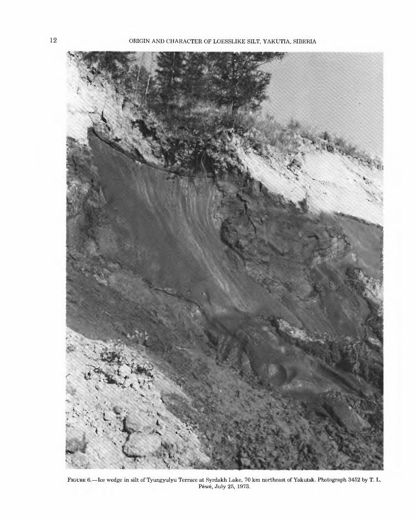
The most conspicuous and controversial type of ice in the permafrost is the large ice wedge or mass, charac terized by parallel or subparallel foliated structures. Most foliated ice masses occur as wedge-shaped vertical, or inclined sheets or dikes 1-cm to 3-m wide and 1- to 10-m high when seen in transverse cross sections (fig. 6). Some masses seen on the face of frozen cliffs may appear as horizontal bodies in a few centimeters to 3-m thick and 0.5-15 m long. Their true shape can be seen only in three dimensions. Ice wedges are part of a polygonal network of ice enclosing polygons or cells of frozen ground 3-30 m or more in diameter. They grow in al most any kind of frozen sediment, including fractured bedrock, but seem to grow to their largest size, both vertically and horizontally, and most commonly in areas of widespread thick loess deposits.
They are common in the ice-rich silt, referred to as "Edoma" by Tomirdiaro (1975), that covers much of the
Arctic, from northeast Siberia to central Alaska and the Yukon. They are abundant and well developed in cen tral Yakutia; gigantic wedges are exposed along the Aldan, Lena, and Yana Rivers (Toll, 1895; Popov, 1955, 1969; Rusanov, 1968; Washburn, 1973,1980; Pewe and others, 1977).
GEOMORPHOLOGY
Although the silt-covered terraces are generally flat or gently rolling, the permafrost and the nature of the silt result in a number of distinctive surface features.
Wherever large ground-ice masses are present in permafrost, thawing caused by a disturbance of insulat ing vegetation, for example, or by general climatic change, can produce thermokarst topography. Ther- mokarst is an uneven topography of mounds, sink holes, tunnels, caverns, and short ravines. A thermokarst fea ture that is especially typical of central Yakutia is the alas (spelling after Fyodorov, 1974) (Solov'ev, 1959, 1973; Czudek and Demek, 1970; Katasonov, 1963, 1979). Alases are broad, steep-sided depressions that form as small depressions coalesce and sediment is washed into the bottom. The depression thus has fairly steep walls and a grass-covered flat bottom. They are 3-40 m deep and as much as 0.1-15 km in diameter. They tend to be round or oval and many contain small lakes (figs. 7, 8). These areas, where ground ice has almost completely disappeared, are important to the agriculture of the area (Solev'ev, 1959, 1973; Shilo, 1978). Where the thawed sediments refreeze, closed- system pingos are common; conical ice-cored hills as high as 30 m formed by the pressure of freezing water (fig. 9). On the Tyungyulyu and Abalakh Terraces, as much as 50 percent of the Pleistocene surface has been modified by alases, many of which formed during the past 7,000 years, some as a result of human activity (Are, 1973).
Many spectacular steep-walled gullies cut the lip of silt terraces on the left limit of the lower Aldan River. Here the abundant water created by the melting of ice wedges cuts the easily erodable silt into gullies, leaving interfluve areas as pyramid-shaped remnants. Such remnants, where mainly the result of the thawing of ice wedges, are called baydjarakhs (fig. 10). The compe tency that allows such features to stand also permits the silt to form steep cliffs and gullies elsewhere where eroded by water. Gullies form where runoff is concen trated, as below culverts, in ditches, or where vegeta tion has been disturbed, for example, as by cultivation on a slope. The steep walls of many alases are gullied, and many of the gullies on the left limit of the Aldan River are spectacular. Like the cliffs in loess in China, the Mississippi valley, central Alaska, France, and elsewhere, the silt cliffs in central Yakutia apparently
12 ORIGIN AND CHARACTER OF LOESSLIKE SILT, YAKUTIA, SIBERIA
FIGURE 6. Ice wedge in silt of Tyungyulyu Terrace at Syrdakh Lake, 70 km northeast of Yakutsk. Photograph 3452 by T. L.Pewe, July 25, 1973.
PHYSICAL SETTING 13
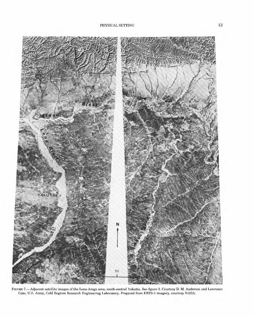
FIGURE 7. Adjacent satellite images of the Lena-Amga area, south-central Yakutia. See figure 3. Courtesy D. M. Anderson and Lawrence Gato, U.S. Army, Cold Regions Research Engineering Laboratory. Prepared from ERTS-1 imagery, courtesy NASA.

14 ORIGIN AND CHARACTER OF LOESSLIKE SILT, YAKUTIA, SIBERIA
J

PHYSICAL SETTING 15
febSO
Icd
QJ~n w
ESto
W
I oi

o S3
O o i W
FIG
UR
E 1
0. B
ayd
jara
khs,
pyr
amid
-sha
ped
rem
nan
ts r
esult
ing f
rom
thaw
ing
of ic
e w
edge
s, l
eft b
ank
Ald
an R
iver
, 22
4 km
abo
ve ju
ncti
on w
ith
Len
a R
iver
. F
rom
Was
hbur
n (1
973,
fig.
10.2
, p.
234
.

DISTRIBUTION AND THICKNESS OF UPLAND SILT 17
stand for many years. Along the lower Aldan River the cliffs are as much as 25 m high. The stability of these cliffs may be due to the angularity of the grains and the strengthening effects of concretionary rods and tubes.
DISTRIBUTION AND THICKNESS OF UPLAND SILT
The silt is thickest near the major rivers draining glaciated areas, but absent on the flood plains and low flood plain terraces. It is especially thick along the south side of the Aldan River where it blankets all the high terraces and the tops of ridges and hills. The blanketing distribution is also recorded in the central and eastern part of the Vilyuy River basin (Alekseev, 1970) (fig. 2). Rusanov (1968, fig. 5) and Sudakova (1969, fig. 11) de scribe the thick cap of silt on the terraces on the left limit of the lower Aldan (fig. 11). Along the Lena River, silt is 10-25 m thick on the edge of the west side of the valley but thins rapidly to a featheredge west of Yakutsk (fig. 3). On the Tyungyulyu Terrace it reaches a maximum thickness of 60 m near Syrdakh in the general region between the junction of the Aldan and Lena Rivers (table 2). On the edge of the Tyungyulyu Terrace adjacent to the the Bestyakh Terrace the silt is very thin, but it rapidly thickens eastward (Solov'ev, 1973, p. 34) and northward toward Syrdakh (Are, 1973). All thicknesses of loess reported from the river bluffs and inland toward Tyungyulyu and Maiya are at eleva tions no higher than 200 m above the level of the rivers. The silt is thin and locally absent on the Magan Terrace.
The silt is only a few meters thick on glacial and glaciofluvial deposits (fig. 3) on the north (right) side of the Aldan River (Vangengeim, 1961; Katasonov and Solov'ev, 1969). Just southwest of the study area (fig. 3), on the steep limestone cliffs of the "Pillars of the Lena" (fig. 12), the loess is thin to absent 200 m or more above the Lena River, but on the north side (left limit) of the river it is 7-25 m thick on the terraces (fig. 13), which are only 30-40 m above the river. In general, silt is
80-meter- high terrace
50-meter-high terrace
thickest in the bottoms of small valleys and on lower slopes and thinner on the highlands, especially on the Magan Terrace. Are (1973, p. 16-20) describes 60 m of silt at Syrdakh (fig. 3), but he does not state if this thickness is in a small valley or on the general terrace level.
Hilltops, where the original silt thickness has not been supplemented by slopewash, are probably the only place where total original thickness can be approxi mated, modified only by the amount removed by ero sion. Some scarps of the terraces along the Lena River and almost all scarps along the south side of the Aldan River are capped with 10-35 m of silt. This does not represent the original thickness of the silt as the upper part has been washed away (Sudakova, 1969).
In general, it appears from exposures west of Pok- rovsk (figs. 3,14) that the silt is thicker on the Abalakh Terrace than on the Tyungyulyu Terrace. Solov'ev (1959, p. 43) states that the Abalakh Terrace is covered with "limnitic-alluvial clay," 60 m thick, the top part pierced with ice veins. Alases, which form best in thick silt, are well developed on both the Tyungyulyu and Abalakh Terraces.
Detailed measurements of loess thickness over a large area, similar to those made in Illinois by Smith (1942), in Iowa by Davidson and Handy (1952) and Ruhe (1969), and in parts of Alaska by Pewe (1955; Pewe and Holmes, 1964) have not yet been made in central Yakutia. As seen from the air, however, the loess forms a widespread cover, evident in the well-developed den dritic drainage patterns on the terraces (fig. 7).
The thickness reported here (table 2) include meas urements from exposures and bore holes. Although silt has plainly washed into depressions in some localities measured, no coarse sediment was observed, so the measurements may give a reliable estimate of the total amount present.
The thick deposits on the south side (left limit) of the Aldan River face the enormous apron of glaciofluvial
30-meter-high terrace
ZZZ^Xl5-meter-high terrace Low flood-....... .vxv . terrace
EXPLANATION
Sand and gravel Gray loess Brown loess Sandy-clayey sediment
FIGURE 11. Loess-capped sand terraces near Mamontova Gora along the Aldan River, Yakutia. Slightly modified from Rusanov (1968, fig. 5).

18 ORIGIN AND CHARACTER OF LOESSLIKE SILT, YAKUTIA, SIBERIA
rV i^* : -^fir ,:i:;. «r v. ?!
13 Ca
T3
2
I<
Jf **I -i ~ be
>
ca
J3 I
CN

DISTRIBUTION AND THICKNESS OF UPLAND SILT
TABLE 2. Thickness of silt in central Yakutia, Siberia, U.S.S.R.
19
Thickness site no. (fig. 3)
1 __
2 _.
3 __
4 __
5 __
6 __
7 __8 __9 __
10 __11 __
12 __
13 __
14 _.
15 _.16 __17 __18 -
19 __
20 -
21 __
Thickness (m) Location
30-35 Chuysakaya Mountain, right limit of the AldanRiver, 30 km upstream From mouth of TumaraRiver.
25-32 Tettigi, left limit of the Aldan River, 130 km frommouth.
25-30 Rossypnoy Perekat, left limit of the Aldan River, 24440-65 km from mouth.5-8 285 km from the mouth on the right limit of the Aldan
River, overlies glaciofluvial material.25 310 km from the mouth on the left limit of the Aldan
River at Mamontova Gora.7- 8. 5 Krest Khal'dzhay, right limit of the Aldan River, 360
km from mouth.60 Syrdakh.50 Tyungyulyu.
.0 53 km west of Yakutsk.2+ Bluff west of Yakutsk, 0.5 km from the edge.5-101 Tabaga Cape, left limit of Lena River, 30 km south of
Yakutsk..0 On Bestyakh terrace 2 km south of N. Bestyakh
Village.8+ At alas, Bestyakh-Maiya Road, edge of Tyungyulu
Terrace..0 On Bestyakh Terrace 25 km south of N. Bestyakh
Village.10+ 7 km southeast of Maiya Village.31 Abalakh Terrace near Abalakh.20 Churapacha.25 On the Abalakh Terrace, 6 km west of Pokrovsk
Village.7 12 km upstream from Pokrovsk on the left limit of the
Lena River.10-15 On the Tyungyulyu Terrace, 1-5 km west of
Pokrovsk.7 Ilankjo Village, left limit of the Lena River, 70 km
upstream from Pokrovsk.
Source
Katsanov and Solov'ev (1969, p. 21) Katasonov andIvanov (1973, p. 18).
Katasonov and Solov'ev (1969, p. 22).
Katasonov and Solov'ev (1969, p. 22) Katasonov andIvanov (1973, p. 24).
Katasonov and Solov'ev (1969, p. 23).
Pewe and others (1977).
Katasonov and Solov'ev (1969, p. 27) Vangengiem(1961, fig. 20).
Are (1973, p. 16, 20).Are (1973, p. 12).Pewe, 1973 field data.Pewe, 1973 field data.Katasonov and Solov'ev (1969, p. 12).
Pewe, 1969 field data.
Pewe, 1973 field data.
Pewe, 1969 field data.
Katasonov and Solov'ev (1969, p. 41).Katasonov and Solov'ev (1969, p. 43).Solov'ev (1973, p. 30).E. M. Katasonov (oral commun, 1973).
Pewe, 1973 field data.
E. M. Katasonov (oral commun, 1973).
Pewe, 1973 field data.
Sediment sample (flg.3)
A,B
C
G,H,I
JMN0
P
D
Z
BB, CC
X, Y
FF
FIGURE 13. Loess-covered terrace of Ilanskjo Village on Cambrian dolomitic limestone, 70 km upstream from Pokrovsk on left limit of LenaRiver. See figure 3. Loess is 7 m thick at gulley.

20 ORIGIN AND CHARACTER OF LOESSLIKE SILT, YAKUTIA, SIBERIA
terrain and glacial moraines emanating from the Ver khoyansk Range to the north (fig. 3). Such a distribution is very similar to distribution in central Alaska where thin loess is present on the apron of glaciofluvial debris emanating from the towering Alaskan Range and ter minating at the Yukon-Tanana Upland to the north mantled by loess of great thickness (Pewe, 1955,1968).
Although loess thicknesses of 10-35 m are reported from northern Yakutia (Tomirdiaro and others, 1974), the thickest deposits in the Republic appear to be along the Lena and Aldan Rivers in central Yakutia. This relation, too, is similar to the distribution of loess in central Alaska where loess as much as 60-100 m thick occurs on the north side of the Tanana River near Fair banks (Pewe, 1955, 1968; 1982), the thickest known loess deposits in the State.
COLOR AND TEXTURE
The unfrozen upland silt is commonly tan, although grayish-tan silt is not rare; when wet or frozen, it is brown to black. In many localities, the frozen silt is gray to black and has thin dark carbonaceous layers and iron-stained bands and mottling.
As an aid to understanding the mechanical composi tion of the upland silt, analyses were completed on 27 samples; analyses were also done on several samples of river silt and eolian and fluvial sand (table 1). The mechanical analyses (granulometric analyses) were made at the Centre de Geomorphologie in Caen, France, by sedimentation in water. Grains smaller than 20 yam were separated by sieving. For comparison, silt samples from other countries were analyzed in the same labora
tory by the same method: windblown dust from Tempe, Arizona, and loess collected by Pewe from Alaska, New Zealand, and Czechoslovakia, and from China (near Peking) collected by R. J. E. Brown (table 3).
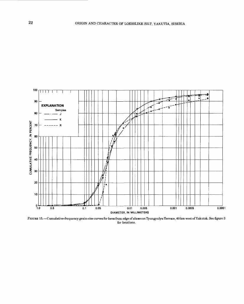
The silt examined is well sorted, especially on high lands away from river flood plains and sand terraces and from low areas where silt has been retransported short distances. On the high edges of major alases, as, for example, near Maiya or Syrdakh (fig. 3) (samples R, J and K; table 1), mechanical analyses (fig. 15) reveal that the sediments are 70-80 percent silt, 1-15 percent sand, and about 15 percent clay2 . Because the clay content is low, the material has little plasticity.
In general, the mechanical analyses of upland silt throughout the area show that the mechanical composi tion and texture of the tan silt is remarkably uniform (figs. 16,17,18) (table 3). The range of texture of the 27 samples is shown by the shaded envelope in figure 16, the average texture is sand 17 percent, silt 70 percent, and clay 13 percent. Solov'ev (1959) states that on the Abalakh Terrace near Churapacha, the upper clayey loam is 70-90 percent silt and is unbedded. Tomirdiaro (1975b) states that this uniform texture exists from the Aldan River to the north coast and even to the Novosibirsk Archipelago. Some samples near the sandy Magan or Bestyakh Terraces may be as much as 40 percent very fine sand (fig. 19, samples Q and O) and some of the silt adjacent to the Aldan and Lena River flood plains may be 20-25 percent fine sand (fig. 19, BB,
2In this report the U.S. Department of Agriculture classification is used: very fine sand, 0.10-0.05 mm; silt, 0.05-0.005 mm; clay, 0.005-0.002 mm.
w
Magan Terrace
Quaternary . sand . and gravel
Thin-bedded Cambrian limestone , I I I _l I I
FIGURE 14. Upland silt mantling terraces west of Pokrovsk, showing location of silt samples. Vertical exaggeration 150 x. Stratigraphic relationsand silt thicknesses from E. M. Katasonov (oral commun., July 30, 1973).
COLOR AND TEXTURE 21
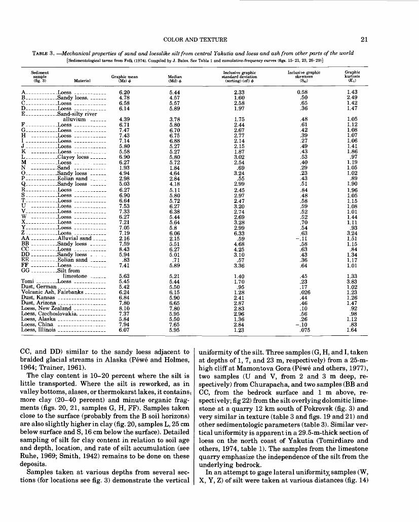
TABLE 3. Mechanical properties of sand and loesslike silt from central Yakutia and loess and ash from other parts of the world[Sedimentological terms from Folk (1974). Compiled by J. Bales. See Table 1 and cumulative-frequency curves (figs. 15-21, 23, 26-29)]
Sediment sample(fig. 3) Material
Graphic mean Median (Md)4>
Inclusive graphicstandard deviation
(sorting) (o/) <#>
Inclusive graphicskewness
(SKI)
Graphic kurtosis
A_______Loess _______ 6.20B_______Sandy loess. ___ 4.78C_______Loess _______ 6.58D_______Loess _______ 6.14 E__- -----Sand-silty river
alluvium ______ 4.39F_______Loess __________ 6.71G_______Loess _______ 7.47H __________Loess _______ 7.43I _______Loess _______ 7.14J _______Loess _______ 5.80K ______Loess _______ 5.58L_______Clayey loess ___ 6.90M ______Loess _______ 6.27N ___Sand ________ 1.93O____ _ _Sandy loess ____ 4.94P_______Eolian sand ___ 2.98Q_______Sandy loess ___ 5.03R_______Loess _______ 6.27S_______Loess _______ 6.90T________Loess ________ 6.64U ___Loess _______ 7.53V_______Loess _______ 7.33W _____Loess _______ 6.27X_______Loess _______ 7.21Y_______Loess _______ 7.05Z_______Loess _______ 7.19AA ______Alluvial sand ___ 2.16BB ______Sandy loess ___ 7.59CC ________Loess ________ 8.43DD ______Sandy loess ___ 5.94EE ______Eolian sand ___ .83FF _______Loess ________ 7.41GG_______Siltfrom
limestone ___ 5.63Tomi _____Loess _______ 5.45Dust, German ___________ 5.42Volcanic Ash, Fairbanks _ ____ 6.24Dust, Kansas ___________ 6.84Dust, Arizona ____________ 7.80Loess, New Zealand _ __ ____ 8.10Loess, Czechoslovakia. _______ 7.37Loess, Alaska ____________ 5.84Loess, China ___________ 7.94Loess, Illinois ____________ 6.07
5.444.575.575.89
3.785.806.706.756.885.275.275.805.721.844.642.844.185.115.805.726.276.385.445.645.86.062.155.516.275.01
.715.89
5.215.445.506.155.906.657.805.955.507.655.95
2.331.602.581.97
1.752.442.672.772.142.151.873.022.54
.693.24
.552.992.452.972.473.202.742.693.282.996.33
.594.684.253.10
.573.36
1.401.70
.951.282.412.872.832.961.362.841.23
0.58 .50 .65 .36
.48
.61
.42
.39
.27
.49
.43
.53
.40
.29
.23
.43
.51
.84
.48
.58
.59
.52
.52
.70
.54
.63-.11
.58
.63
.43
.36
.64
.45
.23
.17
.026
.44
.46
.10
.56
.26-.10
.075
1.432.491.421.47
1.051.121.081.071.061.411.86.97
1.191.051.02
.891.901.961.051.151.081.011.441.11
.933.241.511.15
.841.341.171.01
1.333.831.021.231.261.47
.92
.981.12
.831.64
CC, and DD) similar to the sandy loess adjacent to braided glacial streams in Alaska (Pewe and Holmes, 1964; Trainer, 1961).
The clay content is 10-20 percent where the silt is little transported. Where the silt is reworked, as in valley bottoms, alases, or thermokarst lakes, it contains \ more clay (20-40 percent) and minute organic frag ments (figs. 20, 21, samples G, H, FF). Samples taken close to the surface (probably from the B soil horizons) are also slightly higher in clay (fig. 20, samples L, 25 cm below surface and S, 16 cm below the surface). Detailed sampling of silt for clay content in relation to soil age and depth, location, and rate of silt accumulation (see Ruhe, 1969; Smith, 1942) remains to be done on these deposits.
Samples taken at various depths from several sec tions (for locations see fig. 3) demonstrate the vertical
uniformity of the silt. Three samples (G, H, and I, taken at depths of 1, 7, and 23 m, respectively) from a 25-m- high cliff at Mamontova Gora (Pewe and others, 1977), two samples (U and V, from 2 and 3 m deep, re spectively) from Churapacha, and two samples (BB and CC, from the bedrock surface and 1 m above, re spectively; fig 22) from the silt overlying dolomitic lime stone at a quarry 12 km south of Pokrovsk (fig. 3) and very similar in texture (table 3 and figs. 19 and 21) and other sedimentologic parameters (table 3). Similar ver tical uniformity is apparent in a 29.5-m-thick section of loess on the north coast of Yakutia (Tomirdiaro and others, 1974, table 1). The samples from the limestone quarry emphasize the independence of the silt from the underlying bedrock.
In an attempt to gage lateral uniformity, samples (W, X, Y, Z) of silt were taken at various distances (fig. 14)
22 ORIGIN AND CHARACTER OF LOESSLIKE SILT, YAKUTIA, SIBERIA
100
90
80
o 70 ocID Q.
- 60
ozID§ 50ID OC
> 40
EXPLANATION
Samples
./
**'
30
20
7 f
0.1 0.05 0.01 0.005
DIAMETER, IN MILLIMETERS
0.001 0.0005 0.0001
FIGURE 15. Cumulative-frequency grain-size curves for loess from edge of alases on Tyungyulyu Terrace, 40 km west of Yakutsk. See figure 3for locations.

COLOR AND TEXTURE 23
100
90
80
70
£ 60
50
I I I I I I I l
EXPLANATION
- Average of 27 upland silt samples
> 40
30
20
10
1.0 0.5 0.1 0.05 0.01 0.005
DIAMETER, IN MILLIMETERS
0.001 0.0005 0.0001
FIGURE 16. Average cumulative-frequency grain-size curve for 27 samples of upland silt on high terraces in central Yakutia. Range oftexture of samples shown by cross-hatched area.

24 ORIGIN AND CHARACTER OF LOESSLIKE SILT, YAKUTIA, SIBERIA
100
90
80
70
I I I I f
EXPLANATIONSamples
A
. B
C
.- D
______ C
50
40
20
10
0. 5 0.1 0.05 0.01 0.005
DIAMETER, IN MILLIMETERS
0.001 0.0005 0.0001
FIGURE 17. Cumulative-frequency grain-size curves for loess blanketing terraces along lower Aldan River. Distance of sample locations up Aldan River from mouth: A and B, 30 km; C and D, 244 km; F, 284 km. See figure 3 for locations.

COLOR AND TEXTURE 25
57U
ou
h- 5 70O<rLU Q_
Z en
OZLU
0 50LU(E
LU> 40
^0
§ 30o
20
10
0
EXPLANATION
Samples
M
- T
1f'
* <s s
<
S
\
/
'
/
f
ft
/II
1'
/
fr/r
^/,'
s^
/^
* '
^,-A
^*
^^^ ^-*j*-*
... .-* -«-
--- "*
1.0 0.5 0.1 0.05 0.01 0.005 0.001 0.0005 O.OOC
DIAMETER, IN MILLIMETERS
FIGURE 18. Cumulative-frequency grain-size curves for loess mantling Tyungyulyu Terrace west of Lena River. See figure 3 for locations.

26 ORIGIN AND CHARACTER OF LOESSLIKE SILT, YAKUTIA, SIBERIA
100
10
0.01 0.005
DIAMETER, IN MILLIMETERS
0.001 0.0005 0.0001
FIGURE 19. Cumulative-frequency grain-size curves for upland loess near sandy terraces (Q and O) and near sandy flood plains (BB, CC, and DD) along Lena River. Samples BB and CC are in same section, respectively 1 cm and 70 cm above bedrock. See figures 3 and 22.

COLOR AND TEXTURE 27
100
p\
0.05 0.01 0.005
DIAMETER, IN MILLIMETERS
0.001 0.0005 0.0001
FIGURE 20. Cumulative-frequency grain-size curves for reworked upland loess and B soil horizon illustrating relatively high clay content.See figures 3, 12.

28 ORIGIN AND CHARACTER OF LOESSLIKE SILT, YAKUTIA, SIBERIA
100
0.01 0.005
DIAMETER, IN MILLIMETERS
0.001 0.0005 0.0001
FIGURE 21. Cumulative-frequency grain-size curves for retransported upland loess at various depths in section, illustrating vertical uniformity of texture. Samples G, H, I, Mamontova Gora; U, V, Churapacha. See figures 3, 30, and table 1.

MINERAL AND CHEMICAL COMPOSITION 29
away from the Lena River in the Pokvorsk area to de termine whether the percentages of sand, silt, and clay changed (see Ruhe, 1969, p. 71). Within distance cov ered, only 6 km, no significant changes were seen in the the size distribution (fig. 23).
MINERAL AND CHEMICAL COMPOSITION
A number of chemical and mineral analyses of repre sentative samples were made at the Centre de Geomor- phologie, Caen, France. Heavy mineral analyses were made of 27 samples of the upland silt and of 3 samples of local fluviatile and eolian sand for comparison. The minerals were separated by bromoform (2.87 sp gr) after washing with HC1 (20 percent) and sieving in three granulometric fractions. Fourteen samples were analyzed for 11 oxides. Thirty samples were analyzed for calcium carbonate content alone, and 16 by X-ray for types of clay minerals present. Petrographic exam ination reveals that the silt grains, although slightly iron-stained, are angular and fresh.
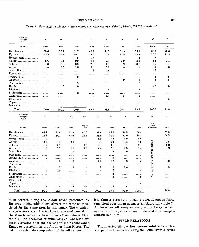
The mineralogy of the loesslike silt is nearly uniform (table 4); typical samples contain abundant quartz, mica, and feldspar, with a lesser amount of heavy min erals. These include 30 to more than 70 percent hornblende; 12-30 percent epidote, and lesser amounts of hypersthene and garnet, and very small amounts of zircon, anatase, tourmaline, rutile, disthene, monazite,
METERS
0-
5-
10-
15-
20-
Excavation ,face ->/ Massive
r ~n silt i / i
Massive
silt
/ Excavated
// / ^20 centimeters-
Loess sample rtft CC
Sandy loess sample BB
Frost-rived fragments of limestone bedrock
FIGURE 22. Location of samples of upland silt mantling dolomitic limestone on right limit of Lena River, 12 km upstream from Pokrovsk.
and other heavy minerals. The analyses show that, in addition to mineral uniformity in the loesslike silt geo graphically, there is vertical uniformity. Samples from various levels in the cliff at Mamontova Gora (table 1, samples G, H, I) and two samples (BB-CC) from a sec tion over limestone 12 km upstream from Potrovsk (fig. 22) are practically the same mineralogically and chemi cally with respect to each other.
The absence of heavy minerals in the limestone that underlies the silt upstream from Yakutsk along the Lena River (sample GG, table 4) confirms the independ ence of the silt and bedrock.
On a local scale, the mineralogy of floodplain sandy- silty alluvium from near the mouth of the Tatta River (sample E) is very similar to nearby upland silt (sample S, table 4). Sands of the Magan and Bestyakh terraces (samples N and P, table 4) are also similar to adjacent silts.
On a larger scale, differences in heavy-mineral con tent between samples from the Lena River and the lower Aldan River may indicate general regional dif ferences despite the small number of samples. In both, hornblende, epidote, hypersthene, and garnet consti tute 80-90 percent of the heavy minerals present. The samples from the Lena River area, however, are con siderably higher in hornblende and epidote and lower in hypersthene and garnet than those from the lower Aldan River. Percentages are: hornblende, 61.0 for the Lena River samples, 46.8 for the Aldan River samples; epidote, 24.1 and 20.0; hypersthene, 1.4 and 8.5; gar net, 5.6 and 12.7. A "mineralogy index" defined as
,, (epidote + hornblende) , ,,M = - - hypersthene givesgarnet
M = 14.9 for the Lena area and M = 4.6 for the Aldan (fig. 24).
To determine the statistical confidence level for the mineralogical differences described here (fig. 24), we calculated a probability value (P), using the "t" test. This value was less than 0.005 and indicates a high degree of confidence. Further, to determine whether the mineralogic differences merely reflected differences in grain-size distribution, we compared textural parame ters (defined by Folk, 1974) for the samples from the two areas. Despite the mineralogic differences, the average values of these parameters are essentially the same for the two groups (table 5). Thus, the mineralogic differ ences seem to reflect a real division between the upland silt of the Lena River area and that of the lower Aldan River.
Chemical analyses (table 6) shows that the upland silt is nearly constant in chemical composition over large areas. The chemical analyses of the upland silt on the

30 ORIGIN AND CHARACTER OF LOESSLIKE SILT, YAKUTIA, SIBERIA
TABLE 4. Percentage distribution of heavy minerals in sediments from Yakutia, Siberia, U.S.S.R.
[Sample No. 30, loess from Peking, China, collected by R. J. E. Brown, National Research Council of Canada, Ottawa, 1973. Analyses made at Centre de Geomorphologie, Caen, France]
Sediment sample A (fig. 3)
Mineral Loess
Hornblen Epidote Hypersth GarnetSphene ZirconStaurolit( Pyroxene (monoclir Anatase Tourmali RutileDisthene Sillimani Andalusi Chloritou TopazMonazite
de
ene
* s ii(:)
ne
61.6 20.2
5.8 8.2
.7
.7
.3
tete I
.3
.3
.7
.3
.3
Total __ ___ ____ 99.7
100
90
80
HJZi 70 o ccLLJ 0.
z
CUMULATIVE FREQUENCY, -» to w .> 01 a
_»o o o o o o c
EXPLANATION
0
Sam - - W
X
Y
-- - z
as 0
fcfc
5
Dies
^.^
C D E F G H I J
Allu- Loess Loess vium Loess Loess Loess Loess Loess
42.4 28.0
1.7 5.9
.8
.8 5.9
.8 1.7
.8
8.4
56.5 15.6 14.4 10.6
.7
.3
.5
.5
-
-
.3
.2
.3
44.7 17.4 16.3 13.9
1.4
4.1 1.1
.3
.5
.3
31.4 17.2 11.2 19.4
1.5 8.9 6.7
3.7
58.8 19.8 7.7
11.4 .4 .4
1.1
.4
45.4 12.1 12.1 16.8
1.5 1.1
5.5 .7 .4
1.1 .4
.7
46.3 27.1
3.9 11.9
.6 5.6
.6
.6 1.1
.6
.6
.6
.6
63.0 27.3
.6 3.61.8
.6
.61.8
.6
97.2 99.9 100.0 100.0 100.0 97.8 100.1 99.9
1 ..-^" 1
^^
Y
-
*
^'
/
i
/
1f
in/,
$?'/ f
/ /
f
'/
*
It
S
s1
^
"
{Pff ^f'
^
-^'
.-"' 1"^
B^-
^*
i*-"
.^w>^
-4-
**£-Z4-;£*
_ +
£^- m""
0.1 0.05 0.01 0.005 0.001 0.0005 0.0001DIAMETER, IN MILLIMETERS
FIGURE 23. Cumulative-frequency grain-size curves for upland loess. Distances from Lena River: W, 10 m; X, 1 km; Y, 5 km; Z, 6 km.See figures 3, 13.
FIELD RELATIONS
TABLE 4. Percentage distribution of heavy minerals in sediments from Yakutia, Siberia, U.S.S.R.-Continued
31
Sediment sample (fig. 3)
W
Mineral Loess Sand Loess Sand Loess Loess Loess Loess Loess
Hornblende ______ 68.6 55.1 51.7 60.8 54.5 69.9 63.1Epidote ____________ 25.5 33.9 29.7 19.3 13.0 21.3 25.4Hypersthene ______ .7 .5 1.7 .3Garnet____________ 2.6 5.1 9.9 4.1 7.1 3.9 3.1Sphene ____________ 1.8 1.9 3.3 2.3 1.7 .9 3.5Zircon __________ .4 3.5 1.6 9.3 15.3 1.4 1.7Staurolite _______ __ __ __ .6 5.6 __ __Pyroxenes _______ ____ ____ __ ____ __ ____ ____(monoclinic) ________ ____ ____ 1.0 _-__ _-_- -___ 1.0Anatase ______ ___ .4 __ .7 __ __ 1.9 .3Tourmaline -_______ ____ ____ .3 __ __-_ -___ .3Rutile __________ __ .5 1.0 __ __ __ Disthene__________ __._ __ ____ 1.2 .5 ____ .7Sillimanite________ __ ____ .2 ____ ____ -___ __Andalusite_______ __ __ __ .6 1.1 .5 .3Chloritoid ________ ____ ____ __ __ ____ ____ __Topaz ___________ ____ ____ __ __ __ ____ __Monazite________ _______ ____ ___ __ _____________
Total _____ _ ____ 100.0 100.0_____99.9_____99.9_____98.8_____99.8_____99.3
Sedimentsample Y Z AA BB CC DD EE FF (fig. 3)
Sandy Minerals Loess Loess Sand loess Loess Loess Sand Loess
Hornblende ________ 67.8 61.8 37.3 60.6 58.8 43.7 46.5 56.4Epidote __________ 22.3 24.1 45.6 24.1 23.6 30.9 30.0 28.7Hypersthene __________ .9 1.2 1.1 2.9 2.9Garnet__________ 4.3 7.3 10.4 5.6 8.4 9.1 10.3 4.9Sphene _________ .9 2.1 4.4 2.4 4.6 4.1 3.4Zircon __________ .9 2.1 4.1 2.8 2.4 5.8 2.5 1.5Staurolite _______ __ __ .5 __ __ .1 .8 __Pyroxenes ________ __ __ __ __ __ __ __ __(monoclinic) _______ .9 ___ __ __ ___ .6 __ -___Anatase ________ .9 .5 1.0 1.6 1.4 .8 .5Tourmaline ________ ____ ____ __ ____ __ __ __ -___Rutile ______________ ____ .5 .5 .4 .8 .8 1.6 ____Disthene_________ .5 1.0 __ .4 .4 .3 __ .5Sillimanite__ ________ ____ ____ __ ____ ____ .1 __ ____Andalusite __________ ____ ____ __ __ ____ .1 __ .9Chloritoid ____________ ____ ____ __ ____ ____ ____ __Topaz ____________ ____ ____ ____ ____ __ ____ __ .5Monazite_________ .5______.5______.5_____1.6______A_______LI______A_________
Total __________ 99.9 99.9 99.9 99.9 100.0 99.7 99.9 100.2
60.326.2
.44.41.92.41.2
1.6
100.0
73.619.9
2.1 1.1 1.6
.5
99.8
GG
Siltfrom
limestone Loess
57.834.5
.23.62.2
.2
99.9
50-m terrace along the Aldan River presented by Rusanov (1968, table 8) are almost the same as those listed for the same area in this paper. The chemical analyses are also similar to those analyses of loess along the Main River in northeast Siberia (Tomirdiaro, 1972, table 2). No chemical or mineralogical analyses are readily available for the bedrock in the Verkhoyansk Range or upstream on the Aldan or Lena Rivers. The calcium carbonate composition of the silt ranges from
less than 2 percent to about 7 percent and is fairly consistent over the area under consideration (table 7). All loesslike silt samples analyzed by X-ray contain montmorillonite, chlorite, and illite, and most samples contain kaolinite.
FIELD RELATIONS
The massive silt overlies various substrates with a sharp contact: limestone along the Lena River, alluvial

32 ORIGIN AND CHARACTER OF LOESSLIKE SILT, YAKUTIA, SIBERIA
TABLE 5. Average grain-size values of samples of upland silt along the Lena and Aldan Rivers in south-central Yakutia, U.S.S.R., analyzed for heavy-mineral content
[Parameters and word descriptions from Folk, 1974, and Folk and Ward, 1957. See figs. 2,24]
Mechanical property
Aldan RiverGroup
(6 samples) Remarks
Lena RiverGroup
(15 samples) Remarks
Graphic mean Mz __________
Median Md ___Inclusive graph
ic standard deviation (sorting), al<j)
Inclusive graph ic skewness, Sk, _______
Graphic kur- tosis, KG ___
6.916.27
Very poorly 2.43 sorted
.44 Stronglycoarse-skewed
1.20 Leptokurtic
6.605.33
Very poorly 3.26 sorted
Strongly .66 coarse-skewed
1.35 Leptokurtic
sand on the left limit of the Aldan River, and glacioflu- vial deposits at places on the right limit of the Aldan River.
The upland silt is massive, showing little or no stratification or jointing except in the retransported fades; however, near valley bottoms where some silt has been retransported, crude stratification is apparent. The faint stratification consists of iron oxide-stained horizons, organic films, vague colored bandings of short lateral extent and thin seams of ice, "Taber ice," which have grown parallel to the very indistinct bedding of the retransported silt. Differences of moisture content at certain horizons outline faint stratification. In no in stance does the faintly developed stratification resem ble fluvial or lacustrine bedding. It is only in the frozen
Hornblende
Epidote
Hypersthene
Garnet
Number of samples
M
Percent 61.0
24.1
1.4
5.6
15
14.9
Hornblende
Epidote
Hypersthene
Garnet
Number of samples
M
20.08.5
12.7
6
4.6
FIGURE 24. Location of loess samples along Lena River and lower Aldan River analyzed for heavy-mineral content. Heavy lines encircle two different mineral suites based on average percentage of composition and differences of "mineralogy index," M. See text for explanation of equation. Only 10 samples of Lena River silt analyzed for hypersthene.
FOSSILS
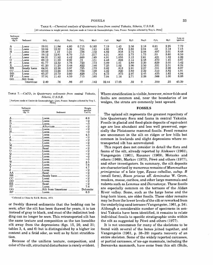
TABLE 6. Chemical analysis of Quaternary loess from central Yakutia, Siberia, U.S.S.R.[All calculations in weight percent. Analyses made at Centre de Geomorphologie, Caen, France. Samples collected by Troy L. Pewe]
33
Sediment sample (fig.3) Sediment SiO2 A12O., Fe2 O3 TiO2 MaO
A ______Loess ______ 59.01 11.84 4.60 0.715 0.163G ___ _ Loess ______ 59.94 12.32 5.36 .724 .145H _ _ Loess _ ____ 58.49 1.10 5.21 .736 .152I- ___ Loess ______ 59.12 12.81 6.70 .715 .217J __ .Loess - __ 64.31 11.92 4.42 .669 .149O ___ Loess ___ 69.19 11.29 2.92 .72 .151S ___ _ Loess ______ 61.77 12.32 4.76 .723 .173X _ ___ Loess ______ 61.20 11.29 3.48 .622 .146BB __ __Sandy loess 64.91 12.38 3.97 .725 .173CC__ ___Loess _ ___ 63.04 12.66 3.98 .786 .138DD__ __ Loess ______ 65.37 10.79 3.60 .628 .174FF___ Loess ___ 57.91 11.40 4.59 .715 .165GG- __ Silt from
limestone 2.49 .76 .86 .07 .142
TABLE 7. CaCO 3 in Quaternary sediments from central Yakutia, Siberia, U.S.S.R.
[Analyses made at Centre de Geomorphologie, Caen, France. Samples collected by Troy L. Pewe]
Sediment Weight sample percent (fig. 3) Sediment CaCO3
A Loess 6.8B Loess =2
E Alluvium <2
I T iflf^QQ A. ^\
J Loess <2K Loess <2
M Loess =3N _____________ ___ ____Sand ___________________ _ <2O Loess <2Q Loess <2
X ___ __ __ Loess _ _ _ __ _ 7.6Y Loess 4.7
AA Sand <2BB ___ _ _ _ Sandy loess. ______ <2CC __ _ __ _ _ Loess __ _ _____ __ <2DD Loess <2EE ____________________Sand __ ___ ____________ <2FF ____________________Loess______ __ ____________ 7.6
301 ____________________Loess__________-___-_____-_ 6.3
'Collected in China by R.J.E. Brown, 1973.
or freshly thawed sediments that the bedding can be seen; after the silt has been thawed for years, it is tan instead of gray to black, and most of the indistinct bed ding can no longer be seen. This retransported silt has the same texture and composition as the tan loesslike silt away from the depressions (figs. 15, 20, and 21; tables 3, 4, and 6) but is distinguished by a higher ice content and a fetid odor, as well as by faint stratifica tion.
Because of the uniform texture, composition, and color of the silt, structural disturbance is rarely evident.
Loss on CaO MgO K2O Na2O P2O 5 H2O ignition
7.19 1.43 2.56 2.18 0.81 2.25 7.794.83 .974 2.82 2.04 .53 3.14 7.154.82 .958 2.74 2.08 .497 3.01 8.484.21 .855 2.73 1.73 .55 3.60 6.594.91 1.055 3.12 2.61 .421 1.32 4.264.48 .826 3.14 2.58 .370 1.45 3.875.09 1.01 2.89 2.20 .629 3.05 5.427.25 1.02 2.90 2.50 .331 2.51 6.243.82 .813 2.91 2.27 .551 3.26 3.974.02 .820 2.89 2.22 .510 3.82 4.814.73 .975 2.97 2.45 .435 1.62 4.847.04 1.16 2.71 2.26 .566 1.00 8.88
32.44 17.05 .32 0 .350 .25 45.39
Where stratification is visible, however, minor folds and faults are common and, near the boundaries of ice wedges, the strata are commonly bent upward.
FOSSILS
The upland silt represents the greatest repository oflate Quaternary flora and fauna in central Yakutia.Fossils in glacial and flood-plain deposits of equivalentQ n*f> OT*O 1 CkCC O V\l lYl/^QYl'f" QYl/i loCC TXrol 1 Tyi*O COY*\7£ifi £kGT\£k
cially the Pleistocene mammal fossils. Fossil remainsare uncommon in the silt on ridges or low hills butcommon in lowlands and slight depressions where re-^"VQT"l OT\f"l'W*^"O/^ CSll'f' Vl O G Q/^/^ll TV! Ill O*t~O/l
This report does not consider in detail the flora andTQimci CIT 4~r\& cil'f' dlT*fiQ/i\7 T*OT\OT*^" o/H r\\7 A IOKGOO^T" ( 1 Qfi 1 1
Vangengeim (1961), Rusanov (1969), Motuzko andothers (1969), Markov (1973), Pewe and others (1977),and other investigators. In summary, the silt depositsQ Y*O (* r\ OT*O/^"^O>*1 rjdn V\\7 Till YY"I O>*f"ll 1 C >*OTY"I Q 1 Yl C f\T nA flYYI m lltr! 7 / O
primigenius of a late type, Equus caballus, subsp. B(small form), Bison prisons aff. derninutus W. Grom,muskox, moose, caribou, and other large mammals androdents such as Lemmas and Dicrostonyx. These fossilsare especially common on the terraces of the AldanRiver valley. Some, such as the large horse and thelong-horn bison, are older fossils. These older remains may be from the lower levels of the silt or reworked from the underlying sand terraces (Vangengeim, 1961, p. 34). Although a considerable number of specimens in cen tral Yakutia have been identified, it remains to relate individual fossils to specific stratigraphic units within the silt as suggested by Pewe and others (1977).
It is not uncommon for many of the skeletons to be found with several of the bones joined together, and Vangengeim (1961, p. 38-39) reports recovery of an entire skeleton. Some of the widely reported carcasses, or partial carcasses, of ice-age mammals, including the Berezovka mammoth, have come from this silt (Shilo,

34 ORIGIN AND CHARACTER OF LOESSLIKE SILT, YAKUTIA, SIBERIA
1978). Partial carcasses of Pleistocene mammals have also been recovered from the perennially frozen re- transported silt in Alaska (Pewe, 1975a).
Aquatic fossils in the silt include two mollusk species collected by Pewe on the south side of the Aldan Valley: Valvata piscinalis Mull, and Valvata cristata (O. F. Muller) (identified by J. Vasatko, Czechoslovakia Academy of Science, Brno, CSSR, written commun., 1974). Solov'ev (1959) reports aquatic mollusks at var ious depths in the upper of two major clayey loam layers near Churapacha.
The retransported frozen silt contains a varied megaflora in the form of peat, sticks, twigs, pods of plant remains, and isolated tree limbs and stumps. Study of such specimens and pollen analysis indicate the pre dominance of herbaceous tundra and forest-tundra veg etation at the time of silt accumulation (Vangengeim, 1961; Giterman and Golubeva, 1967).
ORIGIN
Although the origin of loess has been a controversial subject worldwide for about 100 years, most of the dis cussions have centered on the loess in China, central United States, and later, Alaska. Less is known about the probable origin of the widespread loesslike silt in the lowlands of unglaciated eastern Siberia. Marine, estuarine, lacustrine, fluvial, weathering, and eolian processes have been invoked to explain the loesslike silt. The marine and estuarine hypotheses have had little support; but the lacustrine, fluvial, and residual hypotheses, either separately or in combination, have had widespread support and are currently strongly held by Soviet workers, especially by researchers working with frozen ground. In recent years, however, the eolian hypothesis has been advocated by some workers (To- mirdiaro and others, 1974; Tomirdiaro, 1975b; Pewe and others, 1977).
MARINE AND ESTUARINE HYPOTHESES
Many of the river valleys in central Yakutia, espe cially in the north, are less than 100 m above sea level. It has been suggested that much of the loesslike silt could result from inundation by an advancing sea (Wright, 1902). To deposit such uniform silt at both high and low elevations, however, flooding the valleys many hun dreds of meters deep would have been required (fig. 2).
Moreover, deltas, shorelines, and beaches would be present if the water level had been constant for a long period of time. The silt would stratify and would contain large amounts of clay, mud cracks or ripple marks, and marine fossils, but none of these features are present.
WEATHERING HYPOTHESIS
Berg (1960) proposed that loess forms in place as the underlying rock breaks down. His hypothesis exerted a
profound influence over many Soviet scientists, but now it seems to have little support in the western part of the Soviet Union. In Yakutia, however, many workers have argued more recently that the loesslike silt there is a product of breakdown by seasonal freezing and thawing (Sudokova, 1959; Popov, 1965, 1967, 1972, 1976; Aga- dzhanyan and others, 1973; Danilova, 1973), a combina tion of frost action and chemical weathering (Chigir, 1972; Konishchev, 1972; Konishchev and Rogov, 1972), or chemical weathering alone, a "loessification" process in place (Morozova, 1971). According to this theory, the upland silt of central Yakutia is in the initial stages of loess formation and not yet as well formed as the loess of the Russian plains.
If the upland silts were formed in place by disintegra tion of local country rock, the following features would be expected:
1. The mineralogy of the silt and the underlying rock would be similar, allowing for differen tial resistance to weathering. In central Yakutia, the silt overlies many substrates, in cluding dolomitic limestone, alluvium, poorly consolidated sands, glacial outwash, and till of diverse provenance. In all areas, the mineral ogy and chemistry of the silt is similar de spite the great diversity of underlying mate rial.
In the southern part of the area, the upland silt lies directly on dolomitic limestone, but samples (W, X, Y, Z, BB, CC, DD, and FF; fig. 3) overlie the limestone and could not have been derived from the weathering, either chemical or mechanical, of the underly ing rock. These samples contain a suite of heavy minerals similar to other samples, min erals not present in the underlying bedrock (tables 1, 2, and 4). The percentage of calcium carbonate in these samples is actually about the same as in the rest of the mapped area, or slightly less; yet, one would expect a tre mendously high concentration of calcium car bonate in loess if it had originated from the underlying limestone. On top of dolomitic limestone cliffs 147 m above the Lena River at the Pillars of the Lena, a sample (tables 1 and 4) of weathered limestone was taken from a crevice deep in the rock in a dry environ ment. Although the sample is a well-sorted silt, it contains no heavy minerals and is pure calcium carbonate (fig. 27). The silt occurs high on the bluffs and could not have origi nated from some other local bedrock at higher altitudes and been transported to the area (figs. 13, 14, and 22). It is evident, therefore, that the silt in these localities did not come from the underlying or nearby bedrock.

ORIGIN 35
Sediments produced by rock disintegration would undoubtedly contain some large parti cles, especially of the more resistant miner als, but such resistant particles are scarce, At some localities, angular pieces of resistant limestone as much as 5 cm in diameter occur at the base of the loesslike silt, probably bro ken from the underlying limestone by frost action. The massive loesslike silt overlies these frost derived fragments on a sharp con tact that marks (fig. 22) a great change in textural, chemical, and mineralogical compo sition.
If silt accumulated on top of a hill or a flat-lying area through the disintegration of underlying bedrock, the material should be finer and more weathered at the surface than that closer to bedrock. The vertical uniformity of size distribution evidenced at Mamontova Gora (fig. 21), at consecutive depths of 2 m (U) and 3 m (V) (fig. 3) at Churapacha on the Abalakh Terrace, and by samples BB and CC in loesslike silt overlying dolomitic limestone (figs. 19 and 22) contradicts this expectation.
Mechanical disintegration, probably the domi nant process of bedrock weathering in subarc tic climates, depends largely on the action of alternate freezing and thawing (cryolithic processes). Where a thick layer of breakdown residuum develops, it might be expected to shield the underlying rock from further disin tegration. On hillsides, the silt might be re moved as fast as it forms, but it would ac cumulate on flat hilltops and ridges. The depth of seasonal freeze and thaw of the ground in central Yakutia ranges from 1 to 3 m with deepest penetration in gravel and least penetration in silt. Under present climatic conditions seasonal freeze and thaw of bedrock probably does not occur under a protective mantle of silt thicker than 1-2 m. In past colder periods, seasonal penetration of frost may have been slightly deeper in the nonperennially frozen ground. It is true that, in the past, well-drained silt may have been perennially frozen, but if no frequent alterna tion of freeze and thaw occurred, little disin tegration would take place. Because much more than 3-4 m of upland silt is present on the relatively flat terraces and uplands, in cluding the highest terrace, it is clear that the material could not have originated in place from seasonal frost action.
Residual silt on hilltops, ridges, plateaus, or ter races would contain no carbonaceous layers or soil horizons if the material were formed by
a progressive downward disintegration of the underlying bedrock. Sections of the silt do, however, reveal carbonaceous layers and soil horizons.
In summary, a number of characteristics that would be expected in the loesslike silt if it were formed by disintegration in place are not observed. Together the lack of these characteristics argue convincingly against the disintegration hypothesis.
LACUSTRINE AND FLUVIATILE HYPOTHESES
The most popular explanation of the origin of the upland silt in central Yakutia is that the loesslike silt is a combination of lacustrine and alluvial deposits formed on great flood plains and marshy plains (Popov, 1953; Solov'ev, 1959; Boyarskaya and Malayeva, 1967; Katasonov and Solov'ev, 1969; Motuzko and others, 1969; Agadzhanyan and others, 1973; Ivanov and Katasonov, 1973; Katasonov and Ivanov, 1973; Konishchev, 1973; Popov, 1973). Periglacial research ers concerned with various forms of ground ice favor this hypothesis because of the faint stratification where the silt has flowed into shallow depressions when large amounts of segregated ice melts. The quantity of ground ice present indicated, they thought, that the silt had been deposited on vast partly flooded plains.
It has long been known (Bunge, 1884; Toll, 1895) that ground ice of various types and quantity (fig. 6) is wide spread in the loesslike silt cover of the high and low terraces of central Yakutia, as well as on the coastal plain of the north. The lacustrine-alluvial hypothesis evolved over the years in an attempt to explain the different types and distribution of ground ice. According to Tomirdiaro and others (1974), until the early 1950's of the 20th century, it was believed that most of the ice in the ground was remnant ice and snow from Pleis tocene glaciers buried by clayey alluvium; this idea is the so-called glacial firn theory. It is now known that the glaciers were not that extensive (fig. 4) and that the foliated ground-ice wedges (figs. 6, 25) formed in ther mal contraction cracks in the perennially frozen ground. Many scientists thought that the ice wedges must have grown syngenetically in the saturated sedi ments of a gigantic flood plain and invoked great floods and colossal lacustrine-alluvial plains to account for the great vertical extent of the ice, from modern flood plains to high terraces (Popov, 1953, 1965).
A number of factors combine to make the fluvial and lacustrine hypotheses unlikely. Fluviatile silt is well stratified and crossbedded, individual beds are lens shaped, and, though individual beds are fairly well sorted, samples collected over a broad area or from a thick section are poorly sorted. The upland silt, how ever, is unstratified and uniform in texture. Moreover, though fluviatile silt is abundant on the flood plains of the Lena and Aldan Rivers, it is typically of larger grain

36 ORIGIN AND CHARACTER OF LOESSLIKE SILT, YAKUTIA, SIBERIA
size than the upland silt (fig. 26 and table 3, sample E). It is also difficult to explain, in the context of the fluvial hypothesis, the presence of as much as 25 m of silt on bedrock bluffs as much as 50-100 m above the river level and the character of the silt as a nearly continuous blanket over a surface with 100-200 m of relief.
The lacustrine hypothesis is also improbable for sev eral reasons:
1. No known barriers capable of damming water 200 m deep, 150 km up the Lena River from Yakutsk and 300 km up the Aldan River from its mouth existed in the area where the silt was deposited.
2. No features such as preserved shorelines, wave-cut benches, and deltas, which would be expected to form in a lacustrine environment, are evident in the silt.
3. Lacustrine deposits have a limited vertical ex tent, but the loesslike silt occurs at various elevations and even on the moraines at the foot of the Verkhoyansk Range, hundreds of meters above the Aldan River.
4. Lacustrine silt would be stratified and might even contain varves. The only stratification in the upland silt is produced by isolated car bonaceous layers and iron-stained horizons, and, in most places, stratification is absent. Crude stratification is outlined by concen trations of ground ice and by slight differences
in grain size. In the retransported materials that were carried by slopewash to shallow de pressions, however, this crude stratification disappears upon thawing and complete drying of the silt in cliffs.
An appreciable amount of clay could be expected in the deposits of any large lake. The average cumulative-frequency curve of 27 samples from the upland silt has a very low content of clay, only about 5-15 percent.
As would be expected of lacustrine deposits, the upland silt bears little lithologic relation to the underlying rock. This characteristic, how ever, is typical of any transported sediment.
Some forms of life would have existed in these lakes. So far as we are aware, no lacustrine fossils have been found in the high upland silt, although gastropods and pelecypods have been found in the reworked material of the valley bottoms. The fossils in the valley bot toms probably were derived from thermokarst lakes (alases) that existed at the time of silt accumulation.
Land fossils would be absent or scarce in lacus trine deposits, as they are in the nonretrans- ported upland silt. But land fossils are pre served in the upland silt although they are fragmentary and show evidence of transport. These features, however, are to be expected in
FIGURE 25. Panorama of late Quaternary silt containing ice wedges exposed at Mamontova Gora, left limit of Aldan River, 310 km upstream from junction with Lena River. View downstream. Photographs 3427, 3428, 3429, and 3430 by T. L. Pewe, July 22, 1974. (Reproduced by the courtesy of Quaternary Research.)

ORIGIN 37
transported sediments regardless of the transport mechanism.
9. Mud cracks and ripple marks would be expected in lacustrine silt, but none have been ob served.
All but two of these features of lacustrine deposits are contrary to the observed nature of the upland silt. The two features that are consistent are typical of deposits transported by any mechanism. The observed charac teristics of the silt in central Yakutia cannot be ex plained by the lacustrine and fluviatile hypotheses alone. Moreover, radiometric and paleontologic dating show that the silt accumulated in middle and late Pleis tocene glacial times (Vangengeim, 1961; Sher, 1971; Pewe and others, 1977), not during a warm period when melting would inundate the region. The remains of
100
90
steppe animals such as Siaga (Sher, 1967, 1969, 1971) and steppe tundra (Yurtsev, 1972; Hopkins, 1976; Mathews, 1976) confirm the general dryness of the cli mate.
EOLIAN HYPOTHESIS
Although the idea that the silt in central Yakutia is eolian in origin is not new, it has not been described and evaluated in detail. Obruchev (1945), a longtime Soviet leader in loess studies, mentioned that loess existed in central Yakutia. Volkov and others (1969) have demon strated that the widespread silt in southwest Siberia is eolian in origin. Recently, Tomirdiaro (1972) and To- mirdiaro and others (1974) recognized that the silt in northern Yakutia is loess. Vangengeim (1961, p. 37) referred to the silt as dusty loam, "the formation of
0.1 0.05 0.01DIAMETER. IN MILLIMETERS
FIGURE 26. Cumulative-frequency grain-size curves for sand from Lena-Aldan Rivers area. E, flood-plain alluvium, Ust'Tatta Village; N, sand, top of Magan Terrace, 53 km west of Yakutsk; P, sand dune on Bestyakh Terrace; AA, alluvial sand, 7 km west of Pokrovsk; EE, eolian sand from cliff-head dune, 40 km upstream from Pokrovsk on Lena River. See table 1, figure 3.

38 ORIGIN AND CHARACTER OF LOESSLIKE SILT, YAKUTIA, SIBERIA
which the majority of geologists have correlated with unusual physical-geographical conditions in glaciated regions." Rusanov (1968) mapped all the silt on the high terraces of the lower Aldan River valley as loess. Giter- man and Golubeva (1967) referred to the sediments on the high terraces as loess but did not provide supporting data. Fedorovich (1972) recently mentioned that the study of the silt in Yakutia should be undertaken to provide new contributions to loess science. Our studies of the silt in southcentral Yakutia, and comparisons with similar deposits in other parts of the world, support the identification of the deposits as loess.
Features and characteristics of eolian-deposited silt fall into three groups: field relations, mechanical com position, and petrographic character (Smith and Frazer, 1935).
FIELD RELATIONS
Topographic distribution. Loess characteristically mantles preexisting topography, "filling up the gulleys, covering minor depressions, lying deepest in the depres sions and thinning-out up the flanking slopes of the higher ridges" (Barbour, 1930, p. 468). The silt in cen tral Yakutia conforms closely to this pattern.
It is draped over river terraces of varous levels and thinly over the glacial outwash and moraines emanat ing from the Verkhoyansk Range. It is absent on the flood plain, low floodplain terraces, and the sandy Bes- tyakh Terrace. It is not known why the silt is absent from the Bestyakh Terrace, possibly because the terrace surface, part of a late Pleistocene sandy flood plain of the Lena River, was a source of windblown silt, not an area of accumulation. In general, the high Magan Terrace has little or no loess because: (1) the terrace, in most areas, is distant from the major rivers (fig. 3); (2) the Lena River is narrow and has a small flood plain where it is near this terrace and; (3) the terrace was upwind from a major glacial flood plain, the source of silt.
Independent lithologic character of the deposits. Wind-deposited material may differ mineralogically and texturally from the underlying material. In south- central Yakutia, uniform silt covers glacial till, dolomi- tic limestone, poorly consolidated sandstone, and al luvium. At these several localities, the fine texture of the silt contrasts strongly with the texture of the under lying material, but is very similar to that of the typical tan upland silt in south-central Yakutia (fig. 4) and northern Yakutia (fig. 27).
Decrease in thickness away from source of supply. The greatest thickness of the silt blanket is near its source, the flood plains and low terraces of the Lena and Aldan Rivers. The silt is 2-5 m thick on the bluff of the Magan Terrace west of Yakutsk and thins westward to a featheredge within a few kilometers (fig. 3). Such
marked thinning is consistent with present-day wester ly prevailing winds and may indicate similar wind pat terns during the Pleistocene from the west.
Absence of distinct stratification. Absence of distinct stratification, a characteristic of loess, is a conspicuous feature of the upland untransported silt. The only sug gestion of stratification is imparted by thin carbona ceous horizons and iron-stained horizons.
Color and texture. Wind-deposited silt, like that de scribed here, is generally light colored except where stained by solutions or carbonaceous inclusions; the tex ture is generally uniform and the clay component makes up no more than 10-15 percent of the sediment.
Association with other evidences of wind action. Smith and Fraser (1935, p. 19) state that sand dunes and ventifacts may be expected near the source of material. Well-developed, vegetated sand dunes cover the entire narrow Bestyakh Terrace adjacent to the wide Lena River from Pokrovsk to the mouth of the Aldan River (fig. 3). The eolian forms exist as ridges 2-10 m high and as small merged parabolic dunes. An active cliff-head dune 20 m high occupies the edge of the Bestyakh Ter race on the right limit of the Lena River about 40 km upstream from Pokrovsk. This dune and other dunes are evidence of eolian action still going on where sediment source areas are nearby. Small dust clouds raised today from the almost completely vegetated braided-stream deposits of the major rivers in central Yakutia suggest that enormous clouds of dust may have come from the unvegetated braided streams present during the Pleis tocene. It has been demonstrated by many workers that no more wind is necessary to blow this dust than is present today, as winds up to 20 m/s are more than strong enough to bear quantities of dust in both perigla- cial areas and hot desert areas (Bryan, 1927, p. 39-40; Pewe, 1951; Warn, 1953, p. 70-71; Pewe and others, 1976; Pewe and others, 1981). Chigir (1972), however, believes that much higher wind velocities are necessary and that such winds were produced by the nearness of glaciers. Instead, only larger source areas than now available are necessary, in our opinion, and they were provided by the wide unvegetated, braided Lena and Aldan Rivers in Pleistocene time.
Fossils of air-breathing animals. Fossils of air- breathing animals should logically be expected to be present in the silt if the material is eolian. Middle and late Pleistocene vertebrate fossils are distributed widely in the silt blanketing the terraces on the Lena, Aldan, and Vilyuy Rivers (for example, Alekseev, 1961; Vangengeim, 1961; Rusanov, 1968; and others). Fossils present include remains of mammoth, horse, bison, and other mammals. The preservation of many of the specimens shows evidence of very little transportation.
No land gastropods have been reported in the upland

ORIGIN 39
silt in Yakutia. Russell (1944, p. 34) regarded land gas tropods as being characteristically present in loess. Some other loess deposits, however, in the upper Mississippi Valley and most of the loess in Alaska, do not contain land gastropods (Pewe, 1955, p. 720-721). Also, Dr. T. C. Yen (oral commun., June 27, 1950), former paleontologist at the United States National Museum, Washington, B.C., reported that much of the loess of China and the Rhine Valley contained no terres trial gastropods so this evidence is not conclusive.
MECHANICAL COMPOSITION
If the upland silt is loess, the grain size and degree of sorting would be similar to that of windblown dust or volcanic ash that has been transported a considerable distance (Udden, 1898, p. 31-60; Swineford and Frye, 1945, p. 252; Warn and Cox, 1951, p. 559; Pewe, 1955, fig. 11; and Pewe and others, 1976), or similar to silt known to be loess. Cumulative-frequency curves of me chanical analyses of windblown dust from Kansas (Swineford and Frye, 1945, p. 252) and Germany (Zeuner, 1949, p. 27) and Arizona (Pewe and others, 1981) are similar to the average cumulative-frequency
curve of the upland silt from central Yakutia (fig. 28). It was thought that a great similarity of grain size and
degree of sorting between the upland silt of Yakutia and deposits of silt of known eolian origin elsewhere in the world, would constitute a strong argument for the eo lian hypothesis. For comparison, samples of silt long known to be loess were collected from Czechoslovakia, Alaska, Illinois, China, New Zealand, France, and Uz bekistan. All but one of the samples were analyzed by the same method in the same laboratory as the Yaku- tian samples. The cumulative-frequency curve of a typi cal sample from Yakutia is strikingly similar to curves of loess from other parts of the world (fig. 29).
PETROGRAPHIC CHARACTER
Angular grains have long been considered typical of loess (Twenhofel, 1932; Charlesworth, 1957), and scanning-electron-microscope analysis supports that assumption (Cegla and others, 1971). The silt grains from Yakutia are clearly angular, especially the light minerals such as quartz. It has been suggested that loess grains should also be largely unweathered and clay minerals almost absent (Smith and Fraser, 1935;
N PERCENT
r> --J oo CD c3 0 O O C
CUMULATIVE FREQUENCY, 1
-» ro oj *k 01 c
_,o o o o o o e
EXPLAIN
. 1
VTION
Samples
Tomi
GG
_ -
' if***
^ <Y/
I
jl
*
0 0.5 0.1 0.05
/
/^/
/
x,t
/'K
x*^
^ * -
0.01 0.005 0.001 0.0005 0.001
DIAMETER, IN MILLIMETERS
FIGURE 27. Cumulative-frequency grain-size curves of silt from Yakutia. Sample GG is silt from weathered dolomitic limestone in crevice 147 m above Lena River, 250 km south of Yakutsk. Sample Tomi is loess from northern Yakutia (Tomirdiaro and others, 1974, table 2).

40 ORIGIN AND CHARACTER OF LOESSLIKE SILT, YAKUTIA, SIBERIA
Charlesworth, 1957), though the degree of weathering would depend on the age and rate of deposition of the deposit and the effects of diagenetic processes. The silt from Yakutia, like middle and late Pleistocene loess from other parts of the world, is relatively fresh but shows some weathering under the scanning electron microscope.
The heavy-mineral content of the silt in the Lena and Aldan Rivers area (table 4) confirms the independence of the silt from the underlying deposits, in contrast to Sudakova's (1969, p. 55) claim that the microscopic component is inherited from the underlying rocks. It also indicates the general uniformity of the silt, though it can be used to distinguish the Lena River and Aldan River flood plains (fig. 24). Heavy-mineral content in loess has been used to distinguish source areas in many parts of the world (Kay and Graham, 1943; Pewe, 1955; Frye and others, 1962; Goldthwait, 1968; Journaux and others, 1969; Codarcea and others, 1972).
Summary. Many points of similarity between the characteristics of loess and the loesslike silt in central
Yakutia support the eolian hypothesis. In light of this evidence we conclude that the silt on the terraces and plateaus of the major river valleys such as the Lena, Aldan, and Vilyuy Rivers in south-central Yakutia is loess.
AGE AND CORRELATION
Glaciers pushed southward and westward from the Verkhoyansk Range in pre-Wisconsinan and Wisconsin- an time, advancing almost as far as the Aldan River (fig. 4). During advances of glaciers from this range and ranges farther southeast and of continental glaciers to the west (fig. 4), braided silt-laden melt-water streams such as the Lena, Aldan, and Vilyuy Rivers flowed over wide vegetation-free flood plains and spread glacial flour over the outwash plains. Winds picked up some of the silt on the flood plains and outwash plains and redeposited it as loess on the lowlands, mainly the high terraces and low plateaus.
At least two major periods of loess deposition are recorded in the upland silt in central Yakutia, according
100
90
80
70
£ 60
EXPLAIN
V
- D
Y
------- D
_-_- D
JATIOSar
, Siber
ust, G
Volca airbanl
ust, K
ust, A
_ _ ..
Nnples
ia
ermany
nic ash, cs, Alaska
ansas
rizona
-Z^J£
s*s
7
4
/:*
/ //'i
i /,
T, 7 '/
i n-till'/'4
I // tf
1it I' '1i/
i i !-t1 .'
I!HiH^ //1
/ // /
/ s'''?' 'I/I
/
-
/
//
-
/
/*
-
/ ')
'
? rxs'-
. _. -» _ JT^
50
> 40
5
§ 30o
20
10
1.0 0.5 0.1 0.05 0.01 0.005
DIAMETER, IN MILLIMETERS
0.001 0.0005 0.0001
FIGURE 28. Cumulative-frequency grain-size curves for upland silt (sample K) from near Yakutsk, volcanic ash from Fairbanks, Alaska, and modern wind-deposited dust from Germany (Zeuner, 1949, p. 27), Kansas (Swineford and Frye, 1945, p. 252), and Tempe, Ariz. Samples from Alaska, Arizona, and Siberia collected by T. L. Pewe. Siberian and Arizona samples analyzed at Centre de Geomor- phologie du Centre National de la Recherche Scientifique, Caen, France; Alaskan sample analyzed by U.S. Army Corps of Engineers, Rock Island, 111.
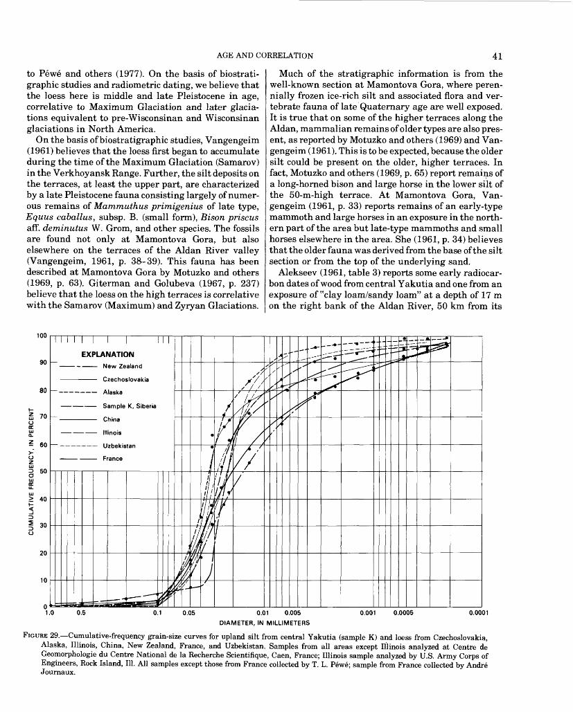
AGE AND CORRELATION 41
to Pewe and others (1977). On the basis of biostrati- graphic studies and radiometric dating, we believe that the loess here is middle and late Pleistocene in age, correlative to Maximum Glaciation and later glacia- tions equivalent to pre-Wisconsinan and Wisconsinan glaciations in North America.
On the basis of biostratigraphic studies, Vangengeim (1961) believes that the loess first began to accumulate during the time of the Maximum Glaciation (Samarov) in the Verkhoyansk Range. Further, the silt deposits on the terraces, at least the upper part, are characterized by a late Pleistocene fauna consisting largely of numer ous remains of Mammuthus primigenius of late type, Equus caballus, subsp. B. (small form), Bison prisons aff. deminutus W. Grom, and other species. The fossils are found not only at Mamontova Gora, but also elsewhere on the terraces of the Aldan River valley (Vangengeim, 1961, p. 38-39). This fauna has been described at Mamontova Gora by Motuzko and others (1969, p. 63). Giterman and Golubeva (1967, p. 237) believe that the loess on the high terraces is correlative with the Samarov (Maximum) and Zyryan Glaciations.
Much of the stratigraphic information is from the well-known section at Mamontova Gora, where peren nially frozen ice-rich silt and associated flora and ver tebrate fauna of late Quaternary age are well exposed. It is true that on some of the higher terraces along the Aldan, mammalian remains of older types are also pres ent, as reported by Motuzko and others (1969) and Van gengeim (1961). This is to be expected, because the older silt could be present on the older, higher terraces. In fact, Motuzko and others (1969, p. 65) report remains of a long-horned bison and large horse in the lower silt of the 50-m-high terrace. At Mamontova Gora, Van gengeim (1961, p. 33) reports remains of an early-type mammoth and large horses in an exposure in the north ern part of the area but late-type mammoths and small horses elsewhere in the area. She (1961, p. 34) believes that the older fauna was derived from the base of the silt section or from the top of the underlying sand.
Alekseev (1961, table 3) reports some early radiocar bon dates of wood from central Yakutia and one from an exposure of "clay loam/sandy loam" at a depth of 17 m on the right bank of the Aldan River, 50 km from its
100
90
80
70
- 60
50
EXPLANATION
New Zealand
Czechoslovakia
Alaska
Sample K, Siberia
China
Illinois
Uzbekistan
France
> 40
30
20
0.5 0.1 0.05 0.01 0.005
DIAMETER, IN MILLIMETERS
0.001 0.0005 0.0001
FIGURE 29. Cumulative-frequency grain-size curves for upland silt from central Yakutia (sample K) and loess from Czechoslovakia, Alaska, Illinois, China, New Zealand, France, and Uzbekistan. Samples from all areas except Illinois analyzed at Centre de Geomorphologie du Centre National de la Recherche Scientifique, Caen, France; Illinois sample analyzed by U.S. Army Corps of Engineers, Rock Island, 111. All samples except those from France collected by T. L. Pewe; sample from France collected by Andre Journaux.
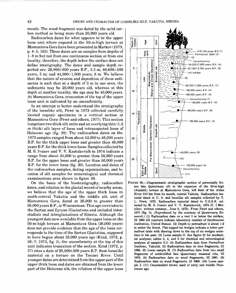
42 ORIGIN AND CHARACTER OF LOESSLIKE SILT, YAKUTIA, SIBERIA
mouth. The wood fragment was dated by the solid car bon method as being more than 20,000 years old.
Radiocarbon dates for what appears to be the upper loess unit where exposed in the 50-m-high terrace at Mamontova Gora have been presented in Markov (1973, p. 4 5, 163). These dates are on samples from depths of 1-8 m but not from one continuous section or from one locality; therefore, the depth below the surface does not define stratigraphy. The dates and sample depth re ported are: 26,800±600 years B.P., 5.5 m; 40,600±500 years, 3 m; and 44,000± 1,900 years, 8 m. We believe that the nature of erosion and deposition of these sedi ments is such that at a depth of 3 m in one area, the sediments may be 20,000 years old, whereas at this depth at another locality, the age may be 40,000 years. At Mamontova Gora, truncation of the top of the upper loess unit is indicated by an unconformity.
In an attempt to better understand the stratigraphy of the loesslike silt, Pewe in 1973 collected carefully located organic specimens in a vertical section at Mamontova Gora (Pewe and others, 1977). This section comprises two thick silt units and an overlying thin (1-2 m thick) silt layer of loess and retransported loess of Holocene age (fig. 30). The radiocarbon dates on the 1973 samples ranged from about 42,000 to 46,000 years B.P. for the thick upper loess and greater than 46,000 years B.P. for the thick lower loess. Samples collected by M. S. Ivanov and V. V. Kastukevich in 1974 indicate a range from about 34,000 to greater than 56,000 years B.P. for the upper loess and greater than 56,000 years B.P. for the lower loess (fig. 30). Location and dates of the radiocarbon samples, dating organizations, and lo cation of silt samples for mineralogical and chemical examinations area shown in figure 30.
On the basis of the biostratigraphy, radiocarbon dates, and relation to the glacial record of nearby areas, we believe that the age of the upper thick loess in south-central Yakutia and the middle silt unit of Mamontova Gora, dated at 26,000 to greater than 56,000 years B.P., is Wisconsinan. This age correlates to the Sartan and Zyryan Glaciations and included inter- stadials and interglaciations of Siberia. Although the youngest date now available from the upper loess on the 50-m-high terrace at Mamontova Gora (26,000 years) does not provide evidence that the age of the loess cor responds to the time of the Sartan Glaciation, supposed to have begun about 25,000 years ago (Kind, 1972, p. 56-7; 1975, fig. 1), the unconformity at the top of this unit indicates truncation of the section. Kind (1972, p. 57) cites a date of 20,900±300 years B.P. from loesslike material on a terrace on the Yenisei River. Until younger dates are determined from the upper part of the upper thick loess and dates are obtained from the lower part of the Holocene silt, the relation of the upper loess
415±40 years B.P.d) Permafrost table (2)
=^ (3)
Unconformity- 34,020i1,500 years B.P. (4)
42,150*3,700 years B.P. (5)
Ice wedge
46,700*1,500 years B.P. (7)
>56,000 years B.P. (4)
>56,000 years B.P. (4)
Unconformity (?) 56,000 years B.P. (4)
46,000 years B.P. 18)
56,000 years B.P. (4)
>43.500 years (9)
(10!
56,000 years (4) Unconformity
(11)
FIGURE 30. Diagrammatic stratigraphic section of perennially fro zen late Quaternary silt in the exposure of the 50-m-high (Abalakh) terrace at Mamontova Gora, left limit of the Aldan River 310 km from its mouth, central Yakutia. Radiocarbon ma terial dated in U. S. and loesslike silt samples collected by T. L. Pewe, 1973. Radiocarbon material dated in U.S.S.R. col lected by M. S. Ivanov and V. V. Kastukevick, 1974 (P. I.Mel- nikov, written commun., June 6, 1975). From Pewe and others, 1977 (fig. 3). (Reproduced by the courtesy of Qitatemary Re search.) (1) Radiocarbon date on a root 1 m below the surface, SI 1968 (SI numbers indicate laboratory number of Smithsonian Institution, United States). (2) Depth to permafrost is about 1-2 m under the forest. Flat-topped ice wedges indicate a lower per mafrost table with thawing down to the top of ice wedges some time in the past. (3) Loess sample G. See figure 21 for mechani cal analyses; tables 3, 4, and 6 for chemical and mineralogical analyses of samples G-I. (4) Radiocarbon date from Permafrost Institute, Yakutsk. (5) Radiocarbon date on tree fragments, SI 1965. (6) Loess sample H. (7) Radiocarbon date from two small fragments of unidentified late Quaternary mammal ribs, SI 1972. (8) Radiocarbon date on wood fragments, SI 1967. (9) Radiocarbon date on wood fragments, SI 1966. (10) Loess sam ple I. (11) Crossbedded brown sand of early and middle Pleis tocene age.
SUMMARY 43
to the Sartan Glaciation is speculative. The base of the upper loess is more than 56,000 years old, and possibly as old as 100,000 years. The top may be as young as 10,000 years. No definitive dates are yet available to mark the boundaries, but we believe the boundaries will prove to be of the order of those ages.
The lower loess is definitely beyond the range of con ventional radiocarbon dating. It may be Wisconsinan in age, but a Samarov age is a strong possibility, correla tive with the Maximum Glaciation of Siberia and older than the last interglacial period. Mammalian remains support the hypothesis that the loess first began to ac cumulate in Maximum time (Vangengein, 1961; Giter- man and Golubeva, 1967); if it did, interglacial beds may be found separating it from the Wisconsinan beds.
Alekseev (1970) believes that the silt beds along the lower Vilyuy River with large ice wedges and mamma lian remains were deposited in the second half of the Pleistocene. He suggests that they represent a large interval of time, from the Riss Glaciation to the end of the Wurm Glaciation.
It is hoped that additional dating of loess samples from the units exposed on the high terraces along the Aldan River and elsewhere will soon be undertaken.
SUMMARY
Loesslike silt mantles the upland terraces and low plateaus throughout south-central Yakutia, reaching maximum thickness along the south side of the Aldan River valley and the east side of the Lena River valley. It is well exposed in the river cuts in these areas, the greatest thickness recorded being more than 60 m on the Tyungyulyu Terrace. The texture and mineral com position are uniform throughout central Yakutia, whether the silt overlies limestone, poorly consolidated sandstone, alluvium, or glacial outwash. All loesslike silt samples examined contain a high percentage of quartz and feldspar and lesser amounts of hornblende, epidote, hypersthene, and garnet. Most samples contain a small amount of sphene, zircon, and rutile.
The loesslike silt is massive except where re- transported and has developed crude stratification. Ver tebrate fossils, not common in the untransported silt, are very common in the retransported silt in shallow depressions. No land snails, typical in loess deposits in some areas, have been found in these deposits.
Hypotheses advanced to explain the origin of the upland silt proposes marine, estuarine, lacustrine, flu vial, residual, or eolian sources, or a combination of these. A marine or estuarine source is unlikely because of the absence of evidence of deltas, shorelines, beaches, clay, mud cracks, ripple marks, and marine or brackish-water fossils. Moreover, such an origin would require a rise of sea level or a subsidence of the land of
many meters in late Pleistocene time, an inundation not borne out by geologic evidence.
The upland silt is not of fluviatile origin because (1) it is unstratified and contains no individual beds or lenses of other sediments, (2) it occurs as a nearly continuous blanket over a surface of irregular topography with relief of 200 or 300 m and is more than 200 m above the major rivers; and (3) no fresh-water fossils are present.
The lacustrine hypothesis is strongly supported by workers studying the ice wedges in the perennially fro zen ground. They believe that the loesslike silt is a combination of lacustrine and alluvial deposits formed on great flood plains and marshy plains. But there are several reasons for believing this origin unlikely. No evidence of shorelines, wave-cut beaches, or deltas are present; nor are mud cracks, ripple marks, or fresh water fossils found. Neither stratification nor an appre ciable amount of clay exists in the silt. No definite upper limit, to be expected under a lacustrine hypothesis, is present.
The hypothesis that loesslike silt is a product of the breakdown in place of the underlying rocks, mainly by frost action, has also received strong support from many workers. Evidence against this hypothesis includes: (1) the minerals in the silt are not everywhere similar to the underlying bedrock, (2) no large particles of more resistant minerals are present, (3) the silt does not be come progressively coarser toward bedrock, (4) mechan ical disintegration by alternate freezing and thawing could not produce untransported silt 60 m thick on flat terraces, and (5) the silt contains undisturbed car bonaceous layers.
Evidence for the eolian origin of the upland silt is abundant: (1) the silt mantles older topography, (2) it is lithologically independent of the underlying material, (3) stratification is indistinct or absent, (4) it is associ ated with sand dunes, (5) it contains fossils of air- breathing land animals, (6) its sorting and texture are similar to those of loess and windblown dust from many places elsewhere in the world, and (7) the grains are angular and relatively fresh.
Central Yakutia has not been glaciated. However, glaciers from the Verkhoyansk Range on the north and west as well as glaciers in the ranges south and east and the continental glacier on the west almost surrounded the interior of Yakutia during times of glacial maxima (fig. 4). We believe the upland silt to be loess deposited mainly during periods of glacial expansion by winds blowing across the unvegetated outwash plains and flood plains of glacial streams.
REFERENCES CITED
Agadzhanyan, A. K., Boyarskaya, T. D., Glusenkova, N. I., and Sudakova, N. G., 1973, Paleogeography and stratigraphy of

44 ORIGIN AND CHARACTER OF LOESSLIKE SILT, YAKUTIA, SIBERIA
Mamontova Gora, central Yakutia: Biuletyn Peryglacjalny, v. 29, p. 19-36.
Alekseev, M. N., 1961, Stratigraphy of continental Neogene and Quaternary deposits in the Vilyuy Depression and the lower Lena River Valley; Akademiya Nauk SSSR, Geologicheskiy Institut, Trudy, v. 51, 199 p. [in Russian].
1970, An occurrence of Tiraspolian fauna at the Vilyuy River (eastern Siberia): Palaeogeography, Palaeoclimatology, and Palaeoecology, v. 8, p. 209-214.
Are, F. E., 1973, Development of thermokarst lakes in central Yakutia: International Conference on Permafrost, 2d, Yakutsk 1973, Guidebook, 29 p.
Baranova, Yu. P., Biske, S. F., Goncharov, V. F., Kul'kova, I. A., and Titkov, A. S., 1968, Cenozoic of the northeastern USSR: Moscow, Nauka, 123 p. [in Russian].
Baranova, Yu. P., Nikitin, V. P., Iljinskaya, LA.., and Fradkina, A. F., 1975, Paleobotanical excursion guide, Mamontova Gora (central Yakutia) tour 14: International Botanical Congress, 12th Leningrad 1975, 15 p.
Barbour, G. B., 1930, The loess problem of China: Geology Magazine, v. 67, p. 458-475.
Berg, L. S., 1960, Loess as a product of weathering and soil formation: Jerusalem, Israel Program for Scientific Translations, 1964, 207 p.
Boyarskaya, T. D., and Malayeva, E. M., 1967, Razvitiye rastitelnosti Sibiri i Dal'nego Vostoka v chetvertichnom periode [Development of vegetation in Siberia and the Far East in the Quaternary period]: Moscow, Nauka, 201 p.
Bryan, Kirk, 1927, The "Palouse soil" problem: U.S. Geological Sur vey Bulletin 790-B, p. B21-B46.
Bunge, A., 1884, Naturhistorische Beobachtungen und Fahrten im Lena Delta: L'Academie Imperiale des Sciences de St. Petersbourg Bulletin, v. 29, p. 422-476.
Cegla, J., Buckley, T., and Smalley, I. S., 1971, Microtextures of parti cles from some European loess deposits: Sedimentology, v. 17, p. 129-134.
Charlesworth, J. K., 1957, The Quaternary era: London, Edward Ar nold, 1700 p.
Chigir, V. G., 1972, Physical-geographic conditions of frost weather ing in the northern Caspian area and the north Caucasian pied mont area, and the problem of loess, in Popov, A. L, ed., Problems of cryolithology: Moscow, Moscow University Press, p. 95-105. Translated by CRREL, TL433 1974. See note at end of list.
Codarcea, Venera, Parichi, M., and Vasilescu, P., 1972, Etude mineralogique de certain sols constitudes surdes loess et des depots loessoides (interfleuve Jijia-Prut, plaine de la Moldavie): Academiae Scientiarum Hungaricae Acta Geologica, v. 16, p. 383-402.
Czudek, Tadeas, and Demek, Jaromir, 1970, Thermokarst and its influence on the development of lowland relief: Quaternary Re search, v. 1, p. 103-120.
Danilova, N. S., 1973, Distribution and conditions of formation of the loess deposits of central Siberia: International Conference on Permafrost, 2d, Yakutsk 1973, Proceedings, v. 2, p. 96-98. [in Russian].
Davidson, D. T., and Handy, R. L., 1952, Property variations in Peor- ian loess of southwestern Iowa: Iowa Academy of Science Proceed ings, v. 59, p. 248-265.
Fedorovich, B. A., 1972, Recent and ancient, cold and warm loesses and their relationship with glaciations and deserts: Academiae Scientiarum Hungaricae, Acta Geologica, v. 16, p. 371-381.
Filippovich,N. Ya, 1974, The pole of cold: Polar Record, v. 17,p. 107,p. 173.
Folk, R. L., 1974, Petrology of sedimentary rocks; Austin, Tex., Hemphill, 182 p.
Folk, R. L., and Ward, W. C., 1957, Brazos River Bar a study in the significance of grain-size parameters: Journal of Sedimentary Petrology, v. 27, p. 3-26.
Frye, J. C., Glass, H. D., and Willman, H. B., 1962, Stratigraphy and mineralogy of the Wisconsinan loesses of Illinois: Illinois Geolog ical Survey Circular 334, 55 p.
Fyodorov, I. S., 1974, English-Russian geocryology dictionary: Yakutsk, Yakutsk State University, 127 p.
Gavrilova, M. K., 1973, Climate of central Yakutia: Yakutsk, Akademiya Nauk, SSSR, Institut Merzlotovedeniya, 119 p. [in Russian].
Giterman, R. E., and Golubeva, L. V., 1967, Vegetation of eastern Siberia during the Anthropogene period, in Hopkins, D. M., ed., The Bering land bridge: Stanford, Stanford University Press, p. 231-244.
Giterman, R. E., and Golubeva, L. V., 1967, Vegetation of eastern Siberia during the Anthropogene period, in Hopkins, D. M., ed., The Bering land bridge: Stanford, Stanford University Press, p. 231-244.
Goldthwait, R. P., 1968, Two loesses in central southwest Ohio, in Bergstrom, R. E., The Quaternary of Illinois; Illinois University College of Agriculture Special Publication 14, p. 41-47.
Hopkins, D. M., 1976, A model for ancient population movements in and through Berengia: American Quaternary Association, 4th Biennial Meeting, Tempe, Ariz., 1976, p. 5-7.
Ivanov, M. S.,andKatasonov, E. M., 1973, Cryogenous deposits of the upper reaches of the Tatta River: International Conference on Permafrost, 2d Yakutsk 1973, Proceedings, v. 2, p. 100-109 [in Russian].
Journaux, A., Helluin, M., Lautridou, J. P., and Pellerin, J., 1969, Distribution, source, and age of the loess in the plain of Caen, Normandy, France, in Pewe, T. L., ed., The periglacial environ ment: past and present: Montreal, McGill-Queen's University Press, p. 303-320.
Katasonov, E. M., 1963, Frost-facies analysis of Quaternary deposits in the lower part of the Tumara River Basin, in Usloviya i asobennosti razvitiya merzlykh tolshch v Sibiri i severe vostoke [Conditions and features of development of frozen layers in Siberia and in the northeast]: Moscow, Akademiya Nauk SSSR, Institut Merzlotovedeniya, Sibirskoye Otdelyeniye, p. 5-24. [in Russian].
1979, Structure and absolute geochronology of alas deposits in central Yakutia: Novosibirsk, Akademiya Nauk SSSR, Institut Merzlotovedeniya Sibirskoye Otdelyeniye, 94 p. [in Russian].
Katasonov, E. M., and Ivanov, M. S., 1973, Cryolithology of central Yakutia (excursion on the Lena and Aldan Rivers): International Conference on Permafrost, 2d, Yakutsk 1973, Guidebook, 38 p.
Katasonov, E. M., and Solov'ev, P. A., 1969, Guide to trip round cen tral Yakutia (paleogeography and periglacial phenomena): In ternational Symposium on Paleogeography and Periglacial Phenomena of Pleistocene, Yakutsk 1969, Guidebook, 87 p.
Kay, G. F., and Graham, J. B., 1943, The Illinoian and post-Illinoian Pleistocene geology of Iowa: Iowa Geological Survey Bulletin, v. 38, p. 1-262.
Kind, N. V., 1972, Late Quaternary climatic changes and glacial events in the Old and New World radiocarbon chronology: Inter national Geological Congress, 24th, Montreal 1972, sect. 12, p. 55-61.
1975, Glaciations in the Verkhoyansk Mountains and their place in the radiocarbon chronology of the Siberian late An thropogene: Biuletyn Perglacjalny, no. 24, p. 41-54.
Konishchev, V. N., 1972, On the role of chemical weathering in the formation of the covering loess-like bodies in the northeast of the European part of the USSR, in Popov, A. I., ed., Problems of Cryolithology; Moscow, Moscow University Press, p. 106-112.
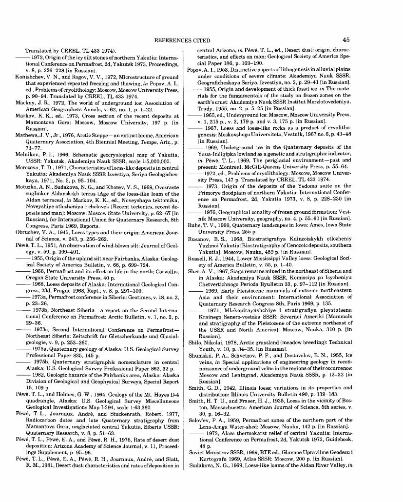
REFERENCES CITED 45
Translated by CRREL, TL 433 1974).1973, Origin of the icy silt stones of northern Yakutia: Interna
tional Conference on Permafrost, 2d, Yakutsk 1973, Proceedings, v. 8, p. 226-228 [in Russian].
Konishchev, V. N., and Rogov, V. V., 1972, Microstructure of ground that experienced repeated freezing and thawing, in Popov, A. I., ed., Problems of cryolithology; Moscow, Moscow University Press, p. 90-94. Translated by CRREL, TL 433 1974.
Mackay, J. R., 1972, The world of underground ice: Association of American Geographers Annals, v. 62, no. 1, p. 1-22.
Markov, K. K., ed., 1973, Cross section of the recent deposits at Mamontova Gora: Moscow, Moscow University, 197 p. [in Russian].
Ma thews, J. V., Jr., 1976, Arctic Steppe an extinct biome, American Quaternary Association, 4th Biennial Meeting, Tempe, Ariz., p. 73-77.
Melnikov, P. I., 1966, Schematic geocryological map of Yakutia, USSR: Yakutsk, Akademiya Nauk SSSR, scale 1:5,000,000.
Morozova, T. D., 1971, Characteristics of loess-like deposits in central Yakutia: Akademiya Nauk SSSR Izvestiya, Seriya Geologiches- kaya, 1971, No. 5, p. 95-104.
Motuzko, A. N., Sudakova, N. G., and Khorev, V. S., 1969, Ovozraste suglinkor Aldanskikh terras [Age of the loess-like loam of the Aldan terraces], in Markov, K. K., ed., Noveyshaya tektomika, Noveyshiye otlozheniya i chelovek [Recent tectonics, recent de posits and man]: Moscow, Moscow State University, p. 62-67 [in Russian], for International Union for Quaternary Research, 8th Congress, Paris 1969, Reports.
Obruchev, V. A., 1945, Loess types and their origin: American Jour nal of Science, v. 243, p. 256-262.
Pewe, T. L., 1951, An observation of wind-blown silt: Journal of Geol ogy, v. 59, p. 399-401.
1955, Origin of the upland silt near Fairbanks, Alaska: Geolog ical Society of America Bulletin, v. 66, p. 699-724.
1966, Permafrost and its effect on life in the north; Corvallis, Oregon State University Press, 40 p.
1968, Loess deposits of Alaska: International Geological Con gress, 23d, Prague 1968, Rept., v. 8, p. 297-309.
1973a, Permafrost conference in Siberia: Geotimes, v. 18, no. 2, p. 23-26.
1973b, Northeast Siberia a report on the Second Interna tional Conference on Permafrost: Arctic Bulletin, v. 1, no. 2, p. 29-36.
1973c, Second International Conference on Permafrost Northeast Siberia: Zeitschrift fur Gletscherkunde und Glasial- geologie, v. 9, p. 253-260.
1975a, Quaternary geology of Alaska: U.S. Geological Survey Professional Paper 835, 145 p.
1975b, Quaternary stratigraphic nomenclature in central Alaska: U.S. Geological Survey Professional Paper 862, 32 p.
1982, Geologic hazards of the Fairbanks area, Alaska: AlaskaDivision of Geological and Geophysical Surveys, Special Report 15, 109 p.
Pewe, T. L., and Holmes, G. W., 1964, Geology of the Mt. Hayes D-4 quadrangle, Alaska: U.S. Geological Survey Miscellaneous Geological Investigations Map 1-394, scale 1:63,360.
Pewe, T. L., Journaux, Andre, and Stuckenrath, Robert, 1977, Radiocarbon dates and late Quaternary stratigraphy from Mamontova Gora, unglaciated central Yakutia, Siberia USSR: Quaternary Research, v. 8, p. 51-63.
Pewe, T. L., Pewe, E. A., and Pewe, R. H., 1976, Rate of desert dust deposition: Arizona Academy of Science Journal, v. 11, Proceed ings Supplement, p. 95-96.
Pewe, T. L., Pewe, E. A., Pewe, R. H., Journaux, Andre, and Slatt, R. M., 1981, Desert dust: characteristics and rates of deposition in
central Arizona, in Pewe, T. L., ed., Desert dust: origin, charac teristics, and effects on man: Geological Society of America Spe cial Paper 186, p. 169-190.
Popov, A. L, 1953, Distinctive aspects of lithogenesis in alluvial plains under conditions of severe climate: Akademiya Nauk SSSR, Geograficheskaya Seriya, Izvestiya, no. 2, p. 29-41 [in Russian].
1955, Origin and development of thick fossil ice, in The mate rials for the fundamentals of the study on frozen zones on the earth's crust: Akademiya Nauk SSSR Institut Merzlotovedeniya, Trudy, 1955, no. 2, p. 5-25 [in Russian].
1965, ed., Underground ice: Moscow, Moscow University Press, v. 1, 215 p., v. 2, 179 p. and v. 3, 175 p. [in Russian].
1967, Loess and loess-like rocks as a product of cryolitho- genesis: Moskovshogo Universiteto, Vestnik, 1967 no. 6, p. 43-48 [in Russian].
1969, Underground ice in the Quaternary deposits of the Yaua-Indigipka lowland as a genetic and stratigraphic indicator, in Pewe, T. L., 1969, The periglacial environment past and present: Montreal, McGill-Queens University Press, p. 55-64.
1972, ed., Problems of cryolithology: Moscow, Moscow Univer sity Press, 147 p. Translated by CRREL, TL 433 1974.
1973, Origin of the deposits of the Yedoma suite on the Primorye floodplain of northern Yakutia: International Confer ence on Permafrost, 2d, Yakutia 1973, v. 8, p. 228-230 [in Russian].
1976, Geographical zonality of frozen ground formation: Vestnik Moscow University, geography, no. 4, p. 55-60 [in Russian].
Ruhe, T. V., 1969, Quaternary landscapes in Iowa: Ames, Iowa State University Press, 255 p.
Rusanov, B. S., 1968, Biostratigrafiya Kainzoiskykh otlozheniy Yuzhnoi Yakutia [Biostratigraphy of Cenozoic deposits, southern Yakutia]: Moscow, Nauka, 459 p. [in Russian].
Russell, R. J., 1944, Lower Mississippi Valley loess: Geological Soci ety of America Bulletin, v. 55, p. 1-40.
Sher, A. V., 1967, Siaga remains mined in the northeast of Siberia and in Alaska: Akademiya Nauk SSSR, Komissiya po Isycheniyu Chetvertichnogo Perioda Byulletin 33, p. 97-112 [in Russian].
1969, Early Pleistocene mammals of extreme northeastern Asia and their environment: International Association of Quaternary Research Congress 8th, Paris 1969, p. 135.
1971, Mlekopitaynshchiye i stratigrafiya pleystotsenaKrainego Senero-vostoka SSSR: Severnoi Ameriki [Mammals and stratigraphy of the Pleistocene of the extreme northeast of the USSR and North America]: Moscow, Nauka, 310 p. [in Russian].
Shilo, Nikolai, 1978, Arctic grassland (meadow breeding): Technical Youth, v. 10, p. 34-35. [in Russian].
Shumskii, P. A., Schvetzov, P. F., and Dostovolov, B. N., 1955, Ice veins, in Special applications of engineering geology in recon naissance of underground veins in the regions of their occurrence: Moscow and Leningrad, Akademiya Nauk SSSR, p. 12-32 [in Russian].
Smith, G. D., 1942, Illinois loess; variations in its properties and distribution: Illinois University Bulletin 490, p. 139-183.
Smith, H. T. U., and Eraser, H. J., 1935, Loess in the vicinity of Bos ton, Massachusetts: American Journal of Science, 5th series, v. 30, p. 16-32.
Solov'ev, P. A., 1959, Permafrost zones of the northern part of the Lena-Amga Water-shed: Moscow, Nauka, 142 p. [in Russian].
1973, Alass thermokarst relief of central Yakutia: Interna tional Conference on Permafrost, 2d, Yakutsk 1973, Guidebook, 48 p.
Soviet Ministrov SSSR, 1969, BTE ed., Glavnoe Upravlime Geodezu i Kartografu 1969, Atlas SSSR: Moscow, 200 p. [in Russian].
Sudakova, N. G., 1969, Loess-like loams of the Aldan River Valley, in

46 ORIGIN AND CHARACTER OF LOESSLIKE SILT, YAKUTIA, SIBERIA
Markov, K. K., ed., Recent tectonics, recent deposits and man: Moscow, Moscow State University, p. 41-61 [in Russian].
Swineford, Ada, and Frye, J. C., 1945, A mechanical analysis of windblown dust compared with analyses of loess: American Jour nal of Science, v. 243, p. 249-255.
Toll, Eduard, 1895, Die fossilen Eislager und ihre Beziehungen zu den Mammuthleichen: L'Academic Imperiale des Sciences de St. Petersbourg, sec. 3, v. 7, ser. 42, no. 13, 86 p.
Tomirdiaro, S. V., 1972, Permafrost and economic development of uplands and plains: Magadan, Knigoizdat, 174 p. [in Russian].
1975a, Loess-ice formation of upper Pleistocene hyperzone in Northern Hemisphere: Geological Investigations in northeastern U.S.S.R., v. 68, p. 170-197 [in Russian].
1975b, Cryogenic evolution of the plains of northeastern Asiain late ice age and Holocene: Izvestiya Vsesoyuznogo Geo- graficheskogo Obshehestva, v. 107, no. 2, p. 124-132 [in Russian].
Tomirdiaro, S. V., Ryabchun, U. K., and Ivanets, B. T., 1974, The physical geographic environment and distinctive features of for mation of the loess glacial mantle on the plains of northeastern Asia: Geologiya and Geofizika, v. 15, p. 47-61 [in Russian].
Trainer, F. W., 1961, Eolian deposits of the Matanuska Valley ag ricultural area, Alaska: U.S. Geological Survey Bulletin, 1121-C, p. C1-C35.
Twenhofel, W. H., 1932, Treatise on sedimentation: Baltimore, Williams and Wilkins, 926 p..
Udden, J. A., 1898, The mechanical composition of wind deposits: Augustana Library Publication 1, 69 p.
Vangengeim, E. A., 1961, Paleontological basis of the stratigraphy of the Anthropogene deposits in northeastern Siberia: Akademiya
Nauk SSSR Geologicheskiy Institut, Trudy, v. 48, 81 p. [inRussian].
Volkov, I. A., Volkova, V. S., and Zadkova, 1.1., 1969, Loess-like coverdeposits and paleogeography of the southwest of West Siberia inPliocene-Quaternary time: Novosibirsk, USSR Nauka, 330 p. [inRussian].
Warn, G. F., 1953, Drought and dust on the plains: Weatherwise, v. 6,p. 67-71.
Warn,G. F., and Cox, W. H., 1951, Asedimentary study of duststormsin the vicinity of Lubbock, Texas: American Journal of Science,v. 249, p. 553-568.
Washburn, A. L., 1973, Periglacial processes and environments: Lon don, Edward Arnold, 320 p.
1980, Geocryology: New York, John Wiley and Sons, 406 p. Wright, G. F., 1902, Origin and distribution of the loess in northern
China and central Asia: Geological Society of America Bulletin,v. 13, p. 127-138.
Yurtsev, B. A., 1972, Phytogeography of northeastern Asia and theproblem of Transberingian floristic interrelations, in Graham,A., ed., Floristics and paleofloristics of Asia and eastern NorthAmerica: New York and London, Elsevier, p. 19-54.
Zeuner, F. E., 1949, Frost soils on Mount Kenya, and the relation offrost soils to aeolian deposits: Journal of Soil Science, v. 1, p.20-30.
NOTE: Translations by CRREL (Cold Regions Research and Engineer ing Laboratories) available from Federal Scientific and Technical Information, Springfield, Va. 22151.