yellowstone national park, the world’s first national … national park, the world’s first...
TRANSCRIPT
Welcome v
Welcome
Yellowstone National Park is as wondrous as it is complex. The park has rich human and ecological
stories that continue to unfold. When Yellowstone was established as the world’s first national park in
1872, it sparked an idea that influenced the creation of the National Park Service and the more than
400 sites it protects today across the United States. Yellowstone National Park also forms the core of the
Greater Yellowstone Ecosystem. At 34,375 square miles, it is one of the largest, nearly intact temper-
ate-zone ecosystems on Earth. The park continues to influence preservation and science, and we are
pleased to share its stories with you.
Many people have dedicated their lives and careers to studying Yellowstone and the park has a long history of research and public interest. The park hosts more than 150 researchers from various agencies, univer-sities, and organizations each year. They produce hundreds of papers, manuscripts, books, and book chapters on their work annually—a volume of infor-mation that is difficult to absorb. This compendium is intended to help you understand the important concepts about Yellowstone’s many resources and contains information about the park’s history, natural and cultural resources, and issues.
In addition to the references listed for each topic covered in this handbook, here are some interdisci-plinary sources:
• www.nps.gov/yell• Yellowstone Science, free from the Yellowstone
Center for Resources, in the Yellowstone Research Library, or online at www.nps.gov/yellowstonescience.
• The park newspaper distributed at entrance gates and visitor centers.
• Site bulletins, published as needed, provide more detailed information on park topics such as trailside museums and the grand hotels. Free; available upon request from visitor centers.
• Trail guides, available at all visitor centers. A $1 donation is requested.
Second Century of ServiceOn August 25, 2016, the National Park Service celebrated its 100th birthday. For a century the National Park Service has cared for and protected wildlife, land, waterways, accomplishments, lessons, and stories belonging to the citizens of the United States. And we are ready to connect with and create the next generation of park visitors, supporters, and advocates.
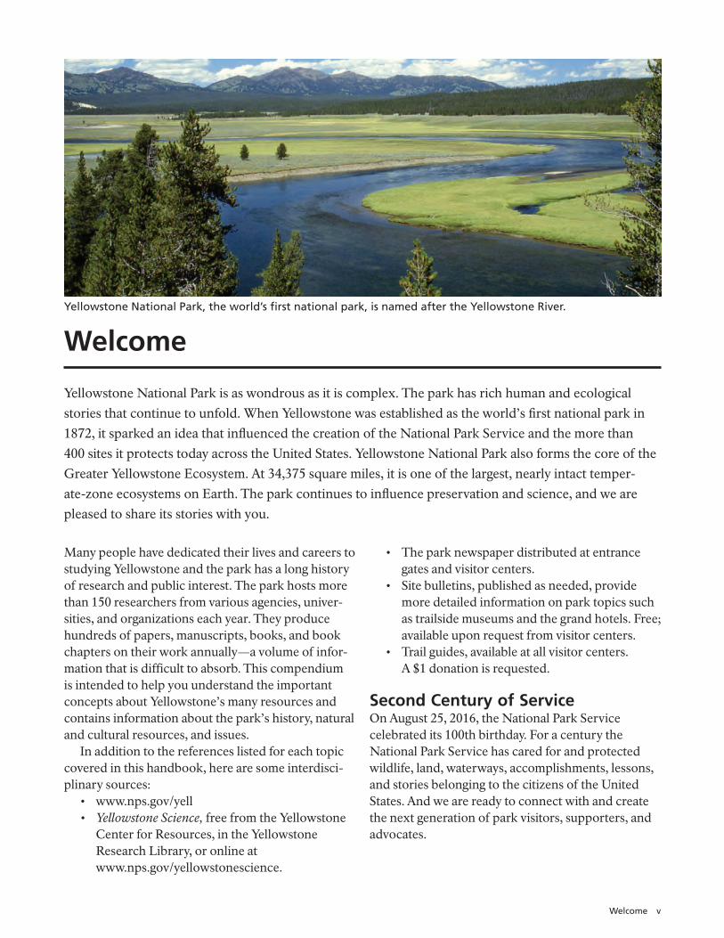
Yellowstone National Park, the world’s first national park, is named after the Yellowstone River.

vi Yellowstone Resources and Issues Handbook, 2017
Park Facts 1
Park Facts
Yellowstone National Park was established on March 1, 1872.
Yellowstone is the world’s first national park.
GEOGRAPHY
3,472 square miles (8,991 km2)2,221,766 acres or 899,116
hectares. Note: No area figures have been scientifically verified. Efforts to confirm the park’s total area continue.
63 air miles north to south (102 km)
54 air miles east to west (87 km)
96% in Wyoming, 3% in Montana, 1% in Idaho
Highest Point: 11,358 feet (3,462 m; Eagle Peak)
Lowest Point: 5,282 feet (1,610 m; Reese Creek)
Larger than Rhode Island and Delaware combined
About 5% covered by water; 15% by grassland; and 80% by forests
PrecipitationAnnual precipitation ranges
from 10 inches (26 cm) at the north boundary to 80 inches (205 cm) in the southwest corner
TemperatureAverage daily, at Mammoth:
January: 9ºF (–13ºC) July: 80ºF (27ºC)
Records: High: 99ºF (37ºC), 2002 (Mammoth) Low: –66ºF (–54ºC), 1933 (West Entrance, Riverside Station)
Yellowstone Lake131.7 square miles of surface
area (341.1 km2)141 miles of shoreline (227 km)20 miles north to south (32
km)14 miles east to west (22 km)Average depth: 138 feet (42 m)Maximum depth: 430 feet
(131 m)
GEOLOGY
An active volcanoOne of the world’s largest
calderas at 45 x 30 miles (72 x 48 km)
1,000 –3,000 earthquakes annually
More than 10,000 hydrothermal features
About 500 active geysers (more than half the world’s active geysers)
About 290 waterfalls Tallest waterfall near a road:
Lower Falls of the Yellowstone River at 308 feet (94 m)
WILDLIFE
67 species of mammals, including: 7 species of native ungulates 2 species of bears
285 species of birds (150 nesting)
16 species of fish (5 nonnative)More than 7 aquatic nuisance
species (3 having significant detrimental effect)
5 species of amphibians 6 species of reptiles2 threatened species: Canada
lynx, grizzly bears
VEGETATION
9 species of conifers (more than 80% of forest is lodgepole pine)
1,000+ species of native flowering species (3 endemic)
225 species of invasive plants186 species of lichens
CULTURAL RESOURCES
26 associated Native American tribes
More than 1,800 known archeological sites
More than 300 ethnographic resources (animals, plants, sites)
25 sites, landmarks, and districts on the National Register of Historic Places; many more eligible for listing
1 National Historic TrailMore than 900 historic
buildings
More than 720,000 museum items, including 30 historic vehicles
Millions of archived documentsMore than 20,000 books
(many rare), manuscripts, periodicals
EMPLOYEES
National Park Service (July 2016)
Permanent (326 total) Full time, year-round: 186 Career Seasonal: 136
Part time: 4 Term (variable duration): 41Seasonal: 430
Concessioners About 3,200 people work for
concessioners at summer peak.
FACILITIES
11 visitor centers, museums, and contact stations
9 hotels/lodges (2,000+ hotel rooms/cabins)
7 NPS-operated campgrounds (450+ sites)
5 concession-operated campgrounds (1,700+ sites)
More than 1,500 buildings52 picnic areas, 1 marina,
ROADS AND TRAILS
5 park entrances466 miles (750 km) of roads
(310 miles [499 km] paved)More than 15 miles (24 km)
of boardwalk, including 13 self-guiding trails
Approximately 1,000 miles (1,609 km) of backcountry trails
92 trailheads301 backcountry campsites
BUDGET
Fiscal Year 2015 (in millions)Total: $91.4Federal Funding:
Congressional Annual Appropriations: Operations and staff (base): $34.7 Wildland Fire: $3.8 Other Appropriations: $19.6
Other Funding: Donations and Grants: $4.1
Fees: $24.4 Utilities & Agreements (Reimbursable): $4.8
Distribution of BudgetAdministration: 5%
Includes human resources, contracting, budget and finance, property management, telecommunications, and information technology
Facility Operations and Maintenance: 53% Includes utilities, roads, trails, structures, historic preservation coordination, construction management
Resource Protection: 19% Includes research and monitoring of natural and cultural resources, invasive species management
Visitor Services: 23% Includes interpretation and education, law enforcement, emergency medical services, search and rescue, entrance station operations, structural fire activities, and park concessions management
VISITATION
In 2016, park visitation was a record 4.25 million. More than one-fourth of the park’s total annual visitation was recorded during the month of July. The last time the park recorded fewer than 3 million annual recreational visits was in 2006, with 2.87 million visits.
Detailed park visitation information is available at https://irma.nps.gov/Stats/
Top 10 Visitation Years1. 2016 4,257,1772. 2015 4,097,7103. 2010 3,640,1844. 2014 3,513,4845. 2012 3,447,7276. 2011 3,394,3217. 2009 3,295,1878. 2013 3,188,0309. 2007 3,151,34310. 1992 3,144,405
2 Yellowstone Resources and Issues Handbook, 2017
John D. Rockefeller, Jr.Memorial Parkway
Grand TetonNational Park
ÏÏ
Ï
Ï
Ï
Ï
Ï
Ï
Ï Ï
Ï ÏÏ
Ï
Ï
ÏÏ
Ï
Ï
Ï
#
#
North Entrance
Tower Junction
Tower FallLamar
NortheastEntrance
CanyonNorris
WestEntrance
Madison
Old Faithful
Fishing BridgeLake
Bridge Bay
West Thumb
Grant
East Entrance
South Entrance
Bechler
Mammoth
Eagle Peak11,358 ft3,462 m
Mount Washburn10,243 ft3,122m
Yellowstone River
Gall atin River
Madi so
n River
Gib bon R
iver
Fire
hol
e R
iver
Yellowsto
ne Ri ver
Be chler
Riv
er
Falls River
Snake River
Yellowstone R
iver
Lamar River
Yellowstone Lake
Shoshone Lake
Lewis Lake
Heart Lake
W Y
M T
I D
0 10
ÁNorth
Ï Developed Areas
NPS Boundary
Caldera
Lakes
Rivers
Roads
Continental Divide
Summits#State Boundary
0 10 Miles
Kilometers
Yellowstone National Park
Frequently Asked Questions 3
Frequently Asked Questions
How did Yellowstone get its name?Yellowstone National Park is named after the Yellowstone River, the major river running through the park. According to French-Canadian trappers in the 1800s, they asked the name of the river from the Minnetaree tribe, who live in what is now eastern Montana. They responded “Mi tse a-da-zi,” which translates as “Yellow Stone River” The trappers translated this into French and in 1797, explorer-geographer David Thompson first used the English translation. Lewis and Clark called the Yellowstone River by the French and English forms. Subsequent use formalized the name “Yellowstone.”
Is Yellowstone the largest national park?No. More than half of Alaska’s national park units are larger, including Wrangell–St. Elias National Park and Preserve, which is the largest unit (13 million acres) in the National Park System. Until 1994, Yellowstone (at 2.2 million acres) was the largest national park in the contiguous United States. That year Death Valley National Monument was expanded and became a national park—it has more than 3 million acres.
Is Yellowstone the most visited national park?No. Yellowstone is in the top five national parks for number of recreational visits. Great Smoky Mountains National Park has the most—more than 11.3 million in 2016. The Grand Canyon (6 million) Rocky Mountain (4.5 Million) and Yosemite (5 million) also received more recreational visits than Yellowstone (4.25 million) in 2016. Visit the website https://irma.nps.gov/Stats/ to find out more details about how many visitors come to our national parks.
What is the difference between a national park and a national forest?National parks are administered by the Department of the Interior and national forests by the Department of Agriculture. The National Park Service is mandated to preserve resources unimpaired, while the Forest Service is mandated to wisely manage resources for many sustainable uses. Six national forests surround Yellowstone National Park.
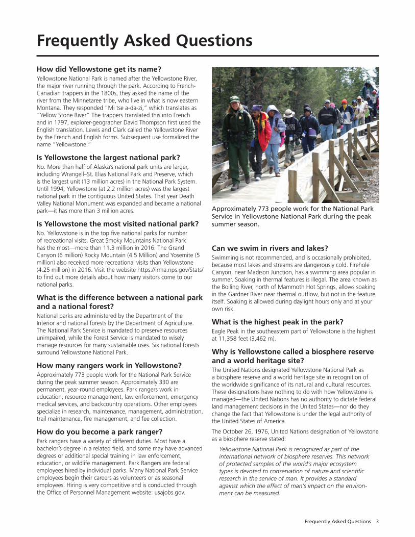
How many rangers work in Yellowstone?Approximately 773 people work for the National Park Service during the peak summer season. Approximately 330 are permanent, year-round employees. Park rangers work in education, resource management, law enforcement, emergency medical services, and backcountry operations. Other employees specialize in research, maintenance, management, administration, trail maintenance, fire management, and fee collection.
How do you become a park ranger?Park rangers have a variety of different duties. Most have a bachelor’s degree in a related field, and some may have advanced degrees or additional special training in law enforcement, education, or wildlife management. Park Rangers are federal employees hired by individual parks. Many National Park Service employees begin their careers as volunteers or as seasonal employees. Hiring is very competitive and is conducted through the Office of Personnel Management website: usajobs.gov.
Can we swim in rivers and lakes? Swimming is not recommended, and is occasionally prohibited, because most lakes and streams are dangerously cold. Firehole Canyon, near Madison Junction, has a swimming area popular in summer. Soaking in thermal features is illegal. The area known as the Boiling River, north of Mammoth Hot Springs, allows soaking in the Gardner River near thermal outflow, but not in the feature itself. Soaking is allowed during daylight hours only and at your own risk.
What is the highest peak in the park?Eagle Peak in the southeastern part of Yellowstone is the highest at 11,358 feet (3,462 m).
Why is Yellowstone called a biosphere reserve and a world heritage site? The United Nations designated Yellowstone National Park as a biosphere reserve and a world heritage site in recognition of the worldwide significance of its natural and cultural resources. These designations have nothing to do with how Yellowstone is managed—the United Nations has no authority to dictate federal land management decisions in the United States—nor do they change the fact that Yellowstone is under the legal authority of the United States of America.
The October 26, 1976, United Nations designation of Yellowstone as a biosphere reserve stated:
Yellowstone National Park is recognized as part of the international network of biosphere reserves. This network of protected samples of the world’s major ecosystem types is devoted to conservation of nature and scientific research in the service of man. It provides a standard against which the effect of man’s impact on the environ-ment can be measured.
Approximately 773 people work for the National Park Service in Yellowstone National Park during the peak summer season.
4 Yellowstone Resources and Issues Handbook, 2017
The September 8, 1978, United Nations designation of Yellowstone as a world heritage site, requested by US President Richard Nixon and Congress, stated:
Through the collective recognition of the community of nations … Yellowstone National Park has been designated as a World Heritage Site and joins a select list of protected areas around the world whose outstanding natural and cultural resources form the common inheritance of all mankind.
To find out more, visit www.unesco.org/mab.
What is the Continental Divide?Think of the Continental Divide as the crest of the continent. Theoretically, when precipitation falls on the west side of the
Divide, it eventually reaches the Pacific Ocean. When it falls on the east side of the Divide, it eventually reaches the Atlantic Ocean. In Yellowstone (as elsewhere), this ridgeline is not straight. You cross the Continental Divide three times between the South Entrance and the Old Faithful area. Craig Pass is the highest crossing, at 8,262 feet (2,518 m).
How did Mt. Washburn form?At 10,243 feet (3,122 m), this peak can be seen from many locations in the park. It is a remnant of an extinct volcano from the Absaroka Volcanics of about 50 million years ago. The volcano was literally cut in half by a volcanic eruption 640,000 years ago. Only the northern part of the original volcano is still visible.
ÀÀÀ
À
À
À
À
À
À À
À
À
ÀÀ !
!
!
!
!
!
!
! !
!
!
!
!
!
!
!
!
!
!
!
!
!
!
!
!
Pocatello
Idaho Falls
Rapid City
Great Falls
Missoula
Billings
Rexburg
Dickinson
Casper
Gillette
Sheridan
Kalispell
Helena
Butte
Bozeman
Williston
Cody
Jackson
Gardiner
WestYellowstone
Cooke City
Livingston
Lewistown
Red Lodge
Miles City
YellowstoneNational Park
John D. Rockefeller, Jr. Mem. PkwyGrand Teton
NPCraters of the MoonNM and Wilderness
Glacier NP
Grant-Kohrs Ranch NHS
Big HoleBattlefield
Bighorn CanyonNRA
Little Bighorn Battlefield NM
Devil’s Tower NM
Fort Union Trading Post NHS
Theodore Roosevelt NPand Wilderness
Mount Rushmore NM
Jewel Cave NM
Wind Cave NP
BTMBIL
BZN
FCA
GTF
HLN
MSO
COD
WYS
IDA
PIH
RAP
CPR
JAC
C A N A D A
M O N T A N A
W Y O M I N G
I D A H O
N D
S D
Roads
State Boundaries Rivers and Lakes
National Park Service
À Airports
ÁNorth
Continental Divide
Missouri River
Yello
wsto
ne R
iver
Yello wstone R
iver
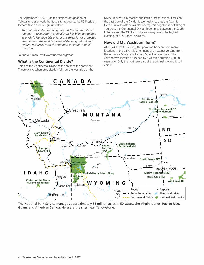
The National Park Service manages approximately 83 million acres in 50 states, the Virgin Islands, Puerto Rico, Guam, and American Samoa. Here are the sites near Yellowstone.
Frequently Asked Questions 5
Canyon Village AreaNotable Areas and Structures• Artist Point
• Grand Canyon of the Yellowstone River
• Mount Washburn
• Hayden Valley
How tall are the falls?Upper Falls: 109 feet (33 m).; Lower Falls: 308 feet (94 m).
How big is the Grand Canyon of the Yellowstone?This huge canyon is roughly 20 miles (32 km) long, more than 1,000 feet (305 m) deep, and 1,500–4,000 feet (457–1,219 m)wide at various points.
How did the canyon form?Scientists continue to develop theories about its formation. After the Yellowstone Caldera eruption, 640,000 years ago, lava flows and volcanic tuffs buried the canyon area; but hydrothermal gases and hot water weakened the rock. The river eroded this rock, carving a canyon in the Yellowstone River beginning at Tower Fall and heading upstream to Lower Falls.
Where can I see the canyon and falls?North Rim Drive: Walkways at Lookout Point and Brink of the Lower Falls lead to views of both waterfalls. The longest stretch of accessible trail can be accessed from parking lots at Lookout or Grand View. You can also see the Lower Falls from Red Rock and Inspiration points.
South Rim Drive: See the Lower Falls at Artist Point, from Uncle Tom’s Trail, and from a few places along the South Rim Trail; see the Upper Falls from two viewpoints at Uncle Tom’s Point.
Visit Brink of Upper Falls from a viewing area just off the Grand Loop Road south of Canyon Junction, between the entrances to North and South Rim drives.
Where can I see both falls at once? The canyon bends between the Upper and Lower falls, so there is no location where they can be seen at the same time.
What causes the different colors in the canyon? You could say the canyon is “rusting.” The colors are caused by oxidation of iron compounds in the rhyolite rock, which has been hydrothermally altered (“cooked”). The colors indicate the
presence or absence of water in the individual iron compounds and hydration of minerals in the rock. Most of the yellows in the canyon result from iron and sulfur in the rock.
How much water goes over the falls?The volume varies from 63,500 gallons (240,000 l) per second at peak runoff to 5,000 gallons (18,900 l) per second in the late fall.
What causes the Lower Falls’ green stripe? The natural color of the water. A notch in the lip of the brink makes the water deeper and keeps it from mixing with air and becoming frothy, so the color is visible as it goes over the edge.
Who was “Uncle Tom”? “Uncle Tom” Richardson was an early concessioner in the canyon area. From 1898–1905, he guided visitors to the canyon floor down a steep trail using rope ladders. Today the trail descends partway into the canyon via steep steel steps.
Can I get to the bottom of the canyon?Only one trail in this area leads to the bottom of the canyon—Seven Mile Hole Trail, a strenuous, steep round trip of 10.2 miles.
Is Artist Point the location where Thomas Moran painted his Grand Canyon of the Yellowstone?No, it is thought that some sketches were made from Moran Point and that a compilation of canyon views were incorporated into the painting.
What animals can I see in this area?Inside the canyon, look for osprey soaring over the river or perched on their five-foot (1.5 m) diameter nests. They nest here from late April until early September. Also look for ravens and swallows. During July, a variety of butterflies feast on the abundant flowers in the meadows.
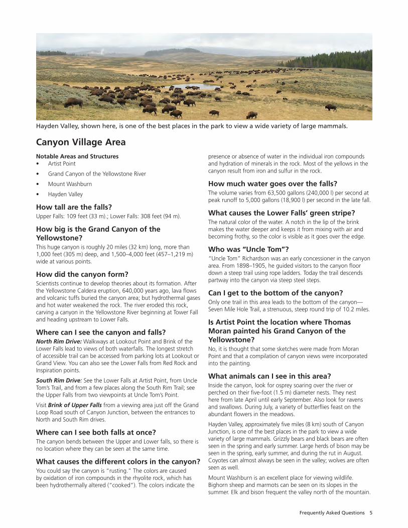
Hayden Valley, approximately five miles (8 km) south of Canyon Junction, is one of the best places in the park to view a wide variety of large mammals. Grizzly bears and black bears are often seen in the spring and early summer. Large herds of bison may be seen in the spring, early summer, and during the rut in August. Coyotes can almost always be seen in the valley; wolves are often seen as well.
Mount Washburn is an excellent place for viewing wildlife. Bighorn sheep and marmots can be seen on its slopes in the summer. Elk and bison frequent the valley north of the mountain.
Hayden Valley, shown here, is one of the best places in the park to view a wide variety of large mammals.
6 Yellowstone Resources and Issues Handbook, 2017
Fishing Bridge, Lake, and Bridge BayHistoric Areas and Structures• Fishing Bridge
• Fishing Bridge Visitor Center
• Lake Historic District
• Lake Fish Hatchery Historic District
• Lake Hotel
• Bridge Bay Marina Historic District
• East Entrance Historic Road
Where does the Yellowstone River begin? Where does it end? It begins on the slopes of Younts Peak in the Absaroka Mountains southeast of the park flows 671 miles (1080 km) to the Missouri River near the Montana–North Dakota border. Its waters then travel to the Mississippi River and into the Atlantic Ocean at the Gulf of Mexico. It is the longest undammed river in the contiguous United States.
How big is Yellowstone Lake? How deep? Is it natural? The lake is natural and has 131.7 square miles (341.1 km2)of surface area and 141 miles (227 km) of shoreline; it is 20 miles (32 km) long by 14 miles (22 km) wide. Its deepest spot is about 430 feet (131 m); its average depth is 138 feet (42 m). The lake’s basin has an estimated capacity of 12,095,264 acre-feet (1.5x10¹³ l) of water. Because its annual outflow is about 1,100,000 acre-feet (1.3x10¹² l), the lake’s water is completely replaced only about every eight to ten years. Since 1952, the annual water level fluctuation has been less than six feet (2 m). It is the largest lake at high elevation (above 7,000 ft/2134 m) in North America.
How did Yellowstone Lake form?The lake’s main basin is part of the Yellowstone Caldera, which was formed 640,000 years ago. West Thumb was formed by a later, smaller eruption. The arms of the lake were formed by uplift along fault lines and sculpting by glaciers. The lake drains north at Fishing Bridge. Some scientists consider LeHardy’s Rapids to be the geologic northern boundary of the lake because the periodic rise and fall of that site appears to control lake outflow.
Why can’t we fish from Fishing Bridge? Overfishing for cutthroat trout here contributed to their decline in the lake. The trout also spawn here. For these reasons, fishing is prohibited from the bridge. It’s still a good place to watch trout.
How cold is Yellowstone Lake? During late summer, Yellowstone Lake becomes thermally stratified with several water layers having different temperatures. The topmost layer rarely exceeds 66°F (18.8°C), and the lower layers are much colder. Because of the extremely cold water, survival time for anyone in the lake is estimated to be only 20 to 30 minutes. In winter, ice thickness on Yellowstone Lake varies from a few inches to more than two feet with many feet of snow on top of the ice.
What happened to the old campground at Fishing Bridge? The National Park Service campground was located where bears came to fish, and many conflicts with bears occurred. It was closed in 1989. A recreational vehicle park, operated by a concessioner, still exists in the area. Only hard-sided camping units or RVs are allowed at this campground.
What animals can I see in this area?The lake is home to the largest population of Yellowstone cutthroat trout in North America. You can see these trout and longnose suckers from Fishing Bridge. In spring, you might be able to see trout leaping upstream at LeHardy’s Rapids, three miles north of Fishing Bridge. Also look for white pelicans, bald eagles, osprey, and a variety of ducks and other water birds.
The Fishing Bridge area, including Pelican Valley to the north and east, is especially significant to bears and other wildlife because lake, river, and terrestrial ecosystems merge here to create a diverse natural complex. Bears visit numerous streams in the spring and early summer to eat spawning trout. A bison herd winters in Pelican Valley, and individuals can be seen throughout the area. Moose used to be seen in the Yellowstone Lake area much more than they are today; look along water edges and in marshes. At Bridge Bay Marina, look for river otters.
What’s that smell at Mud Volcano? That “rotten egg” smell comes from hydrogen sulfide gas. Sulfur, in the form of iron sulfide, gives the features their many shades of gray.
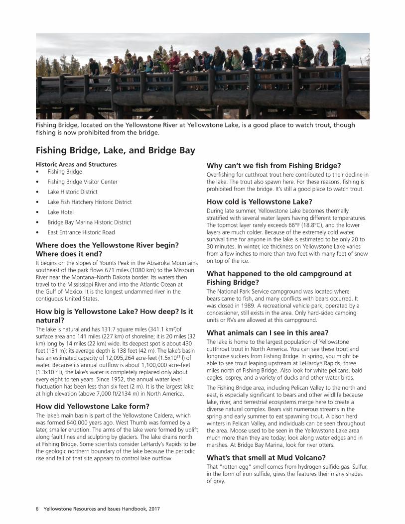
Fishing Bridge, located on the Yellowstone River at Yellowstone Lake, is a good place to watch trout, though fishing is now prohibited from the bridge.
Frequently Asked Questions 7
Madison and West Yellowstone AreaHistoric Areas and Structures • Madison Information Station
How did Madison Junction get its name?Here, the Gibbon River joins the Firehole River to form the Madison River. (The Gibbon River flows from Grebe Lake through the Norris area to Madison Junction. The Firehole River starts south of Old Faithful and flows through the park’s major hydrothermal basins north to Madison Junction.) The Madison joins the Jefferson and the Gallatin rivers at Three Forks, Montana, to form the Missouri River.
What forms the cliffs around Madison Junction?Part of what you see is the rim of the Yellowstone Caldera, plus lava flows. National Park Mountain is actually part of the lava flows. Some of these lava flows come down to the road through Firehole Canyon, approximately one mile (1.6 km) south of Madison Junction. Gibbon Falls, four miles (6.4 km) north of the junction, drops 84 feet (26 m) over a remnant of the caldera rim.
Why is the bridge between Madison and the West Entrance called “Seven Mile Bridge”?Seven Mile Bridge is located midway between (and seven miles from both) the West Entrance and Madison Junction. This landmark serves as a convenient reference point and separates the rugged lava-lined Madison Canyon east of the bridge from gentle hills to the west.
Where is the swimming area?South of Madison Junction is the entrance to the Firehole Canyon Drive, a one-way route that follows the Firehole River. Along this route are views of the Firehole Falls and a swimming area where the water is influenced by thermal activity below the surface. Swimming is undertaken at your own risk. Please note that climbing the cliffs around the swimming area erodes the thin topsoil and damages area habitat. Jumping from the cliffs is very dangerous and is forbidden.
What animals can I see in this area?Along the Madison River, approximately 100 elk live year-round. The meadows adjacent to the Madison and Gibbon rivers are prime elk-calving areas in the spring. During the fall rut, elk frequent the meadows from Seven Mile Bridge to Madison Junction.
During spring, fall, and winter, herds of bison favor the same meadows. Bison often use the entrance road to travel from one foraging area to another. In summer, they move to Hayden Valley, their traditional summer habitat and breeding area.
Bald eagles have nested west of Seven Mile Bridge in recent years. Several pairs of ospreys also nest along the Madison. You might also see trumpeter swans, Canada geese, mallards, Barrow’s goldeneyes, and other water birds.
What is the National Park Mountain story? The legend, which you can read about at the Madison Information Station, tells of explorers camping here in 1870 and deciding Yellowstone should be set aside as a national park. It is a wonderful story, but it isn’t true. Explorers did camp at the junction in 1870, but they apparently did not discuss the national park idea.
They camped in a location where people have camped for millenia. Archeologists have found campfire remnants, obsidian flakes, and bone fragments dating back at least 10,000 years.
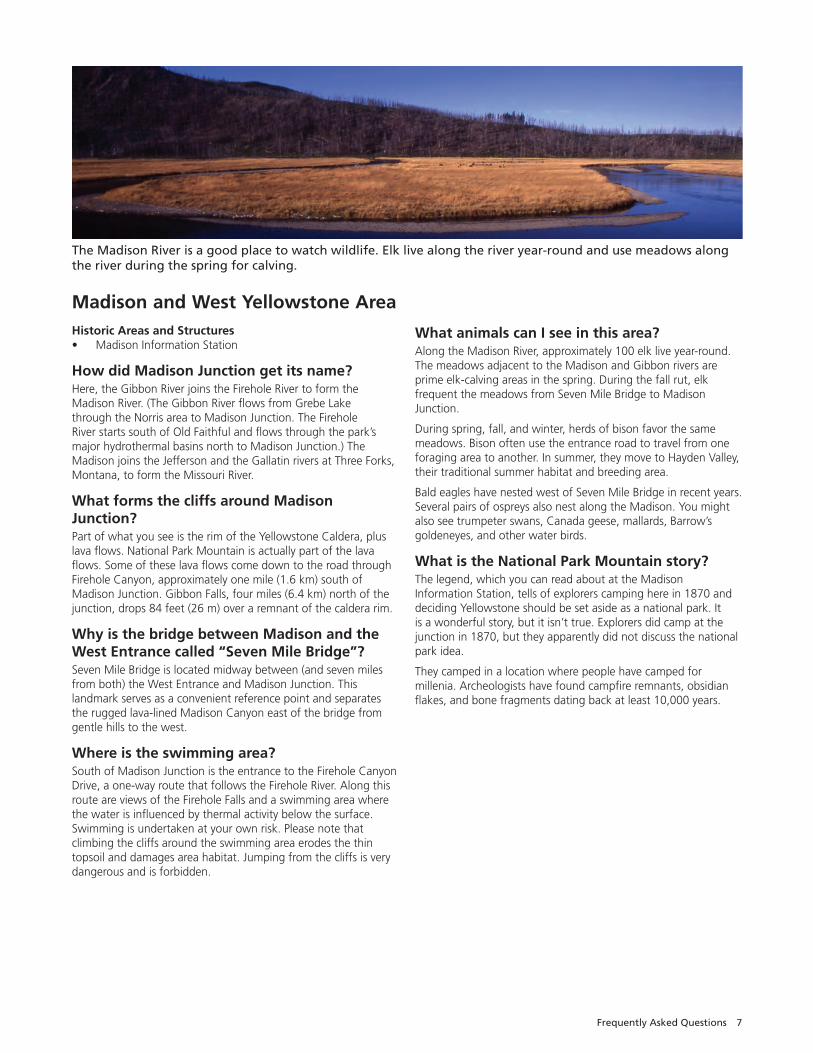
The Madison River is a good place to watch wildlife. Elk live along the river year-round and use meadows along the river during the spring for calving.
8 Yellowstone Resources and Issues Handbook, 2017
Mammoth Hot Springs AreaHistoric Areas and Structures• Mammoth Hot Springs Historic District
• Fort Yellowstone Historic Landmark District
• Obsidian Cliff National Historic Landmark
• US Post Office
• Administrative Headquarters
• Roosevelt Arch
Are the springs drying up? No, the overall activity and volume of water discharge remain relatively constant; most of the water flows underground.
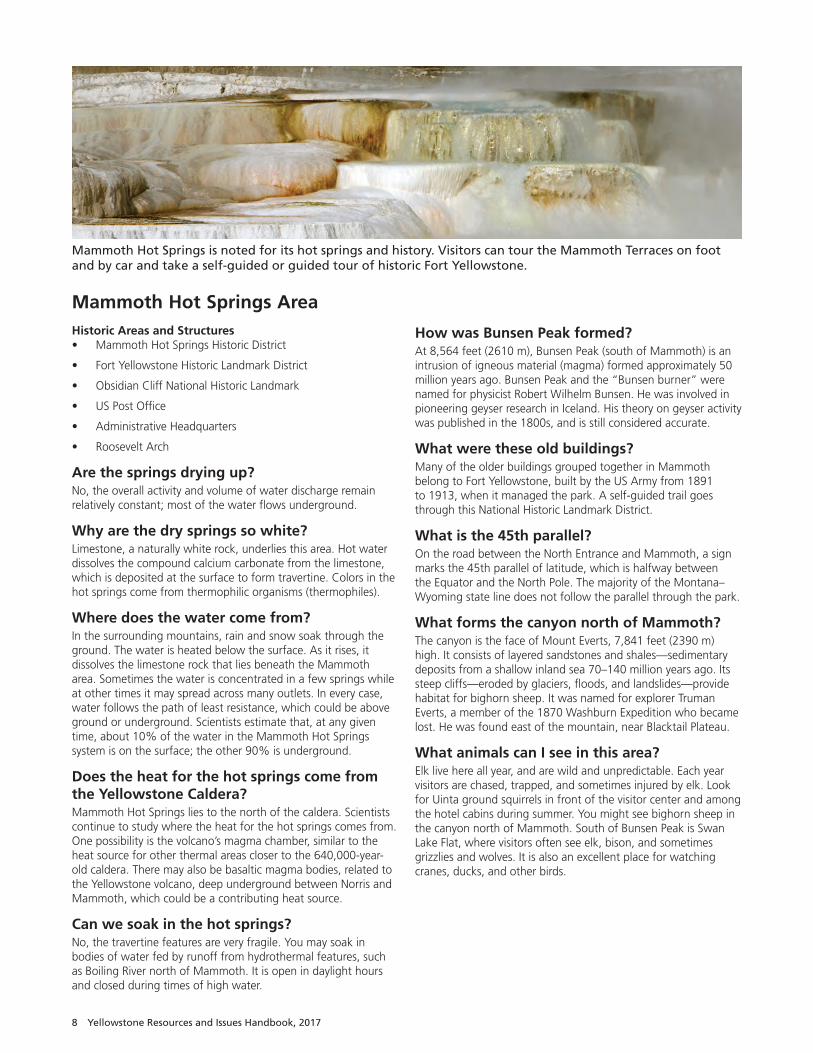
Why are the dry springs so white? Limestone, a naturally white rock, underlies this area. Hot water dissolves the compound calcium carbonate from the limestone, which is deposited at the surface to form travertine. Colors in the hot springs come from thermophilic organisms (thermophiles).
Where does the water come from?In the surrounding mountains, rain and snow soak through the ground. The water is heated below the surface. As it rises, it dissolves the limestone rock that lies beneath the Mammoth area. Sometimes the water is concentrated in a few springs while at other times it may spread across many outlets. In every case, water follows the path of least resistance, which could be above ground or underground. Scientists estimate that, at any given time, about 10% of the water in the Mammoth Hot Springs system is on the surface; the other 90% is underground.
Does the heat for the hot springs come from the Yellowstone Caldera?Mammoth Hot Springs lies to the north of the caldera. Scientists continue to study where the heat for the hot springs comes from. One possibility is the volcano’s magma chamber, similar to the heat source for other thermal areas closer to the 640,000-year-old caldera. There may also be basaltic magma bodies, related to the Yellowstone volcano, deep underground between Norris and Mammoth, which could be a contributing heat source.
Can we soak in the hot springs? No, the travertine features are very fragile. You may soak in bodies of water fed by runoff from hydro thermal features, such as Boiling River north of Mammoth. It is open in daylight hours and closed during times of high water.
How was Bunsen Peak formed? At 8,564 feet (2610 m), Bunsen Peak (south of Mammoth) is an intrusion of igneous material (magma) formed approximately 50 million years ago. Bunsen Peak and the “Bunsen burner” were named for physicist Robert Wilhelm Bunsen. He was involved in pioneering geyser research in Iceland. His theory on geyser activity was published in the 1800s, and is still considered accurate.
What were these old buildings? Many of the older buildings grouped together in Mammoth belong to Fort Yellowstone, built by the US Army from 1891 to 1913, when it managed the park. A self-guided trail goes through this National Historic Landmark District.
What is the 45th parallel? On the road between the North Entrance and Mammoth, a sign marks the 45th parallel of latitude, which is halfway between the Equator and the North Pole. The majority of the Montana–Wyoming state line does not follow the parallel through the park.
What forms the canyon north of Mammoth?The canyon is the face of Mount Everts, 7,841 feet (2390 m)high. It consists of layered sandstones and shales—sedimentary deposits from a shallow inland sea 70–140 million years ago. Its steep cliffs—eroded by glaciers, floods, and landslides—provide habitat for bighorn sheep. It was named for explorer Truman Everts, a member of the 1870 Washburn Expedition who became lost. He was found east of the mountain, near Blacktail Plateau.
What animals can I see in this area?Elk live here all year, and are wild and unpredictable. Each year visitors are chased, trapped, and sometimes injured by elk. Look for Uinta ground squirrels in front of the visitor center and among the hotel cabins during summer. You might see bighorn sheep in the canyon north of Mammoth. South of Bunsen Peak is Swan Lake Flat, where visitors often see elk, bison, and sometimes grizzlies and wolves. It is also an excellent place for watching cranes, ducks, and other birds.
Mammoth Hot Springs is noted for its hot springs and history. Visitors can tour the Mammoth Terraces on foot and by car and take a self-guided or guided tour of historic Fort Yellowstone.
Frequently Asked Questions 9
Norris AreaHistoric Areas and Structures• Norris Soldier Station (now the Museum of the National Park
Ranger)
• Norris Geyser Basin Museum
When will Steamboat Geyser erupt? Steamboat’s major eruptions (more than 300 feet high) are unpredictable and often many years apart. Its most recent major eruption occurred September 14, 2014. Its frequent “minor phase” eruptions eject water 10 to 40 feet high.
When does Echinus Geyser erupt? Once very predictable, Echinus’s eruptions are now months to years apart, but could become frequent again.
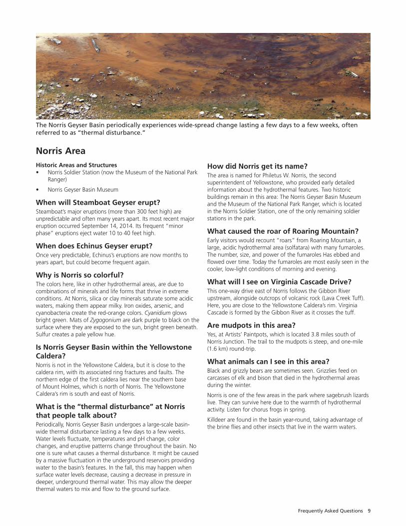
Why is Norris so colorful? The colors here, like in other hydrothermal areas, are due to combinations of minerals and life forms that thrive in extreme conditions. At Norris, silica or clay minerals saturate some acidic waters, making them appear milky. Iron oxides, arsenic, and cyanobacteria create the red-orange colors. Cyanidium glows bright green. Mats of Zygogonium are dark purple to black on the surface where they are exposed to the sun, bright green beneath. Sulfur creates a pale yellow hue.
Is Norris Geyser Basin within the Yellowstone Caldera?Norris is not in the Yellowstone Caldera, but it is close to the caldera rim, with its associated ring fractures and faults. The northern edge of the first caldera lies near the southern base of Mount Holmes, which is north of Norris. The Yellowstone Caldera’s rim is south and east of Norris.
What is the “thermal disturbance” at Norris that people talk about? Periodically, Norris Geyser Basin undergoes a large-scale basin-wide thermal disturbance lasting a few days to a few weeks. Water levels fluctuate, temperatures and pH change, color changes, and eruptive patterns change throughout the basin. No one is sure what causes a thermal disturbance. It might be caused by a massive fluctuation in the underground reservoirs providing water to the basin’s features. In the fall, this may happen when surface water levels decrease, causing a decrease in pressure in deeper, underground thermal water. This may allow the deeper thermal waters to mix and flow to the ground surface.
How did Norris get its name?The area is named for Philetus W. Norris, the second superintendent of Yellowstone, who provided early detailed information about the hydrothermal features. Two historic buildings remain in this area: The Norris Geyser Basin Museum and the Museum of the National Park Ranger, which is located in the Norris Soldier Station, one of the only remaining soldier stations in the park.
What caused the roar of Roaring Mountain?Early visitors would recount “roars” from Roaring Mountain, a large, acidic hydrothermal area (solfatara) with many fumaroles. The number, size, and power of the fumaroles Has ebbed and flowed over time. Today the fumaroles are most easily seen in the cooler, low-light conditions of morning and evening.
What will I see on Virginia Cascade Drive?This one-way drive east of Norris follows the Gibbon River upstream, alongside outcrops of volcanic rock (Lava Creek Tuff). Here, you are close to the Yellowstone Caldera’s rim. Virginia Cascade is formed by the Gibbon River as it crosses the tuff.
Are mudpots in this area?Yes, at Artists’ Paintpots, which is located 3.8 miles south of Norris Junction. The trail to the mudpots is steep, and one-mile (1.6 km) round-trip.
What animals can I see in this area?Black and grizzly bears are sometimes seen. Grizzlies feed on carcasses of elk and bison that died in the hydrothermal areas during the winter.
Norris is one of the few areas in the park where sagebrush lizards live. They can survive here due to the warmth of hydrothermal activity. Listen for chorus frogs in spring.
Killdeer are found in the basin year-round, taking advantage of the brine flies and other insects that live in the warm waters.
The Norris Geyser Basin periodically experiences wide-spread change lasting a few days to a few weeks, often referred to as “thermal disturbance.”
10 Yellowstone Resources and Issues Handbook, 2017
Old Faithful AreaNotable Places• Upper, Midway, and Lower geyser basins
Historic Areas and Structures• Nez Perce National Historic Trail
• Old Faithful Inn
• Old Faithful Lodge
• Old Faithful Historic District
• Both general stores
• Queen’s Laundry, begun in 1881 but never finished, in Sentinel Meadows
How often does Old Faithful Geyser erupt; how tall is it; how long does it last? The average interval between eruptions of Old Faithful Geyser changes; as of October 2015, the usual interval is 94 minutes ± 10 minutes, with intervals ranging from 51 to 120 minutes. Old Faithful can vary in height from 106 to more than 180 feet (32.3–54.8 m), averaging 130 feet (40 m). Eruptions normally last between 1½ to 5 minutes and expel from 3,700 to 8,400 gallons (14,000–31,800 l) of water. At the vent, water is 203ºF (95.6ºC).
Is Old Faithful Geyser as “faithful” as it has always been? Since its formal discovery in 1870, Old Faithful has been one of the more predictable geysers. Over time, the average interval between Old Faithful’s eruptions has increased, in part due to ongoing processes within its plumbing. Changes also result from earthquakes. Prior to the Hebgen Lake Earthquake (1959), the interval between Old Faithful’s eruptions averaged more than one hour. Its average interval increased after that earthquake and again after the 1983 Borah Peak Earthquake, centered in Idaho. In 1998, an earthquake near Old Faithful lengthened the interval again; subsequent earthquake swarms further increased intervals. Sometimes the average interval decreases.
How can you predict it, if it changes so much? Old Faithful Geyser has been analyzed for years by mathemati-cians, statisticians, and dedicated observers. They have shown that a relationship exists between the duration of Old Faithful’s eruption and the length of the following interval. During a short eruption, less water and heat are discharged; thus, they recharge
in a short time. Longer eruptions mean more water and heat are discharged and they require more time to recharge. In the early morning, staff use information posted online by geyser enthusi-asts who are in the basin or watching Old Faithful on the webcam outside regular visitor education center operating hours.
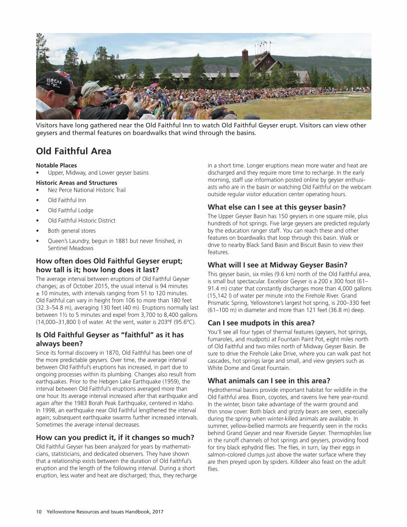
What else can I see at this geyser basin?The Upper Geyser Basin has 150 geysers in one square mile, plus hundreds of hot springs. Five large geysers are predicted regularly by the education ranger staff. You can reach these and other features on boardwalks that loop through this basin. Walk or drive to nearby Black Sand Basin and Biscuit Basin to view their features.
What will I see at Midway Geyser Basin?This geyser basin, six miles (9.6 km) north of the Old Faithful area, is small but spectacular. Excelsior Geyser is a 200 x 300 foot (61–91.4 m) crater that constantly discharges more than 4,000 gallons (15,142 l) of water per minute into the Firehole River. Grand Prismatic Spring, Yellowstone’s largest hot spring, is 200–330 feet (61–100 m) in diameter and more than 121 feet (36.8 m) deep.
Can I see mudpots in this area? You’ll see all four types of thermal features (geysers, hot springs, fumaroles, and mudpots) at Fountain Paint Pot, eight miles north of Old Faithful and two miles north of Midway Geyser Basin. Be sure to drive the Firehole Lake Drive, where you can walk past hot cascades, hot springs large and small, and view geysers such as White Dome and Great Fountain.
What animals can I see in this area?Hydrothermal basins provide important habitat for wildlife in the Old Faithful area. Bison, coyotes, and ravens live here year-round. In the winter, bison take advantage of the warm ground and thin snow cover. Both black and grizzly bears are seen, especially during the spring when winter-killed animals are available. In summer, yellow-bellied marmots are frequently seen in the rocks behind Grand Geyser and near Riverside Geyser. Thermophiles live in the runoff channels of hot springs and geysers, providing food for tiny black ephydrid flies. The flies, in turn, lay their eggs in salmon-colored clumps just above the water surface where they are then preyed upon by spiders. Killdeer also feast on the adult flies.
Visitors have long gathered near the Old Faithful Inn to watch Old Faithful Geyser erupt. Visitors can view other geysers and thermal features on boardwalks that wind through the basins.
Frequently Asked Questions 11
Tower–Roosevelt AreaNotable Places• Lamar Valley
• Northeast Entrance Road
Historic Areas and Structures• Lamar Buffalo Ranch
• Northeast Entrance Station
• Tower Ranger Station Historic District
• Roosevelt Lodge Historic District
• Roosevelt Lodge
Why is this area called “Tower”? The area is named for its major waterfall, Tower Fall, which is named for the tower-like rock formations at its brink.
How tall is Tower Fall? 132 feet (40 m).
Old pictures show a big boulder at the brink of Tower Fall. When did it fall? W.H. Jackson’s photograph in 1871 clearly shows the boulder. For more than a century, visitors wondered when it would fall. It finally did in June 1986.
Can I hike to the bottom of Tower Fall? No, the lower part of the trail is closed because of severe erosion. You can walk past the Tower Fall Overlook for 0.75-mile (1.2 km), ending with a view of Tower Creek flowing into the Yellowstone River. If you have heart, lung, or knee problems, you may want to enjoy the view from the overlook.
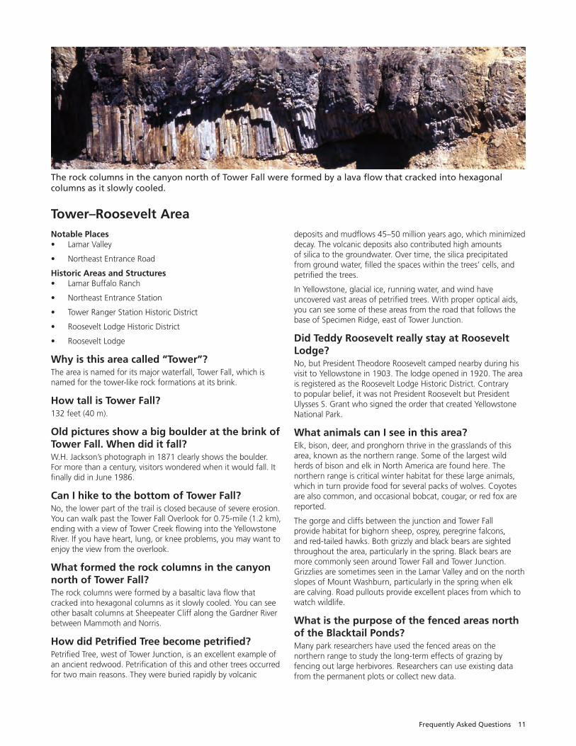
What formed the rock columns in the canyon north of Tower Fall? The rock columns were formed by a basaltic lava flow that cracked into hexagonal columns as it slowly cooled. You can see other basalt columns at Sheepeater Cliff along the Gardner River between Mammoth and Norris.
How did Petrified Tree become petrified? Petrified Tree, west of Tower Junction, is an excellent example of an ancient redwood. Petrification of this and other trees occurred for two main reasons. They were buried rapidly by volcanic
deposits and mudflows 45–50 million years ago, which minimized decay. The volcanic deposits also contributed high amounts of silica to the groundwater. Over time, the silica precipitated from ground water, filled the spaces within the trees’ cells, and petrified the trees.
In Yellowstone, glacial ice, running water, and wind have uncovered vast areas of petrified trees. With proper optical aids, you can see some of these areas from the road that follows the base of Specimen Ridge, east of Tower Junction.
Did Teddy Roosevelt really stay at Roosevelt Lodge?No, but President Theodore Roosevelt camped nearby during his visit to Yellowstone in 1903. The lodge opened in 1920. The area is registered as the Roosevelt Lodge Historic District. Contrary to popular belief, it was not President Roosevelt but President Ulysses S. Grant who signed the order that created Yellowstone National Park.
What animals can I see in this area?Elk, bison, deer, and pronghorn thrive in the grasslands of this area, known as the northern range. Some of the largest wild herds of bison and elk in North America are found here. The northern range is critical winter habitat for these large animals, which in turn provide food for several packs of wolves. Coyotes are also common, and occasional bobcat, cougar, or red fox are reported.
The gorge and cliffs between the junction and Tower Fall provide habitat for bighorn sheep, osprey, peregrine falcons, and red-tailed hawks. Both grizzly and black bears are sighted throughout the area, particularly in the spring. Black bears are more commonly seen around Tower Fall and Tower Junction. Grizzlies are sometimes seen in the Lamar Valley and on the north slopes of Mount Washburn, particularly in the spring when elk are calving. Road pullouts provide excellent places from which to watch wildlife.
What is the purpose of the fenced areas north of the Blacktail Ponds?Many park researchers have used the fenced areas on the northern range to study the long-term effects of grazing by fencing out large herbivores. Researchers can use existing data from the permanent plots or collect new data.
The rock columns in the canyon north of Tower Fall were formed by a lava flow that cracked into hexagonal columns as it slowly cooled.
12 Yellowstone Resources and Issues Handbook, 2017
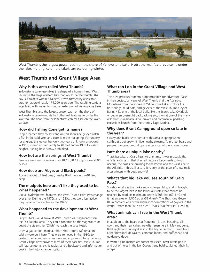
West Thumb and Grant Village Area
Why is this area called West Thumb? Yellowstone Lake resembles the shape of a human hand; West Thumb is the large western bay that would be the thumb. The bay is a caldera within a caldera. It was formed by a volcanic eruption approximately 174,000 years ago. The resulting caldera later filled with water, forming an extension of Yellowstone Lake.
West Thumb is also the largest geyser basin on the shore of Yellowstone Lake—and its hydrothermal features lie under the lake too. The heat from these features can melt ice on the lake’s surface.
How did Fishing Cone get its name?People learned they could stand on this shoreside geyser, catch a fish in the cold lake, and cook it in the hot spring. Fortunately for anglers, this geyser has only two years of known eruptions: In 1919, it erupted frequently to 40 feet and in 1939 to lesser heights. Fishing here is now prohibited.
How hot are the springs at West Thumb?Temperatures vary from less than 100ºF (38ºC) to just over 200ºF (93ºC).
How deep are Abyss and Black pools? Abyss is about 53 feet deep; nearby Black Pool is 35–40 feet deep.
The mudpots here aren’t like they used to be. What happened? Like all hydrothermal features, the West Thumb Paint Pots change over time. During the 1970s and 1980s, they were less active; they became more active in the 1990s.
What happened to the development at West Thumb? Early visitors would arrive at West Thumb via stagecoach from the Old Faithful area. They could continue on the stagecoach or board the steamship “Zillah” to reach the Lake Hotel.
Later, a gas station, marina, photo shop, store, cafeteria, and cabins were built here. They were removed in the 1980s to protect the hydrothermal features and improve visitor experience. Grant Village now provides most of these facilities. West Thumb still has restrooms, picnic tables, and a bookstore and information desk in the historic ranger station.
What can I do in the Grant Village and West Thumb area?This area provides numerous opportunities for adventure. Take in the spectacular views of West Thumb and the Absaroka Mountains from the shores of Yellowstone Lake. Explore the hot springs, mud pots, and geysers of the West Thumb Geyser Basin. Hike one of the local trails, like the Scenic Lake Overlook or begin an overnight backpacking excursion at one of the many wilderness trailheads. Also, private and commercial paddling excursions launch from the Grant Village Marina.
Why does Grant Campground open so late in the year? Grizzly and black bears frequent this area in spring when cutthroat trout spawn in five nearby streams. To protect bears and people, the campground opens after most of the spawn is over.
Isn’t there a unique lake nearby?That’s Isa Lake, at Craig Pass. At one time, it was probably the only lake on Earth that drained naturally backwards to two oceans, the east side draining to the Pacific and the west side to the Atlantic. If this still occurs, it is only at the peak of snow melt after winters with deep snowfall.
What’s that big lake you see south of Craig Pass? Shoshone Lake is the park’s second largest lake, and is thought to be the largest lake in the lower 48 states that cannot be reached by road. Its maximum depth is 205 feet (62.4 m) and it has an area of 8,050 acres (32.6 km2). The Shoshone Geyser Basin contains one of the highest concentrations of geysers in the world—more than 80 in an area 1,600 x 800 feet (488 x 244 m).
What animals can I see in the West Thumb area?In addition to the bears that frequent this area in spring, elk cows and their new calves are often seen here in May and June. Bald eagles and osprey dive into the bay to catch cutthroat trout. Other birds include ravens, common loons, and bufflehead and goldeneye ducks.
In winter, pine marten are sometimes seen. River otters pop in and out of holes in the ice. Coyotes and bald eagles eat their fish scraps.
West Thumb is the largest geyser basin on the shore of Yellowstone Lake. Hydrothermal features also lie under the lake, melting ice on the lake’s surface during winter.