yessabah nature reserve - plan of management (pdf - 243kb)
TRANSCRIPT

YESSABAH NATURE RESERVE
PLAN OF MANAGEMENT
NSW National Parks and Wildlife Service
Part of the Department of Environment and Conservation (NSW)
May 2004

This plan of management was adopted by the Minister for the Environment on13 May 2004.
For additional information or enquiries on any aspect of the plan, contact the NPWSMid North Coast Regional Office at 152 Horton Street, Port Macquarie NSW 2440 orby phone on (02) 6586-8300.
© Department of Environment and Conservation (NSW) 2004: Use permittedwith appropriate acknowledgment
ISBN 0 7313 6557 7

FOREWORD
Yessabah Nature Reserve covers 10ha and is located 15 km west-south-west ofKempsey in the lower Macleay Valley on the mid north coast of NSW.
Yessabah Nature Reserve was originally set aside in 1890 as a reservation forPublic Recreation and the Preservation of Caves. It encompasses a substantialportion of Yessabah Hill, an outcrop of the Yessabah Limestone Belt. The limestoneon the reserve has the highest concentration of caves in northern NSW, which areused for speleological and educational purposes. The caves also havepalaeontological and guano-dependent biota values and are a habitat for cavedependant bats.
The reserve contains excellent examples of dry and subtropical rainforest on itswestern margin and wet sclerophyll forest on its eastern margin. This distribution isunusual and might be attributed to the presence of limestone, karst landforms andrelated soil types on the western side of the reserve. The subtropical rainforest isone of only two lowland communities in the Macleay area and contains a smallpopulation of the small-leafed laurel (Cryptocarya williwilliana), a rare endemic to theMacleay Valley. The National Parks and Wildlife Act 1974 requires that a plan of management beprepared for each nature reserve. A plan of management is a legal document thatoutlines how the area will be managed in the years ahead. The procedures for theadoption of a plan of management for a nature reserve are specified in the Act.
A draft plan of management for Yessabah Nature Reserve was placed on publicexhibition for four months from 15th November 2002 until 24th February 2003. Theexhibition of the plan of management attracted 4 submissions which raised 6 issues.All submissions received were carefully considered before adopting this plan ofmanagement.
This plan of management aims to protect the caves and karst system, protect the dryand subtropical rainforest including significant species such as the small-leafedlaurel, enhance the values of the reserve through protection of adjoining vegetation,wildlife and karst areas in co-operation with neighbours, and encourage furtherscientific investigation into the values of the reserve. This plan of management establishes the scheme of operations for Yessabah NatureReserve. In accordance with section 76 of the National Parks and Wildlife Act 1974,this plan of management is hereby adopted.
BOB DEBUSMINISTER FOR THE ENVIRONMENT

Plan of Management Yessabah Nature Reserve 1
1. NATURE RESERVES IN NEW SOUTH WALES
1.1 LEGISLATIVE AND POLICY FRAMEWORK
The management of nature reserves in New South Wales (NSW) is in the context ofa legislative and policy framework, primarily the National Parks and Wildlife Act 1974(NPW Act), the NPW Regulation, the Threatened Species Conservation Act 1995(TSC Act) and the policies of the National Parks and Wildlife Service (NPWS).Section 72AA of the NPW Act lists the matters to be considered in the preparation ofa plan of management. The policies arise from the legislative background andinternationally accepted principles of park management. They relate to natureconservation, Aboriginal and historic heritage conservation, recreation, commercialuse, research and communication. Other legislation, international agreements and charters may also apply tomanagement of the area. In particular, the Environmental Planning and AssessmentAct 1979 (EPA Act) requires the assessment and mitigation of the environmentalimpacts of any works proposed in this plan. A plan of management is a statutory document under the NPW Act. Once theMinister has adopted a plan, no operations may be undertaken within YessabahNature Reserve except in accordance with the plan. This plan will also apply to anyfuture additions to Yessabah Nature Reserve. Where management strategies orworks are proposed for the reserve or any additions that are not consistent with theplan, an amendment to the plan will be required.
1.2 IUCN GUIDELINES FOR CAVE AND KARST PROTECTION
The International Union for Conservation of Nature and Natural Resources (IUCN),also known as the World Conservation Union, is an inter-governmental agency ofwhich Australia is a member. IUCN seeks to conserve the integrity and diversity ofnature and to ensure that any use of natural resources is equitable and ecologicallysustainable.
In 1997 the World Commission on Protected Areas, a commission of the IUCN,produced Guidelines for Cave and Karst Protection (Watson et al., 1997). Theseguidelines were developed to increase awareness of cave and karst protectionissues and the special management considerations essential for the protection ofcave and karst areas. They were designed to provide a guide for planners,managers and users of karst. This plan of management is based on the IUCNguidelines, although not all are specifically mentioned and some strategies havebeen modified where appropriate to better apply to the management of the reserve.

Plan of Management Yessabah Nature Reserve 2
1.3 GENERAL MANAGEMENT OBJECTIVES
Nature reserves are reserved under the NPW Act to protect and conserve areascontaining outstanding, unique or representative ecosystems, species, communitiesor natural phenomena.
Under the Act, nature reserves are managed to:
• conserve biodiversity, maintain ecosystem functions, and protect geological andgeomorphological features and natural phenomena;
• conserve places, objects, features and landscapes of cultural value;
• promote public appreciation, enjoyment and understanding of the reserve’snatural and cultural values; and
• provide for appropriate research and monitoring.
Nature reserves differ from national parks in that they do not have as a managementprinciple to provide for visitor use. 1.4 SPECIFIC OBJECTIVES FOR YESSABAH NATURE RESERVE In addition to the above objectives, the following specific objectives apply to themanagement of Yessabah Nature Reserve: * protection of the caves and karst system including its geological,
palaeontological and guano-dependent biota values and as a habitat for cavedependant bats;
* protection of the dry and subtropical rainforest, particularly significant plant
species including small-leafed laurel (Cryptocarya williwilliana); * enhancement of the values of the reserve through protection of adjoining
vegetation, wildlife and karst areas in co-operation with neighbours, includingthe rehabilitation of the adjoining quarry; and
* encouragement of further scientific investigation into the values of the reserve.

Plan of Management Yessabah Nature Reserve 3
2 YESSABAH NATURE RESERVE 2.1 LOCATION, GAZETTAL AND REGIONAL SETTING Yessabah Nature Reserve (hereafter called “the reserve”) is located 15 km west-south-west of Kempsey in the lower Macleay Valley on the mid north coast of NSW.The reserve was gazetted on the 4th of April 1996 and covers an area of 10 hectares(see map). The reserve was originally set aside in 1890 as a reservation for Public Recreationand the Preservation of Caves. The reserve encompasses a substantial portion ofYessabah Hill - an outcrop of the Yessabah Limestone Belt where the limestone ismassive and pure enough to support cave and karst development (Spate, 1994). The reserve is bounded by a disused quarry to the north, freehold farming land to theeast and west, and contiguous forest on freehold land to the south. A fireworkstesting and manufacturing site is located to the north-east of the reserve. The disused quarry is on part of a Reserve for Public Recreation (R12999). A seriesof Mining and Mining Purpose Leases were granted over the Recreation Reserveand parts of the surrounding private lands from the 1920’s until the early 1990’s. The reserve is within the Kempsey Local Government area. 2.2 LANDSCAPE CONTEXT Natural and cultural heritage and on-going use are strongly inter-related and togetherform the landscape of an area. Much of the Australian environment has beeninfluenced by past Aboriginal and non-Aboriginal land use practices, and theactivities of modern day Australians continue to influence bushland throughrecreational use, cultural practices, the presence of introduced plants and animalsand in some cases air and water pollution.
The geology, landform, climate and plant and animal communities of the area, plusits location, have determined how it has been used by humans. In the past, parts ofYessabah Hill have been quarried for limestone and bat guano and this hasimpacted on the landscape and other values of the reserve.
Both Aboriginal and non-Aboriginal people place cultural values on natural areas,including aesthetic, social, spiritual, recreational and other values. Cultural valuesmay be attached to the landscape as a whole or to individual components, forexample to plant and animal species used by Aboriginal people. This plan ofmanagement aims to conserve both natural and cultural values. For reasons ofclarity and document usefulness natural and cultural heritage, non-human threatsand on-going use are dealt with individually, but their inter-relationships arerecognised.

Plan of Management Yessabah Nature Reserve 4
2.3 NATURAL AND CULTURAL HERITAGE VALUES Geology and Geomorphology The reserve has a range of karst and cave landforms which represent featurestypical to both cool-temperate and tropical karsts. Karst features include: limestonepinnacles; solution flutes; solution spikes; rainpits; solution bevels; grikes; karstwells; and solution pans typical of cool-temperate areas. Karst features more typicalof tropical karsts include: larger scale solution runnels; rain solution runnels; andbogaz like features (Houshold, 1989). The reserve also has the highest concentration of caves in northern NSW with about60 known caves and 90 entrances (Taylor, 1985). In June 1992 the YessabahCaves were entered onto the Commonwealth’s Register of the National Estate inrecognition of their intrinsic natural values. The caves are also of state widesignificance for their scientific and educational values. The Yessabah Limestone is of Permian age and extends almost continuously over adistance of some 60km from Yessabah to Kunderang Brook (Spate, 1986). It is partof the Kempsey Block of the New England Fold Belt. The limestone consists of abasal calcareous mudstone, a central unit of bioclastic crinoidal limestone and adiscontinuous member (the Mount Pleasant Limestone) of reefal and siliceouslimestones. The caves are found in the central unit. The formation varies inthickness from 6m to more than 500m at Willi Willi, Stony Creek and Yessabah(Lindsay, 1964 and 1969). The limestone exposed on Yessabah Hill dips towards the east at an angle ofapproximately 30-60° and on the whole is fairly massively bedded althoughsolutional etching reveals much thinner bedding in some parts of the outcrop. Thelimestone varies greatly in colour but is uniform in composition and is largely madeup of crinoidal remains (Spate, 1986). The limestone is generally underlain by theKullatine Formation (pebbly mudstone, conglomerate, lithic sandstone andmudstone) or the Carboniferous Boonanghi Beds (mudstone, sandstone andconglomerate). It is conformably overlain by mudstone, sandstone and rareconglomerate of the Warbro Beds and Kempsey Beds (Houshold, 1989). The northern and western sides of the reserve have much less soil mantle and aresteeper than the eastern and southern aspects. As a result, most of the enterablecaves are situated on the northern and western aspects of the reserve. Geomorphologically, the reserve is a disjunct remnant of the eastern escarpment ofthe New England Tableland, truncated as the scarp slowly retreated westwards afteruplift of the highlands in the early-mid Tertiary (Houshold, 1989). The reservepresents a classic limestone residual exposure typical of strong seasonally moist-warm climates (Spate, 1986). As it is near the southern limit of the summer-wet/winter-dry climatic zone, the Yessabah karst is important in understanding theeffects of Australia’s north-south climatic gradient on solutional erosion processes(Houshold, 1989).

Plan of Management Yessabah Nature Reserve 5
Voisey (1936) suggested that the steep slopes on the northern and western slopesof the reserve are the result of faulting. Alternatively, Houshold (1989) suggests thatthe lack of evidence for late Cainozoic tectonics indicates that these slopes are morelikely due primarily to the operation of karst processes, where most water ischannelled underground, and comparatively little surface erosion occurs - generatingcliffed rather than gently graded landscapes. It is possible that the wide valleys surrounding the reserve are past courses of eitherDungay Creek or the Macleay River. The area’s location near the emergence of thestreams onto the coastal plain makes it likely to experience comparatively rapidlateral movements in stream courses. Low outcrops of limestone and exposures indolines in these valleys indicate planation by fluvial processes rather than solutionalone. If this is the case, Yessabah Hill is a remnant of combined karst/fluvialprocesses, with old stream beds being slowly dissected by small incipient streams(Houshold, 1989). Catchment and Hydrology values The reserve has little catchment area and there is rapid run-off to Dungay andCommong Creeks which drain into the Macleay River below the intake for thedomestic water supply of Kempsey. Water from these streams is used for wateringdomestic stock outside the reserve. Yessabah Hill appears to be hydrologically isolated and hydraulically “higher” thanthe surrounding lands. Only two caves appear to have any hydrological interest(Houshold 1989) although during the wetter part of the year, and after storms, manysmall streams are found within caves and flowing as springs on the surface. The Bat Cave (YE1) contains a minor, non-perennial stream running from a joint intothe cave and sinking through sediment. There may be an intermittent spring runningfrom this cave on the hillside quite some distance above the swampy creek to thewest of the reserve. However, it is likely that most water sinking into Yessabah Hilland the Bat Cave stream rises as seepage springs along the length of the swampycreek draining northwards along the western flank of the hill (Spate, 1998). Water Cave (YE50) is immediately south of, but not on the reserve, and appears tobe the only cave containing permanent water on Yessabah Hill. It is a steeplydipping cave on the upper part of the footslopes to the hill; it finishes in a deep poolwhich appears to be perched above the level of the swampy creek to the west of thereserve. Although it has been sampled without result for aquatic fauna on twooccasions, it is of both geomorphic and hydrologic interest and may yet containbiological values (Spate, 1998). Palaeontologic Values The reserve is an important sub-fossil site with a number of bone deposits found inthe caves. The most common are owl roost deposits - mounds of bones of smallmammals built up as refuse heaps under roosting sites (Houshold, 1989). Thesebones indicate the presence of many species in the caves throughout their history,some of which are either extinct or no longer occur in the area. The ghost bat

Plan of Management Yessabah Nature Reserve 6
(Macroderma gigas) which is now restricted to northern Australia, was recorded inbone deposits taken from Yessabah Caves (Anon., 1958). Information gained from sub-fossil deposits contributes to our knowledge of theevolution and distribution of Australian animals. Bone breccias and sedimentdeposits in the caves have a high potential for providing information on pastenvironmental changes and changes in the faunal composition of the area. Native Plants The distribution of vegetation within the reserve clearly demonstrates therelationships between landforms, soils and vegetation. Wet sclerophyll sub-tropicalrainforest and dry rainforest are the dominant vegetation associations in the reserve. A survey of rainforest vegetation (Floyd, 1983) found 36 rainforest tree species in thereserve as well as a number of rainforest shrubs, herbs, vines and epiphytes. Themost frequently occurring rainforest species include: actephila (Actephila lindleyi);yellow tulip (Drypetes australasica); orange kamala (Mallotus phillipensis); giantstinging tree (Dendrocnide excelsa); and shining-leaved stinging tree (Dendrocnidephotinophylla). The reserve contains excellent examples of dry and subtropical rainforest on itswestern margin and wet sclerophyll forest on its eastern margin. This distribution isthe reverse of the usual pattern of rainforests which generally prefer the cooler, moresheltered southern and easterly aspects (Houshold, 1989). This unusual distributionmight be attributed to the presence of limestone, karst landforms and related soiltypes on the western side of the reserve (Houshold, 1989). A small population of thesmall-leafed laurel (Cryptocarya williwilliana), a rare endemic to the Macleay Valley,is also preserved within the subtropical rainforest on the western side of the reserve. The subtropical rainforest is one of only two lowland communities in the Macleayarea, and is dominated by giant stinger (Dendrocnide excelsa), shiny-leaved stinger(D. photinophylla), yellow tulip (Drypetes australis), rosewood (Dysoxylumfraserianum) and Port Jackson fig (Ficus rubiginosa). This community is restricted tothe lower north-western facing slopes where soils are deeper and moister (Kendall,1997a). The dry upper north-western slopes of the reserve support dry rainforest dominatedby shatterwood (Backhousia sciadophora), shiny-leaved stinger (Dendrocnidephotinophylla), yellow tulip (Drypetes australis) and fig (Ficus species). A southernoccurrence sub-form of this dry rainforest sub-alliance occurs in two small pocketson privately owned land to the south and east of the reserve. This sub-form isdominated by white cedar (Melia azedarach). The eastern side of the reserve supports a wet sclerophyll forest association. Theupper strata is dominated by white mahogany (Eucalyptus acmenoides), small-fruited grey gum (E. propinqua), tallowwood (E. microcorys), grey ironbark (E.siderophloia) and pink bloodwood (Corymbia intermedia). The mid strata contains avariety of mesic species of which red kamala (Mallotus phillipensis), native olive

Plan of Management Yessabah Nature Reserve 7
(Olea paniculata) and lantana (Lantana camara) dominate. The lower strata isdominated by Poa labillardieri and Lepidosperma laterale. Nine significant plant species have been recorded in the reserve. The reserverepresents the southern limit of occurrence for many of these species and for othersan important intermediary refuge between other populations (refer table 1). Modelsdeveloped as part of the comprehensive regional assessment (CRA) process havealso predicted Callistemon acuminatus, a rare bottlebrush, as occurring in thereserve. Table 1 Significant plants known to occur within the reserve. Common name Scientific name Significance hairy alectryon Alectryon tomentosus Disjunct population corky prickle-vine Caesalpinia subtropica Southern limit small-leafed laurel Cryptocarya williwilliana Southern limit a vine Deeringia arborescens Near southern limit veinless silkpod Parsonsia rotata Southern limit zig zag vine Rauwenhoffia leichardtii Southern limit deep yellowwood Rhodosphaera rhodanthema Southern limit caustic vine Sarcostemma brunonianum Near southern limit stinging vine Tragia novae-hollandiae Southern limit Native Animals
A vertebrate fauna survey of the reserve (Kendall & Kendall, 1997) identified fivesignificant species (refer table 2). Suitable habitat also exists for a number ofregionally significant or threatened species that are predicted to occur in the reserve(refer table 3). Table 2 Significant animals known to occur within the reserve. Common name Scientific name TSC status and
Significance Mammals spotted-tailed quoll Dasyurus maculatus Vulnerable r
eastern horseshoe-bat Rhinolophus megaphyllus Regionally significant common bent-wing bat Miniopterus schreibersii Vulnerable r
little bent-wing bat Miniopterus australis Vulnerable r
Birds wompoo fruit dove Ptilinopus magnificus Vulnerable Vulnerable = schedule 2 under the TSC Act r recovery plan in preparation.

Plan of Management Yessabah Nature Reserve 8
The cave system in the reserve plays an important role in the life cycles of the littlebent-wing bat and the common bent-wing bat. Thousands of bats gather in the BatCave each winter to roost and stage prior to travelling further up the limestone belt tobreed and rear their young in a bat maternity site in the Willi Willi Caves NatureReserve (Dwyer 1966). The eastern horseshoe bat also utilises the cave system inthe reserve and together with the bent-wing bats are highly vulnerable to humandisturbance. Table 3 Significant animals predicted by modelling to occur within the reserve.
Common name Scientific name TSC status Mammals brush-tailed phascogale Phascogale tapoatafa Vulnerable common planigale Planigale maculata Vulnerable koala Phascolarctos cinereus Vulnerable r squirrel glider Petaurus norfolcensis Vulnerable Yellow-bellied glider Petaurus australis Vulnerable r
Yellow-bellied sheathtail-bat Saccolaimus flaviventris Vulnerable r
Beccari's freetail-bat Mormopterus beccarii Vulnerable eastern freetail-bat Mormopterus norfolkensis Vulnerable hoary wattled bat Chalinolobus nigrogriseus Vulnerable greater broad-nosed bat Scoteanax rueppellii Vulnerable r
Large-eared pied bat Chalinolobus dwyeri Vulnerable eastern cave bat Vespadelus troughtoni Vulnerable Birds red goshawk Ephippiorhynchus asiaticus Endangered Square-tailed kite Lophoictinia isura Vulnerable Rose-crowned fruit-dove Ptilinopus regina Vulnerable glossy black-cockatoo Calyptorhynchus lathami Vulnerable swift parrot Lathamus discolor Endangered#
turquoise parrot Neophema pulchella Vulnerable superb fruit-dove Ptilinopus superbus Vulnerable masked owl Tyto novaehollandiae Vulnerable r
powerful owl Ninox strenua Vulnerable r
barking owl Ninox connivens Vulnerable sooty owl Tyto tenebricosa Vulnerable barred cuckoo-shrike Coracina lineata Vulnerable Reptiles three-toed snake-tooth skink Coeranoscincus reticulatus Vulnerable * white-crowned snake Cacophis harriettae Vulnerable pale-headed snake Hoplocephalus bitorquatus Vulnerable Stephens' banded snake Hoplocephalus stephensii Vulnerable white-crowned snake Cacophis harriettae Vulnerable
* also listed as vulnerable under the Environment Protection and Biodiversity Conservation Act 1999 # also listed as endangered under the Environment Protection and Biodiversity Conservation Act1999 r recovery plan in preparation.

Plan of Management Yessabah Nature Reserve 9
NPWS is required by the TSC Act to prepare and implement recovery plans for alllisted threatened species. These are progressively being prepared and will be usedto guide management of threatened species in the area. The cave system also supports a diverse range of cave invertebrate fauna includinga number of new species of spiders and land snails (Spate, 1994). Some of thesespecies are cave dependent and are known only to occur in the Yessabah Hill caves. The invertebrate fauna of the reserve are likely to be very significant. Eberhard andSpate (1995) collected a large number of specimens, many of which are still to bedetermined taxonomically, some of which may be new species. Aboriginal Heritage Aboriginal communities have an association and connection to the land. The landand water biodiversity values within a landscape are central to Aboriginal spiritualityand contribute to Aboriginal identity. Aboriginal communities associate naturalresources with the use and enjoyment of foods and medicines, caring for the land,passing on cultural knowledge and strengthening social bonds. Aboriginal heritageand nature are inseparable from each other and need to be managed in anintegrated manner across the landscape The reserve lies within the Dunghutti tribal area, and within the area of the KempseyLocal Aboriginal Land Council. It is unknown what significance the originalcustodians to the area placed on Yessabah Hill. The sharp nature of the limestonesurface would have made it challenging for the Dunghutti people to traverse the rockoutcrops. Four Aboriginal sites have been recorded in the Yessabah Hill area: twobora/ceremonial sites, a stone arrangement, and a burial site. It is thought that aspring on the western side of the hill may have a traditional Aboriginal story attachedto it (Kelly, pers. comm., 1997). A preliminary archaeological investigation was conducted in the Small Slide Cave in1989 to determine whether an ash deposit in the cave was of anthropogenic origin.The results of this investigation were not demonstrably significant for their Aboriginalcultural content, although they are informative for scientific purposes (Gollan, 1989). Non-Aboriginal heritage Most of Yessabah Hill was set aside as a Recreation Reserve in 1890, however,between 1920 and 1991 the northern section of the hill was intermittently quarried forlimestone. The limestone was crushed and used for building and agriculture. In theearly 1920s some of the caves were mined for bat guano for use as a plant fertiliser(Spate, 1998). This was one of very few guano mining activities in NSW (Hamilton-Smith, 1998). The area has also been of interest to speleological groups, research scientists, andmembers of the local community since the early part of the twentieth century.

Plan of Management Yessabah Nature Reserve 10
2.4 VISITOR USE Recreational opportunities in the reserve are limited as there is no formal publicaccess to the reserve. The current road access is through the mining lease and thereare concerns about public safety issues relating to the quarry and rehabilitationworks. The steep, rugged nature of the reserve’s terrain also poses public safetyproblems. Additionally, NPWS has not promoted general recreational use of thereserve because of concerns about visitor impacts on cave and karst valuesincluding bats, invertebrates, bone deposits and cave and karst features. The NPWS acknowledges the past use of the caves by speleological groups, inparticular Kempsey Speleological Society, and caving enthusiasts and appreciatestheir input into the current knowledge of the caves within the reserve and into theDraft Visitation Guide prepared for Yessabah Caves (NPWS 1998). Future accessto the caves and karst in the reserve will require approval by the NPWS and privatelandholders (if intending to walk over private property), and will only be granted forspeleological, educational and scientific purposes consistent with the aboveguidelines. 2.5 RESEARCH A number of studies have been undertaken on the natural heritage values of thereserve. These have included research into the vegetation, fauna, karst landforms,geology and geomorphology, ash deposits, biology of cave fauna including bats andinvertebrates, and palaeontology of the reserve. Further research would enhance the knowledge of the natural and cultural heritageof the reserve and would assist in the future management of the reserve. Particularareas that would benefit from further research include: studies of the cave bonedeposits and fossil breccia; biology of cave fauna including bats and invertebrates;aquatic fauna; and karst processes. 2.6 THREATS TO THE RESERVE’S VALUES Fire Details of the fire history are limited, however the presence of charcoal withinbreccias in the caves indicates the past occurrence of fire on the reserve. Therehave been no recorded wildfires in the reserve for the past twenty-five years,although hazard reduction burning has been undertaken in the wet sclerophyll foreston the eastern side of the reserve. While there is potential for grass fires to spread into the reserve from surroundingcleared farmland, a number of natural and man made barriers inhibit the spread offire. To the north and east of the reserve the quarry face and access road providesome protection to the northern boundary although this protection will be reduced asrevegetation of the quarry occurs. A small stream near the northwestern edge of thereserve provides limited protection along this boundary.

Plan of Management Yessabah Nature Reserve 11
The south-eastern slopes of the reserve which are dominated by wet sclerophyllforest are more adapted to fire than the rainforest, however, the wet sclerophyllforest contains a well developed mesic understorey, and in the absence of fire therainforest species are likely to become more common possibly extending therainforest boundary. The north-western, western and south-western perimeters of the reserve are mostvulnerable. The potential for fire to damage the rainforest is high and repeated fire islikely to cause the rainforest to retract. During drought when leaf fall is heavy andsoil moisture is low a fire could spread through the rainforest, however the reserve’snumerous rock outcrops and cliff lines would inhibit the fires progress in all butextreme conditions and fires would be expected to go out or burn slowly in acomplex mosaic pattern (Kendall, 1997a). Significant rainforest species identified in table 1 are likely to have a poor responseto any fire although the majority of these plants are scattered throughout thereserve’s rainforest and are likely to be safe from most fires. The stinging vine(Tragia novae-hollandiae) also occurs commonly in the wet sclerophyll forest whichis more likely to carry fire. The small-leafed laurel (Cryptocarya williwilliana) isparticularly vulnerable to fire as the majority of the population is confined to the lowernorth-western part of the reserve below the lowest series of cliffs and close to theboundary of naturally vegetated land. This location offers no protection from fire bythe numerous cliff lines and rocky areas. Fire also has the potential to damage the limestone karst features within the reserve.In particular, high fire intensities and/or long duration events (e.g. a log smoulderingaway in direct contact with bedrock) can cause destruction of the features via anumber of mechanisms including spalling and calcining (Holland, 1994). Fire, evenat low intensities, rapidly destroys crustose lichens and similar lower plants growingon limestone surfaces (Spate, 1998). Any fire event will remove leaf litter and understorey vegetation with possibleimplications for the significant molluscan and other invertebrate fauna of thelimestone outcrop (Cooper, 1999). Excluding fire from the reserve would maintaindetritus food chains and microclimates at ground level, and also protect habitatprovided by old growth trees, logs and dead trees. Fire may also have an adverse impact on the bat communities which utilise the cavesystem. Starvation is an important cause of mortality in common bent-wing bats andchanges in fire regime may well be among the contributing causes (Dwyer, 1966a &1996b). Hazard reduction burning toward the cooler months of the year could resultin changes to the availability of flying invertebrates at a time when bats need to buildup fat reserves for winter (Spate, 1999). In addition, whilst juveniles are beginning tofly and exploit their environment in late summer and early autumn very largenumbers of individuals may need to forage over a small area (Spate, 1999).

Plan of Management Yessabah Nature Reserve 12
The NPWS approach to fire management planning emphasises the protection of lifeand property, as well as providing direction for the protection of natural and culturalheritage. To achieve these objectives the NPWS uses a system of zones which arecompatible with the system adopted by the Bushfire Coordinating Committee for usein District Bushfire Management Committee bushfire risk management plans.
NPWS has assessed the reserve for fire management planning purposes and haszoned the reserve as a Heritage Area Management Zone (HAMZ). The primary firemanagement objectives for this zone are to prevent the extinction of all species thatare known to occur naturally within the reserve, and to protect culturally significantsites. The reserve has been designated as a HAMZ because of the sensitivity ofrainforest vegetation, limestone karst features, invertebrate fauna and batcommunities.
The HAMZ does not require intensive management and focuses on those actionsappropriate to conserve biodiversity and cultural heritage including exclusion of firefrom the reserve.
Introduced Plants A total of 22 weed species have been recorded in the reserve, although most ofthese species except lantana (Lantana camara) occur as a minor component ofthe natural vegetation. The major weed infestations are confined to the uppernorth-eastern part of the reserve, adjacent to the quarry, and along theboundaries between the reserve and private properties. Lantana, along with fire, poses the greatest threats to native vegetation in thereserve. In the north eastern section of the reserve lantana forms a virtuallyimpenetrable dense thicket. Lantana also occurs in the wet sclerophyll forestand rainforest areas, where it assumes a vine habit and is a potential threat tonative species. The adjacent quarry mining lease area is heavily infested by numerous speciesof weeds including lantana. Giant Parramatta grass (Sporobolus fertilis) is anincreasing problem on adjacent cleared pasture land and in the mining leasearea. Weed control and revegetation programs have recently been undertakenin the quarry area. Care needs to be taken when undertaking control programs that a stablevegetation cover is maintained to prevent soil erosion and that herbicides usedto control introduced species do not affect water quality and hence caveinvertebrates. The application of herbicides by spraying should not be undertaken (or at leastonly undertaken under very tightly controlled operational conditions) on thekarst terrains in the north western part of the reserve, because of the lack of soiland the high degree of integration between surface and subsurface waters(Spate, 1998).

Plan of Management Yessabah Nature Reserve 13
Introduced Animals Wild dogs (Canis familiaris ) as well as foxes (Vulpes vulpes ) and cats (Felis catis)were reported in survey of landholders in the vicinity of the reserve in 1998(RLPB/NPWS 1998). Other pest animals likely to occur in the reserve are the rabbit(Oryctolagus cuniculus), house mouse (Mus musculus), black rat (Rattus rattus), andthe brown hare (Lepus capensis). A 1080 aerial baiting program for dogs and foxes was carried out in 1999cooperatively with State Forests NSW and the Kempsey RLPB. Ground baitingis now the preferred method of pest animal control and this will requirecooperation between neighbours, the Kempsey RLPB and the NPWS. Access Existing road reservations to the reserve are impracticable for road construction dueto steep slopes, and construction of trails within the reserve would cause verysignificant environmental damage There are also conservation concerns regarding visitor access which maydisturb cave fauna, especially bats, and the potential for damaging otherimportant values of the reserve such as karst features and bone deposits. Inthe past sub-fossils have been removed from caves in the reserve. Modification of Surrounding Lands and Fragmentation of the Reserve The area of the reserve does not include all of the limestone and karst features onYessabah Hill and its environs nor does it adequately encompass all of the complexkarst hydrology of the site (Spate, 1998). Thus, management of adjacent lands isimportant for protection of these features. The fireworks manufacturing and testing site to the north-east of the reserve isnot considered to directly impact on the reserve’s values as its activities areundertaken within identified bunkers and during the day when bat activity isminimal. Most of the surrounding lower lying lands have been cleared. Clearing ofvegetation in the area has resulted in fragmentation of habitat. Long termconservation of biodiversity within the reserve depends upon protection,enhancement and connection of remaining habitat across the landscape,involving public and private land remnants. The population of small-leafedlaurel that occurs outside the reserve on privately owned land may also bethreatened by grazing and habitat loss. The Yessabah limestone quarry north of the reserve is no longer mined. Thereare several precipitous quarry faces adjacent to and just within the reservewhich may be a concern for public safety. Due to the scale of the quarry faces,little can be done to rehabilitate the topography of the quarry. Over time thevisual impact of rock exposures will be reduced.

3. RESERVE MAP
Plan of Management Yessabah Nature Reserve 14

Plan of Management Yessabah Nature Reserve 15
4. MANAGEMENT ISSUES AND STRATEGIES
Current Situation Desired Outcomes Strategies Priority Geology, Geomorphology andHydrology The reserve contains a significantkarst system and the highestconcentration of caves in northernNSW. The cave and karst systemis important for its geological,palaeontologic and guano-dependent biota values and as ahabitat for cave dependant bats.Human disturbance can threatenthese values.
• Caves, karsts and
associated features areprotected from humandisturbance and naturalprocesses are allowed tocontinue.
• There is no decline in the qualityor change to natural water flowsin the reserve.
• Design and carry out all works withinthe reserve to minimise impact on thegeology, geomorphology, soils andnatural drainage of the reserve.
• Manage the reserve as far as possibleto ensure continuation of the variouskarst, biological and microbiologicalprocess operating either on thesurface or within the cave and karstsystem.
• Visitor access to the caves and karstswill be restricted to minimise impacts(refer Visitor Use).
High Medium High
Palaeontology Significant sub-fossil bonedeposits occur within the cavesand are potentially important asindicators of past environmentalchanges and evolution. In the pastsome sub-fossils been removedwithout adequate approval anddocumentation.
• Palaeontogical values,
including bone deposits andsub-fossils, are protectedfrom human disturbanceunless for authorisedscientific purposes.
• Ensure all visitors are aware that the
removal of bone deposits and othermaterial is prohibited without NPWSconsent.
• Identify the individuals and
organisations who currently holdcollections of bone material from thereserve and establish a protocol toensure that all bone materials areadequately identified anddocumented.
High Medium

Plan of Management Yessabah Nature Reserve 16
Current Situation Desired Outcomes Strategies Priority Native plant and animalconservation Nine significant plants anduncommon rainforest alliances areknown to occur within the reserve.Rainforest in the reserve issensitive to fire. Four significantanimal species also occur. The caves provide habitat forunique cave dependantinvertebrates found only atYessabah caves. The caves are asignificant winter roosting site forthreatened species of bats and arehighly vulnerable to humandisturbance.
• That the full range of nativeplant and animal speciesfound in the reserve isconserved.
• Emphasis is placed on
protecting the habitats ofanimals listed as vulnerablein the Threatened SpeciesConservation Act 1995 andother species ofconservation concern foundin the reserve.
• Exclude fire from rainforestcommunities in the reserve (refer FireManagement).
• Implement recovery plans for
significant species as prepared. • Restrict visitor access and allow
access for speleological groups,educational and scientific purposesonly to protect cave and karst values(refer Visitor Use).
• Access to the caves will not be
permitted between 1 May and 31August, unless for scientific purposesrelated to bat conservation and subjectto NPWS approval.
• Seek the cooperation of neighbouring
landholders and other landuse planningand management authorities in theprotection of important wildlife habitatsin the vicinity of the reserve (referModification of Surrounding Lands andFragmentation of the Reserve).
High High High High High
Plan of Management Yessabah Nature Reserve 17
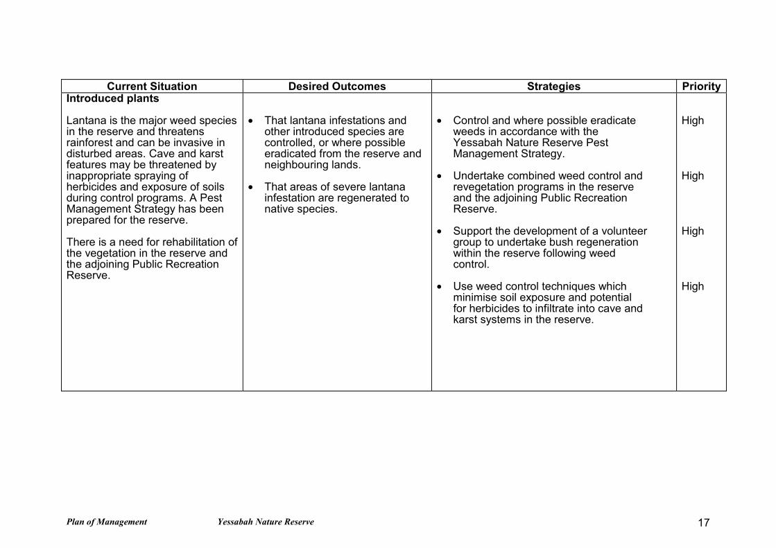
Current Situation Desired Outcomes Strategies Priority Introduced plants Lantana is the major weed speciesin the reserve and threatensrainforest and can be invasive indisturbed areas. Cave and karstfeatures may be threatened byinappropriate spraying ofherbicides and exposure of soilsduring control programs. A PestManagement Strategy has beenprepared for the reserve. There is a need for rehabilitation ofthe vegetation in the reserve andthe adjoining Public RecreationReserve.
• That lantana infestations and
other introduced species arecontrolled, or where possibleeradicated from the reserve andneighbouring lands.
• That areas of severe lantana
infestation are regenerated tonative species.
• Control and where possible eradicate
weeds in accordance with theYessabah Nature Reserve PestManagement Strategy.
• Undertake combined weed control and
revegetation programs in the reserveand the adjoining Public RecreationReserve.
• Support the development of a volunteer
group to undertake bush regenerationwithin the reserve following weedcontrol.
• Use weed control techniques which
minimise soil exposure and potentialfor herbicides to infiltrate into cave andkarst systems in the reserve.
High High High High

Plan of Management Yessabah Nature Reserve 18
Current Situation Desired Outcomes Strategies Priority Introduced animals Foxes, feral cats and wild dogshave been reported in the reserve.Other pest species such as thehouse mouse may also occur.Ground baiting is used to controldogs and foxes. A PestManagement Strategy has beenprepared for the reserve.
• Introduced animals are
controlled and where practicableeliminated.
• Control of introduced animals
uses techniques which haveminimal impact on nativespecies.
• Control introduced animals in accordance
with the Yessabah Nature Reserve PestManagement Strategy.
• Continue the baiting program to control
foxes and dogs in the reserve in cooperationwith the Kempsey RLPB and neighbours.
• Monitor the occurrence of house mouse in
the reserve, and implement a controlprogram if necessary.
High High Medium
Fire Management Rainforest, limestone karstfeatures, bats and invertebratefauna in the reserve are sensitiveto fire. A fire management plan has notyet been prepared for the reserve.
• Fire is excluded from the
reserve. • Persons and property within and
adjacent to the reserve are fromprotected from fire.
• Manage the reserve as a Heritage
Management Zone.
• Prescribed burning will not be undertakenon the reserve unless research indicatesthat fire is necessary to protect biodiversityvalues.
• Maintain liaison and develop co-operative
strategies with the Kempsey Shire and localbrigades about fire management in thereserve and on adjoining lands.
• Liaise with adjoining neighbours and localBushfire brigade about constructing aperimeter trail around the border of thenaturally vegetated land on Yessabah Hill,particularly along the north-western, westernand south-western boundaries of thereserve. This trail will also provide accessfor NPWS management purposes.
High High High High

Plan of Management Yessabah Nature Reserve 19
Current Situation Desired Outcomes Strategies Priority Cultural Heritage Although there are no knownAboriginal sites within the reserve,four sites have been recorded inthe nearby area. An assessmentof cultural heritage values has notbeen undertaken in the reserve. Minor relics of European origin arefound at a cave entrance.
• Cultural features areappropriately conserved andmanaged.
• That the Aboriginal community is
involved in the management of,and research into their heritageand culture.
• Undertake an archaeological survey andcultural assessment prior to all works withthe potential to impact on sites or places ofcultural significance.
• Encourage the participation of the Dunghutti
Elders and the Kempsey Local AboriginalLand Council in the management ofAboriginal heritage.
• Ensure that any research involving
Aboriginal heritage is carried out inconsultation with the Aboriginal community.Provide copies of any research findings onAboriginal cultural heritage to the LandCouncil.
• Record historic relics at cave entrance and
protect from disturbance.
High High High Medium

Plan of Management Yessabah Nature Reserve 20
Current Situation Desired Outcomes Strategies Priority Visitor Use Speleological groups are the mainvisitors to the reserve and haveaccessed the caves for manyyears through private property byagreement with adjoininglandholders. The reserve does not have ahistory of other visitor use. Cave and karst values in thereserve may be threatened bydisturbance to cave fauna,bone deposits and damage tocave and karst features. There are concerns for publicsafety in regard to adjacentquarry cliffs and the sharplimestone surfaces in thereserve.
• Visitor access does not threaten
cave and karst values. • Access to the reserve is limited
to recognised speleologicalgroups, scientific purposes andeducational visits.
• The values of the reserve are
available as an educational off-site resource.
• Access to the reserve will be limited torecognised speleological groups and foreducational and scientific purposes only, andwill require consent from the NPWS andrelevant private land holders.
• Speleological visits and undergroundresearch will be permitted with NPWSconsent between 1 October and 31 May. Amaximum of 2 recreational speleologicalgroup visits and a maximum of 10 people percaving party will be permitted each cavingseason. Permission to access caves withhigh karst conservation values or to accesscaves outside this period will be onlyapproved for research projects that justifysuch access.
• Cave users must be acquainted with, andabide by, the Australian SpeleologicalFederation Inc. (ASF) Code of Ethics andConservation, Safety Code and MinimalImpact Caving Code.
• Information on the caves will be developed
and available on request to local schools,TAFE and other education bodies.
• Commercial and other general recreation
access to the reserve will not be permitted.
High High High Medium High

Plan of Management Yessabah Nature Reserve 21
Current Situation Desired Outcomes Strategies Priority Research Vegetation and vertebrate faunasurveys have been undertaken inthe reserve. Research has alsobeen undertaken into the reserve’scave and karst system. Further scientific study wouldimprove understanding of thereserve’s natural and culturalheritage, the processes that affectthem and the requirements formanagement.
• Research improves knowledge
of the resources of the area andassists management of thereserve.
• Permit research which causes minimal
disturbance to the natural and cultural valuesof the reserve, unless the expected results ofthe research offer significant benefits forimprovement of management programs orknowledge of natural and cultural resources.
• Encourage research into fire behaviour, fire
hazard and fire risk, and the impact of fire onthe reserve’s plant and animal communitiesand karst landforms.
• Encourage research into the cave and karst
system including bone deposits, cavesediments, bats and other cave organisms.
• Require all speleologists and others granted
permission to access the reserve to maintaina detailed and accurate information base onthe caves
• Prepare a list of potential research
opportunities for research institutions.
High High Medium Medium Low

Plan of Management Yessabah Nature Reserve 22
Current Situation Desired Outcomes Strategies Priority Modification of surroundinglands The reserve does not include all ofthe limestone and karst featureson Yessabah Hill. Clearing ofvegetation in the area has alsoresulted in fragmentation of habitatin the area. Management of adjacent lands isimportant for protection of thecaves and karst system and nativevegetation in the reserve. A disused quarry adjoins thereserve and is part of a Reservefor Public Recreation. Arehabilitation committee has beenformed to co-ordinate activitiesinvolving mine rehabilitation andpest plant control on the Reservefor Public Recreation.
• Values of the reserve are
enhanced by adjacent landmanagement.
• The reserve is of sufficient size
to protect the entire Yessabahcaves and karst system.
• That reserve neighbours
support conservation ofremaining areas ofprivately owned nativevegetation near thereserve.
• Work with relevant neighbours to encourage
conservation of remnant native vegetationand revegetation in the area.
• Work with the rehabilitation committee to
ensure safe and effective rehabilitation of thequarry on the northern boundary of thereserve and of the overburden on thereserve.
• Seek inclusion of the Reserve for Public
Recreation into the reserve. • If opportunities arise, seek additional lands
for inclusion into the reserve where theyhave conservation values or for managementpurposes.
• Encourage retention of native vegetation on
adjacent lands through instruments such asVoluntary Conservation Agreements.
• Liaise with surrounding landholders to
protect significant plant species andcommunities on their land, particularlyfrom fire, grazing and habitat loss.
High
Medium
Medium
Medium
Medium
Medium
High priority activities are those imperatives to achievement of the objectives and desired outcomes. They must be undertaken in the nearfuture to avoid significant deterioration in natural, cultural or management resources.Medium priority activities are those that are necessary to achieve the objectives and desired outcomes but are not urgent.Low priority activities are desirable to achieve management objectives and desired outcomes but can wait until resources become available.

Draft Plan of Management Yessabah Nature Reserve 23
7. REFERENCES
Anon., 1958. Report on Yessabah Caves by Cooranbong Speleological Association.In TROG, Newsletter of the Kempsey Speleological Society., 30 (6): 1-5.
Australian Heritage Commission., 1996. Australian Natural Heritage Charter.Australian Heritage Commission.
Australian Speleological Federation (Inc)., 1992. Code of Ethics and Conservation.Australian Speleological Federation.
Australian Speleological Federation (Inc)., 1995. Minimal Impact Caving Code.Australian Speleological Federation.
Cooper, M., 1999. Yessabah Nature Reserve. Unpublished Report, NSW NationalParks and Wildlife Service.
Dwyer, P.D. 1966a. Mortality Factors of the Bent-winged Bat. Victorian Naturalist.,82: 36-41.
Dwyer, P.D., 1966b. Observations on the Eastern Horse-shoe Bat in North-easternNew South Wales. Helictite., 4 (4): 73-82.
Eberhard and Spate (1995) Cave Invertebrate Survey: towards an atlas of NSWcave fauna. Report to the Department of Urban Affairs and Planning and theAustralian Heritage Commission.
Lea, A.M. (1923) Australian dung beetles of the Sub-Family Coprides. Records ofthe South Australian Museum. 2 (3):353-396.
Gray, M.R. (1973a) Survey of the spider fauna of Australian caves. Helictite 11(3):47-75.
Gray, M.R. (1992) New Desidae Spiders (Araneae: Desidae) from New Caledoniaand Eastern Australia. Records of the Australian Museum 44:253-262.
Gilleson, D.1996, Caves. Blackwell
Gollan, K., 1989. Interim Report of Archaeological Excavation in Small Slide Cave,Y25 Yessabah, near Kempsey. Unpublished Report, NSW National Parks andWildlife Service.
Hamilton-Smith, E., 1998. Much ado about very little: bat guano mining in Australia.Australian Zoologist.,
Taylor J., 1985. Special Yessabah Edition. In TROG, Newsletter of the KempseySpeleological Society., 21 (6).
Holland EA 1994 Impacts of Fire on karst terrains, Helictite

Draft Plan of Management Yessabah Nature Reserve 24
Houshold, I., 1989. Yessabah Karst Area - Resource Inventory. Unpublished Report,NSW National Parks and Wildlife Service.
ICOMOS., 1988. The Australian ICOMOS Charter for the Conservation of Places ofCultural Significance (The Burra Charter). Australia ICOMOS (International Councilon Monuments and Sites).
Kendall, P., 1997a. Yessabah Nature Reserve Flora Survey - Report prepared forPort Macquarie Region NPWS. Kendall and Kendall Ecological Services, Kempsey.
Kendall, K., 1997b. Yessabah Nature Reserve Fauna Survey - Report prepared forPort Macquarie Region NPWS. Kendall and Kendall Ecological Services, Kempsey.
Lindsay, J.F., 1964. Permian and Carboniferous Sedimentation of the MacleayDistrict, New South Wales. Unpublished M.Sc. Thesis, University of New England,Armidale.
Lindsay, J.F., 1969. Stratigraphy and Structure of the Palaeozoic Sediments of theLower Macleay Region, North-eastern New South Wales. Roy. Soc. NSW. J. andProc., 102 (1): 41-55.
National Parks and Wildlife Service, 1998. Draft Visitation Guide for YessabahNature Reserve. Version 2 as at 2.11.98 Internal report.
Sivertsen, D., 1986. Conservation Value of Yessabah Caves. Unpublished Report,NSW National Parks and Wildlife Service.
Spate, A., 1986. Yessabah Caves Port Macquarie Region - Report on Caves, Karstand Other Features. Unpublished Report, NSW National Parks and Wildlife Service.
Spate, A., 1994. Karst Reconnaissance - Northern Region. Unpublished Report,NSW National Parks and Wildlife Service.
Spate, A., 1998. Yessabah Nature Reserve - Toward a Draft Plan of Management.Unpublished Report, NSW National Parks and Wildlife Service.
Voisey, A.H., 1936. The Upper Palaeozoic Rocks Around Yessabah, near Kempsey.Roy. Soc. NSW. J. and Proc., 70: 183-204.
Watson, J., Hamilton-Smith, E., Gillieson, D., and Kiernan, K., (Eds), 1997.Guidelines for Cave and Karst Protection. IUCN, Gland, Switzerland andCambridge, UK.
Personal Communications
Kelly, R., 1997. Senior Aboriginal Sites Officer, NSW National Parks and WildlifeService.
Spate, A., 1998. Natural Heritage Officer - Karst, NSW National Parks andWildlife Service.

Draft Plan of Management Yessabah Nature Reserve 25
GLOSSARYACRONYMSEP&A Act NSW Environmental Planning and Assessment Act (1979)NPW Act NSW National Parks and Wildlife Act (1974)NPWS NSW National Parks and Wildlife ServiceRLPB Rural Lands Protection BoardTSC Act NSW Threatened Species Conservation Act (1995)
SELECTED DEFINITIONS
Biodiversity Biological diversity, namely the variety of life forms: the different plants,animals and micro-organisms, the genes they contain, and the ecosystemsthey form. It is usually considered at three levels: genetic diversity, speciesdiversity and ecosystem.
Bogaz A deep grike or cleft
Breccia Angular fragments of rock and/or fossils cemented together or with a matrix offiner sediment.
Cave A natural cavity in rock large enough to be entered by man.
Cave system A collection of caves interconnected by enterable passages or linkedhydrologically or atmospherically a cave with an extensive complex ofchambers and passages.
Crinoidal limestone Limestone formed from the deposition of crinoid corals, Crinoids arefern or lilly shaped echinoderms.
Cultural heritage Encompasses past and present cultural associations of all people inAustralia, including tradition, knowledge and customs. It can be tangible (i.e.have physical manifestations in the form of art, buildings etc.) or intangible(i.e. spiritual or social associations, songs, stories and cultural practices).Cultural significance includes values that are social, spiritual, aesthetic,historic and scientific. When natural resources acquire meaning for aparticular group, they become cultural resources as well.
Fauna Any mammal, bird, reptile or amphibian. NPWS has responsibility for theconservation of fauna. Note this definition excludes fish or invertebrates.
Fire Management Includes all activity associated with the use and control of fire in bushlanddesigned to achieve stated objectives for the protection of life and property,and the maintenance of wildlife communities.
Grikes Solutionally enlarged joints are common on the north-west side of the hill.They are the early stages of pinnacle karst, and are found best developed inthe areas of pinnacles. An excellent example of this is the fissure entrance ofCleft Cave. Less well developed grikes are found over much of the remainingoutcropping limestone.
Introduced species A species occurring in an area outside its historically known naturalrange as a result of intentional or accidental dispersal by human activities.Also known as exotic or alien species.
Karren Sculpture of limestone by solution.

Draft Plan of Management Yessabah Nature Reserve 26
Karst Terrain with special landforms and drainage characteristics on account ofgreater solubility of certain rocks in natural waters than is common.
Karst wells Vertical pipes often forming at the junction of join sets. These may be severalmetres deep. A particularly fine example of this feature is found at theentrance of YE 22, Wishing Well Cave.
Limestone pinnacles These projections of rock are remnants of the former surface, heavilydissected through solution, containing many grikes. Pinnacles are veryexposed to rainfall and often have excellent examples of the smaller scalesolution features superimposed on them. Excellent pinnacle karst is found tothe west of Small Slide Cave, and over Daylight Cave.
Policy A statement of attitude and courses of action, directed toward the attainmentof NPWS corporate goals and/or objectives.
Rain pits Small circular pits in fields, often separated by sharp points. These aregenerally found on the flatter limestone surfaces and in solution pans,merging with solution flutes as slopes increase.
Rain solution runnels Vertical grooves, often 2-3 times the width of solution flutes, ofconstant width for their full length. These may be several metres in length,with best examples found in the depression near the entrance to Small SlideCave, and on the northern face of the hill near the quarry.
Recovery plan A document, prepared under the TSC Act, that identifies the actions to betaken to promote the recovery of a threatened species, or endangeredpopulation or ecological community.
Solution bevels Nearly flat surfaces at the base of sets of solution flutes.
Solution flutes Often very densely spaced and up to several metres in length, these featuresare very common on the pinnacles and ridges of limestone around SmallSlide Cave and Daylight Cave. They are usually found at the tops oflimestone outcrops, and may merge into solution runnels further down slope.
Solution pans Flat-floored, dish shaped closed depressions, often surrounded by rainsolution runnels. Their floors often contain a bed of moss and soil which aidssolution of the pan. Where the floor is bare rock rainpits may be present.These features are common in the area of small slide cave.
Solution runnels Vertical but increasing width grooves produced by concentration of runoff.These are probably the most common karren type found at Yessabah,occurring on most of the exposed rock surfaces on the northern and westernsides of the hill.
Solution spikes Sharply pointed projections often on the ridge crests, extending downwardsfor up to o.5m, then coalescing into solution flutes or solution runnels, thesefeatures are common on most exposed limestone, particularly in thenorthwest side of Yessabah Hill.
Speleology The exploration, description and scientific study of caves and relatedphenomena.