yorkshire dales national park local plan 2015-2030 yorkshire dales local plan adopted version 1 1....
TRANSCRIPT

Yorkshire Dales National Park
Local Plan 2015-2030

The Local Plan was adopted on 20 December 2016. It does not cover the parts of Eden District, South Lakeland or Lancaster City that have been designated as part of the extended National Park from 1 August 2016. This is an interim version of the adoption document. Improvements will be made to its design and layout and a final version will be published in due course. The text will remain unchanged, however.
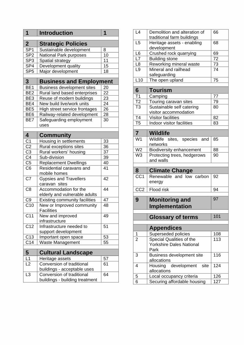
1 Introduction 1
2 Strategic Policies SP1 Sustainable development 8 SP2 National Park purposes 10 SP3 Spatial strategy 11 SP4 Development quality 15 SP5 Major development 18
3 Business and Employment BE1 Business development sites 20 BE2 Rural land based enterprises 22 BE3 Reuse of modern buildings 23 BE4 New build live/work units 24 BE5 High street service frontages 26 BE6 Railway-related development 28 BE7 Safeguarding employment
uses 30
4 Community C1 Housing in settlements 33 C2 Rural exceptions sites 36 C3 Rural workers’ housing 37 C4 Sub-division 39 C5 Replacement Dwellings 40 C6 Residential caravans and
mobile homes 41
C7 Gypsies and Travellers caravan sites
42
C8 Accommodation for the elderly and vulnerable adults
44
C9 Existing community facilities 47 C10 New or Improved community
Facilities 48
C11 New and improved infrastructure
49
C12 Infrastructure needed to support development
51
C13 Important open space 53 C14 Waste Management 55
5 Cultural Landscape L1 Heritage assets 57 L2 Conversion of traditional
buildings - acceptable uses 61
L3 Conversion of traditional buildings - building treatment
64
L4 Demolition and alteration of traditional farm buildings
66
L5 Heritage assets - enabling development
68
L6 Crushed rock quarrying 69 L7 Building stone 72 L8 Reworking mineral waste 73 L9 Mineral and railhead
safeguarding 74
L10 The open upland 75
6 Tourism T1 Camping 77 T2 Touring caravan sites 79 T3 Sustainable self catering
visitor accommodation 80
T4 Visitor facilities 82 T5 Indoor visitor facilities 83
7 Wildlife W1 Wildlife sites, species and
networks 85
W2 Biodiversity enhancement 88 W3 Protecting trees, hedgerows
and walls 90
8 Climate Change CC1 Renewable and low carbon
energy 92
CC2 Flood risk 94
9 Monitoring and Implementation
97
Glossary of terms 101
Appendices 1 Superseded policies 108 2 Special Qualities of the
Yorkshire Dales National Park
113
3 Business development site allocations
116
4 Housing development site allocations
124
5 Local occupancy criteria 126 6 Securing affordable housing 127

Introduction Yorkshire Dales Local Plan
Adopted version
1
1. Introduction 1.1 The Yorkshire Dales Local Plan 2015 to 2030 is a strategy for new development in the National Park. It sets out local policy to steer development decisions and guide planning applications. It will replace the existing Yorkshire Dales Local Plan 2006, Housing Development Plan 2012 and the Minerals and Waste Local Plan 1998 as the statutory development plan for the National Park (see Appendix 1 for a full list of superseded policies). A supplementary planning document dealing with design issues has also been produced to support its policies1.
Strategy 1.2 The purpose of the Local Plan is to help deliver sustainable development2. It responds to the national growth agenda and is a step change in policy that will extend the scope and flexibility for new development that is needed in the Park, or which would otherwise be beneficial to it. 1.3 The Local Plan has been prepared by the National Park Authority in consultation with a wide range of local organisations, stakeholders and residents. A key role of the Local Plan is to help to deliver the ambitions set out in the Yorkshire Dales National Park Management Plan3.. The Management Plan was itself subject to extensive public consultation during 2012. It recognises that people are at the heart of looking after this special place — the people who farm, manage and own the land; the people who live in and own the buildings; the people who own and work in the businesses; the people that give up their time to volunteer; and, the people who visit and love this National Park. 1.4 This is a Plan for more development over the next 15 years than the last 15. It will permit new building and the change of use of land and buildings that will support people living and working in the area. It is also intended to encourage new families and new businesses to move into the area to help sustain local communities. It continues a long-term strategy of focusing new development in towns, villages, farmsteads and rural estates and attempts to make better use of existing assets, such as the large supply of under-used traditional farm buildings. It also encourages specific new development such as a widening in the range of visitor accommodation to increase overnight stays. It provides a flexible approach to facilities to encourage a more rounded visitor experience to keep people returning and to attract new visitors. The Plan will, however, continue to safeguard the Special Qualities that make the National Park distinctive4. Not only do these provide the basis for a multi-million pound tourism industry, they are part of the cultural fabric of the area, and what makes the National Park such a high quality place to live, work and visit.
High quality development 1.5 It is important that new development is to a high standard of design and quality, so that it can serve many generations to come. Most development has a visual impact but some forms of development also have a long-term impact on the intensity of use in an area, for example in terms of vehicle movements or use of services such as shops, waste collection or water supply. If new development is of a high quality it will add to the high quality of the National Park environment and will tend to encourage spending, create employment and maintain quality of life for residents. 1 Yorkshire Dales National Park Authority (2015) Design Guide. 2 The Local Plan is accompanied by and has been informed by a Sustainability Appraisal. This tests the Plan’s objectives and policies against a series of sustainability objectives to ensure that it effectively contributes to the achievement of sustainable development. 3 The Yorkshire Dales National Park Management Plan 2013 is the over arching strategy for the area. It was prepared by a partnership of 14 public, private and voluntary sector organisations and contains a vision, 6 ambitions and 53 objectives to achieve by 2018 or beyond. 4 The Special Qualities that make the Yorkshire Dales National Park distinctive are listed in the National Park Management Plan 2012. They are reproduced in Appendix 2.

Introduction Yorkshire Dales Local Plan
Adopted version
2
Allocations and constraints 1.6 The Local Plan proposes a number of sites for the development of new business and employment opportunities. A flexible range of uses are proposed with the objective of making it easier for developers to bring forward viable schemes. 1.7 The National Park already has a supply of housing land sufficient for more than five years of building at the target rate of 55 dwellings per annum. Allocated housing sites and housing development boundaries around towns and villages are identified on the Policies Map. The Local Plan also provides new flexibility for a wider mix of house types and a wider definition of ‘local occupancy’ – to stimulate new housing development while seeking to protect housing on small sites from being occupied as second homes. Further sites may be allocated after 2020, if monitoring reveals a shortfall in supply in the second half of the Local Plan period. 1.8 In the deeply rural context of the Yorkshire Dales, however, most development will actually come forward from landowners and developers in the form of planning applications on unplanned sites, rather than on the allocated sites on the Policies Map. The Local Plan, therefore, consists predominantly of criteria-based policies that the Authority will use to weigh proposals as they emerge. 1.9 One of the roles of the Local Plan is to identify areas where development should be avoided. The Policies Map identifies quite extensive areas of the National Park that are protected because of their wildlife importance, or their Special Qualities of tranquillity and openness5. It has not, however, attempted to identify every area of environmental significance, but has instead focussed on locally designated features.
The Yorkshire Dales National Park
1.10 The Yorkshire Dales is the second largest National Park in England. It covers 1,762 square kilometres which is an area larger than the counties of Worcestershire, Surrey or Hertfordshire. Around 95% of the land is in private ownership. It has a population of 19,761 people living in 8,804 households (2011). The most populous parish is Sedbergh, with 2,765 residents. Eighty eight per cent of the National Park is within the County of North Yorkshire and 12% is within the County of Cumbria. It includes parts of the Districts of Richmondshire, Craven and South Lakeland (Figure 1). 1.11 The Local Plan covers the whole of the Yorkshire Dales National Park. Designated by Government in 1954 the National Park has two statutory purposes set out in the 1949 National Parks and Access to the Countryside Act, as amended by the 1995 Environment Act:
to conserve and enhance natural beauty, wildlife and cultural heritage; and
to promote opportunities for the understanding and enjoyment of the Special Qualities of the National Park by the public.
1.12 . The Yorkshire Dales National Park Authority was established as an independent body to pursue the statutory purposes in 1997. It has a duty under Section 62(1) of the Environment Act:
in taking forward the national park purposes, [to] seek to foster the economic and social well-being of local communities within the National Park.
5 The Local Plan is accompanied by and has been informed by a screening assessment under the Habitats Regulations. This has concluded that the Plan would not be likely to have a significant effect on any European site, either alone or in combination with any other plans or projects. Habitats Regulations Assessment Screening in relation to the Yorkshire Dales Local Plan 2015-2030, November 2015

Introduction Yorkshire Dales Local Plan
Adopted version
3
The ‘socio/economic duty’ is therefore a key driver of planning policy throughout the Local Plan.
Figure 1: Yorkshire Dales Local Plan key diagram (to be inserted)
Success and challenges 1.13 The quality of life for residents is generally good with low unemployment, high skills, low crime and better than average health. Communities in the National Park tend to be well organised and effective self-helpers. The Special Qualities of the area and its distinctive character attracted over 3.5 million visitors in 2011. 1.14 Despite its strong assets, the area faces some very significant challenges to its sustainability. The 2011 Census revealed that the population has stopped growing for the first time since 1970. The imbalance between the proportion of people aged over 65 (26%) and the proportion aged under 15 (15%) is now large. The existing open market housing stock remains very attractive to people wishing to retire to the National Park, while this external demand pushes up prices beyond the reach of many local families and first-time buyers. The Census also revealed that 22% of housing is now second homes or holiday lets. Collectively, these issues pose long term problems for economic and social vitality. New housing is needed to meet the projected growth in smaller households, increase the supply of affordable housing, widen the range of stock with modern amenities, and to attract new ‘low impact’ businesses with high quality jobs. 1.15 Wages are low, particularly in relation to house prices. Despite low unemployment, there is a need to widen the range of business and create better-paid jobs to improve resilience and keep people living in the area. Capacity for growth exists on sites next to existing business, on brownfield land, and through higher levels of home working. The growth plans of neighbouring authorities will benefit communities living inside the National Park by widening job opportunities and improving services, although this will be predominantly through development in larger settlements outside the Local Plan area. 1.16 Upland farming, which is crucial to many of the Special Qualities of the National Park, continues to face long terms pressures and is in decline as a local employer. The general trend is an economy that is restructuring away from land based industries and towards more service sector jobs. Opportunities remain, however, to make better use of agricultural land and assets and to add value and diversify into new businesses. For example, it is estimated that there are as many as 6,000 traditional farm buildings in the National Park, of which 4,500 are field barns. These are an iconic part of the Dales landscape, yet more than 40% are in very poor condition and will eventually be lost if new uses cannot be found or repair is not possible. Greater flexibility in local planning policy could support new economic uses for at least some of these buildings or could contribute resources for their repair, slowing the rate of their decay. 1.17 In common with other remote rural areas, the National Park has continued to lose shops and schools in recent years. Increased centralisation of public services, industry, leisure and retail provision further away from the Park is having a detrimental impact on local communities and reducing its wider attractiveness as a place for families to move into. 1.18 Reliance on broadband communication becomes even more important when other services are declining. High-speed broadband and mobile phone coverage remains patchy because the low population density makes it financially unattractive to telecommunication companies. That situation is gradually being improved through Government intervention to support rollout to remote rural areas and self-help by some communities.

Introduction Yorkshire Dales Local Plan
Adopted version
4
1.19 Maintaining existing public transport and developing new transport corridors such as the Wensleydale Railway will offer long term challenges but also cross-boundary opportunities for greater connectivity. 1.20 Most of the Plan area is not connected to the gas grid. The housing stock is old, frequently under-occupied and inefficient in energy use. The difficulty and expense of adequately heating homes has a negative impact on quality of life. Modern, smaller, cheaper, energy-efficient housing is needed together with affordable energy solutions that will improve the performance of the existing stock. 1.21 The National Park needs to remain attractive and relevant to visitors in order to support its economy and keep local services. This means encouraging visitors to return and attracting new markets by offering accommodation, facilities and activities that meet modern expectations. 1.22 National policy requires Local Plans to steer development away from flood risk areas and to slow surface water run-off from new development to reduce downstream flooding. New development should contain measures to improve resilience to extreme weather events and the long-term effects of climate change. The planning system also has a role to play in minimising climate altering emissions and steering development into locations that will not consume excessive non-renewable resources. 1.23 Reduced public and private finance to support development is rebalancing the expectations of landowners and making financial viability a more important planning consideration than it used to be. On the one hand, the Local Plan should try to ensure that new development is of high quality and will make a fair contribution to local infrastructure. On the other, it must avoid making development so expensive that it does not take place at all. 1.24 The long-term challenge of maintaining the area’s wildlife and the conservation of its heritage assets will continue. The Plan is an opportunity to enhance biodiversity from all scales of new development and for the first time to identify the Park’s ecological corridors that are important to the movement of wildlife.
Cross-boundary planning issues 1.25 The Local Plan area corresponds to the National Park boundary which has been defined in relation to the desirability of promoting National Park purposes (1.11). As a result the Plan area does not reflect the functional human geographies that the Plan needs to respond to. 1.26 The National Park has three constituent District Councils (Craven, Richmondshire, South Lakeland). The boundaries of the District Council areas within the National Park correspond with the upland watersheds of the main river catchments that flow outwards from the Park’s interior. The river catchments form the distinctive radial arrangement of Dales that provide the key physical framework for human settlement and transport corridors. 1.27 As a result, it is the three constituent District Council areas, and the individual Dales within them, that largely define the functional human geography of the area. They strongly influence the interactions between areas within the National Park and those outside it and characterise the predominant housing market and travel to work areas (Figure 1). 1.28 Within each main Dale there is typically a local service centre, linked to a range of service villages and smaller settlements. Across much of the National Park, subsidiary service villages and other smaller settlements look primarily towards the local service centre to provide a range of basic services in the first instance.

Introduction Yorkshire Dales Local Plan
Adopted version
5
1.29 There are however complexities in the relationships between settlements, Dales and Districts, including where:
settlements are remoter from the local service centre which results in a more direct relationship with towns outside the Park, for example Lower Wensleydale in relation to Leyburn or Upper Swaledale in relation to Kirkby Stephen;
settlements with access to key transport routes allow a greater variety of movements
between Dales and across District boundaries. This includes those that penetrate the upland watersheds (e.g. the Settle-Carlisle Railway and better road links from and into Upper Wensleydale) and lowland corridors on the periphery of the Park such as the Aire Gap through which the Leeds-Morecambe-Carlisle railway line and A65 pass.
1.30 Whatever the precise nature of the relationships between settlements, Dales and Districts, a common theme is that, in such a deeply rural area, there is inevitably reliance on key centres beyond the National Park boundary to service the needs of its resident communities. Growth in services, employment, infrastructure and housing in the Districts beyond the National Park is very important to the viability of communities within the Park. 1.31 This reliance on larger towns means that the matters of greatest strategic cross boundary interest tend to be housing, local services and infrastructure, as well as the value of the National Park’s environmental assets and special qualities. These issues are the main focus of the Duty to Cooperate discussions required by the Localism Act 2011 to ensure that neighbouring planning authorities engage constructively on relevant cross-boundary planning matters. 1.32 The emphasis for new housing provision inside the National Park is on meeting the social and economic needs of its communities. It should also provide opportunities to attract younger working households to live in the Park and help support local services. Some significant changes to housing policy have been incorporated into the Local Plan in response to a changing population and economy. The Plan recognises that some open market housing is now necessary to make sites financially capable of delivering affordable housing. However the likely scale of development and strong housing market makes it unlikely that all housing demand can be met inside the Park. 1.33 Other than the Settle-Carlisle Railway, there are no major transport corridors through the Yorkshire Dales and there are no proposals for regional-scale retail or other forms of development inside the Plan area. That leaves the main cross-boundary planning issues as:
Agriculture and food products. The National Park is an important area for livestock breeding and rearing and the food products associated with this.
Community facilities. The National Park is reliant on areas outside its boundary for the full range of community services, particularly health, further education, leisure, retail services and waste disposal/processing. Decisions to move some services out of the Park or further away from its edge, will harm communities living in the Plan area.
Gateway towns and facilities. The settlements of Richmond/Catterick Garrison, Leyburn, Skipton, Gargrave, Settle, Ingleton, Kendal and Kirkby Stephen provide jobs and services to communities living in the Park and facilities and accommodation for visitors.
Large scale development. National policy avoids locating major development in protected landscapes because of the likely conflict with nationally important environmental assets. The main cross boundary issue therefore tends to be large-scale development situated outside the Park boundary but close enough to have visual or other impacts on its qualities. e.g. commercial wind farms.
Minerals. The National Park is a producer of regional scale importance for crushed rock aggregate and skid resistant road surfacing.

Introduction Yorkshire Dales Local Plan
Adopted version
6
National Park purposes: conservation and public enjoyment. The National Park has a regional and national role as a protected landscape and visitor attraction. It contains assets of national and international wildlife and heritage importance, some of which also cross its boundaries. Planning decisions that affect the purposes of the National Park, or which affect local or sub-regional infrastructure, will be of relevance to various public and private agencies.
Recreational routes. The National Park is crossed by the Pennine Way and the Pennine Bridleway national trails. Other strategic recreational routes include the popular Coast-to-Coast path and the Dales Way.
River catchments. The National Park is a watershed between the Irish and North seas. It includes the tops of several major river catchments, which means it has a cross-boundary role in maintaining and improving water quality and reducing downstream flooding, particularly in a number of key regional urban centres.
Section 62 duty. Planning authorities, government agencies and public utility companies are required by the Environment Act 1995 to have regard to national park purposes in undertaking their functions. This is implemented through decision-making, consultation on neighbouring planning applications, and early discussion of projects that might affect the conservation or enjoyment of the National Park.
Communications. Mobile phone reception is unreliable across the National Park and broadband provision is patchy and frequently slow. Improving both is a priority infrastructure issue. Public transport connections need to be supported and the potential for integrated journeys into West Yorkshire and other surrounding concentrations of population investigated.
Settle/Carlisle and Wensleydale Railway: The Settle/Carlisle railway is part of the national strategic rail network and a vital transport corridor for residents and visitors alike. The proposed re-instatement of the Wensleydale Railway is a cross-boundary economic and transport opportunity shared with South Lakeland, Richmondshire and Hambleton District Councils.
1.34 The first ‘duty to co-operate’ meetings were held during the Local Plan Options stage in Autumn 2013. Since then the Authority has collaborated with its neighbours through an ongoing dialogue and by sharing evidence on flood risk modelling, undertaking minerals and waste assessments, consulting on Neighbourhood Plans, and working on assessments of housing and employment land.
Vision 1.35 In conformity with the objectives of national planning policy, the Local Plan will support development that will help keep the National Park a thriving place for the communities that live and work here, and the visiting public. The Local Plan is also one of the tools that the National Park Authority and its partners will use to deliver the shared ambitions in the National Park Management Plan. It is therefore logical for the Local Plan to share the same 25 year vision, and key thematic objectives, with the Management Plan, but to develop its own planning objectives and policies. This shared overarching vision is articulated as follows: Through their passion for this special place, local people and businesses will keep the Yorkshire Dales National Park a thriving area. Its unique cultural landscape will be treasured for its stunning scenery, exceptional heritage and wonderful wildlife, and every year millions of people will be inspired to be a part of it.

Strategic Policies Yorkshire Dales Local Plan
Adopted version
7
2. Strategic Policies Objectives
1. Support locally-sustainable development that will improve the National Park as a high quality place to live, work and visit.
2. Support development that will maintain existing services or develop new ones for the benefit of local communities.
3. Encourage development that will support a growing, diverse and resilient economy, and which will help make the National Park a more attractive option for young adults and people of working age to live in.
4. Use the planning system to help deliver the statutory National Park purposes of: conservation and enhancement of natural beauty, wildlife and cultural heritage; and, the promotion of opportunities for the understanding and enjoyment of the Special Qualities of the National Park by the public.
5. Encourage development in locations with the best access to existing services and facilities, and where it will not be vulnerable to the impacts of climate change or will increase resilience to it.
6. Support innovative, high-quality and more sustainable building design that complements the distinctive character of the National Park.
7. Ensure the landscape of the National Park continues to be responsive to change while at the same time conserving and enhancing its character.
The strategic policies SP1 – SP5 are applicable to all planning decisions during the Local Plan period.

Strategic Policies Yorkshire Dales Local Plan
Adopted version
8
SP1 Sustainable Development The Yorkshire Dales National Park Authority will presume in favour of development that is sustainable. Sustainable development in the Local Plan area is development that either achieves or does not prejudice the achievement of the following:
a) makes the National Park a high quality place to live and work – including: improving and supporting the use and retention of existing services, infrastructure and facilities, including the housing stock and workplaces;
b) encourages mixed uses, reducing the need to travel;
c) contributes positively to the built environment by having regard to the site context and conforms to the National Park Design Guide;
d) conserves or enhances the landscape character6 of the National Park through use of high quality design, appropriate landscaping, and removal of unsightly development;
e) improves biodiversity by enhancing existing priority habitats and species or creates new priority habitat;
f) improves public access to, and enjoyment of, the National Park’s Special Qualities7;
g) reduces waste and greenhouse gas emissions through compliance with the spatial strategy, improved energy efficiency and making full use of small-scale renewable energy;
h) avoids areas at risk of flooding and is resilient and responsive to the impacts of climate change;
i) conserves or enhances the historic environment and helps secure a sustainable future for the assets at risk.
Development will be deemed to be unsustainable if it would reduce:
j) the health and well-being of local communities;
k) the diversity, quality and local distinctiveness of the natural and cultural landscape, wildlife, historic environment or other Special Qualities of the National Park;
l) the strength, diversity or vitality of the local economy;
m) the supply of housing to meet local needs;
n) access to local services and community facilities. Aim 2.1 To encourage and support development that is sustainable in the context of the Yorkshire Dales National Park and national planning policy. Justification 2.2 The UK government guiding principles for sustainable development include living within environmental limits; ensuring a strong, healthy and just society and achieving a sustainable economy. In national planning policy terms sustainable development is regarded as ‘positive growth’ i.e. delivering economic, environmental and social progress for current and future generations. The National Planning Policy Framework regards the fundamental purpose of the planning system as making development as sustainable as possible. 2.3 There are three dimensions to sustainability:
6 Defined in: Estell Warren (2011) Yorkshire Dales National Park Landscape Character Assessment, and; Natural England (2013) National Character Area Profile for the Yorkshire Dales (NCA21), and; Natural England (2014) National Character Area Profile for The Howgills. 7 See Appendix 2

Strategic Policies Yorkshire Dales Local Plan
Adopted version
9
economic – contributing to a strong, responsive and competitive economy, by ensuring that appropriate opportunities are realised;
social – supporting strong, vibrant and healthy communities, through the supply of housing, accessible local services and by creating a high quality built environment;
environmental – protection and enhancement of the natural, built and historic environment; minimising waste; and, mitigating and adapting to climate change.
2.4 Energy efficiency is an important aspect of sustainability in the National Park, particularly in relation to the social and economic impacts of fuel poverty. The Local Plan does not contain a policy that prescribes a set level of energy efficiency in new buildings, or that requires consequential improvements to existing buildings. This is because the national Building Regulations promote energy efficiency and are already seeking staged improvements towards a zero carbon standard for many new buildings. Also, flexibility is preferred over prescription; especially given the number of listed and traditionally constructed buildings, where more bespoke energy efficiency measures need to be considered. 2.5 In the context of the Yorkshire Dales National Park, development will be sustainable where it achieves the three dimensions in paragraph 2.3 and helps keep people living and working in the area with a good quality of life. In doing so, however, it should not erode the Special Qualities of the Park, which are its unique assets and lie at the heart of developing a stronger local economy.

Strategic Policies Yorkshire Dales Local Plan
Adopted version
10
SP2 National Park Purposes Development will be permitted that furthers the statutory National Park purposes of:
a) conserving and enhancing natural beauty, wildlife and cultural heritage;
b) promoting opportunities for the understanding and enjoyment of the Special Qualities of the National Park by the public.
Development that prejudices these purposes will not be permitted although an exception may be made where development can demonstrate an overriding need and the harm can be mitigated or, as a last resort, compensatory measures can be agreed. Aim 2.6 To support development that will help to deliver the two statutory purposes of National Parks. Justification 2.7 The Yorkshire Dales National Park is a part of the cultural and natural heritage of the nation. It is a working landscape; its natural beauty influenced by centuries of farming and other human activity. It contains important heritage assets, wildlife species, habitats and geological diversity, many of which are recognised as being of national or international importance, and are protected by law. 2.8 The statutory purposes of national parks are set out in paragraph 1.11 and repeated in the policy. 2.9 National policy gives great weight to the protection of the Special Qualities of the National Park, such as its landscape, wildlife and cultural heritage. Planning decisions can also support the viability of related businesses, such as upland livestock farming, that help to maintain many of the Special Qualities. 2.10 The second purpose of ‘understanding and enjoyment’ is less likely to be influenced through the planning system although policies that support visitor related accommodation and facilities will contribute. 2.11 The second purpose is also relevant to conservation because it aims to promote the ‘Special Qualities’ which attract people to the National Park in the first place. It follows that if the Special Qualities are damaged, for example by insensitive development, then that will obstruct their enjoyment by the public. The assumption therefore is that the Special Qualities are a subset of the landscape, wildlife, cultural heritage and the enjoyment of being in the Park. 2.12 Where a development proposal would create conflict between the two statutory purposes, the purpose of conservation is given preference. This is a long-standing presumption known as the ‘Sandford Principle’, which has been repeated most recently in Government Circular advice on National Parks published in 20108. Experience indicates that ‘Sandford’ conflicts tend to be very rare in the Yorkshire Dales. Where they have been encountered, it has usually been possible to resolve the conflict through negotiation and the use of conditions or management agreements attached to a planning permission. 2.13 The majority of development proposals in the Park are modest in scale. Through negotiation on aspects of design and mitigation, it is usually possible to ensure that they do not have a negative impact on the statutory purposes. By the same token, a number of policies in the Plan seek to realise positive effects on statutory purposes, for example by securing the re-use of traditional buildings and opportunities for people to visit and stay in the National Park.
8 DEFRA (2010) English National Parks and the Broads: UK Government Vision and Circular
Strategic Policies Yorkshire Dales Local Plan
Adopted version
11
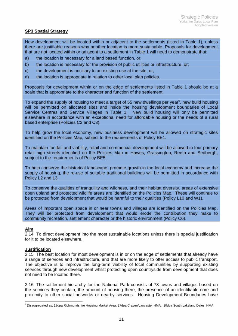
SP3 Spatial Strategy New development will be located within or adjacent to the settlements (listed in Table 1), unless there are justifiable reasons why another location is more sustainable. Proposals for development that are not located within or adjacent to a settlement in Table 1 will need to demonstrate that:
a) the location is necessary for a land based function, or;
b) the location is necessary for the provision of public utilities or infrastructure, or;
c) the development is ancillary to an existing use at the site, or;
d) the location is appropriate in relation to other local plan policies. Proposals for development within or on the edge of settlements listed in Table 1 should be at a scale that is appropriate to the character and function of the settlement. To expand the supply of housing to meet a target of 55 new dwellings per year9, new build housing will be permitted on allocated sites and inside the housing development boundaries of Local Service Centres and Service Villages in Table 1. New build housing will only be permitted elsewhere in accordance with an exceptional need for affordable housing or the needs of a rural based enterprise (Policies C2 and C3). To help grow the local economy, new business development will be allowed on strategic sites identified on the Policies Map, subject to the requirements of Policy BE1. To maintain footfall and viability, retail and commercial development will be allowed in four primary retail high streets identified on the Policies Map in Hawes, Grassington, Reeth and Sedbergh, subject to the requirements of Policy BE5. To help conserve the historical landscape, promote growth in the local economy and increase the supply of housing, the re-use of suitable traditional buildings will be permitted in accordance with Policy L2 and L3. To conserve the qualities of tranquility and wildness, and their habitat diversity, areas of extensive open upland and protected wildlife areas are identified on the Policies Map. These will continue to be protected from development that would be harmful to their qualities (Policy L10 and W1). Areas of important open space in or near towns and villages are identified on the Policies Map. They will be protected from development that would erode the contribution they make to community recreation, settlement character or the historic environment (Policy C6). Aim 2.14 To direct development into the most sustainable locations unless there is special justification for it to be located elsewhere. Justification 2.15 The best location for most development is in or on the edge of settlements that already have a range of services and infrastructure, and that are more likely to offer access to public transport. The objective is to improve the long-term viability of local communities by supporting existing services through new development whilst protecting open countryside from development that does not need to be located there. 2.16 The settlement hierarchy for the National Park consists of 78 towns and villages based on the services they contain, the amount of housing there, the presence of an identifiable core and proximity to other social networks or nearby services. Housing Development Boundaries have
9 Disaggregated as: 18dpa Richmondshire Housing Market Area, 27dpa Craven/Lancaster HMA, 10dpa South Lakeland Dales HMA

Strategic Policies Yorkshire Dales Local Plan
Adopted version
12
been saved from the Housing Development Plan 2012 and are identified on the Policies Map. These identify lines inside of which infill housing and residential conversion will be permissible, in principle, during the Plan period. ‘Settlement boundaries’ have not been defined on the Policies Map which means that non-housing development has more flexibility to locate on land inside or on the periphery of settlements in Table 1.
Table 1 – Settlement hierarchy
District Sub-area Key centres
outside National Park
Local service centres
Service villages
Small settlements
Craven
Wharfedale &
Malhamdale
Skipton
Gargrave
(Pateley Bridge)
Grassington
Threshfield
Airton
Appletreewick
Arncliffe
Bolton Abbey
Buckden
Burnsall
Cracoe
Embsay
Hebden
Hetton
Kettlewell
Kirkby Malham
Linton
Malham
Calton
Conistone
Eastby
Kilnsey
Litton
Rylstone
Starbotton
Stirton
Ribblesdale &
Chapel le Dale
Settle
Giggleswick
Ingleton
Hellifield
Settle
Giggleswick
Ingleton
Austwick
Clapham
Horton
Langcliffe
Long Preston
Stainforth
Stackhouse

Strategic Policies Yorkshire Dales Local Plan
Adopted version
13
District Sub-area Key centres
outside National Park
Local service centres
Service villages
Small settlements
Richmondshire
Wensleydale, Bishopdale & Coverdale
Leyburn
Richmond
Catterick Garrison
(Kirkby Stephen)
Hawes
Gayle
Askrigg
Aysgarth
Bainbridge
Burtersett
Carlton
Carperby
East Witton
Thoralby
Thornton Rust
West Burton
West Witton
Appersett
Breconbar
Castle Bolton
Hardraw
Horsehouse
Marsett
Melmerby
Newbiggin (Bishopdale)
Sedbusk
Stalling Busk
West Scrafton
Woodhall
Worton
Swaledale & Arkengarthdale
Reeth
Grinton
Gunnerside
Healaugh
Hudswell
Langthwaite
Low Row
Muker
Fremington
Keld
Marrick
Marske
Thwaite
South Lakeland
Dentdale, Garsdale, Rawthey Valley & Lonsdale
Kendal
Kirkby Lonsdale
Sedbergh Dent
Millthrop
Garsdale Street
Gawthrop

Strategic Policies Yorkshire Dales Local Plan
Adopted version
14
2.17 Development will be permitted outside towns and villages where it supports farms and rural enterprises that derive their primary inputs from the land or where it provides public infrastructure, or would otherwise comply with specific policies in the Local Plan. 2.18 Larger scale development should be located on sites with capacity to accommodate it. The services, infrastructure and attributes of a settlement should be capable of benefitting from the development or be capable of being upgraded in relation to it, without harm to the community living there or the character, appearance, or landscape setting of the settlement. Larger scale development is encouraged to locate on the business sites allocated on the Policies Map rather than on greenfield sites adjacent to small settlements. 2.19 There are many under-used traditional farm buildings scattered across the Local Plan area. These form a distinctive Special Quality of the National Park but some offer potential for new uses, irrespective of their sub-optimal location in sustainability terms. The appropriateness of these buildings for conversion and the impacts resulting from an intensification of their use are considerations informed by Policy L2, L3 and the Traditional Farm Buildings ‘Toolkit’10. 2.20 Sixty per cent of the National Park is undeveloped moorland, heathland and rough grassland. These extensive areas of open upland have particular qualities of tranquillity and remoteness that have been protected since the 1980s in recognition of their huge value for public access and recreation11. The open upland also contains the majority of the National Park’s nationally and internationally designated wildlife habitat. Although they appear relatively wild, many of the Special Qualities of these areas depend on active management by farmers and landowners. Policy L10 protects open upland as areas of general development constraint but retains scope for development required for their management. 2.21 The designation of important open space is a requirement of national planning policy. Areas of open space within towns and villages that are important for recreation, amenity or heritage have been reviewed in consultation with local communities and are identified on the Policies Map for safeguarding.
10 Yorkshire Dales National Park Authority (2015) Traditional farm Buildings Toolkit 11 Section 3 Map of Mountain and Moorland, Wildlife and Countryside Act 1985

Strategic Policies Yorkshire Dales Local Plan
Adopted version
15
SP4 Development quality All development proposals should conform to the following criteria: Design a) the design is informed by, and responds positively to the site, its surrounding context and
landscape setting, so that the scale, height, proportions, massing, form, materials and appearance of buildings and structures are sympathetic and complementary;
b) it conserves or enhances the archaeological, architectural and historical character and appearance of the site and its setting;
c) the design is high quality, has visual interest and reinforces local distinctiveness; d) the design ensures a development that is environmentally sustainable, minimises the
consumption of resources, and is long lasting and adaptable; e) it maintains or enhances the ecological, geological and geomorphological value of the site; f) it will be accessible for all users including those with a range of mobility needs; Transport g) it does not prejudice highway safety or cause unacceptable levels of traffic that would harm
the environment or capacity of the local road network; h) it contains adequate provisions for connection to public transport; i) where the proposal would generate significant movements of traffic a Transport Statement
will be required. For large scale proposals, a Transport Assessment will be required to indicate methods to manage the scale of movement and avoid congestion;
j) it will not obstruct, damage or lead to an unacceptable use of a public right of way unless an agreed alternative route has been provided;
k) it will have appropriate access and parking provision; Human safety and amenity l) it is located in an area identified as being at the lowest risk of flooding unless it satisfies
relevant sequential and exception tests and it can be demonstrated that the development will remain safe for users without increasing the risk of flooding elsewhere12;
m) if located near to land known or suspected of being contaminated or unstable, a full assessment demonstrates that it will not give rise to unacceptable risks to human health or the environment. This may require suitable remedial works to be carried out in advance of development;
n) it respects the amenity of neighbours and the adequate level of amenity for its future occupants in relation to nearby uses;
o) it will be safe and not vulnerable to crime; p) it will be served by appropriate and adequate storage, waste management and other
infrastructure; Environmental safeguarding It will not give rise to unacceptable, adverse impacts in terms of any of the following: q) the quality or quantity or flow of surface or ground water; r) the quality of the air, land or soil; s) the level of noise and dust/particulates, vibration or natural light; t) the darkness of the night sky; and, u) important public views. Aim 2.22 To ensure the design of new development is high quality and to avoid harmful impacts and danger. 12 See flood risk policy CC2

Strategic Policies Yorkshire Dales Local Plan
Adopted version
16
Justification 2.23 This policy applies to all development proposals. It aims to address some of the fundamental planning issues such as visual appearance, human safety, environmental protection and impact on local amenity. Having a single list of detailed criteria reduces repetition elsewhere in the Local Plan. 2.24 Design is a key aspect of sustainable development. It goes to the heart of most planning proposals. Attitudes to design, especially in an area with such a strong vernacular built tradition, are shaped by what has gone before but will also need to adapt to suit changing technologies, materials, climate, building styles and expectations. 2.25 The Yorkshire Dales National Park has a distinctive built heritage that is recognised as one of its most cherished qualities. The prevalent use of local stone and vernacular design with little architectural detail is characteristic of the area. 2.26 Despite modern architecture being less common in the National Park than elsewhere there are still some very good contemporary buildings that have enhanced their surroundings. Examples that have been professionally recognised include Scargill Chapel, St Margaret Clitherow’s Church, and even the circular bus shelter in Grassington. Many new buildings however are designed in a pseudo-traditional style to blend with existing stone buildings. 2.27 The challenge lies in managing change in a sympathetic way to ensure that new buildings respond to modern needs yet sit in harmony with the historic structures in the surrounding area. This needs to start with a clear appreciation of context, so that proposals can be designed to ‘fit in’, without slavishly reproducing designs from the past. With larger scale development it will require an understanding of how the site relates to the wider landscape. 2.28 The rural nature of the Yorkshire Dales clearly requires different solutions from an urban environment. National Park designation also brings with it a requirement for planning decisions to conserve and enhance the cultural heritage, wildlife and natural beauty of the area. The consequence is that development solutions will tend to be more restrictive and require greater sensitivity to their context. The National Park Authority nevertheless encourages innovation in architecture, materials and technology for new buildings but will normally require more traditional methods for changes to historic buildings. 2.29 To help designers and developers respond to these challenges the Authority has prepared a supplementary Design Guide to provide advice about, and examples of, the quality expected. The Authority will use it to influence proposals and to negotiate on schemes during pre application discussion. It will be used to support decisions on planning applications. 2.30 This policy also deals with a wide range of human safety and environmental protection issues such as land instability, flooding and pollution of natural resources. For example there are a number of important watercourses within the National Park and the area is underlain by Millstone Grit and Carboniferous Limestone aquifers which are important for local water supplies and in supplying base flow to rivers. In some areas aquifers provide a supply of water where no mains alternative is available. This policy therefore embraces water quality and the ecological status of water bodies, which are affected by a broad range of factors such as land management and historic mineral working. The Water Framework Directive is a key piece of legislation governing protection of the water environment while River Basin Management Plans set out the measures and actions required to achieve an improvement in the ecological status of water bodies. As such, these will be material considerations in planning decisions. Water quality is affected by a range of activities beyond development. In the context of the National Park, harmful run off from relict lead industrial sites or from farming practices are prominent issues, the response to which falls within the ambit of other strategies, most notably the National Park Management Plan.

Strategic Policies Yorkshire Dales Local Plan
Adopted version
17
2.31 One of the Special Qualities of the National Park is the extensive areas that benefit from tranquillity and access to a dark night sky. This is an increasingly scarce resource in England and is protected by national planning policy. Where these qualities are present, proposals for development should avoid harmful levels of noise or light emissions. 2.32 Flooding is a significant risk to life and property, particularly for areas downstream of the National Park. Policy CC2 (flood risk) deals with this in more detail.

Strategic Policies Yorkshire Dales Local Plan
Adopted version
18
SP5 Major Development
Planning permission will only be granted for major development in exceptional circumstances and where it can be demonstrated to be in the public interest. Consideration of such applications should include an assessment of all of the following:
a) the need for the development, including in terms of any national considerations;
b) the impact on the local economy of permitting or refusing it;
c) the cost of, and scope for, developing it outside the National Park, or meeting the need for it in some other way; and,
d) any detrimental effect on the environment, the landscape character, recreational opportunities and the extent to which that could be moderated.
Aim 2.33 To steer very large scale development and national infrastructure away from the National Park. Justification 2.34 National planning policy presumes against major new development in National Parks and Areas of Outstanding Natural Beauty because of the likely harm it would cause to the nation’s long term interest of conserving these places. Major development is defined here as development of more than local significance, which will also have a long-term impact on the landscape, wildlife or cultural heritage of a National Park because of its scale and form. Examples from other National Parks include reservoirs, power stations, large housing estates, dual carriageways, military firing ranges and high voltage overhead power lines. This scale of development has a significant impact on the qualities of a National Park whether it is located inside or adjacent to its boundary. Major development is, therefore, only permitted inside National Parks in exceptional circumstances. Proposals are subject to the most rigorous examination and have to demonstrate that they are genuinely in the nation’s interest if they are to proceed. 2.35 Other than post-war quarrying, the Yorkshire Dales National Park has largely avoided major development. This is partly because it is bypassed by the main communication and infrastructure corridors but also because it does not contain any large settlements.
Business and Employment Yorkshire Dales Local Plan
Adopted version
19
3. Business and Employment Providing an outstanding range of benefits for the nation based on its natural resources, landscape and cultural heritage, which underpin a flourishing local economy Objectives
1. Support development that helps existing businesses, notably small businesses, to thrive.
2. Support development of new ‘low impact’ business to encourage high quality jobs that will help make the National Park a more attractive option for young adults and people of working age to live in.
3. Support the growth and diversification of the farming and rural land-based businesses that help to maintain the Special Qualities of the National Park.
4. Support new development that helps farmers and landowners to reduce diffuse pollution and improve the ecological status of rivers and water bodies in the National Park.
5. Protect existing business and support its expansion or relocation in sustainable locations.
6. Make better use of under-used assets, such as buildings and brownfield land, for new and improved employment and business purposes.
7. Support high streets by permitting retail and other suitable high footfall uses.
8. Enhance the role of the local service centres (Sedbergh, Grassington, Hawes and Reeth) as business locations and support them as hubs for the rural economy and social infrastructure.
9. Support railway related development along the route of the Settle Carlisle railway and support the reinstatement of the Wensleydale Railway.
Business and Employment Yorkshire Dales Local Plan
Adopted version
20
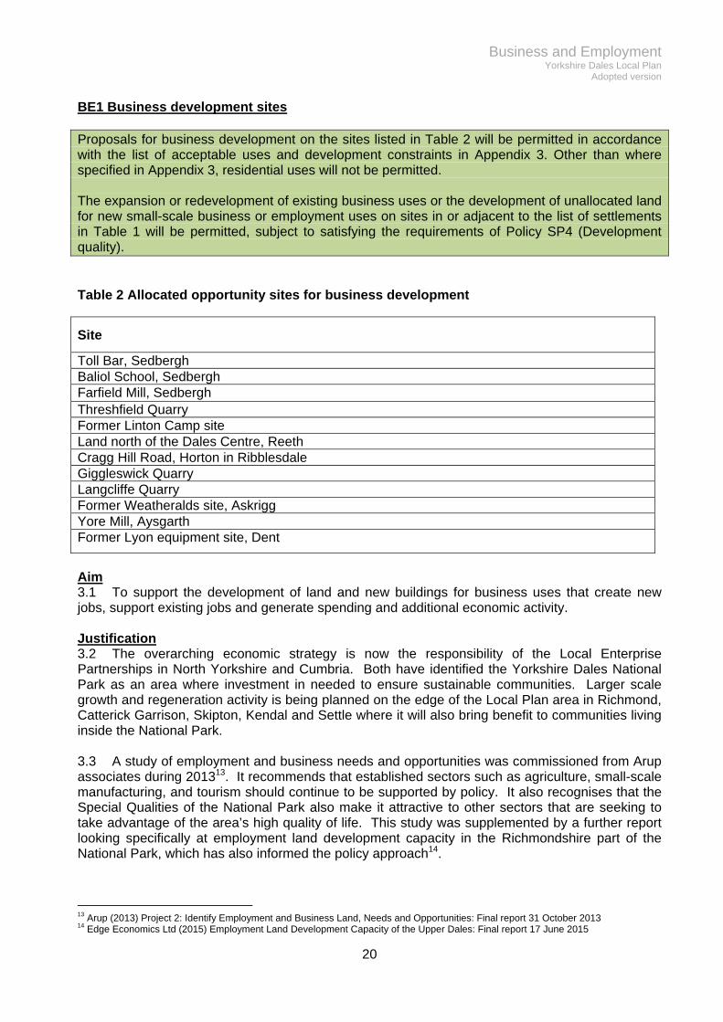
BE1 Business development sites Proposals for business development on the sites listed in Table 2 will be permitted in accordance with the list of acceptable uses and development constraints in Appendix 3. Other than where specified in Appendix 3, residential uses will not be permitted. The expansion or redevelopment of existing business uses or the development of unallocated land for new small-scale business or employment uses on sites in or adjacent to the list of settlements in Table 1 will be permitted, subject to satisfying the requirements of Policy SP4 (Development quality). Table 2 Allocated opportunity sites for business development
Site
Toll Bar, Sedbergh Baliol School, Sedbergh Farfield Mill, Sedbergh Threshfield Quarry Former Linton Camp site Land north of the Dales Centre, Reeth Cragg Hill Road, Horton in Ribblesdale Giggleswick Quarry Langcliffe Quarry Former Weatheralds site, Askrigg Yore Mill, Aysgarth Former Lyon equipment site, Dent
Aim 3.1 To support the development of land and new buildings for business uses that create new jobs, support existing jobs and generate spending and additional economic activity. Justification 3.2 The overarching economic strategy is now the responsibility of the Local Enterprise Partnerships in North Yorkshire and Cumbria. Both have identified the Yorkshire Dales National Park as an area where investment in needed to ensure sustainable communities. Larger scale growth and regeneration activity is being planned on the edge of the Local Plan area in Richmond, Catterick Garrison, Skipton, Kendal and Settle where it will also bring benefit to communities living inside the National Park. 3.3 A study of employment and business needs and opportunities was commissioned from Arup associates during 201313. It recommends that established sectors such as agriculture, small-scale manufacturing, and tourism should continue to be supported by policy. It also recognises that the Special Qualities of the National Park also make it attractive to other sectors that are seeking to take advantage of the area’s high quality of life. This study was supplemented by a further report looking specifically at employment land development capacity in the Richmondshire part of the National Park, which has also informed the policy approach14.
13 Arup (2013) Project 2: Identify Employment and Business Land, Needs and Opportunities: Final report 31 October 2013 14 Edge Economics Ltd (2015) Employment Land Development Capacity of the Upper Dales: Final report 17 June 2015

Business and Employment Yorkshire Dales Local Plan
Adopted version
21
3.4 Releasing new land for business uses is part of the review of planning policy. Five allocated sites remain partly undeveloped from the 2006 Local Plan. The biggest site is at Threshfield quarry near Grassington (5 hectares), which would require significant investment to develop, but remains suitable for a range of uses during the Plan period. 3.5 A number of other, mainly brownfield, sites are identified on the Policies Map. These are mostly close to local service centres or service villages but have some separation from residential areas. The sites are distributed across the National Park so that they are able to counter-balance some of the increasing centralisation of commercial activity and services that have been moving out of rural areas although there may be challenges in terms of ease of access, lack of proximity to markets and possible shortage of employee skills. Appendix 3 provides details about the size of each site, general development constraints and opportunities, and a list of proposed uses. 3.6 The sites lend themselves to a range of uses that would help diversify and strengthen the economy of the park. Collectively these could include digital, media and creative business and financial services, education, administrative, public and utility services, health, hotels and hospitality, leisure, construction, light manufacturing, craft, and retail (although the latter will only be permitted where they would be ancillary to the main use). Businesses that thrive on the National Park’s Special Qualities — such as food production, land management, visitor services, visitor accommodation and outdoor activities — will continue to be supported. 3.7 In addition to allocating sites, the policy also permits the expansion or redevelopment of existing employment uses and will permit wholly new, small-scale sites in or on the edge of service settlements. Small-scale is defined in terms of land of less than 1 acre or 400m2 of new floorspace. New or expanded uses will be considered flexibly but will not be permitted if they conflict with other Local Plan objectives, such as conservation or the protection of residential amenity.

Business and Employment Yorkshire Dales Local Plan
Adopted version
22
BE2 Rural land-based enterprises Agricultural, forestry and other rural land-based development will be permitted if it is necessary to serve the needs of the enterprise in that location and the owner has not been instrumental in disposing of a building within the last 3 years that could otherwise have met the need proposed. Development permitted under the first paragraph of this policy will be required to be dismantled and removed from the site when no longer required for its approved purpose, and the site restored to its former condition, unless permission is given for an alternative use. Diversification of existing land-based enterprises will be permitted if it assists the viability and supports the beneficial aspects of land management and will meet the criteria in policy SP4 (Development quality). New buildings will only be permitted where it can be demonstrated that the conversion or re-use of a suitable existing building cannot accommodate the proposed activity. Aim 3.8 To support new development that will help grow, diversify or improve the viability of farming and other essential rural land management work in the National Park. Justification 3.9 The landscape of the Park has been shaped by farming and other rural land-based enterprises (defined for the purpose of this policy as farming, shooting estates, rural estates, wildlife trusts, National Trust land, the military, and forestry estates; which manage land holdings larger than 5 hectares). It remains one of the main business sectors, with 10% of residents still employed in agriculture in 2011. 3.10 To maintain many of the Special Qualities of the National Park it is important that beneficial types of farming and land management continue. This policy, therefore, supports development necessary for those activities. 3.11 The policy encourages the adaptation of existing buildings. Where this is not possible, the Authority will work constructively to find appropriate sites for new buildings. The National Park Design Guide should provide useful assistance to developers about the construction of new buildings that will be appropriate within the landscape. 3.12 Many large modern agricultural buildings have been permitted where they are necessary for agricultural purposes. In order to enhance the landscape of the Park it is generally desirable that these buildings should be dismantled when no longer required (subject to Policy BE3). 3.13 Farm diversification is another way to grow and improve the resilience of the rural economy. Diversification encompasses activities to enhance the quality and value of farm produce, promote local food, deliver ecosystem services, light manufacturing and contracting that support traditional farming or shooting estates. There are particular opportunities for visitor accommodation, visitor services, nature tourism and recreational activities that make use of the Special Qualities of the area. This policy, therefore, supports and encourages well-conceived diversification schemes that will increase spending, create jobs, improve economic resilience, deliver services and help manage land in accordance with National Park purposes. 3.14 Over time, new uses can sometimes outgrow a rural location. It may be necessary, therefore, to seek legal agreements or impose planning conditions to ensure that new commercial activities remain tied to the agricultural business and do not undermine land management in the longer term.

Business and Employment Yorkshire Dales Local Plan
Adopted version
23
BE3 Re-use of modern buildings Proposals for the change of use of modern buildings to new business and employment uses will be permitted if all the following criteria are met:
a) the building is no longer needed for its current use and will not displace the use elsewhere or conflict with an adjoining use;
b) retaining the building will not perpetuate significant visual harm and any modifications to its appearance and curtilage are acceptable in terms of their impact on the surroundings and on residential amenity;
c) all manufacturing processes and storage are contained wholly within the building or are otherwise visually contained;
d) the proposal should not give rise to demand for the visually intrusive provision, renewal or extension of parking, deliveries, outside storage, external lighting, utility services or place an unnecessary burden on social, community or emergency services;
e) the proposal will accord with policy SP4 (development quality). Aim 3.15 To make more effective use of existing buildings for appropriate new employment and business purposes. Justification 3.16 Modern buildings constructed from the early 20th century onwards are predominantly utilitarian structures that do not enhance the landscape but are essential for modern farming practices. They are mainly steel or wood frame large span structures that have superseded traditional stone farm buildings which are such a notable feature of the landscape. 3.17 On occasion, these modern buildings become surplus to requirements. Depending on the nature and location of the building, there may be benefits to the economy from converting it to a new use. Re-using existing buildings can support farm diversification and will avoid or delay the expense and impact of constructing a wholly new building. 3.18 Not all modern buildings will be suitable for new uses. Some have been permitted in isolated, sometimes prominent locations, because they were necessary for a specific farming purpose. It will not always be in the public interest to prolong the detrimental landscape impact of these buildings if they are no longer needed for farming. 3.19 In terms of suitability for new uses, important planning factors will include: intensity of use; vehicle numbers; road capacity; storage capacity; conflict with existing land uses; and, conflict with other interests such as nearby residential amenity or public access to the Special Qualities of the National Park. The policy recognises that there may be better sites already allocated in the Local Plan or in the case of very intensive uses that require good road access, would be better located in a more accessible location outside the National Park. 3.20 Modern buildings in open countryside outside of towns and villages will not be permitted to be re-used for non-employment uses, unless it can be demonstrated that the new use will deliver community social/economic wellbeing or would further one of the National Park purposes, that is not already being delivered by a more sustainable solution elsewhere.

Business and Employment Yorkshire Dales Local Plan
Adopted version
24
BE4 New build live/work units New build live/work units will be permitted inside the housing development boundaries of the local service centres and service villages in Table 1 and within some of the allocated business sites in accordance with Appendix 3. New build live/work units will also be permitted on the site of a former industrial use, if continued employment use is no longer suitable or the site has been vacant for 3 years, and the site is otherwise capable of supporting a residential use. Proposals outside housing development boundaries will need to be supported by evidence of need for a business unit with ancillary living accommodation and evidence that such a unit would be viable. In the case of a proposed new business, this evidence should include a business plan. Proposals for live/work development will also need to meet the following criteria:
a) The residential use will be ancillary to the business use;
b) The occupancy of the living area will be restricted to a person working full-time in the business.
If located within an area of housing, only uses compatible with residential amenity will be permitted. Aim 3.21 To encourage new forms of purpose-designed live/work units that allow existing businesses to expand and attract new businesses. Justification 3.22 The proportion of people who work from home is already high in the National Park. This is largely because of the predominance of agriculture and small tourism providers. More recently home internet connections have enabled people in other business sectors to work at least some of their time from home. This form of employment offers scope for sustainable growth, if high-speed broadband can reliably reach more areas of the National Park (see Policy C11). 3.23 Working from home reduces commuting and supports local services. Planning permission is not normally needed to convert a room to a home office or craft workshop, as long as the use remains subordinate to the main use as a dwelling. Where planning permission is required for an extension, an ancillary building or an intensification of the employment use, then the Authority will be supportive, subject to safeguarding neighbouring residential amenity and mitigating any other harmful impacts. Where the employment use would grow to a level of activity that would exceed the capacity of a residential area, road network or environment to contain it, then the Authority will encourage relocation to a more appropriate employment site. 3.24 The development of new bespoke buildings for shared residential/business use is a potential opportunity that could fit well into the National Park context. It could be used to promote the National Park as a place to live and work by solving the problem of having to find two separate properties at the same time. It could attract new, low-impact, high-quality and skilled jobs, develop stronger business networks and entrepreneurship, support construction of new local occupancy housing, support existing services and reduce carbon emissions from commuting and modern energy-saving technologies. There is a wide range of low impact uses that would be compatible in the deeply rural context of the National Park. These would include workshops, light manufacturing, food processing, professional services, packaging, journalism, music production, internet sales etc.

Business and Employment Yorkshire Dales Local Plan
Adopted version
25
3.25 Experience of live/work in the National Park suggests that the policy is more likely to be successful when targeted at purpose-designed, new-build premises that do not look like conventional houses and are located within existing or allocated business sites. The Design Guide contains supplementary advice for live/work proposals. 3.26 In the National Park, where a high proportion of housing is occupied by people who have retired to the area or is used as second homes, there is a risk that live/work schemes could lose their work element over time. To try to ensure live/work units achieve their objective of a sustainable mixed use and to avoid them becoming residential only, a number of criteria will be included in a Section 106 legal agreement. This will require the residential use to be secondary to the main business use. The residential part will be required to be occupied after the implementation of the business, in order to avoid invalidating the permission. Sole residential use will only be permitted in the event of retirement or business failure and then only after a period of 5 years business use. The use will then revert to live/work again on re-occupancy. To confirm that the business use is continuing the legal agreement will require the occupier to submit annual approved business accounts to the Authority. 3.27 In considering the detailed design and layout of a new live/work building developers will be required to demonstrate a functional separation between the domestic space and the work area, unless this would prejudice the viability of the employment use proposed. 3.28 The conversion of traditional buildings to live work uses is dealt with by Policy L2.

Business and Employment Yorkshire Dales Local Plan
Adopted version
26
BE5 High street service frontages High street service frontages are identified on the Policies Map for Sedbergh, Grassington, Hawes and Reeth. New or expanded retail (A1) uses will be permitted in these areas. A2, A3, A4, A5, C1, D1 and D2 uses (Appendix 3) will also be permitted in high street frontages except where they would displace an A1 use that would undermine the retail service role to the detriment of the local community. The Authority will require proposals for the loss of a retail use to be tested against Policy BE7 (safeguarding employment uses), unless it is considered that the loss of the use would not have a significant individual or cumulative effect on the retail function of the high street. Outside the high street a sequential test will apply to the development of new A1, A2, A3, A4 & A5 uses. The order of preference will be:
a) sites within high street service frontages; then,
b) sites adjacent to high street service frontages (within 100m); and then,
c) only if suitable sites are not available in a) or b) above, will sites further away from the high street service frontages be considered. Only sites that are easily accessible on foot to the high street, will be permitted for new A1, A2, A3, A4 & A5 uses.
The sequential test will not, however, apply to small-scale farm diversification or community retail and hospitality proposals that would not otherwise impact on the retail function of the high streets. Applications for A1, A2, A3, A4 & A5 and D2 uses larger than 250m2 (gross internal area) outside of the high street service frontage or adjacent to it, will require assessment of the impact of the proposal on:
a) existing, committed and planned public and private investment in a centre or centres in the catchment area of the proposal; and
b) town centre vitality and viability, including local consumer choice and trade in the town centre and wider area, up to five years from the time the application is made.
Where an application fails to satisfy the sequential test or is likely to have significant adverse impact on the town centre, it will be refused. Aim 3.29 To safeguard high streets as the main places where local communities and visitors shop, and access services. Justification 3.30 A study of opportunities for business and employment growth supports the Local Plan and contains a portrait of each of the four National Park service centres15. The study found that the four centres are quite robust and have relatively few empty units, although the trend has between towards retail contraction rather than growth. 3.31 The study reported that demand for shopping remains strong in the National Park but that the centres operate on narrow margins so are therefore vulnerable. They pointed to visitors and residents as both being important markets for the high street but warned that local services should not be undermined by overly dominant visitor-orientated uses.
15 Arup (2013) Project 2: Identify Employment and Business Land, Needs and Opportunities: Final report 31 October 2013

Business and Employment Yorkshire Dales Local Plan
Adopted version
27
3.32 They recommended a wider service centre approach integrating employment, retail, leisure and other services to build long term resilience. They also identified opportunities to improve signage, streetscape, public realm and pedestrian connectivity, which they considered, would enhance the four centres and thereby improve their economic prospects. 3.33 Based on the Arup study, the policy encourages a wide range of high street uses in order to maintain footfall and sustain the viability of existing high street shopping. This flexibility recognises the long term decline of retail high streets. A wide range of non retail uses such as banks, restaurants, markets, cafes, pubs, health and beauty, religious, offices, takeaways, hotels, clinics and leisure uses, can all contribute to the vibrancy of the modern high street. The new policy will permit these uses on the high street service frontages in the Park together with new residential uses on upper floors. However, where one of these uses would displace a retail use and it is considered that the loss would undermine the existing retail function of the centre, and would not compensate through additional footfall or shop front visual interest, then the Authority may request that the continued viability of the retail use is tested by policy BE7, before making a decision on its replacement use. 3.34 The Authority will continue to permit new retail uses elsewhere in the National Park as long as they are small scale, ancillary to a main use or would not otherwise be harmful to the vitality of the high street. 3.35 Where schemes for the development of new high street uses outside of the high street service frontage or the area immediately adjacent are larger than 250m2 gross internal floorspace, the Authority will require the submission of a retail impact assessment to help make a judgement about the potential impact on the high street. 3.36 In dealing with new high street uses the Authority will also have regard to their impact on high street character and appearance in terms of advertising, shop front design and directional signs. The National Park Design Guide provides supplementary advice on this. 3.37 In supporting the viability of town centres the Authority will encourage a range of non development measures such as the promotion of street markets, more attractive and usable open spaces and improvements in surfacing, lighting and street furniture. The Authority will work with local and statutory agencies to facilitate these improvements.

Business and Employment Yorkshire Dales Local Plan
Adopted version
28
BE6 Railway-related development Development that would prejudice the reinstatement of the Wensleydale Railway including operational land and station facilities, will not be permitted. Development that would prejudice the future use of the Swinden Quarry-Threshfield and Clapham-Lowgill track beds as recreational routes will not be permitted. Along the route of the Settle Carlisle Railway, Swinden Quarry link and the former Wensleydale Railway line (Garsdale to Redmire), development will be permitted for railway infrastructure and railway-related economic development, or where it would provide an employment or commercial use of the site, or would benefit understanding and enjoyment of the National Park, subject to Policy W1 (Wildlife sites, species and networks), Policy L1 (Heritage Assets) and SP4 (Development Quality). Development leading to the loss of facilities for rail users will not be permitted. Aim 3.38 To safeguard the Settle-Carlisle railway corridor for railway-related development and support the full reinstatement of the Wensleydale Railway. Justification 3.39 The National Park Management Plan supports the long term reinstatement of the Wensleydale Railway from Redmire to the junction with the Settle Carlisle Railway at Garsdale Station. This would provide a strategic connection for carrying passengers and freight between the west and east coast mainlines. It may also enable local communities in the north of the Park to access services and make trips further afield directly by public transport from closer to their homes. 3.40 A fully or partly re-opened line may be expected to bring greater visitor spending and enhanced public enjoyment of Wensleydale. The re-opened line should encourage new business along its route through the provision of reopened stations, new visitor facilities, car parking, enhanced occupancy of visitor accommodation and greater use of local services. The engineering and associated development works need not harm biodiversity if carefully planned and the reopening of the line should deliver more enjoyment and understanding of the National Park by the public. 3.41 Reinstatement of the line in stages will be permissible if it is capable of being made reversible in the event that it is not successful. If the reconstruction of the line could also deliver a parallel recreational trail, then the joint infrastructure benefits would be much greater. The Authority will therefore want to safeguard and investigate this possibility in parallel to the Wensleydale line. The track beds of the former Swinden Quarry-Threshfield and Clapham-Lowgill lines also offer the potential to form key recreational routes for walking, cycling and, horse riding16 and will also be protected from development that would prevent this long term objective. 3.42 The full reinstatement of the Wensleydale Railway is a very ambitious project that is likely to take longer than the 15 year Local Plan period. It therefore needs to be identified on the Local Plan Policies Map, and the route protected from alternative development that might otherwise prejudice it.
16 Arup (2007) Kirkby Lonsdale to Lowgill Cycle Path Feasibility Report; Asken Ltd (2008) Sedbergh Multi-User Trail Economic Benefit Analysis; Speakman, D, K Szazerbinski and David Hall (2005) Cycleway links to the Yorkshire Dales National Park

Business and Employment Yorkshire Dales Local Plan
Adopted version
29
3.43 The Settle-Carlisle Railway will be protected from development that would fragment its primary purpose as a railway corridor. The objective is to safeguard the function and future flexibility of the railway by preventing the loss of land and buildings to non-railway uses such as private housing, which might in themselves conflict with railway operations. 3.44 The particular value of the Settle-Carlisle line is in terms of the visitors it brings into the area, the employment it supports, the access it provides for residents to jobs and services elsewhere, and its contribution to the architectural and cultural heritage of the National Park. Its continued operation as a passenger and freight railway will continue to bring significant benefits to the amenity of the area, notably by enabling the transfer of thousands of tonnes of quarry product from road onto rail (see Policy L9 Mineral and railhead safeguarding)

Business and Employment Yorkshire Dales Local Plan
Adopted version
30
BE7 Safeguarding employment uses Development that would lead to the loss of existing business land or buildings will not be permitted unless:
a) the loss would be at a scale that causes no significant harm to community vitality or Local Plan employment objectives; or,
b) the continuation of employment use on the site would be environmentally unacceptable, or incapable of being made acceptable; or,
c) the business commenced less than three years ago on a site not previously used for employment purposes; or,
d) it can be demonstrated that the site is no longer commercially viable for sustaining employment activity at the level of the currently permitted use.
Aim 3.45 To avoid the permanent loss of viable business uses to non business uses where this would have a detrimental impact on employment or the local economy. Justification 3.46 A flourishing local economy depends on sustaining existing businesses and keeping sites available for new business. Given the high demand for retirement and second homes in the National Park, once a piece of land changes its use away from employment, normally to housing, it is unlikely to change back. Whilst this might not matter in an area with plenty of surplus brownfield land, it is much more of a problem in a protected landscape that has a lack of alternative sites and employment opportunities. The Authority will, therefore, aim to keep existing suitable buildings and parcels of land in employment use. 3.47 For the purposes of this policy and in the context of the National Park as a regionally important visitor destination, employment use includes hotels, hostels and large guesthouses (i.e. those with 4 or more bedrooms). 3.48 Where a site has supported more than 5 jobs (a significant amount in the rural context of the Park) the Authority may be prepared to accept vacancy in order to reuse the site for employment in the longer term. The Authority will however be flexible on the nature of the new use accepting that the local economy is changing. Temporary uses for employment or non-employment uses may be acceptable on significant employment sites, as a stop gap measure towards the longer term objective of permanent employment use. 3.49 There is an issue of proportionality with this policy. It should not prevent the ebb and flow of small scale business where this is not harmful to the economic vitality of the area. For minor employment or business uses below 5 jobs the Authority will not normally intervene in the principle of the loss of employment, unless the use of the site is considered to be particularly difficult to replace or it offers valuable business diversity and there is some likelihood of the use being required again in the future. 3.50 In order not to discourage new ventures, that are otherwise compatible with local planning policy, the Authority will permit a change of use back to the former use, so long as the business has not been in operation for more than 3 years and the site was not in previous use for employment purposes. 3.51 Where a proposal would lead to a permanent loss of significant employment, the applicant will need to demonstrate through evidence that the use of the site is unlikely to be viable in the longer term for renewed employment activities. This could include market intelligence and market testing that demonstrates that the site has been exposed to sale or rental, at a price, within its

Business and Employment Yorkshire Dales Local Plan
Adopted version
31
current land use classification (or other uses agreed with the Authority), but has not received any realistic offers. The Authority will also seek advice from the local economic development agency. 3.52 For the Authority to accept market testing as effective evidence of lack of demand it will look for advertising of the premises for a minimum of six months at a price which fairly reflects its value or rental value. The price should be agreed with the National Park Authority in advance, and the estate agent should be advised to register expressions of interest with the Authority. 3.53 The following advertising procedure should be used:
i) The National Park Authority will arrange for an independent valuation of the property at the applicant’s cost. ii) The applicant may obtain their own valuation on the same basis if they wish. If there is a discrepancy between the two this should be resolved through discussion. iii) The applicant can then put the property on the market with one or more estate agents. The applicant should inform the Authority which estate agents they are using and when the property is put on the market. Sales particulars should be submitted. The applicants and the estate agents should keep records of all enquiries received regarding the property and forward them to the Authority. The applicant will bear the costs.
3.54 If they have failed to sell or rent the property after six months, or in exceptional circumstances a longer period defined by the Authority, an applicant may use this evidence to support their application. The Authority will give weight to this in making its decision.

Community Yorkshire Dales Local Plan
Adopted version
32
4. Community Home to strong, self-reliant and balanced communities with good access to the services they need Objectives 1. Increase the supply and range of new housing (including affordable and local occupancy
housing) by 55 dwellings per annum.
2. Support community health facilities and wider health care services, including provision of extra care accommodation for the elderly and vulnerable adults.
3. Retain local educational, recreational and social facilities and services.
4. Support development of new and improved community services including much better and faster digital and mobile communications.
5. Ensure new development is supported by appropriate levels of infrastructure.
6. Protect areas of locally important open space against inappropriate development.
7. Permit disposal of locally generated inert waste in appropriate locations, and support local recycling facilities.

Community Yorkshire Dales Local Plan
Adopted version
33
C1 Housing in settlements The sites listed in Appendix 4 are allocated for new housing development and are shown on the Policies Map. Elsewhere, housing development will be permitted on acceptable sites within the housing development boundaries of Local Service Centres and Service Villages, identified on the Policies Map. On sites of 11 or more dwellings, 50% must be affordable housing or alternatively 33% affordable housing and 33% local occupancy restricted housing (as defined in Appendix 5). On sites of between 6 and 10 dwellings, the Authority will require the payment of a commuted sum in lieu of the delivery of the relevant proportion of affordable housing above. On sites of up to 5 dwellings, new housing will be restricted to local occupancy (Appendix 5). If it is demonstrated that the site cannot deliver the mix of housing required, then the Authority will consider an alternative mix of housing on the basis of an independent site viability study. The size, type and tenure of affordable housing required by this policy will be informed by the latest Strategic Housing Market Assessment and any other evidence of need in the locality. Housing sites will be required to meet a minimum density of 35 dwellings per hectare. A lower density will be permitted however where this is necessary to: provide a safe access; conform to highway capacity; fit into the landscape; conserve the character of the settlement; or, is required by the physical characteristics of the site. Aim 4.1 To release land in sustainable locations for a range of new homes that will support the social and economic well-being of local communities. Justification 4.2 Planning authorities must quantify their ‘objectively assessed need’ for housing, and set out an annual target for housing delivery in their Local Plan that will support projected household growth together with any other specific housing requirements. 4.3 The housing target for the local plan area is set at an annual average of 55 dwellings per annum. This is a net figure and will be measured over the year by comparing new dwellings completed to demolitions and change of use to non dwelling uses17. This can be disaggregated into the three main housing market areas of Richmondshire (18), Craven (27) and South Lakeland (10). The target of 55 is almost twice the projected rate of household growth up until 2030 but still only half the estimated shortfall of affordable housing. It is, however, equivalent to the average rate of actual housing completion over the last 12 years, so is firmly rooted in deliverability. 4.4 An assessment of potential housing land supply has been undertaken in support of the target of 55 dwellings per annum18. This has found that, through a combination of sites that are allocated for housing development, sites that already benefit from planning permission, together with a realistic estimate of windfall capacity, there is an adequate supply of housing land at the present time. There may be a need to release further sites later in the Plan period to meet demand during the second half of the Local Plan period. The area of search for future sites will be the local service centres and service villages in Table 1, which have the facilities and capacity to benefit from new development. 4.5 This policy will release additional ‘windfall’ sites through infilling within settlements and other policies in the Plan, notably Rural exceptions sites (C2), Subdivision of large homes (C4), and
17 Yorkshire Dales National Park Authority (2015) Housing need, land supply and housing target, July 2015. 18 Yorkshire Dales National Park Authority (2015) Yorkshire Dales Local Plan 2015-30: Housing land assessment

Community Yorkshire Dales Local Plan
Adopted version
34
Conversion of traditional buildings (L2) will also yield additional unplanned housing supply. The unplanned nature of these windfall sites mean that they cannot be factored into the 5 year land supply, but nonetheless will contribute towards the annual target of 55 dwellings as and when they are developed. 4.6 National planning policy protects National Parks from development that would be harmful to their Special Qualities. The National Park Circular states that these areas are not suitable locations for unrestricted housing, and that the focus should be upon providing for local housing needs. The Local Plan is not, therefore, expected to release inappropriate amounts of land in response to all types of demand. Instead, it is expected to prioritise locally derived housing needs, by releasing a supply of sites that will support the social and economic needs of communities that live and work in the area19. This will be achieved through the delivery of:
affordable housing on the larger sites; and,
occupancy-restricted housing on smaller sites, for households that have a local social or economic need to live in the Park. This housing cannot be lost to second homes, and has the beneficial side effect of lowering house price by around 20%.
4.7 The Authority has carried out a financial viability appraisal which has revealed that delivery of affordable housing on the larger sites will only be financially viable with some element of unrestricted open market housing to cross-subsidise it20. While some of this open market housing will inevitably be purchased for retirement or second home use, it is a necessary lever for securing affordable and local occupancy housing. It also has the potential to attract younger working adults to move into the National Park to live. 4.8 These viability issues, together with the changes to national planning policy that prevent the Authority from requiring on-site delivery of affordable housing on sites of fewer than 11 dwellings, have led the Authority to adapt its policy as follows:
On sites for up to 5 dwellings, all new housing will be subject to local occupancy restrictions (as defined in Appendix 5).
On sites with capacity for between 6 and 10 dwellings, the Authority will permit all housing to be unrestricted open market dwellings in return for a financial contribution in lieu of on-site delivery of 50% affordable housing or 33% affordable housing (where 33% local occupancy is also proposed). This contribution will be paid to the Authority at the point of completion of each dwelling, and will be used to support affordable housing elsewhere in the National Park, for example by assisting with the purchase of land, the construction of houses or the purchase and repair of existing stock. The commuted sum calculation that the Authority will apply is set out in Appendix 6.
On sites for 11 or more dwellings, the Authority will expect either 50% of houses to be affordable; or 33% to be affordable where 33% is local occupancy restricted. Typically, the affordable element will be through a partnership between the developer and a Registered Provider, such as a local housing association. The Authority will rely on the local housing authority for advice on evidence of need, tenure, size and type of affordable housing. The affordable homes will be tied to households with a local connection in accordance with Appendix 6. Development briefs are available for each allocated site. The layout of sites should mix affordable housing with open market housing to avoid non-inclusive arrangements.
4.9 In recent years, tighter lending restrictions have caused problems for mortgage lenders, developers and some home buyers because of the length of time the Authority’s occupancy restrictions have sometimes added to house sales. Developers have cited the restrictions as a significant constraint on house building in the National Park. The Authority has, therefore, widened the definition of ‘local occupancy’ to include the whole of the relevant District Council area outside
19 DEFRA (2010) English National Parks and the Broads: UK Government Vision and Circular (paragraph 78) 20 NPS (2015) Evidence of site viability

Community Yorkshire Dales Local Plan
Adopted version
35
the National Park boundary, in the event that there is no demand from inside the National Park (Appendix 5). This would extend eligibility to many more households in the neighbouring towns, and recognises that local housing market areas extend beyond the National Park boundary. It should mean a faster turnover of occupancy-restricted properties and, therefore, more attractive mortgage lending for the benefit of local households. The Authority will also make the new, more flexible occupancy agreements available to owners of existing restricted properties. 4.10 To help attract new ‘low impact’ businesses and families to the National Park, the definition of ‘local occupancy’ has also been widened to include the self-employed and households with children at school in the National Park. 4.11 The Authority welcomes proposals for self-build and starter housing. Whilst there is very little brownfield land in the National Park it is anticipated that there will be demand for self-build schemes on the small allocated sites below six units (Appendix 4) and on some windfall sites. Self-build is a good opportunity to create a home tailored to a household’s individual requirement. It can also be a good way to provide cheaper housing by avoiding the cost of developer profit. Self-build will be subject to Section 106 occupancy restriction in relation to Appendix 5, thereby ensuring it is targeted locally and keeping it cheaper on resale. 4.12 Although the Local Plan covers a 15 year period, the pace of change in matters relating to housing policy and the evidence that underpins it can be rapid. It is essential that the policy is kept under review to ensure it is responsive to these changes. The Authority has committed to a review of policy C1, including the sites allocated by it, within 5 years of adoption, particularly with a view to: ensuring it is capable of delivering an appropriate mix of housing that meets local needs while
remaining financially viable; ensuring housing land supply remains adequate to satisfy the annual average target; ensuring that the local occupancy restrictions remain effective and fit for purpose.
The policy will be monitored through the Annual Monitoring Report to assess these and other issues and the Local Development Scheme will set out a timetable for the review of the policy.

Community Yorkshire Dales Local Plan
Adopted version
36
C2 Rural exceptions sites As an exception to other policies, small-scale affordable housing will be permitted on land or through the conversion of buildings, adjacent to the development boundaries of Local Service Centres, Service Villages and Small Settlements identified on the Policies Map, provided all the following criteria are met:
a) it is demonstrated that there is a proven local need for affordable housing and an alternative site is not available inside the housing development boundary;
b) all dwellings will be, and will remain, available for people with a local connection, at an affordable cost (Appendix 6). A Section 106 legal agreement will be required to ensure the restriction of the occupancy in perpetuity;
c) all proposals satisfy the requirements of Policy SP4 (Development quality);
d) in the case of a conversion, the proposal accords with Policies L2 and L3 (Conversion of Traditional Buildings).
Aim 4.13 To allow the release of small-scale, affordable housing sites as an exception to Policy C1, where it is demonstrated that there is an unmet need for locally affordable housing. Justification 4.14 Policy C1 allocates land for development to help meet the housing target in Policy SP3 and to reduce the shortfall of affordable housing. Allocated sites alone are unlikely to release sufficient land in the National Park because of the scarcity of development land and the likelihood that some allocated sites will inevitably encounter difficulties in their release. The Authority has, therefore, retained the rural exceptions policy from the Housing Development Plan 2012, which provides additional flexibility to release small unallocated sites for 100% affordable housing schemes. 4.15 Local Service Centres and Service Villages are the most appropriate locations for exceptions sites because they have the best infrastructure to absorb development and will provide immediate access to facilities for new households. However, small exception sites in smaller settlements have not been ruled out. 4.16 The initiative for a rural exceptions scheme is likely to come from the Parish Council or the local housing authority working in partnership with a Registered Provider. The details of how the Authority will secure and maintain affordability are set out in Appendix 6. Evidence of need will come from the district-wide housing needs survey or some more recent survey or evidence endorsed by the local housing authority. 4.17 Proposals will need to demonstrate that there is no available alternative site within a housing development boundary or a more suitable brownfield site outside it. The unavailability of alternative sites will not be regarded as outweighing the potential harm that an unsuitable exceptions site might cause.

Community Yorkshire Dales Local Plan
Adopted version
37
C3 Rural workers’ housing Outside the housing development boundaries of Local Service Centres and Service Villages in Table 1, new residential accommodation for rural workers will only be permitted where all the following are met:
a) it can be demonstrated that the functional needs of agriculture, or some other essential rural-based enterprise, requires that a full time worker must live at the location proposed;
b) it can be demonstrated that there are no opportunities for providing the accommodation by using other dwellings within the control of the applicants, or by the conversion of an existing suitable building, or by the acceptable sub-division or extension of an existing dwelling;
c) the enterprise that the dwelling will serve must not have been instrumental in disposing of any residential property in the preceding three years that would have satisfied the need now identified,
d) the dwelling will be located within or adjoining an existing group of buildings; and,
e) in the case of a new permanent dwelling, its size should be commensurate to the needs of the new rural enterprise or associated agricultural unit. This should be justified by evidence supporting the planning application.
If the proposal is for a new rural enterprise or if the long term financial viability of the enterprise cannot be demonstrated, the need to be met by a temporary solution, such as the siting of a residential caravan in a suitable location, for a three year period. If a dwelling permitted under this policy becomes unoccupied and no suitable occupant is forthcoming after the property has been advertised in accordance with the Authority’s advertising procedure (paragraph 3.53), the Authority will consider varying the restriction to that of local occupancy as described in Appendix 5. Aim 4.18 To safeguard the character of open countryside by preventing avoidable house building outside of towns and villages, while permitting an exception to be made where it is essential for workers in agriculture, forestry or other rural-based enterprises. Justification 4.19 National planning policy strictly controls house building outside towns and villages for reasons of sustainability and to protect the character of the countryside. The Special Qualities of the Yorkshire Dales National Park make it a particularly desirable place to live, but its rural character and openness also make it vulnerable to new residential development. Preventing sporadic, isolated new house building in open countryside is a counterpoint to the Authority’s strategy of allocating sites and widening the range of housing inside or on the edge of Local Service Centres and Service Villages. 4.20 Where it is demonstrated that it is essential for someone to live at their place of work an exception to the spatial strategy for housing may be permissible. The Authority has acknowledged that gamekeepers and managers of larger established visitor accommodation may fall within the definition of essential rural-based enterprises, although dwellings for additional farm workers usually make up the majority of applications. 4.21 National policy requires that the need for new housing in isolated locations should be based on the nature and demands of the enterprise. A functional and financial test will therefore be applied by the Authority as follows:
the enterprise to which the dwelling relates has to be located in the countryside outside a settlement. The Authority will not consider favourably proposals for new housing arising from security concerns, food processing or retirement homes, that do not need to be located in open countryside;

Community Yorkshire Dales Local Plan
Adopted version
38
the dwelling is essential for the proper functioning of the enterprise by one or more workers at most times and could not otherwise be managed from another location;
the need relates to full time work;
the enterprise has been established for at least 3 years, is financially sound and likely to remain so, having regard to its context; and,
the existing accommodation at the enterprise is inadequate for the need identified and a rearrangement of existing accommodation has been rejected for good reason.
4.22 An applicant will be required to submit a statement to support their case. This will usually benefit from specialist consultancy. 4.23 It will usually be preferable to consider alternatives to new building, such as reuse of an existing dwelling, sub division or residential conversion. Where no suitable alternative is available, the Authority will consider permitting a new dwelling. The impact on the surrounding countryside of its siting and design will be key considerations. Essential need will not override considerations of environmental impact. If a proposed dwelling in a particular location would be seriously detrimental to landscape character or some other special quality of the National Park, it will not be permitted. 4.24 New houses for rural based enterprises should normally be located within or adjacent to the farmstead or other existing group of buildings, and should not be located in isolated positions. 4.25 Approval of new agricultural dwellings can lead to the sale of existing farm houses and create further pressure for additional housing. Conditions will, therefore, be attached that restrict the occupancy of existing houses on the same agricultural unit, unless there are material mitigating circumstances that can be demonstrated. Such conditions will not be permitted to be relaxed in response to subsequent changes in the circumstances of the occupier of the farm, unless it can be demonstrated that the current and anticipated future need for agricultural workers’ dwellings in the locality are otherwise adequately met. Other types of rural enterprise dwellings permitted under this Policy will also be subject to precise occupancy restrictions through planning conditions or legal agreement. 4.26 The size of the new dwelling should be justified in relation to the reasonable operational needs of the enterprise. The objective is to provide for the needs of rural enterprises including future as well as initial occupiers. 4.27 Occasionally the opportunity might arise to set up a new rural based enterprise, such as a new farm unit. Since the success of the new venture is not guaranteed the Authority would require that a temporary dwelling, such as a residential caravan or chalet, is provided for the first three years. An application for a subsequent permanent dwelling would then be considered against the evidence of economic viability in the intervening three years. Temporary dwellings will not be permitted in locations that do not have capacity to accommodate a permanent dwelling. 4.28 An essential need must be a need in the immediate future. Consent will, therefore, be granted subject to a condition requiring construction to commence within two years. 4.29 In the event of a rural worker dwelling becoming unoccupied the Authority would require the property to be advertised at a price that reflected its restriction. If after a period of six months an occupant is not forthcoming then the restriction would default to the local occupancy restriction as set out in Appendix 5. This would accord with the Authority’s strategy to direct the release of housing land at local needs.

Community Yorkshire Dales Local Plan
Adopted version
39
C4 Sub-division The sub-division of an existing dwelling to form two or more dwellings will be permitted provided all the following criteria are met:
a) the dwelling has capacity for subdivision having regard to the requirements of Policy SP4 (Development quality);
b) net additional dwellings created are subject to local occupancy or affordability requirements in accordance with Policy C1 (Housing in settlements).
Aim 4.30 To make most efficient use of the existing housing stock by permitting the creation of additional smaller homes from large, under-occupied dwellings. Justification 4.31 The National Park has a good supply of large detached housing. Some of this stock is under-occupied and is large enough to provide opportunities for subdivision and the creation of smaller homes that would better meet the needs of existing and emerging households. In appropriate circumstances this can be a way of delivering additional housing without having to build on greenfield land. The net additional dwellings created will be directed toward local need by restricting their occupancy. 4.32 Sub-division intensifies the use of land by increasing the number of households living on it. A site must therefore have sufficient capacity to accommodate a new curtilage, additional parking, domestic paraphernalia and the creation of additional traffic, without unacceptable harm to neighbouring amenity, the character of the original dwelling or the rural character of the surrounding landscape. 4.33 The Authority is aware that this policy could potentially be abused. For example if permission is sought first for an extension, this could be used to justify a second dwelling through subdivision. If used repeatedly in this way, the policy could begin to create dwellings in unsustainable locations that are contrary to the Authority’s settlement strategy. The Authority will therefore look carefully at the history of extension and weigh the potential conflict between the sustainability benefits of creating new housing with the conservation of landscape, building character, and neighbouring amenity.

Community Yorkshire Dales Local Plan
Adopted version
40
C5 Replacement Dwellings The construction of a replacement dwelling will only be permitted provided all the following criteria are met:
a) residential use of the dwelling has not been abandoned;
b) it is demonstrated that the repair of the existing building is not economically feasible and that the replacement building would bring about a significant enhancement in terms of its landscape impact;
c) replacement would not lead to the avoidable loss of a building that already contributes to architectural or historic interest or makes a useful contribution to local housing needs;
d) the replacement dwelling is located on the same site as the original;
e) the replacement dwelling will not be substantially larger than the dwelling to be replaced and will not have a residential curtilage that is harmful to its setting;
f) the proposal satisfies the requirements of Policy SP4 (Development quality) in all other respects.
Permitted development rights will be removed by planning condition. Further extensions that would increase the size of the replacement dwelling will not be permitted. Aim 4.34 To allow the replacement of an unfit or structurally damaged house that is beyond economic repair. Justification 4.35 In the countryside outside towns and villages national and local planning strategy is restrictive towards the development of new housing (see Policy SP3). There will be occasions however where it is necessary to replace an existing unsuitable dwelling with a new one. This can provide an opportunity to enhance the landscape through better design and use of materials, as well as delivering a much more energy efficient and comfortable modern home. 4.36 Assuming the building still has a lawful residential use, the main planning consideration will be whether repair is possible or not and whether replacement is capable of securing any beneficial improvement in terms of appearance and landscape impact. 4.37 Replacement dwellings should not be substantially larger than the original, having regard to its cubic content together with garaging and ancillary storage. The reason for this is to mitigate landscape impact and avoid a precedent that might undermine the Authority’s housing strategy which seeks to maintain a range of house sizes and types across the National Park. The replacement should also be capable of accommodating a curtilage that will effectively contain ancillary domestic uses. Permitted development rights will be removed at the time of permission and further extensions that would increase the size of the dwelling will not be approved. 4.38 Replacement dwellings will not have their occupancy restricted by legal agreement, unless the original dwelling was already restricted in this way.

Community Yorkshire Dales Local Plan
Adopted version
41
C6 Residential caravans and mobile homes The siting of caravans, mobile homes or other forms of non-permanent accommodation in the National Park will not be permitted for the purpose of permanent residential use Temporary permission may be given during construction works or in the case of a new rural-based enterprise in accordance with Policy C3 (Rural workers’ housing). Aim 4.39 To prevent the siting of caravans and other non permanent structures for use as dwellings. Justification 4.40 Caravans, mobile homes and other forms of non permanent accommodation will not be permitted for use as dwellings because their design and visual impact is incompatible with the conservation of the Special Qualities of the Yorkshire Dales National Park. 4.41 In exceptional circumstances, temporary permissions may be granted during building works, conservation projects, the establishment of new agricultural enterprises or other similar site based works, but only where there is an essential need and no overriding landscape or safety objections.

Community Yorkshire Dales Local Plan
Adopted version
42
C7 Gypsies and Travellers caravan sites As an exception to Policy C3 (Rural workers’ housing), C2 (Rural exceptions sites) and C6 (residential caravans and mobile homes) the Yorkshire Dales National Park Authority will permit the siting of residential caravans for Gypsies and Travellers provided all the following criteria are met:
a) there is evidence of a permanent need for a type and scale of Gypsy or Traveller pitch within the relevant part of the National Park, as advised by the local housing authority;
b) the site is located within one and a half miles of a Local Service Centre or Service Village and is capable of adequate provision of essential infrastructure and services without significant harm to the landscape;
c) the site should respect the scale of, and not dominate the nearest settled community, and should also avoid placing an undue pressure on the local infrastructure;
d) the proposal satisfies the requirements of Policy SP4 (Development quality) in all other respects.
Aim 4.42 The purpose of this policy is to permit an exception to be made to the housing strategy, in the event that it is demonstrated that there is a need for a permanent Gypsy or Traveller residential caravan site inside the National Park. Justification 4.43 National planning policy requires planning authorities to allocate sites for Gypsy and Traveller pitches where there is evidence of need to do so. If there is no evidence of need then authorities are required to set out an exceptions policy, similar to that applied to affordable housing. The purpose is to provide criteria that will guide development, should a need become apparent during the Plan period. 4.44 The use of land for new static caravan sites is not normally permitted in the National Park. The design, shape, colour and materials used in the construction of caravans tend to be harmful to the Special Qualities of the farmed landscape, open moorland and traditional stone villages of the area. Gypsy and Traveller needs for residential caravan pitches are however treated separately in national planning policy as a consequence of their particular cultural identity. 4.45 There is currently no permanent site for Gypsy or Traveller caravans in the National Park. Gypsies and Travellers do however pass through the Yorkshire Dales en-route to gatherings elsewhere, notably the Appleby Horse Fair during late May and early June. During that time they stay widely across the area and though this use is usually unauthorised it is generally tolerated by landowners and local communities because it is predictably temporary. There is no other history of use in relation to either permanent or transit pitches. 4.46 Assessments of need for Gypsy and Traveller pitches have been carried out at whole District levels and therefore can not be disaggregated to the National Park boundary21. Nonetheless, levels of need are negligible and so the evidence is insufficient to justify allocation of a site within the National Park and an exceptions policy is therefore appropriate. 4.47 Poorly located or managed Gypsy and Traveller sites can raise areas of public concern normally associated with neighbouring residential amenity. This may mean that the most appropriate exceptions sites will be those detached from existing residential areas, ideally within a screened landscape setting. Sites that are prominent in public views or immediately adjacent to
21 Arc4 (2008) Gypsy and Traveller Accommodation Assessment: North Yorkshire Sub-region; Arc4 (2009) North Yorkshire Accommodation Requirements of Showmen; Salford Housing and Urban Studies Unit (2013) Cumbria Gypsy and Traveller Accommodation Needs Assessment.

Community Yorkshire Dales Local Plan
Adopted version
43
existing residential, employment or retail areas will not be acceptable because of the likely harm to the amenity of these uses. Nor will sites be acceptable if they would harm areas with heritage assets or nature conservation value. 4.48 As a residential use of land Gypsy and Traveller sites will require reasonable proximity to local schools and services as well as connections to electricity, water, sewage disposal and safe access to the highway. In relation to the Authority’s settlement hierarchy, proximity to services has been defined as one and a half miles. This should help provide a degree of flexibility in finding a suitable site, if a need arises. 4.49 It is to be expected that any permanent need is likely to be small in scale and probably less than 10 pitches. This is a scale of development that is more likely to fit unobtrusively into the landscape and into the National Park’s existing communities. 4.50 In assessing an application for an exceptions site, the Authority will require information on any likely associated business use. The Authority will not automatically refuse permission for associated business or storage uses as long as they are capable of being regulated effectively and without harm to the character of the area.

Community Yorkshire Dales Local Plan
Adopted version
44
C8 Accommodation for the elderly and vulnerable adults Development proposals to provide residential accommodation for elderly persons and other vulnerable adults will be permitted through any of the following:
a) adaptations and extensions to the existing housing stock where they satisfy the requirements of policy SP4 (Development Quality);
b) development of new appropriately designed housing, as part of a wider mix of housing, on allocated, windfall or rural exceptions sites, in accordance with policies C1 (Housing in settlements) and C2 (Rural exceptions sites); or,
c) provision of dedicated extra or residential care facilities on: i) sites in or on the edge of Local Service Centres; or ii) sites within or on the edge of a Service Village where they are commensurate to the
size, function and capacity of the settlement. Dedicated extra or residential care facilities permitted under criterion c) will be required to:
d) meet identified care and support needs, as demonstrated through an up to date elderly/vulnerable persons needs assessment and other relevant supporting evidence, and verified by the County Council in their adult social care role; and,
e) be occupancy restricted in accordance with Appendix 5; and,
f) be appropriately located and designed in relation to the identified need so that they meet all of the following requirements: i) have suitable pedestrian access to local services and public transport connections; ii) are adequately served by existing, or otherwise provide their own, essential services to
meet the needs of residents and aid integration with the wider local community; iii) take account of the access, care and support needs of all users, including those with
restricted mobility; iv) make appropriate provision for communal space both inside and outside.
Aim 4.51 To encourage the development of modern elderly and vulnerable persons accommodation to enable people to live as independently as possible with appropriate care and support. Justification 4.52 The 2011 Census shows a continued trend towards an ageing population. Some 35% of the Park’s population is over 60, with a further 23% between the ages of 45 and 59. Providing suitable residential accommodation to serve the needs of elderly people is, therefore, an important community issue. The policy also covers provision for vulnerable adults with learning and physical disabilities or other needs, for example those associated with conditions like autism. 4.53 Many older people and vulnerable adults live healthy and active lives and make an important contribution to the fabric of Dales’ communities. The policy, therefore, recognises that either adapting the existing housing stock, or providing conventional housing, in ways that provide for the needs of the elderly and vulnerable adults, will have a role to play. This might include adaptations to allow access for those with restricted mobility, or to provide ancillary accommodation so that dependents may be cared for by family members at their existing property. It might also include providing appropriately designed housing that is accessible and adaptable, as part of mainstream residential developments, so that elderly persons’ housing forms part of a wider mix. 4.54 There are some people who have care and support needs that cannot be adequately catered for by mainstream housing. There is a move away from traditional ‘care home’ provision towards an ‘extra-care’ model, which enables older people to live more independent lives while having care and support on hand. Extra care brings multiple benefits. It ensures a long-term commitment to care and support that helps prevent hospital admissions through in-situ medical support and

Community Yorkshire Dales Local Plan
Adopted version
45
healthier lifestyles, together with improved recovery from illness or accidents. It caters for more than just physical health; facilitating social interaction among occupants and the wider community. 4.55 Extra care constitutes self-contained homes with design features and support services to enable self-care and independent living. These homes may be for purchase, rent or shared ownership and often involve a Registered Provider working in partnership with County and District Councils. Facilities can be larger scale ‘residential institutions’, often comprising flats or apartments as part of a larger complex of communal space, catering and other facilities. They can also be smaller developments more akin to sheltered housing with domiciliary care workers or other support services and preventative care. 4.56 Whatever the model of provision, extra care facilities must be aimed at those who have particular care and support needs. The extra and residential care element of this policy does not apply to ‘secure’ residential developments marketed at older people, that fail to make specific provision of professional care and support services on site. The Authority will take advice from the County Councils, in their statutory role as bodies responsible for adult social care, on whether a proposal represents a genuine and sustainable model for meeting elderly and vulnerable adult care and support needs. Providers will normally be expected to be registered and work in partnership with the County Councils. However, the Authority will look carefully at whether commercial models will satisfy the policy criteria for meeting needs, and take advice from the County Councils in this respect. A Section 106 planning obligation will be used to secure the contribution of facilities to providing for care and support needs in perpetuity and tie them to the local occupancy criteria in Appendix 5. 4.57 Both County Councils have undertaken needs assessments that clearly show demand for provision of extra care in the National Park22. In 2010 North Yorkshire County Council predicted a need for 30 new extra care schemes across the County up to 2020, including the equivalent of 4 in Craven, and 3 in Richmondshire. This information has subsequently been updated so that needs are attributed to individual wards, albeit most of these straddle the National Park boundary. In Cumbria, more refined needs data has identified demand for 700 units of extra care housing in South Lakeland District, up to 2025. Breaking the need figure down below the District Council level brings greater risk of statistical inaccuracies so it is not possible to disaggregate a figure for the National Park. Nonetheless, it is clear that there will be demand for more elderly persons housing during the Plan period. 4.58 The best location for bespoke extra care developments will be in one of the four Local Service Centres (see Table 1) where access to health services and other facilities are already available. The Authority made a ‘call for sites’ in 2014 to gauge the availability of sites for allocation. Although the Authority did receive some suggestions, all were either unavailable or unsuitable. 4.59 In light of the lack of specifically identified sites, the policy provides flexibility for new sites in, or on the edge of, Local Service Centres. There is some potential for extra care provision on some of the business development sites identified in Policy BE1 and Appendix 3. There may be situations where Service Villages have capacity for bespoke facilities but there are generally more constraints in these locations in terms of service availability, accessibility and capacity to absorb development. 4.60 The supply of extra care schemes is likely to be limited, so it is essential that provision is targeted at meeting local need. Schemes will, therefore, be expected to be occupied in accordance with local occupancy criteria within Appendix 5. This allows occupancy by existing residents who are unsuitably housed and some returning former residents of the Park. This will help allow older
22 Cumbria County Council (2015) Draft Extra Care Housing and Supported Living Strategy 2015-25; North Yorkshire County Council (2015) The Need for Extra Care Housing.

Community Yorkshire Dales Local Plan
Adopted version
46
and vulnerable adults to remain with, or be close to, their families and friends, which is an invaluable part of their wellbeing. . 4.61 At a time when community services in remote rural areas are under threat, extra care facilities can offer a means of supporting, rationalising, replacing or even supplementing services for the benefit of both occupants and the wider community. The Authority will therefore encourage service provision as part of larger extra care developments.

Community Yorkshire Dales Local Plan
Adopted version
47
C9 Existing community facilities Development that would result in the loss of, or have an unacceptable adverse affect on, an existing community facility, will not be permitted unless it can be demonstrated that:
a) the current use is no longer needed or a suitably located replacement facility of at least equivalent standard has been secured; and,
b) the land or building could not fulfil, or is not needed for, an alternative community use. Applications must be supported by appropriate and proportionate independent evidence, including appropriate financial, business planning, options appraisals, marketing and community engagement evidence. Aim 4.62 To protect vital community facilities. Justification 4.63 A range of facilities are vital in maintaining the fabric of remote rural communities. They include core facilities aimed at providing for educational, healthcare and recreational needs such as schools, childcare, libraries, nurseries, doctors surgeries, dentists, village halls, reading rooms, community offices, sports pitches, churches, chapels, play and recreational areas, public gardens and greens, sports pavilions, gymnasiums and changing facilities. They also include other important amenities like community car parking, allotments, communications and utilities infrastructure. In addition, there are the more commercially-orientated facilities, including pubs, village shops and post offices. 4.64 All these facilities aid social cohesion, reinforce local identity and enable essential services to be provided as locally as possible. The presumption is that they should be retained or replaced with something of equivalent standard. Where development would lead to the loss of a facility or reduce its viability, applicants will need to provide very strong justification based, first and foremost, on there no longer being a need for it. This will require community engagement to assess current and historical use, and to identify barriers to, and opportunities, for continued community use. 4.65 The policy particularly seeks to guard against short-termism. The case for losing a facility must not revolve around the needs of the current owner/tenant, their chosen business model, or narrow consideration of operational models. Applicants will need to look at a full range of potential uses or ways of operating a business or facility, in order to demonstrate that it is not workable in the long term. The Authority will expect applicants to commission independent assessments of the facility in both its current and alternative roles, to assess the potential for continued or alternative uses. Short term marketing assessments will not be sufficient in their own right. By the same token, testing of such proposals will need to be done in a proportionate way where, for example, a premises is clearly only suited to a very narrow range of community uses. Policy BE7 provides guidance on the Authority’s marketing requirements for testing demand. 4.66 The Authority would encourage communities to register important facilities as ‘Assets of Community Value’ under the 2011 Localism Act. This will ensure an added layer of statutory protection against harmful losses, and would offer communities the opportunity to formulate their own proposals to safeguard their future. Where a public house is registered as an asset of community value, ordinarily permitted changes of use now require full planning permission. Where the exercise of a permitted development right for a change of use of a community facility would threaten a valued local facility, the Authority will consider whether an immediate Article 4 Direction should be made to protect the interests of the local community. 4.67 Where it would assist in retaining viable community facilities, changes of use that result in joint or mixed uses of premises will be encouraged.

Community Yorkshire Dales Local Plan
Adopted version
48
C10 New or improved community facilities Development will be permitted for new, or improvements to existing, community facilities, where:
a) there is evidence of need for a facility of the scale and type proposed; and,
b) they are appropriately located to serve the needs of the community Land is allocated on the Policies Map for the provision of a community sports and recreation facility in Hawes. Aim 4.68 To support new or improved community facilities that meet the needs of local residents. Justification 4.69 There are a wide range of facilities in the National Park that are vital in maintaining the fabric of remote rural communities. 4.70 Proposals to improve, replace or create new community facilities will be supported where they meet the needs of communities and are appropriately located in relation to those needs. The Authority would also support the reinstatement of services that have been lost, should the opportunity arise. 4.71 One site has been allocated in Hawes for the specific provision of a community sports and recreation facility, including a swimming pool. This represents a long-identified gap in provision given the absence of any swimming pool in the Richmondshire part of the National Park and the degree of separation between Hawes and other centres beyond the National Park boundary. A consent was granted in 1997 for this facility, which remains extant. However given the strategic importance of this gap in provision, the site is proposed for re-allocation in this Plan.

Community Yorkshire Dales Local Plan
Adopted version
49
C11 New and improved infrastructure Proposals for new or improved infrastructure providing essential services and facilities will be permitted where their siting and appearance:
a) minimises the impact on visual amenity, including the character and appearance of the locality and wider landscape character;
b) will not result in unacceptable impacts upon features of ecological, archaeological, architectural or historic interest; and,
Applicants should demonstrate that the proposal represents the least environmentally harmful deployment option available having regard to the operational requirements and technical limitations that are applicable. All infrastructure shall be removed and the site restored to its former condition when no longer required for its approved purpose. Aim 4.72 To support the development of new infrastructure that will increase the quality of life for those living, working or visiting the National Park, while protecting the area’s Special Qualities. Justification 4.73 This policy embraces a range of different infrastructure types. The Authority has prepared an Infrastructure Assessment which accompanies the Local Plan23. This sets out the current position across the full range of infrastructure types, including key stresses and pinch points which could affect the quality of life for those living, working or visiting the National Park. 4.74 Infrastructure provision will be key to the delivery of sustainable development, including economic growth and meeting the development needs of the National Park. As such, the Authority will support new infrastructure that addresses current shortfalls or enhances provision, subject to its associated impacts being acceptable. 4.75 The remoteness and terrain of the National Park imposes limitations and costs on infrastructure, which mean deficiencies continue to exist. These are usually to the detriment of local communities and business. Although there needs to be an element of realism in the level of infrastructure that can be achieved, significant improvements are still realisable in some of the most basic services. 4.76 Improving broadband and mobile telecommunications services is an important objective in the National Park Management Plan. Such services are now an integral part of modern lifestyles and business operations, and an essential pre-requisite for attracting the sort of business with the scope for sustainable growth in the National Park (see Policy BE1 and BE4). They are also vital in remote rural areas to provide on-line access to services that are otherwise physically located many miles away. 4.77 Better broadband and mobile services will not only benefit residents and businesses but also the millions of people who visit the National Park each year. The policy facilitates this expansion of broadband and mobile infrastructure for the benefit of all, whilst at the same time minimising any environmental impacts.
23 Yorkshire Dales National Park Authority (2015)Local Plan Infrastructure Assessment
Community Yorkshire Dales Local Plan
Adopted version
50
4.78 The fundamental considerations are the same for each type of infrastructure. The main impacts are usually visual but can also be ecological, archaeological or in terms of amenity impacts. These will be balanced against the benefit the infrastructure brings. 4.79 The policy is therefore broad, ensuring that proposals are well justified having regard to available alternatives that are within the realms of operational and technical viability. Cross reference to the development quality policy (Policy SP4) provides safeguards against unacceptable impacts. 4.80 Such a wide spectrum of infrastructure is often the responsibility of different providers undertaking projects discretely. This results in missed opportunities to rationalise or share structures and corridors, where this could result in operational efficiencies for the provider and environmental benefits for the National Park. Proposals in the Park must therefore demonstrate that they represent the optimal deployment method to minimise impacts without compromising operational requirements and technical limitations. This might include where appropriate, undergrounding, mast and pole-sharing, hosting infrastructure on/in existing structures, remote provision and non-mains solutions. 4.81 Particular consideration should be given to reducing the impact of existing infrastructure as part of proposals to renew or reinstall it, rather than simply perpetuating existing arrangements where these are harmful. Regard will be had to cumulative and sequential impacts arising from concentrations of infrastructure in a particular area and the longer term implications of establishing infrastructure in the landscape. Under Section 62 of the 1995 Environment Act there is a duty for certain bodies, including infrastructure providers, to have regard to National Park purposes when carrying out functions and operations in the National Park. Providers should therefore consider carefully the impact of infrastructure upon the cultural heritage, wildlife and natural beauty of the area.

Community Yorkshire Dales Local Plan
Adopted version
51
C12 Infrastructure needed to support development Development will only be permitted where adequate infrastructure exists or will be provided to serve the proposal. Where existing infrastructure is to be used or extended to serve a development, adequate capacity must exist without prejudicing existing users. Where additional or enhanced infrastructure is necessary to support new development, this must be provided as part of the development, or through a financial contribution equivalent to the cost of remedying the infrastructure shortfall. Where an infrastructure requirement is deemed to threaten the ability of a site to be developed viably, applicants will be required to provide evidence to demonstrate this, and should seek to identify alternative forms of mitigation. Where there is a failure to make provision for infrastructure requirements, planning permission will only be permitted where the benefits of delivering the development clearly outweigh the harm caused. Planning obligations will be used to secure infrastructure provision through a legal agreement under Section 106 of the 1990 Town & Country Planning Act or Section 278 of the 1980 Highways Act. All such agreements shall be necessary to make the development acceptable in planning terms, directly related to the development and fairly and reasonably related in scale and kind. Charges shall be formulated in accordance with the policies and advice of infrastructure providers.
Aim 4.82 To ensure that new development is adequately supported by infrastructure. Justification 4.83 The remoteness of the National Park imposes limitations on infrastructure deployment, so deficiencies in existing infrastructure are already known to exist. This Policy seeks to ameliorate infrastructure deficiencies arising as a direct result of new development. This might be entirely new items of infrastructure, or enhancements to existing infrastructure where there is insufficient capacity. 4.84 The Authority has discretion to charge a Community Infrastructure Levy (CIL). This would impose a tariff-based payment on new development to fill identified infrastructure gaps. CIL is a new system for financing infrastructure which partly replaces a system of planning obligations, typically Section 106 agreements, which were previously the sole means of deriving financial contributions from development. 4.85 Section 106 legal agreements can continue to be used, but their legal remit is now more limited, so that financial contributions to fund larger strategic infrastructure items cannot be pooled over more than 5 separate agreements. Furthermore, national policy prevents the Authority charging ‘tariff-style’ contributions on small housing developments of less than 6 units, where these contributions would be pooled into a ‘general infrastructure pot’. The Authority’s proposed approach is to continue to use planning obligations, rather than CIL, to remedy any infrastructure shortfalls arising from new development. This means that any infrastructure gaps must be met at a site scale or through limited pooling of contributions for a specific infrastructure purpose. 4.86 National planning policy is clear in its expectation that local planning authorities should assess the quality and capacity of infrastructure and its ability to meet forecast demands. The

Community Yorkshire Dales Local Plan
Adopted version
52
Authority has produced an Infrastructure Assessment24, which sets out the adequacy of existing infrastructure and the potential impact arising from development permitted through the Local Plan. The Infrastructure Assessment finds that, although the National Park has some infrastructure ‘pinch points’, these are largely pre-existing deficiencies that new development cannot reasonably be expected to pay for. Sufficient capacity to absorb expected development exists across the majority of infrastructure types and wherever deficiencies do arise, they are generally small in scale, and can be addressed on a site by site basis. The Infrastructure Plan therefore concludes that a planning obligation-based approach to deriving infrastructure commitments is still workable in the National Park context. 4.87 Policy C12 sets out a general expectation that infrastructure deficiencies should be addressed as part of a planning application, with commitments to provide necessary infrastructure secured through planning obligations. The Authority will take advice on site-specific requirements from infrastructure providers at the point of planning application is submitted and as part of pre-application discussions. Many providers already have policies and guidance on how they will assess the requirements of an obligation in relation to a particular development25. 4.88 National policy is clear that development viability should be taken into account in imposing planning obligations and financial charges. The policy, therefore, affords some flexibility to consider cases where it is demonstrated that infrastructure requirements cannot be met viably. In some cases, mitigation may be identified as an alternative to infrastructure provision or payments. This could include, for example, future-proofing developments so that the necessary infrastructure can be provided once service connections become available/viable, for example installing service ducts to provide future enhanced fibre broadband services, therefore avoiding future cost and disruption. 4.89 But there will remain a presumption against granting planning consent in the absence of adequate infrastructure, unless the benefits of delivering that development decisively outweighs the disbenefits of under-providing infrastructure. Such cases are likely to concern relatively minor forms of infrastructure that wouldn’t fundamentally undermine sustainability by causing significant harm to the environment, communities and businesses, and/or where a development has a particularly significant benefit in terms of delivering the Local Plan objectives.
24 Yorkshire Dales National Park Authority (2015) Local Plan Infrastructure Assessment 25 For example Cumbria County Council’s Planning Obligations Policy.

Community Yorkshire Dales Local Plan
Adopted version
53
C13 Important open space Within areas designated on the Policies Map as important open space, development proposals will only be permitted where they will not result in the loss of, or significantly harm, their qualities or functions. For spaces designated because of their sporting or recreational value, any loss of or significant harm to their qualities and functions will only be permitted if it can be demonstrated that the space is no longer needed, or a suitably located replacement of at least equivalent standard is secured. Aim 4.90 To retain the contribution that important open spaces make to amenity, recreation and the historical character of towns and villages. Justification 4.91 The whole National Park is the subject of a degree of development constraint because it is a nationally protected landscape. In order to give clarity to decision makers, developers and local communities, it is important that a more specific designation is identified, to remove some of the doubt surrounding whether a particular site or plot is suited to development. It is also important that the designation is used selectively and proportionately, so it has been focussed in and around the settlements in Table 1 (Policy SP3) where the bulk of development is envisaged. 4.92 The last Local Plan also identified important open spaces for protection from development. This policy is a revision and extension of that approach. Local communities have been given a more prominent role in identifying green areas of particular importance to them. Parish Councils were invited to suggest spaces in and around their main settlements that met the relevant criteria. The criteria used for designation are that any qualifying space must:
provide a valued sporting or recreational resource for the local community; or,
allow important public views into or from within a settlement; or,
be of historical significance by contributing to an understanding of the development of the settlement, the setting of important historical buildings or the appreciation of their historical interest, or,
provide important wildlife habitats or help mitigate against flood risk, or,
be crucial to the character or setting of a settlement. 4.93 Suggestions by local communities, alongside the important open spaces that featured in the 2006 Local Plan, were assessed against the designation criteria to ensure consistency. Designations are identified on the Policies Map. 4.94 The policy incorporates flexibility to accommodate some development where it is sufficiently minor so as not to detract significantly from the overall qualities and functions of the open space. So, for example, a space designated for its recreational value may well be capable of accommodating play equipment or other development that is complementary to or enhances its enjoyment. Similarly, the policy will continue to support public realm improvements where these conserve and enhance the qualities of these spaces. Nonetheless, there will be a need to guard against incremental changes to open spaces that result in cumulative harm. 4.95 For many of the spaces designated on the Policies Map however, there will be little flexibility for any development. Their intrinsic undeveloped and open nature will often go to the heart of their value, so will act to severely curb, or often completely rule out, development. Where a space has a sport and recreational function, the test for loss or harm is different because the value of these spaces is rooted in community need. To be consistent with national policy and Policy C2 (Existing

Community Yorkshire Dales Local Plan
Adopted version
54
community facilities), this policy requires that a robust case is made that the space is no longer needed for this function or that suitable alternative provision can be made. 4.96 This policy does not seek to transpose the Local Green Space designation set out in national planning policy26. National policy on Local Green Space affords them equivalent status to urban greenbelt, however in doing so it affords opportunity to accommodate agricultural buildings and infill development. In a nationally protected landscape like the National Park, the degree of protection afforded by designation should be higher than Green Belt, so a more cautionary approach has been adopted. 4.97 The purpose of the designation may extend beyond the planning remit, for example where enhancements to important spaces are proposed, inclusion within the Plan may help lend weight to funding bids. With this in mind, some spaces that seem very unlikely to be subject to development pressures, but are nonetheless locally important, have been included (for example churchyards and village greens).
26 National Planning Policy Framework, paragraphs 76-78

Community Yorkshire Dales Local Plan
Adopted version
55
C14 Waste Management Proposals for the disposal of household and other non-inert wastes will not be permitted. Proposals for the disposal of inert waste will only be permitted where: a) the waste is produced within the National Park; b) the waste cannot be re-used or recycled; and, c) the proposals are small in scale. Proposals for the siting of collection facilities for locally generated, re-usable or recyclable household or commercial waste will be permitted. Proposals for the processing of organic waste will be permitted in accordance with policies BE2 (Rural land based businesses) and CC1 (Renewable and low carbon energy). All proposals for the collection, processing and disposal of waste under this policy will need to satisfy the requirements of Policy SP4 Development quality. Aim 4.98 To encourage and support the re-use and recycling of waste at a scale compatible with the rural context of the area. Justification 4.99 There are no operational waste disposal sites in the National Park and little evidence of demand or need. A recent study of waste streams across North Yorkshire did not identify a need for waste disposal sites within the National Park27. It concluded that, if the planned sub-regional Waste Recovery facility near Boroughbridge is developed, there will be sufficient capacity for the bulk of waste arisings. There will still need to be close cooperation between the Authority and adjacent waste planning authorities (the County Councils), to ensure that facilities beyond the Park boundary are capable of accepting and processing arisings from within the National Park. 4.100 Much of the organic agricultural waste has traditionally been disposed of through land spreading. However, as technology develops, there is increasing scope for small-scale, on-farm anaerobic digestion plants as an alternative means of dealing with livestock wastes. Such plants can reduce the risks posed by diffuse pollution as well as generating useful electricity or heat. This can be a valuable form of farm diversification - providing additional income to support the viability of farm businesses (Policy BE2 Rural land based businesses), but could also be part of other commercial operations, subject to the scale restrictions set out in Policy CC1 Renewable and low carbon energy.
27 Urban Vision & 4Resources (2013) North Yorkshire Sub Region, Waste Arisings and Capacity Requirements: Final report, October 2013

Cultural landscape Yorkshire Dales Local Plan
Adopted version
56
5. Cultural Landscape A distinctive, living, working, cultural landscape that tells the on-going story of generations of people interacting with their environment Objectives
1. Conserve, enhance, manage or bring back into use heritage assets.
2. Retain traditional farm buildings by allowing them to be adapted for continued agricultural use or converted to a range of other uses where the building and its landscape setting have capacity to absorb it.
3. Prevent major new quarrying but allow continued working at existing sites where this will deliver significant local economic and environmental benefits overall.
4. Minimise road haulage and maximise the use of rail to transport quarry products and commercial timber.
5. Support re-opening of small-scale quarries for local building stone.
6. Protect historical mineral workings that are of archaeological or ecological importance.
7. Protect extensive areas of open upland from development that would erode their qualities as places of tranquillity, remoteness and solitude, including their ‘dark skies’.
Cultural landscape Yorkshire Dales Local Plan
Adopted version
57
L1 Heritage assets All development proposals that affect a heritage asset will need to be accompanied by a proportionate assessment of the significance of those parts of the asset that would be directly or indirectly affected by the proposal, together with an assessment of the impact of the proposal upon that significance. Designated heritage assets Development proposals affecting a designated heritage asset will be permitted provided they conserve or enhance its significance. Proposals that result in substantial harm to or loss of a scheduled monument, grade I or II* listed building, or grade I or II* registered park and garden, will only be permitted in wholly exceptional circumstances. Proposals that result in substantial harm to or loss of a grade II listed building, grade II registered park and garden, or a structure that makes a positive contribution to the character and appearance of a conservation area, will only be permitted in exceptional circumstances. Where a proposal results in substantial harm to or loss of a designated heritage asset it must be clearly justified, demonstrating that: a) there is no less harmful, viable option, and; b) the amount of harm has been reduced to the minimum possible, and; c) there are other significant public benefits that outweigh any harm caused. Provision must be made for full recording in advance of any substantial harm or loss. Proposals that result in less than substantial harm to a designated heritage asset will only be permitted where it can be demonstrated that the public benefits of the proposal clearly outweigh the loss of significance. Undesignated heritage assets Development proposals affecting undesignated heritage assets that are demonstrably of equivalent significance to designated heritage assets, will be determined in accordance with the policy for designated assets. Development proposals affecting other undesignated heritage assets will be permitted where their significance will be conserved. Where harm or loss would result from a development proposal, applicants should demonstrate that reasonable efforts have been made to minimise harm and make provision for suitable recording prior to the development taking place. Aim 5.1 To ensure development proposals conserve and, wherever possible, enhance the heritage assets of the National Park. Justification 5.2 The historic environment goes to the heart of the National Park’s Special Qualities. It comprises a range of ‘heritage asset’ types. Broadly speaking, there are four main categories, illustrated in Table 3.

Cultural landscape Yorkshire Dales Local Plan
Adopted version
58
5.3 Heritage assets are sometimes recognised through formal designation as listed buildings, conservation areas, scheduled monuments and registered historic parks and gardens. They benefit from statutory protections, which this policy reinforces at the local level. 5.4 Designated assets however make up only a fraction of all heritage assets. There is an even larger quantity of undesignated assets of architectural, historic and archaeological significance that contribute to the Special Qualities of the National Park. They are particularly vulnerable to inappropriate change or loss due to their lack of specific protection. This policy also therefore seeks to ensure that these significant but currently undesignated features are not overlooked in planning decisions. The Authority will produce guidance to assist in the identification of significant undesignated heritage assets to help ensure consistency and certainty for developers in the application of this policy. 5.5 Whether designated or not, at the heart of planning decisions will be an assessment of a heritage asset’s significance. Significance can be derived from the site or building itself, but also from its setting28. It is the sum of all the ‘heritage values’ of an asset, which can be archaeological, architectural, artistic or historic. 5.6 Understanding significance is crucial to informed decision making, and as a result, all development proposals affecting a heritage asset will need to be accompanied by a ‘Heritage Statement’ to assess how a proposal will impact upon the significance of a heritage asset. Information on many heritage assets can be found on the Authority’s Historic Environment Record (HER). This should be consulted, as a minimum requirement, for all proposals affecting a heritage asset. But the HER is not a definitive record of all heritage assets. Many remain to be identified, or have yet to be properly understood, so additional information from other sources, including investigation and evaluation of the asset, may also need to be retrieved in order to appropriately assess significance. The level of detail required in assessments should be proportionate to the asset’s importance and the heritage statement should be sufficiently detailed to enable significance and any potential impacts to be fully understood. 5.7 This policy establishes a clear presumption against proposals that result in loss of or harm to the significance of heritage assets that are designated or of equivalent significance. Such proposals will be required to present clear and compelling justification for accepting loss or harm. A more measured approach is adopted for the remainder of undesignated assets, although the expectation is still that development proposals will take opportunities to conserve these wherever possible.
28 Historic England (2011) ‘The Setting of Heritage Assets’

Cultural landscape Yorkshire Dales Local Plan
Adopted version
59
Table 3 – Heritage asset types
Archaeology Archaeology is more than buried remains and prehistory. It is any material evidence of past human activity or culture, so can extend to buildings and whole landscapes as well. There are around 200 Scheduled Monuments in the National Park, but many more undesignated sites. Evidence of archaeological significance may be visible above ground, particularly as earthworks and ruined structures but may also exist as below ground deposits.
Archaeological sites which are particularly well represented in the Yorkshire Dales, and therefore worthy of particular consideration in development proposals, include:
Prehistoric, Romano-British and medieval settlements & field systems;
Prehistoric burial monuments such as cairns and round barrows;
Industrial monuments, particularly relating to mineral extraction and processing.
Settlements and building groups This applies to towns and villages in addition to farmsteadings, outfarms (isolated building groups away from the farmstead) or even industrial building groups. There are 34 settlement-based Conservation Areas29 in the National Park which reflect the importance of looking beyond the individual structures towards groups of buildings and other structures in relationship to one another. These and other undesignated building groups, include a range of features and characteristics – the sum of which can be worth more than individual elements in isolation.
Features and characteristics that usually contribute towards the significance of settlements and building groups are:
Overall settlement layout where this provides evidence of the historic development of the settlement and visual appeal, including the pattern of streets, lanes, paths, verges, watercourses, building plots and important open spaces;
Distinct character zones within settlements; Domestic gardens and orchards where these are part
of the public realm or historical development of a settlement;
Mix of commercial, agricultural and domestic building types;
Mix of different vernacular and ‘polite’ designed buildings;
Landmark buildings, or distinct building groups, and the views and setting of them;
Traditional flagged and cobbled surfaces, historic street furniture and signage;
Traditional shop frontages; Important trees, hedgerows, walls, gates, railings and
other boundary features; Landscape setting including field boundaries and
systems; Key views into, out of and within the settlement.
29 Where they exist, Conservation Area Appraisals are sources to refer to in making planning applications and development decisions and they will be used as the basis for considering the appropriateness of development proposals.
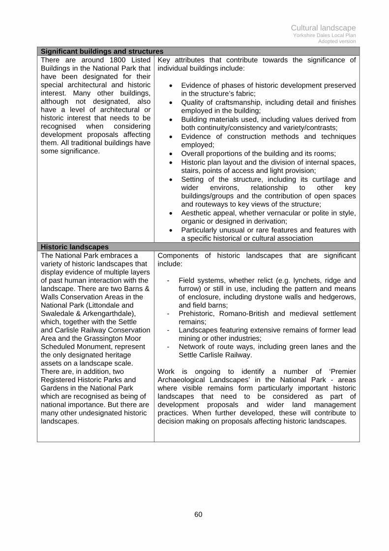
Cultural landscape Yorkshire Dales Local Plan
Adopted version
60
Significant buildings and structures There are around 1800 Listed Buildings in the National Park that have been designated for their special architectural and historic interest. Many other buildings, although not designated, also have a level of architectural or historic interest that needs to be recognised when considering development proposals affecting them. All traditional buildings have some significance.
Key attributes that contribute towards the significance of individual buildings include:
Evidence of phases of historic development preserved in the structure’s fabric;
Quality of craftsmanship, including detail and finishes employed in the building;
Building materials used, including values derived from both continuity/consistency and variety/contrasts;
Evidence of construction methods and techniques employed;
Overall proportions of the building and its rooms; Historic plan layout and the division of internal spaces,
stairs, points of access and light provision; Setting of the structure, including its curtilage and
wider environs, relationship to other key buildings/groups and the contribution of open spaces and routeways to key views of the structure;
Aesthetic appeal, whether vernacular or polite in style, organic or designed in derivation;
Particularly unusual or rare features and features with a specific historical or cultural association
Historic landscapes The National Park embraces a variety of historic landscapes that display evidence of multiple layers of past human interaction with the landscape. There are two Barns & Walls Conservation Areas in the National Park (Littondale and Swaledale & Arkengarthdale), which, together with the Settle and Carlisle Railway Conservation Area and the Grassington Moor Scheduled Monument, represent the only designated heritage assets on a landscape scale. There are, in addition, two Registered Historic Parks and Gardens in the National Park which are recognised as being of national importance. But there are many other undesignated historic landscapes.
Components of historic landscapes that are significant include:
- Field systems, whether relict (e.g. lynchets, ridge and furrow) or still in use, including the pattern and means of enclosure, including drystone walls and hedgerows, and field barns;
- Prehistoric, Romano-British and medieval settlement remains;
- Landscapes featuring extensive remains of former lead mining or other industries;
- Network of route ways, including green lanes and the Settle Carlisle Railway.
Work is ongoing to identify a number of ‘Premier Archaeological Landscapes’ in the National Park - areas where visible remains form particularly important historic landscapes that need to be considered as part of development proposals and wider land management practices. When further developed, these will contribute to decision making on proposals affecting historic landscapes.

Cultural landscape Yorkshire Dales Local Plan
Adopted version
61
L2 Conversion of traditional buildings – acceptable uses With the exception of former dwellings, proposals for the change of use of traditional buildings to high intensity30 residential, visitor accommodation and employment uses will only be permitted within existing settlements and building groups, or other suitable roadside locations31. Proposals for the change of use of isolated traditional buildings to low-intensity32 uses will be permitted provided they do not result in material alteration to the exterior of the building or its surrounds. Proposals for change of use to a dwellinghouse for continuous occupation will be subject to a local occupancy restriction (Appendix 5). All proposals for the conversion of traditional buildings to group visitor accommodation will be required to be capable of effective supervision and management. All proposals for the conversion of traditional buildings to a dwellinghouse for holiday occupation will be restricted to short stay letting only. All proposals for the conversion of traditional buildings to live/work units will be required to meet criteria (a) & (b) of Policy BE4 (New build live/work units). Aim 5.8 To allow traditional buildings to be put to alternative uses where the building and its location is able to accommodate the intensity of the new use and associated impacts. Justification 5.9 Traditional buildings form an important part of the architectural and historic fabric of the National Park, and reveal much about its social, cultural and economic history. Changing circumstances mean many traditional buildings have outlived their original purpose. It is important that the planning system facilitates change of use where this helps to conserve the interest of these buildings. Care is however needed to ensure new uses and their impacts do not undermine what makes these buildings valuable, and that they are permitted in locations that have capacity for the new use. 5.10 This is a conservation-orientated policy aimed at securing the long term future of traditional buildings in a manner that conserves their intrinsic value. Introducing a new use into a traditional building – one for which it wasn’t originally designed – will result in a permanent change to its character and appearance. In architectural, historical and landscape terms, this change will almost always result in some degree of harm to character and appearance. The degree of harm will vary according to the building’s significance, its location, and the intensity of the new use. However, this harm needs to be weighed against the benefits offered by the new use, and the policy provides a framework for these judgements to be made.
30 For the purposes of this policy, higher intensity uses will be permanent residential dwellings, ancillary living accommodation, live work units, group visitor accommodation (bunkhouse barns and holiday lets) and intensive employment uses (such as retail, offices, restaurants/cafes). 31 For the purposes of this policy ‘existing settlements and building groups’ are not restricted to those forming part of the settlement hierarchy set out in Table 1. For a building to be considered roadside it, or its immediate definable curtilage, must physically adjoin the boundary of either a sealed metalled road maintainable by the Highway Authority, or a sealed metalled private road that connects to a road maintainable by the Highway Authority. Roads must have had a sealed metalled surface prior to 1st July 2014. Buildings that do not physically adjoin, but are in close proximity to such routes, or that are served by an established (since at least 1st July 2014) unsealed road or track, will be considered subject to the impact on the landscape. 32 For the purposes of this policy, lower intensity uses are low key employment/business uses (such as light industrial, commercial storage and workshops without outside storage or significant vehicular journey generation), barn pods, camping barns, equestrian and agricultural uses.
Cultural landscape Yorkshire Dales Local Plan
Adopted version
62
5.11 Proposals need to be fully informed and this begins with an assessment of the building’s significance and other attributes. The Authority has produced a Traditional Farm Buildings Toolkit33 alongside the Local Plan. Although aimed at traditional farm buildings, the principle of understanding a building and its capacity for change applies equally to all re-uses of traditional buildings, and applicants should refer to this guidance. 5.12 The policy provides scope for a range of different uses of traditional buildings to be considered, and establishes a clear distinction between higher and lower intensity uses. It seeks to direct the more intensive uses into locations that are most accessible and that already benefit from some degree of infrastructure and services. Table 4 overleaf broadly illustrates the range of different uses and their varying intensities in relation to this policy. 5.13 Intensive uses will not be appropriate in buildings that are isolated in the landscape. These locations will be incapable of absorbing the visual impacts associated with the development, in terms of physical alterations to the building, the provision of new infrastructure, and the higher level of disturbance associated with these uses. These locations will normally only be capable of low-intensity uses. The Traditional Farm Buildings Toolkit provides further guidance on a range of other solutions for these more remote buildings. 5.14 Proposals for re-using traditional buildings as dwellings will be required to be tied to the occupancy criteria set out in Appendix 5 to ensure they contribute towards local housing needs. As an exception to this requirement, however, unrestricted occupancy will be permitted in the following circumstance: Former dwellings – in the National Park there are many examples of houses where residential use has ceased or been abandoned. A number of these are listed buildings, or are otherwise worthy of conservation because of their archaeological, historic, architectural or landscape interest. Reoccupying these houses will sometimes represent the most beneficial and viable use of the building. Great care is however needed to ensure that the re-use retains the building’s significance, to ensure that the policy objective is met. The policy on former dwellings represents an exception to the normal presumption against introducing intensive uses into isolated locations. A number of these buildings are remote from roads or even private tracks, but by virtue of the fact they were originally designed as dwellings, and are often particularly worthy of conservation – including a number that appear on the Authority’s ‘Buildings at Risk’ register – it is considered necessary to introduce an additional degree of flexibility. This represents a continuation of the strategy from the last Local Plan.
33 Yorkshire Dales National Park Authority (2015) Traditional Farm Buildings Toolkit

Cultural landscape Yorkshire Dales Local Plan
Adopted version
63
Table 4 - General guide to use, intensity and likely acceptable locations for adaptation of traditional buildings Proposed use Intensity of use Location
Dwellinghouse (residential dwelling for continuous occupation) Ancillary living accommodation in conjunction with a dwellinghouse Live/work units
HIGH INTENSITY
Most intensive Least intensive
Within settlements, farmsteads and other building groups;
Roadside locations that are capable of being served by a: curtilage with visual impact
minimised; vehicular access not
requiring significant improvements or new access tracks.
Dwellinghouse (self contained short stay holiday let) Group visitor accommodation e.g. bunkhouse barn More intensive employment uses – retail, offices, restaurants/cafes
As above, plus: capable of supervision and
management; adequate separation from
existing dwellings to protect amenity;
ability to contain/control outside storage, noise and other forms of pollution, and ancillary development.
Low key business use e.g. light industrial and workshops, commercial storage facilities
LOW INTENSITY
Pods34 –
short stay holiday letting accommodation;
very minimal impact on the building’s external appearance;
very minimal impact on the building’s fabric;
as self sufficient in energy and other infrastructure needs as possible.
As above, plus more isolated buildings where there is no dedicated on-site vehicular access or parking areas.
Camping barn (basic bothy accommodation/’stone tent’) Equestrian & stabling Agricultural or Estates use – livestock, storage etc.
As above, plus more isolated locations, no road access. No parking or services available, no material alterations to the exterior of the building or its surrounds.
34 A pod, in this sense, is a reversible, detachable self-contained unit inserted within an existing building. Pods can be a means of inserting a variety of different uses into traditional buildings. The classification here as a low intensity use reflects a low key model of use that results in no material alterations to the building and its surrounds. The barn pod can be adapted to more intensive uses, which could still be acceptable, but only in more accessible locations.

Cultural landscape Yorkshire Dales Local Plan
Adopted version
64
L3 Conversion of traditional buildings – building treatment Proposals for the conversion of traditional buildings to new uses will be permitted where they conform to the guidance set out in the Design Guide and it can be demonstrated that:
a) the building has the physical capacity to accommodate the new use without significant extension or alteration, and all ancillary storage and services are accommodated in existing buildings rather than through the provision of new ancillary buildings;
b) alterations to the building, and the creation of any new curtilage, highway access, access roads and other associated storage and infrastructure, are the minimum necessary and are sensitive to the traditional character and appearance of buildings and do not adversely affect the immediate or wider landscape setting of the building, or any parts of the building with recognised significance;
c) the new use does not displace an existing one so that it gives rise to the need to provide new compensatory buildings;
d) materials used are consistent with, or complementary, to local building traditions and any historically or architecturally important features are retained in the conversion, and the building subjected to recording prior to conversion;
e) the building is capable of conversion requiring no more than minor structural work, the extent of which would not compromise the historic interest and character of the building;
f) they satisfy the requirements of policy W1 (designated wildlife sites and species) Aim 5.15 To ensure re-use proposals permitted under Policy L2 do not undermine the architectural and historic character of the building and its landscape setting, or result in other harmful impacts. Justification 5.16 Introducing a new use into a redundant or underused building can provide a long term solution for buildings that might otherwise fall into disrepair or dereliction. Development needs to be carried out sympathetically, however, to avoid damaging the character and appearance of these buildings. 5.17 The starting point is to gain an understanding of the building’s significance and character (see policy L1 – Heritage Assets). In this way, design proposals will be better informed and will be able to conserve or enhance the significance of the building. It is also crucial that the right type of use is found for each building (see policy L2 and the Traditional Farm Buildings Toolkit where relevant) before the detail of design is considered. 5.18 The Authority’s Design Guide contains further detail on ensuring conversions compliment the character and appearance of the building and its surroundings, but this policy establishes some key principles that must be adhered to. 5.19 Fundamentally, if a building is not big enough to accommodate a proposed re-use without the need for large extensions, outbuildings and other intrusive alterations, it is not suitable for that re-use in the first place. The policy therefore seeks to prevent a proliferation of extensions and outbuildings that will obscure the form and setting of the traditional building. Permitted development rights for domestic extensions and outbuildings will be removed as part of any proposal for re-use to prevent incremental creep or domestication at later stages. 5.20 The policy does not require that buildings have to be redundant before they can be converted. Other policies in the Plan may seek to protect community or employment uses as appropriate, but there is no equivalent protection for agricultural uses of Traditional Farm Buildings, which are likely to be the most common type of conversion proposal. Since agricultural uses relate to the particular needs of farm businesses, the Authority has left it to individual applicants to

Cultural landscape Yorkshire Dales Local Plan
Adopted version
65
determine whether a building is still needed to fulfil an agricultural purpose. In affording this discretion, it is important to ensure that conversion does not deprive a farming business of buildings that are still important to the business operation, and in doing so, lead to the need for compensatory new buildings to be constructed. But where there is a clear case for new agricultural buildings to perform uses that could never have feasibly been fulfilled by a traditional farm building that has/will be converted, these applications can be considered on their own merits under policy BE3 (rural land based enterprises). 5.21 Wherever the structural integrity of a traditional building is in doubt, a structural survey - by a suitably qualified conservation accredited structural engineer or surveyor who is skilled and experienced in working with historic structures - will be required to ascertain the amount of rebuilding required. One of the main objectives of conversion is minimum intervention and retention of original fabric. An assessment of significance (see Policy L1 – Heritage Assets) should inform decisions on the amount of alteration, including any rebuilding or strengthening required to facilitate the new use, that can be allowed to take place. Where features of a building are lost or obscured as part of a re-use proposal, provision will need to be made to record these prior to development, so that a record of the building pre-conversion can be made available through the National Park’s Historic Environment Record.

Cultural landscape Yorkshire Dales Local Plan
Adopted version
66
L4 Demolition and alteration of traditional farm buildings Proposals to alter or extend traditional farm buildings that have an existing agricultural use will be permitted provided they:
a) are justified for the purposes of agriculture;
b) will prolong the viable use of the building for agricultural purposes; and,
c) retain the architectural, historical and archaeological significance of the building and involve the minimum amount of alteration necessary.
Proposals to totally or substantially demolish a traditional farm building will not be permitted unless it can be demonstrated that:
a) the building is structurally unsound and beyond repair, and its condition is not the result of deliberate neglect or damage;
b) the building has no particular significance in architectural, historic or landscape terms; and,
c) appropriate recording takes place in advance of demolition and the site is restored in a suitable manner, including the retention of some physical evidence where appropriate.
Aim 5.22 To support the alteration of traditional farm buildings where it would prolong their beneficial use and, as a last resort, the demolition of some buildings where it would not harm the Special Qualities of the National Park. Justification 5.23 This policy introduces further flexibility into the approach to managing the Traditional Farm Building resource. It allows alterations that help retain the buildings in agricultural use but accepts the loss of some buildings in restricted circumstances. 5.24 It is often possible to retain traditional farm buildings in some form of agricultural use. Keeping a building in use means that it is much more likely to be maintained, and keeps open the possibility of other uses in the future. 5.25 Practical adaptations — such as the replacement of a failing stone roof with a tin or fibre cement roof, the insertion of larger openings to enable access for tractors and other large machinery, or the addition of an extension — seldom enhance the appearance of a traditional building but may be a solution that helps to prolong its life. Proposals to adapt buildings in this way should follow the approach to assessing buildings and their capacity for change set out in the Traditional Farm Buildings Toolkit. 5.26 Abandonment of a building results in gradual decay and deterioration and, ultimately, ruination. The building progressively declines and at any point in time is either seen in various stages of dilapidation, a ruined vestige, or is removed from the landscape altogether with little or no physical remnant. But it is important to recognise that ruination is an element of the landscape character of the National Park, so complete removal of a building may not always be desirable. 5.27 The more flexible policies on re-use and adaptation should reduce the complete loss of traditional farm buildings but could lead to increased demand for recycling building materials. Given that some are at an advanced stage of dereliction, there is an acceptance that demolition can sometimes provide a pragmatic solution. While it would not be reasonable for the Authority to seek to control where, when and for what the salvaged building materials are used, it is very likely that good quality traditional building materials will be recycled in the local area. Demolition will also remove risks associated with derelict buildings close to public rights of way.

Cultural landscape Yorkshire Dales Local Plan
Adopted version
67
5.28 Planning permission is required for the demolition of all but the smallest buildings within conservation areas (including the two specific barns and walls conservation areas of Littondale and Swaledale/Arkengarthdale. Elsewhere, planning permission will still be required if the building has been rendered unsafe or uninhabitable by action or inaction. Where this is not the case, permitted development rights allow demolition subject to a simplified written justification or prior approval process. This only allows the Authority to agree certain detailed aspects, rather than the principle, of demolition, so elements of the policy will have less effect outside of conservation areas. Those proposing demolition should always contact the Authority to verify whether planning permission is required.

Cultural landscape Yorkshire Dales Local Plan
Adopted version
68
L5 Heritage assets - enabling development Proposals for enabling development will only be permitted where:
a) the enabling development will secure the long term conservation of a heritage asset that is: i) designated or demonstrably of equivalent significance to a designated asset; and ii) considered to be at risk, and that risk has not come about as a result of deliberate neglect
or damage;
b) the proposal complies with Historic England’s enabling development policy35
c) the long term conservation of the heritage asset can only be secured by enabling development.
Applications for enabling development on estates with multiple heritage assets within the National Park will only be permitted where they form part of, and are justified by, an overarching and up to date conservation management plan that is linked to an up to date business plan. Aim 5.29 To conserve significant heritage assets by permitting departures from normal planning policy in circumstances where the heritage benefits will outweigh the policy disbenefits. Justification 5.30 The historic environment is a significant part of the Special Qualities of the Yorkshire Dales National Park. Some of its heritage assets that are ‘at risk’ would require very considerable investment to restore them. Exceptionally, it will be permissible to generate this investment through an associated development that can cross-subsidise the repair and restoration and, thus, overcome the ‘conservation deficit’. 5.31 This is a solution of last resort and proposals should demonstrate that they have exhausted all other options, and provide sufficient detail (including financial appraisals) to support an enabling solution. Historic England’s guidance sets out in detail how enabling development should work, including a number of case studies. 5.32 The most likely use of this policy will be in association with ‘at risk’ listed buildings. While Policy L2 supports a range of re-uses, some buildings are incapable of accommodating a re-use that would subsidise the works needed to secure its future. In these instances, the Authority will consider whether a proposal to use development to generate the revenue required to conserve the heritage asset can be justified, having regard to the harm that might be caused to other public interests. 5.33 There are a number of landholdings in the National Park that own multiple heritage assets that are at risk (or that otherwise require significant routine investment to maintain them in a manner consistent with their significance). In these instances, a proactive approach should be adopted by formulating a conservation management plan across all assets in the same ownership, and linking this to a business plan. This will enable the financial viability of the whole estate to be understood thus ensuring that enabling development is playing a legitimate role in the overall management of the assets. It will also allow a more coordinated and targeted approach to be taken in developing and prioritising individual projects, for example where some heritage assets are more at risk than others.
35 Historic England (2008) Enabling development and the conservation of significant places

Cultural landscape Yorkshire Dales Local Plan
Adopted version
69
L6 Crushed rock quarrying The development of new crushed rock quarries or the extension of existing quarries into areas of undisturbed land will not be permitted other than in the exceptional circumstances set out in Policy SP5. Extensions, in time, extraction area or depth, will only be permitted in disturbed land within the boundary of an existing active quarry36; and where all the following criteria are met:
a) the environmental and economic benefits of further quarrying will outweigh the individual and cumulative impact on the landscape and the natural and historic environment. Proposals will need to demonstrate how any unavoidable impacts will be mitigated;
b) at those sites where a direct rail link exists or is physically capable of construction, proposals will need to include the use of rail haulage and a reduction in road haulage. The reduction in road haulage must be at least 50%, based on limits that were in place in 2011, unless a developer can demonstrate, by sharing their economic assessment with the Authority, that a lower percentage reduction or a phased reduction is necessary to maintain the viability of the site;
c) using currently-permitted operations and already-agreed restoration schemes as a baseline, any proposal must:
i) demonstrate local economic benefits through job creation or job safeguarding; ii) reduce visual impacts through landscaping and restoration; iii) offset biodiversity impacts during the life of the quarry and then subsequently after
quarrying has ceased through onsite or offsite enhancement in the locality; iv) give up already-permitted reserves where working would result in harmful impacts; v) demonstrate biodiversity and landscape enhancement where nature conservation
afteruse is proposed. Where restoration other than to nature conservation is proposed, this must be supported by an afteruse study that explores options either to deliver National Park purposes or new employment/business/recreational uses that would be compatible with Local Plan policy. The quarry developer will be expected to provide infrastructure and finance to deliver the preferred use. Aim 5.34 To achieve a progressive reduction in the impact of existing crushed rock quarries on the environment and communities. Justification 5.35 The National Park produces a large amount of primary minerals for use in the construction industry. There are currently five operational crushed rock quarries (Table 5). Unless new permissions are granted, mineral working would cease by the end of the Local Plan period at all these working quarries except Horton. The issue for the Local Plan is whether the physical extent of the extraction area or the operational time limits on these quarries should be permitted to extend and, if so, under what circumstances. 5.36 Carboniferous Limestone is used widely in the construction industry for concrete aggregate, in road building and repair and for other construction uses. It is also used as a flux in the iron and steel industry. Although some of the limestone in National Park quarries is of high chemical purity, the majority is used for aggregate. High polished stone value (PSV) gritstone is used mostly in road surfacing because of its skid resistant properties. From time to time some of the quarries also produce small amounts of building stone. 5.37 National policy expects there to be, at any point in time, a supply of land with planning permission for crushed rock sufficient to provide 10 years of historic rates of supply. Conversely, national policy also states that, as far as practical, minerals ‘landbanks’ should be sourced from
36 As defined under Regulation 16 of The Quarries Regulations 1999
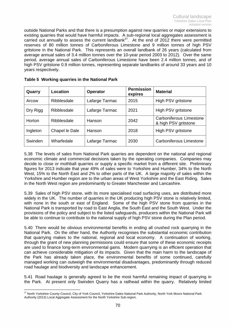
Cultural landscape Yorkshire Dales Local Plan
Adopted version
70
outside National Parks and that there is a presumption against new quarries or major extensions to existing quarries that would have harmful impacts. A sub-regional local aggregates assessment is carried out annually to assess the current landbank37. At the end of 2012 there were permitted reserves of 80 million tonnes of Carboniferous Limestone and 9 million tonnes of high PSV gritstone in the National Park. This represents an overall landbank of 26 years (calculated from average annual sales of 3.4 million tonnes over the 10-year period 2003 to 2012). Over the same period, average annual sales of Carboniferous Limestone have been 2.4 million tonnes, and of high PSV gritstone 0.9 million tonnes, representing separate landbanks of around 33 years and 10 years respectively. Table 5 Working quarries in the National Park
Quarry Location Operator Permission expires
Material
Arcow Ribblesdale Lafarge Tarmac 2015 High PSV gritstone
Dry Rigg Ribblesdale Lafarge Tarmac 2021 High PSV gritstone
Horton Ribblesdale Hanson 2042 Carboniferous Limestone & high PSV gritstone
Ingleton Chapel le Dale Hanson 2018 High PSV gritstone
Swinden Wharfedale Lafarge Tarmac 2030 Carboniferous Limestone
5.38 The levels of sales from National Park quarries are dependent on the national and regional economic climate and commercial decisions taken by the operating companies. Companies may decide to close or mothball quarries or supply a specific market from a different site. Preliminary figures for 2013 indicate that year 49% of sales were to Yorkshire and Humber, 34% to the North West, 15% to the North East and 2% to other parts of the UK. A large majority of sales within the Yorkshire and Humber region are to the urban areas of West Yorkshire and the East Riding. Sales in the North West region are predominantly to Greater Manchester and Lancashire. 5.39 Sales of high PSV stone, with its more specialised road surfacing uses, are distributed more widely in the UK. The number of quarries in the UK producing high PSV stone is relatively limited, with none in the south or east of England. Some of the high PSV stone from quarries in the National Park is transported by road to East Anglia, the South East and the South West. Under the provisions of the policy and subject to the listed safeguards, producers within the National Park will be able to continue to contribute to the national supply of high PSV stone during the Plan period. 5.40 There would be obvious environmental benefits in ending all crushed rock quarrying in the National Park. On the other hand, the Authority recognises the substantial economic contribution that quarrying makes to the national, regional and local economy. A continuation of working, through the grant of new planning permissions could ensure that some of these economic receipts are used to finance long-term environmental gains. Modern quarrying is an efficient operation that can achieve considerable mitigation of its impacts. Given that the main harm to the landscape of the Park has already taken place, the environmental benefits of some continued, carefully managed working can outweigh the environmental disadvantages, predominantly through reduced road haulage and biodiversity and landscape enhancement. 5.41 Road haulage is generally agreed to be the most harmful remaining impact of quarrying in the Park. At present only Swinden Quarry has a railhead within the quarry. Relatively limited
37 North Yorkshire County Council, City of York Council, Yorkshire Dales National Park Authority, North York Moors National Park Authority (2013) Local Aggregate Assessment for the North Yorkshire Sub-region.

Cultural landscape Yorkshire Dales Local Plan
Adopted version
71
tonnages from Ingleton Quarry are transported by rail via the sidings at Ribblehead, which also handle timber. Planning permission for a railhead in Arcow Quarry for use by both Arcow and Dry Rigg Quarries was granted in 2014 and is expected to come into use in 2015. Conditional approval for the re-instatement of the railhead at Horton Quarry was given in 1996 but this has not yet been constructed. Direct rail links are in place or approved at four of the National Park quarries and the Ribblehead sidings are being used by Ingleton Quarry. All of the quarries in the National Park, therefore, have either existing or approved facilities to transport stone by rail. 5.42 There are major environmental and social benefits when rail transport substantially replaces road haulage. The Authority’s position is that road haulage from all quarries in the National Park should be substantially reduced. At those quarries where a direct rail link exists or is physically capable of construction, this reduction should be at least 50%, based on limits that were in place in 2011. A baseline of 2011 has been chosen to reflect the fact that significant reductions have been agreed at some sites since that date. All operators will be expected to continue to progressively reduce road haulage from their sites. 5.43 Where quarries have permitted reserves that would involve harmful extensions to their existing working area, there may be potential for these reserves to be exchanged for further extraction within the existing quarried area. Furthermore, while all quarries have agreed good quality restoration schemes, there may be scope to improve these together with new packages of mitigation and environmental enhancement. Through the negotiation of new planning permissions the quarry operators could pay for off site biodiversity enhancements in Ribblesdale and Wharfedale which would off set the impact that their quarrying activities have on wildlife and biodiversity. Their landscaping and screening proposals could also be brought up to date and improved. Should a proposal to extend quarrying activity have an adverse effect on the integrity of a European site designated under the Habitats Directive, it will be required to meet the tests under article 6(4) of the Directive38 by demonstrating there is no less harmful feasible alternative, there are imperative reasons of overriding public interest and compensatory measures are secured to ensure the overall coherence of the network of European sites is maintained. 5.44 Where an increase in the depth of excavation is proposed, there is potential for impacts on groundwater, surface water or local abstractions. This is greater where extraction is within limestone than in the lower permeability high PSV gritstone. Proposals for quarry deepening will need to demonstrate that they would not have an unacceptable impact on groundwater, surface water or water quality. The necessary mitigation measures must be identified and a scheme of monitoring and implementation agreed. Deep-water areas are generally of low ecological value and the Authority does not wish to see any increase in the overall area of deep water within a restoration proposal when compared with the existing approved scheme. In some instances it may be possible for deeper excavations to be infilled with quarry waste materials or overburden that are derived from operations at the site. 5.45 New planning applications may provide an opportunity to look again at the restoration and after use of these quarries once they cease to be worked. The Authority considers that in most cases nature conservation will be the most appropriate afteruse but there may be scope at some sites for the quarry companies to submit studies on future reuse options including more formal visitor, community and economic opportunities that take account of wider initiatives. Quarry companies will be expected to make a financial contribution to the after use of their sites.
38 Council Directive 92/43/EEC of 21 May 1992 on the conservation of natural habitats and of wild fauna and flora. The Habitats Directive is primarily transposed in England under the Conservation of Habitats and Species Regulations 2010

Cultural landscape Yorkshire Dales Local Plan
Adopted version
72
L7 Building stone Proposals for the quarrying of building stone or roofing slate will be permitted where they satisfy the requirements of Policy SP4 Development quality. Aim 5.46 To support small scale quarrying of building and roofing stone so as to increase supplies of locally sourced materials for use in new developments and the repair and maintenance of traditional buildings. Justification 5.47 Building stone has, in the past, been quarried at numerous sites throughout the National Park to supply materials for the construction of the houses, barns and other buildings which are characteristic of the Yorkshire Dales. These have mostly been small scale operations supplying local needs. Thinly-bedded sandstones have also been extensively quarried to provide stone roofing ‘slates'. 5.48 The only recent working inside the Park has been intermittent extraction at Hill Top quarry above Keld. The majority of newly-won building and roofing stone has to be obtained from quarries outside the National Park. A number of studies of potential sources of building stone have been carried out in the past to stimulate interest in quarrying activity, but no new operations have yet materialised. Historic England has also published a range of information on sources of building stone39. 5.49 The expectation is that most proposals permissible under this policy will be relatively small in scale and proportionate to the needs of the local market, although a judgement on the acceptability of environmental, archaeological, amenity and safety impacts of proposals will need to be made on a case by case basis. Given the lack of working quarries, the need for suitable local stone for repairs to traditional buildings and in some design requirements for new buildings, the Authority has a generally supportive approach to the reopening of quarries. 5.50 Where recycling of stone is inappropriate for landscape, heritage or ecological reasons (see Policy L4), new quarrying will often represent a more sustainable option. Importing natural stone, such as Indian or Spanish slate, or fabricating reconstituted alternatives, may not be sustainable in the long term, or be satisfactory substitutes in terms of their impact upon the character and appearance of buildings.
39 Historic England (2012) Strategic Stone Study – A Building Stone Atlas for North Yorkshire (west)

Cultural landscape Yorkshire Dales Local Plan
Adopted version
73
L8 Reworking mineral waste Proposals for the reworking of mineral waste will not be permitted where:
a) the land has been satisfactorily restored;
b) the deposit has become assimilated or is characteristic of the local landscape; or,
c) the land has archaeological or ecological value in accordance with policies L1 & W1. Aim 5.51 To protect former mineral sites where they have become assimilated into the landscape or have archaeological or ecological value. Justification 5.52 The National Park contains areas of former lead mining activity as well as other areas where quarry waste has been deposited more recently. There may be circumstances in which the reworking of spoil in these areas could become commercially attractive. 5.53 Harm can arise from this form of development, both in terms of the potential release of metalliferous minerals into water courses and pollution as a result of leachates with high metal concentrations contaminating groundwater. It is also possible that surface water drainage with high levels of suspended solids may be produced by reworking of mineral waste, and this could have a significant impact on groundwater, as well as surface waters. A groundwater risk assessment should form part of any application for the reworking of mineral waste. Harm could also arise from disturbance to the historical mining landscape and important habitats and species which are protected under policies L1 (Heritage assets) and W1 (Wildlife sites, species and networks). 5.54 Where former mineral waste has become assimilated into the landscape or forms part of an agreed after-use scheme, the Authority will not permit reworking unless it is justified by a need, which cannot reasonably be met by alternative methods. The Authority will have particular regard to the archaeological or ecological significance of areas of mineral waste where they contribute to understanding of past industrial activity or provide important wildlife habitat, most notably Calaminarian grassland.

Cultural landscape Yorkshire Dales Local Plan
Adopted version
74
L9 Mineral and railhead safeguarding Planning permission will not be granted for development that would sterilise a mineral or railhead safeguarding area identified on the Policies Map, unless there is a need for alternative development that overrides the need to safeguard the mineral or railhead. Aim 5.55 To prevent the unnecessary sterilisation of mineral resources and to safeguard existing and planned railheads so that they are available for the transport of mineral and other products. Justification 5.56 National planning policy requires that Mineral Safeguarding Areas (MSAs) are identified in Local Plans to identify the total area covered by a mineral resource. The purpose of a MSA is to protect strategically important non-renewable resources from sterilisation by new development that would permanently prevent their extraction. 5.57 In compliance with national planning policy extensive areas of the National Park have been identified as MSAs. The identification of a MSA does not however presume in favour of extraction or override international or national landscape, heritage or nature conservation designations. It is merely recognition that a mineral resource exists and that regard should be had to its long term protection. Not all of the deposits shown on the policies map are of sufficient thickness, or appropriately located, to ever be realistically workable. Furthermore, Policy L6 clearly presumes against the establishment of new quarries, or extensions beyond existing quarry boundaries. The designation simply reflects the underlying geology and will not have implications for the vast majority of development proposals in the National Park, which are generally small in scale and located in settlements and other building groups where the mineral resource has already been sterilised. 5.58 The MSAs identified on the Policies Map are taken from the Mineral Resources information produced by the British Geological Survey (BGS). The Policies Map identifies areas underlain by high polished stone value (PSV) gritstone, Carboniferous Limestone and coal:
High PSV gritstone - the term ‘gritstone’ is used in this context to refer to the mixed sequence of strongly folded, indurated siltstones and sandstones that occur below the Carboniferous Limestone. These are quarried in Ribblesdale and Chapel-le-Dale to produce skid-resistant products used mainly for road surfacing;
Carboniferous limestone - the BGS data identifies ‘high purity’ resources of Carboniferous Limestone, suitable for industrial uses, separately from the remainder of the resource. Although the majority of the high purity limestone quarried at present in the National Park is used as aggregate, this distinction is retained on the Policies Map;
Coal – BGS data shows the only significant continuous area underlain by coal to be in the extreme south western corner of the National Park.
5.59 An additional ‘buffer zone’ beyond the resource boundary has not been identified because the resource areas are so extensive. In the case of high PSV gritstone, the Carboniferous Limestone MSA already forms an additional safeguarding zone around the key resource areas. 5.60 The Authority is also required by national policy to identify planned and potential sites for railheads and rail links to quarries. Four existing or planned railheads are shown on the Policies Map. The objective is to protect them for future use by the minerals and other industries for the sustainable transport of minerals and timber.

Cultural landscape Yorkshire Dales Local Plan
Adopted version
75
L10 The open upland In the areas defined as open upland on the Policies Map, development will only be permitted where it can be demonstrated that:
a) it will not conflict with W1 (Wildlife sites, species and networks) and it will have a neutral impact on the Special Qualities of open upland, or is otherwise essential for the management of those qualities; and,
b) there is no alternative solution that would lessen the impact and appropriate mitigation measures are taken to reduce harm.
Proposals that would improve public access will be regarded more favourably. Where the development is no longer needed for essential management the developer will be required to remove it and restore the site to its former condition.
Aim 5.61 To protect the Special Qualities of the extensive open upland areas. Justification 5.62 At the heart of the National Park are extensive areas of relatively wild, open country. These are predominately semi-natural moorland where human influence is still limited. Defined on the Policies Map, they include contiguous stretches and mosaics of upland heath, grass moor, blanket peat, bare rock, and mineral soils. Areas of rough pasture and moorland allotments are also included where they have similar qualities of remote wildness. Although much of the land is managed for game shooting and grazing, it is distinct from more intensively farmed and enclosed land at lower altitude. 5.63 The open upland, much of which is common land or has public access rights, offers special opportunities for informal recreation and is highly valued for its tranquillity. The importance of conserving the wild and natural character of such areas was fundamental to the designation of the National Park in 1954. Development has the potential to detract from these qualities and should only be permitted in carefully controlled circumstances. The importance of the grouse shooting industry for the local economy is understood. Development that is clearly demonstrated to be essential for the management of the Special Qualities of the open upland for grouse shooting, may provide suitable justification for limited development, subject to the criteria in Policy L10, SP4 and W1. Due to its open characteristics, any proposal must be carefully designed and sited to minimise intrusion.

Tourism Yorkshire Dales Local Plan
Adopted version
76
6. Tourism A friendly, open, and welcoming place with outstanding opportunities to enjoy its Special Qualities Objectives
1. Support and encourage development that will help to make the Yorkshire Dales National Park a leading sustainable tourism destination in the UK that is renowned for its local distinctiveness.
2. Support development that improves the quality and variety of visitor accommodation so as to enable more visitors to stay overnight in the Park.
3. Support development that improves the quality and variety of visitor facilities that will extend the tourism season and enable the public to better enjoy the Park’s Special Qualities.

Tourism Yorkshire Dales Local Plan
Adopted version
77
T1 Camping The use of land as a new or extended camp site for tents, and the development of associated buildings or facilities, will be permitted provided that:
a) the site is not isolated in the landscape; and,
b) the development and use of the site, including the provision of site services, external lighting and access provisions, do not harm the landscape character of the National Park or are capable of integration by an approved planting scheme within 5 years of commencement; and,
c) the site is capable of effective management without the construction of a new dwelling. Aim 6.1 To increase overnight stays in the National Park by supporting new or improved camping facilities for tents. Justification 6.2 Camping is a popular, inexpensive and low-impact way of staying overnight in the National Park. It is a low intensity and transient use of land and an appropriate form of recreation that has more potential to benefit the local economy. 6.3 The range of camp sites and the number of pitches has reduced over the last 20 years and very few sites in the National Park are suitable for year-round use. 6.4 A study of visitor accommodation in the National Park found that cost is a key driver and that demand nationally for camping has increased in recent years40. The National Park Management Plan includes objectives to increase the number of overnight stays by visitors and to make the Park more accessible to a diverse range of groups. This includes younger people and the disadvantaged. A good way to do this is to widen and then retain the range of budget accommodation. As well as adding overall capacity, the visitor accommodation study states that more camping pitches will provide more opportunities for visitors to respond to unseasonably good weather and thereby enjoy the National Park outside the main summer holiday season. 6.5 This policy, therefore, permits the development of new sites and facilities and the expansion of existing sites, in locations that are not entirely screened from public view but which would not be significantly harmful to the landscape. This judgement will have to be made on an individual basis, based on the scale of development proposed. The Authority will look to mitigate potential impacts through the use of good quality planting schemes. 6.6 It is hoped that a more flexible policy will support new small scale campsites as a form of farm or rural estate diversification. Farms and rural estates usually contain groups of existing buildings against which tents could be sited to reduce their visual impact in the landscape and which could also host site facilities and management. Where existing buildings are not available or suitable for re-use, the Authority will permit the construction of appropriate new facilities. 6.7 Another objective of this policy is to improve the tourism offer and the quality of visitor enjoyment. The Authority will support development that offers campsite users the following amenities:
locations within walking distance of local services such as shops, pubs and activities, yet with sufficient separation from residential areas to avoid disturbance;
40 Arup (2013) Understanding the Needs and Opportunities for Visitor Accommodation: Final report 2nd December 2013
Tourism Yorkshire Dales Local Plan
Adopted version
78
sheltered, well drained, flood-free pitches that offer a degree of privacy to users; adequate parking; good quality facilities e.g. washrooms; environmentally sustainable designs and layouts that also provide for an enhanced
visitor experience and contact with nature; small, quiet, simple sites that are close to the National Park’s best natural resources; good access to public transport, rights of way and areas with capacity for public
access. 6.8 With additional policy flexibility however there comes a range of challenges that need to be considered alongside the strategic and other policies in the Local Plan. For example, sites need to avoid prominent locations in very open areas and should not be so large that they detract from the character of the landscape. Other sensitivities will include potential light and noise pollution and road congestion, particularly in areas that share qualities of tranquillity. An effective way to manage that will be through restrictions on the number of permissible pitches within the more sensitive areas identified in the Authority’s visitor management strategy41. All proposals must also be able to demonstrate that they can be managed effectively in order to prevent disturbance and safeguard the enjoyment of their users and the amenity of nearby residents. 6.9 Although the intention is to explore the opportunity for year round provision, there will be areas with particular sensitivities in terms of ineffective winter screening, ecological or archaeological sensitivity, where seasonal restrictions will be required.
41 Special Qualities, Special Experiences, an integrated recreation and tourism strategy, YDNPA 2010

Tourism Yorkshire Dales Local Plan
Adopted version
79
T2 Touring caravan sites The use of land for touring caravans will be permitted provided that all the following are met:
a) the pitches, site services, external lighting and access provisions are well screened at the time of application, and subsequently, to the extent that development will not cause adverse impact to landscape character;
b) a wholly new site, or an addition to an existing site, does not exceed 30 pitches, unless it can be demonstrated that the landscape has adequate capacity to absorb this scale of development and that the highway can accommodate the additional traffic;
c) pitches are restricted to short stay holiday occupancy only; and, d) on-site facilities would not harm the economic vitality or viability of nearby settlements. Aim 6.10 To support the provision of touring caravan pitches on appropriate sites. Justification 6.11 Touring caravans are a small but popular part of the visitor accommodation market. There are 26 touring sites in the National Park providing 690 pitches, often including space for camper vans and tents. They are a flexible and transient form of accommodation with demand tending to be linked to fluctuations in the weather. The last 10 years has seen the gradual loss of some touring caravan pitches, and with it the loss of casual opportunities for the public to enjoy the National Park. This policy provides some additional flexibility to encourage new pitches in locations that are well-screened. Although the intention is to provide opportunity for year round provision, there will be areas with particular sensitivities in terms of ineffective winter screening, ecological or archaeological sensitivity, where seasonal restrictions will be required. 6.12 New touring pitches will need to be screened at the point of implementation. This is because the appearance of touring caravans makes them more prominent in the landscape than tents. They also tend to have a bigger footprint and a more significant impact on the road network. 6.13 The Authority will consider proposals and investigate mitigation measures that will enable the improvement of existing sites and the development of some new sites where they can be appropriately screened. The Authority considers that there is scope for the development of some new sites in the Park of up to 30 pitches where the landscape and other impacts would be acceptable. Proposals for new sites in excess of 30 pitches may struggle to be accommodated even within the areas of the Park that are already well screened. The Authority will however consider larger proposals subject to evidence in the form of a business plan to justify a larger scale and by having particular regard to the capacity of the local road network to accommodate the additional traffic. 6.14 Proposals within walking distance of the Local Service Centres (see Table1) are likely to be the most beneficial in terms of access to existing visitor facilities and increased spending in the local economy. However, there is also scope for small touring caravan sites (of around 5 pitches), perhaps mixed with some camping, in some of the quieter areas of the National Park. 6.15 There is sometimes an issue with touring pitches being used for the storage of caravans. This has an impact on the landscape equivalent to static caravans but without benefits to the local economy. The Authority will require a condition that no caravan shall occupy any pitch for more than 28 days per calendar year. The Authority will also work with site operators to designate suitable storage areas, where there is landscape capacity to accommodate this.

Tourism Yorkshire Dales Local Plan
Adopted version
80
T3 Sustainable self-catering visitor accommodation The development of new sustainable self-catering visitor accommodation will be permitted provided that all the following criteria are met:
a) sites are well screened at the time of application, and subsequently, to the extent that development will not cause adverse impact to landscape character; and,
b) the units will be restricted to holiday use and short term letting only; and,
c) on-site facilities would not harm the economic vitality or viability of nearby settlements. Proposals will need to demonstrate that they have incorporated designs, layouts and technologies that will deliver environmental benefits, such as energy saving measures, the use of renewable energy, the provision of recycling facilities and improved biodiversity. The replacement of static caravans with sustainable self-catering visitor accommodation of a more appropriate design that fits less intrusively into the landscape will be permitted. New sites for static caravans will not be permitted. Small extensions or increases in the number of static caravan pitches on existing sites will only be permitted where they would be well screened or would improve the visual impact of the site within the surrounding landscape. Additional units will be restricted to holiday use and short term letting or will be required to be removed from site between 1st November and 1st March. The replacement of tent or touring caravan pitches with more permanent types of accommodation will only be permitted where this would not significantly reduce the supply of tent and touring pitches available locally and the site is capable of such a change without a harmful impact on the Special Qualities of the National Park. Aim 6.16 To expand and diversify the supply of sustainable, short stay, self-catering visitor accommodation that complements the distinctive landscape and will enable visitors to more fully enjoy the Park’s Special Qualities. Justification 6.17 The Authority classifies sustainable self-catering as fixed but reversible short stay visitor accommodation of sympathetic design. This excludes static caravans and which are considered to be an inappropriate and unsustainable form of visitor development in the National Park. 6.18 The market for this accommodation has increased rapidly in recent years and includes wooden cabins, camping pods, ‘shepherds huts’, railway carriage conversions, yurts and other types of off-grid/eco accommodation. These are treated separately in policy terms from tented camp sites and touring caravans because they are a more permanent form of development and a more intensive use of land. 6.19 A visitor accommodation study by the Arup consultancy in 2013 identified a gap in the provision of some of these newer markets. It gave examples of the opportunities that are being realised elsewhere but which should be transferable into the Park, if they can be located on the right sites and managed effectively. The advantage to visitors would be a wider range of accommodation and ultimately a better experience of the area. These forms of accommodation are more resilient to poor weather yet still permit direct enjoyment of the natural resources of the National Park. 6.20 This policy is intended to complement other forms of visitor accommodation and open up opportunities for existing operators, farmers and rural estates to diversify into new

Tourism Yorkshire Dales Local Plan
Adopted version
81
markets. The objective is to diversify supply and support more year round visitor stays, provide opportunities for multi-day visitor activities and educational packages, and generate more spending in the local economy. 6.21 The Authority will consider proposals and investigate mitigation measures for wholly new sites. The design, number and appearance of units will be key to their capacity for satisfactory accommodation into the landscape. So, for example, a scheme that has a high proportion of cabins, camping pods or other units manufactured from wood, designed in organic shapes and with darker colours, is more likely to fit into the landscapes of the Yorkshire Dales. Planning approval for new sustainable self-catering accommodation will define the type of units permitted in order to maintain future control over replacement units. Sites that are located within walking distance of existing services such as shops, pubs and visitor facilities will also be considered more sustainable. The Authority will also expect new units to incorporate designs and technologies that will conserve energy, recycle waste, generate renewable power and heat, utilise natural resources sustainably, and enhance biodiversity. 6.22 The policy is more restrictive towards the use of land for static caravans because of their unsuitable appearance within a protected landscape. Static caravan sites range from individual units in fields, to exclusive luxury chalets and ‘park home’ sites that contain residential dwellings. The wide scope afforded to the legal definition of ‘caravan’ means that they can be replaced by new units of up to twice the original footprint without the need for planning permission. Over time this can lead to an increased footprint and a significant reduction in the amount of green space within a site, reducing its amenity. 6.23 This policy does permit extensions to existing static caravan sites as long the new units would be well screened or will facilitate a remodelling scheme that will improve the overall visual impact of the existing site. 6.24 Whilst there is a good overall supply of static pitches (951) only 197 were available for rental in 2013. This means that most static caravans are not available for wider public use and are unlikely to contribute to the National Park Management Plan objective of increasing overnight visitor stays. Given the high proportion of owner-occupied units, the Authority will insist that any net additional units are for short-term letting only (maximum 28 days) or are seasonal units which are moved from site during the winter months. The Authority will work with site operators to designate suitable storage areas, where there is landscape capacity to accommodate this. 6.25 A particular trend that has been evident over the last 10 years has been the replacement of camping and touring caravan pitches with static units. This has led to a concern about reduced choice and opportunities for visitors, especially those on lower incomes or engaged in educational/voluntary activities. The Authority will, therefore, resist the further loss of any touring pitches where there is evidence that it would have a significant negative impact on the supply or choice available locally.

Tourism Yorkshire Dales Local Plan
Adopted version
82
T4 Visitor facilities Development that provides facilities or services that directly help visitors to enjoy the Special Qualities of the National Park will be permitted subject to conformity with other Local Plan policies. Development of facilities or services that utilise the area’s natural resources in a sustainable way and which will offer visitors wider enjoyment of the National Park without any harm to its Special Qualities, will also be permitted subject to conformity with other policies in the Local Plan. Aim 6.26 To encourage the development of facilities that will improve visitor experience of the Special Qualities of the National Park. Justification 6.27 The National Park is designated primarily because of the value of its landscape and the opportunities it offers for the public to enjoy it. Visitor surveys confirm that it is the scenery, open spaces, opportunities for walking and tranquillity that are the main reasons why people visit. These resources require infrastructure such as footpaths, trails, bridges, access areas, car and coach parking, public transport, toilets, education, wildlife hides and interpretation. This infrastructure needs to be maintained and improved. Such development will be permitted as long as it can be undertaken sympathetically and has regard to the National Park visitor management strategy ‘Special Qualities, Special Experiences’42. 6.28 National policy requires the conservation of a National Park be given priority over its enjoyment by the public if there is a conflict. This is known, as the ‘Sandford Principle’43. It means that in considering the impact of new visitor facilities, beneficial or neutral impacts on the landscape, wildlife or cultural heritage of the Park will be acceptable, but negative ones will not. The Sandford Principle is a planning consideration and can sometimes be a reason for refusing development proposals. More commonly, however, potential conflicts are avoided through negotiation, mitigation or by requiring conditions and management agreements attached to a planning approval. 6.29 There are a range of outdoor facilities that are not necessarily dependent on the Special Qualities but which are nevertheless capable of utilising the National Park’s natural resources in a sustainable manner for enjoyment by the public. These include cycling and horse riding facilities and an ever increasing range of niche outdoor activities. If these can be developed without harm to Special Qualities then they will be permitted, subject to acceptable location, design and management. 6.30 Certain types or scales of outdoor sport, leisure or recreational developments are, however, unlikely ever to fit comfortably into the National Park. For example, golf courses are unlikely to be compatible with the distinctive landscapes of the National Park. Equally, development that creates significant noise levels or more general disturbance may well spoil other users’ enjoyment of the extensive areas of the Park where tranquillity is a particular quality. These activities and some of the ancillary development that may go along with them, are probably better located in environments with fewer qualities or a higher capacity to absorb their impacts, unless it can be demonstrated that their development would not prejudice visitor enjoyment or risk harm to the Park’s Special Qualities.
42 Yorkshire Dales National Park Authority (2010) Special Qualities Special Experiences, An integrated recreation and tourism strategy. 43 See also paragraph 2.12

Tourism Yorkshire Dales Local Plan
Adopted version
83
T5 Indoor visitor facilities Development of indoor facilities aimed at visitors but not reliant on the Special Qualities of the National Park, will only be supported where it is located within existing settlements, or close to existing visitor facilities, or forms part of a farm or rural estate diversification scheme or is allocated in Policy BE1 for a related use. Visitor facilities that would also provide overall benefits to local communities will be considered favourably, subject to the above. Aim 6.31 To encourage the development of indoor visitor facilities and attractions that will improve the year round visitor experience in ways that will not reduce Special Qualities. Justification 6.32 In addition to promoting the enjoyment of the area’s Special Qualities, there is scope for more indoor and weather resilient activities. Attractions aimed at families with young children, teenagers and young adults can encourage more visits out of season and are a key part of modern tourism. They could include cafes, restaurants, pubs, hotels, swimming pools, indoor play facilities, educational, training or other activities. These facilities may not relate directly to the Special Qualities of the National Park but are an important part of the wider visitor experience and would be a potentially valuable contributor to the economy. It is essential that they are as good as they can reasonably be within the proviso that they do not themselves prejudice the conservation of the National Park’s Special Qualities or the enjoyment of those qualities by the public. 6.33 The policy, therefore, permits new uses for existing buildings alongside some new construction, either within settlements, farmsteads, rural estates, or at the site of existing similar facilities. The Authority will also offer greater flexibility for visitor related development if benefits to the resident community can also be demonstrated. 6.34 The most sensitive areas of the Park are its open upland and the remote dale heads, which are identified as having particular landscape sensitivities in the National Park visitor management strategy ‘Special Qualities, Special Experiences’44. These areas should be avoided by new indoor visitor attractions unless their scale or management will guarantee that they will not harm the character of these areas. The most suitable locations are likely to be the main service centres that have access from public transport and where new facilities will complement existing concentrations of services and visitors. There will, however, also be opportunities on farms, rural estates, brownfield sites and even some former quarries to accommodate visitor activity without significant harm. 6.35 The busier tourist areas, such as of Bolton Abbey, Malham, Hawes, Horton, Reeth, Clapham, Aysgarth, Kettlewell and Dent are the most likely locations to receive proposals for further visitor-related development. The Authority will however consider whether, when aggregated with existing facilities, the cumulative impact of a new visitor development would be detrimental rather than beneficial, for example in relation to inadequate car parking.
44 Yorkshire Dales National Park Authority (2010) Special Qualities Special Experiences, An integrated recreation and tourism strategy.

Wildlife Yorkshire Dales Local Plan
Adopted version
84
7. Wildlife By 2040, home to the finest variety of wildlife in England Objectives
1. Protect and restore nationally and internationally designated nature conservation sites.
2. Protect the priority habitats and species identified in the Local Biodiversity Action Plan.
3. Plan for a net gain in biodiversity by requiring new development to incorporate enhancement measures.
4. Use new development to strengthen wildlife networks and generally restore and enhance the biodiversity of the National Park.
5. Support development that is necessary to the good management of priority habitats and species.
6. Retain, enhance and increase native woodland to strengthen habitat networks, increase carbon storage, reduce flooding and increase resilience to climate change impacts.
7. Protect nationally and regionally designated geological and geomorphological sites.

Wildlife Yorkshire Dales Local Plan
Adopted version
85
W1 Wildlife sites, species and networks Development proposals that would be likely to result in an adverse effect on: the population of a European protected species; the population of a UK priority species; the integrity of a ‘core’ habitat area or ‘stepping stone’ within the ecological networks identified on the Policies Map; or the integrity of a regionally important geological or geomorphological site, will only be permitted in exceptional circumstances. For the exceptional circumstances test to be met, applicants must be able to demonstrate that: a) There is no less harmful option available, having regard in order of preference to: i) avoiding adverse impacts altogether; ii) minimising adverse impacts and mitigating the residual impact; iii) implementing compensatory measures where adequate mitigation measures are
not possible; AND b) for internationally protected wildlife sites or species, the development must be carried out for imperative reasons of overriding public interest and compensatory measures are provided to protect the overall coherence of the international network of sites or to maintain the population of the species at favourable conservation status in its natural range; OR c) for Sites of Special Scientific Interest, Limestone Pavement Orders, UK priority species or UK priority habitats of functional size, the development will result in benefits that clearly outweigh the impact on features present on the site and the wider national network, or on the local and wider national population of the species; OR d) for UK priority habitats of non-functional size or regionally-important geological or geomorphological sites, the development will not have a significant adverse effect on the integrity of the local network. All development proposals will be required to provide relevant information so that an informed decision can be made. The level of the information required will be proportionate to the hierarchy of sites, habitats and species above, and the scale of the likely adverse impacts. Agreed measures for the mitigation or compensation of adverse effects under this policy will be secured by a planning condition or Section 106 agreement. Aim 7.1 To protect the most important habitats and species that are found in the National Park, halt the overall decline in biodiversity, and establish more resilient ecological networks. Justification 7.2 The National Park contains one of the best remaining habitat and least fragmented wildlife networks in the country. It includes 17 National Biodiversity Action Plan (BAP) habitats and 124 National BAP priority species. Over 50,000 hectares are nationally or internationally protected for wildlife. The predominant National Biodiversity Action Plan habitats are blanket bog (33,000 hectares); upland heath (12,000 hectares); and, calcareous grassland (5,300 hectares). 7.3 The need to develop robust ecological networks is now well established, and is reflected in the National Planning Policy Framework (paragraphs 109 and 113). Local planning authorities are required to set criteria-based policies against which proposals for any development on or affecting protected wildlife or geodiversity sites will be judged. Distinctions should be made between the hierarchy of international, national and locally designated sites, so that protection is commensurate with their importance and the contribution that they make to wider ecological networks.

Wildlife Yorkshire Dales Local Plan
Adopted version
86
7.4 National policy requires the Local Plan to identify and map components of the local ecological networks, including the hierarchy of international, national and locally designated sites of importance for biodiversity, ancient woodland and the stepping stones and wildlife corridors that connect them. The Local Plan Policies Map identifies the areas of greatest habitat sensitivity. It shows the ‘core areas’ of national and internationally important habitat, and any fragments of the same habitats (‘stepping stones’). Ecological networks are dynamic but the Policies Map is only updated periodically. It will therefore be necessary to have regard in planning decisions to material changes to the networks between reviews of the Policies Map. Table 6 Ecological network
Ecological network Consisting of, in order of importance:
Core Areas 1. Internationally Designated wildlife sites; 2. Nationally designated wildlife sites, and national priority habitats that
are of functional size Stepping Stones 3. Isolated fragments of national priority habitat which are below
functional size Buffer Areas 4. Potential wildlife corridors and networks derived from National Park
Authority and Natural England Habitat data. 7.5 The Local Plan Policies Map does not identify ‘Buffer Areas’ although the Authority does hold this more detailed information. To all intents and purposes, the whole of the National Park is part of a potentially-functional wildlife corridor. The modest scale of development and the extensive green spaces between settlements mean that there is less pressure on these ecological networks than elsewhere. The reality is that these networks should not be a significant constraint to the scale of development normally proposed in the area. Occasionally, however, there may be proposals, for example large agricultural buildings, which could have an impact on some of the networks and which will therefore require ecological supporting information. The opportunities presented by new development to help enhance the functionality of these areas is covered by Policy W2 (Biodiversity enhancement). Internationally designated sites 7.6 The National Park contains three types of internationally designated sites: Ramsar sites; Special Protection Areas (SPAs); and, Special Areas of Conservation (SACs). These cover almost 40,000 ha (23% of the National Park area). 7.7 These sites are protected by The Conservation (Natural Habitats, &c.) Regulations 1994, as subsequently amended. The level of protection is extremely high. Protection is required from damage to the integrity of a site (defined as the coherence of its ecological structure and function across its whole area that enables it to sustain the habitat, complex of habitats and/or the levels of populations of species for which it was classified). 7.8 In assessing development likely to affect the integrity of internationally protected sites, the National Park Authority will follow the procedure set out in the Habitats Regulations. Essentially, this involves assessing likely impacts and considering the alternative solutions. The applicant will be expected to provide this information before the proposal can be considered. The applicant must demonstrate that a proposal would not have adverse effects. If this cannot be proven, planning permission will only be given in exceptional circumstances of overriding public interest. Natural England will advise the Authority in these circumstances.

Wildlife Yorkshire Dales Local Plan
Adopted version
87
Nationally designated sites and national priority habitats 7.9 Sites of Special Scientific Interest (SSSIs) and areas subject to Limestone Pavement Orders are of national importance for their habitats, species or geodiversity. Their importance means that special scrutiny and thorough evaluation is required for development that would have an adverse impact on them. An application for such development on a SSSI will need to be supported by sufficient information for the National Park Authority to make a competent evaluation of it. National policy only permits development that will have an adverse affect on a SSSI where the benefits will clearly outweigh the impact on the qualities of the site or the wider ecological network. This will be an issue for the Authority to weigh with advice from Natural England. Where development is permitted, the National Park Authority will use conditions or planning obligations to minimise its impact. Where appropriate, planning obligations will be used to secure long-term management, to provide funds for management, or to provide nature conservation features to compensate for any lost when development takes place. 7.10 The Local Biodiversity Action Plan ‘Nature in the Dales’45 provides a list of national BAP priority habitats that occur within the Yorkshire Dales National Park. Protected species 7.11 Many species are protected by designation of their habitat. However, a number of species, have specific legal protection under the Habitats Regulations and other statute. The level of protection afforded to individual species varies. Where there would be an adverse effect on a European protected species, and that impact cannot be mitigated, development is only permitted if there is an essential need for it i.e. there are no alternative solutions and there are reasons relating to human health, public safety or beneficial consequences of primary importance to the environment. 7.12 With certain species, the law protects their habitat or places of shelter from damage or disturbance. Traditional buildings, for example, can provide habitat for endangered species such as bats. Where the presence of a European protected species in a building is established, the design and implementation of any approved alterations or change of use must take account of the need to safeguard the habitat. Before a planning application that would affect a European protected species can be determined, the applicant is required to undertake a thorough evaluation to a relevant specification, and include proportionate mitigation measures. 7.13 Nationally important species are treated slightly differently. Whilst it is not necessary to prove an essential need for development that would affect a nationally important species, it is necessary for a developer to incorporate sufficient measures that will mitigate the impact. Geology and geomorphology 7.14 The geology and geomorphology of the National Park is responsible for its spectacular limestone scenery its assembly of habitats and species, its past industrial activities and the materials used to construct its settlements, buildings and dry stone walls. The most important geological and geomorphological sites are protected through SSSI designation or are identified as regionally important geological/geomorphological sites (RIGGs). RIGGs are a non-statutory designation that is considered worthy of protection for their educational, scientific, historic or landscape significance. It is recognised that these sites and features are valuable to the special landscape qualities of the National Park and should be conserved and protected from avoidable harm.
45 Yorkshire Dales National Park Authority (2010) Nature in the Dales: 2020 Vision

Wildlife Yorkshire Dales Local Plan
Adopted version
88
W2 Biodiversity enhancement New development that would have an impact on biodiversity will be required to make a proportionate on-site contribution to wildlife enhancement in accordance with Table 7 and the Yorkshire Dales supplementary Design Guide. Large-scale development may be required to fund wildlife enhancement off-site, if it is considered that would make a better contribution to improving biodiversity than wholly on-site provision. Aim 7.15 To provide net gains in biodiversity where possible, and make ecological networks more resilient. Justification 7.16 New development in the National Park rarely enhances its biodiversity. The new Local Plan is an opportunity to make small and proportionate biodiversity gains on an application-by-application basis; a strategy that is encouraged by national planning policy. 7.17 The policy requires certain types of new development to include proportionate enhancement measures. To ensure that these measures are affordable, their cost should be minimal in relation to the overall value of a scheme. Development costs in the National Park are already competitive because the Authority does not charge an infrastructure levy on planning permissions. There should, therefore, be financial scope for small scale biodiversity enhancement measures to be included in relevant planning proposals. 7.18 The policy only applies to developments that have some form of biodiversity impact e.g. new buildings, housing, extensions, development of land and provision of infrastructure. 7.19 Table 7 provides a schedule of enhancement that is nominal in relation to the cost of development. Developers will normally be required to comply with this policy by incorporating measures into their applications rather than through the payment of a commuted sum. Guidance on biodiversity enhancements that are appropriate within the National Park are set out in the Authority’s Design Guide. Developers should be aware of this requirement when preparing their schemes for application. If they are not included within a submitted scheme then the second best option will be to add them as a condition of planning approval. 7.20 With larger scale developments, such as housing schemes or large agricultural buildings, there may not be sufficient opportunity on the application site to make effective, proportionate enhancements. In that case, off-site enhancements may be a preferred alternative (e.g. a site outside the red line planning application area that would enhance the functionality of part of a nearby ecological network - see policy W1). The Authority can assist with identification of appropriate areas for ecological enhancement. 7.21 Biodiversity enhancement provided in accordance with this policy is additional to any statutory requirements in relation to Policy W1.

Wildlife Yorkshire Dales Local Plan
Adopted version
89
Table 7 Schedule of biodiversity enhancement
Development proposal
description Impact on biodiversity
Typical development cost per square metre
Biodiversity cost
Biodiversity requirement
Domestic extension
Extensions, conservatories, garden extensions, curtilage buildings
Low minimum £1000 £100 flat rate Nesting box or brick installed or ecological landscaping in accordance with the Design Guide
New dwellings New build housing on green or brownfield field sites
Medium minimum £1000 £5:00 p/sqm footprint developed
Multiple nesting boxes or bat roosts, boundary and landscaping enhancements or an off site commuted sum
Conversion of redundant buildings
conversions of traditional farm and other buildings to new uses
Medium £500 - £2000 depending on use or specification
£5:00p p/sqm footprint developed
Nesting/roosting boxes, boundary and landscaping enhancements
Land based development
Agricultural/land management buildings, structures, tracks, new and converted buildings for diversification activities, changed use of land
Medium to high
£70 (new agricultural buildings)
£0.35p p/sqm
Multiple nesting boxes or bat roosts, boundary and landscaping enhancements or an off site commuted sum for large scale development
Commercial Shops, offices, industrial, hospitality, tourism, residential institution, leisure
Low to medium
£500 - £1000 £2:50 p/sqm footprint developed
Multiple nesting boxes or bat roosts, boundary and landscaping enhancements or an off site commuted sum
Community Care homes, meeting places, health, school, recreation,
Low to medium
£900 - £1500 £2:50 p/sqm footprint developed
Multiple nesting boxes or bat roosts, boundary and landscaping enhancements
Transport Railways, roads, car parks, paths and trails, buildings and structures
Medium to high
low Multiple nesting boxes or bat roosts, boundary and landscaping enhancements or an off-site commuted sum for large scale development
Utilities Pipes, wires, masts, bridges, structures, buildings, energy
Medium to high
low Multiple nesting boxes or bat roosts, boundary and landscaping enhancements or an off site commuted sum for large scale development
Quarrying Extraction of aggregates or building stone, new or extended quarries
High low landscaping enhancements or an off site commuted sum

Wildlife Yorkshire Dales Local Plan
Adopted version
90
W3 Protecting trees, hedgerows and walls If the Authority considers that the loss of a tree, hedgerow or drystone wall that are of landscape, nature conservation or historical value, is unavoidable, it will require a scheme of replacement or mitigation that will compensate for the loss. Development in close proximity to existing healthy trees will only be permitted if:
a) adequate space has been left around the trees to prevent future loss or damage; and,
b) the developer has specified how the trees will be protected in the course of development. Where trees are present on a development site, the Authority will require a detailed tree survey to be submitted with a planning application. Aim 7.22 To protect trees, woodland, hedgerows and walls that contribute to the landscape, biodiversity and historical value of the National Park. Justification 7.23 Whilst trees, woodland, hedgerows and drystone walls only cover a small proportion of the Yorkshire Dales by area, they make a disproportionately important contribution to its landscape. Upland woods, wet woods, scrub and semi-natural ancient woodland are identified as having a high importance in the Local Biodiversity Action Plan (and are subject to policy W1). Trees can also prevent soil erosion, reduce flood water run-off, and are a local source of carbon neutral fuel. Hedgerows have additional functions to provide shelter, control livestock, and provide corridors for wildlife. The thousands of miles of dry stone walls are one of the Special Qualities of the National Park. 7.24 Government has recognised a particular threat to hedgerows and it is now against the law to remove countryside hedges without first getting the permission of the local planning authority. Special consent is also required for works to certain trees that are the subject of a Tree Preservation Order or that are situated within a Conservation Area, while felling other trees may require a Felling Licence. Protection is also required for woodland that is not safeguarded by statutory designation but which contributes to the quality of the National Park. In determining planning applications, the National Park Authority will have particular regard to the contribution that trees, woods and hedgerows make to local landscape character. 7.25 The retention of existing healthy trees is an effective way of integrating new development into the landscape. Where development is proposed close to existing trees, it is essential that sufficient space is left to allow for future crown growth. This will not only prevent nuisance and potential hazard to new buildings but will also leave adequate room for future replacement planting. Trees can be damaged during construction operations and developers must demonstrate how they will be protected. 7.26 In most cases development should be sited to retain valuable trees and to incorporate them within a landscaping scheme. Where necessary, the National Park Authority will require the applicant to submit a detailed tree survey with their planning application. The tree survey will involve an assessment of condition, details of how the applicant will protect the valuable trees and how they will be managed in the long term, in line with the relevant British Standard (currently BS5837:2012).

Climate Change Yorkshire Dales Local Plan
Adopted version
91
8. Climate Change Resilient and responsive to the impacts of climate change, storing more carbon each year than it produces Objectives
1. Increase the take up of small scale renewable and low carbon energy that meets the needs of businesses and communities in the National Park.
2. Avoid inappropriate development on land at risk of flooding, and support appropriate development that helps to reduce and mitigate against the impacts of climate change.

Climate Change Yorkshire Dales Local Plan
Adopted version
92
CC1 Renewable & low carbon energy With the exception of development involving wind turbines, proposals for small scale renewable and low carbon technologies will be permitted where they contribute to meeting the energy needs of communities and businesses in the National Park. Particular encouragement will be given to designing renewable and low carbon technologies into new development. Proposals must comply with Policy SP4 (Development quality) and not adversely affect local communities, businesses or the National Park’s Special Qualities, having regard to impacts in isolation and in combination with other renewable energy schemes. All technologies permitted will be required to be removed, and the site restored to its former condition, should they cease to be operational. There will be a presumption against proposals for large scale low carbon and renewable energy development unless it can be clearly demonstrated that they will be compatible with the Special Qualities of the National Park, its communities and businesses. Aim 8.1 To enable the National Park’s communities and businesses to meet their energy needs in a more cost efficient and environmentally friendly manner, without compromising the Special Qualities of the area. Justification 8.2 At a national scale, targets for reductions in carbon emissions of 80% by 2050 relative to 1990 levels, have been embedded in law. 8.3 Capacity studies reveal that there are significant physical, infrastructure and environmental constraints on renewable energy in the National Park46. These result in assumptions that the National Park will only contribute very modestly to regional and sub-regional capacity through microgeneration technologies, chiefly small scale wind, solar, hydro and biomass technologies. The National Park’s main contribution to national targets will be through its carbon ‘sinks’ – woodlands and huge areas of peatland, which absorb carbon from the atmosphere 8.4 Nonetheless, the Authority wants to see greater take up of small-scale renewable and low carbon technologies. With only very limited mains gas supplies, energy choices are already restricted in the Park. Reliance on expensive domestic oil, liquid petroleum gas and solid fuels to heat properties has left many households vulnerable to fuel poverty, and has a negative effect on the viability of local businesses, especially farms. 8.5 This policy, therefore, focuses on supporting take up of small-scale schemes that will reduce costs and generate revenue for local communities and businesses. It contains a presumption against large-scale commercial schemes that would be incompatible with the area’s Special Qualities. 8.6 Small scale technologies can sometimes be problematic in themselves within protected landscapes. As modern technologies, they can jar with traditional buildings and landscapes, especially when retro-fitted, so the Authority has to strike a careful balance with its planning decisions. Other impacts, for example upon biodiversity and archaeology can also occur. The policy does not therefore rule schemes in or out. The Design Guide47 provides more detail on constraints and opportunities.
46 AECOM (2011) Low carbon and renewable energy capacity in Yorkshire & Humber; SQW Ltd & Land Use Consultants (2011) Cumbria Renewable Energy Capacity and Deployment Study Final Report August 2011 47 Yorkshire Dales National Park Authority (2015) Design Guide

Climate Change Yorkshire Dales Local Plan
Adopted version
93
8.7 Landscape impact is a key consideration for many renewable technologies. Regard will be had to the guidance provided by the Landscape Sensitivity Framework for North Yorkshire and York48. Other impacts, including those affecting wildlife and habitats and the historic environment, will be assessed against other relevant policies in the Local Plan and associated guidance. 8.8 This policy does not apply to development proposals involving one or more wind turbines. These proposals will be considered against the Written Ministerial Statement on wind energy development49, alongside other relevant policies, until such time as this area of policy is reviewed.
48 AECOM (2012) Managing Landscape Change: Renewable & Low Carbon Energy Developments – a Landscape Sensitivity Framework for North Yorkshire and York 49 House of Commons: Written Ministerial Statement (HCWS42) made by the Secretary of State for Communities and Local Government 18th June 2015

Climate Change Yorkshire Dales Local Plan
Adopted version
94
CC2 Flood risk Avoiding flood risk All developments should be located in areas identified as being at the lowest risk of flooding as identified in Table 8. Where a development is proposed in an area identified as being at risk of flooding, the procedure set out in Table 8 must be followed, demonstrating as appropriate that:
a) there are no appropriate alternative sites available with a lower probability of flooding (the sequential test) and/or;
b) the flood risks have been assessed and can be managed so that the development remains safe throughout its lifetime and will not increase the risk of flooding elsewhere, taking the vulnerability of its users and climate change into account (evidenced through a site-specific flood risk assessment50), and/or;
c) the development provides wider sustainability benefits to the community that outweigh flood risk (the exceptions test).
In flood zones 3a(i) and 3b, only essential infrastructure or water compatible development may be permitted in accordance with Table 8 and the three policy tests above. Any other forms of development will not be permitted under any circumstances. Where essential infrastructure or water compatible development is proposed in flood zones 3a(i) and 3b, it must be designed and constructed to:
a) remain operational and safe for users in times of flood;
b) result in no net loss of floodplain storage, including securing compensatory provision where relevant; and,
c) avoid impeding water flows in times of flood. Attenuating surface water run off With the exception of minor developments51, all developments will demonstrate that they have incorporated measures to attenuate surface water run-off in accordance with a drainage hierarchy for rainwater so that, in order of priority, they:
a) continue natural discharge processes;
b) store water for later use;
c) adopt infiltration techniques in areas of suitable porosity;
d) store water in open water features for gradual release to a watercourse;
e) store water in sealed water features for gradual release to a watercourse;
f) discharge direct to a watercourse;
g) discharge direct to a surface water drain;
h) discharge direct to a combined sewer.
50 A site specific flood risk assessment will also be required for developments in flood zone 1 if the development site is over 1 hectare in area. It is also advisable in low/very low surface and groundwater risk areas, for the avoidance of doubt, since susceptibility to these forms of flooding is particularly dependent on site specific circumstances and the modelled data on these risks should be considered as indicative only. See Section 3.2.2 of Volume 1 of the Strategic Flood Risk Assessment. 51 Minor developments are defined as: Minor non-residential extensions: industrial/commercial/leisure etc. extensions with a footprint less than 250sqm; Alterations: development that does not increase the size of buildings; Householder development - : e.g. sheds, garages, games rooms etc. within the curtilage of the existing dwelling in addition to physical extensions to the existing dwelling itself. This definition excludes any proposed development that would create a separate dwelling within the curtilage of the existing dwelling e.g. subdivision of houses into flats.

Climate Change Yorkshire Dales Local Plan
Adopted version
95
Using the hierarchy, developments on previously developed land will be expected to incorporate a reduction in surface water run-off rates of at least 30%, while development on greenfield sites will be expected to result in no net increase in surface water run-off rates, unless not technically feasible or viable. Aim 8.9 To steer development away from areas at risk of flooding. Where development must be located in an area of flood risk the policy will require assessment to ensure that the development is properly justified and that risk is managed and that the resultant development will be safe. The policy also aims to reduce the contribution that new development makes to surface water run off. Justification 8.10 Flooding is playing an increasing role in everyday lives. Already high rainfall totals, flashy watercourses and steep gradients bring challenges in managing flood risk; challenges intensified by the predicted effects of climate change. It is important that development plays its part in the overall flood risk strategy set out in Local Flood Risk Strategies and Catchment Flood Management Plans prepared by the County Councils and the Environment Agency. 8.11 To help predict and manage the risks, a Strategic Flood Risk Assessment has been prepared for the National Park52. This is the document prepared in consultation with statutory agencies responsible for flooding. It contains the latest flood mapping of the National Park and refines the information to determine the variations in flood risk from all sources of flooding. It improves understanding of the extent and type of flood risk so that decision making is better informed. It is used to assess sites that are allocated in the Local Plan and will inform planning applications. 8.12 Ideally, all new development would be located in areas at the lowest risk of flooding. In reality, developments come forward from time to time in areas that do have a risk associated with them. National planning policy contains detailed guidance on the extent to which the development type can be reconciled with the risk, and if so, what justification is required. This policy mirrors the national approach, which is summarised in table 8 overleaf. 8.13 Managing flood risk is also about ensuring development does not contribute to downstream flooding and, wherever possible, reduces existing run-off. By requiring new development to consider how surface water run off is managed, the rate of runoff can be reduced. This will require careful consideration of techniques such as rainwater harvesting and other sustainable drainage systems. Further guidance is contained in the Strategic Flood Risk Assessment.
52 North Yorkshire County Council (2014) Strategic Flood Risk Assessment Volume 1 (Decision Support), Volume 2 (Technical Report), Volume 3 (Mapping Volume), Supporting paper (sequential testing).

Climate Change Yorkshire Dales Local Plan
Adopted version
96
Table 8 Flood risk vulnerability matrix
FLOOD RISK CATEGORY53
VULNERABILITY54
Essential infrastructure
Water compatible
Highly vulnerable
More vulnerable
Less vulnerable
Fluvial zone 1 Fluvial zone 2 Fluvial zone 3a Fluvial zone 3a(i) & 3b
Surface water very low/low
Surface water moderate Surface water high
Groundwater very low/low
Groundwater moderate Groundwater high
Key Development is appropriate55
Development is appropriate only after a sequential test56 and site specific flood risk assessment have demonstrated policy requirements (a)&(b) under ‘Avoiding flood risk’ have been satisfied.
Development is appropriate only after a sequential test57, site specific flood risk assessment and exceptions test have demonstrated policy requirements (a)&(b)&(c) under ‘Avoiding flood risk’ have been satisfied.
Development is inappropriate and will not be permitted unless a site specific flood risk assessment can show that the land does not play a functional role in times of flood.
Sequential test required only where a site specific flood risk assessment demonstrates that ground or surface water risks are considered to have the potential to affect vulnerable parts of the development. The following identified site characteristics provide an indication of risk : • history of groundwater or surface / artificial sources water flooding; • presence of a gradient greater than 1 in 100 over which water might flow; • high groundwater levels or the presence of marsh vegetation; • large impervious areas adjacent to the site or geological faults and arrangements of permeable
and non-permeable strata that may facilitate groundwater flooding; • presence of ditches, springs, canals or other water features adjacent to the site.
Exceptions test required only where a site specific flood risk assessment demonstrates that ground or surface water risks are considered to have the potential to affect vulnerable parts of the development. The following identified site characteristics provide an indication of risk :
history of groundwater or surface / artificial sources water flooding; presence of a gradient greater than 1 in 100 over which water might flow; high groundwater levels or the presence of marsh vegetation; large impervious areas adjacent to the site or geological faults and arrangements of permeable
and non-permeable strata that may facilitate groundwater flooding; presence of ditches, springs, canals or other water features adjacent to the site
53 See the glossary for definitions of these classifications. 54 The Strategic Flood Risk Assessment contains guidance on the different flood risk categories and how they have been arrived at. 55 Developments in the lowest flood risk areas that have a site area of 1 hectare or more or that have been identified as having critical drainage problems, will still be required to provide a site specific flood risk assessment. 56 The sequential test is not applicable to minor developments and changes of use, but these developments in areas at risk of flooding are still required to provide a site-specific flood risk assessment. Minor developments are defined as: Minor non-residential extensions: industrial/commercial/leisure etc. extensions with a footprint less than 250sqm; Alterations: development that does not increase the size of buildings; Householder development - : e.g. sheds, garages, games rooms etc. within the curtilage of the existing dwelling in addition to physical extensions to the existing dwelling itself. This definition excludes any proposed development that would create a separate dwelling within the curtilage of the existing dwelling e.g. subdivision of houses into flats. 57 ibid

Monitoring & implementation Yorkshire Dales Local Plan
Adopted version
97
9. Monitoring & implementation The Local Plan will need to recognise and respond to significant changes in the social, economic or environmental conditions within the National Park. Performance monitoring is also a key requirement of the Planning and Compulsory Purchase Act (2004), under which every local authority has to demonstrate the achievement of its policies. The robustness of the Local Plan depends not only on the effectiveness of the policies and their implementation but also the capacity to adapt if the desired outcomes are not being met or where there is a substantive change in context (Government policy, market trends etc). Failure to meet development targets can be caused by many reasons, some of which are beyond the control of the planning system. Nonetheless, it is important both to identify any failures at an early stage and to consider alternatives where there is evidence that a policy is not working. A key role of the Local Plan is to help to deliver the ambitions set out in the Yorkshire Dales National Park Management Plan. The latter is already subject to extensive monitoring. Each year, the National Park Management Plan Steering Group (a partnership of 14 public, private and voluntary sector organisations) produces a progress report, with detailed information on the Management Plan’s 53 objectives. Where Local Plan objectives are explicitly linked to National Park Management Plan objectives, overall progress will continue to be monitored through the annual NPMP progress report. Monitoring of the Local Plan will aim to complement the latter by focusing on measures of specific aspects of development. Levels of development in the National Park are modest and generally driven by local needs. To date, therefore, it has been rare for the Authority to set particular targets or trajectories against which the direct impact of policies can be monitored. In addition, much of the basic national socio-economic data on which local authorities normally rely is not made available at National Park level. For national park authorities, getting such information either involves considerable additional cost (commissioning analysis that other LPAs receive as standard) or extrapolating from ‘best fit’ or ‘proxy’ data from the three constituent districts. As a result, the Authority is much more reliant than other planning authorities on qualitative techniques – generally descriptions of certain trends or high profile issues – as opposed to quantitative techniques. However, wherever numerical data is available (and meaningful), it is now incorporated into the set of indicators identified overleaf. Each year the Authority will publish an Annual Monitoring Report (AMR). The AMR will include:
an overall assessment of wider market trends, demographic changes and government reforms etc;
an overall assessment of the Local Plan’s effectiveness over the previous 12 months;
specific progress on each of the key Local Plan indicators identified below.

Monitoring & implementation Yorkshire Dales Local Plan
Adopted version
98
Indicators
Business and Employment
‘Headline’ National Park Management Plan indicators
Local Plan indicator Target or direction of travel
Employment (by sector)
Proportion of young people and people of working age Level of financial support to farmers and landowners through agri-environment and other environmental support schemes Progress in reinstatement of the Wensleydale Railway from Redmire to Aysgarth % of rivers and water bodies in good ecological condition
No of permissions for new (non-farming/tourism) businesses
No of new live/work units granted permission
Amount of floor space developed for employment use
No of new farming/diversification related permissions
Approved on-farm development to reduce pollution
Area of employment space lost to other types of development
Amount of a) allocated employment land; and b) other land developed for business or employment use
No. of business-related developments in Local Service Centres, and floorspace created (by use type)
Community
‘Headline’ National Park Management Plan indicators
Local Plan indicator Target or direction of travel
No. of affordable and local occupancy dwellings constructed
Extent of mobile phone coverage
Extent of superfast broadband coverage
Extent of good broadband coverage
Extent of services essential to the viability of local communities
Extent of community health facilities
Extent of community meeting and recreational places
No of new dwellings 55 per year
No of new affordable and local-occupancy dwellings 30 per year
Effectiveness of local occupancy restrictions in terms of mortgage availability, categories of households occupying, sold prices and vacancy periods.
% of new dwellings in local service centres and service villages
Net change in availability of extra care facilities as a result of permissions granted
No. of community facilities lost from conversion to other uses
No. of consents for masts/infrastructure for improved mobile or broadband connectivity
Infrastructure secured through s106 conditions
Net loss of locally-important open space
No. of permissions for disposal of inert waste
No. of permissions for processing of organic waste

Monitoring & implementation Yorkshire Dales Local Plan
Adopted version
99
Cultural Landscape
‘Headline’ National Park Management Plan indicators
Local Plan indicator Target or direction of travel
No. of listed buildings at risk No. of Conservation Areas at risk Total road haulage from active quarries National tranquillity mapping
No. of approvals for alterations to Listed Buildings
No of permissions for under-used TBs to be converted to residential use
No of permissions for under-used TBs to be converted to economic uses
No of permissions for TFBs to be altered to retain them in agricultural use
No of new quarries granted permission Nil
No. of extensions to existing quarries, and net benefits arising.
Annual road haulage from quarries Reduction relative to 2011 levels
No. of small-scale quarries permitted
Net loss of open upland (ha) from new development
Tourism
‘Headline’ National Park Management Plan indicators
Local Plan indicator Target or direction of travel
Value of tourism (annual STEAM data)
No. and % of visitors staying overnight
No. of accommodation units permitted (by type)
No. of visitor facilities permitted (by type)
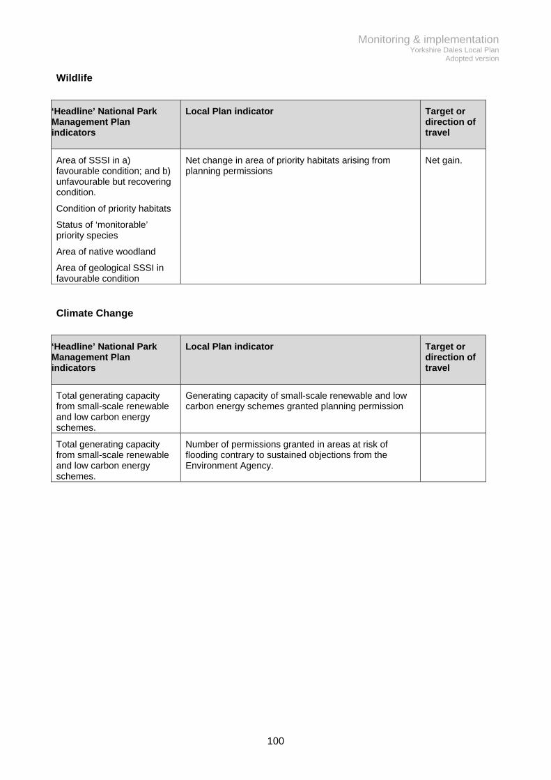
Monitoring & implementation Yorkshire Dales Local Plan
Adopted version
100
Wildlife
‘Headline’ National Park Management Plan indicators
Local Plan indicator Target or direction of travel
Area of SSSI in a) favourable condition; and b) unfavourable but recovering condition.
Condition of priority habitats
Status of ‘monitorable’ priority species
Area of native woodland
Area of geological SSSI in favourable condition
Net change in area of priority habitats arising from planning permissions
Net gain.
Climate Change
‘Headline’ National Park Management Plan indicators
Local Plan indicator Target or direction of travel
Total generating capacity from small-scale renewable and low carbon energy schemes.
Generating capacity of small-scale renewable and low carbon energy schemes granted planning permission
Total generating capacity from small-scale renewable and low carbon energy schemes.
Number of permissions granted in areas at risk of flooding contrary to sustained objections from the Environment Agency.

Glossary
101
Agricultural unit A business presenting certificated accounts on land registered as an agricultural holding, whose primary purpose is the production of livestock, food and fibre. Affordable housing Social rented, affordable rented and intermediate housing, provided to eligible households whose needs are not met by the market. Eligibility is determined with regard to local incomes and local house prices. Affordable housing should include provisions to remain at an affordable price for future eligible households or for the subsidy to be recycled for alternative affordable housing provision. (full definition in the NPPF) Allocated site An area of land identified for development on the Policies Map. Amenity Amenity will be judged having regard to the physical and social features of a site and its surroundings which contribute to a comfortable and desirable living environment. Amenity is not defined in guidance or legislation. It is a matter of fact and degree and each case may be different. Amenity will be judged having regard to the condition of a site, the impact on the surrounding area and the scope for tackling a problem. Ancillary domestic uses Uses that support the main purpose of a development. Assets of community value A building or land that has been safeguarded by the district council at the request of the local community. Owners cannot dispose of them without informing the council and waiting until the end of a six week period to see if there is community interest in purchasing it. Article 4 direction Article 4 of the Town and Country Planning (General Permitted Development) Order 1995 allows the local planning authority to restrict the scope of permitted development rights in defined areas. Brownfield Land that has already been developed for a use other than agriculture, forestry, mineral Extraction, waste disposal; or private residential garden. Community Infrastructure Levy A levy on new development by a planning authority for the purpose of raising funds for infrastructure required to support new development. Conservation area An area of special architectural or historic interest, the character or appearance of which it is desirable to preserve or enhance. Such areas are designated by local planning authorities under the Planning (Listed Buildings and Conservation Areas) Act 1990. Within such areas the local planning authority has a few additional powers over the demolition of buildings and the removal of trees. Conservation deficit The gap between the total project cost of restoring an historic asset and its value after restoration
Glossary
102
Community facility Include core facilities aimed at providing for educational, healthcare and recreational needs such as schools, childcare, libraries, nurseries, doctors surgeries, dentists, town/village halls/institutes/reading rooms, community offices, sports pitches, play and recreational areas, public gardens and greens, sports pavilions, gymnasiums and changing facilities. They might also include other important amenities like community car parking, allotments, travel, communications and utilities infrastructure. . In addition, there are the more commercially-orientated community facilities, including pubs, village shops and post offices, which are perhaps the most vulnerable if a suitable business model isn’t found to sustain them. Commuted sums Payments made by developers to the National Park Authority for use in support of affordable housing, conservation work to traditional farm buildings or compensation for the effects of development on biodiversity. Cultural heritage The buildings and historic places, monuments and artefacts that are considered worthy of preservation (commonly referred to as the ‘historic environment’) and the less ‘tangible’ traditions, customs and practices, aesthetic and spiritual beliefs, artistic expression, language and other aspects of human activity. Curtilage Usually an area containing or closely associated to, and used in connection with, a house or building. In relation to a listed building, the curtilage is an important element in determining the extent of the designation, but it is also a complex legal concept, so advice should always be sought from the Authority. Diversification Adding new business activities to traditional agricultural or rural estate land management. Examples include livestock and food products, energy crops, retail outlets, catering and visitor facilities. Ecosystem services: The benefits people obtain from ecosystems such as food, water, flood and disease control and recreation. Enabling development Development that would otherwise conflict with policy or be considered harmful, is considered acceptable in this context because it would facilitate (or ‘enable’) benefits to built heritage that outweigh the harm. Typically the benefits are the generation of funds that will be used to pay for work to a listed building or other heritage asset (e.g. traditional farm buildings), that is in pressing need of substantial repairs Essential infrastructure (for flood risk purposes – Policy CC2) Essential transport infrastructure (including mass evacuation routes), essential utility infrastructure including electricity generating power stations and grid and primary substations; and water treatment works that need to remain operational in times of flood, wind turbines

Glossary
103
Exceptions test (flood risk) Where it is proposed to site development within a flood risk area it must be demonstrated that; it provides wider sustainability benefits to the community that outweigh flood risk, the development should be on previously-developed land or, there are no reasonable alternative sites on previously-developed land available; A site specific flood risk assessment must demonstrate that the development will be safe, without increasing flood risk elsewhere. Extra care accommodation A form of housing designed for the needs of older people. It provides varying levels of on site care and support. Fuel poverty A household is considered by government to be in fuel poverty if it has required fuel costs that are above the national median level and were it to spend that amount it would be left with a residual income below the poverty line. Greenfield Land that has not been previously developed. Heritage asset A building, monument, site, place, area or landscape (designated or undesignated) that has heritage significance meriting consideration in planning decisions. Heritage statement Heritage Statements describe heritage assets and their significance. Applicants are required to submit them in support of planning applications affecting a heritage asset in order to justify the impact of their proposed works on the heritage asset and its significance, including its setting. Highly vulnerable uses (for flood risk purposes – Policy CC2) Basement dwellings, caravans, mobile homes and park homes intended for permanent residential use, emergency services stations and command centres and telecommunications installations required to be operational during flooding, emergency dispersal points, installations requiring hazardous substances consent Housing development boundary A boundary identified on the Policies Map, usually drawn around the currently built up extent of settlements. The purpose is to guide decisions on infill housing and rural exceptions sites (Policies C1 & C2) Inert waste Waste that is not chemically or biologically reactive and will not decompose. Examples include concrete, stone, building rubble and sand. Infrastructure The physical network of services and facilities that is required for an area to function properly. Examples include education, health, recreation, cultural services, communications, energy and waste management. Land based function Uses that derive their primary input from the land e.g. farming and rural estate management.

Glossary
104
Legal agreement See planning obligation Less vulnerable uses (for flood risk purposes – Policy CC2) Police, ambulance and fire stations which are not required to be operational during flooding, buildings used for shops, financial, professional and other services, restaurants and cafes, hot food takeaways, offices, general industry, storage and distribution, non–residential institutions not included in “more vulnerable”, and assembly and leisure, land buildings used for agriculture and forestry, waste treatment (except landfill and hazardous waste facilities), minerals working and processing (except for sand and gravel working), water treatment works which do not need to remain operational during times of flood, sewage treatment works (if adequate measures to control pollution and manage sewage during flooding events are in place). Listed building A building or structure designated as being of special architectural or historic interest. The designation extends to any structure or object fixed to the building or within its curtilage where it forms part of the land and has done so since 1948. Demolitions, extensions or alterations that are likely to affect their special character will require approval from the local planning authority. Local service centres The National Park hubs for community and visitor services such as housing, employment, retail, transport meeting places, leisure facilities, information and accommodation. See list in Table 1. Mitigation Works carried out during or after construction to reduce the environmental impact of development. More vulnerable uses (for flood risk purposes – Policy CC2) Hospitals, residential institutions such as residential care homes, children’s homes, social services homes, prisons and hostels, dwelling houses, student halls of residence, drinking establishments, nightclubs and hotels, non–residential uses for health services, nurseries and educational establishments, landfill and sites used for waste management facilities for hazardous waste, sites used for holiday or short-let caravans and camping, subject to a specific warning and evacuation plan Neighbourhood Plan A plan prepared by a Parish Council or Neighbourhood Forum for a designated neighbourhood area. If adopted, the Neighbourhood Plan becomes part of the Development Plan for the area concerned. Permitted development The Town and Country Planning (General Permitted Development) Order 1995 permits certain minor alterations and extensions to be undertaken without the need to apply for planning permission from the local planning authority. Permitted reserves The amount of mineral that already has planning permission for extraction. Planning obligation Legal agreements made under Section 106 of the Town and Country Planning Act 1990 between a developer and the local planning authority. The Agreement is legally binding and normally restricts the use of the land in a stated manner or requires specified operations, activities or payments to be carried out in association with development.

Glossary
105
Polite (building style) A building that makes a stylistic statement which goes beyond its functional requirements. Its design is deferential to national or international fashion and may pay little or no regard to the conventional building practices and materials particular to a locality. Policies Map The Policies Map shows the location of development opportunities, constraints to development and where certain planning policies apply. Priority habitats and species Species and Habitats of Principle Importance included in the England Biodiversity List published by the Secretary of State under section 41 of the Natural Environment and Rural Communities Act 2006. Precautionary principle Where the effects of doing something are uncertain, the action taken is required to err on the side of caution rather than risk damage that cannot be repaired. In the Local Plan context it is used to safeguard the integrity of European designated wildlife sites. Railhead A railway siding that provides for the transfer of freight. Retail impact assessment Measurement of the effect of retail proposals on the development plan strategy, their impact on planned new investment and their overall consequences on the vitality and viability of existing centres such as reduction in footfall and impact of vacancies. Rural based enterprise Land-related businesses which, directly or indirectly, need to be located in the countryside rather than in existing settlements. Examples include agriculture, forestry and other activities that obtain their primary inputs from the site, such as the processing of agricultural, forestry and mineral products together with land management activities and support services including agricultural contracting, tourism and leisure enterprises. Service village A settlement that provides a range of services to communities within an immediate area. Sequential test (flood risk) A sequential approach is followed to steer new development to areas with the lowest probability of flooding. The aim is to steer new development to Flood Zone 1 (areas with a low probability of flooding). Where there are no reasonably available sites in Flood Zone 1, local planning authorities should take into account the flood risk vulnerability of land uses and consider reasonably available sites in Flood Zone 2. Only where there are no reasonably available sites in Flood Zones 1 or 2 should the suitability of sites in Flood Zone 3 be considered. Short stay /short term letting This is occupation of a holiday accommodation unit for a period not exceeding 28 days in a single calendar year. The purpose is to prevent single household occupancy of new holiday accommodation in favour of multiple occupancy short stays.

Glossary
106
Site-specific flood risk assessment A site-specific flood risk assessment is carried out by, a developer to demonstrate how flood risk from all sources of flooding to the development itself and flood risk to others, will be managed now, and taking climate change into account. Small settlement A settlement with an identifiable core but very limited services Special Qualities The Special Qualities make up the National Park’s unique sense of place. They are a combination of visual qualities of the landscape, the qualities of the natural environment, and the cultural heritage giving the added dimension of a sense of time, depth and history. They also include more intangible qualities such as peace, solitude, wildness, space and inspiration. See list in Appendix 2. Strategic flood risk assessment A study carried out by one or more local planning authorities to assess the risk to an area from flooding from all sources, now and in the future, taking account of the impacts of climate change, and to assess the impact that changes or development in the area will have on flood risk. Sustainable development Development that meets the needs of the present without compromising the ability of future generations to meet their own needs. It is central to the economic, environmental and social success of the country and is the core principle underpinning the land use planning system. Simply stated, the principle recognises the importance of ensuring that all people should be able to satisfy their basic needs and enjoy a better quality of life, both now and in the future. Traditional buildings Buildings constructed at any time prior to the early to mid 20th Century. During the first half of the 20th Century the use of mass manufactured building materials began to reach the National Park, but traditional methods of construction still persisted. They are typically of solid stone wall construction with flagged or slated roofs, incorporating natural and predominantly locally sourced materials. Traditional Farm Buildings Toolkit’ Guidance for developers and decision makers that is supplementary to the local plan policies. It provides further guidance about assessing buildings and their capacity for change. Transport assessment A systematic process that measures the requirement to improve accessibility and safety for all modes of travel, particularly alternatives to the car such as walking, cycling and public transport. Vernacular A category of architecture based on local needs, construction materials and reflecting local traditions. The function of the building is the dominant factor, aesthetic considerations, though present to some small degree, are quite minimal. Water compatible uses (for flood risk purposes – Policy CC2) Flood control infrastructure. Water transmission infrastructure and pumping stations. Sewage transmission infrastructure and pumping stations. Sand and gravel working. Docks, marinas and wharves. Navigation facilities. Ministry of Defence installations. Ship building, repairing and dismantling, dockside fish processing and refrigeration and compatible activities requiring a waterside location. Water-based recreation (excluding sleeping accommodation). Lifeguard and

Glossary
107
coastguard stations. Amenity open space, nature conservation and biodiversity, outdoor sports and recreation and essential facilities such as changing rooms. Essential ancillary sleeping or residential accommodation for staff required by uses in this category, subject to a specific warning and evacuation plan Windfall sites Unallocated sites that are developed for housing.

Appendix 1 Superseded policies
108
Section 8(5) of the Local Planning Regulations (2012) require that, where a local plan contains a policy that is intended to supersede another policy it must state that fact and identify the superseded policy. This Local Plan supersedes all the policies within the 2006 Local Plan (those policies that were saved in April 2009) and 1998 Minerals & Waste Local Plan (those that were saved in October 2007). It also supersedes all policies within the 2012 Housing Development Plan. Below is a list of the policies that will no longer have effect together with the policies that will replace them on adoption. The new Local Plan contains some policies that cover entirely new ground, which aren’t listed below, but those that deal with equivalent development, but perhaps with a different scope, are listed. Current development plan policy that will cease to have effect
Replacement Local Plan 2015-30 policy
Development Plan Policy
Local Plan 2006 (saved policies 2009)
GP1 - National park purposes SP2 - National park purposes GP2 - General design policy SP4 - Development quality GP3 - Accessibility and safety SP4 - Development quality GP4 - Landscape enhancement schemes
SP4 - Development quality
GP5 - Major development SP6 - Major development GP6 - Permitted development rights
No replacement policy
Local Plan 2006 (saved policies 2009)
E1 - Employment land allocation BE1 - Business development sites E2 - New small-scale employment uses
BE1 - Business development sites
E3 - Existing employment sites BE1 - Business development sites BE7 - Safeguarding employment uses
E4 - Conversion of traditional buildings to employment uses
L2 - Conversion of traditional buildings acceptable uses
E5 - Re-use of modern buildings BE3 - Reuse of modern buildings E6 - Home-based working No specific policy but partly falls within
ambit of L2 - Conversion of traditional buildings acceptable uses
Local Plan 2006 (saved policies 2009)
F1 - Agricultural buildings and structures
BE2 - Rural land based enterprises
F2 - Farm diversification BE2 - Rural land based enterprises BE3 - Reuse of modern buildings L2 - Conversion of traditional buildings acceptable uses
F3 - Residential lets and self-catering holiday accommodation
BE2 - Rural land based enterprises L2 - Conversion of traditional buildings acceptable uses
Local Plan 2006 (saved policies 2009)
C1 - Provision of community facilities C10 - New or Improved community facilities
C2 - Protection of existing community facilities
C9 - Existing community facilities
C3 - Retailing and other services in key service centres
BE5 - High street service frontages
C4 - Village shops BE7 - Safeguarding employment uses C5 - Joint use of community facilities C9 - Existing community facilities

Appendix 1 Superseded policies
109
Current development plan policy that will cease to have effect
Replacement Local Plan 2015-30 policy
Development Plan Policy
Local Plan 2006 (saved policies 2009)
U1 - Foul and surface water drainage C11 - New and Improved infrastructure C12 - Infrastructure needed to support development
U2 - Water resources C11 - New and Improved infrastructure C12 - Infrastructure needed to support development
U4 - Telecommunications C11 - New and Improved infrastructure
U6 - Small-scale renewable developments
CC1 - Renewable and low carbon energy
U7 - Utility service lines C11 - New and Improved infrastructure
Local Plan 2006 (saved policies 2009)
NE1 - The open upland L10 – The open upland NE3 - Sites of special scientific interest
W1 – Wildlife sites, species and networks
NE4 - Limestone pavement W1 – Wildlife sites, species and networks
NE5 - Regional or local sites of nature conservation importance
W1 – Wildlife sites, species and networks
NE6 - Regionally important geological/geomorphological sites
W1 – Wildlife sites, species and networks
NE7 - Protection of species W1 – Wildlife sites, species and networks
NE8 - Preventing habitat fragmentation and species isolation
W1 – Wildlife sites, species and networks
NE9 - Trees, woodlands and hedgerows
W3 - Protecting trees, hedgerows and walls
NE10 - Protecting trees at risk from development
W3 - Protecting trees, hedgerows and walls
NE11 - New or improved habitats W2 – Biodiversity enhancement

Appendix 1 Superseded policies
110
Current development plan policy that will cease to have effect
Replacement Local Plan 2015-30 policy
Development Plan Policy
Local Plan 2006 (saved policies 2009)
B1 - Historic landscapes L1 - Heritage assets B3 - Other sites of archaeological significance
L1 - Heritage assets
B4 - Historic parks and gardens L1 - Heritage assets B5 - Open spaces in settlements C13 - Important open space B6 - Streets and plots L1 - Heritage assets B7 - Building design SP4 - Development quality B8 - Conservation areas L1 - Heritage assets B9 - Demolition within conservation areas
L1 - Heritage assets L4 - Demolition and alteration of traditional farmbuildings
B10 - Shop fronts
L1 - Heritage assets
B11 - Development within barns and walls conservation areas
L1 - Heritage assets L4 - Demolition and alteration of traditional farmbuildings
B12 - The Settle-Carlisle Railway Conservation Area
L1 - Heritage assets
B13 - Listed buildings L1 - Heritage assets B14 - Extensions and alterations to buildings
SP4 - Development quality L1 - Heritage assets
B15 - Conversion of traditional buildings
L3 - Conversion of traditional buildings building treatment
B16 - Re-occupation of former houses L2 - Conversion of traditional buildings acceptable uses
B17 - Changing land to domestic use No replacement policy – would fall within ambit of SP4 - Development quality
B18 - Signs and advertisements No replacement policy – would fall within ambit of SP4 - Development quality
B19 - Advance signs and advertisements
No replacement policy – would fall within ambit of SP4 - Development quality
Local Plan 2006 (saved policies 2009)
EP1 - Protecting the environment
SP4 - Development quality
Local Plan 2006 (saved policies 2009)
SR1 - Provision of community sport and recreation facilities
C10 - New or Improved community facilities C11 - New and Improved infrastructure
SR2 - Protection of existing community sport and recreation facilities
C9 - Existing community facilities
SR4 - Noisy sports No replacement policy SR5 - Golf courses No replacement policy SR6 - Equestrian centres T4 - Visitor facilities
T5 - Indoor visitor attractions SR7 - Private equestrian developments
No replacement policy

Appendix 1 Superseded policies
111
Current development plan policy that will cease to have effect
Replacement Local Plan 2015-30 policy
Development Plan Policy
Local Plan 2006 (saved policies 2009)
VF1 - Assessment of visitor facilities T4 - Visitor facilities T5 - Indoor visitor attractions
VF2 - Bunkhouse barns L2 - Conversion of traditional buildings acceptable uses
VF3 - Tented camp sites T1 - Camping VF4 - Sites for touring caravans T2 - Touring caravan sites
VF5 - Sites for static holiday caravans T3 - Sustainable self catering visitor accommodation
VF6 - Holiday chalets T3 - Sustainable self catering visitor accommodation
Local Plan 2006 (saved policies 2009)
TA1 - Protection of public rights of way and access opportunities
No replacement policy – falls within ambit of SP4 - Development quality
TA2 - New or improved public rights of way and public access opportunities
No replacement policy – falls within ambit of C11 - New and Improved infrastructure
TA3 - Pedestrians, cyclists and equestrians
No replacement policy – falls within ambit of SP4 - Development quality
TA4 - Public transport facilities No replacement policy – falls within ambit of C10 - New or Improved community facilities & C11 - New and Improved infrastructure
TA5 - Journey generating developments
No replacement policy – falls within ambit of SP4 - Development quality
TA6 - Protection of former railway lines
BE6 - Railway related development
TA7 - Rail facilities along the Settle-Carlisle Railway
BE6 - Railway related development
TA8 - Access tracks BE2 - Rural land based enterprises TA9 - Capacity of roads No replacement policy – falls within
ambit of SP4 - Development quality TA10 - Public road developments C11 - New and Improved
infrastructure TA11 - Design and construction of roads
No replacement policy – falls within ambit of SP4 - Development quality
TA12 - Access from the highway No replacement policy – falls within ambit of SP4 - Development quality
TA13 - Public car and coach parks
No replacement policy – falls within ambit of C10 - New or Improved community facilities & C11 - New and Improved infrastructure & T4 - Visitor facilities
TA14 - Parking standards No replacement policy – falls within ambit of SP4 - Development quality
TA15 - Rail transport for quarry and other bulky products
L6 - Crushed rock quarrying

Appendix 1 Superseded policies
112
Current development plan policy that will cease to have effect
Replacement Local Plan 2015-30 policy
Development Plan Policy
Housing Development Plan 2012
HDP1 - Presumption in favour of sustainable development
SP1 - Sustainable development
HDP2 - Land for new build housing
C1 - Housing in settlements
HDP3 - Change of use of non residential buildings to housing
L2 - Conversion of traditional buildings acceptable uses
HDP4 - Housing outside development boundaries
C3 – Rural workers’ housing
HDP5 - Rural exceptions sites
C2 - Rural exceptions sites
HDP6 - Sub division
C4 - Sub-division
HDP7 - Density and size
C1 – Housing in settlements
HDP8 - Energy efficiency & generation in housing developments
No replacement policy. Policy SP1 encourages more energy efficient buildings without requiring it.
HDP9 - Replacement dwellings C5 - Replacement Dwellings
HDP10 - Residential caravans and mobile homes
C6 - Residential caravans and mobile homes
HDP11 - Gypsy and Traveller caravan sites
C7 - Gypsies and Travellers caravan sites
Current development plan policy that will cease to have effect
Replacement Local Plan 2015-30 policy
Development Plan Policy
Minerals & Waste Local Plan 1998 (saved policies 2007)
Policy MLP2 - New quarries and extensions to existing quarries
L6 - Crushed rock quarrying
Policy MLP6 - Building Stone
L7 - Building stone
Policy MLP8 - Reworking of Mineral waste
L8 - Reworking mineral waste
Policy MLP9 - Reuse and recycling of construction and demolition wastes
C14 - Waste Management
Policy MLP17 - After use and long term management of sites
L6 - Crushed rock quarrying
Policy WLP1 - Disposal of household and non inert waste
C14 - Waste Management
Policy WLP2 - Disposal of Inert waste C14 - Waste Management Policy WLP3 - Civic Amenity Sites
C14 - Waste Management
Policy WLP4 - Local recycling sites C14 - Waste Management

Appendix 2 Special Qualities of the Yorkshire Dales National Park
113
In the Yorkshire Dales National Park, the interaction of people with nature has produced a landscape of remarkable beauty and distinctive character that is cherished and enjoyed by the nation. The Yorkshire Dales National Park is a home and a workplace for 20,000 people, with around 95% of the land in private ownership. It is also a place that millions of people visit every year. The area’s unique landscape character is created by the particular combination of many elements - the managed moorland, pastures and valley grasslands; small woodlands; dispersed villages and farmsteads; the local building materials; strong field patterns; drystone walls and field barns. This is what makes it such a special place58. Natural Beauty The area straddles the Pennines, the backbone of England. The underlying geology, natural processes and human activity have created a hugely varied landscape and numerous dramatic features and beautiful views: Dales with distinctive stepped profiles, produced by the weathering of layers of limestone interspersed with shales and sandstones from the Carboniferous period. Fells that rise to over 700 metres in the Millstone Grit-capped ‘Three Peaks’. Glaciers and rivers have cut deep dales into the extensive moorland plateaux, each distinctive in character and atmosphere. One of the best examples in Britain of classic limestone scenery, with its scars such as those at Gordale and Attermire, and limestone pavements, such as those above Malham Cove. Extraordinary cave systems, including the longest cave system in Britain, the largest cave in Britain and the largest waterfall in Britain at Gaping Gill. The Howgills, a series of grassy rounded hills made up of rocks from the older Silurian period, sweeping steeply upwards from deep ravines to broad rounded tops. Significant glacial and post-glacial landforms and features, including: drumlin fields, such as the one at Ribblehead; erratics, including those at Norber; moraines; and the post-glacial lakes of Semerwater and Malham Tarn. Spectacular waterfalls, such as: Hardraw Force; the famous series of Aysgarth Falls; and, Cautley Spout, with a broken drop of 180 metres. A traditional pastoral landscape created by livestock farmers over several centuries. This historic landscape is acknowledged as internationally important and includes:
an intricate network of drystone walls (as well as hedgerows in Lower Bishopdale, Dentdale and Sedbergh) that create a patchwork of enclosures across valleys and valley sides;
traditional stone-built field barns, the density of which in some parts of the National Park notably Swaledale, Wharfedale and Wensleydale, is unique.
58 Yorkshire Dales National Park Management Plan 2013

Appendix 2 Special Qualities of the Yorkshire Dales National Park
114
A highly legible landscape, in which there is still a very clear and evident link between the underlying geology and landform, the historic use and management of the land, the current land uses and land cover. A landscape of striking contrasts, between the deep, sheltered dales and the open, exposed, sweeping fells above. Wildlife Almost 30% (50,000ha) of the Yorkshire Dales National Park is made up of nationally and internationally important habitats – the largest area of any National Park. Geology, natural processes and human influences have created the particular conditions that support rich and diverse wildlife and habitats: Flower-rich hay meadows and pastures, produced by traditional, low intensity management of grazing land over many decades. These are very scarce nationally - this is one of the few areas where they survive in any number. A range of rare limestone habitats linked directly to the geology of the southern Dales. The area’s limestone country is internationally recognised for its biodiversity, which includes rare wet meadows and upland pastures, limestone pavement and limestone woodland and scrub. Extensive areas of moorland, much of it (42% of the area of the National Park) managed as grouse moor, that contain upland heath and blanket and raised bog, which are internationally important for wildlife and the carbon they store as peat. These habitats cover vast areas and contain a variety of plant species and important bird populations. Small areas of broadleaf woodland (2.5% of the area of the National Park) representing remnants of former more extensive broadleaved woodland or later plantings. Surviving areas of ancient woodland are of particularly high biodiversity value. Nationally important populations of breeding waders, black grouse, and ring ouzel; rare lime-loving plants such as bird’s-eye primrose, rigid Buckler fern, globeflower and baneberry; rare and scarce invertebrates such as the northern Brown Argus butterfly and the Atlantic white-clawed crayfish; and important mammals, notably the red squirrel. Cultural Heritage The Yorkshire Dales National Park has been home to communities and industry for several millennia, helping to shape much of what we now think is special. There is an exceptional amount of evidence of these previous generations of occupation, connecting past communities to the present and providing a highly visible record of the area’s social and economic history, including: A culture of community spirit, self-sufficiency, determination and self-belief, which has been shaped by the area’s physical environment and remoteness, nurturing self dependency and close knit communities. Livestock farming, with distinct sheep breeds and a strong tradition of upland cattle rearing, is still deeply interwoven into local life and culture. Livestock sales and agricultural shows play an important part in the lives of local people.

Appendix 2 Special Qualities of the Yorkshire Dales National Park
115
An exceptional range of archaeology, which provides the evidence of human activity from the earliest hunters of the Palaeolithic through to 20th century industrial remains. The remains of former rural industries, whose influences on the area’s culture and social fabric are still evident today. They include lead and lime extraction and processing sites, as well as water mills. Powerful reminders of periods of dominance by large estates and religious houses through place names and some surviving structures, such as Bolton Castle, Bolton Abbey, Barden Tower and Marrick Priory. Distinctive, traditional architecture where the local building materials used link directly to the area’s geology. Numerous small, attractive villages and hamlets most of which have been there for over a thousand years.as well as scattered farmsteads, Minor roads along the dales, bordered by drystone walls or hedgerows and flower-rich verges. Higher up, unfenced roads cross open moorland and offer dramatic views. The Settle-Carlisle Railway Line, opened in 1876, is unique and displays impressive engineering and conserved Midland Railway architecture. It offers a very special way of enjoying the dramatic landscape along its route. A distinctive linguistic, literary and artistic heritage, inspired by the landscape and by the history of the communities – past and present – who have lived and worked here. Enjoying the experience of being here Most of the people who spend any time in the National Park will experience a range of emotions, triggered by the beauty, grandeur and other, less tangible qualities. These all help create the ‘spirit of place’ that is unique to this National Park: Extensive areas where a true sense of tranquillity, remoteness and solitude can still be found, which is rare in England today. The natural sounds of wind, water and birdsong, which are important to the recreational experience; the ‘spiritual exercise and enjoyment’ that is at the heart of National Park designation. Expansive views that show to advantage the areas beauty and variety. Ever-changing light, seasonal change and occasional severe weather, which creates visual drama and contrast that enhance personal experience. Dark night skies - as it suffers little from light pollution, the moon, night sky and atmospheric effects can be fully appreciated. Its historic and extensive network of footpaths, bridleways and tracks, extensive areas of public access, rivers, crags and caves. Welcoming and friendly people and places, each with its own special character, but all with a very close sense of community, reflected in the wide range of local village shows social activities and entertainment.

Appendix 3 Business development site allocations
116
The following sites are allocated by Policy BE1 for a range of business uses and are shown on the Policies Map. The following table sets out the uses that are considered appropriate on each site alongside some information on opportunities and constraints of each that will help guide development proposals. The Authority will prepare full development briefs for each site.
Key to uses: Use class Description A1 Shops, retail warehouses, post offices, ticket and travel agencies, sale of cold
food for consumption off premises, hairdressers, funeral directors, hire shops, dry cleaners, internet cafes
A2 Banks, building societies, estate and employment agencies, professional services (not health or medical services), betting offices
A3 Restaurants and cafes A4 Public houses, wine bars or other drinking establishments A5 For the sale of hot food for consumption off the premises. B1 a) Office other than a use within Class A2
b) Research and development of products or processes c) For any industrial process (which can be carried out in any residential area without causing detriment to the amenity of the area
B2 Industrial processes other than that falling within Class B1 B8 Use for storage or as a distribution centre C1 Hotels, boarding and guest houses (where no significant element of care is
provided) C2 Residential accommodation and care to people in need of care, residential
schools, colleges or training centres, hospitals, nursing homes C3 Use as a dwellinghouse (whether or not a main residence) by a) A single
person or by people to be regarded as forming a single household b) Not more than six residents living together as a single household where care is provided for residents; or c) Not more than six residents living together as a single household where no care is provided to residents (other than use within Class C4)
D1 Clinics, health centres, creches, day nurseries, non-residential education and training centres, museums, public libraries, public halls, exhibition halls, places of worship, law courts
D2 Cinemas, concert halls, bingo halls, dance halls, swimming baths, skating rinks, gymnasiums, other areas for indoor and outdoor sports or recreations not involving motorised vehicles or firearms

Appendix 3 Business development site allocations
117
Site Size (ha)
Proposed uses
Toll Bar, Sedbergh 0.48 B1, B2, B8 Vacant land adjacent to established business units at Toll Bar with scope for similar
business/industrial uses; Planning permission for a single unit of warehouse & office accommodation (950sqm) granted
2013 (S/03/310A), expires 7th August 2016. A scheme of multiple smaller units similar to those already on the site could also be suitable;
Access to be formed from existing estate road. New dedicated access unlikely to be acceptable in highway safety terms;
May require archaeological assessment to investigate postulated Roman fort site; Ecological networks ‘buffer area’ – development to consider how to mitigate against any
detrimental effect on the movement of wildlife across the site; Policy requirement to ensure no net increase in surface water run off rates, so consideration
needs to be given to sustainable drainage systems. Baliol School, Sedbergh 2.01 B1, C1, C2, D1, D2 live/work, extra care Former school, ancillary buildings, 8 residences (5 dwellings & 3 flats) and grounds. Main
building (original house) located centrally in the site (1660sqm) incorporating 3 flats. A separate classroom block (610sqm), sports hall (510sqm) and gym (170sqm) located in the south eastern part of the site,
Potential for a combination of re-use of worthy structures and replacement of more modern structures with new build elements. Overall balance between developed and undeveloped areas to remain broadly the same as existing;
Tudor revival house, although unlisted, has architectural and historic interest, and should be retained. Scope to enhance character and appearance of the original building by removing/improving the 1960s-80s rear extensions. Complex of traditional buildings housing the gym and Pinetrees/Low Field Cottages also worthy of retention. Classroom block should be replaced with a new higher quality building. Scope to either replace or re-use sports hall building;
Potential for mixed uses – particular potential for extra care residential use identified; May require archaeological assessment to investigate postulated Roman Road between
Sedbergh & Kirkby Stephen; Residential area so amenity issues should be given careful consideration; More intensive use of the site likely to require significant access improvements at junction with
A683, alongside a Transport Statement; Tree Preservation Order (F100314) affects south east corner of site and Red Squirrel Buffer
area will affect choice of any planting; Occupancy of Fellside House tied to former school use – planning restriction will need to be
formally varied; Right of way along Thorns Lane gives potential to incorporate pedestrian links; Ecological networks ‘buffer area’ – development to consider how to mitigate against any
detrimental effect on the movement of wildlife across the site. Areas of site also ‘stepping stones’ and development should avoid these areas and consider the scope for increasing connectivity between habitats;
Policy requirement to ensure no net increase in surface water run off rates from undeveloped areas of the site, and a 30% reduction from developed areas, so consideration needs to be given to sustainable drainage systems.
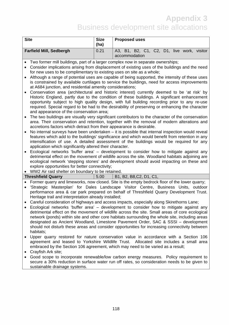
Appendix 3 Business development site allocations
118
Site Size (ha)
Proposed uses
Farfield Mill, Sedbergh 0.21 A3, B1, B2, C1, C2, D1, live work, visitor accommodation
Two former mill buildings, part of a larger complex now in separate ownerships; Consider implications arising from displacement of existing uses of the buildings and the need
for new uses to be complimentary to existing uses on site as a whole; Although a range of potential uses are capable of being supported, the intensity of these uses
is constrained by available curtilages to service the buildings, need for access improvements at A684 junction, and residential amenity considerations;
Conservation area (architectural and historic interest) currently deemed to be ‘at risk’ by Historic England, partly due to the condition of these buildings. A significant enhancement opportunity subject to high quality design, with full building recording prior to any re-use required. Special regard to be had to the desirability of preserving or enhancing the character and appearance of the conservation area;
The two buildings are visually very significant contributors to the character of the conservation area. Their conservation and retention, together with the removal of modern alterations and accretions factors which detract from their appearance is desirable.
No internal surveys have been undertaken – it is possible that internal inspection would reveal features which add to the buildings’ significance and which would benefit from retention in any intensification of use. A detailed assessment of the buildings would be required for any application which significantly altered their character.
Ecological networks ‘buffer area’ – development to consider how to mitigate against any detrimental effect on the movement of wildlife across the site. Woodland habitats adjoining are ecological network ‘stepping stones’ and development should avoid impacting on these and explore opportunities for better connectivity;
WW2 Air raid shelter on boundary to be retained. Threshfield Quarry 5.00 B1, B2, B8,C2, D1, C1, Former quarry and limeworks, now closed. Site is the empty bedrock floor of the lower quarry; ‘Strategic Masterplan’ for Dales Landscape Visitor Centre, Business Units, outdoor
performance area & car park prepared on behalf of Threshfield Quarry Development Trust. Heritage trail and interpretation already installed;
Careful consideration of highways and access impacts, especially along Skirethorns Lane; Ecological networks ‘buffer area’ – development to consider how to mitigate against any
detrimental effect on the movement of wildlife across the site. Small areas of core ecological network (ponds) within site and other core habitats surrounding the whole site, including areas designated as Ancient Woodland, Limestone Pavement Order, SAC & SSSI – development should not disturb these areas and consider opportunities for increasing connectivity between habitats;
Upper quarry restored for nature conservation value in accordance with a Section 106 agreement and leased to Yorkshire Wildlife Trust. Allocated site includes a small area embraced by the Section 106 agreement, which may need to be varied as a result;
Crayfish Ark site; Good scope to incorporate renewable/low carbon energy measures. Policy requirement to
secure a 30% reduction in surface water run off rates, so consideration needs to be given to sustainable drainage systems.

Appendix 3 Business development site allocations
119
Site Size (ha)
Proposed uses
Former Linton Camp site 5.28 B1, C1, C2, visitor accommodation Residential camp actively used 1939-1980s – retains lawful planning use as a residential
institution under class C2 of the Use Classes Order; Extremely prominent open countryside location – visual and landscape character impacts a
key consideration; The focus of development opportunity is upon the part of the site that already contains
buildings. Any development of the remaining parts of the site not currently occupied by buildings will only be permitted where it can be shown to enhance or better reveal the significance of the Scheduled Monument and where it will conserve or enhance the particular landscape, wildlife and archaeological qualities of the area;
New structures likely to be predominantly single storey, in line with the existing structures, have an emphasis on high quality design and landscaping that sits harmoniously in the landscape;
Opportunity for a more ‘organic’ development that avoids the current rigid layout of the buildings & incorporates a more satisfactory scheme of planting to replace the formal shelter belts currently in place;
Any proposals for the site will need to clearly demonstrate that they will not harm those elements of the Scheduled Monument (medieval farmstead) which contribute its significance. Scope for improved planting to enhance the setting and views of the monument so as to better reveal its aesthetic significance;
Social and cultural significance in the context of the National Park – some potential for limited preservation of buildings in-situ, but multi-media recording required in advance of demolition;
Careful consideration needed of how to manage traffic impacts and incorporate sustainable transport choices, including linkages with and enhancements to the rights of way and public transport networks;
High surface water flood risks on undeveloped parts of the site – scope to improve management of water across the whole site as part of redevelopment. Policy requirement to secure a 30% reduction in surface water run off rates, so consideration needs to be given to sustainable drainage systems. Also scope to enhance existing pond habitats as part of this;
Ecological networks ‘buffer area’ – development to consider how to mitigate against any detrimental effect on the movement of wildlife across the site. Small area of core ecological network (ponds) – development should not disturb these.

Appendix 3 Business development site allocations
120
Site Size (ha)
Proposed uses
Land north of Dales Centre, Reeth 0.32 B1, A2 live/work Northern extension to the existing Reeth Dales Centre Business Park, presently a field laid to
pasture and enclosed by a steep slope to the west and housing to the east. drystone walls. Allocated housing sites to the north fronting Arkengarthdale Road – opportunity to consolidate
development activity to minimise disruption; Access to be formed from the existing estate road serving the Reeth Dales Centre. Most of the site is slightly elevated above houses fronting Arkengarthdale Road. Development
would most likely need to single storey and maintain sufficient separation from residential properties to avoid an overbearing impact on these properties, to minimise visual impact in wider landscape views, and for consistency with the established development.
Ecological networks ‘buffer area’ – development to consider how to mitigate against any detrimental effect on the movement of wildlife across the site, in particular because it adjoins a ‘core’ area immediately to the west of the site;
Assessed as being capable of development without harm to the character and appearance of the Swaledale & Arkengarthdale Barns & Walls Conservation Area, but this relies on the scale and massing of development being in line with the adjacent established employment site;
Archaeological excavation and recording likely to be required in advance of development to mitigate against any loss of evidential value of the earthwork evidence of the lynchet field system;
Policy requirement to ensure no net increase in surface water run off rates, so consideration needs to be given to sustainable drainage systems;
Site affected by a recently constructed water main underlying the site. Cragg Hill Road, Horton in Ribblesdale
0.48 B1, B2, B8,
Southern extension to the established development of business units into a field presently laid to pasture and enclosed by the quarry access road and the Settle Carlisle Railway;
Scope to develop further business units or storage facilities to provide scope for new businesses to locate here or to help facilitate expansion of established businesses (including those already occupying the units on Cragg Hill Road);
Settle Carlisle Railway Conservation Area (architectural and historic interest) adjoins site – assessed as being capable of development without harm to the setting of the Conservation Area, but this relies on the scale and massing of development being in line with the adjacent established employment site;
Residential amenity considerations important, particularly in relation to the number and type of vehicle movements in addition to existing quarry traffic along Cragg Hill Road;
Ecological networks ‘buffer area’ – development to consider how to mitigate against any detrimental effect on the movement of wildlife across the site
Policy requirement to ensure no net increase in surface water run off rates, so consideration needs to be given to sustainable drainage systems.

Appendix 3 Business development site allocations
121
Site Size (ha)
Proposed uses
Giggleswick Quarry 3.01 B1, B2, B8, D1, solar farm Former limestone quarry. Allocated site occupies the bedrock floor of the former lower quarry
and avoids areas of upper quarry where the quarry face potentially unstable and a Raven/Peregrine nesting site;
Good vehicular access to A65 & Settle, although the impact from traffic or uses that might compromise the vitality of Settle town centre will need to be carefully considered.
Potential for low key industrial uses or uses in conjunction with nearby golf club and school Suggestion that a solar farm or other renewable/low carbon facility could be housed in the quarry as visual impacts are largely negated;
Ecological networks ‘buffer area’. Woodland and calcareous grassland form ‘core’ and ‘stepping stone’ areas of ecological network either side of the site – development should not disturb these and consider how connectivity could be improved. 15 year restoration scheme already in place as part of Section 106 agreement on closure of quarry;
Large area of Tree Preservation Orders on western flank of site to remain undisturbed; Policy requirement to secure a 30% reduction in surface water run off rates, so consideration
needs to be given to sustainable drainage systems. Former Weatheralds site, Askrigg
1.41 B1, B2, B8, C1, C2, live/work, visitor accommodation, safeguard railway station site
Former railway station and yard, last used as a wood component manufacturing site. Range of modern sheds and traditional railway buildings offering potential for re-use and redevelopment;
Three ownerships resulting in a small part of site being used as a coal yard and the bulk of the remainder due to be partially redeveloped as a base for veterinary business, with some vacant land retained for possible future business expansion. The third and remaining part of the site comprises the former paint shop and portacabin offices adjacent to the site access and a small greenfield paddock beyond, where there remains some capacity for development;
Large areas of high and moderate surface water flood risk identified to the north and south of the site with a small area within the site (coal yard). Flood risk assessment should explore these risks in more detail and identify suitable mitigation. Policy requirement to secure a 30% reduction (previously developed areas) or no net increase (undeveloped areas) in surface water run off rates, so consideration needs to be given to sustainable drainage systems as part of overall surface water management in the site.
Moderate (Flood Zone 2) fluvial flood risk penetrates the eastern half of the site. Site has been sequentially tested by Strategic Flood Risk Assessment, so less vulnerable uses can be considered across the whole site. SFRA assumes that, with the effects of climate change, after 2025 Flood Zone 2 becomes Flood Zone 3, so more vulnerable uses shouldn’t be located on this part of the site and a flood risk assessment should look in more detail at the implications for development of all forms of flood risk.
Former railway trackbed and station site protected under Policy BE6 and shouldn’t be compromised by any employment development
Ecological networks ‘buffer area’ – development to consider how to mitigate against any detrimental effect on the movement of wildlife across the site.

Appendix 3 Business development site allocations
122
Site Size (ha)
Proposed uses
Langcliffe Quarry 1.01 B1, B2, B8, C1, C2, live work Previously developed land consisting of overgrown hard surfaced areas and buildings
associated with former Stainforth sidings serving the limeworks, and the later use of the site as a civic amenity and waster transfer site.
Scope for some small development on part of the site utilising the 19th century buildings and replacing some 20th century structures. Any development on the previous waste transfer site/car park would need to be limited in scale/height to minimise visual impact and respect the setting of the Hoffmann Kiln;
The 19th century buildings, although excluded from the Scheduled Monument, are included in the Conservation Area and make a positive contribution to the significance of the site. They offer possibilities for reuse and their conservation would mitigate against any harm caused by new development. The scale of any new development needs to be subservient to the 19th century structures, and should continue to respect the linear arrangement of the sidings, retaining the visual link to the Settle Carlisle Railway.
Views into and across the site, whether public or private, to key features, particularly the kilns, need to be respected.
Southernmost part of the site has never had archaeological survey and so this should precede development proposals. Impact on Scheduled Monument (Craven Lime Works) & Settle Carlisle Railway Conservation Area, including the impact on setting (including internal and external views), together with proposed mitigation, should be provided as part of any planning and Scheduled Monument Consent applications.
Access to the quarry face and Hoffmann Kiln to be retained to ensure recreational, wildlife (Peregrine nesting site) and historic qualities of site continue to be enjoyed. Use of the site needs to be consistent with maintaining these qualities;
Displacement of dwelling to be considered; Ecological networks ‘buffer area’ – development to consider how to mitigate against any
detrimental effect on the movement of wildlife across the site. Small pocket of woodland habitat at the northern end of the site and larger area immediately to the east of the site form ‘core’ and ‘stepping stone’ areas of ecological network – development should not disturb these and should consider how connectivity could be improved;
Public footpath running through middle of the site to be retained/diverted as appropriate; Pockets of high and medium surface water risk on the site – Strategic Flood Risk Assessment
considered scope to manage the risk through suitable sustainable drainage systems. Policy requirement to secure a 30% reduction in surface water run off rates needs to be incorporated into these measures.
Former Lyon equipment site, Dent
0.31 A1, A2, A3, B1, B2, C1, C2, D1, D2 live/work, extra care
Former light industrial/distribution site, now vacant, with a range of buildings; Flexibility for a range of uses, incorporating re-use or redevelopment of existing buildings; Despite flexibility of uses within site itself, highway access very constrained through village
and over bridge, and it is also in a predominantly residential area, so the nature of the use will need to be able to fit around these constraints and should not attract HGV movements;
High groundwater flood risk (clearwater & superficial deposits) identified from high-level data – site specific investigation required to clarify the nature of the risk;
Ecological networks ‘buffer area’ – development to consider how to mitigate against any detrimental effect on the movement of wildlife across the site. Red squirrel buffer area may affect the choice of planting scheme.
Policy requirement to secure a 30% reduction in surface water run off rates, so consideration needs to be given to sustainable drainage systems.

Appendix 3 Business development site allocations
123
Site Size (ha)
Proposed uses
Yore Mill, Aysgarth 0.10 B1, B2, B8, A3, D1, live/work, visitor accommodation Grade II listed former mill building with three floors and an attic providing over 1000 square
metres of floorspace. Separate ownership from ancillary buildings and cottages surrounding – very restricted
curtilage to service building – public car parking currently available at Falls Country Club National Park Centre and Aysgarth Station site;
An ‘at risk’ listed building due mainly to a defective roof leading to water penetration of the interior. A high priority for re-use to avoid further harm to historic fabric;
Possibility of an enabling development solution if a use of the building will not in itself overcome the conservation deficit associated with the high cost of re-roofing;
Potential for ‘meanwhile uses’ while long term future of building is resolved; Key visitor location, high profile building with good footfall – good linkage with Aysgarth
National Park Centre, Aysgarth Station (Wensleydale Railway with aspirations to reinstate the former line). Suggests a visitor-economy-led use might be optimal;
As part of any re-use proposal, special regard must be had to desirability of preserving or enhancing the building’s setting and features of interest, including consideration of any impact on setting of the building and the wider grouping. Works must be to a conservation standard consistent with the building’s significance and informed by an appropriate historic building assessment;
Ecological networks ‘buffer area’ – development to consider how to mitigate against any detrimental effect on the movement of wildlife across the site. River corridor nearby is a Site of Special Scientific Interest that may be vulnerable to disturbance;
Well used footpath adjacent to the mill links car parks to the falls and wider rights of way. Should remain unobstructed and scope to restore the steps;
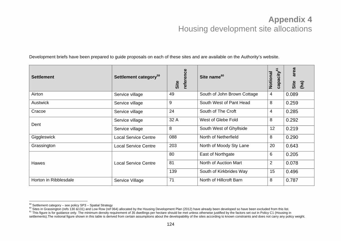
Appendix 4 Housing development site allocations
124
Development briefs have been prepared to guide proposals on each of these sites and are available on the Authority’s website.
Settlement Settlement category59
Sit
e
refe
ren
ce
Site name60
No
tio
nal
cap
acit
y61
Sit
e ar
ea
(ha)
Airton Service village 49 South of John Brown Cottage 4 0.089
Austwick Service village 9 South West of Pant Head 8 0.259
Cracoe Service village 24 South of The Croft 4 0.285
Dent Service village 32 A West of Glebe Fold 8 0.292
Service village 8 South West of Ghyllside 12 0.219
Giggleswick Local Service Centre 088 North of Netherfield 8 0.290
Grassington Local Service Centre 203 North of Moody Sty Lane 20 0.643
Hawes Local Service Centre
80 East of Northgate 6 0.205
81 North of Auction Mart 2 0.078
139 South of Kirkbrides Way 15 0.496
Horton in Ribblesdale Service Village 71 North of Hillcroft Barn 8 0.787
59 Settlement category – see policy SP3 – Spatial Strategy 60 Sites in Grassington (refs 130 &131) and Low Row (ref 064) allocated by the Housing Development Plan (2012) have already been developed so have been excluded from this list. 61 This figure is for guidance only. The minimum density requirement of 35 dwellings per hectare should be met unless otherwise justified by the factors set out in Policy C1 (Housing in settlements).The notional figure shown in this table is derived from certain assumptions about the developability of the sites according to known constraints and does not carry any policy weight.

Appendix 4 Housing development site allocations
125
Settlement Settlement category
Sit
e
refe
ren
ce
Site name
No
tio
nal
cap
acit
y
Sit
e ar
ea
(ha)
Long Preston Service Village 61 West of Grosvenor Farm 9 0.313
113 & 133 North of Greengate Farm 13 0.373
Malham Service Village 83 West of Daisy Bank 2 0.027
Millthrop Service Village 4 South of Derry Cottages 10 0.318
Reeth Local Service Centre
86 Land to rear of Arkle Terrace 4 0.202
136 Land off Arkengarthdale Road 2 0.096
211 East of Park Lea 10 0.216
Sedbergh Local Service Centre 69 West of Shaldon 30 1.256
123 East of Rawthey Gardens 6 0.277
Threshfield Local Service Centre 75 & 126 South of Institute 10 0.409
West Witton Service Village 116 West of School Croft 12 0.569
TOTAL 203 7.699

Appendix 5 Local occupancy criteria
126
An occupying household is required to comply with one of the following criteria, at the point of occupancy:
i) Existing residents of the National Park establishing a separate household, purchasing a property for the first time, downsizing to a more manageable home or requiring more space for a growing family;
ii) A head of household who is or whose partner is in or is taking up full-time permanent employment or self employment, within the National Park (or in another part of a parish split by the National Park boundary). Where a person is employed in a business that operates in multiple locations, their employment activities should take place predominantly inside the National Park;
iii) A household that has a child at a school within the National Park;
iv) Householders currently living permanently in a dwelling which is either shared but not self contained, overcrowded, or is otherwise unsatisfactory by environmental health standards and which is within the National Park (or in another part of a parish split by the National Park boundary);
v) Elderly or disabled persons requiring sheltered or otherwise more suitable accommodation who already live permanently within the National Park (or in another part of a parish split by the National Park boundary;
vi) Persons having to leave tied accommodation within the National Park (or in another part of a parish split by the National Park boundary);
vii) Former residents of the National Park (or of another part of a parish split by the National Park boundary) whose case is accepted in writing by the Authority as having a need to return to the National Park. Notes
If after a period of 12 weeks a qualifying household is not forthcoming then the area will be widened by substituting ‘National Park’ with ‘area of the National Park and constituent district council’.
The categories set out in criteria i), iv), v) and vi) will apply only to persons who have resided permanently in the National Park for the preceding three years. Category vii) will apply to residents who have resided in the National Park for a minimum of 10 years.
Prospective households will have their attention drawn to the occupancy restriction and in particular its effect on the valuation of their property and the potential delay this may cause to its subsequent sale or re-occupancy.
All local occupancy restrictions will be secured through a Section 106 agreement. The Authority’s legal costs of preparing household occupancy agreements will be met by the applicant.
The Authority will encourage existing occupancy restricted dwellings to upgrade to these, more flexible criteria.
Occupation will be as a principal or main residence and not as a holiday home, second home or short term let accommodation.

Appendix 6 Securing affordable housing
127
Affordable housing is defined as social rented, affordable rented and intermediate housing, provided to eligible households whose needs are not met by the market. Eligibility is determined with regard to local incomes and local house prices. Affordable housing should include provisions to remain at an affordable price for future eligible households or for the subsidy to be recycled for alternative affordable housing provision. Local connection A key part of securing affordable housing is ensuring it is made available for occupation by suitable qualifying households. A household’s need for affordable housing will be determined by the Registered Provider and/or the District Housing Authority. For schemes within the National Park, the following local connection criteria will apply:
i) Households resident in the National Park for the preceding three years; or, ii) A household that contains someone that is in or is taking up employment in the National
Park, with a contract length of not less than 12 months, and for a minimum of 16 hours a week; or,
iii) A household returning to the National Park having lived there for at least 10 years previously.
Affordable housing should be offered in the first instance to households who have a connection to the Parish within which the need has been identified or a group of Parishes, as agreed by the National Park Authority. If no eligible occupier can be found within the Parish (or group of Parishes) then those who meet the local connection criteria in the remainder of the National Park will be eligible. If no one there is available, then a third priority area would become valid, embracing the whole district housing authority area. Commuted sums On sites of 6-11 houses, the Authority’s policy requires a financial contribution towards off-site affordable housing in lieu of on-site provision. This is calculated as follows: CS = GDV – TV CS (Commuted sum) the sum payable by the developer to YDNPA in lieu of building
affordable housing on site GDV (Gross development value)
the estimated value that the open market homes will fetch if they are sold in the current economic climate
TV (Transfer value) the price an Housing Association or Registered Provider would pay for the number of affordable dwellings that would otherwise have been delivered on the site
Example (2-bed house): £165,000 (GDV) less £95,000 (TV) = £70,000 (CS)