yuma proving ground haer no. klr-3 yuma county ha£lpv
TRANSCRIPT
Yuma Proving Ground HAER No. klr-3
Yuma County HA£LPv Arizona *
WRITTEN HISTORICAL AND DESCRIPTIVE DATA
Historic American Engineering Record National Park Service
Departmentt of the Interior Washington',' DC 20013-7127
HISTORIC AMERICAN ENGINEERING RECORD
Yuma Proving Ground
AZ-5
Location:
Date of Construction:
Owner:
Significance:
Historical Report Prepared by:
Prepared for Transmittal by:
In southwestern Arizona in Yuma County/ east of the Colorado River.
Established in 1942.
Department of the Army
Yuma Proving Ground was established during World War II by the Corps of Engineers for the testing of a new floating bridge. In 1951, the facility shifted in emphasis to become a testing center for many types of Army equipment, from tanks to water purification units,
William Brenner, 1984
Robie S. Lange, HABS/HAER, 1985.
Yuma Proving Grounds HAER No. A2-5 page 5,
EXECUTIVE SUMMARY
The Yuma Proving Ground, part of the U.S. Army Test and Evaluation Command,
occupies 838,174 acres in southwestern Arizona. The installation conducts
artillery, aircraft, and desert mobility tests, as well as various environmental
tests. It contains a highly instrumented multipurpose aircraft armament
testing range, vehicular test courses, amphibious testing areas, and a large
gunnery range.
The origins of the proving ground date from 1942, when the land it now
occupies was included in Maneuver Area B of General George S. Patton's
Desert Training Center, renamed the California-Arizona Maneuver Area in
1943. One of the training center's six temporary division tent camps, Camp
Laguna, was located on the site of the present Mobility Test Area.
In early 1943, the Army Corps of Engineers began testing a new floating
bridge on the Colorado River below Imperial Dam, several miles northwest of
Camp Laguna. Tests were conducted by the Engineer Board's Yuma Test
Branch and carried out by Engineer battalions under command of the California-Arizona
Maneuver Area and, later, by Italian service units. In 1947, the Yuma Test
Branch was moved from its site below the Imperial Dam to the present Main
Post area at the proving ground. The first group of permanent buildings was
constructed at this time. After a structural collapse in the Gila desilting
basin below the dam in 1949, bridge testing ceased. Yuma Test Branch
closed shortly thereafter, but in 1951 the Yuma Test Station opened on the
same site, and the buildings in the Main Post area were reoccupied. The
majority of the proving ground's existing 664 buildings and structures were
I
Yuma Proving Grounds HAER No. AZ-5 Page 3
were reoecupied. The majority of the proving ground's existing 664 buildings
and structures were erected in the following ten years as the station became
an important testing center for many types of Army equipment, from tanks
to water purification units.
There are no Category I, II, or III historic properties at Yuma Proving Ground.
Yuma Proving Grounds HAER No. A2-5 page <y
CONTENTS
Executive Summary
PREFACE !
1. INTRODUCTION 3
Scope 3
Methodology 4
2. HISTORICAL OVERVIEW 11
Background and Premilitary Land Use 11
California-Arizona Maneuver Area, 1942-1944 , 14
Yuma Test Branch, 1943-1949 16
Yuma Proving Ground, 1951-present.. 27
3. PRESERVATION RECOMMENDATIONS 27
Background 27
Category I Historic Properties 32
Category II Historic Properties 32
Category III Historic Properties.... 32
BIBLIOGRAPHY 34
Yuma Proving Grounds HAER No. AZ-5 page^fT
PREFACE
This report presents the results of an historic properties survey of the Yuma
Proving. Ground. Prepared for the United States Army Materiel Development
and Readiness Command (DARCOM), the report is intended to assist the
Army in bringing this installation into compliance with the National Historic
Preservation Act of 1966 and its amendments, and related federal laws and
regulations. To this end, the report focusses on the identification, evaluation,
documentation, nomination, and preservation of historic properties at the
Yuma Proving Ground. Chapter 1 sets forth the survey's scope and method-
ology; Chapter 2 presents an architectural, historical, and technological over-
view of the installation and its properties; and Chapter 3 identifies sig-
nificant properties by Army category and sets forth preservation recom-
mendations. Illustrations and an annotated bibliography supplement the text.
This report is part of a program initiated through a memorandum of agree-
ment between the National Park Service, Department of the Interior, and the
U.S. Department of the Army. The program covers 74 DARCOM installations
and has two components; 1) a survey of historic properties (districts, buildings,
structures, and objects), and 2) the development of archeological overviews.
Stanley H. Fried, Chief, Real Estate Branch of Headquarters DARCOM,
directed the program for the Army, and Dr. Robert J. Kapsch, Chief of the
Historic American Buildings Survey/Historic American Engineering Record
(HABS/HAER) directed the program for the National Park Service. Sally
Kress Tompkins was program manager, and Robie S. Lange was project manager
for* the historic properties survey. Technical assistance was provided by
Donald C. Jackson.
Yuraa Proving Grounds HAER No. AZ-5 page (&
Building Technology Incorporated acted as primary contractor to HABS/HAER
for the historic properties survey. William A. Brenner was BTI's principal-in-
eharge and Dr. Larry D. Lankton was the chief technical consultant. Major
subcontractors were the MacDonald and Mack Partnership and Melvyn Green
and Associates. The author of this report was William Brenner. The author
gratefully acknowledges the help of Carl Johnson, who was the proving ground's
Environmental Engineer at the time of the survey, and Jim Coles, the post
Public Affairs Officer.
The complete HABS/HAER documentation for this installation will be included
in the HABS/HAER collections at the Library of Congress, Prints and Photographs
Division, under the designation HAER No. AZ-5.

Yuma Proving Grounds HAER No. AZ-5 page 7
Chapter 1
INTRODUCTION
SCOPE
This report is based on an historic properties survey conducted in 1983 of
Army-owned properties located within the official boundaries of the Yuma
Proving Ground. The survey included the following tasks:
• Completion of documentary research on the history of the installation
and its properties.
• Completion of a field inventory of all properties at the installation.
• Preparation of a combined architectural, historical, and technological
overview for the installation.
• Evaluation of historic properties and development of recommendations
for preservation of these properties.
Also completed as a part of the historic properties survey of the installation,
but not included in this report, are HABS/HAER Inventory cards for 18 indi-
vidual properties. These cards, which constitute HABS/HAER Documentation
Level IV, will be provided to the Department of the Army. Archival copies
of the cards, with their accompanying photographic negatives, will be trans-
mitted to the HABS/HAER collections at the Library of Congress.
The methodology used to complete these tasks is described in the following
section of this report.
Yuma Proving Grounds HAER No. AZ-5 page g
METHODOLOGY
1. Documentary Research
The Yuma Proving Ground is a large, and highly unique, desert testing
facility that dates from early 1943, when it was first activiated as the
Yuma Test Branch. Documentary research focussed on the physical
development of the proving ground and on its general history. The
Arizona State Historic Preservation Office was contacted about possible
historic properties at the Yuma Proving Ground but none were identified
by this source.
Army records used for the field inventory included current Real Property
Inventory (RPI) printouts that listed all officially recorded buildings and
structures by facility classification and date of construction; the plant's
property record cards; base maps, and photographs supplied by installation
personnel, and various reports and documents relating to master planning
and environmental assessment. A complete listing of documentary mate-
rial may be found in the bibliography.
2. Field Inventory
The field inventory was conducted by William Brennner during a two-day
period in March 1983. Carl Johnson, the installation Environmental
Engineer at the time of the survey, served as the point of contact and
coordinated the survey activities. Mr. Johnson also acted as survey
escort.
Yuma Proving Grounds HAER No. AZ-5 page C|
Field inventory procedures were based on the HABS/HAER Guidelines
for Inventories of Historic Buildings and Engineering and Industrial Structures.
The Main Post, the Mobility Test Area, Laguna Army Airfield, and the
KOFA Firing Range were surveyed. Building locations and approximate
dates of construction were noted from the installation's property records
and field-verified. The remainder of this approximately 1310 square
mile installation contains only a small number of post-war utilitarian
structures and was not surveyed. USGS topographic maps (7.5 and 15
minute series) for the entire proving ground area were closely examined
to help confirm reports from installation personnel that no pre-military
structures still stand on Army property.
The earliest buildings at the proving ground date from 1947-48. Field
inventory forms were completed for the majority of these properties,
2 and for other representative post-war buildings and structures. Informa-
tion collected on the field forms was later evaluated, condensed, and
transferred to HABS/HAER Inventory cards.
3. Historic Overview
A combined architectural, historical, and technological overview was
prepared from information developed from the documentary research and
the field inventory. It was written in two parts: 1) an introductory
description of the installation, and 2) a history of the installation by
periods of development, beginning with pre-military land uses. Maps and
photographs were selected to supplement the text as appropriate.
Yuraa Proving Grounds HAER No. AZ-5 page |Q
The objectives of the overview were to 1) establish the periods of major
construction at the installation, 2) identify important events and indi-
viduals associated with specific historic properties, 3) describe patterns
and locations of historic property types, and 4) analyze specific building
and industrial technologies employed at the installation.
4. Property Evaluation and Preservation Measures
Based on information developed in the historical overviews, properties
were first evaluated for historical significance in accordance with the
elegibility criteria for nomination to the National Register of Historic
Places. These criteria require that eligible properties possess integrity
of location, design, setting, materials, workmanship, feeling, and associa-
3 tion, and that they meet one or more of the following:
A. Are associated with events that have made a significant contribution
to the broad patterns of our history.
B. Are associated with the lives of persons significant in the nation's
past.
C. Embody the distinctive characteristics of a type, period, or method
of construction, represent the work of a master, possess high artistic
values, or represent a significant and distinguishable entity whose
components may lack individual distinction.
D. Have yielded, or may be likely to yield, information important in
pre-history or history.
Yuwia Proving Grounds HAER No. AZ-5 page \\
Properties thus evaluated were further assessed for placement in one of
five Army historic property categories as described in Army Regulation
420-40:4
Category I Properties of major importance
Category II Properties of importance
Category III Properties of minor importance
Category IV Properties of little or no importance
Category V Properties detrimental to the significance of
of adjacent historic properties
Based on an extensive review of the architectural, historical, and techno-
logical resources identified on DARCOM installations nationwide, four
criteria were developed to help determine the appropriate categorization
level for each Army property. These criteria were used to assess the
importance not only of properties of traditional historical interest, but
of the vast number of standardized or prototypical buildings, structures,
and production processes that were built and put into service during
World War II, as well as of properties associated with many post-war
technological achievements. The four criteria were often used in combination
and are as follows:
1) Degree of importance as a work of architectural, engineering, or
industrial design. This criterion took into account the qualitative
factors by which design is normally judged: artistic merit, work-
manship, appropriate use of materials, and functionality.
Yuma Proving Grounds HAER No. AZ-5 page |"^
2) Degree of rarity as a remaining example of a once widely used
architectural, engineering, or industrial design or process. This
criterion was applied primarily to the many standardized or proto-
typical DARCOM buildings, structures, or industrial processes. The
more widespread or influential the design or process, the greater
the importance of the remaining examples of the design or process
was considered to be. This criterion was also used for non-military
structures such as farmhouses and other once prevalent building
types.
3) Degree of integrity or completeness. This criterion compared the
current condition, appearance, and function of a building, structure,
architectural assemblage, or industrial process to its original or
most historically important condition, appearance, and function.
Those properties that were highly intact were generally considered
of greater importance than those that were not.
4) Degree of association with an important person, program, or event.
This criterion was used to examine the relationship of a property to
a famous personage, wartime project, or similar factor that lent the
property special importance.
The majority of DARCOM properties were built just prior to or during
World War II, and special attention was given to their evaluation. Those
that still remain do not often possess individual importance, but collec-
tively they represent the remnants of a vast construction undertaking
whose architectural, historical, and technological importance needed to
Yuma Proving Grounds HAER No. AZ-5 page to
1940-1945 period, and its contribution to the history of World War II
and the post-war Army landscape.
Because technology has advanced so rapidly since the war, post-World
War II properties were also given attention. These properties were
evaluated in terms of the nation's more recent accomplishments in
weaponry, rocketry, electronics, and related technological and scientific
endeavors. Thus the traditional definition of "historic" as a property 50
or more years old was not germane in the assessment of either World
War II or post-war DARCOM buildings and structures; rather, the his-
toric importance of all properties was evaluated as completely as pos-
sible regardless of age.
Property designations by category are expected to be useful for approxi-
mately ten years, after which all categorizations should be reviewed and
updated.
Following this categorization procedure, Category I, II, and III historic
properties were analyzed in terms of:
• Current structural condition and state of repair. This information
was taken from the field inventory forms and photogaphs, and was
often supplemented by rechecking with facilities engineering personnel.
• The nature of possible future adverse impacts to the property. This
information was gathered from the installation's master planning
documents and rechecked with facilities engineering personnel.
Yuma Proving Grounds HAER No. A2-5 page Y^
Based on the above considerations, the general preservation recommenda-
tions presented in Chapter 3 for Category I, II, and III historic properties
were developed. Special preservation recommendations were created for
individual properties as circumstances required.
5. Report Review
Prior to being completed in final form, this report was subjected to an
in-house review by Building Technology Incorporated. It was then sent
in draft to the subject installation for comment and clearance and, with
its associated historical materials, to HABS/HAER staff for technical
review. When the installation cleared the report, additional draft copies
were sent to DARCOM, the appropriate State Historic Preservation
Officer, and, when requested, to the areheological contractor performing
parallel work at the installation. The report was revised based on all
comments collected, then published in final form.
NOTES
1. Historic American Buildings Survey/Historic American Engineering Record, National Park Service, Guidelines for Inventories of Historic Buildings and Engineering and Industrial Structures (unpublished draft, 1982).
2. Representative post-World War II buildings and structures were defined as properties that were: (a) "representative" by virtue of construction type, architectural type, function, or a combination of these, (b) of obvious Category I, II, or III historic importance, or (c) prominent on the installation by virtue of size, location, or other distinctive feature.
3. National Park Service, How to Complete National Register Forms (Washington, D.C.: U.S. Government Printing Office, January 1977).
4. Army Regulation 420-40, Historic Preservation (Headquarters, U.S. Army: Washington, D.C., 15 April 1984).
10
Yuma Proving Grounds HAER No. AZ-5 page \*S
Chapter 2
HISTORICAL OVERVIEW
BACKGROUND AND PREMIUTARY LAND USE
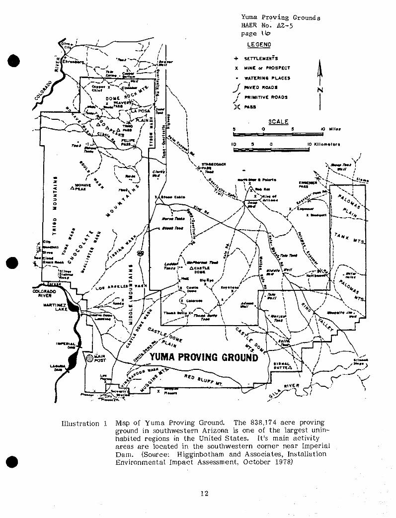
The Yuma Proving Ground, part of the U.S. Army Test and Evaluation Command,
occupies 838,174 acres in the Sonoran Desert in southwestern Arizona, one of
the most sparsely populated regions in the United States. The proving ground
is responsible for conducting tests on a variety of military items including
weapons, munitions, and vehicular equipment. It has a multipurpose aircraft
armament testing range with a highly instrumented complex of cinetheodolite,
telemetry, radar, laser, and multi-lateration space positioning systems. The
proving ground also contains vehicle test courses, drop zones for air drop and
impact testing, and a large gunnery range. (Illustrations 1 and 2)
The Yuma Indians are known to have inhabited portions of the proving ground
more than a thousand years ago. Nine identified Yuman and other Indian
archeological sites lie within its borders. Mining discoveries in 1858 led to a
flurry of mining activity in the vicinity of the proving ground, some of which
still continues. All mining sites on the installation (Copper Chief, Copper
Giant, Hart, Tweed, Gold Harp, among others) are abandoned, and there is no
record of any standing structures at these sites. A former stage route from
Yuma to Quartsite, Arizona, is marked by a sign on the proving ground's
Dust Course, but the installation is devoid of any premilitary structures.
11
Yuma Proving Grounds HAER No. A2-5 page \te?
LEGEND
Illustration 1 Map of Yuma Proving Ground The 838,174 acre proving ground in southwestern Arizona is one of the largest unin- habited regions in the United States. It's main activity areas are located in the southwestern comer near Imperial Dam. {Source: Higginbotham and Associates, Installation Environmental Impact Assessment, October 1978)
12
Yuma Proving HAER No. AZ-5 page
Jrownd;
§
JOOKCS' U.SAX** nHM 4)110 HA0
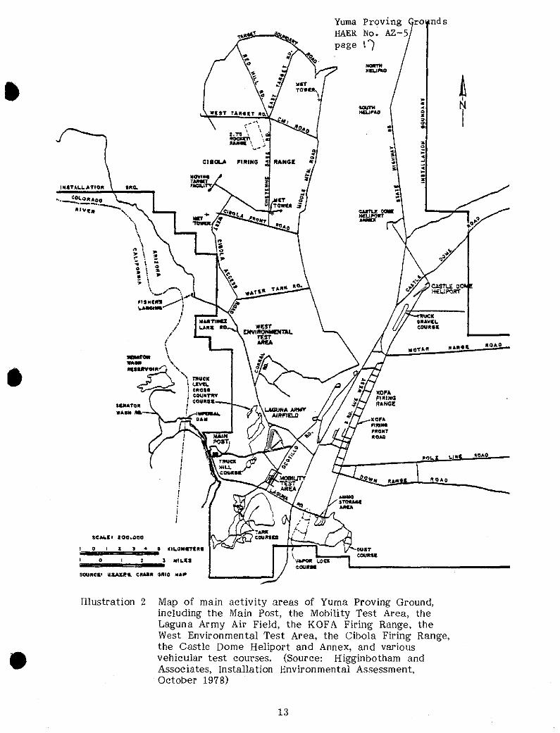
Illustration 2 Map of main activity areas of Yuma Proving Ground, including the Main Post, the Mobility Test Area, the Laguna Army Air Field, the KOFA Firing Range, the West Environmental Test Area, the Cibola Firing Range, the Castle Dome Heliport and Annex, and various vehicular test courses. (Source: Higginbotham and Associates, Installation Environmental Assessment, October 1978)
13
Yuma Proving Grounds HAER No. AZ-5 page \%
CALIFORNIA-ARIZONA MANEUVER AREA, 1942-1944
In early 1942, General George S. Patton established the Army Desert Training
Center (later called the California-Arizona Maneuver Area) in southern
California and Arizona to train Army troops for the invasion of North
Africa, then under the control of Rommel's Afrika Korps. The training
center's boundaries stretched from Pomona, California, east to Phoenix, and
from Yuma north to Boulder City, Nevada. Patton selected sites for his
main division camps in March 1942 and troops began to arrive in April. The
hot climate, sparce vegetation, and lack of rainfall in the thinly populated
area were ideal for desert maneuvers, and the 18,000 square mile training
center became the largest of its kind in U.S. military history. The center
had three maneuver areas; one of them, Maneuver Area B, included the area
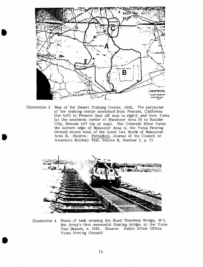
2 now occupied by the Yuma Proving Ground. (Illustration 3)
Camp Laguna, the site of the present Mobility Test Area at the proving
ground, was the home of the 79th Infantry Division, one of the Desert Train-
ing Center's six division-sized units. Patton is said to have visited the camp
sometime in the spring of 1942. The proving ground's Laguna Army Airfield,
located about a mile north of the Mobility Test Area, was originally con-
structed to serve the encampment. No buildings or structures remain from
3 this period at either location.
Camp Horn, located between Kofa Station and Horn, Arizona, on the northern
branch of the Southern Pacific Railroad (just below and outside the south-
eastern corner of the proving ground), housed the 81st Infantry Division from
June to November 1943. Camp Hyder, situated -about 15 miles northeast of
14
i RESTRICTE
SinMTKX MAP
Illustration 3 Map of the Desert Training Center, 1942. The perimeter of the training center stretched from Pomona, California (far left) to Phoenix (just off map to right), and from Yuma (at the southwest corner of Maneuver Area B) to Boulder City, Nevada (off top of map). The Colorado River forms the eastern edge of Maneuver Area A; the Yuma Proving Ground covers most of the lower two thirds of Maneuver Area B. (Source: Periodical, Journal of the Council on America's Military Past, Volume II, Number 2, p. 7)
Illustration 4 Photo of tank crossing the Steel Treadway Bridge, M-2, the Army's first successful floating bridge, at the Yuma Test Branch, c. 1943. (Source: Public Affair Office, Yuma Proving Ground)
15
Yuma Proving Grounds HAER No. AZ-5 page 3t)
Camp Horn on the same branch of the railroad (and also located beyond the
proving ground's boundaries), served as the base of the 77 th Infantry Division
from April to September 1943. A stone marker at the Camp Horn site is
the only remaining structure at either camp, although the outlines of both
camps are still visible from the air.
After Rommel's defeat by the Allies in May 1943, desert hardened troops
were no longer needed for the U.S. combat forces. The training center was
renamed the California-Arizona Maneuver Area and continued to operate as a
general maneuver ground until early 1944. By that time most new troops
were being shipped directly overseas, and in April 1944 the training center
was disbanded.
YUMA TEST BRANCH, 1943-1949
The Army Corps of Engineers began preliminary experiments with floating
bridges in late 1942 on the Colorado River below the Laguna Dam, about 15
miles northeast of Yuma. Work centered on adapting the Army's Steel Tread-
way Bridge to riverine use by the addition of pneumatic flotation devices.
The Germans had devised floating bridges several years earlier and had used
them to considerable advantage in combat. Based on these early experiments
at Laguna Dam, an American version of the floating bridge was fabricated
and a crash testing program established several miles upstream at the foot
of the Imperial Dam.
A government camp, built during the construction of the Imperial Dam in the
1930's, was rented from the Bureau of Reclamation for office and dormitory
16
Yuma Proving Grounds HAER No. AZ-5 page 3 1
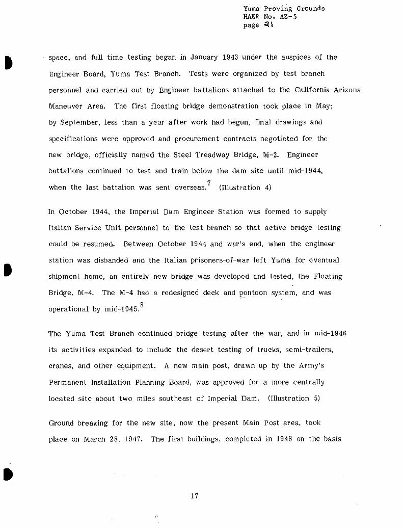
space, and full time testing began in January 1943 under the auspices of the
Engineer Board, Yuma Test Branch. Tests were organized by test branch
personnel and carried out by Engineer battalions attached to the California-Arizona
Maneuver Area. The first floating bridge demonstration took place in May;
by September, less than a year after work had begun, final drawings and
specifications were approved and procurement contracts negotiated for the
new bridge, officially named the Steel Treadway Bridge, M-2. Engineer
battalions continued to test and train below the dam site until mid-1944,
7 when the last battalion was sent overseas. (Illustration 4)
In October 1944, the Imperial Dam Engineer Station was formed to supply
Italian Service Unit personnel to the test branch so that active bridge testing
could be resumed. Between October 1944 and war's end, when the engineer
station was disbanded and the Italian prisoners-of-war left Yuma for eventual
shipment home, an entirely new bridge was developed and tested, the Floating
Bridge, M-4. The M-4 had a redesigned deck and pontoon system, and was Q
operational by mid-1945.
The Yuma Test Branch continued bridge testing after the war, and in mid-1946
its activities expanded to include the desert testing of trucks, semi-trailers,
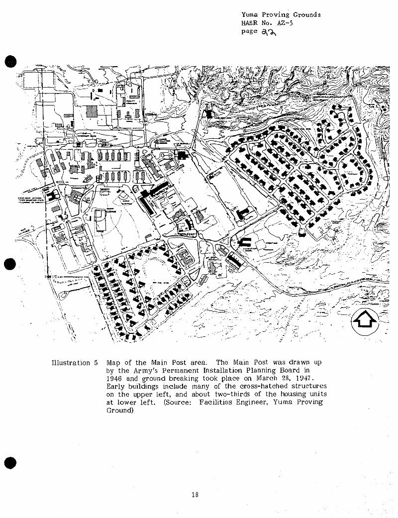
cranes, and other equipment. A new main post, drawn up by the Army's
Permanent Installation Planning Board, was approved for a more centrally
located site about two miles southeast of Imperial Dam. (Illustration 5)
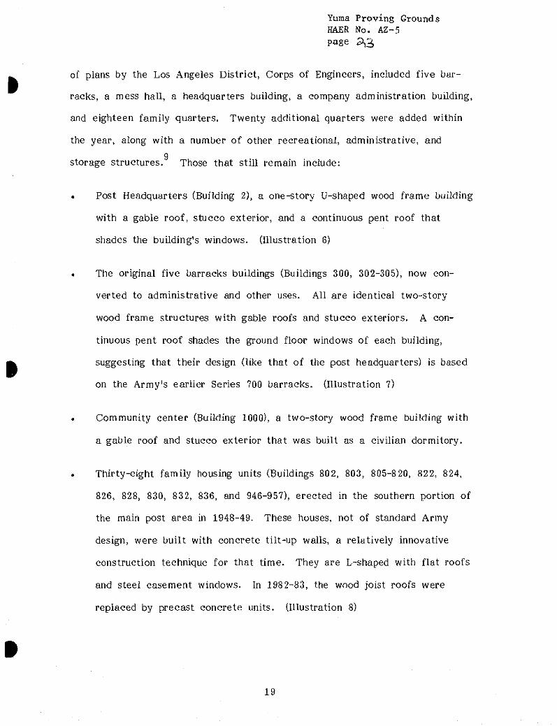
Ground breaking for the new site, now the present Main Post area, took
place on March 28, 1947. The first buildings, completed in 1948 on the basis
17
Yuma Proving Grounds HAER No. AZ-5 Page B^%
Illustration 5 Map of the Main Post area. The Main Post was drawn up by the Army's Permanent Installation Planning Board in 1946 and ground breaking took place on March 28, 1947. Early buildings include many of the cross-hatched structures on the upper left, and about two-thirds of the housing units at lower left. (Source: Facilities Engineer, Yuma Proving Ground)
18
Yuma Proving Grounds HAER No. AZ-5 page 3,3
of plans by the Los Angeles District, Corps of Engineers, included five bar-
racks, a mess hall, a headquarters building, a company administration building,
and eighteen family quarters. Twenty additional quarters were added within
the year, along with a number of other recreational, administrative, and 9
storage structures. Those that still remain include:
• Post Headquarters (Building 2), a one-story U-shaped wood frame building
with a gable roof, stucco exterior, and a continuous pent roof that
shades the building's windows. (Illustration 6)
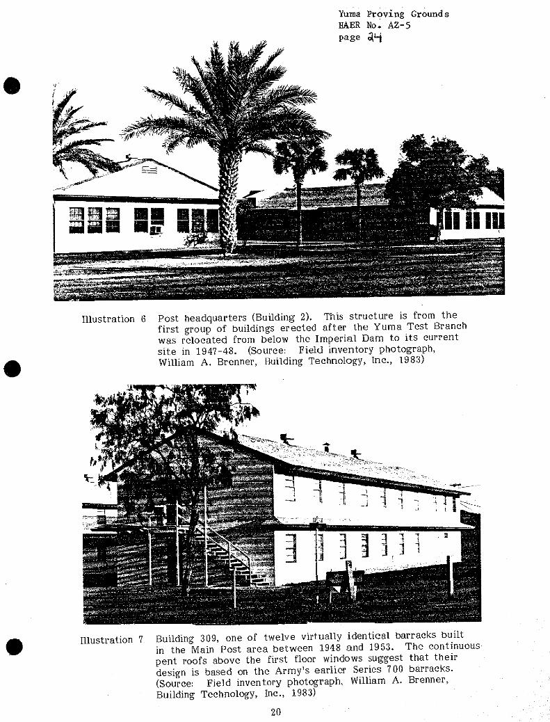
• The original five barracks buildings (Buildings 300, 302-305), now con-
verted to administrative and other uses. All are identical two-story
wood frame structures with gable roofs and stucco exteriors. A con-
tinuous pent roof shades the ground floor windows of each building,
suggesting that their design (like that of the post headquarters) is based
on the Army's earlier Series 700 barracks. (Illustration 7)
• Community center (Building 1000), a two-story wood frame building with
a gable roof and stucco exterior that was built as a civilian dormitory.
Thirty-eight family housing units (Buildings 802, 803, 805-820, 822, 824,
826, 828, 830, 832, 836, and 946-957), erected in the southern portion of
the main post area in 1948-49. These houses, not of standard Army
design, were built with concrete tilt-up walls, a relatively innovative
construction technique for that time. They are L-shaped with flat roofs
and steel casement windows. In 1982-83, the wood joist roofs were
replaced by precast concrete units. (Illustration 8)
19
Yuma Proving Grounds HAER No. AZ-5 page
•
Illustration 6 Post headquarters (Building 2). This structure is from the first group of buildings erected after the Yuma Test Branch was relocated from below the Imperial Dam to its current site in 1947-48. (Source: Field inventory photograph, William A. Brenner, Building Technology, Inc., 1983)
Illustration 7 Building 309, one of twelve virtually identical barracks built in the Main Post area between 1948 and 1953. The continuous pent roofs above the first floor windows suggest that their design is based on the Army's earlier Series 700 barracks. (Source: Field inventory photograph, William A. Brenner, Building Technology, Inc., 1983)
20
Yuma Proving Grounds HAER No. AZ-5 page ^.5
I
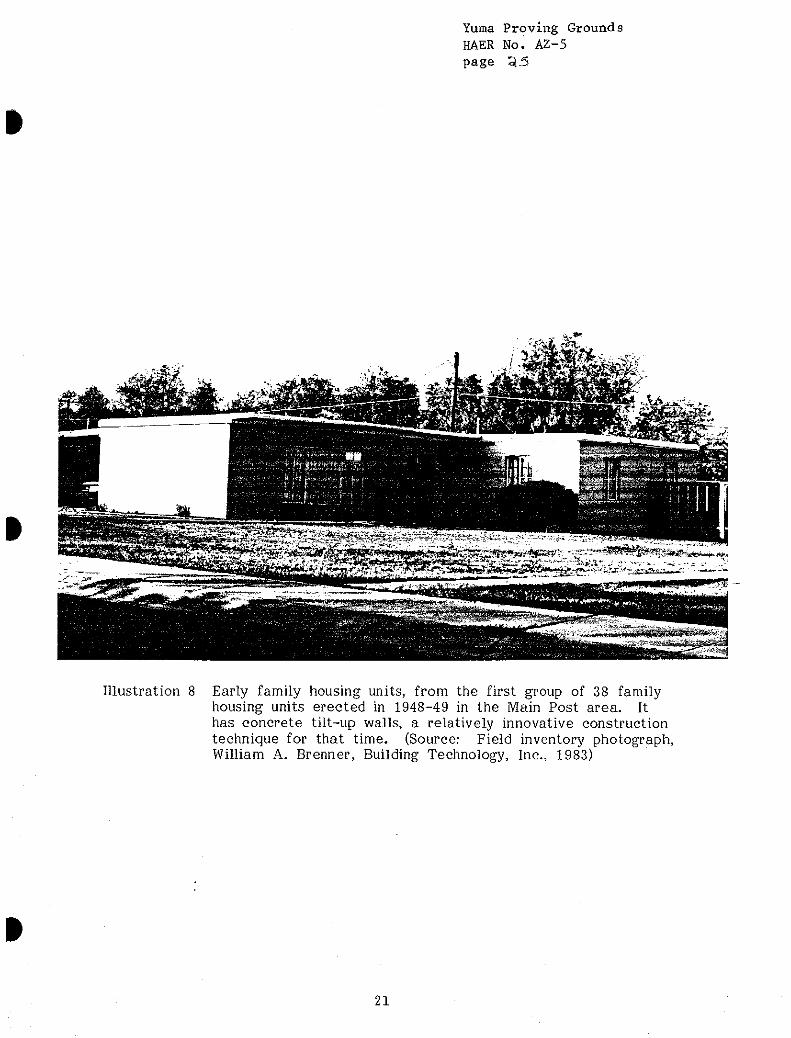
Illustration 8 Early family housing units, from the first group of 38 family housing units erected in 1948-49 in the Main Post area. It has concrete tilt-up walls, a relatively innovative construction technique for that time. (Source: Field inventory photograph, William A. Brenner, Building Technology, Inc., 1983)
21
Yuma Proving Grounds HAER No. A2-5 Page ^
In January 1949, a structural collapse at the Gila desilting basin below the
Imperial Dam forced an end to much of the testing activity, and the Yuma
Test Branch was closed in October of that year. The Los Angeles Engineer
District assumed caretaker responsibility for the installation in January 1950.
With the exception of a small stone paint locker built by the Italian prisoners-
of-war, all buildings in the original test site below Imperial Dam were sold.
Portable buildings in the new main post area were dismantled and shipped to
Fort Belvoir, Virginia. The original test site has since been removed from
proving ground's boundaries.
YUMA PROVING GROUND, 1951-PRESENT
The installation was reactivated in April 1951 as the Yuma Test Station, and
renamed the Yuma Proving Ground in 1963. The majority of the buildings in
the -main post area date from the decade the installation reopened. These
include: the post exchange (Building 504) built in 1952; seven barracks built
in 1952 and 1953 (Buildings 306-309, 500, 501, and 503) that are virtually
identical to the 1948 barracks (see Illustration 6); an officer's open mess
(Building 1001) built in 1953; a commissary and gymnasium (Buildings 105 and
518) built in 1954; a hospital (Building 990) built in 1956; and a theater
(Building 515) built in 1957. All are wood frame structures with stucco
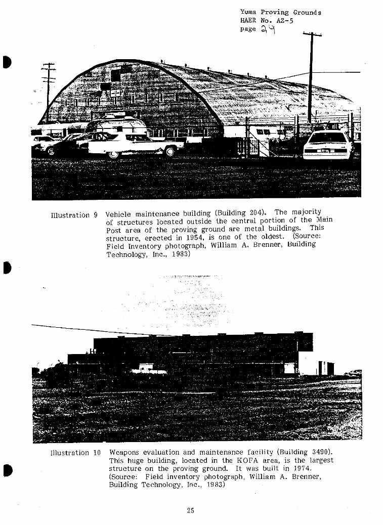
exteriors. In 1954 a large metal quonset-type vehicle maintenance building
(Building 204) was erected north of the barracks area (Illustration 9), and in
1957 twenty-six permanent single family housing units were built in the post
housing area. The houses, all one-story wood frame structures with flat
built-up roofs and stucco exteriors, are of good architectural design.
22
Yuma Proving Grounds HAER No. AZ-5 page 9H
A large L-shaped three-story enlisted barracks (Building 506), built with
concrete block load-bearing walls and a flat roof, was constructed in the
main post area in 1958. A three-story BOQ (Building 1004) of similar con-
struction was built to the southeast of the barracks the same year. In 1959,
143 additional Capehart program family housing units were erected on a hill
east of the post area. They are wood frame dwellings with gable roofs and,
like the earlier housing units at the proving ground, have stucco exteriors.
Since 1960, several other major permanent buildings have been erected in the
main post area, including a post chapel (Building 1100) built in 1965; an
enlisted club (Building 530) built in 1974; and an NCO open mess (Building
451) built in 1975.
Three major operational areas lie to the south and east of the main post:
the Mobility Test Area, the Laguna Army Airfield, and the KOFA Firing
Range (see Illustration 2 for their exact locations). Their buildings are des-
cribed as follows: _
• The Mobility Test Area, site of Camp Laguna in 1942-1943 and the
current center for vehicular testing at the proving ground, contains
several dozen metal buildings, all erected since 1950. Also located in
the test area is the range control facility (Building 2105), a large modern
style structure constructed in 1979. It has a reinforced concrete structure
with stucco covered concrete block walls and a skylight-covered central
atrium. A solar collector array is located adjacent to the southeast
side of the building.
23
Yuma Proving Grounds HAER No. AZ-5 page ^S-
• The Laguna Army Airfield, which also dates from 1942-1943, contains a
number of post-1950 structures. Most are steel-framed metal buildings,
the largest of which are an aircraft maintenance hangar (Building 3015),
built in 1970 and an aircraft hangar and test facility (Building 3017)
built in 1979. A one-story concrete block building (Building 3021) that
serves as the administration headquarters for airfield and test operations
is located in the airfield complex; it was built in 1962.
• The KOFA Firing Range, named after the (now inactive) King of Arizona
gold mine located north of the range site, is an instrumented gunnery
range that contains a number of administrative, maintenance, and sup-
port structures. Most are steel-framed metal buildings, and all date
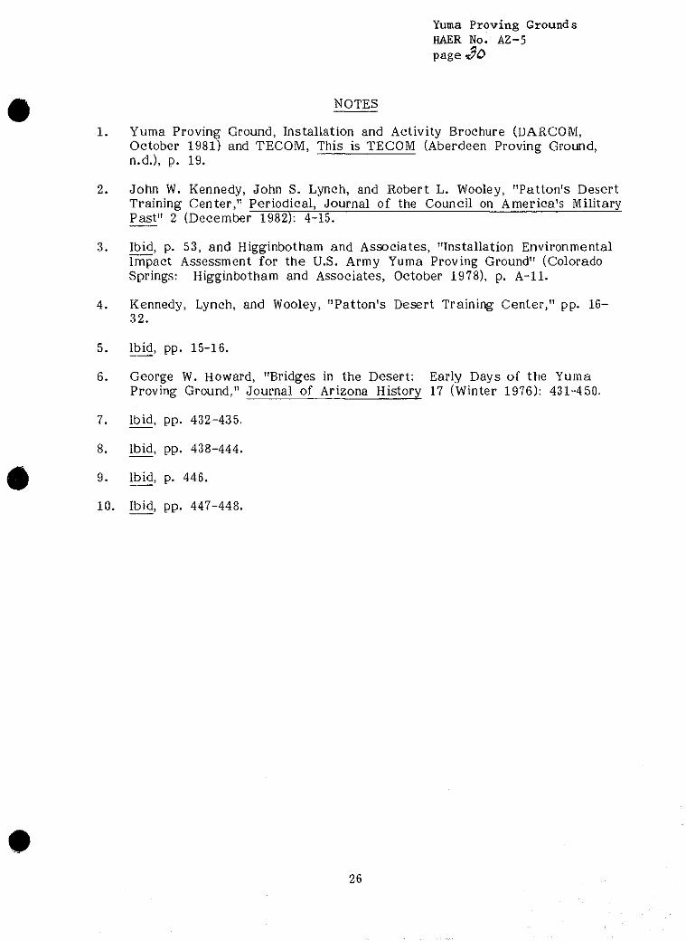
after 1950. The largest structure at the proving ground, the weapons
evaluation and maintenance facility (Building 3490), was built in the
KOFA area in 1974. It is a huge steel-framed building with metal roof
and exterior walls, and large sliding doors for tank exit and entry.
(Illustration 10) Several kinds of ammunition storage igloos are also
located in the KOFA area; the majority are of earth-covered steel
arch construction, and date from 1956 or later.
The proving ground's West Environmental Test Area contains a number of
open sites for various test programs and a limited number of temporary
metal buildings, all of which are of recent vintage. The Cibola Firing Range,
used for aircraft gunnery practice and related tests, and the Castle Dome
Heliport and Annex also contain a small number of semi-permanent structures.
The remainder of the proving ground is relatively unimproved except for
single-lane gravel roads and jeep trails.
24
Yuraa Proving Grounds HAER No. AZ-5 page 3,'^t
»
Illustration 9
I
Vehicle maintenance building (Building 204). The majority of structures located outside the central portion of the Main Post area of the proving ground are metal buildings. This structure, erected in 1954, is one of the oldest. (Source: Field Inventory photograph, William A. Brenner, Building Technology, Inc., 1983)
Illustration 10 Weapons evaluation and maintenance facility (Building 3490). This huge building, located in the KOFA area, is the largest structure on the proving ground. It was built in 1974. (Source: Field inventory photograph, William A. Brenner, Building Technology, Inc., 1983)
25
Yuma Proving Grounds HAER No. A2-5 page
NOTES
1. Yuma Proving Ground, Installation and Activity Brochure (DARCOM, October 1981) and TECOM, This is TECOM (Aberdeen Proving Ground, n.d.), p. 19.
2. John W. Kennedy, John S. Lynch, and Robert L. Wooley, "Patton's Desert Training Center," Periodical, Journal of the Council on America's Military Past" 2 (December 1982): 4-15.
3. Ibid, p. 53, and Higginbotham and Associates, "Installation Environmental Impact Assessment for the U.S. Army Yuma Proving Ground" (Colorado Springs: Higginbotham and Associates, October 1978), p. A-ll.
4. Kennedy, Lynch, and Wooley, "Patton's Desert Training Center," pp. 16- 32.
5. Ibid, pp. 15-16.
6. George W. Howard, "Bridges in the Desert: Early Days of the Yuma Proving Ground," Journal of Arizona History 17 (Winter 1976): 431-450.
7. Ibid, pp. 432-435.
8. Ibid, pp. 438-444.
9. Ibid, p. 446.
10. Ibid, pp. 447-448.
26
Yuraa Proving Grounds HAER No. AZ-5 page gi
Chapter 3
PRESERVATION RECOMMENDATIONS
BACKGROUND
Army Regulation 420-40 requires that an historic preservation plan be developed
as an integral part of each installation's planning and long range maintenance
and development scheduling. The purpose of such a program is to:
• Preserve historic properties to reflect the Army's role in history and its continuing concern for the protection of the nation's heritage.
• Implement historic preservation projects as an integral part of the installation's maintenance and construction programs.
• Find adaptive uses for historic properties in order to maintain them as actively used facilities on the installation.
• Eliminate damage or destruction due to improper maintenance, repair, or use that may alter or destroy the significant elements of any property.
• Enhance the most historically significant areas of the installation through appropriate landscaping and conservation.
To meet these overall preservation objectives, the general preservation recom-
mendations set forth below have been developed:
Category I Historic Properties
All Category I historic properties not currently listed on or nominated to the
National Register of Historic Places are assumed to be eligible for nomination
regardless of age. The following general preservation recommendations apply
to these properties:
27
Yuma Proving Grounds HAER No. AZ-5 PaSe 33L
a) Each Category I historic property should be treated as if it were
on the National Register, whether listed or not. Properties not
currently listed should be nominated. Category I historic properties
should not be altered or demolished. All work on such properties
shall be performed in accordance with Sections 106 and 110(f) of
the National Historic Preservation Act as amended in 1980, and the
regulations of the Advisory Council for Historic Preservation (ACHP)
as outlined in the "Protection of Historic and Cultural Properties"
(36 CFR 800).
b) An individual preservation plan should be developed and put into
effect for each Category I historic property. This plan should
delineate the appropriate restoration or preservation program to be
carried out for the property. It should include a maintenance and
repair schedule and estimated initial and annual costs. The preservation
plan should be approved by the State Historic Preservation Officer
and the Advisory Council in accordance with the above referenced
ACHP regulation. Until the historic preservation plan is put into
effect, Category I historic properties should be maintained in accordance
with the recommended approaches of the Secretary of the Interior's
Standards for Rehabilitation and Revised Guidelines for Rehabilitating 2
Historic Buildings and in consultation with the State Historic
Preservation Officer.
c) Each Category I historic property should be documented in accor-
dance with Historic American Buildings Survey/Historic American
Engineering Record (HABS/HAER) Documentation Level II, and the
28
Yuma Proving Grounds HAER Nol AZ-5 page 33
documentation submitted for inclusion in the HABS/HAER collections
3 in the Library of Congress. When no adequate architectural drawings
exist for a Category I historic property, it should be documented in
accordance with Documentation Level 1 of these standards. In
cases where standard measured drawings are unable to record significant
features of a property or technological process, interpretive drawings
also should be prepared.
Category H Historic Properties
All Category II historic properties not currently listed on or nominated to
the National Register of Historic Places are assumed to be eligible for nomi-
nation regardless of age. The following general preservation recommendations
apply to these properties:
a) Each Category II historic property should be treated as if it were
on the National Register, whether listed or not. Properties not
currently listed should be nominated. Category II historic prop-
erties should not be altered or demolished. All work on such prop-
erties shall be performed in accordance with Sections 106 and
110(f) of the National Historic Preservation Act as amended in
1980, and the regulations of the Advisory Council for Historic
Preservation (ACHP) as outlined in the "Protection of Historic and
Cultural Properties" (36 CFR 800).
b) An individual preservation plan should be developed and put into
effect for each Category II historic property. This plan should
29
Yuma Proving Grounds HAER No. AZ-5 page 3 V
delineate the appropriate preservation or rehabilitation program to
be carried out for the property or for those parts of the property
which contribute to its historical, architectural, or technological
importance. It should include a maintenance and repair schedule
and estimated initial and annual costs. The preservation plan should
be approved by the State Historic Preservation Officer and the
Advisory Council in accordance with the above referenced ACHP
regulations. Until the historic preservation plan is put into effect,
Category II historic properties should be maintained in accordance
with the recommended approaches in the Secretary of the Interior's
Standards for Rehabilitation and Revised Guidelines for Rehabilitating 4
Historic Buildings and in consultation with the State Historic
Preservation Officer.
c) Each Category II historic property should be documented in accor-
dance with Historic American Buildings Survey/Historic American
Engineering Record (HABS/HAER) Documentation Level II, and the
documentation submitted for inclusion in the HABS/HAER collections
in the Library of Congress.
Category HI Historic Properties
The following preservation recommendations apply to Category III historic
properties:
a) Category III historic properties listed on or eligible for nomination
to the National Register as part of a district or thematic group
30
Yuma Proving Grounds HAER No. AZ-5 page^S
should be treated in accordance with Sections 106 and 110(f) of the
National Historic Preservation Act as amended in 1980, and the
regulations of the Advisory Council for Historic Preservation as
outlined in the "Protection of Historic and Cultural Properties"
(36 CFR 800). Such properties should not be demolished and their
facades, or those parts of the property that contribute to the
historical landscape, should be protected from major modifications.
Preservation plans should be developed for groupings of Category III
historic properties within a district or thematic group. The scope
of these plans should be limited to those parts of each property
that contribute to the district or group's importance. Until such
plans are put into effect, these properties should be maintained in
accordance with the recommended approaches in the Secretary of
the Interior's Standards for Rehabilitation and Revised Guidelines
for Rehabilitating Historic Buildings and in consultation with the
State Historic Preservation Officer.
b) Category III historic properties not listed on or eligible for nomination
to the National Register as part of a district or thematic group
should receive routine maintenance. Such properties should not be
demolished, and their facades, or those parts of the property that
contribute to the historical landscape, should be protected from
modification. If the properties are unoccupied, they should, as a
minimum, be maintained in stable condition and prevented from
deteriorating.
31
Yuraa Proving Grounds HAER No. AZ-5
PaSe 3b
HABS/HAER Documentation Level IV has been completed for all Category III
historic properties, and no additional documentation is required as long as
they are not endangered. Category III historic properties that are endangered
for operational or other reasons should be documented in accordance with
HABS/HAER Documentation Level III, and submitted for inclusion in the
7 HABS/HAER collections in the Library of Congress. Similar structures need
only be documented once.
CATEGORY I HISTORIC PROPERTIES
There are no Category I historic properties at the Yuma Proving Ground.
CATEGORY II HISTORIC PROPERTIES
There are no Category II historic properties at the Yuma Proving Ground.
CATEGORY III HISTORIC PROPERTIES
There are no Category III historic properties at the Yuma Proving Ground.
32
Yuma Proving Grounds HAER No. AZ-5 page 3")
NOTES
1. Army Regulation 420-40, Historic Preservation (Headquarters, U.S. Army: Washington, D.C., 15 April 1984).
2. National Park Service, Secretary of the Interior's Standards for Rehabilitation and Revised Guidelines for Rehabilitating Historic Buildings, 1983 (Washington, D.C.: Preservation Assistance Division, National Park Service, 1983).
3. National Park Service, "Archeology and Historic Preservation; Secretary of the Interior's Standards and Guidelines," Federal Register, Part IV, 28 September 1983, pp. 44730-44734.
4. National Park Service, Secretary of the Interior's Standards.
5. National Park Service, "Archeology and Historic Preservation."
6. National Park Service, Secretary of the Interior's Standards.
7. National Park Service, "Archeology and Historic Preservation."
33
Yuma Proving Grounds HAER No. AZ-5 page 3?
#
*
BIBLIOGRAPHY
Higginbotham and Associates. "Installation Environmental Impact Assessment for the U.S. Army Yuma Proving Ground." Colorado Springs: Higginbotham and Associates, October 1978
Howard, George W. "Bridges in the Desert: Early Days at the Yuma Proving Ground." Journal of Arizona History 17 (Winter 1976): 431-450. Provides very complete account of the history of the Yuma Test Branch from 1943 to 1950.
Kennedy, John W.; Lynch, John S.; and Wooley, Robert L. "Patton's Desert Training Center." Periodical, Journal of the Council on America's Military Past, II (December 1982): p. 3-54. Provides account of the Desert Training Center from 1942-44, and briefly mentions several sites at the present Yuma Proving Ground.
U.S. Army Test and Evaluation Command. This Is TECOM. Aberdeen Proving Ground, n.d.
Yuma Proving Ground. Installation and Activity Brochure. DARCOM, October 1981
Yuma Proving Ground. Real Property Inventory. 31 March 1982
"Yuma Proving Ground Enters 5th Decade, Remembers First 40 Years." The Outpost. Yuma Proving Ground, 6 January 1983, pp. 4-5
34