zarópulo report
DESCRIPTION
St. Dimitri assessmentIlir ParangoniTRANSCRIPT

Archaeological survey of the St. Dimitri hill
Butrint 2015
This project was founded by the Butrint Foundation
July 2015

Archaeological survey of the St. Dimitri hill
Butrint 2015
2
This report represents the work of the Centre for Albanian Cultural Heritage (Qendra Trakult) in
the frame of its Survey of the St. Dimitri project, carried out with generous financial support
from the Butrint Foundation.
The report has been prepared by: Ilir Parangoni
Centre for Albanian Cultural Heritage (Qendra Trakult) – Report, July 2015.
Front-cover: East view of St. Dimitri hill during survey.
Centre for Albanian Cultural Heritage Rr. Sulejman Delvina, 40, 4/7 Tirana, Albania
Tel: +355 (0) 69 21 75579 [email protected]
www.trakult.wordpress.com

Archaeological survey of the St. Dimitri hill
Butrint 2015
3
Table of Contents
Acknowledgment................................................................................................................................4
Introduction......................................................................................................................................5
Background ......................................................................................................................................5
Methodology .....................................................................................................................................7
Results ..............................................................................................................................................8
Area 1 (Small eminence to the south of St. Dimitri hill – surface 7 ha). ..............................................8
Area 2 (South part of St. Dimitri hill – surface 18 ha) .......................................................................9
Area 3 (Central part of St. Dimitri hill – surface 22 ha) .................................................................. 13
Area 4 (North part of St. Dimitri, called Bullar – surface 3 ha) ....................................................... 16
Area 5 (Northwest part of St. Dimitri hill – surface 7 ha) ................................................................ 19
Area 6 (Two low eminences near Zara – surface 13 ha) .................................................................. 21
Discussion ....................................................................................................................................... 22
Conclusion ...................................................................................................................................... 23
List of figures .................................................................................................................................. 25
Bibliography ................................................................................................................................... 26
Appendix - List of sites .................................................................................................................... 27

Archaeological survey of the St. Dimitri hill
Butrint 2015
4
Acknowledgment
We would like to express our deep gratitude to the Butrint Foundation who has generously
funded the research project of the St. Dimitri hill in 2015.
Thanks go to Prof. Luan Përzhita (Director of the Institute of Archaeology) for his help and
decisions taken during the fieldwork phase, Prof. Dhimitër Condi (Regional Archaeologist) for
his assistance in field survey and Mr. Brian Ayers for his professional consultation and open-
minded support of this research.
We wish to extend our thanks to the staff of the Butrint National Park and local farmers of Zara
for the collaboration and assistance provided during the project.
The survey research would not have been possible without the help of assistants who
participated in this project thanks goes to them Eriona Qilla (Archaeologist at the Butrint
National Park) and Mirgen Shahmetaj (archaeologist/designer). Special thanks goes to Oliver
Gilkes, Andy Crowson, Prof. Ilir Gjipali (IA), Paul Reynolds (University of Barcelona), Jose
Carvajal Lopez (UCL Qatar), Joanita Vroom and to all of our friends for their help.

Archaeological survey of the St. Dimitri hill
Butrint 2015
5
Introduction
Between 2nd and 17th July 2015 an archaeological survey was conducted at St. Dimitri hill and its
surroundings. This project was carried out in collaboration with the Albanian Institute of
Archaeology, the Butrint National Park and was funded thanks to a generous grant of the Butrint
Foundation. The project is a continuation of research on late Butrint started in 2014 with trial
excavations at the triangular fortress, near the Vivari Channel. In a wider perspective, these
projects are part of a main project that aims to study coastal sites in southern Albania under
Venetian and ottoman influences from 14th to 18th century. The project studies similarities and
distinctions in the topography of sites, domestic architecture, military constructions, religious
buildings and economic relations. From this point of view, St. Dimitri hill has an important part
for the study of late Butrint as a Venetian outpost on the mainland managed through Corfu and
can shed light to a numerous issues related with late settlement pattern, economy and
communications in this area.
Archival and field researches conducted by Oliver Gilkes1, Siriol Davies2, Andrew Crowson3,and
archaeological survey by Jose Caravjal Lopez4 and Richard Andrews5 are a valuable contribution
to the history of later Butrint. Thanks to these studies has become possible to create a basis for
more detailed studies on the Ottoman and Venetian Butrint and its economic, political and military
links. It has been said that although Butrint was managed from Corfu with the arrival of the
Ottomans the sea communications were closed. All production of the area turned inland as Butrint
became overshadowed by the Pashalik of Delvina. On the other hand, as the recent researches at
the triangular fortress show, contacts between Butrint and Corfu and central and southern Italy
were never interrupted.6 During Venetian period, the triangular fortress operated for protection of
the fishery and as a place for embarking local goods to Corfu. As a result, it has been of a great
importance to establish a link between this small harbour and other parts and inland areas through
a network of roads. As the maps of the time show the historical route, connecting Butrint with
other important areas like Delvina and Konispol, passed close to St Dimitri hill when a settlement
is believed to have been built to the south.
Background
St. Dimitri hill lies around 1.7 km southeast of Butrint (Figure 1). The first account on the presence
of a settlement in this area was given by William Martin Leak during his trip to southern Albania.
He mentioned, “… on some low eminences rising from the southern bank of the lake Riza are the
villages Zara and Zarópulo, which are comprehended in the district of Vutzindró (Butrinto)”7.
1 Gilkes, Oliver. A report on the printed and documentary archival for the later history of Butrint to be found in the
United Kingdom. Unpublished report, 1998. 2 Davies, Siriol, Late Venetian Butrint: A report on the research on the archives of Corfu and Venice , Butrint
Foundation, 2002. 3 Crowson, Andrew, The triangular Castle, Butrint Foundation, 2007. 4 Lopez, Jose Caravjal, Ali Pasha’s Castle at Butrint: Butrinti në shekuj, ed. Solinda Kamani, Tiranë 2011. 5 Andrews, Richard, Bolden, William, Gilkes, Oliver and Martin, Sally, The late antique and medieval fortifications
of Butrint: Byzantine Butrint: Excavations and surveys 1994-1999, Oxbow 2004. 6 Parangoni, Ilir. Trial excavations at the Triangular Fortress, Butrint 2014 . Unpublished report. Butrint Foundation
2014. 7 Lik, Ulliam Martin. Udhëtim në Shqipërinë e vezirëve. Tiranë: Migjeni, 2008.

Archaeological survey of the St. Dimitri hill
Butrint 2015
6
Figure 1 Location of the St. Dimitri hill
In the 1960s-70s, thanks to agricultural and reclamation works undertaken around Butrint
considerable archaeological material was brought to light. Excavations carried out by Dhimitër
Çondi at that time identified a Roman necropolis to the northwest foot of the St. Dimitri hill.
Twelve tombs were excavated dating mainly to the II-III century AD associated with ochre
coloured terrasigilata italiana, iron objects and a bronze coin of Hadrian8.
In 1995-96, a survey was conducted by the Butrint Foundation and directed by Pluciennik, Lako,
Përzhita and Brennan on the surrounding area of the ancient site. During that survey near Kalivo
a sparse scatter of limestone and tile was noticed, probably Roman, deposited by dredging.
Extending in an elongated central oval towards Kalivo they found a single-period scatter of
potsherds including combed amphorae sherds and polychrome-glazed wares dating to the early
modern period9.
In 2008 a survey conducted by Sebastiani and Vacarro around Butrint recorded several Roman
tombs found in the 1980s at the St Dimitri hill. Together with the Roman necropolis they found
also some other Roman material suggesting a small village or villas around the hill10.
8 Çondi Dhimitër. Gjetje arkeologjike nga rrethina e Butrintit. Butroti. Tiranë: Akademia e Shkencave e Shqipërisë
1988, fq. 237-249. 9 Mark Pluciennik, Kosta Lako, Luan Perzhita dhe Dee Brennan. The environs of Butrint 2: the 1995-96 field
survey. In R. Hodges, W. Bowden, & K. Lako, Byzantine Butrint: Excavations and Surveys 1994-1999. Oxford:
Oxbow 2004, fq. 47-63. 10 Sebastiani Alessandro dhe Vacarro Emanuele. Preliminary report of the Diaporit-Mursi survey. Unpublished
report. Butrint Foundation 2008.

Archaeological survey of the St. Dimitri hill
Butrint 2015
7
Lastly, during a survey on the Veneto-Ottoman period at Butrint led by Jose Caravajal Lopez
scattered stones in the southern part of the St. Dimitri hill together with presence of Roman graves
were reported. The material found in this part dated back to the 16th-18th and attempts were made
to identify the settlement of Zarópulo around this area11.
Methodology
With reference to all the dispersed information on the St. Dimitri hill coming from different
surveys around Butrint together with the lack of any detailed survey on this area, it was planned
to carry out an archaeological survey. The project aimed to:
Undertake an archaeological survey of the St. Dimitri hill and its surroundings by recording
visible archaeological features and findings (despite their period).
Locate the exact extent of Zarópulo at the St Dimitri hill, assessing its type, layout and
lifespan.
Linking new results with other previous studies carried out in Butrint.
The project survey area was approximately of 70 ha in total. It includes the St. Dimitri hill with a
surface of 50 ha, low eminence to the south of St. Dimitri hill with a surface of seven ha and two
other low hills to the northeast of modern village of Zara with a surface of 13 ha. The entire surface
was considerable wide thus it was divided into six areas. The geographical division was done based
on natural borders and slopes of the St. Dimitri hill (Figure 2).
Figure 2 Division of the surveyed area in 2015
11 Lopez José C. Carvajal, Hayden Benen, Alexiou Kostas, García Marcos. Interim report for the Butrint Foundation
on survey carried out in 2010. Unpublished report. Butrint Foundation 2010.

Archaeological survey of the St. Dimitri hill
Butrint 2015
8
The field methodology applied to this project was extensive survey involving unsystematic
walking across the project area. Archaeological features were recorded using handheld GPS
Garmin GPSMAP62 and other conventional documenting methods applied in archaeology.
Artefacts were collected and examined on surface while diagnostic material was treated as small
finds and deposited at the Butrint National Park storeroom.
The field survey was proceeded by a desktop research focusing on previous researches of the
Butrint Foundation and the Albanian Institute of Archaeology. In collaboration with the Butrint
National Park, contacts were established with local residents, farmers and shepherds who could
have knowledge of the area or indications of archaeological findings. Regarding limitations during
field survey, there were certain spots where visibility and walking was difficult and often
impossible. The prevailing vegetation in this area is fern, which is denser to the eastern slopes of
the hill. Another difficulty encountered during the survey relates to fenced private lands and sheep
sheds. However, thanks to a close collaboration between the Butrint National Park and local
owners it was possible to overcome these obstacles.
Results
Area 1 (Small eminence to the south of St. Dimitri hill – surface 7 ha).
Figure 3 View of area 1
Area 1 lies to the south of the St. Dimitri hill and is called by local inhabitants, paleozivar (Figure
3). Its surface is approximately 7 ha but the survey was slightly extended to the west towards Vrina
plain. The geological composition of this area is of clay and small gravel. Nowadays parts of this
low eminence are planted with olives groves and their access was made possible through owners’
permission. During survey in Area 1 scattered fragments of tiles and small stones mainly to the

Archaeological survey of the St. Dimitri hill
Butrint 2015
9
northwest of the eminence (E20o 3' 3.1466'' N39o 44' 11.8999'') were observed, dating generally
to the 18th-19th century. Other debris were found to the east but they were not associated with any
particular features or structure. It is important to note that this area was terraced during the
communist period and it is therefore difficult to find the origin of their source. Furthermore, the
construction of a military trench to the west could have disturbed any possible earlier structure on
this part of the eminence because other fragments of stones and tiles were found westwards of the
modern road passing near area 1 connecting the St. Dimitri hill with Zara. There was no other
finding on this area. It seems that this low prominence could not have had any significance use in
a certain period. Nonetheless, it is thought that near this area passed the old route that connected
Butrint with Delvina and Butrint with Konispol (see below area 6).
Area 2 (South part of St. Dimitri hill – surface 18 ha)
Figure 4 View of Area 2
Area 2 has a surface of 18 ha and lies to the south of the hill of St. Dimitri (Figure 4). The geology
of this area is composed of clay and small gravel at the bottom and mudstone on top. A few years
ago, a road was built in this area starting from the foot of the hill and going to the top where the
church of St. Dimitri with a large white cross stand today. It is thought that the new road follows
the old route going on top hill. Construction of the new road has disturbed the ruins of a late
settlement which may be identified as Zarópulo. To the south of this area flint artefacts were found
(E20o 2' 59.3421'' N39o 44' 18.9390''). It is believed that they could have been either flint chips
deriving from working of tools or proper tools (Figure 5).

Archaeological survey of the St. Dimitri hill
Butrint 2015
10
Figure 5 Flint findings from Area 2
Flint findings were visible mainly on landslides and erosion. Previously in the area the Albanian
Institute of Archaeology had carried out an excavation about prehistory. The project led by Ilir
Gjipali has found material dating from the High Palaeolithic to Late Bronze. The Archaeologica l
material of this project is still being studied whilst another excavation is planned to be undertaken
in this area in autumn 2015 by the Albanian Institute of Archaeology. Going up to the top of the
hill a great density of scattered building materials were seen (E20o 2' 56.5226'' N39o 44' 22.2580'').
These materials mainly stones, bricks and tiles were found all over the southeastern slope, scattered
on both sides of the modern road. GPS measurements showed that surface seize of ruinous area
was approximately 0.47 ha (Figure 6). It seemed that in some places, the new road follows the
natural slope of the hill but approaching to the area with ruins it is clear that parts of the topsoil
together with construction debris were removed to open the way for the new road. During field
survey, it became obvious that construction of the new road had affected a considerable part of the
settlement. This caused the distribution of scattered fragments of building materials and pottery on
both sides of the new road. Another pile of rubble, not affected by the construction of the road,
was recorded at the eastern slope below the church of St. Dimitri (see area 3). Construction debris
found on this part seem to be of the same type with those found on the southeast slop and probably
they belong to the same settlement. The stones were medium and small sized while amidst were
occasionally large limestone slabs. During survey short alignment of walls were noticed, but the
remains are scarce and never more than 1 or 1.5 m long. Four piles of rubble were found on this
hillside with east west extension. Their layout suggests the creation of flat terraces or spaces on
slopes for construction of buildings. The distance between each terrace is short and their alignment
suggest a direction overlooking Lake Bufi to the east and the old road going from Butrint to
Delvina south.

Archaeological survey of the St. Dimitri hill
Butrint 2015
11
Figure 6 Arial image of the St. Dimitri hill showing debris construction of Zarópulo
An important part of the 2015 project was the documentation of this settlement (Figure 7). Two of
the rubble piles were recorded during the field survey. Referring to both recorded layouts it is
believed that the typology of constructions was rural. They may have been rounded-shaped huts
built largely with small stones and wooden beams, allied with mud and covered with tile roof.
Floors were paved with bricks and slabs. During a cleaning of the area to record the settlement’s
layout, it was noticed that bricks still had remains of a mortar floor adhering to them. Bricks

Archaeological survey of the St. Dimitri hill
Butrint 2015
12
measured 3-4cm thick and have diagonal lines scored across. Similar brick were encountered in
the Roman aqueduct from other earlier researches on the Vrina plain. This might suggest reuse of
the Roman bricks from an unidentified Roman site, perhaps one of those around the hill, during
the late period at the settlement of St. Dimitri hill. This particular style of brick seems, at the
moment, to be the result of one period of manufacture, or indeed one tiler, and can be tentative ly
dated to the later 2nd or early 3rd centuries AD12.
Figure 7 Plan of rural construction to the southeast of St. Dimitri hill
During the survey to the south east of the new road, several fragments of pottery similar to those
found at the triangular fortress were retrieved (Figure 8 a-b). They consist of two vessels base and
some walls. The material is white glazed with blue decoration, possibly imported Italian maiolicas
of the 16th-18th century. To the west upper part of the new road pottery that looks early in date was
found (Figure 7b). It could be an imitation of Zeuxippus ware dated initially in the 13th-14th
centuries (although they kept on being made in Ottoman times)13
12 Oliver Gilkes pers. comm 13 Joanita Vroom. Byzantine to Modern Pottery in the Aegean. An introduction and field guide . Utrecht: Parnassus
Press, 2005.

Archaeological survey of the St. Dimitri hill
Butrint 2015
13
Figure 8 a-b potsherd found amidst the ruins on both side of the new road going to the Church of
St. Dimitri.
Area 3 (Central part of St. Dimitri hill – surface 22 ha)
Figure 9 View of Area 3

Archaeological survey of the St. Dimitri hill
Butrint 2015
14
Area 3 had a surface of 23 ha in total and included mostly the central part of the St. Dimitri hill
(Figure 9). Generally, the area was under a high-density shrub vegetation that hinder field survey.
However, it was possible to notice some important findings. On the north eastern slope where
today is the Church of St. Dimitri a square-shaped stone structure level surface (E20o 2' 46.2294''
N39o 44' 33.7962'') was found. The depth was shallow approximately 1.20 m diameter and initia l ly
has been considered as an abandoned water well. After cleaning the vegetation and soil, it was
observed that the structure was built in white worked limestone bonded with strong modern mortar.
The arrangement of stones in such a way suggested a modern date for that structure probably a
hidden entrance of a communist-era tunnel.
It is important to mention that besides military bunkers and trenches built throughout this hill, there
is a considerable number of underground tunnels linking different defensive features of that period.
To the east of tunnel entrance on a flat slope scattered sandstone were recorded (E20o 2' 46.7894''
N39o 44' 34.8431'). The view from this spot is dominant and looks over Lake Bufi and Kalivo hill.
Further to the south of this spot other similar sandstone associated with several fragments of yellow
coloured tile were evidenced (Figure 10). Dimensions of tiles were about 40 x 15cm but it is
obvious that they were much bigger in their original shape. From preliminary consultations with
Dhimitër Çondi, it is believed that these fragments are Hellenistic in date and may belong to a tile
tomb of that period14.
Figure 10 Yellow tile fragment found the east slope of Area 3
14 Dhimitër Çondi pers. comm.

Archaeological survey of the St. Dimitri hill
Butrint 2015
15
The most substantial feature of this area is the Church of St. Dimitri from where the name of the
hill derives. The church is located on a dominant spot of the hill overlooking the Vrina plain to the
west, Kalivo hill to the north, Lake Bufi to the east and village of Zara to the south (E20o 2'
44.0085'' N39o 44' 28.9256''). A modern road built some years ago connects nowadays the hill with
the village of Zara. The surface on which the church was built is flat. It is hard to say when this
area is flattened or whether it was a natural transformation process. It worth remembering that the
geological composition of this area is sand and lime mudstones, as Lopez had noticed in 2010,
enabling easy alteration of surface from both natural process and human agents. During the survey
on this flat surface, there were only very few tile fragments, though difficult to define their period,
to suggest any early possible construction. The Orthodox church of St. Dimitri is a small one nave
building erected in 1910 referring to an inscription on the entrance. It should be noted that the
walls of the chapel do incorporate blocks of a cloisonee style masonry, which has bene used in
local Orthodox churches for centuries, and which here suggest the presence of an earlier church of
unknown date. However, it is still hard to determine whether this area was ever used before the
construction of the church. No other archaeological remains were found that could suggest an
earlier use of this part of the hill, though there was some significant disturbance of archaeologica l
material during the erection of a substantial concrete cross on the hilltop in the late 1990s. From
conversations with county archaeologist Dhimitër Condi, who assisted during the survey on this
part of the hill, in the 1980s he had undertaken an archaeological excavation on flat surface where
is now the white cross. The excavated area was about 250 m2 (10mx25m) divided by trenches
measuring 5 m wide and down to 1m deep. The excavations results with not many findings except
one tile tomb dating to the second century A.D. It seemed that the tile tomb was robbed at a later
date because there was no skeleton or other archaeological material15. Furthermore, from the same
archaeologist in the 1980s, following a military trench along the mid-range of the western slope
around 20 Roman burials were found of which 12 with inventory. One of these is still preserved
near a fig tree but due to dense vegetation and tress we could not document it (E20o 2' 36.5348''
N39o 44' 31.5837'')16. During walking to the northwest of the hill down to the former agricultura l
cooperative part some flint artifacts were found (E20o 2' 34.4491'' N39o 44' 36.4394''). They are
believed to be high Paleolithic to the Bronze Age although is still soon to define their actual period
(Figure 11). It seems that the flints could have come out due to landslide on the slope. As we have
already mentioned above, most of the geological composition of the area is clay with small gravel
and mudstones and because of that creep is easily to occur.
Following the new road before getting to the church of St. Dimitri on the right there is a ridge
stretching east (E20o 2' 51.4822'' N39o 44' 28.1237''). Here the top hill was flat and building debris
where found during walking. The scattered material mainly tiles and small stones without pottery
occupied an area of about 0.025 ha or 250 m2. The construction debris seemed to be of the same
type with the ones found at Area 2 and are believed to belong also to Zarópulo.
15 Çondi Dh. 1980, unpublished report. 16 Sebastiani, A., & Vacarro, E. (2008). Preliminary report of the Diaporit-Mursi survey. Unpublished report for
Butrint Foundation .

Archaeological survey of the St. Dimitri hill
Butrint 2015
16
Figure 11 Flint collection found to the northwest of Area 3
Area 4 (North part of St. Dimitri, called Bullar – surface 3 ha)
Figure 12 view of area 4

Archaeological survey of the St. Dimitri hill
Butrint 2015
17
Area 4 lies to the northeast of St. Dimitri the hill with a surface of about 3 ha (Figure 12). This
area consists mainly of a cape called by the locals the eminence of bullar. From the field walking
there was no evidence of any archaeological features or finds around this area except a communist
military trench for defensive purpose to the north. However, Dhimitër Çondi claims to have
excavated a Roman tomb with tile roof construction to the south of this eminence (E20o 2' 43.4002''
N39o 44' 42.3270''). This further supports the idea of a Roman period necropolis at the St. Dimitr i
area if we refer to burials found to west part of the hill on area 3. The area to the northeast of the
cape is mentioned by various travellers of the 19th century as Lake Riza used also for fisher ies.
Time to time it turned into swamp but during 1960s it was reclaimed by the state and a numerous
of ditches were opened. During the field walking at the bottom of the eminence to the northeast
scattered limestone rubble was found (E20o 2' 45.0707'' N39o 44' 48.2591''). The stones are large
sizes and more are visible in the vicinity of the hill near some trees figs (Figure 13).
Figure 13 North view of cape of Bullari
Not far from the cape to the north east there are two large rocks or rubble (E20o 2' 45.0127'' N39o
44' 49.9815''). The area between two rocks and the cape of bullar is separated with a drainage
ditch. During field survey at two rocks, it was noticed presence of small stones and bricks with
mortar layer yet attached to them. Some parts of that pile of rubble appears to have gathered there
from the opening of drainage ditches. However, the opening of ditches has probably disturbed
what could have been a probable connection between the northeast cape and the two piles of
rubble. Its character remains unclear because there was no pottery or other archaeological finds

Archaeological survey of the St. Dimitri hill
Butrint 2015
18
associated with the rubble that could give any indication of any possible use. Nonetheless, during
survey it was noticed that some parts of the rubble were dug out in order to use them probably for
burial (Figure 14). The excavated areas, presumably tombs, had dimensions of roughly 1.50m x
50m with no archaeological inventory. Numerous tile fragments thought to belong to the Roman
period were found scattered around. To the north of this area, earlier surveys conducted by the
Butrint Foundation, found Roman pottery and ceramics dating back to the sixteenth century.
Figure 14 Presumably Roman tombs located to the northeast of the cape of Bullari
Close to the cape there is a modern sheep sten (kraal) named after the owner, a Vlach lady named
Sofia (E20o 2' 41.5752'' N39o 44' 40.0032''). Worth mentioning about the Sofia’s sten is that some
years ago the Butrint Foundation obtained a quantity of Venetian silver coins, now on display in
the museum at Butrint. They had collected by local shepherds to the south of the cape of Bullari.
These may well have been the other part of a hoard found by Dhimosten Budina in the 1960s
during drainage work17. During the 2015 survey there was no archaeological evidence in this area.
17 Dhimitër Budina pers. comm.

Archaeological survey of the St. Dimitri hill
Butrint 2015
19
Area 5 (Northwest part of St. Dimitri hill – surface 7 ha)
Figure 15 View of Area 5
Area 5 lies to the northwest of St. Dimitri hill with a surface around seven ha (Figure 15). It was
used for agricultural and military purposes during 1960s-1980s. During survey it was possible to
obtain some important data on the use of this area in the Roman period (E20o 2' 27.1106'' N39o 44'
37.6051''). To its north western edge, the opening of military trenches had disturbed what could be
determine as a Roman site (Figure 16). When cleaning a trench sections for documentation, Roman
potsherds and fragments of a dolium, were found (Figure 17 a-b). Potsherds were shown for
consultation to Paul Reynolds who suggested that they were Roman. According to him, the rim
was part of a large vessel a rectangular rim, outer face folded into a step. The handle is placed over
the outer edge and inner rim top. The handle would prevent anyone putting a lid on the inside. He
mentioned that was the first time for him seeing a piece like that and could offer no parallels from
the Butrint corpus. However, the fabric seemed to be local (with chert), e.g. as vessels in Diaporit.
He suggested a late Roman dating for the rim together with the dolia. These findings suggest the
presence of a Roman settlement, besides a necropolis to the west of the hill, which goes until late
antiquity. The survey conducted in this area has yielded no any other findings. During communist
era, a cowshed stood to the south not far from the Roman findings. Today no structure of cowshed
exists but it is believed that parts of it were built near the area where the Roman potsherds were
found.

Archaeological survey of the St. Dimitri hill
Butrint 2015
20
Figure 16 Section of military trench to the northwest of the St. Dimitri hill.
Figure 17 a-b Roman and late antique sherds found at the military trench to the northwest of the
St. Dimitri hill.
Archaeological survey of the St. Dimitri hill
Butrint 2015
21
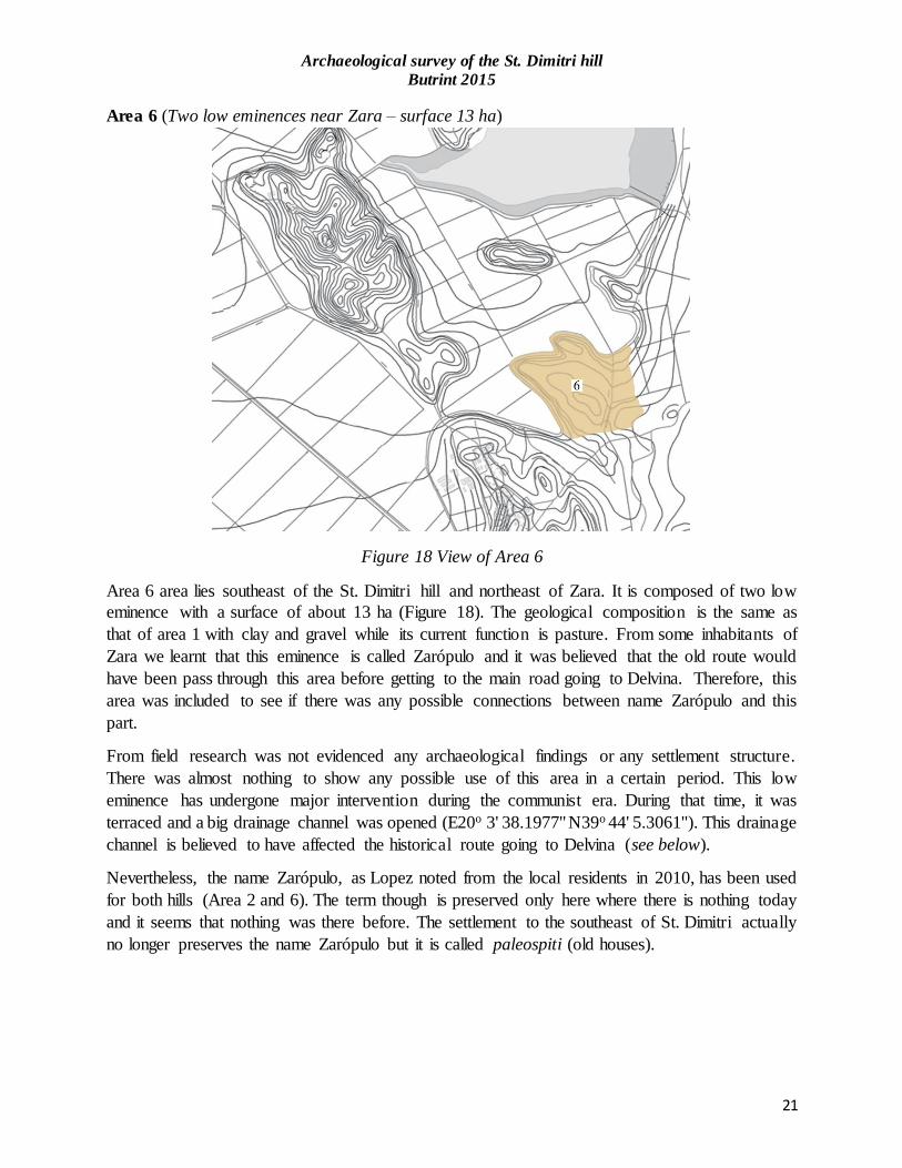
Area 6 (Two low eminences near Zara – surface 13 ha)
Figure 18 View of Area 6
Area 6 area lies southeast of the St. Dimitri hill and northeast of Zara. It is composed of two low
eminence with a surface of about 13 ha (Figure 18). The geological composition is the same as
that of area 1 with clay and gravel while its current function is pasture. From some inhabitants of
Zara we learnt that this eminence is called Zarópulo and it was believed that the old route would
have been pass through this area before getting to the main road going to Delvina. Therefore, this
area was included to see if there was any possible connections between name Zarópulo and this
part.
From field research was not evidenced any archaeological findings or any settlement structure.
There was almost nothing to show any possible use of this area in a certain period. This low
eminence has undergone major intervention during the communist era. During that time, it was
terraced and a big drainage channel was opened (E20o 3' 38.1977'' N39o 44' 5.3061''). This drainage
channel is believed to have affected the historical route going to Delvina (see below).
Nevertheless, the name Zarópulo, as Lopez noted from the local residents in 2010, has been used
for both hills (Area 2 and 6). The term though is preserved only here where there is nothing today
and it seems that nothing was there before. The settlement to the southeast of St. Dimitri actually
no longer preserves the name Zarópulo but it is called paleospiti (old houses).

Archaeological survey of the St. Dimitri hill
Butrint 2015
22
However, after a conversation with local residents we noticed that it is largely accepted that in area
6 passed the road from Butrint to Delvina18. After leaving Butrint, the road continued through the
forest of Vrina, passing south of St. Dimitri hill where Zarópulo (paleospitias) was located. From
whence the road is divided in two directions: one going to Zara and the other one continued to east
passing through two eminences then reaching the main road coming from Delvina through the pass
of Sorone to northern extremity of lake Bufi.
Discussion
From the data collected during the 2015 survey and referring to previous studies, we can say with
certainty that the remains found on the south and east of the St. Dimitri hill are attributed to the
settlement of Zarópulo found on Venetian maps. There is no record of any other later settlement
around this area that can prove the contrary. Saying that, a few questions arise about this
settlement: What was the character of Zarópulo? What function it had on the economy of late
Butrint? Was Zarópulo a permanent settlement or was it used temporary? What is its lifespan and
when was it abandoned?
Leake mentioned Zarópulo during his visit when he describes fishers and economy of Butrint. He
notes that these two villages were part of Butrint’s district built on some low eminences along the
road going to Delvina but giving no details about their character. Situated on the road connecting
Butrint with Delvina, Konispol then Filat and other parts of the Ottoman Epirus, this settlement
could have served as a way station (traveller inn). According to Përzhita this way station, found
along the road Butrint-Delvina, could have replaced the ancient way station of Diaporiti in later
period19.
According to a preliminary analysis of the field recordings, it seems that Zarópulo was not a large
settlement. It may have had 7-8 hats spread in two groups on south and east of the St. Dimitri hill.
Buildings have used Roman bricks found on the Vrina plain for paving the floors. Walls may have
been built with medium limestone, wood, mud and covered with tiled roofs. Regarding their shape,
it is a little difficult to determine accurately but referring to our survey of debris it is thought they
had rounded shapes, placed one after another stretching east-west.
When the borders of the Venetian enclave were defined in 1718 Zarópulo appears as a settlement
on all Venetian maps. Consequently, this makes us think that the village of Zarópulo was probably
existing before 1718 or was built at the same time, whilst its mention from Leake in early 19th
century suggests that it continued to exist together with Zara even after the fall of La Serenisima.
Further, potsherds found during field survey suggests a dating to the end of the 17th beginning of
the 18th century for the site. But, we cannot exclude the idea of an early origin because fragments
of Zeuxippus ware were also found on site. Zeuxippus was widely distributed on Mediterranean
in the 13th-14th century but in the Balkans imitation were produced into Ottoman times20. On the
other hand, the lack of a considerable quantity of ceramic in the settlement can be interpreted in
18 Local inhabitants described the route from Butrint to Delvina more or less in the same way as Leak mentioned
during his journey. 19 Luan Përzhita, pers. com. 20 Joanita Vroom, 2005

Archaeological survey of the St. Dimitri hill
Butrint 2015
23
two ways: first could be the temporary character of the site, which may be linked with a mobile
way of life thus leaving only a sparse archaeological record, or secondly a short lifespan of the
settlement in general. However, future researches and probably archaeological excavations could
shed light on this issue.
Conclusion
The survey conducted in 2015 on the Hill of St. Dimitri brought new data on the use of the hill in
different periods. Thanks to this survey, it became possible also to shed light on late settlements
in the surroundings of Butrint. Data received from this survey date from prehistory to the
communist period when parts of hill were turned into military defensive zone. However, from
preliminary results it is thought that the earliest archaeological records belong to Upper
Palaeolithic period found to the south and north-west of the hill. Other flint material, mainly
residue, show their use stretching probably until early Bronze Age.21 However, in order to create
a more accurate idea about the character of the hill in prehistory we should wait for the research
to be carried out this year by the Albanian Institute of Archaeology in this area.
During the Hellenistic period the hill seems to have some scattered activities but not of any great
importance. Starting from the second century AD the space of St. Dimitri hill was intensively used
as necropolis. Tombs excavated earlier by Çondi and those documented by Sebastiani show the
use of west and northeast hill mainly for this purpose. Apparently, the necropolis at St. Dimitr i
could be a continuation of the Roman necropolis at Vrina. Tombs found at St. Dimitri hill date
mainly to the second century AD at the same period with Roman tombs found earlier in the Vrina
plain. On the other hand, presence of a dolium and late Roman wares same with those found at
Diaporit also suggests that to the northwest cape of the hill a Roman villa with a lifespan continued
until late antiquity could be found.
For the medieval period, there is no much information about any clear use of the hill. The only
indications for this period come from north area where some medieval coins without context were
collected from local residents. It is difficult to say whether this part of Butrint has had significant
role during middle Ages. However, with the beginning of the 16th century there are indication of
activity to the north part of the hill, as is shown earlier from a survey undertaken by the Butrint
Foundation and the Albanian Institute of Archaeology.
In the late period, it seems that southern and south eastern areas were used for the construction of
a settlement. The village of Zarópulo appears to have flourished in the 18th century. Situated on
the communications roads between the harbour and fishers of Butrint and important centres inland
it could have served as a station though its use could have been temporary. The economy and
relations of the village would have been merely connected with that of the Venetian enclave whilst
its abandonment seems to have happened in the 19th century being replaced eventually by Zara.
This is also proven by the inhabitants of Zara itself when they refer to the settlement of Zarópulo
as Paleospiti (old houses).
21 Ilir Gjipali, pers. com.

Archaeological survey of the St. Dimitri hill
Butrint 2015
24
During 20th century, an orthodox church was built on the summit of the St Dimitri Hill giving thus
the name to the hill. Later in the 1960s-1980s, the hill and its surroundings were incorporated in a
large agriculture and military scheme. A cowshed and some drainage ditches were opened while
over 25 bunkers and 7 military trenches were recorded during survey of 2015. All these military
activities had affected archaeological heritage of the hill together with the construction of the new
road going up to the church of St. Dimitri. Contacted the Ministry of Defence in Albania it resulted
that no evidence of what could have been destroyed at the time was recorded. The only records of
what have been found are coming from county archaeologist Dhimitër Çondi who is the only one
to have taken records on those activities.
Nevertheless, the survey of 2015 assessed also the opportunities of St Dimitri hill being exploited
as an itinerary for touristic walking. It is important to mention that the hills of St. Dimitri is located
in an area not far from the ancient city of Butrint, near Lake Bufi and today village of Zara.
Considering all these elements, St. Dimitri hill bears resources to be turned into an important
destination of tourist itineraries within the Butrint National Park. The St. Dimitri Hill can be easily
reached from Butrint through three directions:
Through Vrina Plain. Crossing the Vivari Channel, walking near the modern fisheries, and
then continuing east on the Vrina plain where ruins of Roman colony and an earlier basilica
were excavated. Continuing further east, until the northern hill is reached. (30-35 minutes
walking).
Through St. Deli. Walking through the main road to the south, turning left to the hill of St.
Deli, and then continuing walking until getting to the St. Dimitri. (40 minutes walking).
Through Zara village. Crossing the Vivari Channel continuing the main car road to the
south until getting to the village of Zara. At the end of the village, continue 15 minutes
walking north until reaching the St. Dimitri hill.
Introducing the hill of St. Dimitri into tourist itineraries within the Butrint National Park area is
of particular importance. One should not forget that other destinations around Butrint have
already become part of tourist itineraries such us Triangular fortress crossing the Vivar Channel
or regular walking itineraries to the castle of Ali Pasha by walking on the Vrina plain.

Archaeological survey of the St. Dimitri hill
Butrint 2015
25
List of figures
Figure 1 Location of St. Dimitri hill
Figure 2 Division of the surveyed area in 2015
Figure 3 View of area 1
Figure 4 View of Area 2
Figure 5 Flint findings from Area 2
Figure 6 Arial image of the St. Dimitri hill showing debris construction of Zarópulo
Figure 7 Plan of rural construction to the southeast of St. Dimitri hill
Figure 8 a-b potsherd found amidst the ruins on both side of the new road going to the Church of
St. Dimitri.
Figure 9 View of Area 3
Figure 10 Yellow tile fragment found the east slope of Area 3
Figure 11 Flint collection found to the northwest of Area 3
Figure 12 Vew of area 4
Figure 13 North view of cape of Bullari
Figure 14 Presumably Roman tombs located to the northeast of the cape of Bullari
Figure 15 View of Area 5
Figure 16 Section of military trench to the northwest of the St. Dimitri hill.
Figure 17 a-b Roman and late antique sherds found at the military trench to the northwest of the
St. Dimitri hill.
Figure 18 View of Area 6

Archaeological survey of the St. Dimitri hill
Butrint 2015
26
Bibliography
Çondi, D. (1988). Gjetje arkeologjike nga rrethina e Butrintit. In Butroti (pp. 237-249). Tiranë:
Akademia e Shkencave e Shqipërisë.
Gilkes, O. (1998). A report on the printed and documentary archival for the later history of
Butrint to be found in the United Kingdom. Unpublished report.
José C. Carvajal Lopez, Benen Hayden, Kostas Alexiou, Marcos García. (2010) Interim report
for the Butrint Foundation on survey carried out in 2010. Unpublished report.
Lik, U. M. (2008). Udhëtim në Shqipërinë e vezirëve. Tiranë: Migjeni.
Mark Pluciennik me kontributin e Kosta Lako, Luan Përzhita dhe Dee Brennan (2004). The
environs of Butrint 2: the 1995-96 field survey. In R. Hodges, W. Bowden, & K. Lako,
Byzantine Butrint: Excavations and Surveys 1994-1999 (pp. 47-63). Oxford: Oxbow.
Parangoni, I. (2014). Trial excavations at the Triangular Fortress, Butrint 2014. Unpublished
report
Sebastiani, A., & Vacarro, E. (2008). Preliminary report of the Diaporit-Mursi survey.
Unpublished report.
Vroom J (2005). Byzantine to Modern Pottery in the Aegean. An introduction and field guide.
Utrecht: Parnassus Press.

Archaeological survey of the St. Dimitri hill
Butrint 2015
27
Appendix - List of sites
List of finds at the of St. Dimitri hill in different periods based on the results of current
researches

Archaeological survey of the St. Dimitri hill
Butrint 2015
28
SITE NO. 1001
Definition: Flint collection
Interpretation: Probably flint tools.
Date: Upper Palaeolithic-Late Bronze
Description: flint chips deriving from working of tools or proper tools
SITE NO. 1002
Definition: Flint collection
Interpretation: Probably flint tools.
Date: Upper Palaeolithic-Late Bronze
Description: flint chips deriving from working of tools or proper tools
Archaeological survey of the St. Dimitri hill
Butrint 2015
29
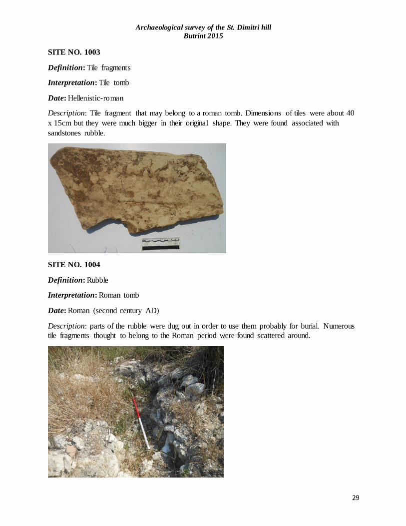
SITE NO. 1003
Definition: Tile fragments
Interpretation: Tile tomb
Date: Hellenistic-roman
Description: Tile fragment that may belong to a roman tomb. Dimensions of tiles were about 40
x 15cm but they were much bigger in their original shape. They were found associated with
sandstones rubble.
SITE NO. 1004
Definition: Rubble
Interpretation: Roman tomb
Date: Roman (second century AD)
Description: parts of the rubble were dug out in order to use them probably for burial. Numerous
tile fragments thought to belong to the Roman period were found scattered around.

Archaeological survey of the St. Dimitri hill
Butrint 2015
30
SITE NO. 1005
Definition: scattered limestone rubble
Interpretation:
Date: ?
Description: The stones are large sizes and are more visible in the vicinity of the hill near some
trees figs. No ceramic was found.
SITE NO. 1006
Definition: Roman tomb
Interpretation: Roman tomb
Date: Roman second-third century AD
Description: excavated Roman tomb with tile roof construction to the south of bullar eminence.
No evidence of that tomb is yet exist.

Archaeological survey of the St. Dimitri hill
Butrint 2015
31
SITE NO. 1007
Definition: Potsherd
Interpretation: Roman Villa
Date: Roman-to late antique
Description: potsherds and fragments of a dolium found on military trench. These findings
suggest the presence of a Roman settlement
SITE NO. 1008
Definition: Roman tomb
Interpretation: Roman tomb
Date: Roman second to third century AD
Description: Tile tomb.

Archaeological survey of the St. Dimitri hill
Butrint 2015
32
SITE NO. 1009
Definition: Roman tomb
Interpretation: Roman tomb
Date: Roman second to third century AD
Description: Tile tomb. No evidence of it yet exist.
SITE NO. 1010
Definition:
Interpretation:
Date:
Description: Only a tile roman tomb dating to the second century A.D was found here during
excavations in the 1980s. There is no evidence of the tomb at the moment only a white cross.

Archaeological survey of the St. Dimitri hill
Butrint 2015
33
SITE NO. 1011
Definition: Coins
Interpretation: hoard?
Date: Medieval – Venetian
Description: the Butrint Foundation obtained a quantity of Venetian silver coins, now on display
in the museum at Butrint. They were collected by local shepherds to the south of the cape Bullar
SITE NO. 1012
Definition: building debris
Interpretation: settlement of Zarópulo
Date: Venetian
Description: scattered fragments of building materials and pottery on both sides of the new road.
Reuse of the Roman bricks on floor pavement and the constructions are rounded in shape.

Archaeological survey of the St. Dimitri hill
Butrint 2015
34
SITE NO. 1013
Definition: building debris
Interpretation: settlement of Zarópulo
Date: Venetian
Description: Construction debris whose layout suggest the creation of flat terraces or spaces on
slopes for construction of buildings. The distance between each terrace is short and their
alignment suggest a direction overlooking to the east and south.
SITE NO. 1014
Definition: building debris
Interpretation: settlement of Zarópulo
Date: Venetian
Description: The scattered material mainly tiles and small stones without pottery occupied an area
of 250 m2. The construction debris seemed to be of the same type with the ones found at Area 2

Archaeological survey of the St. Dimitri hill
Butrint 2015
35
SITE NO. 1015
Definition: tile fragments
Interpretation:
Date: modern
Description: scattered fragments of tiles and small stones mainly to the northwest of the low
eminence.
SITE NO. 1016
Definition: tile fragments
Interpretation:
Date: modern
Description: debris were found to the east but they were not associated with any particular
features or structure.

Archaeological survey of the St. Dimitri hill
Butrint 2015
36
SITE NO. 1017
Definition: Church of St. Dimitri
Interpretation: orthodox Church
Date: modern
Description: The Orthodox church of St. Dimitri is a small one nave building erected in 1910
referring to an inscription on the entrance. The walls of the chapel do incorporate blocks of a
cloisonee style masonry, which has bene used in local Orthodox churches for centuries, and
which here suggest the presence of an earlier church of unknown date.
SITE NO. 1018
Definition: Kraal
Interpretation: sheep sten of Sophia
Date: modern
Description: modern sheep sten (kraal)

Archaeological survey of the St. Dimitri hill
Butrint 2015
37
SITE NO. 1019
Definition: Kraal
Interpretation: sheep sten
Date: modern
Description: modern sheep sten (kraal)