-1971- - north dakota · tm 5754 142-71-35000 183 177-183 8-20-70 24 4.3 177 48 106 9 .6 647 293...
TRANSCRIPT
Addendum ToNorth Dakota Geological Surve y
BULLETIN 49
North Dakota State Water Commissio nCOUNTY GROUND-WATER STUDIES I
GEOLOGY AND GROUND-WATER RESOURCES OF KIDDER COUNTY, NORTH DAKOTA
B yCharles E . Napli n
Ground-Water Geologis t
Published B y
North Dakota State Water Commissio nState Office Buildin g
900 Boulevar dBismarck, North Dakota 5850 1
-1971-

CONTENT S
Explanation
TABLE S
Table I - Chemical Analyses 2
2 - Water Levels in Selected Observation Wells 4
3 - Logs of Test Holes
1 3
ILLUSTRATION S
Figure I - Map of Kidder County Showing Location of Selecte dTest Holes and Wells 1 2
Pag e
1

EXPLANATIO N
Glacial drift aquifers in Kidder County, North Dakota, offer considerabl e
potential for the future development of irrigation in this area . Irrigation
development is directly related to the availability of ground water i n
Kidder County . Therefore, it is necessary that an accurate determinatio n
of aquifer thickness, lithology, areal extent, and the chemical qualit y
of ground water be made to insure the proper utilization of this resource .
When the original ground-water study was made in Kidder County, smal l
diameter observation wells were not installed as part of the field procedure .
As a result, very few water-level and chemical quality data were collected .
In 1970 supplementary test drilling was initiated to gather additional dat a
on water levels, aquifer characteristics, and water quality .
Parts I, II, and III of Geology and Ground-Water Resources of Kidde r
County, North Dakota should serve as text material to explain the glacia l
geology and hydrology of Kidder County . The following tables list data
collected during the recent ground-water investigation and are meant t o
supplement the main report .
-1-

(Analytical results in parts per million except as indicated )
D,nlh of
Date 01
Total
Moo-
Potas- 8 .088-
Car-
Manga -
0wner co
Well
Screened
Collec-
Silica Iron
Calcium 808151 Sodl um
tim
bo08[e 0008 . Sulfate
es
Chlorid e
_ oescrlptlon Location
Interval tlon (5100) (Fe) (Co) (89). (Na) (K) (MCO 3 ) (CO 3) (504) (Mn) (CI)
Tn 3634
138-71- 6ced l
80
77-80
9-23-68
31
0 .20
70
18
97
11
407
128
1 .10
3 . 9
Virgil Rote 138-71- 7000
83
68-83
8-28-68
29
0 .0
78
10
48
6 .3
333
73
0 .65
4 . 4
Virgil Rott
138-71- 7808
85
70-85
10-29-68
31
0 .0
68
21
101
II
418
26
0.95
2 . 7
TN 5771
138-72- 1000,
113
107-113
8-31-70
27
0 .28
68
22
75
403
0
84
0 .88
4 . 7
(South Well )
TN 5771-A
38-72- 1000 2
63
57-63
8-31-70
28
0 .52
75
20
22
3 .9
332
0
48
0 .99
(North Moll )
78 5770
138-72- Iccc
78
72-78
8-31-70
28
0 .05
77
21
76
7 .6
411
0
110
1 .00
2 . 1
Walter
138-72- lace
90
7-28-70
28
0 .28
66
21
68
7 .1
359
o
116
0 .93
0 . 9
Na 1810898 1
TN 5774
38-72- 7000 1
143
137-143
9- 1-70
25
1 .5
69
12
127
6 .9
479
0
107
0 .31
6 . 7
(East Well )
TN 5774-A
138-72- 7000 2
50
47-50
9- 1-70
27
1 .6
77
16
110
7 .0
430
0
42
0 .87
7 . 4
(W,. .1 Well )
Virgil 10-13-68 3o 0 .82 70 22 103
429 0 133 0.70 3 . 3
r. Maltc r8,4110808 1
TN 5916
38-73- 80dd
213
207-213
11-30-70
22
4.7
37
16
380
II
653
400
0 .03
29
81
0 .01
5 . 6Richard
139-71- 000c
3 4ueui v
8-19-70
26
0 .18
94
28
17
4 .3
354
0
Tn 5772
139-71-29c88
148
142-148
8-31-70
25
5 .5
40
254
531
0
196
0.30
5 2
1,chard
139-72- 2001,
106
---
7-28-70
28
0 .34
102
18
45
7 .0
352
0
113
1 .10
1 5
00811 8
rN 5760
139-72-246661
203
197-203
9- 3-70
24
0 .74
67
100
B .9
401
0
09
0 .84
7 . 2
(nest Well )
TN 5760-8
139-72-n1,bh2
83
77-83
9- 3-70
31
0 .12
118
23
57
475
0
131
0 .84
7 . 4
(Eont Well)
TABLE 1 - Chemical analyses (Continued )
(Analytical results in parts per million except as indicated )
Deem of
Date of
Total
nag-
vo tas- sitar-
Car-
88088 -
Owner or
Well
Screened
Collec-
Silica Iron
Calcium n tim
Sodium
i mbonate bonate Sulfate
es
Chloride
Description Location (Feet) Interval [ion (5100) (Fe) (Ca) (Mgl (Ne) (K) (800 3 ) (001 ) (504) (Mn) (CI)
TN 5776
139-72-31888
163
157-163
9- 3-70
32
0 .0
51
9 .7
91
7 .2
397
48
0 .07
6 .9
TN 5775
139-72-31000
344
338-344
9- 2-70
34
0 .24
27
0 .3
271
7 .5
572
113
0 .02
56
(South Well )
TN 5775-A
139-72-3100d 2
163
157-163
9- 2-70
31
2 .10
61
20
107
8 .5
417
102
0 .50
9 .8
(North Well )
Tn 5778
140-71-19000
123
117-123
8-21-70
23
0 .80
87
25
214
18
605
280
0 .51
2 6
Recorder
140-71-28068
60 Perforated
8-25-70
23
0 .72
55
18
68
6 .3
333
86
0 .48
7 . 2
Wel l
TO 5913
140-71-28088,
68
62-68
11-16-70
23
0 .03
70
33
47
4 .7
340
114
1 .50
5 . 7
(South Well )
TM 5913-8
140-71-280882
33
30-33
11-16-70
22
0 .18
68
26
6 .6
2 .0
239
81
0 .01
3 . 0
(North Well )
78 5753
141-70- 6baa
143
137-143
8-19-70
27
1 .3
128
38
44
5 .3
545
109
0 .69
8 . 0
Lawrence
181-74-14060
30
9825864
21
0 .12
204
88
204
15
289
103 0
'Melhoff
Patterson
142-70-16060
107
83-107
10-25-65
30
.7
73
24
3 .9
300
5o
Land Co .
26
2 . 9
59
1 .00
3 . 4Fat lerson
142-70-16060
10 0Land Co .
7-21-70
28
0 .0
89
21
9 .2
3 .4
33 6
TM 5754
142-71-35000
183
177-183
8-20-70
24
4 .3
177
48
106
9 .6
647
293
0 .30

Floo-
Tote!
TotalHardness
r
Sodium
Specific
_
ride
Nitrate Boron Dissolved As C .CO
Noncer- Sodiun, Adsorption-
Conductance
Irrigatio n1 LNO3)
(8) 50, 185
3 bonete (Micronhos 25° C) pH Classification Rrmarks_
0 .27 541 251 44 2 .7 842 7 .9 13-S I
0.24 423 236 30 1 .4 649 7 .7 C2-SI Pumping Rate 900 qpm
0 .73 564 255 45 2 .7 874 7.6 13-51 ramp in, a,i 1 .
595
ire
0.09 477 260 0 38 2 .0 741 7 .9 C2-5 1
0 .06 346 271 0 15 0 .6 565 8 .0 C2-5 1
0 .18 495 279 0 36 2 .0 788 7 .9 C3-5 1
0 .19 451 252 0 36 I .9 726 7 .7 C2-SI Puq,inq Rate 900 08,.
0 .12 557 220 0 55 3 .7 899 7 .8 C3-S I
0 .09 586 258 0 47 3 .0 892 7 .8 C3-5 I
0 .16 576 267 0 44 2 .7 882 7 .8 C3-5 1
0 .90 1170 158 0 83 13 1830 7 .9 03-5 3
0.17 422 352 62 9 0 .4 681 8 .0 C2-S i
0.99 884 146 0 78 9 .1 1350 7 .8 C3-S 2
0 .26 511 331 42 22 1 .1 786 7 .5 C3-51 Pooping 71a1r 800-9110 00
0 .12 538 237 0 47 2 .8 833 8 .1 C3-S I
0 .30 613 391 24 1 .3 938 7 .9 C3-51
0 . 2
0 .1
1 . 0
0 .0
. 0
0 .4
2 . 5
0 .4
3 . 5
0.7
0
0.2
0 . 6
0.4
1 . 0
0 .2
0. 1
0.2
0
Ilou-
-- Total Total Hardness % Sodium Specific
ride
Nitrate Boron Dissolved As 0.003 Noncar- Sodium Adsorption- Conductance Irrigation
(F)
(NO ) ) (81 Solids boneta Ratio (M erce6os 250 C) pN Clessif icatlon Remarks
0.1
1 .0 0.115 418 167 53 3 .1 786 7 .9 03-S l
0.1
2 .5 0.4) 781 69 88 14 1260 8 .0 C3-S 3
0.1
1 .0 0.19 539 234 49 3 .0 833 7 .9 C3-S I
0.2
1 .0 0 .71 966 321 58 5 .2 1420 8 .2 03-5 2
0 .4
2 .5 0 .05 392 211 40 2 .0 762 8 .2 C3-SI Diameter 8
inche s
0 .2
1 .0 0 .42 447 310 31 23 1 .1 724 8 .0 02-S I
0 .2
1 .0 0 .35 )24 276 80 5 0.2 514 8 .1 C2-S I
0 .2
0 .3 0 .06 632 478 31 16 0.9 967 7 .7 C3-S I
0 .3
0 .0 0.00 1860 870 634 33 3 .0 2140 8 .0 03-SI Pumping Pate 15 or '
0 .4
0 0 .08 344 280 34 6 .6 0 .2 543 8 .0 C2-SI Pumping Rate 500 00m
0.4
0 0 .33 344 310 34 6 0 .2 610 7.7 02-5I Pumping Rate 700 gpm
0 .1
0 0 .18 992 638 108 26 1 .8 1450 7.6 C3-S I
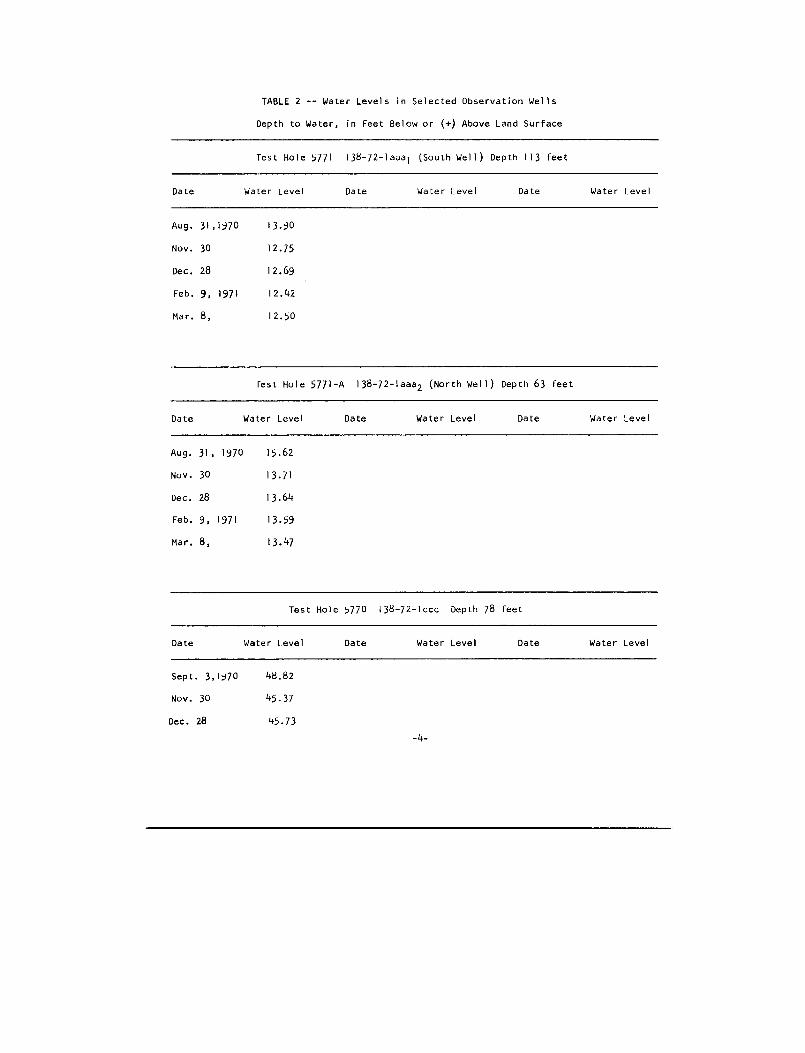
TABLE 2 -- Water Levels in Selected Observation Well s
Depth to Water, in Feet Below or (+) Above Land Surfac e
Test Hole 5771
138-72-laaal (South Well) Depth 113 fee t
Date
Water Level
Date
Water Level
Date
Water Leve l
Aug . 31,1970
13 .90
Nov . 30
12 .7 5
Dec. 28
12 .69
Feb. 9, 1971
12 .4 2
Mar. 8,
12 .5 0
lest Hole 5771-A 138-72-laaa2 (North Well) Depth 63 fee t
Date
Water Level
Date
Water Level
Date
Water Leve l
Aug . 31, 1970
15 .62
Nov . 30
13 .7 1
Dec . 28
13 .64
Feb. 9, 1971
13 .5 9
Mar. 8,
13 .47
Test Hole 5770 138-72-lccc Depth 78 fee t
Date
Water Level
Date
Water Level
Date
Water Leve l
Sept . 3,1970
48.8 2
Nov. 30
45 .3 7
Dec . 28
45 .73
-4-

Test Hole 5774 138-72-7aaa l (East Well) Depth 143 fee t
Date
Water Level
Date
Water Level
Date
Water Leve l
Sept. 3, 1970
+ .2 8
Nov . 30
+1 .5 3
Dec. 28
+1 .7 5
Feb. 9, 1971
+1 .74
Mar . 8
+1 .7 5
Test Hole 5774-A 138-72-7aaa 2 (West Well) Depth 50 fee t
Date
Water Level
Date
Water Level
Date
Water Leve l
Sept. 3, 1970
8 .5 0
Nov. 30
7 .04
Dec. 28
7 .0 7
Feb. 9, 1971
6 .74
Mar. 8
6 .64
Test Hole 5916 138-73-8ddd Depth 213 fee t
Date
Water Level
Date
Water Level
Date
Water Leve l
Mar. 17, 1971
4 .90
-5-
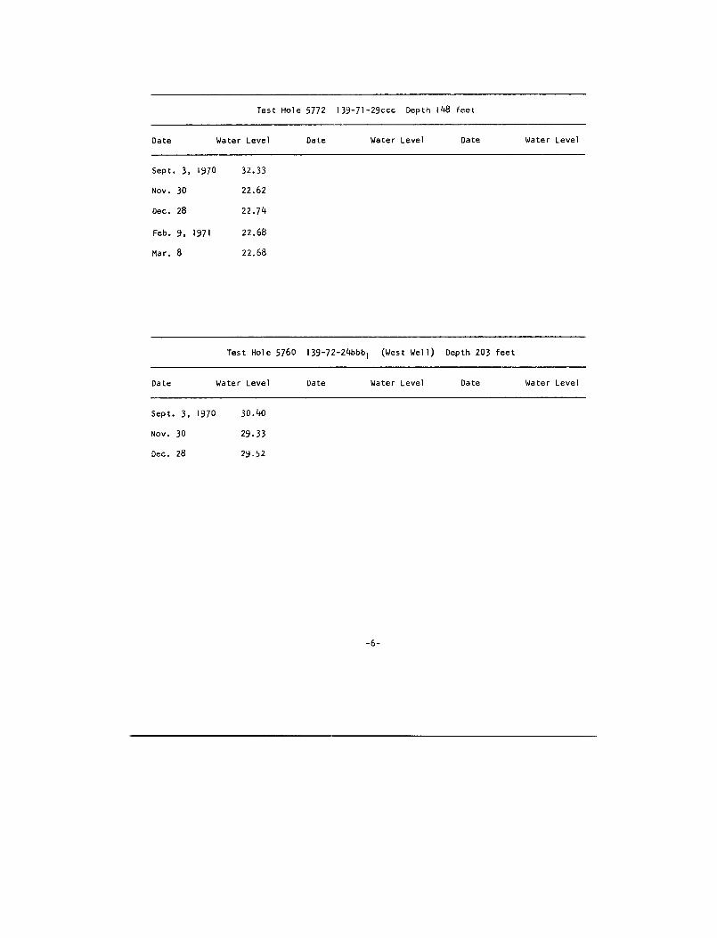
Test Hole 5772 139-71-29ccc Depth 148 fee t
Date
Water Level
Date
Water Level
Date
Water Leve l
Sept . 3, 1970
32 .3 3
Nov. 30
22 .6 2
Dec. 28
22 .7 4
Feb . 9, 1971
22 .6 8
Mar . 8
22 .6 8
Test Hole 5760 139-72-24bbbl (West Well) Depth 203 fee t
Date
Water Level
Date
Water Level
Date
Water Leve l
Sept. 3, 1970
30 .40
Nov . 30
29 .3 3
Dec . 28
29 .52
-6-
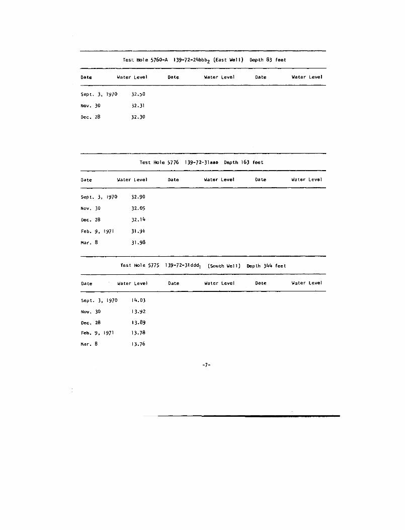
Test Hole 5760-A 139-72-24bbb 2 (East Well) Depth 83 fee t
Date
Water Level
Date
Water Level
Date
Water Leve l
Sept . 3, 1970
32 .5 0
Nov . 30
.32 .3 1
Dec . 28
32.3 0
Test Hole 5776 139-72-31aaa Depth 163 fee t
Date
Water Level
Date
Water Level
Date
Water Leve l
Sept . 3, 1970
32.9 0
Nov . 30
32 .0 5
Dec . 28
32 .1 4
Feb. 9, 1971
31 .9 1
Mar . 8
31 .98
Test. Hole 5775 139-72-31ddd 1 (South Well) Depth 344 fee t
Date
Water Level
Date
Water Level
Date
Water Leve l
Sept . 3, 1970
14 .0 3
Nov . 30
13 .92
Dec . 28
13 .89
Feb . 9, 1971
13 .78
Mar . 8
13 .76
-7-
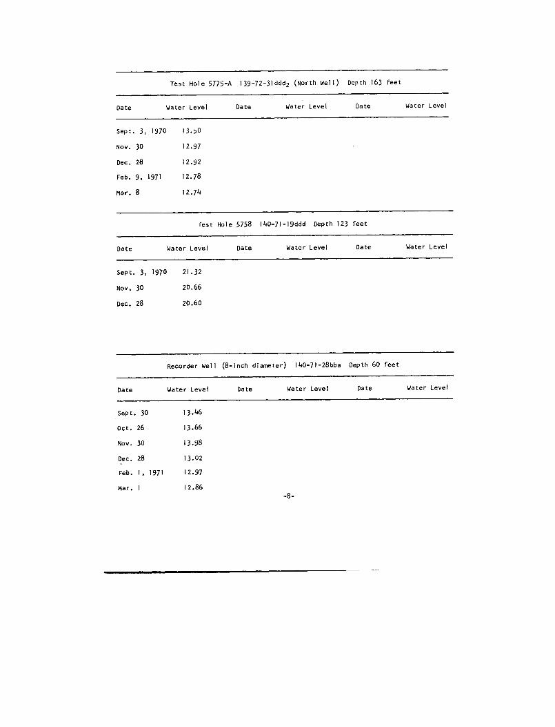
Test Hole 5775-A 139-72-31 ddd2 (North Well) Depth 163 fee t
Date
Water Level
Date
Water Level
Date
Water Leve l
Sept. 3, 1970
13 .5 0
Nov. 30
12 .9 7
Dec. 28
12 .9 2
Feb. 9, 1971
12 .7 8
Mar . 8
12 .74
rest Hole 5758 140-71-19ddd Depth 123 fee t
Date
Water Level
Date
Water Level
Date
Water Leve l
Sept . 3, 1970
21 .3 2
Nov. 30
20 .66
Dec. 28
20 .6 0
Recorder Well (8-inch diameter) 140-71-28bba Depth 60 fee t
Date
Water Level
Date
Water Level
Date
Water Leve l
Sept . 30
13 .46
Oct . 26
13 .66
Nov . 30
13 .98
Dec . 28
13 .0 2
Feb. I, 1971
12 .9 7
Mar. I
12.86
-8-
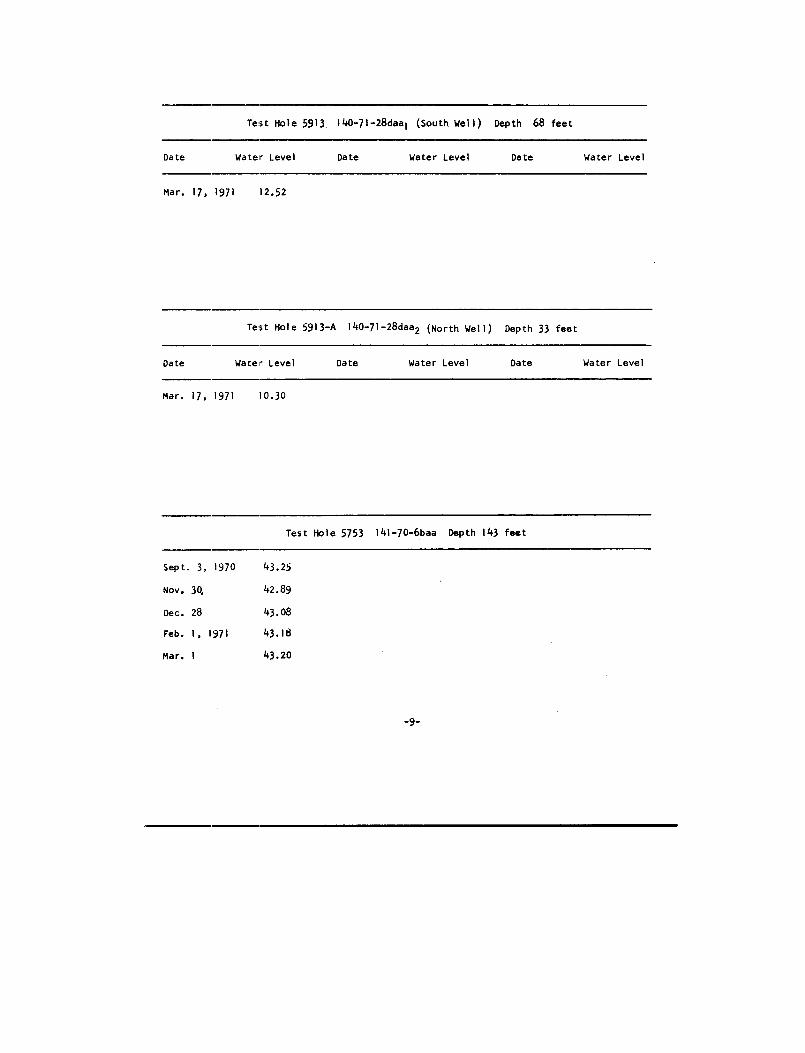
Test Hole 5913 . 140-71-28daa 1 (South. Well) Depth 68 fee t
Date
Water Level
Date
Water Level
Date
Water Leve l
Mar. 17, 1971
12 .52
Test Hole 5913-A 140-71-28daa 2 (North Well) Depth 33 fee t
Date
Water Level
Date
Water Level
Date
Water Leve l
Mar . 17, 1971
10 .30
Test Hole 5753
141-70-6baa
Depth 143 fee t
Sept .
3, 1970 43.2 5
Nov . 3Q 42.8 9
Dec . 28 43.0 8
Feb .
1, 1971 43.18
Mar .
1 43.20
-9 -
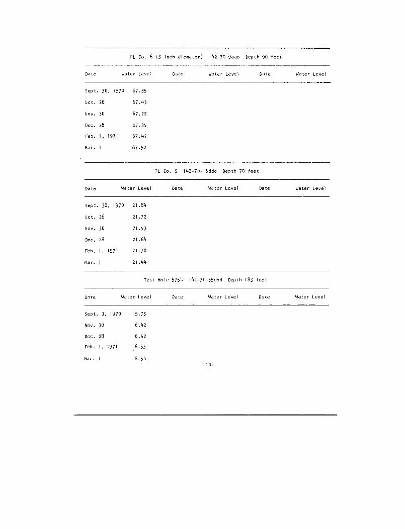
PL Co. 6 (3-inch diameter) 142-70-9aaa Depth 90 fee t
Date Water Level
Date
Water Level
Date
Water Leve l
Sept .
30, 1970 67 .3 5
Oct .
26 67 .4 3
Nov .
30 67 .2 2
Dec .
28 67 .3 5
Feb .
I,
1971 67 .4 5
Mar .
1 67 .52
PL Co. 5 142-70-16ddd Depth 70 fee t
Date
Water Level
Date
Water Level
Date
Water Leve l
Sept. 30, 1970
21 .84
Oct . 26
21 .7 2
Nov . 30
21 .5 3
Dec . 28
21 .6 4
Feb. 1, 1971
21 .7 0
Mar. 1
21 .44
Test Hole 5754 142-71-35ddd Depth 183 fee t
Date
Water Level
Date
Water Level
Date
Water Leve l
Sept . 3, 1970
9 .7 5
Nov. 30
6 .4 2
Dec . 28
6 .5 2
Feb. 1, 1971
6 .5 5
Mar . I
6.54-10-
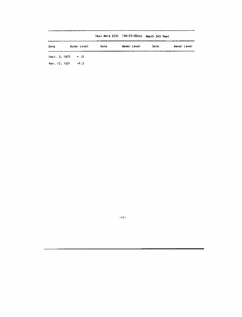
Test Hole 5751 144-70-26«c Depth 343 fee t
Date Water Level Date Water Level Date Water Leve l
Sept .
3, 1970
i-
. 5
Mar .
17, 1971
+1 .3

FIGURE 1 -- MAP OF KIDDER COUNTY SHOWING LOCATIO N
OF SELECTED TEST HOLES AND WELLS

NM"
•nv..nnn.noOn...oOnn.n.On.nnOn m.. M.n.Mnnn.Mn...Mn....
n nnn nnnnMnnnnMnnnnMnnnnn' nnn nnnnMnnnnMnnNMnnnnn
..n n n..nM .nM.
MI - ON r": 111 111nn I nnn I nnn I nnn I nn!Inn1 : ihi 111III 111111iit
1ifn N »-1gR1I1C.M.MnENimMEMO n
1 :_ :ACU5 mIIINn n ce nntnMnnnnnnnnnMMnt?in
11 .n nn ...n.nnMnn Mnnn nn. nn..MlAnMnnn.Mnnnnn
~en
j
n n.n . n..n..n/ Jn. nn► `In~I..n.n n.n r... .n/ n.Mnn..dnnn!nn
n n.n ..n....\ `Vnn.nOnn.Mn .nn n.n....~Ir11M nnnMnm p pn: pE~n N N:n Ma... MOMM MMMU :WPn 1:1110nnn n~JM nnnMnnnn~n`+n~nnnn'TI Ill... ma,.,
sIi Sa-oleoSI x .>r
~~igfi•r'.d© ~!!~_Ix .sI{ KSENMSix! 1
MOD niyiiunM.nn ~iniirnMnnnnnnn n.nnnnMref! Mnq nnnnn ~SI IN I (CCC1 *:~MIEI 1 EMI I... r..•~ .r.a~E S.M.M.nnn/nn1I/nn"
--~`:• nnn nM MU.nnn''i.U.n nnMnnnnnnn NnnnYJ
" : C~11 t• X111" 1111 xt 1111 'MnnnnMnnnnMnnnnM"...
::11III III 11II1r''~N T•M
.73*
H92M
NTI vSCALE IM MILE S
FIGURE 1-- MAP OF KIDDER COUNTY SHOWING LOCATION OF SELECTED TESTHOLES AND WELLS
EXPLANATIO NTEST NILE, LOO IN TAAL( (MMIATION WEL L0NECOIOEN MELL
NGIIEICATIONS USED MIT NYOKE S21INOL 0-0MATEM-IJI EC ISEASNIVENT( I NTAIILE (LOO IN TNSLE 50-ANALYSIS IN TONL E
YDPE TNNN ONE NELL AT 1HI SLOCATION011LT TEST NJLES ONKL(O I N7510 ARE SNOMT I
1 2

TABLE 3 -- LOGS OF TEST HOLE S
Explanation of Litholoyic Symbol s
Gravel or sand and grave l
o• . :is
Boulder clay (till )
Silty clay (ylaciofluvial sediment )
Shal e
The lollowiny lest hole loys are a summary of data from th e
driller ' s logs, geologist's sample descriptions and the resistivit y
and potential electric loys .
Grain size classification is C . K . Wentworth's scale fro m
Pettijohn (1957) .
Elevations are based on mean sea level datum as represented o n
and interpreted from the Dawson, Steele, Steele Northeast, Steel e
Northwest, Tappen North, Tappen South, Tappen Northeast and Tappe n
Southeast, U . S . Geological Survey, topographic maps .
Test holes are called observation wells when they have bee n
completed as wells with 14-inch diameter plastic casiny .
-1 3-

138-71-6ccd lTest Hole 563 4
Elevation 1812 feet
DATE DRILLED: 9-18-68
Geologic
Thickness
Depth
source
Material (feet) (feet )
Glacial Drift :Sand, fine- to coarse-grainedoxidized 30
3 0Silt,
clayey,
olive
gray ,laminated 20
5 0
Gravel, sandy,
fine to coarse ,predominantly limestone an dgranitics,
some shale 30
80
Clay,
(till) 10
90
Observation Wel lDepth 80 fee t
Screened interval 77-80 fee tChemical Analysi s
Electric Log
-14-
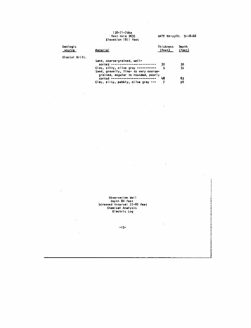
138-71-7bb aTest Hole 3635
Elevation 1811 feetDATE DRILLED : 9-18-68
Geologic
Thickness
Dept h source
Material (feet) (feet )
Glacial Drift :Sand, coarse-grained, well -
sorted 30 30Clay,
silty, olive gray 5 35Sand, gravelly,
fine- to very coarse -grained, angular to rounded, poorl ysorted 48 83
Clay,
silty, pebbly, olive gray --- 7 90
Observation Wel lDepth 80 fee t
Screened Interval 77-80 feetChemical Analysi s
Electric Lo g
-15 -
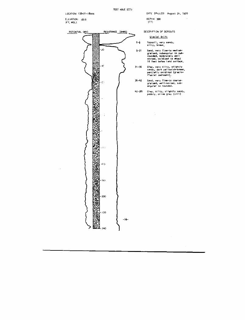
TEST HOLE 577 3LOCATION: 138-71-18ccc
DATE DRILLED : August 31, 197 0
ELEVATION : 1810
DEPTH : 380(FT )
DESCRIPTION OF DEPOSIT S
Glacial Drif t
0-}
Topsoil, very sandy ,
silty, brown ,
}-31
Sand, very fine-to medium-grained, subangular to sub -rounded, moderately wel lsorted, oxidized to abou t10 feet below land surface ,
31-36 Clay, very silty, slightl ysandy, dark yellowish-brown ,partially oxidized (glacio-fluvial sediment) .
36-42 Sand, very fine-to coarse -grained, well-sorted, sub-angular to rounded .
42-281
Clay, silty, slightly sandy ,pebbly, olive gray (till )
(FT, MSL)
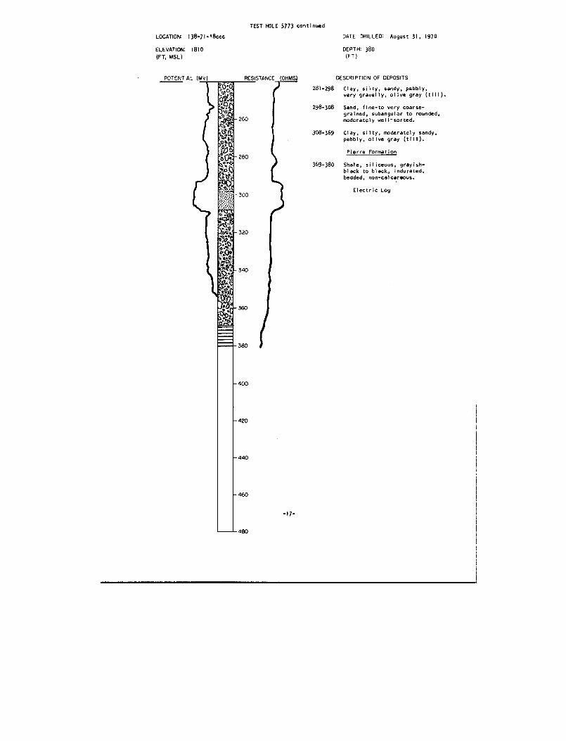
TEST HOLE 5773 continue d
LOCATION : 138-71-18ccc DATE
DRILLED: August 31,
197 0
ELEVATION : 1810 DEPTH : 38 0
(FT, MSL) (FT)
POTENTIAL (MV)
RESISTANCE (OHMS)
DESCRIPTION OF DEPOSIT S
281-298
Clay, silty, sandy, pebbly ,
very gravelly, olive gray (till) .
298-308
Sand, fine-to very coarse -
grained, subangular to rounded ,260
~
moderately well-sorted .
.398-369
Clay, silty, moderately sandy ,
pebbly, olive gray (till) .
Pierre Formatio n
369-380 Shale, siliceous, grayish -black to black, indurated ,
bedded, non-calcareous .
Electric Log
-17-

TEST HOLE 577 1
LOCATION: 138-72-Iaaa
ELEVATION: 176 5
;FT, MSL )
POTENTIAL (MV)
DATE DRILLED : August 28, 197 0
DEPTH : 180(FT )
DESCRIPTION OF DEPOSIT S
Glacial Drif t
0-1
Topsoil, very sandy, silty ,
brownish-black .
1-3
Clay, silty, very sandy ,
pebbly, moderate yellowish -
brown, oxidized (till) .
3-70
Sand, silty, slightly clayey ,
very fine-to medium-grained ,
subangular to subrounded, well -
sorted, slightly oxidize d
upper 20 feet of section, takin g
water, occasional clay lense s
lower 10 feet of section .
Clay, very silty, sandy, olive
gray with light olive gra y
mottling, highly calcareous
(glaciofluvial sediment) .
96-100 Gravel, moderately sandy, fineto coarse, angular to rounded ,
moderately well-sorted, taking
water, caving slightly .
100-103
Clay, silty, moderately sandy ,
pebbly, olive gray (till) .
103-114 Gravel, slightly sandy, occas-
ional thin clay lenses, fin e
to coarse, angular to rounded ,
moderately well-sorted, takin g
water .
114-165
Clay, very silty, sandy, pebbly ,
a few cobbles, occasional thi n
gravel lenses, olive gray (till) .
Fox Hills Formation
165-180
Shale, very silty, moderatel y
sandy, medium gray to medium
dark gray, light olive gray to
dark greenish-gray mottling ,
non-calcareous, slightl y
indurated to indurated, bedded .
Observation Well s
South Well : Depth 113 fee tScreened interval 107-11 3fee t
North Well : Depth 63 fee tScreened interval 57-63 fee t
Chemical Analyse s
Electric Log
-18-
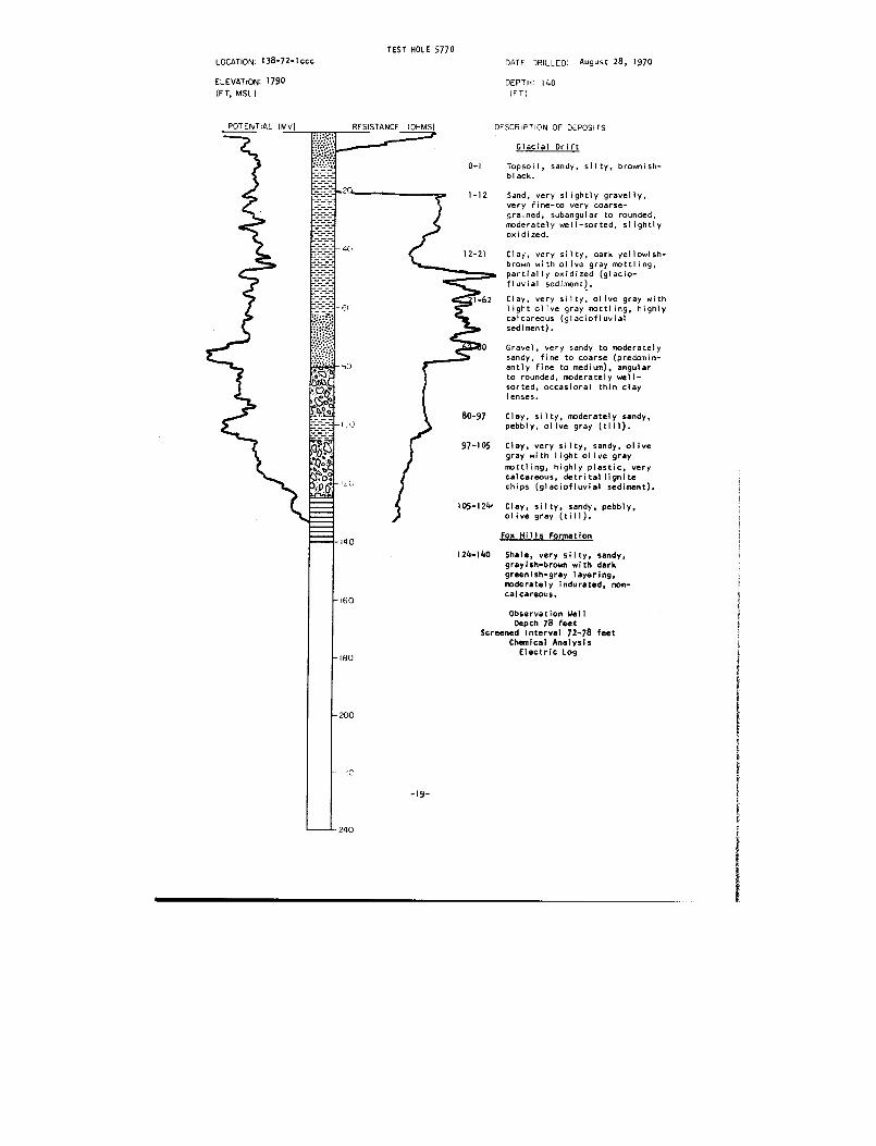
TEST HOLE 577 0
LOCATION : 138-72-1 ccc DATE DRILLED: August 28, 197 0
ELEVATION : 1790
DEPTH : 140
(FT, MSL)
(FT )
RESISTANCE (OHMS)
DESCRIPTION OF DEPOSIT S
Glacial Drif t
0-1
Topsoil, sandy, silty, brownish -
black .
fluvial sediment) .
1-62
Clay, very silty, olive gray wit h
light olive gray mottling, highl ycalcareous (glaciofluvia l
sediment) .
0
Gravel, very sandy to moderatel ysandy, fine to coarse (predomin-
antly fine to medium), angula r
to rounded, moderately well -
80-97
Clay, silty, moderately sandy ,
pebbly, olive gray (till) .
97-105
Clay, very silty, sandy, olivegray with light olive gra y
mottling, highly plastic, ver y
calcareous, detrital lignit e
chips (glaciofluvial sediment) .
105-12 1'
Clay, silty, sandy, pebbly ,olive gray (till) .
Fox Hills Formatio n
124-140
Shale, very silty, sandy ,
grayish-brown with darkgreenish-gray layering ,moderately indurated, non-
calcareous .
Observation Wel lDepth 78 fee t
Screened Interval 72-78 fee tChemical Analysi s
Electric Log
POTENTIAL (MV)
1-12
Sand, very slightly gravelly ,
very fine-to very coarse-
grained, subangular to rounded ,
moderately well-sorted, slightl yoxidized .
12-21 Clay, very silty, dark yellowish -
brown with olive gray mottling ,
partially oxidized (glacio -
sorted, occasional thin cla ylenses .
-19 -
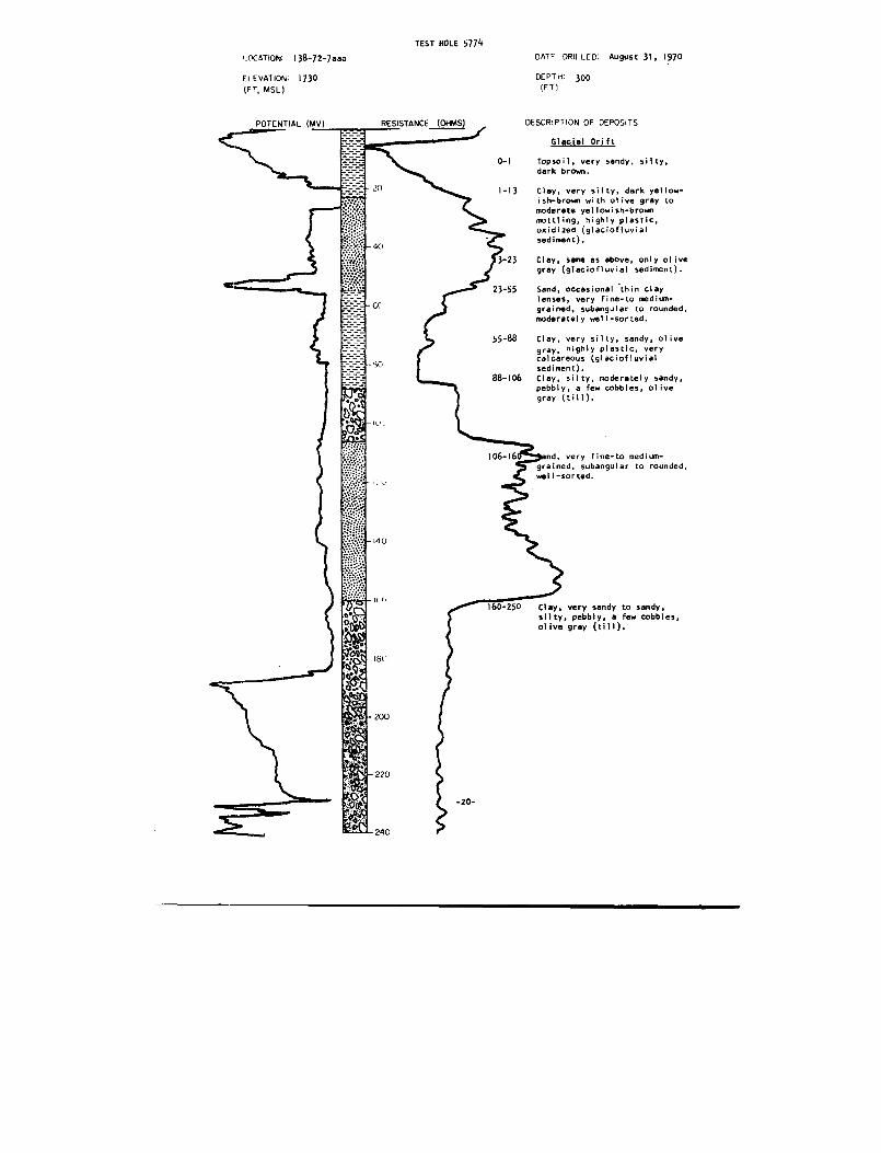
TEST HOLE 577 4
LOCATION : 138-72-7aaa
ELEVATION : 173 0
(FT, MSL)
DATF DRILLED : August 31, 197 0
DEPTH : 300(FT )
DESCRIPTION OF DEPOSIT S
Glacial Drif t
0-I
Topsoil, very sandy, silty ,
dark brown .
1-13
Clay, very silty, dark yellow-
ish-brown with olive gray to
moderate yellowish-brow n
mottling, highly plastic ,
oxidized (glaciofluvia l
sediment) .
3-23
Clay, same as above, only oliv e
gray (glaciofluvial sediment) .
23-55
Sand, occasional thin clay
lenses, very fine-to medium-
grained, subangular to rounded ,
moderately well-sorted .
55-88
Clay, very silty, sandy, oliv e
gray, highly plastic, verycalcareous (glaciofluvia l
sediment) .
88-106
Clay, silty, moderately sandy ,
pebbly, a few cobbles, oliv e
gray (till) .
106-16'
= nd, very fine-to medium-
grained, subangular to rounded ,well-sorted .
1 .0-250
Clay, very sandy to sandy ,
silty, pebbly, a few cobbles ,
olive gray (till) .
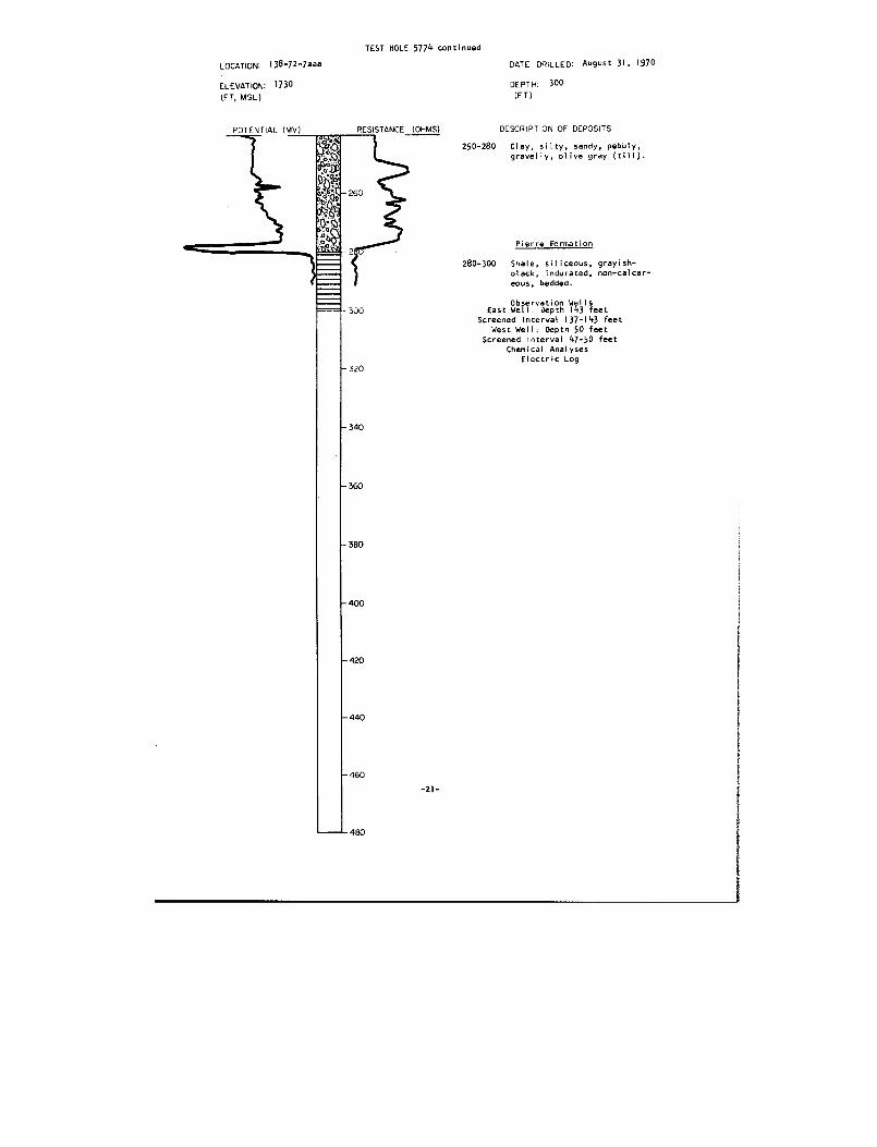
TEST HOLE 5774 continue d
LOCATION : 138-72-7aaa
DATE DRILLED August 31, 197 0
ELEVATION : 1730
DEPTH: 300
(FT, MSL)
(FT )
POTENTIAL (MV) RESISTANCE (OHMS)uus.
"o:Qt
26 0
p~94 in9
DESCRIPTION OF DEPOSIT S
250-280
Clay, silty, sandy, pebbly ,
gravelly, olive gray (till) .
Pierre Formatio n
280-300
Shale, siliceous, grayish -
slack, indurated, non-calcar -
eous, bedded .
Observation Well sEast Well : Depth 143 fee t
Screened Interval 137-143 feet
West Well : Depth 50 fee t
Screened interval 47-50 fee t
Chemical Analyse sElectric Log
300
- 320
- 340
-360
- 380
- 400
420
440
46 0
480
-Y1 -
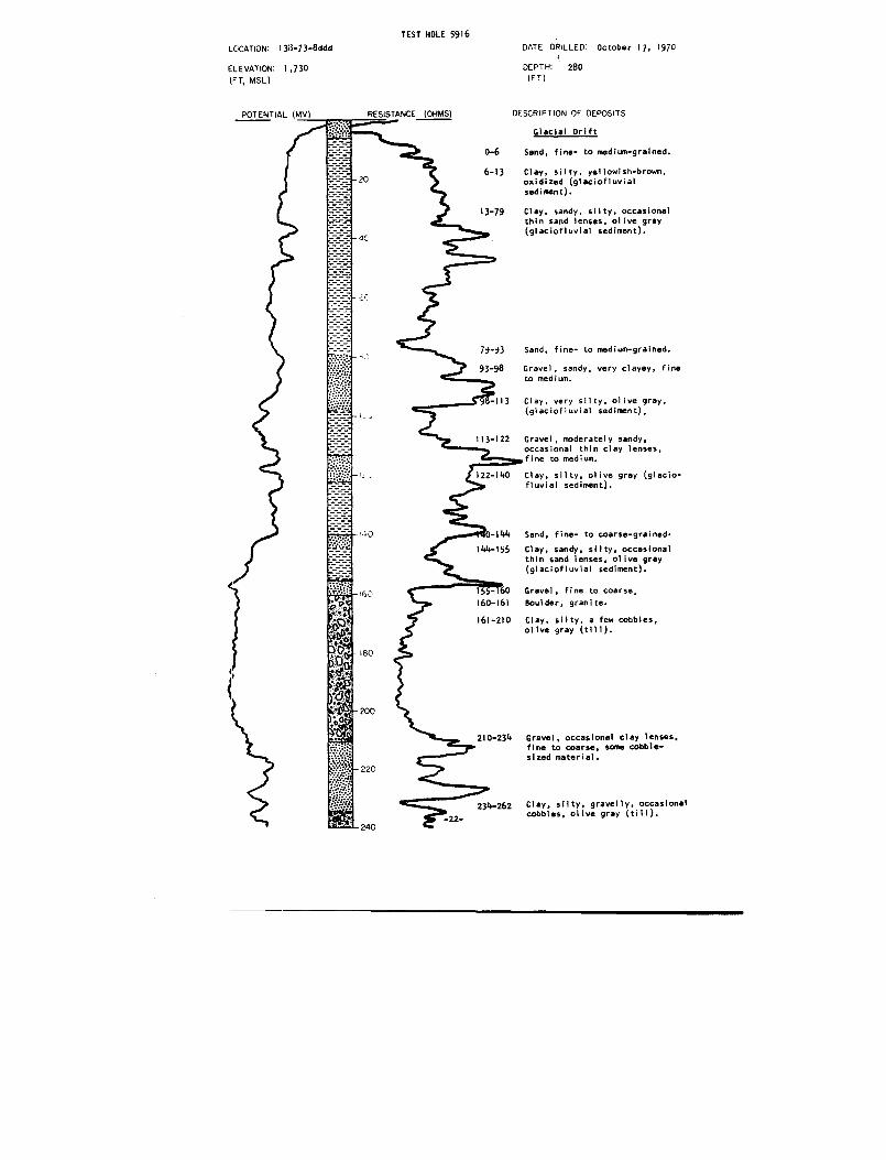
TEST HOLE 591 6
LOCATION: 1 313-7 3-8 dd d
ELEVATION: 1,73 0(FT, MSL)
DATE DRILLED : October 17, 197 0
'DEPTH :
28 0(FT )
POTENTIAL (MV)
0-6
6-13
DESCRIPTION OF DEPOSIT S
Glacial Drif t
Sand, fine- to medium-grained .
Clay, silty, yellowish-brown ,
oxidized (glaciofluvia l
sediment) .
13-79
Clay, sandy, silty, occasiona l
thin sand lenses, olive gra y
(glaciofluvial sediment) .
79-93
Sand . fine- to medium-grained .
93-98
Gravel, sandy, very clayey, fine
to medium .
-113
Clay, very silty, olive gray ,
(glaciofluvial sediment) ,
113-122
Gravel, moderately sandy ,
occasional thin clay lenses ,
fine to medium .
O
0-144
Sand, fine- to coarse-grained .
144-155
Clay, sandy, silty, occasiona l
thin sand lenses, olive gra y
(glaciofluvial sediment) .
155- 60
Gravel, fine to coarse ,
160-161
Boulder, granite .
161-210
Clay, silty, a few cobbles ,olive gray (till) .
210-234
Gravel, occasional clay lenses ,
fine to coarse, sane cobble-
sized material .
Clay, silty, gravelly, occasiona l
cobbles, olive gray (till) .
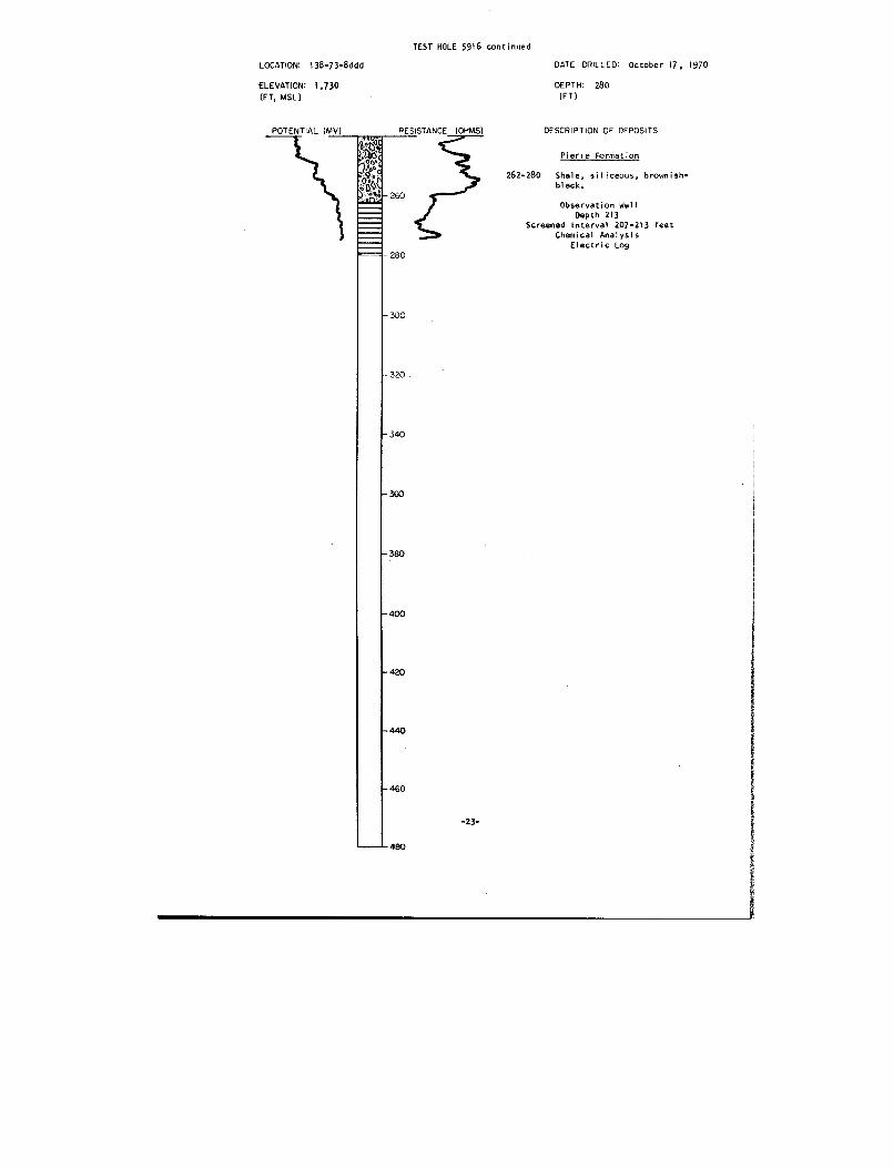
TEST HOLE 5916 continue d
LOCATION : 138-73-8ddd
DATE DRILLED : October 17, 197 0
'ELEVATION : 1,730
DEPTH: 280
(FT, MSL)
(FT )
DESCRIPTION OF DEPOSITS
Pierce Formatio n
262-280
Shale, siliceous, brownish-
black .
Observation Wel lDepth 21 3
Screened Interval 207-213 fee t
Chemical Analysi s
Electric Log
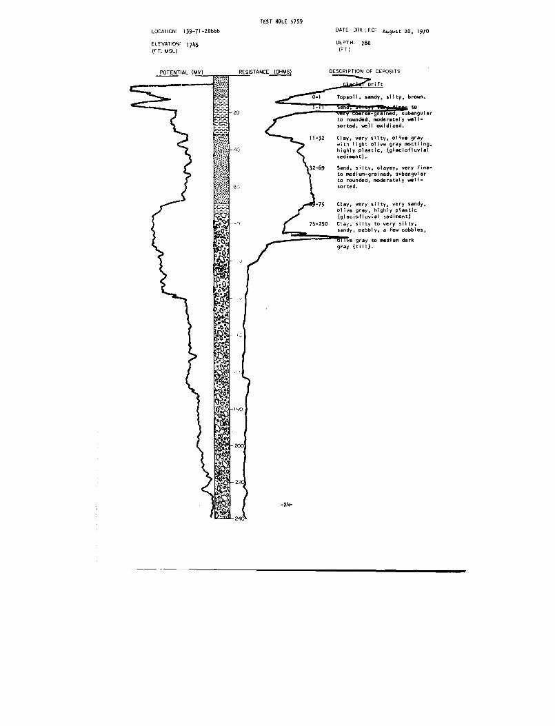
TEST HOLE 5759
LOCATION: 139-71-20bbb
ELEVATION: 1745
(FT, MSL)
DATE DRILLE D
DEPTH : 28 0(FT)
August 20, 197 0
POTENTIAL (MV)
0-1
Topsoil, sandy, silty, brown .
to
very coarse-grain , subangular
to rounded, moderately well -
sorted, well oxidized .
11-32
Clay, very silty, olive gra y
with light olive gray mottling ,
highly plastic, (glaciofluvia l
sediment) .
32-69
Sand, silty, clayey, very fine-
to medium-grained, subangula r
to rounded, moderately well -
sorted .
75
Clay, very silty, very sandy ,
olive gray, highly plasti c
(glaciofluvial sediment )
75-250
Clay, silty to very silty ,
sandy, pebbly, a few cobbles ,
ve gray to medium dar k
gray (till) .
-24-
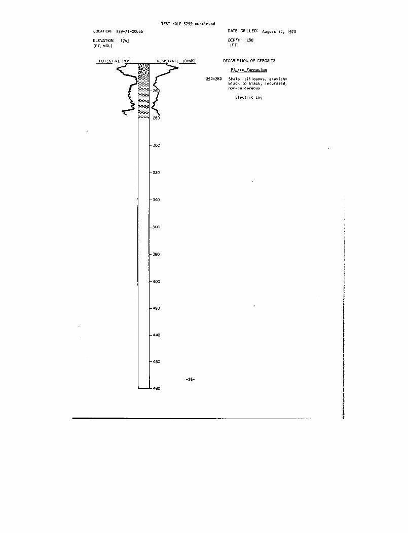
TEST HOLE 5759 continue d
LOCATION: 139-71-20bb b
ELEVATION: 1745(FT, MSL)
August 20, 197 0DATE DRILLE D
DEPTH : 280(FT )
POTENTIAL (MV)
RESISTANCE (OHMS)
DESCRIPTION OF DEPOSIT S
Pierre Formatio n
250-280 Shale, siliceous, grayish -black to black, indurated ,non-calcareou s
Electric Log

TEST HOLE 577 2
LOCATION: 139-71-29ccc
ELEVATION: 1,77 5(FT, MSL)
DATE DRILLED : August 28, 197 0
160DEPTH :
(FT )
DESCRIPTION OF DEPOSIT S
Glacial Drif t
0-i
Topsoil, very sandy, silty ,
pebbly, brownish-black .
1-10
Sand, very slightly gravelly ,silty, very fine- to coarse-
grained, subangular, moderatel y
well-sorted, oxidized .
10-20
Clay, very silty, sandy, dark
yellowish-brown with olive gra y
mottling, highly plastic ,
oxidized (glaciofluvia l
sediment) .
20-31
Sand, slightly clayey, ver y
fine- to medium-grained, sub-
angular to subrounded, modera-
tely well-sorted .
31-43
Clay, very silty, occasiona l
thin sand lenses, olive gray
with light olive gray mottling ,
highly plastic, very calcareous
(glaciofluvial sediment) .
43-68 Sand, very fine- to medium -
grained, subangular to sub -
rounded, moderately well-sorted .
68-136
Clay, very sandy, silty, gravel-
ly, pebbly, olive gray,(till) .
136-151
Gravel, slightly sandy, fine to
coarse (some cobble- and boulder -
sized material), angular t o
well-rounded, fair sorting ,
about 40 percent carbonates, 40
percent siliceous rocks -
quartzite, chalcedony, agate ,
granite and sandstone, 20 per-
cent shale and sandstone ,
taking water, caving in .
Pierre Formatio n
151-160 Shale, siliceous, grayish -
black to black, indurated ,
non-calcareous, bedded.
Observation Wel lDepth 148 fee t
Screened Interval 142-148 fee t
Chemical Analysi sElectric Log
-26-
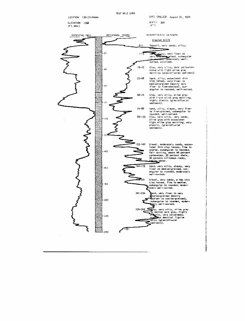
TEST HOLE 576 0
LOCATION: 139-72-24bb b
ELEVATION: 1768(FT, MSL )
POTENTIAL (MV)
DATE DRILLED : August 21, 1970
DEPTH : 36 0(FT )
DESCRIPTION OF DEPOSIT S
Glacial Drif t
0-1
Topsoil, very sandy, silty ,T•nl~
1-19
S
ty, very fine- t o
very
. fined, subangula rmoderately well -
sorted, oxidized .
19-23
Clay, very silty, dark yellowish -
brown with light olive gra y
mottling (glaciofluvial sediment).
23-68 Sand, silty, occasional thi nclay lenses, very' fine- t omedium-grained (mostly very
fine- to fine-grained), sub -
angular to rounded, well-sorted .
68-74
Clay, very silty, olive gra ywith light olive gray mottling ,
highly plastic (glaciofluvia l
sediment) .
74-80 Sand, silty, clayey, very fine -
to fine-grained, subangular to
rounded, well-sorted .
80-133
Clay, very silty, very sandy ,
olive gray with occasiona llight olive gray mottling, ver y
plastic, (glaciofluvia l
sediment) .
133-160
Gravel, moderately sandy, occas -
ional thin clay lenses, fine tocoarse, subangular to rounded ,
fair sorting, about 40 percen t
carbonates, 30 percent shale ,30 percent siliceous rocks ,
_'~----~:i„r. water .
160-179 Sand, very silty, clayey, ver yfine- to medium-grained, sub-
angular to rounded, moderatel ywell-sorted .
01
Gravel, very sandy, a few thi n
clay lenses, fine to medium ,subangular to rounded, moder-
ately well-sorted .
201-234
and, very fine- to ver y
arse-grained (mostl yedium- to coarse-grained) ,
subangular to rounded, moder-
ely well-sorted .
234-340
ay, very silty, olive gra y
to medium dark gray, highl y
tic, very calcareous ,
s detrital lignitecc ips (glaciofluvia l
sediment) .
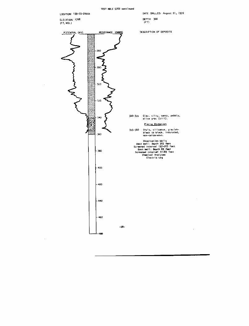
TEST HOLE 5760 continued
LOCATION :
I39-72-24bbb DATE
DRILLED:
August 21, 197 0
ELEVATION :
176 8
(FT, MSL)
DEPTH :(FT)
360
DESCRIPTION OF DEPOSIT S
340-355
Clay . silty, sandy, pebbly ,olive gray (till) .
Pierre Formation
355-360 Shale, siliceous, grayish -black to black, indurated ,non-calcareous .
Observation Well sWest Well : Depth 203 fee t
Screened Interval 197-203 fee tEast Well : Depth 83 fee t
Screened interval 77-83 fee tChemical Analyse s
Electric log
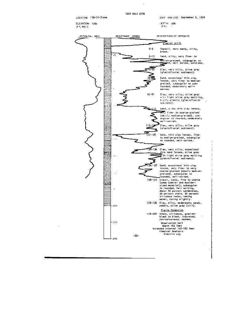
TEST HOLE 5776
LOCATION: 139-72-31aa a
ELEVATION : 1765
(FT, MSL )
POTENTIAL (MV)
DATE DRILLED : September 2, 197 0
DEPTH : 20 0
(FT )
DESCRIPTION OF DEPOSIT S
lenses, very fine- to medium -
grained, subangular to sub -rounded, moderately well -
sorted .
62-81
Clay, very silty, olive graywith light olive gray mottling ,highly plastic (glaciofluvia l
sediment) .
115
Sand, a few thin clay lenses ,
yy fine- to coarse-graine d
(mostly medium-grained), sub-angular to rounded, moderatel y
well-sorted .
'F22-128 Sand, thin clay lenses, fine-
to medium-grained, subangula r
to rounded, well-sorted .
—~ff8-136 Clay, very silty, occasiona l
thin sand lenses, olive gra y
. th light olive gray mottlin g
(glaciofluvial sediment) .
136-158 Sand, occasional thin cla ylenses, very fine- to ver ycoarse-grained (mostly medium-
grained), subangular to
ounded, well-sorted .
158-172 Gravel, sandy, fine to coars e
(some cobble- and boulder -
sized material), subangula rto rounded, fair sorting ,
about 40 percent carbonates ,30 percent shale, 30 percen t
siliceous rocks, takin g
water, caving slightly .
172-176 Clay, silty, moderately sandy ,pebbly, olive gray (till) .
Pierre Formatio n
176-200 Shale, siliceous, grayish -
black to black, indurated ,non-calcareous, bedded .
Observation Wel l
Depth 163 fee tScreened Interval 157-163 fee t
Chemical Analysi s
Electric Lo g
Glacial Drif t
0-}
Topsoil, very sandy, silty ,
brown .
Z-13
Sand, silty, very fine- to
ium-grained, subangular t owaeed, well sorted, oxidized .
- 9
Clay, very silty, olive gray(glaciofluvial sediment) .
29
Sand, occasional thin clay
-29-

LOCATION : 139-72-31dd d
ELEVATION : 1740
(FT, MSL)
TEST HOLE 5775
DATE DRILLED: September 1, 197 0
DEPTH: 400(FT )
DESCRIPTION OF DEPOSITS
Glacial Drif t
0-4
Sand, very fine- to medium-
grained, moderately well -
sorted, angular to subangular .
16
Clay, silty, grayish yellow ,
oxidized (glaciofluvia l
16-20
Clay, sli htl
silty, medium
r.~
ac,o uvial sediment) .
20-56
Sand, silty, occasional cla y
lenses, fine- to medium-grained ,
subangular .
56-68
Clay, silty, sandy, medium gra y
(glaciofluvial sediment) .
68-94
Sand, gravelly, medium- t overy coarse-grained, subangula r
to subrounded, fair sorting .
84-I11
Clay, slightly silty, mediu m
light gray (glaciofluvia l
sediment) .
III-160 Sand, a few thin clay lenses ,fine- to medium-grained, sub -
angular to subrounded, well -
sorted .
160-177 Sand, a few thin clay lenses ,
slightly gravelly, medium- t o
coarse-grained, subangular t o
subrounded, moderately well -
sorted .
177-246
Clay, very silty, sandy, pebbly ,
cobbles and boulders, medium
dark gray, occasional sand an d
gravel lenses (till) .
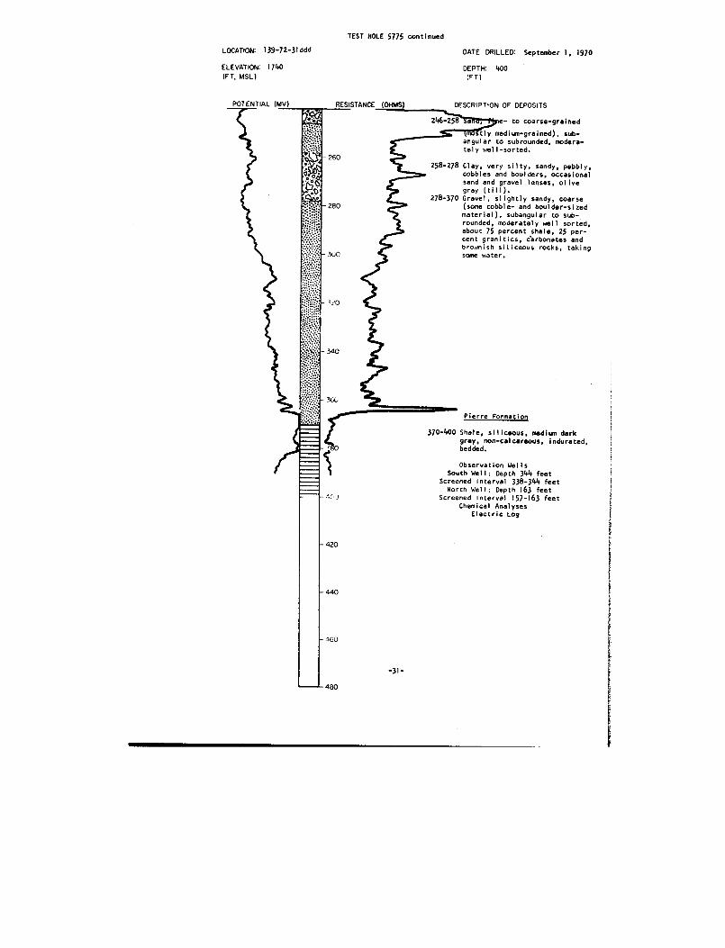
TEST HOLE 5775 continue d
LOCATION : 139-72-31dd d
ELEVATION : 1740(FT, MSL )
POTENTIAL (MV) RESISTANCE (OHMS)
DATE DRILLED : September 1, 197 0
DEPTH : 400(FT )
DESCRIPTION OF DEPOSIT S
246-258e- to coarse-graine d
S Imb tly medium-grained), sub -angular to subrounded, modera-tely well-sorted .
260
280
300
258-278 Clay, very silty, sandy, pebbly ,cobbles and boulders, occasiona lsand and gravel lenses, olivegray (till) .
278-370 Gravel, slightly sandy, coarse(some cobble- and boulder-size dmaterial), subangular to sub -rounded, moderately well sorted ,about 75 percent shale, 25 per-cent granitics, carbonates an dbrownish siliceous rocks, takin gsome water .
;%0
- 340
30*
4CV
Pierre Formatio n
370-400 Shale, siliceous, medium dar kgray, non-calcareous, indurated ,bedded .
Observation Well sSouth Well : Depth 344 fee t
Screened Interval 338-344 fee tNorth Well : Depth 163 fee t
Screened Interval 157-163 fee tChemical Analyse s
Electric Log
420
440
460
-31 -
480

139-73-13dd dTest Hole 591 4
Elevation 1815 feetDATE DRILLED: 11-12-7 0
Geologic
Thickness
Dept hsource
Material (feet) (feet )
Glacial Drift :Topsoil, silty, moderately sandy ,
pebbly, brownish-black 1
1Clay, very silty, moderately sandy ,pebbly, dusky yellow to moderat eyellowish-brown, oxidized
(till)-- 28
29
Fox Hills Formation :Sandstone, very fine-to fine-grained ,dark reddish-brown to yellowish -brown, slightly cemented to wel lcemented, well oxidized and iron -stained, upper 5-10 feet o fsection highly calcareous, other -wise non-calcareous, bedded 26
5 5Sandstone, interbedded with shale ,fine-grained, moderately clayey ,moderately sandy, medium bluish -gray to dark greenish-gray ,slightly cemented to well cemented ,non-calcareous, slightly micaceous ,bedded 25
8 0
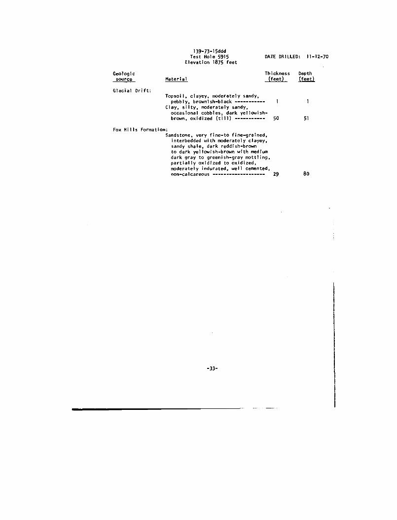
139-73-15dddTest Hole 591 5
Elevation 1875 feetDATE DRILLED: 11-12-7 0
Geologic
Thickness
Depth source
Material (feet)
(feet )
Glacial Drift :Topsoil, clayey, moderately sandy ,
pebbly, brownish-black I
1Clay, silty, moderately sandy ,occasional cobbles, dark yellowish -brown, oxidized (till) 50
5 1
Fox Hills Formation :Sandstone, very fine-to fine-grained ,
interbedded with moderately clayey ,sandy shale, dark reddish-brow nto dark yellowish-brown with mediumdark gray to greenish-gray mottling ,partially oxidized to oxidized ,moderately indurated, well cemented ,non-calcareous 29
80

TEST HOLE 5756
LOCATION : 140-71-2bbb
DATE DRILLED August 19, 197 0
ELEVATION: 191 0(FT, MSL)
DEPTH : 40 0(FT )
DESCRIPTION OF DEPOSITS
Glacial Drif t0-I
Topsoil, silty, pebbly, cobbles ,
boulders, grayish-black .
1-3 Clay, silty, moderately sandy, peb -
bly, cobbles, boulders, moderate
yellowish-brown, oxidized (till) .
3-31
Clay, very silty, dark yellowish -
brown with light olive gra y
to dark gray mottling, highl y
plastic, very calcareous ,partially oxidized (glacio-
fluvial sediment) .
31-57
Clay, very silty, olive gra y
with light olive gray mottling ,
highly plastic, very calcareou s
(glaciofluvial sediment) .
57-59
Sand, very fine-to medium-
grained, subangular, moderatel ywell-sorted .
59235 Clay, very silty, pebbly, olive
gray to medium dark gray (till) .
235-286 Clay, very silty, olive gray wit h
light olive gray mottling ,
highly plastic, very calcareous ,
numerous detrital lignit e
frayr .ents (glaciofluvial sedi-ment t .
286-395 Clay, silty, moderately sandy ,
cobbles (numerous cobbles an d
boulders lower 40 feet o fsection), medium dark gra y
(till) .
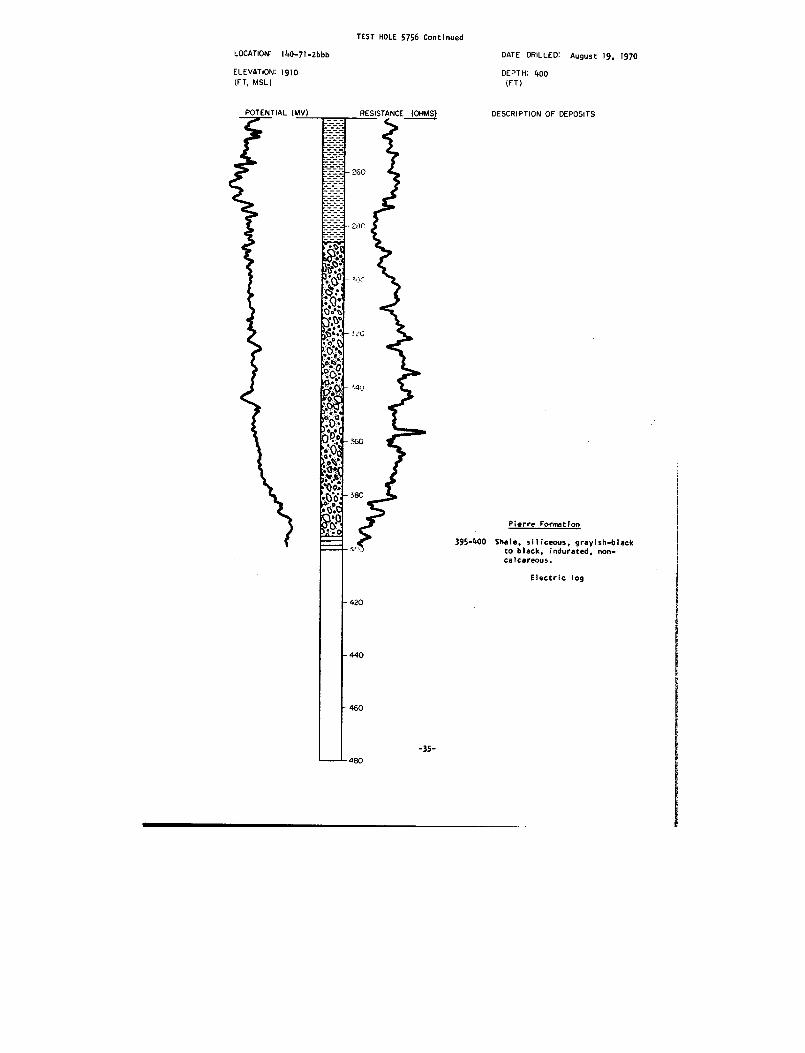
TEST HOLE 5756 Continue d
LOCATION: 140-71-2 b bb
ELEVATION : 191 0(FT, MSL)
DATE DRILLED : August 19, 197 0
DEPTH : 400(FT )
RESISTANCE (OHMS)
DESCRIPTION OF DEPOSIT S
Pierre Formation
395-400 Shale, siliceous, grayish-blac kto black, indurated, non-calcareous .
Electric log
-35-

140-71-5aa aTest Hole 5757
DATE
DRILLED: 8-20-70Elevation 1754 fee t
Geologic
Thickness
Depthsource
Material (feet) (feet )
Glacial Drift :Topsoil, sandy, silty, pebbly ,
brownish-black 1
1Clay, very silty, sandy, pebbly ,moderate yellowish-brown, oxidized(till) 4
5Sand, silty, slightly clayey, ver y
fine-to coarse-grained, subangula rto rounded, moderately well-sorted ,oxidized 8
1 3Clay, silty, slightly sandy, pebbly ,a few cobbles, olive gray (till) 49
6 2Sand, slightly gravelly, very fine
to very coarse-grained (mostl ymedium-to coarse-grained), sub -angular, moderately well-sorted ,slightly oxidized 13
75Clay, silty to very silty, slightl y
sandy, occasional cobbles andboulders, olive gray to mediumdark gray (till) 185
260
Pierre Formation :Shale, siliceous, grayish-blac k
to black, indurated, non -calcareous 20
280
-36-

TEST HOLE 5758
LOCATION: 14n-7I-19ddd
DATE DRILLED : August 20, 197 0
ELEVATION : 1760
DEPTH : 40 0(FT )
RESISTANCE (OHMS)
DESCRIPTIONEPOSIT S
Glacial Drif t
O-;
Topsoil, very sandy, silty ,brown .
1-26
Sand, silty, very fine-to verycoarse-grained, subangula rto subrounded, moderately well -sorted, well oxidized .
26-50
Clay, very silty, olive gra y(glaciofluvial sediment) ,
Sand, very fine-to medium -grained, occasional thin cla ylenses, subangular to rounded ,well-sorted, taking some water ,not caving in .
89-95
Clay, very silty, olive gray(glaciofluvial sediment) .
V-2t
95-98 Sand, neom-grainedd, , subangular
tto sub -
:P*1
rounded, moderately well-sorted .98-113 Clay, silty, moderately sandy ,
pebbly, olive gray (till) .
Gravel, slightly sandy, fine tocoarse (some cobble-size dmaterial), fair sorting, angula rto rounded, taking some water ,caving slightly .
126-300 Clay, silty, slightly sandy ,occasional thin sand lense slower 40 feet of section ,pebbly, a few cobbles, oliv egray to medium dark gray (till) .
-37 -
(FT, MSL )
POTENTIAL (MV)
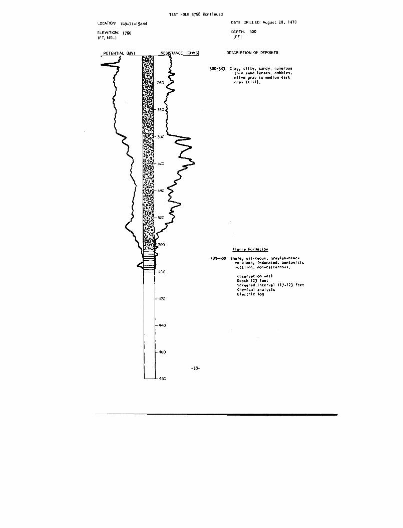
TEST HOLE 5758 Continue d
LOCATION : 140-71-19ddd
DATE DRILLED August 20, 197 0
ELEVATION: 1760
(FT, MSL)
DEPTH : 400
(FT )
DESCRIPTION OF DEPOSITS
300-183 Clay, silty, sandy, numerou sthin sand lenses, cobbles ,
olive gray to medium dark
gray (till) .
Pierre Formation
383-400 Shale, siliceous, grayish-blac kto black, indurated, bentoniti cmottling, non-calcareous .
Observation wel lDepth 123 fee t
Screened interval 117-123 fee t
Chemical analysi s
Electric log

TEST HOLE 591 3
LOCATION :
Iyv-li-2odaa
DAiE DRILLED : October 12, 1970
ELEVATION : 176 5(FT, MSL )
POTENTIAL (MV)
DEPTH : 28 0(FT )
RESISTANCE (OHMS)
DESCRIPTION OF DEPOSIT S
Glacial Drif t
Topsoil, very sandy, pebbly ,brownish-black .
Sand, slightly gravelly, silty ,very fine-to very coarse -grained (mostly medium-grained) ,subangular to rounded, mod-erately well-sorted, takin gsome water, slightly oxidized .
33-53
Clay, very silty, a few thi nsand lenses, dark gray (glacio -fluvial sediment) .
53-70 Sand, slightly clayey, silty ,very fine-to medium-grained ,subangular to rounded, well -sorted, taking some water .
70-88
Clay, very silty, medium darkgray with light olive gra ymottling (glaciofluvia lsediment) .
Gravel, fine to coarse, angula rto rounded, fair sorting .
92-102 Clay, very silty, medium dar kgray with light olive gra ymottling (glaciofluvlal sed-iment) .
102-256 Clay, silty, slightly sandy ,pebbly, occasional cobbles ,olive gray (till) .
-39-

TEST HOLE 5913 Continued
LOCATION :
140-71-28daa
ELEVATION : 176 5(FT, MSL)
DATE DRILLED:
DEPTH: 280(FT)
October 12, 197 0
300
34 U
31., 0
380
- 400
- 420
440
460
DESCRIPTION OF DEPOSIT S
Pierre Formation
256-280 Shale, siliceous, grayish-black,indurated, non-calcareous ,bedded .
Observation well sSouth well : depth 68 fee tNorth well : depth 33 fee tScreened interval 62-68 fee tScreened interval 30-33 fee tChemical analyse sElectric lo g
POTENTIAL (MV)
-40-
480
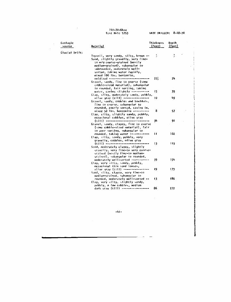
141-70-6ba aTest Hole 5753
DATE DRILLED : 8-18-70
Geologic
Thickness
Depth source
Material (feet) (feet )
Glacial Drift :Topsoil, very sandy, silty, brown - -Sand, slightly gravelly, very fine -
to very coarse-grained (mostl ymedium-grained), subangular tosubroundcd, moderately well -sorted, taking water rapidly ,mixed 100 lbs . bentonite ,oxidized
Gravel, sandy, fine to coarse (som ecobble-sized material), subangula rto rounded, fair sorting, takingwater, caving slightly
Clay, silty, moderately sandy, pebbly ,olive gray (till)
Gravel, sandy, cobbles and boulders ,fine to coarse, subangular t orounded, poorly sorted, caving in ,mixed 50 lbs . bentonite
Clay, silty, slightly sandy, pebbly ,occasional cobbles, olive gra y(till)
Gravel, sandy, clayey, fine to coars e(some cobble-sized material), fai rto poor sorting, subangular t orounded, taking water
Clay, silty, sandy, pebbly, ver ygravelly, cobbles, olive gra y(till)
Sand, moderately clayey, slightl ygravelly, very fine-to very coarse -grained (mostly fine-to medium -grained), subangular to rounded ,moderately well-sorted
Clay, very silty, sandy, pebbly ,occasional thin sand lenses ,olive gray (till)
Sand, silty, clayey, very fine-t omedium-grained, subangular t orounded, moderately well-sorted --
Clay, very silty, slightly sandy ,pebbly, a few cobbles, mediu mdark gray (till)
-41-
23!. 2 4
15 3 9
10 49
8 5 7
34 9 1
II 10 2
13 11 5
39 154
19 17 3
13 186
86 272

141-70-6baa (Cont . )Test Hole 5753
DATE DRILLED : 8-18-70
Geologic
Thickness
Depth
source
Material (feet) (feet )
Pierre Formation :Shale, siliceous, grayish-blac k
to black, indurated, bentonitic ,non-calcareous 8
280
Observation wel lDepth 143 fee tScreened interval 137-143 fee t
Chemical analysis

TEST HOLE 575 2
I41-70-8aaa DATE DRILLED : August 17, 1970
DEPTH : 38 0(FT )
LOCATION:
ELEVATION:(FT, MSL )
POTENTIAL (MV)
RESISTANCE (OHMS)
DESCRIPTION OF DEPOSIT S
Glacial Drif t
0-1
Topsoil, sandy, silty, brownish-black .
1-15 Clay, moderately sandy, silty ,pebbly, moderate yellowish-brown (till) .
15-106 Clay, silty, slightly sandy ,pebbly, a few cobbles, olivegray (till) .
106-112 Gravel, sandy, fine to coarse ,angular to subrounded, fai rsorting, caving in mixed100 tbs . bentonite .
112-168 Clay, silty, moderately sandy ,pebbly, a few cobbles, oliv egray (till) .
168-201 Sand, very clayey, very fine -to very coarse-grained, sub-angular to rounded, fai rsorting .
201-260 Clay, silty, slightly sandy ,pebbly, a few cobbles, mediu mdark gray (till) .
-43-
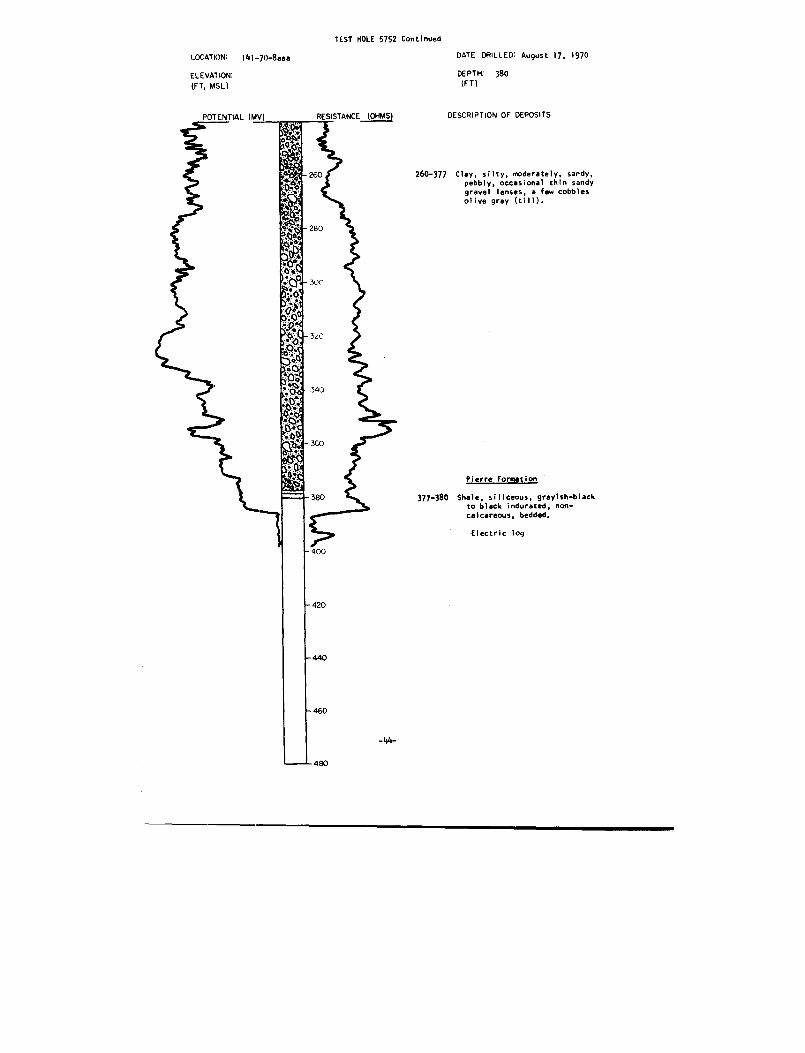
TEST HOLE 5752 Continued
LOCATION:
141-70-8aaa
DATE DRILLED : August 17, 197 0
ELEVAT ION:(FT, MSL)
DEPTH: 380(FT )
POTENTIAL (MV) RESISTANCE (OHMS)
DESCRIPTION OF DEPOSITS
260-377 Clay, silty, moderately, sandy ,pebbly, occasional thin sand ygravel lenses, a few cobble solive gray (till) .
Pierre Formation
377-380 Shale, siliceous, grayish-blac kto black indurated, non-calcareous, bedded .
Electric log

LOCATION : I41-70-22aa a
ELEVATION :(FT, MSL )
POTENTIAL (MV)
TEST HOLE 5755
DATE DRILLED : August 18, 197 0
DEPTH : 36 0(FT )
RESISTANCE (OHMS)
DESCRIPTION OF DEPOSIT S
Glacial Drif t
0-I
Topsoil, sandy, silty, pebbly ,brownish-black .
1-15 Clay, silty, moderately sandy ,pebbly, moderate yellowish-brown, oxidized (till) .
15-17
Clay, silty, slightly sandy ,pebbly, olive gray (till) .
17-19
Gravel, clayey, sandy, fine t ocoarse, subangular, poorl ysorted .
19-134 Clay, silty to very silty ,slightly sandy, pebbly, olivegray to medium dark gray (till) .
134-139 Sand, slightly clayey, very fine -to medium-grained subangular ,fair sorting.
139-150 Clay, silty, slightly sandy ,pebbly, medium dark gray (till) .
150-209 Clay, very silty, olive gra ywith light olive gray to dar kgray mottling, occasiona ldetrital lignite fragment s(glaciofluvial sediment) .
209-336 Clay, silty, moderately sandy ,pebbly, a few cobbles, gravelly ,medium dark gray (till) .
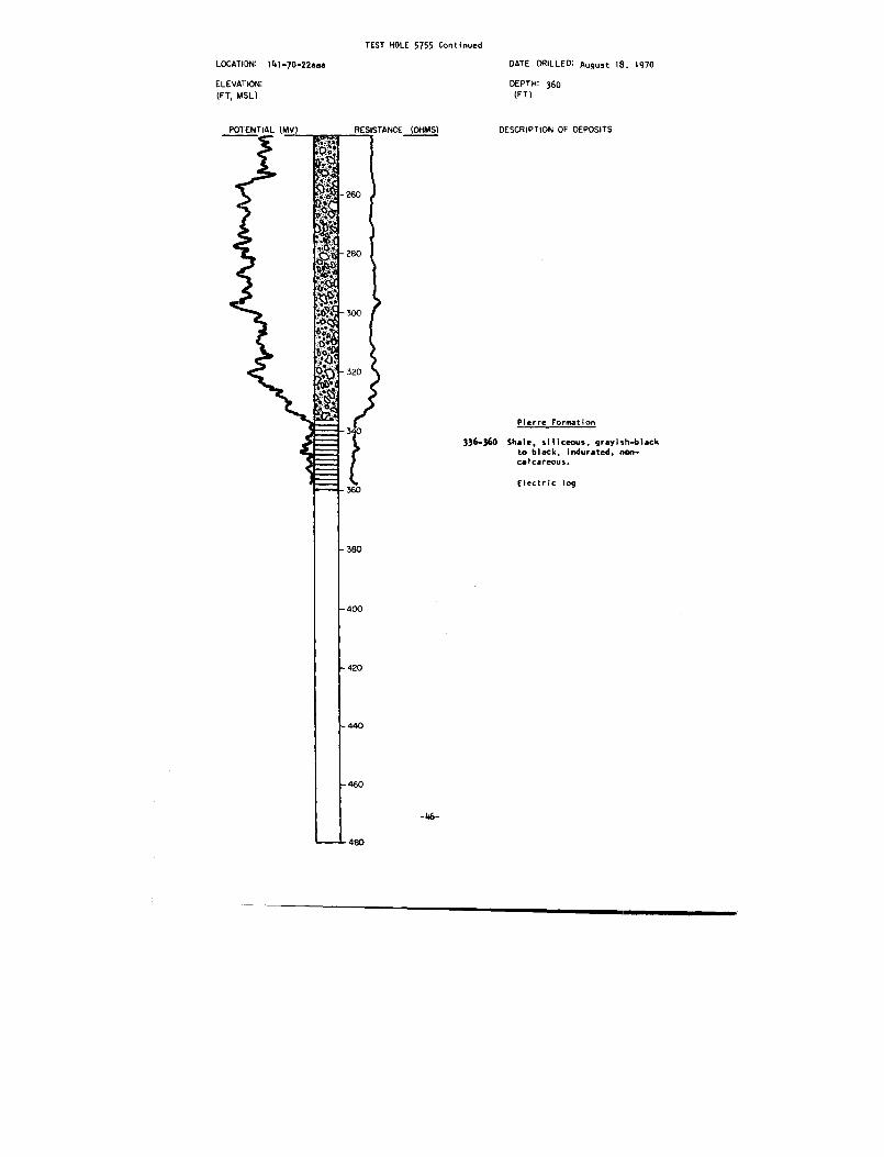
TEST HOLE 5755 Continue d
LOCATION: 141-70-22aaa
ELEVATION :
(FT, MSL)
DATE DRILLED : August 18 . 1970
DEPTH: 360(FT )
DESCRIPTION OF DEPOSITS
Pierre Formation
Shale, siliceous, grayish-blac k
to black, indurated, non-calcareous .
Electric lo g
336-36o
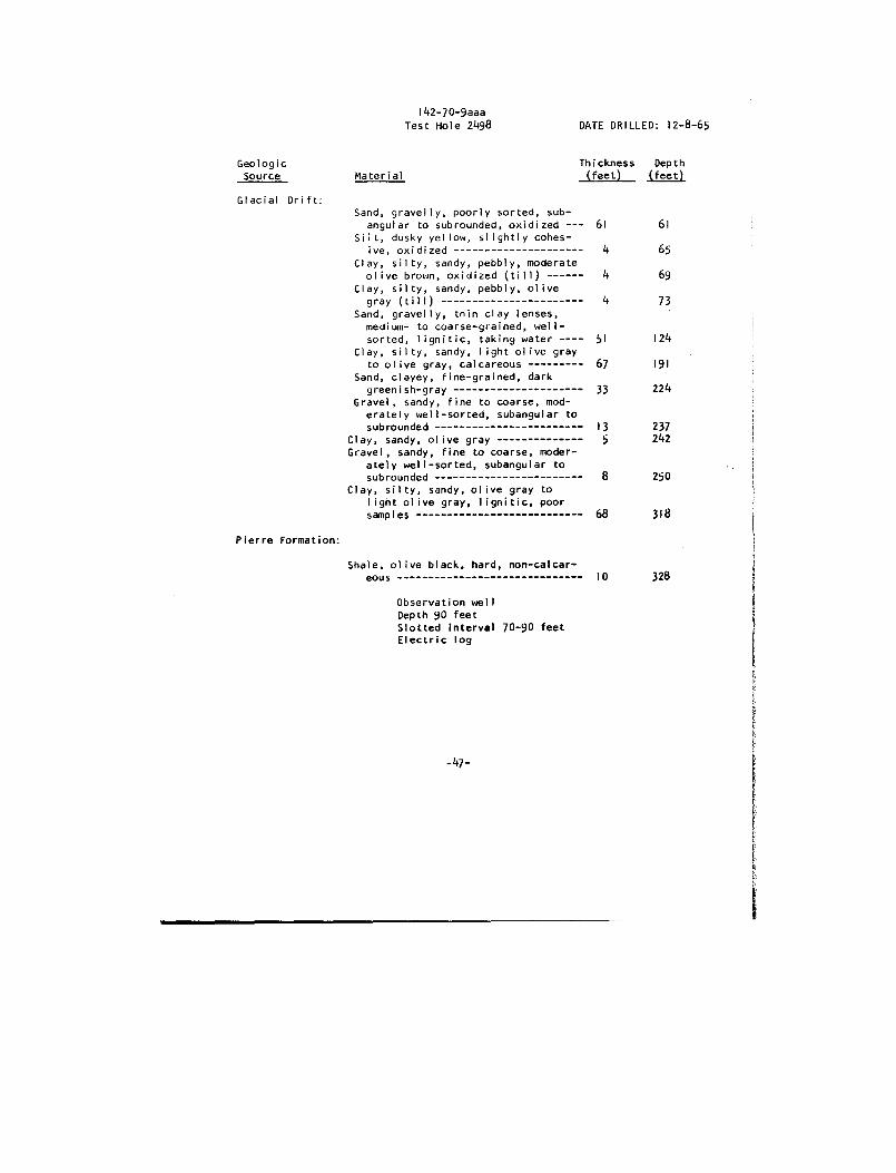
142-70-9aa aTest Hole 2498
DATE DRILLED : 12-8-65
Geologic
Thickness
Dept h Source
Material (feet) (feet )
Glacial Drift :Sand, gravelly, poorly sorted, sub -
angular
to subrounded, oxidized 61 6 1Silt,
dusky
yellow,
slightly cohes -ive,
oxidized 4 6 5Clay,
silty,
sandy,
pebbly, moderat eolive brown,
oxidized
(till) 4 69Clay,
silty,
sandy,
pebbly,
olivegray
(till) 4 7 3Sand,
gravelly,
thin
clay
lenses ,medium-
to coarse-grained, well -sorted,
lignitic,
taking water ---- 51 124Clay,
silty,
sandy,
light olive
gra yto olive gray, calcareous 67 19 1
Sand,
clayey,
fine-grained,
dar kgreenish-gray 33 224
Gravel,
sandy,
fine to coarse, mod -erately well-sorted,
subangular
tosubrounded 13 237
Clay,
sandy,
olive gray 5 242Gravel,
sandy,
fine
to coarse, moderately well-sorted,
subangular tosubrounded 8 25 0
Clay,
silty,
sandy, olive
gray
t olight olive gray,
lignitic,
poo rsamples 68 31 8
Pierre Formation :
Shale, olive black, hard,
non-calcar-eous 10 328
Observation wel lDepth 90 fee tSlotted interval 70-90 fee tElectric log
-47 -
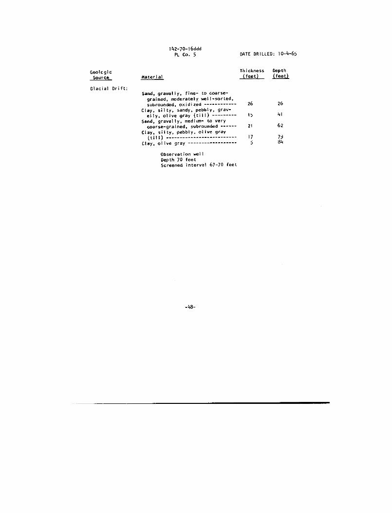
142-70-16dd dPL Co . 5
DATE DRILLED : 10-4-6 5
Geologic
Thickness
Dept h
Source
Material (feet) (feet )
Glacial Drift :Sand, gravelly, fine- to coarse-
grained, moderately well-sorted ,subrounded, oxidized 26
26
Clay, silty, sandy, pebbly, grav -elly, olive gray (till) 15
4 1
Sand, gravelly, medium- to ver ycoarse-grained, subrounded 21
6 2
Clay, silty, pebbly, olive gra y
(till) 17
7 9Clay, olive gray 5
8 4
Observation wel lDepth 70 fee tScreened interval 67-70 fee t
-48-
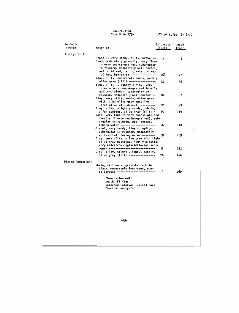
142-71-35dd dTest Hole 5754
DATE DRILLED : 8-18-70
Geologic
Thickness
Dept h source
Material (feet) (feet )
Glacial Drift :Topsoil, very sandy, silty, brown --
z
zSand, moderately gravelly, very fine -
to very coarse-grained, subangula rto rounded, moderately well-sorted ,well oxidized, taking water, mixe d100 lbs. bentonite 26z
2 7Clay, silty, moderately sandy, pebbly ,olive gray (till) 12
3 9Sand, silty, slightly clayey, ver y
fine-to very coarse-grained (mostl ymedium-grained), subangular t orounded, moderately well-sorted --
18
5 7Clay, very silty, sandy, olive graywith light olive gray mottling(glaciofluvial sediment) 22
79Clay, silty, slightly sandy, pebbly ,
a few cobbles, olive gray (till) 35
114Sand, very fine-to very coarse-graine d
(mostly fine-to medium-grained), sub-angular to rounded, well-sorted ,taking water 56
170Gravel, very sandy, fine to medium ,
subangular to rounded, moderatel ywell-sorted, taking water 19
189Clay, very silty, olive gray with ligh tolive gray mottling, highly plastic ,very calcareous (glaciofluvial sedi -ment) 33
222Clay, silty, slightly sandy, pebbly ,olive gray (till) 24
246
Pierre Formation :Shale, siliceous, grayish-black t oblack, moderately indurated, non -calcareous 14
260
Observation wel lDepth 183 fee tScreened interval 177-183 fee tChemical analysi s
-49-
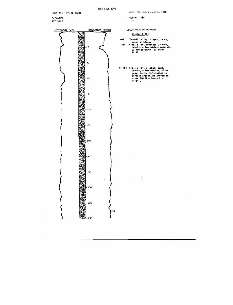
TEST HOLE 5749
LOCATION: 143-70-I0ddd
ELEVATION :(FT, MSL)
DATE DRILLED : August 4, 197 0
DEPTH : 58 0(FT )
DESCRIPTION OF DEPOSIT S
GlacialDrif t
0-1
Topsoil, silty, clayey, sandy ,brownish-black .
1-51
Clay, silty, moderately sandy ,pebbly, a few cobles, moderat eyellowish-brown, oxidized(till) .
51-360 Clay, silty, slightly sandy ,pebbly, a few cobbles, olivegray, losing circulation t osurface cracks and crevasses ,mixed 200 lbs . bentonit e(till) .
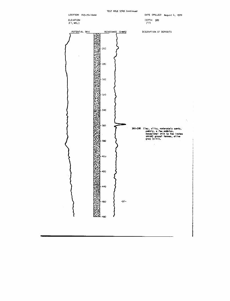
TEST HOLE 5749 continued
LOCATION: ,g.70-,o a
ELEVATION :
Et mu
DATE DRILLEO : August 4, 1970
DEPTH : 58 0(FT )
POTENTIAL (MV) DESCRIPTION soas
480
360-508 Clay, silty, moderately sandy, 'pebbly, a few cobbles ,occasional thin (a few inche sthick) gravel lenses, olivegray (till) .
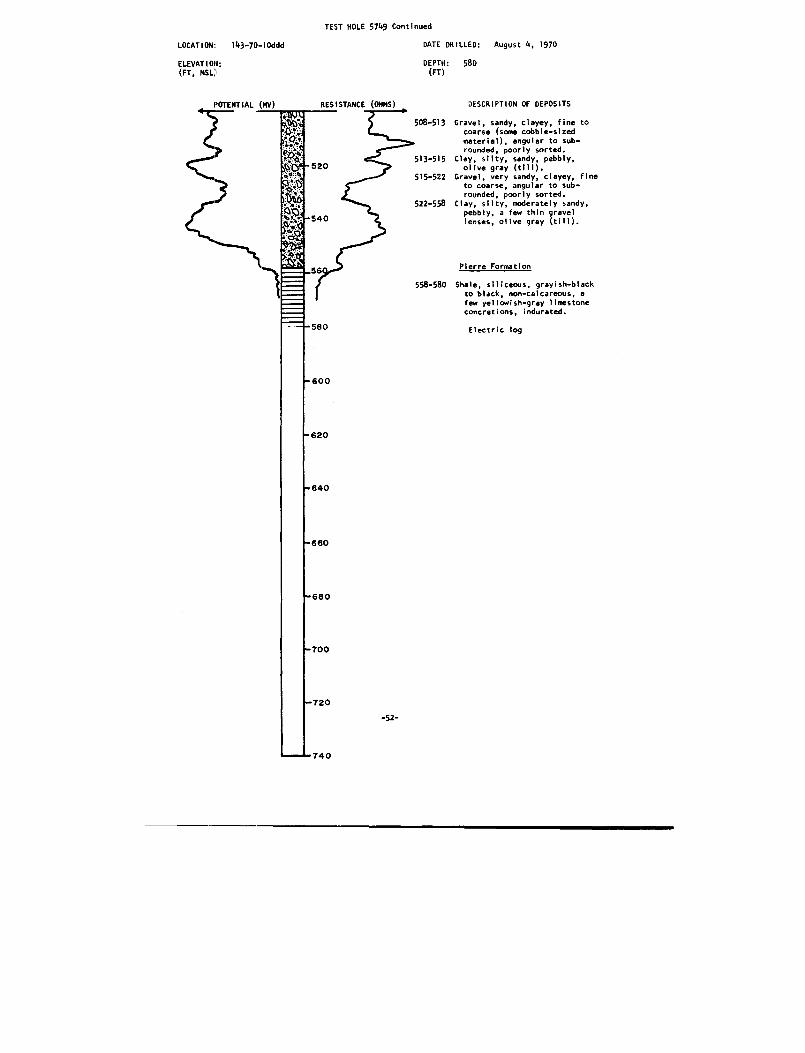
TEST HOLE 5749 Continued
DATE DRILLED :
August 4, 1970
DEPTH :
58 0
LOCATION :
143-70-10ddd
ELEVATION :(FT, NSL}
(FT )
508-513 Gravel, sandy, clayey, fine t ocoarse (some cobble-sizedmaterial), angular to sub-rounded, poorly sorted .
513-515 Clay, silty, sandy, pebbly ,olive gray (till) .
515-522 Gravel, very sandy, clayey, fin eto coarse, angular to sub-rounded, poorly sorted .
522-558 Clay, silty, moderately sandy ,pebbly, a few thin grave llenses, olive gray (till) .
Pierre Formatio n
558-580 Shale, siliceous, grayish-blac kto black, non-calcareous, afew yellowish-gray limestoneconcretions, indurated .
Electric log
-52-
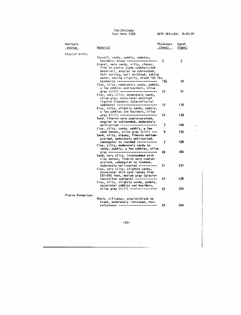
143-70-27adaTest Hole 5750
DATE DRILLED : 8-10-70
Geologic
Thickness
Dept h source
Material (feet) (feet )
Glacial Drift :Topsoil, sandy, pebbly, cobbles ,
boulders, brownGravel, very sandy, silty, clayey ,
fine to coarse (some cobble-size dmaterial), angular to subrounded ,fair sorting, well oxidized, takin gwater, caving slightly, mixed 150 tbs .bentonite 192
2 0Clay, silty, moderately sandy, pebbly ,a few cobbles and boulders, oliv egray (till) 21
4 1Clay, very silty, moderately sandy ,olive gray, occasional detrita llignite fragments (glaciofluvia lsediment) 77
11 8Clay, silty, slightly sandy, pebbly ,
a few cobbles and boulders, oliv egray (till) 21
139Sand, fine-to very coarse-grained ,angular to subrounded, moderatel ywell-sorted 7
146Clay, silty, sandy, pebbly, a few
sand lenses, olive gray (till) 9
15 5Sand, silty, clayey, fine-to medium
grained, moderately well-sorted ,subangular to rounded 3
15 8Clay, silty, moderately sandy to
sandy, pebbly, a few cobbles, olivegray 22
180Sand, very silty, interbedded withclay lenses, fine-to very coarse grained, subangular to rounded ,moderately well-sorted 51
23 1Clay, very silty, slightly sandy ,occasional thin sand lenses from231-245 feet, medium gray (glacio lacustrine sediment) 47
278Clay, silty, slightly sandy, pebbly ,occasional cobbles and boulders ,olive gray (till) 22
32 0
Pierre Formation :Shale, siliceous, grayish-black t oblack, moderately indurated, non-calcareous 20
34 0
-53-

TEST HOLE 575 1
LOCATION : 144-70-26ccc
DATE DRILLED : August II, 1970
ELEVATION:
DEPTH : 680(FT, MSL)
(FT )
RESISTANCE (OHMS)
DESCRIPTION OF DEPOSITS
GlacialDrif t
0-1
Topsoil, sandy, silty, pebbly ,cobbles, brownish-black .
1-30
Clay, silty, moderately sandy ,pebbly, a few cobbles, moderat eyellowish-brown to dar kyellowish-brown with reddish-brown and light olive gra ymottling, oxidized (till) .
30-41
Clay, silty, slightly sandy ,pebbly, a few cobbles, olivegray (till) .
41-47 Sand, fine-to very coarse -grained, subangulay moderatel ywell-sorted .
'
47-62
Clay, very silty, slightly sandy ,medium gray to olive gray wit hlight olive gray mottling(glaciofluvial sediment) .
62-276 Clay, silty, slightly sandy ,pebbly, a few cobbles, oliv egray (till) .

TEST HOLE 5751 Continued
LOCATION: 144-70-26ccc
DATE DRILLED : August 11, 1970
ELEVATION:(FT, MSL)
DEPTH : 68 0(FT )
458-597 Clay,
silty, moderately sandy ,
460gravelly ,cobbles,
pebbly, a fewolive gray to medium
z -55-
dark gray (till) .
ri'480
POTENTIAL (MV)
R ESISTANCE (OHMS)
DESCRIPTION OF DEPOSIT S
276-360 Sand, slightly silty, a fewthin clay lenses, very fine-to very coarse-grained(mostly fine-to medium-grained), subanqular torounded, well-sorted .
360-458 Clay, silty, moderately sandy ,pebbly, a few cobbles, mediumdark gray (till) .
ya3GO
,
ohs
~,
. •'dv - 42 0
' c?̀
C `Ot 440otr rasto$
iefiO9C
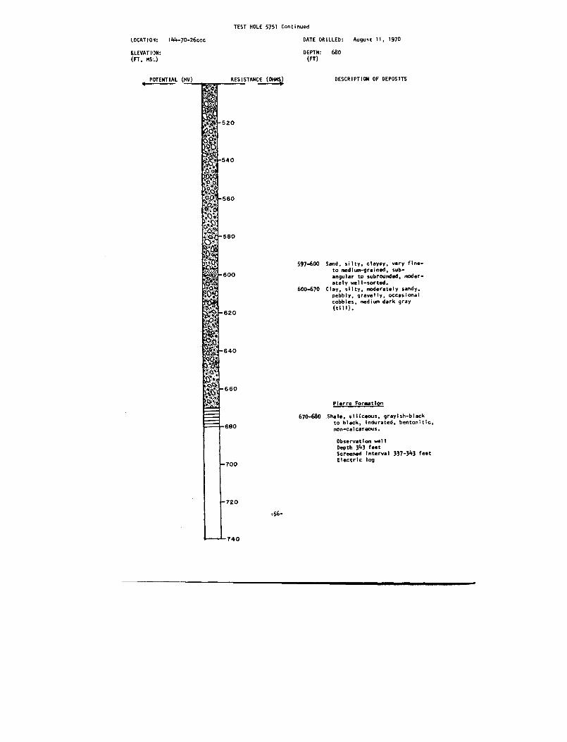
TEST HOLE 5751 Continue d
LOCATION :
144-70-26ccc
DATE DRILLED :
August 11, 1970
ELEVATION :
DEPTH :
680(FT, MSL)
(FT )
POTENTIAL (MV)
RESISTANCE (OHMS)
DESCRIPTION OF DEPOSITS
597-600 Sand, silty, clayey, very fine -to medium-grained, sub-angular to subrounded, moder-ately well-sorted .
600-670 Clay, silty, moderately sandy .pebbly, gravelly, occasiona lcobbles, medium dark gray(till) .
Pierre Formatio n
670-680 Shale, siliceous, grayish-blac kto black, indurated, bentonitic ,non-calcareous .
Observation wel lDepth 343 feetScreened interval 337-343 fee tElectric log
-56 -