biodiversity · december 1999 approved by the chicago region biodiversity council november 22, 1999...
TRANSCRIPT

December 1999
Approved by the Chicago Region Biodiversity Council
November 22, 1999
Adopted by the Northeastern Illinois Planning Commission
December 16, 1999
Adopted by the Northwestern Indiana Regional Planning Commission
M a rch 16, 2000
BiodiversityR E C O V E R Y P L A N
C H I C A G O W I L D E R N E S SA Regional N ature Reserv e
™

2
This plan is the result of efforts by more than 200 peoplewho participated in preparing background papers and inworkshops to address scientific and policy issues. Thesehave included taxonomic workshops that focused ong roups of species (mammals, birds, amphibians, etc.) andecosystem types (forests, prairies, wetlands, etc.) Theplan has also been shaped by the work of the variousChicago Wilderness Teams (Science, Land Management,Education and Communications, and Policy and Strat-egy), as well as a wide variety of other workshops includ-ing the recovery plan review session during the 1999Chicago Wilderness Congre s s .
While no portion of the plan is the product of any oneperson, members of the Recovery Plan Task Force servedas editor/writers for one or more chapters or major chap-ter segments. Laurel Ross, of The Nature Conservancy,John Paige and Irene Hogstrom of the NortheasternIllinois Planning Commission (NIPC), Kent Fuller of theU.S. Environmental Protection A g e n c y, Tim Sullivan,Keith Winsten and Elizabeth McCance of the Bro o k f i e l dZoo, Ders Anderson of the Openlands Project, SusanneMasi of the Chicago Botanic Garden and Jim Anderson ofthe Lake County Forest Preserve District and the ChicagoWilderness Science Team all served in this capacity. SteveP a c k a rd of the National Audubon Society provided valu-able comments throughout and John Oldenberg of theDuPage County Forest Preserve District provided essen-tial input on the perspective of Forest Preserve Districts.
Larry Christmas of NIPC created the first integrated draftof the plan. Barbara Hill served as technical editor.Special recognition is due to Elizabeth McCance and Ti mSullivan for their tireless work in organizing the manyscience workshops and the resulting work pro d u c t s .Also, recognition is due to Wayne Schennum of theMcHenry Conservation District for his valuable contri-butions to virtually all of the science workshops togetherwith his integrative perspective.
Initial funding for development of the recovery plan was provided through grants from the U.S. Enviro n-mental Protection A g e n c y. Additional funding was pro-vided by the Illinois Department of Natural Resourc e s ,the U.S. Forest Service, and the U.S. Fish and Wi l d l i f eService. Matching funds were provided by the IllinoisChapter of the Nature Conservancy, NIPC, and theB rookfield Zoo.
A major strength of this plan lies in its creation thro u g ha participatory process that assembled a broad basedconsensus of expert opinion. If it is to remain valid andbecome implemented, it must continue to be refined, tog ro w, and to incorporate new information as it becomesavailable.
For up-to-date information on Chicago Wilderness activities and programs, visit the Web site at www.c h i c a g o w i l d e r n e s s . o rg .
P r e f a c e
Citation: Chicago Region Biodiversity Council 1999. Biodiversity Recovery Plan. Chicago Region Biodiversity Council, Chicago, IL.)
3
Table of Contents
Chapter 1. Executive Summary: Chicago Wilderness and Its Biodiversity Recovery Plan
1 . 1 I n t ro d u c t i o n . . . . . . . . . . . . . . . . . . . . . . . . . . . . . .51 . 2 The vision . . . . . . . . . . . . . . . . . . . . . . . . . . . . . . . .81 . 3 Key findings and re c o m m e n d a t i o n s . . . . . . . . .9
Chapter 2. The Values of Biodiversity
2 . 1 Overview of the values of biodiversity . . . . . .1 32 . 2 Issues in evaluating the costs and benefits
of protecting biodiversity . . . . . . . . . . . . . . . . . .1 5
Chapter 3. The Biodiversity Challenge in an Expanding Region
3 . 1 How we got where we are today . . . . . . . . . . .1 83 . 2 C u r rent status and future of
m e t ropolitan-wide development . . . . . . . . . . .2 13 . 3 The impact of development on ecosystems . .2 53 . 4 Urban biodiversity . . . . . . . . . . . . . . . . . . . . . . . .3 1
Chapter 4. Overview of Assessment Processes and Findings for Natural Communities and Species of the Region
4 . 1 Te r restrial communities . . . . . . . . . . . . . . . . . . .3 24 . 2 Aquatic communities . . . . . . . . . . . . . . . . . . . . .4 3
Chapter 5. Terrestrial Communities: Status, Needs, and Goals
5 . 1 I n t ro d u c t i o n . . . . . . . . . . . . . . . . . . . . . . . . . . . . .4 45 . 2 F o rested communities—status and
recovery goals . . . . . . . . . . . . . . . . . . . . . . . . . . . .4 45 . 3 Savanna communities—status and
recovery goals . . . . . . . . . . . . . . . . . . . . . . . . . . . .4 95 . 4 Prairie communities—status and
recovery goals . . . . . . . . . . . . . . . . . . . . . . . . . . . .5 15 . 5 Wetland communities—status and
recovery goals . . . . . . . . . . . . . . . . . . . . . . . . . . . .5 55 . 6 Minor community types . . . . . . . . . . . . . . . . . . .6 05 . 7 T h reats and stressors to terrestrial
c o m m u n i t i e s . . . . . . . . . . . . . . . . . . . . . . . . . . . . .6 35 . 8 Recommended actions . . . . . . . . . . . . . . . . . . . .6 75 . 9 R e s e a rch needs for maintenance and
recovery of biodiversity in the Chicago Wilderness re g i o n . . . . . . . . . . . . . . . . . . . . . . . .7 3
Chapter 6. Aquatic Communities: Status, Needs, and Goals
6 . 1 I n t ro d u c t i o n . . . . . . . . . . . . . . . . . . . . . . . . . . . . .7 66 . 2 S t ream communities—status, recovery
goals, and recommended actions . . . . . . . . . . .7 6
6 . 3 Lake communities—status, recovery goals, and recommended actions . . . . . . . . . . .8 6
6 . 4 N e a r- s h o re waters of Lake Michigan . . . . . . . .9 0
Chapter 7. Status of Endangered and Threatened Species: Assessment and Recommendations
7 . 1 Importance of endangered and threatened species to the Chicago Wilderness recovery plan . . . . . . . . . . . . . . . . . . . . . . . . . . . .9 2
7 . 2 E n d a n g e red and threatened species within a community context . . . . . . . . . . . . . . .9 3
7 . 3 Why are organisms rare ? . . . . . . . . . . . . . . . . . .9 37 . 4 T h reats and stresses to endangered
and threatened species . . . . . . . . . . . . . . . . . . . .9 47 . 5 P rotection status of listed species . . . . . . . . . . .9 47 . 6 Management and recovery
re c o m m e n d a t i o n s . . . . . . . . . . . . . . . . . . . . . . . .9 4
Chapter 8. Preserving Land and Water Resources for Biodiversity
8 . 1 I n t ro d u c t i o n . . . . . . . . . . . . . . . . . . . . . . . . . . . . .9 68 . 2 Private landowners: initiatives
for conservation . . . . . . . . . . . . . . . . . . . . . . . . . .9 68 . 3 Local governments: plans, ord i n a n c e s ,
contracts, and strategies . . . . . . . . . . . . . . . . . . .9 9
Chapter 9. Ecological Management, Research, and Monitoring
9 . 1 I n t ro d u c t i o n . . . . . . . . . . . . . . . . . . . . . . . . . . . .1 0 59 . 2 Techniques and guidelines for ecological
restoration and management . . . . . . . . . . . . .1 0 59 . 3 Monitoring and adaptive management . . . . .11 2
Chapter 10. Education and Communication
1 0 . 1 The role of communication ande n v i ronmental education . . . . . . . . . . . . . . . . .11 7
1 0 . 2 Goals and actions for biodiversityeducation and communication . . . . . . . . . . . .1 2 2
1 0 . 3 C o n c l u s i o n . . . . . . . . . . . . . . . . . . . . . . . . . . . . .1 2 6
Chapter 11. Role of Key Players
11 . 1 I n t ro d u c t i o n . . . . . . . . . . . . . . . . . . . . . . . . . . . .1 2 711 . 2 Role of government agencies . . . . . . . . . . . . .1 2 711 . 3 Role of private sector . . . . . . . . . . . . . . . . . . . . .1 3 811 . 4 Role of volunteers . . . . . . . . . . . . . . . . . . . . . . .1 4 111 . 5 Conflict resolution and interg o v e r n m e n t a l
cooperation: recommending a compre h e n s i v ep rocess for managing gro w t h . . . . . . . . . . . . .1 4 3
Literature Cited . . . . . . . . . . . . . . . . . . . . . . . . . . . . . .1 4 4
Table of Contents
4
A p p e n d i c e s
1 . Chicago Wilderness Te r restrial Community Classification System . . . . . . . . .1 4 8
2 . C rosswalk between Chicago Wi l d n e r n e s sCommunities and the National Standardfor Community Ty p e s . . . . . . . . . . . . . . . . . . . .1 6 0
3 . Glossary of Scientific and Common N a m e s . . . . . . . . . . . . . . . . . . . . . . . . . . . . . . . . .1 6 2
4 . P reliminary Results of Community Workshop A s s e s s m e n t s . . . . . . . . . . . . . . . . . .1 6 5
5 . Chicago Wilderness Aquatic C l a s s i f i c a t i o n . . . . . . . . . . . . . . . . . . . . . . . . . . . .1 6 7
6 . Priority Groups of Endangered and T h reatened Plant Species in Chicago Wi l d e r n e s s . . . . . . . . . . . . . . . . . . . . . . . . . . . . . .1 6 9
7 . Tools for Communication and Education Eff o r t s . . . . . . . . . . . . . . . . . . . . . . . .1 7 3
8 . Chicago Wilderness Member O rganizations:Their Mission and Significant Regional A c h i e v e m e n t s . . . . . . . .1 7 4
9 . Examples of Natural LandscapingInstallation and Maintenance Cost . . . . . . . . .1 8 3
1 0 . Conflict Resolution and Interg o v e r n m e n t a lCooperation. A Model for Growth M a n a g e m e n t . . . . . . . . . . . . . . . . . . . . . . . . . . . .1 8 4
11 . Recommendations and Action S t a t e m e n t s . . . . . . . . . . . . . . . . . . . . . . . . . . . . . .1 8 6
Tables and Figures
Table 3.1 Growth forecasts for the ChicagoWilderness re g i o n . . . . . . . . . . . . . . . . . . . . . . . . . . .2 2
F i g u re 3.1 Ecosystem health and human activity . . . . . . . . . . . . . . . . . . . . . . . . . . . . . .2 6
Table 4.1 Te r restrial community types in theChicago Wilderness classification system . . . . . .3 3
Table 4.2 Crosswalk between Chicago Wi l d e r n e s scommunities and national standard forcommunity types for those communitieswhich are globally rare . . . . . . . . . . . . . . . . . . . . . .3 4
Table 4.3 Te r restrial animal assemblagesidentified for conservation planning . . . . . . . . . . .3 5
Table 4.4 Sum of acres from Illinois natural areas inventory by community type and grade . . . . . .3 6
Table 4.5 Sum of acres in protected or other significant natural areas by community type . . .3 7
Table 4.6 Sum of acres in protected areas inIllinois counties by community type . . . . . . . . . . .4 0
Table 4.7 Conservation targests for recovery based on status, importance, and d i s t r i b u t i o n . . . . . . . . . . . . . . . . . . . . . . . . . . . . . . . . .4 2
Table 4.8 Te r restrial species assemblages (orspecies in the case of mammals) of concernor in an overall declining condition . . . . . . . . . . .4 2
Table 4.9 Te r restrial species assemblages whicha re critical or important to the global conservation of the assemblages . . . . . . . . . . . . . .4 3
Table 4.10 Summary of the aquatic community types in the Chicago Wi l d e r n e s sclassification system . . . . . . . . . . . . . . . . . . . . . . . . .4 3
F i g u re 6.1 Flow chart for determining stream and watershed status . . . . . . . . . . . . . . . . . . . . . . . .7 8
Table 6.1 Stream based species features of concern . . . . . . . . . . . . . . . . . . . . . . . . . . . . . . . . . .8 0
F i g u re 6.2 Priority watersheds in northeasternI l l i n o i s . . . . . . . . . . . . . . . . . . . . . . . . . . . . . . . . . . . . .8 1
Table 6.2 Preliminary assessment showingexceptional lakes . . . . . . . . . . . . . . . . . . . . . . . . . . . .8 6
Table 6.3 Preliminary assessment showingimportant lakes . . . . . . . . . . . . . . . . . . . . . . . . . . . . .8 7
Table 11.1 Major public land owningagencies information . . . . . . . . . . . . . . . . . . . . . . .1 2 8

5
Chapter 1
Executive Summary
Chicago Wilderness and ItsBiodiversity Recovery Plan
1 . 1I n t r o d u c t i o n
1.1.1 Chicago Wilderness: who we are,what we are accomplishing.“Chicago Wilderness” refers to nature and to the peopleand institutions that protect it. Chicago Wilderness is200,000 acres of protected conservation land—some ofthe largest and best surviving woodlands, wetlands, andprairies in the Midwest. It is also the much larger matrixof public and private lands of many kinds that supportn a t u re in the region along with the people who pro t e c tand live compatibly with it.
Native Americans were part of the natural ecosystemh e re for thousands of years. To d a y, thousands of volun-teers and hundreds of scientists, land managers, educ-ators, and others are crucial to the survival of our naturalecosystems, as is the “Chicago Wilderness” work of the88 member organizations. The geographic area covere dby the Chicago Wilderness region includes northeasternIllinois, northwestern Indiana, and southeastern Wi s c o n-sin. The coalition’s membership includes local govern-ments, state and federal agencies, centers for re s e a rc hand education, and conservation org a n i z a t i o n s .
The boundaries of the Chicago Wilderness region capturea spectacular concentration of rare ecosystem types.These ecosystems harbor a high diversity of species,including a large number of those listed as threatened ore n d a n g e red in the states of Illinois, Indiana, andWisconsin. Indeed, outside of the Chicago Wi l d e r n e s sregion, levels of diversity drop off sharply. Boundariesof the watersheds containing the natural communitieshelped to define the region, as did the large concentrationof natural preserves in the metropolitan are a .
Many of the surviving natural communities of theChicago region are of national and global significancefor conservation. The region is blessed with both richnessand opportunity for its conservation. Yet re s e a rch indi-cates that we are experiencing a steady decline in bothnative species and communities. For example:
• In a review for this plan, the Chicago Wi l d e r n e s sScience and Land Management Teams found thatm o re than half of the major community types of theregion were at the highest level of conservation con-cern due either to the small amount remaining or tothe poor ecological health of the remaining examples.
• A 1995 survey of DuPage County forest pre s e r v e srevealed that 80% of its natural areas had declined topoor health (Applied Ecological Services 1995).
• A region-wide 1998 study by the Morton A r b o re t u m(Bowles et al. 1998b) documented a significant changeover the past 20 years in forest stru c t u re, including adecline in density and richness of shrub species, a lossof mid-size oaks, and an increase in smaller-size sugarmaples. The study attributed these changes to incre a s-ed shade owing to greater oak and maple canopycover and, in some cases, to deer bro w s i n g .
While the community types in the region have in somecases almost vanished from the earth, this challenge is fard i ff e rent from other societal challenges we face in that weknow what needs to be done to address it. The Chicagoregion’s farsighted leaders set up preserve systems thattoday support almost all of the species ever known tohave occurred in the region’s vast prairies, savannas,woodlands, dunes, marshes, fens, and sedge meadows.Restoration ecology, a growing field for applied re s e a rc h ,has provided proven techniques and tools to managethese fragmented natural areas. The Chicago region is acenter of expertise and citizen involvement in the re s t o r a-tion and management of these rare natural communities.
1 . 1
The purpose of the Chicago Wilderness collaboration isto sustain, re s t o re, and expand our remnant natural com-munities. Thanks to a great concentration of pro f e s s i o n a lexpertise and the contributions of thousands of volun-teers, we have the ability to achieve this purpose, and ina cost-effective manner. In doing this, we are also enrich-ing the quality of life for ourselves and our children. Nowin its third year, our collaborative effort is starting to takel a rger strides to build something big, something thatcould some day transform this region into the world’sfirst urban bioreserve, a metropolitan area where peoplelive in harmony with rare and valuable nature .
1.1.2 What is meant by biodiversityand why is it important?The terms ecosystems, natural communities, biodiversity, a n ds u s t a i n a b i l i t y a re used throughout this plan. An ecosys-tem is the combination of living things and the physicalsystems (geology, topography, moisture, climate, etc.)within which they must live. A natural community is themix of plants and animals found living together in ahealthy ecosystem. S u s t a i n a b i l i t y refers to our ability toenjoy and make use of natural communities in a mannerthat does not compromise future generations’ ability todo the same.
B i o d i v e r s i t y is the totality of genes, species, and ecosys-tems in a region. For example, a healthy prairie commu-nity would normally include dozens of plant species aswell as habitat for various species of birds, mammals,reptiles, amphibians, insects, mites, fungi, and bacteria.Within a region the size of the Chicago area, biodiversitycan also be measured by the number and variety of nat-ural communities that exist side by side in a given are a ,such as oak savannas, meadows, and wetlands. A h i g hd e g ree of biodiversity is normally an indication of a heal-t h y, sustainable natural community, ecosystem, or re g i o n .
This plan identifies 49 diff e rent natural community typesin the region. Of these, 25 are at least rare or uncommonat the global level, and as many as 23 are globally imper-iled. A p p roximately 1,500 native plant species occur inthe region, making the Chicago metropolitan area one ofthe more botanically rich areas, natural or otherwise, inthe United States. This plan also finds that many of theregion’s animals, including grassland birds, woodlandb i rds, savanna reptiles and amphibians, marsh re p t i l e sand amphibians, prairie insects, and savanna and wood-land insects, are globally important for conservation.
A round the world, people depend on biodiversity for thevery sustenance of life. The living things with which wes h a re the planet provide us with clean water and air,food, clothing, shelter, medicines, and aesthetic enjoy-
ment, and they also embody our feelings of shared cul-t u re, history, and community. The nations of the worldhave signed a treaty calling biodiversity the common heritage of humankind and calling on all people to be custodians of the biodiversity found in their countriesand re g i o n s .
In Chicago Wilderness, the value of biodiversity is notjust at the global level, but most importantly for our owncitizens. Natural communities and species are the basis ofthe region’s environmental health. They provide ecologi-cal services in maintaining water quality, abating theimpact of floods, supporting pollination of crops, andc o n t ro lling outbreaks of pests. Equally important, biodi-versity contributes immeasurably to the quality of life forthe citizens of the region and to the region’s long-termeconomic vitality. Recent polls and election results showthat residents of the region strongly support pro t e c t i o nof natural areas for the future. Only if we continue andexpand upon the far-sighted conservation work of thosewho built the Chicago region, will we be able to pass thesep recious biodiversity values on to future generations.
Yet, there is overwhelming evidence that our pro j e c t e ddevelopment patterns and their unanticipated re s u l t swill lead to diminishing economic benefits and degrada-tion of the other services that we derive from our livingre s o u rces. A further discussion of the benefits of pre s e r v-ing biodiversity and the implications of future growth inthe region are contained later in the Recovery Plan.
1.1.3 What is the recovery plan?The Biodiversity Recovery Plan is both a plan and ap rocess guided by its many sponsors. It is intended as aliving document, not a fixed roadmap, that will continueto evolve as new ideas and information arise. For thatreason, it is a snapshot in time, presenting our best eval-uation of the current situation and how we can addre s sissues and capitalize on opportunities. The success of theplan depends on the responses of those who read it andincorporate its findings and suggestions into their ownwork. Likewise, its future usefulness depends on sugges-tions for improvement and new priorities from its re a d e r s .
The plan is intended to complement the many otherplanning efforts that are guiding the region toward a better and more productive future. Foremost amongthese are the plans of the three regional planning com-missions; the Northeastern Illinois Planning Commission(NIPC), the Southeastern Wisconsin Regional PlanningCommission (SEWRPC), and the Northwestern IndianaRegional Planning Commission (NIRPC). Other eff o r t sa re also contributing to the regional discussions, includ-ing the Campaign for Sensible Growth and the Metro-polis 2020 Plan.
6
Biodiversity Recovery Plan

This recovery plan outlines the steps necessary to achievethe overall goal of the Chicago Wilderness collaboration.That goal, in summary, is to protect the natural communitiesof the Chicago region and to re s t o re them to long-term viability,in order to enrich the quality of life of its citizens and to con-tribute to the preservation of global biodiversity.
To achieve this goal, the recovery plan identifies the fol-lowing measurable objectives:
1 . I n v o l v e the citizens, organizations, and agencies of the region in efforts to conserve biodiversity.
a . Obtain broad-based and active public participationin the long-term protection, restoration, and stew-a rdship of the region’s natural communities.
b . S t rengthen local government support by communi-cating with and involving officials in planninge fforts and conservation pro g r a m s .
c . Build partnerships among organizations and agen-cies in support of biodiversity in the re g i o n .
d . Maintain and strengthen volunteer participationin stewardship and re s e a rc h .
e . Stimulate active private-sector involvement.
f . Integrate a broader range of stakeholders, includ-ing businesses and constituency organizations intobiodiversity conservation eff o r t s .
2 . I m p ro v e the scientific basis of ecological m a n a g e m e n t .
a . I n c rease knowledge of species, communities, andecological relationships and pro c e s s e s .
b . Specify results to be achieved in biodiversity andi n c reased sustainability, including reliable indica-tors, baselines, and targ e t s .
c . Evaluate the results of restoration and managementalternatives based on data in order to address thosealternatives’ effects on target species and commu-n i t i e s .
d . Clearly identify conservation priorities.
e . Develop region-wide performance standards andmonitoring techniques that can be implemented byland managers.
3 . P ro t e c t globally and regionally important natural communities.
a . Identify priority areas and elements for pro t e c t i o nbased on an assessment of their contribution to con-serving biodiversity at global and regional levels.
b . P rotect high-quality natural areas in suff i c i e n ta c reage to permit restoration and management fors u s t a i n a b i l i t y.
c . Maintain existing quality of publicly owned, high-quality natural are a s .
d . P rotect high-quality natural areas in private owner-s h i p .
e . Mitigate factors with negative impacts that occuroutside of natural areas but within their watershedsor buffer zones.
4 . R e s t o re natural communities to ecological health.
a . Reestablish the ecological health of deterioratinghigh-quality natural are a s .
b . I m p rove all natural areas, concentrating first onthose that contribute most to global and re g i o n a lb i o d i v e r s i t y.
c . P rovide corridors that link areas as needed.
d . R e s t o re ecological processes that support sustain-able systems.
e . Return natural communities to sufficient size forviable animal populations by restoring or re c re a t-ing them. Fermilab and Midewin are examples.
5 . M a n a g e natural communities to sustain native biodiversity.
a . Attain greater capability for ecological manage-ment within public entities.
b . Encourage sharing of experience and re s o u rc e samong natural-area managers in diff e rent jurisdic-t i o n s .
c . Monitor recovery pro g ress and status of naturalc o m m u n i t i e s .
d . Demonstrate the feasibility of protection and re s t o r-ation in fragmented, human-dominated land-scapes, making use of such tools as pre s c r i b e dburning, restoration of hydro l o g y, and removal ofinvasive species.
6 . D e v e l o p citizen awareness and understanding of local biodiversity to ensure support and p a r t i c i p a t i o n .
a . Form educational partnerships among citizens,o rganizations, and agencies to promote aware n e s s .
b . Build sufficient awareness of natural communitiesof the region and their global significance so thatthey become a recognized part of the culture of there g i o n .
c . Develop educational programs to promote bro a d -based understanding of the global significance ofthe region’s natural communities.
Chapter 1. Executive Summary: Chicago Wilderness and Its Biodiversity Recovery Plan
7

d . Design educational strategies to meet the needs ofall audiences at all levels.
e . Reach those not traditionally involved with educa-tion in natural history or conservation.
7 . F o s t e r a sustainable relationship between societyand nature in the region.
a . Integrate conservation of biodiversity into ongo-ing development and planning for land use, trans-portation, and infrastru c t u re .
b . Encourage major land users to adopt practices thatp romote biodiversity and its sustainability by inte-grating the beauty and function of nature into ourn e i g h b o rhood, corporate, and public lands.
c . Encourage inclusion of biodiversity goals in localplanning and implementation.
d . Identify and address factors that lead to sustainableu s e .
e . Regularly monitor indicators of biodiversity andsustainability throughout the re g i o n .
f . Support and encourage efforts of citizen scientistsworking to conserve biodiversity.
8 . E n r i c h the quality of the lives of the region’s citizens.
a . Enhance human health through improved air andwater quality as well as protection from flooding byrestoring and maintaining the ecological integrityof natural communities.
b . I n c rease opportunities for all citizens to experiencethe beauty and restorative powers of nature .
c . Identify strategies that promote economic gro w t hwhile sustaining biodiversity.
1.1.4 Who are the plan’s intended audiences?One primary audience for the Recovery Plan includes thethousands of staff members and hundreds of thousandsof members of Chicago Wilderness organizations. Theseo rganizations have accepted responsibility for helpingto define and achieve the results contained in the plan.
Another primary audience is all persons who are re s p o n-sible for making or shaping decisions that affect theregion’s land use, water- re s o u rce management, and bio-d i v e r s i t y. Included here are local, state, and federalelected and appointed officials and private owners ofl a rge properties. Also included are key opinion shapersand recognized leaders in the re g i o n .
A t h i rd audience includes all concerned and active citi-zens. Those who vote, speak out publicly and privately,and make choices of many kinds are crucial participantsin the Chicago Wilderness collaboration. This third audi-ence will be reached primarily through the plan’s com-ponents of public participation and education, ratherthan through the plan dire c t l y.
1.1.5 How should different audiences use the plan?This recovery plan is intentionally broad in scope, out-lining the full range of actions needed across the entireregion to conserve biodiversity. As a consequence, theplan is best viewed as a tool that provides general dire c-tion and illustrates the types of actions that can be takento conserve biodiversity. The plan is a blueprint for actionand a re f e rence source for ideas. Because each decision oraction that affects biodiversity will be made in a specificlocal context, and at times local priorities or unavoidableconstraints will suggest a diff e rent path than might besuggested as a priority for the entire region, the plan isnot intended as a set of mandates.
Nonetheless, the priorities and actions in the plan re p re-sent a regional consensus on the most important items forp ro g ress on biodiversity conservation. To be eff e c t i v e ,those making decisions at the local level in the re g i o nshould consider carefully the issues discussed in the planand attempt to address them in their own planningp rocesses. One lesson from the plan is that the region asa whole can sustain biodiversity that is not sustainablet h rough local action alone. Success in this re g a rd willonly come if all actors in the region incorporate a bro a d e rregional view in their own decision-making, and if wecooperate across local jurisdictions.
1 . 2The vision
For the past 200 years, the south end of Lake Michiganhas been the setting of a classic drama. While buildingits economic and cultural wealth, Chicago, one of thenation’s largest metropolises, has partially preserved thenatural communities that had developed here since there t reat of the last glacier, approximately 10,000 years ago.As the metropolis continues to expand, its natural richesdecline. Hence the vision:
To establish a broad policy of beneficial coexistence inwhich the region’s natural heritage is preserved,improved, and expanded even as the metropolis grows.
8
Biodiversity Recovery Plan
1 . 2

Chapter 1. Executive Summary: Chicago Wilderness and Its Biodiversity Recovery Plan
9
At the landscape level, the vision includes a network ofp rotected lands and waters that will preserve habitat fora complete spectrum of the region’s natural communi-ties. More natural land—both public and private—willhave been added to the current core areas and their man-agement will be both active and adaptive. Acritical massof sites will be large enough to maintain a sustainablecomplex of interdependent species and natural commu-nities. Carefully monitored habitat corridors will con-nect sites, both small and large, opening paths for ancientpatterns of migration and dispersal. Fire will be used asa management tool in order to promote ecosystemrenewal. Cycles of prescribed burning will continue thework of lightning and Native American culture s .
At the ecosystem level, water will regain its rightfulplace as a natural agent of renewal. Rainstorms will drainm o re slowly, with less damage to downstream pro p e r t i e sand to the streams themselves, due to the capacity fortemporary storage and absorption aff o rded by naturalopen lands. With appropriate management, pre s e r v e dlands and water bodies will again host healthy commu-nities of native plants and animals for future generationsto study and enjoy.
At the species level, regional populations of animals andplants will be assured long-term viability. Size and con-nectivity of habitat will contribute to their survival; rarespecies will be protected from catastrophe. Whethernative like deer or alien like purple loosestrife, pro b l e mspecies will be prevented from destroying the naturalcommunities in which they live.
While our busy lives do not always provide enough opportunityto consider our increasingly precarious relationship withn a t u re, we have reached the point where we must fulfill thisvision to benefit one species more than all others—our own.The region’s human communities will reclaim a culturaltradition of restoring, protecting, and managing the glob-ally outstanding natural communities that enrich ourlives. In the spirit of the far-sighted planners who cre-ated this region’s earliest forest preserves, we will makeour built environment compatible with the needs of ourwild neighbors.
The foundation for this vision already exists in theregion’s extensive parks and forest preserves, in the re g-ulations protecting wetlands, flood plains, and rare ande n d a n g e red species, in the investments already made toi m p rove the quality of water in the region’s stre a m s ,rivers, and lakes, and in the public and private institu-tions whose missions include a concern for the re g i o n ’ snatural environment. Even so, the fulfillment of thevision will re q u i re a greatly expanded level of publicunderstanding and support. Indeed, this vision can onlybe realized if it becomes broadly share d .
1 . 3Key findings and r e c o m m e n d a t i o n s
The Biodiversity Recovery Plan contains a number of recommended actions at varied levels of detail and importance. Some of the more important ones are indi-cated below, either verbatim or in summary form, withchapter re f e re n c e s .
1.3.1 Manage more land to protect and restore biodiversity.Much of the region’s legally protected land is not yetbeing effectively managed to preserve remnant nativecommunities. Until re c e n t l y, it was thought that mosttypes of natural areas, if left alone, would preserve them-selves. Studies have increasingly shown that the qualityof our natural communities, including those protected bypublic ownership, is steadily degrading because naturalp rocesses have been interrupted and/or because of inva-sive or overly abundant species. (See Chapter 5.) The con-tinuing degradation of existing preserves is a majort h reat to sustaining and enhancing biodiversity.
Ecological management practices are available to dealwith these problems. Limited management is underwayin certain forest preserves and parks and on some pri-vately held lands. But current levels of management are ,in most instances, far from adequate. T h e re f o re, this planassigns the highest priority to establishing and maintaining thep roper management of natural communities.
• M o re re s o u rces need to be applied to the managementof protected lands in the region. The shortage of dollarsto manage lands and waters for biodiversity re pre s e n t sa major threat to the region’s natural communities. Inaddition to the high-quality sites being managedt o d a y, medium- and lower-quality sites, particularlythose containing higher-priority community types,need management efforts. (Chapter 5)
• State-of-the-art management practices should beapplied more broadly to protected lands. This willre q u i re more qualified personnel, both volunteer andpaid, than are presently available (Chapters 5, 9, 11 ) .Land managers should apply a diversity of manage-ment practices in order to sustain natural communi-ties. (Chapter 5)
• The expanded and more effective use of volunteers inland management, monitoring, and stewardship willbe essential for maintaining the health of conserva-tion lands. (Chapter 11 )
1 . 3

• The use of prescribed fire needs to be greatly ex-panded. Aregional training program should be devel-oped for crew members and burn leaders. Outre a c hp rograms should be used to educate local govern-ments in the use of prescribed fire in managing naturalecosystems. State agencies need to craft air- q u a l i t yregulations that foster the expanded use of pre s c r i b e dburns. Finally, a variety of burn strategies is needed.A single management regime, such as burning at thesame intensity and same time each year, is unlikely tosustain biological diversity. (Chapters 5, 9)
• Planning for the management of natural communi-ties should be carried out on a countywide or re g i o n a lscale, allowing a diversity of management strategiesand effects. For example, wetland managementshould be coordinated on a regional basis to assurethat birds have appropriate habitat within the re g i o nre g a rdless of local fluctuations in wetland conditions.(Chapters 5, 9)
1.3.2 Preserve more land with existingor potential benefits for biodiversity.The Chicago region currently contains 200,000 acres ofp rotected land in national parks, state parks, regional for-est preserves, and open spaces owned and maintained bypark districts, private institutions, and corporations. A l lof these lands contain important natural communities orelse serve as buffers, protecting and supporting the nat-ural areas. Over the past few years, local pre s e r v a t i o nagencies have steadily acquired land for a variety of pur-poses and they expect to acquire more in the years ahead.This plan recommends that a high priority be given to identi-fying and preserving important but unprotected natural com-munities, especially those threatened by development, and top rotecting areas that can function as large blocks of naturalhabitat though restoration and management. The plan re c o m-mends that these areas be preserved where possible by theexpansion of public preserves, by the public acquisition of larg enew sites, or by the actions of qualified private owners.
• Public and private agencies should act immediatelyto preserve those high-quality natural areas in theregion that remain unprotected. High-quality re m-nants, even if small, are important reservoirs of geneticmaterial for maintaining regional biodiversity. Em-phasis should be on those community types of higherpriority as outlined in this plan. (Chapter 4, 5)
• Chicago Wilderness and the regions’ land-owningagencies should develop a priority list of areas need-ing protection based on regional priorities for biodi-versity conservation. (Chapter 5)
• Federal, state, and local funding for land acquisitionby county forest preserve and conservation districtsand by other preservation agencies should be expand-ed with the preservation of biodiversity as a priority.Recognizing that public funds are limited, biodiversityconservation efforts should to the greatest extent pos-sible also support the multiple-use missions of publicagencies. (Chapters 8, 11 )
• In Illinois, the state’s imposition of property-tax capsmakes the funding of further acquisition and manage-ment more problematic. Local governments shouldseek to pass re f e renda as necessary to obtain the re v-enues needed to achieve this plan. (Chapters 8, 11 )
• State governments should increase funding to open-space grants programs, both for their own lands andfor lands to be acquired by county forest preserve andconservation districts, park districts, and other eligiblejurisdictions. (Chapter 11 )
• I n c reased federal funding for preserving conserva-tion land is a critical need. High priority should begiven to applications by states and local governmentsthat address critical needs for conserving biodiversityas outlined in this plan. (Chapter 11 )
• Land-acquisition plans of public agencies should giveconsideration to the presence of endangered andt h reatened species. (Chapter 7)
• The granting of protective easements and other pro-tective measures by private landowners for naturala reas and buffer zones is an important tool for biodi-versity protection and will increase in significance asacquisition of public lands becomes more diff i c u l t .M o re training and re s o u rces for the use of these tech-niques are needed. (Chapter 8)
1.3.3 Protect high-quality streams andlakes through watershed planning and mitigation of harmful activities to conserve aquatic biodiversity.One of the most significant negative impacts of humansettlement on the Chicago region’s natural enviro n m e n thas been on streams, rivers, lakes, and wetlands. Drain-ing and filling of wetlands, channelizing of stre a m s ,i n c reases in storm-water ru n o ff due to expanding imper-vious surfaces and resultant changes in the fre q u e n c yand extent of floods, changes in groundwater levels, andthe introduction of wastes, chemical products, and ero d e dsoils into all of the region’s water bodies have had disas-t rous consequences for virtually all forms of aquatic life.
1 0
Biodiversity Recovery Plan

Chapter 1. Executive Summary: Chicago Wilderness and Its Biodiversity Recovery Plan
1 1
As urbanization continues, programs, policies, and re g-ulations to manage water re s o u rces should be developedand implemented with an eye to sustaining natural com-munities. The effectiveness of our efforts to managewater re s o u rces should be measured, in part, by the num-ber and variety of native species found in aquatic habitatst h roughout the re g i o n .
• The highest priority for biodiversity conservation isto maintain the quality of the remaining high-qualitys t reams and lakes, those that support high numbers ofnative and threatened species. (Chapter 6)
• State and local public agencies should protect high-quality streams and lakes through proper watershedplanning and management, including plans for storm-water management. (Chapters 6, 8)
• Local agencies should promote natural drainage, cre-ate buffer strips and greenways along streams, andc reate or re s t o re streamside wetlands. Attention shouldbe given to changes in groundwater levels for terre s-trial communities and wetlands. (Chapters 5, 6, 8)
• Local agencies and private landowners should con-sider restoring streams to their natural meanderingcourses, restoring riffles and other elements of stre a mhabitat, and using bioengineering solutions to contro ls t reambank erosion. (Chapter 6, 8)
• Local agencies should avoid new or expanded waste-water discharges into high-quality streams. A l t e r n-atives include routing flows to regional facilities, usingland treatment, and using constructed wetlands fori m p roving treated effluent before discharging tos t reams. (Chapters 6, 8)
• Many dams in the region impede the movement offish and other aquatic life up and down the waterway.C o n s e q u e n t l y, high-quality streams sometimes abru p-tly deteriorate above or below a dam. Where dams arenot needed for water supply, flood control, or re c re-ation, removal or modification with stru c t u res thate ffectively permit the passage of aquatic specieswould help to conserve biodiversity (Chapter 6).
1.3.4 Continue and expand research and monitoring.While land managers use the best current knowledgeabout the management needs of natural communitiesand species, there is always opportunity and need toi m p rove management techniques and learn more aboutthe complexity of ecosystems and their functioning.Management and monitoring activities need to be org a-nized so that they help evaluate the effectiveness of c u r rent techniques, and re s e a rch projects need to bedesigned to answer questions relevant to management.
T h e re are distinct diff e rences between re s e a rch, moni-toring, and inventory, yet if these activities are linkedtogether in meaningful ways, the results can immediatelybe put to use by conservation practitioners and thus cani m p rove biodiversity management. Management withinan experimental framework, making use of results in future management decisions, is re f e r red to as adap-tive management. Developing and implementing a re g i o n a lmonitoring program and pursuing a prioritized re s e a rc hagenda will provide significant contributions to conservation of biodiversity.
• Compile a prioritized list of re s e a rch needs. Supportre s e a rch projects that will help Chicago Wi l d e r n e s sscientists and land managers to better understand pre-settlement landscape conditions and processes, cur-rent landscape conditions and processes, the besttechniques to re s t o re communities to improved eco-logical health, and re q u i rements for sustaining biodi-versity over the long-term. Examples of specific are a sof re s e a rch needs are given in Chapter 5.
• Compile a thorough literature review of pre v i o u sstudies re g a rding management of natural communi-ties and conservation of biodiversity relevant to eff o r t sin Chicago Wilderness. (Chapter 9)
• Develop better links with academia and pro m o t em o re re s e a rch projects within the Chicago Wi l d e r n e s sregion. This could be achieved through a number ofa p p roaches, including setting up a central location ofpriority re s e a rch needs as a re s o u rce for graduate stu-dents. Another suggestion is to promote the ChicagoWilderness region as a re s e a rch station. This wouldhelp students to identify appropriate sites and experts,as well as to receive permits. (Chapter 9)
• Develop and implement a regional monitoring pro t o-col that emphasizes adaptive management for mak-ing pro g ress toward selected management goals.(Chapter 9)
1.3.5 Apply both public and privateresources more extensively and eff e c-tively to inform the region’s citizens of their natural heritage and whatmust be done to protect it.A p recondition to the success of any important publicendeavor is the understanding and support of a signifi-cant portion of the public. The topic of sustaining biodi-v e r s i t y, including an understanding of its importance toc u r rent and future generations, is just beginning to betaught in schools and conveyed through the local media.Many communities are not being reached through thesee fforts and even citizens who already have a strong envi-

ronmental ethic are often unaware of the richness of ourregional biodiversity and of local restoration successes.
Chapter 10 lays out two types of communications actionsaimed at addressing the challenge described above. Thelong-term goals are necessary to build long-term capacityand understanding in the region, while the short-termgoals address immediate issues of communication andpublic re l a t i o n s .
• E n s u re that every student graduating from a schoolin the Chicago Wilderness region is “biodiversity-l i t e r a t e . ”
• Make topics relating to biodiversity and ChicagoWilderness a focus of local colleges and universities.
• I n c rease the number of communities receiving non-school-based biodiversity education pro g r a m s .
• Gain a better understanding of the views of a bro a d e rsegment of the Chicago-area population on re s t o r a-t i o n .
• I m p rove the public’s understanding of the role ofmanagement in natural areas and communicate doc-umented benefits of local restoration efforts, particu-larly those of most value to humans.
• Foster local grassroots communication and pro v i d em o re opportunities for citizens to get involved in thedecision-making process. Work with user gro u p sa ffected by restoration efforts on issues of commonc o n c e r n .
• I m p rove the credibility and public perception of thepeople involved in restoration eff o r t s .
• Engage advocacy organizations in our efforts. Put as t ru c t u re in place to respond quickly to issues of per-ception as they arise.
• Assess the current state of biodiversity knowledgeheld by key decision-makers such as elected off i c i a l sand their staff, land managers, and planners. Cre a t ep rograms to address their needs for biodiversity edu-c a t i o n .
1.3.6 Adopt local and regional devel-opment policies that reflect the need torestore and maintain biodiversity.In the course of regulating private development and ex-panding the public infrastru c t u re in the three-state re g i o n ,public officials have the opportunity to preserve andenhance biodiversity. This can be accomplished thro u g h
the inclusion of biodiversity objectives within state,regional, and local plans and laws or ordinances govern-ing the urban and suburban development pro c e s s e s .
• Counties and municipalities should amend their com-p rehensive plans, zoning ordinances, and other re g u-lations to incorporate relevant re c o m m e n d a t i o n scontained in this plan. (Chapter 8, 11 )
• The Illinois EPAshould establish a process for re v i e w-ing and approving the expansion of wastewater ser-vice areas that takes into consideration the impacts onthe total natural environment within affected water-sheds. (Chapters 6, 8)
• State agencies responsible for major transportationi n f r a s t ru c t u re should incorporate biodiversity princi-ples into their planning and implementation deci-sions. Further, when a state infrastru c t u re investmentsuch as a toll road or major airport is likely to triggersubstantial residential, commercial, or industrialdevelopment, impacted state agencies and local gov-ernments should be re q u i red to enter enforc e a b l ea g reements minimizing adverse environmental im-pacts including the loss of biodiversity. (Chapter 11 )
• Support the Regional Greenways Plan for northeast-ern Illinois and the Natural A reas Plan for southwest-ern Wisconsin. These plans identify actions to pro t e c tand manage critical habitats for plants and animalsand generally improve ecosystems. They complementand support the objectives of this Recovery Plan.(Chapters 3, 8)
• Participate in the discussions of the Campaign forSensible Growth and Metropolis 2020. The Campaignp romotes principles of economic development, re d e-velopment, and open space preservation. Metro p o l i s2020 has proposed actions to help the region developin a manner that will protect its economic vitality,while maintaining its high quality of life. (Chapter 3)
• Support implementation of regional growth strate-gies by the Northeastern Illinois Planning Comm-ission, the Southeastern Wisconsin Regional PlanningCommission, and the Northwest Indiana RegionalPlanning Commission, insofar as these plans seek toreduce the region’s excessive rate of land consump-tion, preserve important open spaces, and pro m o t ei m p roved water quality. (Chapter 3)
1 2
Biodiversity Recovery Plan
1 3
Chapter 2
The Values of Biodiversity
2.1 Overview of the values
of biodiversity
2.1.1 Biodiversity conservation as a global concernUnderstanding the full value of biodiversity in the re g i o nis re q u i red in order to evaluate this plan’s re c o m m e n d a-tions. Unfortunately, it is difficult to develop and applyneat economic measures for the current and future valueof the region’s biodiversity to its citizens. In addition,attempting to justify biodiversity conservation only interms of its utilitarian benefits to people will inevitablyu n d e restimate its true value. There is, however, a widerange of recognized values of biodiversity, deriving fro mbiodiversity at both the local and global levels. A s t ro n gcase can be made not only that conservation of biodiver-sity makes good economic sense but also that it is impor-tant to the region’s citizens in ways that go beyondadequate economic measures. This chapter outlines thevarious values associated with biodiversity and evalu-ates some of the costs and benefits of conservationactions in Chicago Wi l d e r n e s s .
The rapid decline of biodiversity around the world is apolicy issue of major global concern. At the Earth Summitin Rio de Janeiro in 1992, most of the governments of theworld signed a global Convention on Biological Diver-s i t y. By 1993, enough nations had ratified the Conventionthat it entered into force as international law. TheConvention recognizes the conservation of biodiversityas a “common concern of humankind,” due to its intrin-sic values and its importance to people. The Conventionasserts that governments are responsible for conservingtheir biological diversity and using biological re s o u rc e sin a sustainable manner.
While the connection between the region’s forest pre-serves and parks and the lofty ideals of an internationalconvention may seem slim, in fact, what we conserveh e re has direct bearing on the preservation of global bio-d i v e r s i t y. Further, and more important, the loss of biodi-versity and its associated values that motivated thenations of the world to develop the Convention is occur-ring right here in the Chicago region. The people wholive here stand to lose as much as the people of tro p i c a lr a i n f o rests or old-growth fore s t s .
2.1.2 The range of values of biodiversity
Direct-use valuesEconomists and biologists who measure the value of bio-diversity categorize those values by how people benefitf rom them. In one such category are direct-use values,w h e re people directly consume or use species for theirbenefit. Most of the significant direct-use values are asso-ciated with the great store of global biodiversity. Theseinclude the values of natural products for developingpharmaceuticals, for developing and maintaining thegenetic basis for agriculture, and for supporting indus-tries based on use species such as fisheries and timberextraction. (For more discussion, see World Resourc e sInstitute et al. 1992.) While most of these industries arenot based directly on species in Chicago Wilderness, sci-entists recognize that it is the global store of biodiversity,to which Chicago Wilderness contributes, that maintainsoptions for the future for these and other major economicactivities. With the growth of the use of biotechnology,the economic value of genetic material from naturals o u rces is likely to rise.
Ecosystem servicesIn a second major category of value associated with biodiversity are indirect values provided by ecosystemservices. Ecosystem services are the conditions and
2 . 1

p rocesses through which natural ecosystems, and thespecies that constitute them, sustain and fulfill humanlife (Daily 1997). We could not survive without the basicservices provided by natural systems. These include pri-mary conversion of sunlight to energ y, nutrient cyclingand retention, recycling of organic wastes, soil formation,moderation of climate extremes, moderation and contro lof flood damage, control of insect pests, protection ofwater quality, and pollination of crops (Sullivan 1997,Daily 1997).
The link between ecosystem services and biodiversity isnot always easy to demonstrate. While ecological theoryp redicts that biodiversity should be linked to impro v e decosystem function, re s e a rch at an ecosystem scale witha p p ropriate controls is difficult to conduct. Some criticsmay argue that any green plant can fix carbon dioxidet h rough photosynthesis, and that non-native species canplay many of the roles that native species once played.While this is true to a limited degree, a review of avail-able re s e a rch indicates that many aspects of the stability,functioning, and sustainability of ecosystems depend onbiodiversity (Mooney et al. 1995, Tilman 1996, Tilman etal. 1996). The conservation and management of naturala reas that maintain diverse woodlands, prairies, andaquatic systems will help assure the sustained pro d u c-tion of ecosystem services.
While life as we know it could not continue without theseecosystem services, their value can be considered infinite.H o w e v e r, it is possible to estimate the value they pro v i d ed i rectly to our economy and the cost of replacing themwith human-made substitutes. As a very rough appro x i-mation, economists have estimated that the value ofecosystem services and natural capital at the global levelis $33 trillion per year, or approximately twice the globalg ross national product (Constanza et al. 1997). In theUnited States, Pimentel et al. (1997) estimate the annualeconomic benefits of ecosystem services at appro x i-mately $300 billion.
These global and national studies are difficult to dire c t l yconnect to loss of biodiversity at the local level.Nonetheless, they do indicate that biodiversity is likelybeing grossly undervalued as we continue developmentpatterns that lead to its loss. At the local level, we canm e a s u re some of the obvious costs associated with thepast loss of natural areas and biodiversity. Flooding onthe Des Plaines River alone costs local governments andp roperty owners $20 million in an average year. In thelate 1980s, two floods caused an estimated $100 million indamage (Illinois DNR 1998). Flooding in the region isd i rectly associated with the loss of wetlands and othernatural areas in the watershed that served to trap rain-fall and store it, rather than dumping it in the river.Another measure of the same problem is the cost associ-
ated with developing human-made solutions to the pro b-lem. The Tunnel and Reservoir Plan, known as the DeepTunnel, of the Metropolitan Water Reclamation District,is a multi-billion dollar undertaking to collect excessru n o ff and treat it before releasing it into waterways.These are the services that once were provided moreextensively by prairies, woodlands, and wetlands.
Recreation and aestheticsImportant factors in calculating the value of biodiversitya re the re c reational use of natural areas and the value thatpeople place on natural systems for aesthetics and as partof the cultural heritage. Not only are the protected landsthat constitute Chicago Wilderness of global significancefor biodiversity, but they are also of enormous value forthe quality of life of the region’s citizens. Public use of thef o rest preserves is staggering, with an estimated 40 mil-lion annual visits to Cook County lands alone (Fore s tP reserve District of Cook County 1994). In Lake Countyin 1998, 75% of residents reported visiting a forest pre-serve within the previous two years, with hiking themost common use (Richard Day Research 1998). A c t i v en a t u re-based activities enjoyed by millions of the re g i o n ’ sresidents include hiking, bird watching, fishing, and pho-t o g r a p h y. In 1996, more than 3 million people re p o r t e dengaging in wildlife watching in Illinois, contributing anestimated $1.6 billion to the economy (U.S. Fish andWildlife Service and U.S. Bureau of the Census 1998).
The high levels of use of the region’s natural areas indi-cate the importance of these areas and their biodiversityto the quality of life in the region. The attractiveness ofthe region as a place to live and work is also a critical fac-tor in its future economic competitiveness (Johnson1999). Healthy natural areas are the key for biodiversity,and they provide unparalleled opportunities for the out-door re c reation that millions of people in the region want.
Non-use valuesA final type of value associated with biodiversity, and atype harder to quantify, is non-use value. This includesfeelings of ethical obligation to protect other species fro mextinction, religious values associated with cherishing theEarth and its inhabitants, and the desire to leave forf u t u re generations that which we are able to enjoy. Insome ways, these concerns are the core motives for pro-tecting biodiversity. A national survey of public attitudesabout biodiversity, a survey that included focus groups inChicago, found that responsibility to future generationsand a belief that nature is God’s creation were the twomost common reasons people cited for caring about con-servation of biodiversity (Biodiversity Project 1998).
The importance of one’s natural heritage cannot be esti-mated in dollars. Nonetheless, there is value in the senseof discovery that comes to each new generation as it
1 4
Biodiversity Recovery Plan

Chapter 2. The Values of Biodiversity
1 5
learns the essential facts of what came before. If that his-tory includes a richness of color, shape, and form, somuch the better. The people of this region can learn tot re a s u re remnant prairies, forests, lakes, and streams justas they have learned from their parents and others tot re a s u re their cultural heritage of language, art, arc h i t e c-t u re, music, and re l i g i o n .
2.2 Issues in evaluating
the costs and benefits of protecting biodiversity
2.2.1 Protecting a public investmentalready madeThis region has already made a substantial investmentin preserving open space and in abating pollution ins t reams, rivers, and lakes. Sadly, these investments varyin their utility for sustaining biodiversity. In fact, naturalcommunities are generally still declining, even on pub-licly owned, protected sites and in local streams and lakes.This is partly because the importance of biodiversity, a n dthe means of preserving it, was only dimly understoodwhen many of these public investments were made.
Investments in public open space helped protect naturalcommunities from total destruction, but absent the mea-s u res called for in this plan, those investments willsteadily lose their value. For example, 100 years ago itwas a simple matter to walk through woodlands and,except in winter, enjoy flowering native plants. To d a y,the invasion of exotic plants such as buckthorn coupledwith excessive grazing by deer make the same wood-lands less accessible and much less appealing duringmost of the year.
Major investments have provided an important founda-tion for protecting the aquatic environment, includingb i o d i v e r s i t y, but much remains to be done. Public invest-ments in wastewater treatment plants were intended toi n s u re clean streams and lakes throughout the region, butother sources of pollution still prevail and even the mod-ern local treatment plant can have adverse impacts ondelicate and high-quality aquatic habitats.
Thus, a pragmatic argument for preserving biodiversityis that it protects and enhances the value of large publicinvestments already made in public land and facilities.
Agencies seeking property for permanent open space,with traditional goals of outdoor re c reation and conser-
vation, will often find they can protect sites with biodi-versity values at little or no additional cost. However,p rotecting lands only for re c reational purposes will nots u ffice to protect biodiversity in the region or the fullrange of values it pro v i d e s .
2.2.2 High replacement costsOne approach to placing a value on a natural communityis to calculate its replacement cost. Much of this re g i o n ’ soriginal flora and fauna and their corresponding habi-tats can be considered rare, a factor that normally influ-ences the price of any commodity.
Consider whether it is even possible to replace the twomost characteristic landscapes found in the region priorto European settlement: tallgrass prairies and wetlands intheir various forms. Those few remnants that are insomething close to original condition are rare indeed,making up less than one percent of the region’s land-scape. And though much has been learned about how tore s t o re or replicate original prairies and wetlands, eff o r t sthus far have been less than fully successful. The mea-s u res of success for such replications include both theirnatural sustainability and the extent of their biologicald i v e r s i t y. To date, even the best manmade wetlands andprairies have fallen short, especially by the yardstick ofspecies diversity. While this plan recognizes that re s t o r a-tion of degraded habitats can go a long way towardreturning and protecting the values associated with theregion’s biodiversity, it recognizes that the costs of doingso are far more than protection would cost in the firstplace. Hence, protection of the region’s remnant naturala reas can be viewed as a prudent economic measure.
2.2.3 Value of competing usesAlthough our remnant natural communities may be irre-placeable, the market value of the sites they occupy willoften be dictated by what they can command on the pri-vate market for such purposes as residential or commer-cial development. Fortunately, at least some types ofnatural areas or habitats have not been considered highlysuitable for suburban development or farming. Thesehave included floodplains, some rural wetlands, andfragmented sites such as those found along rail lines. Agood example is the floodplain of the Des Plaines Riverin both Cook and Lake Counties, much of which is nowin forest pre s e r v e s .
C o n v e r s e l y, lake and riverfront property not subject toflooding and sites with mature trees are often highly val-ued for urban development. Thanks to the foresight ofp revious generations, the tradition of preserving at leastsome of these most attractive sites for public use has beenwell established. The best example is the extensive shore-
2 . 2
line of Lake Michigan in Chicago, which is largely in pub-lic ownership if not in its original, natural state. A n o t h e routstanding example is the greenway extending alongmost of the Fox River in Kane County. These two casesdemonstrate that, in the public’s mind, the pre s e r v a t i o nof important open space competes favorably with eventhe most expensive private development.
2.2.4 Costs of land acquisitionThe two principal costs that would result from this plan’srecommended actions are for further land acquisitionand for increased site management. It is not possible todetermine the exact costs of future acquisition because noexact target has been set and because prices will changeover time, generally upward, as further suburban devel-opment takes place.
In the spring of l999, three of the member counties conducted successful re f e renda on acquiring additionalopen space. To g e t h e r, the three counties won authoriza-tion to spend up to $175 million to acquire an estimated15,500 acre s .
Both federal and state grants are expected to be availableto assist local agencies in their land acquisition eff o r t s .Existing and potential grant programs are discussed inChapter 11 of this plan. Land preservation by less thanfee-simple acquisition can also reduce costs. Various landp reservation techniques are described in Chapter 8.
The preservation and enhancement of biodiversity alsoinvolves lands that remain in private ownership. In suchcases, there is little or no acquisition cost to the public.
2.2.5 Costs of managing lands and watersThe dollar costs of managing natural areas to sustain bio-diversity vary with the type and condition of the site andwith the availability of volunteers. These costs will alsovary according to the phase or stage of restoration achiev-ed. For example, the initial or remedial phase may lastt h ree to five years and cost substantially more than sub-sequent annual maintenance.
A consultant’s report to the DuPage County Fore s tP reserve District pre p a red in 1995 estimated that the ten-year costs for restoring and maintaining the County’snatural areas to good ecological condition would beabout $20 million. The authors qualified their estimate bystating that it assumed no innovation or streamlining of processes for remediation and maintenance over a ten-year period. Two effective means of lowering man-agement costs are to use volunteers as part of the
management program and to protect and manage larg e ra reas. The cost of not properly managing these same nat-ural areas was suggested by the finding that 80% of thecounty’s natural areas had declined to poor health sincethey had been originally studied 15–20 years earlier(Applied Ecological Services, Inc. 1995).
Lakes, streams, rivers, and wetlands can also be managedin various ways or left unmanaged. Tr a d i t i o n a l l y, man-aging streams and rivers meant channelizing, dre d g i n g ,and building various stru c t u res such as dams. This typeof management carries a high initial price tag and highcosts for maintenance and re p a i r, yet it provides fewerbenefits than management techniques that replicate nat-ural processes. When streams and rivers are managed inways consistent with the goal of sustaining and enhanc-ing biodiversity, the benefits can include improved aes-thetics, reduced flooding and flood damage, reduced soile rosion and sedimentation, improved fishing and otherre c reation opportunities, and the reduction of invasive,non-native species. These alternative methods also carrya smaller initial price tag and re q u i re less annual main-tenance expenditure (Northeastern Illinois PlanningCommission 1998).
Some sites will re q u i re substantial restoration efforts tosustain or improve biodiversity. While each case is apt tohave unique aspects, many successful projects to re s t o relakes, wetlands, and prairies have already been under-taken within the Chicago Wilderness area, and the land-management agencies in the region can help pro v i d egeneral cost information.
2.2.6 Evidence of public supportIs maintaining biodiversity worth the cost? Both nationaland local surveys consistently suggest that most peoplethink so. A study by the Brookings Institution re p o r t e dthat 72% of the re f e renda on the nation’s state and localparks and conservation won voter approval in Novem-ber of 1998. These measures will trigger an additional$7.5 billion in state and local conservation spending(Myers 1999).
The passage of three local county re f e renda allocatingfunds for land acquisition and management in the springof l999 serves as the most recent direct evidence of pub-lic support for spending public dollars to increase pro-tection of natural areas. The percentages of votersa p p roving by Illinois county were: Kane County–65.6%;Lake County–65.8%; and Will County–57%.
Two years earlier, a $75 million re f e rendum on behalf ofthe DuPage County Forest Preserve District passed by am a rgin of 57.4 to 42.6 perc e n t .
1 6
Biodiversity Recovery Plan
Chapter 2. The Values of Biodiversity
1 7
Neither the Cook County Forest Preserve District nor theMcHenry County Conservation District has held re f e r-enda in recent years. However, other evidence suggeststhat citizens in these counties would also support fur-ther efforts to preserve and re s t o re natural areas. Forexample, in the fall of 1998, the American Farmland Tru s ts p o n s o red a study of public attitudes pertaining to farm-land and open space preservation in Kane, McHenry andDeKalb Counties (Krieger 1999). Among the findingsw e re the following:
• Buying open space to protect it from developmentranked equal to spending for improved law enforc e-ment, crime reduction, and schools, and it ranked sig-nificantly higher than spending for roads, libraries,and more public re c reational facilities.
• Of the actions off e red to protect open space, enlarg-ing forest/prairie preserves and wetlands/marshesfar outranked buying farmland development rights orbuilding more hiking/biking trails, more state parksor local park district parks, or more golf courses.
• The most common reason cited for valuing pro t e c t i o nof open space was wildlife habitat.
In a l996 survey sent principally to residents of CookC o u n t y, more than 90% percent of the respondents saidrestoration of natural areas in around Chicago was goodand beneficial (Barro and Bright 1998).
F i n a l l y, Chicago Wilderness sponsored its own survey ofthe public’s willingness to spend public funds on behalfof biodiversity restoration. Kosobud (1998) summarizesthe re s u l t s :
The survey of a carefully selected, non-random sample ofresidents revealed a significant willingness to pay for newwilderness recovery and extension activities. The personalinterviews were carried out in a manner to acquaint therespondent with the topic and to pre p a re the respondent fora thoughtful answer. The sample mean willingness to paywas a $37.80 per year increase in annual property tax pay-ment, or equivalent increase in rent, all accruing to thea p p ropriate government agencies for this effort. The meanadjusted for the non-random sample was $19.67. Appliedto the close to 3 million households of the region, this esti-mate indicates that up to 59 million dollars per year couldbecome available for land acquisition, soil preparation, weed-ing, seeding, maintenance, and other measures. A p u b l i cwell informed about such activities is an essential pre re q u i-site for such a pro j e c t i o n .

Chapter 3
The Biodiversity Challenge in an Expanding Region
3 . 1How we got where we
are today
3.1.1 Natural historyThe natural history of the Chicago region prior to thearrival of the European settlers in the 1800s is well toldin the companion document to this plan, An Atlas ofB i o d i v e r s i t y, published by Chicago Wilderness in 1997. Itdescribes the geologic evolution of the Chicago re g i o n ,emphasizing the impacts of past glacial periods, and theevolution of natural communities following the lastglacial re t reat about 13,000 years ago.
Of most significance for planning the recovery of theregion’s biodiversity is the fact that its early-history pro-duced a variety ecosystems, each raising its own distinctset of challenges for preservationists and land managers.The current classification system, described in chapter 4,recognizes four main types of forested communities, twoof savanna, two of shrublands, four of prairie, and six ofwetlands, as well as cliffs and lakeshores. Each of thesewas largely shaped by a unique combination of geology(including soils), climate (including variations in botht e m p e r a t u re and moisture), and frequent exposure to fire(whether triggered by lightning or by Native A m e r i c a n s ) ,all of which had prevailed for thousands of years.Another important factor was this region’s flat terrain,which made the area prone to surface and over- b a n kflooding. This flooding, in turn, produced intermittents t reams and wetlands, each supporting its own uniquecomplex of native species. While the terrain was gener-ally flat, subtle variations in topography pro d u c e dh y d rologic diff e rences that gave rise to diff e rent hydricregimes of prairies, wetlands, savannas, and fore s t s .Wind patterns and the resulting water currents along thes h o res of Lake Michigan produced a highly specializeddune ecology.
3.1.2 Human historyThe earliest evidence of human activity in the ChicagoWilderness area dates to approximately 12,000 years ago,when highly nomadic Paleo-Indian clans came primar-ily to hunt larger animals at upland bogs and sloughs.The Paleo era lasted until 8000 B.C. and was followed bythe cultural periods called A rchaic-Indian (8000 to 600B.C.), Woodland-Indian (600 B.C. to A.D. 900), andMississippian-Indian (A.D. 900 to1640). During theseeras of pre h i s t o r y, people gradually shifted from totaldependence on hunting and gathering (Paleo andA rchaic) to a more settled culture that incorporated agri-c u l t u re (Woodland, and especially Mississippian). Inthese prehistoric periods, the peoples necessarily livedin total dependence on the local ecosystems. They helpedshaped the character and health of natural communitiest h rough practices, such as setting fires, that supportedtheir pro c u rement of food, medicine, and materialsimportant to their daily lives.
About 1640, European and French-Canadian trade goodsw e re incorporated into local cultures. By the 1670s,F rench-Canadian trappers and traders used the area. Thefirst re c o rded visitors were members of the Marq u e t t eand Joliet expedition in 1673, who were on their wayback to Ft. Michilimackinac after “discovering” passagesto the Mississippi via both the Wisconsin and Illinoisrivers. In the 1680s, LaSalle and Tonti spent more time inthe region and left the first extensive written descriptionof its flora and fauna.
Although the region was visited in the 1700s by Fre n c hand British military personnel, continuous settlement byc u l t u res other than the Native Americans began only in1779 with Du Sable. From this period until the early1830s, many Pottawattomie, Sauk, and Winnebago peo-ple continued remnants of their previous, uninfluencedc u l t u res. The incoming European-American-African cul-t u re absorbed much indigenous knowledge of the uses of
1 8
3 . 1
Chapter 3. The Biodiversity Challenge in an Expanding Region
1 9
plants, animals, and local materials. Throughout the 19thc e n t u r y, many vestiges of this knowledge were still incommon use, but as agriculture transformed the land-scape and native landscapes disappeared, most of it waslost or not in widespread practice.
In 1831, Cook County was incorporated. In 1833, 8,000Native Americans were displaced to west of theMississippi River. Between 1830 and 1835, the settlementa round the mouth of the Chicago River grew from 200to 3,265 people. By 1840, thousands lived in the city andan increasing number settled the countryside. In 1838,100 bushels of wheat were shipped out; in 1842, this hadg rown to 600,000 bushels.
The settlement and growth of Chicago has been attrib-uted largely to its location at a national transportationc ro s s roads. Indeed, regional and national canals and rail-road systems generated commercial activity and spurre dsettlements throughout the Chicago region. But a re v o-lution in farming technology had an even greater impacton the vast surrounding prairies. During the 1840s, JohnD e e re and others began to produce a steel plow thatfinally made it possible for farmers to break up the soilsof the deep-rooted tallgrass prairies.
Farmers also felt compelled to suppress fires. Theyplowed fire b reaks and mowed fields that might other-wise burn. Absent fire, woody plants and trees had theopportunity to spread into any lands not used for build-ings, crops, or pasture. Livestock grazed in re m n a n twooded areas, further altering the local ecology.
The loss of prairies and forests through fire suppre s s i o nand physical reduction by the plow and ax was acceler-ated by the introduction of Old World plant species.Species including buckthorn, honeysuckle, and multi-flora rose successfully competed with native species, andthe suppression of fire allowed some native species toexpand into new areas. Prairies and savannas becamefilled with gray dogwood, hawthorn, and box elder;woodlands and forests became dominated by box elder,maple, ash, elm, and other fire-sensitive trees. Thei n c rease in both canopy and understory species gre a t l yreduced the available sunlight reaching species gro w i n gat ground level, including oak and hickory seedlings.Graminoids and flowers also suff e red as shade incre a s e d .As the composition of the vegetation changed, insectspecies were often adversely affected, in some cases caus-ing losses in turn to both flora and fauna that dependedupon specific insects. Finally, the loss of native, flamma-ble underg rowth has even limited the ability of fire toe ffectively remove understory bru s h .
Farmers and their village cousins learned to drain or fillwetlands that would otherwise interfere with the plant-
ing of crops or the construction of buildings. This prac-tice eventually led to the loss of over 95% of the re g i o n ’ swetlands. Meandering streams were viewed as a causeof local flooding and a waste of valuable land, a pro b-lem that could easily be solved by straightening or chan-nelizing the streambed. Both techniques destro y e dnatural habitat.
Rivers, streams, and even lakes were considered part ofa cost-free disposal system. Untreated sewage and toxicwastes were routinely discharged into waters that hadp reviously supported abundant fisheries and numero u sother aquatic species.
Harbors and rivers were dredged and, in 1836, theIllinois and Michigan canal project began, spurringanother population boom. Even as the canal was begin-ning operations in 1848, the railroad industry was tak-ing steps toward making Chicago the focal point foroperations serving the entire middle and far westernregions of the country.
The evolution of human interaction with natural com-munities has been paralleled by an evolution of under-standing of that interaction. Settlers may not haveintended to cause the local extinction of so many species,p e rhaps only wolves, bears, and other animals that poseda direct threat to their own lives or pro p e r t y. It took sev-eral decades of rapid decline of the native landscapeb e f o re local leaders recognized the need for a system off o rest preserves throughout Cook County.
In 1894, a nationally prominent landscape architect, JensJensen, began to pre p a re maps of what he thoughtshould be preserved. In 1904, Cook County BoardChairman Henry Foreman, Jensen, architect DwightPerkins, and others published The Outer Belt of Fore s tP reserves and Parkways for Chicago and Cook County. I n1913, the Illinois General Assembly passed enabling leg-islation authorizing the creation of forest preserve dis-tricts in counties other than Cook. In 1915, the GeneralAssembly finally enacted legislation establishing a sys-tem of publicly owned preserves in Cook County.Another famous contributor to this campaign was arc h i-tect and planner Daniel Burnham who, with fellow arc h i-tect Edward Bennett, published the Plan of Chicago.Building upon the recommendations of Foreman, Jensen,and Perkins, this work proposed, among other things,an extensive system of regional parks. The motivationbehind this plan is revealed in the following passagef rom the Plan of Chicago:
The grouping of manufacturing towns at the southern endof Lake Michigan, and the serious attempts that have beenmade (especially in Pullman and Gary) to provide excellentliving conditions for people employed in larger operations,
c reate a demand for extensive parks in that region; becauseno city conditions, however ideal in themselves, supply thecraving for real out-of-door life, for forests and wild flowersand streams. Human nature demands such simple andwholesome pleasures as come from roaming the woods, forrowing and canoeing, and for sports and games that re q u i rel a rge areas. The increasing number of holidays, the gro w-ing use of Sunday as a day of rest and re f reshment for bodyand mind tired by the exacting tasks of the week, togetherwith the constant improvement in the scale of living, allmake imperative such means of enjoyment as the large parkp rovides. There f o re, adequate provision for the growing pop-ulations that of necessity must live in restricted town are a sre q u i res that in the region south and southwest of Chicagoall those marsh lands and wooded ridges which nature hasthus far preserved from being taken for manufacturing pur-poses now should be secured for the parks that in the nextgeneration will be re q u i red, but which will be beyond re a c hunless taken in the immediate future .
The development of a system of outlying large parks alongthe lines above indicated will give to Chicago bre a t h i n gspaces adequate at least for the immediate future; the phys-ical character of the lands to be taken will insure a diver-sity in natural features most pleasing and re f reshing todwellers in cities; and the acquisition of the areas entire l ya round the present city will afford convenient access for allthe citizens, so that each section will be accommodated.M o re o v e r, the development of especially beautiful sections,such as the region about Lake Zurich, will give marked indi-viduality to Chicago’s outlying park system. It is by seiz-ing on such salient features of a landscape and emphasizingtheir peculiar features that the charm and the dignity of thecity are enhanced.
Thus, the very process of metropolitan populationg rowth during the early part of the 20th century estab-lished the demand and, not so incidentally, the tax basethat were essential precursors to today’s system of fore s tp reserves and protection of the remnant natural commu-nities they contain. It follows that the demands of anewly growing regional population for re c reation, cou-pled with growth in the tax base and loss of open space(mostly to suburban development) make the attainmentof this plan’s goals most re a l i s t i c .
While Perkins, Jensen, Burnham, et al. were making theirplans, a pro f e s s o r, Henry Chandler Cowles, was initiat-ing a new science of ecology at the University of Chicago.Christy (1999) writes:
C o w l e s ’s pioneering work over several decades establishedthe concept that a native landscape is really a highly diverseg roup of plant communities, the “residents” of each com-munity adapted to one another and the community as awhole requiring specific physical factors—water, light,
drainage, fire—to survive and thrive. Cowles’s work alsorevealed what has been confirmed ever since: that theChicago region is one of the most biologically rich areas inA m e r i c a .
In the early 1900s, scientists, re c reationists and natureenthusiasts recognizing the value and potential of theIndiana Dunes area, fought to have the region pre s e r v e d .In 1925, Indiana Dunes State Park was established, pro-tecting 2,182 acres of the dunes ecosystem. In the 1960s,Illinois Senator Paul H. Douglas, fearing that commerc ewould swallow the remaining lakefront and dunes,joined the crusade to save the dunes in northwestIndiana that had begun a decade earlier by Doro t h yBuell. As a result of these efforts, the Indiana DunesNational Lakeshore was authorized by Congress in 1966.The National Lakeshore today includes appro x i m a t e l y15,000 acre s .
By 1922, the Cook County Forest Preserve District hada c q u i red 21,500 acres, roughly a third of its pre s e n t - d a yholdings. Acquisition of preserves pro g ressed moreslowly thereafter until the national environmental move-ment of the l960s inspired a federal program of grantsfor open-space acquisition. All of the region’s forest pre-serve and conservation districts took advantage of thisp rogram. Between l960 and l981, the inventory of stateparks and county preserves in Illinois nearly doubledf rom 64,123 acres to 123,101 acres. The l999 total standsat 165,724 acres, plus the 19,000-acre Midewin pre s e r v eand various sites in northwest Indiana and southeastWisconsin. One outcome of the generous federal match-ing grants for open space preservation, when combinedwith the rapid rate of suburban development, was thatlocal districts assigned a higher priority to land acquisi-tion than to land management. More o v e r, the re a l i z a t i o nhas only come recently that our natural communitiesdeteriorate when left unmanaged.
In the 1940s, University of Wisconsin professor JohnCurtis began experimenting with the restoration ofnative plant communities. But it was not until l962 thatMorton A r b o retum biologist Ray Schulenberg launchedthe world’s second major ecosystem restoration: a 100-a c re prairie that today contains 350 species of nativeplants. Schulenberg notes that while the prairie is nowself-sustaining, it still lacks a number of plant and insectspecies that would be found in a natural prairie.
The national environmental movement begun in the l960salso featured federal grants for the abatement of waterpollution, a vital factor in preserving aquatic habitatt h roughout the region. It was also in the 1960s that localp reservationists and planners began to explicitly evaluatepotential preservation sites according to the number ofbenefits presented, thereby increasing the return on the
2 0
Biodiversity Recovery Plan

Chapter 3. The Biodiversity Challenge in an Expanding Region
2 1
taxpayers’ investment. For example, a stream and itsadjacent floodplain might offer opportunities for fishingwhile also re c h a rging groundwater and precluding theflood damages that would have resulted from urbaniza-tion. A s t ream in its natural state would also offer aes-thetic benefits and enhance the values of adjacentp roperties. A site containing all these features wouldclearly outrank a site containing only cultivated fields.
An example of this kind of analysis can be found in thereport pre p a red by the Northeastern Illinois PlanningCommission for the DuPage County Forest Pre s e r v eCommission in 1965. The report recommended adding19 sites totaling 8,714 acres to the 2,350 acres of existingDuPage County forest preserves. Woodlands, marshes,and remnant prairies were among the landscape feature sidentified in that plan. Yet, even in a report so recent, thefurther loss of biodiversity in this region was not re c o g-nized as an impending thre a t .
Another important step for our natural areas came withthe establishment in 1963 of the Illinois Nature Pre s e r v e ssystem. The first nature preserve designation was givento the Illinois Beach Nature Preserve in 1964. There arec u r rently 105 designated sites in northeastern Illinois,many of which are lands owned by county forest pre-serve or conservation districts. Once a site is designated,the Illinois Nature Preserves Commission and theDepartment of Natural Resources provide technicalassistance to the property owner to help preserve the nat-ural communities contained therein. The identification ofa p p ropriate sites for designation has been an outcome ofthe Illinois Natural A reas Inventory, completed in its ini-tial form in 1978.
In Indiana, a state-wide Natural A reas Survey com-menced in 1967, with a two year study to locate, describe,and evaluate areas already in use as nature preserves andother natural tracts worthy of preservation by publicagencies, conservation groups, or educational institu-tions. In that same year, the state legislature authorizedthe creation of the Indiana Nature Preserves System andestablished a Division of Nature Preserves in the Depart-ment of Natural Resourc e s .
Americans have long expressed concern for the plight ofAfrican wildlife, the destruction of the Amazon rainf o rests, and the uncertain fate of the American wildernesswidely thought to exist only in the remotest parts of theFar West and Alaska. Yet the history of this re g i o nt h roughout the twentieth century also demonstrates ap revailing public interest in preserving nature here, how-ever that term has been understood.
3 . 2Current status and future
of metropolitan-wide d e v e l o p m e n t
3.2.1 Forecasts for growth in theChicago Wilderness regionAlthough recent years have seen the increasing use ofbest management practices and best development prac-tices to ease the negative impacts of metropolitan gro w t hon our valued natural re s o u rces, the continuing expan-sion of human development in the Chicago Wi l d e r n e s sregion still carries with it many threats to biodiversity.F o remost among these is the sheer paving over of openspace by new development. Subsequently, the ChicagoWilderness metropolitan region has experiencedi n c reases in flooding, more contamination of streams dueto urban ru n o ff, and a continuing encroachment on wet-lands and other natural habitats.
O fficial forecasts to the year 2020 by regional planningagencies paint a picture of substantial growth amidstuneven growth pre s s u res in the Chicago Wi l d e r n e s sregion. Table 3.1 presents these forecasts, developed bythe regional planning commissions for Illinois, Wi s c o n s i nand Indiana. For the six-county northeastern Illinois are a ,the population is expected to increase by 25% whileemployment increases by 37%. The expected populationg rowth rate in Kenosha County, Wisconsin, is nearly asg reat (24%), while the northwest Indiana counties shouldg row at a more modest level (9%). The forecasted employ-ment growth in Kenosha County (39%) is even gre a t e rthan that in northeastern Illinois. The northwestern Ind-iana region’s employment growth is expected to be 19%.
It should be noted that LaPorte County, Indiana isincluded in the Chicago Wilderness region, as indicatedon Table 3.1. Elsewhere in this plan, either on maps or intables, if information is not presented for LaPorte County,it is because information was not available or time did notallow its inclusion. Any update of this plan will includep roviding the relevant, available information for LaPorteC o u n t y, Indiana.
3.2.2 Past patterns of regional decentralizationThe population of the six-county northeastern Illinoisa rea between 1970 and 1990 increased by only 4% andemployment increased by 21%, while the amount of landin urban uses increased by 33% during the same period.
3 . 2

2 2
Biodiversity Recovery Plan
Table 3.1G rowth forecasts for the Chicago W i l d e rness re g i o n1
P O P U L AT I O N 1 9 9 0 2 0 2 0 1 9 9 0 – 2 0 2 0 % Change
N o rt h e a s t e r n Illinois2
C h i c a g o 2 , 7 8 3 , 7 2 6 3 , 0 0 5 , 3 3 8 2 2 1 , 6 1 2 8 %Surburban Cook County 2 , 3 2 1 , 3 1 8 2 , 5 8 9 , 0 6 1 2 6 7 , 7 4 3 1 2 %Du Page County 7 8 1 , 6 8 9 9 8 5 , 7 0 1 2 0 4 , 0 1 2 2 6 %Kane County 3 1 7 , 4 7 1 5 5 2 , 9 4 4 2 3 5 , 4 7 3 7 4 %Lake County 5 1 6 , 4 1 8 8 2 7 , 5 6 4 3 1 1 , 1 4 6 6 0 %M c H e n ry County 1 8 3 , 2 4 1 3 6 1 , 5 9 8 1 7 8 , 3 5 7 9 7 %Will County 3 5 7 , 3 1 3 7 2 2 , 7 9 4 3 6 5 , 4 8 1 1 0 2 %To t a l 7 , 2 6 1 , 1 7 6 9 , 0 4 5 , 0 0 0 1 , 7 8 3 , 8 2 4 2 5 %
S o u t h e a s t e r n Wi s c o n s i nKenosha County 1 2 8 , 2 0 0 1 5 9 , 6 0 0 3 1 , 4 0 0 2 4 %
N o rt h w e s t e r n IndianaLake County 4 7 5 , 5 9 4 5 0 9 , 2 2 9 3 3 , 6 3 5 7 %P o rter Conty 1 2 8 , 2 9 3 1 5 7 , 8 2 8 2 9 , 5 3 5 2 3 %L a P o rte County 1 0 7 , 0 6 6 1 1 1 , 0 0 0 3 , 9 3 4 4 %To t a l 7 1 0 , 9 5 3 7 7 8 , 0 5 7 6 7 , 1 0 4 9 %
E M P L O Y M E N T 1 9 9 0 2 0 2 0 1 9 9 0 – 2 0 2 0 % Change
N o rt h e a s t e r n Illinois2
C h i c a g o 1 , 4 8 2 , 3 8 1 1 , 7 4 5 , 4 9 5 2 6 3 , 1 1 4 1 8 %Surburban Cook County 1 , 2 9 3 , 6 5 2 1 , 7 7 3 , 8 8 1 4 8 0 , 2 2 9 3 7 %Du Page County 5 3 0 , 3 2 2 8 1 5 , 1 7 8 2 8 4 , 8 5 6 5 4 %Kane County 1 4 5 , 2 0 5 2 2 3 , 0 4 0 7 7 , 8 3 5 5 4 %Lake County 2 2 8 , 6 0 6 3 9 3 , 6 4 1 1 6 5 , 0 3 5 7 2 %M c H e n ry County 6 5 , 5 2 6 1 0 6 , 3 3 6 4 0 , 8 1 0 6 2 %Will County 9 9 , 3 9 3 2 2 2 , 4 2 9 1 2 3 , 0 3 6 1 2 4 %To t a l 3 , 8 4 5 , 0 8 5 5 , 2 8 0 , 0 0 0 1 , 4 3 4 , 9 1 5 3 7 %
S o u t h e a s t e r n Wi s c o n s i nKenosha County 50,900 71,000 2 0 , 1 0 0 3 9 %
N o rt h w e s t e r n IndianaLake County 1 8 8 , 2 6 1 2 1 5 , 6 5 0 2 7 , 3 8 9 1 5 %P o rter Conty 4 6 , 3 4 1 6 7 , 0 5 0 2 0 , 7 0 9 4 5 %L a P o rte County 4 4 , 7 8 5 5 0 , 7 0 0 5 , 9 1 5 1 3 %To t a l 2 7 9 , 3 8 7 3 3 3 , 4 0 0 5 4 , 0 1 3 1 9 %
1 The source of the data in this table are the official forecasts of the regional planning agencies, theN o rt h e a s t e rn Illinois Planning Commission (NIPC), the Southeastern Wisconsion Regional PlanningCommission, and the Nort h w e s t e rn Indiana Regional Planning Commission.
2 The NIPC forecasts shown in this table are one of two forecast files adopted by NIPC. The fore c a s t sshown assume all aviation demand to be accommodated by existing airports. A second file, not shown,assumes the addition of a new airport in the south suburbs.

Chapter 3. The Biodiversity Challenge in an Expanding Region
2 3
The northwest Indiana experience
The goals of biodiversity re c o v e ry in northwest Indiana reflect a region of contrasts, dilemmas and hope.1
Rich and extensive natural re s o u rces such as dunes, marshes, and savannas are contrasted with an indus-trial complex whose pollution discharges were relatively unchecked for decades. The region faces the
challenges of recovering from the loss of high paying jobs and the decline of a productive industrial economicbase. It also faces the pre s s u res of rapidly growing suburban communities at the same time that inner city neigh-b o rhoods are experiencing disinvestment and decline. Amidst these contrasts and dilemmas are a changing c u l t u re that highly values environmental protection and an industrial community which has become more willingto work to balance environmental and economic development objectives.
N o rthwest Indiana generally is bounded by the Kankakee River on the south, the Lake Michigan shoreline on the north, the Illinois State line on the west, and the Valparaiso Moraine on the east. The Calumet area in the west portions of northwest Indiana includes the watersheds of the Little Calumet and Grand Calumet Rivers.About one third of the 45 miles of Lake Michigan shoreline and its adjoining natural re s o u rces are publiclyowned by the municipal, state or federal government. Included in this area are the Indiana Dunes NationalL a k e s h o re and the Indiana Dunes State Park which together pre s e rve over 15,000 acres of shoreline and larg esand dunes. Most of the dunes are covered by deciduous forest while the ones closest to the lake are grass-c o v e red or bare and wind-blown. Behind the dunes are interdunal ponds, marshes and wooded swamps. M o re than 1,300 native plants grow in the Indiana Dunes National Lake Shore, which has the third largest number of plant species in the entire national park system. The varying habitat of the dunes area and the pre s-ence of Lake Michigan, with its influence on migration, provides regular resting, nesting and wintering areas for at least 271 species of bird s .
Late in the 19th century, industry also found the lakeshore, rivers and land (inexpensive and non-agricultural)attractive for steel mills, refineries, chemical plants and hundreds of smaller fabricating and subsidiary industries.industrial development. In 1906, to build the U.S. Steel Gary Works on 9,000 acres of Lake Michigan shore l i n e ,they moved as much dirt as was moved for the Panama Canal, diverted a river 1⁄2 mile from its natural course,laid a tunnel 80 feet deep and 9 miles out into Lake Michigan, and constructed a mile-long break-water that usedmountains of concrete and 160,000 tons of steel. The National Steel Company Midwest Division and Bethlehemsteel plants were built last in the 1960’s. Because of the industrial pollution that resulted from this industrial con-centration, the U.S. Environmental Protection Agency (EPA) considers this area to have the greatest concentrationof environmental problems in the Midwest and initiated intensive enforcement action against violators of pollutionc o n t rol laws. The U.S. EPA has also designated eight Superfund sites (toxic contamination) in northwest Indiana.U n f o rt u n a t e l y, there are far more concentrations of hazardous waste. For example, the Superfund sites do notinclude the Indiana Harbor and Ship Canal, where discharges of wastes by industry and municipal sewage tre a t-ment plants have built up a 20 foot layer of toxic sediment totaling 3.5 million cubic yard s .
During the 1990’s, through the eff o rts of both the federal, state, and local governments, with a strong part i c i p a-tion of citizen environmental groups, there has been a fundamental shift toward a more cooperative re l a t i o n s h i pbetween the economic interests in northwest Indiana and those striving to protect and re s t o re their natural re-s o u rces. Rather than simply fining or penalizing industrial polluters, a process has been initiated whereby joint,cooperative and integrated solutions are pursued on a comprehensive ecosystem basis. Lee Botts refers to this asa “cross-media” approach. It is a shift away from individual penalties for water or air or groundwater pollution toone considering the total environmental effect of an action. Where a diff e rent industrial practice might curtail (asre q u i red) direct discharge, an alternative waste disposal method could increase air pollution. Alternatives to airpollution control practices might have led to increased ground water contamination. Instead, an approach ofexamining and investing in comprehensive solutions to pollution problems is being pursued as a joint pro c e s samong the industries, the U.S. EPA and citizen environmental groups. Some are formalized in “Consent Decre e s ”
(Continued on next page.)
2 4
Biodiversity Recovery Plan
Thus, while regional population growth was moderate,its impacts were substantial because of the way theg rowth was distributed. The population of the gro w i n gsuburban areas in Illinois increased by 24% or almost 1million, while the City of Chicago and 89 suburbs lostabout 770,000 people. Similar patterns occurred inWisconsin and Indiana.
Development in the Illinois six-county area from 1970 to1990 converted over 450 square miles of agricultural andvacant lands to residential and employment uses. Thishigh rate of land consumption, which also occurred inthe Wisconsin and Indiana portions of the ChicagoWilderness region, reflected the generally larger lot sizesthat have characterized residential, commercial, andindustrial development and redevelopment thro u g h o u tthe region. It also reflected a high rate of household for-mation relative to population increase as household sizesdeclined. The overall pattern was one of a few more peo-ple occupying a lot more land.
3.2.3 The challenge of sustainabilityRecent information suggests that the pattern of sprawl-ing growth in the Chicago Wilderness region is continu-ing. The U.S. Census Bureau estimates that northeasternIllinois’s population has increased by as much since 1990as it had in the preceding twenty-year period (1970–1990). The outer suburban areas throughout the ChicagoWilderness region are developing rapidly, adding hous-ing at unprecedented rates and employment-baseddevelopment as well. At the same time, the City of Chic-ago and 65 close-in Illinois suburbs have lost population
since 1990. If the trend towards sprawl is coupled withthe population growth expected for the Chicago Wi l d-erness region in the first two decades of the 21st century,we will see many more people occupying much, muchm o re land.
Sustainability becomes a critical issue when looking tothe future growth of this region. Serving an incre a s i n g l ydispersed population while maintaining the social andeconomic fabric of established communities will re q u i resubstantial and increasing levels of public investment.The threats to air, soil, and water quality implicit in thisg rowth pattern are potentially severe. Both economic ande n v i ronmental factors thus threaten the overall quality oflife in northeastern Illinois. Failure to address traff i cdelays, mismatch between the locations of jobs and housing, environmental quality, and the costs of disin-vestment will pose risks to the region’s economiccompetitiveness. While not unduly limiting the choicesof location that households and business make in themarketplace, the region must seek ways to preserve boththe natural and built re s o u rces it already has and toencourage new growth to take more sustainable forms.
3.2.4 Region-wide efforts for meetingchallenges from growthConcomitant with this Biodiversity Recovery Plan,region-wide planning efforts are underway in each of thet h ree states included in the Chicago Wilderness re g i o n .The Northeastern Illinois Planning Commission is pur-suing a Regional Growth Strategy, which includes thedevelopment and support of public policy that pro m o t e s
negotiated between enforcement agencies, the violators of pollution control laws and the courts. To d a y, moreactions are voluntary because industries have learned that waste prevention promotes production eff i c i e n c y. The first major consent decree in 1992, USX corporation agree to spend $33 million for pollution control and forpollution prevention needed to comply with environmental standards. In a second Consent Decree in 1996, USXcommitted to spend $90 million for cleaner coke oven processes, removal of contaminated sediments from theGrand Calumet River and other clean-up necessary because of past practices. This time another $100 millionwas committed to go beyond what the letter of the laws re q u i res. With the growing agreement that prevention ischeaper than dealing with waste after it has been created and that production must become more sustainable,now more companies are forming partnerships with private groups and government agencies in voluntaryrestoration and pre s e rvation projects.
1 The contrasts and dilemmas described here are well documented in The Environment of Northwest Indiana (PA H L’s Inc.,Valparaiso, Indiana, 1993). The facts about the Indiana Dunes and the industrial development impacts in the area were drawnmostly from The Indiana Dunes Story (Shirley Heinze Environmental Fund, Michigan City, Indiana, 1997). The hopes describedh e re were derived from interviews in January, 1999 with Lee Botts (Indiana Dunes Environmental Learning Center) and MarkReshkin (Northwest Indiana Forum Foundation, Inc. and former Chief Scientist at the Indiana Dunes National Lakeshore ) .

Chapter 3. The Biodiversity Challenge in an Expanding Region
2 5
sustainable growth, with balanced development re s p o n-sive to the limitations of the region’s natural re s o u rc e sand the need to improve environmental quality. Thisg rowth strategy includes support for the RegionalG reenways Plan, which preserves and enhances re g i o n a lbiodiversity with 4300 miles of environmental corridorst h roughout the six-county northeastern Illinois are a .
In Wisconsin, regional plans for land use and for the pro-tection and management of natural areas and criticalspecies habitats, products of the Southeastern Wi s c o n s i nRegional Planning Commission, have outlined detailedstrategies to moderate regional decentralization and top reserve environmental corridors and other areas. TheWisconsin plan specifically identifies 474 square miles forplanned natural-area protection. The NorthwesternIndiana Regional Planning Commission is developing avision for the year 2020 that encompasses land-use pat-terns, the transportation system, the social and economicfabric of the area, and an environmental sensitivity thatp roduces a high quality of life for the region. Other dis-cussions underway and proposals for sustainable devel-opment in the Chicago Wilderness region include the2020 Chicago Metropolis Project, the Strategic OpenLands at Risk Project, the Campaign for Sensible Gro w t h ,and the Illinois Growth Task Force. See sidebar describingnorthwest Indiana’s struggle for environmental quality.
R e c o m m e n d a t i o n s✔ Support the Regional Greenways Plan for northeast-
ern Illinois and the Natural A reas Plan for southwest-ern Wisconsin. These plans identify actions to pro t e c tand manage critical habitats for plants and animalsand generally to improve ecosystems. They comple-ment and support the objectives of this Recovery Plan.
✔ Participate in the discussions of the Campaign forSensible Growth and Metropolis 2020 as they relate tobiodiversity conservation. The Campaign pro m o t e sprinciples of economic development, re d e v e l o p m e n t ,and open space preservation. Metropolis 2020 has pro-posed actions to help the region develop in a mannerthat protects its economic vitality, while maintainingits high quality of life.
✔ Support implementation of regional growth strate-gies by the Northeastern Illinois Planning Commis-sion, the southeastern Wisconsin Regional PlanningCommission, and the Northwest Indiana RegionalPlanning Commission, insofar as these plans seek toreduce the region’s excessive rate of land consump-tion, preserve important open spaces, and pro m o t ei m p roved water quality.
3 . 3The impact of development
on ecosystems
3.3.1 IntroductionDevelopment of land for urban uses is the primary thre a tto the remaining unprotected natural lands of our re g i o n ,and in some cases it is causing serious degradation ofp rotected lands as well.
Impacts on biodiversity by the continuing growth anddecentralization of the greater Chicago region can bevisualized in several ways. One effective approach is top i c t u re the ecosystem in three layers, as illustrated inF i g u re 3.1.
The top layer is ecological health of living communities,which can be measured by the long-term viability of thespecies and ecological communities of the region, theirgenetic diversity and ability to re p roduce. This layer isreflected in discussions of the status of communities con-tained in chapters 5 and 6.
The second layer is the health of the supporting enviro n-ment, which can be measured by the integrity of physi-cal, chemical, and biological habitat and ecologicalp rocesses. This environmental layer contains the ele-ments that support life and also things that place stre s supon life. For example, water is essential for livingthings, but too much water can be stressful and evenfatal. The key stressors that threaten our ecological com-munities are discussed in chapters 5 and 6
The third layer is human activity that places stress onhabitat and natural processes. For thousands of years,humans were a compatible part of the ecosystems of ourregion, but in the last 200 years, human activity hasi n c reased and is now so pervasive that no aspect ofn a t u re is left untouched. Nature can no longer freely takeits course in our region. Our actions determine what willsurvive and what will not.
To understand what is happening to the region’s naturalcommunities, it is first necessary to understand thep rocesses that supported them for thousands of years.Next it is necessary to understand how modern humans’activities have altered these processes and what can bedone to re s t o re them or compensate for the alterations.
3 . 3

2 6
Biodiversity Recovery Plan
The health of the various living communities in ourregion is discussed in Chapters 5 and 6, together withthe status of needed habitats and the factors that aff e c tthem. Chapter 9 describes management tools available too v e rcome problems discussed below.
3.3.2 Natural processes and habitatsThe central theme of this plan is that truly durable andresilient populations of all living organisms inhabitingthe Greater Chicago Region re q u i re, above all else, thep rotection and rehabilitation of ecological habitats andthe natural processes that sustain them. These naturalp rocesses provide the dynamic mix of nurture and stre s sneeded to maintain ecological health.
In the region, the key processes and related factors are :
• Wa t e r
• G roundwater and soil moisture
• Watershed and stream hydro l o g y
• Floodplain processes of inundation, channel move-ment, etc.
• Water quality, including chemistry, nutrient content,c l a r i t y, etc.
• Soil: stru c t u re, fertility, permeability, erosion and sed-i m e n t a t i o n
• Sunlight and microclimates: shade, shelter, weather,and climate
• F i re: its inhibition or promotion of various species
• Competition and natural balances: food-webs, her-b i v o r y, and pre d a t i o n
• Habitat size and connectivity: genetic flow and sur-vival, corridors for migration and dispersal, and habi-tat diversity
• Pollination and seed dispersal
Many of the above elements and processes have beensubstantially altered by human activity since Euro p e a nsettlement. They all still support or adversely affect theremnant natural communities that survived conversionof our landscape to farming and urban uses. Of gre a t e s timportance today are continuing changes in h y d ro l o g yand water quality, the suppression of f i re, and changes inc o m p e t i t i o n, primarily the impact of invasive speciesresulting from human alteration of the environment andnatural pro c e s s e s .
LIVINGCOMMUNITIES
biodiversity and biological health
HUMAN ACTIVITY
HABITAT / ENVIRONMENT
physical chemical biological
F i g u re 3.1 Ecosystem health and human activity
Chapter 3. The Biodiversity Challenge in an Expanding Region
2 7
3.3.3 Hydrology and groundwaterEach of the region’s natural communities has, over thecourse of several millennia, adapted to its own moisturee n v i ronment. The Midwestern seasonal weather patternsinclude sporadic heavy rains, drought, freezing, andthawing. The effect of rain or snow varies with the per-meability of the soil as well as the local topography.
Little of the rainfall on the original landscape of the are aran directly into streams, because most of it was absorbedby the soil aided by the native vegetation. The landscapeincluded many wetlands, seasonal ponds, and areas withhigh gro u n d w a t e r. The streams were wide and shallow,fed by gro u n d w a t e r. Flow varied seasonally and in manycases ceased altogether during dry seasons. Wa t e rdrained slowly from the relatively flat and heavily vege-tated landscape, and much of it was transpired by plantswithout reaching streams at all. Streams rose and fellslowly and did not cut deep channels. Aquatic plantsw e re more abundant than they are today and aquatichabitat was diverse. Living components of the re g i o nw e re adapted to, and dependent upon, the varying pat-terns and degrees of wetness produced by the hydro l-ogy of the are a .
Draining the land for both agricultural and urban pur-poses resulted in vast changes. Draining lowered watertables and eliminated wetlands, ephemeral ponds, sedgemeadows, and wet prairies. The amount of gro u n d w a-ter available, its depth, and the timing of moisture cycleschanged, altering both soil moisture and the flow ofg roundwater into streams. These changes reduced thediversity of both terrestrial and aquatic habitats.
As watersheds become urbanized, the incre a s i n gamounts of impervious surface and added drainage facil-ities make water flow “flashier.” This adds to peak stormflows and adds erosive energ y, which changes the phys-ical form of the stream and its suitability as habitat. Thep revention of natural infiltration reduces gro u n d w a t e rwhile increasing stream volumes. The addition of waste-water may also maintain stream levels during periodswhen they formerly would have been wetlands contain-ing little or no flowing water. Urban ru n o ff also has anegative effect on water quality, bringing with it incre a s-ed nutrients, sediment, pesticides, and other toxic sub-stances. Stream flows also have been substantiallya ffected by construction of dams and dredging of chan-nels, affecting both stream flows and groundwater levels.
Restoration and maintenance of groundwater and stre a mflows are essential to protecting natural areas and the fewhigh-quality stream segments remaining in the re g i o n .
Urban wastewater disposal has also been a major factorin the degradation of the region’s streams, rivers, andlakes. Current federal and state standards governing thequality of wastewater discharges from point sourc e shave helped to upgrade conditions throughout theregion by removing pollutants. However, increases in thequantity of wastewater due to growth can cause adversee ffects on aquatic communities.
Pollution is a well-documented, major stressor of aquaticsystems in the form of sediment, excess nutrients, andtoxic substances. Sediments can create problems such asburying spawning areas, choking small organisms, inter-fering with feeding, and blocking light from aquaticplants. Excess nutrients can cause excess plant gro w t h ,followed by oxygen depletion when algae or plantsd e c a y. Toxic substances can have both acute and chro n i ce ffects ranging from poisoning to long-term endocrined i s ruption including feminization of male org a n i s m s .I m p roved sewage treatment has greatly reduced acutea ffects, but many chronic effects linger and storm waterstill washes toxins into our streams. Roadway salt sprayand salt ru n o ff cause problems and possible adversee ffects. Pollution effects on terrestrial systems are lesswell known. Increasing nitrogen deposition from air-borne sources is an important re s e a rch issue.
Farming has had major adverse impacts on natural communities in the past, including increasing theamounts and rates of storm flow from cultivated fields.H o w e v e r, agricultural land use generally supports bet-ter water quality and stream habitat than urban uses, in large part because agriculture leaves stream buff e r sand creates fewer impervious areas. Pollution from agricultural sources has been reduced as a result of pes-ticide regulation and voluntary adoption of impro v e dmanagement practices. Good farm practices can help top rotect stream quality while poor practices can result in degradation.
3.3.4 Soil formation, fertility, structure, permeability, erosion, and sedimentationThe soil of the region has formed since the melting of theWisconsinan glaciation approximately 13,000 years ago.The raw material left by the glaciers consisted primarilyof clay and sand from the bottom of glacial Lake Chicagoand glacial till left in moraines and other glacial forms.The rich black soils of our area were formed by prairieplants with their deep and prolific root systems. Othersoils formed under the influence of forests. Soil is formedover periods of time far beyond the reach of this plan,but changes in the soil caused by humans can occurr a p i d l y. Soil compaction and loss of stru c t u re and per-
2 8
Biodiversity Recovery Plan
meability decrease the groundwater supply and incre a s eru n o ff and flooding. Compaction can also destroy soilm i c ro o rganisms, eliminate many native plant species,and make restoration difficult. Erosion is a visible pro b-lem in the form of new gullies in a few areas, but grad-ual loss of soil is a greater long-term concern because newsoil forms so slowly.
E roded soil causes major problems downstream, where itcauses water turbidity and settles as sediment in wet-lands, ponds, and rivers. Sedimentation is a major causeof habitat degradation in streams and wetlands. It clogsand buries essential habitat and makes restoration diff i-cult. Also, invasive aquatic plant species often move intoaquatic systems as a result of increased sedimentation.
3.3.5 Sunlight and microclimatesEach species is adapted to a range of intensity and dura-tion of sunlight. Many of the native species of the re g i o na re adapted to the full sunlight of prairies or the scattere dshade of open woodlands. Others are adapted to theheavier shade of closed forests. These various patternsof sunlight were maintained primarily by the forces of cli-mate, fire, and browsing. The availability of sunlight atvarious levels within terrestrial communities and inaquatic communities is a powerful factor in their survivaland is a key consideration in protection and re s t o r a t i o n .Many management and restoration activities are aimedat ensuring the availability of the diverse mix of sunlightand shade needed to support the full range of species ineach ecological community native to our re g i o n .
3.3.6 Fire F i re is an essential force that shaped and sustained thenatural ecosystems of the region. Whether started bylightning or native people, it favored vegetation that hadevolved with fire and limited the extent of fire - s e n s i t i v et rees, shrubs, and herbaceous plants, which would haveotherwise out-competed most of the fire-adapted species.For example, most of the region’s naturally dominantt ree species need ample sunlight in their early stages.Their seedlings and saplings grow only when fire sup-p resses shade-producing vegetation. Sun-loving prairiecommunities also depend upon fire to suppress woodyplants, which would otherwise produce ever- i n c re a s i n gshade. Fire also favors some species by providing condi-tions that stimulate their seed germination or gro w t h .
The varying intensities and frequencies of natural f i res contributed to the rich mosaic of the landscape.Virtually all of the regional landscape was influenced byf i re to some extent and burned at least occasionally.Communities that are highly fire-dependent include
prairies, shrublands, savannas, woodlands, and dry-mesic upland fore s t s .
F i re suppression following settlement has gre a t l yreduced the extent of fire-dependent communities andthe former rich variety of habitats. Prairies, shru b l a n d s ,and savannas have mostly disappeared, even from pro-tected areas, while the surviving woodlands tend to bechoked with brush and fire-intolerant trees, both nativeand exotic. The simplified and homogenized landscapeo ffers little of the complex habitat needed by a wide vari-ety of plants and animals native to the area. In wood-lands and forests, secondary effects from fire suppre s s i o nand invasion by “weedy” species include shading out ofthe ground flora and erosion where soil is exposed.
F i re suppression is obviously needed in non-natural are a sto protect pro p e r t y, but wisely planned and managed fireis essential to re s t o re and maintain the health of the fire -dependent communities of Chicago Wilderness. Return-ing fire to natural areas in the form of prescribed burnso ffers the opportunity to return an essential naturalp rocess and major force of nature to the landscape.
3.3.7 Competition and natural balance,food chains and predationEach organism competes for habitat including the water,nutrients, light, and other ingredients necessary tog rowth and re p roduction. The species found in the nativecommunities of the region compete among themselvesbut are able to persist and even create conditions that arefavorable for each other. Some species depend on thep resence of others in a variety of relationships rangingf rom parasitism to symbiosis. Competition is seldom amatter of overwhelming advantage, but rather a matterof slightly better ability to make use of the habitat.Species within a community are usually in dynamic bal-ance, changing in vigor and abundance as conditionschange from year to year. In healthy communities, dis-turbance can be absorbed without permanent loss,although the diversity within the community may bereduced if some species no longer find the habitat theyneed. Over time, the needed conditions may re a p p e a r,allowing the missing species to return, or the new condi-tions may admit previously excluded species. In eithercase, complexity is re s t o red. In this sense the communi-ties tend to be self-organizing within a dynamic balance.
As species from outside of the region and around theworld are introduced into the area, they compete forhabitat. In most cases, they either fail to survive or find aniche without disrupting the native communities. In afew cases, they find major advantage over the nativespecies and become invasive, choking out the native

Chapter 3. The Biodiversity Challenge in an Expanding Region
2 9
species and unbalancing the native community. This isthe current situation with species such as buckthorn, gar-lic mustard, and purple loosestrife.
Invasive species, many of them exotic, are having a hugeadverse impact on native flora and fauna in both unpro-tected and protected areas. In many cases, the effect ismagnified by the disruption of natural processes, butsome exotic species successfully invade even in theabsence of major disruption, e.g., wood-boring beetles,Dutch elm disease, and carp. The short-term need is toc o n t rol and eliminate invasive exotics before theybecome widespread. The long-term need is to pre v e n tf u t u re introductions of new exotic species and to takequick action to control any new invasions.
Native species can also become invasive and haveadverse impacts on natural communities if ecologicalp rocesses are disrupted. A prime example is the spre a d-ing of fire-intolerant trees such as maples into oak gro v e sand prairies as a result of fire suppression. Native speciescan also become invasive if natural predators are absent.P e rhaps the best example of this is the white-tailed deer.In the absence of predators, the herds have grown farbeyond the carrying capacity of the land and areadversely affecting native plant species and communitiest h roughout much of the region. Raccoons, opossums,and cats are also abundant due to human activities anda lack of predators, and they are adversely affecting pop-ulations of small animals and ground-nesting bird s .
The loss of a species can break a food chain, leaving otherspecies without food or without a consumer to limit theirs p read. Loss of large predators has contributed to exces-sive populations of smaller predators and deer, as notedabove. The endangered Karner blue butterfly is an exam-ple of a species that can be left stranded on a broken foodchain. This butterfly relies exclusively on the wild lupineas a food plant during its larval stage, a factor that con-tributes to its rarity. Many other species depend on plantsthat occur only, or primarily, in remnant natural are a s .
3.3.8 Habitat sizeThe size of available habitat is an essential factor for longterm health and survival of species and ecological com-munities. The many aspects of habitat size are encapsu-lated within the concept of island biogeography. Theseaspects include patch size, habitat diversity, connected-ness, genetic flow, migration, dispersal, and survival ofkeystone species. The theory of island biogeography hasbecome well developed and reported in scientific litera-t u re. For an easily read, but thorough presentation, seeQuammen (1996).
For long-term viability, a population must maintaingenetic diversity. Otherwise, it can become inbred, losingits ability to adjust to change, to survive a disease, or tore p roduce. A population must also be large enough sothat it is not simply wiped out by an event such as anunusual storm. In addition to genetic diversity and size, apopulation needs access to diverse habitat. Some speciesneed diff e rent habitats during diff e rent life stages. A l s o ,habitat itself can vary from year to year due to weatheror other disturbances. Partial compensation for small sizecan be made by connections between populations.H o w e v e r, corridors can also have disadvantages such asp roviding avenues for movement of exotic species.
Some species re q u i re a large area as a home range. In theChicago Wilderness area, these included large pre d a t o r ssuch as bears and wolves and large herbivores such as elkand buffalo. The interactions among such animals andtheir food (plants or prey) are only partially understood,but the large animals no doubt had substantial effects onfood chains, habitat, and species abundance. Some re l a-tively large predators such as marsh hawks and short-e a red owls are now rare, but could be re s t o red byrestoring needed habitat.
The study of island biogeography has brought cleare runderstanding to the limits of relatively small areas andpopulations. In many respects, knowledge of island bio-geography applies to the remnant natural areas of theChicago Wilderness region because they are an arc h i p e l-ago of biological islands. They have become islands as theland around them is used for agriculture or urban devel-opment. But they are also being further divided intosmaller islands as essential habitat is lost due to interru p-tion of natural processes and displacement by invasivespecies. From this perspective, the natural areas ofChicago Wilderness are not only islands that are losingspecies according to the natural laws that apply toislands; they are shrinking islands that will support pro-g ressively fewer species and biodiversity in the future .The realization that biodiversity is being lost due to frag-mentation of habitats is relatively recent, as is the re a l i z a-tion that management can re s t o re natural communities.
Many aspects of island biogeography apply where v e rhabitat is shrinking or being divided. This includes evenaquatic habitats. Although water connects stream habi-tats, both physical and chemical changes can act as bar-riers that divide streams into smaller pieces of habitat.
A major finding of this plan is that the remnant popula-tions of native plants and animals of the region are ing reat danger of being lost, in part because critical habitatsin our natural areas have become shrinking islands. This
3 0
Biodiversity Recovery Plan
Human activities that affect natural processesS t ressors from human activities that reshape naturalp rocesses and are most threatening to the sustainabilityof ecological communities include:
• Development that fragments habitats and isolatesp o p u l a t i o n s
• Urban development: soil compaction, acceleratedru n o ff, ero s i o n
• Poor farming practices: soil compaction, acceleratedru n o ff, ero s i o n
• H y d rological modification of streams and drainageof land
• D redging and filling of wetlands
• F i re suppression and resulting excessive shade
• I n t roduction of non-native species
• Pollution by toxic substances, excess nutrients, ands e d i m e n t
• I n c rease in animals favored by urban conditions, e.g.,d e e r, raccoons and cats, leading to excessive bro w s-ing or pre d a t i o n
• Removal of native vegetation
• Excessive collection of plants, seed, and animalsincluding reptiles and amphibians
• Nighttime lighting, which disrupts normal behaviorand draws migrating birds to collide with stru c t u re s
• Climate change: Climate change is of concern for theChicago Wilderness area but differs from the others t ressors in time and spatial scale. It occurs naturallyover very long periods of time, usually measured interms of millennia. During the slow process, livingsystems respond by gradually moving to areas bestsuited to their survival and through selection of traitsbest suited for survival under the new conditions.Atmospheric changes due to human activities nowappear to be causing changes in climate far faster thannatural processes and probably faster than naturalcommunities can respond. A complicating factor isthat because of habitat fragmentation, the movementof at least some organisms will be blocked. The stre s sof climate change may also reduce the ability of nativecommunities to resist invasion by plants from otherparts of North America and the world. Maintaining afull stock of genetic variability is one way in whichthe species of the region can be aided in survivingchanging climate. Larger protected areas, and func-tional connections between natural areas will also helpspecies and communities respond to changes in cli-matic factors.
t h reat can be addressed through twin activities of pro-tecting more natural areas and managing the land tore s t o re habitat.
As discussed in Chapter 5, there is a great need for larg esites with varied habitat. However, some of the need canbe met by connecting fragmented habitats with corridorsadequate for migration and dispersal.
3.3.9 Pollination and seed dispersalFor a plant population to survive, pollen must reach flow-ers and seed must be dispersed. Wind disperses pollenand seeds for some species, but many others rely on farm o re specific vectors, such as insects, birds, and mam-mals. For example, the prairie white fringed orchid re l i e son the rare sphinx moth for pollination. As another exam-ple, seeds of some plants need to pass through the diges-tive system of a bird or mammal in order to germinate.
3.3.10 Stresses on ecological communitiesSection 3.3 has discussed both natural processes and thehuman activities that exert stress on natural communi-ties. Chapters 5 and 6 discuss the status of each type ofnatural community in our region and the stressors thata ffect that community type. In considering how to pro-tect and re s t o re ecological communities and their species,it is often useful to analyze the processes involved,including stressors and their sources (which are oftenhuman activities). For example, the hydrological cycle (ap rocess) now includes reduced groundwater (a stre s s o r )and farm tiles (a major source of the pro b l e m ) .
S t ressors are summarized below.
Ecological processes exert stress on populations, butnative organisms have been subject to those stresses forsuch a long time that they are adapted to them. Suchs t resses may be beneficial and even necessary for somespecies and communities. By comparison, stresses fro mour industrial society have been present for decadesrather than millennia. Where land has been developedfor agricultural and urban uses all, but a few of the thou-sands of native species have been eliminated except inremnant natural areas. Even in the remnant areas, nativespecies and communities will not survive unless naturalp rocesses are re s t o red or simulated through manage-ment. Humans are part of the ecosystem, but unless wemanage our activities intelligently, we will find ourselvesin an impoverished landscape. Instead of the former richtapestry of life, our surroundings will be a small numberof weedy species that can survive frequent disru p t i o n .

Chapter 3. The Biodiversity Challenge in an Expanding Region
3 1
3 . 4
Direct loss of natural areasThe most direct threat to many natural communitiesremains the common bulldozer. While many of theremaining natural communities are located on pro t e c t e dlands, others are still subject to development and typi-cally lack adequate protection, whether by cooperativea g reements or by local, state, or federal authority. Theidentification of still-unprotected natural communitiesand arrangements to protect them are work in pro g re s s .Once identified, the preservation of unprotected sites willmerit very high priority.
3.4 Urban biodiversity
The seeming oxymoron of “urban biodiversity” lies at theheart of the situation and the opportunity in the ChicagoWilderness region. Tre a s u res remain, yet the tre a s u res areat risk. The greatest risks are the result of human activ-i t y, yet the means of protection lie in the re s o u rces of theurban population and its institutions.
While development has had widespread adverse impacton natural communities and biodiversity, it has also p rovided the financial and human re s o u rces for pro t e c t-ing and restoring what remains. The question is whetherthe people and institutions of the region will take theneeded action. There are reasonable yet powerful ways ofgetting this done and this plan has nearly 150 re c o m-mendations for doing this. In particular, county andmunicipal governments are specifically directed (Section8.3) to use their development review and implementationp rocesses for limiting impacts of development on the nat-ural habitats needed to sustain biodiversity.
F o rest preserves and other passive re c reational are a s ,together with natural areas left undeveloped for a varietyof reasons, have provided a refuge for native biodiversity.The biodiversity surrounding Chicago far exceeds thatfound in the Midwest’s agricultural areas, where essen-tially all land is used for crop production. It was theurban economy and value system that made pro t e c t i o nof natural areas possible. Now we must ensure thatessential further acquisition and management take place.
Although the remnants of the original Chicago Wi l d e r-ness are declining, it is not too late to re s t o re and pro t e c ttheir beauty and biological integrity; it is not too late toe n s u re survival of a complete spectrum of the originalnatural communities of the region. The heritage of invest-ments made during earlier development, together withthe vast re s o u rces of the urbanizing region, provides theplatform enabling us to make a choice.

3 2
Chapter 4
Overview of Assessment Processes and Findings for Natural Communities and
Species of the Region
4 . 1Terrestrial communities
4.1.1 Terrestrial classificationAn important step in developing creating a recovery planfor the region’s biodiversity was the development of asystem for classifying the region’s natural communities.While many of the region’s land managers were usingcommunity classifications based on one developed bythe Illinois Natural A reas Inventory (INAI) (White 1978),t h e re were some diff e rences among the many systems.The primary shortcoming of the INAI system is that itdoes not identify woodlands as a separate communitytype, whereas scientists today recognize this commu-nity’s distinctiveness and importance. Scientists and landmanagers within Chicago Wilderness worked together todevelop a standardized system for the region to serve asa tool for region-wide efforts, although classification sys-tems in place at the local level are still used for specificmanagement actions.
The classification scheme includes seven basic commu-nity classes. Within each community class are severalcommunity types, and often there are subtypes withintypes. Table 4.1 gives the complete listing of terre s t r i a lcommunity types. Complete scientific descriptions of thevarious communities can be found in the ChicagoWilderness Community Classification System (Appendix1). Summarized descriptions may be found in theChicago Wilderness Atlas of Biodiversity ( w w w. e p a . g o v /glnpo/chiwild) and at the beginning of each of the sec-tions in Chapter 5. This classification system was devel-oped for regional purposes. It should be noted that theregion is part of three natural divisions: Morainal, LakePlain, and Grand Prairie. Natural divisions are units of
landscape defined by a combination of geology, phys-i o g r a p h y, soils, hydro l o g y, pre-settlement vegetation, andcharacteristic fauna (Swink and Wilhelm 1994).
While the Chicago Wilderness classification system wasthe basis for this plan, it is important to be able to re l a t ethis system to national efforts to classify communitytypes. Appendix 2 includes a cro s s - re f e rence to the pre-vailing national standard for community classification( G rossman et al. 1998, Anderson et al. 1998, FederalGeographic Data Committee 1997). One benefit of thistranslation is that it allows comparison of ChicagoWilderness community classifications to The NatureConservancy’s database of globally threatened commu-nity types (Faber-Langendoen 1996). Table 4.2 shows thenatural communities in the Chicago Wilderness re g i o nthat are ranked as critically imperiled, imperiled, or rareat the global level. See Appendix 2 for an explanation ofthe entries in this table.
While natural communities are defined mainly accord i n gto plant associations, each community has associated ani-mal species. Chicago Wilderness scientists and land man-agers developed a list of the major animal associationsfound in the terrestrial communities (Table 4.3). The ani-mal assemblages do not coincide exactly with plant com-munities, and some diff e rences in nomenclature arisef rom this. Some animal assemblages occur in more thanone community type. This plan evaluates these animalassemblages in terms of their status and the importanceof the Chicago region to their global conservation.Considering animal assemblages, rather than just indi-vidual species, allows a better understanding of tre n d sdue to widespread habitat loss and degradation. Theregion’s mammal species, for the most part, use a rangeof habitats and do not aggregate readily into diff e re n thabitat-based assemblages. We have not yet described
4 . 1

Chapter 4. Overview of Assessment Processes and Findings for Natural Communities and Species of the Region
3 3
or evaluated animal assemblages associated solely withaquatic communities, although key species and feature sof concern were part of the evaluation process for thesecommunities.
Full reports from the animal workshops are available on-line at www. c h i w i l d . o rg. Scientific names for the speciesmentioned in this plan are listed in Appendix 3.
4.1.2 Overview of existing informationon natural-area extentOriginally based on the Illinois Natural A reas Inventory,the Illinois Natural Heritage database includes informa-tion about amounts and quality of remaining high-qual-ity sites for each community type. These data provide agood re p resentation of the high-quality sites in the
Illinois portion of the region (Table 4.4). These sites maybe publicly protected or they may be on private land.S i m i l a r l y, the Indiana Natural Heritage database pro-vides information on the quantity and quality of com-munity types found in Indiana, but the coverage is notnearly as complete as it is in Illinois. For many sites, thequantity and quality are not known.
To develop a more complete picture of the re m a i n i n gextent of natural communities in the entire ChicagoWilderness region, we compiled data on protected landof each community type from a variety of sources (Ta b l e4.5). While these data re p resent the best available com-pilation, the method of collection imposes many limitsto their interpretation. The Forest Preserve and Cons-ervation Districts vary greatly in the extent and type ofinformation they have on their lands.
F o rested communities
• Upland fore s tD ry - m e s i cM e s i cWe t - m e s i c
• Floodplain fore s tWe t - m e s i cWe t
• F l a t w o o dN o rt h e rnS a n d
• Wo o d l a n dD ry - m e s i cM e s i cWe t - m e s i c
Savanna communities
• F i n e - t e x t u red-soil savannaD ry - m e s i cM e s i cWe t - m e s i c
• Sand savannaD ryD ry - m e s i cM e s i c
S h rubland communities
• F i n e - t e x t u red-soil shru b l a n dD ry - m e s i cWe t - m e s i c
• Sand shru b l a n dD ry - m e s i cWe t - m e s i c
Prairie communities
• F i n e - t e x t u red-soil prairieD ryMesic Wet
• Sand prairieD ryMesic Wet
• Gravel prairieD ryMesic
• Dolomite prairieD ryMesic Wet
Wetland communities
• M a r s hB a s i nS t re a m s i d e
• B o gGraminoid Low shru bF o re s t e d
• F e nC a l c a reous floating matG r a m i n o i dF o re s t e d
• Sedge meadow
• P a n n e
• Seep and springN e u t r a lC a l c a re o u sS a n d
C l i ff communities
• E roding cliff
• Dolomite bluff
L a k e s h o r e communities
• B e a c h
• F o re d u n e
• High dune
Table 4.1Te rrestrial community types in the Chicago W i l d e rness classification system
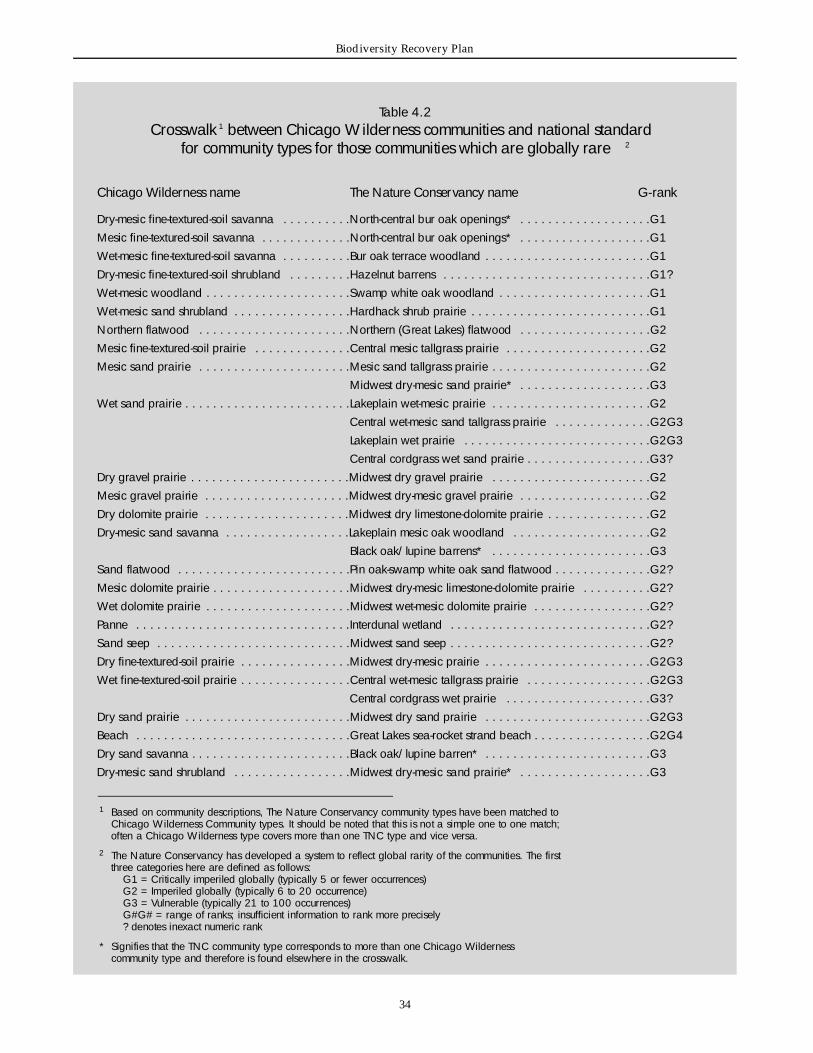
3 4
Biodiversity Recovery Plan
Table 4.2 C ro s s w a l k 1 between Chicago Wi l d e rness communities and national standard
for community types for those communities which are globally rare 2
Chicago Wi l d e rness name The Nature Conservancy name G - r a n k
D ry-mesic fine-textured-soil savanna . . . . . . . . . .N o rth-central bur oak openings* . . . . . . . . . . . . . . . . . . .G 1Mesic fine-textured-soil savanna . . . . . . . . . . . . .N o rth-central bur oak openings* . . . . . . . . . . . . . . . . . . .G 1Wet-mesic fine-textured-soil savanna . . . . . . . . . .Bur oak terrace woodland . . . . . . . . . . . . . . . . . . . . . . . .G 1D ry-mesic fine-textured-soil shru b l a n d . . . . . . . . .Hazelnut barre n s . . . . . . . . . . . . . . . . . . . . . . . . . . . . . .G 1 ?Wet-mesic woodland . . . . . . . . . . . . . . . . . . . . .Swamp white oak woodland . . . . . . . . . . . . . . . . . . . . . .G 1Wet-mesic sand shru b l a n d . . . . . . . . . . . . . . . . .H a rdhack shrub prairie . . . . . . . . . . . . . . . . . . . . . . . . . .G 1N o rt h e rn flatwood . . . . . . . . . . . . . . . . . . . . . .N o rt h e rn (Great Lakes) flatwood . . . . . . . . . . . . . . . . . . .G 2Mesic fine-textured-soil prairie . . . . . . . . . . . . . .Central mesic tallgrass prairie . . . . . . . . . . . . . . . . . . . . .G 2Mesic sand prairie . . . . . . . . . . . . . . . . . . . . . .Mesic sand tallgrass prairie . . . . . . . . . . . . . . . . . . . . . . .G 2
Midwest dry-mesic sand prairie* . . . . . . . . . . . . . . . . . . .G 3Wet sand prairie . . . . . . . . . . . . . . . . . . . . . . . .Lakeplain wet-mesic prairie . . . . . . . . . . . . . . . . . . . . . . .G 2
Central wet-mesic sand tallgrass prairie . . . . . . . . . . . . . .G 2 G 3Lakeplain wet prairie . . . . . . . . . . . . . . . . . . . . . . . . . . .G 2 G 3Central cordgrass wet sand prairie . . . . . . . . . . . . . . . . . .G 3 ?
D ry gravel prairie . . . . . . . . . . . . . . . . . . . . . . .Midwest dry gravel prairie . . . . . . . . . . . . . . . . . . . . . . .G 2Mesic gravel prairie . . . . . . . . . . . . . . . . . . . . .Midwest dry-mesic gravel prairie . . . . . . . . . . . . . . . . . . .G 2D ry dolomite prairie . . . . . . . . . . . . . . . . . . . . .Midwest dry limestone-dolomite prairie . . . . . . . . . . . . . . .G 2D ry-mesic sand savanna . . . . . . . . . . . . . . . . . .Lakeplain mesic oak woodland . . . . . . . . . . . . . . . . . . . .G 2
Black oak/lupine barre n s * . . . . . . . . . . . . . . . . . . . . . . .G 3Sand flatwood . . . . . . . . . . . . . . . . . . . . . . . . .Pin oak-swamp white oak sand flatwood . . . . . . . . . . . . . .G 2 ?Mesic dolomite prairie . . . . . . . . . . . . . . . . . . . .Midwest dry-mesic limestone-dolomite prairie . . . . . . . . . .G 2 ?Wet dolomite prairie . . . . . . . . . . . . . . . . . . . . .Midwest wet-mesic dolomite prairie . . . . . . . . . . . . . . . . .G 2 ?P a n n e . . . . . . . . . . . . . . . . . . . . . . . . . . . . . . .I n t e rdunal wetland . . . . . . . . . . . . . . . . . . . . . . . . . . . . .G 2 ?Sand seep . . . . . . . . . . . . . . . . . . . . . . . . . . . .Midwest sand seep . . . . . . . . . . . . . . . . . . . . . . . . . . . . .G 2 ?D ry fine-textured-soil prairie . . . . . . . . . . . . . . . .Midwest dry-mesic prairie . . . . . . . . . . . . . . . . . . . . . . . .G 2 G 3Wet fine-textured-soil prairie . . . . . . . . . . . . . . . .Central wet-mesic tallgrass prairie . . . . . . . . . . . . . . . . . .G 2 G 3
Central cordgrass wet prairie . . . . . . . . . . . . . . . . . . . . .G 3 ?D ry sand prairie . . . . . . . . . . . . . . . . . . . . . . . .Midwest dry sand prairie . . . . . . . . . . . . . . . . . . . . . . . .G 2 G 3B e a c h . . . . . . . . . . . . . . . . . . . . . . . . . . . . . . .G reat Lakes sea-rocket strand beach . . . . . . . . . . . . . . . . .G 2 G 4D ry sand savanna . . . . . . . . . . . . . . . . . . . . . . .Black oak/lupine barre n * . . . . . . . . . . . . . . . . . . . . . . . .G 3D ry-mesic sand shru b l a n d . . . . . . . . . . . . . . . . .Midwest dry-mesic sand prairie* . . . . . . . . . . . . . . . . . . .G 3
1 Based on community descriptions, The Nature Conservancy community types have been matched toChicago Wi l d e rness Community types. It should be noted that this is not a simple one to one match;often a Chicago Wi l d e rness type covers more than one TNC type and vice versa.
2 The Nature Conservancy has developed a system to reflect global rarity of the communities. The firstt h ree categories here are defined as follows:
G1 = Critically imperiled globally (typically 5 or fewer occurre n c e s )G2 = Imperiled globally (typically 6 to 20 occurre n c e )G3 = Vulnerable (typically 21 to 100 occurre n c e s )G#G# = range of ranks; insufficient information to rank more pre c i s e l y? denotes inexact numeric rank
* Signifies that the TNC community type corresponds to more than one Chicago Wi l d e rness community type and there f o re is found elsewhere in the cro s s w a l k .

Chapter 4. Overview of Assessment Processes and Findings for Natural Communities and Species of the Region
3 5
The McHenry County Conservation District (1998)recently conducted a natural-areas inventory for thee n t i re county. This report provides information on eachsite’s community types and its quality but does notinclude any acreage for the community types. To t a la c reage of each site is given. This study is useful in thatit covers the entire county, not just Conservation Districtlands, but it is limited in that it does not include amountsof land for each community type.
The DuPage County Forest Preserve District has a com-plete database covering all of its holdings, which includesboth quality and quantity of each community type oneach of its sites. The DuPage community-classificationsystem differs more than any other from the ChicagoWilderness system, and a comparison of the types wasre q u i red before the data could be compiled with thosef rom the other counties.
For the Recovery Plan process, the Lake and KaneCounty Forest Preserve Districts estimated the number ofa c res of each community type from aerial photographs oftheir sites. Lake County Forest Preserve District staff out-lined each community type on the photographs and useda planimeter to calculate the areas. For Kane County, thea reas were roughly estimated from the photographs. Inboth cases, the land managers assessed quality based ontheir experience with the lands in question, not on quan-titative surveys.
Both the Cook and Will County Forest Preserve Districtshave data on quantity and quality only for certain sites.These sites include Nature Preserves and a few sites forwhich there are detailed management schedules. Thedata come from the original Illinois Natural A re a sI n v e n t o r y, nature - p reserve dedication proposals, andcounty management schedules. The data do not portraythe complete picture of the natural areas in either county.
To add to the data available at the beginning of theRecovery Plan process, a current Chicago Wilderness pro-ject is using satellite imagery to develop a vegetation mapfor the entire region, including unprotected lands. Fro mthe satellite images, it is possible to identify vegetativecover for eleven land-use categories, including eight nat-ural or semi-natural categories. The accuracy of these clas-sifications is adequate within protected lands in Illinois top roduce preliminary results (Table 4.6). These data helpp rovide a more complete picture of the natural communi-ties currently included in our preserve system. Anext stepin the process will be to improve the accuracy of the clas-sifications of lands outside the preserves and in Indiana.U l t i m a t e l y, remotely sensed data will provide a baselinefor monitoring pro g ress toward achieving the goals of thisrecovery plan, for measuring amounts and quality of nat-ural communities, and for assessing the impacts of frag-mentation and increased suburban development.
Table 4.3Te rrestrial animal assemblages
identified for conservation planning
B i rd s
Moist grassland birds (with and without shru b s )D ry grassland bird sSavanna bird sOpen woodland bird sHemi-marsh bird sS h o reline bird sClosed upland woods bird sClosed bottomland woods bird sPinewood bird s
Reptiles and amphibians
Savanna reptiles and amphibiansSedge meadow, fen, and dolomite prairie
reptiles and amphibiansF o rest and woodland reptiles and amphibiansGrassland reptiles and amphibiansSand savanna and sand prairie reptiles
and amphibiansMarsh reptiles and amphibiansPanne reptiles and amphibiansHigh gradient stream reptiles and amphibiansR i v e r, lake, and pond reptiles and amphibians
I n s e c t s
D ry and mesic blacksoil prairie insectsD ry and mesic sand prairie insectsD ry and mesic gravel prairie insectsWet prairie insectsD ry blacksoil savanna and woodland insectsWet blacksoil savanna and woodland insectsSand savanna insectsFen insectsMarsh insectsSedge meadow insectsBog insectsFloodplain forest insectsUpland forest insectsF o redune insects
M a m m a l s
The mammals of Chicago Wi l d e rness do not a g g regate into assemblages. Mammals of c o n c e rn are listed in Table 4.8.
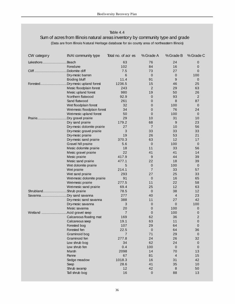
3 6
Biodiversity Recovery Plan
Table 4.4Sum of acres from Illinois natural areas inventory by community type and grade
(Data are from Illinois Natural Heritage database for six county area of nort h e a s t e rn Illinois)
CW category INAI community type Total no. of acr e s % Grade A % Grade B % Grade C
L a k e s h o re. . . . . . . . . . . . . . . . . . . . . . . .Beach 6 3 7 6 2 4 0F o redune 1 0 2 8 4 1 6 0
C l i ff . . . . . . . . . . . . . . . . . . . . . . . . . . . . . . . .Dolomite cliff 7 . 5 7 3 2 7 0D ry-mesic barren 6 0 0 1 0 0E roding bluff 1 1 . 4 9 1 9 0
F o re s t e d. . . . . . . . . . . . . . . . . . . . . . . . . .D ry-mesic upland forest 1 2 3 6 . 5 1 5 4 6 2 5Mesic floodplain forest 2 4 3 2 2 9 6 3Mesic upland forest 9 8 0 1 9 5 0 2 6N o rt h e rn flatwood 9 2 . 9 0 9 3 2Sand flatwood 2 6 1 0 8 8 7Wet floodplain forest 3 2 0 1 0 0 0Wet-mesic floodplain forest 3 4 0 7 6 2 4Wet-mesic upland forest 5 0 0 1 0 0 0
P r a i r i e. . . . . . . . . . . . . . . . . . . . . . . . . . . . .D ry gravel prairie 2 9 1 0 3 1 1 0D ry sand prairie 1 7 9 . 2 6 8 9 2 3D ry-mesic dolomite prairie 2 7 7 1 0 5 6D ry-mesic gravel prairie 3 3 3 3 3 3 3D ry-mesic prairie 1 9 2 6 5 3 2 1D ry-mesic sand prairie 3 7 0 . 3 6 3 1 2 1 7Gravel hill prairie 5 . 6 0 1 0 0 0Mesic dolomite prairie 1 8 1 1 3 3 5 6Mesic gravel prairie 2 2 4 1 4 1 1 4Mesic prairie 4 1 7 . 9 9 4 4 3 9Mesic sand prairie 4 7 7 . 1 2 2 1 8 3 9Wet dolomite prairie 5 0 1 0 0 0Wet prairie 2 1 4 . 1 7 3 3 5 7Wet sand prairie 2 9 3 2 7 2 5 3 3Wet-mesic dolomite prairie 9 1 0 1 6 6 5Wet-mesic prairie 2 7 7 . 5 1 1 2 2 5 8Wet-mesic sand prairie 6 9 . 4 2 5 1 2 6 3
S h ru b l a n d. . . . . . . . . . . . . . . . . . . . . . .S h rub prairie 7 8 . 5 0 3 8 1 2S a v a n n a. . . . . . . . . . . . . . . . . . . . . . . . .D ry sand savanna 2 7 7 4 0 4 2 3
D ry-mesic sand savanna 3 8 8 1 1 2 7 4 2D ry-mesic savanna 3 0 0 1 0 0Mesic savanna 2 0 0 1 0 0 0
Wetland . . . . . . . . . . . . . . . . . . . . . . . . .Acid gravel seep 7 0 1 0 0 0C a l c a reous floating mat 1 6 9 6 2 3 6 2C a l c a reous seep 1 9 . 1 6 3 1 1 0F o rested bog 1 0 7 2 9 6 4 0F o rested fen 2 2 . 5 0 6 4 3 6Graminoid bog 7 7 1 2 9 0Graminoid fen 2 7 7 . 8 2 4 2 6 3 2Low shrub bog 3 4 6 2 2 4 0Low shrub fen 0 . 4 1 0 0 0 0Marsh 2 0 9 8 1 4 7 0 1 3Panne 6 7 8 1 4 1 5Sedge meadow 1 0 1 8 . 3 1 6 3 1 4 2Seep 2 8 . 6 4 1 3 5 1 0S h rub swamp 1 2 4 2 8 5 0Tall shrub bog 1 6 0 8 8 1 3
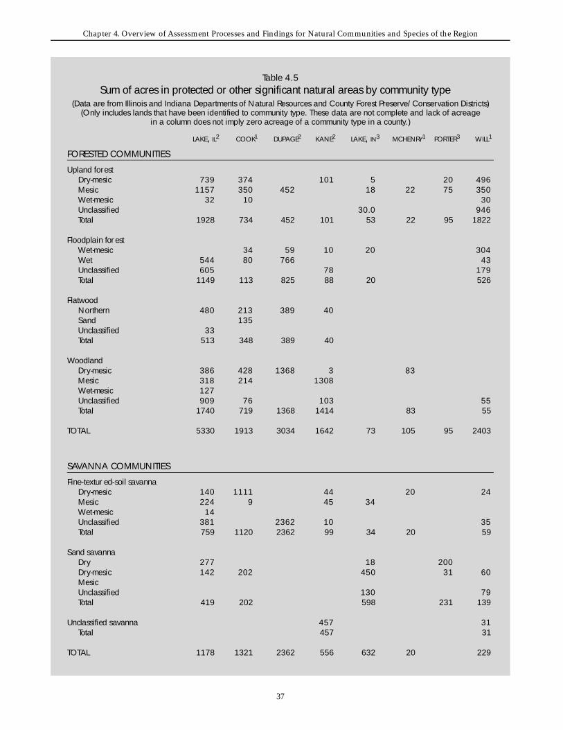
Chapter 4. Overview of Assessment Processes and Findings for Natural Communities and Species of the Region
3 7
L A K E, I L2 C O O K1 D U PA G E2 K A N E2 L A K E, I N3 M C H E N RY1 P O RT E R3 W I L L1
FORESTED COMMUNITIES
Upland fore s tD ry-mesic 7 3 9 3 7 4 1 0 1 5 2 0 4 9 6Mesic 1 1 5 7 3 5 0 4 5 2 1 8 2 2 7 5 3 5 0Wet-mesic 3 2 1 0 3 0Unclassified 3 0 . 0 9 4 6To t a l 1 9 2 8 7 3 4 4 5 2 1 0 1 5 3 2 2 9 5 1 8 2 2
Floodplain for e s tWet-mesic 3 4 5 9 1 0 2 0 3 0 4Wet 5 4 4 8 0 7 6 6 4 3Unclassified 6 0 5 7 8 1 7 9To t a l 1 1 4 9 1 1 3 8 2 5 8 8 2 0 5 2 6
F l a t w o o dN o rt h e rn 4 8 0 2 1 3 3 8 9 4 0S a n d 1 3 5Unclassified 3 3To t a l 5 1 3 3 4 8 3 8 9 4 0
Wo o d l a n dD ry-mesic 3 8 6 4 2 8 1 3 6 8 3 8 3Mesic 3 1 8 2 1 4 1 3 0 8Wet-mesic 1 2 7Unclassified 9 0 9 7 6 1 0 3 5 5To t a l 1 7 4 0 7 1 9 1 3 6 8 1 4 1 4 8 3 5 5
T O TA L 5 3 3 0 1 9 1 3 3 0 3 4 1 6 4 2 7 3 1 0 5 9 5 2 4 0 3
S AVANNA COMMUNITIES
F i n e - t e x t u r ed-soil savannaD ry-mesic 1 4 0 1 1 1 1 4 4 2 0 2 4Mesic 2 2 4 9 4 5 3 4Wet-mesic 1 4Unclassified 3 8 1 2 3 6 2 1 0 3 5To t a l 7 5 9 1 1 2 0 2 3 6 2 9 9 3 4 2 0 5 9
Sand savannaD ry 2 7 7 1 8 2 0 0D ry-mesic 1 4 2 2 0 2 4 5 0 3 1 6 0Mesic Unclassified 1 3 0 7 9To t a l 4 1 9 2 0 2 5 9 8 2 3 1 1 3 9
Unclassified savanna 4 5 7 3 1To t a l 4 5 7 3 1
T O TA L 1 1 7 8 1 3 2 1 2 3 6 2 5 5 6 6 3 2 2 0 2 2 9
Table 4.5Sum of acres in protected or other significant natural areas by community type
(Data are from Illinois and Indiana Departments of Natural Resources and County Forest Pre s e rv e / C o n s e rvation Districts) (Only includes lands that have been identified to community type. These data are not complete and lack of acreage
in a column does not imply zero acreage of a community type in a county. )
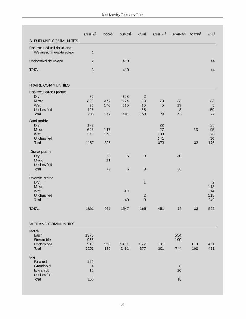
3 8
Biodiversity Recovery Plan
L A K E, I L2 C O O K1 D U PA G E2 K A N E2 L A K E, I N3 M C H E N RY1 P O RT E R3 W I L L1
SHRUBLAND COMMUNITIES
F i n e - t e x t u r ed-soil shr u b l a n dWet-mesic fine-textured-soil 1
Unclassified shr u b l a n d 2 4 1 0 4 4
T O TA L 3 4 1 0 4 4
PRAIRIE COMMUNITIES
F i n e - t e x t u r ed-soil prairieD ry 8 2 2 0 3 2Mesic 3 2 9 3 7 7 9 7 4 8 3 7 3 2 3 3 3Wet 9 6 1 7 0 3 1 5 1 0 5 1 9 5Unclassified 1 9 8 5 8 3 5 9To t a l 7 0 5 5 4 7 1 4 9 1 1 5 3 7 8 4 5 9 7
Sand prairieD ry 1 7 9 2 2 2 5Mesic 6 0 3 1 4 7 2 7 3 3 9 5Wet 3 7 5 1 7 8 1 8 3 2 6Unclassified 1 4 1 3 0To t a l 1 1 5 7 3 2 5 3 7 3 3 3 1 7 6
Gravel prairieD ry 2 8 6 9 3 0Mesic 2 1Unclassified To t a l 4 9 6 9 3 0
Dolomite prairieD ry 1 2Mesic 1 1 8Wet 4 9 1 4Unclassified 2 1 1 5To t a l 4 9 3 2 4 9
T O TA L 1 8 6 2 9 2 1 1 5 4 7 1 6 5 4 5 1 7 5 3 3 5 2 2
WETLAND COMMUNITIES
M a r s hBasin 1 3 7 5 5 5 4S t reamside 9 6 5 1 9 0Unclassified 9 1 3 1 2 0 2 4 8 1 3 7 7 3 0 1 1 0 0 4 7 1To t a l 3 2 5 3 1 2 0 2 4 8 1 3 7 7 3 0 1 7 4 4 1 0 0 4 7 1
B o gF o rested 1 4 9Graminoid 4 8Low shrub 1 2 1 0Unclassifed To t a l 1 6 5 1 8
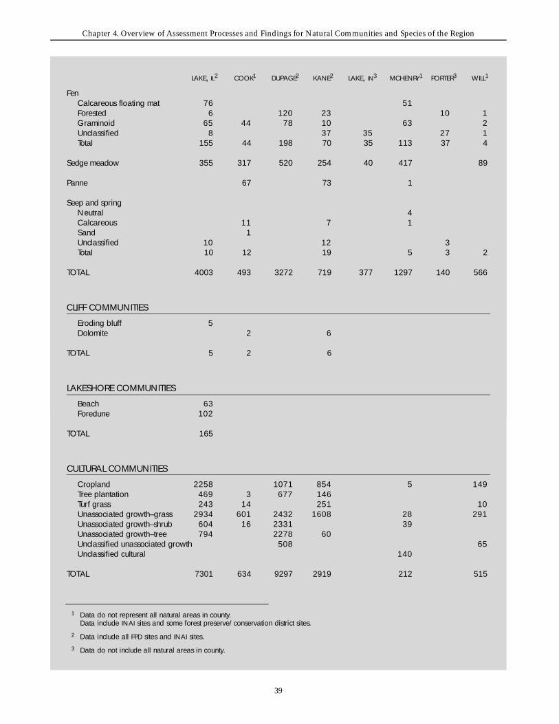
Chapter 4. Overview of Assessment Processes and Findings for Natural Communities and Species of the Region
3 9
L A K E, I L2 C O O K1 D U PA G E2 K A N E2 L A K E, I N3 M C H E N RY1 P O RT E R3 W I L L1
F e nC a l c a reous floating mat 7 6 5 1F o rested 6 1 2 0 2 3 1 0 1Graminoid 6 5 4 4 7 8 1 0 6 3 2Unclassified 8 3 7 3 5 2 7 1To t a l 1 5 5 4 4 1 9 8 7 0 3 5 1 1 3 3 7 4
Sedge meadow 3 5 5 3 1 7 5 2 0 2 5 4 4 0 4 1 7 8 9
P a n n e 6 7 7 3 1
Seep and springNeutral 4C a l c a reous 1 1 7 1Sand 1Unclassified 1 0 1 2 3To t a l 1 0 1 2 1 9 5 3 2
T O TA L 4 0 0 3 4 9 3 3 2 7 2 7 1 9 3 7 7 1 2 9 7 1 4 0 5 6 6
CLIFF COMMUNITIES
E roding bluff 5Dolomite 2 6
T O TA L 5 2 6
LAKESHORE COMMUNITIES
B e a c h 6 3F o re d u n e 1 0 2
T O TA L 1 6 5
C U LTURAL COMMUNITIES
C ro p l a n d 2 2 5 8 1 0 7 1 8 5 4 5 1 4 9Tree plantation 4 6 9 3 6 7 7 1 4 6Tu rf grass 2 4 3 1 4 2 5 1 1 0Unassociated gro w t h – g r a s s 2 9 3 4 6 0 1 2 4 3 2 1 6 0 8 2 8 2 9 1Unassociated gro w t h – s h ru b 6 0 4 1 6 2 3 3 1 3 9Unassociated gro w t h – t re e 7 9 4 2 2 7 8 6 0Unclassified unassociated gro w t h 5 0 8 6 5Unclassified cultural 1 4 0
T O TA L 7 3 0 1 6 3 4 9 2 9 7 2 9 1 9 2 1 2 5 1 5
1 Data do not re p resent all natural areas in county. Data include I N A I sites and some forest pre s e rv e / c o n s e rvation district sites.
2 Data include all F P D sites and I N A I s i t e s .3 Data do not include all natural areas in county.

4 0
Biodiversity Recovery Plan
4.1.3 Methodology for community assessmentTo generate information for this Recovery Plan, theScience and Land Management Teams developed a two-stage process to assess the status of biodiversity in theregion and to make recommendations for conservingregional biodiversity.
The first stage in this evaluation process was to examinethe status and conservation needs of the region’s animalassemblages. This assessment was conducted in a seriesof four workshops, each focusing on a major taxonomicg roup (birds, mammals, reptiles and amphibians, andinvertebrates). These workshops brought together experts on these species to develop consensus on theidentification of the species assemblages, their status, andthe region’s contribution to the global conservation ofthe species.
The second stage in the process was to examine the statusof each terrestrial community type, its biological impor-tance, and the region’s contribution to its global conser-vation. In four workshops, using a consensus-building
p rocess, land managers and scientists covered the fourmain community groupings: forested, savanna, prairie,and wetland. Prior to the workshop, we gathered dataf rom the Illinois Natural Heritage Database, the IndianaDepartment of Natural Resources, and the Fore s tP reserve or Conservation Districts of the six northeasternIllinois counties, as described in section 4.1.2. There arestill major gaps in the data on how much of each naturalcommunity type exists in the region. Thus, the informa-tion available for the development of this plan onlyallowed relative assessments across community types.The workshops relied primarily on the expert knowledgeof the scientists and land managers from the re g i o n .
The community-status evaluation in this second stagehad two parts. The first part developed a measure or levelof concern about how much of the community type cur-rently remains in the region, using the following criteria:
• Number of acres re m a i n i n g
• P e rcent remaining from extent before European s e t t l e m e n t
• Number of occurre n c e s
Table 4.6Sum of acres in protected areas in Illinois counties by community type
(Data are from Satellite Imagery; sites include Forest Pre s e rv e / C o n s e rvation Districts, IL DNR, and I N A I S i t e s )
Community Ty p e1 C o o k D u P a g e K a n e L a k e M c H e n ry Wi l l To t a l
Savanna (oak woodland) 5 , 8 3 2 1 , 7 0 7 5 7 7 3 , 0 8 7 8 5 0 1 , 6 1 0 1 3 , 6 6 3
Floodplain fore s t 5 , 6 8 6 9 5 6 5 8 9 1 , 7 5 7 6 7 8 2 , 0 6 1 1 1 , 7 2 7
Upland fore s t / w o o d l a n d 1 2 , 1 7 8 3 , 6 6 7 7 4 0 2 , 1 6 0 7 1 4 4 , 7 1 8 2 4 , 1 7 7
P r a i r i e 5 , 4 1 1 1 , 9 8 9 1 5 8 2 , 2 0 7 2 6 7 3 , 8 9 0 1 3 , 9 2 2
We t l a n d 5 , 5 1 2 3 , 2 3 6 1 , 0 9 5 8 , 3 0 7 4 , 8 0 1 3 , 5 7 6 2 6 , 5 2 7
Open water 5 , 1 3 6 1 , 1 3 9 2 8 3 4 , 2 4 0 7 5 0 1 , 8 3 7 1 3 , 3 8 5
Unassociated woody 1 1 , 6 0 9 1 , 7 7 2 5 2 3 2 5 5 9 1 3 2 , 4 2 5 1 7 , 4 9 7
Unassociated grassy 1 1 , 7 7 3 7 , 2 2 2 2 , 6 8 3 4 , 4 4 8 2 , 6 8 2 1 4 , 9 0 0 4 3 , 7 0 8
1 These community types are not strictly parallel to those in other tables. They re p re s e n tthe level of detail for which there is confidence in the correlation between satelliteimage classifications and gro u n d - t ruthing and the knowledge of land managers.

Chapter 4. Overview of Assessment Processes and Findings for Natural Communities and Species of the Region
4 1
• Number of sufficiently large occurrences
• Amount under formal pro t e c t i o n
The second part developed a measure of level of concernbased on the condition of the remaining examples andused the following criteria:
• P e rcentage remaining of good quality
• D e g ree of fragmentation and isolation
• Extent and effectiveness of current managemente ff o r t s
Each community type received a relative ranking foreach factor and a combined ranking to re p resent an over-all level of conservation concern (very high, high, mod-erate, or low). It is important to stress that there arei n s u fficient data for any of these criteria to allow a quan-titative assessment. The criteria, and available data, wereused only as guides in reaching consensus amongChicago Wilderness scientists and land managers aboutthe relative status of the communities. A high priorityfor work in Chicago Wilderness is to continue to developm o re precise assessments of the quantity and quality ofnatural areas in our re g i o n .
Relative biological importance for each community typewas determined with the criteria of species richness,numbers of endangered and threatened species, levelsof species conservatism, and presence of important eco-logical functions (such as the role of wetlands in impro v-ing water quality in adjacent open waters). Informationf rom the workshops focusing on major taxonomicg roups provided the basis for this discussion.
Workshop participants then judged the role of theChicago Wilderness region in the global conservation ofeach of the community types. For some communities, theChicago Wilderness region is on the edge of the range; forsome, the region contains important examples but thecommunity type is also well-re p resented in other re g i o n s ;and for others, the region is central to the community’sglobal conservation.
In addition to these assessments, the workshops dis-cussed threats to species and communities, and oppor-tunities and needs for action. A t h i rd series of workshops,o rganized by major community class, helped to re f i n evision statements for each of the communities. Thesevisions help to define what scientists say the landscapeshould look like fifty years from now if we are to con-serve all of the region’s current biodiversity. All of thesediscussions together provided a basis for identifyingrecovery needs and actions for the community types pre-sented in Chapter 5.
4.1.4 Overall priorities and conditionThe assessments conducted in the workshops have beenused to rank each of the community types and each of thespecies assemblages. The rankings on status, biologicalimportance, and contribution to global conservation havebeen combined together for each community type tocome up with a tiered ranking of conservation targ e t sfor the region (see Table 4.7). These tiers re p resent re l a t i v epriorities for increased conservation attention to the com-munity types. Those in the highest tier are of the highestconcern, because these communities are at high risk ofloss (due to the small amount remaining or its degradedcondition), have high biological importance, and re p re-sent some of the best opportunities in the world to con-serve the community type. Lower tiers have somecombination of these factors, but are not at a high levelof concern or importance in all categories. This tiered sys-tem does not imply that efforts in place to protect andmanage those communities falling in lower tiers shouldbe halted or diminished. Often, it means the opposite:these conservation measures are having the desired eff e c tand these communities are at less risk of complete loss.All the community types are important components ofthe region’s biodiversity, and all are at some risk of beinglost. Those in the higher tiers are more likely to be lost ordegraded substantially if they do not receive more con-servation attention. In no way should lower rankings inthis scheme be used to justify non compliance with exist-ing laws, rules, and regulations designed to protect thesecommunities and parcels of land.
The rankings in Table 4.7 should not be the sole basis fordetermining priorities for land management and landacquisition. As discussed in chapter 5, there are severalother factors to consider in prioritizing actions for biodi-v e r s i t y. These include the need to address threats thata ffect many species and communities, such as the im-pacts of fragmentation or the disruption of naturalp rocesses at the landscape level. Further, the plan clearlyrecognizes the functional value of mosaics of diff e re n tcommunity types in sustaining biodiversity. The targ e t sin Table 4.7 should be one element in developing man-agement plans and monitoring plans.
The workshops evaluated each terrestrial animal assem-blage in terms of whether it was declining or of concernfor other reasons, as well as in terms of the Chicagoregion’s contribution to the global conservation of thespecies involved. The results are presented in Tables 4.8and 4.9. Again, assemblages of greater global significanceor of greater concern due to their status should be a pri-ority for increased conservation attention, but all curre n tconservation efforts should be maintained.

4 2
Biodiversity Recovery Plan
Table 4.8Te rrestrial species assemblages
(or species in the case of mammals) of concern or in an overall
declining condition
B i rd s
Poor conditionMoist grassland birds (without shru b s )
Suboptimal conditionsMoist grassland birds (with shru b s )D ry grassland bird sSavanna bird sOpen woodland bird sHemi-marsh birds (without shru b s )S h o reline bird s
Reptiles and amphibians
D e c l i n i n gSavanna reptiles and amphibiansSedge meadow, fen, and dolomite prairie
reptiles and amphibiansF o rest and woodland reptiles and amphibiansGrassland reptiles and amphibiansSand savanna and sand prairie reptiles
and amphibiansHigh gradient stream reptiles and amphibians
I n s e c t s
Of concern D ry and mesic blacksoil prairie insectsD ry and mesic sand prairie insectsWet prairie insectsSand savanna insectsFen insectsD ry and mesic gravel prairie iInsectsMarsh insectsD ry and blacksoil savanna and woodland insects
M a m m a l s
Of concernE a s t e rn molePygmy shre wLeast shre wLittle brown myotisIndiana myotisN o rt h e rn long-eared batE a s t e rn pipistre l l eEvening batLeast weaselB a d g e rGray foxF r a n k l i n ’s ground squirre lS o u t h e rn flying squirre lWoodland vole
Table 4.7C o n s e rvation targets for r e c o v e ry basedon status, importance, and distribution
First (highest) tier Woodland (all moisture classes)F i n e - t e x t u red-soil savanna (all moisture classes)Mesic sand savannaSand prairie (all moisture gradients in dune
and swale topography)Dolomite prairie (all)P a n n eGraminoid fenF i n e - t e x t u red-soil prairie1 (all moisture classes)
Second tier D ry sand savannaGravel prairie (all)Basin marsh2
C a l c a reous floating matC a l c a reous seepSand prairie (other than those in dune
and swale topography)N o rt h e rn flatwoodS t reamside marsh3
T h i rd tierSand flatwoodD ry-mesic sand savannaF o rested fenSedge meadow
F o u rth tierUpland forest (all)4
Fifth tierFloodplain forest (both)Bogs (all)Sand and neutral seep
1 F i n e - t e x t u red-soil prairie is in the highest tier because 1) CWhas so many relatively large high quality examples and somuch adjacent land that is restorable, and in many casesbeing re s t o red, 2) that CW has so many and such larg erestoration areas, 3) that this community type has suff e re dthe highest pro p o rtional loss of high quality acreage, and 4)this community type is especially important as a gene poolfor agriculture, since it produced the soils which are pro b a-bly the Midwest’s long term most important natural re s o u rc e .
2 Basin marsh has been placed in a higher tier than would bethe case based on status and importance alone, because itis receiving significant conservation attention in the re g i o nand there is great opportunity to do more .
3 S t reamside marshes are very difficult to re s t o re in the curre n ta l t e red hydrological conditions. There f o re, the priority is tore s e a rch ways to improve their condition before undert a k i n gextensive restoration actions.
4 Though not separated in the CW Classification system, up-land forests dominated by oak stands are of higher concernthan those dominated by maple stands. In addition, cert a i nf e a t u res of upland forests, particularly vernal ponds, are ofhigh concern from a conservation perspective.

Chapter 4. Overview of Assessment Processes and Findings for Natural Communities and Species of the Region
4 3
Appendix 4 includes lists of the rankings on diff e rent fac-tors that led to the overall rankings on conservation con-cern for the communities. The findings are discussed indetail in Chapter 5. More detailed reports on naturalcommunities and animal assemblages are available on-line (www. c h i w i l d . o rg ) .
4 . 2Aquatic communities
4.2.1 Process for assessing aquatic communitiesA classification system for the aquatic communities wasdeveloped, using primarily physical characteristics. Asummary is presented in Table 4.10 and the complete ver-sion is in Appendix 5. Two diff e rent groups of ChicagoWilderness scientists and land managers evaluated theaquatic communities of the region. One group looked atrivers and streams and the other at inland lakes. Whilethe two groups used diff e rent methods for evaluating thecommunities, both used various criteria to place specificlakes, rivers, and streams into diff e rent categories. In bothcases the emphasis was on the existing quality of these
Table 4.9Te rrestrial species assemblages whicha re critical or important to the global
c o n s e rvation of the assemblages
Globally critical
Moist grassland birds (with and without shru b s )
Globally impor t a n t
Savanna birds (with and without shru b s )Open woodland birds (with and without shru b s )Savanna reptiles and amphibiansMarsh reptiles and amphibiansSedge meadow, fen, and dolomite prairie reptiles
and amphibiansD ry and mesic blacksoil prairie insectsD ry and mesic sand prairie insectsWet prairie insectsSand savanna insectsWet blacksoil savanna and woodland insects (??)D ry blacksoil savanna and woodland
Table 4.10 S u m m a r y of the aquatic community
types in the Chicago Wi l d e rness classification system
S t re a m s
Headwater str e a m s• Continuous flow
Coarse substrateFine substrate
• I n t e rmittent flowCoarse substrateFine substrate
Low ord e r• High gradient• Low gradient
Mid ord e r• High gradient• Low gradient
L a k e s
• Natural lakes• Lake Michigan• Glacial
K e t t l eFlow thro u g h
• B o t t o m l a n d• Ve rnal pond• Manmade
N a t u r a l i z e dO t h e r
bodies of water. The categories used inform the re a d e rof the relative quality of the lake, river, or stream, andthey also give an indication of what some of the re c o v-ery goals should be. In both cases, as more informationbecomes available and or conditions change, the lakes,rivers, and streams will move between categories. A f u l ldescription of the assessment process is in Chapter 6.
4.2.2 Overall prioritiesEach stream has a recovery goal based on its current con-dition or the presence of features of special concern. Therecovery goals are protection, restoration, re h a b i l i t a t i o n ,and enhancement. The streams with goals of pro t e c t i o nand restoration are of higher quality and are of very highand high priority respectively for conservation action.Complete results for the streams assessed are includedin Figure 6.1. Of the streams assessed, 37% are of high orvery high priority.
The lakes were organized into the following four cate-gories: exceptional, important, restorable, and other.Again, priority is placed on the exceptional and impor-tant lakes, which are currently of higher quality. Tw e n t y -t h ree lakes were identified as exceptional lakes andtwenty-five as important lakes. The results are shown inTables 6.1 and 6.2.
4 . 2

4 4
Chapter 5
Terrestrial Communities:Status, Needs, and Goals
1 . 1I n t r o d u c t i o n
This chapter describes the status and significance of eachcommunity type and gives a vision of the condition of thecommunity class in the long term in order to sustain bio-d i v e r s i t y. Following this are sections on threats, re c o m-mended actions, and re s e a rch needs. Many communitytypes suffer from similar stressors, and actions areneeded at the landscape level. For this reason, discus-sions on threats, actions, and re s e a rch needs are gro u p e dtogether for all community types.
The information presented in this chapter is based on theopinions of Science and Land Management Team mem-bers, gathered through a number of workshops andreview processes. Many statements are based on pro f e s-sional experience, rather than published literature, anda re presented to give an indication of priority and dire c-tion for future conservation work. Complete workshopreports from which this chapter was written can be foundon the Chicago Wilderness Web site (www. c h i w i l d . o rg ) .
1 . 2Forested communities—status
and recovery goals
5.2.1 Description of communitiesThe forested community class includes all the commu-nity types that are dominated by trees, with an averagecanopy cover of greater than 50%. Forested communi-ties have a multi-layered stru c t u re composed of thec a n o p y, sub-canopy, shrub, and herbaceous layers.H i s t o r i c a l l y, this multi-layered stru c t u re was maintained
t h rough fire and other natural disturbances. Within thef o rested community class there are four communitytypes: upland forest, floodplain forest, flatwoods, andw o o d l a n d s .
Upland forest has a canopy cover of 80–100%. Canopyt ree species are well re p resented in varying age classesf rom seedling to canopy-sized individuals. The firereturn period is presumed longer for this communitytype than for woodlands or savannas. The longer firereturn period and lower fire intensities would result fro mf i re barriers provided by woodlands, savannas, and larg erivers or lakes on the south and west sides of these com-munities. Three subtypes of upland forest are based onsoil moisture: dry-mesic, mesic, and wet-mesic.
Floodplain forests a re located on the floodplains ofrivers and streams. These communities are shaped by thef requency and duration of flooding, by nutrient and sed-iment deposition, and by the permeability of the soil. Thecanopy cover (80–100%) is similar to that of uplandf o rests, but the understory is more open due to the fre-quent flooding. The subtypes, based on soil moisture ,range from wet-mesic to wet.
F l a t w o o d s have a canopy cover of 50–80% and occur onlevel or nearly level soil that has an impermeable orslowly permeable layer that causes a shallow, perc h e dwater table. Because soil moisture fluctuates so widely bythe season, the moisture gradients do not define the sub-types. Rather, the two subtypes are defined by geographyand soil type. Northern flatwoods are associated with theValparaiso, Ti n l e y, and Lake Border morainal systems,while sand flatwoods have a meter or more of acidic sandover silty clay and are found in the more southern partsof the re g i o n .
Wo o d l a n d s developed under a canopy cover of 50–80%,intermediate between that of savanna and forest. To d a y,
5 . 1
5 . 2
Chapter 5. Te r restrial Communities: Status, Needs, and Goals
4 5
many original woodlands have canopy cover gre a t e rthan 80% due to years of fire suppression. Such sites canbe recognized by the failure of the canopy tree species tore p roduce, with few, if any, canopy species re p resented inthe seedling or sapling layer. Based on soil moisture ,woodland subtypes are dry-mesic, mesic, and wet-mesic.
M o re detailed descriptions of the forested communitytypes may be found in Appendix 1. Associated animalassemblages may be found in Table 4.3.
5.2.2 Findings and prioritiesOf the forested community types, the woodlands are ofthe highest conservation concern. All moisture classes ofwoodland are in the first tier of conservation targets forthe Chicago Wilderness region. Wet-mesic woodland isc o n s i d e red critically imperiled at the global level (G1)by The Nature Conservancy (which calls this communityswamp white oak woodland). A substantial number ofa c res of woodlands remain, providing opportunities fortheir conservation, but remaining sites are generally invery poor condition. The healthy woodlands in theChicago Wilderness region tend to be species-rich, indi-cating that they are biologically important. The ChicagoWilderness region also has a unique landscape setting ofwoodlands, including those originally interspersed withp r a i r i e s .
The flatwoods of the region are of high concern, becausethe remaining examples are both degrading rapidly anddisappearing due to development or conversion to otherland uses. In The Nature Conservancy’s global rankingsystem, both northern flatwoods and pin oak-swampwhite oak sand flatwoods, which correlate to ChicagoWilderness’s sand flatwoods, rate as imperiled globally(G2). The primary conservation concern for upland fore s tand floodplain forest is their current degraded condi-tion. All of the forested communities are important aswildlife habitat, and they are key areas for human re c re-ation. The primary re q u i rement for their conservation issignificantly increased management eff o r t s .
5.2.3 Status
Upland forestsUpland forest, particularly areas not dominated by oak,was probably much less common historically than wood-land, savanna, or floodplain forest (Bowles et al. 1998a).
T h e re are comparatively greater amounts remaining ofdry-mesic upland forest than of other subtypes. Dry-mesic upland forest is mostly fragmented, but some larg eblocks still exist, such as in Busse Woods. There has beenmuch less loss of both dry-mesic and mesic upland for-est than of other community types.
Upland forests are more secure because a relatively highp e rcentage of their original acreage has been pro t e c t e d .Mesic upland forest was an initial target of the Fore s tP reserve Districts when they first started acquiring land. However, many occurrences are still in privatehands, and others are threatened by development.Management options are more limited on upland fore s t son private pro p e r t y.
In general, drier upland forests are considered to be inbetter condition than wetter upland forests due to lessimpact from invasive species. There are few or noremaining high-quality examples of wet-mesic uplandf o rest. However, the quality of drier sites is decliningr a p i d l y, primarily through the ongoing loss of the shru bl a y e r. Many of the remaining acres of mesic upland fore s thave significantly impaired ecosystem function, includ-ing quality of wildlife habitat. Diff e rent types of uplandf o rest are affected diff e rently; oak stands are curre n t l ydeteriorating more rapidly than maple stands (Bowles etal. 1998b). In some parts of the region, both are rapidlydeteriorating. It would be valuable to have more inven-tory and monitoring to determine the full extent and rateof degradation. Significant threats to upland fore s t sinclude lack of fire, fragmentation, browsing by deer, andinvasive species, particularly buckthorn.
H i s t o r i c a l l y, moisture gradients and community typesvaried with subtle changes in the landscape. To d a y, wemainly have fragmented remnants that do not incorpo-rate these landscape-scale variations. Complexity in thelandscape is important for animals, as they respond tos t ru c t u re and community mosaics, not to one communitytype. Succession toward more closed forests is occurringdue to the lack of fire, and species diversity is being lostin the process. In the remaining fragments, most animalcommunities are not doing well, primarily due to thee ffects of isolation and loss of key habitat feature s .Amphibians, in particular, are doing very poorly and aredeclining precipitously in places, due to fragmentation.Individual populations are at risk because they are nolonger functioning as part of metapopulations, with geneflow between separate subpopulations (Mierzwa 1998).
FORESTED COMMUNITIESC o n s e rvation targets in top tiers
First tierWoodland (all subtypes)
Second tierN o rt h e rn flatwood
T h i rd tierSand flatwood
4 6
Biodiversity Recovery Plan
Floodplain forestsFloodplain forests have always been relatively rare inthe Chicago Wilderness region, occurring along themajor river courses. The region has lost some originalfloodplain forests to conversion to agriculture and otherdevelopment, but many acres are protected in forest pre-serve holdings. Because of lack of fire, trees are appearingin some floodplains that were sedge meadow and wetprairie historically. A d d i t i o n a l l y, with increased hydro-logical inputs, areas along rivers now experience longerand more frequent flooding. This combination of hydro-logical change and lack of fire has allowed certain speciesto become more abundant, changing the stru c t u re andspecies make-up of floodplains. These more re c e n t l ydeveloped floodplain forests do not seem to have highlevels of floristic diversity, although they do have somelimited wildlife values.
The quality of original floodplain forests suffers fro ma l t e red hydrology and increased sedimentation. The sen-sitive amphibian species have been lost, and those thatremain are tolerant of flooding. Further study of thec a u s e - a n d - e ffect relationships in the development anddegradation of floodplain forests would lead to a betterassessment of their status.
F l a t w o o d sBoth types of flatwoods occurring in the ChicagoWilderness region, sand and northern flatwoods, aree x t remely rare and are considered globally imperiled(G2). Unlike the other forested community types, the dif-f e rences between the two subtypes are substantial anda re not based on moisture. Overall, both flatwood typesa re in fair condition compared to other forested commu-nities, but they are degrading rapidly in the absence ofmanagement. Lack of fire, invasive species, and over-abundant deer are primary threats. Flatwoods have avery delicate moisture balance, so their condition is sen-sitive to changes in hydro l o g y. Surrounded by develop-ment, flatwoods can experience raised water levels,which damages them through excess flooding. Thus, thel o w e r-lying flatwoods are more prone to loss. Converse-l y, in some areas, flatwoods are drying up as water intheir watershed is diverted away from them.
Most sand flatwoods in the region occurred in southeast-ern Cook County and in Indiana around the edge of LakeMichigan. Occurring primarily in the Lake Plain Div-ision, sand flatwoods are naturally rare in the re g i o n .Many sand flatwoods have been lost to agriculture, andothers have succumbed to development and drainage.
A few good-quality examples of northern flatwoodsremain today, and more remnants are of degraded qual-i t y. Northern flatwoods are generally found in andamongst upland forests and woodlands and occur in the
drainage ways and depressions associated with glacialmoraines. There f o re, northern flatwoods survive betterwhen they are imbedded in a large preserve. In thesmaller preserves, altered hydrology will remain a sig-nificant pro b l e m .
Wo o d l a n d sIn the absence of fire, canopy cover in woodlandsi n c reases and biodiversity declines. Before larg e - s c a l es u p p ression of fire, woodlands were extensive in theregion. Unfortunately, good-quality examples are hard tofind today. All of the woodland subtypes are suff e r i n gthe same threats, most significantly lack of fire, invasivespecies, impacts from overabundant deer, and loss due tod e v e l o p m e n t .
A fairly large amount of degraded woodland stillremains on protected land, providing opportunities forrestoration and conservation. The woodlands that wereoriginally interspersed with prairies in the southern andwestern areas of the region have been lost to a gre a t e rextent than woodlands more closely associated with for-est communities. Woodlands, along with forests, arefound more often in protected areas than other commu-nity types, because originally they were a focus of Fore s tP reserve District acquisition. However, much woodlandthat was not protected has been lost to development.H i s t o r i c a l l y, across the landscape, woodlands were a partof a shifting mosaic of communities; this dynamic hasbeen lost in our fragmented landscape.
Virtually all of the woodlands remaining in the ChicagoWilderness region are in very poor condition. In somea reas, considerable management is devoted to wood-lands, and in these areas their condition is impro v i n g .H o w e v e r, the majority of woodland acres are not man-aged. The last twenty years have seen significanti m p rovement in management attention for these com-munities, but considering the significance of this community type to the region’s biota, and its rarity else-w h e re, there is still a long way to go.
Woodlands can maintain some of their values better thanupland forests in a fragmented state, since they havealways occurred in smaller patches interspersed withother community types. This provides greater opportu-nities for successful restoration of this important com-munity type.
5.2.4 Biological significance
Upland forestsBecause of the degraded state of upland forests, it is likelythat the current richness of plant species is comparativelyl o w, although comparisons to historical conditions have

Chapter 5. Te r restrial Communities: Status, Needs, and Goals
4 7
not been made. In most upland forests, much of the orig-inal floral diversity has certainly been lost, especially thesummer and fall herbaceous species, the shrubs, and thegraminoid fuel matrix. Oaks historically dominated mostof our upland forests, but now maple and ash are becom-ing more common.
For the region’s mammals, upland forests and wood-lands are the most important community types, althoughthese mammals benefit most from a complex of diff e re n tcommunities in an area. Many mammals depend on bothf o rests and woodlands. Mammals of concern found inf o rests include the federally endangered Indiana bat, theeastern pipistrelle (a type of bat), and the woodland vole.
Upland forests, along with the other forested communitytypes, provide important habitat to amphibians and re p-tiles, including the eastern box turtle, the eastern newt,the eastern rat snake, and the spring peeper. The overallassemblage of forest and woodland reptiles and amphib-ians is considered to be in decline. Upland forests alsoserve a critical need as migratory pathways for migratingb i rds. The remaining forest blocks in the region are likelytoo small to sustain viable breeding populations of fore s t -interior birds. This is due to greatly increased rates of pre-dation (from raccoons, feral cats and other animals) andnest parasitism (from brown-headed cowbirds) in thefragmented forests of the region (Robinson et al. 1995). Itis most important to protect the largest blocks of re m a i n-ing forest from additional fragmentation to increase thechance of some successful re p roduction by these species.
Floodplain forestsFloristic diversity in floodplain forests is maintained byregular patterns of flooding. Floodplain forests havealways been dominated by disturbance-tolerant species.Along with other forest types, floodplain forests areimportant for mammals, particularly as feeding are a s ,and they serve as important migratory corridors forb i rds. Breeding birds, including Cerulean warbler, re d -s h o u l d e red hawk, American redstart, and pro t h o n o t a r yw a r b l e r, also depend on floodplain fore s t s .
Floodplain forests of the Chicago region are importantas insect habitat because of the rich assortment of plants.P a w p a w, yellow birch, black walnut, sycamore, andmany others are typically found only in high-qualityfloodplain forests. Insect species depending on theset rees for food will, there f o re, be dependent on re m n a n t sof high-quality forest. Examples include the zebra swal-lowtail butterfly, the sycamore sallow moth, and thepawpaw sphinx moth.
Floodplain forests also provide benefits to river systemsby trapping sediment and improving water quality, aswell as slowing floodwaters.
F l a t w o o d sFlatwoods are key amphibian breeding grounds. In p a r t i c u l a r, the blue-spotted salamander is abundant ingood-quality flatwoods. A d d i t i o n a l l y, massasauga andKirtland’s snake may rely on flatwoods, although bothspecies occur only in the more open parts. Flatwoods pro-vide habitat for a number of endangered and thre a t e n e dplant species. Plant species of concern include purple-fringed orchid and dog violet. Good-quality flatwoodsgenerally have higher levels of plant diversity than otherf o rests and harbor a number of conservative species. A sfor insects, species such as the mouse-colored lichenmoth, fern moths, the royal fern bore r, sensitive fernb o re r, the northern fern geometer, and a variety of millersand cutworms appear to be associated with flatwoods.The temporary ponds have unique communities ofaquatic invertebrates since they are fishless and seasonal.
Wo o d l a n d sWoodlands are particularly important for biodiversity.The larger and better examples of woodlands can bespecies-rich in amphibians, reptiles, birds, and mammals.The more diverse sites are those in larger savanna/wood-l a n d / f o rest complexes or woodland/wetland complexes.Woodlands provide important habitat for many speciesof conservation concern, such as the declining re d -headed woodpecker. Forest and woodland reptiles andamphibians are in decline overall.
For birds, the woodlands are the most important of theregion’s forested communities. Sensitive bird speciesinclude yellow-billed cuckoo and whip-poor-will. Theopen-woodland bird assemblage is in suboptimal condi-tion and is considered globally important. Wo o d l a n d s ,like the other forested communities, also serve as impor-tant pathways for migratory bird s .
Woodlands harbor a number of endangered and thre a t-ened plant species of concern, including northern cranes-bill, shadbush, false bugbane, pale vetchling, and buff a l oc l o v e r.
The woodland and savanna insect communities arepotentially globally significant, yet more remains to belearned about these communities. The insect assemblageof dry blacksoil savanna and woodlands is of concern.Sensitive insects found in woodlands and savannasinclude Appalachian eyed-brown, silvery checkerspot,hobomok skipper, silvery blue, and pipeline swallowtail.
5.2.5 Global significance and conservation importanceA c c o rding to The Nature Conservancy’s global rankingsystem, both types of flatwood communities are glob-

4 8
Biodiversity Recovery Plan
ally imperiled (G2). The Chicago Wilderness region con-tains a number of good-quality examples of flatwoods.The region might include the majority of remaining high-quality northern flatwoods. The upland forests ofChicago Wilderness are unusual in their pattern of occur-rence on the landscape. These forested communities wereonce naturally fragmented by prairies and other commu-nity types, creating a unique mix of species. ChicagoWilderness has the best and possibly the only extensiveexamples of this landform—oak forests in the middle ofthe prairie. Floodplain forests are found along most of themajor river valleys, but in general they are rarer thanother forested community types. Although woodlandsa re widespread, this region is very important for two re a-sons: 1) much conservation attention has been and isbeing paid to woodlands here, and 2) the dynamic inter-action of prairie and forest that creates woodlands couldbe re s t o red here .
5.2.6 Long-term vision and recovery goalsThis plan’s vision for the region’s forested communities isto improve conditions and re s t o re natural processes toallow canopy tree species to regenerate (in viable num-bers) and to maintain an appropriate continuum ofcanopy cover across the region to sustain viable popula-tions of rare species and community assemblages. Afocus for achieving this goal will be on natural are a sw h e re disturbance is essential for ecological health andfor allowing natural regeneration to occur. Natural dis-turbances include fire, disease, storms, and sustainablelevels of animal browsing. Viable management options,including prescribed burns and selective or patch cutting,should mimic natural disturbance. Forested sites shouldbe managed to maximize structural and biological diver-sity and to maintain a continuum of canopy from open toclosed, reflecting historical proportions of canopy cover.An important goal, and an indicator of system health,will be to re s t o re understory layers of shrubs andsaplings and ground layers of native herbaceous speciest h roughout all forested communities.
L a rge-scale planning and restoration should attempt toc reate opportunities for landscape-scale processes thatc reate healthy forested communities. These eff o r t sshould also seek to maintain a variety of juxtapositionsbetween woodland and forest, and between woodlandand grassland, to sustain the species dependent on thesedynamic interactions. Flatwoods, for example, arealways contained within other forested communitytypes. A goal is to move forested communities into moreself-sustaining conditions, which will reduce the man-agement effort needed over time. Some forested com-munity types, such as flatwoods and true floodplain
f o rests, are rare, and a goal should be to sustain the rarespecies they support through appropriate managementand additional land protection where still possible.
Additional indicators for evaluating the long-term healthof the forested communities are the reptile and amphib-ian assemblage and some wide-ranging mammal species,such as the gray fox. The region’s woodlands should sup-port sustainable populations of woodland amphibiansand reptiles with opportunities for gene flow among sep-arate sub-populations. Because amphibians have com-plex life cycles, conservation of this assemblage re q u i re sa variety of breeding wetlands within woodland sites.Amphibian species of concern associated with fore s t e dcommunities include spotted salamanders, spring peep-ers, and wood frogs, which are currently threatened byfragmentation of upland forests and the lack of bre e d i n gwetlands within forested blocks. It should be a goal top roperly protect and manage flatwoods to sustain larg epopulations of blue spotted salamanders.
Maintaining viable populations of woodland birdspecies, particularly sensitive species such as the re d -headed woodpecker, is another goal. Due to habitat typesand shapes of habitat occurrences, the Chicago Wi l d e r-ness region has never provided major breeding gro u n d sfor most forest-interior bird species. However, a goalshould be to maintain a number of locations that pro-vide the structural habitat re q u i red for these species.Chicago Wilderness’s forested communities play a sig-nificant role for migrating birds, and these communitiesshould be maintained to provide these fundamentallyimportant stop-over sites.
Another goal is to expand populations of rare plantspecies to ensure their continued existence on our land-scape. Flatwoods, in particular, harbor a large number ofr a re plant species, and more open-canopy examples areneeded for their continued existence. Recovery plans forkey species are needed to identify priority actions.
In total, it is thought that approximately 50,000–100,000a c res of healthy forest and woodland complexes areneeded in the region to meet these goals. To maintain thediversity and richness of amphibian species, it is re c o m-mended that we maintain enough sites to provide for awide range of quality breeding habitat. Ideally, as manyas 20 good-quality sites larger than 500 acres would pro-vide a rich diversity of amphibians and other species.Several 800- to 1000-acre sites, with appropriate land-forms (slope, soils, and hydrology), are needed to main-tain a variety of plants and woodland types.
While size is more important than quality for somespecies, most species that depend on forests and wood-

Chapter 5. Te r restrial Communities: Status, Needs, and Goals
4 9
lands need good-quality sites for their survival. Toachieve a healthy state of the forested communities in theregion, it is recommended that at least 90% of the highlyf i re-dependent communities be managed with pre-scribed burns on a rotating schedule. In addition, thedensity of deer should be reduced to a level that, in com-bination with prescribed burns, will allow the herba-ceous and understory layers to return to a healthycondition. Active restoration, including cutting, burn-ing, weeding, and planting, should take place on manym o re sites to increase the overall health of forested com-munities in the re g i o n .
5.3 Savanna communities—status
and recovery goals
5.3.1 Description of communitiesSavannas are wooded communities with a graminoidg roundcover and with an average tree canopy cover ofless than 50% but greater than 10%. A savanna may haves h rubby areas, and the tree canopy may locally be gre a t e ror less than the above limits. Savannas often have soilsthat are transitional between forest and prairie, and theyhave distinctive plants and animals. These communitiesw e re maintained by fire before European settlement.They were among the most widespread and characteris-tic communities in Illinois and Indiana, but few high-quality stands remain. Most remnants have changede x t e n s i v e l y. The least-disturbed remnants are on sandyland that still is frequently burned and on the very driestslopes, where woody encroachment has been slowest.The two diff e rent types of savanna are fine-texture d - s o i lsavanna and sand savanna. Savanna subtypes are dis-tinguished by soil moisture. The subtypes of fine-tex-t u red-soil savanna are dry-mesic, mesic, and wet-mesic.The subtypes of sand savanna are dry, dry-mesic, andmesic. A m o re complete description of savanna commu-nities is in Appendix 1. Associated animal assemblagesa re shown in Table 4.3.
5.3.2 Findings and prioritiesSavannas were once common across the landscape in theChicago Wilderness region. To d a y, much of the savannahas been lost, although of greater concern is the poor con-dition to which the region’s remaining savannas havedegraded. Due to their degraded condition, and theirglobal conservation significance, savannas are one of thehighest priorities for additional conservation attentionin the region. The Nature Conservancy considers fine-t e x t u red-soil savannas critically imperiled at the global
level (G1). Mesic sand savanna is also a first-tier conser-vation target for Chicago Wilderness, due to the smallnumber of remaining examples. Dry and dry-mesic sandsavannas and are in the second and third tiers of conser-vation priority, as remaining examples are in somewhatbetter condition overall. Many acres of savanna are sodegraded that they are barely recognizable as savannas.At the same time, savannas are very important due totheir biological richness. Savannas are often a transitionalcommunity between woodlands and prairies or wet-lands, which leads to their high diversity of species.
5 . 3 S AVANNA COMMUNITIESC o n s e rvation targets in top tiers
First (highest) tier F i n e - t e x t u red-soil savanna (all subtypes)
Mesic sand savanna
Second tier D ry sand savanna
T h i rd tierD ry-mesic sand savanna
5.3.3 StatusFor all types of savanna, the region has lost most of whatwas once here, but across the region more fine-texture d -soil savanna has been lost than sand savanna. In Indiana,very little fine-textured-soil savanna remains. In Illinois,mesic and dry-mesic fine-textured-soil savannas are stillthe most common types of savanna. Much of thesavanna in the region was lost in the conversion of landto row crops and pasture. The wetter savannas of bothtypes are the rarest today. Many of the wetter fine-tex-t u red-soil savannas were drained through tiling and con-verted to agriculture .
Of the remaining savanna, most of the known high-qual-ity sites are protected. Savannas were often included inthe original public land purchases along with wood-lands. Due to the aesthetic appeal of savannas, manyhave been incorporated into golf courses and collegecampuses, which has helped to protect them to a certainextent, although such examples have lost most of theiroriginal species diversity. Sand savannas, particularly inthe eastern and southern parts of the region, have beenp reserved in moderately large blocks, whereas the fine-t e x t u red-soil savannas have been severely fragmented.
Of the sand savannas, most of what remains in the re g i o nis dry-mesic sand savanna, particularly in southern Wi l lC o u n t y, in Lake County, Illinois, and in Indiana. In these
5 0
Biodiversity Recovery Plan
a reas, management is being applied to good-quality sites.Due to these efforts, dry-mesic sand savanna is in the bestcondition of all the savanna community types. Yet, pos-sibly as much as 50% of the remaining dry-mesic sandsavanna is not being managed and is declining in quality.
Little of the dry sand savanna remains. With lack of man-agement, these areas become overg rown, which alters them o i s t u re gradient and leads to a loss of community stru c-t u re and diversity. Mesic sand savanna has always beene x t remely rare in this region, because it occurs in a spe-cific type of hydrology within a specific topography. Theremaining examples in the Chicago Wilderness re g i o na re at Illinois Beach State Park and Indiana DunesNational Lakeshore .
T h e re is a high level of concern about the amount ofremaining mesic and wet-mesic fine-textured-soil savan-na and its fragmented condition. The hydrology of wet-mesic fine-textured-soil savannas has very rarely beenleft intact, and hydrological change is a threat to allsavannas. If the hydrology is lost, it is extremely diff i c u l tto re s t o re this community type to original condition.
Savannas are fire-dependent communities, and the lackof burning leads to their rapid degradation. Many acre sof fine-textured-soil savanna are not managed at all. Anatural, healthy savanna is as easy to manage as a prairieor woodland, and much easier to manage than a lawn org a rden. Invasive species are a significant threat to savan-nas, and degraded savannas often re q u i re larg e - s c a l emechanical management at first, which can be expensive.During restoration, some species of trees, shrubs, andherbaceous plants may need to be reduced in number oreliminated. Additional threats to savannas include over-abundant deer and re c reational pre s s u re s .
5.3.4 Biological significanceAll types of savanna are biologically significant due totheir species richness and numbers of rare species.Savannas were once very widespread and now generallyoccur only in small pockets, which raises concerns aboutthe genetic viability of some remaining savanna species.
Sand savannas in the region have high species diversity,since the dunes systems where many occur contain amosaic of community types. The species richness in fine-t e x t u red-soil savannas is also very high, because theycontain a mixture of woodland, prairie, and wetlandspecies. Many species, particularly plants and insects,depend on savannas. State-listed endangered and thre a t-ened plant species found in savannas include re d ro o t ,savanna blazing star, pale vetchling, and veiny pea.
The assemblages of insects found in fine-texture d - s o i lsavannas differ from that of sand savannas, and therea re diff e rences depending on moisture gradients as well( Table 4.3). All of the savanna insect assemblages appearto be in decline and are of conservation concern (Ta b l e4.8). A d d i t i o n a l l y, the sand-savanna insect assemblageof the region has been identified as globally important( Table 4.9). The fine-textured-soil insect communitiesmay also be globally important, but not enough is knownabout these species.
Characteristic insects associated with sand savannasinclude the federally endangered Karner blue butterflyand American burying beetle. The phlox flower moth,originally described from the dune-and-swale complexesof northwest Indiana, was thought to have been extir-pated from Indiana until its recent re d i s c o v e r y. A d d i t i o n-al globally rare, but often overlooked, species includethe persius duskywing skipper, the cobweb skipper, theIndian skipper, the frosted elfin butterfly, Grote’s dartmoth, and numerous other moths and leafhoppers.Grasshoppers, bees, wasps, beetles, and flies also havemany species restricted to sand prairies and open sands a v a n n a s .
Insect species of concern re c o rded from fine-texture d - s o i lsavannas include the rare silvery blue, which feeds as alarva exclusively on the equally rare veiny pea. Va r i o u sadditional woodland and wetland butterflies and skip-pers are found primarily (or in greatest numbers) in high-quality remnants of these savanna types. These includethe silver- b o rd e red fritillary, silvery checkerspot, andAppalachian eyed-bro w n .
The savanna bird assemblage is in suboptimal conditionand is considered globally important. The re d - h e a d e dwoodpecker is found predominantly in savannas and responds well to management of the habitat. Someother savanna bird species, such as eastern kingbird, a re declining.
Assemblages of reptiles and amphibians differ betweenf i n e - t e x t u red-soil and sand savannas. The amphibiansand reptiles of fine-textured-soil savanna appear to bedeclining due to lack of management of their habitat.Plains leopard frog and smooth green snake are sensi-tive species. The Chicago Wilderness region is veryimportant to the conservation of this assemblage. Thereptile and amphibian assemblage of sand savanna andsand prairie also includes declining species. Sensitivespecies belonging to this assemblage include Fowler’ stoad, eastern racer, bull-snake, and western ribbon snake.F i n a l l y, it is difficult to determine the habitat re q u i re-ments of the endangered massasauga and Kirtland’ssnake, as a number of factors are contributing to theirdecline. Savannas are, however, potentially important tothese species.

Chapter 5. Te r restrial Communities: Status, Needs, and Goals
5 1
5.3.5 Global significance and conservation importanceF i n e - t e x t u red-soil savannas are in as much tro u b l et h roughout their range as they are in the Chicago Wi l d-erness region. Fine-textured-soil savannas are frag-mented throughout their range and are considered critically imperiled (G1). Chicago Wilderness is veryimportant for the global conservation of these savannas,because large amounts of restorable savanna remain. Itis possible that the Chicago Wilderness region has thebest chance anywhere of conserving the fine-texture d -soil savannas.
T h e re are significant biological diff e rences between thesand savannas that occur in the Lake Plain Division andthose that occur elsewhere. The Chicago Wi l d e r n e s sregion is very important for the sand savannas in theLake Plain Division. Sand savannas along Lake Michigana re ranked as globally threatened in The Nature Conserv-ancy’s system. Lake County, Illinois, and Porter and LakeCounties, Indiana, have the best examples of this type ofsand savanna.
5.3.6 Long-term vision and recovery goalsThis plan’s vision for the region’s savannas is to dramat-ically improve the condition and integrity of re m a i n i n gsavanna communities within the region. This globallyimperiled ecosystem can again be a vibrant componentof the region’s natural landscape and can contribute sig-nificantly to the survival of all the species existing withinthe mosaics of prairie, savanna, woodland, and wetlandthat constituted the original landscape of the region. A spart of this goal, Chicago Wilderness members re c o g-nize North American savanna communities as amongthe rarest community types on earth and will aim to ful-fill a responsibility and opportunity to significantly con-tribute to their global preservation. Goals for savannasshould focus on the health of the communities, their abil-ity to regenerate, the restoration of natural ecologicalp rocesses, and their role in a matrix of other natural com-munity types. Savannas should function as stru c t u r a l l yand compositionally dynamic communities in time andspace, especially in conjunction with shrublands andw o o d l a n d s .
With restoration of fire and other natural disturbancesas a goal, sites need to be large enough that landscape-scale processes can occur. Development of re l a t i v e l ycomplete savanna communities will be most cost-eff e c-tive on larger sites, though smaller sites are also valu-able and can be healthy if well managed. The Karner bluebutterfly is a sensitive species and, where it occurs, it canbe helpful in defining management goals for sand savan-
nas. The Karner blue depends on large, fire - m a i n t a i n e dsavannas or on complexes of smaller, high-quality savan-nas without much distance between them. The key tolong-term survival for insect species that depend on sandsavanna lies in the quality of the habitat and how it ismanaged over time.
While fewer animal species depend only on savannasthan depend on other community types, savannas dohave distinctive inhabitants, particularly birds, re p t i l e s ,and amphibians. These species serve as a target for con-servation. Savanna birds re q u i re appropriate stru c t u r a lconditions. Curre n t l y, the region has many savannas inpoor condition. Management should be undertaken inthese savannas in order to improve their quality ands t ru c t u re. Based on a general understanding of the habi-tat re q u i rements of reptiles and amphibians, it appearsthat viable amphibian populations re q u i re sites of 200 to500 acres in size. As with all amphibian and reptile assem-blages, multiple sites with functional connections for dis-persal to sustain metapopulations are re c o m m e n d e d .
5 . 4Prairie communities—status
and recovery goals
5.4.1 Description of communitiesPrairies are communities dominated by grasses ono rganic or mineral soils. Trees may be present, but lessthan 10% of the area has tree cover. Four natural com-munities are recognized based on soil type: fine-texture d -soil prairie, sand prairie, gravel prairie, and dolomiteprairie. Soil moisture gradients for each of these prairietypes range from dry to wet (except that gravel prairiesrange only from dry to mesic). More complete descrip-tions of all types are in Appendix 1. Associated animalassemblages are shown in Table 4.3.
5.4.2 Findings and prioritiesGiven how much has been lost and the generally poorcondition of what remains, we re g a rd all prairie typeswith a high level of concern. The region’s fine-texture d -soil prairies, dolomite prairies, and the sand prairies inthe dune-and-swale topography are in the first tier ofconservation targets. Gravel prairies, some subtypes of sand prairies, and dolomite prairies are considere dglobally imperiled (G2). Prairies once dominated thelandscape but now mainly exist in small, isolated re m-nants. Few high-quality prairies remain. More examplesof fair- to poor-quality prairie exist, but as of yet they arereceiving little management attention and thus are
5 . 4

5 2
Biodiversity Recovery Plan
degrading. Prairie communities have high biologicalimportance, and the prairie communities within theChicago Wilderness region are important to globalprairie conservation, because the region contains some ofthe best remaining examples. The dune-and-swale topo-graphy is rare for sand prairies elsewhere, and there f o rethis region is important to the global conservation of thistype of sand prairie.
lost proportionately more mesic fine-textured-soil prairiesince European settlement than dry or wet. Wet fine-tex-t u red-soil prairie was often drained for agriculture, sotoday there is less available for restoration unless theh y d rology can be re s t o re d .
Sand prairies were probably never large and occurred incomplexes with dunes and other sand communities.Relatively large remaining examples of these sand prairiecomplexes can be found at Illinois Beach State Park,Chiwaukee Prairie, and the Indiana Dunes NationalL a k e s h o re. Despite these remaining examples, most ofthe sand prairies have been lost since European settle-ment. For instance, the Lake Calumet region has lostalmost all (95%) of its sand prairies. Lake County, Illinois,today has approximately 20% of the sand communitiesthat once occurred along its portion of Lake Michigan.
The patches of sand prairie were always smaller than thef i n e - t e x t u red-soil prairies. However, there is concernabout the increased isolation of sand prairies due tohuman activities. Sand prairies were interwoven withother sand communities. This loss of community mosaicshas affected the diversity of remaining sand prairies. InIndiana, the drier sand prairies have been damaged morethan wetter ones, because these areas were developedfirst. Changes from development have pushed drier con-ditions into the originally wetter areas. Drier sandprairies do recover with appropriate management.
Gravel prairies are naturally small and rare; this com-munity type has never occurred in the Indiana portionof the Chicago Wilderness region. However, the re g i o nhas lost almost all of the gravel prairies that were onceh e re. Those that remain today are very small, and veryfew have been protected. Because gravel prairies are sosmall, some may still exist that have not yet been identi-fied and protected. They are also favored sites for hous-ing or sand and gravel mining. In the past, whenconversion to agriculture was a large threat to prairies,gravel prairies were somewhat protected because theyoccur on slopes that are difficult to plow. But today thesesame slopes are targets for housing developments. Oncethe gravel hills are lost, there is little chance of re s t o r i n ga gravel prairie.
Dolomite prairie has always been the rarest prairie type,and the region has suff e red a tremendous loss. A c ross theUnited States, dolomite prairie is a very rare communitytype. Most of the Chicago Wilderness dolomite prairiesoccur by the lower Des Plaines River. Dolomite prairiesoccur as patches within other prairies and thus tend to bevery small. It is possible to re s t o re the remaining poor-quality dolomite prairies around the Des Plaines River,because the area has not been plowed. However, most ofthe other dolomite prairies have been lost to mining andother development.
PRAIRIE COMMUNITIESC o n s e rvation targets in top tiers
First (highest) tier Sand prairie (all subtypes in dune and
swale topography)Dolomite prairie (all subtypes)
F i n e - t e x t u red-soil prairie (all subtypes)
Second tier Gravel prairie (all subtypes)
Sand prairie (other than those in dune and swale topography)
5.4.3 StatusAlong with fine-textured-soil savannas, fine-texture d - s o i lprairies were once the most widespread community typein the Chicago Wilderness region. They were certainlythe most extensive of all the prairie types, although allprairie types occurred in a mosaic at the landscape level.U n f o r t u n a t e l y, a tremendous amount of these prairieshas been lost, more than any other community type.H i s t o r i c a l l y, the threat was conversion of prairie to agri-c u l t u re; this threat has shifted to development. Develop-ment, particularly suburban sprawl, severely aff e c t sh y d rology and limits the amount and types of manage-ment that can be done. Both of these factors thre a t e nprairies and other natural communities.
Only one one-hundredth of one percent (0.01%) ofIllinois’ original high quality prairie survives (CriticalTrends Assessment Project 1994). Although most of thef i n e - t e x t u red-soil prairie has been lost, there are still somegood-quality remnants of up to 100 acres. Very few larg eexamples of fine-textured-soil prairie, such as GooseLake Prairie, remain. However, there is opportunity, par-ticularly at Midewin National Tallgrass Prairie, to cre a t em o re large prairies. Most of the remaining prairie is inpublic ownership. In addition to the remnants, there arenow a number of re - c reation projects, which one hopeswill someday become higher-quality prairie.
Of the fine-textured-soil prairies, the dry subtype is pro b-ably the rarest today, as it was originally. The region has

Chapter 5. Te r restrial Communities: Status, Needs, and Goals
5 3
The overall condition of prairies remaining in ChicagoWilderness is a complex subject for two reasons. First,most measures of quality primarily consider floristicq u a l i t y, and there f o re they may not adequately re f l e c toverall quality, including faunal components. Second, theprairies today have lost a number of their ecologicalp rocesses, and this compounds the threats facing them.We will now discuss each of these points in turn.
The INAI survey’s quality ratings may give a biased pic-t u re of the condition of prairies, because it did not rankthe status of the faunal communities. For example, therea re some places where grassland birds are doing well,but there is poor floristic quality. There may be sites ofgrade D quality according to INAI that have thrivinginsect communities, as insect richness does not necessar-ily correlate to floristic quality. This is probably not ap roblem unique to prairies, and a diff e rent system isneeded to measure faunal or overall quality. A s y s t e mthat evaluates the condition of a number of diff e rent tax-onomic groups would inform management goals for d i ff e rent sites. For instance, in Indiana the largest fine-t e x t u red-soil prairie is only about 30 acres, which is notl a rge enough to manage for birds, but this site could bemanaged for important plant communities. Certain fac-tors cannot be improved with management alone, par-ticularly size and functionality at the landscape level.These factors should be taken into account when assess-ing conservation value. Even just looking at floristic qual-i t y, the number of acres remaining of high-quality prairieis extremely small for all prairie types.
To d a y, several ecological processes are missing. Some,such as fire, can be returned through management, otherscan not. Historically, grazers recycled large amounts ofbiomass in prairies. Parts of the biomass-re c y c l i n gp rocess are missing today, and it is unclear how this maya ffect various organisms. An important re s e a rch pro b l e mis identifying the role grazers once played in maintainings t ru c t u re, because some species, notably birds andinsects, rely on short-stru c t u red prairies.
Fragmentation and the small size of the remaining re m-nants are specific problems for fine-textured-soil prairie.Other significant threats include invasive species andlack of fire. In places where prairie remnants are re c e i v-ing intense management, they are showing signs ofi m p rovement. More management and restoration areneeded than land managers currently have the financialand human re s o u rces to do. For all prairie types, muchm o re land is not being managed than is. In general, land-managing agencies are focusing their re s o u rces on theh i g h e r-quality sites. More than half of the high-qualityprairie remaining in the region is being managed. How-e v e r, of the low-quality prairie of all types, perhaps aslittle as 10% is being managed.
Once prairies have reached the point of maintenanceafter restoration efforts, they are relatively easy to main-tain. Regular burning is the only major managementneed, provided there has not been significant build-upof bru s h .
5.4.4 Biological significanceSome have re f e r red to prairies as a tropical rainfore s tturned upside-down, as the underg round portion of aprairie has a tremendous amount of biodiversity. Notonly are prairies very rich in species, but they are alsoamong the most endangered ecosystems in NorthAmerica. The Nature Conservancy ranks almost all of theprairie types that occur here as globally imperiled (G2),because most examples have been eliminated thro u g hconversion to other land uses or have become woodiera reas due to lack of fire .
Prairies contribute significant ecological benefits tohumans. Prairies are able to retain considerable mois-t u re on site, thus dampening extremes in hydro l o g i c a lcycles and minimizing flood damage. Grasslands alsos t o re more carbon per acre than most other ecosystems.Ninety percent of the biomass is underg round, and there-f o re the carbon is locked underg ro u n d .
All types of prairies rate very high in biological impor-tance, due to their high levels of diversity, particularly ofplants and insects. Of the prairie types, mesic prairieshave higher diversity than wet or dry prairies. However,species richness is affected by scale; larger sites harborm o re diversity.
Prairies have high plant-species richness and high plant-species conservatism. Species conservatism is particu-larly prominent in the dolomite prairies. Many localprairie plant species are important either because theya re globally rare or because their critical range lies withinor includes the Chicago Wilderness region. These speciesinclude the prairie bush-clover, eastern prairie fringedo rchid, leafy prairie clover, globe mallow, pale false fox-glove, shore St. John’s wort, Kalm’s St. John’s wort, Hill’sthistle, and Hall’s bulrush. Of these species, the first thre ea re threatened at the federal level.
The prairies within the Chicago Wilderness region havelong been known to harbor rare insect species as well asinsect species dependent on good-quality prairie re m-nants. Every prairie type has a distinctive insect fauna, asubset of which it does not share with other types. All ofthe prairie insect assemblages are of concern. Sensitiveprairie insects include the regal fritillary, Belfrag’sstinkbug, the red-veined prairie leafhopper, and the rat-tlesnake master borer moth. Important re m n a n t - d e p e n-dent species associated with prairie habitat include the

5 4
Biodiversity Recovery Plan
dusted skipper, silver- b o rd e red fritillary, silvery check-erspot, two-spotted skipper, ottoe skipper, eyed bro w n ,g reat grey copper, byssus skipper, Acadian hairstre a k ,a p h rodite fritillary, and a variety of moths, leafhoppers,and grasshoppers. Many of these insects are tracked asspecies of concern throughout the Midwest. Some are atthe eastern and southern extremes of their ranges, whileothers appear to be regional endemics. The insect assem-blages of dry and mesic blacksoil prairie, dry and mesicsand prairie, and wet prairie are of global importance.
Various reptiles and amphibians depend on prairies ashabitat. Three reptile and amphibian assemblages areassociated with prairies, specifically with the fine-t e x t u red-soil, sand, and dolomite types. All three assem-blages are in decline. The sedge meadow, fen and dolo-mite prairie assemblage is globally important. Thespecies in these assemblages rely on other habitat typesin addition to the prairie communities. Sensitive prairiespecies include the smooth green snake, plains leopardf rog, queen snake, spotted turtle, bull-snake, easternr a c e r, eastern hognose snake, and Fowler’s toad.
In their number of bird species, the prairie communitieshave fewer than other community types, but prairies doharbor many bird species of concern. Of all the birdassemblages, grassland birds have the highest perc e n t a g eof threatened species and species of concern. Birds do notdistinguish specifically between types of prairie,although habitat use does vary according to moisturegradient, and diff e rent bird species use diff e rent prairies t ru c t u res. Moist-grassland bird populations in theChicago Wilderness are critical to the global conservationof this assemblage. Sensitive species in this assemblagea re willow flycatcher, yellow-breasted chat, Bell’s vire o ,American bittern, northern harrier, sandhill crane, kingrail, short-eared owl, Henslow’s sparro w, and bobolink.Important species in the drier areas are loggerh e a dshrike, lark sparro w, upland sandpiper, and westernm e a d o w l a r k .
5.4.5 Global significance and conservation importanceThe Chicago Wilderness region is very important for the conservation of all its prairie types. The one possibleexception is gravel prairie, for which less information is available.
This region is very important for dolomite prairie con-servation, as it contains some of the best remaining exam-ples. Similar plant communities called alvars grow ondolomite substrate around the Great Lakes, but these dif-fer from the dolomite prairies of Chicago Wi l d e r n e s s .
The Chicago Wilderness region is also very important forsand prairies. The sand prairies of the Lake Plain Div-ision, with its dune-and-swale topography, are globallyr a re. There are a few similar sand prairies around To l e d oand Detroit, some of which are of high quality and larg e ,but otherwise very few are situated in this topography.It is the flora of the dune-and-swale communities that aredistinctive. This type of sand prairie occurs as part of amosaic, typically with a narrow band of wet-mesic sandprairie, then a band of mesic sand prairie, then dry-mesicsand prairie.
Even though fine-textured-soil prairies stretch across theMidwest, plant communities gradually change betweenIllinois and Nebraska, with no obvious line splitting thisprairie into distinct types. Nonetheless the prairies of theG reat Plains are very diff e rent from the prairies of theChicago region. For the conservation of fine-texture d - s o i lprairies occurring east of the Mississippi, the ChicagoWilderness region is important. The Chicago Wi l d e r n e s sregion has a high concentration of fine-texture d - s o i lprairie remnants, particularly of high-quality re m n a n t s .A d d i t i o n a l l y, because much restoration work on theseprairies is taking place in the Chicago Wilderness re g i o n ,this region has added significance for their conservation.
Gravel prairies were created on glacial deposits, whichw e re never abundant in the Chicago Wilderness re g i o nor elsewhere. Gravel prairies range into southernWisconsin and other areas where gravel glacial depositso c c u r red, but they have always been rare. Through quar-rying, most of gravel prairies have been destroyed in theChicago Wilderness region. However, it is unclear howwell they are surviving in other locations. Possibly thisregion has some important remaining examples.
5.4.6 Long-term vision and recovery goalsThis plan’s vision for the region’s prairies is to manageand re s t o re prairies on the landscape so that they sustainviable populations of all area-limited species and all for-merly common species, and to protect multiple viableexamples of all the region’s prairie types. In addition, it isa goal to have landscape-scale natural processes, such asf i re, hydro l o g y, and gene flow between populations, playa significant role in maintaining the ecological integrity ofprairies. Achieving these goals re q u i res: (1) active pro-tection of all high-quality prairie remnants that are larg eenough to sustain native species far into the future; (2)g reatly increased and improved levels of managementof all prairie remnants and other natural communities ina matrix of re s t o red prairie and unre s t o red grasslands;and (3) far more acreage of re s t o red prairie.

Chapter 5. Te r restrial Communities: Status, Needs, and Goals
5 5
Prairies in the Chicago Wilderness region vary by sub-strate type and moisture level, and efforts should bemade to protect and manage all prairie types. All areimportant components of the region’s biodiversity, andall are considered rare or imperiled at the global level. Agoal for prairie conservation in the region should be top rotect viable populations of all currently endangere dand threatened plant species that were historically wide-s p read throughout the region. While some plants andinsects rely on high-quality remnants, the region’s grass-land birds depend on large expanses of grassland. One ofthis plan’s goals is to maintain stable or increasing pop-ulations of all grassland bird species that occur or histor-ically occurred in the region. In addition to the birds thatdepend on pure grassland, a distinct set of birds re l i e son grassland with shrubs. Several species of reptiles, suchas smooth green snake, are restricted to grassland habi-tats, and a goal is to conserve all of these species.
Of all the elements of the prairie community, the grass-land birds are the most area-sensitive and are decliningregionally and nationally. Focusing on the needs of thesespecies will be necessary to fulfill this plan’s goals forprairies. The region is fortunate to have a very large pro-tected site for grasslands at Midewin. Efforts to manageand re s t o re the most area-dependent species shouldfocus on this site. However, no single site is sufficient toe n s u re stable populations of grassland birds. It is thoughtthat ten to twelve large sites throughout the region, eacha p p roximately 3000–4000 acres in size, are needed to sus-tain viable populations of grassland birds and otherprairie species.
These large sites should consist of native vegetation inmosaics of grasslands, savannas, and wetlands, in ord e rto contribute to the conservation of all prairie-communityelements. Both within and among sites, there should bevariation in stru c t u re and moisture to provide a fullrange of habitats. Fire with diff e rent effects across thelandscape would help to re s t o re this diversity of habitats.C o re areas of high-quality remnants need to be includedin larger sites to provide a basis for recolonization byprairie plants and insects. A d d i t i o n a l l y, translocation andre i n t roduction may be essential to establish prairie inver-tebrates successfully. Watersheds containing key sitesshould be managed to allow hydrological re s t o r a t i o n .
Viable populations of prairie reptiles and amphibiansneed a metapopulation stru c t u re. Reptile and amphib-ian assemblages appear to re q u i re a minimum of 200a c res to maintain most of the species. There f o re, to con-serve all of the region’s reptiles and amphibians, it is re c-ommended that we create as many medium-sized (500-to 1000-acre) grassland sites as possible. These sitesshould consist of core natural areas within a landscapethat allows them to function as breeding habitat. A p r i-
ority should be to expand as many existing 80- to 200-a c re prairie remnants as possible into 500- to 1000-acresites. When given the opportunity, mobile species willrecolonize functioning habitats. These sites should bemanaged with a diversity of processes to create the vari-ety of habitats needed by diff e rent species.
As there are so few examples of gravel and dolomiteprairies, all remaining examples should be protected, nomatter how small. Beyond the rare prairie types, allremaining good-quality prairie sites (such as INAI gradeC or above) should be protected and improved wherepossible. These sites will serve as important seed sourc e s ,and they will also play significant roles in conservingspecific endangered and threatened plants and re m n a n t -dependent insects.
Because the condition of prairie communities is curre n t l ydeclining due to lack of sufficient management, all prairieremnants under protection should be vigorously man-aged and, where possible, expanded to make manage-ment more eff i c i e n t .
5.5 Wetland communities—status
and recovery goals
5.5.1 Description of communitiesThe Chicago Wilderness region has one of the mostdiverse collections of wetlands in North America. TheChicago Wilderness community-classification systemrecognizes six major categories of wetlands: marsh; bog;fen; sedge meadow; panne; and seeps and springs. Inaddition, wet prairie is often considered a wetland type(although it is classified under prairie in this document).All wetlands are inundated or saturated by surface org roundwater for a sufficient part of the year to supportvegetation that is adapted to life in saturated soil. Theirvegetation, the amount of water they hold, and the chem-istry of their soil and water define the diff e rent wetlandtypes. For a more complete description of the diff e re n twetland types, see Appendix 1. Associated animalassemblages are shown in Table 4.3.
M a r s h e s a re cyclical wetlands dominated by emerg e n treeds and grasses and other aquatic plants. Ve g e t a t i o nand wildlife composition varies spatially with waterdepth. The stages of the marsh cycle form a continuumf rom a ponded state in which open water covers all butthe marsh’s shallow edges to a closed, 100% cover bye m e rgent vegetation. Maximum structural diversity ofimportance for wetland birds is reached where the sur-
5 . 5

5 6
Biodiversity Recovery Plan
face is approximately 50% open water and 50% emerg e n tvegetation. This is called the hemi-marsh stage, and in itthese two structural features are completely interspersedto maximize the internal interface between water andvegetation. There are two subtypes of marshes. Basinmarshes occur in glacial kettles, potholes, and swales.They are most often found with savannas or prairies.S t reamside marshes are restricted to the floodplains ofc reeks and rivers. They border the streams themselves oroccupy connected backwaters and abandoned oxbows.
B o g s a re glacial-relict wetlands restricted to hydro l o g i-cally isolated kettles. Precipitation, naturally nutrient-p o o r, is the sole source of water. This factor, the cool basinm i c roclimate, and the nutrient- and water- a b s o r p t i o np roperties of its dominant ground cover, sphagnummoss, combine to create a highly anaerobic, cold, nutri-ent-deficient acidic substrate of sphagnum peat with lit-tle biochemical decay. Three developmental stages in bogsuccession are recognized as distinct subtypes (gramin-oid, low shrub, and forested), but all are characterizedby relict boreal wetland vegetation, which is now rare inthe Chicago Wilderness re g i o n .
F e n s a re created and maintained by the continuous inter-nal flow of mineral-rich groundwater from bord e r i n gupland rock formations and other re c h a rge areas. A nimpervious layer of till or other water barrier forces cold,oxygen-deficient, mineralized groundwater to seep outat the bases of upland slopes. Fens support many plantsadapted to high concentrations of dissolved alkaline min-erals. There are three subtypes of fen: calcareous floatingmat, graminoid fen, and forested fen.
S e d g e m e a d o w s a re sedge-dominated grasslands thatinclude wet-prairie grasses. Groundwater seepage and/or shallow flooding are the principal hydrological fac-tors, and frequent fire is needed to retain their open stru c-t u re. Sedge meadows often grade into fens, marshes, orwet prairies.
P a n n e s a re unique interdunal wetlands on calcare o u s ,moist sands of the lake plain, generally within one mile ofLake Michigan. Sedges and sedge relatives dominate thiso p e n - s t ru c t u red wetland, which has considerable floris-tic overlap with fens and calcareous seeps.
Seeps and springs occur where groundwater flows to thesurface. A s e e p is an area with saturated soil caused bywater flowing to the surface in a diffuse flow. Seeps mayhave local areas of concentrated flow, and the water usu-ally collects in spring runs. Seeps are usually smaller than0.1 acre and are most common along the lower slopes ofglacial moraines, ravines, and terraces. The three sub-types of this community (calcareous, neutral, and sand)
a re separated on the basis of water chemistry. A s p r i n ghas a concentrated flow of groundwater from an openingin the gro u n d .
5.5.2 Findings and prioritiesAll types of wetlands in the Chicago Wilderness re g i o nhave declined in quantity and quality. Conservation ofthe remaining examples, restoration of degraded sites,and creation of new wetland areas are priority activitieswithin Chicago Wilderness due to the high value of thesecommunities both for species diversity and for ecologicalp rocesses of functional value to people.
Graminoid fens are in the first tier of priority for addi-tional conservation action, due to their rarity, degradedcondition, and the global significance of the re m a i n i n gexamples in the Chicago Wilderness region.
Pannes are also a first-tier conservation priority due totheir rarity and the loss of natural nourishment pro c e s s e s .Pannes have high biological importance, and the re g i o nhas some of the best remaining examples.
Basin marshes are a relatively high priority for additionalconservation attention. Basin marshes have high biolog-ical importance, particularly as habitat for wildlife. Theymerit particular consideration for additional conserva-tion effort, because restoration efforts have proven suc-cessful in re c reating their functional values, particularlywhen compared to the other wetland types.
T h e re is a high level of concern about stre a m s i d emarshes, because so few remain and they are in poor con-dition. Unfortunately, it will be difficult to design eff e c-tive conservation actions for these areas withouta d d ressing substantial problems arising from changes inthe hydrology of the region’s streams and rivers. Bio-engineering techniques are showing limited success, butm o re effective watershed practices and ways to re s t o res t reamside marshes must be found.
C a l c a reous floating mats are more numerous and in bet-ter condition than graminoid fens. Calcareous floating-mat fens rate as a relatively high priority for additionalconservation attention due to their biological importanceand the significance of the Chicago Wilderness region totheir global conservation.
Sedge meadows are of slightly lower priority for addi-tional conservation attention. Their status is somewherein the middle of the continuum of concern, as a fairamount of this community type remains. Managed sedgemeadows are improving in condition, and there is oppor-tunity to improve further by bringing more sedge mead-ows under management.
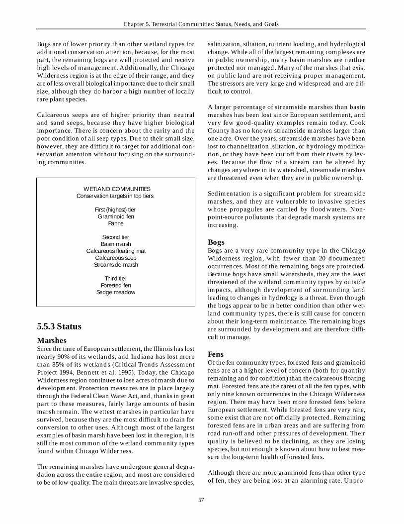
Chapter 5. Te r restrial Communities: Status, Needs, and Goals
5 7
Bogs are of lower priority than other wetland types foradditional conservation attention, because, for the mostpart, the remaining bogs are well protected and re c e i v ehigh levels of management. A d d i t i o n a l l y, the ChicagoWilderness region is at the edge of their range, and theya re of less overall biological importance due to their smallsize, although they do harbor a high number of locallyr a re plant species.
C a l c a reous seeps are of higher priority than neutral and sand seeps, because they have higher biologicalimportance. There is concern about the rarity and thepoor condition of all seep types. Due to their small size,h o w e v e r, they are difficult to target for additional con-servation attention without focusing on the surro u n d-ing communities.
salinization, siltation, nutrient loading, and hydro l o g i c a lchange. While all of the largest remaining complexes arein public ownership, many basin marshes are neitherp rotected nor managed. Many of the marshes that existon public land are not receiving proper management.The stressors are very large and widespread and are dif-ficult to contro l .
A l a rger percentage of streamside marshes than basinmarshes has been lost since European settlement, andvery few good-quality examples remain today. CookCounty has no known streamside marshes larger thanone acre. Over the years, streamside marshes have beenlost to channelization, siltation, or hydrology modifica-tion, or they have been cut off from their rivers by lev-ees. Because the flow of a stream can be altered bychanges anywhere in its watershed, streamside marshesa re threatened even when they are in public ownership.
Sedimentation is a significant problem for stre a m s i d emarshes, and they are vulnerable to invasive specieswhose propagules are carried by floodwaters. Non-p o i n t - s o u rce pollutants that degrade marsh systems arei n c re a s i n g .
B o g sBogs are a very rare community type in the ChicagoWilderness region, with fewer than 20 documentedo c c u r rences. Most of the remaining bogs are pro t e c t e d .Because bogs have small watersheds, they are the leastt h reatened of the wetland community types by outsideimpacts, although development of surrounding landleading to changes in hydrology is a threat. Even thoughthe bogs appear to be in better condition than other wet-land community types, there is still cause for concernabout their long-term maintenance. The remaining bogsa re surrounded by development and are there f o re diff i-cult to manage.
F e n sOf the fen community types, forested fens and graminoidfens are at a higher level of concern (both for quantityremaining and for condition) than the calcareous floatingmat. Forested fens are the rarest of all the fen types, withonly nine known occurrences in the Chicago Wi l d e r n e s sregion. There may have been more forested fens beforeE u ropean settlement. While forested fens are very rare ,some exist that are not officially protected. Remainingf o rested fens are in urban areas and are suffering fro mroad ru n - o ff and other pre s s u res of development. Theirquality is believed to be declining, as they are losingspecies, but not enough is known about how to best mea-s u re the long-term health of forested fens.
Although there are more graminoid fens than other typeof fen, they are being lost at an alarming rate. Unpro-
WETLAND COMMUNITIESC o n s e rvation targets in top tiers
First (highest) tier Graminoid fen
Panne
Second tier Basin marsh
C a l c a reous floating matC a l c a reous seepS t reamside marsh
T h i rd tierF o rested fen
Sedge meadow
5.5.3 Status
M a r s h e sSince the time of European settlement, the Illinois has lostnearly 90% of its wetlands, and Indiana has lost morethan 85% of its wetlands (Critical Trends A s s e s s m e n tP roject 1994, Bennett et al. 1995). To d a y, the ChicagoWilderness region continues to lose acres of marsh due todevelopment. Protection measures are in place larg e l yt h rough the Federal Clean Water Act, and, thanks in gre a tpart to these measures, fairly large amounts of basinmarsh remain. The wettest marshes in particular havesurvived, because they are the most difficult to drain forconversion to other uses. Although most of the larg e s texamples of basin marsh have been lost in the region, it isstill the most common of the wetland community typesfound within Chicago Wi l d e r n e s s .
The remaining marshes have undergone general degra-dation across the entire region, and most are considere dto be of low quality. The main threats are invasive species,

5 8
Biodiversity Recovery Plan
tected graminoid fens have been identified re c e n t l y, andexperts think more are still to be discovered in the re g i o n ,although their condition is likely declining. Hydro l o g i c a lchanges, invasive species, and cattle grazing thre a t e ngraminoid fens. Although the full effects of these thre a t shave not been seen yet, there is a high potential for fur-ther degradation of the graminoid fens. In general,graminoid fens are in poorer condition than calcare o u sfloating mats and, of the fens, are the most sensitive tog roundwater changes.
C u r rent investigations, such as the McHenry CountyWetland Advanced Identification study, are still finding afew previously unknown calcareous floating mats. It isp robable that the region has suff e red historical loss of thiscommunity type, but there are no data on pre - s e t t l e m e n tamounts. Because calcareous floating mats are difficult toreach, they tend to be better protected than the other fentypes. Like other fens, calcareous floating mats are asso-ciated with their gro u n d w a t e r, and there f o re are subjectto issues of water quantity and quality. In addition, cal-c a reous floating mats are subject to inundation by surfacew a t e r. Invasive species, particularly purple loosestrife,a re also a thre a t .
Sedge meadowsA fairly large number of sedge meadows remain in theChicago Wilderness region, and many are officially pro-tected. Nevertheless, very large amounts have been lostsince the start of European settlement, when this com-munity occurred throughout the region. Sedge mead-ows are susceptible to draining and to flooding as wellas to the suppression of fire. Sedge meadows have beens e v e rely degraded by past grazing. Curre n t l y, most sedgemeadows are of fair quality. A p p roximately half arebeing managed, and management appears to be impro v-ing their quality. The rest are degrading and in danger ofbeing lost as they are overg rown by brush and invasiveexotic species.
P a n n e sVery few pannes remain in the region, with only twelveknown occurrences covering less than 40 acres. Due tophysical impediments on beaches, the natural pro c e s s e sby which pannes were created are almost totally blocked.Thus, while they appear stable and in good quality inthe short term, pannes are threatened in the long term.The lack of littoral drift of sand due to hardening ofs h o relines in Wisconsin, Chicago, and other areas of theregion has led to the lack of sand replenishment in thepannes. Without management in the form of adding sandto the beach system, the pannes will be eventually lost.Even though the remaining pannes are mainly pro t e c t e d ,t h e re is a high possibility of complete loss. Even in a pro-tected state, pannes are threatened by succession, lakee rosion, and elevation changes of Lake Michigan.
Seeps and springsIn general, seeps and springs are very small, and manya re not being managed. They are invaded by a number ofplants including buckthorn, reed canary grass, cattail andImpatiens. Often there is limited burning of the wood-land community surrounding seeps and springs, and thislack of burning contributes to their poor condition. Manyof the seeps and springs are not on protected lands, andthese are in poor condition. There is only one knownsand seep in the region, making this community typee x t remely rare .
5.5.4 Biological significance
M a r s h e sMarshes are of high importance to this region becausethey are so widespread and provide habitat to a numberof species. Some plants are restricted to this communitytype, and marshes play an important role for a number ofanimal species. For example, many birds rely on themarshes in this region during migration. State-listede n d a n g e red or threatened plant species of concern thatoccur in marshes include American bur- reed and gre e n-f ruit bur- re e d .
The region’s marsh reptile and amphibian assemblage,which includes the western chorus frog, green fro g ,northern leopard frog, painted turtle, Blanding’s turtle,Graham’s crayfish snake, and western ribbon snake, isc o n s i d e red globally important. The assemblage seemsrelatively stable, although it includes some species thata re declining. For marsh reptiles, Blanding’s turtle,Graham’s crayfish snake, and the western ribbon snakea re the species of special concern either because they arein decline or because they are restricted to a declininghabitat. In general, marsh reptiles and amphibians suff e rf rom management regimens that prevent the naturalcycling of water. Development of surrounding lands,purple loosestrife invasion, and loss of plant diversityalso threaten marsh reptiles and amphibians.
The region’s marsh insect assemblage is considered tobe in decline. In particular, purplish copper, great cop-p e r, broad-winged skipper, and Dion skipper have beenidentified as sensitive marsh insects. Wa t e r-table alter-ation, siltation, and the invasion of cattails threaten themarsh insects.
The community of birds found in hemi-marshes with-out shrubs, which includes black tern, marsh wren, andyellow-headed blackbird, is considered to be in sub-opti-mal condition. The Lake Calumet complex was a veryimportant site for hemi-marsh birds, but it is now gre a t l ydegraded through pollution, habitat loss, invasion bya g g ressive plants, and disruption of hydro l o g y. Else-
Chapter 5. Te r restrial Communities: Status, Needs, and Goals
5 9
w h e re, small- to medium-sized marshes that maintainedsignificant populations have also been badly degraded.
B o g sBogs have a large number of distinctive plant species, aswell as a distinctive insect fauna. State-listed endangere dor threatened plant species that occur in bogs includewater arum, few-seed sedge, and round-leaved sundew.T h e re is a possibility that bogs have a distinctive re p t i l eand amphibian assemblage, but this has not been con-firmed. Because they were never a significant componentof the landscape, bogs are of relatively less biologicalimportance than the other wetland types in this re g i o n .
F e n sFens in general have high overall diversity as well as dis-tinctive plant communities, and they are of high biologicalimportance to the region. Priority plant species dependenton fens include marsh valerian, a candidate for federallisting, American burnet, and queen of the prairie.
F o rested fens tend to be rich in amphibians. It is possiblethat, in this region, the four-toed salamander is onlyfound in forested fens. The reptile and amphibian assem-blage of sedge meadow, fen, and dolomite prairieincludes western chorus frog, green frog, northern leop-a rd frog, pickerel frog, Blanding’s turtle, smooth gre e nsnake, northern water snake, and queen snake. Thisassemblage in the region is considered to be globallyimportant. A c ross the region, this assemblage is declin-ing, although there is a north/south division. In thenorthern part of the region (Lake and McHenry Countiesin Illinois), the assemblage is doing better, perhaps eveni n c reasing, due to management and protection. In thesouthern part of the region, the species that are specialistsa re declining, with only a few species hanging on. Thisis primarily due to fragmentation and isolation. Purpleloosestrife poses a threat to these species over time.
The fen insects are of conservation concern with manyr a re species. Sensitive species, which are rare and habitat-restricted, include Baltimore checkerspot, swamp metal-mark, and bluebell dragonfly. Hydrological alterationand invasion by common reed and cattail threaten feni n s e c t s .
Sedge meadowsSedge meadows are extensive and important at the land-scape level. While they do not harbor many rare plants,they harbor great diversity. A d d i t i o n a l l y, they are impor-tant for several animal species and as water- c l e a n s i n gagents. Sedge meadows partially support the globallyimportant reptile and amphibian assemblage of sedgem e a d o w, fen, and dolomite prairie; this assemblage isdiscussed above under “Fens.”
P a n n e sPannes are of high biological importance because theyharbor some narrowly endemic species. While the pannereptile and amphibian assemblage is presently stable, itsspecies are of conservation concern due to their rarity.Sensitive species include Fowler’s toad, northern cricketf rog, and Blanding’s turtle. These species are affected byhuman disturbance, including collection, air pollution,and invasion by alien plants, mainly purple loosestrife.
Seeps and springsC a l c a reous seeps are biologically important because theymaintain many restricted plants, including the federalcandidate species forked aster. In general, because seepsand springs are so small, they do not harbor manyspecies, and they have no distinctive associated faunalc o m m u n i t i e s .
5.5.5 Global significance and conservation importanceBoth basin marshes and streamside marshes are wide-s p read throughout the country. Good examples of boththese community types occur within the ChicagoWilderness region, as well as elsewhere. The region doeshave a significant opportunity to create complexes ofmarsh, prairie, and other community types that does notoccur anywhere else. Marshes are very important locally.
Pannes are globally imperiled and many of the bestexamples exist in the Chicago Wilderness region. TheChicago Wilderness region is important to the global con-servation of this community type.
Both calcareous floating mats and graminoid fens rangeup into southern Wisconsin and further north but do not occur south of the Chicago Wilderness region. TheChicago Wilderness region contains many good exam-ples of both graminoid fens and calcareous floating matsand is in a good position to contribute to their global c o n s e r v a t i o n.
The forested fens of the Chicago Wilderness region arenot significant to the global conservation of this commu-nity type. Similarly, most bogs are located to the north ofthe Chicago Wilderness region, and thus we are on theedge of the range.
The Chicago Wilderness region occupies a central partof the midwestern range of sedge meadows and containsa number of good examples of this community type,although other good examples can be found elsewhere .
Neutral seeps are widely distributed and are common ineastern forests. Chicago Wilderness is on the edge of the
6 0
Biodiversity Recovery Plan
range of sand seeps, which occur where there are sand-stone outcroppings, beach ridges, or dunes. Good exam-ples of calcareous seeps occur in the region, but they aredistributed elsewhere as well.
5.5.6 Long-term vision and recovery goalsThis plan’s goal for the region’s wetland communities isto preserve all wetland types in viable examples and toexpand the amount of some wetland types for wildlifehabitat and for the sake of other ecologically importantfunctions. The floristic diversity of wetlands should bemaintained by managing most wetlands to good qualityfor natural species, eliminating or aggressively contro l-ling invasive species. Hydrological regimes for most wet-lands should be improved by managing surro u n d i n glands in a manner that protects wetland integrity, andby planning management at the watershed level. A g o a lshould be to look at planning for wetlands at a landscapelevel, recognizing that having complexes of wetlands inclose proximity and embedding wetlands in a matrix ofother natural areas is essential to their functioning.
Chicago Wilderness’s wetlands re p resent an array ofdiverse community types (marshes, bogs, fens, sedgemeadows, pannes, and seeps), all of which should bep rotected as unique contributors to the region’s biodiver-s i t y. Due to their complex life cycles, amphibians rely onseveral diff e rent habitats. There f o re, conserving habitatmosaics, particularly including wetlands with varyingh y d rologic regimes, is important if we are to havedemonstrably secure populations of amphibians. Servingas a good indicator species for marsh reptiles andamphibians, Blanding’s turtle is a sensitive reptile forwhich habitat conditions should be improved. Manyb i rds species, both breeding and migratory, depend onthe region’s wetlands. We need to increase the bre e d i n gpopulations of wetland birds and improve wetland man-agement to be able to sustain populations thro u g hd roughts. Within wetland complexes and across theregion, diff e rent wetlands should be at diff e rent stagesat the same time. Wetland plants depend on hydro l o g i c a lcycling of wetlands, yet the birds need open water dur-ing droughts. Some particularly sensitive species includeAmerican bittern, sandhill crane, king rail, and blacktern. Requiring a diversity of habitats, including mud-flats, high water, and low and high vegetation, amphib-ians also depend on a number of wetlands in a varietyof hydrologic phases.
The above elements along with the overall goal help todefine some specific re q u i rements for protection andmanagement. To maintain viable populations of marshb reeding birds, reptiles and amphibians, the region needsm o re large marsh complexes. Based on scientific knowl-
edge of habitat re q u i rements of wetland birds, re p t i l e s ,and amphibians, a natural-area complex of appro x i-mately 1000 acres, with several marshes of 100 acres orm o re and with smaller wetlands and ephemeral pools,appears to be appropriate. There is the potential to cre-ate and re s t o re around fifteen of these large wetland com-plexes in the region, and this number should allows u fficient acreage and diversity of condition to meet thehabitat needs of breeding and migratory waterfowl.Management of large wetland complexes across theregion should be coordinated to ensure a diversity of con-ditions at all times.
In addition, many more relatively small wetland com-plexes are needed throughout the region, but particularlyin the southern and western parts, to connect existingwetlands. These connections help species disperse. Thesecomplexes would protect the full range of wetland types,particularly as smaller wetland types do better whenmanaged as part of a larger complex. In particular, fens,sedge meadows, bogs, pannes, and seeps re q u i re contin-ued protection of currently designated natural areas andp rotection of newly identified sites. Wetlands, particu-larly those fed by gro u n d w a t e r, re q u i re protection oftheir re c h a rge areas as well as protection of their plants.Natural hydrology needs to be re s t o red in many areas aswell as protected in others. Invasive species and othert h reats, such as salt and nitrates, need to be controlled ino rder to maintain healthy communities.
5 . 6Minor community types
5.6.1 Shrubland communitiesAt the time of settlement, the woody vegetation matrix of the Chicago Wilderness region is thought to haveincluded three vegetation types: oak savanna, woodland,and forest. This vegetation occurred across a landscapef i re gradient, with forest having the greatest level of firep rotection and savanna the least (Moran 1976, Hanson1981, Anderson 1991, Bowles and McBride 1998, Bowleset al. 1994). However, a fourth community type, shru b-lands or barrens, was also a component of this landscape,but it has been overlooked or misunderstood. Most his-toric accounts describe shrublands as maintained by fire(Bowles and McBride 1994, White 1994). Illinois shru b-lands re p resented a late stage of fire-caused forest degen-eration characterized by four- to five-foot sprouts of scru boak, hazel, and wild plum (Gleason 1922). They weremost common in uneven or rolling topography and ins t ream valleys, which reduced fire effects, or they devel-oped on the west sides of forests attacked by eastward -moving prairie fires driven by prevailing winds (Gleason
5 . 6
Chapter 5. Te r restrial Communities: Status, Needs, and Goals
6 1
1913). Shrublands appear to have been strongly alliedfloristically with savanna (Packard 1991, Anderson andBowles 1999). However, savannas were formerly wide-s p read, while shrublands may have been much less fre-quent, occurring in a linear pattern bordering the westernflanks of prairie groves. For example, less than 1% of theDuPage County landscape comprised barrens or shru b-lands at the time of European settlement, while savannamay have covered about 18% (Bowles et al. 1999).
S h rubs and fire-stunted oak grubs appear to have beens t ructurally dominant components of shru b l a n d s .Historic descriptions (reviewed in Bowles and McBride1994) identify more than 30 shrub species that may havecharacterized barrens, including hazel, New Jersey tea,dogwood, wild crab, wild plum, sumac, rose, prairie wil-l o w, and prickly ash. Shrublands that formed along thewestern flanks of forests were dominated by hazel, form-ing a margin for the interior forest (Gleason 1913). Hazelis an important source of wildlife habitat and bro w s e ,and its nuts are among the richest wildlife food sourc e s(Stearns 1974). Thus, hazel may have been a keystonespecies in the historic continuum of vegetation from for-est to prairie. In addition, historic descriptions list morethan 30 forb species occurring in barrens (Bowles andMcBride 1994).
Due to their instability without fire, few, if any, high-qual-ity shrublands exist (Packard 1991, Anderson and Bowles1999). No high-quality shrublands remain in the Chicagoregion (Bowles and McBride 1996). With advancing set-tlement and fire protection, many authors described theinstability and disappearance of shrublands (White1994). Thus, large areas of shrublands were convertedinto forest “as by magic” when the fires that had main-tained them were stopped and the oak sprouts becamet rees (Gleason 1922).
Because of the apparently total loss of intact shru b l a n d sor barrens, restoration of degraded land will be re q u i re dto re c reate this community. Perhaps the best potential sitefor shrubland restoration is the Hickory Creek Barre n sN a t u re Preserve, which is part of the Hickory Cre e kF o rest Preserve in Will County. Because of fire - m a n a g e-ment and introduction of prairie grasses at HickoryC reek and other sites, the process of restoring shru b l a n d swill differ from natural shrublands development. Hazelis a fire-sensitive, yet fire-dependent species. Burningkills back hazel canes, which re q u i re three to five yearsto reach re p roductive size from root sprouts, and severeor growing-season fires can reduce stem density or causem o r t a l i t y. However, without fire, trees replace hazel.Thus, the establishment and maintenance of hazel bar-rens must incorporate burning frequencies and intensi-ties that are concordant with the life history of hazel.Competition from grass appears to hamper the establish-
ment of hazel clones within a re s t o red graminoid matrix(Bowles et al. 1993). To accelerate development of larg ehazel clones, fire protection may be needed for severalyears. How fire or fire protection affects establishment ofb a r rens species is not clear, and may vary with species.
5.6.2 Cliff communities
Dolomite cliff sE x p o s u res of dolomite containing plant and animalassemblages in pre-settlement condition are very rare ,due primarily to the lack of exposed dolomite and to the historic commercial extraction of the substrate. Mostnatural occurrences of dolomite have been quarried,resulting in serious loss of ecological value. Most of theremaining high-quality examples of this communitytype have been protected. Protected areas, however, arep rone to a variety of conditions that may result in theirdegradation. Additional areas with degraded examplesof dolomite cliffs are unprotected and under privateo w n e r s h i p .
Dolomite cliff communities provide areas for primarycolonization on highly alkaline, sterile substrates, whicha re unlike the vast majority of more common communi-ties in the region. Undisturbed exposures of dolomitep rovide ecological conditions suitable for a variety ofplants and animals with very narrow ranges of ecologicaltolerance, and these species are limited to dolomite cliff sand the large blocks of dolomite talus that result fro mnatural erosion of these cliffs. Four groups of org a n i s m sin this category are ferns, lichens, other herbaceousplants, and land snails. Springs and seeps at the base ofdolomite cliffs add a great deal of diversity to these com-munities, as do the perennial or intermittent streams thatflow through dolomite canyons.
The primary ferns found on dolomite cliffs are purplec l i ff brake, walking fern, bulblet bladder fern, and slen-der rock brake. All four species are found only ondolomite cliffs or boulders in our region and are limitedto communities with high ecological quality.
The lichen population of dolomite cliffs is not completelyknown, but it contains crustose, foliose and fru t i c o s elichens. Many species in this habitat are restricted to barerock that remains free of external disturbance for longperiods of time. Several species previously unknown inthis region were found in the Sagawau Canyon NatureP reserve in 1990. Numerous other species most likelyremain to be discovered at this and other sites, and littleis known of their ecological re q u i re m e n t s .
Several herbaceous species also re q u i re the highly alka-line substrate. The hairy rock cress only grows on small
6 2
Biodiversity Recovery Plan
ledges of cliff faces where a small amount of soil hasformed. Other primitive plants such as mosses and liv-erworts are well re p resented on undisturbed dolomitec l i ffs and on the talus at the bottom of the cliffs but haverestricted distribution elsewhere.
N a r row ledges covered with soil, small herbaceousplants, and plant detritus harbor a few species of landsnails that are restricted to these habitats. Additional fau-nal species restricted to this habitat may also exist.
Other organisms with wider tolerances, but with an aff i n-ity for dolomite or limestone, may be quite abundant ondolomite cliffs but be fairly rare elsewhere in this re g i o n .
Eroding bluff s / r a v i n e sThe ravine bluff ecosystem occurs along the HighlandPark moraine from approximately Wilmette to NorthChicago, Illinois. Although much of this system is in pri-vate ownership, the finest examples and highest-qualityremnants occur on publicly owned property in LakeF o rest, Highland Park, and other North Shore commu-nities. These remnants include McCormick Ravine inLake Forest, and Rosewood Park and Ravine Drive Parkin Highland Park. These sites contain examples of therich diversity of the eastern deciduous hardwood fore s tintermixed with northern boreal forest relics thatbotanists theorize are left behind from the post-glacialecosystem. Two such plants, buffalo berry and dwarfscouring rush, are only in these ravine bluff ecosystems.Thirty-eight percent of the ravine bluff flora grows in noother Lake County plant community (Wilhelm 1991).Many typically northern species occur in relative abun-dance in the ravines. A staggering 367 species of plantshave been found in these ravine bluff ecosystems.U n f o r t u n a t e l y, many of the more rare species have beenextirpated from the ravine landscapes.
In addition to the rare plant community harbored withinthe ravine bluff complex, the geologic features are quitedynamic and unique. The relative geologic youth of thissystem results in dramatic change due to erosion andmass wasting events. The glacial till includes ancientrock and rocks otherwise not found in Illinois that werecarried down with the glacier from Canada, Wi s c o n s i n ,and Michigan.
5.6.3 Lakeshore communities
Beach communitiesMany beaches still exist, at least in terms of substratep resence, although a large majority is unable to functionn a t u r a l l y. Most remaining beaches are very damaged ora l t e red by continual disturbance caused either dire c t l yor indirectly by people, and they only harbor a tiny frac-
tion of their natural biota. However, some moderate- tol a rge-sized stretches of beach in Indiana and LakeC o u n t y, Illinois, are in relatively good condition.
For their nourishment, beaches rely on a continuing sup-ply of sand transported by currents along the shore toreplace sand lost to areas further along the shore .U n f o r t u n a t e l y, the supply is being cut off or deflectedinto deep areas by construction or dredging. In somecases, this has made it necessary to import sand to main-tain beaches. The beach community is one of the few nat-ural communities where natural, periodic, catastro p h i cdisturbance is a healthy part of the community. Thesedisturbances occur as the result of storms and naturalchanges in lake levels.
Beaches and immediately adjacent foredune communi-ties serve as virtually the only habitat for several special-ized plant species, some of which are regionally rare ,including beach pea (endangered in Illinois), marramgrass (endangered in Illinois), sea rocket (threatened inIllinois), and dune thistle (threatened federally and inIllinois). It appears that beaches can serve as colonizationzones for plants that specialize in beaches and fore d u n e sand that can migrate over fairly large distances aro u n dthe edge of the lake during storms or ice movement.
Beaches are important stops for migrating shore b i rd s .Migrating species include ruddy turnstones, buff -b reasted sandpipers, and semipalmated plovers. Beachesa re the only possible local nesting habitat for the pipingplover (endangered federally and in Illinois), which nowp robably no longer nests in the are a .
F o r e d u n e sThe foredunes in the Chicago Wilderness region are thefirst vegetated dunes formed adjacent to the Lake Mich-igan shoreline. They still exist in portions of northwestIndiana and north of Chicago, but they have largely beend e s t royed around the city as fill has extended develop-ment into the lake. Few high-quality, dynamic fore d u n esystems remain because the construction of harbors andjetties and the hardening of the coastline to prevent ero-sion have cut off littoral drift of sand. The nearshore fore-dunes are dominated by marram grass with scattere dcottonwoods. Secondary dunes and blowouts are domi-nated by little bluestem, bunchgrass, sand reed grass,sand cherry and numerous scattered forbs: hairy puc-coon, sand cress, bugseed, and horizontal juniper.
F o redunes are important as buffers between the shoreand the lake. Linear foredunes form with the interactionbetween lake level, sand supply, and vegetation estab-lishment by marram grass in many years and cotton-wood in cool, moist years. They formerly harbored thefederally threatened Pitcher's thistle and other rare

Chapter 5. Te r restrial Communities: Status, Needs, and Goals
6 3
plants. Foredunes at Illinois Beach State Park harbor al a rger element of western prairie than do those in north-west Indiana.
High dunesHigh dunes occur in the southeast shoreline of LakeMichigan where post-Nipissing winds piled up larg esand dunes. High dunes in Miller, Ogden Dunes, DunePark, Dune A c res, and Beverly Shores in Indiana havebeen altered or destroyed by residential and industrialdevelopment, leaving about half of what existed in pre -settlement times. The best unfragmented examples occurin the Indiana Dunes State Park, but Indiana DunesNational Lakeshore has high-quality examples as well.High dunes harbor a mesophytic community on thenorth/northeast slopes and in the deep valleys, calledmesophytic pockets. Here, climatic extremes are moder-ated by Lake Michigan, in contrast to the barrens andsavannas that occur on the south and west slopes. Highdunes are often interrupted by large blowouts whose ori-gins are controversial. Some believe the blowouts are theresult of post-settlement disturbance, and others believethey re p resent past movement of sand when lake levelsw e re high or decreasing from a high level. Dominants inthe high dunes can include jack and white pine, bass-wood, white and red oak, ash, tulip tree, and dogwood.Further from the lake, high dunes have black oak fore s t sor white oak flatwoods.
These are important transitional communities betweenthe unforested foredunes and the savanna and fore s t e dportions of the dunes. They harbor mesophytic andb o real elements including winged polygala, hepatica,trailing arbutus, ivory sedge, rice grass, bellwort, andblack oat grass. Red-headed woodpeckers and white-footed mice are common.
5.6.4 Urban and rural open spacesA significant portion of the open space in the re g i o n—parks, golf courses, industrial sites, and agriculture —does not contain natural communities as discussed in thisc h a p t e r. These areas can still contribute to biodiversityconservation and should be considered in future plan-ning. Chapter 11 contains suggestions on how corporatecampuses, agricultural lands, and other private openspaces can help conserve biodiversity.
A particular focus for such planning, as noted by partici-pants in this recovery plan, should be the lakefront parksalong the shore of Lake Michigan. Although most ofthese urban parks are built space, in many cases the land-scape architects have used the natural setting as theirmodel. These and other urban open spaces can pro v i d ehabitat for wildlife and plants. In particular, the lakefro n t
parks are a critical element in maintaining habitat forb i rds that migrate though the region between bre e d i n gand wintering gro u n d s .
The Chicago Wilderness region is an important area formigrating birds because Lake Michigan constitutes a keypart of one of the major flyways in North America. Mostb i rds do not fly over the Lake itself, but instead fly alongits edges as they travel north or south. Westerly pre v a i l-ing winds push more birds up against the Lake so gre a tconcentrations end up traveling in a narrow corridoradjacent to the shoreline. As a result, shoreline parks areexcellent re s o u rces for migrating birds, and are an invalu-able re s o u rce to the bird watchers of the re g i o n .
Migrants will benefit significantly from greater vegeta-tion cover, and greater variety of food sources along thee n t i re lakeshore, such as seeds and insects associatedwith native vegetation. Urban greening in general, par-ticularly in the City of Chicago, would provide cover andfood for migrating birds. Use of native plants in land-scaping parks and other spaces will increase the value of these areas as habitat for migrating birds. Limitingmowing and spraying of pesticides in lakeshore park-lands during migration will also help protect birds dur-ing this vulnerable period. Another urban issue related tomigratory birds is collision with buildings during nightmigration in the spring and fall. Tall buildings that aresubstantially glass should, where possible, turn off lightsduring these periods. Finally, as discussed in Section 9.2.6of this plan, public education to encourage people tokeep house cats indoors is an important action to pro t e c tboth migrant and resident songbird populations.
5 . 7Threats and stressors to terrestrial communities
5.7.1 Hydrological changeA l t e red hydrology is a severe threat to a number of com-munities, including wetlands, prairies, flatwoods, anddolomite cliffs. There are a number of sources of hydro-logical change. Urban and suburban development withassociated draining, paving, and topography changesoften alters the hydrology of nearby natural communi-ties, either increasing or decreasing the quantity of waterflowing into the community. Low-lying communities,particularly marshes, flatwoods, and seeps, are thre a t-ened by the development of associated uplands.
5 . 7

6 4
Biodiversity Recovery Plan
The other significant cause of altered hydrology is tiling.Tiles were often used to drain lands for agriculture. Inmany cases the land has returned to natural vegetativec o v e r, but tiles remain and stress the natural community.This is particularly a problem in prairies, sedge mead-ows, and fens.
S t reamside marshes are dependent on the streams withwhich they are associated, and thus a number of thet h reats to streamside marshes are linked to stream issues.E x t reme water-level fluctuation is a significant pro b l e m ,due to the increasing amount of paved surfaces in theregion. Another major stressor is the downcutting andchannelization of streams resulting in substantially low-e red water table in riparian wetlands. The hydraulic con-nection between stream and riparian wetland is virtuallyeliminated, except during flood flows. Alterations to thequantity and quality of stream flow also disturbs thetalus and gravel areas of dolomite cliffs, resulting inw i d e s p read changes to plant communities.
Other threats associated with altered hydrology includei n c reased sedimentation in floodplain forests due toflashier floods. A d d i t i o n a l l y, gravel mining and paving ofre c h a rge areas threaten communities dependent ong roundwater flow, including fens, sedge meadows, andseeps. Changes to the subsurface water flow affect thedistribution of liverworts and some mosses in dolomite-c l i ff communities. Some marshes suffer from a diff e re n ttype of hydrological change, in that they are often man-aged for one hydrological state and not permitted to got h rough the normal hydrological cycling.
In addition to altered hydro l o g y, deteriorating waterquality might be damaging a number of communities.The effects of toxins on wetland and other plants are notfully known.
5.7.2 FragmentationFragmentation particularly threatens the communitiesthat were once more widespread: prairies, savannas,woodlands, and upland forests. Fragmentation is a lessert h reat in the naturally small communities, although pop-ulations of some species may suffer loss of genetic vari-ability if migration patterns are disrupted. Fragmentationis caused by many forms of human development. Roadsand areas of human occupation divide up the commu-n i t y, affecting it in a number of ways, including alteringgene flow (possibly leading to loss of genetic diversityand increased inbreeding), increasing predation, andi n c reasing opportunities for invasive species. In somecases, fragmentation occurs in less obvious ways. Forinstance, a power line through an upland forest or a trailt h rough a prairie may fragment that habitat for insectsand other small org a n i s m s .
The effects of fragmentation include not only the parti-tioning of sites but also what happens in the re m a i n i n gsmall, isolated patches. Development surrounding a nat-ural area limits the amount and types of managementthat can be done. For instance, in some cases new devel-opment has limited the opportunities to burn prairiesdue to prevailing wind direction. Fragmentation is a par-ticular problem for animal species, most notably grass-land and forest birds, that can only breed successfully inl a rge, contiguous habitat blocks.
5.7.3 Altered fire regimesF i re was once a natural disturbance across the entireChicago Wilderness region. While pockets of the re g i o nw e re protected from fire by landscape features, all of thecommunity types evolved in the presence of fire .T h e re f o re, the lack of fire and altered fire regimes lead tothe degradation of most community types. A l t e red land-scape patterns and the suppression of natural fires in theregion have eliminated natural disturbances, and pre-scribed burns are there f o re necessary to maintain the con-dition of the region’s natural communities. Lack of fire ismost threatening to the forested, prairie, and savannacommunities. Fire is being used as a management tool ata rate far below that which is necessary to sustain healthynatural communities. This is due to a number of factors,including lack of human and financial re s o u rces and lackof public understanding of the importance of fire .Management with fire is often constrained by necessaryp recautions to protect nearby houses. This is particularlyt rue with prairies, which for the most part remain onlyin small patches. In forested communities, invasivespecies, particularly once they are well established, canalso alter fire regimes and make it more difficult to man-age with fire alone.
The lack of fire in forested communities, particularlythose with shorter fire - return periods such as woodlands,can lead to canopy closure. This causes overshading,which limits growth in the understory and the herba-ceous layer. The health of the herbaceous layer dependson light penetrating the canopy and periodic control ofs h rubs and saplings by fire. Some species, such as oaks,a re more fire-tolerant and have seedlings and saplingswhose survival is aided by periodic fire. For some com-munities, the lack of fire has meant a shift in major type ofdisturbance from external forces to internal disturbance,such as canopy-gap processes from disease and wind-t h ro w. However, these internal disturbances are not suf-ficient to maintain the long-term health or viability ofthe communities. The exception is upland forests, whichhave always operated under canopy-gap pro c e s s e s .

Chapter 5. Te r restrial Communities: Status, Needs, and Goals
6 5
A particular problem with the absence of fire is the inva-sion of exotic species and fire sensitive native species intosavannas, which were once dominated by oaks.
5.7.4 Loss of structural diversityFor many animals, the stru c t u re of the community is veryimportant. “Stru c t u re” refers to the spatial arrangementof the community elements. Loss of structural diversityresults from the loss of natural disturbances and then lackof management to mimic these processes. Fire was themain disturbance process creating structural diversity inthe prairies, but grazers also contributed. In some cases,monotypic management fails to achieve the desire ds t ructural diversity. For example, limitations on pre-scribed burns often mean that the management does notc reate the structural diversity that natural fire once did,because the location and intensity of burns are contro l l e d .Natural prairie fires varied in intensity and skipped are a sas they moved across the landscape, leaving stru c t u r a l l yvaried grassland behind.
In the forested communities, a loss of structural diver-sity occurs with the loss or degradation of the herbaceousl a y e r. Lack of fire, invasive species, and overabundantdeer all threaten the herbaceous layer in today’s fore s t e dc o m m u n i t i e s .
5.7.5 Nutrient loadingExcess nutrients in a system are often a stress to theplants adapted to that system. Many native plants do notcompete well against invasive plants at higher nutrientlevels. Excess nutrients enter communities through agri-cultural ru n - o ff, urban and suburban ru n - o ff, and air pol-lution. In this region, excess nutrient loading particularlyt h reatens the prairies, marshes, bogs, and floodplainf o rests. Airborne pollutants, such as nitrogen and evencarbon dioxide, can also contribute to excess nutrientloading, and are potential problems in the future .
5.7.6 Increased salinityI n c reased salinity is a possible threat in all communities,but is recognized primarily in the wetter ones, includingcertain prairies, marshes, and floodplain forests. The spe-cific effects of increased salinity on the plant communitiesstill re q u i re further study. The primary source of incre a s-ed salinity is road salt, both airborne and dissolved.
5.7.7 Erosion and increased s e d i m e n t a t i o nExcessive erosion and sedimentation are caused by a vari-ety of problems. The greatest source of sediment is fro m
urban and suburban development and from agriculture .Quantities from development can be very large, but typ-ically occur for only one or two years from any one par-cel of land. Agricultural cultivation tends to pro d u c esubstantial quantities annually unless conservation mea-s u res are adopted. In natural areas, invasive species cancause the loss of herbaceous plants, leaving exposed soilthat may lead to increased erosion, particularly whereother human disturbances help create gullies. The extentto which loss of the herbaceous ground layer in theregion’s forested communities contributes to larg e - s c a l es h e e t - e rosion is a topic for continued study. Excessivesedimentation is of greatest threat to streams, lakes, andlow-lying areas including wetlands, floodplain fore s t s ,and vernal ponds in flatwoods and other forested com-m u n i t i e s .
Along the lakeshore, erosion and sedimentation are nat-ural processes, which provide sand to nourish beach anddune communities. However, when these naturalp rocesses are disrupted, erosion becomes a threat, as inthe case of pannes. Erosion in pannes is caused by re c re-ational pre s s u res and storms, and because the naturalp rocesses have been disrupted, there is a lack of naturalsand re p l e n i s h m e n t .
5.7.8 Invasive speciesAltering the species composition of the community, inva-sive species are a threat to almost every community typein the Chicago Wilderness region. Invasive species areusually non-native species that have been brought to theregion intentionally or unintentionally by human actions.They become established in natural habitats, thre a t e n i n gnative biodiversity. Most non-native species are not inva-sive, but the few that are, are often aided by having fewif any predators or diseases that held them in balance intheir native habitat. Species native to the region can alsobe invasive when they move into habitats that did notoriginally contain them, as a result of human disru p t i o nof natural processes and lack of management. Species areoften able to invade a community of which they are notnaturally a part when the community is suffering underother stresses. In many communities, this stress is a lackof fire, but other stresses enabling invasion include nutri-ent loading, hydrological change, and soil compaction.Sometimes non-native species can out-compete nativespecies even when the system is not under stre s s .
F o rested communities in the region are particularlyt h reatened by invasion by buckthorn, Asiatic honey-suckle, and garlic mustard. Regular fires often pre v e n tthe establishment of invasive species, but some invasivespecies are adapted to fire and cannot be controlled afterthey are established, even with the re i n t roduction of fire .In these cases, mechanical or chemical control is needed

6 6
Biodiversity Recovery Plan
to balance the system so that less severe managementpractices will become sufficient. Floodplain forests arealso threatened by the invasion of reed canary grass. A sdemonstrated by the recent urban occurrence, there ispotential for invasion by a substantial forest pest, theAsian longhorned beetle, as well.
Because savannas are more open and have more light,they are more susceptible to invasive species than fore s t sor woodlands. Buckthorn is extensively invading fine-t e x t u red-soil savanna. Other significant invasive speciesinclude garlic mustard, bush honeysuckle, and re e dcanary grass in the wetter savannas. Mesic sand savan-nas have problems with purple loosestrife and commonreed invasion. Species such as Norway maple, A m u rmaple, and Japanese hedge parsley are also invading. Inthe absence of fire in savannas, many native tree speciesbehave as invasive species, especially those with wind-disseminated seed such as ash, maple, and elm.
Prairie invaders, which may or may not be controlled byf i re, include crown vetch, sweet clover, reed canary grass,teasel, and leafy spurge. These non-native grasslandspecies can alter species composition and eventuallys t ru c t u re and soil chemistry. A whole host of additionalplant species is beginning to invade prairies. As discussede a r l i e r, lack of fire in prairies leads to invasion and majordegradation by brush, both native and non-native.Knapweed is invading dolomite prairies, and wet prairiesof all types suffer from invasion by purple loosestrife.
Wetlands are also threatened by invasive species. Basinmarshes suffer from the invasion of giant reed, purpleloosestrife, glossy buckthorn, narrow-leaved cattail, re e dcanary grass, and carp, among others. Carp is the pri-mary invasive species threatening streamside marshes.Buckthorn and purple loosestrife are the invasive speciesof particular concern for bogs. Lack of fire in graminoidfens and calcareous floating mats leads to invasion byb rush and non-native species. A very significant thre a tto sedge meadows is the invasion of reed canary grass,which might be correlated with increased siltation.Purple loosestrife is another threat to sedge meadows.
Dolomite cliffs are being invaded by garlic mustard ,which is resulting in a serious decline of native species.Red and Austrian pine and Lombardy poplar are fre q u e n tinvasive species in foredune communities. Garlic mus-t a rd, Asiatic bush honeysuckle, winged euonymus, andoriental bittersweet are occasionally a problem in highdunes. Although it is a secondary threat, beach communi-ties are also subject to problems from invasive species.
5.7.9 Overabundance of deer and other animal species Amajor concern for forested and savanna communities isdeer overabundance. Deer overabundance results fro mthe absence of natural predators, the shrinking of avail-able habitat due to development, and lack of manage-ment. The primary effects of overabundant deer arereduction or elimination of some herbaceous plants andselection against certain woody species, including oaks,with consequent increases in less-palatable species suchas maple, white ash, and ironwood. Deer often harmspecies of conservation concern, typically monocots(lilies, orchids), which are usually the most difficult tore s t o re because of their rarity, and legumes, which maybe important for soil fertility (Etter 1998). Deer also cre a t ea corridor for invasive species to move into quality are a sby disturbing the soil along their trails. These trails canalso serve as an avenue for animal predators. The inter-active relationship between deer overabundance and fire ,or lack of fire, is an important topic for further study toi m p rove management techniques. Although deer favorf o rests and woodlands over savannas, the effects fro mdeer are the same in savannas as they are in forests. Deernumbers generally decrease with successful savannarestoration. Overabundant deer are also a severe threat tohigh-dune communities and a concern in prairie re s t o r a-tion and management.
The density at which deer cause permanent damage toecosystems varies by community type and specific siteconditions. Studies in eastern forests (deCalesta 1994,Alverson et al. 1988, Tilghman 1989) indicate that dam-age to ecosystems occurs at densities exceeding 10–15 pers q u a re mile. However, excessive damage from lowerdensities has been observed, and lower densities may bere q u i red for communities to recover from their curre n tdegraded state. Current re s e a rch in Chicago Wi l d e r n e s sis assessing the local situation, and the results will beimportant for future management efforts.
Not enough is known about the natural population sizesof various other animal species, or about the effects ofchanges in relative population sizes, to fully understandthe negative impacts they may be causing. For instance,n e s t - p redation rates are currently high for grassland andf o rest birds due to small predators such as raccoons andhouse cats. Raccoons are abundant due to developmentand the absence of large predators. Forest fragmentationalso leads to high nest parasitism by brown-headed cow-b i rds. In grasslands, the specific causes of nest pre d a t i o na re less clear, and more re s e a rch is needed.

Chapter 5. Te r restrial Communities: Status, Needs, and Goals
6 7
5.7.10 Other threatsMany communities are threatened by other, less perva-sive human activities. Forested, savanna, and lakeshorecommunities are threatened by human over-use andabuse. Activities of concern include bike and horsebackriding off trails, foot trampling, off - road vehicles, andthe dumping of grass clippings. Beaches are fre q u e n t l yraked and bulldozed by municipalities in order to sculptthem for re c reational purposes. This abruptly terminatesbeach substrate succession and plant succession so thatnothing beyond the earliest successional stage can bereached. Recreational activities including hiking, ro c kclimbing, and rappelling, along with fossil and plant col-lecting, seriously degrade dolomite cliff communities.
Beach health includes successional periods of stabiliza-tion when there is a rough balance between sand depo-sition and erosion. But major public works projects suchas harbors and piers interfere with the original patterns oflake-water movement, often leaving sand deposition toolow at some beaches and too high at others. Some stru c-t u res divert sand into deep water, where it is lost as beachnourishment. Shoreline erosion is a threat to high dunesand fore d u n e s .
Basin marshes are often used as a dumping ground forgrass cuttings and other wastes, and humans and dogsoften disturb marsh wildlife. Mosquito abatement is alsoa potential threat to wildlife. Cats are a threat to manyb i rds and mammals. In some places, commercial collec-tion of snakes and turtles is an increasing problem. Wi t hthe growing popularity of mushrooms, mushroom col-lecting in savannas, woodlands, and forests is a poten-tial problem. If collection harms a mushroom population,this may affect the habitat negatively for other species aswell. For example, some mushrooms are the fruiting bod-ies of symbiotic fungi, whose presence is necessary forthe survival of oak tre e s .
5 . 8Recommended actions
✔ Increase number of acres under manage-ment on public lands
Many of the natural communities, even when they arep rotected, are degrading, because natural ecologicalp rocesses have been disrupted and the communitiesa re not being adequately managed to compensate forthe loss. Depending on the community type, re q u i re dmanagement includes controlling invasive species,c o n t rolling water levels, conducting prescribed burns,and carrying out other activities to improve the habi-tat for plants and animals. When communities are not
managed, they degrade and lose biodiversity. All ofthe community types need more management atten-tion. For the forested community types, marshes, andfens, the most important action is to increase theamount being managed. Because of the appare n t l ytotal loss of intact shrublands, restoration of degradedland will be re q u i red to re s t o re this community. Lackof human and financial re s o u rces, and public re s i s-tance to certain management practices, often hinderc u r rent management.
A c ross the region, probably less than 10% of fore s t e dland is being actively managed. The DuPage CountyF o rest Preserve District is actively managing appro x i-mately 30% of its forested communities, but this islikely the highest of all counties. The Cook CountyF o rest Preserve District is actively managing about15% of its forested communities.
While some high-quality sites still re q u i re furthermanagement and they are a priority where they arenot managed, a much greater general effort needs tobe placed on managing fair- and low-quality sites.Priority should be placed on sites with importantspecies and on sites with the highest species diversity.In managing more fair-quality sites, one goal is toreconnect remnant high-quality pockets. Priorityshould also be placed on managing and re s t o r i n ga reas that have multiple community types.
The top priority for wetlands is to manage thosew h e re the associated uplands are protected in ord e rto maintain the proper hydrology of wetlands and tomitigate the threat of invasive species. In general, it isbest to re s t o re a community within a complex of exist-ing natural communities, because source populationswill be there, increasing the likelihood of re c o n s t ru c t-ing a high-quality community.
An important area for continued and expanded man-agement efforts is that of deer. The overabundance ofdeer is causing significant harm to forested commu-nities and is also a threat to savanna and other naturalcommunity types. Chapter 9 includes further discus-sion of deer and other wildlife-management issues.
Some specific actions include:
• Allocate more funds to management activities
• Apply generally accepted management techniques,as discussed in Chapter 9, including pre s c r i b e dburning, hydrological restoration, re i n t roduction ofnative species, control of invasive species, and man-agement of deer and other problem wildlife.
• Train more people in management techniques
• Make more effective use of volunteers in manage-ment activities
5 . 8
6 8
Biodiversity Recovery Plan
• Educate the public to build support for neededmanagement practices
✔ Increase management and biodiversityplanning outside preserves
While the recommendations described above gener-ally apply to sites owned by public land-managingagencies, local parks, private land, and land held byagencies not charged with protecting natural re s o u rc e salso re q u i re ecological management in order to con-serve biodiversity. For some community types, such asthe forested, substantial amounts are on private lands.And for all community types, although particularlywetlands, biodiversity concerns need to be incorpo-rated into other, broader planning efforts. Since thedegradation of marshes and other wetlands is so wide-s p read and the stressors so large, the best way toi m p rove the quality of wetlands is for watershed plan-ning to integrate biodiversity concerns.
Strategies need to be developed to work with variouslandowners to protect and manage communities ontheir pro p e r t y. One goal is to work more cooperativelywith state and local transportation agencies, utilitycompanies, and railroads in managing prairies andother communities that exist in their rights of way.Corporate and college campuses provide anotheropportunity for cooperative management. These sitescan be managed for hydrology and some biodiversityvalues, and, possibly more importantly, they can serveas demonstration sites. Corporate land could be usedfor broad-scale linkages or corridors to public land.
Some specific actions include:
• Develop and implement strategies to work withl a n d o w n e r s
• Work with state and local transportation agencies,utility companies, and railroads to manage com-munities in rights of way
• Implement Best Management Practices (BMPs) forwater quality and water management in ongoingd e v e l o p m e n t
• Integrate a biodiversity component into existingB M P s
• Integrate a biodiversity component into watershedplanning
✔ Increase public understanding of land-management needs
Management of natural communities is often limitedby poor public understanding of their significance andof what actions are needed to keep them healthy and
save biodiversity. Public resistance may inhibit cer-tain management activities that are essential to thep rotection of biodiversity. Greater emphasis needs tobe placed on informing and educating the generalpublic. In particular, the importance of disturbance innatural communities needs to be better explained toc reate support for a wider range of management activ-ities. The best example of a social barrier to manage-ment is objection to burning.
A first step is to identify all of the barriers to the eff e c-tive use of fire and other management practices in theregion. Then, appropriate education and training ofboth the public and land managers should be incor-porated into overall regional planning.
Some specific actions include:
• Identify all barriers to the effective use of fire
• Inform/educate the public about disturbance anda p p ropriate management
• Train/educate land managers about social barriersand appropriate approaches to sharing informationwith the public
✔ Communicate information about thee ffects of management
Considerable knowledge about the effects of manage-ment on communities and specific animal populationsexists, but not all of it is easily accessible. ChicagoWilderness members should facilitate compilationand communication of such information to the landmanagers, scientists, and the public throughout theregion. This information will not only help land man-agers in their work, but should also be used to informthe public about the benefits of re s t o r a t i o n .
Some specific actions include:
• Compile information on techniques and eff e c t i v e-ness of management
• Disseminate to land managers and re s e a rc h e r s
• Summarize and communicate to the public
✔ Increase the number of people qualified to manage land
Limited human re s o u rces are one barrier to managingm o re. One goal is to develop a region-wide standard-ized training program for burning that would give thepublic confidence in the oversight of burns and in-c rease the number of people trained to conduct burns.In particular, a burn-training course specific to oururban context should be developed and implementedin the Chicago Wilderness region. Illinois is establish-

Chapter 5. Te r restrial Communities: Status, Needs, and Goals
6 9
ing statewide burn-leader standards, which should besupported in the Chicago Wilderness re g i o n .
Some specific actions include:
• Develop a region-wide standardized burn-trainingp ro g r a m
• Implement the training pro g r a m
• Support Illinois statewide standards for burn l e a d e r s
• Publicize the training pro c e s s
✔ Implement adaptive management, linkinggoal setting, implementation, monitoring,and research
To recover biodiversity and achieve greater diversity,management techniques should be improved anddiversified through knowledge currently availableand through additional re s e a rch. This can be achievedby implementing adaptive management across theregion. Adaptive management is the practice of con-ducting management within an experimental frame-work and using the results in future managementdecisions. Adaptive management allows testing anddiversification of management strategies. Diversifiedmanagement is needed for everything from learninghow to better manage communities to learning moreabout various elements and processes in the system.Experimental approaches to improving existing tech-niques should be developed for prescription burns,c o n t rol of invasive species, and other managementp r a c t i c e s .
A specific action is to:
• Develop and implement a region-wide monitoringp rogram based on conservation design, as dis-cussed in Chapter 9.
✔ Increase the variety of management approaches to better simulate the effects of natural processes
In order to re s t o re biodiversity, the types and eff e c t sof management need to be diversified. Management isused in large part to mimic natural disturbances thatonce maintained the region’s communities. However,today’s management tends to be somewhat narro win its effects and thus does not fully mimic the varietyof natural processes. For example, the limited diver-sity in fire regimes reduces the diversity of habitatconditions and stru c t u res necessary to maintain a fullcomplement of biodiversity. Many animal species re l yon structural diversity within a given communitytype, and this diversity is often achievable under cur-
rent management constraints. Also, some naturalp rocesses, such as elk grazing, have been lost but arenot yet being mimicked adequately.
Some specific actions include:
• I n c rease the variety of burns through space, time,and intensity
• Manage for short-stru c t u red grasslands
• E x p l o re how haying and other mechanical tech-niques can mimic loss of biomass consumption byg r a z e r s
✔ Create and manage large preserves
To conserve biodiversity at all scales, the ideal condi-tion is to have large sites that contain a variety of com-munity types. Large preserves are important for anumber of reasons. Small remnants have been shownto lose species. To maintain viable populations, larg e ra reas are needed. The exact size needed depends onthe species. Large preserves also allow landscape-scalep rocesses to occur. These processes are important formaintaining healthy and diverse communities. Buff e rzones around natural areas are also re c o m m e n d e dbecause they help to mitigate threats and to makemanagement easier and more effective. Creating larg esites also makes economic sense, as it is much moreexpensive to maintain small preserves than larg e ,functioning ecosystems.
Knowledge of habitat needs of various taxonomicg roups provides some clues to the preserve sizesneeded to support viable populations. The variousworkshops convened to compile information for therecovery plan produced some rough estimates of min-imum size re q u i rements for various target species andg roups. Based on scientific knowledge of habitatre q u i rements of wetland birds, reptiles, and amphib-ians, a natural-area complex of approximately 1000a c res, with several marshes of 100 acres or more andwith smaller wetlands and ephemeral pools, appearsto be appro p r i a t e .
At least 500 acres are needed to support a full com-munity of birds in a wet-mesic grassland. A few veryl a rge grassland sites (1000 to 3000 acres) are neededin the area to support species such as harriers thatre q u i re relatively large expanses to breed. These larg e rgrasslands are also needed to act as anchors for theg r a s s l a n d - b i rd community in the region. A l t h o u g hsmaller areas (100 to 500 acres) will lack a few of thespecies normally found in a full community, as long ast h e re are enough of these blocks spread thro u g h o u tthe region, most species should be pre s e n t .

7 0
Biodiversity Recovery Plan
F o rest and woodland amphibians need good-qualitysites of at least 500 acres to maintain a complete suiteof sensitive species. Forested sites as large as 10,000a c res may be needed to maintain viable populations ofsensitive larger mammals such as gray fox. These fig-u res are all rough planning guides, and additionalre s e a rch in this area will be needed to understand theconditions that ensure long-term population viability.The vision statements for community classes foundearlier in this chapter provide additional informationon the goals for creating large preserves, based on ourc u r rent best knowledge.
Some specific actions include:
• A c q u i re buffer zones around existing pre s e r v e s
• P rotect and re s t o re natural communities adjacent toexisting preserves to connect and enlarge pre s e r v e s
• Continue re s e a rch to determine how large a sitemust be to maintain target species
• D i rect Section 404 mitigation funds and land-acqui-sition funds to sites near existing pre s e r v e s
• P rotect re c h a rge areas for gro u n d w a t e r-fed wet-lands and other wet communities
✔ Create and manage community mosaics
H i s t o r i c a l l y, natural communities occurred in mosaicswith a heterogeneous mix of diff e rent habitats dep-ending on soil type, moisture, aspect, fire patterns, andother factors. As a result, many species and pro c e s s e sdepend on the close interconnections between com-munity types. In particular, many animals rely onmultiple habitats for their various life stages, and thesehabitats need to be managed together. For example,wetland insects, reptiles, and amphibians re q u i re inte-grated management of uplands and wetlands, as wellas integrated management of multiple wetland types.Wetlands themselves do much better when managedtogether with their associated uplands. The large pre-serves discussed above do not need to be of a singlecommunity type. In fact, large mosaics of diff e re n tcommunity types are preferable in most cases, becausethe interconnection of communities allows more eco-logical processes. The one caution, however, is thatmosaics should not be created on sites too small tosupport them. In addition, some species, notablygrassland birds, need large areas of one stru c t u r a lcommunity type.
Some specific actions include:
• Manage associated uplands with wetlands
• Mange communities as part of a large system
• Manage whole watersheds to conserve ecosystemp ro c e s s e s
• R e s t o re communities as part of mosaics
✔ Protect priority areas
A region-wide viability assessment is re c o m m e n d e dto determine which sites would give the biggestreturn for the investment, thus helping to prioritizeregional protection efforts. The three protection prior-ities are: 1) remaining high-quality sites, 2) land thatwill connect or expand existing natural areas, and 3)any large sites with some remnant communities (seenext action). High-quality sites are important becausethey are genetic reserves. It is very difficult to translo-cate plants and insects, and thus protecting re m a i n-ing high-quality areas is the best conservation action.Remnant communities in larger areas are importantbecause they serve as the basis for re c o n s t ru c t i n gl a rger natural communities.
Some community types found in the ChicagoWilderness region have always been rare, but never-theless are an important part of the region’s biodiver-s i t y. Some of these communities are rare because theya re on the edge of their range here. However, theseexamples are important to the global conservation ofthe community type, because areas at the edge of therange often harbor high genetic diversity. Many ofChicago Wilderness’s rare community types, such asbogs and pannes, are currently well protected, but theirneed for protection is worth highlighting because wecannot aff o rd to lose any examples of these communitytypes. The rare lakeshore communities (beaches, fore-dunes, and high dunes) and dolomite cliffs need pro-tection from re c reational pre s s u re s .
Some specific actions include:
• Use existing inventories, such as INAI, the RegionalG reenways Plan, and ADID, and conduct addi-tional inventories, to identify priority areas for pro-t e c t i o n .
• Assess acquisition opportunities
• Prioritize opportunities
• Develop protection strategies for priority are a s
• Look to protect remaining remnants of particularlyr a re community types, including dolomite andgravel prairies, forested bogs, dolomite cliffs, andp a n n e s .
✔ Identify potential large complexes
Opportunities still exist in the Chicago Wi l d e r n e s sregion to create large protected areas with a variety of

Chapter 5. Te r restrial Communities: Status, Needs, and Goals
7 1
community types, through either expanding existingp reserves or connecting several together. This curre n topportunity to acquire large blocks of undevelopedland to re c o n s t ruct into natural communities or to pro-vide buffers, however, will not last long. In the nearf u t u re, this opportunity will be lost as open space isdeveloped. Land-owning agencies should take advan-tage of this opportunity now (as recommended ear-lier), even if they do not have the capacity to re s t o rethe land immediately. It is particularly important toa c q u i re more buffer zones around existing wood-lands, as there is little opportunity to protect any addi-tional woodland areas, and the buffer zones willi m p rove the condition of existing woodlands.
T h e re is also the likelihood of increased funding forland acquisition in the near future from state and fed-eral sources. As a priority action, the Chicago Wi l d e r-ness Science and Land Management teams shouldhelp to identify possible areas for large mosaics. A l i s tof criteria, including size, current condition, diversity,p resence of conservative species, and estimated cost,would need to be developed to prioritize sites forrestoration and acquisition. This assessment wouldmaximize the contribution of each land-owninga g e n c y. The Chicago Wilderness teams should helpto identify areas where preserves could be expandedif connected together to form larger pre s e r v e s .
The region-wide assessment would help to identifyopportunities to create more large complexes. Somecounties, such as DuPage and Lake Counties, area l ready working to map out potential complexes, butthis would be more beneficial if done on a re g i o n a lscale. Specifying exactly which blocks of land and howbig the blocks need to be re q u i res further investiga-tion. These questions re q u i re immediate attentionbecause acquisition should start as soon as possible.The Illinois Department of Natural Resources hasstarted this work with its “large grasslands ecosystemp roject,” which aims to identify large grassland sitesremaining in Illinois. A study of hydric soils couldhelp to identify areas where large wetland complexescould be created. The Lake Calumet area andMidewin may provide opportunities to re s t o re andc reate some large complexes. The regional vegetationmap pre p a red through the recent NASA C h i c a g oWilderness project can serve as a very important toolfor planning and identifying opportunities.
Some specific actions include:
• Use tools—hydric soil maps, GIS, large grasslanda reas project—to identify potential sites
• Develop criteria to prioritize sites for re s t o r a t i o nand acquisition
• Chicago Wilderness members should facilitateacquisition and management of sites that cro s spolitical bord e r s .
✔ Understand and mitigate urban threats to metapopulations and gene flow
Genetic diversity may not be maintained in frag-mented landscapes, because many things act as barri-ers to dispersal. There f o re, in the urbanized context ofChicago Wilderness, it is important to learn moreabout genetic neighborhoods, gene flow, and barriersto dispersal. Given the number of small sites, strate-gies to maintain genetic diversity need to bere s e a rched, developed, and implemented. Gene flowstudies on plants are particularly needed.
One possibility for plants is to introduce seed fro msmall, high-quality sites to larg e r, degraded sites. Goodtechniques to do this type of translocation with re p-tiles and amphibians have not been developed, andpast attempts have often degraded the source popula-tion. More is known about genetic management inmammals, although the specific effects of fragmenta-tion in this region have not been studied, and strategiesfor genetic management for mammal species of con-cern should be developed.
To aid gene flow, it might be better to think in termsof connections rather than artificial colonization. Thee ffectiveness of narrow corridors is still not clear, andthey may have some negative aspects by facilitatingmovement of invasive species and predators. A b e t t e rstrategy might be understanding and removing barri-ers to dispersal. For instance, the intervening spacebetween blocks of forest or woodland can be a signifi-cant barrier to woodland wildlife dispersal. Plantingoak trees in this space can diminish the barrier, even ifthe full community type is not re s t o red. Other barriersneed to be removed as well. For instance, a road canbe a significant problem because it increases the mor-tality of wildlife and acts as a complete barrier to somespecies. Also, gradients rather than abrupt shiftsshould be maintained between habitat types. Thesegradients are of particular importance for bird s .
Some specific actions include:
• R e s e a rch , develop, and implement strategies tomaintain genetic diversity
• Study gene flow in plants including the role of dis-persers and pollinators
• Translocate plants or seeds from high-quality are a sto larger fair-quality sites
• I m p rove translocation techniques for amphibiansand re p t i l e s
7 2
Biodiversity Recovery Plan
• Develop strategies for genetic management inm a m m a l s
• Study barriers to dispersal
• Plant oaks in space intervening between forest orwoodland blocks
• Remove or mitigate barriers such as roads in keya re a s
• Maintain gradients between community types
✔ Manage a portfolio of sites
In our urban landscape, a portfolio approach to man-agement and protection is necessary. Protecting a widevariety within each community type ensures pro p e rhabitat for the broadest array of species. Likewise,diversity in management spread across sites allows ag reater diversity of habitats.
As prairies are quite varied and only small re m n a n t sremain today, a variety of sites is needed to pro v i d ea p p ropriate habitat for the region’s fauna. Very fewsites, if any, p rovide all things for all birds, and there-f o re a collection of sites is needed to capture a widerange of habitats.
The natural fluctuations in the hydrology of wetlandsa re important in maintaining species diversity, andwetland management should there f o re be considere dat a regional scale. Marshes and other wetlands willnot provide good habitat for birds in all of their stages.H o w e v e r, birds will move from site to site. So long ast h e re is a diversity of hydrological states within wet-lands of the region, the birds can find suitable habitat.Land managers should communicate with each otherabout planned fluctuations in their wetlands to pro-mote hydrologic variability at the regional level.
C u r re n t l y, management is being conducted mainly ona site-by-site basis. However, it would be better formanagement planning to occur on a broader scale, atleast at the county level, as is already occurring in somecounties. A range of effects from management strate-gies should be distributed across sites, rather thanusing a narrow range of management prescriptions onevery managed site. It is difficult to implement a bro a d -scale management strategy because many high-qualityremnants contain rare species, for which these sites areand need to be managed specifically.
Some specific actions include:
• Communicate across the region about planned fluc-tuations in wetlands
• Vary management from site to site
✔ Increase seed supply of local genotypes
One current limitation to management is the limitedavailability of seeds of local genotypes. The gro w i n gdemand for native species depletes the supply ofseeds for restoration projects, and nurseries and gar-den centers often stock non-local genotypes. Nativespecies of non-local genotypes can cause genetic dete-rioration of the local genotypes if they spread intolocal natural areas. Native plantings in gardens and oncorporate campuses should be encouraged, but anadequate supply of seeds from local genotypes isneeded. Potentially, corporations could increase thep re s s u re on garden centers to carry local genotypes byi n c reasing the demand.
• Land-managing agencies should create nurseries toi n c rease supply for seed
• I n c rease demand on nurseries and garden centersto supply local genotypes
✔ Mitigate the threat of salinization
Salinization of wetlands and other wet communitytypes due to road salt is a growing pro b l e m .Alternatives to road salt in sensitive areas need to beinvestigated, as well as ways to keep excessive saltand water out of wetlands. The full impact of salt onplant communities is not understood and should bere s e a rc h e d .
Some specific actions include:
• S e a rch for alternatives to road salt
• Investigate the full impact of salt on plant commu-n i t i e s
• Look for ways (especially in the design of ro a ddrainage) to keep excessive salt and water out ofw e t l a n d s
✔ Mitigate the threat from hardening ofshorelines and prevent further hardening
With the hardening of shorelines in some portions ofthe Chicago Wilderness region, a continuous supply ofadditional sand is needed to resupply natural beachecosystems including pannes, beaches, foredunes, andsand prairies. Sand needs to be deposited at strategiclocations at Illinois Beach and the Indiana DunesNational Lakeshore and littoral drift allowed to carrythe sand along the lakeshore. Coastal protection funds( f rom the Conservation and Reinvestment Act) shouldbe allocated to ensure a continued, adequate sourc eof sand to maintain coastal ecosystems. These fundsshould be used to obtain and transport clean dre d g esand from harbors and local quarries, and they could

Chapter 5. Te r restrial Communities: Status, Needs, and Goals
7 3
be used to clean minor amounts of contaminants fro mcloser sources of sand. In addition, agencies shoulddiscourage additional hardening of the shore l i n e ,which ultimately starves the down-drift beaches andother communities of sand.
5 . 9Research needs for
maintenance and recovery of biodiversity in the
Chicago Wilderness region
5.9.1 IntroductionContinuing to increase our knowledge about biodiversityand how to maintain it is an important re c o m m e n d a t i o nof this plan. Suggestions for increasing the amount ande ffectiveness of re s e a rch are included in Chapter 9. Te na reas of re s e a rch concern have been identified thro u g hseveral workshops that brought together scientists andland managers in the region. These concerns can beg rouped into two broad categories of Natural History/Ecological Process and Management/Stresses. Pro v i d i n ganswers to some or all of these questions will gre a t l yi m p rove the effectiveness of preserving biodiversity inthe Chicago Wilderness region. Below are listed examplesof some of re s e a rch issues for terrestrial communities.
5.9.2 Research needs on natural historyand ecological processes in terrestrialc o m m u n i t i e s
Ecological processIn considering biodiversity conservation, the number ofspecies of plants and animals is usually foremost in people’s minds. Equally important, however, is thep reservation of the diversity of ecological pro c e s s e s(decomposition, pollination, herbivory, predation, etc.).P reserving the pieces without considering the pro c e s s e sthat formed them and tie them together would fall shortof long-term, sustainable conservation. To guide manage-ment, it is important to understand both former and cur-rent processes at work in a community and how thecommunity responds to these processes. To obtain a bet-ter understanding of these processes, the following exam-ples are re p resentative of the re s e a rch needed in this are a :
• Examining the role of grazers in prairie systems andhow best to mimic their effects today
• Examining how fire functions in natural systems, andhow it can best be used in restoration and manage-m e n t
• Studying below-ground processes to improve long-term success of restoration
• Understanding the return of soil stru c t u re to more nat-ural conditions when previously cultivated land isre s t o red to natural communities
H y d r o l o g yH i s t o r i c a l l y, most of the plant communities of theChicago region were dependent on ground water. To d a y,surface water is the predominant source. This water isoften irregularly abundant and of poor quality. Under-standing the hydrology of healthy systems and how tore s t o re this critically important function is of tre m e n d o u simportance to maintaining the biodiversity of the re g i o n .Examples of re s e a rch issues in hydrology include:
• Studying the relationship of vegetation cover toamount and quality of ru n o ff water
• Looking at the long-term impact of water quality onreptile and amphibian populations
• Monitoring effects of re s t o red hydrology in naturalc o m m u n i t i e s
• Identifying methods of managing gro u n d - w a t e r- f e dsystems under changing hydrological conditions
S o i l sSoil is a valuable re s o u rce for ecological restoration inseveral ways. It is an archive of ecological informationand may help managers better understand the vegetationand ecological history of their sites. This knowledge mayassist the manager in choosing historically appro p r i a t emanagement objectives, where such considerations areimportant. Soil provides the rooting medium of plants,and soil characteristics may provide an important crite-rion when selecting species for re i n t roduction. While them i c ro-biota of soil is poorly understood, soil micro b e sre p resent the greatest concentration of biological diver-sity within terrestrial ecosystems. Soil provides dire c tbenefits to the public and is a re s o u rce to be pro t e c t e dand developed. Public benefits include carbon storage;rainwater absorption and storage; and adsorption of tox-ins on soil particles, preventing their movement into sur-face and ground water.
The soils of natural areas in the Chicago Wi l d e r n e s sregion are poorly known. Our understanding of soil inthe Chicago area and elsewhere has focused primarily onthe manipulation of soil for agriculture, horticulture, anddevelopment. Scientific understanding of soil and its ro l ein Chicago Wilderness ecosystems needs to advance in atleast five major are a s :
5 . 9
7 4
Biodiversity Recovery Plan
• Describing soils for the entire region, including localvariations in properties, and extensively gro u n d -checking existing soil maps
• Examining relationships between soil and ecosystem,starting with less disturbed ecosystems. Knowledgegained here then can be applied to situations in whichthe biota has been greatly or completely disru p t e d .
• Investigating soil function, particularly as it relates toh y d rology and nutrient re g i m e s .
• Studying soil biodiversity, particularly comparing thediversity and composition of organisms in re m n a n tnatural soils to those in the highly disturbed andmanipulated soils of agricultural and developed land-s c a p e s
• Monitoring the short-term and long-term effects ofecological restoration on the soils of natural are a s
Distribution, abundance, and statusKnowing where species and communities are, how manyindividuals are in populations, and whether these popu-lations are increasing or decreasing are essential piecesof information to effectively preserve biodiversity. A sm o re work is done, once-rare species are found to bem o re common, new species for the region are discovere d ,and species previously thought to be extirpated are re d i s-c o v e red. All of this information helps in planning andd i recting re s o u rces and effort. Inventories are also impor-tant as a baseline against which to compare the impactsof management techniques. Examples of re s e a rch neededon this topic include:
• Mapping the distribution of specialized and rare com-munities such as gravel prairies
• Determining the distribution of understudied faunalspecies, such as bats
• Identifying taxonomic groups that have key re m n a n t -dependent species
• Developing baseline inventories for understudiedg roups such as soil fauna
Life history and habitat needsBasic information on life history is lacking for manyspecies. This is particularly true of diff i c u l t - t o - s t u d yo rganisms such as nocturnal species and invertebrates.The habitat needs of many species are also poorly under-stood. Diff e rent community types may be necessary ford i ff e rent parts of an organism’s life cycle. For thre a t e n e dand endangered species, it is necessary before develop-ing recovery plans to know basic information on their lifehistories, phenology, and re p roductive biology, as well astheir ecological and habitat re q u i rements. Research needsh e re include:
• Ascertaining habitat re q u i rements relevant to thee n t i re life history of priority reptiles and amphibians
• Determining the habitat needs of bats for foraging androosting
• Documenting the effects of coyotes on other natives p e c i e s
• Investigating relationships between species of concernand the effects of overabundant species
• Determining the habitat and other ecological needs ofe n d a n g e red and threatened species
Genetic studiesMany once-common species have been isolated in small,fragmented pockets. This isolation may have led to lossof genetic variability in species that were once geneticallydiverse and widespread. Genetic considerations also areimportant in determining sources for propagules toreestablish lost populations or to bolster severely frag-mented ones. Knowing the best method to increase andto re s t o re these populations depends on a good under-standing of their genetic make-up, especially for speciesthat have always been rare or that survive in drasticallyreduced populations. Examples of re s e a rch topics re l a t-ing to genetics are :
• Determining the genetic relationships between popu-lations of priority reptiles and amphibians to identifymanagement needs
• Evaluating the significance of genetic drift in plantsin fragmented habitats
• Determining habitat and population dynamicsneeded for viable populations and communities
5.9.3 Research needs on management and stressesRestoration and effects of management t e c h n i q u e sRestoration is being carried out currently on many sitesusing a variety of management methods. Although spe-cific goals and objectives direct this work, many unan-s w e red questions present themselves about how thesemethods affect various pieces or processes within thecommunities being re s t o red. Many of these questionsmay re q u i re long-term investigation. There f o re, due toimminent threats to the communities, restoration oftenp roceeds without having all the information in hand andwithout setting up controls to measure the impacts ofmanagement. No one realizes the importance of obtain-ing pertinent management information more than therestorationists themselves do. Land managers are contin-ually looking for ways to improve their management,

Chapter 5. Te r restrial Communities: Status, Needs, and Goals
7 5
and so they re q u i re an experimental framework to exam-ine options. Research issues in this category include thef o l l o w i n g :
• Determining how re s t o red habitats accommodate allmajor life forms of those communities
• Looking at the impacts of restoration on soil pro p e r t i e s
• Investigating the effects of timing, fre q u e n c y, andintensity of fire on biodiversity and habitat quality
• Determining which species will move from re m n a n t sinto re s t o red areas and under what conditions
• Evaluating whether management to a pre s e t t l e m e n tcondition maximizes biodiversity
Human effects and effects of urban environmentsG rowing human populations and changing land-usepractices have shifted the relationship between humanand non-human communities into one of instability andu n s u s t a i n a b i l i t y. Understanding our relationship to theland will be critical to maintaining biodiversity in theregion. Examples of re s e a rch in this area include:
• Examining the effects of adjacent land-use practices onnatural communities and determining how adverseimpacts can be best mitigated
• Studying the impact of materials such as road salt onplant populations
• Determining the effects of mosquito-abatement pro-grams and pesticides on native species
• Determining the effects of fragmentation on metapopu-lations, and determining effective mitigation strategies
• Developing a better understanding of the cumulativee ffects of stressors in the urban enviro n m e n t
Preserve designKnowing how species interact with their habitat is criticalto designing effective preserves for conservation. Thep reserve’s size and shape, the diversity of communitieswithin it, and its connectivity to other similar habitatsa re all important factors in preserve design. Examples ofre s e a rch concerns in this area include:
• Examining the dispersal of reptiles and amphibians
• Studying how species use corridors, and under whatconditions corridors promote biodiversity conservation
• Understanding barriers to dispersal for diff e re n ts p e c i e s
• Determining the conditions under which nearby iso-lates function as a complex for species viability
Further re s e a rch is not necessary to understand that mostof the natural communities in the Chicago region are ina degraded condition, are losing ground, and are in needof human action. The need for re s e a rch should not beseen as a reason to fail to take positive action based onbest current knowledge. However, re s e a rch is necessaryto refine and improve land-management methods toachieve the desired goals of these practices. As re s t o r a-tion of natural communities pro g resses, more questionswill be generated. Research into those questions, in addi-tion to the examples provided above, will serve to informthe restoration process. More details on the interactionbetween conservation planning, monitoring, and re-s e a rch are presented in Chapter 9.