~ .morgm junction - seattle neighborhood plan represents the desired future of the morgan junction...
TRANSCRIPT

,.
.,.
~ .Morgm JunctionR e s i d e n t i a l
N e i
Ja
9
n
h b o
I.ta
U r b a n V i l l a g e
r h o o d .Plan
rY 1 9 , 1 9 9 9
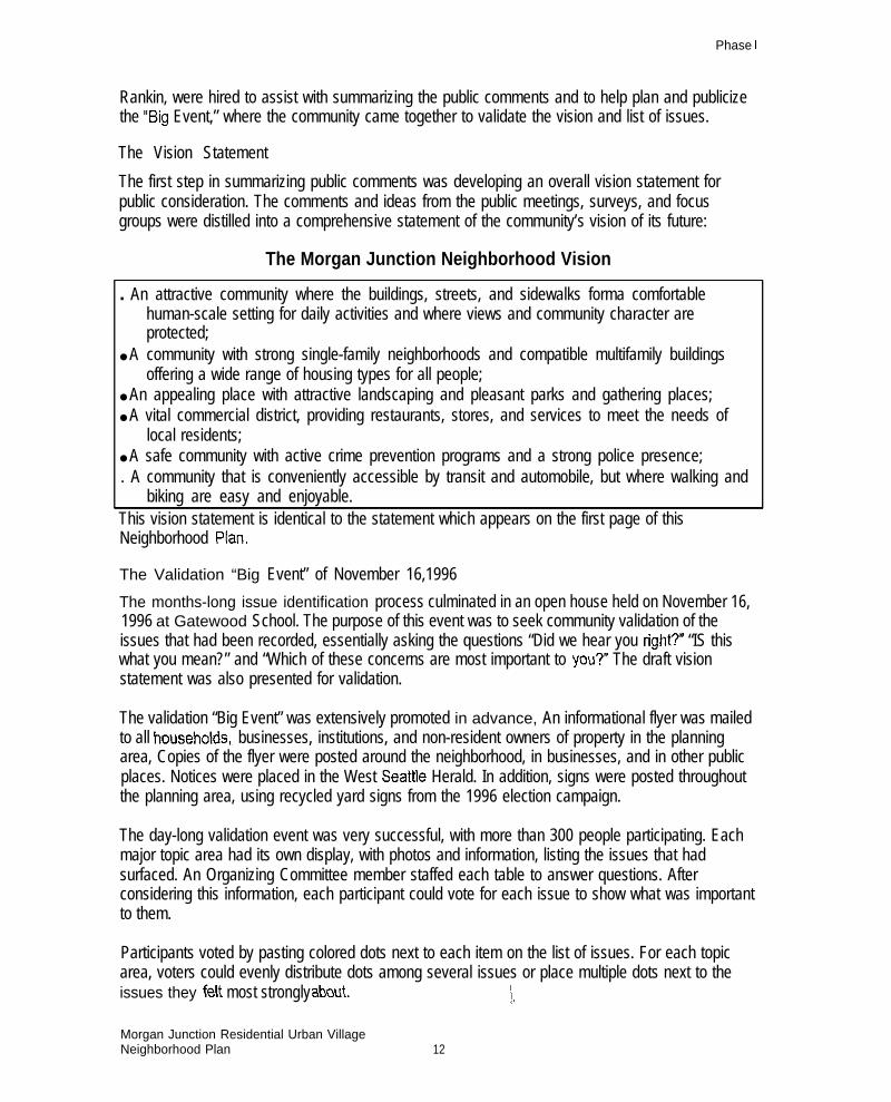
The VisionThis Neighborhood Plan represents the desired future of the Morgan Junction Neighborhood, as expressed inour Vision Statement.
The Morgan Junction Neighborhood Vision
●
●
An attractive community where the buildings, streets, and sidewalks forma comfortablehuman-scale setting for daily activities and where views and community character areprotected;
A community with strong single-family neighborhoods and compatible multifamily buildingsoffering a wide range of housing types for all people;
An appealing place with attractive landscaping and pleasant parks and gathering places;
A vital commercial district, providing restaurants, stores, and services to meet the needs oflocal residents;
A safe community with active crime prevention programs and a strong police presence;
A community that is conveniently accessible by transit and automobile, but where walking
●
●
●
●
and biking are easy and enjoyable.
We area small, mainly residential community, with a small-town feel to our business district. Our neighborhoodcontains a diversity of residents, interests, and opportunities for enhancement which will all contribute to thedirection this community takes over the next 20 years. This plan lays out the guiding principles and initialrecommendations by which we hope to attain this vision of our neighborhood’s future, We also hope that thisplan will bean enduring tool for helping our community cope with changing circumstances and take advantageof oppoflunities that may arise in the coming decades.
i

M o r g a n J u n c t i o n
R e s i d e n t i a l U r b a n V i l l a g e
N e i g h b o r h o o d P l a nJ a n u a r y 1 9 9 9
P l a n n i n g C o m m i t t e e
Chuck Talcott, Co-chair
Cindi Barker, Co-chai~ Chair, Public Safety
Linda Park, Chair,. Parks and Open Space
Tom Gut, Chair, Transportation
Jane Tobin, Co-chair, Housing and Land Use
Midge Batt, Co-chair, Housing and Land Use
Steve Becker, Chair, Community and Culture
C o n s u l t a n t s
Carison Architects, Greg Waddell, Lead Consultant
Gaynor Landscape Architecture/Design
Peggy Gaynor, Parks and Open Space
Robert Bernstein, P, E., Transportation
David Fansler, Housing and Land Use
Pacitic Rim Resotirces, Tony Higgs, Outreach
C i t y o f S e a t t l e
Neighborhood Planning Off ice ,
Venus Velazquez, Project Manager I
ii

Morgan Junction Residential Urban VillageNeighborhood Plan
Table of Contents
The Planning Process
The Neighborhood PlanUrban Village Boundary
Key Strategy-The Green Crescent . . . . . . . . . . . . . . . . . . . . . . . . . . . . . . . . . . . . . . . . . . . . . . . . . . . . . . . . . . . . . . . . ...35
Key Strategy -Fauntleroy Way Pedestrian Safetyand Landscaping improvements . . . . . . . . . . . . . . . . . . . . . . . . . . . . . . . . . . . . . . . . . . . . . . . . . . . . . . . . . . . . . . . . . . . . . ..4l
Morgan Juncth Residential Urban VillageNeighborhood Plan
Parks and Open Space
TransportationFauntleroy Way Corridor . . . . . . . . . . . . . . . . . . . . . . . . . . . . . . . . . . . . . . . . . . . . . . . . . . . . . . . . . . . . . . . . . . . . . . . . . . . . . . . . . . . . . . . . . . . . . . . . . . . . . . . . . . . . . . . . . . ...52California Avenue SW Corridor Pedestrian Improvements . . . . . . . . . . . . . . . . . . . . . . . . . . . . . . . . . . . . . . . . . . . . . . . . . . . . . . . . . . . . . . . . . 5735~ Avenue SW Corridor Pedestrian Improvements . . . . . . . . . . . . . . . . . . . . . . . . . . . . . . . . . . . . . . . . . . . . . . . . . . . . . . . . . . . . . . . . . . . . . . . . . 59East-West Arierial Corddor improvements . . . . . . . . . . . . . . . . . . . . . . . . . . . . . . . . . . . . . . . . . . . . . . . . . . . . . . . . . . . . . . . . . . . . . . . . . . . . . . . . . . . . . . . . . 59Trafic ManagemenVCalming and Spot improvements . . . . . . . . . . . . . . . . . . . . . . . . . . . . . . . . . . . . . . . . . . . . . . . . . . . . . ..6OPublic Transportation Facilities and Seivices . . . . . . . . . . . . . . . . . . . . . . . . . . . . . . . . . . . . . . . . . . . . . . . . . . . . . . . . . . . . . . . . . . . . . . . . . . . . . . . . . . . ..6O
Business District
Housing and Land UseBackground . . . . . . . . . . . . . . . . . . . . . . . . . . . . . . . . . . . . . . . . . . . . . . . . . . . . . . . . . . . . . . . . . . . . . . . . . . . . . . . . . . . . . . . . . . . . . . . . . . . . . . . . . . . . . . . . . . . . . . . .................. 65Impact of the Urban Village on Zoning and Capital investment . . . . . . . . . . . . . . . . . . . . . . . . . . . . . . . . . . . . . . . . . . . . . . . . . . . . . . . ...65Principal Issues Addressed
Community and Culture . . . . . . . . . . . . . . . . . . . . . . . . . . . . . . . . . . . . . . . . . . . . . . . . . . . . . . . . . . . . . . . . . . . . . . . . . . . . . . . . . ...76

Introduction
IntroductionBackground: A Brief Historyof the Neighborhood Planning ProcessWhere did this plan come from? What are its roots?
Ten years ago, the Seattle area (and the state as a whole) were experiencing a tremendouseconomic and population boom, not unlike today. Rapid population growth, mounting trafficcongestion, escalating housing costs, and urban sprawl led to popular demands to “do something”about growth. In response, the State Legislature enacted the 1990 Washington State GrowthManagement Act (GMA).
The Washington State Growth Management Act
The Growth Management Act required the state’s largest and fastest-growing counties tocoordinate with cities and other local governments to draft comprehensive land-use andtransportation plans that would:
● Prevent urban sprawl, yet provide enough space to accommodate 20 years’ growth ofpopulation and employment (within urban growth areas);
. Provide and pay for adequate infrastructure (roads, schools, utilities) to support growth (the“concurrency” requirement); and
. Coordinate plans of different jurisdictions so they did not conflict with one another,
In response to GMA, the counties and cities of the Puget Sound region went through a lengthyprocess to update their comprehensive plans, An extensive public involvement process preferred amulti-centered approach, in which most new population and employment growth would be” focusedinto a ‘limited number of moderate- and high-density urban centers connected by a high-capacitytransit network.
Seattle’s Comprehensive Plan
In 1,994, the City of Seattle adopted its Comprehensive Plan, Toward a .Susfairrab/e Seati/e, It is a20-year policy plan covering the years 1994 through 2014 which is designed to articulate a visionof how Seattle will grow in ways that sustain its citizens’ values. The Comprehensive Plan makesbasic policy choices and provides a flexible framework for adapting to changing conditions overtime. The initial building blocks of the Comprehensive Plan are the five “elements” required to beaddressed under by the state GMA: land-use, transportation, housing, capital facilities, and utilities.
Three additional elements were added to the Comprehensive Plan. King County’s CountywidePlanning Policies required the addition of an economic development element, and the SeattleFramework Policies (Resolution 28535) called for the inclusion of a neighborhood planning elementand a human development element: The ideas in the Plan were developed over five years through
Morgan Junction Residential Urban VillageNeighborhood Plan

Introduction
discussion, debate, and the creative thinking of thousands of Seattle citizens working with City staffand elected officials.
The goal that unifies all the elements of the Comprehensive Plan is, to presewe the best qualities ofSeattle’s distinct neighborhoods while responding positively and creatively to the pressures ofchange and growth. A key component of the City’s plan to achieve this goal is the Urban VillageStrategy.
The Urban Village Strategy represents a stepping-down of the multi-centered approach to the cityof Seattle. Seattle’s Comprehensive Plan calls for the bulk of new population and employmentgrowth to be concentrated in five large urban centers. Most of the remaining growth is to occur inand around 24 existing neighborhood commercial/multifamily districts, including Morgan Junction,The Comprehensive Plan calls for the City to:
● Encourage future population and employment growth to locate within urban centers and urbanvillages;
● Target investment in public facilities, parks, amenities, infrastructure, etc. into urban centersand urban village areas to mitigate the negative impacts of growth; and
● Link together the urban centers and urban villages with a multi-modal public transportationsystem that is efficient enough to be competitive with the private automobile,
The Comprehensive Plan calls for Seattle to strive to develop and enhance these qualities of urbanvillages:
●
.
.
.
●
.
A diverse mix of people of varied ages, incomes, cultures, employment, and interests;
A variety of housing types, scaled appropriately for each village, to meet the needs andpreferences of all residents of the, diverse community;
A strong relationship between residential and commercial areas, with shopping and serviceslocated within easy walking distance of village residents;
Community facilities, including schools, community and recreation centers, libraries, parks, andhuman services within walking distance of the village core;
Partnerships with neighborhood and community-based organizations to improve people’saccess to services and activities and to create opportunities for interaction through such meansas neighborhood planning and community policing;
Transit, bicycle and pedestrian facilities with connections to neighboring villages, goodcirculation within the village and between the village and surrounding neighborhoods;
Well-integrated public open space, providing recreational opportunities for village residents andworkers;
A unique identity reflecting local history, the village’s natural features, its culture and othersources of community pride,
For each of the urban villages, the local community is to prepare its own Neighborhood Plan.1’
Morgan Junction Residential Urban VillageNeighborhood Plan 2

The Morgan Junction ‘Residential Urban Village
When Seattle’s ComprehensivePlan, was adopted in 1994, thecommunity surrounding theintersection of California,Fauntleroy, and Morgan found thatit had been designated as aResidential Urban Village. MorganJunction is one of 18 ResidentialUrban Villages designated in the,1994 Seattle Comprehensive Plan.
The City’s proposed villagebounda~ included 139 acrescentered at the intersection ofCalifornia Avenue SW andFauntleroy Way SW. When thevillage was first designated, therewere 1,104 households within theboundary proposed in theComprehensive Plan. Theboundary was set to providesufficient capacity for 300additional households in the villageby the year 2014 under existingzoning.
Under th~ Comprehensive Plan,the Morgan Junction communityhad the option of accepting theCity’s plan “as is,” or it could createits own Neighborhood Plan, whichwould be the 20-year plan specificto the Morgan neighborhood, This
City’s proposed Urban Viflage Bounda~
plan could be developed as a grass-roots effort, but it would have to fit within the framework of theCity’s Comprehensive Plan. The City would provide funding and technical assistance to help theneighborhood develop its plan, The neighborhood could hire outside consultants to grovide its own
—
Nt
technical expertise.
The Neighborhood Plan had to address the same “elements” required under the GrowthManagement Act and the Seattle Comprehensive Plan; however, the neighborhood was given theflexibility to tailorthe plan’s elements to fit its own specitic circumstances,
Morgan Junction Residential Urban Village ‘Draft Neighborhood Plan. 3
Introduction
The neighborhood” had the option of challenging the City’s designation of the urban village. Theneighborhood also had the option of adjusting the boundaries of the urban village. The boundayissue is addressed under Urban Vi//age Boundaries on page 22.
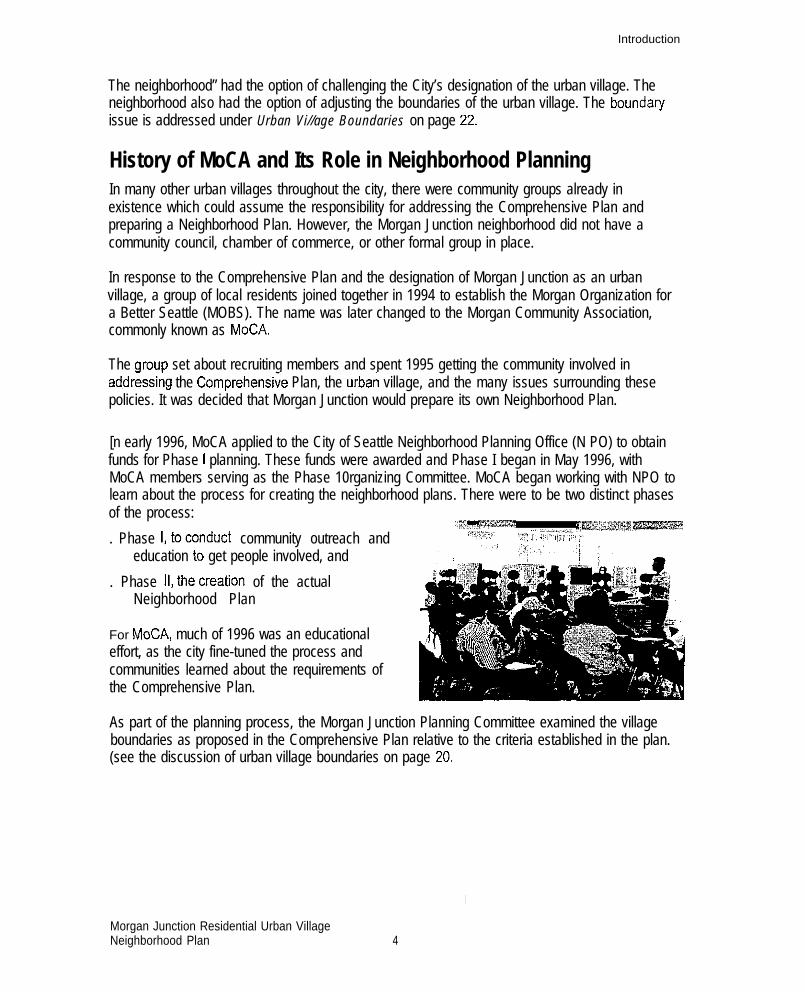
History of MoCA and Its Role in Neighborhood PlanningIn many other urban villages throughout the city, there were community groups already inexistence which could assume the responsibility for addressing the Comprehensive Plan andpreparing a Neighborhood Plan. However, the Morgan Junction neighborhood did not have acommunity council, chamber of commerce, or other formal group in place.
In response to the Comprehensive Plan and the designation of Morgan Junction as an urbanvillage, a group of local residents joined together in 1994 to establish the Morgan Organization fora Better Seattle (MOBS). The name was later changed to the Morgan Community Association,commonly known as MoCA.
The group set about recruiting members and spent 1995 getting the community involved inaddr&sing the Comprehensi~e Plan, the urban village, and the many issues surrounding thesepolicies. It was decided that Morgan Junction would prepare its own Neighborhood Plan.
[n early 1996, MoCA applied to the City of Seattle Neighborhood Planning Office (N PO) to obtainfunds for Phase I planning. These funds were awarded and Phase I began in May 1996, withMoCA members serving as the Phase 10rganizing Committee. MoCA began working with NPO tolearn about the process for creating the neighborhood plans. There were to be two distinct phasesof the process:
:;~m*lX% ..,,, .._,,,,,d, fim=m~l. Phase l,toconduct community outreach and ,,.+,!;$$.. %;l, :w, pt?: ;.
education to get people involved, and
. Phase 11, thecreation of the actualNeighborhood Plan
For MoCA, much of 1996 was an educationaleffort, as the city fine-tuned the process andcommunities learned about the requirements ofthe Comprehensive Plan.
As part of the planning process, the Morgan Junction Planning Committee examined the villageboundaries as proposed in the Comprehensive Plan relative to the criteria established in the plan.(see the discussion of urban village boundaries on page 20
I
Morgan Junction Residential Urban VillageNeighborhood Plan 4
Phase I
Phase ICommunity Outreach and EducationThe Morgan Junction community faced a particular challenge in addressing Seattle’sComprehensive Plan. Although the area was designated as an urban village, it had neither acommunity organization nor a strong community identity. However, neighbors successfully cametogether and carried out an extensive outreach effort to identify and validate neighborhood issuesand to develop a broadly-supported scope of work for Phase II planning,
The Phase 1,Organizing Committee developed an outreach plan which included special educationalsessions, discussion of the neighborhood planning process at the MoCA monthly generalmeetings, and supplemental outreach efforts, including written surveys and focus groups,Extensive promotion, particularly two mass mailings, newspaper announcements, and numerousflyers posted throughout the business district, brought good attendance at the events, At each ofthe educational sessions, the community was asked to describe its vision of the future, and then listand prioritize its concerns and desires. MoCA also collected information through the use of awritten survey which was distributed at the West Seattle Street Fair, several of the educationalsessions, and in front of the Thriftway store on weekends.
The backbone of the Phase I outreach effort was the regular monthly MoCA meetings, which wereheld the second Thursday of each month at Gatewood Elementary School. Each meeting waspublicized in advance in the West Seattle Herald, with key agenda items noted, At each meeting,attendees were brought up to date orI the progress of MoCA’S outreach and planning efforts,followed by discussion and input from the community,
In the fall of 1996, as the outreach activities were completed, the community input was collectedand compiled by the Organizing Committee, An overall vision statement was drafted and the issuesconsidered most important to the” community were summarized,
The next step was to take the vision statement and list of issues back to the community forapproval before entering into the actual Phase II planning. Two consultants, Mimi Sheridan andLeslie Rankin, were hired to assist with summarizing the public comments and planning andpublicizing the “Big Event’’--where the community came together to validate the vision and list ofissues.
The November 1996 “Big EvenV validation meeting was attended by more. than 300 people, whovoted to select which issues should be addressed in the, Neighborhood Plan, They”overwhelminglyvalidated the community vision statement, which emphasized a safe, attractive, pedestrian-orientedneighborhood with an economically viable vital business district (the statement of this visionappears at the beginning of this document), Many participants signed up to work on the Phase IIPlanning Committee or on subcommittees dealing with specific elements of the NeighborhoodPlan.
Morgan Junction Residential Urban VillageNeighborhood Plan 5

Phase I
Elements of Phase IThis section provides greater detail about the key elements and activities addressed during thePhase I outreach/education process.
‘ IDENTIFICATION OF STAKEHOLDER GROUPS
Early in the project, several analyses were performed to identify the community’s stakeholdergroups and to develop a targeted plans to reach out to them. Using data provided by the City andindependently compiled by MoCA members, seven stakeholder groups were identhied:s homeowners,. renters,● non- resident property owners,● . institutional “populations,● t h e p h y s i c a l l y c h a l l e n g e d ,● business owners, and. institutions such as Gatewood Elementary School, retirement homes, and churches.For each stakehoider group, specific outreach methods were determined; the implementation ofthese methods is described below.
OUTREACH ACTIVITIES
The outreach described below significantly increased pAttendance at MoCA’S general meetings increasedfrom 27 in January 1996 to 51 by the end of the year,Representation greatly increased as well, growingfrom homeowners and a few businesses to activeparticipation by six of the seven identifiedstakeholdergroups.
MoCA also coordinated with surroundingcommunities. Oraanizina Committee members
Participation in the planning process.
.-attended meetings of the Friends of the Junctionplanning group and met with them to discuss common interests. They also coordinated with “aplanning group at High Point and with the Fauntleroy Community Association to discuss mutualobjectives, A MoCA representative regularly participated in meetings of the Southwest DistrictCouncil.
MAILINGS
Two mass mailings were done, one paid for by the City and one paid out of MoCAk own planningbudget. The first, in April 1996, notified everyone in the planning area that the NeighborhoodPlanning process was beginning and that it was important for them to participate in shapingforming Morgan Junction’s future.The second mailing went to all residents, businesses, institutions, and owners of property withinthe planning area. [t was sent in early November 1996 to advertise the validation “Big EvenT onNovember 16, 1996. This flyer listed some of the main issues that had arisen and included a mapshowing the proposed urban village and planning area boundaries,
Morgan Junction Residential Urban VillageNeighborhood Plan 6

Phase I
In addition, MoCA maintained a mailing list every person who signed in at any MoCA meeting orevent. Numerous additional mailings went to that list, advising of MoCA general meetings andsoecial events.
ISSUE IDENTIFICATION WORKSHOPS
MoCA’S first task was issue identification--discovering what the community was concerned about,what people wanted to see changed, and what their vision was of the community’s future, Theheart of this process was a series of four informational meetings where neighbors came to learnabout not only about the Neighborhood Planning process and issues, as well as to discuss theirpreferences and concerns.These meetings were widely advertised through eye-catching flyers and posters distributed atneighborhood businesses, apartments, and public places, and through notices published in theWest Seati/e Herald. The four public informational meetings were held in the summer of 1996,during MoCA’S regular Thursday evening meetings. The following topics were discussed:
June 13,1996 Housing, Land-use, and Design ReviewJuly 11,1996 Trafic and TransportationAugust 8,1996 Public Safety and UtilitiesSeptember 12,1996 Community Life (Parks/Open Space/Parks, Ark/Culture,
Business District)
Each meeting began with a slide show overview of the topic with examples from Morgan Junctionand introducing the issues to be covered. Resource people then made brief presentations,providing additional more information for participants to consider. The slide show and presentationswere followed by a facilitated discussion where participants expressed their ideas, comments, andconcerns. The following sections summarize each meeting and the participants’ comments,
Housing, Land-use, and Design Review (June 13, 1996)The first informational meeting focused on housing and land-use, discussing the existing housingstock inside and outside the urban village, development trends, cost and affordability, designguidelines, and Comprehensive Plan requirements. Slides showed the variety of housing optionsavailable in Morgan, from small older bungalows to large new homes, duplexes, small apartmenthouses, and large multifamily complexes. Also discussed were residential densities in the urbanvillage and the planning area, the rising cost of housing, household sizes, and the changesoccurring every day as new units are constructed and older homes are remodeled or replaced.
Summary of Participant Comments.●
●
✎
✎
✎
✎
✎
✎
Make sure that new buildings are compatible with the communityEnsure that multifamily housing fits into the communityChannel growth along arterialsRequire hidden parkingAllow duplexes and detached accessory housing in single-family zonesLimit low-income housingPreserve views by limiting building heights and undergrounding wiresEncourage a diversity of building styles and peopleEncourage owner occupancy
Morgan Junction Residential Urban VillageNeighborhood Plan 7

Phase I
Traffic and Transportation (July 11, 1996)Trai%c and transportation was the topic of the second informational meeting. Much of thediscussion focused on King County Metro Transit’s presentation of its Six-Year Transit Plan andthe process for planning service improvements in West Seatile. Metro intends to conduct focusgroups to gather input about the service changes people would like to see. Broader changes arealso being planned by the Regional Transit Authority. A representative of the SeattleTransportation Department was also on hand to answer questions and discuss specifictransportation improvements suggested by participants.
Summary of Participant Comments.
.
.
.
.
.
.
.
.
Add~ess congestion on the West Seattle freewayImprove traffic flowAddress the ferry traffic problemReconfigure and improve the Morgan/California/Fauntleroy intersection for both pedestriansand vehiclesIncrease pedestrian and vehicle safety on residential streetsReduce vehicle noiseImprove bicycle lanesIncrease and enhance Metro bus service both for both commuting and circulation within WestSeattleInvolve the community in transit planning
Public Safety and Utilities (August 8, 1996)The August 8 informational meeting focused on public safety and utilities, with speakers from theSeattle Public Utilities Department, Seattle City Light, the Seattle Police Department, and the WestSeattle Crime Prevention Center.Public Utilities Department studies indicate few utility planning issues affecting Morgan, since boththe water and sewage systems are capable of handling any growth expected under current zoning,Some routine maintenance and upgrades are planned.
Seattle City Light is continuing its long-term upgrade of the electrical distribution ,system in order toserve higher population densities throughout the city; they expect to complete the process in West
Seattle in eight to ten years. City Light also plans to increase the number of street lights in areasdesignated as high crime locations areas by the Police Department, One of the neighborhood’sprimary desires, underground wiring, is not part of City Ligh~s routine upgrades but can be installedwherever all residents agree to bear the cost,
The City Light representative also discussed their plans to “surplus” a substation inside the urbanvillage boundaries at Southwest Morgan Street and the alley east of 42nd Avenue Southwest, Thisproperty has potential for conversion to open space or another public use.
A representative from the West Seattle Anti-Crime Council spoke about the local Crime PreventionCenter, a drop-in office where the police officers can write reports or complete other policebusiness, saving the time of traveling to the existing South Precinct station on Beacon Hill, TheCenter also disseminates information about ctime prevention to the community, Monthly meetingsare held with residents, business owners and local police oticers to discuss local public safetyconcerns and devise solutions.
Morgan Junction Residential Urban VillageNeighborhood Plan 8
Phase I
Two Seattle Police officers who serve West Seattle discussed their schedules and the amount ofpolice coverage in the Morgan Junction area. They encouraged the community to state in its planthe high priority given to a local police precinct, since the City has not yet funded this project. Theysaid that criminal activity in Morgan is comparable to other parts of the city, with car prowls andthefts being most prevalent. Other crimes are lower in Morgan than in other parts of Seattle, Theyalso said that a new captain being assigned to the area is committed to making changes andaddressing many of the issues raised.
Sunrrrrary of Participarrf Cornrnerk● Establish a police precinct in West Seattle. Increase the police presence in the community. Increase community education and involveinent● Enforce trafic and parking regulations● Develop supportive youth programs● Increase youth discipline● Make streets safer at night. Increase gratliti prevention
Community Life (September 12, 1996)The community life informational meeting covered three topics affecting quality of life in the MorganJunction neighborhood: the business ~strict, arts and culture, and parks and open space,
Business DistrictSlides of the business district, with statistics about the types of businesses found in MorganJunction, kicked off the meeting. Lynn Harmon of Prudential/Cayce & Gain Real Estate addedfurther details about the types of businesses usually found in neighborhood shopping areas andtheir needs. Morgan does not have the large land parcels required by major chain stores but hasexcellent demographics and sites good locations suitable for smaller stores.Seattle neighborhoods that have attracted strong local businesses (such as Admiral and QueenAnne) have done so through g~d demographics coupled with dedicated business and propertyowners working to reinvest in their community and promote themselves to generate strong supportfrom local shoppers. Some business districts feature a distinctive theme or have specialty storesthat attract people from outside the area,
Surnrrrary of Participant comments● Need new businesses such .as a bookstore/newsstand, office supplies, antique shops, juice
bar, laundromat, funky jewelry and clothes, gifts/post office/photocopying● Need a greater variety of restaurants● Implement design guidelines and restrict inappropriate signs to improve the appearance of the
business district● Inc rease park ing , espec ia l l y beh ind shops. Improve pedestrian atmosphere/safety near shops
Arts and CultureThe second part of the meeting focused on arts and culture in the Morgan community. The slidesfeatured local arts facilities (primarily churches used by the arts organizations), scenic views,
Morgan Junction Residential Urban VillageNeighborhood Plan 9

Phase I
gardens, and public art throughout West Seatile. Inga Carmack of Arts West, a non-profit artsorganization serving West Seattle, explained their activities. The Arts West gallery at Jefferson
Square features a different artist each month, Arts West also sponsors theater productions inchurches and works with local business groups on beautification projects such as street trees, ArtsWest is also promoting the development of a new arts/performance center to be used as a gallery,theater and public gathering place,
Summary of Participant Comments:. Build facilities that enhance arts and culture such as community center and theater.● Add public art to the community, such as sidewalk tiles or a landmark statue or fountain.
Parks and Open SpaceThe parks slide show demonstrated that the proposed Morgan urban village currently has no parkswithin its boundaries. However, several open spaces lie within the planning area, includingLowman Beach Park, Lincoln Park, Gatewood Reservoir, and Gatewood and Fairmountplaygrounds. An additional open space, the Pelly Place Natural Area, was acquired after greatcommunity effort and will be restored to its a natural state with a City matching grant, A similarnatural area is located in the Orchard Street Ravine. Potential spaces for pocket parks were alsohighlighted. Catherine Anstett and Don Harris of the Seattle Department of Parks and Recreationprovided maps of the City’s open space projects in the area and provided pointers on how best toplan to for and obtain additional open space and parks,
Summary of Participant Commenfs. Make better use of existing public spaces● Add amenities such as pocket parks, a community garden, street trees, a skateboard park, and
bicycle paths
SPECIAL Focus GROUP SESSION
MoCA made specific efforts to involve groups that usually do not attend public meetings orparticipate in community activities. One such, effort was a focus group at Cal-Mor Circle, asubsidized apartment complex for the elderly located in the heart of the Morgan Junction businessdistrict. About 20 percent of the building’s 58 residents participated in the focus group, Following ageneral presentation about” the planning process, residents discussed their concerns and rankedthe importance of various issues,
All of the focus group participants’ major concerns were related to improving the area’s walkability--making it easier for people, especially those who have difficulty walking, to get around thecommunity easily and safely. Specific suggestions included:....
.
.
.
longer pedestrian signals at crosswalks,improved sidewalks and crosswalks,more wheelchair ramps,better enforcement of traffic regulations,storm drain repair to prevent sidewalk flooding,improved lighting, anda greater police presence,
I
Morgan Junction Residential Urban VillageNeighborhood Plan 10

Phase I
These concerns were combined with results of the educational workshops and the survey andwere included in the issues presented during the November “8ig EvenV validation open house.
BUSINESS SURVEY
During March 1996, MoCA conducted a detailed survey of all the business distticts in the”planningarea. Follow-uP surveys was were done in March 1997 and March 1998 to measure changes in thebusiness community over time. The survey collected the following information for each individualbusiness and storefront (or office) in the urban village and planning area:● the name of the business● the address/location● the type of business (including vacant space, but excluding home-based businesses). the type and size of space occupied by the business● the location and availability of parking (both off-street and on-street)
This information was summarized and disseminated to the business community. It also waspresented during the informational meetings and the November validation “Big Event.”
WRITTEN SURVEY
To reach out to people who do not typically attend meetings, MoCA developed a written surveyThe questionnaire was distributed from July to October 1996 at MoCAS regular meetings, at theWest Seattle Street Fair, at the Night Out Against Crime in August 1996, and at an informationtable staffed on Saturdays by MoCA volunteers “at the local Thriftway store.
The survey was based on a similar questionnaire used by other neighborhood planning groups.The questionnaire asked people to list their top priorities in four major areas: housing and land-use,transportation and trafic, public safety, and quality of life. The survey also collected basicdemographic information to determine which stakeholder group(s) the respondents represented.
A totalof119 completed questionnaires were received and analyzed by MoCA, Respondents wereprimarily homeowners (66%) living within the proposed Urban Village (28%) or within the PlanningArea (52%). Twenty percent were owners or managers of local businesses, One-quarter of therespondents were bus riders and one-third had children living at home.The respondents gave the highest importance to reducing violent crime, ensuring that newmultifamily housing tits into the community, increased police and emergency services, designguidelines for new construction, and having a range of housing prices available. All of the issuesaddressed in the surveys were included in the final list of issues presented at the Novembervalidation open house; all open-ended responses were also tabulated.
Two important new items were obtained from the survey responses and included in laterdiscussions--establishing a police precinct in West Seattle and maintaining the integrity of single.family neighborhoods.
Validation Of Phase I EffortsAs the outreach activities were completed, the Organizing Committee summarized all the i,nputreceived from the public and drafting a comprehensive statement of the community’s vision of itsfuture, This information was then submitted to the community for approval and to set the agendafor the actual planning to be done during Phase Il. Two consultants, Mimi Sheridan and Leslie
Morgan JunctionResidential Urban villageNeighborhood Plan 11
Phase I
Rankin, were hired to assist with summarizing the public comments and to help plan and publicizethe “Big Event,” where the community came together to validate the vision and list of issues.
The Vision Statement
The first step in summarizing public comments was developing an overall vision statement forpublic consideration. The comments and ideas from the public meetings, surveys, and focusgroups were distilled into a comprehensive statement of the community’s vision of its future:
The Morgan Junction Neighborhood Vision
. An attractive community where the buildings, streets, and sidewalks forma comfortablehuman-scale setting for daily activities and where views and community character areprotected;
● A community with strong single-family neighborhoods and compatible multifamily buildingsoffering a wide range of housing types for all people;
● An appealing place with attractive landscaping and pleasant parks and gathering places;● A vital commercial district, providing restaurants, stores, and services to meet the needs of
local residents;● A safe community with active crime prevention programs and a strong police presence;. A community that is conveniently accessible by transit and automobile, but where walking and
biking are easy and enjoyable.This vision statement is identical to the statement which appears on the first page of thisNeighborhood Plan.
The Validation “Big Event” of November 16,1996
The months-long issue identification process culminated in an open house held on November 16,1996 at Gatewood School. The purpose of this event was to seek community validation of theissues that had been recorded, essentially asking the questions “Did we hear you right? “IS thiswhat you mean?” and “Which of these concerns are most important to you? The draft visionstatement was also presented for validation.
The validation “Big Event” was extensively promoted in advance, An informational flyer was mailedto all households,, businesses, institutions, and non-resident owners of property in the planningarea, Copies of the flyer were posted around the neighborhood, in businesses, and in other publicplaces. Notices were placed in the West Seatile Herald. In addition, signs were posted throughoutthe planning area, using recycled yard signs from the 1996 election campaign.
The day-long validation event was very successful, with more than 300 people participating. Eachmajor topic area had its own display, with photos and information, listing the issues that hadsurfaced. An Organizing Committee member staffed each table to answer questions. Afterconsidering this information, each participant could vote for each issue to show what was importantto them.
Participants voted by pasting colored dots next to each item on the list of issues. For each topicarea, voters could evenly distribute dots among several issues or place multiple dots next to theissues they feK most strongly about. ~,
Morgan Junction Residential Urban VillageNeighborhood Plan 12

Phase I
Each person received a total of 27 dots for the 51 issues, getting a ration of dots at each station.The number of dots varied among the topic areas, depending on the number of issues in that topic.For example, there were thirteen issues under Transportation and people received seven dots,while they received only three dots to distribute among the six Community/Culture issues, This wasdone to provide more or less equal weighting of votes among the various topic areas, so that asingle composite list of priorities could be developed for all issues across the topical areas.
Final Issues List●
.
.
.
The strongest supporl went to two West Seattle-wide issues: establishing a police precinct andaddressing congestion on the West Seattle freeway.
Within the Morgan Junction area, the greatest concern revolved around housing and growth,especially maintaining existing single-family housing and allowing no more low-income housingin the neighborhood.
Development of design guidelines for new construction, limiting building heights to retainviews, and building a branch library were also highly rated.
The vision statement was overwhelmingly approved, by a vote of 218 to 25. Many peopleadded comments, primarily stating their desire to retain the existing character of theneighborhood and maintain existing single-family housing.
Morgan Junction Reddential Urban VillageNeighborhood Plan 13 . .

Phase II
Phase IICreating the Neighborhood PlanOne of the key features of the November 1996 Big Event was a display describing the Phase IIplanning process and soliciting interested people to participate in Phase II and other futureactivities.
Preparation for Phase II
Immediately after the Big Event, MoCA began preparing for Phase II with a community workshopon December 9, 1996. Following a presentation of the results of the issue validation process(described above), participants divided into small groups by topic to discuss the structure of thePhase II Planning Committee and work groups, to answer questions, and to complete formsexpressing their interest in participating in Phase II. Approximate y 35 people attended thisworkshop; 26 signed up for the Phase II Planning Committee.
The Organizing Committee reviewed the applications and presented the applicants to the public atthe MoCA general meeting on January 9, 1997. The names of all 26 candidates were submitted forpublic approval at the MoCA general meeting on February 13, 1997. Validation consisted of apublic vote to approve or disapprove the entire slate of candidates; the slate was approved by amargin of 27 to 1.
The Phase II Planning Committee began meeting on February 27, 1997. Over the next threemonths, they met several times to (1) develop a strong decision-making structure andcommunications procedures and (2) begin the task of putting together a work plan for Phase II, InMarch 1997, the Committee held a half-day planning retreat, which provided an excellentopportunity to bfingnew members uptodateon Phase Iactivities and forallmembers to discussthe Phase II scope of work.
The Phase II Planning Committee initially consisted of a chair and 14 members, including thechairs of the six topical subcommittees (Transportation/Traffic, Housing/Land-Use, BusinessDistrict, Parks/Open Space, Community/Culture/Human Services, and Public Safety), At the time itwas formed, all stakeholder groups were represented on the Planning Committee.
The initial committee structure proved unwieldy in practice and too much work fell on the shouldersof the chair, These problems, coupled with attrition, led to a reorganization of the PlanningCommittee into MO co-chairs and seven members, including the heads of each of the topicalsubcommittees.
The Committee hired a consultant, Carlson Architects, to assist with the Process of creating aScope of Work and Work Plan for Phase II, and to coordinate consultant support for the to~calsubcommittees and ongoing outreach activities. The Neighborhood Planning OftIce also providedspecific assistance during this time period, especially in defining the steps needed to prepare thedrafl Neighborhood Plan which would be presented to the City departments for review,
Morgan Junction Residential Urban VillageNeighborhood Plan 14

Phase II
Outreach and education continued during Phase II as well, with several MoCA meetings devoted tospecific neighborhood planning topics of interest, such as housing, land-use, and transportationissues, Comments received at these meetings were considered during the next step of theprocess, creation of the final Goals, Policies and Recommendations of the Morgan ,JunctionNeighborhood Plan.
Goals and Policies
Each topical subcommittee again sifted through all the Phase I results, as well as the requirementsof the Comprehensive Plan, and crafted a series of goals and policies for its topic area.
. Goals are intended to set a general direction by expressing our community’s values and an.ideal future end. They are not quantifiable or time-dependent, nor do they suggest specificsteps for implementation.
. Policies are broad statements which help guide decision making, They provide a context forsetting priorities and for guiding the activities needed to achieve the goals,
After the topical subcommittees drafted their goals and policies, they were reviewed and revised bythe Planning Committee as a whole. This was done to insure consistency and to make sure that allviewpoints were considered.
Community Check.in Fair (May 16, 1998)
The drafl goals and policies for the Morgan Neighborhood Plan were presented at a Community“Check-in” Fair held May 16, 1998 at Gatewood School. The community was notitied about thisevent with mailings, flyers posted throughout the business district and distributed at the Thriftwaycheckout stands, and a notice published in the West Seattle Herald. While attendance wasdisappointing (with only 76 people attending), there was significant acceptance of the goals andpolicies presented.
At this meetina. the Housina and Land-Use Committee oatheredadditional feedback on alte~natives to the proposed Urb% Villageboundary, small-lot zoning, and design guidelines. The ParksCommittee also used a survey to collect input on several specific ideasbeing considered for the Morgan Junction neighborhood,
Planning Recommendations
The tinal step in completion of the Neighborhood Plan was the creationof specific recommendations to be included in the Plan, Therecommendations are a series of activities or action-specific statementsand” can include:,
● A specific action by the City, such as the enactment of anordinance, adoption of a resolution, or construction of a public
“facility.● A list of steps to be undertaken by the community which are needed
proposed project or setup an ongoing program.
Morgan Junction Residential Urban VillageNeighborhood Plan 15
Phase II
Recommendations are captured in two places:
. In the Neighborhood Plan itself, and● In a document called the Approval and Adoption Matrix, which is a document used by City staff
to review the Neighborhood Plan recommendations and identifies all the city’s responses tothe draft Plan. The final Approval and Adoption Matrix is that portion of the Plan which will be,adopted into law by thecity when our Neighborhood Plan is incorporated into the SeattleComprehensive Plan.
Community Review of Recommendations (September 10, 1998)
Because the Planning Commiitee was disappointed by the May turnout,, it decided to devote theMoCA general meeting of September 10, 1998 to a review of the recommendations in the hopethat more community members would attend, learn about the Neighborhood Planning process, andprovide additional input. An eight-page brochure was mailed to every household, institution andbusiness in the Morgan Junction planning area to publicize this meeting and provide citizens withfull information on the proposed goals, policies, and recommendations,
At this meeting, the draft recommendations were reviewed by the community, which was asked ifthe Organizing Committee had correctly captured the desires of the neighborhood in itsprioritization of projects and actions. A total of 75 community members attended, and theirresponses provided additional input for the topical subcommittees to consider.The specific goals, policies, and recommendations are presented in the body of the plan and underKey Strategies below (beginning on page 29).
Graham Street Block Club PetitionAt the September event, members of the Planning Committee were approached by a group ofcitizens who requested that the urban village bounda~ be changed to remove a one-block areafrom the village. They were asked to submit a petition describing exactly which area they wantedto remove from the village and their reasons for making”fhe request. Shortly thereafter, the petitionwas received with 27 signatures representing 28 people. The petition was evaluated against fourcriteria to assess its impact on the intent of the Urban Village strategy and the objectives of theComprehensive Plan:
.
●
.
.
The signers of the petition must represent a majority of the properties in the affected area,
The boundary revision must not adversely affect ,the compactness and talkability of the urbanvillage or the centrality of the business district within the village,
The boundary revision must not remove from the village any property zoned for multifamily orcommercial development, and
The boundary revision must not have a significant, adverse effect on the development capacityof the urban village.
Morgan Junction Residential Urban VillageNeighborhood Plan 16

Phase II
Based on these criteria, the Planning Committee determined that the requested boundary changedid not adversely affect the overall objectives of the Plan and thus accepted the proposedboundary revision and incorporated it into the final Draft Plan presented to the community for finalvalidation. A COPY of the Graham Street Block Club petition and the analysis are included asattachments to this plan.
PLAN VALIDATKIN, NOVEMBER 1998
Validation of the Draft Plan took place during November, 1998. Early in the month, validationmailers were sent to all addresses in the .Morgan Junction planning area. Additional publicitymethods included : flyers and copies of the Draft Plan placed in the business district and in publicplaces, flyers handed out at Thriftway during the week preceding the Validation Event, 15campaign-style yard signs placed in high traffic areas throughout the Planning Area, a paidadvertisement and public notices placed in the West Seattle Herald two weeks prior to the event,and extensive pre-event coverage by the Herald:
The Validation Event was held at Gatewood School from 10:00 a.m. to 400 p.m. on Saturday,November 21, 1998. 142 people signed in and 111 ballots were cast during the event. Anadditional 111 ballots were received by mail or at the West Seattle Town Hall by November 28~, fora total of 222 ballots.
Also at the Validation Event, two additional and separate surveys or “straw polls” were distributedby concerned citizens, the results of which are included in the Appendix.
On, several occasions between November 21, 1998 and January 14, 1999, the Planning Committeeasked the people who conducted the straw poll to submit a written minority report or attachment tothe plan which would describe their progress and findings, While oral summaries were presented atboth a Planning Committee meeting and a MoCA general meeting, no formal report was eversubmitted for incorporation into the Plan, Accordingly, the attachment to the Plan is limited to acopy of the straw poll questionnaire; a tabular summary of the results and the completedquestionnaire.
Results and Modifications
Overall, the Draft Plan passed, receiving a majority (56 percent) of the votes, The proposedboundary change was also approved by 57 percent of the respondents, The Green Crescent KeyStrategy was approved with a 55 percent “yes” vote; however, the Fauntleroy Way Key Strategyreceived only 39 percent approval.
All of the individual elements of the Plan were also approved, though the strength of supportvaried widely. Driven by support for a police precinct in West Seattle, the Public Safety elementwas the most popular, receiving over 80 percent approval. The Business District andCommunity/Culture elements received strong support, with 63 and 62 percent approval,respectively. The Housing/Land-Use and Transportation elements were approved, by slightly morethan 54 percent of the respondents, while the Parks and Open Space element received only a one-vote plurality (50.2 percent approval).
Morgan, Junction Residential urban WageNeighborhood Plan 17
Phase II
The West Seattle-wide recommendations received 59 percent approval
A large number of written comments were also .received, which proved invaluable in helping thePlanning Committee identify and address specific concerns about the various elements of the Plan,The ballots and written comments were categorized by element and reviewed by each committeechair, who used them to develop responses and changes to the draft Plan. In addition, Cityresponses to the Draft A & A Matrix were also considered at this time. A summary of the validationresults is attached to this plan.
Eddy Street Ravine Petition
During the evaluation of the Validation Event results, the Planning Committee received a petitionfrom 135 people concerned with inclusion of the Eddy Street Ravine and surrounding properties inthe Neighborhood Plan. The petition requested that
. The Urban Village boundary be shifled to the east, to exclude the ravine and all propertieslying west of the business district (from Juneau Street to Fauntleroy Way) and Fauntleroy Way(south and west of California Avenue), and
● All references to the Eddy Street Ravine be removed from the Plan.
The requested boundary change was evaluated using the same criteria that were applied to theGraham Street Block Club petition. See page 26 for additional summary evaluation information, Afull copy of the Eddy Street Ravine Petition analysis appears as an attachment to the Plan, Theanalysis recommended a compromise in which the bulk of the ravine and adjacent propertieswould be removed from the village boundary. In January 1999, negotiations were held withrepresentatives of the petitioners over final delineation of the boundary and mutually acceptablerevisions to the language in the Plan. A compromise was agreed to on January 11, 1999; thecompromise boundary and plan language are now contained in the body of the NeighborhoodPlan.
Final Modifications
Roughly summarized, the following changes were incorporated,
Urban Village BoundaryThe Village boundary was shifled to the compromise location between the boundary advocated bythe Eddy Street Ravine petitioners and the boundary validated at the November 21, 1998 event,With this change, a majority of the properties adjacent to the ravine were removed but the criticalcharacteristics of the Urban Village were maintained. A map showing the final recommendedvillage boundary appears in the Urban Vi//age Boundary section of this plan,
Transportation and the Fauntleroy Way SW Improvement Key Strategy.Based on the balloting and the comments received, the community does not accept a boulevardconcept for Fauntleroy Way. References to studying and developing Fauntleroy Way SW as alandscaped two-lane boulevard were removed from the Plan. Greater emphasis was placed onpedestrian, bicycle ~d traffic safety, and maintaining roadway capacity and improving traffic flow.
Morgan Junction Residential Urban WageNeighborhood Plan Is

Phase II
Reference to neighborhood involvement with proposed trafic and Metro changes was alsostrengthened.
Parks and Open Space and the Green Crescent Key StrategyA new policy was added to reflect concerns with maintenance and upkeep of existing and futureParks and Open Space areas, References to incorporating alleys into a bicycle route system wereremoved due to safety concerns, All negotiated compromise language from the January 11, 1999meeting with the Eddy Street Ravine Preservation Alliance representatives was incorporated.References to the P-Patch were changed to Community Garden to reflect the full range of potentialopportunities at that location. A clarifying street location was added to reflect information sent outin the Validation Mailer which had inadvertently been omitted from the Draft Plan. All reference toFauntleroy Way SW as a boulevard was deleted.
Housing and Land UseA statement was added saying that Single-Purpose Residential zoning not be adopted in the UrbanVillage, and that further study needs to be done. A policy and recommendation had reference tofuture RSL consideration removed, as future allowance was discussed in the body of the Plan, Arecommendation to develop design guidelines for tandem housing, cottage housing and RSL wasremoved, as none are recommended for inclusion in the Plan.
Public SafetyBased on comments about concerns for safety in parks and open space areas, specific mention ofpolice patrols in parks was added to the Plan. Slight changes in wording were made to bring the ,Plan in line with the City’s concept of “emphasis patrols” instead of special patrols,
Business DistrictNo changes were made
Community and CultureNo changes were made.
It’s Our Plan
The Plan you hold in your hand is the result of the work of the Planning Committee and dozens ofyour fellow citizens over the past three years, These committees have been staffed by yourneighbors, who have devoted thousands of hours of their personal time to draft a plan which theybelieve will allow our community to better withstand the impacts of growth over the next 20 years,allowing us to enhance the quality of life for all residents of the Morgan Junction neighborhood,
The process has been complex’and not without controversy, Both the Committee and the City havebeen “learning as we go,” and the evolving process frequently forced us to aim at moving targets.There is a diversity of opinions in our neighborhood, and many of these opinions are strongly held,The fact that the Neighborhood Plan was done at the behest of the City contributed to widespreadskepticism about the integrity and ultimate outcome of the process,
Despite these difficulties, the Morgan Junction Planning Committee is encouraged to see thecommunity get engaged in the planning process and contribute ideas and opinions that challenged
Morgan Junction Residential Urban villageNeighborhood Plan 19

Phase II
the Committee to create the best possible plan for the community as a whole, Prior to 1994, ourcommunity did not have a voice. Today, we not only have a plan, but also are laying thegroundwork for a network of citizens that can provide us with permanent organized repres,entationwhen dealing with the City, developers, or other forces which can affect the future of ourcommunity,
What’s Next for MoCA?MoCA is a grassroots association of property owners, residents, business persons, and otherpeople who have a stake in the future of our neighborhood. These “stakeholders” are the heart ofMoCA. Our primary purpose is to make the Morgan Junction a better place to live, work, shop, andenjoy.
Our goal is to continue in a stewardship role as after the Morgan Junction Neighborhood Plan isapproved and its recommendations are considered for implementation. MoCA intends to evolveinto a permanent community council to represent the interests of our neighborhood and helpoversee and facilitate implementation of the Plan and its recommendations. Quite obviously, it isadvantageous for our neighborhood to have organized representation when dealing with the Cityon planning, zoning, and capital improvement matters that affect our community. lt is equallyobvious that a broad and diverse organization better represents the entire community, To this end,MoCA will continue to actively recruit new members,
Community Outreach Will Continue
As details of projects and specific recommendations are developed in the future, the communitywill have a better opportunity to visualize and understand them. On some of the major projectspresented during our planning outreach, concern has been expressed that the details were arrivedat without full consultation with the community, particularly neighbors who might be directlyaffected.
While the MoCA Planning Committee realizes that we will not gain complete community consensuson some projects and recommendations, we want to emphasize that we will adhere to the followingprinciples:
● No projector recommendation shall go forward without significant direct outreach to thosecommunity members that we can identify as being directly affected. For example, if a park isproposed, any studies or design work must include efforts to reach out to and”involve theowners and occupants of all adjoining properties.
● No Neighborhood Planning project shall go forward without consultation and review by theneighbors, MoCA, and the City,
1’
Morgan Junction Residential Urban VillageNeighborhood Plan 2 0

Phase II
The Plan
The following pages contain the body of the Morgan Junction Neighborhood Plan, It is organizedinto three major sections:
1. A discussion of the changes to the urban village boundary recommended in the Plan.
2. A discussion of the two Key Strategies presented in the plan. The “Green CrescenV. Fauntleroy Way Pedestrian Safety and Landscaping Improvements
3. The last section presents separate discussions of each of the elements in our plan:. Parks and Open Space.● Transportation and Trafic● Business “District● Housing and Land-Use. Public Safety. Community and Culture
Each of these sections presents the background, goals, po~cies, and recommendations for each ofthe elements of the plan.
Morgan Junction Residential Urban VillageNeighborhood Plan 21

Urban Village Boundary
Urban Village BoundaryH would be an understatement to say that maintenance of the single-family character of the MorganJunction neighborhood is a high community priority. Throughout the neighborhood planningprocess, this sentiment was expressed again and again.
Background
Concern for the protection of our single-family neighborhoods began with the City designatedMorgan Junction as a Residential Urban Village in the 1994 Comprehensive Plan and established
preliminary boundaries for the urban village. Among the criteria used in designating urban villageswere:
.
.
.
The area’s current zoning, which provides suftlcient capacity for future growth anddevelopment,Location along major transportation routes, including roads and mass transit lines, andThe ability to achieve residential densities which will support compact living and. pedestrian-and transit-friendly environments (for example, 2,000 dwelling units exist or can beaccommodated within a 2,000-foot radius of the center of the urban village, Morgan Junction is
already zoned to accommodate this residential density),
The urban village designation has implications for both zoning and capital investment by the City,
● Zoning: Urban villages have access to zoning options not available to areas outside of villageboundaries. Urban village neighborhoods can:.
.
■
■
■
Suggest rezones of single-family areas within the urban village boundary to low densitymultifamily or commercial zones in areas close to principal commercial streets;Allow Residential Small Lot (RSL) zoning, which can include (1) single-family houses onindividual small lots, (2) two houses on a one lot, and/or,(3) clusters of small cottages onlarger lots;Identify commercial areas within the village bounday where residential development willbe emphasized (Neighborhood Commercial/Residential zoning);Designate areas within an urban village as appropriate or inappropriate for moderate-density multifamily zoning (including L3 and L4 zones);Recommend how residential buildings without ground-floor commercial space should betreated in commercial zones within the urban village. The plan can allow such single-purpose residential buildings outright, permit them only under specific conditions, or it canprohibit these buildings in commercial zones altogether,
. Capital Facilities and Investments: The Comprehensive Plan has a goal of making capitalinvestments consistent with the urban village strategy by encouraging the City to locate “newcommunity-based capital facilities,” including libraries, community centers, and parks in areasthat serve urban villages. It also requires the City to provide written justification whenproposing to locate major capital facilities outside urban village areas, The City is also directedto “consider providing capital facilities or amenities in urban villages as an incentive to attractboth public and private investments to an area” (Source: City of .Seaft/e tStrafegic P/armingOffice).
Morgan Junction Residential Urban VillageNeighborhood Plan 22

IUrban Village Bounday
The Comprehensive Plan includes goals for the provision of adequate and accessible openspace within urban villages. Efforts to acquire open space and develop recreation facilities aredirected to give particular attention to serving urban villages, which are in general expected tohave the greatest need for additional open space and recreation facilities (Source; City ofSeatt/e Strategic Planning Office).
Because the urban village strategy has direct impacts on zoning and new public investment, the,location of the urban village boundary is critical.
~Boundary Issues
There was considerable discussion about changing the urban village boundaries throughout theoutreach and visioning processes of Phase I and Phase II. Two broad schools of thought emergedduring the discussion:
1,’ Protect single-family neighborhoods from rezones to multifamily or commercial by excludingthem from the urban village,
2, Accept the City’s proposed urban village boundary, but add selected areas adjacent to thevillage so our Neighborhood Plan can make recommendations regarding the future use ofthese areas.
~Each school of thought is described below.
I Remove Single-Family Zones from the Village
A large portion of the community was concerned that, once the urban village was formally ~~established, it would be easier to develop the area inside the village boundary more intensivelythan outside the village. The messages “protect existing single-family neighborhoods” and... .“preserve exlstlng smgle-tamlly housing” were among the most frequently-expressed opinionsreceived throughout the visioning and outreach process,Specific concerns were:
● It will be easier to rezone single-family-zoned properties to multifamily or commercial zoneswithin the urban village boundary than outside it.
● Development standards will be different inside the village boundary, permitting taller, larger,bulkier buildings, with higher residential and commercial densities and with less off-streetparking.
These people cited several policies in the Comprehensive Plan and other City memoranda whichimplied that this was possible.
Many of those concerned about these issues believed that the only strategy guaranteed to protectsingle-family neighborhoods was to change the urban village boundaries so they include onlymultifamily- and commercially-zoned areas (chiefly. along California Avenue and Fauntleroy Way),
They argued that such a boundary shift would not significantly alter the development capacity ofthe Morgan Junction Urban Village because the single-family neighborhoods within the City’s
Morgan Junction Residential Urban VillageNeighborhood Plan 23

Urban Village Boundary
proposed boundary were almost fully built-up; virtually all of the future development capacity laywithin the commercial and multifamily zones,
Selective Expansion of Urban Village Boundaries
The second school of thought believed that areas within urban villages would have priority for Cityplanning, scheduling, and funding of infrastructure and maintenance projects, new communityfacilities, and the.like. If the village boundaries were contracted, the excluded areas would losethese opportunities. This group cited policies in the Comprehensive Plan and other Citymemoranda to support this argument.
In addition, some members this group were particularly interested in making improvements to theEddy Street Ravine, most of which ties outside the City’s proposed village boundary.
Finally, there was concern about the future disposition of Gatewood Elementary School, should itever be closed. Because of the size and location of the ravine and school site, it was felt that theseareas be added to the village so they could be specifically addressed in our Neighborhood Plan.
Development of Alternatives
Because an enormous number of potential boundary configurations were possible, theHousing/Land-Use Committee, in consultation tith the Administrative Committee, determined thatthree village boundaiy alternatives be presented to the public for review and validation:
1. The urban village boundary originally proposed by the City (Map 1),2. A revised boundary which was the City’s proposed boundary, but with three areas added (Map
2):● ’ The Eddy Street Ravine and lots between the ravine and the City’s proposed boundary,● The block containing Gatewood School (bounded by SW Frontenac Street, California
Avenue SW, SW Myrtle Street, and Fauntleroy Way SW.● A small landscaped triangle at the northeast gateway to the urban village, bounded by
Fauntleroy Way, SW Juneau Street, and 3W Avenue SW,3. A revised boundary which generally corresponded to Map 2, but with three single-family-zoned
areas excluded (Map 3):. The block faces on either side of 44~ Avenue SW,.from SW Juneau Street to SW Graham
Street.● TWO areas extending along the entire east side of the proposed village, between the City’s.
proposed village boundary and the east boundary of the multifamily- and commercially-zrmed areas along California Avenue and Fauntleroy Way.
● This plan also excluded the landscaped triangle at Fauntleroy Way, Juneau Street, and
.39~ Avenue, as it would no longer be contiguous to the village bounda~.
All of the proposals maintain a potential capacity for future development of approximately 300housing units, based on current zoning and the City’s ,method of measuring development capacity.Also, all of the proposals maintain an urban village shape that is compact, walkable, and centeredaround the principal intersection of Fauntleroy Way, California Avenue SW, and SW MorganStreet,
Morgan Junction Residential Urban VillageNeighborhood Plan 24

Urban Village Boundary Alternatives Considered and Rejected
Map 1: City’s Proposed Urban Village Boundaty
Explanation
Differences between the City’s proposed urban village boundaryand the boundaries evaluated by the Morgan Planning
EzzI$sNl
COmmitiee
Proposed urban
village bounday
Deletions fmm the utban villageproposed by the City
Additions to the uhan villageproposed by the City
Moman Junction Residential Urban Villaae
Map 2: Add Gatewood School & Eddy Street Ravine
Map 3: Housing/Land-Use Committee Proposal
Neighborhood phi”
Urban Village Boundav
Discussion
The Eddy Street Ravine was included in Maps 2 and 3 because, at approximately 3,8 acres, thisundeveloped street right-of-way may represent an opportunity to enhance a large undevelopedarea near the heart of the business district without having to purchase property from privateowners, Several proposals for the ravine were developed by the Parks and Open SpaceCommittee; these are described in the Green Crescent Integrated .%4egy and the Parks andOpen Space element of the Neighborhood Plan.
Gatewood School was included in Maps 2 and 3 because it is the largest single parcel in ourneighborhood and it is located immediately adjacent to the City’s proposed urban village, While theproperty is currently operated as an elementay school by Seattle Public Schools, a change in usecould possibly occur over the 20-year planning horizon. Former school properties elsewhere inSeattle have been converted or redeveloped into a wide range of uses, including apartments,
“condominiums, shopping centers, mixed-use complexes, churches, community centers, and otheruses, The Housing/Land-Use Commitiee believed that it was in the best interest of theneighborhood to include such a large and potentially important property within the urban village sothat it could be specifically addressed in our Neighborhood Plan.The landscaped triangle at Fauntleroy, Juneau, and 39ti Avenue was included in Map 2 because itis contiguous to the City’s urban village, is located at the northeast entrance to the village, and hasthe potential for creating a formal gateway to the village, especially is combined with a similar, non-Iandscaped triangle across the intersection of Fauntleroy and Juneau,
The single-family-zoned areas shown in Map 3 were recommended for deletion from the villagebecause their removal would not create a residual village thatwas still relatively compact andwalkable, while not significantly affecting future development capacity, The single-family areas inthe southeast portion of the City’s proposed urban village are located on a steep hillside and thusare not very walkable.
Other single-family-zoned areas within the City’s proposed village boundary were considered fordeletion, but were left inside the Map 3 boundary because their removal would have created aradial spoke-shaped village that was neither compact nor walkable. If all single-family zones weredeleted from the City’s proposed village, the result would have been two discontinuous areas,which also violated the compactness criterion,
Community Feedback
At the May 16, 1998 Community Check-in, there was no decisive mandate of support for any onebounda~ alternative.
1. The City’s proposed boundary (Map 1) was the least popular of the three alternatives,
2. Alternative Map 3 (the boundaries recommended by the Housing/Land-Use Committee)received the most votes (40%), but did not receive a plurality of votes, H also received fewervotes than the other two alternatives combined (41 Yo).
!,Morgan Junction Residential Urban villageNeighborhood Plan 26

Urban village Boundary
3. There remains a significant number of people who do not want an urban village to bedesignated at Morgan Junction, or want the urban village downgraded to an anchor. TheAdministrative Committee rejected these alternatives because:
● A lengthy analysis would have to be done to challenge the City’s designation;
● The cost of such an analysis wouldexhaust most, if not all, of the planning budget; and
. The probability of a successful challenge was considered to be very low,
4. Six percent of respondents recommended other boundaries, but only two submitted maps orverbally described boundaries:
● One suggested extending the village boundary to the north to encompass the multifamilyzones along California and Fauntleroy, as far as SW Brandon Street. A variation of thissuggestion was considered by the Housing/Land-Use Committee, but was rejectedbecause of,concerns about compactness, talkability, and the encouragement of linearstrip development of multifamily housing, creating a “wall” of tall buildings up and down thearterials.
. The only other suggestion was a non-specific reference to extending the boundary northand west to SW Bruce Street and Puget Sound. Since SW Bruce Street Kes outside theplanning area, this suggestion was not considered realistic. It violated the compactnesscriterion, and the suggestion failed to specify the location of the connecting boundariesbetween the outlying areas and main portion of the village.
Draft and Recommended Urban Village Boundary
The Housing/Land~Use Committee and its consultant reviewed the results of the M,ay 16,1998Check-In, as well as the input received regarding other issues (notably small-lot zoning). The resultwas a compromise between Maps 2 and 3, which is designed to include properties which are largeenough to accommodate cottage housing, shou/d the corrmmify choose to adopt F!esidenfia/Srna// Lot zoning in the future. This compromise boundary is shown on Map 4, with the majordifferences from Map 3 discussed below.
1. The block faces on the east side of 44~ Avenue SW, between Juneau Street and GrahamStreet, would be retained inside the village ,bounda~. This area is the single largestconcentration of lots big enough to accommodate cottage housing without assembly ofadjacent lots (refer to the discussion of Residential Small Lot zoning in the Housing/Land-Useelement of this plan). This area could, at some point in the future, provide a transition/bufferzone between the multifamily/commercial area along California and the single-family areas tothe west should the community choose to adopt Residential Srna// Lot zoning in the future,.
2. The block face immediately east of the large apartments/condominiums on the east side ofCalifornia, between SW Holly Street and SW Frontenac Street. This area also contains a highproportion of lots large enough for cottage housing, should the corrrrnunify choose to adoptResidential .9na// Lot zorring in the future. View blockage should not be a problem because (1 )the height limit for cottages is lower than that for single-family houses and (2) the largemultifamily buildings on California already present a view blockage problem.
Morgan Junction Residential Urban VillageNeighborhood Plan 27

Map 4: Draft Urban Village Boundary Validated During November 1998
Explanation
Recommended uban
I?zzl ~~
Deletions from the urban
village boundmy village proposed by the City
Additions to the urban
0
., ...:.. . . . . . . . ~ Areas with concentrations of Iota large
vfilage proposed by the City . . . . . . . :,. . . . . . . ~ugh to accommodate cottage housing
Morgsn Junction Residential Urban VillageNeighborhood Plan

El
------
a“Urban village boundary poriginally proposed by the City
Urban village boundary recommended
in the Morgan Junction Neighbokood Plan
City properties
Other public propeties
Parks and open space
Morgan Junction Residential Urban VillageNeighborhood Plan

Urban Village Boundary
3. Addthetfiangle parkat Fauntleroy, Juneau, and39fi forpotential inclusion asa''gatewa~tothe Morgan area. This triangular area touches the northeast corner of the recommendedvillage boundary.
The draft village was considered to be a “compromise” because it
.
.
.
.
Still takes some single-family-zoned areas out of the City’s proposed urban village, especiallythe hillside areas to the east of the village. The steep hillsides in this area are not very“walkable” and the area is largely built-up alread,y,
Allows creation of some cottage housing on the fringes of commercially-zoned and multifamily-zoned areas, providing a transition between these zones and the single-family areas to theeast and west of the village.
Maintains the development capacity of the urban village at around 300 units
The @aft boundary incorporated the change recommended by the Graham Street Block Clubpetition’of September 1998, This petition was discussed in the description of Phase IIpresented above,
The draft village boundary was submitted to the community for approval at the November 21,1998validation event. The change was approved by 57 percent of the respondents overall, thoughsupport for the boundary was only 35 percent within the urban village and 46 percent on the fringe“of the village. In the planning area, however, nearly 77 percent of the respondents approved thechange, A review of the comments received about the boundary showed that many of the peoplewhoopposed the boundary change also opposed the concept ofurban villages ingeneral, Someof the people who signed the Graham Street Block Club petition also voted against the boundarychange (even though their petition was accepted) because the flyer that was mailed out topublicize the event did not show the removal of the Graham Street area from the boundary.
A large number of ballots opposed to the boundary change came from residents of the area aroundthe Eddy Street Ravine. After the validation event, a group of these people submitted a petition tothe Planning Committee requesting that the west bounday of the village be moved so that itfollowed thealley immediately westof California Avenue SW from SW Juneau Street to FauntleroyWay SW, and thence south and west along Fauntleroy to intersect the dratl boundary at SW HollyStreet
The petition contained 129 signatures from people living within the Planning Area, plus eight frompeople residing outside the Planning Area, A mapping of the petition signers’ residences showedthat they comprised about half of the properties abutting the ravine and about one-third of theproperties in the area proposed for deletion from the urban tillage.
The petitioners felt that removal of the ravine area from the urban village was one way ofpreserving the ravine in its current state and preventing development of a public trail along theunimproved right-of-way of Eddy Street.
Morgan Junction Residential Urban VillageNeighborhood Plan 30
Urban Village Boundary
Their issues included:
. Concerns about ecological impacts, including destruction ofanexisting wetland wildlife habitat,● Concerns about thestability of thesteep slopes intheravine andthepotenfial physical,
financial, and legal impacts on adjoining property owners, as well as public safety concernsrelated to landslides.
● Secutity ofpropeties abutting theravine andthepotential fortheravine being ahaven fortransients, delinquents, drunks, and drug abusers.
● Impacts onprivacy andproperty values.
An analysis of the petition was made using the same criteria applied to the Graham Street BlockClub petition submitted in September 1998. A copy of this analysis appears as an attachment tothe Plan. After the analysis was completed, the petitioners turned in additional signatures insupport of their request. Because of time constraints, these additional signatures were not includedin the analysis; they are, however, included as an attachment to this Plan,
In reviewing the petition and the analysis, the Planning Committee became concerned that thepetitioners’ boundary would leave the business district on the edge of the urban village when; from
aplanning perspective, itismostdesirable tohavethe business disttict located nearthegeographic center of the village which surrounds it. The petitioners’ bounday would pass withinone-half block of the main intersection of the village (Fauntleroy Way SW and California AvenueSW).
After considerable discussion, the Planning Committee recommended a compromise in which thebulk of the ravine and adjacent properties would be removed from the village boundary, but thewesterly boundary of the village would” be at least one-half block away from the business district,The petitioners were not completely satisfied with this recommendation, so negotiations were heldbetween representatives of the Planning Committee and the petitioners over final delineation of thebounda~; A compromise was agreed to on January 11, 1999; this compromise boundary appearsin Map 5 and is the boundary recommended for the Morgan Junction Urban Village in thisNeighborhood. Plan,
Community Res~onse: (the following waswtitten andsubmi~ted bythe Eddy Street RavinePresewation Alliance)
"Jherewassignificant opposition totherecommended urban village bounda~setoutbr the Drafl Plan. Approximately f86homeownerstakeholders signedaPetition, which wassubmitted to MOCA, tochange theurban village boundaries. Thepetition fudherdirected MOCAto establish new boundaries as California Avenue SWand FaunfleroyAvenue SW, lnaddifion to!ieeping theurban vilageeest andsoufhofthese two arterial streets, this boundary change would have excluded the Eddy StreetRavine and adjacent properties.
Although opposition to the proposed wban village bounday was raised at aSeptember 1998 public meeting, a petition drive was instituted aftar learning thatanother group had succeeded in moving the proposed boundary by petition witha p p r o x i m a t e l y 25signatures,
Morgan Junction Residential Urban VillageNeighborhood Plan 31

Urban Village Boundary
0nNovember28,1998, MOCA”received apetilion with 135signatures fromhomeownerstakeholders opposing the MOCAboundaries andrequesting theboundaiy run along California and down Fauntleroy so that urban development wouldremain in and around the business district junction (where there are already hrulti-family typeuntis and/orapartments. Thegmupsupporting the bounda~changecontinued iogathersignatures andon January 17, 1999provided MOCAanaddtiional51 signatures supporting the petition to change the urban village boundaiy,
Thejustification forchangjng the boundaries wasstatedin thepetition, Insummay, Petitioners rationale was fhaf the Eddy Street Ravine is a fragileecosystem, which should not redeveloped. Thearea isalsoclassified asaslide areaand any disruption in the toe of the slopes could trigger additional soil erosion andresult in landslides. Petitioners were concerned thatihis ravine not become ahaven,ashasbeen fhecase inmanyotherpublic green areas, forthehomeless and/ordrugand alcohol abusers.
Thelogicalboundaries for Urban development shouldbe thetwomajoraflerialstreets, California Avenue SbVand Faunfleroy Way SW.
His important to understand the underlying intent of making the boundaythese twoatierialstreets. First, doing soprovides afailsafe forany capitalimprovements proposed bythe Cityof Seattle. Forexampie, pursuantto theComprehensive .Plan, the City must provide writfen justification when proposing tolocate majorcapitaifaciltiies otiside anurban viilagebounda~. This wdftenjustification will provide the overall community an oppotiunity for notice of, andparticipation in, proposed Cityprojects. Second, deve~opment, especially multiunits/apaftmenfs rentals, with attendant parking, dumping, storm/sewer and surfacewater drainage problems should besteeredaway fromresidential areas and fragileecosystems.
0nJanuary9, 1999, MOCAresponded tothe Petition, The AdministrativeCommittee voted to retain the boundary recommended in the neighborhood plan in thearea north of Eddy Street, sfating that our request would put California Avenue SW off-center andonlyone parseloutof 26hadsigned our petition. Forthe record,petitioners had not even statied in this area so the fact that t/rere was only onesignature k not indicative of community support or opposition to moving the boundary.
On Janua~ 11, 1999 representatives of Petitioners met with representativas ofMOCA and again reiterated that the logical boundaty of the urban village should be theMomainaderial streets, California Avenue SWand Fauntleroy Avenue SW. Somepetitioners had msjor concerns about parking and illegal dumping in areas adjacent tothe SWEddy Street right-of-way, There isvifluallynoparking on441h Avenua SWand451h Avenue SWonboth sides of the Eddy Street right-of-way. Illegal dumpinghas occurred in these areas and other areas along the Eddy Sfreet right-of-way.Otherpetitioners expressed absolufe opposition fo being included within the urbanvillage boundafy.
MOCA representatives remained firm that the boundary would nof be moved toCalifornia and Fauntleroyas requesfedirr fhe Patifion. bWhoutwaiving anyrights and“under profest” representatives of the Petition re-negotiated fhe MOCA proposed
Morgan Junction Residential Urban VillageNeighborhood Plan 32
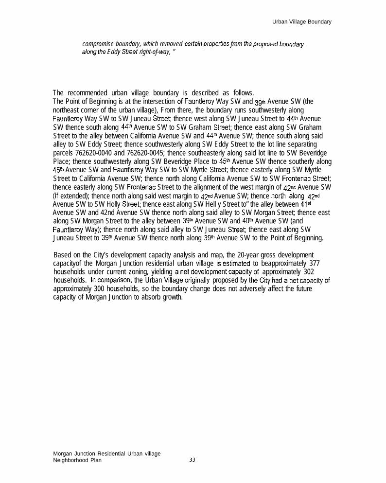
Urban Village Boundary
compromise boundary, which removed cetiain propetiies from fheproposedbounda~along the Eddy Street right-of-way, ”
The recommended urban village boundary is described as follows.The Point of Beginning is at the intersection of”Fauntleroy Way SW and 39tk Avenue SW (thenortheast corner of the urban village), From there, the boundary runs southwesterly alongFauntleroy Way SW to SW Juneau StreeC thence west along SW Juneau Street to 44~ AvenueSW thence south along 44fh Avenue SW to SW Graham Street thence east along SW GrahamStreet to the alley between California Avenue SW and 44ti Avenue SW; thence south along saidalley to SW Eddy Street; thence southwesterly along SW Eddy Street to the lot line separatingparcels 762620-0040 and 762620-0045; thence southeasterly along said lot line to SW BeveridgePlace; thence southwesterly along SW Beveridge Place to 45m Avenue SW thence southerly along45~ Avenue SW and Fauntleroy Way SW to SW Myrtle Street thence easterly along SW MyrtleStreet to California Avenue SW; thence north along California Avenue SW to SW Frontenac. Streetthence easterly along SW Frontenac Street to the alignment of the west margin of 42nd Avenue SW(if extended); thence north along said west margin to 42nd Avenue SW; thence nofih along @dAvenue SW to SW Holly Street thence east along SW Hell y Street to” the alley between 41sAvenue SW and 42nd Avenue SW thence north along said alley to SW Morgan Street; thence eastalong SW Morgan Street to the alley between 39* Avenue SW and 40fi Avenue SW (andFauntleroy Way); thence north along said alley to SW Juneau StreeC thence east along SWJuneau Street to 39~ Avenue SW thence north along 39~ Avenue SW to the Point of Beginning.
Based on the City’s development capacity analysis and map, the 20-year gross developmentcapacityof the Morgan Junction residential urban village isestimated to beapproximately 377households under current zoning, yielding anetdevelopment capacityof approximately 302households. lncompatison, the Urban Mllageofiginally proposed bythe~ty hadanet capacityofapproximately 300 households, so the boundary change does not adversely affect the futurecapacity of Morgan Junction to absorb growth.
Morgan Junction Residential Urban villageNeighborhood Plan ~~
Key Strategies
Key StrategiesKey Sfrafegies are projects, activities, or policies that affect more than one of the elements coveredby our Neighborhood Plan: Parks and Open Space, Transportation, Housing and Land-Use,Business District, Community and Culture, and Public Safety. As each subcommittee worked withinits own topical area, it became apparent that Morgan did have recurring issues that lent themselvesto being combined into integrated strategies. Asgoals, policies, and recommendations weredrafted to reflect the various topical issues, the Planning Committee selected thoserecommendations that could be presented to the City as Key Strategies for Morgan Junction.
Each Key Strategy consists of activities for a single complex projector theme that theneighborhood considers cfitical toachieving itsvision of the future. While the Key Strategies are .-high priorities for the neighborhood, they are also part of a 20-year plan, so the specific activitieswithin each Key Strategy may be implemented over the span of many years,The Morgan Junction Neighborhood Plan contains two Key Strategies:
. The’’Green C r e s c e n t● Fauntleroy Way Pedestrian Safe~and Landscaping improvements
Each Key Strategy isdiscussed inthepages that follow. Thissection is followed by presentationsof the goals, policies, and recommendations for each of the individual plan elements.
It is important to remember that these are recorrmemktior?s, and not detailed plans.As the details of projects and specific recommendations are developed in the future,the community will have a better opportunity to visualize them and participate in theirdevelopment. MoCA is committed to open and inclusive community involvement.
1
Morgan Junction Residential Urban VillageNeighborhood Plan 34

Key StrategyThe “Green Crescent”
Key Strategy
The “Green Crescent”
The Morgan Planning area and Urban Village do not meet the goals for a residential urban villageset forth in the 1994 Seattle Comprehensive Plan and 1993 Parks and Recreation ComprehensivePlan These goal stipulate a minimum of 1/3 acre of open space per 100 residents, accessibleopen spaces for neighborhood parks and/or village commons, and a community garden, Thus itwas a high priority of the Parks and Open Space Committee to meet these goals by developing astrategy to provide additional “Breathing Room” in the Morgan Junction neighborhood, particularlyin the business district and in residential areas where open space is lacking,
While currently there are no parks within the original proposed Urban Village Bounday, due to itstopography, the larger Morgan Junction Planning Area contains several valuable areas of natural,and mostly undeveloped land, some of which maybe considered open space, To further openspace linkage, the parks and open space committee researched and created a detailed matrix ofcity-owned rights-of-way, open spaces, substations and other publicly-owned properties, With thismatrix and planning area maps in hand, several walking and driving tours were conducted duringthe Phase II planning process, The group explored the supply of existing natural open spaces andparks surrounding the community, including Peily Place, Lowman Beach Park, Lincoln Park andLincoln Park Annex, Orchard Street Ravine and the Myrtle Street Reservoir area, and looked forother potential areas the neighborhood might hold as open space, such as Eddy Street Ravine,From this information base, the Parks Committee developed goals, policies and recommendationsto meet or exceed the standards of the Comprehensive Plan and to provide a framework toenhance and better utilize our neighborhood resources and opportunities. Key discoveries andideas that developed during Phase II planning are described in detail on the Parks and OpenSpace section on page 44.
By unifying and enhancing existing green space elements and reclaiming underutilized portions ofcurrently used street rights of way, open space and trail opportunities can be linked to create anetwork of pedestrian links throughout the neighborhood. Unused street rights-of-way, such as theEddy Street Ravine, may not be available for park and/or trail development. This strategy, whichhas been identified as one of two Key Integrated Strategies in the Morgan Junction NeighborhoodPlan, would involve implementation of several Parks and Open Space recommendations and resultin a “Green Crescen~ of parks, open space, trails and green street. The over-riding concept of theGreen Crescent will provide a focus for planning and prioritization of the many park, open spaceand trail opportunities that exist within the community. More details on the Green Crescent, thespecific recommendations that it contains, and the goals and polides that support theserecommendations can be found in the Parks and Open Space section beginning on page 44.
Morgan Junction Residential Urban VillageNeighborhood Plan 35
,, .,, . .

Key StrategyThe “Green CrescenV
The Key recommendations in the Green Crescent are listed below
Key Recommendations
.
.
.
●
.
.
●
.
●
✎
✎
Develop a “Green CrescenY that would run from the Reservoir park at 35th Ave SW and SWMytile St., through the SW Orchard Street Ravine, to the Lincoln Park Annex, through the PellyPlace/Lowman Beach Park area, and potentially up through the,SW Eddy St. Ravine, oralternative green link, into the center of the Morgan Junction business district. Development ofeach element of the “Green Crescent should be preceded by a feasibility study which wouldassess environmental impacts to sensitive ecosystems, slope stability, adjacent andsurrounding property owner concerns, maintenance, safety, funding and legal implications, asapplicable,
Acquire the Seattle City Light substation on Morgan Street for possible future parkfplaza spaceand/or reconfiguration of street intersections in order to support the Green Crescent while atthe same time improving traffic flow and pedestrian safety.
Preserve the Eddy Street Ravine as a natural ecosystem. In consideration of any futureenhancements of the ravine, balance the sensitivity of the Eddy Street Ravine ecosystem andimpacts on neighboring residents with public access via the “Green Crescent”,
Utilize the Eddy Street right-of-way, where it meets California Avenue SW, to create a pocketpark in the business district and create a natural separation between the pocket park and theSW Eddy Street ravine. In the event of future enhancements of the ravine, redesign of thebuffer may be needed.
Encourage the maintenance and restoration of native habitat and species in existing openspace sites, including Pelly Place, SW Orchard Street Ravine and the Lincoln Park Annex aswell a$ other areas such as SW Eddy Street Ravine. Sponsor programs to increase awarenessof property owners of the native habitat and species a,nd actions they can take to maintainthem.
Develop a community garden, potentially located at the Lincoln Park Annex,
Redevelop and renovate the Lincoln Park Annex with a panoramic viewpoint and picnic area,natural terraced seating on the existing slope and interpretive signage.
Improve the SW Orchard Street Ravine by restoring native plant and wildlife habitat,constructing a neighborhood trail and stairways, and installing interpretive or educationalsignage.
When the op,en reservoir at 35~ Ave SW and SW Myrtle St. is covered; move the securityfencing closer to the reservoir and create usable open space for family-oriented activities,
Create neighborhood trails maps and install effective signage to highlight the “Green CrescenVroute and other greenlinks.
Study the ecological, geotechnical and economic feasibility of recreating the historic salmonstream within the SW Eddy Street Ravine.
I
Morgan Junction Residential Urban VillageNeighborhood Plan 36

I
Key StrategyI The “Green Crescent”
~
Community Response: (the following was written and submitted by the Eddy Street RavinePresewation Alliance)
“Tfrera we-s signficart community opposition to the SW Eddy Street Ravine being referenced asan irrtagra/ part of the P/arr3 proposed Green Crescent. ,4ppmximate/y 186 homeowner
stakeholdem signed a petition, which was submited to MOCA. This pebfion requested MOCA.- exc/ude the Eddy Street Ravine from development as a pmposad pocket park and tmi/.
Furthe~ the pe%fion mquaated MOCA exckrde the ravine from tie Green Crescent Sbategy.
The Eddy Street Ravine is privately owned pmpaw, wfh an old straat.easement at the verybottom of the ravine. Jhe Draff P/an erroneously cafegorfzad this ravine as public open space,and rafarmd to this ravine as if II were a designated park and open space wit$in the proposedGreen Crescent. The Plan also inciudad development of the ravine as part of a GreenCrescent key strategy wifhout any attempt to invoive at fhe planning stages directfy impastadhomaowrrera living in and around the ravine.
In mid-1996, a homeowner suggested to the Parks and Open Space Planning Comm%t& that,if the ravine wera indudad in the Plan, homeowners living on the ravkre shouldba involved atthe planning staga. Although MOCA raprwentatiss concurred this was a gocd idea, MOCAmade no special otiresh to homeowrrers along the ravine. At a Septembe~ 1998 publicmeeting, homeowner stakeholdess raised oppoafion to instusion of the Eddy Street Ravine inthe Green Crescent and Parks and Open Space pruposals. On Novembar 28, f998, MOCAreceived a petifion with 135 signatures from the Eddy Skeet Ravfhe Presewation ,4//ianceopposing inclusion of the SW Eddy Street Ravine in the Plan as part of a pmposad GreenCrescent. On January 11, 1999, pefr7ionem provided MOCA an additiona/ 51 signaturesoPPosin9 development of the rawrre. 7he petition requested MOCA aliminate the propo.sak3 ofa pocket park and pub/it bai/ through the SW Eddy Sfraet Ravine as part of tie pmpo.sad GreenCrescant. The Petfion detaikd fourspecfic raasons forexcfuding the Eddy Sfraat Ravine fmmthe Pads and Opan Space and Groan Crascari Kay Strategies e.s defined in the draff P/an:
+ Impacts on the rlagile ecosystem, including destruction of an existing wetiand and wildlifehabrfat;
+ Slope stabilly impsvt.s in the ravine, which is designated as a potential slide area by theC@ of Seattle, and the attendant risk of Iiabilfty to the public and acjoining property owners aswall as public safety concerns ralated to /ands/ides;
I + Securtiy of propeiiies abuiting the ravine and the potential for the ravirre being a havenfor bansienta, delinquents, disem?anchisad and drug and alcohol abusers;
I + Impacts on ptiacy and propedy values.I
I On Wi?dnasdey Januaiy 6, 1999 a meeting was held between the P/arming Commfieeand representatives of the patifion signers, which had grown to 186 signatures.
On January 9, 1999 MOCA responded that tie administrattie commltee rear%rrad “thanead to keap the SW Eddy Straef Ravirre in the fieighbodrcod Plan. MOCA, with the Cly/iaison praaerrf, advised PebTioners that they were not amenable to de/eting the Ravine from theParks and Open Space and Green Crescent strategy asset out in the draff Plan. Due tb a Ciiy
1 Morgan Junction Residential Urban VillageNeighborhood Plan 37
I I

I
Key StrategyThe “Green Crescent”
imposed deadline for MOCA’S submitta/ of the pkm to the City of Seatt/e, revisions to the draft . .Plan were raquiti by Monda~ January 11, 7999.
On Monday Januaiy 11, 1999, representatives of the pet%ion sigrreis met wifhrapreserrtatives of the MOCA P/anrrirrg Cammittea. The petitioner repraserrtatias submifedrevisions to the draff P/an, Petlioners also communicated fhe fo//owirrg concerns ragarding theMOCA pmcass:
+ Lack of outreach to directly affded homeowners on or adjacenf to the SW Eddy SWaetRavine and other identifad padrs and open spaces proposed as part of the Green Crescentduring earfierstage-s of the neighbodrocdplannirrg pmce.s%
+ Charecferfzafion of the Ravine .as an “open space” versus a streaf rfght of way and non-distinction ofptiate versus public pmpedy in public documents.
+ Potentially flawed procedures for gathering, evaluating, and ana/yzing data, irrchdingappeamnce of unfairness, which Pefitionem fe/t undermined the p/arming prrxess.
+ Potentially incorrect talying of the validation ballots, whera the parks arrd open spaceproposa/ appears to have fai/ed to pass va/idatiorr.
Wthouf waiving any rights, and “under pmfest,” representatives of the Petiion negotiatedcertain revisions to the Drar? plan ~ading the SW Eddy Street Ravine. The ‘gist” of Urewisions.’ a) c/a@ Uret Eddy Street Ravine is rrefherpublic nor a designated open space; b)require feasibility studies and errvimnmental impact assassmem% be done before any further
,pianning or implementation in developing the ravine as an open space, trail or salmon stream;C) MquiE,a buffer betwean a pmpo%d packet park and the ravine, and d) require specticcontact wdh potentially affected homeowners in and around his ravine (or any otier park oropen space) idenfbied in tie Green Crescent strategy
Petlionem did not have an oppoiiurrily to mmmerd on or nagofiafe certain changes that wereadded to the dratl Plan recommendations in Pa&s and Open Space affer the Januaiy f 1, 7999meeting; i.e., deve/op a green space af Ho//y P/ace SW intersection wlh Faunt/emy Way SWend 49 Avenue SW, Petitioned were under #e impmssion that 4P Avenue SW was notepart of this graen sp&ceproposa/. Anypofentia/ creation of a graan space at this (or any otherrecommended location) should require an feasibility studylenvimnmental impxt assessmentand direct ouire%h to all neighbors in ffre immedafe vicinity of such planned greenspace.”
Morgan Junction Residential Urbsn VillageNeighborhood Plsn 38

-——
1 r’E=!=%n*
—..
,
—

Foundation of the Green Crescent:Existing Parks and Unimproved Rights-of-Way
City+ proposed urban village boundary

Key Strategy
Key StrategyFauntleroy Way SkV Improvements
Fauntleroy Way SW Pedestrian Safety and LandscapingImprovements
Fauntleroy Way SW is one of the main arterials serving West Seattle and Vashon Island, BecauseFauntleroy Way serves the Washington State Ferry terminal at Fauntleroy Cove, trarlc volumescan be heavy with through-trafhc, creating significant obstacles for neighborhood residents wishingto cross the arterial. Our neighborhood strongly supports maintaining current roadway capacitylevels,
As it meanders through the Morgan Junction neighborhood from southwest to northeast, theFauntleroy Way right-of-way cuts across the original street grid, leaving triangular remnants ofstreet right-of-way in a number of locations. These triangular remnants provide opportunities forbeautifying of the corridor with landscaping. South of California Ave. SW, Fauntleroy Way SW hasa three-lane cross-section - with one travel lane each direction and a center two-way Iefl turn lane.North California Ave. SW, Fauntleroy Way SW has two lanes in each direction. There is only onetrafic signal (at California Ave. SW) the entire segment of Fauntleroy Way SW from the ferryterminal to the West Seattle Junction commercial area. The combination of skewed streets, wideroadway width, and unbroken traffic platoons contribute in making pedestrian and vehicularmovement across Fauntleroy Way SW difficult and dangerous. The Fauntleroy Way SWImprovement strategy is a combination of actions intended to both take advantage of opportunitiesfor aesthetic enhancement and improve vehicle and pedestrian safety and accessibility forneighborhood vehicular and pedestrian traffic. A study is proposed that would evaluate thestrategy and verify community and City (SEATRANS) suppoti.
It is important to note that in the plan development and validation process, our neighborhoodlooked at the idea of extending the existing Fauntleroy Way SW lane configuration west ofCalifornia Avenue SW (one lane each direction) through the Morgan Junction Neighborhood as ameans to improve safety, accessibility, and aesthetics. At the validation process, this idea was metwith strong concern that roadway capacity could be compromised and traffic congestion couldoccur.
Key Recommendations
■ Evaluate the Fauntleroy Way SW corridor for opportunities to improve vehicle, bicycle andpedestrian safety, accessibility, traffic flow, and provide aesthetic landscaping improvementsthat maintain and improve existing traffic flow.
● Analyze traffic volumes (existing and future), delay times, travel times when consideringpotential new tra~c and/or pedestrian signals, and retaining on-street parking and buszones; consider bicycle lanes
● Improve bus stops and pedestrian crossings by installing painted crosswalks, curb bulbs,pedestrian median refuges, and pedestrian signals in appropriate locations,
,’I
Morgan Junction Residential Urban VillageNeighborhood Plan 41

Key StrategyFauntleroy Way SW Improvements
m
.
m
.
■
. Redesign Faurd[eroy Way SW / California Ave SW intersection for improve neighborhoodtratic circulation.
Reconfigure and channel “non-standard” Fauntleroy Way SW intersections; landscape unusedstreet right-of-way and islands at the following locations:
● 40th Ave SW/ SW Juneau St./39th Avenue SW. “45th Ave SW/Holly Place SW. Lincoln Park Drive SW
In order to mitigate current traffic circulation and pedestrian safety problems at the intersectionof 42nd, Fauntleroy, and Morgan, assess the feasibility of reconfiguring the intersection.Prepare a traffic study to determine the positive and negative transportation and safety impactsof the development of a pedestrian “plaza” in the triangle bordered by 42nd “Avenue SW, SWMorgan Street, and Fauntleroy Way SW. The study should examine the following impacts:
. The impacts resulting from the possible re-alignment of SW Morgan Street betweenFauntleroy Way SW and 42nd Avenue SW, especially the effect on adjacent residentialstreets, operations of the Fauntleroy Way SW/California Ave. SW intersection, andpedestrian safety.
● Consider installing a traffic signal at Fauntleroy Way SW/42nd Avenue SW intersections Revising 42nd Avenue SW street alignment to provide a better connection between
Fauntleroy Way and SW Morgan Street (to/from the east).● Improving bus stops and pedestrian crossings at and around the plaza.
Pending results of a trafhc study (see above) design and develop Fauntleroy Way SWimprovements including appropriate landscaping and street trees.
Develop a landscaped entryway in the existing triangles on either side of Fauntleroy Way SWat SW Juneau Street. Study other locations for neighborhood gateway improvements.
Develop green space at the intersection of SW Holly Place SW, Fauntleroy Way SW and 45Ave. SW;
Pending results of a trafic study (see above) develop a community plaza at the intersection ofFauntleroy Way SW and SW Morgan Street, In addition to landscaping, other features theplaza might include are an improved bus stop, shelter with cafe-style tables and benches, acommunity bulletin board, public art and, potentially, a fountain.
Morgan Junction Residential Urban VillageNeighborhood Plan 42

Plan Elements
Plan ElementsThis section presents the main portion of the Plan: the goals, policies, and recommendations whichaddress each of the six major elements covered by the Plan:
. Parks and Open Space
. Transpotiation a n d TraMc● Business District● Housing and Land Uses Public Safety. Community and Culture
The recommendations presented below are intended for implementation by the City, MoCA, andother community organizations over both the near term and long term.
The recommendations were originally drafted by each of the topical subcommittees and thenreviewed by the Planning Committee. Although each of the subcommittees met independently overthe course of the Phase ([ planning period, an overa{[ Planning Committee meeting was held eachmonth to share each sub-committee’s progress, concerns, and recommendations,
Many of the issues that confronted the Planning Committee defied categorization and thus wereaddressed by more than one subcommittee. For example, streetscape design and pedestriansafety were addressed by the Transportation Committee for the overall urban village and by theParks and Open Space Committee in its “green streets” poticies.
As a result of this overlapping, some recommendations appear, in similar form, several timesthroughout the Neighborhood Plan, Also, the recommendations presented above under KeyStrategies are repeated under the sections dealing with each plan element below,
There are also issues which were of concern to our community but which affect West Seattle as awhole. Our plan has goals, policies and recommendations which address those issues and arepresented within the individual elements which follow. They are also summarized in a separate“West Seattle wide” section (see page 80).
It is important to remember that these are recommendations, and not detailed plans, As the detailsof projects and specific recommendations are developed in the future, the community will have abetter opportunity to visualize them and participate in their development. MoCA is committed toopen and inclusive community involvement.
I
Morgan Junction Residential Urban VillageNeighborhood Plan
43

Parks and Open Space
Parks and Open Space,The Morgan Planning area and Urban Village do not meet the goals for a residential urban villageset forth in the 1994 Seattle Comprehensive Plan and 1993 Parks and Recreation ComprehensivePlan, These goals stipulate a minimum of 1/3 acre of open space per 100 residents, accessibleopen spaces for neighborhood parks and/or village commons, and a community garden. Thus itwas a high priority of the Parks and Open Space Committee to meet these goals “by developing astrategy to provide additional “Breathing Room” in the Morgan Junction neighborhood, particularlyin the business district and in residential area where open space is lacking.
While currently there are no parks within the original proposed Urban Village Boundary, due to itstopography, the larger Morgan Junction Planning Area contains several valuable areas of natural,and mostly undeveloped, open space, To further open space linkage, the parks and open spacecommittee researched and created a detailed matrix of city-owned rights-of-way, open spaces,substations and other publicly-owned properties. With this matrix and planning area maps in hand,several walking and driving tours were conducted during the Phase II planning process. The groupexplored the supply of existing natural open spaces and parks surrounding the community,including Pelly Place, Lowman Beach Park, Lincoln Park and Lincoln Park Annex, Orchard StreetRavine and the Myrtle Street Reservoir area, and looked for other areas that might hold potentialfor open space, such as the Eddy Street Ravine. Due to time, manpower and budgetaryconstraints, no targeted outreach was made to adjacent property owners in these areas,
From this information base, the Parks Committee developed goals, policies and recommendationsto meet or exceed the standards of the Comprehensive Plan and to provide a framework toenhance and better utilize our neighborhood resources and opportunities, Kay discoveries and ideasthat developed during Phase II planning include:
■
.
.
Several steep-sided natural ravines run generally east-west to Puget Sound and are theneighborhoods’ primary potential open space resource, This ravine topography loosely formsan arc or crescent of green space extending from the business district to Puget Sound andback east to 35~ Avenue SE. Named the “Green CrescenV during Phase II planning, thisnatural system of open space becomes both backbone and future planning focus for MorganJunction parks and potential open space, greenway trails and linkages, and urban foresthativehabitat restoration and enhancement,
Recent redevelopment of the Thritlway in Morgan Junction creates opportunities for a newcommunity plaza near the heart of the business district, in the triangle bordered by 42ndAvenue SW, SW Morgan St, and Fauntleroy Way SW. Seattle City Light’s Morgan Substationto the east will become surplus in 2002 and could extend opportunities for a public plaza in thisgeneral area (See more complete discussion of this idea, including a trafic study, in the Trafficand Transportation section beginning on “page 52,
Eddy Street Ravine has an unimproved street right-of-way near Morgan Junction and, if itcould be classified as open space, could present potential opportunities for native habitatrestoration and public access. In addition, old timers in the community remember when thesmall stream within the ravine actually had spawning salmon.
Moraan Junction Residential Urban VillaaeNei~hborhood Plan
. .44
This information stimulated the

Parks and Open Space
idea of re-creating this “historic” salmon stream within the ravine and connecting it to PugetSound. It was discussed that further exploration of the ravine as an open space and potentialsalmon stream would have to include current wastewater, stormwater and sewer drainage astheviable stream existed prior to a storm drain/sewer system that channels effluent andwastewater to the Lowman Park Sewage Holding Pond. After appropriate due diligence, thereis potential for development ofa pocket park where the Eddy Street right-of-way meetsCalifornia Avenue SW in the business district.
= Relatively short walking distances separate existing open spaces, such as Pelly Place,Lowrnan Beach Park and Lincoln Park and the Eddy Street Ravine area, A system ofpedestrian trails connecting open spaces and parks mayutiiize existing rights-of-ways alongscenic, view-oriented, topographically interesting and pedestrian-friendly streets.
■ An undeveloped, easily-accessible portion—..,
‘iiiii
View from Lincoln Park Annex
of Lincoln Park Annex adjacent to .SW WebsterStreet has been proposed as a communitygarden by local residents for some time. Inaddition, a built fill soil terrace with views toPuge\ Sound and the existing wooded hillsidewithin the largely undeveloped park provideopportunities for a viewpoint; picnicking andnative habitat restoration.
= Open space parcels along SW OrchardStreet make up the Orchard Street ravine, whichprovides opportunities for trails, wildlife habitatrestoration and interpretive signage.
= The City plans to cover the Myrtle Street Resetioir in the future with a soft-cover lid, thuscreating opportunities for additional recreation and community-related activities within thereservoir site.
■ Several other small undeveloped public parcels and/or rights-of-way fall within the GreenCrescent, which can strengthen and enhance pedestrian trails and open space linkages.
■ Outside of the Green Crescent, development is dense with few opportunities for additionalopen space. To promote pedestrian linkage from these dense residential areas to theCrescent, business district, Puget Sound shoreline and other West Seattle neighborhoods, agrid of existing residential streets could be developed as “green streets” and pedestrian ways.These streets would be a focus for future street tree planting.
■ The alleyways east and west of California Avenue SW are generally uninterrupted and pavedwithin Morgan Junction and provide unique opportunities for pedestrian and. bicycle linkage toplaces-of-interest in greater West Seattle. These alleyways are named Junction Way East andJunction Way West in both the Morgan Junction and West Seattle Junction plans. ~~
= Fauntleroy Way SW, California Avenue SW, 35ti Avenue SW and, to a lesser extent, Beach
Morgan Junction Residential Urban VillageNeighborhood Plan 45

Parks and Open Space
Drive SW are major arterials through Morgan Junction. Along its curvilinear alignment,Fauntleroy Way SW creates several triangular-shaped parcels, which are existing open spaceor undeveloped right-of-way areas, Landscape, pedestrian and/or community gatewayimprovements to these triangles and other rights-of-way areas along all the arterials would‘(green” the streets and, make them more pedestrian-friendly. During planning, thetransportation committee suggested the possibility of a planted median within Fauntleroy WaySW- an idea enthusiastically supported by parks and open space advocates,
With such a vast array of park, open space and trail opportunities within the Morgan Junctionplanning area, the greater challenge is setting priorities. The over-riding concept of the GreenCrescent provides the focus for planning and prioritization. The proposed system of linkages -trails, pedestrian greenways and boulevards - complements and connects features of the GreenCrescent both within Morgan Junction and to other West Seattle neighborhoods”,
Six opportunities in particular stand out as having particular potential and are outlined below withelements that could be considered in future projects, All six of these opportunities would “clearlyrequire additional study, programming and design, and community input processes. Currently atraftlc study the impacts for various options for the proposed Community Plaza is underway, withfunding from a Department of Neighborhoods grant,
Morgan Community Plaza (for more information see Transportation section, page 52.
Description:..
.
Existing .1+ acre City-owned right-of-wayLocated south of Fauntleroy Way SW&east of California Avenue SW, adjacentThrh%vaySpace potentially contributing to the plaza could include the triangular trafic islandwith existing Metro bus stop and landscaping, existing SW Morgan Street fromFauntleroy Way SW to 42nd Avenue SW, and future space available from thesurplusing of the Seattle City Light Morgan Substation in 2002,
Potential Opportunities:● Neighborhood gathering place. Improved bus stop● Shelter with cafe-style tables& benches. Community bulletin board or kiosk● Public art● Landscaping and buffer along Fauntleroy Way
o Simplified, tra~c flow
Eddy Street Ravine and Pocket Park
Description:Eddy Street Ravine
● Approximately 3,8 acres of street right-of-way● Located west of California Avenue SW to 47* Avenue SW, along curve of SW Eddy
Street .. Steep%ided ravine with remnant streamand wildlife habitat
Morgan Junction Residential Urban VillageNeighborhood Plan 46

Parks and Open Space
o Morgan Junction’s largest undeveloped street right-of-way
Potential Opportunities:● Pocket Park at California Avenue SW/SW Eddy Street right-of-way● Native Plant and Wildlife Habitat Restoration● Re-create the Historic Salmon Stream within. the Ravine. Neighborhood Trail (wood chip surface). Interpretive or Educational Signage
Lincoln Park Annex P-Patch, Panoramic Viewpoint and Native Habitat Area
Description:..
.
.
Existing City park landLocated east of Fauntleroy Way SW between SW Webster Street and SW FontanelleStreetExisting tennis courts along west end are only formal development at presentWest-facing slope with upper plateau (on fill) and unfilled wooded ravine areaextending to 44~ Avenue SW.
Potential Opportunities:Q Community garden (south edge)● Panoramic viewpoint& picnic area (plateau). Natural terraced seating on existing slope. Native habitat enhancement of wooded area● Interpretive signage
Orchard Street Ravine
Description:● Approx. 1 acre of City-owned rights-of-way and open space
● Located alona SW Orchard Street east of California Avenue SW to 36~ Avenue SW● Steep slopes-and ravines along quiet residential street
Potential Opportunities:● Native plant and wildlife habitat restoration● Neighborhood trail (wood chip surface) and
stairways● Interpretive or educational signage
SW Myrtle Street Reservoir Park
Description:● Existing City Water Department property. Located west of 35~ Avenue SW between SW
.
.
.Am. “
Willow Street &SW Myrtle Street View from Myrtle Sfreet ResewoirHighest point in the City with sweeping views;small viewpoint area already developedExisting reservoir and water towers
Morgan Junction Residential Urban VillageNeighborhood Plan 47

Parks and Open Space
● Reservoir maybe covered with softcover in the future, and security fences could bemoved closer to the reservoir edge
Potential Opportunities:. City High Point/Viewpoint Enhancement● Loop Trail& Jogging Trails Active Family-oriented Recreation
Junction Way East and Junction Way West (pedestrian- and bicyclist-friendly alleys)(Pedestrian-oriented north-south alleys connecting neighborhoods)
Description:● Existing north-south public alleys, directly east and west of California Avenue SW. Currently used by pedestrians/bicyclists; Alleys provide access to back doors of
businesses in The Junction
Potential Opportunities:● Junction Way East Enhance alley for pedestrian/bike use from Fauntleroy Way SW
(and possible Morgan Community Plaza) north to SW Charlestown Street (throughWest Seattle Junction to Admiral Oistrict)
. Junction Way, West Enhance alley for pedestrianhike use from east end of EddyStreet Ravine to SW Brandon StreeL (Continues intermittently through West SeattleJunction,)
Goals, Pol ic ies and Recommendat ions
Goal 1: “Pursue future open space acquisition through purchase, donation, or land trade toprovide additional “Breathing Room” in the Morgan Junction neighborhood.
Policy 1.1 Achieve 1994 Seattle Comprehensive Plan and 1993 Department of Parks andRecreation Comprehensive Plan goals for a residential urban village, including a minimum1/3 acre of open space per 100 residents, accessible open spaces for neighborhood parksand/or village commons, and a community garden.
Policy 1.2 Provide additional open space within the Morgan Junction business district.
Policy 1.3 Add open space to residential areas of the neighborhood that currently lackgreen space or “breathing room”,
Recommendation: Acquire the Seattle City Light substation on Morgan Street forpossible future parklplaza space and/or reconfiguration of street intersections in order tosupport the Green Crescent while at the same time improving tratic flow and pedestriansafety.
Goal 2: Preserve and maximize opportunities for public open space and pedestrianhicycletrails.
Policy 2.1 Keep unused and unimproved street rights-of-way~and alleys in city ownership.
Morgan Junction Residential Urban VillageNeighborhood Plan 48

Parks and Open Space
Policy 2.2 Eliminate encroachment on unused and unimproved street and alley rights-of-way.
Policy 2.3 Identify unused and unimproved public rights-of-way with clear public signage toencourage public, use.
Goal 3: Create and develop opportunities. for public open space and trails.
Policy 3.1 Unify and enhance existirig green space elements to”create a” Green Crescent”of open space areas; trails and “green streets” as a framework for open space planning,and to provide pedestrian links throughout the neighborhood,
Policy 3.2 Reclaim underutilized portions of currently used street rights-of-way to developopen space and trail opportunities,
Policy 3.3 Capitalize on opportunities within the business district to create public openspace/plazas that serve as community gathering places,
Policy 3.4 Work with appropriate city departments to ensure adequate maintenance of allexisting and future green elements in the Green Crescent.
Recommendation: Develop a “green crescen~ that would run from the Reservoir park at35th Avenue SW and SW Myrtle Street, through SW Orchard Street Ravine, to the LincolnPark Annex, through the Pelly Place/Lowman Beach Park area, and up through SW EddySt Ravine or alternative greenlink, into the center of the Morgan Junction business district,Development of each element of the “Green Crescent” should be preceded by a feasibilitystudy which would assess environmental impacts to sensitive ecosystems, slope stability,adjacent and surrounding property owner concerns, maintenance, safety, funding andlegal implications as applicable.
Recommendation: Preseme the Eddy Street Ravine as a natural ecosystem, Inconsideration of any future enhancements of the ravine, balance the sensitivity of the EddyStreet Ravine ecosystem and impacts on neighboring residents with public access via the“Green Crescent”.
Recommendation: Utilize the Eddy Street right of way where it meets California Ave SWto create a pocket park in the business district and create a natural separation between thepocket park and the ravine. In the event of future enhancements of the SW Eddy Streetravine; redesign of the buffer maybe needed,
Recommendation: Redevelop and renovate the Lincoln Park Annex with a panoramictiewpoint and picnic area, natural terraced seating on the existing slope and interpretivesignage.
Recommendation: Develop a community garden, potentially located at the Lincoln ParkAnnex.
Recommendation: Improve the SW Orchard Street Ravine by restoring native plant and.wildlife habitat, constructing a neighborhood trail and stairways, and installing interpretiveor educational signage,
Morgan Junction Residential Urban VillageNeighborhood Plan 49

Parks and Open Space
Recommendation: When the open reservoir at 35~ Avenue SW and SW Myrtle Street iscovered, move the security fencing closer to the reservoir and create usable open spacefor family-oriented activities,
Recommendation: Create neighborhood trails map and install effective signage tohighlight the “Green Crescenf’ route and other greenlinks.
Recommendation: Develop a green space at Holly Place SW intersection with FauntleroyWay SW and 45~ Avenue SW.
G,oal 4: Provide safe, aesthetic street and/or alleyways for pedestrian and bicycle travel
Recommendation: Provide, and identify with signage, an on-street and on-alley non-motorized transportation network coordinated with and complementary to the open space
and trail system.
Recommendation: Create “green streets” link for pedestrians on the alleyways east andwest of California Avenue SW, extending from Morgan Junction north through the WestSeattle Junction to the Admiral district named Junction Way East and Junction Way Weston parks and open space plans.
Recommendation: Develop a walkingbiking path along Beach Drive SW,
Goal 5: Preserve and enhance the neighborhood’s native habitat, ecosystems, and plantand animal species.
Policy 5.1 Re-vegetate parks and open spaces with native plants and reintroduce nativespecies, such as tree frogs, to appropriate habitats,
Recommendation: Encourage the maintenance and restoration of native habitat andspecies in existing open space sites, including Pelly Place, SW Orchard Street Ravine,and the Lincoln Park Annex, as well as other areas such as the Eddy Street Ravine.Sponsor programs to increase awareness of property owners of the native habitat andspecies and actions they can take to maintain them.
Recommendation: Study the ecological, geotechnical and economic feasibility ofrecreating the historic salmon stream within the SW Eddy Street Ravine.
Goal 6: Improve neighborhood identity and aesthetics.
Policy 6J Develop neighborhood gateways at north and south entries into the MorganJunction neighborhood and business district with associated open space andlorlandscaped areas and signage.
Policy 6.2 Promote greening and beautification of the neighborhood with local citizenparticipation, including planting of appropriate street trees as approved by City arborist,
Policy 6.3 Enhance the health of the urban forest within existing parks and open spaceareas.
Recommendation: Develop a landscaped entryway in the existing triangles on either sideof Fauntleroy Way SW at SW Juneau Street. Study other locations for gatewayimprovements.
Recommendation: Develop a long-term street-tree planting program to create a large gridoverlay complementary to the trail system. Streets within this grid include SW Brandon
Morgan Junction Residential Urban VillageNeighborhood Plan 50
.,.,

Parks and Open Space
Street, SW Juneau Street, 49~ Avenue SW, 46fi Avenue SW, SW Morgan Street, SWWarsaw Street, 38fi and 39~ Avenues SW, 35ti Avenue SW, SW Kenyon Street, SWThistle Street and SW Webster Street.
Goal 7: Provide safer, greener and more aesthetically pleasing arterial streets through theneighborhood.
Policy 7.1: Focus improvements on Fauntleroy Avenue SW and California Avenue SW:
Policy 7.2: Improve aesthetics, pedestrian, bike and traffic safety with street trees,landscape features and public pocket parks.
Recommendation: Pending results of a traffic study, design and develop Fauntleroy WaySW improvements, including appropriate landscaping and street trees.
Recommendation: improve California Avenue SWstreetscape withthe installation oflandscaping and street trees.
Community Response: The Eddy Street Ravine Presewation Al/iance hadconcernsandcorrrrnerrfs regardirrg the Parks arrd Open .Spacee/ernent. Their commerrtary ispresentedorJ page 37 in the Gteen Crascerrt Key Strategy section,
1,
Morgan Junction Residential Urban VillageNeighborhood Plan 51
Transportation
TransportationTransportation is an issue that has major impacts, both positive and negative, on the vitality andlivability of a community. The viability of local businesses and the overall character of theneighborhood are both affected by transportation facilities, often in conflicting ways,
On a larger scale, West Seattle is a peninsula with only a few direct connections to the rest of thecity and the regional highway system, With growth and development within West Seattle and withincreasing traffic congestion on the roads connecting West Seattle to the outside, access to/fromWest Seattle is becoming increasingly difficult. Congestion and delay on West Seattle’s externalconnections degrades accessibility and mobility for residents and businesses alike. The issue ofWest Seattle access is being addressed in a separate study in which”MoCA is collaborating withother West Seattle neighbor~oods. Initial recommendations from t~at study have been -
incorporated into our Plan, and are summarized in the section “West Seattle-wide Issues” on page80,
Locally, outreach has shown us that pedestrian/bicycle access and safety and automobile mobilityare the highest priority transportation issues. At the same time, maintaining smooth traftic flow onour arterial streets is also most important. The Transportation Committee, therefore, identified fiveareas on which to focus our planning efforts. These include the Fauntleroy Way SW Corridor, theCalifornia Avenue SW Corridor, the 35~ Avenue SW corridor, east-west arteriak, and traticmanagementicalming spot improvements at key locations.
Fauntleroy W a y C o r r i d o rThe Fauntleroy Way corridor is one of the main north-south arterial routes serving West Seattle,The corridor provides arterial access between the Morgan Junction neighborhood and the regionalhighway system (via the West Seattle Bridge), and it serves as the primary access route to/fromthe Washington State Ferry System’s Fauntleroy terminal and its Vashon Island and Southworth(Kitsap County) ferry service. Fauntleroy Way also provides access to the Morgan Junctioncommercial area, located at and around the Fauntleroy Way/California Avenue SW intersection,
In making its way from the ferry terminal in the southwest to the West Seaflle Bridge in thenortheast, Fauntleroy Way cuts across the grid of local and arterial streets in West Seattle; theroadway runs diagonally through part of the neighborhood, and in other parts it follows thealignment of north-south streets. The diagonal segments of the alignment create awkward andconfusing local and arterial street intersections at 39th Avenue SW, SW Juneau Street, 40thAvenue SW, SW Morgan Street, 45th Avenue SW, and Holly Place SW.
North of the Morgan Junction commercial area, Fauntleroy Way has four travel lanes with on-streetparking on both sides of the street, South of the Morgan Junction commercial area, FauntleroyWay has a three-lane cross-section - with one travel lane in each direction and a wide center two-way left turn lane – with on-street parking on both sides of the street. The portion of FauntleroyWay in the Morgan Junction neighborhood is designed to support free-flowing tratic operations:there is only the one traffic signal at California Avenue SW to control traffic flow on Fauntleroy Waybetween the ferry terminal and SW Edmunds St.
I
Morgan Junction Residential Urban VillageNeighborhood Plan 52
Transportation
Trafffc volumes on Fauntleroy Way can be heavy, with traffic leaving the ferry! tending to travel inunbroken “platoons” through the neighborhood (the lack of tratic signals allows the platoons toremain intact over a greater distance from the terminal than they might otherwise). Speeds onFauntleroy Way are excessive; the roadway configuration and traffic control (i.e., the roadwaywidth and the lack of signals) are significant contributors to the speed problems that exist, Therealso is a perception that much of the traffic enroute to and from the ferry is trying to get through thearea as quickly as it can, and that there is little respect for the neighborhood through whichFauntleroy passes. Allofthese factors -roadway width, skewed streets, trafic volume,platooning, and speed - combine to make pedestrian and vehicle movement across FauntleroyWaydifficult anddangerous, To facilitate safecrossings atselected Locations there arepedestfiansignals at Findlay Street on the north side of the neighborhood, and at Myrtle Street and WebsterStreet near Lincoln Park. Our neighborhood strongly supports maintaining current roadwaycapacity levels.
In addition to its important traffic-carrying role, Fauntleroy Way must provide safe, convenientcrossings for pedestrians walking to/from bus stops, parks, commercial areas and otherneighborhood destinations. Lane configuration andtrafic con!rol/calming must bedesignedtoserve these conflicting needs,
Goall: improve local access andcirculation onatierial roadways inthe Morgan Junctionneighborhood
Policyl.1 Periodically assess pavement conditions andimplement repairs aswarranted.
Policyl.2 Optimize laneconfiguration andsignal timing atsignalized intersectionstoimprove, vehicle and pedestrian circulation.
Policyl.3 Develop andimplement strategies toreduce speeding traficand to maintainaPPrOPfiate speeds on arterial roadways,
Recommendation: Evaluate the Fauntleroy Way SW corridor for opportunities to improvevehicle, bicycle and pedestrian safety, accessibility, trafic flow and provide aestheticlandscaping improvements that maintain or improve existing traffic flow,
.
.
●
Analyze traffic volumes (existing and future), delay times, and travel times whenconsidering potential newtrafic and/or pedesttiansignais, andretaining on-streetparking and buszones; consider bicycle lanesImprove bus stops and pedestrian crossings by installing painted crosswalks, curbbulbs, pedestrian median refuges, and pedestrian signals in appropriate locationsRedesign Fauntlerov Wav SW / California Avenue SW intersection for imorovedneighb~rhood trafff~ circ~lation,
Recommendation: Reconfigure and channelize “non-standard Fauntleroy Way SWintersections; landscape unused street right-of-way andislands atthe following locations:
f lti$impotint tonotetiat tie fewsystem hasafinite, hmit&mpaciw mputtmfic on FaunUemy Way, During tie busiest 60.mlnuteperiti, amaximum of fourtwat$ dockat Fauntleroy. ThSeboak havearnmtinti tO&lveNcle wVingapaciw of405~s, andasaresult feWtiticcannot amount to more than3,00400 vehicles prhouron "otibound FaunUemy Way~ftie boabare 811full andalloff.loating titicmntinuesnorfhon Fauntiemy). Comparing tieXvOlumS bti8~piml mwciVofan afledal lane(f400.1500 veticles perhour), itmnbewnclud& matwiti the exceplim of UIe Sgnafized intemecoon at Cafifom ia Avenue SW, a sing Ie travel lane in each diretion will provide adequak capacity fortraffic on FaunUemy Way. 1,
Morgan Junction Residential Urban Village,Neighborhood Plan 53
Transportation
. 40th Avenue S,W/SWJuneau Streef/39th Ave SW(Figurel)
● 45th Avenue/Holly Place SW(Figure2). Lincoln Park Drive
Recommendation: In order to mitigate current traffic circulation and pedestrian safetyproblems at the intersection of 42nd, Fauntleroy, and Morgan, assess the feasibility ofreconfiguring the intersection, Prepare atraftlc study todetermine thepositive andnegative transportation and safety impacts of the development of a pedestrian “plaza” inthe triangle bordered by 42nd Avenue SW, SW Morgan Street, and Fauntleroy Way SW,The study should examine the following impacts:
.
.
.
.
.
The impacts resulting from the possible re-alignment of SW Morgan Street betweenFauntleroy. Way SW and 42nd Avenue SW, especially the effect on adjacentresidential streets, operations of the Fauntleroy Way SW”/ California Avenue SWintersection, and pedestrian safety.Consider installing a potential traffic signal at the Fauntleroy Way SW/42nd AvenueSW intersectionRevising 42nd Avenue SW street alignment to provide a better connection betweenFauntleroy Way and SW Morgan Street (to/from the east),Improving bus stops and pedestrian crossings at and around the plaza.Pending results of a trafk study (see above) develop a community plaza at theintersection of Fauntleroy Way SW and SW Morgan Street, In addition to landscaping,other features the plaza might include are an improved bus stop, shelter with cafe-style tables and benches, a community bulletin board, public art and, potentially, afountain.
Morgan Junction Residential Urban VillageNeighborhood Plan 5 4
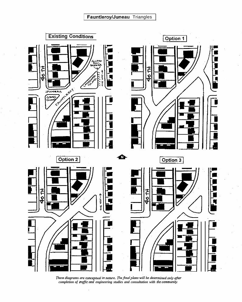
FauntIeroylJuneau Triangles
Existing Conditions
“’i
‘These diagrams are conceptual in nature,
i
‘)
L
completion of lraj>c and engineering studies and consultation with the commmiy,
,.

Fauntleroy/Holly Place/45th Avenue Intersection
I Or3tion 2 I
7?ws. diagrams are conceptual in nature. The JnaIplans will be determined ozdy q?ercoinpletio” of trafic and engineering studies and consultation with the cmmnunig.

Transportation
California Avenue SW Corridor Pedestrian Improvements
The California Avenue SW corridor is one of the main north-south arterial routes serving WestSeattle, Its main roles are to provide a connection to Fauntleroy Way to/from the north (includingthe West Seattle Bridge), to provide access to the Morgan Junction and West Seattle Junctioncommercial areas, and connect Morgan Junction with the residential area atop Gatewood Hill,
The California Avenue SW roadway is fairly wide, its cross-section accommodating two wide trafficlanes with on-street parking on both sides south of the Morgan Junction commercial area (south ofSW Holly Street), and three lanes - a travel lane in each direction plus a center two-way left turnlane – plus parking on both sides through the commercial area and north of it, There are traficsignals at the Fauntleroy Way SW and SW Graham Street intersections, there is a pedestriansignal at SW Frontenac Street south of the commercial area, and there marked crosswalks withilluminated signs at SW Findlay Street north of the commercial area and SW Othello Street southof the commercial area.
Heavy traflc volumes and high speeds combine with the roadway width to make it difficult forpedestrians to cross the street, even at the signalized intersections. In addition to its importanttraffic-carrying role, California Avenue SW must provide safe, convenient crossings for pedestrians.walking to/from bus stops, parks, schools, and other neighborhood destinations. Pedestrianconvenience and safety in the commercial area surrounding the Fauntleroy Way SW intersectionalso is important to the health and viability of local businesses. Lane configuration and trafficcontrol/calming must be designed to serve these conflicting needs.
Goal 2 Improve pedestrian and bicycle mobility in the Morgan Junction neighborhood toprovide safe and convenient opportunities for pedestrian and bicyclists to crossarterial streets, acceas bus stops, and utilize neighborhood businesses and parks.
Policy 2.1 Implement arterial roadway improvements with pedestrian and bicycle facilities.
Policy 2.2 Coordinate roadway improvement efforts with Business Oistrict, Parks/Open Spaceand Public Safety Goals and Policies.
Recommendation: Improve pedestrian crossings by installing the following devices, asappropriate, at intersections in the Morgan Junction business district and north and southalong California Avenue SW:. paint crosswalks. curb bulbs. pedestrian median refuges● pedestrian signals
Specitic locations on California Avenue SW at which pedestrianimprovements should be installed include the following:
. SW Holden Street intersection● the existing crosswalk at SW Othello Street. the existing pedestrian signal and crosswalk at SW,
Frontenac Street● all bus stops south of Fauntleroy Way
I
Morgan Junction Residential Urban VillageNeighborhood Plan 57
Pedestrian safety improvements arerecommended in various locations.

Transportation
● in the Morgan Junction commercial area (south of Fauntleroy Way SW) at or near SWHolly Street
● Fauntleroy Way SW/SW Morgan Street intersection’● north of Fauntleroy Way SW: all bus stops and/or every second block (i.e., at some
regular interval that provides adequate pedestrian access across California AvenueSW for the surrounding neighborhoods and adjacent businesses and residences)
\ ““’...,>\ \. . . . . .\
.. . ... ,,. . .. .
p
. .. ,. \., ::... . .
P. . . . . ./’ ,;.,.,:; ~
/ :’”.” ““”’;”/ ‘;’:./ . ..’. .
Curb bulbs are one method to improve pedestriansafety.
Morgan Junction Residential Urban VillageNeighborhood Plan
Pedestrian refuges improvesafety on busy arterial streets.
IJ!q.lJllH8&Hl
T1’MT
!“i,
5 8
Transportation
35th Avenue SW Corridor Pedestrian Improvements
The 35th Avenue SW corridor is one of the main north-south arterial routes serving West Seattle.Its main role is to carry trafic to and from the West Seattle Bridge and to provide access toWestwood and other shopping destinations south of the Morgan Junction neighborhood, The 35thAvenue SW roadway is fairly wide, accommodating four trafic lanes with on-street parking on bothsides. On the portion of 35th Avenue SW in the Morgan Junction neighborhood, there are trafficsignals at SW Findlay Street, SW Morgan Street, SW Mytile Street, SW Webster Street, and SWHolden Street, and there is a pedestrian signal at SW Raymond Street,
Heavy trafic volumes and high speeds combine with the roadway width to make it difticult forpedestrians to cross the street, even at the signalized intersections. In addition to its importanttraffic-carrying role, 35th Avenue SW must provide safe, convenient crossings for pedestrianmovement to/from bus stops, parks, and other neighborhood destinations. Lane configuration andtraffic control/calming must be designed to serve these conflicting needs.
Recommendation: Improve pedestrian crossings at signalized cross-streets and at bus stopsalong 35~ Avenue SW by the installation of the following, as appropriate
. paint crosswalks● curb bulbs. pedestrian median refuges● pedestrian signals
East-West Arterial Corridor Pedestrian Improvements
There are several east-west arterial corridors in the Morgan Junction neighborhood that provideconnections between the major north-south arterials as well as access to the residential areas theypass through. These east-west arterials – SW Graham Street, SW Morgan Street, and SW HoldenStreet – carry much less trarlc than Fauntleroy Way SW, California Avenue SW, and 35th AvenueSW, the major north-south arterials. However, each of the east-west arterials has a wide roadway,and tratlc on each can tend to travel fairly fast (especially on downhill segments), Traffic speeds,roadway width, and limited sight distance at the crests of hills make these arterials difficult for
pedestrians to cross.
Recommendation: Improve pedestrian crossings along SW, Graham Street (from CaliforniaAvenue SW to Fauntleroy Way SW), SW Morgan Street (from 42nd Avenue SW to 35th AvenueSW), and SW Holden Street (from California Avenue SW to 35th Avenue SW) by, installing thefollowing devices, as appropriate, at bus stops, on school walk routes, and at a spacing of nogreater than two blocks elsewhere:
● pa in t c rosswalks. curb bulbs. pedestrian median refuges. pedestrian signals
Morgan Junction Residential Urban. VillageNeighborhood Plan 59

Transportation
Traffic Management/Calming and Spot Improvements
There are a number of local streets and intersections throughout the Morgan Junctionneighborhood that experience excessive speeds and/or inappropriate through traffic flows that“create safety hazards for motorists, pedestrians, and bicyclists, cause noise and inconvenience forlocal residents, and generally degrade the residential environment. These problems can beaddressed by means of a variety of traffic calming, traffic control, and street networkimprovements.
Goal 3: Improve the safety and maintain the character of residential streets.
Policy 3.1 Develop and implement improvements to encourage through trafftc to utilize arterialroadways,
Policy 3.2 Develop and implement strategies to reduce speeding traffic,
3 k“Recommendation: Install traffic calming and traffic control.:. .. . . .,
,.,. devices to decrease speeds and discourage through traffic at the,., ,-. ; following locations as approved by the surrounding residents:. ...:. SW Holly Street from 41st Avenue SW to California Avenue
0“
Sw. 48th Avenue SW from SW Raymond Street to SW JuneauStreet
q~ . SW Frontenac Street and SW Myrtle Street from Fauntleroy,. :.:.Way SW to California Avenue SW”(at Gatewood School)● 38th Avenue SW from SW Findlay Street to SW Juneau Street”
Traffc circles are commonly used traffic . SW Juneau St. from 35~ Avenue SW to California Avenue SWcalming devices. . Ss!h Avenue Sw arlcj Sjw willow street
● 42rid Avenue SW between SW Morgan and SW Holly
Public Transportation Facilities and ServicesTransit is a critical element of the transportation system that provides internal and external accessand mobility for West Seattle residents, visitors, and businesses. West Seattle relies heavily ontransit for access to downtown Seattle and other parts of the City and the ‘region, With accessto/from West Seattle provided almost exclusively by the heavily-congested West Seattle Bridge, itis critical to the future health and vitality of West Seattle neighborhoods and commercial districtsthat all forms of public transportation be expanded and improved. The finite automobile capacityinto and out of West Seattle is over-taxed, even at current levels of trafic and development.Accordingly, public transportation will need to play an expanded role to serve West Seattlecommuters and other travelers if future growth in travel demand generated by com,prehensive-plan-specified growth is to be adequately accommodated.
Note: Some of the recommendations that follow are West Seattle-wide in nature and are alsoincluded “in the”’’West Seattle-wide Issues” section on page 72. These are marked by a “WSWsymbol below.
Morgan Junction Raaidential Urban VillageNeighborhood Plan 60

Transportation
Goal 4: Ensure that new transit improvements, including Metro bus, Sound Transit bus, andmonorail, benefit the Morgan Junction neighborhood in terms of transportation servicesand impacts on local acti~ties and environmental conditions.
Policy 4.1 Ensure that the new Sound Transit regional express bus route through West Seattleserves the urban villages along California Avenue SW
Recommendation: Improve and expand public transportation facilities and services providingaccess to/from West Seattle (WSW):
.
.
.
●
Improve speed and erTciency of existing and future bus service by enabling buses to avoidtrafic congestion
Expand service coverage in West Seattle to make transit services more easily accessible tomore people and activities
Expand transit network connections to provide more and better linkages between WestSeattle and other parts of the City and region
Develop new, alternative modes of Dublic transr)ortation to rxovide additional non-autoaccess”to West Seattle (e.g., waterborne transit, monorail)’
Recommendation: Metro should continue to expand service hours and frequency of its West Seattleservice. Also, Metro should continue to increase the number of West Seattle, Seattle, and King Countyorigins/destinations served by West Seattle routes Work with Metro to locate routes and site bus stops formaximum ridership and minimal impact to adjacent property owners. (WSW),
Goal 5: Support efforts to address traffic and transportation issues which have an impact on WestSeattle.
Policy 5.1 Support and participate in coordinated West Seattle transportation planning regardingthe West Seattle Bridge, ferry traftic, and other transportation issues,
Recommendation: Work with Fauntleroy Community Association to encourage the rerouting ofstate ferries to the downtown Seattle ferry terminal.
Recommendation: Develop and implement a comprehensive “action program” of transportationsystem improvements and actions that will fully address the existing and future access needs ofthe entire West Seattle community (WSW). The action program must
.
.
.
define and quantify existing and future access needs
be comprehensive: it must jointly address all modes of transportation, and it must address alllevels of detail, from the “universaY (e.g., transportation system capacity) to the “microscopic”(e.g., traffic operations on bridge on-ramps)identify immediate, near-term, and long-range improvements and actions, and develop implementationprograms for them
Recommendation: West Seattle Bridge-Spokane Street Viaduct Bus Operations: The City ofSeattle, the Port of Seattle, WSDOT, and Metro should cooperate to provide roadway, intersection,and tratlc control improvements that give Regional Express and Metro buses priori~ to, from, onto,offof, andacross the West Seattle Btidgeand the Spokane Street Maduct(WSW), Suchimprovements should include:
., I
Morgan Junction Residential Urban VillageNeighborhood Plan 61

Transportation
o add HOVlanes onthebridge and the viaduct. intersection and ramp queue jump/bypass lanes on bridge and viaduct access routes. traffic signal priority and preemption
“Regional Express,” the express bus division of Sound Transit (RTA) plans to begin operating anumber ofexpress busroutes throughout theregion inthefallofl999. Oneofthe RegionalExpress routes will operate, between Sea-Tat Akpor? and downtown Seattle via Burien, WhiteCenter, Fauntleroy, and West Seattle,
~~ Recommendation (WSW):
. Recognizing theneed tomakelimited stops onthisexpress sewice, the Regional ExpressWest Seattle route should maximize the connections and access it provides in West Seattle,including transfers with Metro routes, access to the Fauntleroy Ferry Terminal, and ensuringthat the Regional Express bus route serves the urban villages along California Avenue SW.
. The Regional Express West Seatile route should beextended orthrough-routed vial-90 to theEastside after stopping in downtown Seattle,
Water Taxi/Seabus
The existing Elliott Bay Water Taxi, begun in 1997, is a summer-season passenger-only ferry serviceconnecting West Seatile and downtown Seattle.
Recommendation: The Water Taxi service should be expanded into a permanent year-roundsystem (like Vancouver, BC’S Seabus) that is designed to be an integral and important element ofthetransportation system serving West Seattle, Inorderto determine thecapital andoperationalrequirements of such a system and to guide its incremental development, a long rangecomprehensive master plan for facilities and services - on both sides of Elliott Bay – should beprepared (WSW).
Recommendation: Connections to the West Seattle Seabus terminal should be expanded and improved.Bus service, shutfle/circulator service, a potential tram/funicular system, parking (or lack thereo~, andbicycle/pedestrian pathways should be addressed (WSW),
Morgan Junction Residential Urban VillageNeighborhood Plan 62

Business Dtstrict
Business DistrictThe Morgan Junction Residential Urban Village is centered around its business district, Mostbusinesses in the district, generally focused at the intersection of Fauntleroy Way SW andCalifornia Avenue SW, are oriented towards serving the surrounding residential neighborhood. Thedistrict’s largest business, the Thriftway supermarket, reopened its doors in a new facility this year,almost exactly one year after being destroyed by fire.
The business district is zoned NC3-30, a zone intended for pedestrian oriented neighborhoodservice businesses and multi-family residential structures. The majority of the commercial uses arein older single story structures oriented towards California Avenue SW. The multi-family buildingsare, for the most part, multiple story structures built to the height limit of 30 feet
Morgan Junction does not have the large land parcels needed for major chain stores but hasexcellent demographics and locations suitable for smaller stores. Attracting more small shops anda greater variety of restaurants into the district were goals expressed during Phase I outreach,Maintaining and enhancing the appearance of the business district and making the districtconvenient and pedestrian friendly also emerged as important issues for the community.
During Phase 11, business participation on the Business District Committee was very sparse. It wasassumed by the Planning Committee that this was due to the business owner’s general satisfactionwith the current state of the commercial area, and being too busy running their businesses, ratherthan because of lack of interest
Goals, Policies and RecommendationsGoal 1: Support the economic vitality of the local Business District.
Policy 1.1: Encourage improvements in the business district that will promote thediversification of the Morgan community business district.
Goal 2: Enhance the physical appearance of the Morgan Business District, so it is anattractive place for people to live, work, and shop,
Policy 2.1: Use City design guidelines to develop consistent building types andcharacteristics with the option of reviewing guidelines in the future.
Recommendation: Supplement current City design guidelines with guidetines that are’specific to Morgan Junction in order to maintain the current small-town character,
Recommendation: Place notice of City Design Review meetings in the West SeattleHerald and post notices of the meetings at the project site,
Morgan Junction Residential Urban VillageNeighborhood Plan 63

Business District
Goal 3: Make the Business District accessible for customers and visitors.
Policy 3.1: Promote the use of transit, including possible shuttles, to reduce parking and
traffic congestion.
Policy 3.2:. Pursue new and inventive ways to improve parking and access to businesses
Policy 3.3: Create a pedestrian friendly environment to encourage walking to and throughthe business district.
Recommendation: Improve California Avenue SW streetscape wi~h the installation oflandscaping and street trees and the construction of curb bulbs,
Recommendation: Create a “green streets” link for bicycles and pedestrians from MorganJunction through the West Seattle Junction to the Admiral district on the alley east ofCalifornia Avenue SW (Junction Way East).
Goal 4: Continue to promote cooperation among businesses, residents and communitygroups <
Policy 4.1: Encourage the creation of public gathering places,
Recommendation: Develop a community plaza at the intersection of Fauntleroy Way SWand SW Morgan Street,
Strong support for local design guidelinesemerged from community review of theabove goals and policies. Many expressedthe desire to maintain the “small town”character of the business district, and tomake the district unique and distinctive; aplace that attracts new businesses as wellas shoppers. The need for better guidelinesfor the design of multi-family residential andmixed-use projects was frequently voiced,
The City of Seattle has developed aMixed-use developments provide housing and businessopportunities in the business disfyict,
manual entitled Pre~arina vour own De.siqnGuidelines - A Handbook for Seati/e’sNeicrhborhoods. This handbook could be a useful tool in helping the Morgan Junction
neighborhood develop design guidelines that arespecific totheneighborhood. Anexcerptfrom theHandbook is included in the Housing and Land Use section of this, plan.
Morgan Junction Residential Urban VillageNeighborhood Plan 6 4

Housing and Land Use
Housing and” Land-UseBackground
It would be an understatement to say that maintenance of the single-family character of the MorganJunction Neighborhood is a high priority of our community. Throughout the neighborhood planningprocess, this sentiment was expressed again and again.
Concern for the protection of our single-family neighborhoods began when the City designated MorganJunction as .a Residential Urban Village in the 1994 Comprehensive Plan and established thepreliminary boundaries for the urban village. Among the criteria used by the City in designating urbanvillages were:
● The area’s current zoning, which provides sufficient capacity for future growth and development.The Morgan Junction urban village has the ability to absorb 300-plus new residential units undercurrent zoning.),
● Location ,along major transpotiation routes, including roads and mass transit lines, and
● The ability to achieve residential densities which will support compact living and pedestrian- andtransit-friendly environments (for example, 2,000 dwelling units exist or can be accommodated witha 2,000 footlradius of the center of the urban village).
Impact of the Urban Village on Zoning and Capital Investment
The urban village designation has implications for both zoning and capital investment by the City.
Impacts on Zoning
Urban villages have access to zoning options not available to areas outside of village boundaries.Urban village neighborhoods can:
.
*
●
✎
✎
Suggest rezones of single-family areas within the urban village boundary to low density multifamilyor commercial zones in areas close to principal commercial streets;
Allow Residential Small Lot (RSL) zoning, which can include (1) single-family houses on individualsmall lots, (2) two houses on a one lot, and/or (3) clusters of small cottageson larger lots;
Identify commercial areas within the village bounda~ where residential development will beemphasized (Neighborhood Commercial/Residential zoning);
Designate areas within an urban village as appropriate or inappropriate for moderate-densitymultifamily zoning (including L3 and L4 zones);
Recommend how residential buildinas without mound-floor commercial sDace should be treated in~, commercial zones within the urban-vill
age. Tie plan can allow such ~ngle-purpose residential
Morgan Junction Residential Urban VillageNeighborhood Plan
65

Housing and Land Use
buildings outright, permit them only under specific conditions, or it can prohibit these buildings incommercial zones altogether,
There has been much discussion and disagreement on the Morgan Planning Committee regarding theimpact of the urban village on zoning, especially on the single-family zones.
● Some members of the committee see the urban village as offering protection for single-familyzones by stipulating in the Neighborhood Plan exactly what zoning changes can and cannot occur,The majority of the Administrative Committee subscribes to this view,
● Other members of the committee view the urban village as an overlay zone which will lead tochanges in the permitted uses and development standards of the underlying” zoning, Rezones andvariances may also be easier to obtain within the village than outside, These changes, in turn,would allow the City to increase allowable densities and building size (see the diagram below),possibly accelerating the rate of development in the Morgan area, The majority of the Housing andLand-Use Subcommittee holds this opinion
Impacts on Capital Facilities and Investment
The Comprehensive Plan has a goal of making capital investments consistent with the urban villagestrategy by encouraging the City to locate “new community-based capital facilities,” including libraries,community centers, and parks in areas that serve urban villages. It also requires the City to providewritten justification when proposing to locate major capital facilities outside urban village areas. TheCity is also directed to “con$ider providing capital facilities or amenities in urban villages as anincentive to attract both public and private investments to an area” (Source: Cify of Seatt/e StrategicHarming 0r7ice).
The Comprehensive Plan includes goals for the provision of adequate and accessible open spacewithin urban villages. Efforts to acquire open space and develop recreation facilities are directed togive particular attention to serving urban villages, which are in general expected to have the greatestneed for additional open space and recreation facilities (Sourca: City of Seat!/e .Wafegic PlanningOffice),
These issues, too, have generated much debate on the Planning Committee,
.
●
“Some committee members believe that the urban village will make it easier for our neighborhoodto acquire needed open space, amenities, and capital facilities, and that funding will be morereadily available for maintenance and new projects within the village than outside its boundaries, Amajority of the Administrative Committee subscribes to this view.
To other members of the Planning Committee, the urban village offers no guarantee that fundingwill be available for these facilities and amenities without an increase in property taxes, While thecapital improvements are not a uncertainty, the higher density requirements within the villaae are,A majority of the Housing and Land-Use Subcomm-ittee holds ‘this opinion.
Morgan Junction Residential Urban VillageNeighborhood Plan
66

Housing and Land Use
Principal Issues Addressed
In light of these concerns, coupled with the opinions received from the community during the outreachand validation events, the implications of the Urban Village designation for the neighborhood’s single-family character became the primary focus for the Housing and Land-Use Subcommittee.
After many hours of study and discussion, the Housing and Land-Use Subcommittee determined thatthere were four areas of primary importance on which efforts would be focused:
.
.
.
.
Zoninghow best to preserve the single-family areas and small town feel of the community, whileexploring the possible impact of adopting any of the “zoning tools” offered to urban villages by theCity, such as Residential Small Lot (RSL) zones.
Building Height, Bulk and Setbacks--are there mechanisms that can be created that will result inbetter, more compatible design within our existing multifamily and commercial zones? This wouldinclude recommendations for specific design guidelines.
Parking.-much discussion was focused on parking problems, both in the business district and onnearby residential streets, Special attention was paid to the impact of new multifamily developmenton the on-street parking situation.
The Urban Village Boundary--Should it remain as proposed by the City or be changed. Thisissue was discussed in the Urban Vi//age Boundary section on page 23.
Zoning
It was the general opinion of the community, the Housing and Land-Use Subcommittee, and theAdministrative Committee that zoning in the neighborhood not be changed and that there should be nodifference between permitted uses, development standards, and rezoning/variance criteria within andoutside of the urban village. One issue that garnered special attention was Residential Small Lotzoning.
Residential Small Lot Zoning (RSL)
The RSL zones allow for development of smaller detached homes built on lots that are one-half to one-quarter the size of a standard single-family lot, The idea behind small-lot housing is that, because thehouses and lots are smaller, they would be more affordable than conventional single-family homes,There is no guarantee, however, that this will actually happen under market conditions that may existin the Morgan Junction neighborhood over the next 20 years.
The RSL zones can be used o@_within designated urban village boundaries, The local communitycan determine which areas within an urban village coul,d be designated RSL and these locations mustbe specified in the Neighborhood Plan. There are four distinct types of RSL zones that can potentiallybe included in our Neighborhood Plan:
RSL Allows small houses on individual small lots. Minimum lot size is 2,500 square feet, half ofa ~Pical so X 120 or 40’ x 128~lot. Maximum building height is 30 feet (as opposed to a
Morgan Junction Residential Urban VillageNeighborhood Plan
67

Housing and Land Use
35-foot maximum for most single-family houses). A common example of this kind ofhousing is “skinny” houses which are placed side-by-side. Another example involvessplitting a standard lot cross-wise to allow smaller houses of more standard proportions,
RSLIT Allows two houses on a single lot (“tandem houses”) at a maximum density of one houseper 2,500 square feet of lot area. Minimum overall lot size is 5,000 square feet and housescannot be more than 28 feet high,
RSL/C Allows clustering of at least four “cottage” houses on lots of at least 6,400 square feet, Atypical 50 x 128 foot lot could meet the 1,600-square foot maximum density requirementand support 4 “cottage” houses, Additional cottages can be placed on the lot for each1,600 square feet of lot area above 6,400 square feet, Each cottage cannot be larger than650 square feet and maximum building height is 28 feet,
RSL/TC Allows both tandem and cottage housing.
Community Response
A segment of the community felt that some form of RSL zoning could be adopted in specific areas,subject to strict design guidelines, to perhaps create more affordable housing (especially for seniors)and to provide a “buffefl zone between the single-family areas and the tallerbuildings in the multifamilyand commercial zones. Other members of the community expressed a number of concerns about RSLzoning, including:
.
.
.
.
Further increased density in the neighborhoodAdding even more trallc to an already overtaxed systemAdding to off-street parking problemsThe architectural appearance of cottage and “skinn~ housing
There also was uncertainty in the community about how the size of lots was measured, especially forcottage housing. Does the area of the lot consist of the actual parcel, or can the area to the centerlineof the adjoining alley (if any) be included when calculating lot area, The total number of lots potentiallylarge enough to accommodate cottage housing is considerably larger if a portion of the alley can beincluded.
The total of all input received throughout the Phase I and Phase II process indicates that the broadercommunity does not fully understand and/or suppoti RSL zoning. Thre were some mixed signalsreceived during the Phase I and Phase II outreach, for example:
● Comments received during meetings and a survey administered by the Housing and Land-UseSubcommittee in early 1998 indicated that a majority of the community was opposed to using anyform of small-lot zoning.
● In another survey, which was administered at the May 16,1998 Community Check-In, about 2/3 ofthe respondents felt that some form of small-lot zoning was appropriate, but there was noagreement about which type(s) of RSL zone should be used.
Morgan Junction Residential Urban VillageNeighborhood Plan
68

Housing and Land Use
Therefore, “the Housing and Land-Use Subcommittee recommended against adopting RSL zoninganywhere in the neighborhood as part of the Morgan Junction Plan. The Administrative Comrriitteedecided not to adopt any’ RSL zoning at the present time, but that the use of RSL zones could beconsidered at an unspecified future date. The were No main reasons for this decision:
. The above-described lack of consensus within the community about RSL zoning,
. A lack of time to fully explore this complex issue, educate the community, discuss the pros andcons, and get feedback. After spending more than two years doing outreach, visioning, and“getting ready to planv the time available for actually doing the planning was less than eightmonths. This was insufficient time to conduct the kind of wide-ranging, in-depth analysis andcommunity discussion needed to deal with a brand-new zoning and housing type which thecommunity had never seen before (while still allowing time to cover all the other issues addressedin neighborhood planning).
Design Guidelines
Throughout the Phase I and Phase II outreach and visioning activities, members of the communityexpressed concerns about the physical appearance of new development. Design guidelines were oftenmentioned as a potential means of addressing this issue.
The City of Seattle has developed a manual entitled F’reoarirru Your Own Des/an Guide/ines—A”Handbook for Seattle’s Neighborhoods. This handbook could be a useful tool in helping the Morgan
Junction neighborhood develop design guidelines that are specific to the neighborhood. An excerptfrom the Handbook is included on the following page,
Because of the magnitude, complexity, and potential cost of the drawing up guidelines specific toMorgan Junction, this project is to be undertaken in the future. The development of neighborhooddesign guidelines would include a process for extensive community input and review,
Single-Purpose Residential in the NC Zones
The Plan recommends against adopting SPR (Single-Purpose Residential) in the NCI, NC2, NC3neighborhood commercial zones at this time due to the complexity of zoning issues, The Housing andLand Use sub-committee recommends addressing this issue by addendum or amendment to the Plan,following adequate study.
IMorgan Junction Residential Urban VillageNeighborhood Plan
69

Housing and Land Use
W HAT ARE D ESIGN G UIDELINES?
V/Oh establishmerd of the Design Review Program, Seattle has adopted a set of citywide Design Guidelines. Theseguidelines describe ways that new multifamily and commercial buildings can be compatible with the environment aroundthem. In contrast to the City’s Land Use Code, which contains very specific regulations, the guidelines provide examplesthat illustrate how projects can better fit their surroundings,
The goals of the Cityk Design Review Program are
. To encourage better design and site planning to help ensure that new development enhances the character of the cityand sensitively fits into neighborhoods, while allowing for diversity and”creativity
. To provide flexibility in the application of development standards to better meet the intent of the Land Use Code isestabhahed by City poticy, to meet neighborhood objectives, and to provide for effective mitigation of a proposedproject’s impact and influence on a neighborhood.
. To improve communication and mutual understanding among developers, neighborhoods and the City early andthroughout the development review process.
The Citywide Design Guidelines are organized into five major topics (1) site planning (2) height, bulk and scale; (3)architectural elements and materials (4) pedestrian environment and (5) landscaping,
Through departures from development standards in the Code, design review will allow the Code to be applied more flexibly.Development standard departures may be permitted for the following through design review
. Structure width and depth
● Setback requirements
. Modulat ion
. Design, location and access to parking
● Open apace requirements
. Lot coverage
. Screening and landscaping requirements
. Standards for the location and design of nonresidential uses in mixed use buildings,
Other development standarda, such as height, density,. and parking requirements, may be added to this hst throughneighiiorhaod-speci fic design guidelines. Neighborhood Design Guidelines may address specifrc development standards toreflect the existing neighborhood pattern.
Neighborhood Design Guidelines
The design review program provides the opportunity for neighborhoods to develop design guidelines that are specific toindividual neighborhoods. Once adopted by the City Council, Neighborhood Design Guidelines will supersede the CitywideGuidelines and become the basis for project review within that neighborhood.
Design review ia a tool that allows increased flexibility in the application of zoning regulation. It provides an opportuni~ for.early discussion of a proposed projects design between the neighborhood and the applicant before a permit application iseven submitted. Because of the increased dalogue and flexibility, new development till more tikely fit the character of itssurroundings than would be possible if zoning regulations were strictly applied.
Morgan Junction Residential Urban VillageNeighborhood Plan
70
Housing and Land Use
Parking
The issue of parking is related to both housing/land-use and transportation. Of particularconcernto the community and the Housing/Land-Use Subcommittee were the following:
The number of off-street parking stalls required per unit in multifamily and mixed-use buildingsunder the” zoning code. This requirement has been declining steadily over the past 20 years as theCity has sought to encourage more people to use mass transit. During the outreach activities,however, most respondents expressed the opinion that this policy is not grounded in reality, Thenumber of motor vehicles per household has continued to increase, as has the number of vehiclemiles driven.
Reductions in the minimum parking requirement merely force an increasing number of residents ofmultifamily units to park their cars on the street. This has created a severe access problem insome parts of the neighborhood, most notably residential streets close to the business district,One particular example is the section of 42nd Avenue SW betiveen Holly Street and GrahamStreet, which is frequently crowded with parked cars on both sides of the street, making only asingle lane available for tratic.
A related problem is the lack of off-street parking for guests of building tenants in multifamilybuildings and customers, guests, and employees in mixed-use buildings, Again, this surplusparking demand spills out onto the street. A lack of off-street”customer parking may also contributeto the high commercial vacancy rate in some mixed-use buildings in the neighborhood,
Finally, for better or for worse, the car-buying preferences of the motoring public have changed inthe past decade. The proportion of small cars has declined, while larger vehicles (pickup trucks,vans, and sport-utility vehicles) has grown dramatically. The ratio of compact to standard parkingstalls allowed in the zoning code has failed to reflect changing patterns of vehicle ownership,effectively reducing the number of available off-street parking stalls from a functional standpoint.
For these reasons and others, the Housing and Land-Use Subcommittee recommended a numberof policies to redress the imbalance and make off-street parking more reflective of the actual autoownership and usage patterns of today’s population.
Morgan Junction Residential Urban VillageDraft Neighborhood Plan

Housing and Land Use
Goals, Policies and Recommendations
Land Use Goals
Goal 1: Preserve and maintain single family housing and the character of single familyneighborhoods.
Policy 1.1 Retain all existing single family zoning in the Neighborhood.
Policy 1.2 Ensure that all single-family development standards and criteria are the same inall single-family zones in the Morgan Junction Planning Area.
Recommendation: Protect the character and integrity of
Area.
the existing Single Family areas through City adoption ofthe following policies:
4
,,.%..,? !, . Do not approve” changes in zoning from
single-family zone (all zones with SF prefix) to multi-familyor commercial zoning in the Morgan Junction Planning
. Do not approvechanges in zone boundaries, development standards, orpermitted uses for any zones within the Morgan Junctioncommunity regardless of whether the that zone is locatedinside or outside the urban village boundaries.
● Permit new multifamily housing only in areas zoned formulti-family and commercial use as of April 1, 1998.
● Permit new commercial uses only in areas zoned forcommercial and mixed-use as of April 1, 1998.
Recommendation: Amend the Urban Village boundary as follows. The description followsthe boundary in a counterclockwise direction, starting in the extreme northeast corner ofthe village area. Unless other wise spetified, the boundary follows the centerline of allstreets and alleys described bel,ow. (See map on page 29)
The Point of Beginning is at the intersection of Fauntleroy Way SW and 39~ Avenue SW(the northeast corner of the urban village). From there, the boundary runs southwesterlyalong Fauntleroy Way SW to SW Juneau Street thence west along SW Juneau Street to44th Avenue SW; thence south along 44(h Avenue SW to SW Graham Street thence eastalong SW Graham Street to the alley between California Avenue SW and 44~ AvenueSW; thence south along said alley to SW Eddy Street thence southwesterly along SW
Morgan Junction Residential Urban VillageDraft Neighborhood Plan
72

Housing and Land Use
Eddy Street to the lot line separating parcels 762620-0040 and 762620-0045; thencesoutheasterly along said lot line to SW Beveridge Place; thence southwesterly along SWBeveridge Place to 45~ Avenue SW; thence southerly along 45~ Avenue SW andFauntleroy Way SW to SW Myrtle Street thence easterly along SW Myrtle Street toCalifornia Avenue SW; thence north along California Avenue SW to SW Frontenac Street;thence easterly along SW Frontenac Street to the alignment of the west margin of 42ndAvenue SW (if extended); thence north along said west margin to 42nd Avenue SWthence north along 42nd Avenue SW to SW Holly Street; thence east along SW HollyStreet to the alleybeWeen4151 Avenue SWand 42nd Avenue SW; thence north along saidalley to SW Morgan Street thence east along SW Morgan Street to the alley between 391hAvenue SW and 40~ Avenue SW (and Fauntleroy Way); thence north along said alley toSW Juneau Street thence east along SW Juneau Street to 391h Avenue SW; thence northalong 391h Avenue SW to the Point of Beginning,
Recommendation: Adopt resolution directing DCLU to place notice in the West SeattleHerald, post notices at the project site, and provide advance notice to MoCA of all designreviews, land use permit applications, rezone applications, variance requests, conditionaluse requests and proposed changes to land use or development regulations.
Goal 2: Preserve the character of the urban village by focusing new commercial and multi-family development into a well-planned and cohesive core.
Policy 2.1: Allow new commercial and multi-family development in areas currently zonedfor such uses.
Policy 2.2: Concentrate commercialdevelopment in the village in the vicinityof the intersection of Fauntleroy Way SWand California Avenue SW,
Policy 2,3: Concentrate multi-familyresidential development in the existinglow-density multi-family zones and in theneighborhood commercial zones alongCalifornia Avenue.
Recommendation: Maintain the appropriate scale of multi-family housing in the MorganJunction planning area by City adoption of the following policy:
● Do not approve changes in zoning from LDT, LI, L20r L3 to any zoning classificationof L4 or higher. Land use changes that take effect automatically, unless aneighborhood plan provides otherwise, shall not take effect in the Morgan JunctionResidential Urban Village.
Goal 3: Protect neighborhood character by limiting building heights.
Morgan Junction Residential Urban VillageDrsft Neighborhood Plan
73

Housing and Land Use
Policy 3.1: Retain existing height limits in the commercial and multi-family zones,
Policy 3.2: Apply height limits to all parts of buildings.
Policy 3.3: Provide information for community members who wish to create a LocalImprovement District for the purpose of burying overhead utility lines,
Recommendation: Conduct study to evaluate the effects on new development ofrequiring that all mechanical equipment and mechanical penthouses remain within themaximum or base height limits set forth in the zoning cod,e.
Goal 4 Balance residential and commercial growth in the urban village with the need foradequate parking, traffic circulation and pedestrian safety on neighborhood streets,
Policy 4,1: Encourage developers of new commercial, mixed-use, and multi-familybuildings to provide sufficient off-street parking, over and above code requirements, forcustomers, residents, and guest of building tenants,
Policy 4.2: Increase parking requirements for new multi-family development to reflect theratio of vehicle ownership per multi-family dwelling unit in the neighborhood.
Policy 4.3: Adjust the number of compact parking spaces allowed in new development toreflect the proportion of compact cars registered in the city of Seattle, based onWashington Department of Motor Vehicle license data,
Recommendation: Adopt resolution directing DCLU to encourage developers of newcommercial, mixed-use and multi-family buildings to provide sufficient off-street parking(over and above code minimum requirements) for customers, residents and guests ofbuilding tenants.
Recommendation: Conduct a study to explore methods for creating wider sidewalks,including setbacks, in appropriate locations adjacent to commercial, multifamily andmixed-use developments without decreasing existing trai%c and parking capacity,
Goal 5: Ensure that the design of new multi-family, commercial, and mixed-use buildings iscompatible with the character of the neighborhood.
Policy 5.1: Use current City design guidelines to develop consistent building types andcharacteristics withthe option of reviewing guidelines in the future.
!,
Morgan Junction Residential Urban VillageDraft Neighborhood Plan
74

Housing and Land Use
Policy 5.2: Explore methods of creating wider sidewalks in appropriate locations adjacentto commercial, multi-family and mixed use developments.
Recommendation: Develop community-based design guidelines for new muliti-family,commercial and mixed-use developments to ensure their compatibility with the characterof the Morgan Junction neighborhood. These guidelines should address building height,building setbacks, and building bulk and shape.
Housing Goals
Goal 1: Accommodate housing for a variety of demographic and income groups.
Policy 1.1: Encourage and promote home ownership for a broad range of income levelsand a diverse range of people and building stYles.
Policy 1.2: Encourage the presewation of well-managed low-income housing both inside.and outside the urban village.
Policy 1.3: Support and promote existing and new programs and policies aimed a helpinglow-income persons, especially seniors, retain ownership of their homes.
Policy 1.4 Accommodate low and moderate-income housing (as defined by Citystandards) in the urban village in an amount that is proportional and equitable relative tothe quantity of low and moderate-income housing citywide.
Recommendation: Adopt resolution directing the appropriate public agencies to considerthe proximity and impact of the High Point public housing project on the Morgan JunctionResidential Urban Village when considering the citywide distribution of low and moderate-income housing.
I
Morgan Junction Residential Urban VillageDraft Neighborhood Plan
75

Community and Culture
Community and CultureMany of the topics discussed by the Community and Culture Committee are West Seattle-wide innature. On the other hand, there are certain needs that are specific to the Morgan Junction village,For example, although Gatewood Elementary School has served the community well during theneighborhood planning process, the committee believes strongly that the Morgan Junctionneighborhood needs a flexible and consistent meeting place for groups and organizations in thecommunity. Also needed is an outdoor “gathering place” in the heart of the community,
Community and Culture Committee also recognizes that a very important aspect of “community” ishuman development and the provision of human services. Like arts and culture, humandevelopment is an area that is best addressed on a West Seattle-wide basis, and the Morgancommunity should be active participants in efforts to address human service issues.
Goals, Policies and Recommendations
Goal 1: Develop a community that has a distinctive flavor in arts and culture, yet integrateswith the overall arts and culture community in West Seattle
Policy 1.1: Where new public space is created, assess for incorporation of public art,
Policy 1.2: Identify and capitalize on those elements that give the Morgan Junction itsunique identity.
Policy 1.3: Coordinate with other West Seattle community groups,
Recommendation: Develop a community plaza at the intersection of Fauntleroy Way SWand SW Morgan Street that includes public art.
Recommendation: Work with ArtsWest to bring Arts and Cultural activities to MorganJunction.
Goal 2: Focus on integrating an artistic or cultural element which reflects our communityinto the Morgan Junction Business District
Policy 2.1: Participate in design reviews to encourage incorporation of art in buildings orpublic spaces.
Policy 2.2: Encourage businesses and property owners to display art in existingbusinesses and vacated store-fronts,
Recommendation: Place notice of City Design Review meetings in the West ,SeattleHerald and post notices of the meetings at the project site.
Goal 3: Provide for the ability of our community members to easily congregate forcommunity and culture-related activities.
Policy 3.1: Seek a community-gathering location
Policy 3.2: Where parks are created or expanded in Morgan Junction, encouragedevelopment of space for public gathering
Morgan Junction Residential Urban VillageNeighborhood Plan 76

. . . . . . ., , -. .,.Lommurmy mm wwre *
Policy 3.3: Encourage businesses and public agencies to provide public gathering spacesin new construction or expansion,
Recommendation: Explore the feasibility of a community center or gathering placecentrally located to serve the Junction, and Morgan neighborhoods,
Recommendation: Develop a Community and Cultural Center serving all of the WestSeattle/Duwamish area.
Goal 4: Support the sharing of community andsocial services or information related to socialservices for our community members.
Policy 4,1: Work together with West Seattle serviceproviders to share a service/information network.
Policy 4.2: Assist people in identifying social services,
Policy 4.3: Pursue better access to library services inthe, Morgan Junction neighborhood,
A community meeting and gathering Recommendation: Complete a West Seattleplace is a high priority for the Community inventory, needs assessment and human developmentand Culture Commitiee. strategic plan to guide service delivey and funding over the
next 20 years.
Recommendation: Develop a multi-faceted set of communication/public outreach tools tobetter serve clients and increase”knowledge of available services. Tools may include: WEBpage! written flyers, non-written communications/ announcements, public serviceannouncements.
Recommendation: Work with other West Seattle neighborhoods and agencies to developa Human Services Provider Information Network that would result in more knowledgeablereferral information being provided to the consumer of human services,
Goal 5: Support community activities for children, teens, and families,
Policy 5.1: Promote the input and involvement of youth in the development of activities for childrenof the same age.
Morgan Junction Residential Urban VillageNeighborhood Plan 77
Public Safety
PublicSafetyCrime and public safety are issues that transcend neighborhood boundaries, yet in many cases, crimeprevention is most effective when it originates in the community and is the result of individual
responsibility. The vision of Morgan Junction isthatof asafecommunity ”with active crime preventionprograms and a strong police presence. This vision can ,only be realized through community support oflaw enforcement activities, community participation in crime prevention education, individualparticipation in crime prevention programs such as Block Watch, and individual actions to make one’shome or business less vulnerable to crime.
,In outreach activities during Phase I of the Neighborhood Planning process, the following were identifiedas community priorities related to public safety:
●
✎
✎
✎
✎
●
✎
✎
✎
Reduce the occurrence of violent crimeEstablish a West Seattle police precinctIncrease the police presenceIncrease community education and involvementEnforce traff!c and parking regulationsDevelop supportive youth programsIncrease youth disciplineMake streets safer at nightIncrease graffiti prevention
The Seattle Police Department (SPD) has been very responsive to MoCAS requests for information andcooperation. The Depatiment cumently hasseveral programs which focus,on theneeds of theindividuaIneighborhoods, andthose resources areavailable to us. The Goalsr Policies and Recommendations ofthe Public Safety Committee encourage a close partnership with the SPD, and also with the WestSeattle Anti-Crime Council,
Goals, Policies and Recommendations
Goal 1: Establish a police precinct in West Seattle.
Policy 1.1: Work with other West Seattle groups and the City of Seattle to determine the bestservice approach for all of West Seattle and establish the best location.
Recommendation: Develop a fully staffed West Seattle Police precinct with 24-hour operation,7 days a week.
Goal 2: Encourage a safe and crime free environment in Morgan Junction.
Policy 2.1: Work with the Seattle Police Department to receive information about crime trends inthe community and address problems as they arise.
1,Morgan Junction Residential Urban VillageNeighborhood Plan 78

Public Safety
Policy 2.2: Work with the Seattle Police Department on ways to improve service in the MorganJunc~on neighborhood, such as bike patrols, park patrols, additional beat coverage and trafficoficers.
Policy 2.3: Address physical security and safety issues in the neighborhood such as betterlighting, parks security and traffic safety,
Policy 2.4: Provide information to the community on preventative measures and” encouragepersonal responsibility.
Policy 2.5: Support local Block Watch programs.
Recommendation: Twice yearly, distribute a Crime Prevention Newsletter specific to theMorgan Junction Planning area stakeholders that presents crime statistics and trends in tabularand map form and that would teach people about Crime Prevention Through EnvironmentalDesign (CPTED) and other concepts they can use around their home and business, Thenewsletter should be written by the Morgan Community Association, in cooperation with theSeattle Police Department and the West Seattle Crime Prevention Council, and should bedistributed by the City.
Recommendation: The Seattle Police Department conduct emphasis patrols, as needed, thattarget specific issues expressed by neighborhood residents and businesses. These issuesinclude, but are not limited to, speeding traffic on Fauntleroy Way, park patrols, car prowlingand late night noise and rowdiness.
Recommendation: Have the Seattle Police Department review plans of new pocket-parks,pedestrian trails or other park development for adequacy of Kghting and other safety concerns
Goal 3: Encourage a positive attitude towards public safety and responsible behavior in ourneighborhood youth.
Policy 3.1: Work with the school district, Parks and Recreation Department, and Seattle PoliceDepartment to increase availability of youth and family activities,
Policy 3.2: Work with other Morgan Junction youth programs and projects to incorporatepositive public safety behavior
Policy 3.3: Work with the Seattle Police Department and local businesses on graffiti preventionprograms
Morgan Junction Residential Urban VillageNeighborhood Plan 79
West Seattle-wide Issues
West Seattle-wide IssuesThere are many community issues that transcend village or planning area boundaries and arecommon to all neighborhoods in West Seattle, Issues and opportunities related to public safety,transportation, human development and cultural arts are recognized to be larger than the “sphereof influence” of any single neighborhood or community organization” and should be addressed incollaborative efforts of all effected communities.
The recommendations contained in this section are repeated from the individual topic sections thatprecede in this document. However, MoCA believes that acknowledging the commonality of theseissues herein will help begin the process of collaboration among West Seattle neighborhoods
Transportation
Recommendation: Develop and implement a comprehensive “action program” of transportationsystem improvements and actions that will fully address the existing and future access needs ofthe entire West Seattle community. The action program must:
.
●
●
Define and quantify existing and future access needs
Be comprehensive: it must jointly address all modes of transportation, and it must address alllevels of detail, from the “universaP (e.g., transportation system capacity) to the “microscopic”(e.g., trafic operations on Bridge on-ramps)
Identify immediate, near-term, and Iong-rancre improvements and actions, and develop animplementat ion program for them - -
Recommendation: West Seattle Bridge - Spokane St. Viaduct Bus Operations:
The City of Seattle, the Port of Seattle, WSDOT, and Metro should cooperate to provide roadway,intersection, and traffic control improvements that give Regional Express and Metro buses priorityto, from, onto, off of, and across the West Seattle Bridge and the Spokane St, Viaduct, Suchimprovements should include:
● HOV lanes on the Bridge and the Viaduct
● Intersection and ramp queue jump/bypass lanes on Bridge, and Viaduct access routes
● Traffic signal priority and preemption
Recommendation: Regional Express (RTA) Bus Service:
“Regional Express,” the express bus division of Sound Transit (RTA) plans to begin operating anumber of express bus routes throughout the region in the fall of 1999. One of the RegionalExpress routes will operate between Sea-Tat Airporl and downtown Seattle via Burien, WhiteCenter, Fauntleroy, and West Seattle
1
Morgan Junction Residential Urban VillsgeNeighborhood Plan 80

West Seattle-wide Issues
.
●
Recoanizirw the need to make limited stoos on this exr)ress service the Regicmal ExpressWest -Seattie route should maximize the c&mections and access it p;ovides in West Seattle,
including transfers with Metro routes and access to the Fauntleroy “Ferry Terminal,, ensuringthat the Regional Express bus route serves the urban villages along California Ave SW,
The Regional Express West Seattle route should be extended or throuah-routed via 1-90 to theEastside after stopping in downtown Seattle.
Recommendation: Elliott Bay “Seabus”
The existing Elliott Bay Water Taxi, begun in 1997, is a summer-season passenger-only ferryservice connecting West Seattle and downtown Seattle. The Water Taxi service should beexpanded into a permanent year-round system (like Vancouver, BC’S Sea bus) that is designed tobean integral and important element of the transportation system sewing West Seattle, In order todetermine the capital and operational requirements of such a system and to guide its incrementaldevelopment, a long range comprehensive master plan for facilities and services – On both sides ofElliott Bay - should be prepared.
Connections to the West Seattle Seabus terminal should be expanded and improved. Bus service,shuttle/circulator service, a potential tram/funicular system, parking (or lack thereof), and bike/pealpathways should be addressed.
Recommendation: Improve and expand public transportation facilities and services providingaccess to/from West Seattle:
●
✎
✎
✎
Improve speed, and etliciency of existing and future bus service by enabling buses to avoidtraffic congestion
Expand service coverage in West Seattle: make transit services more easily accessible tomore people and activities
Expand transit network connections: provide more and better linkages between West Seattleand other parts of the City and region
Develop new, alternative modes of public transportation to provide additional “auto-less”access to West Seattle (e.g., waterborne transit, monorail)
Metro should continue to expand service hours and frequency of its West Seattle service, Also,Metro should continue to increase the number of West Seattle, Seattle, and King Countyorigins/destinations served by West Seattle routes,
Several transit “hubs,” where multiple bus and rail routes can exchange passengers, should bedeveloped to improve the efficiency, effectiveness, and utility of West Seattle transit service:
.
.
A transit hub on Spokane St, near I-5 would provide West Seattle buses with direct Eastsideconnections, transfers with South Seattle, South King County, and Eastside bus routesinbound and outbound to/from downtown, and a link to the RTAs future Commuter Rail line,A transit hub at the west end of the West Seattle Bridge would Rrovide a connection ooint forMetro and Regional Express bus routes serving vafious pa& of West Seattle (includingshuttles/circulators) and for access to the Elliott Bay “Seabus” terminal.
Morgan Junction Residential Urban VillageNeighborhood Plan 81

West Seattle-wide Issues
● A transit hub at the West Seattle Junction would provide a connection point for Metro andRegional Express bus routes serving various parts of West Seattle,
● Encourage electrification of local West Seattle bus routes,
In addition to the hubs, direct bus-only ramps connecting the Spokane St, Viaduct and the E-3Busway (to/from the downtown transit tunnel) are needed to improve travel times for West Seattle-d o w n t o w n t r a n s i t s e r v i c e .
Recommendation: Work with Fauntleroy Community Association to encourage the rerouting ofState ferries to downtown Seattle,
Human Development
Recommendation: Complete a West Seattle inventory, needs assessment and humandevelopment strategic plan to guide service delivery and funding over the next 20 years,
Recommendation: Develop a multi-faceted set of communication/public outreach tools to betterserve clients and increase knowledge of available services. Tools may include: WEB page, writtenflyers, non-written communications/ announcements, public service announcements,
Recommendation Work with other West Seattle neighborhoods and agencies to develop aHuman Services Provider Information Network that would result in more knowledgeable referralinformation being provided to the consumer of human services,
Community and Culture
Recommendation: Develop a Community and Cultural Center serving all of the WestSeattle/Duwamish area.
Public Safety
Recommendation: Develop a fully staffed West Seattle Police precinct with 24-hour operation, 7days a week.
Morgan Junction Residential Urban VillageNeighborhood Plan 82