1. 179th street station - transportation alternatives · 1. 179th street station 1.1 location the...
TRANSCRIPT
1
SUBWAY-SIDEWALK INTERFACE PROJECT
179TH STREET
1. 179TH STREET STATION
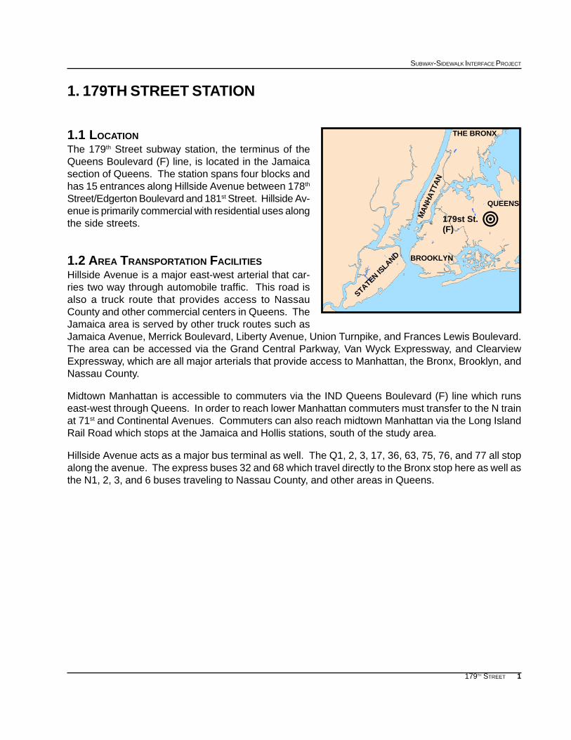
1.1 LOCATIONThe 179th Street subway station, the terminus of theQueens Boulevard (F) line, is located in the Jamaicasection of Queens. The station spans four blocks andhas 15 entrances along Hillside Avenue between 178th
Street/Edgerton Boulevard and 181st Street. Hillside Av-enue is primarily commercial with residential uses alongthe side streets.
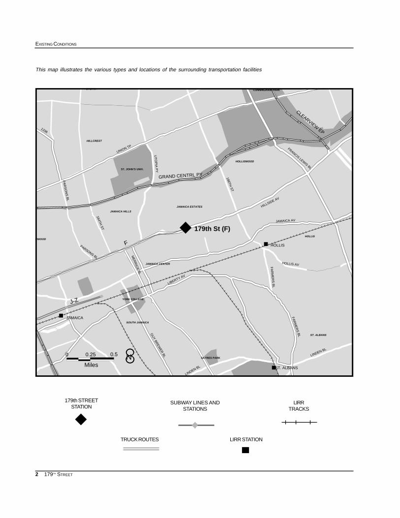
1.2 AREA TRANSPORTATION FACILITIESHillside Avenue is a major east-west arterial that car-ries two way through automobile traffic. This road isalso a truck route that provides access to NassauCounty and other commercial centers in Queens. TheJamaica area is served by other truck routes such asJamaica Avenue, Merrick Boulevard, Liberty Avenue, Union Turnpike, and Frances Lewis Boulevard.The area can be accessed via the Grand Central Parkway, Van Wyck Expressway, and ClearviewExpressway, which are all major arterials that provide access to Manhattan, the Bronx, Brooklyn, andNassau County.
Midtown Manhattan is accessible to commuters via the IND Queens Boulevard (F) line which runseast-west through Queens. In order to reach lower Manhattan commuters must transfer to the N trainat 71st and Continental Avenues. Commuters can also reach midtown Manhattan via the Long IslandRail Road which stops at the Jamaica and Hollis stations, south of the study area.
Hillside Avenue acts as a major bus terminal as well. The Q1, 2, 3, 17, 36, 63, 75, 76, and 77 all stopalong the avenue. The express buses 32 and 68 which travel directly to the Bronx stop here as well asthe N1, 2, 3, and 6 buses traveling to Nassau County, and other areas in Queens.
179st St.(F)
!
BROOKLYN
STATEN ISLAND
MA
NH
ATT
AN
QUEENS
THE BRONX
2
EXISTING CONDITIONS
179TH STREET
""""
""""
""""
""""
""""
""""
#
#
#
HOLLISWOOD
HOLLIS
ST. ALBANS
JAMAICA HILLS
UTOPIA
HILLCREST
JAMAICA ESTATES
JAMAICA CENTER
SOUTH JAMAICA
ARWOOD
Miles
0 0.25 0.5
FA
RM
ER
S B
L
FA
RM
ER
S B
L
HOLLIS AV
1336
PARSONS BL
LIBERTY AV
FRANCIS LEWIS BL
JAMAICA AV
UT
OP
IA P
Y
188TH S
T
164TH S
T
PA
RS
ON
S B
L
GU
Y B
RE
WE
R B
L LINDEN BL
AVLINDEN BL
ME
RR
ICK
BL
HILLSIDE AV
UNION TP
J-Z
F
179th St (F)
GRAND CENTRL PY
CLEARVIEW EP
JAMAICA
HOLLIS
CUNNINGHAM PARK
ST. JOHN’S UNIV.
YORK COLLEGE
SAYRES PARK
ST. ALBANS
8N
This map illustrates the various types and locations of the surrounding transportation facilities
SUBWAY LINES ANDSTATIONS
179th STREETSTATION
LIRRTRACKS
LIRR STATIONTRUCK ROUTES
3
SUBWAY-SIDEWALK INTERFACE PROJECT
179TH STREET
AGE DISTRIBUTION: 1990
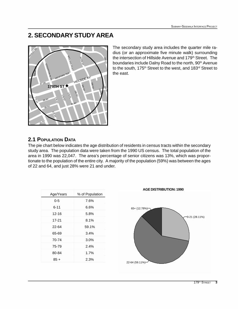
2. SECONDARY STUDY AREA
The secondary study area includes the quarter mile ra-dius (or an approximate five minute walk) surroundingthe intersection of Hillside Avenue and 179th Street. Theboundaries include Dalny Road to the north, 90th Avenueto the south, 175th Street to the west, and 183rd Street tothe east.
2.1 POPULATION DATAThe pie chart below indicates the age distribution of residents in census tracts within the secondarystudy area. The population data were taken from the 1990 US census. The total population of thearea in 1990 was 22,047. The area’s percentage of senior citizens was 13%, which was propor-tionate to the population of the entire city. A majority of the population (59%) was between the agesof 22 and 64, and just 28% were 21 and under.
% of PopulationAge/Years
7.6%0-5
6.6%6-11
5.8%12-16
8.1%17-21
59.1%22-64
3.4%65-69
3.0%70-74
2.4%75-79
1.7%80-84
2.3%85 +
0-21 (28.11%)
65+ (12.78%)
22-64 (59.11%)
182 PL
184 ST
178 ST
ED
GE
RTO
N B
LVD WEXFORD TER
HILLSIDE AV
87 DR
MID
LAN
D P
KW
Y
DA
LNY
RD
90 AV
182 ST
183 ST
175 ST 88 AV
89 AV
AV
ON
ST
91 AV
176 ST
HENLEY R
D
179TH ST
179 ST
179 PL
180 ST
181 ST
E
4
EXISTING CONDITIONS
179TH STREET
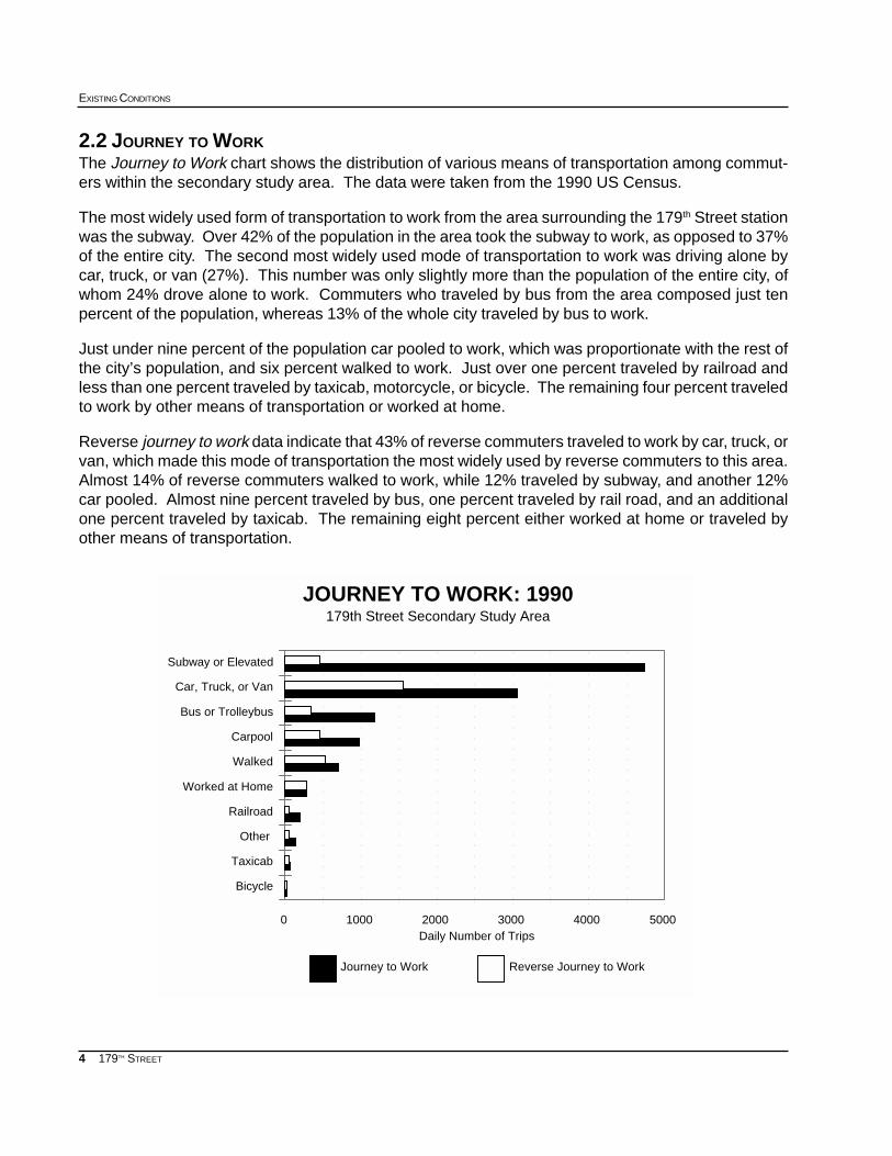
2.2 JOURNEY TO WORKThe Journey to Work chart shows the distribution of various means of transportation among commut-ers within the secondary study area. The data were taken from the 1990 US Census.
The most widely used form of transportation to work from the area surrounding the 179th Street stationwas the subway. Over 42% of the population in the area took the subway to work, as opposed to 37%of the entire city. The second most widely used mode of transportation to work was driving alone bycar, truck, or van (27%). This number was only slightly more than the population of the entire city, ofwhom 24% drove alone to work. Commuters who traveled by bus from the area composed just tenpercent of the population, whereas 13% of the whole city traveled by bus to work.
Just under nine percent of the population car pooled to work, which was proportionate with the rest ofthe city’s population, and six percent walked to work. Just over one percent traveled by railroad andless than one percent traveled by taxicab, motorcycle, or bicycle. The remaining four percent traveledto work by other means of transportation or worked at home.
Reverse journey to work data indicate that 43% of reverse commuters traveled to work by car, truck, orvan, which made this mode of transportation the most widely used by reverse commuters to this area.Almost 14% of reverse commuters walked to work, while 12% traveled by subway, and another 12%car pooled. Almost nine percent traveled by bus, one percent traveled by rail road, and an additionalone percent traveled by taxicab. The remaining eight percent either worked at home or traveled byother means of transportation.
0 1000 2000 3000 4000 5000 Daily Number of Trips
Bicycle
Taxicab
Other
Railroad
Worked at Home
Walked
Carpool
Bus or Trolleybus
Car, Truck, or Van
Subway or Elevated
Journey to Work Reverse Journey to Work
JOURNEY TO WORK: 1990179th Street Secondary Study Area
5
SUBWAY-SIDEWALK INTERFACE PROJECT
179TH STREET
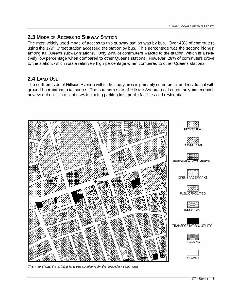
This map shows the existing land use conditions for the secondary study area
2.3 MODE OF ACCESS TO SUBWAY STATIONThe most widely used mode of access to this subway station was by bus. Over 43% of commutersusing the 179th Street station accessed the station by bus. This percentage was the second highestamong all Queens subway stations. Only 24% of commuters walked to the station, which is a rela-tively low percentage when compared to other Queens stations. However, 28% of commuters droveto the station, which was a relatively high percentage when compared to other Queens stations.
2.4 LAND USEThe northern side of Hillside Avenue within the study area is primarily commercial and residential withground floor commercial space. The southern side of Hillside Avenue is also primarily commercial,however, there is a mix of uses including parking lots, public facilities and residential.
RESIDENTIAL /COMMERCIAL
RESIDENTIAL
COMMERCIAL
OPEN SPACE /PARKS
PUBLIC FACILITIES
INDUSTRIAL
PARKING
VACANT
TRANSPORTATION / UTILITY
6
EXISTING CONDITIONS
179TH STREET
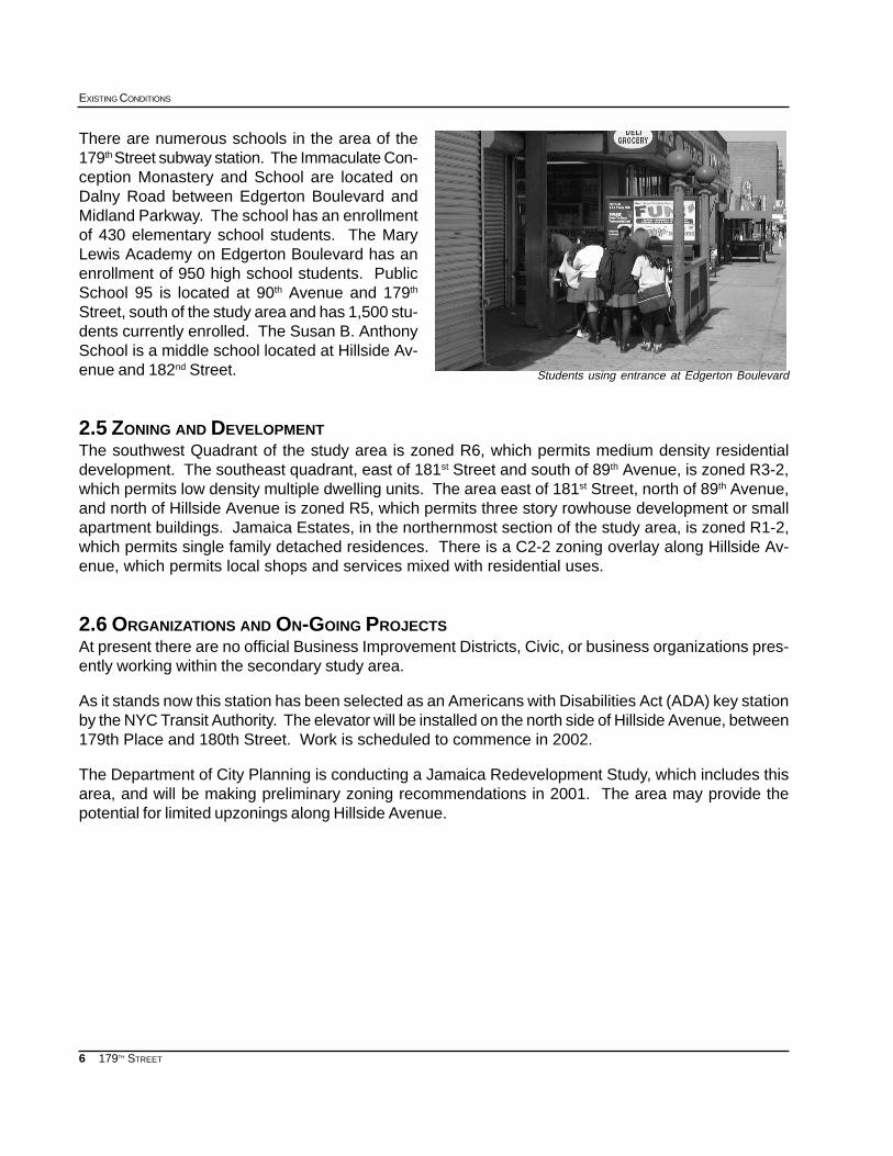
There are numerous schools in the area of the179th Street subway station. The Immaculate Con-ception Monastery and School are located onDalny Road between Edgerton Boulevard andMidland Parkway. The school has an enrollmentof 430 elementary school students. The MaryLewis Academy on Edgerton Boulevard has anenrollment of 950 high school students. PublicSchool 95 is located at 90th Avenue and 179th
Street, south of the study area and has 1,500 stu-dents currently enrolled. The Susan B. AnthonySchool is a middle school located at Hillside Av-enue and 182nd Street.
2.5 ZONING AND DEVELOPMENTThe southwest Quadrant of the study area is zoned R6, which permits medium density residentialdevelopment. The southeast quadrant, east of 181st Street and south of 89th Avenue, is zoned R3-2,which permits low density multiple dwelling units. The area east of 181st Street, north of 89th Avenue,and north of Hillside Avenue is zoned R5, which permits three story rowhouse development or smallapartment buildings. Jamaica Estates, in the northernmost section of the study area, is zoned R1-2,which permits single family detached residences. There is a C2-2 zoning overlay along Hillside Av-enue, which permits local shops and services mixed with residential uses.
2.6 ORGANIZATIONS AND ON-GOING PROJECTSAt present there are no official Business Improvement Districts, Civic, or business organizations pres-ently working within the secondary study area.
As it stands now this station has been selected as an Americans with Disabilities Act (ADA) key stationby the NYC Transit Authority. The elevator will be installed on the north side of Hillside Avenue, between179th Place and 180th Street. Work is scheduled to commence in 2002.
The Department of City Planning is conducting a Jamaica Redevelopment Study, which includes thisarea, and will be making preliminary zoning recommendations in 2001. The area may provide thepotential for limited upzonings along Hillside Avenue.
Students using entrance at Edgerton Boulevard
7
SUBWAY-SIDEWALK INTERFACE PROJECT
179TH STREET
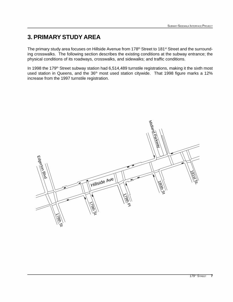
3. PRIMARY STUDY AREA
The primary study area focuses on Hillside Avenue from 178th Street to 181st Street and the surround-ing crosswalks. The following section describes the existing conditions at the subway entrance; thephysical conditions of its roadways, crosswalks, and sidewalks; and traffic conditions.
In 1998 the 179th Street subway station had 6,514,489 turnstile registrations, making it the sixth mostused station in Queens, and the 36th most used station citywide. That 1998 figure marks a 12%increase from the 1997 turnstile registration.
Hillside Ave
Midland P
arkway
179th St
179th Pl
178th St
180th St
181st St.
Edgerton B
lvd
8
EXISTING CONDITIONS
179TH STREET
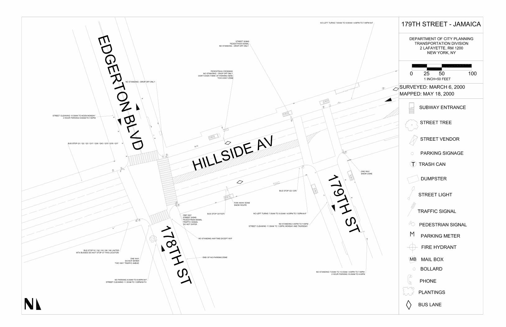
3.2 STREETS ADJACENT TO THE STATION ENTRANCEThe 179th Street subway station is located along a span of four blocks.
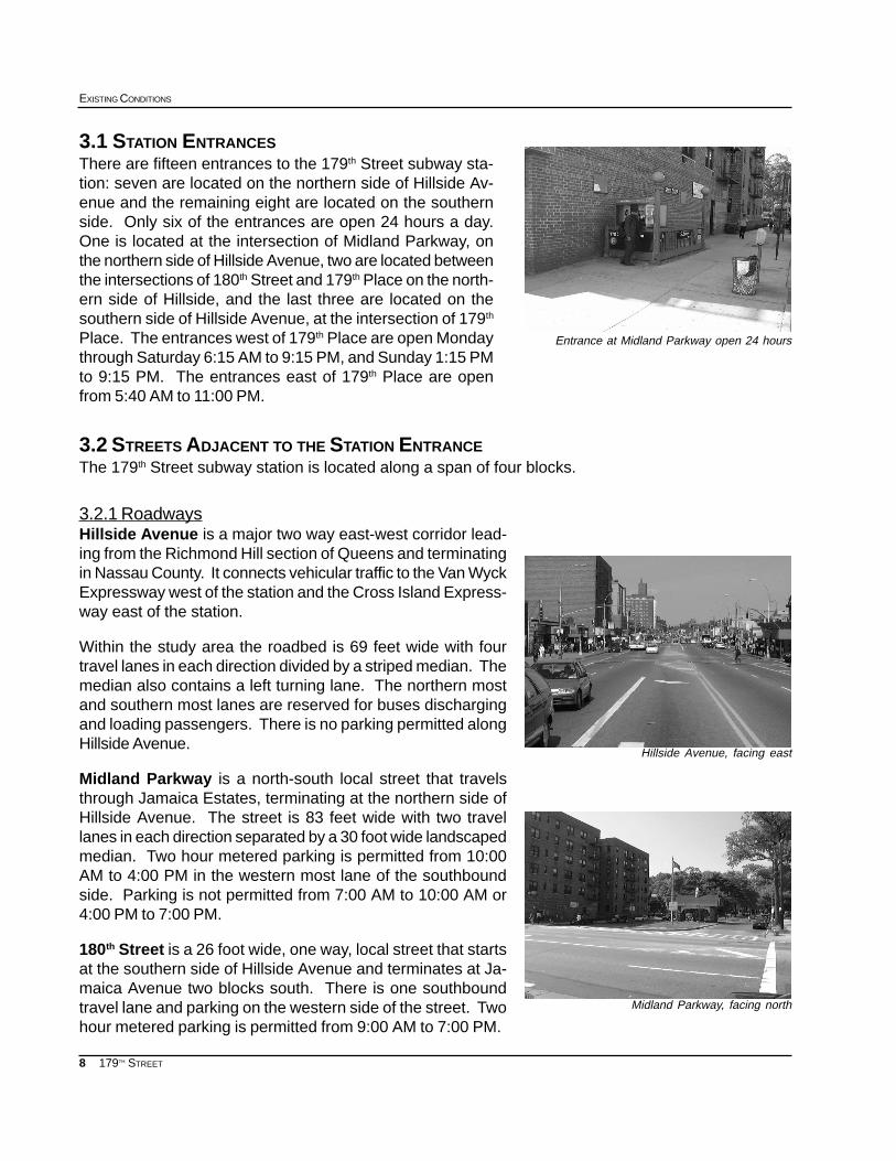
3.2.1 RoadwaysHillside Avenue is a major two way east-west corridor lead-ing from the Richmond Hill section of Queens and terminatingin Nassau County. It connects vehicular traffic to the Van WyckExpressway west of the station and the Cross Island Express-way east of the station.
Within the study area the roadbed is 69 feet wide with fourtravel lanes in each direction divided by a striped median. Themedian also contains a left turning lane. The northern mostand southern most lanes are reserved for buses dischargingand loading passengers. There is no parking permitted alongHillside Avenue.
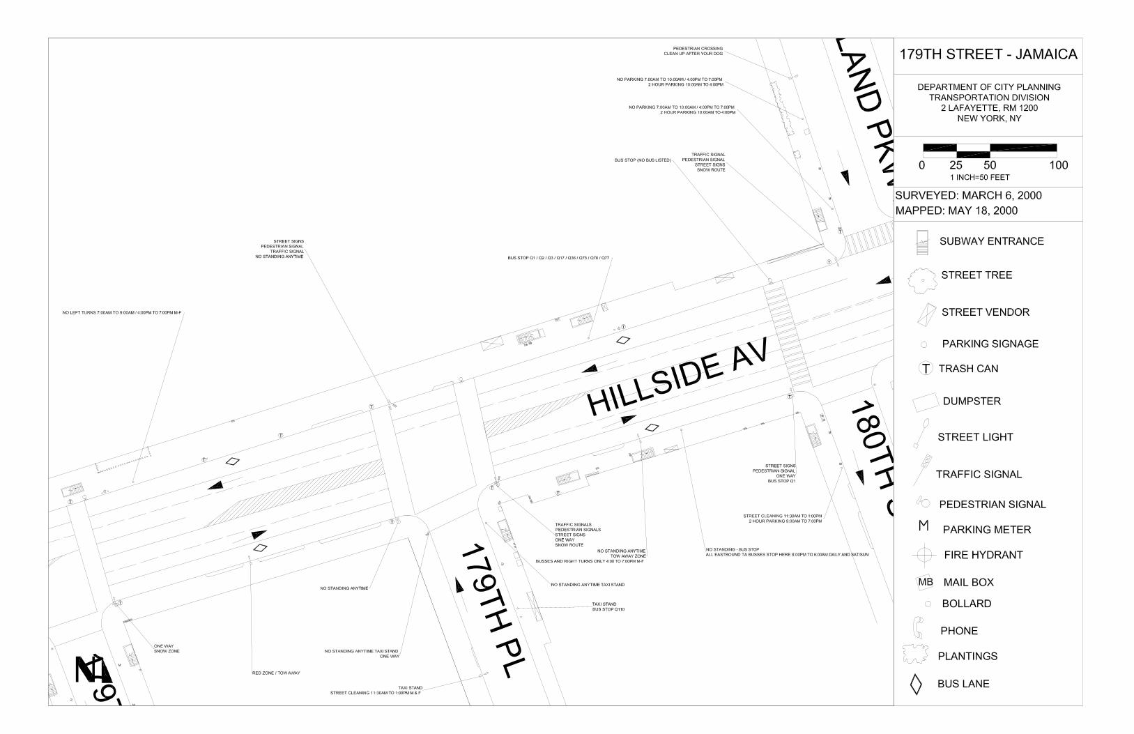
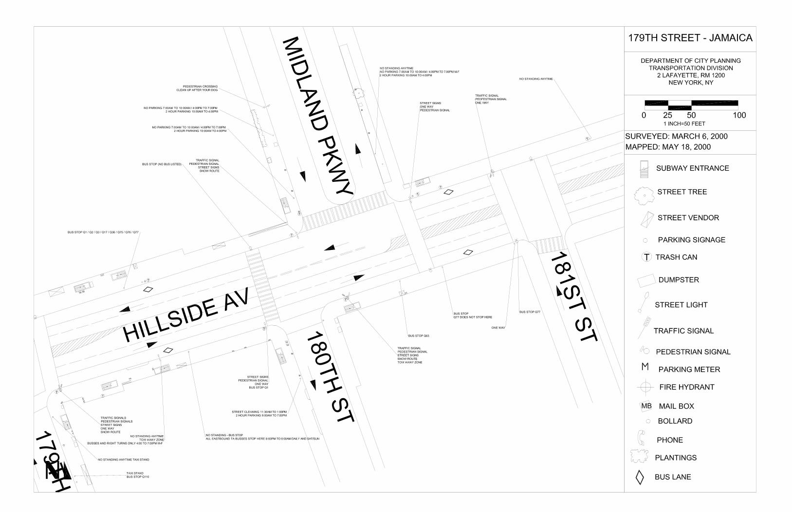
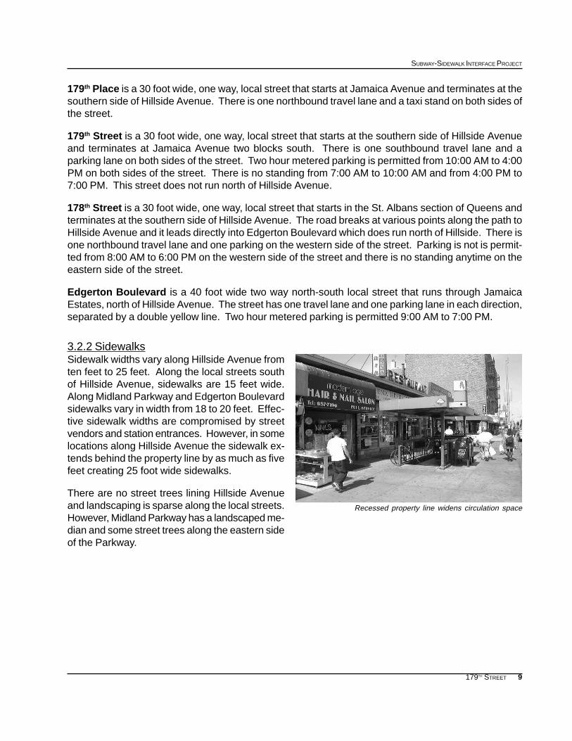
Midland Parkway is a north-south local street that travelsthrough Jamaica Estates, terminating at the northern side ofHillside Avenue. The street is 83 feet wide with two travellanes in each direction separated by a 30 foot wide landscapedmedian. Two hour metered parking is permitted from 10:00AM to 4:00 PM in the western most lane of the southboundside. Parking is not permitted from 7:00 AM to 10:00 AM or4:00 PM to 7:00 PM.
180th Street is a 26 foot wide, one way, local street that startsat the southern side of Hillside Avenue and terminates at Ja-maica Avenue two blocks south. There is one southboundtravel lane and parking on the western side of the street. Twohour metered parking is permitted from 9:00 AM to 7:00 PM.
3.1 STATION ENTRANCESThere are fifteen entrances to the 179th Street subway sta-tion: seven are located on the northern side of Hillside Av-enue and the remaining eight are located on the southernside. Only six of the entrances are open 24 hours a day.One is located at the intersection of Midland Parkway, onthe northern side of Hillside Avenue, two are located betweenthe intersections of 180th Street and 179th Place on the north-ern side of Hillside, and the last three are located on thesouthern side of Hillside Avenue, at the intersection of 179th
Place. The entrances west of 179th Place are open Mondaythrough Saturday 6:15 AM to 9:15 PM, and Sunday 1:15 PMto 9:15 PM. The entrances east of 179th Place are openfrom 5:40 AM to 11:00 PM.
Entrance at Midland Parkway open 24 hours
Hillside Avenue, facing east
Midland Parkway, facing north
9
SUBWAY-SIDEWALK INTERFACE PROJECT
179TH STREET
179th Place is a 30 foot wide, one way, local street that starts at Jamaica Avenue and terminates at thesouthern side of Hillside Avenue. There is one northbound travel lane and a taxi stand on both sides ofthe street.
179th Street is a 30 foot wide, one way, local street that starts at the southern side of Hillside Avenueand terminates at Jamaica Avenue two blocks south. There is one southbound travel lane and aparking lane on both sides of the street. Two hour metered parking is permitted from 10:00 AM to 4:00PM on both sides of the street. There is no standing from 7:00 AM to 10:00 AM and from 4:00 PM to7:00 PM. This street does not run north of Hillside Avenue.
178th Street is a 30 foot wide, one way, local street that starts in the St. Albans section of Queens andterminates at the southern side of Hillside Avenue. The road breaks at various points along the path toHillside Avenue and it leads directly into Edgerton Boulevard which does run north of Hillside. There isone northbound travel lane and one parking on the western side of the street. Parking is not is permit-ted from 8:00 AM to 6:00 PM on the western side of the street and there is no standing anytime on theeastern side of the street.
Edgerton Boulevard is a 40 foot wide two way north-south local street that runs through JamaicaEstates, north of Hillside Avenue. The street has one travel lane and one parking lane in each direction,separated by a double yellow line. Two hour metered parking is permitted 9:00 AM to 7:00 PM.
3.2.2 SidewalksSidewalk widths vary along Hillside Avenue fromten feet to 25 feet. Along the local streets southof Hillside Avenue, sidewalks are 15 feet wide.Along Midland Parkway and Edgerton Boulevardsidewalks vary in width from 18 to 20 feet. Effec-tive sidewalk widths are compromised by streetvendors and station entrances. However, in somelocations along Hillside Avenue the sidewalk ex-tends behind the property line by as much as fivefeet creating 25 foot wide sidewalks.
There are no street trees lining Hillside Avenueand landscaping is sparse along the local streets.However, Midland Parkway has a landscaped me-dian and some street trees along the eastern sideof the Parkway.
Recessed property line widens circulation space
10
EXISTING CONDITIONS
179TH STREET
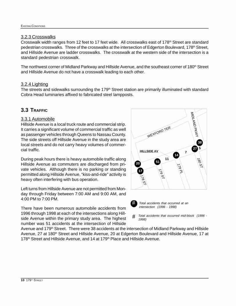
27
38
57
14HILLSIDE AV
1151
2017
20
178 ST
179 ST
WEXFORD TER
179 PL
MID
LAN
D P
KW
Y180 S
T
Total accidents that occurred at anintersection (1996 - 1998)
Total accidents that occurred mid-block (1996 -1998)
#
#
3.2.3 CrosswalksCrosswalk width ranges from 12 feet to 17 feet wide. All crosswalks east of 178th Street are standardpedestrian crosswalks. Three of the crosswalks at the intersection of Edgerton Boulevard, 178th Street,and Hillside Avenue are ladder crosswalks. The crosswalk at the western side of the intersection is astandard pedestrian crosswalk.
The northwest corner of Midland Parkway and Hillside Avenue, and the southeast corner of 180th Streetand Hillside Avenue do not have a crosswalk leading to each other.
3.2.4 LightingThe streets and sidewalks surrounding the 179th Street station are primarily illuminated with standardCobra Head luminaries affixed to fabricated steel lampposts.
3.3 TRAFFIC
3.3.1 AutomobileHillside Avenue is a local truck route and commercial strip.It carries a significant volume of commercial traffic as wellas passenger vehicles through Queens to Nassau County.The side streets off Hillside Avenue in the study area arelocal streets and do not carry heavy volumes of commer-cial traffic.
During peak hours there is heavy automobile traffic alongHillside Avenue as commuters are discharged from pri-vate vehicles. Although there is no parking or standingpermitted along Hillside Avenue, “kiss-and-ride” activity isheavy often interfering with bus operation.
Left turns from Hillside Avenue are not permitted from Mon-day through Friday between 7:00 AM and 9:00 AM, and4:00 PM to 7:00 PM.
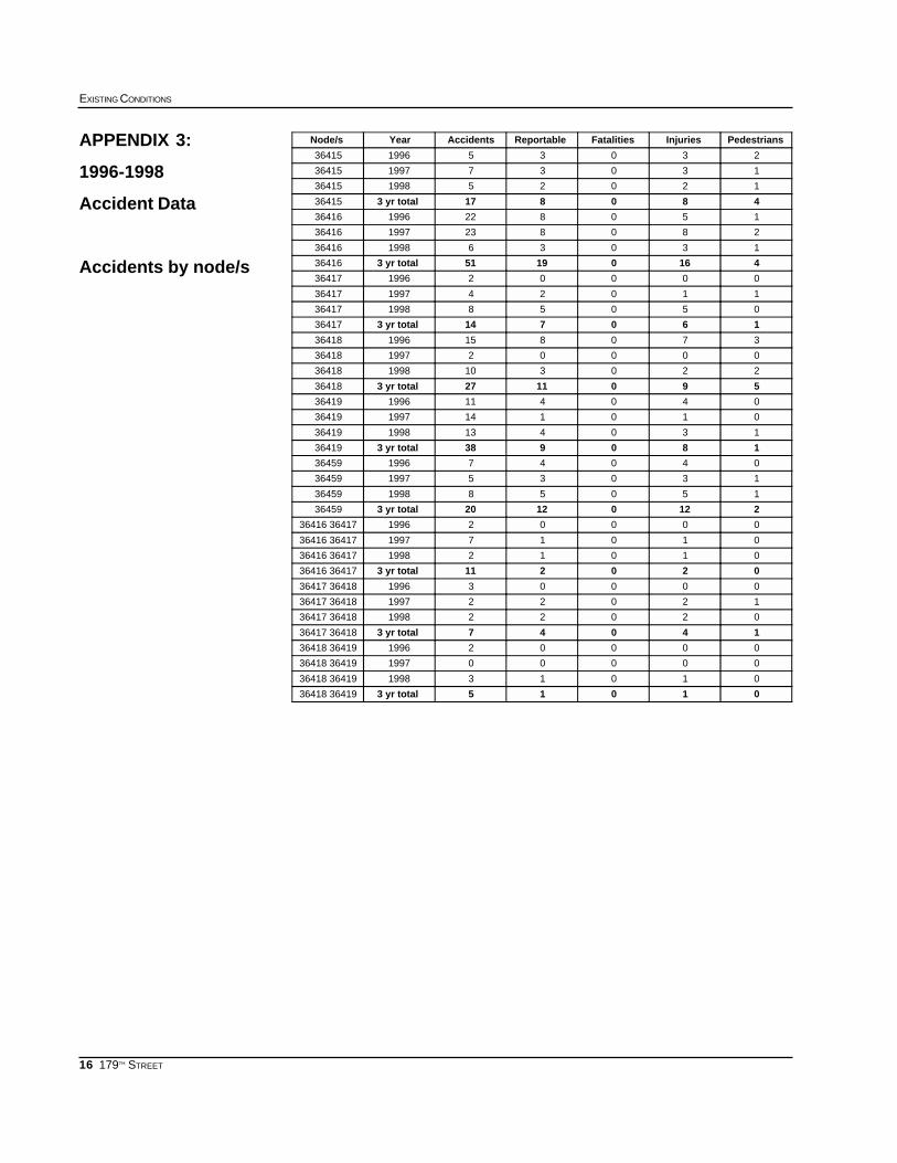
There have been numerous automobile accidents from1996 through 1998 at each of the intersections along Hill-side Avenue within the primary study area. The highestnumber was 51 accidents at the intersection of HillsideAvenue and 179th Street. There were 38 accidents at the intersection of Midland Parkway and HillsideAvenue, 27 at 180th Street and Hillside Avenue, 20 at Edgerton Boulevard and Hillside Avenue, 17 at178th Street and Hillside Avenue, and 14 at 179th Place and Hillside Avenue.
11
SUBWAY-SIDEWALK INTERFACE PROJECT
179TH STREET
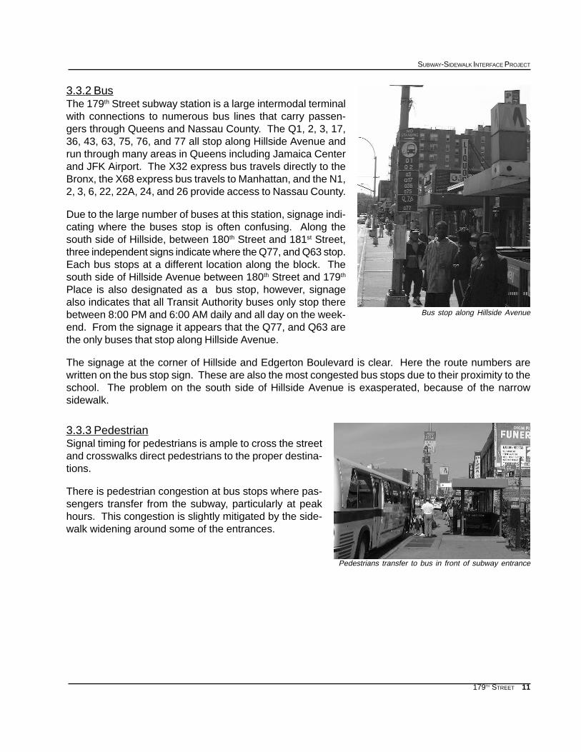
3.3.2 BusThe 179th Street subway station is a large intermodal terminalwith connections to numerous bus lines that carry passen-gers through Queens and Nassau County. The Q1, 2, 3, 17,36, 43, 63, 75, 76, and 77 all stop along Hillside Avenue andrun through many areas in Queens including Jamaica Centerand JFK Airport. The X32 express bus travels directly to theBronx, the X68 express bus travels to Manhattan, and the N1,2, 3, 6, 22, 22A, 24, and 26 provide access to Nassau County.
Due to the large number of buses at this station, signage indi-cating where the buses stop is often confusing. Along thesouth side of Hillside, between 180th Street and 181st Street,three independent signs indicate where the Q77, and Q63 stop.Each bus stops at a different location along the block. Thesouth side of Hillside Avenue between 180th Street and 179th
Place is also designated as a bus stop, however, signagealso indicates that all Transit Authority buses only stop therebetween 8:00 PM and 6:00 AM daily and all day on the week-end. From the signage it appears that the Q77, and Q63 arethe only buses that stop along Hillside Avenue.
The signage at the corner of Hillside and Edgerton Boulevard is clear. Here the route numbers arewritten on the bus stop sign. These are also the most congested bus stops due to their proximity to theschool. The problem on the south side of Hillside Avenue is exasperated, because of the narrowsidewalk.
3.3.3 PedestrianSignal timing for pedestrians is ample to cross the streetand crosswalks direct pedestrians to the proper destina-tions.
There is pedestrian congestion at bus stops where pas-sengers transfer from the subway, particularly at peakhours. This congestion is slightly mitigated by the side-walk widening around some of the entrances.
Bus stop along Hillside Avenue
Pedestrians transfer to bus in front of subway entrance
12
EXISTING CONDITIONS
179TH STREET
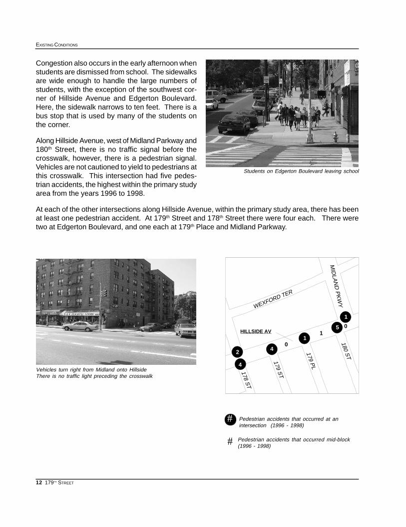
Pedestrian accidents that occurred at anintersection (1996 - 1998)
Pedestrian accidents that occurred mid-block(1996 - 1998)#
#
5
1
01
10
42
HILLSIDE AV
2
4
4
180 ST
MID
LAN
D P
KW
Y
179 ST178 S
T
WEXFORD TER
179 PL
Students on Edgerton Boulevard leaving school
Vehicles turn right from Midland onto HillsideThere is no traffic light preceding the crosswalk
Congestion also occurs in the early afternoon whenstudents are dismissed from school. The sidewalksare wide enough to handle the large numbers ofstudents, with the exception of the southwest cor-ner of Hillside Avenue and Edgerton Boulevard.Here, the sidewalk narrows to ten feet. There is abus stop that is used by many of the students onthe corner.
Along Hillside Avenue, west of Midland Parkway and180th Street, there is no traffic signal before thecrosswalk, however, there is a pedestrian signal.Vehicles are not cautioned to yield to pedestrians atthis crosswalk. This intersection had five pedes-trian accidents, the highest within the primary studyarea from the years 1996 to 1998.
At each of the other intersections along Hillside Avenue, within the primary study area, there has beenat least one pedestrian accident. At 179th Street and 178th Street there were four each. There weretwo at Edgerton Boulevard, and one each at 179th Place and Midland Parkway.
13
SUBWAY-SIDEWALK INTERFACE PROJECT
179TH STREET
179TH STREET APPENDICES
APPENDIX 1: 1990 CENSUS DATA
Population Data by Age and Census Tract
APPENDIX 2: 1990 CENSUS DATA
Journey to Work - Workers by place of residence
Reverse Journey to Work - Workers by place of employment
APPENDIX 3: 1996-1998 ACCIDENT DATA
Accidents by Node/s
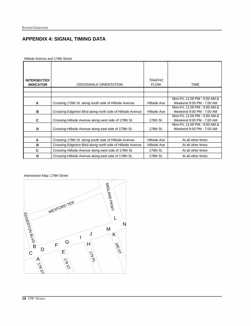
APPENDIX 4: SIGNAL TIMING DATA
APPENDIX 5: INVENTORY OF EXISTING CONDITIONS

14
EXISTING CONDITIONS
179TH STREET
Population data by age
APPENDIX 1: 1990 CENSUS DATA
Source: US Bureau of Census, 1990, STF 3
85+ yrs80-84 yrs75-79 yrs70-74 yrs65-69 yrs22-64 yrs17-21 yrs12-16 yrs6-11 yrs0-5 yrsTotalTract
1523595545123313913996711875458
1523010525213334705015174775986235462
22362949436931238394821254464
2571897314216609736691772439466
529735112919633341642812183247468
713366210020193561892633043349470
29216613512015219932361421792333648472
51836852666274413031178612701459168322047People
2.3%1.7%2.4%3.0%3.4%59.1%8.1%5.8%6.6%7.6%100%Percent
468
470
472466
462
458
464
179th St

15
SUBWAY-SIDEWALK INTERFACE PROJECT
179TH STREET
Journey to Work - Workers by place of residence
Reverse Journey to Work - Workers by place of employment
APPENDIX 2: 1990 CENSUS DATA
Source: US Bureau of Census, 1990, STF 3
PercentTotal472470468466464462458Census Tract
27.2%3041551526260483239671311Car, Truck, or Van
8.7%967167191142715925879Carpool
10.4%11629733719162738187Bus or Trolley
0.5%56813960200Streetcar, Trolley
42.3%47296796427768022451106479Subway or Elevated
1.5%17147058004620Railroad
0.0%00000000Ferry
0.4%50722090120Taxi
0.2%2408000160Motorcycle
0.0%00000000Bike
6.0%6737112719981271617Walk
0.3%3850000330Other
2.4%263793207043309Work at Home
PercentTotal472470468466464462458Census Tract
42.9%15435651282732942897158Car, Truck, or Van
12.3%44491684415355231Carpool
8.9%322193190841970Bus or Trolley
0.0%00000000Streetcar, Trolley
12.3%443841952311101614Subway or Elevated
0.9%31131300005Railroad
0.0%00000000Ferry
0.8%2727000000Taxi
0.0%00000000Motorcycle
0.0%00000000Bike
13.8%4985183152671710622Walk
0.8%2890120007Other
7.3%263793207043309Work at Home
16
EXISTING CONDITIONS
179TH STREET
APPENDIX 3:
1996-1998
Accident Data
Accidents by node/s
PedestriansInjuriesFatalitiesReportableAccidentsYearNode/s
23035199636415
13037199736415
12025199836415
4808173 yr total36415
150822199636416
280823199736416
13036199836416
416019513 yr total36416
00002199636417
11024199736417
05058199836417
1607143 yr total36417
370815199636418
00002199736418
220310199836418
59011273 yr total36418
040411199636419
010114199736419
130413199836419
1809383 yr total36419
04047199636459
13035199736459
15058199836459
212012203 yr total36459
00002199636416 36417
01017199736416 36417
01012199836416 36417
0202113 yr total36416 36417
00003199636417 36418
12022199736417 36418
02022199836417 36418
140473 yr total36417 36418
00002199636418 36419
00000199736418 36419
01013199836418 36419
010153 yr total36418 36419
17
SUBWAY-SIDEWALK INTERFACE PROJECT
179TH STREET
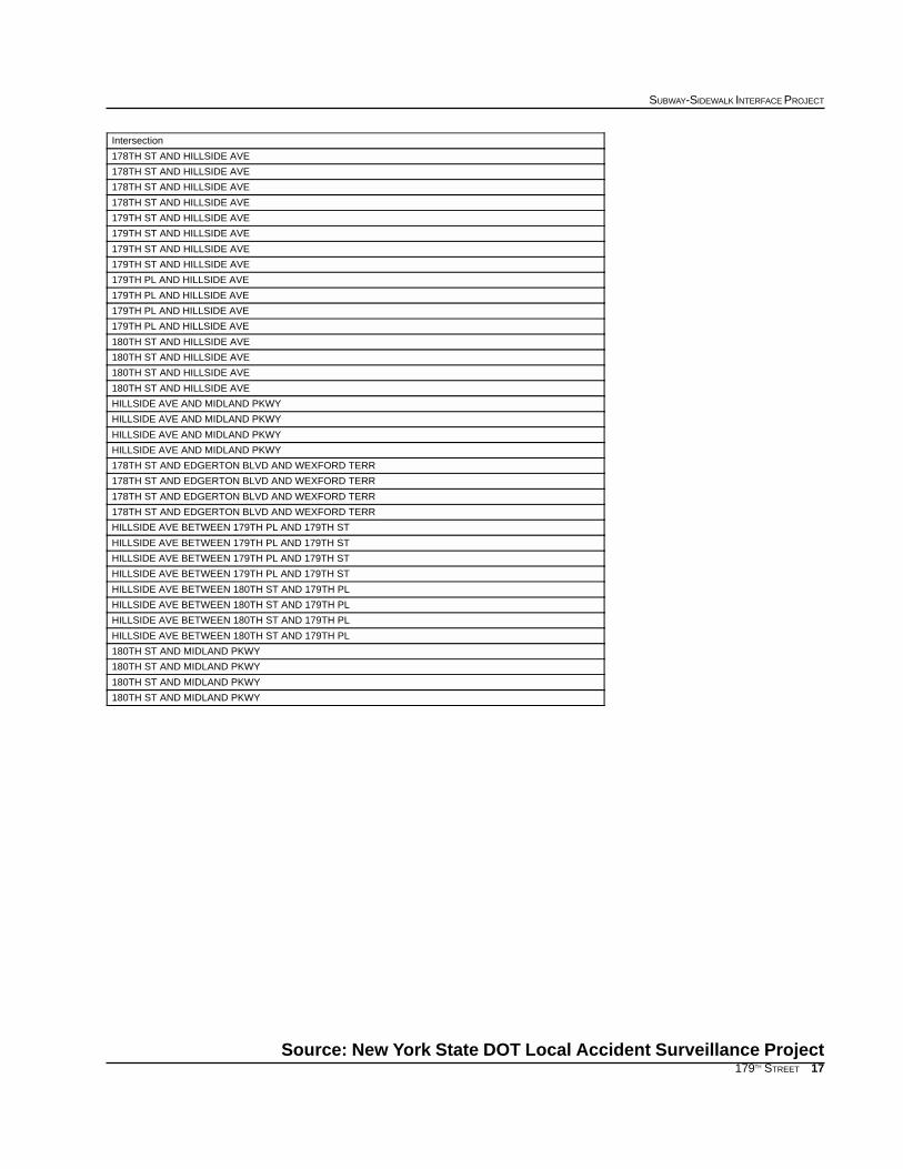
Source: New York State DOT Local Accident Surveillance Project
Intersection
178TH ST AND HILLSIDE AVE
178TH ST AND HILLSIDE AVE
178TH ST AND HILLSIDE AVE
178TH ST AND HILLSIDE AVE
179TH ST AND HILLSIDE AVE
179TH ST AND HILLSIDE AVE
179TH ST AND HILLSIDE AVE
179TH ST AND HILLSIDE AVE
179TH PL AND HILLSIDE AVE
179TH PL AND HILLSIDE AVE
179TH PL AND HILLSIDE AVE
179TH PL AND HILLSIDE AVE
180TH ST AND HILLSIDE AVE
180TH ST AND HILLSIDE AVE
180TH ST AND HILLSIDE AVE
180TH ST AND HILLSIDE AVE
HILLSIDE AVE AND MIDLAND PKWY
HILLSIDE AVE AND MIDLAND PKWY
HILLSIDE AVE AND MIDLAND PKWY
HILLSIDE AVE AND MIDLAND PKWY
178TH ST AND EDGERTON BLVD AND WEXFORD TERR
178TH ST AND EDGERTON BLVD AND WEXFORD TERR
178TH ST AND EDGERTON BLVD AND WEXFORD TERR
178TH ST AND EDGERTON BLVD AND WEXFORD TERR
HILLSIDE AVE BETWEEN 179TH PL AND 179TH ST
HILLSIDE AVE BETWEEN 179TH PL AND 179TH ST
HILLSIDE AVE BETWEEN 179TH PL AND 179TH ST
HILLSIDE AVE BETWEEN 179TH PL AND 179TH ST
HILLSIDE AVE BETWEEN 180TH ST AND 179TH PL
HILLSIDE AVE BETWEEN 180TH ST AND 179TH PL
HILLSIDE AVE BETWEEN 180TH ST AND 179TH PL
HILLSIDE AVE BETWEEN 180TH ST AND 179TH PL
180TH ST AND MIDLAND PKWY
180TH ST AND MIDLAND PKWY
180TH ST AND MIDLAND PKWY
180TH ST AND MIDLAND PKWY
18
EXISTING CONDITIONS
179TH STREET
APPENDIX 4: SIGNAL TIMING DATA
TIMEFLOWTRAFFIC
CROSSWALK ORIENTATIONINDICATORINTERSECTION
Weekend 9:00 PM - 7:00 AMMon-Fri, 11:00 PM - 5:00 AM &
Hillside AveCrossing 178th St. along south side of Hillside AvenueA
Weekend 9:00 PM - 7:00 AMMon-Fri, 11:00 PM - 5:00 AM &
Hillside AveCrossing Edgerton Blvd along north side of Hillside AvenueB
Weekend 9:00 PM - 7:00 AMMon-Fri, 11:00 PM - 5:00 AM &
178th St.Crossing Hillside Avenue along west side of 178th St.C
Weekend 9:00 PM - 7:00 AMMon-Fri, 11:00 PM - 5:00 AM &
178th St.Crossing Hillside Avenue along east side of 178th St.D
At all other timesHillside AveCrossing 178th St. along south side of Hillside AvenueAAt all other timesHillside AveCrossing Edgerton Blvd along north side of Hillside AvenueB
At all other times178th St.Crossing Hillside Avenue along west side of 178th St.C
At all other times178th St.Crossing Hillside Avenue along east side of 178th St.D
Hillside Avenue and 178th Street
L
M
HI
J K
N
AC
D EF
GB
178 ST
ED
GE
RT
ON
BLV
D
180 ST179 P
L
179 ST
WEXFORD TER
MID
LAN
D P
KW
Y
Intersection Map: 179th Street
19
SUBWAY-SIDEWALK INTERFACE PROJECT
179TH STREET
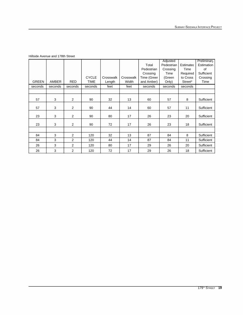
Hillside Avenue and 178th Street
TimeCrossingSufficient
ofEstimationPreliminary
Street*to CrossRequired
TimeEstimated
Only)(GreenTime
CrossingPedestrianAdjusted
and Amber)Time (Green
CrossingPedestrian
Total
WidthCrosswalk
LengthCrosswalk
TIMECYCLE
REDAMBERGREEN
secondssecondssecondsfeetfeetsecondssecondssecondsseconds
Sufficient857601332902357
Sufficient1157601444902357
Sufficient2023261780902323
Sufficient1823261772902323
Sufficient8848713321202384Sufficient11848714441202384
Sufficient20262917801202326
Sufficient18262917721202326
20
EXISTING CONDITIONS
179TH STREET
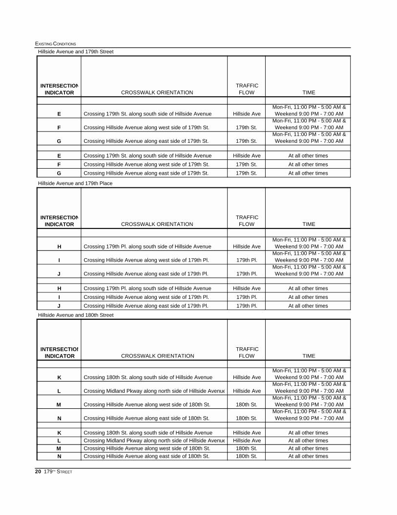
TIMEFLOWTRAFFIC
CROSSWALK ORIENTATIONINDICATORINTERSECTION
Weekend 9:00 PM - 7:00 AMMon-Fri, 11:00 PM - 5:00 AM &
Hillside AveCrossing 179th St. along south side of Hillside AvenueE
Weekend 9:00 PM - 7:00 AMMon-Fri, 11:00 PM - 5:00 AM &
179th St.Crossing Hillside Avenue along west side of 179th St.F
Weekend 9:00 PM - 7:00 AMMon-Fri, 11:00 PM - 5:00 AM &
179th St.Crossing Hillside Avenue along east side of 179th St.G
At all other timesHillside AveCrossing 179th St. along south side of Hillside AvenueE
At all other times179th St.Crossing Hillside Avenue along west side of 179th St.F
At all other times179th St.Crossing Hillside Avenue along east side of 179th St.G
TIMEFLOWTRAFFIC
CROSSWALK ORIENTATIONINDICATORINTERSECTION
Weekend 9:00 PM - 7:00 AMMon-Fri, 11:00 PM - 5:00 AM &
Hillside AveCrossing 179th Pl. along south side of Hillside AvenueH
Weekend 9:00 PM - 7:00 AMMon-Fri, 11:00 PM - 5:00 AM &
179th Pl.Crossing Hillside Avenue along west side of 179th Pl.I
Weekend 9:00 PM - 7:00 AMMon-Fri, 11:00 PM - 5:00 AM &
179th Pl.Crossing Hillside Avenue along east side of 179th Pl.J
At all other timesHillside AveCrossing 179th Pl. along south side of Hillside AvenueH
At all other times179th Pl.Crossing Hillside Avenue along west side of 179th Pl.I
At all other times179th Pl.Crossing Hillside Avenue along east side of 179th Pl.J
TIMEFLOWTRAFFIC
CROSSWALK ORIENTATIONINDICATORINTERSECTION
Weekend 9:00 PM - 7:00 AMMon-Fri, 11:00 PM - 5:00 AM &
Hillside AveCrossing 180th St. along south side of Hillside AvenueK
Weekend 9:00 PM - 7:00 AMMon-Fri, 11:00 PM - 5:00 AM &
Hillside AveCrossing Midland Pkway along north side of Hillside AvenueL
Weekend 9:00 PM - 7:00 AMMon-Fri, 11:00 PM - 5:00 AM &
180th St.Crossing Hillside Avenue along west side of 180th St.M
Weekend 9:00 PM - 7:00 AMMon-Fri, 11:00 PM - 5:00 AM &
180th St.Crossing Hillside Avenue along east side of 180th St.N
At all other timesHillside AveCrossing 180th St. along south side of Hillside AvenueKAt all other timesHillside AveCrossing Midland Pkway along north side of Hillside AvenueLAt all other times180th St.Crossing Hillside Avenue along west side of 180th St.MAt all other times180th St.Crossing Hillside Avenue along east side of 180th St.N
Hillside Avenue and 179th Street
Hillside Avenue and 179th Place
Hillside Avenue and 180th Street
21
SUBWAY-SIDEWALK INTERFACE PROJECT
179TH STREET
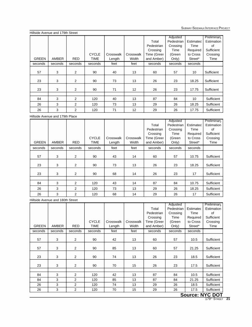
Hillside Avenue and 179th Street
Hillside Avenue and 179th Place
Hillside Avenue and 180th Street
Source: NYC DOT
TimeCrossingSufficient
ofEstimationPreliminary
Street*to CrossRequired
TimeEstimated
Only)(GreenTime
CrossingPedestrianAdjusted
and Amber)Time (Green
CrossingPedestrian
Total
WidthCrosswalk
LengthCrosswalk
TIMECYCLE
REDAMBERGREEN
secondssecondssecondsfeetfeetsecondssecondssecondsseconds
Sufficient1057601340902357
Sufficient18.2523261373902323
Sufficient17.7523261271902323
Sufficient10848713401202384
Sufficient18.25262913731202326
Sufficient17.75262912711202326
TimeCrossingSufficient
ofEstimationPreliminary
Street*to CrossRequired
TimeEstimated
Only)(GreenTime
CrossingPedestrianAdjusted
and Amber)Time (Green
CrossingPedestrian
Total
WidthCrosswalk
LengthCrosswalk
TIMECYCLE
REDAMBERGREEN
secondssecondssecondsfeetfeetsecondssecondssecondsseconds
Sufficient10.7557601443902357
Sufficient18.2523261373902323
Sufficient1723261468902323
Sufficient10.75848714431202384
Sufficient18.25262913731202326
Sufficient17262914681202326
TimeCrossingSufficient
ofEstimationPreliminary
Street*to CrossRequired
TimeEstimated
Only)(GreenTime
CrossingPedestrianAdjusted
and Amber)Time (Green
CrossingPedestrian
Total
WidthCrosswalk
LengthCrosswalk
TIMECYCLE
REDAMBERGREEN
secondssecondssecondsfeetfeetsecondssecondssecondsseconds
Sufficient10.557601342902357
Sufficient21.2557601385902357
Sufficient18.523261374902323
Sufficient17.523261570902323
Sufficient10.5848713421202384
Sufficient21.25848713851202384
Sufficient18.5262913741202326
Sufficient17.5262915701202326

22
EXISTING CONDITIONS
179TH STREET

23
SUBWAY-SIDEWALK INTERFACE PROJECT
179TH STREET