1. 36th street station - transportation alternatives street 1. 36th street station 1.1 location the...
TRANSCRIPT
1
SUBWAY-SIDEWALK INTERFACE PROJECT
36TH STREET
1. 36TH STREET STATION
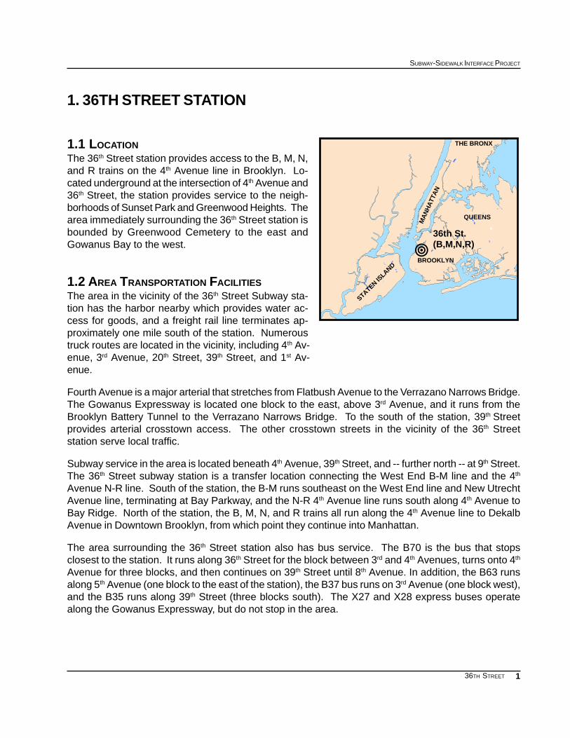
1.1 LOCATIONThe 36th Street station provides access to the B, M, N,and R trains on the 4th Avenue line in Brooklyn. Lo-cated underground at the intersection of 4th Avenue and36th Street, the station provides service to the neigh-borhoods of Sunset Park and Greenwood Heights. Thearea immediately surrounding the 36th Street station isbounded by Greenwood Cemetery to the east andGowanus Bay to the west.
1.2 AREA TRANSPORTATION FACILITIESThe area in the vicinity of the 36th Street Subway sta-tion has the harbor nearby which provides water ac-cess for goods, and a freight rail line terminates ap-proximately one mile south of the station. Numeroustruck routes are located in the vicinity, including 4th Av-enue, 3rd Avenue, 20th Street, 39th Street, and 1st Av-enue.
Fourth Avenue is a major arterial that stretches from Flatbush Avenue to the Verrazano Narrows Bridge.The Gowanus Expressway is located one block to the east, above 3rd Avenue, and it runs from theBrooklyn Battery Tunnel to the Verrazano Narrows Bridge. To the south of the station, 39th Streetprovides arterial crosstown access. The other crosstown streets in the vicinity of the 36th Streetstation serve local traffic.
Subway service in the area is located beneath 4th Avenue, 39th Street, and -- further north -- at 9th Street.The 36th Street subway station is a transfer location connecting the West End B-M line and the 4th
Avenue N-R line. South of the station, the B-M runs southeast on the West End line and New UtrechtAvenue line, terminating at Bay Parkway, and the N-R 4th Avenue line runs south along 4th Avenue toBay Ridge. North of the station, the B, M, N, and R trains all run along the 4th Avenue line to DekalbAvenue in Downtown Brooklyn, from which point they continue into Manhattan.
The area surrounding the 36th Street station also has bus service. The B70 is the bus that stopsclosest to the station. It runs along 36th Street for the block between 3rd and 4th Avenues, turns onto 4th
Avenue for three blocks, and then continues on 39th Street until 8th Avenue. In addition, the B63 runsalong 5th Avenue (one block to the east of the station), the B37 bus runs on 3rd Avenue (one block west),and the B35 runs along 39th Street (three blocks south). The X27 and X28 express buses operatealong the Gowanus Expressway, but do not stop in the area.
!36th St. (B,M,N,R)
QUEENS
BROOKLYN
STATEN ISLAND
MA
NH
ATT
AN
THE BRONX

2
EXISTING CONDITIONS
36TH STREET
This map illustrates the various types and locations of the surrounding transportation facilities
SUBWAY LINES ANDSTATIONS
36TH STREET STATION LIRRTRACKS
LIRR STATIONTRUCK ROUTESOTHER PROJECT SITES
""""
""""
""""
""""
""""
""""
""""
""""
""""
""""
"""" """"
""""
""""
""""
""""
""""
""""
""""
""""
WINDSOR TERRACE
KENSINGTON
BOROUGH PARK
SUNSET PARK
PARK SLOPE
GOWANUS
RED HOOK
0 0.25
Miles
0.5
F
36th Street(B-M-N-R)
B M
B M N
R
4 AV
GO
WAN
US
EXW
Y3
AV
43 ST
1 AV
39 ST
N R
60 ST
FT HAMILT
ON PKW
Y
4 A
V
9 ST
MC
DO
NA
LD A
V
9 ST
PROSPECT EXWY
20 ST
OC
V
LIRR BAY RIDGE DIV
GREENWOOD CEMETERY
AD PARK
RED HOOK PARK
RED HOOK PLAYGROUND
SUNSET PARK
8N
3
SUBWAY-SIDEWALK INTERFACE PROJECT
36TH STREET
% of PopulationAge/Years10.5%0-5
7.7%6-11
7.9%12-16
7.8%17-21
54.5%22-64
5.3%65-69
2.4%70-74
1.7%75-79
1.4%80-84
0.8%85 +
0-21 (33.88%)
65+ (11.58%)
22-64 (54.54%)
30 ST
33 ST
34 ST
32 ST
GO
WANUS
EXW
Y
35 ST
3 AV
5 AV
39 ST
36 ST37 ST
40 ST41 ST
4 AV
2 AV
42 ST
36TH ST38 ST
US BLK BNDY
AGE DISTRIBUTION: 1990
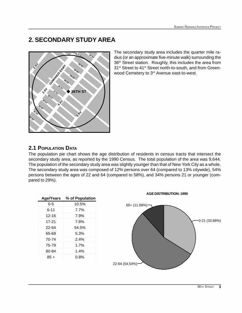
2. SECONDARY STUDY AREA
The secondary study area includes the quarter mile ra-dius (or an approximate five-minute walk) surrounding the36th Street station. Roughly, this includes the area from31st Street to 41st Street north-to-south, and from Green-wood Cemetery to 3rd Avenue east-to-west.
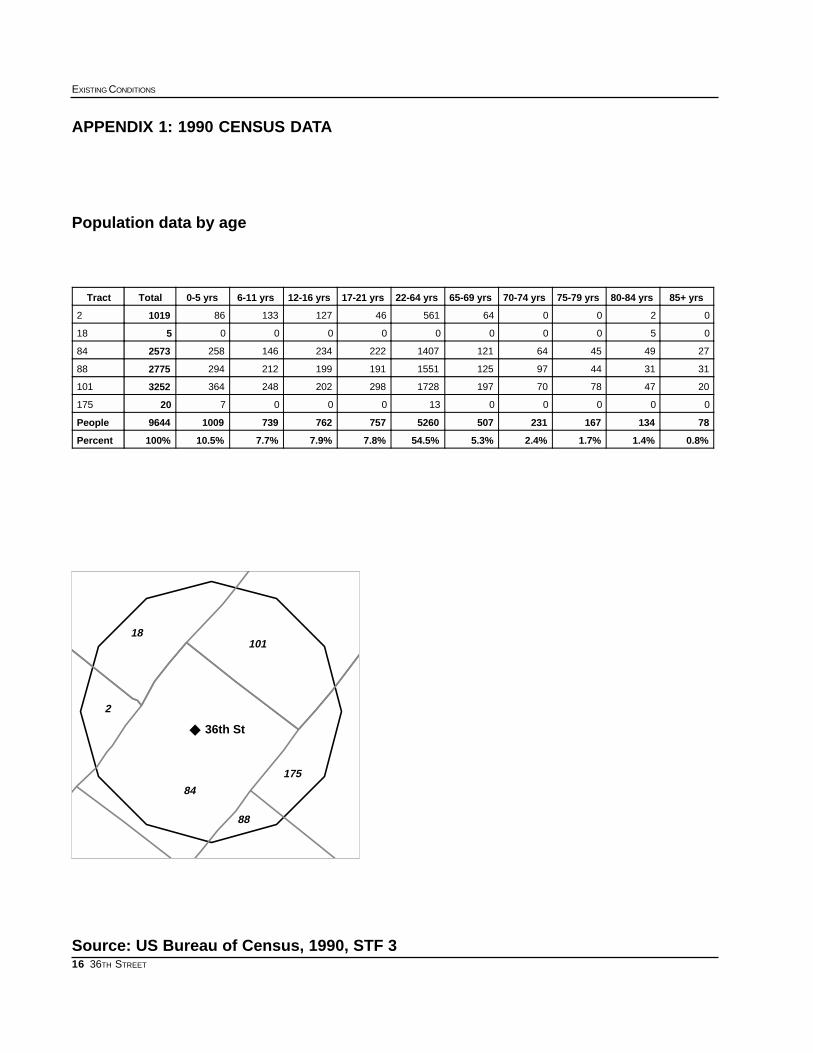
2.1 POPULATION DATAThe population pie chart shows the age distribution of residents in census tracts that intersect thesecondary study area, as reported by the 1990 Census. The total population of the area was 9,644.The population of the secondary study area was slightly younger than that of New York City as a whole.The secondary study area was composed of 12% persons over 64 (compared to 13% citywide), 54%persons between the ages of 22 and 64 (compared to 58%), and 34% persons 21 or younger (com-pared to 29%).

4
EXISTING CONDITIONS
36TH STREET
0 1000 2000 3000 4000 5000 6000 Number of Trips
Taxicab
Other
Bicycle
Railroad
Worked at Home
Carpool
Bus or Trolleybus
Walked
Car, Truck, or Van
Subway or Elevated
Journey to Work Reverse Journey to Work
JOURNEY TO WORK: 199036th Street Secondary Study Area
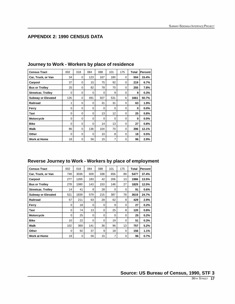
2.2 JOURNEY TO WORKThe Journey to Work chart presents the distribution of various means of transportation among com-muter living in census tracts that intersect a quarter mile radius of the 36th Street subway station.These data were taken from the 1990 census.
Among employed residents living in these census tracts, the dominant mode of transportation to workwas the subway, which accounted for 50% of commuters who live in the area. Other modes ac-counted for much smaller numbers: 15% of the commuters drove a car, truck, or van, 12% walked,eight percent took the bus, seven percent car pooled, and three percent worked at home. The remain-ing five percent traveled to work by other means of transportation.
When these data are compared to New York City as a whole, a larger portion of the residents in thearea of the 36th Avenue station took the subway to work: 50% of the workers in the secondary studyarea took the subway to work in 1990, versus 37% in the city as a whole. Fewer people in the second-ary study area drove (15% compared to 33%) or took the bus (eight percent compared to 13%) than inthe city as a whole. The proportion of persons who walked to work in 1990 was slightly higher than thecity as a whole (12% compared to 11%).
Reverse Journey to Work data show that in 1990 more persons worked in the area (14,663) than livedthere (9,644). Of persons commuting to the area, 37% drove to work alone, and 14% car pooled. Only25% of reverse commuters, the second largest group, traveled to work by subway. Of the remainingmodes of travel to work, 13% of commuters traveled by bus, five percent walked to work, three percenttraveled by rail, and less than one percent traveled to work by taxicab and bicycle. The remaining twopercent traveled to work by other means of transportation.

5
SUBWAY-SIDEWALK INTERFACE PROJECT
36TH STREET
This map shows the existing land use conditions for the secondary study area
2.3 MODE OF ACCESS TO SUBWAY STATIONAccording to the MTA’s 1990 survey of subway riders, 76% of the 36th Street subway riders walked tothe station. The second-largest group -- 19% -- arrived at the station by automobile. Only 3% arrived bybus, and less than 2% arrived by other means. Of the 160 Brooklyn stations, the 36th Street stationranked among the highest in terms of persons who accessed the station by automobile.
2.4 LAND USEThe secondary study area contains a diverse mix of land uses, including open spaces as well asindustrial, commercial, and residential buildings. The area west of the station on 2nd and 3rd Avenueshas many large scale industrial and commercial uses. The area east of the study area, around 5th
Avenue, has small-scale residential and commercial uses, as well as Greenwood Cemetery.
RESIDENTIAL /COMMERCIAL
RESIDENTIAL
COMMERCIAL
OPEN SPACE /PARKS
PUBLIC FACILITIES
INDUSTRIAL
PARKING
VACANT
TRANSPORTATION / UTILITY

6
EXISTING CONDITIONS
36TH STREET
Major destinations in the area include Greenwood Cemetery, located on the east side of 4th Avenue atthe entrance to the 36th Street subway station, and several public schools and a Board of Educationbuilding, located on 4th Avenue.
Buildings on 4th Avenue house a mix of auto-related, warehouse, and commercial uses, often withresidential uses on the upper floors. Development along 5th Avenue includes auto-related uses, low-rise residential buildings, and mixed-use structures with commercial storefronts and residential spaces.Development between 4th and 5th Avenues is predominately low-rise, attached residential buildingsexcept for the Greenwood Cemetery between 34th and 36th Streets, Public School 24 on the north sideof 38th Street, and the South Brooklyn Railway tracks (below grade), on the south side. The GowanusExpressway’s 38th Street exit ramp is located on the southwest corner of 38th Street and 4th Avenue.
Few of the buildings on the east side of 3rd Avenue have their main entrances on the Avenue. However,John Demic Park and Playground between 34th and 35th streets is accessible from 3rd Avenue. Thewest side of 3rd Avenue is the site of Industrial City, where there are a number of six-story loft buildings,some with commercial frontages.
West of the site, there is a 142,000 square-foot Costco store bounded by 36th and 39th streets and 3rd
and 2nd avenues, which has parking for 575 cars. The Costco is adjacent to the South BrooklynRailway tracks and the Gowanus Expressway 39th Street exit ramp. The area west of 3rd Avenue alsocontains loft buildings and the South Brooklyn Marine Terminal. A New York City Economic Develop-ment Corporation (EDC) port development study (see section 2.6) has analyzed this industrial water-front area.
2.5 ZONING AND DEVELOPMENTThe east side of 4th Avenue from 32nd to 39th Streets has three zoning district classifications: R6, R6/C2, and M1-2. The R6 zoning district stretches from 32nd Street to 37th Street and allows for mediumdensity housing in buildings that range from three to twelve stories. From 34th to 32nd Street, the lotsfronting 4th Avenue also have a C2 overlay which allows for local shopping and services in addition toresidential uses. South of 37th Street on 4th Avenue is an M1-2 zone, which allows for light industrialand commercial uses.
The area between 4th and 2nd Avenues from 32nd to 39th streets is contained by three zoning districts:M1-2, M1-2D, and M3-1. The M1-2 district is located between 37th and 39th Street and allows for lightmanufacturing and commercial uses. The M1-2D zoning district stretches from 32nd Street to 37th
Street between 3rd and 4th avenues and allows for some residential uses in addition to industrial andcommercial. East of 3rd Avenue there is a M3-1 zoning district which is intended for use by heavyindustry.
There are no current or recent Uniform Land Use Review Process (ULURP) actions. However, a fewlarge commercial uses have opened near Costco, including a furniture showroom at Industry City anddiscount linen outlet.

7
SUBWAY-SIDEWALK INTERFACE PROJECT
36TH STREET
2.6 ORGANIZATIONS AND ON-GOING PROJECTSThe New York City Economic Development Corporation studied Sunset Park as part of its StrategicPlan for the Redevelopment of the Port of New York. In the short term the plan calls for renovating andupgrading the existing South Brooklyn Marine Terminal so that it may handle automobiles and breakbulk cargo. In addition, short term plans call for the construction of a waterfront park to be used forpublic open space.
Also, the Board of Education has preliminarily selected a site at 38th Street and 4th Avenue as a pos-sible location for a new high school.
8
EXISTING CONDITIONS
36TH STREET
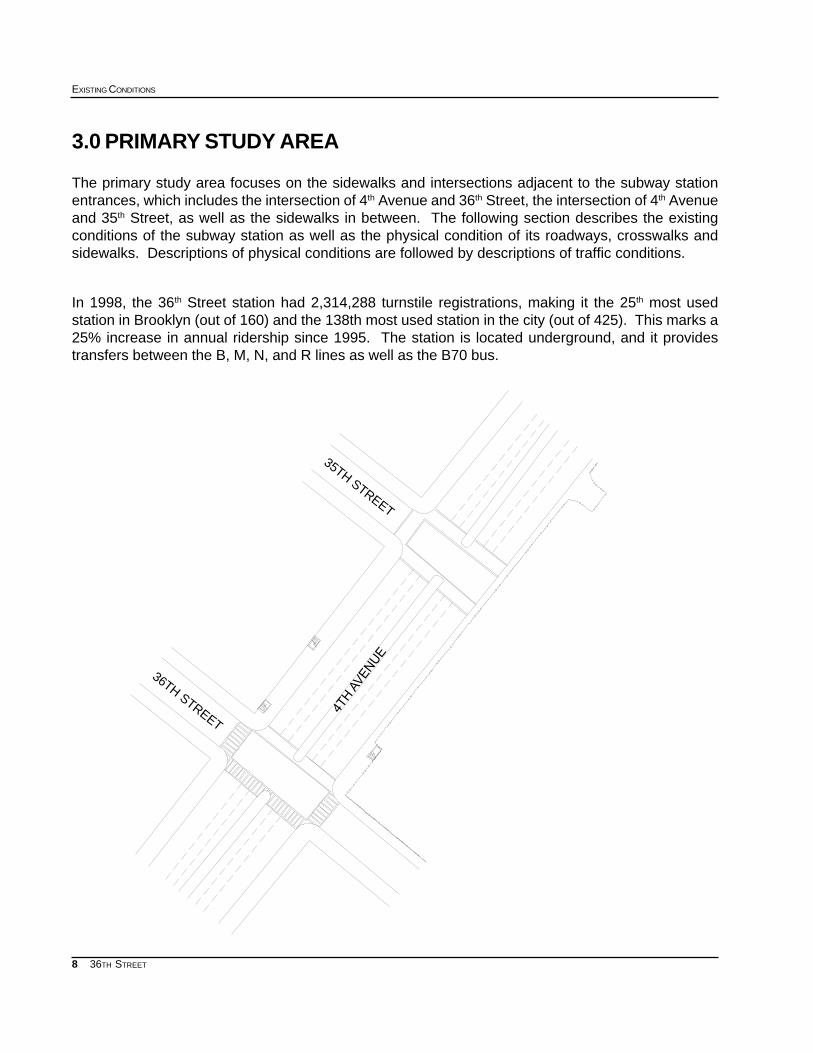
3.0 PRIMARY STUDY AREA
The primary study area focuses on the sidewalks and intersections adjacent to the subway stationentrances, which includes the intersection of 4th Avenue and 36th Street, the intersection of 4th Avenueand 35th Street, as well as the sidewalks in between. The following section describes the existingconditions of the subway station as well as the physical condition of its roadways, crosswalks andsidewalks. Descriptions of physical conditions are followed by descriptions of traffic conditions.
In 1998, the 36th Street station had 2,314,288 turnstile registrations, making it the 25th most usedstation in Brooklyn (out of 160) and the 138th most used station in the city (out of 425). This marks a25% increase in annual ridership since 1995. The station is located underground, and it providestransfers between the B, M, N, and R lines as well as the B70 bus.
36TH STREET
35TH STREET
4TH
AVE
NU
E

9
SUBWAY-SIDEWALK INTERFACE PROJECT
36TH STREET
South-West entrance at 36th Street and 4th Avenue
North-West Entrance at 36th St. and 4th Ave.
East entrance at 36th and 4th Avenue
3.1 STATION ENTRANCESThree entrances are available for the 36th
Street subway station: two are on the westside of 4th Avenue, north of 36th Street, andone is on the east side of 4th Avenue, north of36th Street. All three of the stairwell entrancesare open 24 hours a day and provide accessto all trains.
The southwest entrance faces southward, 20feet from the curb at 36th Street, and is flushagainst a small grocery/deli. The station en-trance is seven and a half feet wide and 19feet long, and the stairwell interior is approxi-mately six feet across. The sidewalk narrowsto 11.5 feet at the subway entrance.
The northwest entrance faces northward, withthe entrance located approximately 132 feetsouth of 35th Street. This entrance’s dimen-sions are the same as described above, ex-cept that the entire entrance is only 11 feetlong. The entrance is flush with the buildingline and a smoke shop’s entrance is locatedimmediately outside the entrance stairwell.
The east entrance faces south and is locatedapproximately 52 feet from the curb at 36th
Street on 4th Avenue. On two sides, the en-trance is flush against Greenwood Cemetery’sfence. The entrance is 14.5 feet long, and itnarrows the sidewalk to just over eight feet.The sidewalk behind the station entrance iseven narrower, at six and a half feet. The pres-ence of a street vendor further serves to nar-row the usable sidewalk space.

10
EXISTING CONDITIONS
36TH STREET
This photo shows the intersection of4th Avenue and 36th Street.
3.2 STREETS ADJACENT TO THE STATION ENTRANCES
3.2.1 RoadwaysRoadways within the primary study area include 4th Avenue, 35th Street, and 36th Street.
4th Avenue is a two way vehicular arterial that runs southwest-to-northeast, parallel to the waterfront.Within the study area, the roadbed is approximately 86 feet wide with a median/pedestrian refuge thatis nine feet nine inches wide. The roadway has three moving lanes and metered parking on each side.Parking lanes are approximately eight feet wide and the moving lanes are approximately ten feet wide.Parking signs prohibit parking in front of the eastern station entrance 7:00 to 10:00 AM weekdays, butotherwise permit two hour metered parking. Near the western entrances parking is prohibited 4:00 to7:00 PM weekdays, but otherwise permit one hour metered parking.
35th Street is a one way, northeast-bound street that runs perpendicular to (and terminates at) 4th
Avenue. Within the study area the roadbed is approximately 30 feet wide, with a moving lane and aparking lane. Parking is prohibited between 8 :00 AM and 6:00 PM on the north side of the street, andstreet cleaning rules are posted on the south side of the street within the study area. There are nopavement markings defining the lanes.
36th Street is a one way, southwest-bound street that runs perpendicular to 4th Avenue. Within thestudy area the roadbed is approximately 30 feet wide, with one moving lane and parallel parking onboth sides of the streets. Alternate side parking regulations are posted along 36th Street, with theexception of the parking reserved for the Board of Education. There are no pavement markings defin-ing the lanes.
11
SUBWAY-SIDEWALK INTERFACE PROJECT
36TH STREET
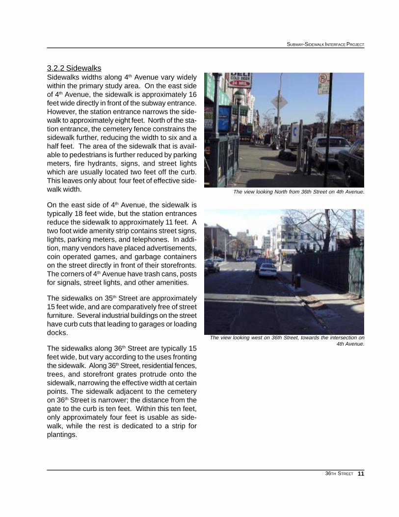
3.2.2 SidewalksSidewalks widths along 4th Avenue vary widelywithin the primary study area. On the east sideof 4th Avenue, the sidewalk is approximately 16feet wide directly in front of the subway entrance.However, the station entrance narrows the side-walk to approximately eight feet. North of the sta-tion entrance, the cemetery fence constrains thesidewalk further, reducing the width to six and ahalf feet. The area of the sidewalk that is avail-able to pedestrians is further reduced by parkingmeters, fire hydrants, signs, and street lightswhich are usually located two feet off the curb.This leaves only about four feet of effective side-walk width.
On the east side of 4th Avenue, the sidewalk istypically 18 feet wide, but the station entrancesreduce the sidewalk to approximately 11 feet. Atwo foot wide amenity strip contains street signs,lights, parking meters, and telephones. In addi-tion, many vendors have placed advertisements,coin operated games, and garbage containerson the street directly in front of their storefronts.The corners of 4th Avenue have trash cans, postsfor signals, street lights, and other amenities.
The sidewalks on 35th Street are approximately15 feet wide, and are comparatively free of streetfurniture. Several industrial buildings on the streethave curb cuts that leading to garages or loadingdocks.
The sidewalks along 36th Street are typically 15feet wide, but vary according to the uses frontingthe sidewalk. Along 36th Street, residential fences,trees, and storefront grates protrude onto thesidewalk, narrowing the effective width at certainpoints. The sidewalk adjacent to the cemeteryon 36th Street is narrower; the distance from thegate to the curb is ten feet. Within this ten feet,only approximately four feet is usable as side-walk, while the rest is dedicated to a strip forplantings.
The view looking North from 36th Street on 4th Avenue.
The view looking west on 36th Street, towards the intersection on4th Avenue.
12
EXISTING CONDITIONS
36TH STREET
3.2.3 CrosswalksThe intersection of 4th Avenue and 36th Street has crosswalks on all four crossings. All of the cross-walks have ladder type crosswalks, with the exception of the north crossing which is a standard cross-walk. The sidewalks leading to the crosswalks all have curb cuts on the corners and the pedestrianrefuge also has curb cuts. However, the curb cuts on the pedestrian refuge are not aligned with thecrosswalk, forcing pedestrians who wish to use the curb cuts to walk out of the cross walk area.
The intersection of 4th Avenue and 35th Street has three standard crosswalks.
3.2.4 LightingThe streets and sidewalks surounding the 36th Street subway station are illuminated with standardCobra Head luminaries affixed to fabricated steel lampposts.
3.3 TRAFFIC
3.3.1 Automobile4th Avenue is a busy thoroughfare with substantial vehicu-lar traffic. Travel along 4th Avenue proceeds smoothly andrapidly. South of the station, a number of school busesuse 4th Avenue for access to the Board of Education build-ing. Light vehicular traffic was observed along both 36th
Street and 35th Street.
During rush hours, a high volume of automobiles was ob-served loading and unloading passengers at the east en-trance to the station. Short term parking and loading/un-loading were noted in traffic lanes not designated for suchuses. On the west side, livery cab drivers were observedstanding next to the station entrances, waiting for passen-gers.
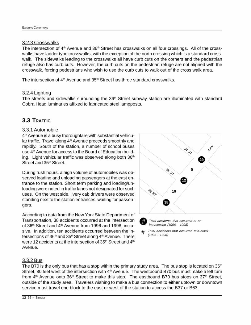
According to data from the New York State Department ofTransportation, 38 accidents occurred at the intersectionof 36th Street and 4th Avenue from 1996 and 1998, inclu-sive. In addition, ten accidents occurred between the in-tersections of 36th and 35th Street along 4th Avenue. Therewere 12 accidents at the intersection of 35th Street and 4th
Avenue.
3.3.2 BusThe B70 is the only bus that has a stop within the primary study area. The bus stop is located on 36th
Street, 80 feet west of the intersection with 4th Avenue. The westbound B70 bus must make a left turnfrom 4th Avenue onto 36th Street to make this stop. The eastbound B70 bus stops on 37th Street,outside of the study area. Travelers wishing to make a bus connection to either uptown or downtownservice must travel one block to the east or west of the station to access the B37 or B63.
Total accidents that occurred at anintersection (1996 - 1998)
#Total accidents that occurred mid-block(1996 - 1998)#
29
5
38
12
10
4 AV34 ST
35 ST
36 ST

13
SUBWAY-SIDEWALK INTERFACE PROJECT
36TH STREET
3.3.3 PedestrianPedestrian activity in the area of the 36th Street stationcenters on 4th Avenue, and with the exception of the B70bus stop, pedestrian travel on 36th Street and 35th Streetwas observed to be very light. Along 4th Avenue, the high-est pedestrian volumes were observed along the westside of the street, where a number of commercial estab-lishments are located.
The east side of the street is fronted by the cemetery andhas sidewalk width of only four usable feet. In addition,the sidewalk next to the cemetery is particularly dark af-ter nightfall. Observed pedestrian volumes on this side-walk were light.
A number of schools are located south of the station on4th Avenue and many students use the 36th Street stationas part of their commute to school. Manufacturing work-ers use the station for access to their workplaces to thewest of the station. In addition, the Costco discount storealso generates foot traffic from shoppers who use thesubway.
The island in the middle of 4th Avenue was the location of a number of signs and traffic signals. Whilethe island provides a usable refuge for pedestrians crossing the street, the curb cuts are not alignedwith the crosswalks. Nevertheless, pedestrians could typically cross 4th Avenue in one ‘walk’ signaltiming cycle.
From 1996 to 1998, six pedestrian accidents occurred in the immediate vicinity of the 36th Streetstation: three at the intersection of 4th Avenue and 36th Street, one at the intersection of 4th Avenue and35th Street and two accidents at the intersection of 34th Street and 4th Avenue. There were no mid-block pedestrian accidents and no pedestrian accidents at 35th Street and 4th Avenue.
Pedestrian accidents that occurred at anintersection (1996 - 1998)
#
Pedestrian accidents that occurred mid-block(1996 - 1998)
#
#
0
2
3
0
1
35 ST
4 AV
34 ST
36 ST

14
EXISTING CONDITIONS
36TH STREET

15
SUBWAY-SIDEWALK INTERFACE PROJECT
36TH STREET
36TH STREET APPENDICES
APPENDIX 1: 1990 CENSUS DATA
Population Data by Age and Census Tract
APPENDIX 2: 1990 CENSUS DATA
Journey to Work - Workers by place of residence
Reverse Journey to Work - Workers by place of employment
APPENDIX 3: 1996-1998 ACCIDENT DATA
Accidents by Node/s
APPENDIX 4: SIGNAL TIMING DATA
APPENDIX 5: INVENTORY OF EXISTING CONDITIONS
16
EXISTING CONDITIONS
36TH STREET
APPENDIX 1: 1990 CENSUS DATA
Population data by age
Source: US Bureau of Census, 1990, STF 3
175
88
84
2
10118
36th St
85+ yrs80-84 yrs75-79 yrs70-74 yrs65-69 yrs22-64 yrs17-21 yrs12-16 yrs6-11 yrs0-5 yrsTotalTract
020064561461271338610192
0500000000518
274945641211407222234146258257384
313144971251551191199212294277588
2047787019717282982022483643252101
0000013000720175
78134167231507526075776273910099644People
0.8%1.4%1.7%2.4%5.3%54.5%7.8%7.9%7.7%10.5%100%Percent
17
SUBWAY-SIDEWALK INTERFACE PROJECT
36TH STREET
APPENDIX 2: 1990 CENSUS DATA
Journey to Work - Workers by place of residence
Reverse Journey to Work - Workers by place of employment
PercentTotal175101088084018002Census Tract
15.4%5040180167123034Car, Truck, or Van
6.7%2190927515037Carpool
7.8%2550707882025Bus or Trolley
0.3%9090000Streetcar, Trolley
50.7%166165315074910126Subway or Elevated
1.9%6303131001Railroad
0.0%0000000Ferry
0.8%2501213000Taxi
0.0%0000000Motorcycle
0.8%2701314000Bike
12.1%396070104136086Walk
0.5%180810000Other
2.9%96071556018Work at Home
PercentTotal175101088084018002Census Tract
37.4%5477896563386093036749Car, Truck, or Van
13.5%198613206421831265277Carpool
12.5%1829271481531431080278Bus or Trolley
0.6%91002884114Streetcar, Trolley
24.7%3619783872155791839521Subway or Elevated
2.9%429862286321157Railroad
0.2%270900180Ferry
0.8%120825013740Taxi
0.2%250000250Motorcycle
0.3%51019002210Bike
5.2%757139636141369102Walk
1.1%156018937920Other
0.7%96071556018Work at Home
Source: US Bureau of Census, 1990, STF 3

18
EXISTING CONDITIONS
36TH STREET
APPENDIX 3:
1996-1998
Accident Data
Accidents by node/s
PedestriansInjuriesFatalitiesReportableAccidentsYearNode/s
020210199616197
130310199716197
260818199816197
311013383 yr total16197
01014199616196
03035199716196
12023199816196
1606123 yr total16196
00003199616196 16197
00013199716196 16197
00004199816196 16197
0001103 yr total16196 16197
12036199616195
020210199716195
160613199816195
210011293 yr total16195
00001199616195 16196
00011199716195 16196
01013199816195 16196
010253 yr total16195 16196

19
SUBWAY-SIDEWALK INTERFACE PROJECT
36TH STREET
Source: New York State DOT Local Accident Surveillance Project
Intersection
36TH ST AND 4TH AVE
36TH ST AND 4TH AVE
36TH ST AND 4TH AVE
36TH ST AND 4TH AVE
35TH ST AND 4TH AVE
35TH ST AND 4TH AVE
35TH ST AND 4TH AVE
35TH ST AND 4TH AVE
4TH AVE BETWEEN 35TH ST AND 36TH ST
4TH AVE BETWEEN 35TH ST AND 36TH ST
4TH AVE BETWEEN 35TH ST AND 36TH ST
4TH AVE BETWEEN 35TH ST AND 36TH ST
34TH ST AND 4TH AVE
34TH ST AND 4TH AVE
34TH ST AND 4TH AVE
34TH ST AND 4TH AVE
4TH AVENUE BETWEEN 34TH ST AND 35TH ST
4TH AVENUE BETWEEN 34TH ST AND 35TH ST
4TH AVENUE BETWEEN 34TH ST AND 35TH ST
4TH AVENUE BETWEEN 34TH ST AND 35TH ST

20
EXISTING CONDITIONS
36TH STREET
APPENDIX 4: SIGNAL TIMING DATA
4th Avenue and 36th Street
4th Avenue and 35th Street
A
BC
D
E
F
G
34 ST
36 ST
35 ST
4 AV
Intersection Map: 36th Street
TIMEFLOWTRAFFIC
CROSSWALK ORIENTATIONINDICATORINTERSECTION
All Times4th AvenueCrossing 36th street along west side of 4th avenueA
All Times4th AvenueCrossing 36th street along east side of 4th avenueB
All Times36th Street Crossing 4th avenue along south side of 36th streetC
All Times36th Street Crossing 4th avenue along north side of 36th streetD
TIMEFLOWTRAFFIC
CROSSWALK ORIENTATIONINDICATORINTERSECTION
All Times4th AvenueCrossing 35th street along west side of 4th avenueE
All Times35th StreetCrossing 4th avenue along south side of 35th streetF
All Times35th StreetCrossing 4th avenue along north side of 35th streetG

21
SUBWAY-SIDEWALK INTERFACE PROJECT
36TH STREET
4th Avenue and 36th Street
4th Avenue and 35th Street
Source: NYC DOT
TimeCrossingSufficient
ofEstimationPreliminary
Street*to CrossRequired
TimeEstimated
Only)(GreenTime
CrossingPedestrianAdjusted
and Amber)Time (Green
CrossingPedestrian
Total
WidthCrosswalk
LengthCrosswalk
TIMECYCLE
REDAMBERGREEN
secondssecondssecondsfeetfeetsecondssecondssecondsseconds
Sufficient7.75798215.5311202379
Sufficient7.75798215311202379
Sufficient23313413.5921202331
Sufficient23313413921202331
TimeCrossingSufficient
ofEstimationPreliminary
Street*to CrossRequired
TimeEstimated
Only)(Green
TimeCrossing
PedestrianAdjusted
and Amber)Time (Green
CrossingPedestrian
Total
WidthCrosswalk
LengthCrosswalk
TIMECYCLE
REDAMBERGREEN
secondssecondssecondsfeetfeetsecondssecondssecondsseconds
Sufficient7.5798215301202379
Sufficient22313414881202331
Sufficient22313415881202331
