1 2 4 3 · pdf filehistoric riverside trail ... george wilkinson and bill davidson of newark...
TRANSCRIPT
D&P/01.12/EXT/6192
Printed on 80% recycled paper
NewarkHistoric Riverside
Trail
This is the fourth in a series of leaflets and the full range may be viewed on our website www.newarkcivictrust.org.uk
This trail was made possible by the following organisations:
Co-authors: George Wilkinson and Bill Davidson of Newark Civic TrustRegistered Charity Number: 1015046
Newark Historic Riverside TrailDistance:1.4km
Time:1.5 hour. Easy trailStart/Finish:at the bronze model of Newark
in the Castle GroundsWheelchair & pushchair friendly
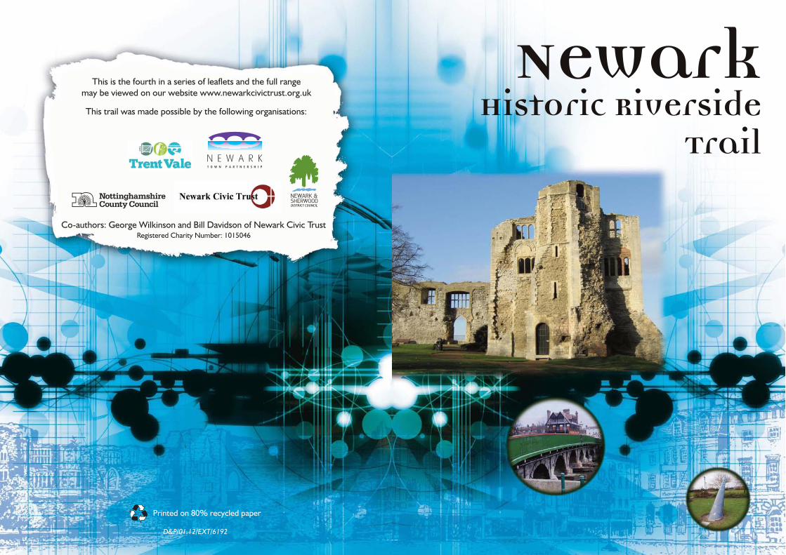
The River Trent and its Devon tributaryhave played an important role in Newark’slife for many centuries. Before highways,canals, railways and finally motor transportwere established, the rivers were the onlypractical means to transport large andheavy goods over long distances; rivers alsoprovided access to the sea for internationaltrade. Newark was built at the lowestfording point on the Trent, which waseventually protected by the castle and thenbridged, so it was natural that it shouldbecome a centre for river-bornecommerce, particularly trading in wool.The river banks hosted a thriving inlandport with wharves, warehouses, mills,maltings and breweries bringing people,employment and wealth to the town. Thistrail covers a good deal of the riversidearea upstream of Trent Bridge.
Start the route at the bronze model ofNewark in the Castle Grounds and thenleave via the iron gates, turning right towalk along Castle Gate. To your right yousoon find another set of gates leading toThe Gilstrap Centre (1)- opened in1883 as the town’s first free public library.It was the gift of Sir William Gilstrap;originally a very successful hotelier, heturned to malting when the arrival of therailways spelt the end of the coachingtrade. At one time, a cattle marketoccupied part of the castle grounds. Thecattle market was moved to the far side ofthe river in 1885 - a site we will visitfurther on in this trail.
The tall tower is a ventilation shaft for thestage area within (limelight gives off toxicfumes), where evening entertainment wasprovided for traders- as well as maximisingthe use of the building, socialising in this way was akin to the modern practice ofmeeting business associates for a round ofgolf.
Continue upstream to the Town Lock.Immediately to your right you will see twosmall locks - both disused and much smallerthan the one further over, which we willcome to later. William Jessop built the lockin 1772, while the extension was built in1808. The locks were installed, along withweirs, to augment the natural depth of theriver, thus providing for bigger barges.
Opposite the pointwhere the twolocks meet is aprivate house, alsodating from 1772,which was theoriginal lock-keeper’s cottage(4). A quaint café
now occupies the second lock keeper’scottage - built when the lock was extendedand the first cottage proved too small.
Just past the older cottage, look for apassage entry on your left. Follow thisand look out for the dog mural made ofbricks. Take the turning to the right justbefore this and continue to arrive inNavigation Yard.To your front is a largewarehouse and industrial unit (5). It stillbears the legend Newark Egg Packers, for acompany which in addition to packing eggs,a task performed in a smaller buildingnearby, used the larger one in front of youfor warehousing and to house a provendermill and a bagging plant producing pig andpoultry feeds.
Continue along Castle Gate then, justpast the next set of metal gates, turn
right to follow the steps or rampdown to the riverside atCuckstool Wharf.
This trail covers a good
deal of the riverside
area upstream of
Trent Bridge.
4
3
5
12
For centuries this was a hive of industry, with warehouses and maltings enjoying immediate access tothe river; you passed one of the maltings(2), long since converted to housing, onyour left as you descended. Until 1801, thearea by the river also accommodated thecuckstool or ducking stool, a popularpunishment for scolds and for merchantswho gave short measure - both genderswere eligible but women werepredominantly the victims!
Turn left to move upstream.The ornatebuilding high up on the left is the CornExchange (3), built in 1847 to a design byLondon architect Henry Duesbury. Itsgrandeur serves as a memorial to thesuccess and scale of the trade in grain, inparticular barley for malting and brewing.

D&P/01.12/EXT/6192
Printed on 80% recycled paper
NewarkHistoric Riverside
Trail
This is the fourth in a series of leaflets and the full range may be viewed on our website www.newarkcivictrust.org.uk
This trail was made possible by the following organisations:
Co-authors: George Wilkinson and Bill Davidson of Newark Civic TrustRegistered Charity Number: 1015046
Newark Historic Riverside TrailDistance: 1.4km
Time: 1.5 hour. Easy trailStart/Finish: at the bronze model of Newark
in the Castle GroundsWheelchair & pushchair friendly
The River Trent and its Devon tributaryhave played an important role in Newark’slife for many centuries. Before highways,canals, railways and finally motor transportwere established, the rivers were the onlypractical means to transport large andheavy goods over long distances; rivers alsoprovided access to the sea for internationaltrade. Newark was built at the lowestfording point on the Trent, which waseventually protected by the castle and thenbridged, so it was natural that it shouldbecome a centre for river-bornecommerce, particularly trading in wool.The river banks hosted a thriving inlandport with wharves, warehouses, mills,maltings and breweries bringing people,employment and wealth to the town. Thistrail covers a good deal of the riversidearea upstream of Trent Bridge.
Start the route at the bronze model ofNewark in the Castle Grounds and thenleave via the iron gates, turning right towalk along Castle Gate. To your right yousoon find another set of gates leading toThe Gilstrap Centre (1) - opened in1883 as the town’s first free public library.It was the gift of Sir William Gilstrap;originally a very successful hotelier, heturned to malting when the arrival of therailways spelt the end of the coachingtrade. At one time, a cattle marketoccupied part of the castle grounds. Thecattle market was moved to the far side ofthe river in 1885 - a site we will visitfurther on in this trail.
The tall tower is a ventilation shaft for thestage area within (limelight gives off toxicfumes), where evening entertainment wasprovided for traders- as well as maximisingthe use of the building, socialising in this way was akin to the modern practice ofmeeting business associates for a round ofgolf.
Continue upstream to the Town Lock.Immediately to your right you will see twosmall locks - both disused and much smallerthan the one further over, which we willcome to later. William Jessop built the lockin 1772, while the extension was built in1808. The locks were installed, along withweirs, to augment the natural depth of theriver, thus providing for bigger barges.
Opposite the pointwhere the twolocks meet is aprivate house, alsodating from 1772,which was theoriginal lock-keeper’s cottage(4). A quaint café
now occupies the second lock keeper’scottage - built when the lock was extendedand the first cottage proved too small.
Just past the older cottage, look for apassage entry on your left. Follow thisand look out for the dog mural made ofbricks. Take the turning to the right justbefore this and continue to arrive inNavigation Yard. To your front is a largewarehouse and industrial unit (5). It stillbears the legend Newark Egg Packers, for acompany which in addition to packing eggs,a task performed in a smaller buildingnearby, used the larger one in front of youfor warehousing and to house a provendermill and a bagging plant producing pig andpoultry feeds.
Continue along Castle Gate then, justpast the next set of metal gates, turn
right to follow the steps or rampdown to the riverside atCuckstool Wharf.
This trail covers a good
deal of the riverside
area upstream of
Trent Bridge.
4
3
5
1 2
For centuries this was a hive of industry, with warehouses and maltings enjoying immediate access tothe river; you passed one of the maltings(2), long since converted to housing, onyour left as you descended. Until 1801, thearea by the river also accommodated thecuckstool or ducking stool, a popularpunishment for scolds and for merchantswho gave short measure - both genderswere eligible but women werepredominantly the victims!
Turn left to move upstream. The ornatebuilding high up on the left is the CornExchange (3), built in 1847 to a design byLondon architect Henry Duesbury. Itsgrandeur serves as a memorial to thesuccess and scale of the trade in grain, inparticular barley for malting and brewing.
Continue on over the bridge, pausingto look to the right, where stands thetollhouse (16), with unusual ‘crow step’gables to its rear extension, now the HQfor the Nottinghamshire Federation ofWomen’s Institutes. Although partlyrebuilt and overshadowed by theRomanesque gatehouse of the castlebeyond, it still commands a certainauthority over passers-by.
Cross the road ahead with care andpause again outside the magnificentTudor style Ossington Coffee Palace(17). Founded in 1882 as a temperancehotel by Countess Ossington, it providedan alcohol-free alternative for travellersand visitors to the markets until shortlybefore the Second World War, when itwas converted for use as governmentoffices (a sign painted on the wall of the
single storey building at the far end refersto billeting for airmen). Variousunsuccessful businesses occupied it inlater years, but now it stands in goodhealth, having been converted to mixedresidential and restaurant use.
Traverse the zebra crossing (noting howconsiderate Newark drivers can be) toend the trail back at the castle.
Map ©Newark and Sherwood District Council
13
12
14
15
16
11
10
9
8 7 6
17
1
2
3
4
5
6
78
9
10
11
12
13
14
15
16
17
START/FINISH
Proceed through the arch to see amalting, now converted to housing.The oval wall plate (6) over thepassageway, similar to those mentionedin our Malting and Brewing Trail leaflet,attests that Corcoran, Witt of London,malt kiln builders, were responsible forthe building or perhaps its modification.The firm, which probably employed localtradesmen, supplied all types of maltingequipment and may have been brought infor the expertise it had gained in thelong-established London malting industry.
Immediately beyond the passagewaynote the patchwork haulage path (7) -two tracks made from granite setts withtarmac between (the tarmac is a recentaddition, the areas between the settswould originally have been rough stone).These tracks were designed to help drayhorses to grip as they pulled their loadsfrom the wharf and from the townweighbridge - the site of which can justbe made out as a slightly depressedrectangular pattern in the setts. Thewharf itself is now The Otter Park with anartwork, by Judith Bluck, consisting ofbronze otters atop limestone rocks.
Follow the Riverside Walk sign under alow roof, then turn right to see a range ofbuildings that used to be the workshop ofa wheelwright. This is evident from thehooping base (8) - a circular concreteslab in the ground that once was used tocentre and stabilise wagon wheels duringconstruction. After assembly of the hub,spokes and rim, the iron tyre would beheated to dull red and then dropped overthe wheel. As the tyre cooled andcontracted it drew everything togetherto make a sound structure.
Moving on, the 5-storey building (9)seen ahead was originally a malting butwas extended in 1880 by the TrentNavigation Commissioners andconverted into a warehouse. Adjoiningthis is Millgate Museum (well worth avisit), housed in what was once an oil-seed mill owned by James Clark - thewall plates bear the letters “JC 1870”.
Past the museum and through thearch, turn right; several more wallplates can be seen at eye-level, giving arare opportunity for a close-upinspection. In front now is Mill Bridge.Formerly a hump-backed brick builtbridge gave access to Parnham’s Millwhich was destroyed by fire in 1965. Thepresent bridge was built in 1952 as partof the town lock expansion works.
Once across the bridge, turn left andhead for the 2 stone parapets whichform the sides of Longstone Bridge(10) This was built to carry the towpathacross the back-stream which takes themain flow of water, since the lock gatesdownstream block the flow most of thetime. From the bridge may be seen theweir, designed to ensure a head of waterfor the mill and lock and now oftenenjoyed by white water canoeists. Themillstream, which once served threewater wheels, can also be seen to theright of the weir.
Returning past Mill Bridge, the widestretch of water which can be seen infront of the museum is known as NewarkBasin - always full of barges in its heyday.From here there is a good view of thebuilding opposite, with its hoist towerand the two large arches of what wasonce the boiler room. Above these canbe seen the stump of the chimney whichonce rose to 52ft (16m).
Just beyond the British Waterwaysworkshop buildings on the left, the routecrosses the gates of a dry dock (11) -the largest inland dry dock in Britain.Barges were once built and maintainedhere while work is still occasionally doneon British Waterways’ smaller workingboats.
Just a little further downstream is thelatest and largest of the three locks. Over90ft (27m) long and 32ft (9.75m) wide,this lock was constructed in 1952 toaccommodate four barges at a time. Atthe time of construction, numerouspetrol tanker barges regularly passedthrough to discharge their loads atColwick. In the 1960s a pipeline grid forthe transport of oil took over this roleand the traffic in large barges virtuallyceased. As you pass the lock, to your leftis a sensory garden and the third andlatest lock-keeper’s cottage (1952).Ahead is the Girder Bridge - functional butnot elegant, it replaced an earlierwooden structure (named the HaylingBridge - a version or corruption of‘hauling’), which fell victim to theconstruction of the much bigger lock.
Cross the bridge to see the MillenniumMonument (12), built in the form of asundial. Thirteen slate markers are sunkinto the turf to mark the hours. Each isinscribed with an event significant inNewark’s history. The gnomon (the bitthat sticks up) bears a wavy blue linesignifying the river as well as datesrelating to the events portrayed on themarkers.
Follow the path past the sundialtowards the small clock tower in thedistance. Cross the road and passbetween the bollards to reach theRiverside Arena - the site that the cattlemarket was relocated to in 1885 (it hassince been moved to its present site,further along Great North Road). At thefar side, at the foot of the wall, can beseen the tops of seven arches (13).These are the remains of some ofSmeaton’s Arches. In 1772, John SmeatonFRS, designer of the EddystoneLighthouse, founder of the Institute ofCivil Engineers and known as ‘the fatherof civil engineering’, was commissionedto create a viaduct from Muskham Bridgeto Newark Trent Bridge to allow winterpassage across the flood plain of thelucrative coach traffic on the Great NorthRoad. The arches you see are in fact 16ft6in (5m) tall from top to (underground)bottom and are set on brick piers 16ft 6in(5m) between centres; they were filled inwhen the ground level was raised as aflood control measure in 1932. Eighty-five of the original 105 arches still existand some may be seen beyond the A46roundabout, still performing their originalrole whenever the Trent floods.
Turn away from the Riverside Arena,cross the road and head towards TrentBridge (14). Just before the bridge, aturn to the right and then to the left givesaccess to the board walk that passesunderneath. From here it can be seenthat the bridge is built of brick with stonefacings. Constructed in 1775 -immediately after Smeaton’s Arches - itreplaced a wooden bridge with stonepiers which had been too low and toonarrow to permit larger river craft topass upstream to Nottingham. Theconcrete and steel cutwaters of thepresent bridge were added in 1952 toafford protection from passing vessels.Above can be seen the cast iron beamswhich carry the walkways, added in 1848to accommodate the passengers andtraders using the recently openedMidland Railway station (1846).
Follow the path up to the bridge andcross to see, at the halfway point, thedate of 1848 shown in Roman numeralson plaques on the railings (15). Thereare four plaques in all - two facing theroad and two facing the river -emphasising the continued importance ofthe river to the town. The plaques alsobear Newark’s coat of arms and themotto “DEO FRETUS ERUMPE” -referring to the Civil War period andtranslating as “Put your trust in God andsally forth”.