1 - 4 - burnaby · 4205,4213,4223 and 4227 canada way; ... city staff have reviewed the ntc lands...
TRANSCRIPT

FILE NO. 2410-20
CITY OF BURNABY
ADVISORY PLANNING COMMISSION
NOTICE OF MEETING
DATE: THURSDAY, 2014 NOVEMBER 13
TIME: 6:00 P.M. (DINNER 5:00 P.M IN CAFETERIA)
PLACE: COMMITTEE ROOMS 1 & lA, CITY HALL
1.
AGENDA
MINUTES
a) Meeting of the Advisory Planning Commission held on 2014 September 18
PAGE
1 - 4
2. ZONING BYLAW AMENDMENTS
a)
b)
BURNABY ZONING BYLAW 1965, AMENDMENT BYLAW NO. 34, 2014 - BYLAW NO. 13408 5 - 24
Text Amendment
The purpose of the proposed bylaw text amendment is to create a new P12 Utility Corridor District, add a definition for 'utility corridor' and make minor amendments to two sections of the supplemental regulations.
BURNABY ZONING BYLAW 1965, AMENDMENT BYLAW NO. 35, 2014 BYLAW NO. 13409 25 - 36
Rez. #14-37
BC Hydro Corridor Properties
6760, 6763, 6772 and 6777 Arcola Street; 6780, 6792, 6808, 6809, 6823, 6831 and 6843 Balmoral Street; 6844 (Lots 17 and 18), 6856, 6868, 6869, 6885 and 6891 Elwell Street; 7085 and 7086 Burford Street; 7051 and 7061 Halligan Street; 6908 Imperial Street; 6559

Advisory Planning Commission 2014 November 13 Meeting Page 2 of3
c)
and 6560 Leibly Avenue; 6558, 6568 and 6569 Malvern Avenue; 6617, 6637, 6647, 6667 and 6687 Salisbury Avenue; 6620 Sixth Street and 6570 Walker Avenue
City Owned Properties
6974,6984 and 6994 Imperial Street; 7409 Morley Drive; 6595 Walker Avenue
Lots 12 and 13 Block 7, Lots 13, 14, 15,32 and 33, Block 6, Portion of Lots 17, 18, Lots 19,20,27,28,29 and 30, Block 3, Lots 22, 23 and 24, block 2, D.L. 96, Group 1 NWD Plan 1194; Lots 61, 62, 63, 64, 65, 66, 67, 68, 69 and 70, D.L.95, Group 1, NWD Plan 1056; Part .284 of an acre more or less of Lot 162, DL 92, Group 1, NWD Plan As Shown Red On Statutory Right Of Way Plan 10599; Lot 21, DL 92, Group 1 NWD Plan 1318; D.L. 90, NWD Plan 10303; Lot 12, Block 1, Lots 1 and 12 Block 2, Lots 1 and 2 Block 3, DL 91, Group 1, NWD Plan 1348; Lot 211, District Lots 89 and 90, Group 1, NWD Plan 35322; Lot I, Block 1, D.L. 91, Group 1, NWD Plan 1348; Lot 324, D.L. 91, Group 1, NWD Plan 46432; Lot 162 Except: Firstly: Part on Statutory Right of Way Plan 10599; Secondly: Part subdivided by Plan 13681, D.L. 92, Group 1, NWD Plan 1146
From: Rl Residential District, R2 Residential District, R3 Residential District, R5 Residential District, RM2 Multiple Family Residential District, and RM3 Multiple Family Residential District
To: P12 Utility Corridor District
The purpose of the proposed zoning bylaw amendment is to maintain the Newell Transmission Corridor as a utility corridor consistent with the Official Community Plan (OCP) and other community plans.
BURNABY ZONING BYLAW 1965, AMENDMENT BYLAW NO. 36, 2014 - BYLAW NO. 13410 37 - 51
Rez. #12-38
4205,4213,4223 and 4227 Canada Way; 4108,4206,4214 and 4224 Norfolk Street; 3249 Gilmore Diversion
Lots 1, 2, 6, 7, 8, Lot 3 Except: Part Dedicated Road on Plan LMP 50077, Lot 4 Except: Part Dedicated Road on Plan LMP 50077, Lot 5 Except Firstly: Part on Plan with Bylaw Filed 56876, Secondly: Part on Bylaw Plan 64207, Blk 49, DL 69, Group 1, NWD Plan 1321; Lot 46, DL 69, Group I, NWD Plan 54176
From: P5 Community Institutional District and R5 Residential District

Advisory Planning Commission 2014 November 13 Meeting Page 3 of3
To: CD Comprehensive Development District (based on RM3 Multiple Family Residential District, P5 Community Institutional District, and Broadview Community Plan as guidelines and in accordance with the development plan entitled "Chartwell Carlton Gardens Retirement Residence" prepared by Craven, Huston, Powers Architects)
The purpose of the proposed zoning bylaw amendment is to. permit the development of a new 105 unit seniors rental apartment building (independent supportive living and assisted living units) to complement the existing seniors complex care development.
3. NEW BUSINESS
4. INQUIRIES
5. ADJOURNMENT

FILE NO.: 2410-20
CITY OF BURNABY
ADVISORY PLANNING COMMISSION
MINUTES
A meeting of the Advisory Planning Commission was held in the Clerk's Committee Room, Burnaby City Hall, 4949 Canada Way, Burnaby, BC on Thursday, 2014 September 18 at 6:00 p.m.
PRESENT: Mr. Valentin Ivancic, Chair Mr. Craig Henschel, Vice Chair Mr. Matt Foley, Parks, Recreation & Culture Commission Representative Mr. Larry Myers Ms. Jasmine Sodhi
ABSENT: Ms. Sarah Campbell Mr. Arsenio Chua Mr. Harman Dhatt Ms. Stella Tsiknis
STAFF: Mr. Ed Kozak, Assistant Director, Current Planning Ms. Eva Prior, Administrative Officer
The Chair called the meeting to order at 6:05 p.m.
1. MINUTES
(a) Minutes of the Advisory Planning Commission meeting held on 2014 August 14
MOVED BY COMMISSIONER FOLEY: SECONDED BY COMMISSIONER MYERS:
"THAT the minutes of the Advisory Planning Commission meeting held on 2014 August 14 be adopted."
CARRIED UNANIMOUSLY
2. ZONING BYLAW AMENDMENTS
MOVED BY COMMISSIONER SODHI: SECONDED BY COMMISSIONER HENSCHEL:
"THAT the Zoning Bylaw Amendments be received."
CARRIED UNANIMOUSLY
01

Advisory Planning Commission Minutes - 2014 September 18
Page 2
a) BURNABY ZONING BYLAW 1965,
02
AMENDMENT BYLAW NO. 31, 2014 - BYLAW NO. 13387
Rez. #14-25
7650, 7701, 7702 Eighteenth Street, Portion of 7679 Eighteenth Street, and 7105, 7205 Eleventh Avenue
Address
7650 Eighteenth Street
7679 Eighteenth Street
7701 Eighteenth Street
7702 Eighteenth Street
7105 Eleventh Avenue
7205 Eleventh Avenue
Legal Description
Lot 68 Except: part on Plan 34711, D.L. 53, Group 1, NWD Plan 33863
Lot 42, D.L. 53, Group 1, NWD Plan 28569 Except Plans 49756, BCP7569 & BCP34566
Lot 2 Except: part dedicated road on Plan BCP7569, D.L. 53, Group 1, NWD Plan LMP44380
Parcel "A" (Statutory Right of Way 34711), Lot 68, D.L. 53, Group 1, NWD Plan 33863
Westerly 20Q.43 ft. Lot "E", D.L. 53, Group 1, NWD Plan 14210 having a frontage on Eleventh A venue by the uniform full depth & adjoining the said westerly boundary Except: part dedicated road on Plan BCP9577
Block "E" Except: the westerly 200.43 ft. having a frontage of 200.43 ft. on Eleventh Avenue by the uniform full depth of block "E" & adjoining the said westerly boundary, D.L. 53, Group 1, NWD Plan 14210
From: Ml Manufacturing District, M2 General Industrial District and R5 Residential District
To: CD Comprehensive Development District (based on the RM5 and RMI Multiple Family Residential Districts, C2 Community Commercial District, and the development plan entitled "Southgate Master Plan Concept Book and Design Guidelines" prepared by IBI Group and PWL Partnership)
The purpose of the proposed zoning bylaw amendment is to establish a Master Plan for the subject site, which would guide further site specific rezoning applications for the development of a multi-phased, mixed-use, multiple-family residential neighbourhood.

Advisory Planning Commission Minutes - 2014 September 18
Page 3
No specific development or new construction is being sought under the subject rezoning application.
MOVED BY COMMISSIONER FOLEY: SECONDED BY COMMISSIONER HENSCHEL:
"THAT the Advisory Planning Commission SUPPORT Rez. #14-25, Bylaw No. 13387."
CARRIED UNANIMOUSLY
b) BURNABY ZONING BYLAW 1965, AMENDMENT BYLAW NO. 32, 2014 - BYLAW NO. 13388
Rez. #13-37
7550 Cumberland Street
Lot 112, D.L. 11, Group 1, NWD Plan 72024
From: P5 Community Institutional District
To: CD Comprehensive Development District (based on P5 Community Institutional District and George Derby Community Plan as guidelines and in accordance with the development plan entitled "Derby Manor 7550 Cumberland Street, Burnaby, BC, V3N 3X5" prepared by DYS Architecture)
The purpose of the proposed zoning bylaw amendment is to pennit the development of a new five-storey, 122 unit, non-profit seniors' supportive housing facility.
MOVED BY COMMISSIONER FOLEY: SECONDED BY COMMISSIONER SODHI:
"THAT the Advisory Planning Commission SUPPORT Rez. #13-37, Bylaw No. 13388."
CARRIED UNANIMOUSLY
c) BURNABY ZONING BYLAW 1965, AMENDMENT BYLAW NO. 33, 2014 - BYLAW NO. 13389
Rez. #12-29
6205 and 6255 Kingsway.
Lot "C", D.L. 97, Group 1, NWD Plan 15308; Lot A (X95792) Except: Part Dedicated Road on Plan 77668, D.L. 97, Group 1, NWD Plan 7570
From: C4 Service Commercial District
" 03

Advisory Planning Commission Minutes - 2014 September 18
Page 4
To: CD Comprehensive Development District (based on C9 Urban Village Commercial District and Royal Oak Community Plan guidelines and the development plan entitled "620516255 Kingsway, Burnaby" prepared by Wilson Chang Architect Inc.)
The purpose of the proposed zoning bylaw amendment is to permit the construction of a four-storey mixed-use development with full underground parking, comprised of at grade commercial fronting Kingsway with residential uses behind and above.
MOVED BY COMMISSIONER FOLEY: SECONDED BY COMMISSIONER HENSCHEL:
"THAT the Advisory Planning Commission SUPPORT Rez. #12-29, Bylaw No. 13389."
CARRIED UNANIMOUSLY
4. NEW BUSINESS
There were no new business brought before .the Commission at this time.
5. INQUIRIES
There were no inquiries brought before the Commission at this time.
6. ADJOURNMENT
MOVED BY COMMISSIONER FOLEY: SECONDED BY COMMISSIONER HENSCHEL:
"THAT this meeting do now adjourn."
The meeting adjourned at 6:55 p.m.
Ms. Eva Prior Administrative Officer
04
CARRIED UNANIMOUSLY
Commissioner Valentin Ivancic Chair

~ City of ~T-Burnaby
item ............................................................ .
Meeting ......................................... 2014 Oct 20
COUNCIL REPORT
TO: CITY MANAGER DATE: 2014 October 08
FROM: DIRECTOR PLANNING AND BUILDING
SUBJECT: BURNABY ZONING BYLAW AMENDMENT 1'12 UTILITY CORRIDOR DISTRICT
FILE: 42000 05/68000 20
Pl.IRPOSE: To propose a Burnaby Zoning Bylaw amendment and property rezoning process to appropriately zone utility transmission corridor lands.
RECOMMENDATIONS:
I. THAT Council authorize the introduction, at a future Public Hearing, of a bylaw to amend the Burnaby Zoning Bylaw to recognize utility tnmsmission use of lands under a new 1'12 Utility Corridor District, as outlined in Section 4.1.1 of this report.
2. THAT Council authorize staff to pursue a City-initiated rezoning process of properties within the Newell Transmission Corridor to the 1'12 Utility Corridor District, as outlined in Section 4.1.2 of this report.
3. THAT Council authorize stall'to pursue future City-initiated rezoning processes for other utility transmission corridor lands to the 1'12 Utility Corridor District, as outlined in Section 4.1.3 of this report.
4. THAT Council authorize staff to advise BC Hydro and the applicable Ministry responsible for the subject lands of the proposed rezoning to the 1'12 Utility Corridor District.
5. THAT a copy of'this repOlt be sent to the Community Development Committee and the Parks, Recreation and Culture Commission for their infonnation.
REPORT 1.0 BACKGROllND
The City has been advised by BC Hydro of a proposal for the potential sale and transfer of a group of Provincial Crown properties that form part of the Newell Transmission Corridor (NTC), located in and adjacent to the Edmonds Town Centre. BC Hydro has advised that the sale of these properties is intended to potentially generate revenue for the Provincial Government through the sale of land assets considered surplus.
City staff have reviewed the NTC lands that could potentially be sold to private interests, and have concluded that the prevailing zoning in place for these lands is inconsistent with the City's adopted Oftlcial Community Plan and other area plans. The direction and intent of the City's
05

To: City Manager From: Director Planning and Building Re: Burnaby Zoning Bylaw Amendment- P 12 Ulility Corridor Districl 2014 Oclober 08 ....................................................................... Page 2
plans are to specifically preserve these lands for their intended and current dual use for both utility transmission corridors and open space purposes. The development of the NTC and other similar lands under prevailing zoning would erode the consistency of the City's plans for their use as transmission corridors and the contribution that is made to open space in our residential and other neighbourhoods. Further impacts would arise as opportunities are lost to improve and enhance the development of open space; create connections to public trail and cycle rouies; and improve the sustainability and liveability of our neighbourhoods, in association with these lands.
Consistent with the City's prevailing Official Community Plan and other adopted area plans, this report seeks Council approval to advance a text amendment to the Burnaby Zoning Bylaw, and to pursue City-initiated rezoning processes for the NTC and other similar lands in Burnaby.
2.0 TRANSMIS.SION CORRIDORS IN BURNABY
There are a number of significant transmission corridors that link with urban electrical substations in Burnaby, which have been established and recognized as part of the city's community plans. Many of these corridors are within designated parks and conservation areas and are specifically integrated within adopted plans for use as pedestrian and cycle trails. These transmission corridors and their related titled properties are also located within the boundaries of, and/or adjacent to, many parks, conservation areas, and public open spaces including but not limited to:
• Burnaby Mountain Conservation Area • Capitol Hill Conservation Area • Stoney Creek Ravine Park • Burnaby Lake Regional Nature Park· • Burnaby Lake Sports Complex • Byrne Creek Ravine Park • BC Parkway (Expo SkyTrain Line) • Highland Park Line
A map showing these corridors in relation to the City's Park and Open Space System is provided in Attachment 1.
3.0 NEWELL TRANSMISSION CORRIDOR (NTC)
In 2013, BC Hydro advised the City that it was adding twenty properties that comprised a portion of the NTC to the "BC Hydro Surplus Property List." This proposal would potentially result in the sale of these lands to private interests for development under prevailing zoning. In many instances, the City's prevailing zoning for these lands does not reflect the directions and designations of the City'S adopted community plans. This situation has arisen as the sale of such lands has generally been unprecedented in the City's history, and as such, consideration of a need for the specific zoning of these lands, to define their use consistent with the City's adopted plans, had not arisen, in past, as a topic of concern or interest.

i I l--------
To: City Manager From: Direclor Planning and Building Re: Burnaby Zoning Bylaw Amendment- P 12 Utility Corridor Districl 2014 October 08 ........................................................................ Page 3
3.1 Creation of the Newell Transmission Corridor
The NTC is a historic electric utility corridor that was developed with the approval and cooperation of the Municipality of Burnaby in 1949. The British Columbia Electric Company Limited (the predecessor of BC Hydro) required the development of a transmission line to link the Stave Falls Transmission Line and the Hill Avenue Substation on the south side of Burnaby Lake to the Newell Substation located at Griffiths Avenue and Kingsway to serve increased electrical use and capacity (see Attachment 2). .
As Council considered the project integral to the post-war development of the municipality, and in the broad public interest, it advanced its approval to provide for the creation of a 100 foot wide corridor through Robert Burnaby Park and other city-owned lands parallel to Imperial Street and terminating at the Newell Substation at Kingsway and Griffiths Avenue. Additionally, the City, through "Burnaby Land Sale Bylaw No. 2063," approved the sale of a number of Tax Sale properties in the form of vacant residential lots to the BC Electric Company as: "Council ... deem it expedient and in the Public interest to accept the said offer." Subsequently the corridor was cleared and the high voltage transmission line was constructed and completed in 1950.
The NTC has retained its original overhead transmission lines (69 KV Circuit) supported with wood poles. Later an underground conduit (230 KV Circuit) was added to the right-of-way. In 2000-2001, BC Hydro completed a significant upgrade to the transmission line's cables and infrastructure including installation of new underground line. These transmission lines remain an important part of the electrical distribution system within Burnaby serving both the City and regional transmission network.
3.2 Public Use ofthe Newell Transmission Corridor
The NTC has been incorporated into the City's ongoing pIanning to protect the function and safety of this major electrical utility corridor, to enhance the City's urban design, and to provide for open space, recreational and transportation opportunities for citizens. The long-held civic interests in the NTC are outlined below.
3.2.1 Bumaby OCP-Parks and Public Open Spaces
Following the completion of the NTC in 1950, the right-of-way with its associated access road became widely and informally used by residents within the Edmonds and Lakeview neighbourhoods for passive trail use to access parks and recreational amenities including Malvern Park, Lakeview Elementary School, Lakeview Park and Robert Burnaby Park. The active public use of the corridor was first recognized in the 1970s, and was formally adopted as part of the City's trail network by Council in the Burnaby Trail Study (1980), and again was reflected in the Burnaby Trail Inventory and Development Program (1986). Council adopted the Newell Transmission Line route as part of the Burnaby Transportation Plan in 1995 for use by both pedestrians and cyclists.
07

To: City Manager From: Director Planning and BUilding Re: Burnaby Zoning Bylaw Amendment - P 12 Utility Corridor District 2014 October 08 ........................................................................ Page 4
In \998, Burnaby's OCP was adopted with a number of goals and provIsIOns related to integrating all of the City's trail, greenway and transportation plans. This plan, which provides for a more formalized and ongoing vision of the City's Urban Trail system, identified the NTC as a park trail route with the potential to become a fully developed 'greenway' that would provide significant open space linking green spaces to the developing Edmonds Town Centre. This vision is articulated in the Park and Open Space section of the OCP within the goal: " ... to provide a system of pedestrian/cycle trails and other greenways to connect the major park and open space areas of the City with each other and other strategic components of the City and adjacent municipalities."
3.2.2 Urball Greenway Plall
Using the connectivity concept envisioned by the OCP, Burnaby has worked over many years to establish a regional urban greenway plan. In \999, Burnaby partnered with Metro Vancouver to commence the planning phase for the Burrard Peninsula Recreational Greenway Plan. The concept of a regional greenway vision originates from the Green Zone Strategy and the Liveable Region Strategic Plan. The goal of the plan is to achieve connectivity amongst the region's parks and open spaces by developing a network of regionally significant recreational greenways that link across municipalities.
Council adopted a comprehensive greenway plan for the City which included the "Byrne CreekBurnaby Lake Greenway" which utilized the NTC as a key component of this route. Following this direction, the Planning Department approached BC Hydro to establish an agreement respecting its use for a public trail/greenway. As BC Hydro was in the process of upgrading the transmission line at that time, the development of a formal agreement related to the planning and development of the anticipated urban trail on the NTC was delayed pending the completion of these works.
Discussions with BC Hydro, however, resulted in a written commitment from BC Hydro that it " ... had no objection in principle to the ... trail within our right-of-way" subject to:
• advancement of the project following completion of the cable replacement project; • any trail works would require separate approval; • installation of gates or post to prevent unauthorized vehicles; • maintaining continuous access for BC Hydro at all times; and, • the City would be requested to execute a Licence of Occupation to use the right-of-way
for a recreational urban trail.
These conditions would be expected to remain applicable for any future agreement reached between the City and BC Hydro respecting the implementation of future formalized public access, on the NTC or other similar routes in Burnaby. .
08

To: City Manager From: Director Planning and Building Re: Burnaby Zoning Bylaw Amendment- P 12 Utility Corridor District 2014 October 08 ........................................................................ Page 5
3.2.3 Beautification Area
In 1979, the City entered into a lease with BC Hydro for a 3,433 m2 (0.85 acres) section of the Newell Transmission Corridor for a civic beautification area that also included City properties and closed road allowances. The lease agreement encompassed. nine properties owned by BC Hydro located at the intersection of Imperial Street, Walker Avenue and Salisbury Street (see Attachment 4).
This project recognized the local community interest in ensuring that the transmission line was properly integrated into its mature residential neighbourhood context, as an amenity. The Parks Department completed the works under the Burnaby Beautification Committee with a landscape plan that includes flowering trees and lawns that have been maintained annually by the City. Later, civic improvements such as road closures and the installation of sidewalks have been completed to improve pedestrian access and use of the greenway and road intersection.
The five year lease term (1979 - 1983) was for $1.00 per year, with terms that have since permitted the agreement to continue on an ongoing month to month basis. The lease provides a termination clause permitting either party to cancel the agreement with formal notification of 90 days. BC Hydro staff have indicated that it is not their intention to cancel the lease with the City at this time, but to cooperate to ensure civic needs for the lands are maintained as part of an agreement for any associated BC Hydro properties.
3.2.4 Edmonds Town Centre Community Plan
The legal lots that comprise the section of transmission line within the boundaries of the Edmonds Town Centre, and located between Kingsway and Balmoral Street, were designated for Park and Public Use, as part of the adopted Community Plan initially developed in 1981. This designation recognized, in part, that the use of the corridor properties for a major transmission line precluded their future redevelopment for other commercial and/or residential purposes (see Attachment 2).
3.3 Be Hydro Surplus Property Review Process
As noted, in 2013 the City was formally advised by BC Hydro that it was adding a number of properties in Burnaby to their "Surplus Property List" (see Attachments 3 and 4 and Appendix B). As part of this process, BC Hydro is undertaking a review of the potential disposition of 20 residentially zoned properties (approximately 2.35 acres) that constitute a significant section of the NTC in and adjacent to the Edmonds Town Centre. Two of the subject properties are currently leased to the City, as part of the beautification area located at Salisbury Avenue and Halligan Street. These properties were identified as surplus, and available for sale under the Provincial Budget directive, based on a special review of land assets by the BC Hydro. Seven additional properties within the beautification area under lease are not affected by the potential land sale.
09

To: City Manager From: Director Planning and Building Re: Burnaby Zoning Bylaw Amendment - P 12 Utility Corridor District 2014 October 08 ..... , .................................................................. Page 6
Staff have been advised that it is the current policy of BC Hydro to sell any lands considered surplus and to protect existing electrical transmission infrastructure through the registration of any necessary easements or rights-of-way. Following BC Hydro's established disposition policy for surplus properties, notification was provided to the City of Burnaby, Metro Vancouver (Property Division), Province ofBC (Shared. Services) and TransLink to determine whether any of these governments and agencies have an interest in acquiring the identified properties. At this time, staff are not aware that any other agency has expressed an interest in the acquisition of the subject lands.
City staff have advised BC Hydro representatives of the long-standing City designations and public interests served by transmission corridor lands, as outline above. BC Hydro staff have, however, indicated' that there is the potential for the properties to be made available for public sale, as soon as surveys of the current infrastrnctnre have been completed and legally registered against the legal titles of the lands, and any necessary ntility relocation work has been completed to support fntnre development of the lands under prevailing zoning.
3.4 Development Potential Under Prevailing Zoning -
The properties being considered by BC Hydro for sale, under existing historical zoning, wonld include 13 legal lots in the Single Family (RS) Residential District, 4 legal lots in the Multifamily (RM3) Residential District, and 3 lots in the Multi-family (RM2) Residential District. These lands and prevailing zoning designations are shown on Attacflmellt 5 and Appelldix B. As legal lots, the lands could be developed directly, or sold for consolidation purposes with adjacent private holdings. As noted above, development of these lands under prevailing zoning is inconsistent with the City's Official Community Plan and other plans.
4.0 PROPOSED CITY-INITIATED REZONING
Based on the established community plan designations and broader civic interest in tlle NTC lands, staff propose that a City-initiated rezoning of the lands be pursued. The rezoning of the NTC lands to a District consistent with the prevailing designations of the City's community plans would serve to maintain the lands for their designated purposes, whether the lands are held by Be Hydro or other private .interests. This would also ensure that tlle lands were not developed, contrary to the City plans, under historic zoning designations that are inconsistent with the City's intent and purposes for the lands. Rezoning to the proper district would also serve to protect citizens from impacts arising from the development of these lands contrary to the local community plans. Potential impacts include: loss of open space, greenways, trails, and buffer zones between residential uses and electrical transmission infrastructure, and incompatible urban design implications.
4.1 Land Use Zoning Designations for Transmission Corridors
It is noted that in the past, the lands associated with transmission corridors were largely seen by the City to have been held within a well-defined "public trust" which would be protected both by BC Hydro and the Provincial Government. The consistent administration of the corridors by BC
10

To: City Manager From: Director Planning and Building Re: Burnaby Zoning Bylaw Amendment - P 12 Utility Corridor District 2014 October 08 ...........................................................•........... Page 7
Hydro, in cooperation with the City, ensured that these assets served transmission needs and supported community integration objectives and that they were not eroded by inappropriate development.
Given the current circumstances, it is now necessary to consider establishing the appropriate zoning designation for these lands, consistent with the City's plans and designations. Primarily, the new zoning of the lands would serve to maintain the opportunity for these lands to provide for the accommodation of electrical transmission and/or other utility infrastructure to meet the future needs of the community as we continue to grow into the future.
To achieve the City's community plan objectives and provide for continued and future utility infrastructure on the subject lands, it is proposed that the lands be rezoned to a new district, the P12 Utility Corridor District, as discussed below.
4.1.1 Proposed Text Amelldmellts to the Bumaby ZOllillg Bylaw
To support the proposed approach, several amendments to the Burnaby Zoning Bylaw are required, including:
• Creation of the new P12 Utility Corridor District; • Addition of a definition for "utility corridor;" and, • Minor amendments to two sections of the Supplemental Regulations.
These proposed amendments are discussed in tum below.
P 12 Utility Corridor District·
Currently, no district in the Zoning Bylaw explicitly provides for the current and intended uses of utility transmission corridors, as discussed above. Similarly, these uses do not readily fit within the intent of any existing zoning district. For these reasons, and to ensure that the intended uses and regulation of utility transmission corridors are dearly defined, it is recommended that a new zoning district, the P12 Utility Corridor District, be added to the Zoning Bylaw (see Appendix A).
As proposed, the Pl2 Utility Corridor District would provide for the location of utility . infrastructure, including:
• overhead electrical transmission lines and support structures; • underground electrical transmission lines; • underground sewer or water lines; • underground telecommunication infrastructure; and, • other underground infrastructure.
11

To: City Manager From: Director Planning and Building Re: Burnaby Zoning Bylaw Amendment- P 12 Utility Corridor District 2014 October OB ....................................................................... Page 8
It would also permit compatible uses, including:
• trails and open space; and, • accessory uses and structures.
The latter could include equipment boxes and other utility infrastructure, as well as benches, signage, and other infrastructure related to trail amenities.
It is recommended that the above noted uses be subject to a condition of use that requires those portions of a P12 zoned lot not used for permitted uses to be fully and suitably landscaped and properly maintained.
In order to ensure the safety of adjacent roads and to minImIze interference, it is also recommended that where a lot abuts a street or lane, all electrical transmission lines and support structures shall comply with BC Ministry of Transportation desil,'Il criteria for transmission lines adjacent to highways.
In addition, in order to minimize conflicts with adjacent residential uses, it is recommended that a minimum setback of3 m (9.84 ft.) be required for all uses on a P12 District lot that abuts a lot in an A, C8, C9, R, or RM District, or in a CD District based on an A, C8, C9, R, or RM District.
Definition of "Utility Corridor"
In order to clarify the applicability of the proposed P12 District, it is recommended that the following (or similar) definition be added to Section 3 of the Zoning Bylaw:
"UTILITY CORRIDO!?," means a parcel or an assemblage of parcels of land forming a linear tract that contains or is intended to contain as the principal use, one or more of the following:
a) overhead electrical transmission lines and support structures; b) underground electrical transmission lines; c) underground sewer or water lines; d) underground telecommunications infrastructure; and/or, e) other underground infrastructure
and that contains no development other than the above noted uses and/or open space, trails, or accessory uses and structures that are customarily ancillwy to such uses.
This definition distinguishes utility corridors trom utility intrastructure that is located within road right-of-ways or that exists solely on easements or statutory right-of-ways through private land.
Infrastructure and development in road right-of-ways, including ntility lines, is not generally regulated under the Zoning Bylaw; utility infrastructure in easements and right-of-ways is generally more limited in extent and is intended to coexist unobtrusively within a variety of
12

To: City Manager From: Director Planning and Building Re: Burnaby Zoning Bylaw Amendmenl- P 12 Utility Corridor Districl 2014 October 08 _________ .. __ ................. ___ ................. __ ... __ ._. __ ........ _Page 9
development contexts. Neither of these forms of utility development fit within the intended scope of the proposed P 12 District
Supplementary Regulations
Utility corridors are distinct from most development types in that they generally contain no buildings, parking or loading facilities. In order to ensure that all relevant Zoning Bylaw provisions apply to the specific forms of development permitted in the proposed P12 District, it is necessary to amend two sections of the Supplementary Regulations, as discussed below.
Section 6.6(1)(a) states
No accessory building or structure shall be erected on any lot unless the prinCipal building to which the accessory building is an incidental use has been erected or will be erected simultaneously with said accessory bUilding.
It is the intent of the proposed PI2 District that the principal utility corridor uses be established before or simultaneously with any accessory structures and uses. However, since such uses will not likely consist of buildings, it is necessary to amend Section 6.6(1)(a) to also apply to uses and structures, as follows:
No accessory building or structure shall be erected on any lot unless the prinCipal building, structure, or use to which the accessory building or structure is an incidental use has been erected or will be erected simultaneously with said accessory building, structure, or use.
Section 6.15(1) states
In R, RM, C5 and P Districts, any part of a lot not used for building, parking or loading facilities or outdoor recreation or, in the case of a lot in the P 4 District, not used for any permitted use, shall be folly and suitably landscaped and properly maintained.
Similar to P4 Cemetery District uses, utility corridors contain fewer buildings, and more limited parking and loading facilities. It is therefore recommended that the reference to the P4 District in Section 6.15(1) be extended to include the P12 District, as follows:
In R, RM, C5 and P Districts, any part of a lot not used jor building, parking or loading jacilities or outdoor recreation or, in the case ofa lot in the P4 or P 12 District, not used for any permitted use, shall be fully and suitably landscaped and properly maintained.
It is turther noted that the provisions of the Pl2 Utility Conidor District would not apply to utility transmission lines and other underground infrastructure on easements or right-of-ways in other zoning districts. Existing installations would also largely conform to the proposed amendment to the Bylaw. It is noted, however, that Be Hydro, in pursuing new infrastructure, may rely on its prevailing legislative entitlement to develop new facilities, in line or contrary to City requirements.
------------------
13

To: City Manager From: Director Planning and Building Re: Burnaby Zoning Bylaw Amendment- P 12 Utility Corridor District 2014 October 08 ....................................................................... Page 10
4.1.2 Proposed City-initiated Rezoning of Newell Transmission Corridor Lands
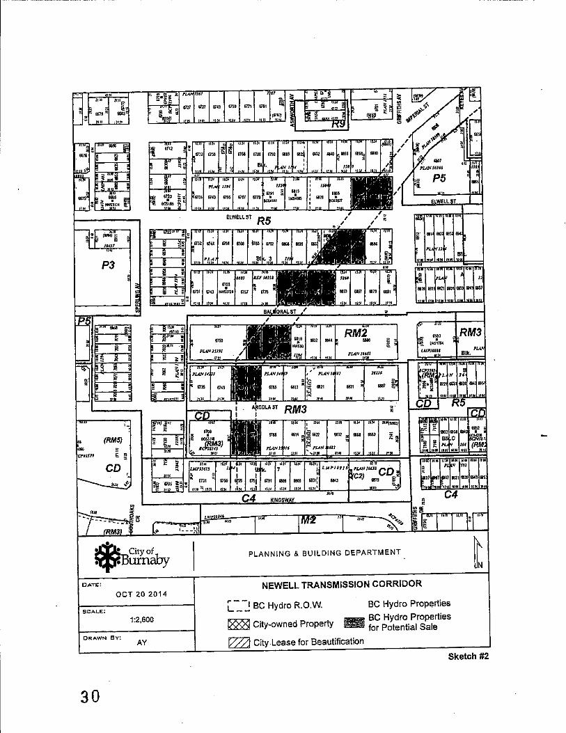
With respect to the Newell Transmission Corridor (NTC), it is recommended that with the proposed creation of the P12 Utility Corridor District, these lands be advanced to Public Hearing for rezoning. This proposed rezoning includes three groups of BC Hydro and City-owned properties that comprise sections of the NTC, as follows:
• The NTC proposed for rezoning between Arcola Street and Walker Avenue consists of the lands previously described, which include 26 lots owned by BC Hydro and four lots owned by the City and zoned under RM2, RM3 and R5 Districts (see Attachment 5).
• The NTC proposed for rezoning between Walker Avenue and Malvern Park consists of seven properties owned by BC Hydro and zoned under the R3 and R5 Districts (see Attachment 6).
• The NTC proposed for rezoning between Sixth Street and Lakefield Drive (linking· Lakeview School and Park with Robert Burnaby Park) consists of one property owned by BC Hydro zoned under the R2 District (see Attachment 7).
The rezoning of these lands to the P12 Utility Corridor District would conform to and be consistent with the Burnaby OCP and the adopted land use designations, as outlined in the Edmonds Community Plan.
The full list of properties and their current zoning designations are listed in Appendix B. As outlined, Attachments 5, 6, and 7 illustrates the areas of the NTC proposed for rezoning to the P12 Utility Corridor District.
4.1.3 Future City-initiated Rezoning of Other Lands
In order to implement rezoning of other transmission corridor lands, it is proposed that the City undertake a program of future City-initiated rezoning of these properties to the P12 Utility Corridor District, as appropriate.
These identified corridors and associated lands would be part of a phased program of rezoning to ensure that the highest priority corridor lands were rezoned to their appropriate District. Each rezoning would be advanced through its own individual rezoning process with appropriate notification of the affected land owner(s) including BC Hydro and the responsible Provincial Ministry.
The rezoning of these lands to the P12 Utility Corridor District would also be pursued to conform to and be consistent with the Burnaby OCP and specific community plan land use designations to protect the communities' interests in the long-term protection of these lands for utility infrastructure and open space purposes.
14

To: City Manager From: Director Planning and Building Re: Burnaby Zoning Bylaw Amendment - P 12 Utility Corridor District 2014 October 08 ..................................................................... ..Page If
5.0 CONCLUSION
The proposal by the Provincial Government and BC Hydro to advance the potential sale of land assets that currently fonn electric transmission corridors has significant implications for the City. The prevailing historical zoning of these lands, which would allow for their residential development, is inconsistent and contrary to the City's established community plans which designate these lands for protection of electrical transmission corridors and open space. Specifically, the potential loss <if lands associated with the Newell Transmission Corridor to residential development would significantly erode the City's long-standing commnnity plans.
In order to appropriately zone these lands, it is recommended that Council authorize staff to:
• introduce a bylaw at a future Public Hearing to amend the Burnaby Zoning Bylaw to recognize utility transmission corridor use of lands under a new zoning district - the P12 Utility Corridor District;
• pursue a City-initiated rezoning process of specific properties within the Newell Transmission Corridor to the P12 Utility Corridor District;
• pursue future City-initiated rezoning processes for lands that fonn utility transmission corridors to the P12 Utility Corridor District;
• advise BC Hydro and the applicable Ministry responsible for the subject lands of the proposed rezoning to the P12 Utility Corridor District; and
• forward a copy of this report to the Community Development Committee and Parks, Recreation and Culture Commission for their infonnation.
These recommendations, if adopted, would result in the substantial implementation of a process to regulate the subject Newell Transmission Corridor properties, as well as other utility corridor lands, in a manner consistent with Burnaby's OCP and other community plans.
~/~~ u Pelletier, 6i'r~
PLANNING AND BUILDING
JWILF:tn Attachments cc: Deputy City Managers
Director Engineering Director Parks, Recreation and Cultural Services Director Finance City Solicitor City Clerk
[I:1Llly PordlBylaw Amelldmellfs\P12 Utilily CorrldorslBlImaby ZVl1ing Bylaw Amendmefll • P J 2 UtililY Carridor District 20/-1 I020.Doc.1:
15

Appendix A
Proposed P12 Utility Corridor District
512. UTILITY CORRIDOR DISTRICT (P12)
This District provides for the location and regulation of utility corridors and compatible uses.
512.1 Uses Permitted:
(I) Utility corridors containing:
a) overhead electrical transmission lines and support structures; or b) underground electrical transmission lines; or c) underground sewer or water lines; d) underground telecommunication infrastructure; or e) other underground infrastructure.
(2) Trails and open space.
(3) Accessory uses and structures.
512.2 Conditions of Use:
(I) All those portions of a lot not used for permitted utility, infrastructure or trail purposes shall be fully and suitably landscaped and properly maintained.
(2) Where a lot abuts a street or lane, all electrical transmission lines and support structures shall comply with BC Ministry of Transportation design criteria for transmission lines adjacent to highways.
512.3 Setbacks:
Where a lot abuts a lot in an A, CS, C9, R, or RM District, or in a CD District based on an A, R, or RM District, a setback of not less than 3 m (9.S4 ft.) from the abutting lot line shall be provided for all above ground structures.
16

AppendixB
Newell Transmission Line: Properties Proposed for Rezoning to P12 Utility Corridor District
1'7

II
~ City of ~Burnaby
Burnaby Planning Department
Printed October 6. 2014
18
Newell Transmission Corridor
BC HYDRO TRANSMISSION CORRIDORS
@ Major BC Hydro Substations
Major BC Hydro Transmission Cooridors
Burnaby Parks and Open Space System
D N
o 0.5 2 - -Kilometers
Attachment 1

I-' co
I~""""-~
!
-~--bAKLAND 51
'r
~r:, r~~,,\ .. //'··~·:/ . ,
:~"''''''--'''' /" .- i:"\.._1...
"-.,.;- ~ g..~~ .. " .. ~.
,,-,0. ~J' .
~ . . ,,<ii'~"5
~'<.-'v'v ~«;.,
S8!ii Attar;~~~tnt 6
•••• ," M.'--· --.',!,"111." •• ' .
See Attachment 7
. Robeit, Bumatif '- 'P.~.(
,',. J.
~:: . .. \~t' ,"
' .. . . '
<,/< '.' ...... .(;-;/ .-, /\ ' ~. .' ''v'<' \ '\ ~ ... '" ,.' .' . ,,~ . . . " ,'" rt"~ . . . • o· ."" ;, ,W .' . '.'
. ,/'.~J' ... \ ./ .. .,.
See A~CI)~.nt 4 and 5
<" "'\ <,./
. .1'0,1'.,.,.
See Attachment 3 and 5
.f /""'.' .... .' V······ .' ,,'
•• ' • 0 o· 0 "" • 00 .••• A . " " ,......... '" '/' "f " ..... ."- ",. ~ .'
'i~''''
~ Cily0abyf ~Burn
Bumaby Planning Department
Printed October 6, 2014
~-. ~ ,.-"
/("G.~, -""""1:
.. .." . -". ,. . ~. a'.... "-.J>.
"
." " ..
.... . ' : 0'
.. " ,~,
NEWELL TRANSMISSION CORRIDOR
.. .. .. .... Major Trail (Existing an~ Proposed)
'--1 l __ J Be Hydro Newell Transmission COrridor
_SChOOlS
Park and Open Space Plan
J
. .j( .••.
,;." "'):;"
.' . ,,' ~.~.
.. " ,'.
j N
'" "'" ..... 1:15,000
Attachment 2

<.
N o
6620 6626' 6634 6638 6648, 6654 6662· 6668 6676 ~.
~. 6619 6625 66336639, 6647" 6653 6661 6667 6675
6685
EDMONDS TOWN CENTRE BOUNDARY-,
.. "
0627
i
BC HYDRO PROPERTY PROPOSED FOR SALE
ii
.. " I~
en "1l m ;0 ,... Z Gl
~
~ ...... ~. : .. _., ____ 685 1 ~
IMPERIALST
6112
;" ~
6723
"" " -;!;--. ~
;:g'~i
'67326738: ti: t;:" 6166" 6780; 6792 6808, 682ri sali SlWD 6856: 6868,
.' ; j : 6131 6143; 675!! 6767, 617 6791 6815
..•. _ .. .....;, ... - --ELWELLST
i613~ 6744: 6158: &768: 87M! 6792; 6808: 6820: M
iii .. -" ..
;.r4r
. i.: :6131; 6743 6155~ 6767: 6175
A'
C]1Jt~Q.\.ll ; , .
6853: 6867; 6879; 6891 :
-. __ 6715.
"- .:g .. - -.~ .
-:::l-. g
~ ~ g. ~.
6715
~
''"'
6135, 6821 6831 6887
6956: 6976' 6996 7014 703Z 705() 7058.; 7086
l . 6961 :69836995',1001: 7015. 1035105!
r----EDMONDS·TOWN CENTRE BOUNDARY---j
Gl :u :jj 1 '" ~
N
.~ 6922 "6940
Ci92~ ,6957
6930
~ .6931
"IX) 7060
'6993 7035
70.0 7OSO
6975 103~
6869 Elwell SI 6885 Elwell SI 6891 Elwell SI 6844 Elwell SI 6856 Elwell SI 6868 Elwell 51 6809 Balmoral 51 6823 Balmoral 51 6831 Balmoral 51 6843 Balmoral SI 6780 Balmoral SI 6792 Balmoral SI 6808 Balmoral St 6763 Arcola SI 6777 Arcola SI 6760 Arcola SI 6772 Arcola St
EDMONDS TOWN CENTRE
.. " .. "
'<59
*B~~~Y Btlmaby Planning Departmont
Printed October 6, 2014
. , ~~; ~
6814 - 6822 6632 : 6868 6<180. "g ,,,. . ;:
;:. ;: 6922
~:f . 6976 6S8S :89~~ 5952
1---1
~ ;:
I, . . I. I:. ,
" . 6101 :. 6731 : 6755: 6755)671': 619( 6809: 6809, 6831:' _," . . . I., , en ••.•.•• -•.•.• -•.•••• .....-~;. -. '" . 13 • KINGSWAY
,."
:r ",. _": ~ U-:. ..... _ .••• ,~. '0 • ~'~ElL SUB'STATlqN .C/}
68" 6901
./ .•..
Gl ;0
0;; ;0 :!! .
-i' ::t: : (J) 690tf (;926 8926'
NEWELL TRANSMISSION CORRIDOR
BC Hydro Properties
(;953 (;315
6958· " ..
1 ___ I BC Hydro R.O.w.
••••• Adopted Greenway Roule (Conceptual) III BC Hydro Properties for Potential Sale
"" Gl ;0 m m
~z .."
0 ;c 0
1001
1040
702:; 7'<1
J. N
" "-1:2.700
7041 .
"
Attachment ~

l
l\:) .....
Gl
'" 'n " =< :J: (J)
~
~
5l ;z
6908
~
m
6940
693S .... BRYANTCT
6936 6950 ....
6941
~'" ,,1'
~~ 696S 7019
;; 0 ~ ~
'" 0
'lt~ ~ 0 ~
6970 6990 7020 '-~
6975 6991 7007 7019 7031 7043 70SS
BURFORDST
~ 6922 6936 6950 696B 6978 6992 7008 7020 7032 7044. 7056 7068
I 691569296933 6945 69696971 6979 6995 700770097019
HALLIGAN ST
~ .... ,-
" " " ~7' /' ..-o;;,oso 70507060 7062
<1l-'l> .
If"
~ ~
i !Dill
ID
~
'-0
~
,/ ~ /"" i
't, " ..
~ en OJ c
"
~
'\ /~ ~~"
" "
\,,)'\,":1
",.
q;, ..
~' -f:>'\..Q, •
,~.
'"
<'% r ...
"1",
"
.(1'.
'It"
" <%>~ "
-(¢'
"" ,," ~
<,§>'
<%>~
'It" <%>~
q;,~
<%> ..
<%>",
'<jl. ~,
" '1\), "'.
% .. <jl.1>
'\
" <~ <:)~
1-"1",
~,
~
1.~,,'1,
,#
" ~
" ~;, 01-• "1",
" <%>'1>
% .. <%>1>
<%>>,.
<%>q,
'>'b
'>",
'>'1>
~ ~ ~
l8 ~
<%>q, '%,
BC HYDRO PROPERTY FOR POTENTIAL SALE 6667 Salisbury Ave. 6687 Salisbury Ave
7120 7126 7152 7188
~
"\ '>
'\>
'>~
'> "
% .. '>'1>
'%;. ~~
'><%>
~
~ City of NEWELL TRANSMISSION CORRIDOR ~
~Burnaby 1---1 1 ___ I Be Hydro R.O.W.
N
" ., .. ~. Be Hydro Properties ~ City Lease for Beautification Area
SUmaby Planni1g Department • •• •• Adopted Greenway Route (Conceptual)
BC Hydro Properties ~ , for Potential Sale ~ City land 1:2.000
Printed October 6, 2014 Attachment 4

'-
I\) 1\)'
R9
P8
P5
P3
m s: "0. )J
,m. .~
~
P3
CD
*B~~~ Bumaby Planning Depanment
Printed October 6, 2014
',:-, ,
BRYANTST ,.--, .. -.~"" ... ,.. .. _~.RYA_Nt_Ct ' .'
... -... -:.. --..: .. - .'::'-" / >~"< :~<~,:',-/
.... // / -.~.:, ~ /
','
.-.. :..-.:.-.;. ... . ..:.,."~-.....:.~. ,.'-,_.;
0'" en "0 m )J 0-
: )0";. - .. ", 00.
1=:
BURFORDST
"'!_.'
.' ,~--,~/~>,~q;:/ / "/. <f~' -/~ -, .. / /'~~<
;i.;~>/ ~"f<t ' t-'. Z
Gl
~:
::0 .. .,: -i J:
"i~ R5
MCBRIDE ST IMPERIALST
...... ,- ~.' - ,-'
RM2
RM3
CO
ARCOLAWY
CO C4 i
~ M2 cp
NEWELL TRANSMISSION CORRIDOR· ARCOLA STREET TO WALKER AVENUE
D Existing ~oning Districts
_ Proposed Public Utility Use District (P12) Zoning
'. ,,' ',~ ,. ,,- .;.'
/
/,/"/. ~.
/'
/
"
.RM3:",
C3 I CD I Pl
C7 C3
"
/ .. ~
P2 CD ~.
1 N ,
'" '" ....... 1:5,000
Mtachment5

~ .' , ,
,
", "". t... Q." .... g- "',
, ,
",I ,0:: .' Ci ' ,,<
,
),
, , , , , '.
, ,
/'
", j"
, ,
, , , " ,
" , )
, , ,
"
' .... "
'. " , "
, . ..
, ......
, ,
, ,.,
, ,
'.
,
, ,
, .'
;-, '
, " ,
, , , ,
,
, ,
, ,
'" "
.' " ,.,'
, ,
, ,
,
'.
, , , ,
, , , , " ,
"
, ' \,' \, ,
, "
, ,
, , ,.
.,
,
, '
" > .... " '> / ,".~
)' " ,
,
,
, , , , , ,
, , ' .. ,
, ,
.'
, ,
•
,
23

<."
N ~
/
'" .. , . ""1l
. //" ,. .....
,',
.. " (".L\ • ... ,')... .. .-
.. ~r·'./ .. /
... ," ",,, . 'i) ,
~o~~.,
" <
"
/
.. ~~">~. ') .
> .. ..... ,>.,.:
", ""
"~, / " . '.
~""'" .•.• ;'-. " /\ / \
'>' / /' . ", /' "'" . / / )/
/ '" ,-. ,:.,
,.
.~", '. ' . , ....... /
REIGATE RD
, ....
. , ..... \ ~.,i.., ... / ~
'" ~ .. tn' ...... ~~
-,,-
.-" .. -', :.
,
/ ~ .. , .'
, .. ,.,
8,,,,-"
R2~ ... ~.;..." C' ~/" . " "
~", .. ,.'"
....
" . . <j, "v . , " ~<p.'. .,',
, ~Q .-:./ /, 01>· ......
\ l' /', .. ,,~:
.. /"
, . /. , ,. ,
.' /
/
'" ,. .'
".
.,/'\ ,,,,,
"f: \:" <a '. , ''A ./
... ./ ''--~' .. '' ,
C<.
,,;.: 1:··· ,.' \ ....
...
/// .~ .. , ..... .....
:-."
;\/IV~i:t.i,5i~ " .
-".
.//
Lakeview School
Park P3
/ /
/.
/ ..
,"',
.......... .<
(~~D8 ~t-"'-'
"
/
, ,
...
, ,
.......
,
,,'
.. '
" .. -.: ......
/"'1<A \
. .-- '\. ~1-~'" / ,. "" ~ '." ,'. . ..,. /
", V'?'o /" , ' ...::
,
, /'
" '- "~ ..
'" ... r //'
, / ' ,'/ /' ,
~" '-'; "'<l'~
C>;. -'-:~" "
/,
'.
'-"- -"'\/ .' "
,/ ' .. ' , ~ , v , " " -" ..
" ,,'" ", .. " .' .
/
// ......
, ,
y
, ,
, ,
/
,
, ./ <t- '
" /
/r *' ...... <:>// ~ ,. ~ .. / "
'. '.
/.
,;'/
'/ /' ... , ,
,
, /
, , , , ,
,.
,
J
*Biiih~by NEWELL TRANSMISSION CORRIDOR - SIXTH STREET TO LAKEFIELD DRIVE
D Existing Zoning Districts Burnaby Planning Department _ Proposed Public Utility Use District (P12) Zoning
Printed October 6, 2014
,
,,',
'.
, .. .. ~ :
" ,
Robert Burnaby
Park P3
/~:~ " ' "1$1 .. ". . :.;. , '
RS.
,,-'
rOO>':' , ,
, ///'/ .. /
,'" ,..!
~ N ~
...... 1:2,790
".
'"
"'fulchment 7

-----------_._---------- -------------,--_. - --.-,---------
• i.I.I.Ii City of iT¥Burnaby
PROPOSED DEVELOPMENT SUMMARY FOR ADVISORY PLANNING COMMISSION (APe)
REZONING REFERENCE # 14-37 Meeting Date: 2014 November 13
ADDRESS: Forty (40) properties in the Morley-Buckingham, Richmond Park, and KingswayBeresford neighbourhoods, as shown on Schedule A (attached).
DEVELOPMENT PROPOSAL:
The purpose of this rezoning application is to maintain the Newell Transmission Corridor as a utility corridor consistent with the Official Community Plan (OCP) and other community plans.
1. Site Area: 3.29 ha (8.13 acres)
2. Existing Use: Utility corridor
Adjacent Use: Multi-family residential, school, park, single and two family residential
Proposed Use: Utility corridor
Permitted/Required
3. Gross Floor Area: N/A
4. Site Coverage: N/A
5. Building Height: N/A
6. Vehicular Access from: N/A
7. Parking Spaces: N/A
8. Loading Spaces: N/A
9. Communal Facilities: N/A
10. Proposed development consistent with adopted plan? (i.e. Development Plan, Community Plan, or OCP)
rk' ~ P:\REZONING\FORMS\APCSTATSHEET
Note: N/A where not applicable
Proposed/Provided
N/A
N/A
N/A
N/A
N/A
N/A
N/A
Il!l YES [] NO
25

~ CitY°abf V Burn y
TO: CITY MANAGER
FROM: DIRECTOR PLANNING AND BUILDING
SUBJECT: REZONING REFERENCE #14-37 Newell Transmission Corridor
Item ............................................................. 03 Meeting .................................. 2014 October 27
COUNCIL REPORT
2014 October 22
ADDRESS: Forty (40) properties in the Morley-Buckingham, Richmond Park, and KingswayBeresford neighbourhoods, as shown in Sketches #1 to. #5 (attached).
LEGAL: Schedule A (attached)
FROM: Rl Residential District, R2 Residential District, R3 Residential District, R5 Residential District, RM2 Multiple Family Residential District and RM3 Multiple Family Residential District
TO: P12 Utility Corrido~ District
APPLICANT: City of Burnaby 4949 Canada Way Burnaby, BC V5G 1M2
PURPOSE: To seek Council authorization to forward this application to a Public Hearing on 2014 November 25.
RECOMMENDATIONS:
1. THAT a Rezoning Bylaw be prepared and advanced to First Reading on 2014 November 03 and to a Public Hearing on 2014 November 25 at 7:00 p.m.
2. THAT a copy of this report be sent to BC Hydro and the applicable Ministry responsible for the subject lands.
REPORT
1.0 REZONING PURPOSE
The purpose of this rezoning application is to maintain the Newell Transmission Corridor as a utility corridor consistent with the Official Community Plan (OCP) and other community plans.
26

---- --------
To: City Manager From: Director Planning and Building Re: Rezoning Reference #14-37 2014 October 22 ............................................................. Page 2
2.0 NEIGHBOURHOOD CHARACTERISTICS
The subject properties form part of a linear corridor that extends approximately 2.4 !an (1.5 miles) from Robert Burnaby Park to north of the Newell Substation at Kingsway and Griffiths Avenue. This corridor passes through primarily single and two family residential neighbourhoods, as well as seven multi-family residential properties in the Edmonds Town Centre near the corridor terminus at the Newell Substation. The Newell Transmission Corridor also passes through Morley Park, Lakeview School and easement areas on private properties. Those portions of the corridor are not included in this rezoning proposal.
3.0 BACKGROUND
3.1 On 2014 October 20, Council authorized staff to pursue a City-initiated rezoning process for forty (40) properties within the Newell Transmission Corridor to the P12 Corridor District. This report responds to that authorization.
3.2 On 2014 October 20, Council authorized staff to introduce a bylaw to amend the Burnaby Zoning Bylaw to include a new P12 Utility Corridor District. First Reading of the amending bylaw is scheduled for 2014 October 27, concurrent with this report.
4.0 GENERAL COMMENTS
4.1 The proposal consists of the rezoning of forty (40) properties in the Newell Transmission Corridor from the Rl Residential, R2 Residential, R3 Residential, R5 Residential, RM2 Multiple Family Residential and RM3 Multiple Family Residential Districts to the proposed P 12 Utility Corridor District. A list containing the address, ownership, PID number, zone district, and lot area of each property is shown in Schedule A (attached). Portions of the corridor located on park and school properties in the P3 Park and Public Use District, or on easements through private properties, are not included in this rezoning proposal.
4.2 Development on the subject properties is limited to utility infrastructure, including both overhead 69 kV electrical transmission lines supported by wood poles and underground 230 kV electrical transmission line conduits. Portions of City storm mains are also located on some properties, incliIding 6620 Sixth Avenue, 6595 Walker Avenue, 6831 Balmoral Street, 6843 Balmoral Street, and 6844 Elwell Street. Landscaping consists primarily of mown grass, with trees in some locations. Concrete bollards to prevent vehicle access and BC Hydro signage have been placed on some of the properties, and many contain informal footpaths. A portion of one of the subject properties, 6620 Sixth Street, contains a culverted Class B reach of Crayfish Creek; otherwise no streams are present.
27

,-------------------------------------------------------------
To: City Manager From: Director Planning and Building Re: Rezoning Reference #14-37 2014 October 22 ............................................................. Page 3
The City maintains a lease with BC Hydro for a beautification area and public walkway at Imperial Street and Walker Avenue. It is noted, however, that the entire Newell Transmission Corridor is reflected in the City'S open space and trail network as a component of the Byrne Creek - Burnaby Lake Greenway. In conjunction with future utility development of this corridor, the fulfilment of the formal greenway concept is encouraged.
43 Given that there is no development proposed as part of the subject rezoning, no development fees are required.
4.4 No servicing requirements, road dedications, easements, statutory rights-of-way or covenants are required in conjunction with this rezoning application.
5.0 DEVELOPMENT PROPOSAL
5.1 Lot Area (total of all lots) 3.29 ha (8.13 acres)
Individual lot areas are provided in Schedule A (attached).
OU;elletier, ~ PLANNING AND BUILDING
LF:spf Attacilments
cc: Director Engineering Chief Building Inspector City Solicitor City Clerk
P:\REZONING\Applications\2014\14-37 P12 ~ Newell Corridor\Rezoning Reference 14-37 Newell Corridor.docx
28

"" ',~
' .. ,~, ,,, .~!. ,-, '~"",
~, "'1'-"
i • ~ City of ",¥Burnaby
DATE:
OCT 20 2014
1:15,247
ORAWN BV: AY
'.[>,<0, ,~,,' ~c<,
\.
',."','",' . -~ .. " ,,,-..... [,,
•
See Sketch #4
See Sketch #3
--
',,'_"1""_ ,~
";;"S.' -t.",-,',..
Parks, School Lands and Easement Areas Not Included in Rezoning Proposal
PLANNING & BUILDING DEPARTMENT
NEWELL TRANSMISSION CORRIDOR
'l""""" "'e,;"''''·
,..--. L __ BC Hydro R.OW. _ BC Hydro Properties
Sketch #1
29
.n
P3
(RMS)
[ ~ CD
;(i); City of ~Burnaby
O;..TE:
OCT 202014
SCALE:
1:2,600
DRAWN By: AY
30
PLANNING & BUILDING DEPARTMENT
NIOWELL TRANSMISSION CORRIDOR
l'..-_-,2 BC Hydro R.O.W.
I888l City-owned Property
BC Hydro Properties
_ BC Hydro Properties - for Potential Sale
~ City Lease for Beautification
Sketch #2

;(i); City Doof :q:t' Burn y:
DATE::
OCT 20 2014
SCALE:
1:2,650
DRAWN Bv: AY
-------- ----------.---------------------
PLANNING & BUILDING DEPARTMENT
NEWELL TRANSMISSION CORRIDOR
L -=--2 BC Hydro R.O.W.
18881 City-owned Property
BC Hydro Properties
_ BC Hydro Properties - for Potential Sale
City Lease for Beautification
Sketch #3
31

-------- ---
~BCitYO~1.. . "'f" illrnavy
DATE:
OCT 202014
SCALE:
1:2,600
DRAWN By: AY
32
P3
PLANNING & BUILDING DEPARTMENT
NEWELL TRANSMISSION CORRIDOR
L-_-:! BC Hydro R.O.W.
18881 City-owned Property
BC Hydro Properties __ BC Hydro Properties - for Potential Sale
I222l City Lease for Beautification
Sketch #4

ill Single and Two Family Residential
[!] Medium Density Multiple Family Residential
[iI High Density Multiple Family ResIdential
rn Commercial
[!] Medium Density Mixed Use
[1] High Density Mixed Use
W Industrial
fiQ!lnstitutional
[g] Park and Public Use/Public School
I1Zl Low or Medium Density Multiple Family
Residential (Ground Oriented)
~ Low/Medium Density
Mixed Use
~ City of
Edmonds Town Centre Plan Development Guidelines
:ocpBurnaby o 45 90 180 _oiC:~!!!-_iiMeters
u.coo NING & BUiLDING DEPARTMENT
Printed on October 20, 2014 Sketch #5 33

ADDRESS
SCHEDULE A Rezoning 14-37
Newell Transmission Corridor
LEGAL DESCRIPTION PID
BC HYDRO CORRIDOR PROPERTIES
6760 Arcola St. Lot 12, Block 7, D.L. 96, Group I, NWD 011-142-162 Plan 1194
6763 Arcola St. Lot 33, Block 6, D.L. 96, Group I, NWD 011-142-120 Plan 1194·
6772 Arcola St. Lot 13, Block 7, D.L. 96, Group I, NWD 011-142-171 Plan 1194
6777 Arcola St. Lot 32, Block 6, D.L. 96, Group 1, NWD 011-142-103 Plan 1194
6780 Balmoral St. Lot 13, Block 6, D.L. 96, Group 1, NWD 012-030-457 Plan 1194
6792 Balmoral St. Lot 14, Block 6, D.L. 96, Group I, NWD 012-030-473 Plan 1194
6808 Balmoral St. Lot 15, Block 6, D.L. 96, Group I, NWD 011-142-090 Plan 1194
6809 Balmoral St. Lot 30, Block 3, D.L. 96, Group I, NWD 011-142-073 Plan 1194
6823 Balmoral St. Lot 29, Block 3, D.L. 96, Group I, NWD 011-142-065 Plan 1194
6831 Balmoral St. Lot 28, Block 3, D.L. 96, Group I, NWD 011-142-057 Plan 1194
6843 Balmoral St. Lot 27, Block 3, D.L. 96, Group I, NWI? 011-142-049 Plan 1194
6844 Elwell St. That Portion Lot 17, Block 3, D.L. 96, 011-141-981 (Lot 17) Group I, NWD Plan 1194 Shown
Outlined Red On Statutory Right Of Way Plan 10599
6844 Elwell st. That Portion Lot 18, Block 3, D.L. 96, 011-141-999 (Lot 18) Group 1, NWD Plan 1194 Shown
Outlined Red On Statutory Right of Way Plan 10599
6856 Elwell St. Lot 19, Block 3, D.L. 96, Group I, NWD 011-142-014 Plan 1194
6868 Elwell St. Lot 20, Block 3, D.L. 96, Group 1, NWD 011-142-031 Plan 1194
6869 Elwell st. Lot 24, Block 2, D.L. 96, Group I, NWD 011-141-948 Plan 1194
34
LOT ZONING AREA
(m2l
RM3 557.42
RM3 557.42
RM3 557.42
RM3 557.42
RM2 557.42
RM2 557.42
RM2 557.42
R5 557.42
R5 557.42
R5 557.42
R5 557.42
R5 451.76
R5 557.42
R5 557.42
R5 557.42
R5 527.22

ADDRESS
SCHEDULE A Rezoning 14-37
Newell Transmission Corridor
LEGAL DESCRIPTION PID
BC HYDRO CORRIDOR PROPERTIES 6885 Elwell St. Lot 23, Block 2, D.L. 96, Group 1, NWD 011-141-921
Plan 1194
6891 Elwell st. Lot 22, Block 2, D.L. 96, Group 1, NWD 011-141-905 Plan 1194
6667 Salisbury Ave Lot 67, D.L. 95, Group 1, NWD Plan 011-990-449 1056
6687 Salisbury Ave. Lot 66, D.L. 95, Group 1, NWD Plan 011-990-406 1056
7085 Burford St. Part .284 Of An Acre More Or Less Of 013-784-374 Lot 162, D.L. 92, Group I, NWD Plan 1146 As Shown Red On Statutory Right Of Way Plan 10599
7086 Burford st. Lot 21, D.L. 92, Group I, NWD Plan 012-091-278 1318
7051 Halligan St. Lot 64, D.L. 95, Group I, NWD Plan 011-990-384 1056
7061 Halligan St. Lot 65, D.L. 95, Group I, NWD Plan 011-990-392 1056
6908 Imperial St. D.L. 90, NWD Plan 10303 024-074-811
6559 Leibly Ave. Lot 12, Block 1, D.L. 91, Group 1, NWD 012-168-980 Plan 1348
6560 Leibly Ave. Lot 1, Block 2, D.L. 91, Group 1, NWD 012-169-013 Plan 1348
6558 Malvern Ave. Lot 2, Block 3, D.L. 91, Group 1, NWD 012-169-081 Plan 1348
6568 Malvern Ave. Lot 1, Block 3, D.L. 91, Group I, NWD 012-169-064 Plan 1348
6569 Malvern Ave. Lot 12, Block 2, D.L. 91, Group 1, NWD 012-169-048 Plan 1348
6617 Salisbury Ave. Lot 70, D.L. 95, 'Group I, NWD Plan 011-990-431 1056
6637 Salisbury Ave. Lot 69, D.L. 95, Group I, NWD Plan 011-990-422 1056
6647 Salisbury Ave. Lot 68, D.L. 95, Group 1, NWD Plan 011-990-414 1056
LOT ZONlNG AREA
(m2)
R5 527.22
R5 421.78
R5 356.75
R5 356.75
R5 1,175.06
R5 577.92
R5 119.74
R5 180.65
R5 1,623.93
R3 1,174.26
R3 1,135.72
R5 836.13
R5 1,131.93
R5 1,205.42
R5 149.18
R5 248.63
R5 345.78
35

SCHEDULE A Rezoning 14-37
Newell Transmission Corridor
ADDRESS LEGAL DESCRIPTION PID
BC HYDRO CORRIDOR PROPERTIES 6620 Sixth St. Lot 211, D.L.'s 89 & 90, Group 1, NWD 007-146-094
Plan 35322
6570 Walker Ave. Lot 1, Block I, D.L. 91, Group 1, NWD 012-168-947 Plan 1348
CITY OWNED PROPERTIES 6974 Imperial SI. Lot 63, D.L. 95, Group I, NWD Plan 011-990-376
1056
6984 Imperial SI. Lot 62, D.L. 95, Group I, NWD Plan 011-990-368 1056
6994 Imperial S. Lot 61, D.L. 95, Group I, NWD Plan 011-990-341 1056
7405 Morley Dr. Lot 324, D.L. 91, Group I, NWD Plan 002-460-203 46432
6595 Walker Ave. Lot 162 Except: Firstly: Part On 012-012-131 Statutory Right Of Way Plan 10599 Secondly: Part Subdivided By Plan 13681, D.L. 92, Group I, NWD Plan 1146
36
ZONING LOT AREA (ml)
R2 8,921.89
R3 1,179.85
R5 290.73
R5 262.74
R5 335.98
RI 971.25
R5 577.85

~ City of ~Burnaby
PROPOSED DEVELOPMENT SUMMARY FOR ADVISORY PLANNING COMMISSION (APe)
REZONING REFERENCE # 12-38 Meeting Date: 2014 November 13
ADDRESS: 4205/4213/4223/4227 Canada Way, 4108/4206/4214/4224 Norfolk Street and 3249 Gilmore Diversion
DEVELOPMENT PROPOSAL:
The purpose of the proposed rezoning bylaw amendment is to permit the development of a new
105 unit seniors rental apartment building (independent supportive living and assisted living units) to complement the existing seniors complex care development.
1. Site Area: Lot 1 Gross Area 8,751.2 m2 (94,197 sq.ft.) + Lot 2 Gross Area 4,088.6 m2 (44,009 . sq.ft.) = Gross Site Area 12,839.8 m2 (138,206 sq.ft.)
2. Existing Use: Seniors complex care facility (to remain) and vacant lots
Adjacent Use: Multi-family residential, fire hall, industrial, commercial, single- and two-family dwellings
Proposed Use: Seniors rental apartment building
Permitted/Required
3. Gross Floor Area: lot 1 7,115.4 m2 + Lot 2 8,851.8
m2 = Total 15,967.2 m2
4. Site Coverage: lot 1 33%, lot 2 39% &
Overall Site Coverage 36%
5. Building Height: Complex Care Facility- 2 Storeys Retirement Residence - 6 Storeys
6. Vehicular Access from: Norfolk Street
7. Parking Spaces: Care Facility 33
Retirement Residence 21
8. Loading Spaces: 3
9. Communal Facilities: Multi-purpose meeting room with kitchen amenities & outdoor plaza.
10. Proposed development consistent with adopted plan?
/J/J ~ (i.e. Development Plan, Community Plan, or OCP)
~ote: N/A where not applicable
P:\RElONlNG\FORMS\APC STAT SH EET
Proposed/Provided
Lot 1 7,115.4 m2 + lot 2 8,851.8 m2 = Total 15,967.2 m2
Lot 1 33%, lot 2 39% & Overall Site Coverage 36%
Complex Care Facility- 2 Storeys Retirement Residence - 6 Storeys
Norfolk Street
Care Facility 35 Retirement Residence 36
3
Multi-purpose meeting room with kitchen· amenities & outdoor plaza.
IGl YES [] NO
37

-- -------------------------
~ Cityo~1-pBurndlJY
item······ .. • .. ••·• .... •• .. • .... • .. •·••·• .. •·•·•·••·•·• .. ·•• .... ·Ol. Meeting ................................. 2014 October 27
. COUNCIL REPORT
TO: CITY MANAGER 2014 October 22
FROM: DIRECTOR PLANNING AND BUILDING
SUBJECT: REZONING REFERENCE #12-38 Carleton Gardens Senior Residential Facility
ADDRESS: 4205/4213/4223/4227 Canada Way, 410814206/4214/4224 Norfolk Street, and 3249 Gilmore Diversion (Sketches #1, #2 and #3 atiachetl)
LEGAL:
FROM:
TO:
Lots 1,3-8, D.L. 69, Group 1, NWD Plan 1321; Lot 2, D.L. 69, Group 1, NWD Plan 54176
P5 Community Institutional District and R5 Residential District
CD Comprehensive Development District (based on RM3 Multiple Family Residential District, P5 Community Institutional District, and Broadview Community Plan as guidelines and in accordance with the development plan entitled "Chartwell Carlton Gardens Retirement Residence" prepared by Craven, Huston, Powers Architects)
APPLICANT: Brodel Northwest Corp. 45555-A Hodgins Avenue Chilliwack, BC V2P IP3 (Attention: Eldon Unger)
PURPOSE: To seek Council authorization to forward this application to a Public Hearing on 2014 November 25.
RECOMMENDATIONS:
1. THAT the sale be approved in principle of vacant City-owned properties at 4214, 4224 Norfolk Street and the remnant parcel at 3249 Gilmore Diversion in accordance with Section 3.11 of this report and subject to the applicant pursuing the rezoning proposal to completion.
2. THAT a Rezoning Bylaw be prepared and advanced to First Reading on 2014 November 03, and to a Public Hearing on 2014 November 25 at 7:00 p.m.
3. THAT the following be established as prerequisites to the completion of the rezoning:

To: City Manager From: Director Planning and Building Re: Rezoning #12-38 (4205142131422314227 Canada Way. 4108142061421414224 Norfolk Street. and 3249
Gilmore Diversion) 2014 October 22 .............................................. Page 2
a. The submission of a suitable plan of development.
b. The deposit of sufficient monies, including a 4% Engineering Inspection Fee, to cover the costs of all services necessary to serve the site and the completion of a servicing agreement covering all requisite services. All services are to be designed to City standards and constructed in accordance with the Engineering Design. One of the conditions for the release of occupancy permits will be the completion of all requisite services.
c. The installation of all electrical, telephone and cable servicing, and all other wiring underground throughout the development, and to the point of connection to the existing service where sufficient facilities are available to serve the development.
d. The subdivision of the net project site into two legal parcels.
e. The undergrounding of existing overhead wiring abutting the site.
f. The granting of any necessary statutory rights-of-way, easements and/or covenants.
g. The dedication of any rights-of-way deemed requisite.
h. Completion of the Highway Closure Bylaw.
i. The approval of the Ministry of Transportation to the rezoning application.
j. Compliance with the Council-adopted sound criteria.
k. The submission of an exterior lighting plan which meets the standards for seniors housing complexes as adopted by Council.
1. The provision of a public pedestrian walkway statutory right-of-way from Gilmore Diversion to Norfolk Street and the construction of a concrete walkway and pedestrian lighting to the approval of Director Engineering.
m. The provision of a covered car wash stall and adequately sized and appropriately located garbage and recycling material holding space to the approval of the Director Engineering and a commitment to implement the recycling provisions.
n. The review of on-site residential loading facilities by the Director Engineering.
o. The submission of a suitable on-site stormwater management system to the approval of the Director Engineering, and the granting of a Section 219 Covenant
39

To: City Manager From: Director Planning and BUilding Re: Rezoning #12-38 (4205142131422314227 Canada Way, 4108142061421414224 Norfolk Street, and 3249
Gilmore Diversion) 2014 October 22 ............................... " ............. Page 3
and deposit of sufficient monies to guarantee its provision and continuing operation.
p. The review of a detailed Sediment Control System by the Director Engineering.
q. The completion of the sale of City property.
r. The deposit of the applicable Parkland Acquisition Charge.
s. The deposit of the applicable GVS & DD Sewerage Charge.
t. The deposit of the applicaple School Site Acquisition Charge.
REPORT
1.0 REZONING PURPOSE
The purpose of the proposed rezoning bylaw amendment is to permit the development of a new 105 unit seniors rental apartment building (independent supportive living and assisted living units) to complement the existing seniors complex care development.
2.0 BACKGROUND
2.1 This site is located within the Broadview Community Plan and is designated for community institutional uses including seniors housing (see attached Sketches #1 and #2). The overall site is comprised of nine lots, bound by Canada Way to the south, Gilmore Avenue to the west, Norfolk Street to the north, and Gilmore Diversion to the east. The western portion of the site (Lot 1), is comprised of 4108 Norfolk Street, which accommodates the existing seniors complex care development, and is currently zoned P5 Community Institutional District. The eastern portion of the site (Proposed Lot 2) is comprised of the subject properties at 4205/4213/4223/4227 Canada Way, 4206/4214/4224 Norfolk Street and 3249 Gilmore Diversion, all of which are currently zoned R5 Residential District (see attached Sketch #3). The properties located at 4205, 4213,4223, and 4227 Canada Way and 4206 Norfolk Street are owned by CPAC (Care) Holdings, a Chartwell Seniors Housing company, while the properties located at 4214, 4224 Norfolk Street and 3249 Gilmore Diversion are owned by the City.
40
To the north of the subject site are a mix of single and two-family dwellings, a fourstorey apartment building and the No. 7 Fire Hall. Light industrial buildings are located to the east across Gilmore Diversion. The Ismaili Centre, the Finnish-Canadian Rest Home, and two six-storey office buildings are located to the south across Canada Way, The Schou Educational Centre is located to the west across Gilmore A venue, with Broadview Park beyond.

----------------------------
To: City Manager From: Director Planning and Building Re: Rezoning #12-38 (4205142131422314227 Canada Way, 410814206/4214/4224 NorjolkStreet, and 3249
Gilmore Diversion) 2014 October 22 .......... " .................................. Page 4
2.2 The nine properties were previously the subject of Rezoning Reference #06-69. On 2007 January 22, Council received an initial report from the Planning and Building Department regarding the rezoning and consolidation of these properties to permit the development of a comprehensive seniors residential campus on the site (long term care, independent supportive living, and assisted living). The CD (RM3, PS) District rezoning was proposed for the site. Council authorized the Department to work with the applicant, Chartwell Seniors Housing, in preparing a suitable plan of development for the site.
Chartwell later withdrew the rezoning application and proceeded to develop 4108 Norfolk Street (Lot I) only, under the property's prevailing PS Community Institutional District zoning. Preliminary Plan Approval PPA #10-381 was issued to permit development of the 128-bed Carlton Gardens Long Term Care Residence, and construction of this facility is now complete.
2.3 On 2012 November 19, Council received the report of the Planning and Building Department concerning the subject rezoning application of the subject site and authorized the Department to work with the applicant in preparation of a suitable plan of development for an independent supportive living and assisted living seniors rental apartment complex, with the understanding that a further and more detailed report would be submitted at a later date.
Chartwell Seniors Housing is now proposing to develop the eastern properties of the project site (Lot 2) for a new seniors rental apartment building, comprised of independent supportive living and assisted living units, with the proposed development density and six-storey building height based on the combined density available under the RM3 MUltiple Family Residential District and PS Community Institutional District in a CD Comprehensive Development approach for the overall site.
The supported density for the overall site (comprised of Lot I and Lot 2) is calculated on an aggregate basis, based on the RM3 Multiple Frupily Residential District with its maximum 1.1 FAR with full underground parking, combined with the PS Community Institutional District with its maximum 0.8 FAR, for a total permitted site density of 1.9 FAR. A portion of the available density derived from the overall site is being reallocated to the eastern portion of the site (Lot 2) to support the proposed form of development. The overall density to be achieved is 1.3 FAR under the proposed plan.
The applicant has now submitted a development plan suitable for presentation to a Public Hearing. -
3.0 GENERAL COMMENTS
3.1 The proposed overall development of the two properties is intended to provide an integrated campus of care. The subject rezoning application is for the second phase of the campus' overall redevelopment. The proposal for the subject site includes a I~S-unit
41

To: City Manager From: Director Pianni,!g and Building Re: Rezoning #12-38 (4205/4213/4223/4227 Canada Way, 410814206/4214/4224 Norfolk Street, and 3249
Gilmore Diversion) 2014 October 22 .............................................. Page 5
seniors rental apartment I retirement residence building over six levels, with amenities internal to the facility to support residents, as well as several outdoor plaza areas and an indoor amenity space meeting room for the benefit of residents, visitors and the general pUblic.
3.2 The site is located within the Council-adopted Broadview Community Plan and is designated for community institutional use (see attached Sketch #2). The overall campus, which includes one of the subject properties, 4108 Norfolk Street, is presently developed with a long-term seniors care facility. The remaining properties that comprise the overall campus are currently vacant.
3.3 The subdivision associated with this rezoning application will create two parcels, as well as achieve various required dedications, some of which were unable to be achieved during the development process for the existing complex care facility at 4108 Norfolk Street.
3.4 As noted, the subject site is comprised of both Lot 1 (4108 Norfolk Street), which accommodates an existing seniors complex care development, the future Lot 2, which proposes the development of a lOS-unit seniors rental apartment I retirement residence. The allocated density of Lot 1 is 0.58 FAR and the allocated density of the proposed Lot 2 is to be 0.72 FAR. Combined, the overall density of both lots is 1.3 FAR. Together, both lots are within the maximum allowable 1.9 FAR, as permitted by the RM3 MUltiple Family Residential District and P5 Community Institutional District as guidelines. To appropriately allocate densities between Lot 1 and Lot 2, a Section 219 Covenant will be required in conjunction with the subject rezoning application.
3.5 The Director Engineering will be requested to prepare an estimate for all services necessary to serve this site. The servicing requirements will include, but not necessarily be limited to:
42
• the construction of a 2.7m saw-cut concrete separated sidewalk, 1.8m front grass boulevard with street trees, street lighting and pedestrian lighting on the north side of Canada Way across the frontage of Lot 1 and Lot 2;
• the construction of a 4.0m asphalt urban trail, a 1.8m front grass boulevard with street trees, street lighting, and pedestrian lighting, and a 1.2m rear landscaped boulevard on the west side of Gilmore Diversion across the development frontage;
• the construction of a 2.7m saw-cut concrete separated sidewalk, a 1.8m front grass boulevard with street trees and street lighting on the south side of Norfolk Street across the frontage of Lot 1 and Lot 2;
• the construction of a 2.7m saw-cut concrete separated sidewalk, a 1.8m front grass boulevard with street trees and street lighting on the east side of Gilmore Avenue across the development frontage; .

------------------------------- -
To: City Manager From: Director Planning and Building Re: Rezoning #12-38 (4205142131422314227 Canada Way, 4108142061421414224 Norfolk Street, and 3249
Gilmore Diversion) 2014 October 22 ____ .......................................... Page 6
• the construction of a 2.0m saw-cut concrete pathway with pedestrian lighting on the north side of 4206,4214, and 4224 Norfolk Street from the Norfolk Street culde-sac to Gilmore Diversion;
• the construction of a saw-cut coloured concrete plaza at the northeast corner of the site, complete with street furniture and bicycle storage facilities; and,
• Storm, sanitary sewer, and water main upgrades as required.
Necessary road dedications include a 4.5m dedication along Gilmore Diversion, and a 4.0m dedication along Canada Way starting at the intersection of Canada Way and Gilmore Avenue, tapering to a l.5m dedication at the at the intersection of Canada Way and Gilmore Diversion.
3.6 A series of public amenities are being proposed in conjunction with the development, including:
• a public plaza at the northeast corner of the site with street furniture, public bicycle storage racks, drinking fountains for individuals and pets, and garbage facilities;
• a 73.3 m2 (789 sq. ft.) mUlti-purpose room with kitchen facilities and adjacent outdoor plaza area, located on the ground floor at the southeast corner of the new building, which will be open for use by the public subject to scheduled bookings with the management of the site; and,
• a public pathway connection from the Norfolk Street cul-de-sac to Gilmore Diversion, located on the north side of Lot 2.
3.7 3.0m x 3.0m corner truncations will be required at the intersections of Canada Way and Gilmore Diversion, Canada Way and Gilmore Avenue, Gilmore Avenue and Norfolk Street, and at the northeast corner of the site.
3.8 A Highway Closure Bylaw will be pursued to close a small portion of Norfolk Street east of the cul-de-sac that is not required for City purposes. The road right-of-way will be exchanged for the lar~er area of road dedications required. The area to be closed is approximately 155.6 m (1,675 sq. ft.).
3.9 Any necessary easements, covenants and statutory rights-of-way for the overall site will need to be provided, including but not necessarily limited to:
----------~- ----~--- - ---
• Section 219 Covenant to allocate gross floor area and associated densities for Lots 1 and 2 in accordance with the overall plan of development;
• Section 219 Covenant restricting the enclosure of balconies; • Section 219 Covenant ensuring compliance with the submitted acoustical
analysis; • Section 219 Covenant to ensure the provision and continuing operation of
stormwater management facilities;
43

-------------------------
To: City Manager From: Director Planning and BUilding Re: Rezoning #12-38 (4205/4213/4223/4227 Canada Way, 410814206/4214/4224 Nor/olkStreet, and 3249
Gilmore Diversion) 2014 October 22 .............................................. Page 7
• . Section 219 Covenant to ensure that the use and ownership of the site is for seniors housing/care;
• Section 219 Covenant to ensure the continued use and availability to the public of the community amenity multi-purpose room through the provision of scheduled bookings with the management of the site;
• A 3.0m statutory right-of-way on the north side of the site for a pedestrian walkway connection;
• A 4.5m statutory right-of way on the eastern side of Lot I for a sanitary storm line that bisects the overall site from Canada Way and Norfolk Street; and,
• An easement for reciprocal access between the two lots, including access to an outdoor plaza on the north side of the overall site to be used by residents of both parcels, and the use of loading facilities on located on Lot 1 in favour of Lot 2.
3.1 0 Undergrounding of the existing overhead lines on Gilmore Avenue is required.
3.11 Council, on 2012 November 19, approved in principle, for the sale of City-owned land at 4214, 4224 Norfolk Street and 3249 Gilmore Diversion for inclusion in the subject site. The Legal and Lands Department has determined a recommended sale price for the City land of $120 per sq. ft. of land. The exact amount of land to be sold is approximately 1,240.6m2 (13,354 sq. ft.) (subject to detailed survey). This recommended land value would be valid for nine months from the date of Second Reading of the rezoning amendment bylaw. At that time, and every six months thereafter until the sale is completed, the land value would be updated by the Legal and Lands Department. If there is a decrease in land value, further Council approval would be required for a reduction in the sale price. If there is an increase in value, the developer would be informed and the sale price for the City land would be based on that increased value.
3.12 Vehicular access to the site will be restricted to Norfolk Street.
3.13 In light of the proximity to Canada Way and Gilmore Diversion, an acoustical study is required to ensure compliance with the Council-adopted sound criteria.
3.14 One car wash stall will be provided on site with an appropriately screened common garbage handling area to be located on the subject site, with an outdoor temporary garbage storage area to be shared between the two legal parcels.
3.15 The Ministry of Transportation's approval to the rezoning is required.
3.16 An exterior lighting plan suitable for seniors housing complexes is required.
3.17 Engineering Environmental Services Division will need to review a submission of a detailed plan of an engineered Sediment Control System prior to Final Adoption. The proposed Sediment Control System will then be the basis after Final Adoption for the necessary Preliminary Plan Approval and Building Permit.
44

----------------- ---"~-----------~------------------
To: City Manager From: Direclor Planning and Building Re: Rezoning #12-38 (4205142131422314227 Canada Way, 4/08/42061421414224 Norfolk Slreel, and 3249
Gilmore Diversion) 2014 Oclober 22 .............................................. Page 8
3.18 An on-site stonnwater management system to the approval of the Director Engineering is required. A Section 219 Covenant and bonding are required to guarantee its provision and continuing operation.
3.19 There are no trees suitable for retention on the subject site. A tree survey will be required to identifY all trees to be removed. In accordance with the Burnaby tree bylaw, a tree cutting pennit will be required for the removal of any tree over 20.3cm (8 in.) in diameter.
3.20 Development Cost Charges:
a) Parkland Acquisition Charge of$3.84 per sq. ft. of residential gross floor area. b) School Site Acquisition Charge of$800.00 per unit c) GVS&DD Sewerage Charge of $590.00 per unit
4.0 DEVELOPMENT PROPOSAL
4.1 Site Area
Lot 1 Gross Area: Lot 2 Gross Area: Gross Site Area:
Road Closure Area (adjacent to Lot 2):
Lot 1 Dedications Lot 2 Dedications Total Dedications:
Net Area Lot 1 Net Area Lot 2 Total Net Site (inclusive o/Road Closure area):
4.2 Density
FAR Cbased on a combined site area)
Existing Complex Care Facility (Lot 1) Proposed Retirement Residence (Lot 2) Overall Allocated FAR
8,751.2 m2 (94,197 sq. ft.) 4,088.6 m2 (44,009 sg.ft.) 12,839.8 m2 (138,206 sq.ft.)
155.6 m2 (1,675 sq.ft.)
304.1 m2 (3,273 sq.ft.) 422.3 m2 (4.546 SQ.ft.) 726.4 m2 (7,819 sq.ft.)
8,447.1 m2(90,924 sq.ft.) 3,821.9 m2 (41.139 sg.ft.) 12,269 m2 (132,063 sq.ft.)
Pennitted
0.58 FAR 0.72 FAR
1.3 FAR
45

To: City Manager From: Director Planning and Building Re: Rezoning #12-38 (4205/4213/4223/4227 Canada Way, 4/08/4206/42/4/4224 Norfolk Sireel, and 3249
Gilmore Diversion) 2014 October 22 .............................................. Page 9
Gross Floor Area CG.F.A.) Existing Complex Care Facility (Lot I) (excluding underground parking level) Proposed Retirement Residence (Lot 2) Total G.F.A.
Site Coverage
Existing Complex Care Facility Proposed Retirement Residence Overall Site Coverage
4.3 Height·
Existing Complex Care Facility
Proposed Retirement Residence
4.4 Unit Mix
Existing Complex Care Facility
Proposed Retirement Residence 17 Studio units: 68 one-bedroom units: 20 two-bedroom units:
105 Total Seniors Rental Housing Units
4.5 Parking and Loading
Existing Complex Care Facility (1.0 spaces/6 beds) (1.0 spaces/3 employees)
Proposed Retirement Residence (1.0 spaces/5 units)-
Overall Site Total Parking:
46
7,115.4 m2 (76,590 sq.ft.)
2' 8,851.8 m (95,280 sq.ft.) 15,967.2m2 (171,870 sq. ft.)
33% 39% 36%
2 storeys 9.86 m (32.34 ft.)
6 storeys 18.67 m (61.24 ft.)
128 Complex Care Beds
37.6 - 39.6 m2 (405 -426 sq.ft.) 48.9 - 53.8 m2 (526 - 579 sq.ft.) 73.4 - 74.0 m2 (790 - 797 sq.ft.)
Required Provided
22 spaces 35 spaces II spaces
21 spaces 36 spaces
54 spaces . 71 spaces

To: City Manager From: Director Planning and Building Re: Rezoning #12-38 (4205/4213/4223/4227 Canada Way, 410814206/4214/4224 Norfolk Street, and 3249
Gilmore Diversion) 2014 October 22 .............................................. Page 10
4.6
Residential and Non-Residential Deliveries Loading (I per 5,600 m2 of institutional use)
Motorized Scooter Storage:
4.7 Bicycle Parking/Facilities
Surface bicycle racks for visitors are to be provided.
4.8 Communal Facilities
3 spaces
Required
o spaces
3 spaces (to be shared over both parcels)
Provided
14 spaces
Communal facilities a ground floor multi-purpose meeting room with kitchen facilities and adjacent outdoor plaza area, which would be shared with the adjacent site at 4108 Norfolk Street and also open to the public subject to scheduled bookings by the management of the Carlton Campus of Care. In addition, an outdoor plaza located at the northeast comer of the site, with a pedestrian connection from Gilmore Diversion to Norfolk Street is proposed for use by residents and the general public.
-~~
Pelletier, DIrector LANNING AND BUILDING
GT: AI/oeilme/Iis
cc: Director Engineering City Solicitor City Clerk
P:\REZONING\AppIiCilions\2012\Rel 12~)8 Cznlda Way@Oilmore\R=ningReference 12·38 Carleton Gardens 2D\41027.docx
47

4205 Canada Way
4213 Canada Way
4223 Canada Way
4227 Canada Way
4108 Norfolk Street
4206 Norfolk Street
4214 Norfolk Street
4224 Norfolk Street
3249 Gilmore Diversion
Rezoning Reference #12-38 Schedule "A"
Lot 8, Blk 49, DL 69, Group 1, NWD Plan 1321
Lot 7, Blk 49, DL 69, Group 1, NWD Plan 1321
Lot 6, Blk 49, DL 69, Group 1, NWD Plan 1321
Lot 5 Except Firstly: Part on Plan with Bylaw Filed 56876, Secondly: Part on Bylaw Plan 64207, Blk 49, DL 69, Group 1, NWD Plan 1321
Lot 46, DL 69, Group 1, NWD Plan 54176
Lot I, Blk49, DL 69, Group 1, NWD Plan 1321
Lot 2, Blk 49, DL 69, Group I, NWD Plan 1321
Lot 3 Except: Part Dedicated Road on Plan LMP50077, Blk 49, DL 69, Group 1, NWD Plan 1321
Lot 4 Except: Part Dedicated Road on Plan LMP50077, Blk 49, DL 69, Group 1, NWD Plan 1321
P;\REZONING\Applications\2012\Rez 12·38 CWlada Way@Gihnore\ScheduleA 12-38.docx
48

!-
L1§.2012 I 20.'2 I li56 I '5.56 ,a2,1 PLAN
\\ 15.56 15.56
M5 DOMINION ST
SUBJECT SITE "5 '!iSS 15.55 - "'.-,,-4192 •
BCS11~
,,, • ",MS4698
~ ~
4120 4136 4 0 4164 4178
BCPU56 132/ P£;' N II 1449
3 64 87
t:; M1 ~ __ ~~20~.12~i=~~;.1'~2~::'5:.5~5~~15~.~~=~ffl'~!SS~;'~!i~55~==~"~!k
.C~:~4 20.12 21113 6().40 • ,or CD % \'!~ ~ ~ ~ LMP31365 IiIRE HALL ;~ ~ I~.*~·§ 4125 ~ 4~3 (Rn~~ 4t:'1 )~" Prop".d4.5mRoad rr~ II'R ~ NWS1425 LMS3453 • \Nidenlng Dedication \
~.;. 17.1 20.12 "'.13 -, "'5 f ~~f (P2) ~ ~~ CD .\ Exl'ting P,blle ; ~-~-'l-l
~ N0R-H)~K-S.'fo walkway ~ ~ \ -_-\ if.:. .z;
~~~-.--__ (.lmj----.l.----o...- V/"'.12 "".l?' •• ~ . i ~ ... 3mx3m
1.-.:::...----, I 6 4214 422 T",ncalion
Proposed Truncation Proposed Road I ~ 4
4108 RIWClo",e./1: :llk,49 ,"' 20,12 20.1' IIA ,
2 12
~ ~ ·~''!-.,r-.------'I R5 rL..-,1--..Iii.o----"'''' II.: ."~OP:O:'.:d..::1.::5:.:-4:::.':m:::R:o:ad:::w;::':d.:ni:;ng~O::::.~di~ca:1i~on~ ... ----.'GANADA+WA¥-
/3mX3m I~
Truncation I
CD
Mosque
•
lMU
~ CilYC.,f ~BUl'naby
DATE:
OCT162014
SCALE:
1:1,500
DRAWN BY: AY
5540
PLAN 44159
Seniors Housing
I I I II' I I II) I I )1 I I 1 III I I "I I I II J I
"I I I II I I
: 1/ 1 I III I
96.18
CD (MBa)
Discovery Place
PLANNING & BUILDING DEPARTMENT
r--L_J Subject Site City-owned Property REZONING REFERENCE #12 -- 38
Proposed Redevelopment·Seniors Supportive Housing Campus 4205, 4213, 4223 AND 4227 CANADA WAY
4108,4206,4214 AND 4224 NORFOLK STREET 3249 GILMORE DIVERSION
Sketch #1
49

\ ir-'I , i l I I ,''--- ---._"
SUBJECT SITE l " I I 'I "",')' ! I I
" ·II-</~'·< r= 'TO r:Jl [ i'~ I I- ,Ll _ i~
I ~F- ~( !J~ .1= i ~I ... . · rn - _J ,_ '
'l'_'~--I! 1\ "'1// i:= JI I 9 '. !rr
L......-. __ .-1 I~ [[jJ1 .
1-' !~r-I~ ,_JL_ I 12"
t III I I 3111J1 ~ " [lHg" I, ;--..
~ 6 ! 11 J i~
~L1 II u 1'l I t; 12
r: "" ~
1\-lF= II I II ,
\ I 1 . ,
01 1 II~I I 611 ~ --". LAUREL ST l' 15 ElL" ,13 , 1~3 2
DujDJJIIlJ]] I--j ,~
~ ~ §[morrIIillJ 3 J 15
i I-
~ f- t=
L~DJmnTnID p 2 2 /=::: t:::::: G"ltE 011
AVONDALEST 12 ,--' "", ~[1ID1DIllTI ~1~1~ I I
--
= I - illJlIDnlLlJ] III~~;~~'" - /
I I = Fl, -//
f-I11 I II I I . \ I . III ::::= General land Use Designations iIJSlngle and Two Family Residential W Industrial il]Low Density Multiple Family Residential [Q]lnstitutional
WMedium Density Multiple Family Residential (gJPBrk and Public Use/Public School
L§JCommercial !1§ICommunity Institutional
WMedium Density Mixed Use [ • Ci~O~ Broadview Community Plan (I 2D olD " .BUl"l1 Metll.
(Community Plan Eight) 1:6,145
i and Building Dept PrInted on October 16, 2014 Sketch #2
50

DOMINION ST M5
SUBJECT SITE
~ W 0:: o :E ...J
4120 4136
4106
4178
4161 • lMS30153
Proposed Road RfIN Closure
I FIRE HALL 7f;,
I .,
CD
LOT 1
CD
Mosque
~ Cit)' (>1
~Burnaby
SCAL.£:
OCT 16 2014
1:1,500 • DRAWN BY:
AY
P5 Proposed PubHc
li'valkway
I I I I I I I I I
CD
Seniors Housing
II J I "I I II I I Il' I Discovery Place
I I
PLANNING & BUILDING DEPARTMENT
Subject Site REZONING REFERENCE #12 -- 38
Proposed Redevelopment-Seniors Supportive Housing Campus 4205, 4213, 4223 AND 4227 CANADA WAY
4108,4206,4214 AND 4224 NORFOLK STREET 3249 GILMORE DIVERSION
Sketch #3
51