1 introduction - dbedt hawaiidbedt.hawaii.gov/hcda/files/2013/05/kakaako-tod-overlay-draft_1... ·...
TRANSCRIPT

1 INTRODUCTION
D R A F T

D R A F T

URBAN SYNERGY IN KAKA`AKO
“As a net is made up of a series of ties, so everything in this world is connected by a series of ties. If anyone thinks that the mesh of a net is an independent, isolated thing, he is mistaken. It is called a net because it is made up of a series of interconnected meshes, and each mesh has its place and responsibility in relation to other meshes.” - The Buddha


“Planning for indefinite expansion is now wasteful and obsolete. The city of the future will have a better sense of its natural limits: it will attempt to make the most of what it has, rather than to evade its actual difficulties and its actual deterioration by encouraging its popula-tion to move out to the outskirts and permit the interi-ors to become more completely blighted. Good planning means rehabilitation: it means beginning over again and doing the job right.”
—Lewis Mumford, Whither Honolulu? (1939)
O`ahu development patterns prior to Western contact 1778 AD
O`ahu development patterns now 2012 AD
D R A F T
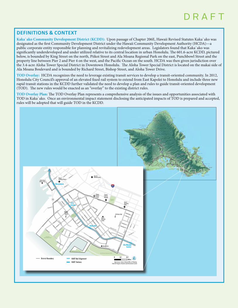
DEFINITIONS & CONTEXTKaka`ako Community Development District (KCDD): Upon passage of Chapter 206E, Hawaii Revised Statutes Kaka`ako was designated as the first Community Development District under the Hawaii Community Development Authority (HCDA)—a public corporate entity responsible for planning and revitalizing redevelopment areas. Legislators found that Kaka`ako was significantly underdeveloped and under utilized relative to its central location in urban Honolulu. The 601.6-acre KCDD, pictured below, is bounded by King Street on the north, Piikoi Street and Ala Moana Regional Park on the east, Punchbowl Street and the property line between Pier 2 and Pier 4 on the west, and the Pacific Ocean on the south. HCDA was then given jurisdiction over the 3.4-acre Aloha Tower Special District in Downtown Honolulu. The Aloha Tower Special District is located on the makai side of Ala Moana Boulevard and is bounded by Richard Street, Bishop Street, and Aloha Tower Drive. TOD Overlay: HCDA recognizes the need to leverage existing transit services to develop a transit-oriented community. In 2012, Honolulu City Council’s approval of an elevated fixed rail system to extend from East Kapolei to Honolulu and include three new rapid transit stations in the KCDD further validated the need to develop a plan and rules to guide transit-oriented development (TOD). The new rules would be enacted as an “overlay” to the existing district rules.TOD Overlay Plan: The TOD Overlay Plan represents a comprehensive analysis of the issues and opportunities associated with TOD in Kaka`ako. Once an environmental impact statement disclosing the anticipated impacts of TOD is prepared and accepted, rules will be adopted that will guide TOD in the KCDD.
D R A F T
61
83
72
H2
99
H1
93
H3
99
H1
93
83
83
83
63 72
H3
72 72
H1
Laie Bay
Turtle Bay
Pokai Bay
Kahana Bay
Kailua Bay
Yokohama Bay
Koolau Bay
Waialua Bay
Waimanalo Bay
Haleiwa Boat Harbor
Waimea Bay
Kawela Bay
Kaiaka Bay
KaneoheBay
Hanauma Bay
KeehiLagoon
MaunaluaBay
HonoluluHarbor
P E A R L H A R B O R
Aiea
Manoa
Waiau
Maili
Heeia
Hauula
Waimea
Kualoa
Kahala
Kailua
Waipio
Kahuku
Kawela
Makaha
Kakaawa
Waialua
Pupukea
Kaimuki
Olomana
Lanikai
Kapolei
Waipahu
Waikele
Wahiawa
Newtown
Haleiwa
Waianae
Kahaluu
Kalaheo
Waimalu
WaikikiWailupe
Mokuleia
Waiahole
Makakilo
Mililani
Nanakuli
Ahuimanu
Tantalus Woodlawn
Kuliouou
Waimanalo
Ewa Beach
Salt Lake
Punchbowl
Ala MoanaHawaii Kai
Kalihi Kai
Ewa Gentry
Honouliuli
Mapunapuna
Aina Haina
Sand Island
Keolu Hills
Bellows Afb
Royal Kunia
Ford Island
Sunset Beach
Diamond Head
Honokai Hale
Village ParkAiea Heights
Kalama Valley
Kalihi Valley
Palolo Valley
Alewa Heights
Nuuanu Valley
Kaohikaipu Is.
Mariners Ridge
Mililani Mauka
Moanalua Valley
Paci�c Heights
Whitmore Village
Paci�c Palisades
Hickam AirForce Base
Campbell Indust. Par
Wheeler AirForce Base
Kaneohe Marine Corps
Kapahulu
Koko Head
Pearl City
Waialae Nui
Royal Summit
Hahaione Valley
Waipio Peninsula
Farri
ngto
n Hw
yKam Hwy
Pali HwyLikelike Hwy
Kahekili Hwy
Farrington Hwy
Kam Hwy
Kam
Hwy
Kalanianaole Hwy
Queen Liliuokalani Fwy
Kam Hw
y
Kam Hw
y
John A. Burns Fwy
Lunalilo Fwy
Farringt on Hwy
Farri
ngto
n Hw
yKam Hwy
Pali HwyLikelike Hwy
Kahekili Hwy
Farrington Hwy
Kam Hwy
Kam
Hwy
Kalanianaole Hwy
Queen Liliuokalani Fwy
Kam Hw
y
Kam Hw
y
John A. Burns Fwy
Lunalilo Fwy
Farringt on Hwy
Kalanianaole Hwy
Veterans Memorial Fwy
Moanalua F w y
Kalanianaole
Veterans Memorial Fwy
Moanalua F w y
Hwy
Ñ
Ñ
Ñ
Ñ
"
"
n n
"
Queens Medical Center
Kaiser Honolulu Clinic
Straub Clinic & Hospital
Straub Financial District
Ward Centers
McKinley High
Voyager Charter School
Alapai Transit Center
Neal S.BlaisdellCenter
Aloha TowerMarket Place
Ala Moana Regional Park
Kakaako Waterfront Park
Kewalo Basin Park
Mother Waldron
Playground
ThomasSquare
H1
92
92
Queen St
Piiko
i St
Ala Moana
Cooke St
Pens
acola
St
Kona St
Coral St
Waimanu St
Punchbowl St
Keawe St
Halekauwila St
Richards St
Ahui
St
Pohukaina StAlakea St
Bishop St
Elm St
Alder
St
Kamakee St
Kelikoi St
Kamaile St Birch
St
Ilaniwai St
Hopaka St
South Ave
Aloha Tower Dr Mililani St
Channel St
Sheridan St
Clayton St
Kamani St
Curtis St
Hoolai St
Olomehani St
Alohi Way
Reed Ln
Emily
St
Cummins St
Quinn Ln
Chap
in St
Ahui StKamani St
IIalo St
Cooke St
Pohukaina St
Queen St
Ward Ave
Auahi St
Auahi StAla Moana
Kawalahao St
Kapiolani Blvd
Kapiolani Blvd
Ohe S
t
Dreier St
South Ave
King St
King St
Ward Av
e
Piiko
i St
Quee
n St
Kaka‘ako
Downtown
Civic Center
Ala MoanaCenter
HART Rail AlignmentHART Stations
District BoundaryData Sources: State of Hawaii Office of Planning
State GIS Program; Honolulu Land Information System
0 0.1 0.2Miles

D R A F T
Introduction | 1-1
PROJECT PURPOSEThe Hawai`i Community Development Authority (HCDA) and the Kaka`ako community have a vision for the Kaka`ako Community Development District (KCDD) to be a sustainable, highly livable, cultur-ally vibrant, economically strong, healthy, and walkable urban neighborhood. This vision is manifested in the Kaka`ako Mauka Area Plan and Rules as well as in the Makai Area Plan and Rules. HCDA plans to work with many partners to develop the district into an internally diverse network of housing, businesses and amenities; while simultaneously strengthening the district’s critical role in preserving the health of greater urban Honolulu.
The Kaka`ako Community Development District’s (KCDD) Transit Oriented Development Plan and Rules Overlay (TOD Overlay Plan) enhances the policies and direction set forth in the previously established district plans and rules by maximizing development through the use of smart growth principles, multi-modal transportation, and walkable neighborhood design. The intention of the TOD Overlay Plan is to foster development that creates well-used and well-loved urban places that are safe, comfortable, diverse, attractive and representative of the diverse character in the Kaka`ako community, while providing safe and comfortable streets and convenient access to the district’s three future Honolulu Authority for Rapid Transit (HART) stations.
Figure 1-1 Elements of Transit-Oriented Development in KCDD
Transit-oriented neighborhoods are places that, by their design, allow people to drive less and walk, cycle, and take transit more. This is achieved by concentrating higher-density, mixed-use, human scale development around transit stops and stations. Transit-oriented neighborhoods provide mobility and access through well-connected and well-designed networks of streets, creating walking- and cycling-friendly streets. Such places help to reduce unnecessary auto travel by locating a wide range of needed services close to where people live and work. Transit-oriented neighborhoods allow developers to build more efficiently, maximizing the use of space for productive uses such as housing, offices, entertainment, retail, and services. Communities built in this way have proven to be particularly livable, sustainable, and resilient places.
Image from HCDA
1 INTRODUCTION
D R A F T
Mobility + Access Availability of Services
Development Potential
Mobility & Access Available Services Redevelopment Potential

1-2 | TOD OVERLAY PLAN
D R A F T
WHY A TRANSIT-ORIENTED KCDD MATTERS FOR O`AHUHonolulu and urban O`ahu are regarded as places of great natural beauty with a unique quality of life. However, O`ahu faces a number of challenges including high housing costs, high energy prices, high levels of traffic congestion and auto dependence, increas-ing obesity rates, urban design that restricts walking and healthy activities, and a high level of dependence on imported oil for energy and mobility.
� Honolulu has among the most expensive housing in the nation—the median housing price in Honolulu is $576,5001
� Honolulu is highly reliant on fossil fuels—over 90% of energy consumed in Hawai`i is from imported petroleum2
� Honolulu has the worst traffic congestion in the nation—the average driver spent 58 hours in traffic in 20123
� 10 square miles of land were developed on O`ahu between 1992 and 20054 Transit-oriented development can help to address each of these challenges, particularly in urban areas where good bus service and pedestrian infrastructure is already in place, amenities and services are abundant, and is in close proximity to major job centers. The KCDD represents the region’s best opportunity to create a rich urban neighborhood that reduces per capita demands on energy, land, and other valuable resources, creates affordable housing opportunities, and reduces the overall cost and impact of living, while simultaneously building a culturally rich and vital urban neighborhood in the heart of urban Honolulu. This is no small feat; it is necessary to address threats to Honolulu’s livability and environment.
1 US Census Bureau, American Community Survey, 2011.2 US Energy Information Administration, Hawaii Energy Profile, 2009.3 Inrix National Travel Scorecard. 2013. Accessed at http://scorecard.inrix.com/scorecard/default.asp. 2013.4 Developed areas assessed based on Coastal Change Analysis Program and 2005 Hawaii Land Cover datasets,
NOAA Coastal Services Center, 2009.
Typical weekday peak traffic congestion on Lunalilo Freeway (H1). Due to Honolulu’s geographic constraints, travel demand is funneled into a limited number of Ewa-Koko Head corridors.
Image from Flickr user Casey Serin
D R A F T

TOD OVERLAY PLAN
Introduction | 1-3
D R A F T
PROJECT BACKGROUND/CONTEXTPolicy ContextThis TOD Overlay Plan evolves from a rich history of planning for urban Honolulu and the Kaka`ako community. The coming introduction of rail transit - in parallel with community driven interest in creating a city that is highly walkable, friendly and safe for cyclists - is an impetus for this plan. However, a changing transportation paradigm is only a representation of a much broader movement to bring vitality to urban Honolulu, reflecting the values of native Hawai`ian culture, particularly stewardship of land and environment, preservation of native culture, openness to the visiting world, and responsibility to local people and their prosperity.
This plan builds directly on the Mauka Area Plan and Rules and the Makai Area Plan and Rules and references many other important guiding plans and policies.
Mauka Area Plan and Rules was adopted in the fall of 2011. This plan provides the strongest policy foundation for the district, as it was developed around Smart Growth principles, placing high value on sustainable development, quality urban form, and creation of walkable streets and pedestrian scale environments. The Mauka Area Plan and Rules were developed with the anticipation for an additional overlay that would enhance the Smart Growth principles established in its guide-lines. Thus, this TOD Overlay Plan functions as an extension and not only translates the principles in the Mauka Area Plan and Rules to other parts of the district, but also is developed to integrate district development, transportation networks and active public spaces into a tightly-knit network.
SHOPFRONT
A. Shopfront Dimensions1. Height shall be between 12 feet and 25 feet, as
measured from the adjacent sidewalk to the ceiling of the ground floor.
2. Fenestration shall be a minimum of 65% of the facade’s first floor wall area.
3. Shopfronts may be recessed from the frontage line up to 8 feet.
B. Frontage Elements1. At the facade, awnings shall only cover windows
and doors.2. The pedestrian zone shall be paved from building
face to curb.
Plan View
Cross seCtion
FiGUre Ft.5
For Illustrative Purposes Only
For Illustrative Purposes Only
Public Realm Private Realm
Furn.Zone
Ped.Zone
EncroachmentZone
8’ max.
12’-25’
Shopfront Primary Urban Center: Development Plan. The PUC Development Plan addresses O`ahu’s Primary Urban Center, including Kaka`ako, as it functions as a critical piece of O`ahu’s overall development pattern. The PUC plan implements the community’s vision for the urban center as expressed in the O`ahu General Plan and outlines necessary actions in order to accomplish the vision. The actions focus on land use, transportation, infrastructure and public facilities; all of which are important components of this TOD Overlay Plan. Specifically addressed are the land use and transportation sections that promote goals and ideas around:
▪ Protecting and Enhancing Natural, Cultural, and Scenic Resources
▪ Cultivating Livable Neighborhoods
▪ Promoting In-Town Housing Choices
▪ Developing Honolulu as Pacific’s Leading City
▪ Creating a Balanced Transportation System
The Hawai`i 2050 Sustainability Plan was developed as a “people’s plan” with more than 10,500 participants. The Hawai`i 2050 Sustainability Plan addresses the future of Hawai`i through an economic, social and environmental lens, filter-ing a common ground that suggests ideas to encourage a long-term economic strength, environmental stewardship, and quality of life for Hawai`i’s citizens and visitors. In 2011, the Hawai`i State Plan (Chapter 226, Hawai`i Revised Statutes), was amended to include the Hawai`i 2050 Plan’s definition of sustainability. New priority guidelines and principles to promote sustainability were also added to the
PUC

1-4 | TOD OVERLAY PLAN
D R A F T
Hawai`i State Plan. As set forth in the State Plan, “Sustainability means achieving the following:
1. Respect of the culture, character, beauty, and history of the State’s island communities;
2. Striking a balance between economic, social, community, and environmental priorities; and
3. Meeting the needs of the present without compromising the ability of the future generations to meet their own needs.”
This TOD Overlay Plan recognizes the importance of long-range sustainability as a primary influence in the development and well-being of the Kaka`ako community. 2050 Plan principles permeate this Plan.
LEED for Neighborhood Development. Offering a balance of ideas and smart growth principles at a neighborhood scale, this rating system was composed by great minds on the forefront of community building and environmental preserva-tion. Their knowledge and case studies offered in the LEED ND manual present a means of translating global issues relating to green neighborhood development into individual diverse communities within Kaka`ako. The guiding elements in the manual are headlined under ideas such as Smart Locations and Linkages, Neighbor-hood Pattern and Design, and Green Infrastructure and Buildings.
Makai Area Plan and Rules. As set forth in the 2011 Conceptual Plan for the Makai District, the area of the KCDD makai of Ala Moana Boulevard (and including the Aloha Tower Special District) is envisioned as the community’s gathering place that welcomes all people with enriching cultural, recreational, and educational public uses. It will serve as a safe and secure place for neighboring residents and visitors; sustaining public uses on public-owned lands for the greater public good; offering enriching cultural facilities; incorporating a Hawai`ian sense of place in the design of area public facilities; and ensuring future sustainable operation of the area’s public facilities. While the TOD Overlay Plan proposes no new development in the Makai District directly related to the proposed transit stations, it envisions the integration of the Complete Streets concept throughout the Mauka and Makai Districts.
Landowner Plans. The TOD Overlay is also closely coordinated with the develop-ment plans of the two major landowners in the KCDD: Kamehameha Schools and the Howard Hughes Corporation.
MAPR

TOD OVERLAY PLAN
Introduction | 1-5
D R A F T
Ñ
Ñ
Ñ
Ñ
"
"
n n
"
Queens Medical Center
Kaiser Honolulu Clinic
Straub Clinic & Hospital
Straub Financial District
Ward Centers
McKinley High
Voyager Charter School
Alapai Transit Center
Neal S.BlaisdellCenter
Aloha TowerMarket Place
Ala Moana Regional Park
Kakaako Waterfront Park
Kewalo Basin Park
Mother Waldron
Playground
ThomasSquare
H1
92
92
Queen St
Piiko
i St
Ala Moana
Cooke St
Pens
acola
St
Kona St
Coral St
Waimanu St
Punchbowl St
Keawe St
Halekauwila St
Richards St
Ahui
St
Pohukaina StAlakea St
Bishop St
Elm St
Alder
St
Kamakee St
Kelikoi St
Kamaile St Birch
St
Ilaniwai St
Hopaka St
South Ave
Aloha Tower Dr
Mililani St
Channel St
Sheridan St
Clayton St
Kamani St
Curtis St
Hoolai St
Olomehani St
Alohi Way
Reed Ln
Emily
St
Cummins St
Quinn Ln
Chap
in St
Ahui St
IIalo St
Cooke St
Pohukaina St
Queen St
Ward Ave
Auahi St
Auahi StAla Moana
Kawalahao St
Kapiolani Blvd
Kapiolani Blvd
Ohe S
t
South Ave
King St
King St
Ward Av
e
Piiko
i St
Quee
n St
Makai
Pauahi
Central Kaka`ako
KapiolaniThomas Square
Sheridan
Auahi
Civic Center
Aloha Tower Special District
Kaka‘ako
Downtown
Civic Center
Ala MoanaCenter
HART Rail AlignmentHART Stations
District BoundaryData Sources: State of Hawaii Office of Planning
State GIS Program; Honolulu Land Information System
0 0.1 0.2Miles
District Boundaries and SizeThe TOD Overlay encompasses the entire Kaka`ako Community Development District (KCDD) including the Aloha Tower Special District. The KCDD is comprised of two areas, one of which is approximately 450 acres on the mountain (mauka) side of Ala Moana Boulevard bounded by Piikoi Street, Punchbowl Street and King Street ; hereinafter referred to as the “Mauka Area.” The second area in the KKCD is approximately 151.6 acres on the ocean (makai) side of Ala Moana Boulevard bounded by Ala Moana Regional Park and the property line between Pier 2 and Pier 4 at the Honolulu Harbor shoreline; hereinafter referred to as the “Makai Area.” The Aloha Tower Special District is comprised of approximately 3.4 acres located on the ocean side of Ala Moana Boulevard bounded by Richard Street, Bishop Street and Aloha Tower Drive. The total area addressed in the TOD Overlay Plan is approximately 605 acres.
The Kaka`ako Community Development District is composed of several sub-neighborhoods, each with its own unique character. With the exception of the Makai District and Aloha Tower Special District, these neighborhoods were defined in the Mauka Area Plan and Rules based on existing and emerging land uses, building forms, and land tenure patterns combined with the influences of major transportation corridors and adjacent districts. Each neighborhood will be influenced differently from the provisions laid forth in this Overlay. The intent of implementing transit oriented development is not to redefine the character of the existing neighborhoods, but to utilize TOD to enhance the exist-ing quality of Kaka`ako as a whole.
Figure 1-2 Neighborhoods in the KCDD
The KCDD has nine neighborhoods each with their own emerging character predominant land use.Source: Nelson\Nygaard

1-6 | TOD OVERLAY PLAN
D R A F T
KAKA`AKO’S DIVERSE NEIGHBORHOODS
Pauahi is presented in the Mauka Area Plan as a mixed-use “urban village.” The name of the neighborhood honors the legacy of Princess Bernice Pauahi Bishop, who is the benefactor of Kamehameha Schools - the major landowner in this area. HART’s proposed Civic Center station is located within this neighborhood. The Mauka Area Plan envisions the Pauahi neighborhood as a high-rise area with pedestrian scaled podiums and active front-ages. Several properties on the mauka side of Ala Moana Boule-vard are owned by Kamehameha Schools. The implementation of the Kamehameha School’s Master Plan will help to activate the Pauahi neighborhood and potentially areas along busy Ala Moana Boulevard.
Auahi is emerging as Kaka`ako’s retail and entertainment center. Recent development has generated a marked increase in pedestrian activity, particularly in the vicinity of Auahi and Kamakee Streets. This activity is expected to multiply as the Howard Hughes Corporation, the majority land holder in this neighborhood, builds out its master plan. The Auahi neighborhood is envisioned to expand upon its retail and entertainment base providing active frontages and lively pedestrian environment with high-rise residential towers above. HART’s proposed Kaka`ako Station is slated to be built on the master planned property mak-ing this district a gateway to Kaka`ako’s Kewalo Basin Harbor and waterfront promenade for rail transit patrons.
Kapiolani is a neighborhood where land uses are strongly influenced by the busy Kapiolani Boulevard corridor. As a link between Downtown Honolulu and Waikiki, the Kapiolani corridor is an attractive location for high-rise mixed-use development, including retail stores, services and showrooms at grade level, and office and residential uses on higher floors. The continuous canopy of monkeypod trees and wide planting strip at the curb line lends a distinctive character to the corridor that enhances its value for future development and as a shaded, comfortable street for pedestrian traffic. The entire neighborhood is within a five minute walk from either a proposed HART station or one of TheBus transfer stations.

TOD OVERLAY PLAN
Introduction | 1-7
D R A F T
Thomas Square District is a neighborhood makai of the historic Thomas Square park.1 The park is surrounded by properties that are home to some of Honolulu’s major cultural and educational venues – the Honolulu Academy of the Arts, the Neal S. Blaisdell Center, and McKinley High School. The majority of the Thomas Square District land west of the park is owned by the City and County of Honolulu, Hawai`i State Department of Education, and the Hawaiian Electric Company. While there are no immedi-ate redevelopment plans for the lands west of the park, these properties are in many ways ideal candidates for transit oriented redevelopment. The properties are large, relatively under-utilized, and well-connected to the urban grid and a wealth of services and amenities.
1 While Blaisdell Center and the high school are situated within the Thomas Square District, Thomas Square Park and the Academy are not.
Aloha Tower Special District is a single property that is a part of a much larger neighborhood near downtown Honolulu. The property is owned by the Hawaiian Electric Company and is situated next to the Aloha Tower Marketplace and entertainment complex. It is immediately adjacent to HART’s proposed down-town station. In early 2013, Hawai`i Pacific University secured the lease of the Aloha Tower Marketplace property and announced its intention to locate student dormitories on a portion of the property. This proposed use is consistent with and supportive of transit oriented development.
Central Kaka`ako is composed primarily of small lots with individual ownership. Predominate land uses in this area are service businesses, many with an industrial character, such as repair shops and production facilities. As a distinct reminder of the district’s legacy as a light-industrial and residential com-munity, Central Kaka`ako is valued as a convenient location for service businesses and this Plan intends to maintain the existing character because of the important role these businesses will play in providing services to the many new residents expected to move into the area. Significant redevelopment is not expected in this area because of the small lot size. However, some improvements are needed and there are opportunities to create more pedestrian tolerant linkages between other important redevelopment areas and HART stations.

1-8 | TOD OVERLAY PLAN
D R A F T
Civic Center is characterized by government and other important civic buildings spread out in a campus-like setting. Only a small portion of this neighborhood falls within the KCDD and therefore this Plan has relatively minor influence on the overall character of the neighborhood. HART’s proposed Civic Center station will be located within a five minute walk from most government buildings providing employees convenient access to rail transit. Given the existing campus character and the scale and ambiance of the significant and historic buildings in this area, existing zoning parameters will remain in place. The TOD Overlay Plan is expected to have marginal direct impact.
Sheridan is predominately a residential neighborhood composed of small, fee simple lots. This established residential neighborhood also includes active commercial uses fronting King Street and the historic Makiki Christian Church located along Pensacola Street. The KCDD’s Sheridan neighborhood area represents approximately half of the larger Sheridan Tract, which is bisected by Piikoi Street. The land use, small lot size, block size and land tenure patterns are very similar to the other half of Sheridan Tract, which is located on the Diamond Head side of Piikoi Street, just outside the KCDD. While some building renovations and redevelopment does occur in this area, the scale and pace of change is slight compared other areas of Kaka`ako. Residents in this neighborhood will be within walking distance of HART’s proposed Ala Moana Station.
Purpose and Legislative IntentThe Hawai`i State Legislature created and empowered the Hawai`i Community Development Au-thority (HCDA) with the enactment of Chapter 206E, HRS with comprehensive planning, regulation and development responsibilities. Section 206E-33, HRS governs HCDA’s planning and development activities to ensure that HCDA functions consistent with legislative intent. Although this Overlay, along with the current district plans and rules in its entirety, address all the policies defined in Section 206E-33, HRS, the TOD overlay focuses on rule 206E-33, HRS in light of the direct correlation to transit oriented development.
HRS 206E-33.3. Activities shall be located so as to provide primary reliance on public transportation and pedestrian facilities for internal circulation within the district or designated subareas.
Plan Time Horizons
The planning horizon for the TOD Overlay Plan is 2035. The analysis conducted for the TOD Overlay Plan assumes 2013 as the baseline, but includes data assembled from prior years by the State of Hawai`i, the City and County of Honolulu, and the large landowners in the district.

TOD OVERLAY PLAN
Introduction | 1-9
D R A F T
TOD OVERLAY PLAN FORMATThe KCDD TOD Overlay Plan is guided by a set of goals, objectives, and policies presented in Chapter 2 of this report. Several chapters set forth ideas, strategies, regulations, and implementing actions to realize the KCDD vision.
Chapter 2 Guiding Principles
Chapter 2 defines the goal of the TOD Overlay Plan as well as the objectives and policies that guide the recommendations set forth in subsequent chapters. Plan goals are organized around six key factors known to promote sustainable, transit-oriented development.
Chapter 3 Land UseChapter 3 describes the existing land use patterns in the KCDD and the principles and land use alternatives that can achieve plan goals. This chapter describes the results of a develop-ment propensity analysis that indicates where TOD is most viable and beneficial in the KCDD.
Chapter 4 Urban Design FrameworkChapter 4 describes principles for achieving a high quality and highly functional urban form including development of new high-rise buildings, view preservation, active public space, and development of community amenities.
Chapter 5 Mobility and AccessChapter 5 describes how the development of a diverse and resilient transportation system supports the goals of the KCDD.
Chapter 6 Complete StreetsChapter 6 describes a new framework for mobility and access in the KCDD - Complete Streets - and establishes basic street and intersection design principles to guide future street design and operation. Complete Streets are designed for all users, with priority given to the pedestrian and modes that prioritize efficient movement of people through the limited urban rights-of-way that must support new district development.
Chapter 7 HART Stations and AccessChapter 7 describes the integration and role of the three HART rail transit stations in orga-nizing development in the KCDD and needed improvements to ensure safe, efficient, and comfortable access for district residents and employees traveling by rail.
Chapter 8 Parking and Transportation Demand Management Chapter 8 provides recommendations for managing parking in the KCDD, including policies and practices that allow developers to reduce the footprint and impact of parking on this increasingly urbanizing area. Further the chapter explores approaches to reducing unneces-sary auto travel and parking demand, which are critical to developing walkable, vibrant, and interesting streets.
Chapter 9 Implementation - To Be DevelopedChapter 9 defines key steps for implementing the KCDD TOD Overlay Plan.
