10. the use of river basin modeling as a tool to … · the use of river basin modeling as a tool...
TRANSCRIPT

July 9, 2007 22:3 spi-b465 Bridges Over Water 9.75in x 6.5in ch10 FA1
10. THE USE OF RIVER BASIN MODELINGAS A TOOL TO ASSESS CONFLICT ANDPOTENTIAL COOPERATION
Objectives
After reading this chapter, you should have a general understanding of howriver basin models are developed and how they are used within the field ofinternational water resources. You should also have gained a basic understandingof some of the ways in which countries have attempted to use river basin models.
Main Terminology
Calibration; Constraint; Economic-based allocation; Emergency water manage-ment; Geographic information system; Integrated River Basin Management;Model building process; Multiobjective analysis; Node–link network; Optimiza-tion modeling; Priority-based allocation; River basin model; Scenario; Sensitiv-ity analysis; Simulation modeling; Systems approach; Trade-off; Verification.
The allocation of water resources in river basins is a critical issue, especially whenmultiple riparian countries are involved. River basins are inherently complex sys-tems with many interdependent components (streams, aquifers, reservoirs, canals,cities, irrigation districts, farms, etc.). The sustainability of future economic growthand environmental health in a basin depends on the rational allocation of wateramong the basin riparians (users sharing the basin’s water resources) and sectors(municipal, industrial, agricultural, and environmental, among others). Efficient andcomprehensive models are available to make water allocation and water quality deci-sions that can lead to sustainable water use strategies in many river basins.
This chapter presents an overview of river basin modeling and its use in under-standing conflicts and cooperation options. Also discussed are data needs and datamanipulations, possible scenarios to be used in modeling, and how they can affectconflicts and the prospects for cooperation.1 In a later chapter, a demonstration
1River basin model, Scenario is an alternate future development or course of action depending on
various system inputs or decisions taken to control the system.
189

July 9, 2007 22:3 spi-b465 Bridges Over Water 9.75in x 6.5in ch10 FA1
190 Bridges Over Water
of modeling a generic river basin is presented, including quantitative results onnoncooperation-unilateral extraction, climate change impact, population growthpressure, and optimization-cooperation. More detailed information on river basinmodeling can be found in the textbooks: Maass et al. (1962), Hall and Dracup(1968), Loucks et al. (1981), Viessman and Welty (1985), Mays and Tung (1992),Grigg (1996), Lee and Dinar (1996), and Loucks and van Beek (2006).
HOW MODELS HELP US UNDERSTAND CONFLICTS
AND COOPERATION OPTIONS
The principal sources of many transboundary rivers lie in mountainous states wherewater may be regulated by a cascade of reservoirs for various purposes (e.g., energyproduction) and compete with water use for other uses (e.g., agricultural produc-tion) in downstream countries (e.g., the Syr Darya basin in Central Asia). In thesecases, the issues of river basin management are international, and policy solutionsoften entail regional cooperation among the concerned riparian countries.
If a basin is wholly contained within one country, some sort of locally opti-mal allocation of water to uses that are most economically efficient can be a goodsolution. However, in transboundary basins, where countries exert their (limited)sovereignty over water resources on their territory, this is often impossible. In thiscase, the water allocated to a country by agreement between the basin ripariansbecomes an upper limit on water available for that country. The allocation of thatwater share within the country is, by and large, a domestic policy issue for thatcountry. However, the allocation of shares between countries is an internationalissue faced by all the basin riparians.
In many cases, downstream countries do not have local water sources, but theyhave developed significant irrigated lands and they must rely on upstream countriesfor water supply (e.g., Nile, Indus, and Aral Sea basins). An upstream country’s goalin river basin management may be to maximize hydroelectric power production,and this could be in conflict with the downstream country, whose goal may be tomaximize the utilization of water for irrigated agricultural production. Sometimesthe temporal characteristics of the goals of upstream and downstream countries in abasin may lead to international water management problems. For instance, upstreampeak power demand may occur in the winter, while in downstream countries, peakdemand for irrigation water typically occurs in the summer. Without cooperation,these situations can lead to international conflict over the shared waters of a basin.
River basin models have been used to aid in the determination of fair andequitable long-term water sharing agreements or short-term operational plans intransboundary basins. A river basin model is a mathematical model that rep-resents the relevant processes in a river basin and can predict the behavior of thebasin under different conditions or management scenarios.
These models help decision-makers from the basin states understand theramifications of different water allocation scenarios and operational regimes and

July 9, 2007 22:3 spi-b465 Bridges Over Water 9.75in x 6.5in ch10 FA1
River Basin Modeling as a Tool to Assess Conflict and Potential Cooperation 191
the corresponding benefits to themselves and their neighbors. They can be usedto understand the trade-offs2 between water releases made for one use (say,agricultural production) versus those made for another (say, hydroelectric powergeneration).
As an example, consider a transboundary basin where an upstream country’swater management goal is power generation and a downstream country’s goal isirrigation water supply. Making releases for power generation in the winter will notallow saving that water for summer release for irrigation. The following scenarioscould be considered by the different countries for this situation:
Upstream country:
• Maximize power generation in the upstream country over the planningperiod; or
• Minimize power deficits in the upstream country in winter months over theplanning period.
Downstream country:
• Maximize water supply for irrigation in the downstream country over the plan-ning period.
Clearly, the upstream and downstream scenarios could be in direct conflictwith one another. An analysis of modeling results of trying to satisfy these differentmanagement objectives can be helpful in determining possible cooperative solutionsto water management in the basin (objectives are goals intended to be attained by astakeholder in managing a river basin). Such results would include deficits of waterfor irrigation as well as deficits of power delivered under the different managementscenarios. Economic valuation of the water uses (agricultural production, electric-ity generated, municipal users served, etc.) can also be evaluated by the model. Theapplication of such a model in the Syr Darya basin of Central Asia is discussed laterin this chapter. The results of such a model can be used in the creation of a gametheory setting for water management in the basin.
As with any model, certain assumptions are made and constraints exist. (Aconstraint in a river basin model is a limitation on the values which a variablemay take on in a river basin model.) Models are always constrained by theavailable data (e.g., streamflow records, reservoir operations, water demands, etc.)and by the constraints of the countries in question. Assumptions must be madeabout various data input to the model and the scenarios, such as, the length ofthe modeling period and the time step, the environmental flows required at variouslocations in the basin, and initial storage volumes of the basin reservoirs. To modelthe uncertain nature of regional climate, various flow sequences should be used,such as sequences of normal, dry, and wet years.
2Trade-off in the context of a basin model is the amount of one objective value that must be given
up in order to increase the value of a conflicting objective.
July 9, 2007 22:3 spi-b465 Bridges Over Water 9.75in x 6.5in ch10 FA1
192 Bridges Over Water
WHY WE MODEL
River basin models are interactive programs that utilize analytical methods, suchas simulation and optimization algorithms, to help decision-makers formulate waterresources alternatives, analyze their impacts, and interpret and select appropriateoptions for implementation. Models are used to simulate water resource systembehavior based on a set of rules governing water allocations and infrastructureoperation. Models are also used to optimize water resource system behavior basedon an objective function and accompanying constraints. Models tend to reducethe time for decision-making in these uses, and improve the consistency and qualityof those decisions.
In the context of transboundary river basins, models are needed by negotiators,planners, and managers of water resource systems, as well as other stakeholderswho may be concerned about the economic or environmental uses of shared waterresources. The objective of these decision-makers is, among other things, to pro-vide a reliable supply of water with a quality appropriate for its use, production ofhydropower, protection from floods, and protection of ecosystems. In transbound-ary basins, the allocation of water to various users and sectors is carried out inaccordance with the prevailing institutional structure of water rights according tonational laws, basin-wide negotiated agreements, and international laws.
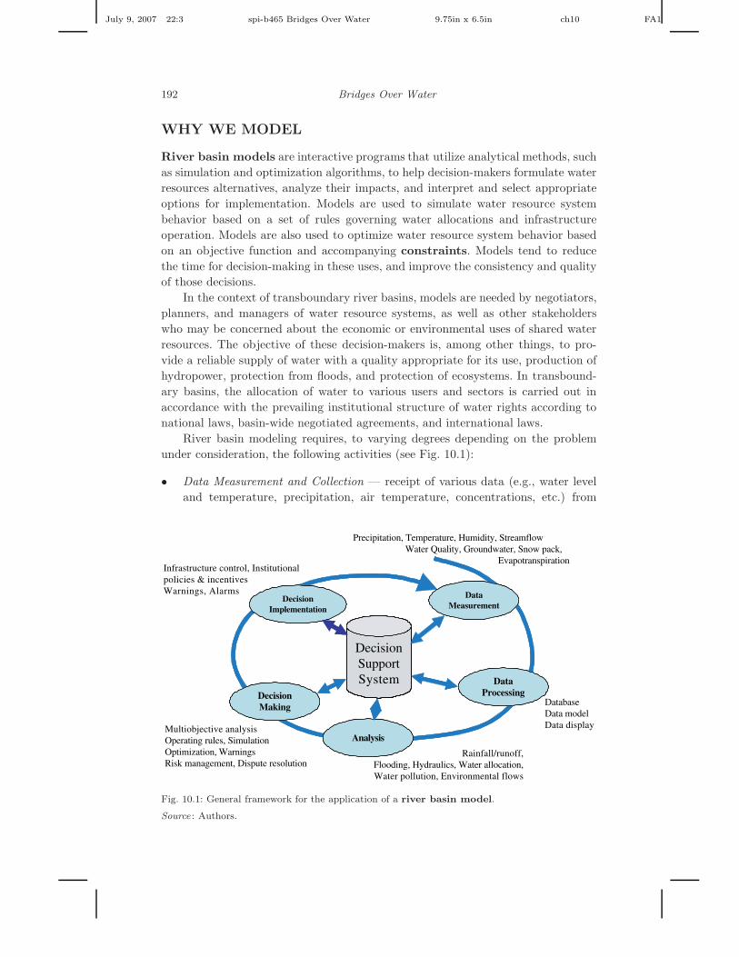
River basin modeling requires, to varying degrees depending on the problemunder consideration, the following activities (see Fig. 10.1):
• Data Measurement and Collection — receipt of various data (e.g., water leveland temperature, precipitation, air temperature, concentrations, etc.) from
DecisionSupportSystem
DataMeasurement
Precipitation, Temperature, Humidity, StreamflowWater Quality, Groundwater, Snow pack,
Evapotranspiration
DataProcessing
DatabaseData modelData display
Analysis
Rainfall/runoff,Flooding, Hydraulics, Water allocation,Water pollution, Environmental flows
DecisionMaking
Multiobjective analysisOperating rules, SimulationOptimization, WarningsRisk management, Dispute resolution
DecisionImplementation
Infrastructure control, Institutionalpolicies & incentivesWarnings, Alarms
Fig. 10.1: General framework for the application of a river basin model.
Source : Authors.
July 9, 2007 22:3 spi-b465 Bridges Over Water 9.75in x 6.5in ch10 FA1
River Basin Modeling as a Tool to Assess Conflict and Potential Cooperation 193
stations throughout a river basin. In addition, various economic and social dataare measured and collected.
• Data Processing — storage and processing of data related to the processes ofinterest in the basin, both spatial features as well as time series data. In thiscontext a relational database is used to store the measured data, a data model isused to organize the data in the database according to the “basin” principle, anda geographic information system3 is used to display the data graphically.
• Analytical Tools — models designed to predict basin response to various climateand development scenarios.
• Decision Formulation and Selection — use of results from the models and inter-action with users to make decisions on water management in the basin; and
• Decision Implementation — dissemination of decisions regarding water useunder various conditions.
WHAT WE MODEL
River basin modeling requires the consideration of a wide scope of social, eco-nomic, and environmental aspects of resource use and protection. Principal areas ofdecision-making in water resources management include: emergency water man-agement, water regulation, allocation, and quality. Decision-making regimes tendto be different for these areas due to differences in time available for making deci-sions (hours in the first case, days to months in the second, and years to decades inthe third).
Emergency Water Management
We distinguish between river basin management problems dealing with early warn-ing of extreme events, flood management, and accidental chemical spill management.
Early Warning
Early warning systems for floods or accidental chemical spills are information sys-tems designed to send automated hydrologic and water quality data regarding water-related disasters to river basin planners, who combine them with meteorological dataand river basin models to disseminate hazard forecasts and formulate strategiesto mitigate economic damage and loss of human life.
Flood Protection
Protection from flooding events requires higher dimension models and smaller timesteps than for many other water resource management models, such as munici-pal or agricultural water supply, recreation, water quality, etc. Flood flows usually
3Geographically referenced data in a relational database with a graphical mapping system.

July 9, 2007 22:3 spi-b465 Bridges Over Water 9.75in x 6.5in ch10 FA1
194 Bridges Over Water
occur over short time intervals (hours to days or weeks) making it impractical tomodel such events in multipurpose water resource planning models using simplemass balances. Calculating flood inundation as a result of flood wave propaga-tion in a watershed requires two-dimensional modeling, rather than one-dimensionalmodeling.
Structural measures (e.g., reservoirs, levees, flood proofing) and nonstructuralmeasures (e.g., land use controls and zoning, flood warning, and evacuation plans)are used to protect against floods. Upstream reservoir operators must provide stor-age capacity for flood protection and emergency warning to populations living indownstream floodplains. These operators need to know how much water to releaseand when in order to minimize expected flood damage downstream. The flood flowand peak in a basin depend on flood storage capacity and flood flow release poli-cies. These can be determined by simulating flood events entering basin reservoirs.Expected flood damage can be predicted if the distribution of peak flows and therelationships between flood stage and damage, and flood stage and peak flow areknown.
Chemical Spills
Accidental chemical spills are a major concern for areas that have vulnerable river-ine ecosystems and cities with vulnerable drinking-water supplies and weak spillresponse capabilities. To protect against accidental spills, studies are performed todetermine travel times in river reaches and to plan emergency responses to chemi-cal spills into rivers, including guiding decisions regarding closing and reopening ofintakes to drinking-water systems.
Emergency planning for spills in rivers and lakes entails having advective, non-reactive, nonmixing transport models capable of providing quick, worst-case sce-narios of chemical concentrations at critical points downstream of spill sites. Theseallow for planning and deciding on alerts to be issued. More detailed, advective-dispersive, reactive modeling of the chemical fate and transport in the river systemtypically follow after the immediate response actions are taken.
Water Regulation, Allocation, and Quality
River Basin Management
In the area of general river basin management, decision-makers are faced with amyriad of problems, including:
• Operation of reservoirs to supply water for various purposes, including recre-ation, municipal and industrial water use, environmental flows, irrigation, andhydropower production.
• Examination of the effects of land-use and land-management policies on waterquality.
• Assessment of eutrophication in surface water bodies.

July 9, 2007 22:3 spi-b465 Bridges Over Water 9.75in x 6.5in ch10 FA1
River Basin Modeling as a Tool to Assess Conflict and Potential Cooperation 195
• Development of pollution control plans for river basins and estuaries, includinghydrodynamic and water quality impacts of alternative control strategies.
• Design and operation of wastewater treatment plants, i.e., what level of treat-ment is necessary to meet water quality goals under specific flow conditions; and
• Management of river basins, including the evaluation of the interrelationshipsbetween economic productivity and environmental degradation in a basin.
Lake and Reservoir Operation
In this area, decisions must be made regarding pollution control, water supply, andhydropower operation, mitigation of climate change effects, reservoir eutrophica-tion, phosphorus control strategies, and operation of multiple reservoir systems.Different types of models are required in this area, such as, water allocation modelsto determine the distribution of water for economic production and environmentalprotection in a basin; or two- and three-dimensional models to analyze water qualityin lakes.
Nonpoint Source Pollution
Here plans are made for agricultural chemical use or protection of vulnerable waterbodies, stream, and aquifers. Modeling and managing agricultural nonpoint sourcepollution typically requires the use of a distributed parameter watershed model. Thedata management and visualization capabilities are needed to allow decision-makersidentify and analyze problem areas easily.
Conjunctive Use of Surface and Ground Water
Because decision-makers are typically required to consider a multitude of social,legal, economic, and ecological factors, models have great potential for improving theplanning and management of conjunctive use (ground and surface water) systems.This can require the integration of a number of simulation and optimization modelswith graphic user interface capabilities to provide an adequate framework for thediscussion of water allocation conflicts in a river basin. Conjunctive use models andmultiobjective decision methods can be combined to provide effective interbasinwater transfer planning allowing decision-makers to analyze the social, economic,and environmental impacts of water transfers. Models are valuable in facilitating theconsideration of a wide range of impacts, allowing decision-makers to incorporatetechnical information into the decision-making process, and providing output thatcan be interpreted easily.
For Further Discussion. To what extent do the different areas of waterresources decision-making discussed above: emergency water management,water regulation, allocation, and quality, have different data requirements? Forexample, the time periods are different for each area (hours, to days, to months).

July 9, 2007 22:3 spi-b465 Bridges Over Water 9.75in x 6.5in ch10 FA1
196 Bridges Over Water
Some Issues in River Basin Modeling
There are a number of issues related to water management that must be consid-ered for effective river basin modeling. First, water management takes place in amultidisciplinary and multijurisdictional environment and the problems must beapproached from an integrated perspective (McKinney, 2004). Second, water man-agement must be considered at the scale of the river basin in order to internalizethe major, potential externalities between activities of users in different parts ofa basin. Finally, the importance of scale effects in trying to model the integratedeffects of water uses across an entire basin must be addressed.
Integrated River Basin Management
Integrated River Basin Management are river basin management conceptsbased on the premise that water is an integral part of the ecosystem, a naturalresource and a social and economic good, whose quantity and quality determine thenature of its utilization. River basin management includes both structural inter-ventions and nonstructural rules and policies. Structural interventions include thedesign and construction of physical works under criteria of safety, workability, dura-bility, and economy, including short-term, operation and maintenance activities withexisting structures and long-term investments in new structures (McKinney et al.,1999). Nonstructural interventions combine optimal operating rules of hydrologicsystems, economic optimization of water allocation, and understanding commu-nity behavior and institutional processes related to the formation and support ofagencies making decisions about water management. These institutional directives,economic/financial incentives, and hydrologic system operating rules have greatlymodified the traditional, structural approach to water management. The interdis-ciplinary nature of water problems requires the integration of technical, economic,environmental, social, and legal aspects into a coherent framework for decision-making purposes. The requirements of users as well as those relating to the preven-tion and mitigation of water-related hazards should constitute an integral part ofthe integrated water management process.
Water allocation between competing uses is best addressed at the river basinscale through the use of combined economic and hydrological models. To be effective,river basin models must adopt an interdisciplinary approach and a number ofbarriers must be overcome:
• Hydrological models often use simulation techniques, whereas most economicanalyses are performed with optimization procedures.
• Political and administrative boundaries of economic systems are rarely the sameas those of hydrological systems; and
• Different spatial development scales, and time horizons are frequently encoun-tered in economic versus hydrologic models.

July 9, 2007 22:3 spi-b465 Bridges Over Water 9.75in x 6.5in ch10 FA1
River Basin Modeling as a Tool to Assess Conflict and Potential Cooperation 197
River basin models are often used to assist planners in answering water policyquestions, including socio-economic issues, such as:
• What is the appropriate level of transaction cost for various market-based incen-tives to improved water use efficiency (e.g., the acceptable level of cost for infor-mation, monitoring, contracting, and enforcement of market transactions)?
• How should water be allocated to achieve optimal productivity and net benefitsof different water uses (e.g., agricultural, domestic, and industrial use)?
• What will be the demand for and economic value of water (e.g., productioncosts and willingness to pay) under various management scenarios?
River Basin Systems
Figure 10.2 shows the components of a river basin system, including possible sourcesof water supply (groundwater and surface water), a delivery system (river, canaland piping network), water users (agricultural, municipal, and industrial), and adrainage collection system (surface and subsurface). The atmosphere forms the riverbasin’s upper boundary, and mass and energy exchange through this boundarydetermines the hydrologic characteristics of the basin. However, the state of thebasin (e.g., reservoir and aquifer storage, and water quality) and the physicalprocesses within the basin (e.g., stream flow, evapotranspiration, infiltration and
Municipal &Industrial
Demand Sites
ConsumptiveUse
Aquifer
River Reaches & ReservoirsInstream Uses
DistributionSystem
GroundwaterPumping
AgriculturalDemand Sites
Drainage Collection,Treatment,& Disposal
Evapotranspiration
DownstreamRequirements
Precipitation Other SourcesRunoff
Treatment
Precipitation
Precipitation
Fig. 10.2: Schematic diagram of the components of a river basin system.
Source : Authors.

July 9, 2007 22:3 spi-b465 Bridges Over Water 9.75in x 6.5in ch10 FA1
198 Bridges Over Water
percolation) are affected by human actions, including impoundment, diversion,irrigation, drainage, and discharges from urban areas. Therefore, a river basinmodel should include representations of not only the natural and physical pro-cesses, but also the artificial “hardware” (physical projects) and “software” (man-agement policies) systems as well. The model should represent human behavior inresponse to policy initiatives. This may be as simple as a price elasticity of demandcoefficient or as complex as a model of farmers’ simultaneous choice of optimalwater use, crops, and water application technology. The essential relations withineach component and the interrelations between these components in the basin mustbe considered in river basin models.
It has been noted by some water resources professionals that there is a tendencyfor modeler to include too much detail into a model or to neglect important andrelevant components of a model. This can lead to inaccurate model results and toinappropriate interpretation of those results. The complexity of a model should bedependent on the problem being analyzed and no more (Ford, 2006).
River basin models need to include interactions between water allocation,agricultural productivity, nonagricultural water demand, and resource degradationto estimate the social and economic net benefits from water allocation and use.
In order for decision-makers to understand critical water management aspectsin the basin, the model should represent:
• The underlying physical processes.• The institutions and rules that govern the flows of water and pollutants in the
basin.• The water diversion, use and return sites in the basin, including consumptive
use locations for agricultural, municipal, industrial, and in-stream water uses(incorporating also reservoirs and aquifers); and
• The economic benefits of water use by applying production and benefit func-tions for water for use in the agricultural, environmental, urban, and industrialsectors.
Scaling of Processes
Figure 10.3 illustrates the scales (basin, district, and user) of relationships and deci-sions in river basin management. Water is used for instream purposes (hydropowergeneration, navigation, recreation, environmental flows, etc.) as well as off-streampurposes (agricultural, municipal and industrial (M&I) water uses). Basin plannersoften attempt to maximize the socio-economic net benefits to the basin stakehold-ers, such as the economic value of M&I water use, profit from irrigation, and benefitsfrom instream water uses, but also minimize environmental damages due to wastedischarges, irrigation drainage, and negative impacts on instream uses.
At one level, institutional policies such as water rights and economic incen-tives (e.g., water price, crop prices, and penalties on waste discharge and irrigationdrainage) constrain or induce system operations and water use decisions. The man-agement of water quantity and quality in a basin is based on the operation of

July 9, 2007 22:3 spi-b465 Bridges Over Water 9.75in x 6.5in ch10 FA1
River Basin Modeling as a Tool to Assess Conflict and Potential Cooperation 199
Net benefits in thebasin
Net benefits of thewater users
Crop yield, area,production and net
benefit
Return flowand pollutants
Fields
Basin –Network ofreservoirs, aquifers,
and river reaches
Water users
Net benefits in thenationsNations
Regional Policy, Institutionsand Economic incentives
National Policy, Institutionsand Economic incentives
Local Policy, Institutionsand Economic incentives
Water and saltbalance
Water and saltbalance
Water and saltbalance
Water and saltbalance
Water allocation
Water allocation
Water allocation
Fig. 10.3: Framework for river basin modeling at various scales.
Source : Authors.
reservoirs, aquifers, and conjunctive surface and ground water systems. The con-nections between water supply and demand and between upstream and downstreamusers are important considerations when considering return flows in the basin. Theregulation of spatially distributed flows, pollutants, and demands has to be consid-ered in a river basin model integrated over the proper scale within the river basinnetwork.
For Further Discussion. Why is scale an important issue in river basin mod-eling? How does it enter into the formulation of models? What processes arepredominant in considering the integrated management of river basins and whyare they so important? How has neglecting the integrative nature of river basinsresulted in environmental, economic, or social problems in the past?
HOW WE MODEL
Simulation and Optimization Models
Multiobjective, multipurpose, multifacility solutions to problems encountered inriver basin management must be not only technically feasible but socially,

July 9, 2007 22:3 spi-b465 Bridges Over Water 9.75in x 6.5in ch10 FA1
200 Bridges Over Water
environmentally, economically, and politically feasible as well. In most river basinmanagement situations, it is hard to see how all the disparate components can becombined into a management plan or design, which meets prescribed and some-times conflicting objectives and constraints. The “systems approach,” that is,disassembling complex phenomena into smaller, isolated, more readily understood,subsystems, and analyzing the interactions between the subsystems and betweenthe subsystems and the larger environment (Churchman, 1968), can aid in identi-fying situations where a minimum investment of funds and energies will producemaximum gains in terms of resource allocations, economic development, and envi-ronmental welfare. Using this approach, we can focus on the functioning of thecomponents and the relationships and interactions between them under conditionsto which the system may be subjected. This provides a means of sorting through themyriad of possible solutions to a problem and narrowing the search to a few poten-tially optimal ones in addition to determining and illustrating the consequences ofthese alternatives and the trade-offs between conflicting objectives.
Basin-scale analyses are often undertaken using one of two types of models(McKinney et al., 1999): ones that simulate water resources behavior in accordancewith a predefined set of rules governing water allocations and infrastructure oper-ations, or ones that optimize and select allocations, infrastructure, and operationsbased on an objective function and accompanying constraints. Often system per-formance can best be assessed with simulation models, whereas system improvementcan often be achieved through the use of optimization models.
River basin models that simulate the behavior of various hydrologic, waterquality, economic, or other variables under fixed water allocation and infrastructuremanagement policies are often used to assess the performance of water resources sys-tems. A distinguishing feature of these simulation models, as opposed to optimiza-tion models, is their ability to assess performance over the long term, i.e., decades.Consequently, simulation is the preferred technique to assess water resources systemresponses to extreme, nonequilibrium conditions, and thereby to identify the systemcomponents most prone to failure, or to evaluate system performance relative to aset of sustainability criteria that may span decades. However, sustainability analysishas been accomplished through optimization recently (Cai et al., 2002).
Models that optimize water resources based on an objective function and con-straints must include a simulation component, however rudimentary, with whichto calculate flows and mass balances. A distinct advantage of optimization mod-els over simulation models is their ability to incorporate values (both economic andsocial) in the allocation of water resources. However, to be adopted by policymakersand system managers, optimal water allocations must agree with an infrastructureoperator’s perspective. This often requires that models be calibrated not only withrespect to physical parameters of the system being modeled, but also with respectto the system management, i.e., the operation and decision-making processes for thesystem. This latter aspect is often overlooked in model development and applicationand can lead to poor acceptance of models in practice.
Many river basin models tend to have unwieldy input files and cryptic outputfiles, making them useful only to technical specialists. Wide use of these models

July 9, 2007 22:3 spi-b465 Bridges Over Water 9.75in x 6.5in ch10 FA1
River Basin Modeling as a Tool to Assess Conflict and Potential Cooperation 201
and the vastly expanded access to data have brought about the need for othertechnologies (e.g., databases and GUIs) to be integrated with models in order tomake data accessible to models and to make inputs and results understandable toanalysts and decision-makers. Unfortunately, except in very few cases, most modelshave yet to utilize the capabilities of modern relational databases.
River basin models have been reviewed by several authors (e.g., Yeh, 1985;Wurbs, 1993; Wurbs, 1994; Wurbs, 1998; Wagner, 1995; Watkins and McKinney,1995; Labadie, 2004; McKinney, 2004). Yeh (1985) provided a comprehensive state-of-the-art review of reservoir operation models with a strong emphasis on optimiza-tion methods. Wurbs (1993) provided a review of a wide array of reservoir simulationand optimization models and evaluated the usefulness of each approach for differ-ent decision-support situations. He hoped that his paper would help practitionerschoose the appropriate model from the overwhelming number of models and mod-eling strategies that currently exist. Labadie (2004) points out the need to improvethe operational effectiveness and efficiency of water resource systems through theuse of computer modeling tools. He notes that the demand for this is increasing asperformance-based accountability in water management agencies increases and asoperators and managers come to rely more on modeling tools to respond to newenvironmental and ecological constraints for which they have little experience todraw on.
River basin models range from fully data oriented models to fully processoriented models. Data oriented models are represented by regression models orneural networks (i.e., black box models). Process oriented models are represented bymodels which have detailed representations of processes, but require few site specificdata (i.e., white box models). The choice depends on the quantity and quality ofdata available and the knowledge of important physical, chemical, biological, andeconomic processes affecting the system.
For Further Discussion. What are some situations when simulation mod-eling of a basin may be preferred to optimization modeling and vice versa?How might one go about formulating an appropriate objective for optimizationmodeling of a river basin?
Components of River Basin Models
A typical river basin model is developed as a node–link network, in which nodesrepresent physical entities and links represent the connection between these entities(Fig. 10.4). The nodes included in the network are: (1) source nodes, such as rivers,reservoirs, and groundwater aquifers; and (2) demand nodes, such as irrigation fields,industrial plants, and households. Each distribution node is a location where wateris diverted to different sites for beneficial use. The inflows to these nodes includewater flows from the headwaters of the river basin and rainfall drainage enteringthe entities. Agricultural water users are assumed to allocate water to a series of

July 9, 2007 22:3 spi-b465 Bridges Over Water 9.75in x 6.5in ch10 FA1
202 Bridges Over Water
Fig. 10.4: Schematic representation of a transboundary river basin.
Source : Authors.
crops, according to their water requirements and economic profitability. Both croparea and yield may be determined endogenously depending on the model.
To solve the river basin model and obtain values for flow and storage in allarc and nodes of the basin network, some solution criterion must be established toprovide regulation of the water resources of the basin river under various imposedconditions (scenarios). In other words, the model tries to:
• Balance water at the model nodes during each period of a specified planninghorizon.
• Satisfy, to the extent possible, the demands of water users in the basin duringthe planning horizon.
• Follow the operation regimes of the basin reservoirs according to their technicalrequirements and rules of their operation; and
• Satisfy, to the extent possible, requirements for environmental flows.

July 9, 2007 22:3 spi-b465 Bridges Over Water 9.75in x 6.5in ch10 FA1
River Basin Modeling as a Tool to Assess Conflict and Potential Cooperation 203
Fig. 10.5: Schematic diagram of a reservoir with power plant: (a) plan view; and (b) side elevation
view.
Source : Authors.
The network representation of a river basin in a model is an arrangement ofthe river reaches, reservoirs and power plants, water users and lateral inflows (seeFig. 10.4). For every reservoir, water balances are calculated as (see Fig. 10.5):
Stj − St−1
j = Qtin,j − Qt
out,j − Ltj, (10.1)
where
Stj volume of water in reservoir j at time t (million m3);
Qtout,j release from reservoir j in period t (million m3);
Qtin,j inflow to reservoir j in period t (million m3); and
Ltj loss from reservoir j over time t (million m3) from seepage or
evaporation.
The energy generated at a hydropower plant associated with a dam and reservoiris calculated as (see Fig. 10.5):
Etj = 2730 ∗ εj ∗ Qt
out,j ∗ Htj , (10.2)
where
Etj energy generated by plant j in time period t (kWh);
Htj effective hydraulic head on plant j in time period t (m). For “run-of-the-
river” power plants, this value is a fixed constant; and
εj efficiency of plant j.

July 9, 2007 22:3 spi-b465 Bridges Over Water 9.75in x 6.5in ch10 FA1
204 Bridges Over Water
tjsource,Q
tjin ,1Q
tjin ,2Q
jNode
tjout,Q
tjsource,Q
tjin ,1Q
tjin ,2Q
jNode
tjout,Q
jNode
tjout,Q
tjin,Q
jNode
tjout,Q
tjin,Q
(a) (b)
Fig. 10.6: Nodes representing (a) flow at a river confluence with a local source; and (b) return flow
from an agricultural water user.
Source : Authors.
For nodes representing confluences of rivers, we have for each node j of thistype and for each time period t (see Fig. 10.6)
∑
out
Qtout,j =
∑
in
Qtin,j + Qt
source,j , (10.3)
where
Qtin,j inflow to the node j in period t (million m3);
Qtout,j outflow from the node j in period t (million m3); and
Qtsource,j source of water for node j in period t (million m3).
For water users, return flow from their diversion can be calculated as
Qtout,j = rj ∗
∑
in
Qtdel,j , (10.4)
where 0 ≤ rj ≤ 1 is the return flow coefficient for node j (dimensionless).
Allocation of Water to Users
Priority-Based Allocation
Such allocation of water to users in a river basin is based on a set of imposed oragree upon priorities assigned to water users. Often, the criterion used to calculatethe allocation of water to users in a river basin model is to minimize deficits ofwater delivery to all users in each time period
Minimize∑
i
wi
Qtdem,i − Qt
del,i
Qtdem,i
, (10.5)
where
Qtdem,i water demanded by user i in period t (million m3);
Qtdel,i water delivered to user i in period t (million m3); and
wi priority of user i in the allocation process (dimensionless).

July 9, 2007 22:3 spi-b465 Bridges Over Water 9.75in x 6.5in ch10 FA1
River Basin Modeling as a Tool to Assess Conflict and Potential Cooperation 205
This method is used in the Water Evaluation and Analysis Program (WEAP)software discussed in a later chapter. There are different methods that can be usedto endogenously or exogenously estimate the demands for water in the basin (pri-marily agricultural and municipal); however, an exogenous determination is themost common.
In the priority allocation method, for each time step a network flow solverattempts to satisfy the demands of the water users with the highest priority first.Then the lower priority users are satisfied in decreasing order of priority. This is atypical method of solution for several well-known river basin models, includingWEAP (SEI, 2004), WRAP (Wurbs, 2001), ModSim (Labadie, 2000), and Oasis(Hydrologic, 2004).
River basin simulation models use network flow optimization algorithms to solvelarge sets of simultaneous equations in order to balance the flows in the networkrepresenting the basin. To mimic operating policies, such sets of procedures can bedifficult to generate for complex systems, and very different and new rule sets maybe needed if structural or significant policy changes are to be investigated. To avoidthis, river basin models can be formulated as minimum cost capacitated networkflow problems solved using network flow solvers, such as the out-of-kilter algorithm(used in HEC-ResSIM) or the more efficient Lagrangian approach (used in ModSim)of Bertsekas (1994). The network flow solver computes the values of the flows in eacharc so as to minimize the weighted sum of flows, subject to constraints on massbalance at each node and upper and lower flow bounds. The weights are penaltiesexpressing relative priorities in user-defined operating rules (WEAP, 2004). The usermust provide lower and upper bounds on diversions, instream flows, and reservoirstorage levels and assign relative priorities for meeting each flow requirement andfor maintaining target reservoir storage levels. The network solver computes theflows and storage changes in a particular time interval (say, a day or a month),and then uses the solution as the starting point for calculations in the next timeinterval.
A distinguishing feature of these hybrid simulation/optimization models is theuse of optimization on a period by period basis to “simulate” the allocation ofwater under various prioritization schemes, such as water rights, without perfectforeknowledge of future hydrology and other uncertain information.
Economic-Based Allocation
As an alternative to priority-based allocation, economic optimization can beused to allocate water based on economic criteria, such as priority to those usesthat return the highest net benefits in the basin. Agricultural water demand canbe determined endogenously within such a model using crop production functions(yield vs. water, irrigation technology, salinity, etc.) and an M&I water demandfunction based on a market inverse demand function. Water supply can be deter-mined through a hydrologic water balance in the river basin with extension to theirrigated areas. Water demand and water supply are integrated into an endogenous

July 9, 2007 22:3 spi-b465 Bridges Over Water 9.75in x 6.5in ch10 FA1
206 Bridges Over Water
system and balanced based on the economic objective of maximizing net bene-fits from water use, including irrigation, hydropower, and M&I benefits (Rosegrantet al., 2000).
The net benefit (profit) from agricultural water use at a particular site can beexpressed as crop revenue minus fixed crop cost, irrigation technology improvementcost, and water supply cost:
NBAg =∑
cp
A ∗ Y ∗ p − A ∗ fc − w ∗ pw, (10.6)
where
NBAg net benefit from agricultural water use (US$);A harvested area (ha);p crop price (US$/mt);fc fixed crop cost (US$/ha);pw water price (US$/m3); andw water delivered to demand sites (m3).
A crop yield function, yield as a function of applied water, can be specified asfollows:
Y = Ymax[a0 + a1(w/Emax) + a2 ln(w/Emax)], (10.7)
where
Y crop yield (metric tons [mt]/ha);Ymax maximum attainable yield (mt/ha);a0, a1, a2 regression coefficients;w applied water (mm); andEmax maximum evapotranspiration (mm).
The net benefit from M&I water use can be derived from an inverse demand functionfor water (Rosegrant et al., 2000):
NBM&I = w0p0/(1 + α)[(w/w0)α + 2α + 1] − w · wp, (10.8)
where
NBM&I net benefit from M&I water use (US$);w0 maximum water withdrawal (m3);p0 willingness to pay for additional water at full use (US$);e price elasticity of demand; andα 1/e.
Net benefits from power generation can be calculated as:
NBPower = E ∗ (pprice − pcost), (10.9)
where E is the produced hydropower (kWh), pprice is the price of power production(US$/kWh); and pcost is the cost of power production (US$/kWh).
A river basin model based on this development will also include institutionalrules, including minimum required water supply for users, minimum and maximum

July 9, 2007 22:3 spi-b465 Bridges Over Water 9.75in x 6.5in ch10 FA1
River Basin Modeling as a Tool to Assess Conflict and Potential Cooperation 207
crop production, and environmental flow requirements. In such a case, the objectiveis to maximize net benefits in the basin from the supply of water to agricultureand M&I water uses, and hydroelectric power generation, subject to institutional,physical, and other constraints. The objective is:
Maximize Z =∑
j−Ag
NBAg,j +∑
j−M&I
NBM&I,j +∑
j−power
NBpower,j . (10.10)
For Further Discussion. What are the reasons for not using economic allo-cation of water in a transboundary basin? What are the issues of nationalsovereignty that must be considered in this case? How can we build these into ariver basin model?
Multiobjective Analysis Techniques
Water resources problems are inherently multifaceted with conflicting uses of waterwhere trade-offs must be made between stakeholders with differing goals. In theprevious section, we developed an objective function with three components rep-resenting the net benefits from allocating water to agricultural use, municipal andindustrial use, and hydropower generation. Using net benefits in common monetaryunits, these individual objectives are commensurate. When the components areequally weighted, then each component is being given equal priority in the solutionprocess according to its contribution to net benefits. That is, a dollar of agriculturalbenefit is equivalent to a dollar of hydropower benefit. However, these componentsor objectives can often be in conflict with one another, such as when agriculturalwater demand peaks in the summer growing season and hydropower demand peaksin the winter heating season.
Modeling methods that are used to determine the trade-offs between vari-ous conflicting objectives in water resources problems are used in multiobjectiveanalyses. Multiobjective modeling methods have been used for several decades todetermine the trade-offs between various objectives in water resources problems.Several books devoted to the subject of multiobjective planning, many with applica-tions to water resources problems, have been published over the past three decades,including Haimes et al. (1975), Keeney and Raiffa (1976), Cohon (1978), Zeleny(1982), and Steuer (1986).
Examples of multiobjective modeling in water resources planning include Bog-ardi and Duckstein (1992), who presented an interactive multiobjective analysismethod to embed the decision-maker’s implicit preference function; Ridgley andRijsberman (1992), who employed multicriteria decision aid for policy analysis of theRhine estuary; and Theissen and Loucks (1992), who presented an interactive waterresources negotiation support system. In these last two examples, multicriteria eval-uation to support group decision-making was emphasized. Other work has focusedon integrating technologies to support multiobjective analysis. Simonovic et al.

July 9, 2007 22:3 spi-b465 Bridges Over Water 9.75in x 6.5in ch10 FA1
208 Bridges Over Water
(1992) presented a rule-based expert system to facilitate and improve multiobjectiveprogramming in reservoir operation modeling.
Model Building Process
The river basin model building process consists of several steps (see Fig. 10.7):
• Problem identification — identify the important elements of the basin to bemodeled and the relations and interactions between them. That is, a generaloutline and purpose of the model must be established. The modeler must iden-tify the appropriate type of model for the system and the degree of accuracyneeded given the time and resources available for modeling. Generally the sim-plest model with the least number of parameters which will produce reliableresults in the time available is preferred (Ford, 2006).
• Conceptualization and development — establish the mathematical descriptionof the relationships identified previously. In this step, appropriate computationaltechniques are also determined and implemented for the problem.
• Calibration — determine reliable estimates of the model parameters. In thisstep, model outputs are compared with actual historical or measured outputs of
Problem identificationand description
Model verification &sensitivity analysis
Model documentation
Model application
Model calibration ¶meter estimation
Modelconceptualization
Modeldevelopment
Data
Present results
Fig. 10.7: General diagram of the steps in the model building process.
Source : Authors.

July 9, 2007 22:3 spi-b465 Bridges Over Water 9.75in x 6.5in ch10 FA1
River Basin Modeling as a Tool to Assess Conflict and Potential Cooperation 209
the system and the model parameters are adjusted until the values predicted bythe model agree, to a reasonable degree of accuracy, with the measured values.
• Verification — an independent set of input data, i.e., different from that usedin the calibration step, is used in the model and the model results are comparedwith measured outputs. If they are found to agree, the model is considered tobe verified and ready for use.
• Sensitivity analysis — Many of the input data and assumptions that are usedto construct a model are inaccurately measured, estimated from sparse data,or poor approximations. Modelers need to know what impact these potentialsources of error or uncertainty may have on their model results. Sensitiv-ity analysis explores and quantifies the impacts of possible errors in inputdata on predicted model outputs and system performance indices (Loucks andvan Beek, 2005). Sometimes small changes in model parameters can producelarge, abrupt changes in model solutions. Often, sensitivity analysis is a trial-and-error process of incrementally adjusting model parameters, coefficients, andinputs and subsequently solving the model. In this way, the modeler can see thechange in model output values resulting from modest changes in input valuesand determine the importance of imprecision or uncertainty in model inputs inthe modeling process (Loucks and van Beek, 2005).
Geographic Information Systems
Database systems provide comprehensive facilities for storing, retrieving, displaying,and manipulating data essential to the decision-making process. Two common datamanipulation and storage tools are the relational database, which relates infor-mation in a tabular way so that the rules of relational algebra can be applied,and the geographic database (or geographic information system-GIS), whichrelates information pertaining to fundamental spatial features such as points, lines,and polygons. GIS brings spatial dimensions into the water resources database, andit has the ability to better integrate social, economic, and environmental factorsrelated to water resources planning and management for use in decision-making.GIS offers a spatial representation of water resources systems, but only limitedanalytical capabilities for solving water resources problems.
There are several strategies for coupling environmental models to GIS(McKinney and Cai, 2002), ranging from loose couplings where data are transferredbetween models and GIS, and each has separate database management capabilitiesand systems; to tight couplings where data management in the GIS and model areintegrated and they share the same database. Tighter coupling between GIS andriver basin models has been enhanced by the ArcHydro data model (Maidment,2002) that can easily represent river basins in GIS.
ArcHydro defines a data structure of classes, such as watersheds, cross-sections,monitoring points, and time series in a manner that reflects the underlying physicalwatershed. It also defines relationships between the data, so that a river basin(catchment) may know which point represents its outlet, or a monitoring point
July 9, 2007 22:3 spi-b465 Bridges Over Water 9.75in x 6.5in ch10 FA1
210 Bridges Over Water
may be aware of time series records for that location. The ArcHydro data modelis being used for water resources planning in the Rio Grande basin shared betweenthe U.S. and Mexico (Patino-Gomez and McKinney, 2005) and the South FloridaWater Management District for the basis of an enterprise GIS database to supportflood control, natural system restoration, operations decision support, and regionalmodeling projects (PBS&J, 2004).
MODELS USED IN TRANSBOUNDARY SETTINGS
Syr Darya Basin
The Syr Darya Basin, with average annual flow of 37.2 billion m3 and area ofabout 484,000km2, stretches some 2,337km from the Naryn River headwaters inKyrgyzstan through the Fergana Valley shared by Kyrgyzstan, Uzbekistan, andTajikistan, the Hunger Steppe in Uzbekistan, the Kyzyl Kum desert in Kazakhstan,before finally reaching the Aral Sea. Kyrgyzstan’s Toktogul reservoir is the largest inthe Syr Darya Basin and the only one with multiyear storage capacity (14 billion m3
usable storage volume). The reservoir was designed and constructed in the Sovietperiod to operate in an irrigation mode with minimal winter season releases. Prior toindependence in 1991, surplus power generated by summertime, irrigation releasesfrom Toktogul was transmitted to neighboring regions of the Soviet Union. In returnfor this electricity and irrigation water, those regions sent electric power and fuels(natural gas, coal, and fuel oil) back to Kyrgyzstan for winter heating needs. Fora description, the water resources situation in the basin and in Central Asia moregenerally, see McKinney (2004).
This situation changed drastically when independent states were establishedin Central Asia in 1991. Because of complications in intergovernmental relationsand account settlements, the introduction of national currencies, and increasingprices of oil, coal, natural gas, the supply of wintertime fuels and electricity sent toKyrgyzstan from the other Republics was reduced. This created a winter heatingcrisis to which the Kyrgyz responded by increasing wintertime releases from Tok-togul for hydroelectric generation thus depleting reservoir storage during the middle1990s.
To alleviate these problems, the Syr Darya basin countries authorized the for-mation of a group to negotiate an interstate agreement on the use of water andenergy resources in the Syr Darya Basin. This resulted in an agreement that cre-ated a framework addressing trade-offs between the competing uses of water forenergy and irrigation in the Basin. Under the agreement, compensation is paid forcompliance with a Toktogul release schedule that takes into account both upstream(Kyrgyz) winter energy needs and downstream (Uzbek and Kazakh) summer irriga-tion water demand. To date, the system has remained stable without major conflictand the agreement has entered the second five-year implementation period withoutmajor revision.

July 9, 2007 22:3 spi-b465 Bridges Over Water 9.75in x 6.5in ch10 FA1
River Basin Modeling as a Tool to Assess Conflict and Potential Cooperation 211
A critical element in the negotiations of the Syr Darya agreement was helpingthe parties understand the trade-offs between the conflicting objectives of winterelectricity releases and summer irrigation releases. A multiobjective optimizationmodel was developed to promote understanding of, and aid in the development of,efficient and sustainable water allocation options for the republics (McKinney andCai, 1997; Cai et al., 2003). The multiple objectives combined in the model included(1) minimizing upstream winter power deficits and maximizing downstream irri-gation water supply. By integrating these objectives with the system’s physical,political, and operational constraints in an optimization model, the trade-offsbetween the conflicting objectives of satisfying agricultural water demand, and gen-erating hydroelectric power were elaborated and used to develop a number of waterallocation scenarios to aid decision-making. Further analysis of the economic con-sequences of the proposed options was prepared using hydroelectric and agriculturalinput and output costs and prices (Keith and McKinney, 1997).
Rio Grande Basin
The Rio Grande originates in the San Juan Mountains of southern Colorado, flow-ing 3042km from its headwaters to the Gulf of Mexico, passing through parts ofthree U.S. states (Colorado, New Mexico, and Texas) and five Mexican states in(Chihuahua, Durango, Coahuila, Nuevo Leon, and Tamaulipas). The Rio Grandeis the international border from the El Paso, Texas area to the Gulf of Mexico.The basin covers an area of about 869,000 sq. km. Of the part of this area thatcontributes runoff to the river, about half is in Mexico and half is in the U.S. Prin-cipal tributaries to the river include the Conchos, San Rodrigo, Alamo, and SanJuan Rivers in Mexico, and the Pecos and Devils Rivers in Texas. The Rio Grandewater resources are almost entirely allocated and used by the time the river passesEl Paso and the river has intermittent flow until it reaches the confluence with theRio Conchos, flowing out of the Mexican state of Chihuahua.
Mexico and the United States have two treaties and various cooperative regu-lations that govern allocation of the water resources they share. The two nationssigned the “Convention for the Equitable Division of the Waters of the Rio Grandefor Irrigations Purposes” in 1906 (IBWC, 1906). This treaty allocated the waterin the upper basin above Texas. In 1944, the United States and Mexico signed theTreaty for the “Utilization of Waters of the Colorado and Tijuana Rivers and of theRio Grande” allocating the water of the lower part of the Rio Grande basin (IBWC,1944). Under the treaty, each country receives half of the water in the main stemof the river, and full use of the waters in their tributaries (IBWC, 1944). How-ever, the treaty provides that one-third of the flow reaching the river from severalnamed tributaries is allocated to the United States, provided that this is not lessthan a specified annual amount (averaged over five-year accounting cycles). Thevast majority of this water comes from the Rio Conchos basin, as flow in the othertributaries is minimal during much of the year.
Today the Rio Grande supports a thriving agriculture. It also provides waterfor drinking, hydroelectric power, sewage disposal, industry, and recreation for more

July 9, 2007 22:3 spi-b465 Bridges Over Water 9.75in x 6.5in ch10 FA1
212 Bridges Over Water
than five million people who live in this basin. Current diversions from the river goprimarily to agriculture (more than 87%) with Mexico irrigating about 445,154ha,and the U.S. about 401,852ha.
Drought has been a persistent problem in the Rio Grande Basin. Indeed, arecent drought event lasted for about 10 years, longer than was ever anticipated inthe negotiations of the 1944 treaty, and, as a result, Mexico was unable to deliverthe quantities of water required under the 1944 Treaty and accumulated a “waterdebt” at the end of two consecutive five-year treaty accounting cycles.
The traditional segment-specific approaches to water management planninghave been deemed inadequate to meet the challenges of a large transboundary basinsuch as the Rio Grande. To illuminate strategies to reduce future conflicts over waterthroughout the entire basin, a comprehensive, model-based planning exercise wasundertaken. These strategies include making agriculture more resilient to periodicconditions of drought, improving the reliability of supplies to cities and towns, andrestoring lost environmental functions in the river system.
The effort consisted of two parallel, interacting and converging activities, oneof which was building a water resources database (Patino-Gomez and McKinney,2005) and an associated hydrologic planning model that represents the entire basin(Danner et al., 2006). This model was used to evaluate the hydrologic feasibility ofa suite of scenarios for improving the management of the limited water available inthis system, particularly those opportunities that bridge across management unitsand jurisdictional boundaries. Hydrologic feasibility includes both physical viabilityand the ability to provide mutual benefits to stakeholders throughout the system.This enabled the elaboration and understanding of the hydrologic dynamics in thebasin such that the trade-offs associated with a range of management strategiescould be clearly illuminated.
Simultaneously with the development of a basin-wide model, the project gen-erated a set of future water management scenarios that respond to the needs andobjectives of the basin stakeholders, including water users, planning agencies, envi-ronmental organizations, universities and research institutes, and local, state, andnational government officials. These scenarios were evaluated for hydrologic feasi-bility by the basin-wide model in a set of gaming exercises. Modeling is necessaryto understand how these options will affect the entire system and how they can becrafted to maximize the benefits and avoid unintended or uncompensated effects.
The development of the scenarios informed the process of assembling the datato populate the planning model. In constructing the management scenarios, a 30–50 year planning horizon was used so that the issue of climate variability and climatechange could be considered.
Practice Questions
1. What is “systems analysis” and how can it aid in the planning and design ofwater resources projects?

July 9, 2007 22:3 spi-b465 Bridges Over Water 9.75in x 6.5in ch10 FA1
River Basin Modeling as a Tool to Assess Conflict and Potential Cooperation 213
2. What is the difference between “simulation” and “optimization modeling”?Give an example when it might be more appropriate to use one rather thanthe other.
3. In the model building process, why is it important to have independentdata sets for the calibration and verification of a model?
4. What is sensitivity analysis and how would you use the results of such ananalysis to guide data collection efforts?
5. Discuss the circumstances when countries might find themselves with con-flicting river basin management objectives.
ANNEX 10A — SOME AVAILABLE RIVER BASIN
MODELING SYSTEMS
Some of the more common river basin modeling tools are listed in this Annex,particularly the ones related to water allocation.
Delft-Tools (Delft Hydraulics, 2004) — Delft-Tools is a framework for decisionsupport developed by Delft Hydraulics for the integrating water resources simula-tion programs. Functions of the system include scenario management, data entry,and interactive network design from map data, object-oriented database set-up,presentation, analysis, and animation of results on maps. DELFT-TOOLS inte-grates the Delft Hydraulics models: SOBEK, RIBASIM, and HYMOS. SOBEK is aone-dimensional river simulation model that can be used for flood forecasting, opti-mization of drainage systems, control of irrigation systems, sewer overflow design,ground-water level control, river morphology, salt water intrusion, and surface waterquality. RIBASIM (River Basin Simulation Model) is a river basin simulation modelfor linking water inputs to water-uses in a basin. It can be used to model infras-tructure design and operation and demand management in terms of water quantityand water quality. HYMOS is a time series information management system linkedto the Delft Hydraulics models.
Mike-Basin (DHI, 2004) — MIKE-BASIN couples ArcView GIS with hydrologicmodeling to address water availability, water demands, multipurpose reservoir oper-ation, transfer/diversion schemes, and possible environmental constraints in a riverbasin. MIKE-BASIN uses a quasi-steady-state mass balance model with a networkrepresentation for hydrologic simulations and routing river flows in which the net-work arcs represent stream sections and nodes represent confluences, diversions,reservoirs, or water users. ArcView is used to display and edit network elements.Water quality simulation assuming advective transport and decay can be modeled.Groundwater aquifers can be represented as linear reservoirs. Current developmentsare underway to utilize the functionality of ArcGIS-9 in MIKE-BASIN.
Basic input to MIKE-BASIN consists of time series data of catchment run-offfor each tributary, reservoir characteristics and operation rules of each reservoir,

July 9, 2007 22:3 spi-b465 Bridges Over Water 9.75in x 6.5in ch10 FA1
214 Bridges Over Water
meteorological time series, and data pertinent to water demands and rights (forirrigation, municipal and industrial water supply, and hydropower generation), andinformation describing return flows. The user can define priorities for diversionsand extractions from multiple reservoirs as well as priorities for water allocation tomultiple users. Reservoir operating policies can be specified by rule curves definingthe desired storage volumes, water levels and releases at any time as a functionof existing storage volumes, the time of the year, demand for water, and possibleexpected inflows.
Water quality modeling in MIKE-BASIN is based on steady, uniform flow withineach river reach and a mass balance accounting for inputs of constituents, advec-tive transport and reaction within the reach. Complete mixing downstream of eachsource and at tributary confluences is assumed. Nonpoint pollution sources are han-dled in the model as well as direct loading from point sources. The model accountsfor the following water quality parameters: biochemical oxygen demand, dissolvedoxygen, ammonia, nitrate, total nitrogen, and total phosphorus. Nonpoint loads arerepresented using an area loading method accounting for the nitrogen and phospho-rous loads originating from small settlements, livestock, and arable lands assumingcertain unit loads from each category.
ModSim (Labadie et al., 2000; Dai and Labadie, 2001) — ModSim is a gen-eralized river basin DSS and network flow model developed at Colorado StateUniversity with capability of incorporating physical, hydrological, and institu-tional/administrative aspects of river basin management, including water rights.ModSim is structured as a DSS, with a graphical user interface (GUI) allowingusers to create a river basin modeling network by clicking on icons and placingsystem objects in a desired configuration on the display. Through the GUI, the userrepresents components of a water resources system as a capacitated flow networkof nodes (diversions points, reservoirs, points of inflow/outflow, demand locations,stream gages, etc.) and arcs (canals, pipelines, and natural river reaches). ModSimcan perform daily scheduling, weekly, operational forecasting and monthly, long-range planning. User-defined priorities are assigned for meeting diversion, instreamflow, and storage targets. ModSim employs an optimization algorithm at each timestep to solve for flow in the entire network to achieve minimum cost while sat-isfying mass balance at the nodes and maintaining flows through the arcs withinrequired limits. Conjunctive use of surface and ground water can be modeled with astream-aquifer component linked to response coefficients generated with the MOD-FLOW groundwater simulation model (Fredricks et al., 1998). ModSim can be runfor daily, weekly, and monthly time steps. Muskingum–Cunge hydrologic routing isimplemented in the model.
ModSim has been extended to treat water quality issues in stream-aquifer sys-tems through an interactive connection to the EPA QUAL2E model for surfacewater quality routing, along with a groundwater quality model for predicting salin-ity loading in irrigation return flows (Dai and Labadie, 2001).
ModSim is well documented in both user manuals and source code comments.Model data requirements and input formatting are presented along with sample
July 9, 2007 22:3 spi-b465 Bridges Over Water 9.75in x 6.5in ch10 FA1
River Basin Modeling as a Tool to Assess Conflict and Potential Cooperation 215
test applications useful in understanding model set up and operation. Currently,ModSim is being upgraded to use the “.NET Framework” with all interface functionshandled in Visual Basic and C#. This will greatly enhance the ability of the modelto interact with relational databases and all variables in the model will be availablefor reading or writing to a database.
ModSim is in the public domain, and executable versions of the model areavailable free of charge for use by private, governmental, and nongovernmental users.Generally, the source code for the model is not available. However, some governmentagencies have negotiated agreements with the developer in which the source codeis made available to the agency and the agency is allowed to change or modify thesource code as necessary for agency-related projects.
OASIS (Hydrologics, 2001; Randall et al., 1997) — Operational Analysis and Sim-ulation of Integrated Systems (OASIS) developed by Hydrologics, Inc. is a generalpurpose water simulation model. Simulation is accomplished by solving a linearoptimization model subject to a set of goals and constraints for every time stepwithin a planning period. OASIS uses an object-oriented graphical user interface toset up a model, similar to ModSim. A river basin is defined as a network of nodesand arcs using an object-oriented graphical user interface. Oasis uses MicrosoftAccess for static data storage, and HEC-DSS for time series data. The OperationalControl Language (OCL) within the OASIS model allows the user to create rulesthat are used in the optimization and allows the exchange of data between OASISand external modules while OASIS is running. OASIS does not handle groundwateror water quality, but external modules can be integrated into OASIS. Oasis doesnot have any link to GIS software or databases.
RiverWare (Carron et al., 2000; Zagona et al., 2001; Boroughs and Zagona,2002; CADWES, 2004) — The Tennessee Valley Authority (TVA), the UnitedStates Bureau of Reclamation (USBR), and the University of Colorado’s Centerfor Advanced Decision Support for Water and Environmental Systems (CADWES)collaborated to create a general purpose river basin modeling tool — RiverWare.RiverWare is a reservoir and river system operation and planning model. The soft-ware system is composed of an object-oriented set of modeling algorithms, numericalsolvers, and language components.
Site specific models can be created in RiverWare using a graphical user inter-face (GUI) by selecting reservoir, reach confluence, and other objects. Data foreach object is either imported from files or input by the user. RiverWare is capa-ble of modeling short-term (hourly to daily) operations and scheduling, mid-term(weekly) operations and planning, and long-term (monthly) policy and planning.Three different solution methods are available in the model: simulation (the modelsolves a fully specified problem); rule-based simulation (the model is driven by rulesentered by the user into a rule processor); and optimization (the model uses LinearGoal-Programming Optimization).
Operating policies are created using a constraint editor or a rule-based editordepending on the solution method used. The user constructs an operating policyfor a river network and supplies it to the model as “data” (i.e., the policies arevisible, capable of being explained to stakeholders; and able to be modified for policy

July 9, 2007 22:3 spi-b465 Bridges Over Water 9.75in x 6.5in ch10 FA1
216 Bridges Over Water
analysis). Rules are prioritized and provide additional information to the simulatorbased on the state of the system at any time. RiverWare has the capability ofmodeling multipurpose reservoir uses consumptive use for water users, and simplegroundwater and surface water return flows.
Reservoir routing (level pool and wedge storage methods) and river reach rout-ing (Muskingum–Cunge method) are options in RiverWare. Water quality param-eters including temperature, total dissolved solids, and dissolved oxygen can bemodeled in reservoirs and reaches. Reservoirs can be modeled as simple, well-mixed,or as a two-layer model. Additionally, water quality routing methods are availablewith or without dispersion.
RiverWare runs on Sun Solaris (Unix) workstations or Windows based PCs.RiverWare does not have a connection to any GIS software; however, a hydrologicdatabase (HDB) may be available (Frevert et al., 2003; Davidson et al., 2002). HDBis a relational database used by the USBR and developed by CADWES to be usedin conjunction with RiverWare. HDB is an Oracle-based SQL database and includesstreamflow, reservoir operations, snowpack, and weather data.
Dynamic Simulation Software — Dynamic simulation software has beenapplied to river basin modeling. This includes the software STELLA (High Perfor-mance Systems, 1992), POWERSIM (Powersim, 1966), VENSIM (Ventana, 1995),and GOLDSIM (Goldsim, 2003). These are dynamic simulation packages that stemfrom the system dynamics modeling method “Dynamo” invented by Forrester atMIT in the 1960s. The latest generation of these packages use an object-oriented pro-gramming environment. The models are constructed from stocks, flows, modifiers,and connectors, and the software automatically creates difference equations fromthese based on user input. These methods all include components for: (1) identifica-tion of stocks and flows in a system; (2) graphically representing dynamic systemsin “stock-and flow-diagrams”; and (3) a computer language for simulating the con-structed dynamic systems. Models can be created by connecting icons together indifferent ways into a model framework so that the structure of the model is verytransparent.
WEAP (Raskin et al., 1992; SEI, 2004) — The Water Evaluation and PlanningSystem (WEAP) developed by the Stockholm Environment Institute’s Boston Cen-ter (Tellus Institute) is a water balance software program that was designed to assistwater management decision makers in evaluating water policies and developing sus-tainable water resource management plans. WEAP operates on basic principlesof water balance accounting and links water supplies from rivers, reservoirs, andaquifers with water demands, in an integrated system. Designed to be menu-drivenand user-friendly, WEAP is a policy-oriented software model that uses water bal-ance accounting to simulate user-constructed scenarios. The program is designedto assist water management decision-makers through a user-friendly menu-drivengraphical user interface. WEAP can simulate issues including sectoral demand anal-yses, water conservation, water rights, allocation priorities, groundwater withdrawaland recharge, streamflow simulation, reservoir operations, hydropower generation,pollution tracking (fully mixed, limited decay), and project cost/benefit analyses.Groundwater supplies can be included in the WEAP model by specifying a storage
July 9, 2007 22:3 spi-b465 Bridges Over Water 9.75in x 6.5in ch10 FA1
River Basin Modeling as a Tool to Assess Conflict and Potential Cooperation 217
capacity, a maximum withdrawal rate, and the rate of recharge. Minimum monthlyinstream flows can be specified.
WEAP is relatively straightforward and user-friendly for testing the effects ofdifferent water management scenarios. The results are easy to view for comparisonsof different scenarios. Changing input data to model newly proposed scenarioscan be readily accomplished, as long as it is not necessary to make any changes tothe ASCII file of historical data.
REFERENCES
Bogardi, J. and L. Duckstein (1992). Interactive multiobjective analysis embedding the
decision maker’s implicit preference function, Water Resources Bulletin, 28(1), 75–78.
Cai, X., D.C. McKinney and L.S. Lasdon (2002). A framework for sustainability analy-
sis in water resources management and application to the Syr Darya Basin, Water
Resources Research, 38(6), 21/1-21/14.
Cai, X., D.C. McKinney and L.S. Lasdon (2003). An integrated hydrologic-agronomic-
economic model for river basin management, Journal of Water Resources Planning
and Management, 129(1), 4–17.
Churchman, C.W. (1968). The Systems Approach. New York: Dell Publishing Co.
Cohon, J. (1978). Multiobjective Programming and Planning. New York: Academic Press.
Danner, C.L., D.C. McKinney and R.L. Teasley (2006). Documentation and testing of the
WEAP model for the Rio Grande/Bravo Basin, CRWR Online Report 06-08, Center
for Research in Water Resources, University of Texas at Austin, August 2006.
Ford, D.T. (2006). Tall, Grande or Venti models? J. Water Resour. Plng. and Mgmt.,
132(1), 1–3.
Grigg, N.S. (1996). Water Resources Management. New York: McGraw Hill.
Haimes, Y., W. Hall and H. Freedman (1975). Multiobjective Optimization in Water
Resources Systems. Amsterdam: Elsevier Scientific.
Hall, W. and J. Dracup (1970). Water Resources Systems Engineering. New York: McGraw-
Hill.
HydroLogics, User Manual for OASIS with OCL, Version 3.4.14, 2001, http://www.
hydrologics.net/oasis/index.shtml
International Boundary and Water Commission (IBWC) (1944). Treaty between the
United States of America and Mexico, http://www.ibwc.state.gov/Files/1944Treaty.
Keeney, R.L. and H. Raiffa (1976). Decisions with Multiple Objectives: Preferences and
Value Tradeoffs. New York: Wiley.
Keith, J. and D.C. McKinney (1997). Options analysis of the operation of the Toktogul
reservoir, Issue Paper No. 7, USAID Environmental Policy and Technology (EPT),
Almaty, Kazakhstan, August.
Labadie, J. (2000). ModSim: Decision support system for river basin management, Docu-
mentation and User Manual-2000, http://modsim.engr.colostate.edu/
Labadie, J. (2004). Optimal operation of multireservoir systems: State-of-the-art review,
Journal of Water Resources Planning and Management, 130(2), 93–111.
Lee, D. and A. Dinar (1996). Integrated approaches of river basin planning, development,
and management, Water International, 21(1), 213–222.

July 9, 2007 22:3 spi-b465 Bridges Over Water 9.75in x 6.5in ch10 FA1
218 Bridges Over Water
Loucks, D.P., J.R. Stedinger and D.A. Haith (1981). Water Resource Systems Planning
and Analysis. Englewood Cliffs: Prentice Hall.
Loucks, D.P. and E. van Beek (2006). Water Resources Systems Planning and Manage-
ment: An Introduction to Methods, Models and Applications. Paris: UNESCO.
Maas, A., M.M. Hufschmidt, R. Dorfman, H.A. Thomas, S.A. Marglin and G.M. Fair
(1962). Design of Water Resource Systems. Cambridge: Harvard.
Maidment, D.R. (2002). Arc Hydro: GIS for Water Resources. ESRI Press.
Mays, L.W. (ed.) (1996). Handbook of Water Resources. New York: McGraw Hill.
Mays, L.W. and Y.-K. Tung (1992). Hydrosystems Engineering and Management. McGraw
Hill.
McKinney, D.C. (2004). Cooperative management of transboundary water resources in
central asia. In: Burghart, D. and T. Sabonis-Helf (eds.), In the Tracks of Tamerlane-
Central Asia’s Path into the 21st Century, National Defense University Press.
McKinney, D.C. (2004). International survey of Decision Support Systems for Integrated
Water Management, Technical Report, US Agency for International Development,
Agricultural Pollution Reduction Activity in Romania, Bucharest, Romania.
McKinney, D.C., X. Cai, M. Rosegrant, C. Ringler and C. Scott (1999). Integrated basin-
scale water resources management modeling: Review and future direction, System-
Wide Initiative on Water Management (SWIM) Research Paper No. 6, International
Water Management Institute, Colombo, Sri Lanka.
McKinney, D.C. and X. Cai (2002). Linking GIS and water resources management models:
An object-oriented method, Environmental Modeling and Software, 17(5), 413–425.
McKinney, D.C. and X. Cai (1997). Multiobjective water resource allocation model for Tok-
togul reservoir, Technical Report, US Agency for International Development, Envi-
ronmental Policy and Technology Project, Central Asia Regional EPT Office, Almaty,
Kazakstan, April.
Patino-Gomez, C. and D.C. McKinney (2005). GIS for large-scale watershed observational
data model, CRWR Online Report 05-07, Center for Research in Water Resources,
University of Texas at Austin, December.
Ridgeley, M. and F. Rijsberman (1992). Multicriteria evaluation in a policy analysis of a
Rhine estuary. Water Resources Bulletin, 28(6), 1095–1110.
Rosegrant, M.W., C. Ringler, D.C. McKinney, X. Cai, A. Keller and G. Donoso (2000).
Integrated economic-hydrologic water modeling at the basic scale: The Maipo river
basin, Agricultural Economics, 24(1), 33–46.
Simonovic, S., H. Venema and D. Burn (1992). Risk-based parameter selection for short-
term reservoir operation, Journal of Hydrology, 131, 269–291.
Steuer, R. (1986). Multiple Criteria Optimization: Theory, Computation, and Application.
New York: John Wiley & Sons.
Theissen, E.M. and D.P. Loucks (1992). Computer assisted negotiation of multiobjective
water resources conflicts, Water Resources Bulletin, 28(1), 163–177.
Viessman Jr, W. and C. Welty (1985). Water Management: Technology and Institutions.
New York: Harper & Row, Publishers.
Wagner, B. (1995). Recent developments in simulation-optimization groundwater man-
agement modeling, U.S. National Contributions in Hydrology 1991–1994, Reviews of
Geophysics, Supplement, 1021–1028, July.
Watkins Jr, D.W. and D.C. McKinney (1995). Recent developments in decision support
systems for water resources, U.S. National Contributions in Hydrology 1991–1994,
Reviews of Geophysics, Supplement, 941–948, July.

July 9, 2007 22:3 spi-b465 Bridges Over Water 9.75in x 6.5in ch10 FA1
River Basin Modeling as a Tool to Assess Conflict and Potential Cooperation 219
Wurbs, R. (1993). Reservoir-system simulation and optimization models, Journal of Water
Resources Planning and Management, 119(4), 455–472.
Wurbs, R. (1994). Computer models for water resources planning and management, US
Army Corps of Engineers, Institute for Water Resources, IWR Report 94-NDS-7,
Alexandria, VA.
Wurbs, R. (1998). Dissemination of generalized water resources models in the United
States, Water International, 23(3), 190–198.
Wurbs, R.A. (2001). Reference and users manual for the water rights analysis package
(WRAP). Texas Water Resources Institute, College Station, TX, July.
Yeh, W.-G. (1985). Reservoir management and operations models: A state-of-the-art
review, Water Resources Research, 21(12), 1797–1818.
Zeleny, M. (1982). Multiple Criteria Decision Making, New York: McGraw-Hill.
ADDITIONAL READING
Boroughs, C. and E. Zagona (2002). Daily flow routing with the Muskingum-Cunge method
in the Pecos River RiverWare model. In: Proceedings of the Second Federal Intera-
gency Hydrologic Modeling Conference, Las Vegas, NV.
CADWES (Center for Advanced Decision Support for Water and Environmental Systems),
RiverWare Overview, 2004, Accessed 2004: http://cadswes.colorado.edu/riverware/
overview.html
Carron, J., E. Zagona and T. Fulp (2000). Uncertainty modeling in RiverWare. In: Pro-
ceedings of the ASCE Watershed Management 2000 Conference, Ft. Collins, CO.
Dai, T. and J. Labadie (2001). River basin network model for integrated water quan-
tity/quality management, Journal of Water Resources Planning and Management,
127(5), 295–305.
Danish Hydraulics Institute (DHI) (2004a) Mike-Basin Description, Accessed April 2004:
http://www.dhisoftware.com/mikebasin/Description/
Danish Hydraulics Institute (DHI) (2004b) TimeSeries Manager Description, Accessed
2004: http://www.dhisoftware.com/mikeobjects/TS Manager/archydro.htm
Davidson, P., R. Hedrich, T. Leavy, W. Sharp and N. Wilson (2002). Information systems
development techniques and their application to the hydrologic database derivation
application. In: Proceedings of the Second Federal Interagency Hydrologic Modeling
Conference, Las Vegas, NV.
Delft hydraulics (2004) Accessed April 2004: http://www.wldelft.nl/soft/tools/index.html
Fredericks, J., J. Labadie and J. Altenhofen (1998). Decision support system for con-
junctive stream – Aquifer management, Journal of Water Resources Planning and
Management, 124(2), 69–78.
Frevert, D., T. Fulp, G. Leavesley and H. Lins (2003). The watershed and river sys-
tems management program — an overview of capabilities, Submitted to the ASCE
Journal of Irrigation & Drainage Engineering. Accessed at: http://cadswes.colorado.
edu/riverware/abstracts/FrevertJIDE2003.html
Goldsim Company (2003). Accessed April 2004: http://www.goldsim.com/
High Performance Systems (1992). Stella II: An introduction to systems thinking, High
Performance Systems, Inc., Nahover, New Hampshire, USA, Accessed April 2004:
http://www.hps-inc.com

July 9, 2007 22:3 spi-b465 Bridges Over Water 9.75in x 6.5in ch10 FA1
220 Bridges Over Water
HydroLogics (2004). User Manual for OASIS with OCL, Version 3.4.14, 2001, Accessed
April 2004: http://www.hydrologics.net/oasis/index.shtml
Labadie, J. (2004). ModSim: Decision support system for river basin management,
Documentation and User Manual-2000, Accessed April 2004: http://modsim.engr.
colostate.edu/
Powersim Corporation (1996). Powersim 2.5 Reference Manual, Powersim Corporation
Inc., Herndon, Virginia, USA, Accessed April 2004: http://www.powersim.com/
Randall, D. and D. Sheer (1997). A water supply planning simulation model using a mixed
integer linear programming engine, Journal of Water Resources Planning Manage-
ment, ASCE, 123(2).
Raskin, P., E. Hansen, Z. Zhu and D. Stavisky (1992). Simulation of water supply and
demand in the Aral Sea Basin, Water International, 17, 55–67.
Stockholm Environment Institute (SEI) — Boston (2001). Tellus Institute, WEAP Water
Evaluation and Planning System, User Guide for WEAP 21, Boston, MA. Accessed
April 2004: http://www.weap21.org/downloads/weapuserguide.pdf
Ventana Systems (1995). Vensim User’s Guide, Ventana Systems Inc., Belmont,
Massachusetts, USA, Accessed April 2004: http://www.vensim.com/
Zagona, E. A., T. J. Fulp, R. Shane, T. Magee and H. M. Goranflo (2001). Riverware:
A generalized tool for complex reservoir system modeling, Journal of the American
Water Resources Association, 37(4), 913–929.