110024770 bio8014 consultancy report wind turbine
TRANSCRIPT

GIS- based Wind Farm Site Selection for Cumbria
Executive Summary
This report highlights a suitable site in Cumbria County for locating a small scale ten turbine windfarm taking into account various economical, physical, social and environmental factors and constraints through the use of Geographical Information Software (GIS). GIS analysis methods involved creating buffer exclusion zones around roads, settlements and water features to minimise turbine interference with the public. Other analyses include a Multi-Criteria Evaluation (MCE) which produces suitability values based on wind speed and proximity to electrical lines, roads and settlements, all of which are important parameters for situating a windfarm. A viewshed analysis was then conducted on sites displaying the highest MCE values which identified settlements visually affected by a potential windfarm. Results show two potential sites shortlisted which meet all the essential criteria and are economically viable in terms of distance to roads and electrical lines, with site A perceived as socially more suited, however site B possesses a higher MCE value which results from a superior wind speed (Appendix 1). Therefore site B displayed in Figure 3 was selected as the best area to locate the windfarm as it reaps the benefits of generating the most power at an economical cost, also the viewshed analysis of site A in Figure 5 doesn’t take into account visibility of areas outside Cumbria which are within the 8 km radius. Informing the locals on the benefits of clean renewable energy may help develop positive views and lessen the complaints on visual pollution of the windfarm.

Introduction
A wind farm can be an important source of clean energy in the region as there is always a huge potential for wind as a renewable source. However determining where to situate a wind turbine farm can be very difficult, as a wide range of factors need to be taken into account. These factors are economical, physical, social and ecological.
Economical
The costs of wind turbine construction and maintenance can be expensive as the wind farm would need to be situated relatively near to roads, electric lines and it would obviously need to be located in a position where it can receive a reliable supply of wind in order to reap the benefits of the investment.
Physical
The slope, ground condition (i.e. not peaty) and distance from water features are necessary to consider as access and construction would be troublesome at steep slopes.
Social
For windfarms to be socially acceptable, they shouldn’t be situated near any urban areas as local residents are likely to complain about visual and noise pollution.
Ecological
The farm should be in a viable location where it doesn’t interfere with any special areas of wildlife and nature conservation areas, and is also necessary to comply with legislation.
Weighing all the above components can be complicating, therefore Geographical Information software (GIS) is a useful tool to simplify and combine these factors in order to aid in locating a suitable site to satisfy all the relevant requirements.
Many GIS tools are needed to facilitate this process. Buffer zones are useful in providing exclusion zones around a particular feature. A Multi-criteria evaluation (MCE) helps to weigh which factors are the most important, also a viewshed analysis is relevant to determine and help reduce the impacts of visual pollution
This report aims to define a potential site for a small scale 10 wind turbine farm in Cumbria County, ensuring it complies with the above factors, using the relevant GIS techniques.
2 | P a g e

Analytical Methods
In order to take all of the factors and constraints of locating a wind turbine farm into account, a variety of tools and processes needed to be conducted. These GIS based procedures are all summarised in Figure 1 on page 5. The site selection process was conducted in 3 stages. Stage 1 involves buffering which aids in creating exclusion zones around a particular feature to a specified distance. Stage 2 is a MCE which is useful for selecting a suitable site based on giving higher weightings to acknowledge the most important site factors. Finally, stage 3 consists of conducting a viewshed analysis around the chosen site to determine the number of settlements that are likely to be exposed to the proposed windfarm site.
Stage 1: Buffer zones & Slope calculation
To start off with the analysis, road, settlement and river/lake data were added to the map. A buffer of 2000 metres was created around all settlements, a 50 metre buffer around water features and a 500 metre buffer was created surrounding all roads. The settlement buffer distance helps minimise the interference of the windfarm with the public, as Baban & Parry (2001) suggested that a 2km distance minimises noise and visual pollution. Also a 500 metre road buffer is an acceptable compromise as locating the windfarm too close to roads may result in public complaints, however situating a windfarm too far away would prove more costly for construction and maintenance.
The slope was then calculated in order to exclude sites which contain a slope greater than 10o, as this proves difficult for crane accessibility to lift turbine parts (Haaren & Fthenakis, 2011). Finally, the buffers and slope output were then merged together to form parts of the exclusion areas for the windfarms.
Stage 2: Multi-Criteria Analysis (MCE)
Electrical line, wind speed, roads and settlement data were used in the MCE as these are arguably the prime factors for windfarm site suitability. These variables were given scores of 1-10, with a value of 10 as most desirable.
The following equations were used in the raster calculator to form the MCE values:
(5* Electric lines) + (3* Wind speed) + (2* Roads) + (Settlements) = output
Output * binary map = MCE values
Proximity to electric lines is important as it can be very costly to connect feeder lines from the wind turbines to the main electricity line to form a grid connection. For instance, Haaren & Fthenakis (2011) mentioned that the cost of feeder lines can vary from over £65,000/kilometre and £130,000/mile which could result in as much as 10% of the capital cost. Therefore, this can prove to be a significant cost, which is why distance from electric lines was given a weighting of 5.
3 | P a g e

It is obvious that sites possessing higher wind speeds are necessary in order to maximise electricity revenue and hence making the investment worthwhile which meant it was necessary to give this variable a weighting of 3.
Distance from roads is another economical factor that is necessary to consider for saving costs during construction and maintenance, as locating a farm that is approximately 10 kilometres from a road would be very expensive. Therefore this justifies its importance and is given a weighting of 2.
Distance from settlements is a critical social factor to consider, to minimise the windfarm from becoming a nuisance to the public, though this was given the lowest weighting in the MCE as the viewshed analysis in stage 3 would be used to visual pollution.
Once the MCE calculation was performed, the output was multiplied with a binary map which consists of all the excluded areas such as Natural England designated sites, national parks and areas of peat. The final result consists of varying values of suitability across the Cumbria County based on the MCE criteria mentioned.
Stage 3: Viewshed Analysis
Once the MCE was performed, a few suitable locations were pinpointed, taking into account the highest MCE values and ensuring that the exclusion zones from step 1 are avoided. A viewshed analysis was then performed at each site to determine the number of settlements that may be visually affected by the proposed windfarm within an 8 kilometre radius. Finally, a site would be chosen based on both the MCE values and the number of settlements affected.
4 | P a g e

5 | P a g e

Results
Figure 2 shows all the suitable areas available based on MCE values out of 110 and areas which are not within any excluded areas. The red areas represent areas where it is definitely not possible to locate a windfarm. Two potential sites were selected, with area 1 situated North West and area 2 located south of Cumbria. Both of these areas are outside of the excluded areas, with area 1 containing a value of 88 and area 2 received a value of 95.
6 | P a g e

7 | P a g e
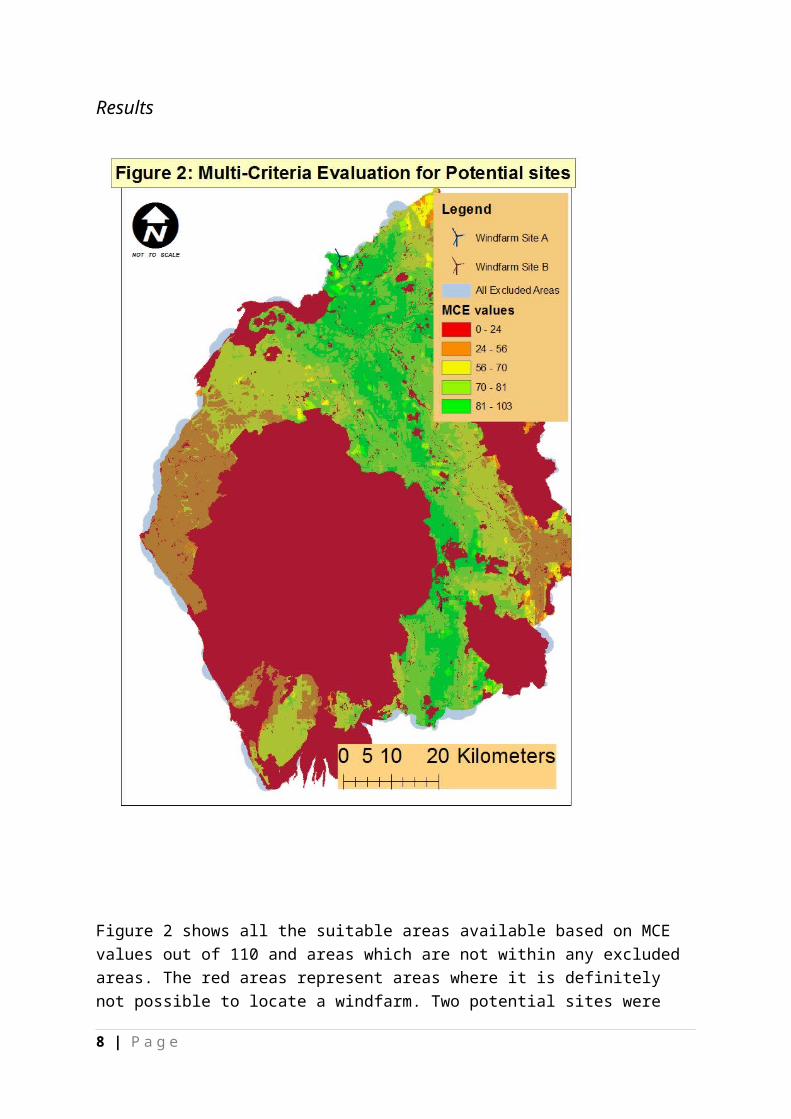
Table 1: Areas visually affected by proposed windfarm
Legend Settlement NameLarge Urban Area polygon KendalSmall Urban Area polygon BurnesideSmall Urban Area polygon Meal BankSmall Urban Area polygon Patton BridgeSmall Urban Area polygon GrayriggSmall Urban Area polygon FirbankSmall Urban Area polygon Beck FootSmall Urban Area polygon WatchgateSmall Urban Area polygon TebaySmall Urban Area polygon Garnett BridgeSmall Urban Area polygon SelsideSmall Urban Area polygon Gaisgill
8 | P a g e

Table 2: Areas affected by Windfarm site A
Legend Settlement NameSmall Urban Area polygon
Longtown
Small Urban Area polygon
Moat
Small Urban Area Polygon
Easton
Small Urban Area Polygon
Netherby
9 | P a g e

Discussion
Both of the potential areas selected in Figure 2, are some of the few sites that both possess a very high MCE value above 80 and are outside of the excluded areas that are infeasible for locating a windfarm. The high MCE values implies that both sites are within close proximity of electric lines and roads making them both a very economical option.
Windfarm Site B from Figure 2 was selected as the most suitable site for the ten turbine windfarm due to its higher MCE value of 95, which was due to its superior wind speed (Appendix 1) and elevation in contrast to Windfarm A, therefore the selected site is shown in Figure 3. Figure 3 shows that the selected windfarm site is situated in an area outside of any excluded areas and is only within 2 kilometres of electricity lines and roads making it a very viable option.
However when comparing Figure 4 & 5 and Table 1 & 2, it appears that area A is more favoured socially as only four settlements are affected, compared to area 2 where one large urban area and 11 small settlements are affected. Nonetheless, it is important to point out that area A in Figure 5 is located on the edge of Cumbria and therefore the viewshed analysis did not take into account areas affected outside of the county that were within the 8 km radius.
The number of settlements in Table 1 are in fact still lower than viewsheds that were conducted on at least three other sites during the GIS procedures where these other sites consisted of over 15 settlements becoming visually affected.
In a changing world where the need for renewable energy is becoming more prevalent, the public would need to understand the value of clean air from green energy sources, so perhaps educating the locals via leaflets on the benefits of wind power may help develop positive attitudes towards wind turbines. Also, according to a study by Pedersen et al., (2009), they observed that noise is a recurring public complaint on wind turbines, however this should not be an issue as studies from those such as Haaren & Fthenakis (2011) mentioned that a 2km buffer should be enough to eliminate noise pollution, which ensures that the proposed site in Figure 3 is in a suitable position to minimise public interference.
Therefore, from an economical point of view, it is necessary to maximise energy output and minimise the costs of installation and maintenance in order to get the highest returns from the initial investment. Hence the proposed Windfarm in Figure 3 would help to gain the highest economic return resulting in a worthwhile investment and a reliable clean energy supply to the residents of Cumbria County.
.
10 | P a g e

Appendices
References
Baban, S.M.J., Parry, T. (2001) Developing and applying a GIS-assisted approach to locating wind farms in the UK. Renewable Energy. 24 (1): 59-71.
Haaren, R.V., Fthenakis, V. (2011) GIS-based wind farm site selection using spatial multi-criteria analysis (SMCA): Evaluating the case for New York State. Renewable and Sustainable Energy Reviews. 15, 3332-3340.
Pedersen, E., Berg, F.V.D., Bakker, R., Bouma, J. (2009) Response to noise from modern wind farms in the Netherlands. Acoustical Society of America. 126(2): 634-643.
11 | P a g e