110824 boggabri coal modification ea
TRANSCRIPT

APPENDIX A
Air Quality and Greenhouse Gas

�

PAEHolmes
SYDNEY
Suite 203, Level 2, Building D, 240
Beecroft Rd Epping NSW 2121
Ph: + 61 2 9870 0900
Fax: + 61 2 9870 0999
BRISBANE
GOLD COAST
TOOWOOMBA
A PEL COMPANY Queensland Environment Pty Ltd Trading as PAEHolmes ABN: 86 127 101 642
16 August 2011 Ben Eastwood Hansen Bailey Sent via email: [email protected]
RE: BOGGABRI COAL MINE MODIFICATION – AIR QUALITY AND GREENHOUSE GAS
Dear Ben,
1 INTRODUCTION
Boggabri Coal Pty Limited (Boggabri Coal) is a wholly owned subsidiary of Idemitsu Australia Resources Pty Limited which operates the Boggabri Coal Mine. Boggabri Coal operates in accordance with Development Consent DA 36/88 under the Environmental Planning and Assessment Act 1979 (EP&A Act).
Boggabri Coal is located 15 kilometres north-east of Boggabri in the North West Region of NSW. In 2010 Boggabri Coal produced 2.3 Million tonnes of product coal from the Maules Creek Formation down to the Merriown coal seam.
Hansen Bailey Pty Ltd (Hansen Bailey) has been commissioned by Boggabri Coal to prepare an Environmental Assessment (EA) to support a modification to the Development Consent under Section 75W of the EP&A Act. This Modification is required to allow Boggabri Coal to continue its mining operations for a further two years following the expiry of its current consent on 14 November 2011.
Specifically the Modification would include the following:
� Extending the approval period of DA 36/88 by a further two years;
� Continuing to mine coal at up to 3.5 Million tonnes per annum (Mtpa) product coal;
� Continuation of use of all existing infrastructure and facilities;
� Construction and use of approved extensions to the administration, bathhouse and workshop buildings;
� Construction and use of a heavy vehicle workshop; and
� Construction and use of water management infrastructure.
Further details regarding the Modification, including a plan showing the currently approved mining area and the proposed Modification Boundary is included in the main volume of the Boggabri Coal Modification EA.
This report has been commissioned by Hansen Bailey on behalf of Boggabri Coal to assess the air quality impacts as part of the Boggabri Coal Modification EA. This report includes an assessment of air quality impacts associated with the Modification to current NSW Office of Environment and Heritage (OEH) guidelines and policies described below.

160816_3362d Boggabri Modification FINAL.Docx Page 2
2 ASSESSMENT CRITERIA
Table 2-1 summarises the air quality goals for concentrations of particulate matter that are relevant to this study.
Table 2-1: Air quality standards / goals for particulate matter concentrations
Pollutant Averaging period Standard / Goal Agency
Total suspended particulate matter (TSP)
Annual mean 90 �g/m3 � NHMRC
Particulate matter with an equivalent aerodynamic
diameter less than 10 �m (PM10)
24-hour maximum 50 �g/m3
� NSW OEH impact assessment criteria;
� NEPM reporting goal, allows five exceedances per year for bushfires and dust storms;
Annual mean 30 �g/m3
� NSW OEH impact assessment criteria;
� DoP acquisition criteria
Notes: �g/m3 – micrograms per cubic metre, �m – micrometre.
Table 2-2 shows the maximum acceptable increase in dust deposition over the existing dust levels from an amenity perspective. These criteria for dust fallout levels are set to protect against nuisance impacts (NSW DEC, 2005).
Table 2-2: OEH criteria for dust (insoluble solids) fallout
Pollutant Averaging period Maximum increase in deposited dust level
Maximum total deposited dust level
Deposited dust Annual 2 g/m2/month 4 g/m2/month
3 CURRENT AIR QUALITY
3.1.1 Introduction
Air quality standards and goals refer to pollutant levels that include the contribution from specific projects and existing sources. To fully assess impacts against all the relevant air quality standards and goals (see Section 2) it is necessary to have information or estimates on existing dust concentration and deposition levels in the area in which the Modification is likely to contribute to these levels. It is important to note that the existing air quality conditions (that is, background conditions) will be influenced to some degree by the existing mining operations.
The following sections provide a summary of the monitoring results for dust deposition, PM10 and TSP in the area surrounding the Modification.
3.1.2 Dust Deposition
Dust deposition is monitored using dust deposition gauges at 15 locations in the vicinity of the Modification. Dust deposition gauges use a simple device consisting of a funnel and bottle to estimate the rate at which dust settles onto the surface over a period of one month. The measured dust fallout levels include the effects of all existing sources of particulate matter including the existing mining operations.

160816_3362d Boggabri Modification FINAL.Docx Page 3
Data collected from the gauges between 2005 and July 2011 are summarised in Table 3-1.
The data indicate that deposition levels are generally low and within the OEH’s annual average assessment criteria of 4 g/m2/month for insoluble solids.
Table 3-1: Dust deposition data (insoluble solids) (g/m2/month)(a)
Dust gauge
2005average
2006average
2007average
2008average
2009average
2010 average
2011average(to July)
D1(b) 0.7 0.9 1.8 2.1 1.7 4.0(c) 1.4
D2(b) 0.7 1.5 2.0 2.1 1.5 2.7 1.4
D3 2.1 1.6 2.9 1.8 3.2 0.9 3.4(d)
D4 2.2 1.5 2.3 1.6 1.7 2.4 2.8(e)
D5 1.4 1.3 1.7 1.4 1.7 0.8 0.9
D6 1.5 1.0 1.7 1.6 1.3 0.9 1.1
D7 0.8 1.2 1.5 1.2 1.0 0.8 1.0
D8 1.1 1.1 1.3 1.2 1.1 0.9 1.1
D9 1.1 1.3 1.0 1.3 1.9 1.5 4.3(f)
D10 1.1 0.8 1.1 1.1 0.9 0.4 0.5
D11 1.5 1.2 1.0 1.4 1.1 0.7 0.4
D12 1.1 1.6 1.9 1.7 1.7 2.8 1.6
D13 1.5 1.8 2.2 2.4 1.6 1.6 0.4
D14 0.9 0.9 1.6 1.7 3.7 3.6 1.0
D15 - - - 1.1 1.4 1.1 1.8
D16 - - - - - - 1.8 (a) Excluding contaminated data; (b) Monitor located on land owned by Boggabri Coal; (c) An elevated reading of 11.6 g/m2/month was recorded in June 2010 at D1. Whilst the field notes do not indicate that
the sample was contaminated, the result contains greater than 70% combustible matter, suggesting contribution from sources other than mining, for example, bushfires or wood smoke.
(d) This value is the average of just two valid samples (May and July 2011) for D3. All other samples collected at this site during 2011 have been identified in field notes as contaminated with insects.
(e) An elevated reading of 8.9 g/m2/month was recorded in June 2011 at D4. Whilst the field notes do not indicate that the sample was contaminated, the result contains greater than 75% combustible matter, suggesting contribution from sources other than mining, for example, bushfires or wood smoke.
(f) An elevated reading of 13.1 g/m2/month was recorded in June 2011 at D9. Whilst the field notes do not indicate that the sample was contaminated, the result contains greater than 75% combustible matter, suggesting contribution from sources other than mining, for example, bushfires or wood smoke.
3.1.3 PM10 and TSP concentrations
Particulate matter (PM10) concentrations have been monitored by Boggabri Coal since 2005. 24-hour average concentrations of PM10 are collected at site D7 every sixth day using a High Volume Air Sampler (HVAS). An additional HVAS monitor is located to the south of the Modification as a part of the Tarrawonga Mine environmental monitoring system.
The data collected by Boggabri Coal is available between August 2005 and July 2011. There have been five elevated concentrations above the OEH 24-hour average goal of 50 �g/m3. Two of these events in December 2005 occur when strong northerly winds were reported by Bureau of
160816_3362d Boggabri Modification FINAL.Docx Page 4
Meteorology (Bureau of Meteorology, 2005). Narrabri, 60 km northwest of Boggabri, recorded winds greater than 115 km/h on the 28th December 2005, as such, it is likely there was significant sources of wind-generated dust, from both mining and agricultural activities in the area. Sampling field notes also indicated there was fire in Pilliga (approximately 115 km north-west of Boggabri) on 30 December 2005 which will have contributed to the elevated concentrations.
There were two other days where the dust levels were recorded to be above the OEH criterion, both of which occurred in November and December of 2009. As with the above, these elevated levels are unlikely to have been caused by operations at Boggabri. The Bureau of Meteorology identifies dust storms and raised dust levels in to the west of the area in both these monitoring periods (Bureau of Meteorology, 2009). There have been no recorded concentrations above the criterion since December 2009.
The monitoring data collected at the Tarrawonga HVAS indicates that there have been five elevated recordings above the OEH goal, with four occurring between September and December 2009, a period in which a number of dust storms and strong winds were experienced in New South Wales. The maximum 24-hour average PM10 concentration recorded was 97 μg/m3 on 8 December 2009, a day when most of the State experienced strong winds and elevated dust levels.
Although the data indicates fewer than the five exceedances per year allowed by the OEH goal, it should be noted that the monitoring is not continuous and so it is not possible to conclude that the area complies with the PM10 Air-NEPM standard. However the fact that the exceedances are attributable to periods of severe wind suggests that air quality is satisfactory. Figure 3.1 shows a graphical representation of the data.
The rolling annual average is below the OEH goal of 30 �g/m3. In April 2009, the rolling annual average PM10 concentrations were 19 �g/m3, and have been as high as 25 �g/m3 (April 2007). Overall, the PM10 concentrations decreased significantly in June 2008, a slight increase is observed during 2009, with a decrease occurring from March 2010.
There are no TSP data collected, however, experience with monitoring in other mining areas in the State indicates that where mining activities are a significant source of the particulate matter, then on an annual basis, approximately 40% of the TSP will be in the form PM10. This would suggest that the annual average TSP concentrations are in the range 48 �g/m3 to 63 �g/m3. These concentrations are less than OEH’s annual average 90 �g/m3 assessment criterion for TSP.

160816_3362d Boggabri Modification FINAL.Docx Page 5
Figure 3.1: Measured PM10 concentrations (HVAS)
4 ASSESSMENT METHODOLOGY
4.1 Meteorology
One of the most important factors in determining the transport of dust from emission sources at Boggabri Coal to the surrounding area is the frequency of different wind directions and wind speeds.
Boggabri Coal operates an automatic weather station (AWS) located to the south-west of the Modification Boundary. The meteorological data consist of 15-minute readings of temperature, wind speed, wind direction and sigma-theta (a measure of the fluctuation of the horizontal wind direction). The data from this site were incomplete and did not meet the OEH’s requirements of 90% with data missing from 1 November 2008 to 25 December 2008 and 1 September 2009 to 17 September 2009. These data have been replaced with meteorological data from a nearby weather station operated by the Tarrawonga Coal Mine, 2 km southeast of the Boggabri AWS. There were still data missing from the Tarrawonga dataset for the period from the 2 May to 2 June in 2009. However, with the supplemented data from 1st November 2008 to 25 December 2008 and 1 September 2009 to 17 September 2009, the meteorological file is now 90.1% complete and meets the OEH’s requirements.
Annual and seasonal windroses compiled from the onsite meteorological data are presented in Figure 4-1. The windroses show that on an annual basis, winds are predominantly from the north, west-northwest and southeast. During summer and autumn, winds from the southeast are predominant, with very few winds originating from the north-eastern quadrant. As winter progresses, the wind distribution pattern is predominantly from the north and the northwest. This wind pattern carries through until spring, when winds from the south and south-southeast are present in more significant proportions. The percentage of calms (when the wind speed is less than 0.5 ms-1) is 14.7%. The annual average wind speed for the 2008/2009 data is 2.3 m/s.
Sep
-05
Dec
-05
Mar
-06
Jun-
06
Sep
-06
Dec
-06
Mar
-07
Jun-
07
Sep
-07
Dec
-07
Mar
-08
Jun-
08
Sep-
08
Dec
-08
Mar
-09
Jun-
09
Sep-
09
Dec
-09
Mar
-10
Jun-
10
Sep
-10
Dec
-10
Mar
-11
Jun-
11
Date
0
10
20
30
40
50
60
70
80
90
100
110
PM
10 C
once
ntra
tion
- �gm
3
Boggabri�HVAS�24�h�average
Boggabri�HVAS�rolling�annual�average
OEH�24�hour�goal
OEH�annual�goal
Tarrawonga�HVAS�24�h�average

160816_3362d Boggabri Modification FINAL.Docx Page 6
Figure 4-1: Annual and seasonal windroses for Boggabri
4.2 Dispersion Modelling
PAEHolmes completed a detailed air quality impact assessment (PAEHolmes, 2011) as input to the Environmental Assessment (EA) prepared for the Continuation of Boggabri Coal Mine (Boggabri EA) which is currently being assessed by NSW Department of Planning and Infrastructure (DP&I).
The model used was a modified version of the US EPA ISCST3 model (ISCMOD). ISCST3 is fully described in the user manual and the accompanying technical description (US EPA, 1995a and US EPA, 1995b).
The proposed Modification Boundary is shown in Figure 4-2.
NNNNENNE
NENE
ENEENE
EE
ESEESE
SESE
SSESSESS
SSWSSW
SWSW
WSWWSW
WW
WNWWNW
NWNW
NNWNNW
4% 8% 12% 16% 20%
NNNNENNE
NENE
ENEENE
EE
ESEESE
SESE
SSESSESS
SSWSSW
SWSW
WSWWSW
WW
WNWWNW
NWNW
NNWNNW
4% 8% 12% 16% 20%
NNNNENNE
NENE
ENEENE
EE
ESEESE
SESE
SSESSESS
SSWSSW
SWSW
WSWWSW
WW
WNWWNW
NWNW
NNWNNW
4% 8% 12% 16% 20%
NNNNENNE
NENE
ENEENE
EE
ESEESE
SESE
SSESSESS
SSWSSW
SWSW
WSWWSW
WW
WNWWNW
NWNW
NNWNNW
4% 8% 12% 16% 20%
NNNNENNE
NENE
ENEENE
EE
ESEESE
SESE
SSESSESS
SSWSSW
SWSW
WSWWSW
WW
WNWWNW
NWNW
NNWNNW
4% 8% 12% 16% 20%Wind speed (m/s)
>0.5 - 1.5
>1.5 - 3
>3 - 4.5
>4.5 - 6
>6 - 7.5
>7.5
Annual and seasonal windrosesfor Boggabri
(September 2008 to August 2009)
SpringWinter
AutumnSummer
AnnualCalms = 14.7%
Calms = 16.3% Calms = 13.7%
Calms = 13.8% Calms = 14.7%

160816_3362d Boggabri Modification FINAL.Docx Page 7
Figure 4-2: Proposed Modification Boundary
As shown on Figure 4-3, the proposed mine disturbance area is in a similar location, but smaller than modelled in detail for Year 5 of the Boggabri EA.
Figure 4-3: Proposed Additional Mine Disturbance Area Required for Modification compared with Year 5 activity per Boggabri EA
160816_3362d Boggabri Modification FINAL.Docx Page 8
4.3 Estimated Emissions
4.3.1 Construction
While dust would be generated from earthworks associated with the proposed infrastructure upgrade and expansion, there are a number of safeguards that can be put in place during these types of operations to ensure there is no detrimental impact on the local air quality. Therefore the impacts have not been specifically modelled.
Nominal equipment to be used during the construction works will include:
� Scrapers;
� Graders;
� Excavators;
� Backhoes;
� Crane;
� Smooth drum rollers;
� Pad foot rollers;
� Flat bed trucks;
� Fuel Truck;
� Water carts; and
� Dozers.
Mitigation measures to ensure minimal dust generation during construction may include:
� Establishment of vegetation on all disturbed areas as each stage is completed;
� All roadways, entrances and main traffic areas will be compacted, sealed or coated with a dust suppressant or mist spray regularly;
� Establishment of wind breaks composed of earth banks and other screens to protect areas by reducing capacity of the wind to raise dust;
� Trucks entering and leaving the site being well maintained in accordance with the manufacturer’s specification to comply with all relevant regulations;
� Truck movements controlled onsite and restricted to designated roadways;
� Truck wheel washes or other dust removal procedures being installed to minimise transport of dust offsite; and
� Modifying construction activities during periods of high wind.

160816_3362d Boggabri Modification FINAL.Docx Page 9
4.3.2 Emissions from the Modification
Table 4-1 shows the calculated emissions from Year 5 of the Boggabri EA, based on a production rate of 6.97 Mtpa. As Boggabri Coal does not intend to produce more than 3.5 Mtpa during the proposed Modification, these emission estimates are considered to be conservative.
Table 4-1: Summary of estimated TSP emissions from the Modification (kg/y)
ACTIVITY Year 5
Topsoil Removal-Dozers/Excavators stripping topsoil 9,801
Topsoil removal-Sh/Ex/FELs loading topsoil 758
Topsoil removal -Hauling topsoil to emplacement area 50,404
Topsoil removal -Emplacing topsoil at emplacement area 758
OB - Drilling 67,260
OB - Blasting 250,316
OB - Dragline removal of overburden n/a
OB - Excavator loading OB to haul truck 123,118
OB - Hauling to emplacement area 2,182,006
OB - Emplacing at emplacement area 123,118
OB - Dozers removing OB 219,374
OB - Dozers on OB dumping in emplacement area 219,374
CL - Dozers ripping/pushing/clean-up 806,769
CL - Hauling open pit coal to ROM pad 274,222
CL - Unloading ROM to ROM stockpiles 81,979
CL - Loading ROM directly to hopper to be crushed 327,916
CL – Loading from stockpile to crusher using FELs 81,979
CL - Crushing ROM 23,137
CL - Unloading Product coal from crusher 85,694
CL- Loading coal from hopper for transfer to CHPP (2 Mtpa production rate). 354
CL - Hauling coal from hopper to CHPP n/a
CL - Unloading to CHPP 531
CL - Handle coal at CHPP 389
CL - Rehandle coal at CHPP 89
CL - Dozers at ROM Pad 9,046
CL - Loading product coal to haul trucks 903
CL - Hauling product coal to rail loop 373,921
CL - Unloading product coal at rail loop 903
CL - Loading product coal to trains 903
CL - Loading rejects to haul trucks 208
CL - Hauling rejects from CHPP 41,010
CL - Unloading rejects 208
WE - OB dump area 902,650
WE - Open pit 507,945
WE - ROM stockpiles 16,118
WE - Product stockpiles 16,493
WE - Topsoil area and stockpiles 372,728
WE - Product stockpiles at Rail loop 19,792
Grading roads 26,957
Tarrawonga Coal Mine 1,600,000
Total 7,219,260

160816_3362d Boggabri Modification FINAL.Docx Page 10
4.3.3 Estimated emissions from neighbouring mines
For the purposes of addressing cumulative air quality impacts, the inventories used in the modelling of Year 5 (Boggabri EA) included operations at the site and estimates of emissions from Tarrawonga Coal Mine located to the south of Boggabri Coal Mine.
In the cumulative modelling work, Tarrawonga Coal Mine has been treated as nine volume sources located at the apparent points of major emissions as estimated from the known locations of the pits and/or major dust sources on the mine or facility.
Sources have been considered in three classes covering all dust emission sources for which there are emission factor equations for open cut mines.
1. Wind erosion sources where emissions vary with the hourly average wind speed according to the cube of the wind speed.
2. Loading and dumping operations where emissions vary with wind speed raised to the power of 1.3.
3. All other sources where emissions are assumed to be independent of wind speed.
For the Tarrawonga Coal Mine, the proportion of emissions in each of these categories has been assumed to be:
� 0.73 for emissions independent of wind speed;
� 0.14 for emissions that depend on wind speed (such as loading and dumping); and
� 0.13 for wind erosion sources.
These factors are based on a detailed analysis of mine dust inventories undertaken as part of the Mount Arthur North EIS (URS, 2000) and these factors have been applied to subsequent air quality impact assessments for coal mines.
It is noted that, should approval be granted, Maules Creek Coal Project, located to the north of the Project, may be under construction during the 2-years of the Modification. Due to the terrain that currently exists between the two sites, prevailing wind directions would differ to those identified in the Boggabri assessment. In addition, the vegetation and terrain that currently exist between the two sites would largely remain, thus providing a buffer to any dust emissions generated by the Maules Creek Coal Project. It is therefore considered that the potential for the operations at the Maules Creek Coal Project to have any significant impact on those residences south of Boggabri is minimal.
4.3.4 Estimated emissions from other sources
In addition to those sources identified in Section 4.3.3, contributions from, for example, small local sources of dust such as dust from vehicles using private unsealed access roads, stock movements and fugitive emissions of coal dust from trains will contribute to PM2.5, PM10, TSP concentrations and dust deposition.
An estimate of the background allowance for non-mining sources, as presented in the Boggabri EA, was calculated by comparing the predicted cumulative impact with the monitoring data. This suggests that the annual average quantity of particulate matter contributed to by these more distant sources is 12 μg/m3 for annual average PM10, 33 μg/m3 for annual average TSP and 0.5 g/m2/month for annual average deposited dust.

160816_3362d Boggabri Modification FINAL.Docx Page 11
4.4 Predicted impacts
Figure 4-4 shows the predicted annual average PM10 and TSP concentrations and dust deposition levels for operations in Year 5 of the Boggabri EA, showing the effects the Modification in combination with other sources. For simplification, only the assessment criteria contour has been presented. The contour for maximum predicted 24-hour PM10 impacts is the effects of the Modification alone.
Table 4-2 presents the predicted dust concentration results for all private receptors in the vicinity of the Modification and highlights in bold those values above the relevant project specific criteria or cumulative criteria where the Modification is expected to influence air quality.
In summary for Year 5, the following receptors where criteria are exceeded were identified:
� Annual average PM10 above 30 �g/m3 due to the Modification and other mines and other sources
– Tarrawonga (ID 54). It is noted that this property has the right to acquisition under the current Tarrawonga Mine Conditions of Consent.
As discussed in Section 4.3.1, these predicted impacts are based on a production rate of almost 7 Mtpa, which is double the production rate proposed for the Modification, and as such are considered to be conservative.

160816_3362d Boggabri Modification FINAL.Docx Page 12
Table 4-2: Predicted PM10, TSP and dust deposition for Year 5 (Boggabri EA)
Modification alone Modification and other sources
(Cumulative)
PM10
(�g/m3)TSP
(�g/m3)
DustDeposition
(g/m2/month)
PM10
(�g/m3)TSP
(�g/m3)
DustDeposition
(g/m2/month)Averaging Period 24-hour Annual Annual Annual Annual Annual Annual
Owner IDImpact Assessment Criteria
50 30 90 2 30 90 4FJ Maunder 2 5 1 1 0.0 13 34 0.5
RB & ML Kerr 3 5 1 1 0.0 13 34 0.5
Glek Pty Ltd 4 6 1 1 0.0 13 34 0.5
H & M Bullock(a) 18 7 2 2 0.0 14 35 0.5
Cooboobindi 23 14 3 3 0.1 15 36 0.6
Cooboobindi 27 13 3 3 0.1 15 36 0.6
Billabong 32 10 2 2 0.0 14 35 0.5
Brighton 33 13 1 1 0.0 14 35 0.5
Belleview(a) 35 15 3 3 0.1 15 36 0.6
Roma 43 13 2 2 0.0 14 35 0.5
Glenhope 44 12 1 2 0.0 14 35 0.5
Jeralong 51 22 3 3 0.0 16 37 0.6
Tarrawonga(b) 54 50 15 15 0.1 33 54 0.7
DC & EL Cheeseman(c) 59 32 7 7 0.1 21 42 0.8
Bradlock Pty Ltd(c) 63 50 8 9 0.5 21 43 1.1
Goonbri 67 31 4 4 0.1 17 38 0.6
Goonbri 68 28 3 4 0.1 16 37 0.6
Wirrilah(a) 69 27 3 3 0.1 15 36 0.6
Northham 79 16 3 4 0.0 16 37 0.5
Kyalla 86 40 10 10 0.1 28 50 0.6
Pine Grove(b) 88 40 7 7 0.1 22 44 0.6
Barbers Lagoon 90 14 2 2 0.0 14 35 0.5
Callandar 94 16 4 4 0.0 17 38 0.5
Flixton 98a 23 4 4 0.1 18 39 0.6
Flixton 98b 19 4 4 0.1 18 39 0.6
Bailey Park 100 15 3 3 0.1 16 37 0.6
Hazeldene 115 7 1 1 0.0 14 35 0.5
JE & RJ Picton 140 19 3 3 0.1 15 37 0.6
JE & RJ Picton 147 20 2 3 0.1 15 36 0.6
JE & RJ Picton 148 15 2 2 0.1 14 35 0.6
JE & RJ Picton 153 16 2 3 0.1 15 36 0.6
JE & RJ Picton 155 14 2 2 0.0 14 35 0.6
(a) Purchased by Boggabri Coal after the air quality assessment was completed. (b) Right to acquisition under Tarrawonga Coal Mine. (c) Purchased by Tarrawonga Mine after the air quality assessment was completed.

160816_3362d Boggabri Modification FINAL.Docx Page 13
Figure 4-4: Air quality contours (per Boggabri EA @ 6.97 Mtpa)

160816_3362d Boggabri Modification FINAL.Docx Page 14
5 MANAGEMENT AND MITIGATION MEASURES
Boggabri Coal will revise the Air Quality Management Plan for the site to incorporate practical management measures to ensure dust emissions are minimised and regulatory criteria are met at the private receivers, these include:
� A review of the existing air quality monitoring program (which has commenced);
� Minimising overburden and ROM coal haul road distances;
� The use of water sprays where practical;
� The use of dust suppressant product (or other comparable effective alternatives) on all active coal and overburden haul roads where necessary;
� Maintaining the bitumen sealed product coal haul road to the Boggabri Coal Terminal;
� Enclosing conveyor systems and installing automatically triggered dust suppression sprays to conveyors;
� Revegetating disturbed areas as soon as practicable including rehabilitation areas and obsolete haul roads; and
� Installing a Tapered Element Oscillating Microbalance (TEOM) air quality monitoring unit to aid real-time dust management and monitor compliance.
6 GREENHOUSE GAS EMISSIONS
6.1 Introduction
CO2-equivalent (CO2-e) emissions from the Modification would result from the following sources:
1. The extraction and processing of the open cut coal due to the combustion of diesel fuel (used in diesel-powered equipment, in blasting and to power the diesel generators).
2. The transport of the product coal to the Port of Newcastle and the transport of the product coal overseas.
3. The combustion of the open cut coal in general industry, steelmaking and power generating facilities.
The following sections present the calculation of CO2-e due to extraction, processing, transport and usage of coal from the Modification only.
The National Greenhouse Accounts (NGA) Factors published by the Department of Climate Change and Energy Efficiency (DCCEE) (previously the Department of Climate Change (DCC)) (DCC, 2008 and DCCEE, 2011) have been used to convert fuel usage and electricity consumption into CO2-equivalent emissions. The relevant emission factors are summarised in Table 6-1.

160816_3362d Boggabri Modification FINAL.Docx Page 15
6.2 Emission Factors
Table 6-1: Summary of greenhouse gas emission factors
Type of Fuel and Electricity Emission factor Scope Source
Diesel - onsite activitie1s (a)
69.9 kg CO2-e/GJ
1
Table 4
DCCEE, 2011
5.3 kg CO2-e/GJ 3 Table 38
DCCEE, 2011
38.6 GJ/kL Table 4
DCCEE, 2011
Explosives use(c)
ANFO 0.17 t CO2-e/tonne 1 Table 4
DCC, 2008a
Heavy ANFO 0.18 t CO2-e/tonne 1 Table 4
DCC, 2008a
Emulsion 0.17 t CO2-e/tonne 1 Table 4
DCC, 2008a
Electricity(d)
0.89 kg CO2-e/kWh 2 Table 5
DCCEE, 2011
0.17 kg CO2-e/kWh 3 Table 39
DCCEE, 2011
Extraction of coal 0.045 t CO2-e/tonne ROM 1 Table 7
DCCEE, 2011
Transport of Coal (Rail) 11(e) t CO2-e/Mt.km 3 Proponent
Transport of Coal (Shipping) (f) t CO2-e/Mt.km 3 Proponent
Notes: (a) The emission factors for diesel use include Scope 1 emission (i.e. those activities associated with actual use of fuel) and
Scope 3 emissions (those associated the production, processing and transport of diesel fuel to the site). (b) Refers to all equivalent greenhouse gases where applicable. (c) As the calculation of emissions from explosives use are no longer required under the NGER reporting requirements, the GHG
emissions factor for explosives use has been removed from NGA Factors published June 2009 (DCCEE, 2011). Therefore the factors published in February 2008 (DCC, 2008) have been used.
(d) The emission factors for electrical energy include Scope 2 emissions (i.e. those associated with generating the electricity) and Scope 3 emissions (those associated with producing the fuel for the power station and the distribution losses involved in delivering electricity to the mine).
(e) The emission factor associated with the transport of coal via rail has been obtained from the Proponent. (f) The emission factor associated with the transport of coal using ships has been provided by the Proponent. This varies
depending on type of ship used (see Section 6.2.2.2).

160816_3362d Boggabri Modification FINAL.Docx Page 16
6.2.1 Emissions from extraction and processing
As discussed in Section 6.2, to estimate CO2-e emissions from extraction of the coal, the following assumptions have been made.
� Each kWh of electrical energy used results in the release of 1.06 kg of CO2;
� Each litre of diesel fuel burnt is assumed to result in the release of 2.9 kg of CO2;
� Each tonne of explosive used is assumed to result in the release of 0.17 t of CO2; and
� Each tonne of open cut ROM coal mined results in the release of 2.17 kg of methane and that methane has a greenhouse warming potential of 21 (this means that each kilogram of methane, because of its lifetime in the atmosphere and its spectral absorption characteristics, is equivalent to 21 kg of CO2). Therefore, the CO2-e emissions released for each tonne of ROM coal mined is equal to 45.0 kg (see Table 7, DCCEE 2011).
Information was provided by Boggabri Coal on the usage of electrical energy, usage of explosives and diesel fuel for the year ending June 2006/2007, 2007/2008 and 2008/2009. Table 6-2 provides a summary of this information and the consumption rates used to pro-rata future energy consumption based on ROM removal.
Table 6-2: Fuel, energy and explosives usage from mining processing
Emission source 2006/2007 2007/2008 2008/2009
Average Consumption
rate (per tonne of ROM)
Product coal exported (t) 826,375 1,302,313 1,450,147 n/a
ROM coal mined (t) 924,000 1,399,277 1,467,939 n/a
Fuel consumption (diesel) (kL) 7,473 8,409 9,802 0.007
Explosives (t) 1,186 5,503 7,371 0.003
Electricity consumption (kWh) 575,765 598,302 640,514 0.496
Table 6-3 summarises the fuel and energy usage for the extraction and processing of the coal.
Table 6-4 summarises the estimated annual average CO2-e emissions from the Modification due to extraction and processing using the emissions factors presented in Table 6-1.
Table 6-3: Fuel, energy and explosives usage from mining processing
Year Total ROM coal
(kt ROM coal/y)
Electrical energy used (processing)
(kWh)
Diesel used in extraction total
(Litres/y)
Explosives used in blasting (kt/y)
1 3,500,000 1,734,877 24,237,055 11,944
2 3,500,000 1,734,877 24,237,055 11,944
Total 145,276,667 3,469,754 48,474,110 23,888
Table 6-4: Summary of estimated CO2-e emissions from mining and processing of coal from the Modification
Year
CO2-e from electrical energy
(processing) (t/y)
CO2-e from mining (diesel usage)
(t/y)
CO2-e from blasting
(t/y)
CO2-e from CH4
released during mining (t/y)
Total(t/y)
Scope 2 Scope 3 Scope 1 Scope 3 Scope 1 Scope 1 Scope 1
& 2 Scope 3 1 1,544 295 65,395 4,958 2,030 157,500 226,469 5,253
2 1,544 295 65,395 4,958 2,030 157,500 226,469 5,253
Total 3,088 590 130,790 9,917 4,061 315,000 452,939 10,507

160816_3362d Boggabri Modification FINAL.Docx Page 17
6.2.2 Emissions from export and burning of the product coal
6.2.2.1 Emissions from off-site transport of product coal via rail
Information has been provided by the proponent that all product coal will be shipped overseas and that all coal destined for shipment overseas is transported by rail to the Port of Newcastle, a distance of approximately 364 km (one way) from Boggabri Coal Mine. According to a study commissioned by QR Network Access (2002) the Australian average CO2-e emission rate for rail transport is 12.3 g/net tonne-km for a loaded train. As it is assumed that the train would at some point return to Boggabri Coal Mine, emissions estimations have incorporated the return trip from the Port of Newcastle, and conservatively assumed the same emissions factor.
Using this information, Table 6-5 presents a summary of the CO2-e emissions from transporting the product coal from the Project Site to the Port of Newcastle and the return journey.
Table 6-5: Estimated CO2-e emissions from rail transport of product coal (t/y)
Year Product coal to
Port of Newcastle (t/y)
Total CO2-efrom rail transport
(t) Scope 3
1 3,500,000 31,340
2 3,500,000 31,340
Total 134,560,780 62,681
6.2.2.2 Emissions from shipping of product coal overseas
There will also be emissions associated with the shipping of the product coal to overseas customers and the use of the product coal overseas. Estimating emissions from these activities is difficult to calculate for the life of the mine as the final destination and use of the product will vary. Table 6-6 presents a summary of assumed coal destination and shipping distances from the Port of Newcastle.
Table 6-6: Port of Newcastle coal destinations and distances
Location Country % of coal(a) Distance one-way (km)(b)
Osaka Japan 81 8065
Kaohsiung Taiwan 6 7821
Penang Malaysia 11 8488
Shanghai China 2 8469 (a) Information provided by the Proponent (b) Umwelt (2008)
Emissions were estimated as follows:
� Average ship capacity of 89,000 t (Boyle, 2009);
� Freight shipping energy efficiency is equal to 4.16 tkm/MJ (The Allen Consulting Group, 2001); and
� Ships are assumed to burn heavy fuel oil.
Estimated CO2-e emissions from the sea transportation of the coal are provided in Table 6-7.

160816_3362d Boggabri Modification FINAL.Docx Page 18
Table 6-7: Estimated CO2-e emissions from sea transport of product coal (Mt)
Year Japan Malaysia Taiwan China
Total CO2-efrom sea transport
(Mt) Scope 3
1 0.40 0.06 0.03 0.01 0.50
2 0.40 0.06 0.03 0.01 0.50
Total 0.81 0.12 0.06 0.02 1.00
6.2.3 Emissions from use of coal
The Proponent’s customers will make use of the coal, and there will inevitably be GHG emissions associated with the end use. The emissions from burning the product coal will be much larger than those associated with the extraction and processing of the coal. The adopted convention is that these emissions are attributed to the user of the coal not the producer, however, to address the judgement of her Honour Pain J in the matter of Gray v The Minister for Planning, estimates of the GHG emissions associated with the use of the coal have been made.
The convention of not including these emissions avoids double counting of the emissions: leaving the accounting of the emissions from the use of the coal to the end user is also desirable as emissions due to the end use depend on the method by which the coal is used to produce energy and any control measures that might be in place. Various methods of burning will be used by different customers. As most coal from the Project is to be exported, any assessment of greenhouse emissions by its use in those other jurisdictions will be speculative and potentially unreliable. However, based on information provided by the Proponent, it has been assumed that 10% of the coal would be used in steel production and it is assumed that the remainder of the coal is burnt in a power station.
The quantity of CO2 emitted can be estimated with a reasonable degree of reliability if the carbon content of the coal is known. It is reasonable to assume that all the carbon will be converted to CO2 and that minor emissions of CO will be converted to CO2 reasonably rapidly (in 1 to 4 months) (Seinfeld and Pandis, 1998). There will, however, be some uncertainty as to the production of N2O, which depends not only on the nitrogen content in the fuel but the temperature of the combustion process. Some small quantity of carbon will also be retained in the ash from combustion in power stations.
It is assumed that 90% of the coal would be used in a power station and that the power station would have similar emissions to a power station in NSW burning black coal. The emissions can then be estimated using the NGA emission factor of 88.43 kg CO2-equivalent/GJ (Table 1, Scope 1 of DCCEE, 2011).
There is insufficient information available to use the detailed method defined in DCCEE, 2011to calculate emissions from usage in steel production, therefore the default emission factor for metallurgical (coking) coal has been used. The NGA emission factor is 90.22 kg CO2-equivalent/GJ (Table 1, Scope 1 of DCCEE, 2011).

160816_3362d Boggabri Modification FINAL.Docx Page 19
Table 6-8 summarises the estimated CO2-e emissions for each year of the Project due to usage of the product.

160816_3362d Boggabri Modification FINAL.Docx Page 20
Table 6-8: Estimated CO2-e emissions from usage of coal (Mt)
Year
Coal used in steel
production (Mt/y)
Coal used in power stations
(Mt/y)
CO2-e from steel
production (Mt/y)
CO2-e from power
production (Mt/y)
Total CO2-eemissions
from usage (Mt/y)
Scope 3 Scope 3 Scope 3 1 0.35 3.15 0.95 7.52 8.47
2 0.35 3.15 0.95 7.52 8.47
Total 0.70 6.30 1.89 15.04 16.94
6.2.4 Total CO2-equivalent emissions
Table 6-9 summarises the total emissions from all sources.
Table 6-9: Summary of total estimated CO2-e emissions all sources (Mt)
Year
Product coal (Mt)
CO2-e Mining and extraction
(Mt)
CO2-eTransport of product coal (rail & sea)
(Mt)
CO2-eUsage of product
coal (Mt)
CO2-eTotal (Mt)
Scope 1 & 2 Scope 3 Scope 3 Scope 3 Scope 1 & 2 Scope 3 1 3.50 0.23 0.005 0.53 8.47 0.23 9.01
2 3.50 0.23 0.005 0.53 8.47 0.23 9.01
Total 7.00 0.45 0.01 1.07 16.94 0.45 18.01 TOTAL (Scope 1, 2 & 3) 18.47
Annual Average (Scope 1, 2 & 3) 9.43
The total CO2–e emissions for the State of NSW in 2008 were 164.7 Mt CO2–e (DCCEE, 2011a). The average annual emissions estimated for the lifetime of the proposed Boggabri Coal Mine modifications (Scopes 1 and 2) are 0.23 Mt CO2–e. This equals approximately 0.14% of the total emissions for NSW in 2008.
In 2008, Australia’s total greenhouse gas emissions were estimated at 541.2 Mt CO2-e (DCCEE, 2011a). When comparing emissions for (Scope 1 and 2) associated with the Modification, the predicted increase is 0.04% of total 2008 Australian emissions.
7 CONCLUSIONS
This letter report has investigated the likely effects on air quality from the proposed Modification.
The Modification is proposed to have a similar (albeit smaller) particulate emission inventory and mine footprint to that described for Year 5 of the Boggabri EA (PAEHolmes, 2011).
Based on the dispersion modelling completed for Year 5 of the Boggabri EA, the assessment concluded that when considered both in isolation, and cumulatively with other sources, the Modification is unlikely to result in exceedances of the OEH’s impact assessment criteria for annual average PM10, TSP or dust deposition at any private properties in the vicinity of the site.
Predicted 24-hour average PM10 concentrations due to the Modification were below the assessment criterion of 50 μg/m3 at all private residences.
As the proposed operations are not dissimilar to those already occurring at the site, and the current monitoring of 24-hour PM10 concentration has been below the assessment criteria since the end of 2009 (see Section 3), it is considered that the cumulative 24-hour impacts will be similar during the Modification.

160816_3362d Boggabri Modification FINAL.Docx Page 21
In view of the foregoing, it is anticipated that the Modification may be managed to ensure that adverse air quality impacts do not occur at the nearest sensitive receptors to the Modification Boundary.
With respect to GHG emissions, the Modification will contribute less than 0.2% of the total emissions for NSW (based on 2008 emissions).
Please do not hesitate to contact me should you require any further information.
Judith Cox Senior Engineer References:
Boyle (2009) http://www.railexpress.com.au/archive/2009/march-04-09/other-top-stories/capacity-balancing-act-newcastle-export-coal-chain
Bureau of Meteorology (2005) http://reg.bom.gov.au/inside/services_policy/public/sigwxsum/pdf/sigw1205.pdf Bureau of Meteorology (2009) http://www.bom.gov.au/climate/mwr/ DCC (2008)
“National Greenhouse Account (NGA) Factors” February 2008. Published by the Department of Climate Change.
DCCEE (2011)
“National Greenhouse Account (NGA) Factors” July 2011. Published by the Department of Climate Change and Energy Efficiency. http://www.climatechange.gov.au/publications/greenhouse-acctg/national-greenhouse-factors.aspx
DCCEE (2011a)
“State and Territory Greenhouse Gas Inventories 2008”. May 2010. Published by the Department and Energy Efficiency. Available from http://www.climatechange.gov.au/~/media/publications/greenhouse-acctg/state-territory-inventory-2008.pdf
PAEHolmes (2011) “Air Quality Impact Assessment: Continuation of Boggabri Coal Mine” 30 November 2010. Job
No. 3362. Prepared for Hansen Bailey on behalf of Boggabri Coal Pty Limited. QR Network Access (2002)
“Comparison of Greenhouse Gas Emissions by Australian Intermodal Rail and Road Transport” QR Network Access, 127 Creek Street, Brisbane, Queensland 4000.
Seinfeld J H and Pandis S N (1998)

160816_3362d Boggabri Modification FINAL.Docx Page 22
“Atmospheric Chemistry and Physics” Published by John Wiley & Sons Inc The Allen Consulting Group (2001)
“Greenhouse Emissions Trading. Implications and Opportunities for the Australian Transport Sector” Report to the National Transport Secretariat.
Umwelt (2008)
“Mt Arthur Underground Project Environmental Assessment – Appendix 13 Greenhouse Gas Assessment” Prepared by SEE Sustainability Consulting July 2007. http://projects.umwelt.com.au/mtarthur-underground/
US EPA (1995a)
“User’s Guide for the Industrial Source Complex (ISC3) Dispersion Models - Volume 1 User’s Instructions” US Environmental Protection Agency, Office of Air Quality Planning and Standards Emissions, Monitoring and Analysis Division, Research Triangle Park, North Carolina 27711.
US EPA (1995b)
“User’s Guide for the Industrial Source Complex (ISC3) Dispersion Models - Volume 2 Description of Model Algorithms” US Environmental Protection Agency, Office of Air Quality Planning and Standards Emissions, Monitoring, and Analysis Division, Research Triangle Park, North Carolina 27711.

APPENDIX B
Acoustic Impact Assessment

�

BRIDGES Acoustics
ABN: 73 254 053 305
78 Woodglen CloseP.O. Box 61
PATERSON NSW 2421
Phone : (02) 4938 5866Mobile: (0407) 38 5866
E-mail: [email protected]
BOGGABRI COAL PTY LIMITED
ACOUSTIC IMPACT ASSESSMENT
BOGGABRI COAL MINEMODIFICATION
ENVIRONMENTAL ASSESSMENT
REPORT J0130-50-R122 AUGUST 2011
Prepared for:Hansen Bailey Pty Ltd Prepared by:P.O. Box 473 Mark Bridges BE Mech (Hons) MAASSINGLETON NSW 2330 Principal Consultant

Boggabri Coal Mine Modification – Acoustic Impact Assessment 22 August 2011Ref J0130-50-R1
BRIDGES Acoustics Page 1 of 33
TABLE OF CONTENTS1 INTRODUCTION .........................................................................................................................3
1.1 The Modification ....................................................................................................................3
1.2 Environmental Noise Policies.................................................................................................3
1.3 Receivers.................................................................................................................................4
2 EXISTING ENVIRONMENT......................................................................................................4
2.1 Environmental Impact Statement............................................................................................4
2.2 Statement of Environmental Effects .......................................................................................4
2.3 Recent Noise Monitoring Data ...............................................................................................4
2.4 Adopted Background Noise Levels ........................................................................................5
3 CRITERIA .....................................................................................................................................6
3.1 Mining Noise ..........................................................................................................................6
3.1.1 Tarrawonga Mine Noise Levels .....................................................................................6
3.1.2 Proposed Maules Creek Mine Noise Levels ..................................................................7
3.1.3 Assessment Noise Criteria .............................................................................................7
3.2 Sleep Disturbance ...................................................................................................................8
3.3 Traffic Noise...........................................................................................................................8
3.4 Low Frequency Noise.............................................................................................................9
3.5 Blast Overpressure and Vibration...........................................................................................9
4 ASSESSMENT...............................................................................................................................9
4.1 Noise Assessment Method......................................................................................................9
4.2 Weather Conditions ..............................................................................................................10
4.2.1 Gradient Winds ............................................................................................................10
4.2.2 Drainage Flows ............................................................................................................11
4.2.3 Adopted Weather Conditions.......................................................................................11
4.2.4 Strong Temperature Inversions ....................................................................................12
4.3 Noise Control Measures .......................................................................................................12
4.4 Operational Noise Sources ...................................................................................................13
4.5 Predicted Mining Noise Levels ............................................................................................14
4.6 Existing Measured Noise Levels ..........................................................................................15
4.7 Construction Noise ...............................................................................................................15
4.8 Sleep Disturbance .................................................................................................................16
4.8.1 Noise Sources...............................................................................................................16
4.8.2 Calculated Noise Levels...............................................................................................16
4.9 Road Traffic Noise ...............................................................................................................17
4.9.1 Receivers and Traffic Flows ........................................................................................17
Boggabri Coal Mine Modification – Acoustic Impact Assessment 22 August 2011Ref J0130-50-R1
BRIDGES Acoustics Page 2 of 33
4.9.2 Assessment...................................................................................................................17
4.10 Rail Traffic Noise .................................................................................................................17
4.11 Low Frequency Noise...........................................................................................................18
4.11.1 Mining Sources ............................................................................................................18
4.12 Blast Overpressure and Vibration.........................................................................................18
4.12.1 Previous Blast Monitoring ...........................................................................................18
4.12.2 Ground Vibration Analysis ..........................................................................................18
4.12.3 Overpressure Analysis .................................................................................................19
4.12.4 Buildings ......................................................................................................................19
4.12.5 Cumulative Blast Impacts ............................................................................................19
4.13 Cumulative Noise Levels......................................................................................................20
5 CONCLUSION ............................................................................................................................20
APPENDIX A – NOISE CONTOUR FIGURES...............................................................................21
APPENDIX B – NOISE SOURCE LOCATION FIGURES............................................................29

Boggabri Coal Mine Modification – Acoustic Impact Assessment 22 August 2011Ref J0130-50-R1
BRIDGES Acoustics Page 3 of 33
1 INTRODUCTIONBoggabri Coal Pty Limited (Boggabri Coal) operates the Boggabri Coal Mine located approximately 15 km north east of Boggabri within the Narrabri Shire Council (NSC) Local Government Area (LGA). Boggabri Coal currently operates under Development Consent 36/88 which allows mining of up to 5 Million tonnes per annum (Mtpa) of product coal for a period of 21 years from the granting of a mining lease. The current Development Consent expires on 14 November 2011. In 2010 Boggabri Coal produced approximately 2.3 Mtpa of product coal.
1.1 The ModificationThe proposed Modification to DA 36/88 would include the following:
� Extending the approval period of DA 36/88 by a further two years;
� Continuing to mine coal at up to 3.5 Mtpa product coal;
� Continuation of use of all existing infrastructure and facilities;
� Construction and use of approved extensions to the administration, bathhouse and workshop buildings;
� Construction and use of a heavy vehicle workshop; and
� Construction and use of water management infrastructure.
This report has been commissioned by Hansen Bailey on behalf of Boggabri Coal to assess noise and vibration impacts associated with the Modification to current NSW Office of Environment & Heritage (OEH) guidelines and policies as described below.
1.2 Environmental Noise PoliciesOEH has developed or adopted policies and recommended procedures to assess environmental noise levels from various noise source categories. The following policy documents are relevant to this assessment:
� The NSW Industrial Noise Policy (INP) (EPA, 2000) is intended to guide noise investigations from existing or proposed industrial developments including coal mines. The INP recommends procedures to determine:- background noise levels at receiver properties;- existing noise levels from an industrial site;- recommended, not mandatory, noise criteria for existing and proposed operations;- predicted noise levels from proposed developments; and- negotiation options if recommended noise criteria are not or may not be met.
� The NSW Road Noise Policy (RNP) (DECCW, 2011) provides recommended noise criteria and assessment procedures for road traffic noise, including Project-related traffic, from public roadsbut excludes noise produced by vehicle movements on the Project site. The RNP also discussessleep disturbance effects and the discussion is considered relevant to industrial sources;
� The Technical basis for guidelines to minimise annoyance due to blasting overpressure and ground vibration (the Blasting Guideline) (Australian and New Zealand Environment Council (ANZEC), 1990) recommends residential ground vibration and overpressure limits and time restrictions for blasting;
Boggabri Coal Mine Modification – Acoustic Impact Assessment 22 August 2011Ref J0130-50-R1
BRIDGES Acoustics Page 4 of 33
� Assessing Vibration – a Technical Guide (DEC, 2006) provides recommended criteria and methods for assessing vibration, primarily from construction activities such as pile driving;
� Interim Guideline for the Assessment of Noise from Rail Infrastructure Projects (Interim Rail Noise Guideline) (DECC, 2007) provides criteria and methods to assess noise from train movements on publicly owned rail lines; and
1.3 ReceiversThe existing Boggabri Coal Mine operates primarily within the Leard State Forest and adjoins rural and residential receivers on all sides. Properties to the immediate south of the Modification Boundaryare owned by Boggabri Coal to provide an environmental buffer around the mine, while further properties are owned by Whitehaven Coal Mining Pty Ltd (Whitehaven Coal). Properties and residences owned by Boggabri Coal or another mining company are not considered to be noise-sensitive receivers and are not specifically assessed in this report.
A land ownership plan is included in each noise contour figure in Appendix A.
2 EXISTING ENVIRONMENT2.1 Environmental Impact StatementThe Boggabri Coal Project Environmental Impact Statement (BHP – AGIP – Idemitsu Joint Venture, 1987) (EIS) described the results of background noise measurements taken at various locations around the mine in 1979. While the measurement procedures and instrumentation used do not necessarily comply with current standards, the results are considered relevant to this assessment.
Noise measurements at Nagero Homestead, at the site of the current mine facilities, indicated background noise levels in the range 30 to 35 dBA during the day and as low as 23 dBA during the night. The reported levels were LA90 levels measured over an unspecified time period.
Noise measurements at Heathcliff and Cooboobindi Homesteads indicated background levels were approximately 30 dBA during the day and in the range 20 to 25 dBA during the night, while measurements within the town of Boggabri indicated similar background levels during the night and higher levels during the day due to traffic on Wee Waa Street.
2.2 Statement of Environmental EffectsThe Boggabri Coal Project Statement of Environmental Effects (Parsons Brinckerhoff, February 2009) (SEE) adopted noise criteria from the current Development Consent. No additional background noise monitoring was conducted for the SEE.
2.3 Recent Noise Monitoring DataThe Tarrawonga Coal Mine lies immediately south of the Modification Boundary. The 2008 AEMR for the Tarrawonga Coal Mine includes detailed noise monitoring results at four receiver locations around the mine, with all receivers located south of the Modification. These results are considered representative of background noise levels at all assessed receivers. Table 1 shows monitoring results reported in the Tarrawonga AEMR.

Boggabri Coal Mine Modification – Acoustic Impact Assessment 22 August 2011Ref J0130-50-R1
BRIDGES Acoustics Page 5 of 33
Table 1: Measured Background Noise Levels, Tarrawonga AEMR 2008, LA90,15min.
ReceiverMeasured Background Level, LA90,15min
July 07, February 08Day Evening Night
54 Tarrawonga * - , 24 - , 23 - , 2185 Ambardo * 21, 28 21, 26 21, 24Templemore * 19, 41 # 18, 42 # 18, 41 #
Bollol Creek Station * 18, 27 16, 33 16, 30* Properties owned by Whitehaven Coal.# Higher background noise levels were due to a pump or similar machine operating near the homestead during
the monitoring period.
The most recent 2009-10 Tarrawonga AEMR has also been reviewed, however it does not include background noise monitoring data.
Boggabri Coal commissioned Spectrum Acoustics Pty Ltd (Spectrum) to measure existing mining and background noise levels at a number of representative receiver locations around the Boggabri Coal Mine. Noise measurements were taken by Spectrum in March 2011 and June 2011 using unattended noise monitors installed for periods of 7 days, with results shown in Table 2.
Table 2: Measured Background Noise Levels, Spectrum Acoustics 2011, LA90,15min.
ReceiverMeasured Background Level, LA90,15min
March, June 2011Day Evening Night
Templemore * 39, 28 35, 27 30, 27Tarrawonga * 34, 28 39, 26 31, 24The Rock # 22, 42 28, 41 21, 41
* Property owned by Whitehaven Coal.# Property owned by Boggabri Coal.
Background noise levels in Table 2 may include some influence from existing Boggabri Coal noise. However, the results indicate background levels regularly drop below 30 LA90,15min which is the lowest background noise level that can be adopted according to the INP.
2.4 Adopted Background Noise LevelsThe data above indicates background noise levels below 30 dBA have been measured at various receiver locations around the mine. While not all measurement results have necessarily been obtained according to currently recommended standards or procedures, it is nevertheless clear that existing background noise levels are below 30 LA90,15min during all time periods, at all receiver locations.
As the INP recommends background noise levels below 30 LA90,15min should be considered 30 LA90,15min for the purposes of a noise assessment, a background level of 30 LA90,15min has been adopted for all receivers and time periods.

Boggabri Coal Mine Modification – Acoustic Impact Assessment 22 August 2011Ref J0130-50-R1
BRIDGES Acoustics Page 6 of 33
3 CRITERIA3.1 Mining NoiseThe INP contains two sets of noise criteria for residential receivers. Intrusive criteria are set 5 dBAabove the Rating Background Level (RBL) in each time period and are designed to limit the relative audibility of mining or industrial operations. These criteria can be adjusted by one or more ‘modifying factors’ such as tonality or impulsiveness described in Section 4 of the INP, or alternatively the source noise levels can be adjusted to consider any modifying factors applicable to those sources. As any relevant adjustments have been applied to source noise levels, an intrusive criterion of 35 LAeq,15min is adopted for this assessment for all receivers and time periods.Amenity limits recommended in the INP depend on existing industrial noise levels, in the absence of existing Boggabri Coal Mine noise, and the nature of the receiver area. The amenity limits are designed to control the total or cumulative level of industrial noise at a sensitive receiver such as a residence. Amenity criteria are set to the amenity limits in cases where limited industrial noise is currently received, or to lower levels to ensure the cumulative impact of existing and proposed noise sources does not exceed the amenity limit for each time period.
3.1.1 Tarrawonga Mine Noise Levels
The only known existing source of potentially audible industrial noise in the area, excluding existing Boggabri Coal Mine operations, is the nearby Tarrawonga Coal Mine previously known as the East Boggabri Coal Mine. Predicted noise levels from Tarrawonga are shown in the East Boggabri Coal Mine Noise and Vibration Assessment (2005 Tarrawonga Assessment) (R.W.Corkery & Co and Spectrum Acoustics, 2005) and the Tarrawonga Mine Modification Environmental Assessment (Tarrawonga EA) (Resource Strategies and Wilkinson Murray, 2010) are shown in Table 3.
The Tarrawonga AEMR 2008 and AEMR 2010 also contain data regarding the noise level contribution from Tarrawonga Coal Mine as shown in Table 3.
Table 3: Tarrawonga Mine Noise Contribution, LAeq,15min.
Receiver Day Evening NightPredicted Noise Level LAeq,15min, Spectrum Acoustics 2005
Initial Mining, End Year 1, Year 3, Year 4, Year 6Tarrawonga* 30, 31, 31, 29, 28 30, 31, 31, 29, 28 34, 33, 33, 34, 31
Ambardo* 31, 31, 30, 30, 29 31, 31, 30, 30, 29 33, 31, 30, 32, 31Templemore * 34, 33, 33, 35, 33 34, 33, 33, 35, 33 34, 33, 33, 35, 33
Bollol Creek Station * 33, 32, 32, 34, 32 33, 32, 32, 34, 32 33, 32, 33, 34, 32Matong * 28, 28, 28, 28, 28 28, 28, 28, 28, 28 28, 28, 28, 28, 28
Predicted Noise Level LAeq,15min, Wilkinson Murray 2010(privately owned properties with noise levels over 35 LAeq,15min)
Jeralong 36 35 36Barbers Lagoon 35 35 36
Northam 35 36 36Kyalla 37 40 40
Measured Noise Level LAeq,15min, AEMR 2008July 07, Sept 07, Jan 08, Mar 08
Tarrawonga* - , - , - , IA - , - , - , IA - , - , - , IAAmbardo* 31, 35, 36, 28 36, 36, 33, 34 IA, 28, 29, IA
Templemore * IA, 26, IA, - IA, 30, IA, - IA, 32, IA, -Bollol Creek Station * IA, 29, IA, 20 IA, 31, IA, 20 IA, 33, IA, 20

Boggabri Coal Mine Modification – Acoustic Impact Assessment 22 August 2011Ref J0130-50-R1
BRIDGES Acoustics Page 7 of 33
Receiver Day Evening NightMeasured Noise Level LAeq,15min, AEMR 2010
June 09, Sept 09, Dec 09, Mar 10Tarrawonga* IA, 37, IA, <20 <25, IA, 25, 22 <25, IA, IA, <20
Ambardo* 40, 37, 34, 43 40, 34, 30, 37 IA, IA, <20, <20Bollol Creek Station * 26, 30, 30, 29 33, 35, 18, 29 31, 33, 20, 33
Pine Grove * # 41, 36, 36, 38 - , - , - , - - , - , - , -Blair Athol * IA, 38, - , 20 31, 34, - , 33 30, 31, - , 32Kyalla ** # 40, - , - , - - , - , - , - - , - , - , -
* Properties owned or being acquired by Whitehaven Coal.** Private Agreement in place regarding Tarrawonga noise levels.# Properties receiving noise from the coal truck haul route only
IA means ‘inaudible’, a dash ‘ – ’ means no measurement was taken.
Noise measurement results in Table 3 indicate the existing Tarrawonga Coal Mine can produce up to 36 LAeq,15min at closest privately owned residences depending on both mine operating conditions and prevailing weather conditions, excluding noise from coal trucks on the haul route to the Whitehaven CHPP. Noise levels at closer properties owned by Whitehaven Coal, or at properties near the coal haul route, can be higher than 36 LAeq,15min at times. Therefore, it is reasonable to conclude Tarrawonga Coal Mine would produce 36 LAeq,15min or less at any assessed privately owned residence during the day and evening and 35 LAeq,15min or less during the night.
Measured and predicted noise levels from Tarrawonga Coal Mine are all expressed as LAeq,15min levels which are average noise levels over a worst case 15 minute period during the day, evening or night. Noise levels during the worst case 15 minute period would occur as a result of combined worst case operating conditions, with mining equipment in relatively exposed areas of the mine, and worst case weather conditions including a north westerly wind during all time periods or a temperature inversion during the night. Worst case noise levels are unlikely to persist for an entire day, evening or night due to variations in both mine operating conditions and prevailing weather conditions and a nominal correction factor of -3dBA has been applied to adjust predicted or measured LAeq,15min noise levels to LAeq,period noise levels.
3.1.2 Proposed Maules Creek Mine Noise Levels
The proposed Maules Creek Mine, if approved, is expected to begin construction in 2012 or 2013. The Maules Creek Mine Environmental Assessment (Maules Creek EA) (Hansen Bailey, 2011) predicts noise levels below 35 LAeq,15min at all privately owned properties near the Modification, excluding properties near the coal haul road and the proposed Maules Creek Rail Spur. Mining noise levels from the proposed Maules Creek Mine would therefore not affect amenity criteria applied to the Modification, while proposed Maules Creek Rail Spur noise levels would not approach the amenity criterion when averaged over an entire day, evening or night.
3.1.3 Assessment Noise Criteria
In the absence of noise from Boggabri Coal Mine, most assessed receivers would be considered ‘rural’ properties as defined in the INP due to the lack of industrial noise and heavy traffic. Receiversclose to Tarrawonga Coal Mine and the Kamilaroi Highway could conceivably be considered ‘urban’ receivers due to their proximity to dominant traffic or existing industrial sources, although the results in Table 2 indicate existing noise levels from Tarrawonga Coal Mine are not sufficient to justify this classification. For the purposes of determining appropriate noise amenity criteria, all assessed receivers have conservatively been assigned the ‘rural’ amenity category.

Boggabri Coal Mine Modification – Acoustic Impact Assessment 22 August 2011Ref J0130-50-R1
BRIDGES Acoustics Page 8 of 33
Amenity criteria are determined by considering the relevant amenity limits for the area and the existing level of industrial noise excluding existing Boggabri Coal Mine noise. Table 4 shows the intrusive and amenity criteria adopted for this assessment and the method used to determine thesecriteria.
Table 4: Adopted Boggabri Coal Operational Noise Criteria.
Time Period Day* 7am – 6pm
Evening6pm – 10pm
Night10pm – 7am
Adopted background noise level LA90,15min (Section 2.3) 30 30 30Intrusive Criteria LAeq,15min (Background + 5 dBA) 35 35 35Amenity limit LAeq,period (INP, rural category) 50 45 40Existing industrial noise level LAeq,period < 33 < 33 < 33Amenity Criteria LAeq,period (Table 2.2 of INP) 50 45 40Adopted Noise Criteria LAeq,15min 35 35 35* Night ends and Day begins at 8am on Sundays and public holidays.
Noise criteria in Table 4 apply to all on-site noise sources including mining and coal processing equipment, coal trucks on the private haul road, train loading equipment and train movements on a private rail loop. The criteria apply within 30m of a residence, or at the receiver property boundary where the boundary is closer than 30m from the residence.
Car and truck traffic on public roads and train movements on public rail lines are subject to alternativenoise criteria as described below.
3.2 Sleep DisturbanceSleep disturbance can be caused by a short, sharp sound that is noticeably louder than the typical or usual noise level within a bedroom, although further research is required to accurately determine the effects of different types of noise on sleep. Historically, sleep disturbance was assessed to the ENCM which recommended a conservative sleep disturbance criterion of 15 dBA above the night background noise level.
The more recent RNP also discusses sleep disturbance criteria. Section 5.4 of the RNP suggests:
� A LAnight,outside (approximately equivalent to LAeq,9hr) of 40 dBA;
� Maximum internal noise levels below 50-55 dBA are unlikely to awaken people from sleep; and
� One or two noise events per night, with maximum internal noise levels of 65-70 dBA, are not likely to affect health and wellbeing significantly.
All residential properties are therefore subject to a sleep disturbance criterion of 50 LAmax inside, which is approximately equivalent to an external noise level of 60 LAmax. The criterion applies 1 moutside the potentially most affected bedroom window of a residence during the hours 10pm to 7am, or to 8am on Sundays and public holidays.
3.3 Traffic NoiseRelevant traffic noise criteria are listed in Table 3 in the RNP. Residential noise criteria for Situation 6 “Existing residences affected by additional traffic on existing local roads generated by land use developments” are 55 LAeq,1hr during the day and 50 LAeq,1hr during the night and apply to all traffic on the road including vehicles associated with the Modification.

Boggabri Coal Mine Modification – Acoustic Impact Assessment 22 August 2011Ref J0130-50-R1
BRIDGES Acoustics Page 9 of 33
The LAeq,1hr parameter refers to the average traffic noise level in the loudest 10% of the hours in a day or night. As it is difficult to determine the loudest 10% hour during the day and night, this assessment conservatively considers the loudest hour during a 24 hour period.
Rail noise criteria are sourced from the Interim Rail Noise Guideline which recommends trigger levelsof 65 LAeq,15hr during the day, 60 LAeq,9h during the night and 85 LAmax from existing rail lines such as the Mungindi to Werris Creek Railway (MWCR).
Similarly, Condition L6.1 of Environment Protection Licence (EPL) 3142 issued to the Australian Rail Track Corporation (ARTC) specifies noise level objectives of 65 LAeq,15hr day, 60 LAeq,9hr night and 85 LAmax at one metre from the façade of affected residential premises.
3.4 Low Frequency NoiseSection 4 of the INP recommends low frequency noise levels be considered in the normal operational noise criteria by the addition of a ‘modifying factor’ to either a source sound power level or a receivednoise level. Any modifying factors that are relevant to the assessment have been applied to the adopted sound power levels for mining and transportation equipment and no further assessment of low frequency noise is required.
3.5 Blast Overpressure and VibrationCurrent noise and vibration criteria are recommended in the Blasting Guideline:� Overpressure 115 dBL; and� Ground vibration 5mm/s Peak Particle Velocity (PPV).
The Blasting Guideline recognises blast effects cannot always be controlled accurately and allowshigher limits of 120 dBL and 10mm/s PPV for up to 5% of the total number of blasts on a site in a 12 month period. Recommended blasting criteria apply during the hours 9am to 5pm Monday to Saturday, excluding public holidays.
4 ASSESSMENT4.1 Noise Assessment MethodNoise levels from operation of the proposed mine, including the haul road and rail loading facility, have been assessed using a comprehensive model of the site based on RTA Technology’s Environmental Noise Model (ENM) software. ENM is a general purpose noise modelling package that combines terrain and noise source information with other input parameters such as weather conditions to predict noise levels at specific receiver locations or as contours over a specified receiver area. It is recognised in NSW as the most appropriate choice for situations involving complex topography and a large number of individual noise sources and where a detailed assessment of the effects of atmospheric conditions on noise propagation is required.
The standard ENM package includes data input modules to allow terrain and noise source information to be entered and amended, plus an initial setup page containing terrain and source lists and modelled weather conditions for each scenario. All terrain and source files were prepared for this assessment using a combination of AutoCad and Excel based data then automatically converted to ENM format terrain and source files using specially prepared software. All outputs were obtained using ENM’s standard sectioning algorithms and equivalents to ENM’s standard contouring algorithms and are presented on a landownership plan. Tabulated noise levels at residences, and noise levels over 25% of contiguous properties, have been produced by specially prepared software based on ENM’s
Boggabri Coal Mine Modification – Acoustic Impact Assessment 22 August 2011Ref J0130-50-R1
BRIDGES Acoustics Page 10 of 33
intermediate calculation files used to produce the noise contours. Noise contour figures are presented in Appendix A while modelled noise source locations are shown in Appendix B.
4.2 Weather ConditionsAtmospheric conditions including temperature, relative humidity, wind speed, wind direction and vertical temperature gradient can all affect noise propagation and received noise levels at some distance from a source. A weather dataset has previously been compiled by PAE Holmes using raw data obtained from weather stations operated by Boggabri Coal and Tarrawonga Coal Mine for the period September 2008 to September 2009. The compiled dataset has been analysed using the Noise Enhancement Wind Analysis (NEWA) program (Holmes Air Sciences and OEH, 2009) to determine appropriate atmospheric parameters for this assessment.
The INP recommends noise enhancing winds or temperature inversions that occur for at least 30% of the time in any season or time period should be considered when predicting noise levels. The supplied dataset included stability classes A to F with no occurrence of G class inversions, which would normally indicate strong temperature inversions do not occur in this area. As this result is unexpected, further discussion of this issue is included in Section 4.2.4 below.
4.2.1 Gradient Winds
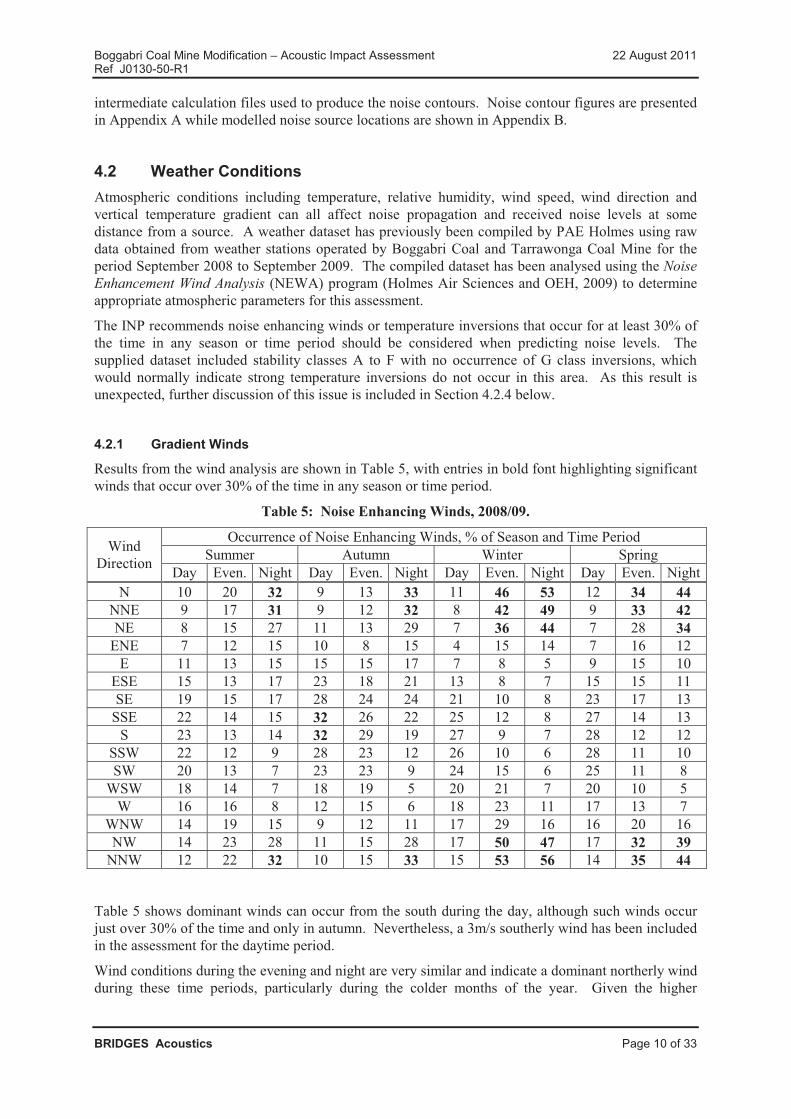
Results from the wind analysis are shown in Table 5, with entries in bold font highlighting significant winds that occur over 30% of the time in any season or time period.
Table 5: Noise Enhancing Winds, 2008/09.
WindDirection
Occurrence of Noise Enhancing Winds, % of Season and Time PeriodSummer Autumn Winter Spring
Day Even. Night Day Even. Night Day Even. Night Day Even. NightN 10 20 32 9 13 33 11 46 53 12 34 44
NNE 9 17 31 9 12 32 8 42 49 9 33 42NE 8 15 27 11 13 29 7 36 44 7 28 34
ENE 7 12 15 10 8 15 4 15 14 7 16 12E 11 13 15 15 15 17 7 8 5 9 15 10
ESE 15 13 17 23 18 21 13 8 7 15 15 11SE 19 15 17 28 24 24 21 10 8 23 17 13
SSE 22 14 15 32 26 22 25 12 8 27 14 13S 23 13 14 32 29 19 27 9 7 28 12 12
SSW 22 12 9 28 23 12 26 10 6 28 11 10SW 20 13 7 23 23 9 24 15 6 25 11 8
WSW 18 14 7 18 19 5 20 21 7 20 10 5W 16 16 8 12 15 6 18 23 11 17 13 7
WNW 14 19 15 9 12 11 17 29 16 16 20 16NW 14 23 28 11 15 28 17 50 47 17 32 39
NNW 12 22 32 10 15 33 15 53 56 14 35 44
Table 5 shows dominant winds can occur from the south during the day, although such winds occur just over 30% of the time and only in autumn. Nevertheless, a 3m/s southerly wind has been included in the assessment for the daytime period.
Wind conditions during the evening and night are very similar and indicate a dominant northerly wind during these time periods, particularly during the colder months of the year. Given the higher

Boggabri Coal Mine Modification – Acoustic Impact Assessment 22 August 2011Ref J0130-50-R1
BRIDGES Acoustics Page 11 of 33
occurrence of this wind during the cold months and the location of the weather station near the mine’s existing surface facilities, it is clear that this result represents a cold air drainage flow associated with a temperature inversion rather than a gradient wind. Evening and night time periods have been combined in this assessment given the similarities between evening and night weather conditions shown in Table 5.
4.2.2 Drainage Flows
Cold air drainage flows tend to flow downhill and, with significant variations in topography across thesite, would change direction depending on the location of the observer. A detailed inspection of topographic features around the Boggabri Coal Mine has indicated the mine itself is located in a depression bounded to the north, east and west by hills, and open to the south. Cold air accumulating in the mining area during the evening and night would therefore tend to run towards the south, and it is this cold air flow that is reflected in the results in Table 5.
Further analysis of topography over the Boggabri Coal Mine indicates the existing train loading facility is located on the southern side of a hill. Drainage flows associated with temperature inversions would therefore also flow from north to south past the train loading facility.
The existing haul road from the mine to the train loading facility crosses the Namoi River floodplainwhich is different from the terrain near the mine and train loading facility. The Namoi River flows from south to north in this area and cold air drainage flows would therefore also flow along the river valley from south to north.
This assessment therefore considers noise enhancement due to a northerly wind for the mine, rail loading facility and locomotives on the existing rail loop. A southerly wind is considered for the existing haul road on the floodplain. Noise contours and predicted noise levels presented in this report for the night wind scenarios represent the noise enhancing effect of both sets of weather conditions.
4.2.3 Adopted Weather Conditions
Table 6 shows adopted atmospheric parameters for this assessment. The adopted weather conditions represent prevailing conditions for receivers in all directions from the site, including those which do not receive a significant occurrence of winds towards them from the site and are therefore assessed under calm wind conditions during the day and temperature inversion conditions during the night.
Table 6: Modelled Weather Conditions.
Atmospheric ParameterDay Evening and Night
Neutral Prevailing Neutral InversionNo wind
Inversionand Wind
Temperature, °C 20 20 15 10 10Relative Humidity, % 70 70 80 90 90Wind Speed, m/s 0 3 0 0 2
Wind Direction - South - - North (mine, rail loop)South (haul road)
Temp Gradient, °C/100m -1 -1 0 3 3

Boggabri Coal Mine Modification – Acoustic Impact Assessment 22 August 2011Ref J0130-50-R1
BRIDGES Acoustics Page 12 of 33
4.2.4 Strong Temperature Inversions
Anecdotal evidence indicates previous noise and atmospheric investigations on other mine sites in the Gunnedah Basin have shown the need to consider stronger temperature inversions that the INP default of 3 °/100m.
Temperature inversions tend to cause increased received noise levels because they refract sound ‘rays’ down towards the ground. Winds also cause increased noise levels, for receivers down wind, for the same reason. Research indicates the effects of inversions and winds are approximately cumulative and the noise model software adopts this approach by combining inversions and winds into an equivalent inversion strength. For the ‘rural’ terrain category in ENM software as used for this assessment, the equivalent inversion strength used for determining received noise levels is calculated by:
Equivalent Inversion °/100m = Inversion °/100m + 2.5 x Wind speed m/s. Equation 1.
Table 6 indicates the night scenarios include a combined 3 °/100m inversion plus a 2m/s wind, from the north for the mine and rail loop and from the south for the haul road across the Namoi River floodplain. According to Equation 1, a 2m/s wind is equivalent to a 5 °/100m inversion for receivers downwind of the source and the night scenarios, with a combined wind and inversion, include an equivalent inversion of 8 °/100m for downwind receivers. This equivalent inversion is significantly stronger, and causes greater noise enhancement, than the INP default 3 °/100m inversion strength.
The combined wind and inversion approach adopted in this assessment satisfies the recommendations in the INP while simultaneously assessing strong temperature inversions for closest receivers located generally south of the mine. Noise levels at receivers generally north and east of the mine are calculated using a 3 °/100, inversion, which is appropriate given the significant ridgeline that exists between the mine and receivers which would prevent a strong inversion forming in this area.
The adopted weather conditions would also result in increased rail loop noise for receivers generally south of the existing rail loop, which is likely to be appropriate given the topography in this area, and for receivers north of the haul road which again is appropriate given the expected southerly drainage flows that would occur in the Namoi River valley.
4.3 Noise Control MeasuresThe following noise control and mitigation measures have been incorporated into the Modification to minimise noise impacts on receivers and to reduce the area of affectation.� All mining trucks would be fitted with best practice exhaust silencers to reduce their noise
emissions;� The overburden fleet would be directed to higher, exposed emplacement areas during favourable
weather conditions (generally during the day) and to lower, more shielded emplacement areas where possible during noise enhancing weather conditions (generally during the evening and night);
� Product haul trucks would be operated at a speed of 90 km/hr during the day and during favourable weather conditions, and at a speed of 50 km/hr during noise enhancing weather conditions in the evening and night to produce a maximum sound power level of 108 dBA per truck at these times. Trucks that are fitted with additional sound suppression equipment or can otherwise operate within the 108 dBA sound power limit at a higher speed may operate at the higher speed at any time;
� Vehicle reverse alarms and horns, equipment start alarms and other audible warning devices would be selected, installed and adjusted to produce the lowest possible noise level consistent with safe operation; and

Boggabri Coal Mine Modification – Acoustic Impact Assessment 22 August 2011Ref J0130-50-R1
BRIDGES Acoustics Page 13 of 33
� Mobile and coal handling equipment would be maintained in good condition to maximiseproductivity and, at the same time, minimise any additional or unnecessary noise.
4.4 Operational Noise SourcesProposed mining operations would rely on a number of items of fixed and mobile equipment to uncover, extract, process and transport coal. Sound power levels for proposed equipment included in the noise model are listed in Table 7 and include the noise reduction measures listed in Section 4.3.
Table 7: Modelled Noise Sources and Sound Power Levels.
Code, Source Octave Band Centre Frequency, dBL * L A63 125 250 500 1k 2k 4k 8k Total TotalCHPP and Transportation Sources
C1, Conveyor 100m 97 96 96 99 99 95 85 75 105.7 102.3C2, Conveyor 200m 100 99 99 102 102 98 88 78 108.7 105.3C5, Conveyor 500m 104 103 103 106 106 102 92 82 112.7 109.3Cpp,Preparation plant 111 112 111 112 112 109 103 94 119.8 115.9FB, ROM feeder breaker 109 107 107 108 105 100 93 83 115.6 109.3Sk, Stacker tripper/chute 105 106 102 102 98 97 90 84 111.7 104.0Tr, Transfer station 111 110 101 101 98 95 87 76 115.9 103.4B, Truck or train loading bin 107 109 103 99 97 94 92 82 113.4 102.8Loi, Locomotive (idling) 100 101 97 93 90 89 80 75 106.2 96.2
Haul truck fleet (90km/h) 130 126 123 114 111 108 104 99 133.3 119.2Haul truck fleet (50km/h) 126 122 118 111 107 103 99 93 130.2 114.7
Mining SourcesS, Rope Shovel 120 115 118 115 113 110 108 99 125.6 118.2Dr, Drill 125 115 106 112 111 111 109 96 128.6 116.9Dz, Dozer 121 121 111 111 110 108 107 101 126.3 115.7E, Excavator 125 121 116 115 116 113 110 103 129.6 120.2L, Loader 121 119 114 109 113 111 104 100 126.0 117.0G, Grader 119 121 119 114 103 104 101 93 126.0 115.2W, Water cart 121 123 121 116 105 106 103 95 128.0 117.2Tf, Truck (flat ground) 119 121 119 116 106 107 104 96 126.0 116.8Tu, Truck (uphill) 111 119 118 117 113 113 106 99 124.5 119.4* dBL means unweighted, as opposed to A-weighted, noise levels. Total dBL and dBA sound power levels are
shown in the last two columns in Table 7.
Sound power levels in Table 7 have been derived from on-site noise measurement data obtained by Spectrum Acoustics where such data were available, or from noise measurements taken around similar equipment on other mine sites. Sound power levels for locomotives travelling at slow speed on a loading loop were measured on a loop at another mine in the Muswellbrook area.
Minor items of equipment that are unlikely to be audible at any receiver under any weather conditions, such as pumps located in the pit or conveyor drives within the coal handling area, have been shown by preliminary noise modelling to have no appreciable effect on received noise levels and have been omitted from the assessment. Figures showing noise source locations for the mine and rail loading facility are included in Appendix B.

Boggabri Coal Mine Modification – Acoustic Impact Assessment 22 August 2011Ref J0130-50-R1
BRIDGES Acoustics Page 14 of 33
4.5 Predicted Mining Noise LevelsNoise levels from future operation of the Modification have recently been assessed as described in the Continuation of Boggabri Coal Mine Environmental Assessment (Boggabri EA) (Hansen Bailey, 2011). The Boggabri EA included an assessment of noise levels at 1, 5, 10 and 21 years with a production rate of up to 7 Mtpa of product coal. Noise levels during the 2 year extension proposed in this Modification would be similar in many respects to noise levels described for years 1 and 5 in the Boggabri EA subject to the following comments:
� Noise levels reported for year 1 in the Boggabri EA, including noise from product haul trucks,would apply directly to this assessment; and
� Noise levels reported for year 5 in the Boggabri EA were for a proposed production level of 6.9 Mtpa, compared to a maximum production level of 3.5 Mtpa proposed in this Modification. A correction factor of -2.5 dBA applied to the Boggabri EA results would therefore be appropriate for this Modification. As the Modification seeks approval for a 2 year period rather than 5 years, the year 5 results in the Boggabri EA would conservatively overstate predicted noise levels during the 2 year Modification.
Predicted noise levels for year 1 have therefore been calculated based on the year 1 mine plan described in the Boggabri EA. Predicted noise levels for year 2 have been calculated based on the year 5 mine plan in the Boggabri EA, with a correction factor of -2.5 dBA for a maximum production rate of 3.5 Mtpa.
Noise contour figures showing predicted noise levels for years 1 and 2 under neutral and prevailing weather conditions are included in Appendix A while detailed tables of noise levels at potentially affected receiver locations are presented in Appendix C. Predicted noise levels include normal mining activity, coal processing, road haulage of coal to the existing rail loading facility, operation of the rail loading facility and three locomotives operating at low speed on the loading loop.
Table 8 presents a summary of results to residences and over 25% of contiguous properties. Noise levels in the table have been shaded based on predicted exceedances of the noise criteria. Residencesand properties that are owned by a mining company or are not predicted to be affected by noise from the Modification have been excluded from the table.
Results in Table 8, excluding properties under negotiation with a mining company, indicate:
� Two residences (67 Goonbri and 52 Jeralong) and three other properties (13,14 Horse Shoe, 53,79,81,82,84,86 Northam/Kyalla and 87 Templemore) are predicted to receive moderate noise impacts. Two moderately affected properties also contain mildly affected residences (68 Goonbri and 86 Kyalla); and
� Five other properties (23-27,29,31,36 Cooboobindi, 28,30 Bullock Paddock, 48 Wilboroi East, 78,80 BJ Cosby and 116 RA & CM Collyer) are predicted to receive mild noise impacts from the Modification.
Table 8: Summary of Predicted Noise Levels, LAeq,15min
OwnerID
Residence 25% of Property Area
Resi-dence
ID
Day Neutral Day Evening/ Night Property ID
Day Neutral Day Evening/ Night
Year Year1 2 1 2 1 2 1 2 1 2 1 2
13 - - - - - - - 13,14 35.3 35.8 37.5 38.0 37.2 37.8
14 23 30.8 30.3 30.8 30.3 32.7 32.6 23-27,29,31,36 34.6 34.1 34.6 34.1 35.3 35.127 33.0 32.5 33.0 32.5 33.9 33.915 - - - - - - - 28,30 34.4 34.9 34.4 33.9 35.1 34.9

Boggabri Coal Mine Modification – Acoustic Impact Assessment 22 August 2011Ref J0130-50-R1
BRIDGES Acoustics Page 15 of 33
OwnerID
Residence 25% of Property Area
Resi-dence
ID
Day Neutral Day Evening/ Night Property ID
Day Neutral Day Evening/ Night
Year Year1 2 1 2 1 2 1 2 1 2 1 2
21 67 21.5 20.9 33.1 26.3 36.9 37.4 67,68,102 19.2 19.4 32.6 29.2 34.9 36.468 19.5 19.6 33.4 28.2 36.0 37.0
26 54 27.5 28.0 27.5 28.0 39.9 39.5 54,55,83 26.2 26.2 26.2 26.2 39.6 38.8- - - - - - - 95,96 21.3 21.6 21.3 21.6 33.4 33.0
31 - - - - - - - 48 26.5 25.4 26.5 25.4 35.3 36.532 52 27.4 26.1 27.4 26.1 37.1 38.0 51,52 28.1 26.8 28.1 26.8 37.5 38.4
33 79 23.4 22.9 23.4 22.9 33.3 34.7 53,79,81,82,84,86 25.5 25.7 25.5 25.7 37.4 37.186 22.3 22.5 22.3 22.5 36.1 35.239 - - - - - - - 78,80 26.2 26.2 26.2 26.2 36.9 37.040 - - - - - - - 87 21.3 22.1 21.3 22.1 39.2 37.041 88 20.1 20.9 20.1 20.9 35.3 34.1 88 20.1 20.6 20.1 20.6 34.8 33.651 - - - - - - - 116 17.6 16.6 17.6 16.6 35.3 33.0
Contour Figure A1 A4 A2 A5 A3 A6 - A1 A4 A2 A5 A3 A6Number of
affected residences/ properties
0 0 0 0 0 0 Significant 0 0 0 0 0 00 0 0 0 1 2 Moderate 0 0 1 1 4 30 0 0 0 3 2 Mild 1 1 0 0 5 5
Red – Significant noise impact of more than 5 dBA over the criterionBlue – Moderate noise impact of up to 5 dBA over the criterionGreen – Mild noise impact of up to 2 dBA over the criterionPurple – Under negotiation with a mining company
4.6 Existing Measured Noise LevelsBoggabri Coal commissioned Spectrum Acoustics (Spectrum) to measure existing mining noise levelsat representative receiver locations around the Modification Boundary. Spectrum completed two noise surveys, in March 2011 and June 2011, with the following results:
� Measured Boggabri Coal noise levels were within the 35 LAeq,15min criterion at all assessed residences in March; and
� Measured Boggabri Coal noise levels were within the 35 LAeq,15min criterion at all assessed privately owned residences in June with the exception of 67 Goonbri. A noise level of 38 LAeq,15min was measured at ‘Goonbri’ during the evening of 23 June 2011 due to mining activity under noise enhancing weather conditions.
The measured mining noise level of 38 LAeq,15min at 67 Goonbri is consistent with the predicted noise level of 38 LAeq,15min listed in Table 8.
4.7 Construction NoiseConstruction work would be required for the following facilities.� Approved extensions to the administration, bathhouse and workshop buildings; and� Construction and use of a heavy vehicle workshop.
Table 9 shows typical construction noise sources required to complete the proposed works, assuming all machines operate continuously at full power to present a worst case assessment. The earthmoving

Boggabri Coal Mine Modification – Acoustic Impact Assessment 22 August 2011Ref J0130-50-R1
BRIDGES Acoustics Page 16 of 33
phase of the construction program is included in Table 9 as it represents the loudest construction component.
Table 9: Typical Construction Sources and Sound Power Levels.
Project Typical Construction MachinesSound Power Level, dBA
Per Machine Total
Office, bathhouse, workshops
(earthmoving phase)
Truck 108
118Excavator 112Grader 112Roller 110Backhoe/bobcat 110
Upgrades to the office, bathhouse and workshop facilities would occur at least 4.8 km from any privately owned residence. The expected construction sound power level of 118 dBA would produce less than 35 LAeq,15min at any residence, under all daytime weather conditions, which is acceptable.
4.8 Sleep Disturbance4.8.1 Noise Sources
Coal mining primarily involves a number of diesel powered machines operating to remove overburden and extract coal. Most machines have very little potential to produce noises likely to disturb sleep. Other machines such as shovels and dozers can produce intermittent louder noise depending on working conditions, machine condition and operator actions.
Noise measurements on other mine sites indicate a shovel gate can produce a wide range of noise levels, with a sound power level in the range 125 to 128 dBA representing a typical maximum for this source. The level of noise a dozer can produce in reverse depends on a number of factors including machine type, condition, speed and ground conditions, with a sound power level in the range 125 to 130 dBA representing a typical maximum for this source.
Other sources of potential sleep disturbance include raw coal being dumped from a truck or loader into a steel ROM hopper, vehicle horns and equipment alarms. Noise measurements on other mine sites indicates these sources tend to produce a sound power level in the range 115 to 120 dBA, although the proposed vehicle horns and alarms would be significantly quieter.
This discussion indicates dozer tracks are generally the loudest sources of potential sleep disturbancewithin the mine, followed by shovel gates. Received noise levels from these sources depend on the location of the source and receiver. Dozer track noise can occur from within the mining area and from within the rail loading facility.
4.8.2 Calculated Noise Levels
Figure A7 in Appendix A shows the 60 LAmax and 45 LAmax contours, which relate to current and historical sleep disturbance criteria, produced by the following sources:
� Dozer track noise within the mining area for all assessed years;
� Dozer track noise within the existing rail loading facility; and
� Maximum passby noise from a truck on the haul road from the mine to the rail loadout facility.
Figure A7 shows the previous 45 LA1,1min sleep disturbance criterion may be exceeded at residences 23 and 27 while the more recent 60 LA1,1min criterion would be met at all residences.

Boggabri Coal Mine Modification – Acoustic Impact Assessment 22 August 2011Ref J0130-50-R1
BRIDGES Acoustics Page 17 of 33
Properties 23 and 27 are included in Table 8 and are already identified as being mildly affected bynoise from the Modification.
Maximum noise levels from coal truck movements along the haul road would not increase above current levels, as additional truck movements per hour do not increase the maximum passby level. Calculated maximum noise levels are therefore consistent with current approvals.
4.9 Road Traffic NoiseThe Modification includes a production rate to 3.5 Mtpa which is below 5 Mtpa as considered in the EIS. Proposed road traffic noise levels due to the Modification would therefore be consistent with the EIS and current road traffic noise levels.
4.9.1 Receivers and Traffic Flows
The Mine access route would continue to be from the Kamilaroi Highway via Manilla Road and Leard Forest Road. Closest residences to the access route are Residence 33 approximately 500m north of Manilla Road, Residence 90 approximately 420m south of Manilla Road and Residence 52 approximately 390m east of Leard Forest Road. The Modification is assumed to include employment for up to 400 full time staff and a reasonable worst case traffic noise assessment would assume two thirds of the staff would either enter or leave the site in a period of one hour. An operational traffic noise assessment is therefore based on 270 car movements per hour along the access route, assuming a worst case situation where most staff travel separately to the site. The assessed situation is most likely to occur at shift changeover times which would occur two or three times per day, during the day and night.
A number of truck movements along the access route are also required for delivery of fuel and lubrication products, spare parts, gravel and other civil products. Such deliveries are usually intermittent and occasional, although fuel deliveries would occur on a fairly regular basis. A reasonable worst case assessment would assume two heavy trucks would enter and leave the site in a one-hour period.
4.9.2 Assessment
Based on the assumed 300 car and 4 truck movements per hour, the following traffic noise levels have been calculated.� Residence 33 41.8 LAeq,1hr;� Residence 90 42.5 LAeq,1hr; and� Residence 52 42.8 LAeq,1hr.
As Project-related traffic flows represent most of the traffic on the access route, non-project traffic flows would have an insignificant effect on traffic noise levels and do not need to be specifically considered. Calculated traffic noise levels are acceptable compared to the 55 LAeq,1hr day and 50 LAeq,1hr night criteria and no traffic noise control measures are required or recommended.
4.10 Rail Traffic NoiseThe Modification includes a production rate of 3.5 Mtpa which was considered in the EIS. While current rail traffic levels are lower than anticipated due to the historically lower production levels, proposed train movements due to the Modification would be consistent with the EIS and current approvals.

Boggabri Coal Mine Modification – Acoustic Impact Assessment 22 August 2011Ref J0130-50-R1
BRIDGES Acoustics Page 18 of 33
The 2009-2018 Hunter Valley Corridor Capacity Strategy – Consultation Document (ARTC, 2009) includes the following data regarding train movements from Narrabri to Curlewis:
� 12 train movements per day from Narrabri to Boggabri;
� 14 train movements per day from Boggabri to Gunnedah; and
� 20 train movements per day from Gunnedah to Curlewis;
An average of two train movements per day to and from the existing Boggabri Coal Mine is included in the ARTC data. The Project would require up to two trains per day (an average of 3 train additional movements per worst-case day) to transport up to 3.5 Mtpa of product coal, which represents less than a 10% increase in train movements from Boggabri to Curlewis and an increase in worst case train noise levels of 0.3 LAeq,15hr day and LAeq,9hr night. Maximum passby noise levels would not change as a result of the Project assuming all trains produce a similar maximum noise level.
A 0.3 dBA increase in worst case train noise levels at all potentially affected residences near the Werris Creek Railway represents a very minor noise impact and is therefore considered acceptable.
4.11 Low Frequency Noise4.11.1 Mining Sources
A modifying factor of 5 dBA has been applied to modelled mining and transportation sources where relevant so no further analysis of low frequency noise levels is required under the INP.
4.12 Blast Overpressure and Vibration4.12.1 Previous Blast Monitoring
Explosive blasting is currently used at Boggabri Coal Mine to fragment overburden and this practice would continue at a rate consistent with the proposed increase in annual coal production. Boggabri Coal currently operates a blast monitoring system using monitors installed at Bollol Creek Station to the south east and Greenhills to the east, with both of these properties owned by Whitehaven Coal.Overpressure and vibration monitoring results reported in the 2010 Boggabri Coal AEMR have been reviewed to determine the mine’s recent blasting history.
Section 3.6.1 of the AEMR shows peak vibration levels produced by blasts in 2009-10. The monitored results show a maximum vibration level of 2.0mm/s Peak Particle Velocity (PPV) compared to the 5 mm/s criterion.
Section 3.6.2 of the AEMR similarly presents monitored overpressure levels during 2009-10. The results show maximum overpressure levels of 114 dBL at both Bollol Creek Station and Greenhillscompared to the 115 dBL criterion. Bollol Creek Station is located approximately 4.5 km from the 2008 blast sites while Greenhills is approximately 4 km from the blast sites.
Privately owned properties are further from the existing mining area and therefore currently receive lower vibration and overpressure levels.
4.12.2 Ground Vibration Analysis
Analysis of the AEMR blast results indicates ground vibration levels are consistent with, or a little lower than, expected vibration levels considering typical Maximum Instantaneous Charge (MIC) weights in the range 1500 to 2500 kg as used in open cut coal mine blasts.

Boggabri Coal Mine Modification – Acoustic Impact Assessment 22 August 2011Ref J0130-50-R1
BRIDGES Acoustics Page 19 of 33
Calculations based on Appendix J of Australian Standard 2187.2-1993 indicate ground vibration levels would remain within the 5 mm/s criterion for blasts 1700m from a residence, based on an MIC of 3000 kg and ground coefficients of K=1140 and b=1.6.
With the closest privately owned residence (67 Goonbri) at least 3.9 km from proposed blasts, ground vibration levels are not expected to exceed 2 mm/s PPV which is well within the 5 mm/s criterion. No additional vibration control measures are expected to be required although ongoing blast monitoring is recommended to ensure vibration levels remain acceptable.
4.12.3 Overpressure Analysis
Analysis of the AEMR blast results indicates overpressure levels in 2009-10 reached a maximum level of 114 dBL at monitoring locations approximately 4 km from the blast site. Proposed blasts would be a minimum of 3.9 km from privately owned properties and, assuming the same blast practises continue, would produce a maximum overpressure level of 114.2 dBL and most overpressurelevels below 110 dBL. Most residences would remain over 4.8 km from proposed blasts and are expected to receive less than 112 dBL for all blast events and less than 107 dBL for most blast events.
As the predicted worst case overpressure levels would approach the 115 dBL criterion at closestreceivers, ongoing blast monitoring is recommended to ensure overpressure levels remain acceptable.
The proposed increase in mine production would require additional, rather than larger, blasts. Available data indicate a total of 71 blast events occurred in 2008, for a production rate of approximately 2.3 Mtpa of coal. At a proposed maximum production rate of 3.5 Mtpa, approximately 110 blast events per year would be required which is an average of just over 2 events per week.
4.12.4 Buildings
Blast noise and vibration criteria are designed to provide an acceptable level of personal comfort for residents and other sensitive receivers. Noise and vibration criteria to minimise the chance of residential building damage are an order of magnitude higher than the criteria and the levels currently experienced by closest receivers. The proposed blasting program therefore offers an extremely low chance of even superficial or cosmetic damage to privately owned residences. This means structural members within each residence absorb the vibration in an elastic manner, without yielding or suffering permanent damage or change, which in turn means the vibration could theoretically continue indefinitely with no noticeable change to the building structure.
An increase in the average number of blast events per week as a result of the Modification would therefore be unlikely to result in any damage to residences or other buildings.
4.12.5 Cumulative Blast Impacts
Potential cumulative impacts from blasting would normally be limited to an increase in the average number of blasts per day noticed by residents, with a very low chance of blast events at two or more mines occurring simultaneously.
Nevertheless, Boggabri Coal should coordinate blasting schedules with other mines within a 10km radius to avoid any potential for simultaneous blast events. All blast events associated with the Modification would be designed to meet relevant overpressure and ground vibration criteria. Potential cumulative impacts, in the form of additional blast events per day from two or more nearby mine sites, would not increase maximum overpressure or ground vibration levels so would not result in exceedances of relevant criteria.

Boggabri Coal Mine Modification – Acoustic Impact Assessment 22 August 2011Ref J0130-50-R1
BRIDGES Acoustics Page 20 of 33
4.13 Cumulative Noise LevelsCumulative noise impacts would potentially be caused by simultaneous operation of the Modificationand other nearby industrial developments such as the existing Tarrawonga Coal Mine to the south.Existing noise levels from Tarrawonga Coal Mine have been considered in Section 3.1 when determining Modification noise criteria and no further cumulative assessment of existing Tarrawonga Coal Mine noise levels is required.
Aston Resources has recently submitted an application to develop the Maules Creek Coal Mine in the northern section of the Leard State Forest. The Maules Creek Coal Mine Environmental Assessment (Hansen Bailey, 2011) includes a cumulative noise impact assessment and concluded no cumulative noise impacts with Boggabri Coal Mine were likely to occur. As the Modification would advance generally to the east rather than towards the proposed Mauls Creek Mine during the proposed 2 year extension period, no cumulative noise impacts are likely to occur at any receiver.
5 CONCLUSIONThis assessment shows noise levels from the Modification are not expected to cause significant noise impacts at any residence or over any property, however mild and moderate noise impacts are predicted at some privately owned residences:
� Two residences (67 Goonbri and 52 Jeralong) and three other properties (13,14 Horse Shoe, 53,79,81,82,84,86 Northam/Kyalla and 87 Templemore) are predicted to receive moderate noise impacts. Two moderately affected properties also contain mildly affected residences (68 Goonbri and 86 Kyalla); and
� Five other properties (23-27,29,31,36 Cooboobindi, 28,30 Bullock Paddock, 48 Wilboroi East, 78,80 BJ Cosby and 116 RA & CM Collyer) are predicted to receive mild noise impacts from the Modification.
Sleep disturbance from impact sources within the mine such as a shovel gate and dozer tracks is unlikely to occur considering the large distance from the mine to closest receivers. Truck movements on the existing haul road have the potential to disturb sleep for closest residents according to previous sleep disturbance criteria but would not affect these residents according to current criteria. Maximum noise levels due to truck movements on the haul road would not change from current levels.
Noise from road traffic and rail traffic would be consistent with current approvals and would remain acceptable compared to current noise criteria.
The Modification would not cause an increase in current acceptable levels of low frequency noise.
Blasting associated with the Modification is expected to produce ground vibration and overpressure levels below relevant amenity criteria at all privately owned residences. Blast monitoring at closest residences, or at other representative locations, is proposed to confirm ongoing compliance with blast criteria.

Boggabri Coal Mine Modification – Acoustic Impact Assessment 22 August 2011Ref J0130-50-R1
BRIDGES Acoustics Page 21 of 33
APPENDIX A – NOISE CONTOUR FIGURES
FIGURE DESCRIPTIONA1 Year 1 Day, neutral weather conditionsA2 Year 1 Day, prevailing weather conditionsA3 Year 1 Evening/Night, prevailing weather conditionsA4 Year 2 Day, neutral weather conditionsA5 Year 2 Day, prevailing weather conditionsA6 Year 2 Evening/Night, prevailing weather conditionsA7 Year 1 & 2 Night, sleep disturbance LAmax, prevailing weather conditions

Boggabri Coal Mine Modification – Acoustic Impact Assessment 22 August 2011Ref J0130-50-R1
BRIDGES Acoustics Page 22 of 33
Figure A1: Year 1 Day, Neutral Weather Conditions

Boggabri Coal Mine Modification – Acoustic Impact Assessment 22 August 2011Ref J0130-50-R1
BRIDGES Acoustics Page 23 of 33
Figure A2: Year 1 Day, Prevailing Weather Conditions

Boggabri Coal Mine Modification – Acoustic Impact Assessment 22 August 2011Ref J0130-50-R1
BRIDGES Acoustics Page 24 of 33
Figure A3: Year 1 Evening/Night, Prevailing Weather Conditions

Boggabri Coal Mine Modification – Acoustic Impact Assessment 22 August 2011Ref J0130-50-R1
BRIDGES Acoustics Page 25 of 33
Figure A4: Year 2 Day, Neutral Weather Conditions

Boggabri Coal Mine Modification – Acoustic Impact Assessment 22 August 2011Ref J0130-50-R1
BRIDGES Acoustics Page 26 of 33
Figure A5: Year 2 Day, Prevailing Weather Conditions
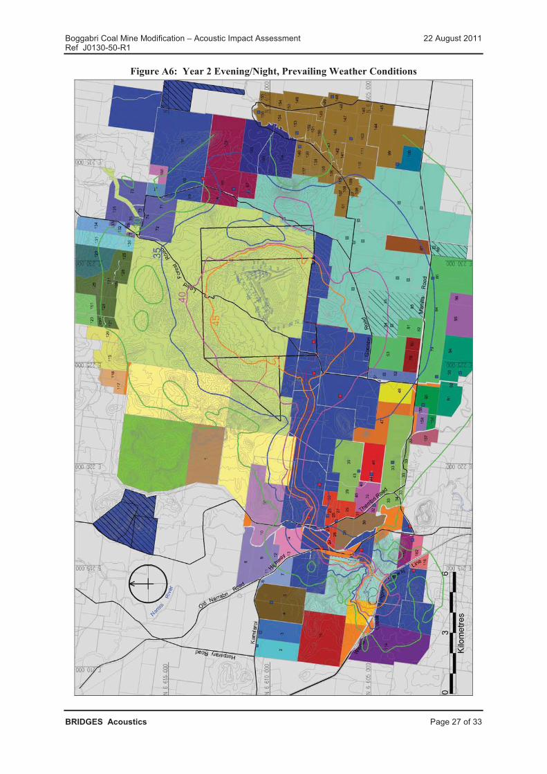
Boggabri Coal Mine Modification – Acoustic Impact Assessment 22 August 2011Ref J0130-50-R1
BRIDGES Acoustics Page 27 of 33
Figure A6: Year 2 Evening/Night, Prevailing Weather Conditions

Boggabri Coal Mine Modification – Acoustic Impact Assessment 22 August 2011Ref J0130-50-R1
BRIDGES Acoustics Page 28 of 33
Figure A7: All Years Night, Sleep Disturbance LAmax, Prevailing Weather Conditions

Boggabri Coal Mine Modification – Acoustic Impact Assessment 22 August 2011Ref J0130-50-R1
BRIDGES Acoustics Page 29 of 33
APPENDIX B – NOISE SOURCE LOCATION FIGURES
FIGURE DESCRIPTIONB1 Year 1 Mine Day noise source locationsB2 Year 1 Mine Evening/Night noise source locationsB3 Year 2 Mine Day noise source locationsB4 Year 2 Mine Evening/Night noise source locationsB5 All Years, Rail Loading Facility noise source locations
Figure B1: Year 1 Mine Day Noise Source Locations

Boggabri Coal Mine Modification – Acoustic Impact Assessment 22 August 2011Ref J0130-50-R1
BRIDGES Acoustics Page 30 of 33
Figure B2: Year 1 Mine Evening/Night Noise Source Locations

Boggabri Coal Mine Modification – Acoustic Impact Assessment 22 August 2011Ref J0130-50-R1
BRIDGES Acoustics Page 31 of 33
Figure B3: Year 2 Mine Day Noise Source Locations

Boggabri Coal Mine Modification – Acoustic Impact Assessment 22 August 2011Ref J0130-50-R1
BRIDGES Acoustics Page 32 of 33
Figure B4: Year 2 Mine Evening/Night Noise Source Locations

Boggabri Coal Mine Modification – Acoustic Impact Assessment 22 August 2011Ref J0130-50-R1
BRIDGES Acoustics Page 33 of 33
Figure B5: All Years, Rail Loading Facility Noise Source Locations

APPENDIX C
Soil Survey and Land Resource Impact Assessment

�

��������
���������
�������� ����� ������������� �� ���� �� ���������� �
����������� ���� �������� ������ ������ �������

�� ����������������������������
������� ������� ������ � ��� ����� �����������������
�� ���� �� ��� ����������� �
������ !�� "��"��#$� %"�� &'��% "$$$$$$$$$$$$$$$$$$$$$$$$$$$$$$$$$$$$$$$$$$$$$$$$$$$$$$$$$$$$$$$$$$$$$$$$$$$$$$$$$$$$$$$$$$$$$$$$$$$$$$$$$$$$$$$$$$$$$$$$$$$$$$$$$$$$$$$$$$$$$$$$$$$$$$$$$$$$$$$$$$$#
��� ������� �����������������������������������������������������������������������������������������������������������������������������������������������������������������������������
��! ��"�#�$"%& �����������������������������������������������������������������������������������������������������������������������������������������������������������������������!
��' ($)* +$)$#�+�)� ,)��� ����������������������������������������������������������������������������������������������������������������������������������������������������!
($� ��)�*���*�+,++�� $$$$$$$$$$$$$$$$$$$$$$$$$$$$$$$$$$$$$$$$$$$$$$$$$$$$$$$$$$$$$$$$$$$$$$$$$$$$$$$$$$$$$$$$$$$$$$$$$$$$$$$$$$$$$$$$$$$$$$$$$$$$$$$$$$$$$$$$$$$$$$$$$$$$$$$$-
!�� �)���*,����)����������������������������������������������������������������������������������������������������������������������������������������������������������������������'
!�! ���( +$""�)# ����������������������������������������������������������������������������������������������������������������������������������������������������������������������'
!�' ���( "��-�(�)# ��������������������������������������������������������������������������������������������������������������������������������������������������������������������'
!�� ���( -��(* $�����+�)���������������������������������������������������������������������������������������������������������������������������������������������������������
!�� ($)* �$"$��(��& $�����+�)� ����������������������������������������������������������������������������������������������������������������������������������������������
!� $#���,(�,�$( �,��$��(��& $�����+�)�������������������������������������������������������������������������������������������������������������������������������
-$� )*���� $$$$$$$$$$$$$$$$$$$$$$$$$$$$$$$$$$$$$$$$$$$$$$$$$$$$$$$$$$$$$$$$$$$$$$$$$$$$$$$$$$$$$$$$$$$$$$$$$$$$$$$$$$$$$$$$$$$$$$$$$$$$$$$$$$$$$$$$$$$$$$$$$$$$$$$$$$$$$$$$$$$$$$$$$$$$$$$$$$$�
'�� ���(� �����������������������������������������������������������������������������������������������������������������������������������������������������������������������������������.
'�! ��"*�����)# �,��$��(��& / $ $�($��(��&����������������������������������������������������������������������������������������������������������������������������0
'�' ������) "���)��$( ������������������������������������������������������������������������������������������������������������������������������������������������������������0
'�� "���)��$( $��* #�)��$��)# +$����$( ������������������������������������������������������������������������������������������������������������������������������0
'�� ($)* �$"$��(��& ������������������������������������������������������������������������������������������������������������������������������������������������������������������
'� $#���,(�,�$( �,��$��(��&���������������������������������������������������������������������������������������������������������������������������������������������������
.$� , ���)/0�1*��0�0�*�*�� $$$$$$$$$$$$$$$$$$$$$$$$$$$$$$$$$$$$$$$$$$$$$$$$$$$$$$$$$$$$$$$$$$$$$$$$$$$$$$$$$$$$$$$$$$$$$$$$$$$$$$$$$$$$$$$$$$$$$$$$$$$$$$$$$$$$$$$$$$$$$#(
��� ��"���( ����""�)#�$)* %$)*(�)# ��������������������������������������������������������������������������������������������������������������������������������������!
��! ��"���( ��1�"��$*�)#�������������������������������������������������������������������������������������������������������������������������������������������������������'
��' ($)*-��+ *���#)2 ������) ��)���(�$)* ���*�)# ����������������������������������������������������������������������������������������������������������'
����� ������ ������������������������������������������������������������������������������������ ��
����� ��������������������� ��������������������������������������������������������������������� ��
����� ����������������� ������������������������������������������������������������������������������ ��
2$� )*3*)*�1*�$$$$$$$$$$$$$$$$$$$$$$$$$$$$$$$$$$$$$$$$$$$$$$$$$$$$$$$$$$$$$$$$$$$$$$$$$$$$$$$$$$$$$$$$$$$$$$$$$$$$$$$$$$$$$$$$$$$$$$$$$$$$$$$$$$$$$$$$$$$$$$$$$$$$$$$$$$$$$$$$$$$$$$$$$$#2
������
������ 4 �'������"&���5��%�%�6�������� $$$$$$$$$$$$$$$$$$$$$$$$$$$$$$$$$$$$$$$$$$$$$$$$$$$$$$$$$$$$$$$$$$$$$$$$$$$$$$$$$$$$$$$$$$$$$$$$$$$$$$$$2
������� 4 ���%�'��'�����'%���%�%�6�������� $$$$$$$$$$$$$$$$$$$$$$$$$$$$$$$$$$$$$$$$$$$$$$$$$$$$$$$$$$$$$$$$$$$$$$$$$$$$$$$$$$$$$$$$$$$$$$$$$�
������7 4 ���6��� 8"����&��% "���� ���5� !%��$$$$$$$$$$$$$$$$$$$$$$$$$$$$$$$$$$$$$$$$$$$$$$$$$$$$$$$$$$$$$$$$$$$$$$$$$$$$$$$$$$$$�
������� 4 �%������ 8"�'"%! �� ���9���6���"&�5� !%�� $$$$$$$$$$$$$$$$$$$$$$$$$$$$$$$$$$$$$$$$$$$$$$$$$$$$$$$$$$$$$$$$$$$$$$�
������� 4 ��� ���"&�&����%55%"��&�5��� $$$$$$$$$$$$$$$$$$$$$$$$$$$$$$$$$$$$$$$$$$$$$$$$$$$$$$$$$$$$$$$$$$$$$$$$$$$$$$$$$$$$$$$$$$$$$$$$$$$$$#�

�� ����������������������������
������� ������� ������ � ��� ����� �����������������
�� ���� �� ��� ����������� ��
5�����
5����� 4 ���6��� 8"����&��% "���� ���5� !%�� �������������������������������������������������������������������� �
5������ 4 ���6��� 8"����&��% "���� �����"&���5� ������������������������������������������������������������� �
5�����7 4 �%������ 8"�'"%! �� ���9���6���"&�5� !%�� �������������������������������������������������������
5������ 4 �%������ 8"�'"%! �� ���9���6���"&���"&���5� ������������������������������������������������
!%�'���
!%�'��� 4 � %���65������������������������������������������������������������������������������������������������������������������������������� �

�� ����������������������������
������� ������� ������ � ��� ����� %�������� ��
�� ���� �� ��� 3�4����� �
� %"�� &'��% "
����5��������6�4�������7� ����5��������� �����89���4��8 �7���5��7���4��:� �7�����������������;�����<��
6�4� ������7� 89�<9� �=������� �9�� ����5��� ����� 3� �� ����5��� ����� �=������� � � �<<��7� <�� 8��9
������=�� ���� �� ������������ 7����9� � ��� � ������� � ��� �������� ���������� �6����<���
����5�������������<���7����>��������� ���9�������:�����5���� ��9������9�?����;���� ��:��?� � �����
����5��������=��7�<�7�����3����� ��� ����:�=��7�<��<����:�����9��3����������>��������� �7�8 �����9�
3�����8 �<���������
�� �� � ����4� 6�4� ��7� �� �� � ����4�� 9��� 5�� � <�������� �7� 54� ����5��� ���� ��� =��=���� �
� ���� �� ������������ �� ���������7�:4��9��������=�� ���� �� ��� 7����<��� ���?��:��9���6����<��
@9�����7�:�<���� ������A����7��������8�����5�����������<� �� ��������� � ���=������ ��:�����:���9����8��4����
:����8� ���9���B=��4��: ����<���� ��<� �� ��� ���������5��������
� =�<�:�<���4��9����7�:�<���� �8���7�� <��7���9��:����8� ��
� �B�� 7� ���9���==������=����7��:����������54���:���9����8��4�����
� �� �� ����� ��:������:������B���� ��� :������<������ 7�:�<��������
� �� �� �� ������� ��<��������=��������3�=��=��7�<��<����
� �� ����<��� � � 7� ���� �:� �==����7� �B�� ��� �� ��� �9�� �7�� �������� �� 5��99����� � 7� 8��>�9�=
5���7� ���
� �� ����<��� �� 7������:���9���4���9�<���8��>�9�=��� 7
� �� ����<��� �� 7������:�8������� ����� ��� :������<�����
����9���7������������7� ���9����7�:�<���� ��� <��7� ����=�� ��9�8� ���9��<���� ��4��==����7��� � �������� 7
�9��=��=���7��B�� ��� ���������� <��7�7�� ��9����� ���������:��9������5��������3�7�:�<���� ����
@9�����=����9���5�� �<�������� �7�54 �� �� �����4�� �5�9��:��:�����5�������� �����������9� ������ 7
�� 7�<�=�5����4 ��=�<������=�����:��9� ����5��������3�7�:�<���� ���� @9�����=����� <��7���� ��������� ���:
������ 7��� 7�<�=�5����4���=�<�������<����7�8��9��9��3�7�:�<���� ����<���� � �?���=����� ���:�@��7��� 7
� ������ ��� ;���� ��� � :������<����� � 7� ����<��� �@�;�� :������4� �9� ��=����� �� �:� � ���� �� ��
���������9� �����?����� ���7��� ���� 7�=���<����7��<��5�7�5���8�
@9� 3�7�:�<���� ����������9�8 �� ! ������
� �:��� ;��
@�� ������ ����5�� ���� 8��9 �9� 5����� �� ���74�� ��=�<�� �������� �� � 7 =������ � �� ��9�5��������
�<�����������������4��:��� 7�������<�� 8���� 7����>� �54�� � 7�=���� ��7�� ��9��:����8� ����=�����
� � ��������� �� ����� ��:�����5��������3� ��6��C�<��� ���� �� ������������ �����������4
� 7��� 7�;�����<����=�<���������� ��;�=����
� �� �� �����4� ��������� �� ����� ��:�����5��������3� ���;��=� �������5������ ��
� �� �� �����4� ��������� �� ����� ��:�����5��������3� ���;���7����3�������;�=����
@9����C�� �5C�<�������:��9� �������� �� � 7����>� �54�� 8��� ���

�� ����������������������������
������� ������� ������ � ��� ����� %�������� ��
�� ���� �� ��� 3�4����� �
� =����7�� �� 7��<��=��� � �:� �9�� ����� �4=�� 8��9� � �9� 6��C�<�� �� 7��4�� � 7� 9��9���9�� ������ �:
� :������5�� ���������89�<9���A������=�<�:�<��� ����� ��� 7�9� 7�� ��=��<��<���
� =����7����7��<��=��� �:��� 7�:��������9�8� �� �9�� �� 7�<�=�5����4�� 7�����<�������������5����4�8��9�
�9� 6��C�<���� 7��4�
� =����7�� ��<���� 7���� �� :��� ����==� �� 7�=�9� :��� =��=���7� 7�����5� <�� ������� � <��7� �� � 4
��<���� 7���� ��:�� 9� 7�� �� ���<>=��� � � 7������������ :���������� ���9�5�������� � � 7
� 7��<��5� �<�����4������� �� 7���7��� ��<� ���� �������� ����� ���� � ������� 7����<>=���7�����
������<���
@9��:����8� ����=����=���� ����9�����������:� �9�������4�� 7����>� �54���� 7��9���������� ���: �� 7
������<���8��9� ��9� 3�7�:�<���� ��� 7��4�
�� ��<����<=>
@9� 3�7�:�<���� �� 7��4 <������� �������:��==��B������4������ 9��8��9� � �9� ����7������������� @9�
��=����=94� �:� �9� 3�7�:�<���� ��� 7��4� <� ��� ����7������ ���=��� � 7� 7��� ���� �� ���8��9� �� �� �����4
8����� ���=�<�� @9�� ��������� 7��9����� �=���7��=��4� � � �����=��7�<� ����� �����5����4�<9� ���=�����
��� ����� 7����� ���������� ����8�9�����8��9 ���7�7�������� � �� D �������=���
�7 ����������������'� ��
� � 3��<9� ����� �9�� ������ ���<9�� �� 3� ����� �� ���9����4� �3��� <�����7� �� ��=� �����7� E�� 7
3� ����� �� F ���� �3F�� � � �9�� ������ ���<9�� �G�� @9��� ��=� 8��� ���7� ��� �7� ��:4 � �� ��� � �� 7
�� ����� ��� �� :�� 7�8��9� ��9� 3�7�:�<���� ��� 7��4�����7��<��5�7�5���8 �������3��������
��� ������>����<������������>�� � �� ���<��
�7��� ���4� ���=����:� �� �����4 � D ���� �<<��� �:�� �5���8��3F��7��� ���4������ @�=� �������7���=�
89�<9�:�� �����9��=��� ��� 7�:������=����@9���� ��������� <��7���������8��9����=����:�������9� �����5���89�<9
9���� ���4� �9����8� ������ � 7� �9���:���� 9���� ������7� <�=�5����4� @9��� �3F ��� <9���<������7� 54���7������4
�9����8������� ���9������� 7��>���������7 � 5��8 �����9���� 7���<>4����<��=��8��9��� �������=����=���� 7
��8��<��:: � ��>��5� <9����@9��������� �4��� ���8������5���=��5������ �������:� �9�� ��8������=���� ������4
89����� ���=�����5�����4����: ��<>�� �����=����9�����=����� 7�<�=�5����4����<�����:��7�����������7�=� 7� �
� ����=��� 7������7�=�9�

�� ����������������������������
������� ������� ������ � ��� ����� ���;�>����=������>
�� ���� �� ��� ����������� �
�� �'�9�6����� & � �6
�� %�������� ��
� <��=��9� ���� ���� � 7� �� 7� <�=�5����4 �����4 8��� � 7����>� � � ������ ���� 54� � :��� �9�
�� �� ����� �:�����5�� �����3� ��6��C�<� � ���� �� ������������ �� ����5�� ���� @9� 3�7�:�<����
�� 7��4 :����9����������� � �������5���<��� �:��9� ����5����� 6��C�<� �� 7��4�89�<9 8���=��������4
�������7�� 7�7��<��5�7� � � �9���� ��������������4� � 7��� 7�;�����<�� ��=�<���������� �� @9��
��=������������:�:� 7� ���:������<� ���������� ����=���� �� � 7����>���9��:����8� � ���>��
�� ���<�����:4 � 7�7������ ���9� �����=��:�����4=�� �:��9� 3�7�:�<���� ��� 7��4�
�� �� ������ �9� �����5����4��:��9��<���� � ��=������������� :���:��������9�5�������� � � 7
�� �� �7� ��:4 � 4 =��� �����4 � :������5�� ���� �������� :��� ��9�5�������� 8��9� � �9� 3�7�:�<����
�� 7��4�
@9�� �����4� 8��� <� 7�<��7� � � �<<��7� <�� 8��9� �9� ������ �� ���� ����� �� ����� � �� �� �� �������
3< � H�� ������������� @9��������� 7��� 7 <�=�5����4�������������=���� ��7�� ���� ���7 �:��9�����=����
��� �� � ��<< ��
� �� �������������=�8���7�����=�7���� ���9��:����8� ��������<���� 7���<9 �A����
� ��������!�������!��� ����������!�������
�������=9����� 7���=����=9�<���=�� ���=������� �8������7��������������� �� ����<9 �A�������8� ��7������7
� ��4�����:��9���� 7�<�=�� � 7���==� ���:�:������� �B=�<��7����5� ������7�����9��7�����5���� ��:�������8��9�
�9� 3�7�:�<���� ��� 7��4�
" �����������������������
@9� ��<� ����� <� �����4�� :������� �� 7��9���� 7��� ����� � � ����8����=����7�7�54��9���������3��
@9������:��� <���8�������7����=����7����:����8��>�:����9��7������7������4�� 7����>� �� �������������
# �����������$������ �
�����8� ��=��7�<��� ��:�� 5���7 �������=�� ���:�<������� �B=�������� ��=����=94�� 7���������� �9����9���
�9�� =��� ����� 7�����5� <�� ������ 8���� �������4� �������7� ��� ����:4� =��� ����� ����� � ����� 7��� ����� ����� � ��
5�� 7������� 7�7������ ��=��:����7���<���� ��:����������7���5���:�<��� ���������� ��
��7 �� � 5��� � ��
�5���:�<���B=������8����� �����4�� 7����>� �54�5�<>9����B<������ ��:������=������ ��� � 7��=� @9������
=�����<���� ��8����<9��� ����=����7����=���� �������=��:������:��9��������4=���� <�� ����7�7��� ���9�������4�
@8������� �����=����8������<���7�� <�����=��B����4�����9��3�7�:�<���� ��� 7��4�� 7�=����7����::�<�� ��7���
�9���<� �5�������7� � �������� ���9��=��� ����������=��:����8��9� ��9��3�7�:�<���� ��� 7��4� @9������� ��4���
8������ �����4� 7���� ����9�7�� � �9��5����� �:� <9� ���� � � ��B������ ����<������ 7� <����������� <�������8���
�������7� �<<��7� �� ��� �9�� 3� ����� ���� ������� �9����� 3�<5��9�� ������� 69������=9�� �:� ����� =��:���
�B=�������8�����������>� � ����=��:�����8�������� �5�����7��9����9 �9� �����: ���:�<� �B=���������<���7
� ��B���� �������� ��������

�� ����������������������������
������� ������� ������ � ��� ����� ���;�>����=������>
�� ���� �� ��� ����������� �
��� �� � ! ��������������
����=��:�����8��9� � �9� 3�7�:�<���� ��� 7��4 8�����������7��� �����4� � ��<<��7� <��8��9� �9�����������
����� 7��� 7�����4�����7��� 75��> �����<�����:�<���� �=��<�7���� 3<�� ��7 �������������������4������
��<9�=��:��� �����8����������������7��<<��7� �������=��<�7����7�����7�54��������� 7�I� ���� ����� :����9�
��<�� ���� � �:� �����5�� ��=7����� � ��������� @9��� =��<�7���� �������7 ������ 5���7� � � ���7� ��� ��B�����
����<������<� ����� <��������� ��� 7������=���� <�� @9���4���������� ���9��5� <9���>�:����� 7�������<�
�������� ��� ��9����������� �<������ � ��� 7����4�
����9���H� ��������� �:��7�54��������� 7���� � ��9�����=��� ���8��9��9�����:�<��9���H� �5�� ������ 7���5����
9���H� �� 5�� �� ��� �� ���� � @9�� ���=���� 8���� ��5��A�� ��4� � ��4��7 � � �9�� ��5������4� :��� �9�� :����8� �
=����������
� �������
� 6����<����H��� ��4����
� ������ �����������@����
� =��
� ���<���<����� 7�<�����4�
� ����� ��B<9� �����=�<��4��� 7
� �B<9� ���5����7����
@9�� ��5������4� ����� �������� 8���� ���7� � � <� C� <��� �8��9� �9�� :���7� �������� �� �������� ��� 7������ �� �9�
7�=�9��:����������������9�����������5���:�����<����4�� 7�������������8�9���7����� ���9�5�������� ���������4�
=��� �����4 � :������5������� ���������<� �5���7� ��:��7�
��� �������<�� � �>�����������
@9�� �� 7� <�=�5����4� �������� �� �:� �9� 3�7�:�<���� � �� 7��4 8��� <� 7�<��7 � � �<<��7� <�� 8��9 �9�
��=����� �� �:���������;�����<��� ��;�� ����� :������4� �9���?������� �������� �����<��� ������ �� 7
<�=�5����4 <�����:�<���� �4�������@9���4�����<� �������:����9� �� <��������89�<9�<�����:4��� 7�� ��9��5����
�:� � � � <����� �� ����� ������ �9�H��7�� 7�7�<����� �� ����������4� �:� ����� � ��� ��<�� ����� �9�� :����8� �� �9���
�4=����:��� 7������
� �� 7������5���:���<��������� �
� �� 7������5���:������H� ���� 7
� �� 7� ��������5���:���������=��7�<��� �
@9���� <�=�5����4� <�����:�<���� �� �7� ��:4� ��������� �� � � �9�� ���� �:� �9�� �� 7� ��� �� ������� �:� �9�� � ����<���
5��8�� � �9�� =94��<��� ������<��� � 7� �� �=�<�:�<� �� 7� ����� � @9�� =�� <�=��� ��������� � ��<�� ���7� 54� �9���
<�=�5����4�<�����:�<���� ������9�����5����4��:��9��������� ���� ����4��������
@9�����9�7��:� �� 7� <�=�5����4� �������� �� ��>��� � ����<<�� ���� �� ����:� :�<����� � <��7� �� <�������� ������
������4�� ������=9����4�� ����� ������ �� ��=����=94� � 7� �9���::�<��� �:� =���� �� 7� ������ � @9�� <�����:�<����
7��� ��� �<�������4���:��<���9���B���� ���� 7����� ���9������� 7�<������9��=��� ������:��9���� 7�:����������<9
���<��=�=��7�<��� ��=���������=������ ��� 7����H� ��

�� ����������������������������
������� ������� ������ � ��� ����� ���;�>����=������>
�� ���� �� ��� ����������� �
@9�� �4����� ����8�� :��� �� 7� ��� 5�� ����<���7� � ��� ���9�� =����5��� <������� 8��9� �� 7� <�=�5����4� 7�<����� �
=�����������4�:���������������������I������@9��<�����������7��<��5�7�� ����� 5���8�
�� 7��<��=��� � �:� �� 7� <�=�5����4� <�����:�<���� � :��� ���� �� 7� 8��9� � �9� 3�7�:�<���� � �� 7��4 ��� 7��<����7
:���9�� � ���� �� 7���
����� 4 ����� �������<�� � �>��������
�������������<�� � �> ����� � ��� ����>����
���������� ������� ��� � �> �����&�� � � ��
������� ;����������������� ��������� �<� �������A������ ��
�������� ;����������������� ��=�����A������ �����<9����<��=�������� �� 7��� �����������<
8��>�
��������� ;����������������� � �� ����������<� �������� ������������A����7���<9�<� ����
5� >��� 7�8����8�4�
�������I ��H� ����<<���� ���<��������� ��=���=��<��<�����<9�������<>�<� ������ 7�:�����������==��<����
������I ��H� ����<<���� ���<��������� � �� ����������<� �������� ������������A����7���<9�<� ����
��==� ��� 7�5� >�
������I� ��H� ��� �4 3� ���7����� ��������� 7�<����������� ��� �7
������I�� F �����5���:���������=��7�<��� ��� ����5������ ��� �7����<� �����������
������I��� F �����5���:���������=��7�<��� 9���7� ���5��<�����7�������7�������H�7
�<�� ���?�� ���
F F�5� ������ F �����5���:���������=��7�<���
� ������������ F �����5���:���������=��7�<���
3 3� � ����A����4� ������� F �����5���:���������=��7�<���
���<������ �� �������� �����<���:��?� ������

�� ����������������������������
������� ������� ������ � ��� ����� ���;�>����=������>
�� ���� �� ��� ����������� �
��� ��� �������� �� ��� � �> ����������
@9������<�������������5����4��������� ���:��9� 3�7�:�<���� ��� 7��4 8���<� 7�<��7�� ��<<��7� <��8��9��9�
��=����� �� �:� 6�����4� � 7�������� �6��� :������4� �?� ����<������� �� ���9������ ����<�������� �����5����4
<�����:�<���� ��4����� @9���4�����<� �������:� :���� ���<��������=����7� ���� �� >� ���:� �� 7���<<��7� �� ��
�9����=��7�<�����4�:�����8�7���� ����:�����<���������<���������8��9��9���5C�<������:�7������ � ���9��=��� �����:��
<��=����8�9�8��9� �<����� ��������
@9��<�����:�<���� ����5���7��=� ��9���::�<����:�<����������=����=94�� 7������<9���<�������<����9��<��������� 7
=94��<�����A������ ���:�����������<��=��� 7�=���������� 7��B���� ����<����<� ���<�:�<����� � <��7� ����<��
� :������<������ 7�������=9�<���<���� ���@9����:�<�����<��5� �����7������ ���9��=��7�<�����=��� ������:��9�
�� 7� � 7� ���� <�=�<��4� ��� =��7�<�� <��=��� =�������� � 7� �������<>�� � @9�� <������� ���� 7��<��5�7� � ������ �
5���8�
������� 4 ��� ����������� ��� � �>��������
��� ����������� ��� � �>������ � ��� ����>����
���������� ��� ����������� ��� � �> �����&�� � � ��
������� ���9�4�=��7�<������� 7������7���
5��9���8�� 7�:���7�<��=�
���5����� 7������5���:���� �� �����<��������� �89����<� ����� �����
������ �7�9��9���������:�����<��������=��7�<��� ������� �����
�5�� �
������� ���9�4�=��7�<������� 7������7���
5��9���8�� 7�:���7�<��=�
���5����� 7������5���:�����������<��������� �:���<��=��5��� ��
�����7����<� �� �����<���������
������� 3�7������4�=��7�<������� 7�������7
�����=����7�=�������� 7����<��==� �
8��9� ���=��������������
��H� ���� 7������ 7�8���������7����=���������=������ ��������4
5��<��������7����<��==�7�� �������� �8��9�=������
������� 3���� ����� 7�� ��������5���:��
<��������� �� 7�8��9�����8�������4
��8�=��7�<�����4�:������H� �
�� 7������5���:������H� ��5��� ���:���<��������� ������<���������
5���7�� � �����������=����7�=������������5���9�7���� �
�� ������������
������� 3���� ����� 7�� ��������5���:��
<��������� �� 7�8��9�����8�������4
��8�=��7�<�����4�:������H� �
�� 7�� �����5���:�������<�������������5���������7�� �4�������9�
���H� �
���<����?�����<������������9������ ������

�� ����������������������������
������� ������� ������ � ��� ����� �������
�� ���� �� ��� ����������� �
7� ���'���
7� �� ��
@9��:����8� � �8� ������ ����8�����7� ��:��7�8��9� ��9� 3�7�:�<���� ��� 7��4�
� ��4���8 ���7���� ���������� 7
� ���9� ��8 �F �:����������4�� 7�
@9��7�����5���� ��:� �9����������� � 7� �9�� ��<���� ��:� �9�� ��=���� ������������ =������� ����������7� � ! ���� �
�B=���7�=��:������:���C��������� ���������9�8 �� 5����� � 7� �� 7�<�=��=9������:�������89������<9�����
� ���8����5�����7������9�8 �� 5��������� ��

�� ����������������������������
������� ������� ������ � ��� ����� �������
�� ���� �� ��� ����������� �
��������� ��������� ������
%�������� & @9�� ��4� ��8 � ��7���� ��� ����� ������ �� �����4� <� ����� �: =���� 5��8 � ��� ���9�� ���4
�������4� �� 74� ����� ��� ������ �����4� �� �� ���7���� <9� ��� ��� ���9�� 4����8��9� 5��8 � <��4
������ @9��� ��7������4� 7��� �7 ������ �� ��� :���� ����9��4� �<�7�<� ��� ������� � � �9�� �==��
��4����������� ��4��<�7�<������7������4���>��� �����7�=�9��@9�������������� �����4� � ����� �
8��9� =���� ��� ��7������ :�������4� <9���<�������<��� @9�� ��=����� ��� � ���7�<� �� 7� � ��
��7������4���7�< � ��9����5�����
������� & @9��������� <���� ������ ������ 9���:��9��=��C�<�������� 7�����:�� 7�� ��9��8� � ����7���
��8�� ���=���8��9� ��9������7������������� @9���������4=�������=���� ��7�54��������
�� ���& @9���� 7������4� ���9�������������<���� ��4�7���� ���7�������:�������� 7�9�� 5�� �����<�����4
�����7� :��� �� 4� 4����� 3� 4� ���<>�� ��� ��<�� �9� ��������� 89�<9 <� ������ �: 4�� �� ��
�������������� <��7� ��<4=������ 7�5��<>�=� ����89����5�B�� 7���� 5��>��=�<����
'� ��� �& @9� ��=� ���� �� �:� �9��� ����� ��� �����5��� :��� ����==� �� � 7� �����7� �� ��=7����� � �
��9�5�������� ��@9����5�������� �����<���� 7�7�:�� ������� ���9�5�������� �7�������9�������� �
:�<������:���� ��<� �� ��� 7���7��������7�<��4����7�=�9��@9����������A������� �4��9����� 7��7
������ �� 7���7��� ��<� ���������������:�7�����5�7��9�8��������� ��9����7�<��4����7�=�9���:
�9����=��������������7�������4����7����7��=����� �� 7������� �� �8���<� 7���� ��
����� 7 4 ���>����@�������� ��������� 5��� ��
��6�� &�5������ &����%5�% "
������������ 6���� ��8 � ��J;� ������ 8��>� <� ����� <�� ����� ��� �������4� �� 74� ������ �� 8��>
=�7����4� ��� �������� �������� 8��9 ��������<�7��4� =����������������9� ��� ���7��=�����
��@�� ������ ���� � ����� � �� ���������7������� ��������� 7�����������:�8���
<���� � � 7�!���� ��� �� !�� ���� �==��B� ���=��� 7�=�9� ���� �� ��7���� ���
5�� 7��4������4�����
� ������������ ���9�� ���4� ��J;� ������ ��7����� <� ����� <� ����4 ����� ��� �������4� �� 74� ������ �
��7������ =�7����4� ��� ����� !� ���� ���� �<�7�<� �� ������ =�� ���������� ����9�
7��=����� � ��@�� ���� � ����� � �� ����7������� ���� 7�����������:�8�� 7 ���
��� �� !�� ���� �==��B����=���7�=�9����� �� ��������� �5�� 7��4������4�����
7 ������������ ���9�� J����8��9� ��8 � ��J;� ����� ��7������ ��� ���� � <� ����� <� <��4� ������ �
���� � =�7����4� 5��<>4������ ���������8��9 ���� ��4��<�7�<������7������4���>��� �� =�
���������� ����9�� �� 9��9� 7��=����� � ��@�� ����� � ���� � ����� � �� ���������7���
����������� 7���� � ������� 7 �������� ��� �� ����� ���� �==��B����=���7�=�9
���� ��
5����� 4 ���>����@�������� ��������� 5��� �� 5������ 4 ���>����@�������� �����������������<�

�� ����������������������������
������� ������� ������ � ��� ����� �������
�� ���� �� ��� ����������� �
���������� �� ��������������� �
%�������� & @9� ���9����8 �F �:����������4�� 7 �������� �����4�<� ������: ���9� 5��8 ��� 5��8 ����4
�������4 ����4� �� 7� �9����9���� �9�� =��:����� @9��� 8��� 7��� �7 ������ �� ��� :���
��7������4 �<�7�<��� ���� ��4��<�7�<����7�=�9��@9�������������� �����4� � ����� ��8��9�=���
:�������4�<9���<�������<���@9����=���� � 7���5�������� � ���7�<�
������� & @9���� ������ <���� ��� �� ���� 9���:� �9��=��C�<�� ������ 7����� :�� 7�� � �9� �==������=��
<������� 7���7���� �� 8��9� ��9������7������������� @9���������4=�������=���� ��7�54��������
�� ���& @9���� 7������4� ���9�������������<���� ��4 7���� ���7�������:�������� 7�9���5�� �����<�����4
�����7� :��� �� 4� 4������ 3� 4� ���<>�� ��� ��<�� �9�� ��������� � 89�<9� <� ������ �:� 4�� �� ��
������������ 7��� ���7�54 <4=���� =� ����5��<>�=� �� � 7���� 5��>��=�<����
'� ��� �& @9��������� � �����5���:�������==� ��� 7������7��������=7����� ��� ���9�5�������� 7�������9�
9��9� ��� �� <� �� ��� @9��� ����� ��A������ � �4� �9�� ��� 7��7� ������ � � 7� ��7��� �� <� ����
����������:�7�����5�7�
����� � 4 � �=� ���@� '� ��������;���>����� 5��� ��
��6�� &�5������ &����%5�% "
� ���� ������� ���9��5��8 � ���J;������ ���4 8��>�<� ����� <� ���4 �������4 ����4��� 7��� ��=�7��
�� ���� ���� �7� ���� �9��� ��� ��7������ ��� ���� �� �<�7��4� =�� ���������� ����9�� ��� ��
7��=����� � ��@�� ������ ���� � ����� � �� ���������7���� ������������� 7����
����� �� 4� �==��� ������ �� :�8� ��� 7�=�9� � 7� ������� ��� �� ������ ����� �==��B
���=���7�=�9 ������ ��7������� �5�� 7��4������4�����
� ���� �� ���� K����� J����8� ��� ��8 � �J; ��� D ���J;� ����� ���4� 8��>� ��� ���� � <� ����� <�
�������4� ����4� �� 7�� �=�7��� �� ���� ���� �7� ��� �=�7��� ������� ���� �9��� �� ���� ��4
�<�7�<� =� ��������������9� 7��=����� � ��@�� ���� � ����� � �� ����7������������
7����� ����� � �� ��� :�8� � 7� ������� ��� �� ������ ����� �==��B�� ���=��� 7�=�9
���� ��
5�����7 4 � �=� ���@� '� ��������;���>����� 5��� �� 5������ 4 � �=� ���@� '� ��������;���>����� �������<�

�� ����������������������������
������� ������� ������ � ��� ����� �������
�� ���� �� ��� ����������� ��
7�� ��<����� �� �� ��� � �> ���;� ��� � �>
��5������4������� ��4��<�� ��������8�������7�� �<� C� <��� �8��9��9��:���7��������� �����7������ ���9��7�=�9
�:�������������� �����5���:�����<����4 � 7������������� ��=7����� ����������� � ���9�5�������� �����<������� 7
��B������=��=��������:���5���������� ��8��9���� ��� 7��=����� �=��� ��������7�<��4�� 7��<�7��4���>��� ��4 �����9�
���� <���� � � 7 ��� �:�<� �� ������ �� :�<����� � � 7������ � �� 7�=�9� �:� ����� �����5����4� :��� ������� @9�
��<���� 7�7� ����==� �� 7�=�9� :��� ��<9� ����� � ���� �����9��� 8��9� ����� �:� �� 7� � 7� <��<�����7� ������� ���
=����7�7�� ��������
����� � 4 ����������� ��� << �� &�<�=�
��� � ��� ����������>
�� ��'� ���><������������
��� << ���&�<�=����������=��
�<<��A ����
9��������7�
��4���8 ���7���� ��
�������� ������ �������
���9����8 �F �:���
������4�� 7
���==� �����
;�<���� 7�7���� �
������9����� �������
������9�����
����9� 7�� �����������8� <�������
����8� �� :��� �� ���� 9� 7�� �� ������ �==��B������4 ������� ���:� �����5��� ��=7����� �� ��� ������5�� :��
��9�5�������� �=��=���� 8��9� � �9� 3�7�:�<���� ��� 7��4� @9����C����4��: 3�7�:�<���� ��� 7��4 <� ��� �
�9� ��4� ��8 � ��7���� ��� ������ 8��9� �� �� ��� ��<��� <� ��� � � �9�� ���9�� ��8 � F �:���� ������4
� 7��
7�7 ���� ���5����� ��
���� ����� ���=���� 8���� ��5������4� �����7� :��� 7��=����� �� ��� �� �9�� ������ ��������� @���� ��@�� � 7
��7�<��4����� ���9���B<9� ���5����7����6��<� ����� �6���@9����������� 7�<�����9�����<�=��5����4��: � ����
��� ���� � ��� ����<������ 7�5� 7� ��<�=�<��4�89� �8����� 7� �9���:���� �9�������� �=��� ������:� �9������� @9�
���������9�8�7 �9����4���8 ���7���� �������� �==�����4����5�� �� � �7��=�������� 7� � ���7�<�89����
�9����5��������� 7�7��� ��7������7��=����� �� 7 ��7����� ��7�<��4�8��9�7�=�9�
@9���==��=������������ �� 7���7��� ��<� ���������������9���7�5��� �=��<��=�����������:�<��7�����5� <���:
�9���������������9�����>��:������� ����9��9�� <���9����5���������B=���7���==��=������������������������ �7��
���� ����� �:� �9��� ��=����� @9���� ��5������ �9���7� �����5� =��<�7 � � �9������5��7� ��=��<��� � �����
89�����9�4������ ��>��4����5���B=���7�����9����� :�������7��� ����:����� ��=����7���:�������@9�����9����8
F �:����������4�� 7��8���� � 7��=�������� 7� � ����� ���9����9�����9��=��:����
7�� 5����� ����� ��������� �������� ��
@9�� =��� ����� :��� �<�7� �� ������ � :���� �������9� ��������� ��=����� � 7� ��5������ 8��9� � �9� 3�7�:�<����
�� 7��4 �����8���@9���7���� ���� <��7���<�7�=��� �����8��9� ��9������5��7� ���������� <� ����7���7�5�7��<>
5���8�� D � ��7�=�9���89�<9�8��� ����������7�7��� ���9��������4�� ���7������� � <��7���9��<���� ���������:
�<�7��4�8��9� ��9������� ���� =����������� @9���9���5�� ��������7�� ��9� �����<9���<����������� �� ;�
�����
�<�7� ��=9���� ����� ���� 89�<9� ���� �9�� ��� � <����� �:� �<�7� �� ������ � 8��9� � �9�� ����� �� ����� ���
<���� �4�:�� 7�������9� � ���5���������������=����<�����4�� ���8��4� ��<���������������<9������ �������

�� ����������������������������
������� ������� ������ � ��� ����� �������
�� ���� �� ��� ����������� ��
���������9����:���7=��� ����8��=���8���� 7��������������� 7�5��<>��9������7�����>��� @9����9���5�� �������
9�����4� �:� �<�7� �� ������ � :���� �������9� �������� � � �9� ����5�� ����� 89�<9� ��� ��<���7� �==��B������4
��� >��:�����9��<������ @9����8���� �����7� ��:��7�8��9� ��9��3�7�:�<���� ��� 7��4�
7�� �������<�� � �>
;������� 7�<�=�5����4�<�����:�<���� 8�� <� 7�<��7�� ��<<��7� <��8��9��9����A������ ����:��9� �@�;���@9��
�4����� 8��� � ���7�<�7� 54� �9�� :������ ������ �������� � ����<�� �:� �?� � 7� �9�� ������ �� ���7��� �� ��
=����7�7� � �������(��� ���)���������������� ��� � �*+�����!�,��� ����4�������� ���������7
�9������� :��� �� 7�<�=�5����4�� 7�<� :����7���7�:��7� �9��<�������� 7�<�����5�� 7������7��� �� �9�� :���7������
� 7�:����8� ����5������4���������
@9� 3�7�:�<���� � �� 7��4 <� ������ �:� ������ �I� �� 7� <�=�5����4� �����4� �� �9�� ��4� ��8 � ��7���� ��
�������89�����������I��B�����������9����������<��� ��:����9����8 �F �:����������4�� 7��
7�� ��� ����������� ��� � �>
�:��9�������8���<�����7��9� ��C����4��:��9� 3�7�:�<���� ��� 7��4 <���7�5� <� ��7���7������ � ����<�������
�����5����4�<����� � �9������ �: ��4���8 ���7���� ������� �==��B������4 �������9�� ���������� 7�����
��7������4� =��7�<���� ���H� �� �� 7 ��� �� 7�8���� �����7� ��� =������� ��=������ ��� �����4� 5�� <��������7� ��
<��==�7� � � ������� �8��9�=��������@9�� ����� � ������� ����������� ����<�������� �����5����4� <����� �� �9�������
������:����9����8 �F �:����������4�� 7���==��B������4 ���� 9������������� 7����������� ����� 7�� ��
�����5���:���<��������� �� 7�8��9��� ��8�������4� ��8�=��7�<�����4�:������H� �� K��������7�������9��3�7�:�<����
�� 7��4� �B���� �� 8��9� � � 9�����4� ��������7 ����� ������� ����� �9�� �� 7� ��� <���� ��4� � �����5��� :��
����<���������<�����4�

�� ����������������������������
������� ������� ������ � ��� ����� & ��������������������
�� ���� �� ��� ����������� ��
�� &%��'���"�����"�����"�
� ���7��������7�<���9��=��� ����� :���7����7���� �8��9� ��9� 3�7�:�<���� ��� 7��4 � 7��7C�� � �� �� 7��� �9�
:����8� ���� ����� ��� 7���������� ������������������<���� 7�7�:�����=���� ����� =��������<���� <� �
�� � ���<���������
�� ��<�� ����� << ������������ ��
?9���� ��=����� ����==� �� � 7� ��� �=������� � ��� ��A����7�� �9�� :����8� �� ��=����� 9� 7�� �� ��<9 �A���� ���
��<���� 7�7����=���� ���B<������������7����������� �
� ���=��������������9��7�=�9�������7�� ����� �����5C�<�����:���9���� ���������� ������A����7�
� @�=������9���7�5����� ��� �7�� �������9��4�������<� 7���� �7��� ������==� ����3���������9���7� ���5�
����==�7�� ����9���� ��B<�������4�7�4����8���<� 7���� �
� 6��<�� ����==�7� ��������� 7���<��4� � ��� ���9�=�7� ����5��7� � � 7� �=���7� ����7�����4� �:� �� � �
��A�� <���� �A��=�� �� �<9�7��� �� � 7� 8���9��� <� 7���� �� =������� ��� ����7� �9�� ��A������ � :��
���<>=��� ��
� ��7� �� ��� =��9� �� ����� � ��� 8� 7��8�� 8��9� ���7���� ��� 7�H���� :��� ������ <����<��� � 54 �=� � 5�8�
�<��=����� ��� :��� ���7� �� � ��� ����� 7��=� ���<>��54� :�� ��� 7� ���7����� ���� �B��=�����:�=��:��� ����
���������������������9� 7�� ���4�������@9����� �������<��=������ ��::�<����:��9��9���4��A��=�� �
�9�������:�� � �<�����4�:����<� ���<������ �=�����:���������������
� ������� �=����7�54�7��=����<>����4�5��=��<�7�7���<��4�� �������������������� �=����7�54��<��=���
���5����=��9�7����:�������<>=�����54���9����A��=�� �� ���� 7�H�����������7����<>� �������=��������4
���7������
� @9�����:�<���:���������<>=������9���7�5����:��� ����<������4���B����7���<� 7���� ����=����5���� ���7��
��� =������� � :�������� � � 7� �� ������ ������ � � ���� ��������� � ��� ����5���9�7� � 7 ��� =���� �
� ����5�<�H� ���:���� ��
� ������� �������������� ��� �����B��������<>=����9���9���:�� �������4�4��������9���7�5�������7��
��8������<>=�����:����9������=����7���:������<��=���7������ 7����������
� �:� �� ������� ���<>=��� �� ��� =�� �7� ����� ������� �9� � ����� �9���� ���7�� 7� :��������� ���<>=����� ��
��� ����=����5��� � �� ����<�����<��=��=�<���� �9���=��7�<���������� :���������� ���7���9���7�5�
��8 �� � �� ��=�7� ���8� �� � 7� 9����94� � ���� =������� �8��7� =����7��� ��::�<�� �� <��=������ � ��
�� �������9�������� <���:�� 7�����5���8��7��=�<������@9��� ����=��������=�<����8���� ���=������
� � �9�� ��9�5�������� � ������ 5���8���� =����7�� ��::�<�� �� <��=������ � :��� ������ ��8��7� �=�<���� � 7
� 9� <���9��7�����5�����<������� �����<�����4�� ��9�������
� 6������������=���7� � ���<>=���7���=������ ������9�=�7�����5��7� � =����<�����4�� ���7���� ���7�����
���7� �� �������� � � �������� �� �:� 8��7� � :������� � � � ���<>=����� �9���7� 5�� � 7����>� � ��
7������ ���:� � 7���7�������<>=�������A�����9��5�<�7���==��<���� �� 7������E�<��=� �G��: 8��7��=�<���
=����������=������=���7� ��
� � � � �� ���4� �:� ������5��� ����� �9���7� 5�� ��� ��� �7� ��� � ����� �7�A����� ��=����� ���������� ���
������5���:���=�� �7���9�5�������� ��<���������

�� ����������������������������
������� ������� ������ � ��� ����� & ��������������������
�� ���� �� ��� ����������� ��
��� ��<�� ������<���� ��
?9����=����5���� ��=����� �9���7�5���=���7�7���<��4 � ��� ���9�=�7�������� �?9���� ��=����� ������<�������8�
��=������9���7�5���=���7����� ��� �� 7�=�9��: ��� �� � �����������7�7��=������@�=������9���7�5���=���7�
������7�8��9 :��������� �� �������� ���� 7 ���7�7� � �� ��<� ��<�������=������ �� ��� ��7�<�� �9��=��� ����� :��
��=�������������8� 7�� 7�8����������� �
��7 ���������&�� ��� ���� ���������� ��� ���� ��
;�9�5�������� ������������� 7�<� <�=���=��=���7�5���8�9����5�� � :��������7��<<��7� �� �� �9� ���������:
� 7����4�8�7��������<9� ��<9��� '� ��� ��(�$� ������+���& ������� ��)� �������� - .�����"��'� �
� ��/������ ����� ������ � 7 =�������������� � �B=���� <��
��7� 5����& ���������������� ��
@9����� ��5C�<������:������7� �� ������=��7�<�����=��� ������ �� ��9��� 7��9�=����9�������<��=���5���8��9
�9��=��=���7��� 7���� � 7� ���=�� ������ �� �<<�=��5���������:������� ���� �������7�8��9��9��������7��� ���
=����� ��9������<�=�5����:�<� ��4� ���� �::�:�����9�� �8�4�<�����7�<��<9�� ���89������� ����� ���9�����>��:
������ �� 7���7��� ����� �
��7�� ���� �������� ������������
@9���������� �:�<� ����� ���:�<� ������ �����:�<��:��8�� �7�����5�7�������������<� ����<��<� �����:����8����
<� �����5� >������ ��������7�8 ��9�����=����@9���::�<���:��9����������7���7������ �����=��� �������������:��9���
���=���8��9��9��<��<9�� �������<���� <� � �����<9�5� >����:����8���@9���=���� ����� �::�:�������<9� ���
7�=�9��:�:��8��������<��4��9���8���7�<����������� �������9�����=��� ����� <���������9��5� >�����:����8������
5���=�<�7�<�����������9���� ������=�� ��������<9�7�89�����9�4����� ���� �����::�<�����
�� �������==� ���<������9�����7�����54�:����9�������<���� �:�����:�����<������������ �<� ������ ��� �������
������������� �����4�=����7�����������������:������� �=����<��� �� 7�<�����������9�����:�<��� ����7� ���
:�����8� ��
��7�7� 5� >�� ���� ���� �����4� �� ��<9� ������� ������ � �:� <� ����� :����8��� 8��9� �� =��=����� ����4� �������
<�=�<��4������������ �::�� 7����7��� � �����������<9��� �7��<9�����=�� ����@9��5� >������<� ����<��7��8�4
:�����9�������<� �����������7���� �7����7�� �� ����������������9����9�4�7��� �8�����:����� ��=�����:������=�
���� ��9����:����B��=������8��7����8����<�������������7��� ��<� �����7���
��� �����4�� �� �::� �9���9���5�� � � ���<�=��7�� 7�7������7������ 5��7��=���7��:�7�8 � ���=��� � @9�������:
� �� ����7�8����8�4����� �������� �5�� >��������� 7�<�������������� �� 7������=���=������<���� 7�7���
��:��4�7��=�����:��� �::�7�8 ���=��
@9��<� ����<��� ��:���7��� ��<� �����7���� ��� ��<���� 7�7�:��� �9��=��=�����:�<�=���� ����7��� �� ��7�
�� �::� =����� ��� �::������ ��������� � �7��� �� <� ����� 7���� ��� ���=� ��5��� :��� ��=���� �� 8����� A�����4
�9����9���� �9�� �� �� ����� � 7�� �9����9� �9�� =������� � �:� �����=���� � �� 8����� ���������� � 9� <�� �9�
�<�����<���7�������4��:��9�������
@9��:����8� ��=�� ����9���7�5��<� ��7���7�89� �����<�� ��������:�����7��� ��<� ���� 7����
� ��<9� 7��� �9���7� 5�� ��<���7� ��� �9��� �� �::� ��4� 5�� �����4� 7���<��7� ��� ���� 8��9���� �9�� ��7� :��
�B�� ����� <9� ��� �B<������ � ��� :��� �B<������� <9� ��� ���7�� ��� �9� ���� ����� 5�� �5��� ��
7��<9������ ����9��7���8��9�������>��:������� ���������4���=���8�4�������5��7���� �7�� 7���<���7���
��������:��4�<� ��4��9����B������ ��<�=���7�7��<9�����
� @9�� ��������� :���� 89�<9� �9�� 7��� ��� <� ����<��7� ����� 5�� ���5���� ���=����5��� <��4�� 8���� ��A����
������� �� 8��9� ������ �4=���� � 7���� 5� �� ���� ��� =���� �� :������� �:� �9�� 8���� 54� �� ��� ������ �
��������54��� ���� ������������>��4�� �7����89�<9���������<� ��7���5���7�=�9��:�8������5�������� 7

�� ����������������������������
������� ������� ������ � ��� ����� & ��������������������
�� ���� �� ��� ����������� ��
����������89����8�����������:��<�������8�7��4��������9���7���8�4��5��8���������7��������>������4
���7����� ���5����4�����8�����������8� �������<� �����������9����������� 7����������:�8�����
� @9�� ��5��� � 7� <�=�<��4� �:� 7���� �9���7� 5�� ������7� ��� �9�� ������ ����� �:� <��<9�� �� � 7� �9�
� ��<�=���7���������:��� �::���@9�������7����� ����� ���� ��������:������� �� 7���7��� ��=��5����
������<�����7��9��9�� �� ���4��������
��7�7 ��������5��<���� ��
@9�����9� ���75�7� =��=������ � �9���7� 5�� � 7����>� � ��� � ����� �=������ ����5���9�� �� � 7� ���8�9� �:
��������� �� ����� ��=�����7��������9���7�5� ���9��4 <� �������==�7� �:���� ��=������=���7� ��� ���<��������E>�4G
5��8�� � �9�� ����� � 7� �9�� �=����� � ;�==� �� �9���7� 5�� � 7����>� � � � �9�� <� ����� � 7� �9�� �4 ��� ��:��7� :��
�==��B������4� �� �� ����4� ���� �� ��� ��7�<�� �9�� =��� ����� :��� <9� �����7� ������ �� � ���� �������� 8���� 5�
�5��� �7�54� ��==� ��89� ������ ���������� 7�89� �� 7����>� ����7�����4�=����� �����8� ��� �@9�� ���=���7
��=����� ���:�<�� �9���7�5�� �<���:��7�=����� ���� ��� 7��� �����7� ��� ��� ��7�<�� �� ��::�� 7� � <������ � :�������� �
@9���<� �5��� 7����>� �54�<� ���������� ��8��9���:� ���4 �7�=����9����7��<�9����8�

�� ����������������������������
������� ������� ������ � ��� ����� ����������
�� ���� �� ��� ����������� ��
�� ��!���"���
��=����� ���:�� ���� �� ��� 7����������9� ��� ������ ����� '� ��� ��(�$� ������+���&�������� �
)� �������� - .����� "��'� �� � ��/������ ������� 47 �4�3����=����� ����<9�� ��3� ����� �
���9����4�������������
��=����� ���:���������;�����<��� ������ �� ��)���$��������������%�����;�����<��� :������� �F ������ ���
;����
�������� ���� � 7� I� ����� ;���� ������ ������ � ��� 0������� �� '������� ���� �!�$�������� � ��� %�����$�
������ ��!�1� ���.������"�������� �����?����������
����4�� ���� ������ �������� � )���$������'���� ��������� �������� �����<���:��?��47 �4���?�
� ��������� �� ����� � �:�����5��������3� �� 6��C�<�� � ���� �� ���� �������� ��� ���� ����4� � 7
�� 7�;�����<����=�<���������� ��;�=����
�� �� �����4� ��������� �� ����� ��:�����5��������3� ���;��=� �������5������ ��
�� �� �����4� ��������� �� ����� ��:�����5��������3� ���;���7����3�������;�=����
3�<5��9� ������ '� ���������)������)!�������;�����7��7���� �
���������<9�� ��3� ����� �����9����4� ��������� 7�3� ����� ��F ����� ��9�����������<9�� � D 3�=
������ 7�
����� ��� ���������� � � ���� � 7� @����� ��@� ������ ������ �� ���� ����� �� ����� � �� �� �
�������&� ��� �� ����� �7�� 3< � H��� ��� 3�"�� �� 74�� ;�� ?�5����� �� ��"�� ;� ��I������ ��;K
6�5���9� ��������������
�?� ����<�������� ���9������ ������ ������������� �����$������ '��� - (��� � �� ��������� ��� ��:�<�� ����
�<� 7��7���� �
;�� ���� �� ���� �����������5�����<9���<����������� �


�

APPENDIX D
Geochemical Assessment

�

RGS Environmental Pty Ltd 18 Inglis Street Grange QLD 4051 Tel/Fax: 07 3856 5591 Mob: 0431 620 623 Page 1
12 August 2011
Project No. 890022 Hansen Bailey Pty Ltd PO Box 473 SingletonNSW 2330
Attention: Ben Eastwood
Dear Ben,
Subject: Boggabri Coal Modification EA – Geochemical Assessment
1. INTRODUCTIONBoggabri Coal Pty Limited (Boggabri Coal) is a wholly owned subsidiary of Idemitsu Australia Resources Pty Ltd which operates the Boggabri Coal Mine. Boggabri Coal operates in accordance with Development Consent DA 36/88 under the Environmental Planning and Assessment Act 1979 (EP&A Act).
Boggabri Coal Mine is located 15 km north-east of Boggabri in the North West Region of NSW. Hansen Bailey Pty Ltd (Hansen Bailey) has been commissioned by Boggabri Coal to prepare and Environmental Assessment (EA) to modify the Development Consent under Section 75W of the EP&A Act (the Modification). This Modification is required to allow Boggabri Coal to continue its mining operations for a further two years following the expiry of its current consent on 14 November 2011. Specifically the modification would include:
� Extending the approval period of DA 36/88 by a further two years; � Continuing to mine coal at up to 3.5 Million tonnes per annum; � Continuation of use of all existing infrastructure and facilities; � Construction and use of approved extensions to the administration, bathhouse and
workshop buildings; � Construction and use of a heavy vehicle workshop; and � Construction and use of water management infrastructure.
Further details regarding the Modification, including a plan showing the currently approved mining area and the proposed extension area is included in the main volume of the Boggabri Coal Modification EA.
This report has been commissioned by Hansen Bailey on behalf of Boggabri Coal to assess the potential environmental impacts of overburden and coal reject generation and management as part of the Boggabri Coal Modification EA. This assessment has been completed to comply with current mining industry standards and guidelines as well as NSW Office of Environment and Heritage (OEH) guidelines and policies, where applicable.

z/projects0809/Boggabri/Boggabri RGS Letter_August 2011 Page 2
2. GUIDELINES, POLICIES AND LEGISLATION
� AMIRA (2002). ARD Test Handbook: Project 387A Prediction and Kinetic Control of Acid Mine Drainage. Australian Minerals Industry Research Association, Ian Wark Research Institute and Environmental Geochemistry International Pty Ltd, May 2002.
� ANZECC (2000). Australian and New Zealand Guidelines for Fresh and Marine Water Quality. Australian and New Zealand Environment Conservation Council and Agriculture and Resource Management Council of Australia and New Zealand, Canberra, ACT (2000). Livestock drinking water (cattle).
� DITR (2007). Department of Industry, Tourism and Resources. Leading Practice Sustainable Development Program for the Mining Industry. Managing Acid and Metalliferous Drainage. February 2007, Canberra ACT.
� INAP (2009). Global Acid Rock Drainage Guide( GARD Guide). Document prepared by Golder Associates on behalf of the International Network on Acid Prevention (INAP). June 2009 (http://www.inap.com.au/).
� NEPC (1999a). National Environmental Protection Council (NEPC). National Environmental Protection (Assessment of Site Contamination) Measure (NEPM). Guideline on investigation levels for soil and groundwater. HIL(E); parks, recreation open space and playing fields.
� NEPC (1999b). National Environment Protection Council (NEPC). National Environmental Protection (Assessment of Site Contamination) Measure (NEPM). Guideline on investigation levels for soil and groundwater. Groundwater Investigations Levels (Agricultural: Livestock).
� Protection of the Environment Operations Act, 1997.� Environmental Planning and Assessment Act 1979.
3. METHODOLOGY
RGS Environmental Pty Ltd (RGS) has previously completed a geochemical impact assessment of Boggabri Coal Mine as part of the Continuation of Boggabri Coal Mine (and supporting (EA) that is currently being assessed by the DP&I under Part 3A of the EP&A Act to increase production up to 7Mtpa (the Project). The Modification Boundary is a sub-section of the larger Project Boundary from the RGS 20091 study. The samples assessed as part of this study are considered representative of the material within the Modification Boundary.
The findings and recommendations of the geochemical assessment of overburden and coal reject materials at Boggabri Coal1 have been adopted by RGS to assess additional potential impacts of the proposed Modification.
1 RGS (2009). Continuation of Boggabri Coal Mine. Geochemical Assessment. RGS Environmental Pty Ltd Report no. 890022 (R001_C), 3 November 2009.

z/projects0809/Boggabri/Boggabri RGS Letter_August 2011 Page 3
4. IMPACT ASSESSMENT
The area contained within the proposed Modification Boundary was assessed as part of the RGS (2009) study and therefore the potential impacts associated with the Modification are relevant to those described in that report. The Modification will disturb similar types of overburden and generate similar types of coal reject materials to those described in the previous geochemical assessment of overburden and coal reject materials at Boggabri Coal Mine1. The only significant difference is that the proposed modification covers an area which is significantly smaller than the area likely to be affected and assessed as part of the previous geochemical assessment (see Figure 1). Hence, the amount of overburden and coal reject materials generated by the proposed modification will be significantly less and therefore, the magnitude of the potential environmental impacts likely to result from the proposed modification will be less than those described in the previous RGS geochemical assessment.
The RGS assessment found that: � Most overburden and coal reject has a high factor of safety with respect to potential acid
generation and is classified as Non-Acid Forming (NAF). The exception is immediate roof and floor materials from the Braymont seam (and possibly the Jeralong seam), which are classified as Potentially Acid Forming (PAF).
� The concentration of total metals in overburden and coal reject is low and well below applied guideline criteria for soils and will not present any environmental issues associated with revegetation and rehabilitation.
� Most overburden and coal reject materials will generate slightly alkaline and relatively low-salinity run-off and seepage following surface exposure. The exception is potential coal reject material from the Braymont seam (and possibly the Jeralong seam) where PAF materials may generate acidic and more saline run-off and seepage over time.
� The concentration of dissolved metals in initial run-off and seepage from overburden and coal reject materials is unlikely to present any significant environmental issues associated with surface and ground water quality from the Modification.
� Most overburden and coal reject materials are sodic and may have structural stability problems related to potential dispersion. Some near surface and conglomerate overburden materials are less sodic and may be the most suitable materials for revegetation and rehabilitation activities (as a growth medium). For all other sodic overburden materials, it is likely that treatment would be required if these were to be considered for use as vegetation growth medium.
5. MANAGEMENT AND MITIGATION MEASURES
The RGS (2009) assessment, which is relevant to the Modification, recommended: � Pre-stripping topsoil from areas to be mined for use in final rehabilitation activities
(surface cover or vegetation growth medium); � Placement of reject materials in the open pit and/or co-disposal with overburden; � Deep (in-pit) burial of PAF coal reject materials from the Braymont and Jeralong seams;

z/projects0809/Boggabri/Boggabri RGS Letter_August 2011 Page 4
� Placement of overburden at the emplacement area in a manner that limits the risk of surface exposure of highly sodic material and subsequent run-off and erosion;
� For the co-disposal option, placement of NAF coal reject material in a manner that limits the risk of surface exposure of highly sodic materials and subsequent run-off and erosion;
� Confirmation of the geochemical and physical characteristics of coal rejects material in future (post approval) when bulk samples become available from the CHPP; and
� Continued monitoring of run-off/seepage from overburden and coal reject emplacement areas for pH, electrical conductivity (EC), total suspended solids (TSS) and dissolved metals, as required.
The RGS (2009) assessment found that the only significant potential environmental impact from overburden is associated with sodicity and the potential for some overburden materials to be prone to structural stability and dispersion issues. However, less sodic overburden material has also been identified at the site, which could be used as a growth medium for revegetation and rehabilitation activities. Hence, the management recommendation to place overburden materials at the emplacement area in a manner that limits the risk of surface exposure of highly sodic material and subsequent run-off and erosion will adequately address this issue for the proposed modification.
For coal reject materials, the previous geochemical assessment found that these materials are sodic and immediate roof and floor materials from the Braymont seam (and possibly the Jeralong seam) are PAF. There are two existing management recommendations in the previous geochemical assessment which address these issues. To address the elevated sodicity of coal reject materials for a co-disposal option, NAF coal reject materials should be placed at the emplacement area in a manner that limits the risk of surface exposure of highly sodic material and subsequent run-off and erosion. Additionally, PAF coal reject from the Braymont and Jeralong Seams should be buried deep in the open pit.
6. CONCLUSIONS
The geochemical assessment of the Modification Boundary has confirmed that most overburden and coal reject has a high factor of safety with respect to potential acid generation and is classified as Non-Acid Forming. Most overburden and coal reject materials will generate slightly alkaline and relatively low-salinity run-off and seepage following surface exposure. Most overburden and coal reject materials are sodic and may have structural stability problems related to potential dispersion. Some near surface and conglomerate overburden materials are less sodic and may be the most suitable materials for revegetation and rehabilitation activities.
Assuming that the recommended management measures described in Section 5 are adopted by Boggabri Coal, then the risk of significant environmental impact from the proposed Modification is considered to be low.

z/projects0809/Boggabri/Boggabri RGS Letter_August 2011 Page 5
7. SIGN-OFFWe trust that this letter report meets your current requirements. Please contact Dr. Alan Robertson on 07 3856 5591 if you have any queries.
Yours sincerely,
RGS ENVIRONMENTAL PTY LTD
Dr. Alan Robertson
Principal Geochemist

�

APPENDIX E
Groundwater Assessment

�

Australasian Groundwater & Environmental Consultants Pty Ltd ABN 64 080 238 642
Level 2 / 15 Mallon Street, Bowen Hills, Qld. 4006 Australia Phone (617) 3257 2055 Fax (617) 3257 2088
email: [email protected]: www.ageconsultants.com.au
JST/ae Project No. G1465.F (Boggabri) 23 August 2011
Hansen Bailey Pty Ltd PO Box 473 SINGLETON NSW 2330
Attention: Mr. Ben Eastwood
Dear Ben,
RE: BOGGABRI COAL MODIFICATION ENVIRONMENTAL ASSESSMENT GROUNDWATER
1.0 Introduction
Boggabri Coal Pty Limited (Boggabri Coal) is a wholly owned subsidiary of Idemitsu Australia Resources Pty Limited which operates the Boggabri Coal Mine. Boggabri Coal operates in accordance with Development Consent DA 36/88 under the Environmental Planning and Assessment Act 1979 (EP&A Act).
Boggabri Coal is located 15 kilometres north-east of Boggabri in the North West Region of NSW. In 2010 Boggabri Coal produced 2.3 Million tonnes of product coal from the Maules Creek Formation down to the Merriown coal seam.
Hansen Bailey Pty Ltd (Hansen Bailey) has been commissioned by Boggabri Coal to prepare an Environmental Assessment (EA) to modify the Development Consent under Section 75W of the EP&A Act. This modification is required to allow Boggabri Coal to continue its mining operations for a further two years following the expiry of its current consent on 14 November 2011.
Specifically the modification would include the following:
� Extending the approval period of DA 36/88 by a further two years; � Continuing to mine coal at up to 3.5 Mtpa product coal; � Continuation of use of all existing infrastructure and facilities; � Construction and use of approved extensions to the administration, bathhouse and
workshop buildings; � Construction and use of a heavy vehicle workshop; and � Construction and use of water management infrastructure.
Further details regarding the modification, including a plan showing the currently approved mining area and the proposed extension area, is included in the main volume of the Boggabri Coal Modification EA.

Page 2 Boggabri (Project No. G1465/F)
This report has been commissioned by Hansen Bailey on behalf of Boggabri Coal to assess the groundwater impacts as part of the Boggabri Coal Modification EA. It includes an assessment of groundwater impacts associated with the Modification to current NSW Office of Water guidelines and policies described below.
� Groundwater Quality Protection Policy, adopted in December 1998; � Groundwater Dependent Ecosystems Policy adopted in 2002; and � Groundwater Quantity Management Policy (undated document).
2.0 Methodology
Australasian Groundwater and Environmental Consultants Pty Ltd (AGE)1 completed a comprehensive groundwater study for the continuation of Boggabri Coal Mine Project in 2010 (AGE 2010). The study assessed the continuation of Boggabri Coal’s mining activities for a further 21 years and up to 7 Million tonnes per annum (Mtpa). A numerical model was used to simulate the groundwater flow regime and the potential impacts of a 21-year mine plan. Figure 1 below compares the 21-year mining advancement rate assessed in the EA, to the proposed two-year modification disturbance footprint within which is located the coal extraction limit, the subject of this letter report.
Figure 1: Proposed Mine Advancement Compared to Two-Year Modification Disturbance
1 Australasian Groundwater and Environmental Consultants Pty Ltd, (2010), “Report on Continuation of Boggabri Coal Mine – Groundwater Assessment”, Project No G1465. October 2010.

Page 3 Boggabri (Project No. G1465/F)
The two-year modification is a smaller portion of the larger mining footprint assessed in the EA, and is equivalent to about years one to three in the 21-year mine plan.
The impact of a two-year extension to the existing Development Consent has been assessed by reviewing the modelled impacts simulated during by the 21-year mine scenario as described in the AGE (2010) Groundwater Assessment. To put the proposed two-year extension in context, a summary of the key outcomes of the longer 21-year mine plan from AGE (2010) is provided below.
� “The modelling indicates the depressurised zone extends between about 3km and 3.5km from the edge of the open cut pit at the end of mining in Year 21. The zone of influence largely remains within the Permian outcrop zone, but does extend slightly into the alluvial aquifer, in the south-west where a thin zone of alluvium is present in a small valley extending into the outcropping hill. As the alluvium thickens to the south-west, the transmissivity and ability to transmit water increases and the zone of influence does not extend further into the alluvium for this reason.
� The modelling indicates a zone of influence extending between about 3km and 3.5km beyond the open cut pit at the end of mining in Year 21. A total of 28 registered bores are encompassed within this zone.……The majority of the bores within the zone of influence are located on land owned by Boggabri Coal or other neighbouring mining companies. Fifteen bores are for groundwater monitoring at either the Boggabri Coal Mine or Tarrawonga Mine. As the remaining bores are located on land owned by mining companies, it is unlikely they remain in use. No registered irrigation bores constructed in the alluvial sediments are present within the zone of influence.
� Inflows to the Project void are predicted to rise gradually as the length of the advancing face increases and the mine progresses down-dip. Predicted pit seepage rates peak at about 1.25ML/day (457ML/yr) in the final six years of mining.
� The modelling indicates that the loss of water from the alluvial aquifer due to the Project reaches a maximum at almost 0.2ML/day (73ML/yr) at the end of mining when the zone of influence and depressurisation of the bedrock has expanded to the maximum extent.
� The modelling indicates that a limited zone of depressurisation will remain at 100 years but it does not extend into the alluvial aquifer and the magnitude of the drawdown is relatively limited.”
3.0 Impact Assessment
3.1 Groundwater Levels
A network of groundwater monitoring bores is located around the current Boggabri Coal Mine. The bores are in selected coal seams, alluvial and volcanic basement aquifers. Water levels and quality are analysed on an annual basis with, the most recent review undertaken by Parson Brinkerhoff (2011)2. This review concluded that:
“groundwater levels on the mining lease have decreased in all monitoring bores located near the mine development, except for IBC2105 and BC2181 which showed increases in groundwater levels of 1.3 m and 1.4 m respectively. The greatest decrease in groundwater level over the reporting period was observed in monitoring bore IBC2102 (3.9 m). The most significant decrease in groundwater levels occurred in the Merriown seam, followed by the Bollol Creek seam. No drawdown is recorded in monitoring bores downgradient of the mine site installed in the alluvium and Boggabri volcanics. The groundwater level in these
2 Parsons Brinkerhoff, (2011), “Boggabri Coal Project – Annual Groundwater Monitoring Review”, March 2011.

Page 4 Boggabri (Project No. G1465/F)
monitoring bores has increased over the monitoring period by up to 2.5 m in monitoring bores IBC2110 and IBC2111 (screened in Boggabri volcanics) and 1.5 m in MW6 (screened in alluvium). The rise in groundwater levels was likely due a monitoring year with above average rainfall.”
Figure 2 below shows the groundwater levels reproduced from PB (2011)2.
Figure 2: Groundwater Levels (reproduced from PB [2011])
The monitoring undertaken to date indicates depressurisation of the coal seam aquifers surrounding the mine is occurring due to drainage of groundwater into the open-cut mining void. This depressurisation is not unexpected, and was predicted by the groundwater model undertaken by AGE (2010)1. The monitoring has not detected an impact on groundwater levels in the alluvial aquifer, which is consistent with previous modelling results.
The monitoring data indicates groundwater levels in the monitoring bores constructed in the coal seams adjacent to the mining void have fallen about 10m over the previous two years. A continuing decline in groundwater water levels in the coal seams will likely occur with an additional two years of mining. The depth and rate of mining will determine the magnitude of the decline in water levels in the coal seam monitoring bores. The hydrograph data suggests the rate of decline is starting to stabilize is some bores, but a further decline of groundwater level in the order of magnitude of up to 10m over the two-year extension period is possible.
Water levels in the bores monitoring the alluvial and volcanic basement aquifers have risen in response to recent above average rainfall and do not appear to be impacted by depressurisation of the coal seams. The break of slope zone, where the outcropping hills meet the alluvial flood plain, has been assumed as a recharge zone by in previous modelling undertaken by New South

Page 5 Boggabri (Project No. G1465/F)
Wales Office of Water3, and the rising water levels observed in these areas appears to confirm that assumption. The recharge rate in these areas likely exceeds any drainage associated with mine dewatering, and therefore no significant impact on groundwater levels within the alluvial aquifer is expected with a two-year extension to the mine life.
3.2 Impact on Groundwater Users
The modelling for the 21 Year EA indicated a zone of influence extending between about 3km and 3.5km beyond the open cut pit at the end of mining. Figure 3 shows the zone of influence at Year 5 in the 21-year mine plan.
Figure 3: Zone of Influence – Year 5 of 21 Year Mine Plan
The modelling indicated this zone would expand relatively quickly during the early years of the mine life, as has been observed in the monitoring bore network. The 21 Year EA found 28 registered bores encompassed within the zone of influence, but all the bores within the zone of influence were located on land owned by Boggabri Coal or other neighbouring mining companies. No registered private bores including stock, domestic or irrigation bores constructed in the alluvial sediments are expected to be impacted by the two-year extension to the mine life.
3 New South Wales Department of Natural Resources, (2006), “Upper Namoi groundwater flow model, Groundwater Management Area 004; Zones 2,3,4,5,11 and 12, model development and calibration”, prepared by Craig McNeilage.

Page 6 Boggabri (Project No. G1465/F)
3.3 Groundwater Inflows
The AGE (2010) model predicted groundwater inflows to be about 0.75ML/day (274ML/yr) when the pit advances into the two-year extension area. Although no drawdown has been observed in the alluvium to date, the groundwater model predicts a mining induced loss from the alluvial aquifer in the order of 0.075ML/day (27ML/yr) during the two-year extension. The model assumed some limited connectivity between the alluvial aquifer and the Permian coal seam measures. Therefore some loss of water from the alluvial aquifer as a result of Boggabri Coal Mine was predicted. This flow of water from the alluvial aquifer cannot be directly measured at the mine site. However, it can be inferred from recent monitoring results from bores constructed in the alluvial and basement volcanic aquifer that current mining activities are not adversely impacting the alluvial aquifers.
Boggabri Coal Mine currently holds 52 unit shares of alluvial water under licence 90BL252849 for a bore on the Daisymede property. In addition Boggabri Coal has been actively pursuing the acquisition of further water entitlements on the open market over the past 12 months. This has resulted in the purchase of an additional 567ML of alluvial groundwater entitlement as of February 2011. These licences will fully offset any water loss from the alluvial groundwater.
Boggabri Coal Mine currently holds water licence 90BL255090 under the Water Act 1912, whichallows the use of up to 142ML/year of groundwater seepage from the open cut pits. Further to this, Boggabri Coal has submitted an application for an additional groundwater licence with NOW under the Water Act 1912. This licence will be for access to an additional 700ML of hard rock aquifer water. This will take Boggabri Coal’s total groundwater allocation from both the alluvial and hard rock groundwater sources to over 1,400ML. This will provide adequate water to enable Boggabri Coal to offset seepage from alluvial and hard rock aquifers.
3.4 Groundwater Quality
PB (2011)2 analysed groundwater quality data collected from the monitoring bore network and concluded that:
“the EC, TDS and pH values for all monitoring bores were either below or within the guidelines for stock and irrigation use (ANZECC, 2000). Dissolved metals were below irrigation and stock use guidelines (ANZECC, 2000) in most monitoring bores, with iron the only exception. Iron was slightly elevated in most monitoring bores in relation to long-term irrigation guideline values (ANZECC, 2000). However several monitoring bores had decreased iron concentrations in this monitoring period, compared with historical results. Elevated iron concentrations are typical for the Boggabri area. Nitrogen was below irrigation and stock use guidelines (ANZECC, 2000) in all monitoring bores. Total phosphorus exceeded guidelines (ANZECC, 2000) in the majority of monitoring bores’.
The available monitoring data does not indicate any impact on groundwater quality from the current mining operations. The geochemistry assessment undertaken for the Continuation of Boggabri Coal Mine Project indicated the overburden would generate benign slightly alkaline and low salinity runoff (RGS 2009). Therefore, no adverse impact on groundwater quality during the two-year extension period is considered likely.
3.5 Groundwater Dependent Ecosystems
No groundwater dependent ecosystems are known to be present in the ridge area or to be connected to the coal seam aquifers.

Page 7 Boggabri (Project No. G1465/F)
4.0 Management and Mitigation
Following a review of recent groundwater monitoring results at the mine and the scope of the proposed modification, the following groundwater management and mitigation measures are recommended:
� Installation of three additional nested bores in the alluvial aquifer and underlying bedrock; � Monitoring of water levels and water quality in the bores; � Monitoring of seepage rates to the open cut pit with flow meters on all pumps; � Analysis of in-pit seepage samples for key isotopes to enable the proportion of alluvial
water, if any, in the pit seepage to be estimated; and � Data management and reporting procedures.
5.0 Conclusion
The area that will be mined as part of the proposed modification to the Boggabri Coal Development Consent has been assessed and considered in recent groundwater monitoring studies, in particular AGE 20101. This study is considered to provide a more than adequate level of assessment of the proposed modification area and can be relied upon to determine potential groundwater impacts for the Project. Recent groundwater monitoring data was reviewed to determine the accuracy and level of confidence of the modelling methodology.
The monitoring data indicates that depressurisation of the coal seam aquifers is occurring, as predicted by previous numerical modelling efforts. The impact of mining activities at this stage appears to be restricted to the coal seam aquifers only, and no impact has been detected in the bores installed in the alluvial aquifer or the volcanic basement. However the monitoring network in the alluvial aquifer is limited and recommendations to improve this have been provided.
The two year extension to the mine life proposes to continue mining in an east and north-easterly direction. This is away from the main productive zone of the Namoi alluvial aquifer which is contained within a deeper palaeo-channel following the alignment of the Namoi River. The continued depressurisation of the coal seam aquifers is expected over the two-year extension period. However no impact on the alluvial aquifer is considered likely as the monitoring data suggests the coal seams have a very poor hydraulic connection to the alluvial aquifer.
Mining within the proposed modification area has been identified not to have any adverse impacts on privately owned landholders bores adjacent to Boggabri Coal Mine.
The recent monitoring data has also confirmed the assumptions of previous modelling that recharge rates are higher along the break of slope zone between the hill and floodplain areas. Therefore this higher recharge rate would be expected to buffer any drawdown induced by mining.
Yours sincerely,
JAMES S. TOMLINPrincipal Hydrogeologist Australasian Groundwater and Environmental Consultants Pty Ltd

�

APPENDIX F
Surface Water and Namoi River Flood Assessment

�

0590-01 D 5 August 2011
Ben Eastwood Hansen Bailey PO Box 473 Singleton
Dear Ben,
SUBJECT: BOGGABRI COAL MODIFICATION – NAMOI RIVER FLOOD IMPACT ASSESSMENT
1 INTRODUCTION
Boggabri Coal Pty Limited (Boggabri Coal) is a wholly owned subsidiary of Idemitsu Australia Resources Pty Limited which operates the Boggabri Coal Mine. Boggabri Coal operates in accordance with Development Consent DA 36/88 under the Environmental Planning and Assessment Act 1979 (EP&A Act). Boggabri Coal is located 15 kilometres north-east of Boggabri in the North West Region of NSW. In 2010 Boggabri Coal produced 2.3 Million tonnes of product coal from the Maules Creek Formation down to the Merriown coal seam. Hansen Bailey Pty Ltd (Hansen Bailey) has been commissioned by Boggabri Coal to prepare an Environmental Assessment (EA) to modify the Development Consent under Section 75W of the EP&A Act. This modification is required to allow Boggabri Coal to continue its mining operations for a further two years following the expiry of its current consent on 14 November 2011. Specifically the modification would include the following:
� Extending the approval period of DA 36/88 by a further two years;
� Continuing to mine coal at up to 3.5 Mtpa product coal;
� Construction and use of approved extensions to the administration, bathhouse and workshop buildings;
� Construction and use of a heavy vehicle workshop; and
� Construction and use of water management infrastructure. Further details regarding the modification, including a plan showing the currently approved mining area and the proposed extension area is included in the main volume of the Boggabri Coal Modification EA. WRM Water & Environment Pty Ltd (WRM) has been commissioned by Hansen Bailey on behalf of Boggabri Coal to assess the impacts of the revised proposal on Namoi River flood flows. The previous assessment by

0590-01 D 5 August 2011
2
WRM (2009) investigated the impact of a proposed rail line to haul coal from the mine across the Namoi River floodplain to the Werris Creek Mungindi Railway, approximately 9 km north of Boggabri. The existing haul road across the Namoi River floodplain was also to be widened and an overpass on Therribri Road constructed in place of the existing grade intersection. Under the current proposal, no changes are proposed on the Namoi River floodplain. The haul road will remain unchanged from existing conditions and the railway and Therribri Road overpass will not be constructed. On this basis, the proposal will not impact on Namoi River flows above existing conditions. Please do not hesitate to contact me if you have any queries.
For and on behalf of WWRM Water & Environment Pty Ltd
Greg Roads Director Reference: WRM (2009) Continuation of Boggabri Coal Mine – Namoi River Flood Impact Assessment. Report
prepared for Hansen Bailey on Behalf of Boggabri Coal December 2009
ParsonsBrinckerhoffAustraliaPty Limited ABN 80 078 004 798
Level 27, Ernst & Young Centre 680 George Street SYDNEY NSW 2000 GPO Box 5394 SYDNEY NSW 2001 AustraliaTelephone +61 2 9272 5100 Facsimile +61 2 9272 5101 Email [email protected]
Certified to ISO 9001; ISO 14001; AS/NZS 4801
ParsonsBrinckerhoffAustraliaPty Limited ABN 80 078 004 798
Level 3 51–55 Bolton Street NEWCASTLE NSW 2300 PO Box 1162 NEWCASTLE NSW 2300 AustraliaTelephone +61 2 4929 8300 Facsimile +61 2 4929 8382 Email [email protected]
Certified to ISO 9001; ISO 14001; AS/NZS 4801
ParsonsBrinckerhoffAustraliaPty Limited ABN 80 078 004 798
Level 27, Ernst & Young Centre 680 George Street SYDNEY NSW 2000 GPO Box 5394 SYDNEY NSW 2001 AustraliaTelephone +61 2 9272 5100 Facsimile +61 2 9272 5101 Email [email protected]
Certified to ISO 9001; ISO 14001; AS/NZS 4801
ParsonsBrinckerhoffAustraliaPty Limited ABN 80 078 004 798
Level 3 51–55 Bolton Street NEWCASTLE NSW 2300 PO Box 1162 NEWCASTLE NSW 2300 AustraliaTelephone +61 2 4929 8300 Facsimile +61 2 4929 8382 Email [email protected]
Certified to ISO 9001; ISO 14001; AS/NZS 4801 A+ GRI Rating: Sustainability Report 2009
Over a Century ofEngineering Excellence
Our reference 2123173A / LT0436
17 August 2011
Ben Eastwood Senior Environmental Scientist Hansen Bailey Pty Ltd PO Box 473 Singleton NSW 2330
Dear Ben
Boggabri Modification Environmental Assessment- Surface Water Assessment
1. Introduction
Boggabri Coal Pty Limited (Boggabri Coal) is a wholly owned subsidiary of Idemitsu Australia Resources Pty Limited which operates the Boggabri Coal Mine. Boggabri Coal currently operates in accordance with Development Consent DA 36/88 under the Environmental Planning and Assessment Act 1979 (EP&A Act).
Boggabri Coal Mine is located 15 kilometres north-east of Boggabri in the North West Region of NSW. In 2010 Boggabri Coal Mine produced 2.3 Million tonnes of product coal from the Maules Creek Formation down to the Merriown coal seam.
Hansen Bailey Pty Ltd (Hansen Bailey) has been commissioned by Boggabri Coal to prepare an Environmental Assessment (EA) to modify the Development Consent under Section 75W of the EP&A Act. This modification is required to allow Boggabri Coal to continue its mining operations for a further two years following the expiry of its current consent on 14 November 2011.
Specifically the Boggabri Modification would include the following:
� Extending the approval period of DA 36/88 by a further two years.
� Continuing to mine coal at up to 3.5 Million tonnes per annum (Mtpa) product coal.
� Continuation of use of all existing infrastructure and facilities.

…/22123173A / LT0436
Over a Century ofEngineering Excellence
� Construction and use of approved extensions to the administration, bathhouse and workshop buildings.
� Construction and use of a heavy vehicle workshop.
� Construction and use of water management infrastructure.
Further details regarding the modification, including a plan showing the currently approved mining area and the proposed extension area is included in the main volume of the Boggabri Coal Modification EA.
This report has been commission by Hansen Bailey on behalf of Boggabri Coal to assess the surface water impacts as part of the Boggabri Modification EA.
2. Methodology
Parsons Brinckerhoff Pty Ltd previously prepared the Continuation of Boggabri Coal Mine Project Surface Water Assessment, October 2010, (Boggabri EA Surface Water Assessment). The proposed Continuation of Boggabri Coal Mine Project involves continuation of mining operations within Boggabri Coal’s current mining tenements up to 7 Mtpa for a further 21 years.
The Boggabri EA Surface Water Assessment provided water management system concepts for the Year 1, 5, 10 and 21 landforms. Mine site water balance modelling was undertaken for the Year 1, 5, 10 and 21 landforms using a GoldSim model, which incorporated the AWBM rainfall-runoff model to simulate catchment runoff. The model was run using Data Drill sourced daily rainfall and evaporation for the 109 year period from 1900 to 2009. Hydrological modelling of the local Nagero Creek catchment (extending to the Namoi River floodplain) was undertaken for the Year 1, 5, 10 and 21 landforms using XP-SWMM to estimate peak flow rates downstream of the mine site. A desktop water quality assessment was undertaken based on water quality monitoring data collected by Boggabri Coal between July 2008 and February 2009.
The Modification Boundary is a sub-component of the area assessed in the Boggabri EA Surface Water Assessment. The findings of the Boggabri EA Surface Water Assessment have been adopted for the purposes of assessing the Boggabri Modification. No additional modelling has been undertaken for the Year 2 landform, and this assessment relies on modelling results for the Year 1, 5, 10 and 21 landforms as described in the Boggabri EA Surface Water Assessment. Additional water quality monitoring data collected by Boggabri Coal between February 2010 and July 2011 has been utilised in the desktop water quality assessment. As for the Boggabri EA, the baseline is taken as Year 1.
3. Impact assessment
Local catchment hydrology
The majority of Boggabri Coal Mine, including the mine infrastructure area, mine working area and the Modification Boundary, is located within the Nagero Creek catchment. The Nagero Creek catchment is approximately 4,250 ha to the point where the creek meets the Namoi River floodplain, approximately 1 km downstream of the Boggabri EA Project Boundary. Downstream of this point Nagero Creek flows west

…/32123173A / LT0436
Over a Century ofEngineering Excellence
into the ‘Slush Holes’ on the Namoi River floodplain. The southern portion of the Boggabri Coal Mine irrigation area (approved but not yet constructed) is contained within the Bollol Creek catchment.
The disturbance area for the Modification is approximately 118 ha, compared to a current disturbance area of 473 ha and an EIS disturbance area of 1,176 ha. The study catchment breakdown for Years 1 and 2 are provided in Table 1. The study catchment extends to the point where Nagero Creek meets the Namoi River floodplain, and also includes the southern irrigation area. For comparison purposes, the study catchment breakdown for Year 5 obtained from the Boggabri EA Surface Water Assessment is also provided in Table 1.
Table 1 Changes to study catchment
Landform
Catchment area (ha)
Clean water(to creek)
‘Dirty’ water management system
‘Contaminated’ water management system
Year 1 3,731 165 518
Year 2 3,631 (-3%) 223 (+35%) 560 (+8%)
Year 5 2,911 (-22%) 819 (+396%) 684 (+32%)
Note. Percentage change from Year 1 is given in brackets
Table 1 shows that the catchment draining to the Boggabri Coal Mine ‘dirty’ and ‘contaminated’ water management system will increase by approximately 100 ha between Years 1 and 2 as a result of the Modification. The catchment draining to the creek system will reduce by approximately 100 ha, which is equivalent to a 3% reduction for Year 2 of the Modification. This is significantly less than the 22% to 31% reduction for Years 5 to 21 estimated in the Boggabri EA Surface Water Assessment. As such, whilst there will be some reduction in runoff volumes to Nagero Creek resulting from the Modification, the reduction in runoff volumes will be significantly less than for the Years 5, 10 and 21 scenarios modelled in the Boggabri EA Surface Water Assessment.
Site water balance
A mine site water balance was undertaken as part of the Boggabri EA Surface Water Assessment. Asummary of the estimated annual contaminated water surplus / deficit is provided in Table 2 for the Year 1 and Year 5 landforms from the Boggabri EA Surface Water Assessment. A surplus occurs when the volume of contaminated water exceeds demands and is represented by a positive volume in Table 2. A deficit occurs when the volume of contaminated water is not adequate to meet demands and is represented by a negative volume in Table 2. The demands in Table 2 are significantly higher after Year 5, as it is assumed that a washery would be commissioned in Year 5. However, the washery is not proposed to be commissioned as part of the Modification.

…/42123173A / LT0436
Over a Century ofEngineering Excellence
Table 2 Mine site water balance
Landform
Potable water and vehicle washdown demand (requiring high quality water)
(ML/yr)
Dust suppression and CHPP demand
(ML/yr)
Contaminated water surplus / deficit (ML/yr)
10th
percentile year (dry)
50th
percentile year (median)
90th
percentile year (wet)
Year 1 58 162 +8 +208 +545
Year 5 58 1,251 -886 -503 +42 Note. Surpluses / deficits do not account for supply of water from existing water entitlements held by Boggabri Coal
As discussed above, water balance modelling has not been undertaken for the Year 2 landform. However, the water balance for Year 2 will be generally similar to Year 1. Demands for Year 2 will be slightly higher than those for Year 1 to account for the increase in disturbed area that requires spraying to suppress dust. The slight increase in demands for Year 2 is likely to be offset by an increase in runoff from disturbed areas being captured in the mine site water management system.
A surplus of 545 ML/yr was estimated during a wet year for the Year 1 landform. A similar surplus could be expected for a wet year for the Year 2 landform, although this has not been confirmed by water balance modelling. Surplus water will be disposed of via the approved onsite irrigation system, stored in mine water dams, or stored in-pit.
The approved irrigation system is described in the Boggabri EA Surface Water Assessment, as well as the Irrigation Management Plan for Boggabri Coal Mine (Aquatech Consulting, 2009). The approved irrigation system is adequate to dispose of the estimated 208 ML/yr surplus for a median year, but not the estimated 545 ML/yr surplus for a wet year for the Year 1 and 2 landforms. As such, water would accumulate in mine water dams or in-pit if extended wet weather is experienced during Years 1 and 2. However, excessive volumes are not expected to accumulate in-pit over the two year duration of the Modification.
Boggabri Coal currently holds licenses for 194 unit shares of groundwater from the Namoi Groundwater Source and 325.7 unit shares of surface water from the Namoi Regulated River Water Source. This is a total of 519.7 unit shares, or 519.7 ML/yr assuming 100% allocation. However, the surface water licences are ‘general security’ and ‘supplementary’ categories, so entitlements can be much less than the long term average during extended dry periods. For the purposes of assessing the adequacy of existing licences held by Boggabri Coal, zero allocation has been assumed for general security and supplementary surface water licenses during a dry year. An allocation of 1 ML/yr/unit share has been assumed for groundwater licences. Based on these assumptions, a total allocation of 194 ML/yr could be expected from existing licenses during a dry year. This is more than adequate to meet demands for Years 1 and 2 of the Modification.
Water quality
Concentration limits for surface water emissions specified under Boggabri Coal’s current Environmental Protection Licence (EPL) No. 12407 are provided in Table 3.

…/52123173A / LT0436
Over a Century ofEngineering Excellence
Table 3 Concentration limits for emissions to water (as per EPL No. 12407)
Pollutant
Concentration limit
50th percentile 90th percentile 100th percentile
Oil & grease (mg/L) - - 10
pH - - 6.5-8.5
Total suspended solids (mg/L) 20 35 50
Surface water quality in the local catchment is monitored by Boggabri Coal as per the conditions of EPL No. 12407. Monitoring is undertaken at seven sites, including Nagero Creek upstream and downstream of existing mining operations, and within existing sediment and mine water dams. Monitoring is undertaken for pH, electrical conductivity, total suspended solids, oil and grease, nitrate, nitrogen (total), phosphorus (total) and reactive phosphorus. Monitoring for metals, cations, hydrocarbons and volatile organic compounds is also undertaken at selected sites. A summary of the monitoring data collected by Boggabri Coal between July 2008 and July 2011 is provided in Table 4.
Table 4 Summary of surface water quality monitoring data
Monitoring Site Sample date
Compound
pH Elec
tric
alco
nduc
tivity
(μS/
cm)
Susp
ende
dso
lids
(mg/
L)
Tota
lNitr
ogen
asN
(mg/
L)
Tota
lPh
osph
orus
asP
(mg/
L)
Oil
&gr
ease
(mg/
L)
SW1 23/09/2008 6.7 231 2,070 3.8 0.38 -
SW1 06/10/2008 7.4 127 169 3.1 0.29 -
SW1 13/12/2008 7.7 174 158 1.2 - -
SW1 17/02/2009 7.3 59 160 1.9 0.12 <5
SW1 31/07/2010 7.4 211 124 2.5 0.33 <5
SW1 10/08/2010 7.9 98 128 2.4 0.24 <5
SW1 10/12/2010 7.0 136 - 2.5 0.08 -
SW2 23/09/2008 5.9 56 99 0.7 0.19 -
SW2 06/10/2008 7.0 72 32 0.6 0.13 -
SW2 13/12/2008 7.8 86 66 0.8 - -
SW2 17/02/2009 7.1 33 110 0.5 0.11 <5
SD1 21/04/2010 8.2 391 120 1 0.10 <10
SD2 17/07/2008 8.1 310 44 33.3 13 -
SD2 23/09/2008 6.8 337 273 3.4 <0.01 -
SD2 06/10/2008 7.3 247 382 1.3 0.1 -
SD2 21/04/2010 7.7 276 296 2.1 0.24 6
SD2 28/10/2010 8.2 353 190 2.6 0.36 <5
SD2 21/07/2011 8.4 607 24 3.1 0.18 <5
SD3 17/07/2008 8.1 818 46 0.9 0.15 -
SD3 06/10/2008 7.2 295 656 6 1.72 -

…/62123173A / LT0436
Over a Century ofEngineering Excellence
Monitoring Site Sample date
Compound
pH Elec
tric
alco
nduc
tivity
(μS/
cm)
Susp
ende
dso
lids
(mg/
L)
Tota
lNitr
ogen
asN
(mg/
L)
Tota
lPh
osph
orus
asP
(mg/
L)
Oil
&gr
ease
(mg/
L)
SD3 21/04/2010 7.7 446 30 1.9 0.34 <10
SD3 10/08/2010 7.4 310 280 4.9 0.25 <5
SD3 28/09/2010 7.6 373 112 5.2 0.67 6
SD3 06/10/2010 7.4 413 390 1.4 0.40 <5
SD3 28/10/2010 7.9 400 102 2.6 0.22 <5
SD6 06/10/2008 7.1 355 60 1.5 0.23 -
SD6 16/10/2008 7.8 394 - 1 0.31 <5
SD6 17/07/2008 8.1 507 165 1.7 0.26 -
SD6 16/02/2010 7.7 222 307 2.4 0.40 <5
SD6 21/04/2010 7.9 277 13 0.8 0.15 <10
SD6 28/09/2010 8.3 263 20 1.1 0.17 5
SD6 28/10/2010 8.3 273 18 1.3 <0.01 <5
SD6 15/11/2010 8.3 282 24 1.7 0.07 <5
SD6 10/12/2010 7.7 236 - 1.4 <0.01 -
SD6 21/07/2011 8.2 401 8 1.4 0.01 <5
MD2 16/02/2010 8.9 1,330 22 7.9 <0.01 <5
MW2 17/07/2008 8.8 1,300 38 7.8 <0.01 -
MW2 16/10/2008 8.6 1,300 - 9.1 0.13 <5
MW2 21/04/2010 8.8 1,350 12 8.3 0.05 <10
MW2 15/11/2010 9.1 1,410 16 7.5 0.06 <5
MW3 21/07/2011 8.7 749 11 0.7 0.02 <5
Detection limit 0.01 1 1 0.1 0.01 5
Minimum 5.9 33 8 0.5 <0.01 <5Maximum 9.1 1410 2,070 33.3 13 6
Monitoring site ‘SW2’ is located upstream of mining operations. Monitoring has been undertaken at SW2 on four occasions. A summary of the results is provided below:
� pH ranged from 5.9 to 7.8
� electrical conductivity ranged from 33 to 86 μS/cm
� suspended solids concentrations ranged from 32 to 110 mg/L
� oil and grease was only sampled on one occasion, and was not detected.

…/72123173A / LT0436
Over a Century ofEngineering Excellence
Background suspended solids concentrations at the upstream monitoring site SW2 are naturally elevated and exceed the limits specified under EPL No. 12407 (100th percentile limit of 50 mg/L). The background pH was lower than the range specified under the EPL No. 12407 on one occasion (100th percentile range of 6.5 to 8.5).
Monitoring site ‘SW1’ is located downstream of Boggabri Coal Mine, at the Nagero Creek crossing of Leard Forest Road. Monitoring has been undertaken at SW1 on seven occasions. A summary of the results is provided below:
� pH ranged from 6.7 to 7.9
� electrical conductivity ranged from 59 to 231 μS/cm
� the suspended solids concentration was 2,070 mg/L on one monitoring occasion, but was between 124 and 169 mg/L on the other five monitoring occasions
� oil and grease was sampled on three occasions, and was not detected.
Suspended solids concentrations at the downstream monitoring site SW1 exceeded the limits specified under EPL No. 12407 (100th percentile limit of 50 mg/L).
Monitoring site ‘MW2’ is located at Mine Water Dam 2. This is the ‘turkey’s nest’ dam that stores mine water pumped from the mining void. Monitoring at this site has been undertaken on five occasions and indicates that mine water is mildly saline (electrical conductivity of 1,300 to 1,410 μS/cm) and alkaline (pH of 8.6 to 9.1). The additional monitoring data from site ’MW2’ that is provided in the Boggabri EA Surface Water Assessment indicates that mine water typically has high levels of sodium and carbonates.
4. Management and mitigation measures
The objectives of the water management system for the Modification are similar to those described in the Boggabri EA Surface Water Assessment.
The water management system has been designed to segregate clean runoff, dirty runoff and contaminated water generated from rainfall events and mining operations. The following definitions have been adopted for the various runoff types:
� Clean water is defined as runoff from undisturbed bushland catchments located upslope of the mine site.
� Dirty water is defined as runoff from disturbed areas within the mine site and includes runoff from the MIA, spoil dumps and haul roads. This water contains high levels of suspended solids.
� Contaminated water is defined as runoff generated from coal stockpiles and the mining void, as well as groundwater inflows to the mining void. This water contains high levels of suspended solids and is mildly saline.
Clean water runoff from undisturbed catchments will be diverted around the mine working area and into Nagero Creek as much as practical. Where it is not practical to provide diversion drains within the Boggabri EA Boundary, a highwall dam will capture clean runoff to minimise inflows to the mining void.

…/82123173A / LT0436
Over a Century ofEngineering Excellence
The highwall dam water will be pumped out to Nagero Creek, however, it will overtop to the mining void during large storm events.
Dirty water runoff will be captured in sediment dams to encourage the settling of suspended solids. Runoff from large storm events will overtop sediment dams and discharge to Nagero Creek. Captured water will either be released to Nagero Creek or pumped to mine water dams for storage and reuse. This will depend on water quality and the site water balance. As there is still some potential for spoil dump runoff to have elevated acidity, salinity, dissolved metals and oils and greases, sediment dams will be provided with manually operated valves on the outlet pipes so that discharge to Nagero Creek can be prevented if water quality is not suitable (e.g. to allow for flocculation). Based on recent monitoring data, oil and grease has been detected in dirty water sediment dams SD3 and SD6, and sediment dams should therefore be fitted with oil and grease removal devices.
Contaminated water will be captured in mine water dams for storage and reuse and will not be released to Nagero Creek. The water management system will aim to reuse as much contaminated water as possible onsite, and contaminated water will be used as a priority for dust suppression. Surplus contaminated water will be disposed of via the approved onsite irrigation system or stored in-pit.
The Year 2 water management system concept is provided in Figure 1, and a summary of the storages is provided in Table 5. The capacity of existing storages SD2, SD3, SD6 and MD3 will be increased as part of the Modification.
Table 5 Summary of Year 1 and 2 storages
Storage Description Design storm Runoff
coefficient Catchmentarea (ha)
Capacity(ML)
SD1 Existing dirty water sediment dam capturing runoff from MIA
90th %ile 5 day 0.75 9.3 1
SD2 Existing contaminated water sediment dam capturing runoff from ROM stockpile
100 yr ARI 72 hr 0.75 14.5 32.8
SD3 Existing dirty water sediment dam capturing runoff from spoil dump
90th %ile 5 day 0.4 to 0.75 170 100
SD4 Existing contaminated water sediment dam capturing runoff from rail loading facility
100 yr ARI 72 hr 0.75 2.3 8.1
SD5 Existing dirty water sediment dam capturing runoff from MIA
90th %ile 5 day 0.75 2.8 1.4
SD6 Existing dirty water sediment dam downstream of MIA
90th %ile 5 day 0.75 20.1 55
SD23 Proposed dirty water sediment dam capturing runoff from soil stockpile
90th %ile 5 day 0.75 20.4 12.7
Highwall dam
Proposed dam capturing runoff from undisturbed catchment draining to mining void
100 yr ARI 72 hr 0.4 119 119
MD5 Proposed mine water dam receiving water pumped from mining void (to replace existing MD2)
- - - 300
MD3 Existing mine water dam receiving surplus contaminated water for irrigation
- - - 600
MD4 Approved irrigation recirculation dam - - - 30

…/92123173A / LT0436
Over a Century ofEngineering Excellence
The Year 2 water management system concept is very similar to the Year 1 concept provided in the Boggabri EA Surface Water Assessment. However, the Year 2 concept includes two new intermediate diversion drains and a highwall dam to minimise runoff from the undisturbed eastern catchment flowing into the mining void. The Year 2 concept also includes a new mine water dam MD5 that will replace MD2.
The surface water monitoring program for the Modification will be similar to that outlined in the Boggabri EA Surface Water Assessment. The water quality monitoring data collected to date indicates that the background surface water runoff has naturally elevated suspended solid concentrations that are above the limits set by EPL No. 12407 for Boggabri Coal Mine. This can be demonstrated at baseline monitoring site SW2 that is located upstream of existing mining operations. It is therefore proposed that water quality concentration limits for the Modification be based on the monitoring data collected to date at baseline monitoring site SW2.
5. Conclusion
The Modification will have less impact than the Continuation of Boggabri Coal Mine project. The surface water impacts of the Boggabri Modification project will be mitigated through the implementation of the proposed surface water management system and monitoring program.
The existing water management system already in place at Boggabri Coal Mine will be able to be utilised for the Modification with only minor changes and upgrades as mining progresses to the east.
6. Limitations
This assessment for the Modification relies on the modelling results for Year 1, 5, 10 and 21 provided in the Boggabri EA Surface Water Assessment. No additional water balance or hydrological modelling has been undertaken for Year 2 as part of this assessment.
7. References
� Parsons Brinckerhoff, October 2010. Boggabri Coal Mine Project Surface Water Assessment.
� Aquatech Consulting, 2009. Irrigation Management Plan for Boggabri Coal Mine.

…/102123173A / LT0436
Over a Century ofEngineering Excellence
Should you require any additional information, please don’t hesitate to contact the undersigned.
Yours sincerely
Leigh DoelemanSenior Environmental Engineer Water Resources Parsons Brinckerhoff Australia Pty Limited
Attachments: Figure 1 Surface water management system concept – Year 2

MD
3
MD
5
SD3
SD6
MD
4
SD2
SD23
SD1 SD
5
CLI
ENT:
HA
NSE
N B
AIL
EY P
TY L
TDPR
OJE
CT:
BO
GG
AB
RI M
OD
IFIC
ATIO
N P
RO
JEC
T, S
UR
FAC
E W
ATER
ASS
ESSM
ENT
FIG
UR
E 1
WAT
ER
MA
NA
GE
ME
NT
SY
STE
M C
ON
CE
PT
- YE
AR
2
© P
arso
ns B
rinck
erho
ff Au
stra
lia P
ty L
imite
d ("
PB")
Cop
yrig
ht in
the
draw
ings
, inf
orm
atio
n an
d da
ta re
cord
edin
this
doc
umen
t ("th
e in
form
atio
n") i
s th
e pr
oper
ty o
f PB.
This
doc
umen
t and
the
info
rmat
ion
are
sole
ly fo
r the
use
of th
e au
thor
ised
reci
pien
t and
this
doc
umen
t may
not
be
used
, cop
ied
or re
prod
uced
in w
hole
or p
art f
or a
ny p
urpo
seot
her t
han
that
for w
hich
it w
as s
uppl
ied
by P
B. P
B m
akes
no re
pres
enta
tion,
und
erta
kes
no d
uty
and
acce
pts
nore
spon
sibi
lity
to a
ny th
ird p
arty
who
may
use
or r
ely
upon
this
doc
umen
t or t
he in
form
atio
n.
©G
oogl
e
±G
DA
199
4 M
GA
Zon
e 56
\\AU
NC
LF\p
roj\H
\Han
sen_
Bai
ley\
2123
173_
EM
A_B
OG
GA
BR
I_C
OA
L_E
A\0
5_W
rkP
aper
s\G
IS\O
utpu
t\Map
s
01
0.5
Kilo
met
ers
Lege
nd Bog
gabr
i Coa
l Min
ing
Tene
men
ts
Priv
ate
haul
road
EA
Bou
ndar
y
Mod
ifica
tion
Min
e D
istu
rban
ce
EA
Min
e D
istu
rban
ce
Min
e D
istu
rban
ce to
Nov
201
1
EIS
Min
e D
istu
rban
ce (B
ogga
bri E
xist
ing)
Stu
dy c
atch
men
t (to
Nam
oi R
iver
floo
dpla
in)
Dra
inag
e lin
e
Year
2 W
ater
Man
agem
ent
Pum
p / P
ipel
ine
Dirt
y w
ater
Cle
an w
ater
Wat
er s
tora
ges
App
rove
d irr
igat
ion
area
CW4
CW1
CW
2
DW1
DW
2
Tarra
wonga
Divers
ion D
rain
To B
ollo
l Cre
ek
Nage
ro C
reek
DW19
CW9
CW
18
Hig
hwal
lda
mB
ogga
bri C
oal M
ine
Tarr
awon
ga C
oal M
ine
Will
owtre
e Ra
nge

�