1.2 justification of the proposed...
TRANSCRIPT

Environmental and Social Management Plan (ESMP) of Olorungunwa Culvert – Poat Area (Omi River)
ENVIRONMENTAL AND SOCIAL MANAGEMENT PLAN (ESMP) FOR
OLORUNGUNWA CULVERT
Ibadan Urban Flood Management Project
AUGUST 2016
SFG1993 V14

Environmental and Social Management Plan (ESMP) of Olorungunwa Culvert – Poat Area (Omi River)
ENVIRONMENTAL AND SOCIAL MANAGEMENT PLAN (ESMP) FOR
OLORUNGUNWA CULVERT
Submitted to:
Project Implementation UnitIbadan Urban Flood Management Project (IUFMP)
Ibadan, Oyo State, Nigeria
By:
Bodley Company Limited 21, Oshin Road, New Bodija, Ibadan, Oyo State, Nigeria
Tel No.: 08033068212, 08026357816E-mail: [email protected]
AUGUST 2016

Environmental and Social Management Plan (ESMP) of Olorungunwa Culvert – Poat Area (Omi River)
TABLE OF CONTENTS
TABLE OF CONTENTS.........................................................................................................................iLIST OF TABLES................................................................................................................................. iiiLIST OF FIGURES AND PLATES......................................................................................................ivLIST OF ABBREVIATION AND ACRONYMS..................................................................................vEXECUTIVE SUMMARY....................................................................................................................viCHAPTER 1............................................................................................................................................1INTRODUCTION...................................................................................................................................11.1 Background.................................................................................................................................11.3 Objectives of the ESMP..............................................................................................................21.4 Approach and Methodology of the ESMP..................................................................................31.4.1 Study Approach..........................................................................................................................31.4.2 Field Studies...............................................................................................................................31.4.2.1 Environmental Data Acquisition.................................................................................................41.4.2.2 Socio-economics Data Acquisition.............................................................................................41.4.2.3 Community and Stakeholder Consultations...............................................................................61.4.2.4 Risk / Hazard Assessment..........................................................................................................61.4.3 Quality Control...........................................................................................................................71.4.4 Method for Assessment of Impacts............................................................................................7CHAPTER 2............................................................................................................................................8POLICY, LEGAL AND ADMINISTRATIVE FRAMEWORK............................................................82.1 Introduction.................................................................................................................................82.2 State Policies...............................................................................................................................82.2.1 Oyo State Policy on Environment (2013)...................................................................................82.3 National Policies.........................................................................................................................82.3.1 National Policy on the Environment (1988)...............................................................................82.4 Regulatory Framework...............................................................................................................92.4.1 Federal Legislation.....................................................................................................................92.4.2 Other Acts and Legislations......................................................................................................102.4.2.1 Land Use: Land Use Act (1978)...............................................................................................102.5 Assessment of the Policy and Regulatory Framework............................................................112.5.1 Environmental Impact Assessment (EIA) Act..........................................................................112.5.2. Federal Environmental Protection Agency (FEPA) Sectoral Guideline..................................112.5.3 National Policy on Environment...............................................................................................112.6 International Environmental Agreements.................................................................................112.7 Institutional Framework................................................................................................................112.7.1 Oyo State Ministry of Environment and Water Resources.......................................................122.7.2 Federal Ministry of Environment (FMEnv)..............................................................................122.8 World Bank Safeguard Policies...............................................................................................122.9 Nigeria EIA Guidelines and World Bank EA Guidelines........................................................132.10 Adequacy of Legal Instruments for Environmental & Social Issues........................................15CHAPTER 3..........................................................................................................................................16PROJECT DESCRIPTION...................................................................................................................163.1 River Culvert Study Area.........................................................................................................163.2 Description of the Proposed Intervention Works.....................................................................183.2.1 Description of Possible Alternative Routes During Construction:...........................................203.3 Project Activities.......................................................................................................................20CHAPTER 4..........................................................................................................................................21DESCRIPTION OF THE PROJECT ENVIRONMENT......................................................................214.1 Physical Environment...............................................................................................................214.1.1 Climate /Meteorology...............................................................................................................214.1.2 Geology/Hydrogeology............................................................................................................224.1.3 Hydrology.................................................................................................................................224.1.4 Surface Water Quality..............................................................................................................23
i

Environmental and Social Management Plan (ESMP) of Olorungunwa Culvert – Poat Area (Omi River)
4.1.5 Soil Quality...............................................................................................................................244.1.6 Air Quality and Noise Level.....................................................................................................254.2.1 Vegetation.................................................................................................................................254.2.1 Microbiology............................................................................................................................284.2.1 Wild Life...................................................................................................................................294.2.1.1 Fauna Resources.......................................................................................................................294.3 Waste Management...................................................................................................................294.3.1 Waste Management Practice.....................................................................................................294.4 Socio-economics.......................................................................................................................294.4.1 Social Organisation...................................................................................................................294.4.2 Infrastructural Facilities............................................................................................................304.4.3 Demography..............................................................................................................................304.4.4 Economic activities...................................................................................................................304.4.5 Solid waste generation..............................................................................................................314.4.6 Socio-economic Characteristics of Respondents......................................................................314.4.6 Characteristics of Building (House) and Neighbourhood.........................................................344.4.7 Flood impacts............................................................................................................................354.4.8 Anticipated Positive and Negative Impact of the Proposed project.........................................364.4.9 Specific Effect of Olorungunwa Culvert Rehabilitation Project..............................................374.4.10 Existing Organisations and Local Customs/Festivals in the Community................................394.4.11 Gender relations........................................................................................................................394.4.12 Mitigating Measures.................................................................................................................39CHAPTER 5..........................................................................................................................................40POTENTIAL ENVIRONMENTAL AND SOCIAL IMPACTS..........................................................40CHAPTER 6..........................................................................................................................................42ENVIRONMENTAL AND SOCIAL MANAGEMENT PLAN..........................................................426.1 Mitigation Measures.................................................................................................................426.2 Monitoring Plan........................................................................................................................426.3 Institutional Arrangement.........................................................................................................546.4 Training and Capacity Building/Strengthening Plan................................................................556.5 Implementation Schedule.........................................................................................................576.6 Proposed Budget for ESMP Implementation............................................................................576.7 Reporting..................................................................................................................................586.8 ESMP Disclosures....................................................................................................................58CHAPTER 7..........................................................................................................................................60PUBLIC / STAKEHOLDERS CONSULTATIONS............................................................................607.1 Stakeholders’ Meeting..............................................................................................................607.2 Community Risk Assessment...................................................................................................62CHAPTER 8..........................................................................................................................................64SUMMARY AND RECOMMENDATIONS.......................................................................................64REFERENCES......................................................................................................................................65ANNEX A: BID SPECIFICATIONS FOR ENVIRONMENTAL MANAGEMENT FOR
CONSTRUCTION CONTRACTS..................................................................................66ANNEX B: QUESTIONNAIRE...........................................................................................................72ANNEX C: MINUTES OF STAKEHOLDER’S MEETING...............................................................77ANNEX D: ATTEDANCE AND PHOTOS AT STAKEHOLDER’S MEETING..............................79ANNEX E: ATTEDANCE AND PHOTOS AT COMMUNITY RISK ASSESSMENT....................82ANNEX F: SCHEDULE OF FEEDBACK TO STAKEHOLDER COMMUNITIES ON
SOCIOECONOMIC/HAZARDS SURVEY....................................................................84ANNEX G: ENVIRONMENTAL AND SOCIAL CHECKLIST........................................................85ANNEX H: TERMS OF REFERENCE................................................................................................87
ii

Environmental and Social Management Plan (ESMP) of Olorungunwa Culvert – Poat Area (Omi River)
LIST OF TABLES
Table 1.1: Sampling methods for environmental parameters..................................................................4Table 1.2: Phases of the participatory risk assessment*..........................................................................7Table 1.1: Existing National Environmental Protection Regulations......................................................9Table 2.2: List of Proposed Environmental National Legislations........................................................10Table 2.3: Summary of Safeguards Policies triggered..........................................................................13Table 2.4: Nigeria EIA Guidelines and World Bank EA Guidelines....................................................14Table 3.1: Hydraulic Structure Size and Design Details.......................................................................19Table 3.2: Geometric and Pavement Data for Approach Roads............................................................19Table 3.3: Scope of Works for Road and Hydraulic Structures............................................................19Table 3.4: Proposed Built and Work Areas for Project Sites................................................................19Table 3.5: Proposed Activities...............................................................................................................20Table 4.1: Physicochemical Characteristics of Surface water...............................................................24Table 4.2: Physcio chemical characteristics of soils..............................................................................24Table 4.3: Air Quality and Noise Measurements in the Study Area.....................................................25Table 4.4: Species list of the Olorungunwa site....................................................................................27Table 4.5: Water Microbiology.............................................................................................................28Table 4.6: Soil Microbiology.................................................................................................................28Table 4.7: Fauna species list of the Olorungunwa project site.............................................................29Table 4.8: Distribution of the population in the 11 LGAs of Ibadan.....................................................30Table 4.9: The population growth of Ibadan (1856-2010)...................................................................30Table 4.10: Economic activities in Ibadan.............................................................................................31Table 4.11: Dumpsite Areas in Ibadan..................................................................................................31Table 4.12: Socio-economic Characteristics of Respondents................................................................32Table 4.13: Characteristics of Building (House) and Neighbourhood..................................................34Table 4.14: Flood Impacts.....................................................................................................................35Table 4.15: Anticipated Positive and Negative Impact of the Proposed project...................................36Table 4.16: Effect of the Ogbere Moradeyo Culvert Rehabilitation Project.........................................37Table 4.17: Specific Effect of Olorungunwa Culvert Rehabilitation Project........................................38Table 4.18: Coping Strategies During Periods of Flood........................................................................38Table 5.1: Significant Potential Environmental Impacts.......................................................................40Table 5.2: Significant Potential Social Impacts.....................................................................................41Table 6.1: Environmental and Social Mitigation and Monitoring Plan................................................43Table 6.2: Institutional Safeguards Responsibilities.............................................................................54Table 6.3: Proposed Training Programme for the Implementation of the ESMP.................................56Table 6.5: Estimated Budget for the Implementation of ESMP............................................................58Table 6.6: Types of Reports..................................................................................................................58Table 6.7: Disclosure Procedure............................................................................................................59Table 7.1: Summary of Proceedings of Consultations..........................................................................61Table 7.2: Hazards in the community....................................................................................................62Table 7.3: Risk Analysis........................................................................................................................62
iii

Environmental and Social Management Plan (ESMP) of Olorungunwa Culvert – Poat Area (Omi River)
LIST OF FIGURES AND PLATES
List of Figures
Figure 3.1: Olorungunwa Culvert Location..........................................................................................16Figure 5.1 Annual Rainfall for Ibadan (1925-2014).............................................................................21Figure 5.2: Average Daily Temperature oC...........................................................................................21Figure 5.3: Average Daily Relative Humidity (%)...............................................................................21Figure 5.4: Average Daily Solar Radiation (gm-cal/cm2).....................................................................21Figure 5.5: Average Daily Wind Speed (mph)......................................................................................22Figure 5.6: Computed Potential Evapotrsnapiration (Et) and IITA Evaporation (Ep)..........................22Figure 5.7: Runoff Hydrograph for the river.........................................................................................23
List of Plates
Plate 3.1: Olorungunwa Culvert – Poat Area (Omi River) Schematic Layout......................................17Plate 5.1(a-d): Vegetation around Olorogunwa culvert.........................................................................26Plate I: Stakeholders’ Attendance Sheet................................................................................................79Plate II: Stakeholders’ Pictures..............................................................................................................81Plate III: Community Risk Assessment Attendance Sheet....................................................................82Plate IV: Community Risk Assessment Pictures...................................................................................83
iv

Environmental and Social Management Plan (ESMP) of Olorungunwa Culvert – Poat Area (Omi River)
LIST OF ABBREVIATION AND ACRONYMS
ARAPs Abbreviated Resettlement Action PlansAU African UnionBOD Biochemical Oxygen DemandCBOs Community Based OrganizationsCDA Community Development AssociationsDO Dissolved Oxygen EA Environmental AssessmentECOWAS Economic Community of West African StatesEIA Environmental Impact Assessment EMS Environmental Management SystemsESIA Environmental and Social Impact AssessmentESMF Environmental and Social Management FrameworkESMP Environmental and Social Management PlanFe IronFEPA Federal Environmental Protection AgencyFGDs Focus Group Discussions FMEnv Federal Ministry of EnvironmentGPS Global Positioning SystemH2S Hydrogen SulphideHSE Health, Safety and Environment IUFMP Ibadan Urban Flood Management ProjectK PotassiumLGA Local Government AreasMg MagnesiumMn ManganeseN NitrogenNa SodiumNESREA National Environmental Standards and Regulations Enforcement AgencyNGOs Non-Governmental OrganisationsNi NickelNO2 Oxides of NitrogenNOSDRA National Oil Spill Detection and Response AgencyPb LeadPDO Project Development ObjectivepH Hydrogen Ion ConcentrationPIU Project Implementation UnitPPE Personal Protective EquipmentQA/QC Quality Assurance / Quality ControlRAM Risk Assessment MatrixRAPs Resettlement Action PlansRPF Resettlement Policy FrameworkSHM Spoil Handling Management SOx Oxides of SulphurSPM Suspended Particulate MatterSS Sub SoilTDS Total Dissolved SolidsTSS Total Suspended Solids WHO World Health OrganizationWMP Waste Management PlanZn Zinc
v

Environmental and Social Management Plan (ESMP) of Olorungunwa Culvert – Poat Area (Omi River)
EXECUTIVE SUMMARY
ES1 BackgroundThe Oyo State Government is being supported by the World Bank to implement the Ibadan Urban Flood Management Project (IUFMP) that aims at developing a long-term flood risk management framework. Specifically, the Bank’s support is financing some priority investments related to improving the infrastructure of Ibadan City, especially those destroyed by August 26, 2011 floods. The Bank's support will help Ibadan reduce flood risks, improve waste collection and treatment, while developing and improving the quality of existing infrastructural assets. Through the ESMF developed for the IUFMP priority sites, this study has been categorized as an Environmental and Social Management Plan (ESMP). The environmental management Consultant, Bodley Company Limited has been contracted by the IUFMP-PIU to carry out this ESMP study.
ES2 Policy Legal and Administrative FrameworkThe framework for the EA of the IUFMP involves the following; Oyo State Ministry of Environment and Water Resources, Federal Ministry of Environment (FMEnv) in conjunction with the implementing MDAs. These institutions and agencies are responsible for regulating and monitoring environmental issues, information and waste management standards applicable to the IUFMP. The Nigeria’s EIA requirements and the Bank safeguard policies were harmonized as far as possible. This is made responsive with regard to the following: early consideration of environmental and social issues (starting at the screening stage); identification and early consultation with stakeholders; prevention of negative environmental and social impacts through the consideration of feasible alternatives; and incorporation of mitigation measures into planning and (engineering) design.
ES 3 Project DescriptionThe Olorungunwa Culvert – Poat Area (Omi River) priority site is located in Egbeda Local Government Area. The existing inadequate Olorungunwa culvert constructed on an earth road has a flow of water from Olorunguwa stream to Omi River. The existing road has been damaged by erosion. There is excessive growth of weeds which obstructs the flow of water. Drainage exists on only one side of the road. There are no protective barriers on both sides of the culvert. Culvert is inadequate and needs to be replaced. Drainage also requires reconstruction. The proposed civil works include constructing appropriate road drainage to carry the significant flows that can be generated during intense storms and routing these flows through a new single cell box culvert under the road and into the natural channels beyond and the minimum land area required for the proposed intervention is estimated at about 25m2.
ES 4 Project OptionThe following project options were considered and compared: no project option, delayed project option, construct at new location and construct now at proposed location. The “construct now at proposed location” is the recommended option; the advantages of this option include: no new land take and access roads are required, flooding and flood associated risks to physical and human environments are prevented or mitigated, the stakeholder communities shall be cooperative and happy and the government is perceived favourably by the people. There is no known disadvantage compared with the other options.
ES5 Description of the EnvironmentIbadan city sits on a rolling topography with the basement rock types characterized by low porosity and permeability. The city sprawls on either side of Aremo and Mapo ridges. The city has tropical rainy climate with an average annual rainfall of 1265.6mm. From the estimated runoffs of the river, only one flow peak occurred in 1980 (August), and two peaks in 1990, 1999 and 2011 which occurred in July and October. The water bodies were slightly alkaline and had pH values varying from 8.71 - 8.96, the values fell within the tolerable limits for surface waters of pH 6 –9 stipulated by FMENV. The range of values of concentrations of the various air quality parameters measured showed that the levels of suspended particulate matter (13.0 – 24.0 μg/m3), nitrogen dioxide (<0.01ppm), sulphur dioxide (<0.01ppm), hydrogen sulphide (<0.01ppm) and carbon monoxide (1.00 – 5.00ppm), were
vi

Environmental and Social Management Plan (ESMP) of Olorungunwa Culvert – Poat Area (Omi River)
within the Federal Ministry of Environment (FMENV) permissible limits. The ambient noise levels in the study area ranged between 56.7 – 74.9dB (A). These levels are within the FMEnv permissible exposure limits of 90dB (A) per day
The project site is naturally rainforest vegetation presently rated as low sensitivity area where development can proceed with little ecological impact due to urban expansion and activities. The site is mostly occupied by weeds, grasses and a few shrubs and very sparse trees. The fauna species mostly seen at the site are the reptiles which include Lizard e.g. Agama agama and Furcifer pardalis. Crack and broken fences at the site provide prevailing conducive niche for the herpetology species to thrive. A total number of four species of avi-fauna were sampled at the site, ranging from different families. The aves were sparsely distributed and species mostly found are the pigeon, Dove, Chicken and Fowl Most of the species are classified as lower risk.
Majority of the people not satisfied with the condition of public health institutions in the community and considered potable water and public electricity to be very poor; the source of water for domestic use is mainly from wells and boreholes. There is a fair level of literacy among the populace. The communication facilities are relatively fair but public recreation facilities are very poor. The roads within the community are generally poor. Motorcycle popularly known as ‘okada’ is the most frequently patronised mode of transportation in the area. Occupationally, they are mostly traders and artisans, others include professionals, civil servants and pensioners; there is a sizable percentage of unemployed especially among the youth. The organizations in the community include landlords association for community development. The existing gender relations in the community are cordial and non-discriminatory; women participate actively alongside men in community development activities. There is also cordial relationship between the Christians, Muslims and people of other religious faiths. The practice of indiscriminate dumping of wastes on side drains, streams, and canals by the populace has contributed to the frequent occurrence of flooding in the area.
ES 6 Potential Environmental and Social Impacts
Significant Potential Environmental ImpactsProject Phase
Positive Negative
Pre-Construction
Ambient Air deterioration from release of dusts and gaseous emissions Noise and Vibration from the use of machineries and motorized equipment Vegetation loss from land clearing and preparation activities Fauna Habitat alteration and displacement due to site clearing Exposure of soil to erosion and loss of quality from devegetation Generation of vegetal wastes, other cleared materials and construction wastes Surface water contamination as a result of sediment run off from exposed soils
Construction Propagation of vegetal cover Restoration of flora habitat Ecological balance and
conservation Soil stabilization and regeneration
Ambient Air deterioration from release of dusts and gaseous emissions Noise and Vibration from the use of machineries and motorized equipment Soil erosion from exposure of soil to rain and wind Slope instability arising from excavation in active areas Predisposition of soil to erosion resulting from improper abandonment of borrow
pit Water pollution due to sedimentation and siltation from runoff from spoils Soil contamination and loss of soil quality Generation of spoils and other construction wastes Underground water pollution from spillages & leakages from oil storage tanks. Increased surface water run-off due to diversion during construction.
Operation/ Maintenance
Reduced vulnerability to flooding hazards
Lesser vulnerability of people and property,
Improved disaster preparedness for adverse events;
Increased resilience of communities at risk of flooding, and the preservation of assets of households and businesses against
Reoccurrence of flooding as a result of uncontrolled solid waste disposal in the stream or side drains causing blockage
vii

Environmental and Social Management Plan (ESMP) of Olorungunwa Culvert – Poat Area (Omi River)
flood risk Improved solid waste management
Significant Potential Social ImpactsProject Phase
Positive Negative
Pre-Construction
Employment of local labour for site clearing
Traffic congestion and increased risk of road traffic accidents and injuries Risk of occupational accidents, injuries and .diseases
Construction Employment of local labour for construction and vegetation activities
Damage to existing underground public utility cables and pipes and disruption of services
Traffic congestion and increased risk of road traffic accidents and injuries Health and safety risks associated with falls and drowning in improperly
abandoned borrow pits Risk of occupational accidents, injuries and diseases HIV/AIDS and other STDs arising from the interactions amongst the
workforce and the host community Injuries from accidental discharge of construction materials during
transportation to site Social stress and disruptions due to lack of local labour
Operation/ Maintenance
Reduced mortality and morbidity from water related diseases
Diversification of livelihood and increased productivity.
Reduction in public spending on replacement and rehabilitation of infrastructure
Creation of employment
Occupational accidents and injuries Risk of falls from unprotected culverts
ES 7 Environmental and Social Management PlanCost effective measures to prevent / reduce the negative impacts or enhance the positive impacts of the activities of the proposed construction project and a monitoring plan for the activities are proffered. The detailed proposed mitigation measures and related monitoring activities are provided in the Environmental and Social Mitigation and Monitoring Plan in Table 6.1. The successful implementation of this ESMP depends on the commitment and capacity of various institutions and stakeholders to implement the ESMP effectively. The roles and responsibilities of the various institutions in the implementation of this ESMP are outlined in Table 6.2, while the types of trainings proposed to be organized during the project period and the estimated cost is given in Table 6.3. The implementation schedule and the proposed budget for the ESMP implementation are given in Tables 6.4 and 6.5 respectively. The total cost for implementing the ESMP is estimated at Forty-four Thousand Three Hundred and Thirty Dollars only (US$44,330.00) which is Seventeen Million, Seven Hundred and Thirty-two Thousand Naira only (N17,732,000.00).
ES8 Public Consultation The public consultation indicated that the socio-economic livelihoods of the communities are negatively affected by flooding. The following are some of the conclusions and issues raised:
o There was harmony of purpose by the community members at the forum, and everyone who contributed to the discussion spoke as for the entire community.
o Due to years of unfulfilled promises of construction of affected culvert/bridge, there was trust problem across communities. Hence there is need to build trust across project sites.
o There was harmony of purpose by the community members at the forum, and everyone who contributed to the discussion spoke as for the entire community.
o Communities had utilized self-galvanized efforts in reducing adverse impacts of the sites on their livelihoods through periodic contributions.
o Corruption was identified as responsible of previously poorly constructed culvert/bridges which were not durable. Hence, stakeholders do not want quality of the projects compromised.
viii

Environmental and Social Management Plan (ESMP) of Olorungunwa Culvert – Poat Area (Omi River)
o Communities demand right to grievance and petitions.o There is demand for provision of formal garbage and sewage disposal sites to stop dumping
of waste in rivers. o Communities demand for alternative routes during construction of the new bridge/road
infrastructure.It is expected that the issues raised by stakeholders will be taken into consideration during the implementation of this project. It is expected that the results of the socio-economic impact assessment be communicated to the community through a process of debriefing on results of the study. This will allow the communities to make final input before full project implementation.
ES9 Conclusions and RecommendationsThe following conclusions and recommendations are presented.
The contractor and PIU shall coordinate with the Oyo State Federal Road Safety Commission and Oyo State Traffic Management Agency all through pre-construction and construction works on site to ensure that safety is maintained and potential traffic impact managed;
Design and construct a temporary alternative access bridge and approach road for community members for pedestrian and light traffic usage;
Install proper lightening and relevant road signage and barriers for safety precautions; Community members shall be sensitized and duly informed on the time and duration of civil
works through consultations; Community members shall be carried along during project implementation and shall be
mobilized to provide community security for equipment and personnel working on site; Community members shall be given preference for casual labour and semi-skilled labour as
much as practicable in order to minimize social problems at the community level; The stream banks shall be cleared of vegetation and the width widened appropriately along
the project area of influence; The silt, vegetation and solid wastes obstructing the stream shall be cleared and evacuated; Pre-construction and construction works shall be carried out in an environmentally
sustainable and socially responsible and inclusive manner; The topography of the approach roads to the bridge as well as side drains shall be taken into
consideration during the construction for proper discharge downstream and for the avoidance of sheet erosion;
Adequate mitigation measures have been proffered for the few negative environmental and social impacts that may occur due to the activities associated with the proposed works, while enhancement measures are proffered for the potential positive impacts;
Appropriate institutional framework has been drawn up to implement the mitigation measures and the proposed monitoring programmes;
Therefore the proposed intervention work is doable in an environmentally sustainable and socially responsible and inclusive manner, and it is most desirable because of the obvious environmental, health and socio-economic benefits.
ix

Environmental and Social Management Plan (ESMP) of Olorungunwa Culvert – Poat Area (Omi River)
CHAPTER 1
INTRODUCTION
1.1 Background
The Oyo State Government is being supported by the World Bank to implement the Ibadan Urban Flood Management Project (IUFMP) that aims at developing a long-term flood risk management framework. Specifically, the Bank’s support is financing some priority investments related to improving the infrastructure of Ibadan City, especially those destroyed by August 26, 2011 floods. The Bank's support will help Ibadan reduce flood risks, improve waste collection and treatment, while developing and improving the quality of existing infrastructural assets.
The project is designed to keep a good balance between urgent post disaster needs (dredging, reconstruction of bridges, roads, etc.) and medium-to-long term needs (institutional support, upgrading existing and building new infrastructure to upgrade services and mitigate future risks). Overall, the Project Development Objective (PDO) is to “improve the capacity of Oyo State to manage flood risk and to respond effectively and promptly to flooding in the city of Ibadan”.
A preliminary assessment by the World Bank and State Government team identified multiple and interconnected reasons which contribute to the growing challenge of flooding in Ibadan. As a response to the Government’s request, the World Bank constituted a team of experts to work with the city stakeholders to assess the causes of flooding and the associated impacts. A preliminary flood risk assessment was carried out based upon field visits and discussions with local officials and community leader and supported by an initial broad scale hydrological and hydraulic analysis. The assessment identified a complex combination of different factors: (i) prolonged and torrential rainfall, (ii) a landscape typified by small rounded hills and relatively flat bottomed valleys, (iii) a highly interconnected drainage network, and (iv) a dense urban development, which inevitably creates significant flood risk in the city.
The IUFMP activities involve medium-sized civil works such as construction of infrastructure and/or stabilization or rehabilitation in and around the Ibadan city. These could result in environmental and social impacts thus triggering the World Bank’s Safeguard Policies including Environmental Assessment OP 4.01; Involuntary Resettlement OP4.12; Natural Habitats OP 4.04; Physical Cultural Resources OP 4.11, and Safety of Dams OP 4.37 and Public Disclosure OP 17.60.
The environmental and social safeguards concerns are being addressed through the national instrument already prepared under the project: an Environmental and Social Management Framework (ESMF). Through the ESMF developed for the IUFMP priority sites, the study for this priority site has been categorized as an Environmental and Social Management Plan (ESMP). The environmental management Consultant, Bodley Company Limited has been contracted by the IUFMP-PIU to carry out this ESMP study.
1.2 Justification of the Proposed ProjectThe initial investigations by the World Bank and State Government team highlighted the following main drivers of flood risk within the city. The main drivers of flood risk in Ibadan include the following:
Rapid and uncontrolled runoff from the built environment; in particular the large expanses of impermeable tin roofs, characteristic of Ibadan, and the hard packed soils, contribute to a rapid runoff response.
Deforestation and loss of vegetation in the upper parts of the catchment; these result in greater run-off rates and volumes.
1

Environmental and Social Management Plan (ESMP) of Olorungunwa Culvert – Poat Area (Omi River)
Poorly controlled development in the natural floodplain; this places property and life in danger, and reducing the effectiveness of the floodplain as a natural flood storage area and conveyance.
Inadequate and poorly maintained road ways and watercourse crossings; numerous small watercourses intersecting the city are typically crossed by low bridges or culverts. These bridges/culverts are prone to scour leading to collapse while poorly surfaced road ways soon become impassable during the floods.
The lack of effective debris management within the City; this means that high levels of debris (man-made and natural) are readily recruited by flood flows leading to blockages of the culverts and bridges, thereby causing significant local flooding and severely reducing the capacity of the channel to convey flood flows.
Inadequate surface drainage throughout the City; thus forcing the majority of rainfall to be carried as overland flow while the formation of deep rills and gullies on the steeper slopes exacerbates the rapid run-off and contributing to severe soil erosion.
Lack or limited awareness of the community of the risks associated with flooding and how to respond.
Lack of formal emergency response capability, both at government level with limited civil contingency planning and at a local level, and along with limited community resilience means that response to flood events is difficult to coordinate and actions taken are not as effective in reducing impacts as they could be.
Lack of flood forecasting and warning capability; a lack of technical infrastructure and clarity of ministerial responsibility and organizational structure means little warning is given regarding the onset of flooding and how best to minimize impacts.
Therefore, the project is deemed necessary in order to overcome the flood risks of the City contributed to by the above factors.
1.3 Objectives of the ESMP The overall objective of this exercise is to assist Oyo State to undertake the necessary studies and prepare Environmental and Social Management Plan (ESMP) of the proposed project, in compliance with the World Bank environmental, social safeguards policies and procedures as well as the Oyo State Ministry of Environment and Water Resources and the Federal Ministry of Environment guidelines and procedures.The specific objectives of the ESIA are to:
Describe the proposed project by providing a synthetic description of the project relevant components;
Identify the policy, legal and administrative framework relevant to the project. Define and justify the project study area for the assessment of environmental and social
impacts; Describe and analyse the physical, biological and human environment conditions in the study
area before project implementation; Present and analyse alternatives to the proposed project, including the “without project”
option, by identifying and comparing the alternatives on the basis of technical, economic, environmental and social criteria;
Identify potential positive and negative environmental and social impacts that may arise from the implementation and operation of the project;
Define appropriate mitigation/enhancement measures to prevent, minimise, mitigate, or compensate for adverse impacts or to enhance the project environmental and social benefits, including responsibilities and associated costs;
As appropriate, prepare an environmental hazard plan including an analysis of the risk of accident, the identification of appropriate security measures and the development of a preliminary contingency plan;
Identify institutional responsibilities and needs for capacity building if necessary to implement the recommendations of the environmental and social assessment;
2

Environmental and Social Management Plan (ESMP) of Olorungunwa Culvert – Poat Area (Omi River)
Carry out consultations with primary and secondary stakeholders in order to obtain their views on and preoccupations about the project;
Determine the project’s social impacts on health and social well-being ; quality of the living environment; economic material well-being ; family and community; and gender relations
Identify and communicate any key uncertainties and risks associated with the accuracy of the findings of the social assessment, as well as of the proposed project.
Assess the impact of the construction on individuals and groups whose livelihoods are tied to the route/road (motor cycle taxi and tricycle operators etc.). As part of consultations, the ESMP shall identify the potential negative impact on the livelihoods of these individuals and groups and propose appropriate mitigation measures
Propose management actions that need to be implemented in order to mitigate the negative environmental and social impacts and enhance the positive impacts of the project;
Propose environmental and social management plan (ESMP) that will ensure that mitigation measures are implemented and effective during the project activities and adequate and timely corrective actions are taken where required;
Propose institutional arrangements, incorporating roles and responsibilities of stakeholders involved in management actions and monitoring;
Describe capacity building and training requirements for effective implementation of the ESMP;
Outline the implementation schedule and reporting procedures for the ESMP; Ensure the allocation of sufficient resources for effective implementation.
1.4 Approach and Methodology of the ESMP
1.4.1 Study ApproachThe study was carried out in conformity with the requirements of the World Bank and other Development Finance Institutions criteria for Project Financing and the Approval of the Federal Ministry of Environment and Oyo State Ministry of Environment and Water Resources. The study was also carried out in conformity with the Terms of Reference.
The Consultant reported to the Project Coordinator of the Project Implementation Unit (PIU) of IUFMP at the takeoff of the studies, in order to be familiarized with the project. Technical assistance was sought from the Safeguards Specialists of the PIU and they were carried along in the Stakeholders consultative forum and the Field Study.
The documents that were reviewed included the following. Environmental and Social Management Framework of Ibadan Urban Flood Management,
January 2014 Project Implementation Manual for IUFMP, February, 2015 Environmental and Social Screening of 14 Priority Sites under IUFMP, Final Report,
February 2015 Resettlement Policy Framework (RPF); Detailed Engineering Designs, Preparation of Tender Documents and Construction
Supervision for Twelve (10+2) Priority Sites in Ibadan, Draft Final Report, December 2016
World Bank Safeguards Policies; Federal and State Environmental Laws, Regulations, Policies and Guidelines.
1.4.2 Field StudiesThe environmental and socioeconomics field studies were carried out to complement the literature review information on the baseline conditions. The studies involved collection of biophysical and biological samples for laboratory analysis, in-situ measurements, community stakeholder meetings, questionnaire administration, focus group discussions and oral interviews.
3

Environmental and Social Management Plan (ESMP) of Olorungunwa Culvert – Poat Area (Omi River)
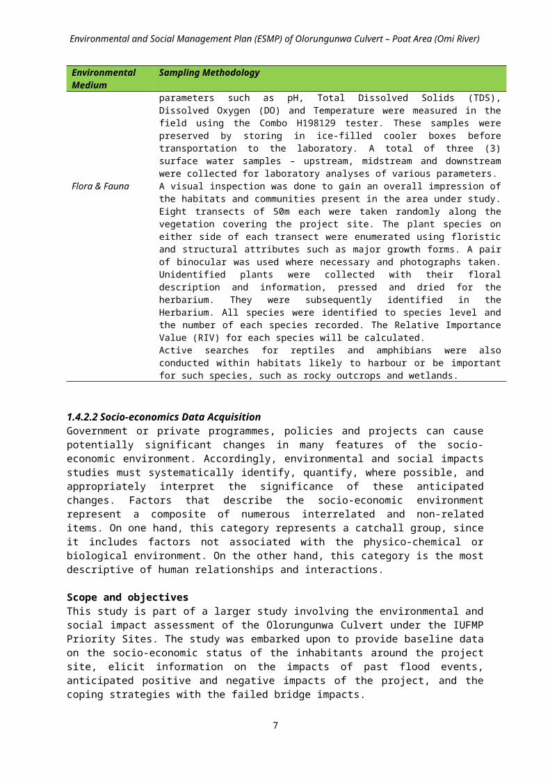
1.4.2.1 Environmental Data Acquisition GPS Garmin model 75s were used to geo-referenced and mapped the sampling points in the study area. The ecological features, geographical location of communities within the project area were taken into considerations in the selection of sampling points. Table 1.1 indicates the sampling / in-situ methods used for the environmental parameters.
Table 1.1: Sampling methods for environmental parametersEnvironmental Medium
Sampling Methodology
Climate & Meteorological Studies
The meteorological data such as temperature, relative humidity, sunshine hour, radiation, and rainfall was obtained from the Synoptic Meteorological Station at IITA. The data were analyzed whilst the prevailing climatic conditions were assessed in-situ.
Air Quality Studies The list of equipment used for the ambient air quality monitoring within and around the site are shown in table below
EQUIPMENT USED PARAMETERS ANALYSEDAltair 5x multigas detector SO2, NO2, CO, H2S and O2
Sper Scientific Humidity/Temperature Meter
Relative Humidity And Temperature
Aerotrak Particulates Monitor, 9303 SPM (suspended particulate matter)Sound Level Meter, Extech 407730 Noise level
Noise Measurement The precision Sound Level Meter Extech 407730 was used to measure the Noise levels. Measurements were done by holding the sensors monitoring equipment at a height of about two meters in the direction of the prevailing wind and readings were recorded when a steady rate has been established.
Soil Studies Soil Samples were collected within grid cells in the study area. This pattern is adopted in soil sampling to ensure that the entire area is covered for easy characterization of soil. Surface (0-15cm) for top (T) and sub-surface (15-30cm) for bottom (B) samples was collected. Sub-samples of soil for microbial analyses were taken in sterilized 100ml McCartney plastic bottles (properly labeled) and stored in a cool box. A total of six soil samples were collected.
Surface Water Water samples were collected from surface water across the project area using the Niskin Sampler. Clean sampling bottles and sterile 100ml plastic containers were used to collect surface water samples at the designated geo-referenced locations. Amber bottles of 250ml capacity were used to collect water samples for heavy metals analysis. These samples were acidified to pH of 2 in the field using concentrated nitric acid. Fast changing physico-chemical parameters such as pH, Total Dissolved Solids (TDS), Dissolved Oxygen (DO) and Temperature were measured in the field using the Combo H198129 tester. These samples were preserved by storing in ice-filled cooler boxes before transportation to the laboratory. A total of three (3) surface water samples – upstream, midstream and downstream were collected for laboratory analyses of various parameters.
Flora & Fauna A visual inspection was done to gain an overall impression of the habitats and communities present in the area under study. Eight transects of 50m each were taken randomly along the vegetation covering the project site. The plant species on either side of each transect were enumerated using floristic and structural attributes such as major growth forms. A pair of binocular was used where necessary and photographs taken. Unidentified plants were collected with their floral description and information, pressed and dried for the herbarium. They were subsequently identified in the Herbarium. All species were identified to species level and the number of each species recorded. The Relative Importance Value (RIV) for each species will be calculated. Active searches for reptiles and amphibians were also conducted within habitats likely to harbour or be important for such species, such as rocky outcrops and wetlands.
1.4.2.2 Socio-economics Data AcquisitionGovernment or private programmes, policies and projects can cause potentially significant changes in many features of the socio-economic environment. Accordingly, environmental and social impacts studies must systematically identify, quantify, where possible, and appropriately interpret the significance of these anticipated changes. Factors that describe the socio-economic environment
4

Environmental and Social Management Plan (ESMP) of Olorungunwa Culvert – Poat Area (Omi River)
represent a composite of numerous interrelated and non-related items. On one hand, this category represents a catchall group, since it includes factors not associated with the physico-chemical or biological environment. On the other hand, this category is the most descriptive of human relationships and interactions.
Scope and objectivesThis study is part of a larger study involving the environmental and social impact assessment of the Olorungunwa Culvert under the IUFMP Priority Sites. The study was embarked upon to provide baseline data on the socio-economic status of the inhabitants around the project site, elicit information on the impacts of past flood events, anticipated positive and negative impacts of the project, and the coping strategies with the failed bridge impacts.
The specific objectives of the study are to:1. Find out the existing demographic and socio-economic characteristics of the inhabitants of the
communities bordering the project site.2. Examine the impacts of the past flood and bridge collapse on the residents3. Investigate the people’s perception of the likely impact of the project on their socio-economic
well being.4. To provide the basis for monitoring whatever positive/negative impacts the project might
have on the inhabitants’ well being.
Description of the Social settingThis description involves: socio-economic and cultural environment, including present and projected, where appropriate. Review the description of the social setting as provided by IUFMP. Other gaps were filled during the site visit using structured questionnaire, indepth interview, FGDs and onsite assessment. Some of the variables used in the description of the social setting include the following.
Demographic structure of the community; Leadership patterns and political process; Family structure; Services available in or near the community: schools, health facilities, credit facilities,
religious organizations, government agencies; Debt/Credit relationships; Existing organizations (e.g. age grades, religious groups) and capacity for community action; Conflicts and divisions (ethnic, religious ,etc.) within the community or between
communities; Important local customs and festivals; Educational Levels; Permanence of the community; Primary forms of livelihood; Community attitudes towards erosion and drainage; Relevant aspects of gender relations; women’s vs. men’s roles.
In addition to the existing information on the socio-economic setting, structure questionnaire was designed in such a way as to allow a reconstruction of the cultural model, which characterizes the communities in the study area. Some of the information elicited from the questionnaire include the socio-economic characteristics of the respondents, the characteristics of the house and neighbourhood they live, flood impacts on the community, impacts of the failed culvert, and coping strategies with the impacts. In addition to the structures questionnaire, Focus Group Discussions were held in the community and key indepth interviews with some stakeholders.
1.4.2.3 Community and Stakeholder Consultations
5

Environmental and Social Management Plan (ESMP) of Olorungunwa Culvert – Poat Area (Omi River)
Public forum meeting was held on the 8th of July, 2016 including direct discussions with key stakeholders in the community and the PIU to determine their current views. The outcomes of these were documented and these include how issues and problems raised would be resolved. It should be pointed out that the stakeholders’ forum provided the takeoff for the participatory risk assessment which was subsequently conducted two weeks later after due consultation.
1.4.2.4 Risk / Hazard AssessmentIn order to effectively address the issue of environmental and social impacts and to effectively engage the communities, participatory risk assessment method was used. This is a method used to engage communities developmentally using highly participatory approaches. This method emphasizes a bottom-up approach that aims to empower communities by involving them in defining problems, deciding solutions, implementing activities and evaluating results of interventions.
The different role players relevant to a risk reduction projects include the residents, local leaders, CBOs, local government and NGOs as well as other representatives of stakeholder groups. Therefore, the first step is to establish enabling local stakeholders and institutional arrangements.
On the spot assessments will be used to describe and analyze the physical and human environment conditions in the project locations. The basic issues in this assessment involve the proper contextualization of hazard, risk and vulnerability which are defined here as follows:
Hazard – Things or processes that may have dangerous or harmful effects on people and the environment. These will be assessed by doing transect walk across the communities in the project sites and asking the people themselves to identify the various hazards they are faced with.
Vulnerability – Internal conditions that increase people’s exposure and susceptibility to hazards or other shocks and stresses. These include both physical and social conditions of the people. The physical conditions of vulnerability include the conditions of the buildings (mostly residential), the quality of the neighbourhood (drainage, waste management, access roads and aesthetics). The social vulnerability would be assessed using the income, education and occupation (livelihood) of the people.
Risk – The chance of harmful effects occurring due to the interaction between a hazard and vulnerability. An important first step in managing risks is to understand them, why they happen and who is most affected. Six important questions that would be asked with respect to risk include:1. Who is most at risk?2. Why are they at risk?3. When are they most at risk?4. What is increasing (or reducing) the risk?5. What is the outcome of the risk?6. How do at-risk groups reduce and cope with the risk?
In view of the above, the participatory risk assessment was structured in three phases as presented in Table 1.2.
6

Environmental and Social Management Plan (ESMP) of Olorungunwa Culvert – Poat Area (Omi River)
Table 1.2: Phases of the participatory risk assessment*Phase 1 Preparatory groundwork Scope the risk context and the feasibility for risk reduction
initiatives.Establish enabling local stakeholder and institutional arrangements Do background research on the settlement’s risk and development profileMake clear administrative and logistics arrangements with key stakeholders.
Phase 2 Carry out participatory risk assessment
Ensure risk assessment process is participatory, inclusive and robustDo thorough on-site field assessment
Phase 3 Generate integrated disaster risk reduction plans
Make risk reduction planning participatory, inclusive, with achievable, ‘do-able’ activitiesIntegrate local actions with supportive municipal development processesIncrease local responsibility for risk reduction Establish monitoring and evaluation processes
1.4.3 Quality ControlSample collection, handling and preservation were carried out in accordance with the World Bank Guidelines and the National and State Environmental guidelines and standards. Equipment were set, calibrated and operated following strictly manufacturers’ instructions. Both random and non-random samplings were considered for the field sampling. All data were entered into a log-book as soon as measurement or readings were taken. Results of the field sampling program, including information recorded on field datasheets were reviewed by the team leader for potential errors/omissions and to identify anomalous results. Original raw data files, including field notes, were retained; and duplicate files used for data analysis.
1.4.4 Method for Assessment of ImpactsAll significant environmental and social impacts, both positive and negative, which may occur as a result of the development, were identified. The criteria for predicting / assessing the impacts adopted were adopted from the International Organisation for Standardisation-Environmental Management System (IS0 14000). This approach was chosen considering its interactive and descriptive analysis of the relationship between the proposed project activities and the ecosystem components. In order to reduce elements of subjectivity inherent in the ranking process, our team of multi-disciplinary experts were co-opted to independently rank / quantify the potential impacts based on the five criteria: Legal/Regulatory Requirements (L), Risk (R), Environmental Impact Frequency (F), Environmental Impact (l) and Public Perception (P).
The impacts are classified as significant if: (L+R+F+I+P) ≥ 15 or (F + I) ≥ 6 or P = 5.
The impacts of the project activities were also characterized and described based on the following: short term or long term; beneficial or adverse; direct or indirect; reversible or irreversible; cumulative or incremental
7

Environmental and Social Management Plan (ESMP) of Olorungunwa Culvert – Poat Area (Omi River)
CHAPTER 2
POLICY, LEGAL AND ADMINISTRATIVE FRAMEWORK
2.1 IntroductionThis chapter presents an overview of applicable state, federal and international policies and regulations that guide the implementation of the ESMP.
2.2 State Policies2.2.1 Oyo State Policy on Environment (2013)Oyo State Policy on environment is a broad course of action that the Oyo State Government adopts so that it meets its objectives. The following are the environmental policies in Oyo State.
Be responsible for formulation, enforcing and coordinating policies, statutory rules and regulation on Solid Waste collection and disposal, general environmental protection, flood control and regulation of the ecological system and all activities related therein, throughout the state;
To advise the Government on state environmental policies and properties and on scientific and technological activities affecting the environment;
Conduct public enlightenment campaigns and disseminate vital information on environmental and ecological matters, and to mobilize the inhabitants of all area for effective observance of environmental rules and guidelines, for purpose of healthy and safe environment;
Render advisory services and support to all Local Government in the State in areas of Flood Control, Solid Waste Management, Ecological and Sanitation Matters;
Preparation of annual State of the Environment report for the State and transmit same to the Secretariat of the National Council on Environment;
Monitor sources of toxic pollutants in air, land and water and offering of necessary advice to industrial establishments;
Initiate measure to ensure pollution-free air, land, water throughout the State including any other steps to obviate, mitigate or eliminates environmental discomfort to individuals or groups or danger to lives and properties;
Ensure that the lawns and the surroundings of the departmental offices in Secretariat precincts are kept tidy and well trimmed;
Study, investigate, advice and recommend any all matters pertaining to beautification and citizens’ participation relating of same to the Government;
Obtain research findings from the relevant Federal and State Agencies for the purpose of policy formulation and dissemination of same on environmental sanitation and beautification to the public in the State; and
Carry out both administrative supervision and establishment duties with a view to ensuring well-managed finances and administration of the Ministry in line with Government policies.
2.3 National Policies Nigeria National Policy on environment is a broad course of action that the Government of Nigeria adopts so that it meets its objectives.
2.3.1 National Policy on the Environment (1988)The National Policy on the Environment aims to achieve sustainable development in Nigeria, and in particular to:
secure a quality of environment adequate for good health and well being; conserve and use the environment and natural resources for the benefit of present and future
generations; restore, maintain and enhance the ecosystems and ecological processes essential for the
functioning of the biosphere to preserve biological diversity and the principle of optimum sustainable yield in the use of living natural resources and ecosystems;
8

Environmental and Social Management Plan (ESMP) of Olorungunwa Culvert – Poat Area (Omi River)
raise public awareness and promote understanding of the essential linkages between the environment, resources and development, and encourage individuals and communities participation in environmental improvement efforts; and
co-operate with other countries, international organizations and agencies to achieve optimal use of trans-boundary natural resources and effective prevention or abatement of trans-boundary environmental degradation.
2.4 Regulatory FrameworkThe regulatory framework is a system of regulations and the means used to enforce them. They are established by the Government of Nigeria to regulate environmental specific activities and are recognized by the law. The following gives an overview if the existing Federal legislations.
2.4.1 Federal LegislationFederal Environmental Protection Agency Decree No 58 (1988)
The Federal Environmental Protection Agency (FEPA) was established by Decree No. 58 of 1988 and charged with the responsibility for environmental protection. Following the upgrading of the agency to a Federal Ministry of Environment (FMEnv) in January 2007, the Ministry was mandated to coordinate environmental protection and natural resources conservation for sustainable development.
The FMEnv has developed statutory documents to aid in the monitoring, control and abatement of industrial waste. These guidelines stipulate standards for industrial effluent, gaseous emissions and hazardous wastes. Table 2 summarizes the existing national legal instruments applicable to environmental protection.
Table 1.1: Existing National Environmental Protection RegulationsS/N Regulations Year Provisions1 National Environmental Protection
(Effluent Limitation) Regulations 1991 The regulation makes it mandatory for industrial facilities to
install anti-pollution equipment, makes provision for effluent treatment and prescribes a maximum limit of effluent parameters allowed.
2 National Environmental Protection (Pollution and Abatement in Industries in Facilities Producing Waste) Regulations
1991 Imposes restrictions on the release of toxic substances and stipulates requirements for monitoring of pollution. It also makes it mandatory for existing industries and facilities to conduct periodic environmental audits.
3 National Environmental Protection (Management of Solid and Hazardous Wastes) Regulations.
1991 Regulates the collections, treatment and disposal of solid and hazardous wastes from municipal and industrial sources.
4 Harmful Wastes (Special Criminal Provisions etc) Decree No. 42
1988 Provides the legal framework for the effective control of the disposal of toxic and hazardous waste into any environment within the confines of Nigeria
5 Environmental Impact Assessment Act (Decree No. 86).
1992 The decree makes it mandatory for an EIA to be carried out prior to any industrial project development
6 National Guideline and Standard for Environmental Pollution Control
1991 The regulations provide guidelines for management of pollution control measures.
7 Workmen Compensation Act 1987 Occupational health and safety8 Urban and Regional Planning Decree
No 881992 Planned development of urban areas (to include and manage
waste sites)9 Environmental Sanitation edicts,
laws and enforcement agenciesGeneral environmental health and sanitation. Enforcing necessary laws
10 State waste management laws Ensure proper disposal and clearing of wastes11 Public Health Law Covering public health matters12 National Guidelines on
Environmental Management Systems (EMS)
1999 Recognizes the value of EMS to EIA and sets out objectives and guideline on general scope and content of an EMS
13 National Policy on the Environment 1989 The policy identifies key sectors requiring integration of environmental concerns and sustainability with development
9

Environmental and Social Management Plan (ESMP) of Olorungunwa Culvert – Poat Area (Omi River)
S/N Regulations Year Provisionsand presents their specific guidelines
14 National Guidelines and Standards for Water Quality
1999 It deals with the quality of water to be discharged into the environment, sets standards and discharge measures for a wide range of parameters in water discharged from various industries. It also sets out the minimum/maximum limits for parameters in drinking water
15. National Air Quality Standard Decree No. 59
1991 The World Health Organization (WHO) air quality standards were adopted by the then Federal Ministry of Environment (FMEnv) in 1991 as the national standards. These standards define the levels of air pollutants that should not be exceeded in order to protect public health.
16. National Environmental Standards and Regulations Enforcement Agency (NESREA Act)
2007 Established to ensure compliance with environmental standards, guidelines and regulations.
17. National Policy on Flood and Erosion Control (FMEnv)
2006 This policy addresses the need to combat erosion in the country utilizing the procedures outlined in the National Action Plan for Flood and Erosion Control and Technical Guidelines, developed by the WIC Environmental Committee which was set up to plan an operational platform for these issues
18. National Oil Spill Detection and Response Agency (NOSDRA Act)
2005 This statutory regulation makes adequate regulations on waste emanating from oil production and exploration and its potential consequences to the environment.
Table 2.2: List of Proposed Environmental National LegislationsS/N Regulation Year 1 Waste Prevention and Recycling Bill 19992 Response, Compensation and Liability For Environmental Damage Bill 19993 Waste Prevention and Recycling Bill 20004 Federal Environmental Protection Agency (Amendment) Bill 20015 Pollution Abatement and Waste Generation Facilities (control) Bill 20016 Federal Environmental Protection Agency Bill 20037 Industrial Wastewater Pollution and Control Bill 20038 Environmental Managers Registration Council of Nigeria Bill 20039 Amendment of EIA Decree No. 86 of 1992 Bill 2005
2.4.2 Other Acts and Legislations Other formal written enactment produced by a legislature or by a legislative process important in the project includes:
2.4.2.1 Land Use: Land Use Act (1978)This act provides a legal basis for land acquisition in Nigeria. The major provisions include:
Section 1: all land comprised in the territory of each state in the Federation is vested in the Governor of the state and such land shall be held in trust and administered for the use and common benefit of all.
Section 2 (a): all land in urban areas shall be under the control and management of the Governor of each State; and
Section 2 (b): all other land shall be under the control and management of the local government within the area of jurisdiction in which the land is situated.
State governments have the right to grant statutory rights of occupancy to any person for any purpose; and the Local Government has the right to grant customary rights of occupancy to any person or organization for agricultural, residential and other purposes. Further details on the Land Use Act (1978) are discussed in the RPF.
10

Environmental and Social Management Plan (ESMP) of Olorungunwa Culvert – Poat Area (Omi River)
2.5 Assessment of the Policy and Regulatory FrameworkThe existing legal framework for environmental assessment in Nigeria is considered adequate. Detailed laws, regulations and guidelines have been developed and serve as the framework for environmental protection. The implementation has been poor due to poor enforcement.
2.5.1 Environmental Impact Assessment (EIA) ActThe Environmental Impact Assessment (EIA) Act does not encourage the participation of people whose lives are likely to be affected by a project; rather, it encourages the collection and documentation of technical information which is confusing to most people.
2.5.2. Federal Environmental Protection Agency (FEPA) Sectoral GuidelineFEPA’s Guideline covering infrastructural projects deals with both the procedural and technical aspects of EIA for construction projects. The guideline stresses the need to carry out an EIA at the earliest stage possible. Infrastructure Project EIAs have been conducted in rather loose form, and often taken as a supplementary requirement to overall economic and engineering issues.
2.5.3 National Policy on EnvironmentThe policy and its institutional arrangements have not yielded the desired results. This is principally due to weak enforcement; inadequate manpower in the area of integrated environment management; insufficient political will; inadequate and mismanaged funding; low degree of public awareness of environmental issues; and a top–down approach to the planning and implementation of environmental programme.
2.6 International Environmental AgreementsNigeria is also a signatory to the following relevant international conventions:
Basel Convention on the control of hazardous wastes and their disposal; Bonn Convention on conservation of Migratory Species; Stockholm Convention on Persistent Organic Pollutants; The African Convention on the Conservation of Nature and Natural Resources, The African
Convention, 1968; The Convention Concerning the Protection of the World Cultural and Natural Heritage, The
World Heritage Convention, 1972; The Convention on International Trade in Endangered Species of Wild Fauna and Flora,
CITES, 1973; The Framework Convention on Climate Change, Kyoto Protocol, 1995; The Convention on Biological Diversity, 1992; and The Convention on the Prevention of Marine Pollution by Dumping of Waste, MARPOL,
1972;
In addition, Nigeria also has obligations to protect the environment through various commitments to the African Union (AU), the Economic Community of West African States (ECOWAS) and the Commonwealth. It is also committed through relations with the European Community under the Lome IV Convention.
2.7 Institutional Framework The framework for the EA of the IUFMP involves the following in conjunction with the implementing MDAs. The following institutions and agencies are responsible for regulating and monitoring environmental issues, information and waste management standards applicable to the IUFMP.
2.7.1 Oyo State Ministry of Environment and Water ResourcesSome of the mandate of the Oyo State Ministry of Environment and Water Resources is as follows:
11
Environmental and Social Management Plan (ESMP) of Olorungunwa Culvert – Poat Area (Omi River)
Ensure the implementation of the provisions of the National Environmental Sanitation Policy and Guidelines at all levels of Government;
Enforce compliance with the provisions of these regulations; Issue permits as prescribed in the relevant section of these regulations; Ensure compliance with conditions of the permits as contained in the relevant schedules; Establish strategic alliance with other Federal MDAs other states, local government areas and
other relevant stakeholders; Ensure that the waste management facilities comply with the Environmental Impact
Statement; Embark on intensive environmental education and awareness campaign on sound
environmental sanitation and waste management; and Develop and publicize set standards, for environmental sanitation, waste management and
equipment procurement and maintenance.
2.7.2 Federal Ministry of Environment (FMEnv)The FMEnv in accordance with its mandatory functions will ensure that the project implementation conforms to the Environmental Impact Assessment Act 1992.
FMEnv has responsibility to administrate and enforce environmental laws in Nigeria. The specific responsibilities of the ministry include: Monitoring and enforcing environmental protection measures; Enforcing international laws, conventions, protocols and treaties on the environment Prescribing standards for and making regulations on air quality, water quality, pollution and
effluent limitations, atmosphere and ozone protection, control of toxic and hazardous substances; and
Promoting cooperation with similar bodies in other countries and international agencies connected with environmental protection.
2.8 World Bank Safeguard Policies The World Bank has 10 + 2 Safeguard Policies to reduce or eliminate the negative environmental and social impacts of potential projects, and improve decision making. Details of the safeguard policies can be seen in Annex 2. These World Bank safeguard operational policies are:
OP/BP 4.01: Environmental Assessment OP/BP 4.04: Natural Habitats OP 4.09: Pest Management OP/BP 4.12: Involuntary Resettlement OP 4.10: Indigenous Peoples OP 4.11: Physical Cultural Resources OP 4.36: Forests OP/BP 4.37: Safety of Dams OP/BP 7.50: Projects on International Waters OP/BP 7.60: Projects in Disputed Areas
Plus 2 OP/BP 4.00: Use of Country System OP/BP 17.50: Public Disclosure
Table 2.3: Summary of Safeguards Policies triggeredOperational Policy Yes Reasons NoEnvironmental Assessment(OP.4.01);
X Safeguards policy OP 4.01 is triggered in this study with the civil work activities for the immediate restoration of bridges / culverts. Therefore an
12

Environmental and Social Management Plan (ESMP) of Olorungunwa Culvert – Poat Area (Omi River)
Operational Policy Yes Reasons NoEnvironmental and Social Impact Assessment (ESIA) which will be prepared and cleared by the Bank. In addition, the cleared ESIA will be publicly disclosed countrywide in Nigeria and at the World Bank Info Shop.
Natural Habitat (OP/BP 4.04)
X This policy is triggered because some project activities may take place near to critical natural habitats or environmentally sensitive areas and some mitigation measures may be necessary to minimize any negative environmental and social impacts. The project is not being implemented in any area with critical natural habitats, nor does it involve the significant conversion or degradation of natural habitats.
Forests (OP 4.36) The project will not finance the development of forests. The area in which this project would be implemented will not have impacts on the health and quality of forests or the rights and welfare of people and their level of dependence upon or interaction with forests.
X
Physical Cultural Resources (OP 4.11)
X Some activities in the project shall include civil works that could expose chance finds. These chance find sites may include sacred shrines and burial sites.. To mitigate this risk, specific procedures (such as chance find procedures) will be included in the ESIAs as required.
Involuntary Resettlement (OP/BP 4.12)
X This policy is trigged because most of the sub-projects could involve minimal or moderate land acquisition and or restriction of access to usual means of livelihood as most of the sub-projects will largely be rehabilitation of existing infrastructure. However, some of the projects may involve significant land acquisition and displacement of affected people. As part of the safeguards due diligence, the client will prepare a Resettlement Policy Framework RPF which will be reviewed and cleared by the Bank.Also, site specific Resettlement Action Plans (RAPs) or Abbreviated Resettlement Action Plans (ARAPs) will address the needs of persons who will be affected by loss of economic activities, land acquisition and/or relocation. The preparation of these safeguards documents will be inclusive and participatory, promoting community ownership and social accountability. The RPF and/or RAPs will be reviewed and cleared by both the project safeguards team and the Regional Safeguards Advisor. The RPF will have to be sent to the bank for review and clearance before it is disclosed publicly in country and on the Bank’s info shop prior to project appraisal.
Projects in Disputed Areas (OP/BP 7.60)
The area in which this project would be implemented is not a conflict or disputed area.
X
Disclosure Policy (OP/BP 17.50)
X All projects must disclose key information in country and through the Bank’s Info shop
2.9 Nigeria EIA Guidelines and World Bank EA Guidelines The Environmental Impact Assessment Act No. 86 of 1992 requires that development projects be screened for their potential environmental and social impact. Based on the screening, a full, partial, or no EIA may be required. Guidelines issued in 1995 direct the screening process. According to these guidelines the Nigeria EIA Categories include: (See Table 2.4 below).
Table 2.4: Nigeria EIA Guidelines and World Bank EA GuidelinesFMEnv
13

Environmental and Social Management Plan (ESMP) of Olorungunwa Culvert – Poat Area (Omi River)
Category I II IIIProjects will require a full Environmental Impact Assessment (EIA) for projects under this category EIA is mandatory according to Decree No. 86. Projects includes large-scale activities such as agriculture (500 hectares or more), airport (2500m or longer airstrip), land reclamation (50 hectares or more), fisheries (land based aquaculture of 50 hectares or more), forestry (50 hectares or more conversion, etc.
Projects may require only a partial EIA, which will focus on mitigation and Environmental planning measures, unless the project is located near an environmentally sensitive area--in which case a full EIA is required
Projects are considered to have “essentially beneficial impacts” on the environment, for which the Federal Ministry of the Environment will prepare an Environmental Impact Statement.
World BankCategory A B C F1
Projects are those whose impacts are sensitive, diverse, and unprecedented, felt beyond the immediate project environment and are potentially irreversible over the long term. Such projects require full EA.
Projects involve site specific and immediate project environment interactions, do not significantly affect human populations, do not significantly alter natural systems and resources, do not consume much natural resources (e.g., ground water) and have negative impacts that are not sensitive, diverse, unprecedented and are mostly reversible. Category B projects will require partial EA, and environmental and social action plans.
Projects are mostly benign and are likely to have minimal or no negative environmental impacts. Beyond screening, no further EA action is required for a Category C project, although some may require environmental and social action plans.
A proposed project is classified as Category FI if it involves investment of Bank funds through a financial intermediary, in sub-projects that may result in negative environmental and social impacts.
This World Bank categorization (A, B, & C) corresponds in principle with the Nigeria EIA requirements of Category (I, II and III), which in actual practice is done with regard to the level of impacts associated with a given project. However, in the event of divergence between the World Bank safeguard policies and the Nigeria EA laws, the World Bank Safeguards policies takes precedence over Nigeria EA laws, guidelines and standards.
Thus for this ESIA, the Nigeria’s EIA requirements and World Bank safeguard policies were harmonized as far as possible.
This is made responsive with regard to the following:
Early consideration of environmental and social issues (starting at the screening stage); Identification and early consultation with stakeholders; Prevention of negative environmental and social impacts through the consideration of feasible
alternatives; and Incorporation of mitigation measures into planning and (engineering) design.
2.10 Adequacy of Legal Instruments for Environmental & Social Issues Generally with regard to environmental and social management issues, legislation is in a continuing process of development in Nigeria. Amongst the existing pieces of legislations highlighted above,
14

Environmental and Social Management Plan (ESMP) of Olorungunwa Culvert – Poat Area (Omi River)
there are a number of state, national and international environmental guidelines applicable to the sub-projects under the proposed IUFMP.
In other words, Oyo State has a good governance framework and laws to back up and manage the environmental and social safeguard issues that shall be triggered.
The Oyo Ministry of Environment and Water Resources are conversant with the Environmental Assessment (EA) legislation, procedures and framework applicable based on the Federal EIA Act 86 of 1992. The main challenge would be enforcement of these legislation/guidelines.
Thus as part of this ESMP, in order to support the due diligence process, to avoid causing harm and to ensure consistent treatment of environmental and social issues across the sub-project intervention areas, institutional capacity strengthening and funding have been recommended.
15

Environmental and Social Management Plan (ESMP) of Olorungunwa Culvert – Poat Area (Omi River)
CHAPTER 3
PROJECT DESCRIPTION
3.1 River Culvert Study Area The Olorungunwa Culvert – Poat Area (Omi River) priority site is located in Egbeda Local Government Area. The site falls within the Ibadan Metropolis and lies between x and y coordinates N7.36993 and E3.99749 and at an altitude of 190msl.
Figure 3.1: Olorungunwa Culvert Location
16

Environmental and Social Management Plan (ESMP) of Olorungunwa Culvert – Poat Area (Omi River)
Plate 3.1: Olorungunwa Culvert – Poat Area (Omi River) Schematic Layout
17
Inadequate existing ring culvert
Olorungunwa spring/stream Dilapidated structure very close to stream
Existing drainage

Environmental and Social Management Plan (ESMP) of Olorungunwa Culvert – Poat Area (Omi River)
The existing inadequate Olorungunwa culvert constructed on an earth road has a flow of water from Olorunguwa stream to Omi River. The existing road has been damaged by erosion. There is excessive growth of weeds which obstructs the flow of water. Drainage exists on only one side of the road. There are no protective barriers on both sides of the culvert. Culvert is inadequate and needs to be replaced. Drainage also requires reconstruction. Blockage by natural and anthropogenic debris is a significant issue that further reduces the culvert capacity during times of flood.
The topography of the project area of influence is a gentle slope and characterized by igneous rock formations with sandy soils. The area receives surface water (upstream) from Olorungunwa stream/springand discharges at Omi River. Vegetation in the area is composed mainly of few trees, high shrubs and grasses. However, the original vegetation has been undergoing modifications due to urban expansions and human activities.
Human activities have impacted on the environment resulting in series of environmental and social concerns such as sheet erosion, presence of undercutting in roads/erosion, No drainages on existing earth roads; Aquatic weeds restricting flow of water and high sediment load in stream.
3.2 Description of the Proposed Intervention WorksThe proposed intervention works are according to the engineering designs and properties of the priority site, and are summarized in the Tables below as follows:
Hydraulic Structure Size and Design Details (Table 3.1) Geometric and Pavement Data for Approach Roads (Table 3.2) Scope of Works for Road and Hydraulic Structures (Table 3.3) Proposed Built and Work Areas for Project Sites (Table 3.4)
18

Environmental and Social Management Plan (ESMP) of Olorungunwa Culvert – Poat Area (Omi River)
Table 3.1: Hydraulic Structure Size and Design Details
GPS Slope %
Manning Coefficient
(n)Velocity
(m/s)
Peak Flow Qpeak
(m3/s)
Width of Flow x (m)
Depth of Flow y (m)
Free Board (m)
Rectangular Flow Section
Hydraulic Radius R = A/P
Recommended Structure
Channel X – Section
(Xmm*Ymm)
Areas of Flow A = xy
Wetted Perimeter P = x+2y RC Bridge
RC Culvert
609999N 815202E 0.02 0.15 0.6 2.75 3 1.5 0.83 4.5 6 0.751-Cell
3mx3.5m1-Cell
3mx3.5m 3.0 x 3.0
Table 3.2: Geometric and Pavement Data for Approach Roads
GPS
Stream Length Surveyed (m) Approac
h Road Length
(m)
Paved Width
of Roads
(m)
Length/Width of Adjoining Roads (m)
No of Adjoining Roads
Pavement Structure (mm)RC Side Drains
(mm2)
Up Stream
Down Stream
Sub-base
CourseBase
Course
Asphaltic
OverlayRight Side
Left Side
609999N
815202E 1733 280 700 7.3 75.0/7.3 6 200 200 50 750x750
750x750
Table 3.3: Scope of Works for Road and Hydraulic Structures
Hydraulic Structure
Length of Approach Road Pavement Structures (m)
Length of Approach Road Pavement Structures (m) No. of Adj.
Rd/Width Access
Culvert (m)
No. of Cross
Culv./Width (m)
Retaining Wall (m)
Drains to be
Desilted (m)
Drains to be
Repaired (m)
Length of Stream
Excavation (m)
Appr. Road
Asp Halt
Base
Sub-Base
Lined Drain
Adj. Road
Asp Halt Base
Sub-
baseLined Drain
1-Cell 3m x3.5m 700 700 700 700 1400 450 450 200 450 900 6/9.3 1/9.3 20 0 0 200
Table 3.4: Proposed Built and Work Areas for Project Sites Project Summary Bridge Built Area (m2) Bridge Ramp Built
Area (m2)Total Built Area
(m2)Total Work Area
(m2)L (m) W (m) L (m) W (m) L (m) W (m) L (m) W (m) L (m) W (m)
Box Culvert 3m x 3.5m n.a n.a n.a n.a 9.06 14.76 11.06 15
19
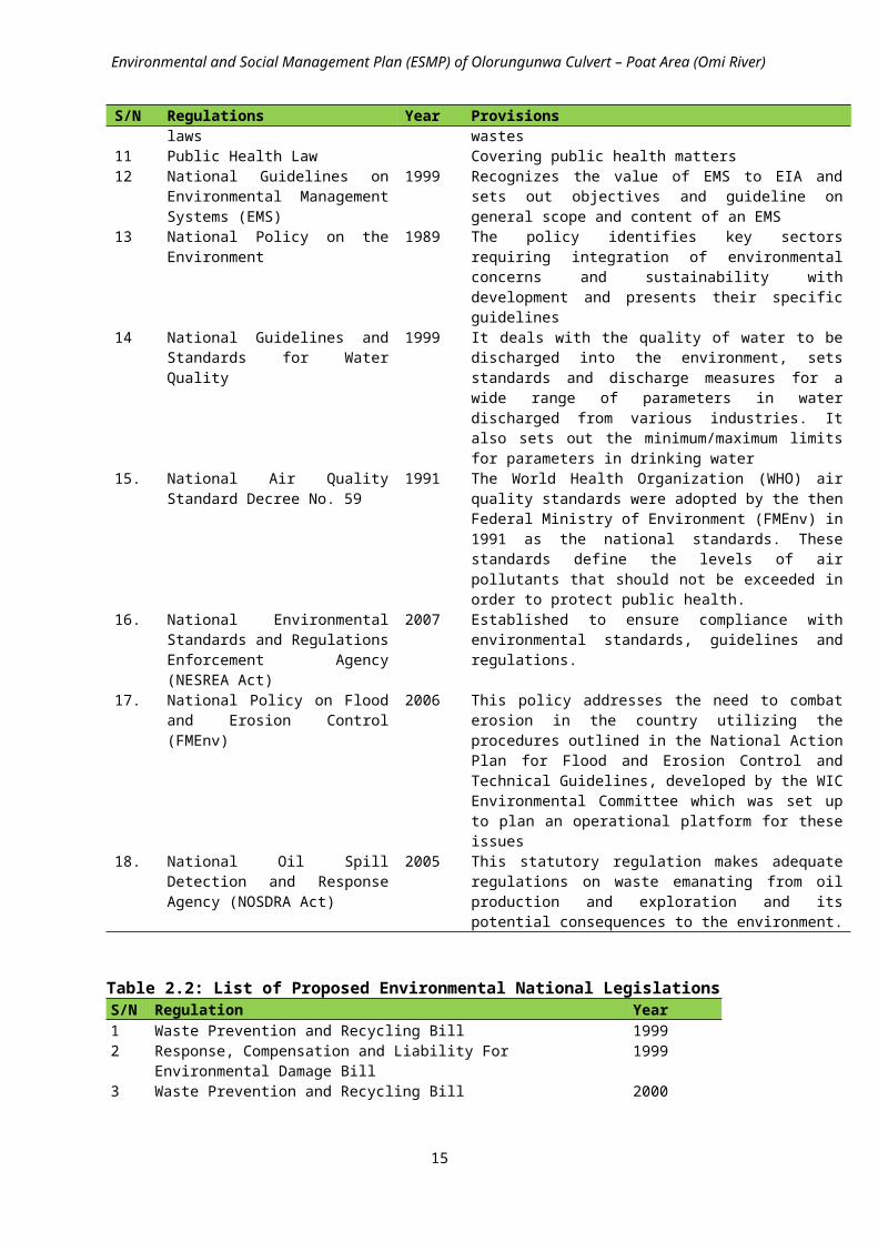
Environmental and Social Management Plan (ESMP) of Olorungunwa Culvert – Poat Area (Omi River)
3.2.1 Description of Possible Alternative Routes During Construction:Olorungunwa culvert is located after Omiri culvert; both are along the same linear route. Alternativeaccess to Olorunguwa culvert will be through Ibadan – Ife Expressway through Iyana Afoni then toBethel junction or Bioku Junction. This alternative route will be for road users who want to accessOlorunguwa. This road will serve as a useful alternative to streets behind Olorunguwa Culverts. The road condition traverses developed residential developments however the road is not passable for vehicles because of the earth gullies on the road. It can be said that the road condition is very bad. The alternative routes will be graded at intervals during construction of Olorunguwa culvert.
3.3 Project ActivitiesThe proposed works will be carried out in three phases namely; Pre-construction, Construction and Operational and Maintenance phases.
Table 3.5: Proposed ActivitiesPhase Proposed
InterventionActivities
Pre-Construction
SensitizationMobilisationMarkingTemporary access culvertClearingSafety measures
Sensitize and inform community members on the time and duration of civil works.
Mobilize trucks, vehicles and other equipment and install camp office and workshop.
Mark the boundaries of the working areas around the site. Construct a temporary pedestrian access culvert for community members
and other users; Clear vegetation covering stream banks and widen banks appropriately Evacuate obstacles such as silt and solid waste along stream Install lightening and relevant road signage and barriers at construction site
Construction Road works Scarification; Sub-grade preparation; Earthworks; Construction of base course and asphalt layers
Side drains Site clearing and excavation; Drainage structure and facilities; Retaining walls and earth – filling; Any other ancillary works.
Culvert works Excavation, and stabilization Construction of bed, and concrete screeding; Construction of reinforced concrete wall (Abutments); Construction of deck concrete; Construction of parapet wall
Post-Construction/Operational /Maintenance
Maintenance of Culvert, Drains, Stream and access Road
Regular clearing of culverts, drains and stream of silt and solid waste; Regular checks and maintenance of road surface; Checks and exchange of wearing course after number of years; Exchange of binder course after a number of years; Routine inspections of foundations, joins etc; Routine inspections of pavement;
Maintenance of other ancillary facilities
Maintenance of road restraint systems; Maintenance of traffic control and information systems; Maintenance of road markings and studs; Maintenance of fencing walls screens and environmental barriers; and Maintenance of the road verge (including landscaping and rehabilitation).
20

Environmental and Social Management Plan (ESMP) of Olorungunwa Culvert – Poat Area (Omi River)
CHAPTER 4
DESCRIPTION OF THE PROJECT ENVIRONMENT
4.1 Physical Environment
4.1.1 Climate /MeteorologyThe rainy season in Ibadan lasts from April to October and the dry season from November to March. The climate is determined by the movement of two air masses – the Dry Tropical Continental Air Mass (cT), which originates from the Sahara Desert and is responsible for the dry season, and the Moist Tropical Maritime (mT), from the Atlantic Ocean, which is responsible for the rainy season. Ibadan therefore has tropical rainy climate with an average annual rainfall of 1265.6mm (Figure 4.1).
21
JAN FEB MAR APR MAY JUN JUL AUG SEP OCT NOV DEC0
5
10
15
20
25
30
35
40
Ave mean Ave Min Ave Max
Axis
Title
JAN FEB MAR APR MAY JUN JUL AUG SEP OCT NOV DEC0
20
40
60
80
100
120
Ave Mean Ave Min Ave Max
Axis
Title
JAN FEB MAR APR MAY JUN JUL AUG SEP OCT NOV DEC0
100
200
300
400
500
600
Ave mean Ave Min Ave Max
Axis
Title
Figure 4.1 Annual Rainfall for Ibadan (1925-2014) Figure 4.2: Average Daily Temperature oC
Figure 4.3: Average Daily Relative Humidity (%) Figure 4.4: Average Daily Solar Radiation (gm-cal/cm2)

Environmental and Social Management Plan (ESMP) of Olorungunwa Culvert – Poat Area (Omi River)
4.1.2 Geology/HydrogeologyIbadan city sits on a rolling topography with the basement rock types characterized by low porosity and permeability. The city sprawls on either side of Aremo and Mapo ridges. The upland areas are places above 200m. Among the upland areas is the central ridge called ‘Oke Aremo’. It has a north-south trend with a gap in its northern section through which Ogunpa river cuts its valley. The ridge is the main watershed from the headstream of the Ogunpa, Ona and Kudeti rivers. The highest point on the ridge is about 280m and this is at the Bower hill. The lowland areas are places below 200m. There is generally a decline in the elevation of the land from north-east to the south-east.
The main rivers draining Ibadan are Ona, Ogunpa and Ogbere rivers with their tributaries, including the River Omi, Kudeti, Alaro, Alapata, Maje, Elere, etc. The city area sits on the basement complex rocksuit comprising older granite, quartz schists/quartzite and gneiss. There are ridges of quartzite/quartz schists, inselbergs of gneiss and older granite. These rocks are quite old predating the Pan African orogeny. Each rock type possesses its own typical failure plane. Gneiss foliations are marked by alternating white and black bands. In quartzite, micaceous bands constitute possible failure planes. The granite and granite gneiss complex have high residual stress, sub aerial weathering which enhances anisotropy. They also have deformability modules which vary non-linearly with micropetrographic quality index.
In-situ permeability coefficient decreases with depth and their in-situ shear strength parameters increase with decrease in percentage water absorption. The branded gneiss always has faults fracture zones. The shear strength varies almost linearly with compressive strength. Loading gives rise to irrecoverable deformation and deformability increase linearly with strength. Quartzite and quartz schists have significant soil content. They can show toppling failure when disturbed. The yield of boreholes in quartz schists varies from 0.01 l/s to 6.0 l/s. In granitic rockmass, the yield varies from 0 to 4.0 l/s. The quality of the groundwater in basement complex is generally good. However, shallow groundwater can be easily polluted by high nitrate content and possible bacterial infection from sewage.
4.1.3 HydrologyThe stretch of the river on either side of the culvert contains a sizeable volume of debris which reduces the effective carrying capacity of the river channel. This debris consists of fallen trees, shrubs, rocks and garbage. The volume of debris continually varies, mostly upwards, with the natural and human activities around the culvert; thus continually affecting the flow of the river.
22
JAN FEB MAR APR MAY JUN JUL AUG SEP OCT NOV DEC0
1
2
3
4
5
6
Ave Mean Ave Min Ave Max
Axis
Title
JAN FEB MAR APR MAY JUN JUL AUG SEP OCT NOV DEC0
1
2
3
4
5
6
Ep Et
Axis
Title
Figure 4.5: Average Daily Wind Speed (mph) Figure 4.6: Computed Potential Evapotrsnapiration (Et) and IITA Evaporation (Ep)

Environmental and Social Management Plan (ESMP) of Olorungunwa Culvert – Poat Area (Omi River)
Runoff estimationLike most rivers in Nigeria, no flow data are available for the river. Hence, runoffs were computed from the rainfall and other climatic data indicated in the figures above. With the use of the water balance equation and using the computed potential evapo-transpiration, runoffs in cubic meters per second (cum/sec) for the river were estimated. From the runoff hydrographs in Figure 4.7, only one flow peak occurred in 1980 (August), and two peaks in 1990, 1999 and 2011 which occurred in July and October.
Figure 4.7: Runoff Hydrograph for the river
4.1.4 Surface Water QualityWater is absolutely necessary to sustain life and an important resource for all economic activities relating to exploration and production activities. Pollution of water is an impairment of water quality by man’s activity, causing an actual hazard to public health or impairment beneficial use of water. The aquatic environment is an intricate system of living and non-living elements. Physical, chemical and biological factors influencing water quality are so interrelated that a change in any water quality parameter triggers on other changes in a complex network of the interrelated variables. Often it is difficult to categorize the nature of these interrelationships that may result from man’s activity and influence on the entire water system. All natural waters have the capacity to assimilate certain amounts of waste without apparent effect upon the environment, thus all natural waters have self-purification properties.
The summary of the physico-chemical characteristics of the water samples from the study area is presented in Table 4.1 The water bodies were slightly alkaline and had pH values varying from 8.71 - 8.96, the values fell within the tolerable limits for surface waters of pH 6 –9 stipulated by FMENV. The total dissolved solids varied from 129 – 145mg/l, electrical conductivity, which is a measure of the ionic richness of the river course, ranged between 340.0 and 360.0μs/cm, the alkalinity ranged from 4.22 to 4.57mg/l, the BOD values ranged from 6.35mg/l – 8.04mg/l, these values were all below the limit recommended for surface waters by DPR/FMENV. The results of the heavy metals analysed
23

Environmental and Social Management Plan (ESMP) of Olorungunwa Culvert – Poat Area (Omi River)
show that all the metals occurred in trace levels or very minute quantities far below recommended limits set by FMENV.
Table 4.1: Physicochemical Characteristics of Surface water
4.1.5
Soil Quality The composite physicochemical analysis of the soil in the area is predominantly sandy and moderately acidic with total acidity values ranging from 47.88 - 50.25mg/l. The total nitrogen concentration varied from 0.001 to 0.023%, while the available phosphorus concentration varied from 0.087 to 0.271mg/kg, the heavy mental concentrations of the soils were low and were dominated by iron with ranged values of 22.39 – 24.16mg/kg (Table 4.2). The relatively high level of iron may be attributed to the underlying rocks where the soils of Ibadan region were formed. The major soil groups are the ferruginous soils.
Table 4.2: Physcio chemical characteristics of soils
Parameter TS1 SS I TS 2 SS 2 TS3 SS3FMEnv.
LimitMg/l Total Acidity 83.33 79.07 80.45 79.70 80.60 80.00 -
% Nitrogen 0.001 0.004 0.013 0.023 0.002 0.004 -
Avail P mg/kg 0.12 0.15 0.087 0.096 0.091 0.271 1.00
Cmol/kg Ca 2.73 2.61 3.06 3.01 2.62 2.62 -
Cmol/kg Mg 1.67 1.82 1.27 1.31 1.36 1.20 -
Cmol/kg K 0.69 0.72 1.15 1.15 0.87 0.92 -
mg/kg Mn1.82 1.61 0.78 0.73 1.25 1.24
-
mg/kg Fe22.39 22.46 24.13 24.16 22.62 22.43
1.50
24
Parameter Downstream Midstream Upstream FMEnv. LimitspH 8.96 8.77 8.71 6-9µs/cm Conductivity 340.0 348.0 360.0 -Temperature 0C 29.6 30.0 30.0 <40mg/l Mn 28.5 29.2 29.7 5mg/l Fe 0.16 0.18 0.15 20mg/l Cu 6.56 8.49 6.34 <1.0mg/l Zn 0.03 0.06 0.06 <1.0mg/l Cd 0.02 0.01 0.02 <1.0mg/l Pb <0.01 <0.01 <0.01 <1.0mg/l Cl 0.00 0.00 0.00 600mg/l Carbonate 115.27 98.38 108.35 -mg/l BI Carbonate 24.05 22.68 24.52 -mg/l NH3N 5.880 4.612 4.035 20mg/l SO4
2- 15.27 16.86 14.29 500mg/l Alkalinity 4.22 4.36 4.57 -mg/l PO4 4.31 4.28 4.02 5mg/l TDS 145 132 129 2000mg/l TSS 8.12 6.48 2.49 30Hardness mg/l 0.46 0.46 0.47 200mg/l DO 7.91 7.91 8.02 -mg/l BOD 6.35 8.04 7.91 30

Environmental and Social Management Plan (ESMP) of Olorungunwa Culvert – Poat Area (Omi River)
Parameter TS1 SS I TS 2 SS 2 TS3 SS3FMEnv.
Limitmg/kg Cu
0.018 0.021 0.104 0.089 0.015 0.0160.20
mg/kg Zn0.019 0.015 0.022 0.009 0.016 0.008
0.10
mg/kg Pb 0.00 0.00 0.00 0.00 0.00 0.00 0.01
mg/kg Ni 0.00 0.00 0.00 0.00 0.00 0.00 -
GRAIN SIZE DISTRIBUTION% Sand 40 40 10 10 40 40 -
% Silt 35 35 35 35 35 35 -
% Clay 25 25 55 55 25 25 -
TS – Top soil, SS – Sub soil
4.1.6 Air Quality and Noise LevelThe range of values of concentrations of the various air quality parameters measured showed that the levels of suspended particulate matter (13.0 – 24.0 μg/m3), nitrogen dioxide (<0.01ppm), sulphur dioxide (<0.01ppm), hydrogen sulphide (<0.01ppm) and carbon monoxide (1.00 – 5.00ppm), were within the Federal Ministry of Environment (FMENV) permissible limits (Table 4.3). The ambient noise levels in the study area ranged between 56.7 – 74.9dB (A). These levels are within the FMEnv permissible exposure limits of 90dB (A) per day
Table 4.3: Air Quality and Noise Measurements in the Study AreaParameter Unit FMEnv
StandardsPoint 1 Point 2 Point 3
N 7.37470 N 7.37443 N 7.37393E 3.99655 E 3.99660 E 3.99655
CO ppm 10 5.0 1.0 1.0SO2 ppm 0.14 <0.01 <0.01 <0.01O2 % 20.5-20.9 20.8 20.8 20.8NO2 ppm 0.06 <0.01 <0.01 <0.01H2S ppm 0.008 <0.01 <0.01 <0.01SPM µg/m3 150 14.0 13.0 24.0Noise dB 90 74.9 56.7 72.3Source: Fieldwork, June 2016
4.2 Biological Environment
4.2.1 VegetationThe entire study site was covered by two transects. Transects 1 (Plate 5.1(a-d)) covered the stretch of the upstream of Olorungunwa stream while transect 2 covered the stretch of the downstream.
Transect 1 (7.36997 N & 3.99742 E to 7.37052 N & 3.99728 E (elev. 183m)) (Plate 5.1(a-b)) located upstream was composed of shrubs and very sparse shrubs such as Citrus sinensis, Elaeis guineensis, Musa sapientum, Carica papaya, Sida acuta, Sida rhombifolia, Combretum hispidum, Ocimum gratissimum, Hoslundia sp, Alchornia laxiflora, Indigofera sp, Urena lobata, Triumfetta cordifolia, Jathropha curcas, J. gossypifolia, Gossypium arboreum, Senna hirsuta, Solanum nigrum, and Malvastrum coromandelianum. The grasses and sedges were Mariscus alternifolius, M. fabelliformis, Cyperus iria, Setaria barbata, Axonopus compressus, Sorghum sp, Panicum maximum, Saccharum sp and Oplismenus burmannii. Others were mainly weeds which included Acalypha fimbrata,
25

Environmental and Social Management Plan (ESMP) of Olorungunwa Culvert – Poat Area (Omi River)
Gomphrena celosioides, Boerhavia diffusa, B. erecta, B. coccinea, Alternanthera sessilis, Amaranthus spinosus, A. hybridus, Ipomoea triloba, Physalis angulata, Solenostemon monostachyus, Calotropis procera, Tridax procumbens, Momordica charantia, Spermococea ocymoides, Aspilia africana, Corchorus aestuans, Croton lobatus, Mitracarpus villosus, Euphorbia hirta, Oldenlandia corymbosa, Desmodium scorpiurius, Mucuna pruriens, Colocasia esculenta, Cyathula prostrata, Ludwigia decurrens, Ludwigia erecta, Hyptis suaveolensis, Cleome viscosa, Biden pilosa, Commelina benghalensis, Portulaca oleracea, Agerantum conyzoides, Asystasia gagentica, Laportea ovalifolia, Luffa cylindrica and Abutilon mauritianum.
Species encountered in transect 2(7.36972 N & 3.99773 E (elev. 184m)) (Plate 5.1(c-d)) located downstream was occupied by very sparsed grasses, sedges, weeds, shrub and trees. The weeds were Gomphrena celosioides, Luffa cylindrica, Commelina benghalensis, Boerhavia diffusa, Boerhavia erecta, Alternanthera sessilis, Amaranthus spinosus, A. hybridus, Aerva lanata, Ipomoea triloba, Ludwigia erecta, Laportea aestuans, Cyathula prostrata, Acalypha fimbrata, Centrosema pubescens, Solenostemon monostachyus, Hiwettia sublobata, Abrus precatorius Agerantum conyzoides. The shrubs were Sida acuta, Sida rhombifolia, Senna hirsuta, Ricinus communis, Datura metel, Chromolaena odorata, Alchornia laxiflora, Triumfetta cordifolia, Solanum nigrum, Malvastrum coromandelianum, Jathropha gossypifolia and Hoslundia opposita. Trees encountered in the transect were Elaeis guineensis, Ficus sur, Artocarpus communis, Musa sapientum, Cocos nucifera. Panicum maximum, Sorghum sp, Axonopus compressus, Saccharum officinarum and Maricus alternifolius were the grasses and sedges encountered in the transect.
The area is rated as low sensitivity area where development can proceed with little ecological impact due to urban expansion and activities. This site is mostly occupied by weeds, grasses and a few shrubs and very sparse trees.
Seventy-nine species were documented in this study consisting of 8 trees (10%), 17 shrubs (22%), 44 herbs (56%), 7 grasses (9%) and 3 sedges (4%). The species are distributed on both sides along the stream while the shrubs and trees were scattered all over the study area. All the species encountered are non-timber forest resources with a few of the species being useful as food or medicine. The most prominent plants with their Relative Importance Values (RIV) are Ipomoea triloba (2.6%), Alternanthera sessilis (1.3%), Luffa cylindrica (0.9%), Oldenlandia corymbosa (0.9%), Gomphrena celosioides (0.9%), Mucuna pruriens (0.9%), Biden pilosa (0.9%), Ludwigia decurrens (0.9%), Laportea aestuans (0.9%), Croton lobatus (0.6%), Centrosema pubescens (0.6%), Abrus precatorius (0.6%), Agerantum conyzoides (0.6%), Momordica charantia (0.6%), Boerhavia erecta(0.6%) and Boerhavia diffusa (0.6%). (Table 5.4). There were no endangered or threatened species encountered during the study.
26
ba

Environmental and Social Management Plan (ESMP) of Olorungunwa Culvert – Poat Area (Omi River)
Table 4.4: Species list of the Olorungunwa site.S/no Taxa Common Names Life form Family RIV % Economic
importance1 Citrus sineensis Orange Tree Rutaceae 0.1 Medicine2 Raphia hookeri Tree Palmae 0.01 Medicine 3 Elaeis guineensis Oil palm Tree Palmae 0.1 Food/medicine4 Carica papaya Pawpaw Tree Caricaceae 0.1 Food/medicine5 Ficus sur Fig tree Tree Moraceae 0.2 Medicine6 Musa sapientum Banana Tree Musaceae 0.1 Food/medicine7 Artocarpus communis Bread fruit Tree Moraceae 0.1 Food/medicine8 Cocos nucifera Tree Palmae 0.1 Food 9 Ocimum gratissimum Shrub Labiatae 0.1 Medicine10 Jathropha gossypifolia Shrub Euphorbiaceae 0.2 Medicine11 Datura metel Shrub Solanaceae 0.1 Weed/medicine12 Urena lobata Hibiscus bur Shrub Malvaceae 0.1 Weed 13 Senna hirsuta Shrub Leguminosae-
Papilionoideae0.1 Medicine
14 Solanum nigrum Black night shade Shrub Solanaceae 0.1 Medicine 15 Sida acuta Broom weed Shrub Malvaceae 0.2 Weed/medicine16 Sida rhombifolia Wire weed Shrub Malvaceae 0.3 Weed/medicine17 Chromolaena odorata Siam weed Shrub Asteraceae 0.4 Weed/medicine18 Gossypium arboreum Cotton plant Shrub Malvaceae 0.03 Medicine 19 Ricinus communis Castol oil Shrub Euphobiaceae 0.1 Medicine 20 Hoslundia opposita Shrub Lamiaceae 0.1 Medicine 21 Indigefera sp Shrub Papilionaceae 0.1 Medicine 22 Alchornia laxiflora Shrub Euphorbiaceae 0.1 Medicine 23 Jathropha curca Shrub Euphorbiaceae 0.2 Medicine24 Triumfetta cordifolia Bur weed Shrub Malvaceae 0.2 Weed/medicine25 Malvastrum
coromandalianumShrub Malvaceae 0.2 Weed
26 Combretum hispidum Shrub Commelinaceae 0.2 Medicine 27 Amaranthus spinosus Spiny amaranth Herb Amaranthaceae 0.5 Weed28 Gomphrena
celosioidesHerb Amaranthaceae 0.9 Weed
29 Tridax procumbens Coat button Herb Compositae 0.5 Weed/medicine30 Desmodium scorpiurus Begger weed Herb Leguminosae 0.5 Weed31 Ageratum conyzoides Goat weed Herb Compositae 0.6 Weed/medicine32 Cleome viscosa spider flower Herb Capparidaceae 0.3 Weed33 Alternanthera sessilis Herb Amaranthaceae 1.3 Weed
27
c
Plate 5.1(a-d): Vegetation around Olorogunwa culvert
d

Environmental and Social Management Plan (ESMP) of Olorungunwa Culvert – Poat Area (Omi River)
S/no Taxa Common Names Life form Family RIV % Economic importance
34 Amaranthus hybridus Herb Amaranthaceae 0.3 Weed35 Synedrella nodiflora Herb Compositae 0.2 Weed/medicine36 Ipomoea triloba Herb Convulvulaceae 1.1 Weed/food37 Laportea ovalifolia Stinging nettle Herb Urticaceae 0.3 Weed/medicine38 Corchorus aestuans Herb Malvaceae 0.3 Weed/medicine 39 Centrosema pubescens Climber Leguminosae-
Papilionoideae0.6 Medicine
40 Boerhavia diffusa Red spiderling Herb Nyctaginaceae 0.6 Weed 41 Luffa cylindrica Sponge Herb Cucurbitaceae 0.9 Weed/medicine42 Boerhavia erecta Herb Nyctaginaceae 0.6 Weed 43 Boerhavia coccinea Tarvine Herb Nyctaginaceae 0.4 Weed 44 Colocasia esculentus Cocoyam Herb Araceae 0.3 Food/medicine45 Commelina
benghalensisTropical spidermont
Herb Commelinaceae 1.0 Weed
46 Physalis angulata Goose berry Herb Solanaceae 0.5 Weed/medicine 47 Abrus precatorius Climber Leguminosae-
Papilionoideae0.6 Medicine
48 Croton lobatus Herb Euphorbiaceae 0.6 Weed49 Acalypha fimbrata Copper leaf plant Herb Euphorbiaceae 0.4 Weed50 Mucuna pruriens Crawler Leguminosae- 0.9 Weed51 Portulaca oleracea Common purslane Herb Portulacaea 0.1 Weed 52 Calotropis procera Herb Asclepiadaceae 0.1 Medicine 53 Momordica charanthia Crawler Cucurbitaceae 0.6 Medicine 54 Aspilia africana Herb Asteraceae 0.2 Weed 55 Spermococe ocymoides Herb Rubiaceae 0.5 Weed56 Cyathula prostrata Herb Amaranthaceae 0.1 Weed 57 Ludwigia decurrens Herb Onagraceae 0.9 Weed58 Ludwigia abyssinica Herb Onagraceae 0.4 Weed 59 Hyptis suaveolensis Herb Acanthaceae 0.3 Weed 60 Biden pilosa Herb Asteraeae 0.9 Weed 61 Asystasia gagentica Herb Acanthaceae 0.5 Weed62 Abutilon mauritianum Herb Malvaceae 0.1 Weed 63 Oldenlandia
corymbosaHerb Rubiaceae 0.9 Weed
64 Euphorbia hirta Herb Euphorbiaceae 0.5 Medicine 65 Solenostemon
monostachyus Herb Lamiaceae 0.3 Weed
66 Mitracarpus villosus Herb Rubiaceae 0.3 Weed 67 Hiwettia sublobata Crawler Convolvulaceae 0.2 Weed 68 Aerva lanata Herb Amaranthaceae 1.0 Weed 69 Laportea aestuans Nettle Herb Urticaceae 0.9 Weed/medicine70 Panicum maximum Guinea grass Grass Graminae 0.2 Weed71 Cyperus iria Sedge Cyperaceae 0.2 Weed 72 Mariscus fabelliformis Sedge Cyperaceae 0.1 Weed 73 Mariscus alternifolius Sedge Cyperaceae 0.2 Weed74 Setaria barbata Bristle foxtail Grass Graminae 0.2 Weed75 Axonopus compressus Grass Graminae 0.1 Weed76 Oplimenus burmannii Grass Graminae 0.1 Weed/medicine77 Saccharum
officinarumSugar cane Grass Graminae 0.2 Food/medicine
78 Saccharum sp Grass Graminae 0.4 Weed79 Sorghum bicolor Grass Graminae 0.1 Food /weed
4.2.1 MicrobiologyThe Total Coliform Counts per ml of the surface water and soil samples analyzed are shown in Table 4.5 – 4.6. Generally, total coliform counts ranged from 1.2 x 10 3cfu/ml to 2.0 × 10⁴cfu/ml, while no growth was found in soil samples. The total coliform test is considered an indicator, since
28

Environmental and Social Management Plan (ESMP) of Olorungunwa Culvert – Poat Area (Omi River)
the presence of bacteria indicates the possibility, that disease organisms may also be present in water. When total coliforms are absent there is a very low probability of disease organisms being present in the water. The ability of the total coliform test to reliably predict the bacterial safety of water relative to the hundreds of possible diseases is critical since it is impossible, in a practical sense, to frequently check for every type of disease causing organism. These organisms are also prolific in the soil.
Table 4.5: Water MicrobiologyColiform Count 10-1 10-3 CFU/ML 10-1 CFU/ML10-3
SW1 (Downstream) 12 1 1.2 x10³ 1 x 10⁴
SW2 (Midstream) 16 2 1.6 x10³ 2 x 10⁴
SW3 (Upstream) 14 1 1.4 x 10³ 1 x 10⁴
NG- No Growth, Cfu - Colony Forming Unit
Table 4.6: Soil MicrobiologyColiform Count 10-3 10-5 CFU/ML 10-3 CFU/ML10-5
TS1 NG NG NG NGSS1 NG NG NG NGTS2 NG NG NG NGSS2 NG NG NG NGTS3 NG NG NG NGSS3 NG NG NG NG
NG - No Growth, Cfu - Colony Forming Unit4.2.1 Wild Life
4.2.1.1 Fauna ResourcesThe species mostly seen at the site are the reptiles which include Lizard e.g. Agama agama and Furcifer pardalis. Crack and broken fences at the site provide prevailing conducive niche for the herpetology species to thrive. A total number of four species of avi-fauna were sampled at the site, ranging from different families. The aves were sparsely distributed and species mostly found are the pigeon, Dove, Chicken and Fowl (Table 4.7). Most of the species are classified as lower risk.
Six families were recorded using both direct and indirect sampling methods. Most of them are not resident species due to precarious habitat condition. These are Bat, Rat, Squirrel, Goat and Dog (Table 4.7)
Thirteen fauna species including 5 Mammalia (38%), 4 Reptilia (31%) and 4 Aves (31%) were documented from the project site (Table 4.7). The most prominent fauna and their Relative Importance value (RIV) are Gallus gallus domesticus (1.7%), Rattus rattus (1.6%), Agama agama (1.6%), Canis lupus familiaris (1.3%), Dove (1.3%) and Furcifer pardalis (1.2%) (Table 4.7). There were no endangered fauna species encountered in the project site.
Table 4.7: Fauna species list of the Olorungunwa project site.S/NO Animal Name Class Scientific Name RIV(%)1 Bat Mammalia Chiroptera sp 0.92 Rat Mammalia Rattus rattus 1.63 Squirrel Mammalia Sciurus sp 0.34 Goat Mammalia Capra aegagrus hircus 0.95 Dog Mammalia Canis lupus familiaris 1.36 Pigeon Bird/Aves Columba livia 0.37 Dove Bird/Aves Zenaida sp 1.38 Chicken Bird/Aves Gallus gallus domesticus 1.79 Fowl Bird/Aves Francolinus sp 0.810 Lizard Reptilia Agama agama 1.611 Lizard Reptilia Varanus niloticus 0.8
29

Environmental and Social Management Plan (ESMP) of Olorungunwa Culvert – Poat Area (Omi River)
12 Lizard Reptilia Crotaphytus sp 0.413 Chameleon Reptilia Furcifer pardalis 1.2
4.3 Waste Management4.3.1 Waste Management PracticeThe waste generated within Ibadan metropolis comprises mainly of leaves, paper, food waste, tins, glass wares, building construction waste and rags. This is because Ibadan is located in the heart of a rich agricultural land and has a large old and unplanned section. Generally, wastes are being dumped indiscriminately in the city by the populace; in several part of the city wastes are dumped on side drains, roads, streams, canals, open land spaces and bushes. This practice has contributed to the frequent occurrence of flooding in the city. Government has made some efforts to clean up the city through Oyo State Waste Management Authority (OYOSWMA) but there is need for more action to be taken.
4.4 Socio-economics
4.4.1 Social OrganisationThe people are predominantly Yoruba. The social organisation revolves around community leaders including the traditional ruler, Community Development Associations (CDA) executives and other opinion leaders. Thus, the issue of the bridge and its attendant impacts on the community are taken up by any or the three groups. This was clearly revealed during the administration of questionnaires and interviews in which members of CDAs participated actively.
4.4.2 Infrastructural Facilities Major complaint in the community was inadequacy and non-functional infrastructural facilities. The community has some basic infrastructural and social facilities including electricity and roads but they were ineffective hence source of water for domestic use is mainly from wells and boreholes. The bad state of these facilities was obvious during the on-the-spot assessments in the community and during the interactions in various fora that were held with the community members.
4.4.3 DemographyIbadan experienced geometrical increase in population between 1851 and 1921. By 1856 the population was estimated at 60,000 which rose to over 200,000 in 1890, 238,094 in 1921, and 386,359 in 1931. The 1991 census in Nigeria put the population at 1,222,570 with a density of 475.11 persons per square kilometer. Its population is estimated to be about 2,559,853 people according to the 2006 estimates. Its projected population by 2010, using 3.2 percent growth rate, is about 2,893,137 (See Table 4.8 and 4.9 below).
Table 4.8: Distribution of the population in the 11 LGAs of IbadanGrowth rate March 2006 2006 Census 2006-2012 (March)
S/N LGA 1991-2006 Male Female Total Total Male Female1 Ibadan NE 1.29 163,844 167,600 331,444 358,043 176,993 181,0502 Ibadan N 0.13 152,608 155,511 308,119 310,600 153,837 156,7633 Ibadan NW 0.28 75,410 78,619 154,029 156,661 76,699 79,9634 Ibadan SE 1.16 130,334 136,123 266,457 285,579 139,687 145,8925 Ibadan SW 0.15 139,622 143,476 283,098 285,670 140,891 144,7806 Akinyele 2.88 105,594 106,217 211,811 251,808 125,534 126,2747 Egbeda 5.47 137,527 146,116 283,643 393,879 190,976 202,9038 Ido 4.63 52,465 51,622 104,087 137,440 69,276 68,1639 Lagelu 4.11 74,220 73,913 148,133 204,083 102,253 101,83010 Ona Ara 5.37 130,615 134,956 265,571 366,470 180,240 186,23011 Oluyole 5.57 102,371 101,090 203,461 284,255 143,022 141,233
Source: Federal Republic of Nigeria official gazette of 2nd February 2009 No. 2 Vol. 96.
30

Environmental and Social Management Plan (ESMP) of Olorungunwa Culvert – Poat Area (Omi River)
Table 4.9: The population growth of Ibadan (1856-2010)Year Population1856 60,0001890 200,0001921 238,0941931 386,3591991 1,222,5702006 2,550,5932010 2,893,137
Source: Wahab (2011)
4.4.4 Economic activitiesIbadan is located at a strategic location on the operational railway route in the Southern region connecting Lagos to Kano in the North of Nigeria. It is a major trade stop for traders who trade in cassava, cocoa, cotton, timber, rubber and palm oil. The main industries in the area include the processing of agricultural products; tobacco processing and cigarette (manufacture); flour mills, leather-working and furniture-making. There is abundance of clay, kaolin and aquamarine in its environs, and there are several cattle ranches, a diary farm as well as a commercial abattoir in Ibadan. Table 4.10 below lists the economic activities in Ibadan city.
Table 4.10: Economic activities in IbadanAgricultural products
Cottage Industry Other industries/Institutes Tourist attractions
Yams Cotton spinning Cannery Ibadan University ZooCorn (Maize) Weaving Brewery Agodi Zoological GardenCassava (manioc) Dyeing Publishing Beans Leather working (sheep and goat
skins)Tobacco-processing
Millet Wood carving Wood and steel furniturePlantain Mat making Motor vehicle assembly plantTobacco International Institute of
Tropical Agriculture (IITA)Cocoa Cocoa Research Institute of
Nigeria (CRIN)Palm oil and Palm Kernels
Federal Research Institute of Nigeria (FRIN)
CottonKola nutsIndigoFruits
4.4.5 Solid waste generationThere are 4 dumpsites located at the cardinal points of Ibadan city. These dumpsites are Lapite, Ajakanga, Aba-Eku and Awotan (Table 4.11 below).
Table 4.11: Dumpsite Areas in IbadanCardinal points Name Size (Hectares)North Lapite 9South Ajakanga 20East Aba-Eku 20West Awotan 50
Source: Official information by Oyo State Waste Management Authority
31

Environmental and Social Management Plan (ESMP) of Olorungunwa Culvert – Poat Area (Omi River)
The solid waste composition in Ibadan comprises leaves, paper, food waste, tins, glass and rags. This is because Ibadan is located in the heart of a rich agricultural land and has a large old and unplanned section.
4.4.6 Socio-economic Characteristics of RespondentsThree quarter of the respondents was male. A half of them were in their active productive age of between 21 and 40 years of age. None of the respondents was less than 21 years of age and none was above 60 year of age either. Hence, the age of all the respondents was between 21 and 60 years. Eighty percent of them were married and twenty percent were still single and never married. The respondents were also relatively literate as 69 percent have completed secondary school (54.3%) and post-secondary school education (14.8%). Occupationally, they were mostly engaged in artisan (41%) and trading (30%). Ten percent of them were retired and ten percent were also unemployed. Income was evenly distributed among the respondents. Thus, twenty percent of the respondents earned above N60,000 income monthly. Equal number of respondent (18.5%) earned below N10,000; between N10,000 to N20,000; and between N40,001 to N50,000. About 70 percent of the respondents have lived in the community for at least seven years. Their two main sources of energy for lighting were private generator (53.2%) and IBEDC- national grid -(31.2%). Rechargeable lamp (10.4%) and hurricane lamp (5.2%) accounted for the other sources. Kerosene was the major source of energy for cooking accounting for more than 85 percent. Gas and charcoal contributed about 10 percent and five percent respectively. About 54 percent of them disposed their waste by burning, and 31 percent disposed theirs through the organised private waste collectors. Whatever is left was disposed by burying and open dump. More than half of them own a private car and 35 percent has motorcycle for transporting their family member. Significantly, they also used motorcycle (44%) and car (41%) frequently more than any other mode of transportation.
Table 4.12: Socio-economic Characteristics of RespondentsVariable Options Frequency Percentage Gender of Respondent Male 61 75.3
Female 20 24.7Total 81 100.0
Age <21 years 0 021-30 years 12 1931-40 years 24 3741-50 years 12 1951-60 years 17 26Above 61years 0 0Total 65 100
Marital Status Single/Never Married 16 19.8Married 65 80.2Separated 0 0.0Divorced 0 0.0Widow 0 0.0Total 81 100.0
Highest Education No Formal 8 Primary School Not Completed 0 0.0Primary School Completed 13 16.0Secondary School Not Completed 0 0.0Secondary School Completed 44 54.3Post Secondary Education 12 14.8Koranic Education 4 4.9
32

Environmental and Social Management Plan (ESMP) of Olorungunwa Culvert – Poat Area (Omi River)
Variable Options Frequency Percentage Other (specify) 0 0.0Total 81 100.0
Occupation Civil servants 4 4.9Farming 0 0.0Fishing 0 0.0Artisan 33 40.7Trading 24 29.6Professional 0 0.0Retired 8 9.9Unemployed 8 9.9Others Specify 4 4.9Total 81 100.0
Estimated Monthly income
<₦10,000 12 18.5₦10,000-20,000 12 18.5₦20,001-30,000 8 12.3₦30,001-40,000 8 12.3₦40,001-50,000 12 18.5₦50,001-60,000 0 0.0Above ₦60,000 13 20.0Total 65 100.0
How long have you lived in this community (Years)'
1-3 4 6.34-6 16 25.07-10 12 18.811-20 28 43.821-30 4 6.3Above 30 0 0.0Total 64 100.0
Energy source for lighting used by household
Hurricane Lamp 4 5.2Rechargeable Lamp 8 10.4Private Generators 41 53.2IBEDC (National Grid) 24 31.2
Energy for cooking Firewood 0 0.0Charcoal 4 4.9Kerosine 69 85.2Gas 8 9.9Electricity 0 0.0Saw dust 0 0.0
Waste disposal Burying 4 4.9Busy 0 0.0Burning 44 54.3Open dump 4 4.9Organised Collection by private organisation 25 30.9
Organised Collection by government 4 4.9Dumped in the nearby river channel 0 0.0Dumped in the nearby gutter 0 0.0
33

Environmental and Social Management Plan (ESMP) of Olorungunwa Culvert – Poat Area (Omi River)
Variable Options Frequency Percentage Sort of transport family own
Bicycle 0 0.0Motorcycle 28 34.6Tricycle 0 0.0Car 49 60.5Truck 0 0.0Bus 0 0.0Others, Specify 4 4.9Total 81 100.0
Mode of transport frequently use
Bicycle 4 5Motorcycle 36 44Tricycle 0 0Car 33 41Truck 0 0Bus 0 0Others, Specify 8 10Total 81 100
4.4.6 Characteristics of Building (House) and NeighbourhoodAbout 41 percent of the respondents lived in bungalow sort of housing, while 25% lived in detached and 15 percent in semidetached accommodation. Three quarter of the houses were built with cement block in addition to a few houses built with plastered brick/mud and plastered cement block. The main sources of drinking water were the protected dug well (44.4%) and public tap (16%).Sometimes they also source for drinking water from unprotected dug well (10%), borehole with pump (5%), rain water collection (5%) and bottled water (5%).They used only two toilet facilities, namely, flush or pour flush toilets (75%) and pit latrine (25%). Almost all the respondent submitted that both the road network to and within the community were in poor shape. Significant percentage (65.4%) of the respondent perceived the schools in the community to be poor, just as about thirty-five percent said that the condition of the schools was fair. Majority of the respondents seems to be unsatisfied with the condition of public health institutions in the community as 55.6 percent and 44.4 percent of them think that the health institution was poor and fair respectively. About 60 percent of respondents considered potable water to be fair and 39.5 percent considered the condition of potable water to be fair. Almost all the respondents said that public electricity was poor with the exception of the twenty percent who perceived the state of public electricity to be fair. Regarding communication facilities, significant number (70.4%) of respondents were of the view that it was fair, however, about 20 percent of them felt that communication facilities were in a poor state. About 64 percent of the respondent said that public recreation facilities were was fair, but 31 percent still considered it to be poor.
Table 4.13: Characteristics of Building (House) and NeighbourhoodVariable Options Frequency Percentage Sort of housing does your household live
Bungalow 33 40.7Duplex 0 0.0Detached 20 24.7Semidetached 12 14.8One room apartment 8 9.9Self-contain 8 9.9Total 81 100.0
Type of materials used for your Wood/Wood log 0 0.0
34

Environmental and Social Management Plan (ESMP) of Olorungunwa Culvert – Poat Area (Omi River)
Variable Options Frequency Percentage house Brick/Mud 4 4.9
Cement Block 61 75.3Plastered brick/mud 8 9.9Plastered cement block 8 9.9Any other, specify 0 0.0Total 81 100.0
Source of drinking water for members of HH
Public tap 13 16.0Borehole with pump 4 4.9Protected dug well 36 44.4Rainwater collection 4 4.9Bottled water 4 4.9Unprotected dug well 8 9.9Other 12 14.8Total 81 100.0
Toilet facility do members of HH usually use
Flush or pour flush toilet 61 75.3Pit latrine 20 24.7Bucket toilet 0 0.0Bush 0 0.0Others, specify 0 0.0Total 81 100.0
Roads to the community Good 4 4.9Fair 8 9.9Poor 69 85.2Total 81 100.0
Roads within the community Good 0 0.0Fair 0 0.0Poor 81 100.0Total 81 100.0
Schools in the community Good 0 0.0Fair 53 65.4Poor 28 34.6Total 81 100.0
Public Health Institutions Good 0 0.0Fair 36 44.4Poor 45 55.6Total 81 100.0
Potable Water Good 0 0.0Fair 49 60.5Poor 32 39.5Total 81 100.0
Public Electricity Good 0 0.0Fair 16 19.8Poor 65 80.2Total 81 100.0
Communication facilities Good 8 9.9
35

Environmental and Social Management Plan (ESMP) of Olorungunwa Culvert – Poat Area (Omi River)
Variable Options Frequency Percentage Fair 57 70.4Poor 16 19.8Total 81 100.0
Public recreation facilities Good 4 5.2Fair 49 63.6Poor 24 31.2Total 77 100.0
4.4.7 Flood impactsFlood created triple effects on the road in the community, namely, washed road away, caused pot hole and cut off road completely. The bridge has been undermined/ weakened and even collapsed as a result of flood. Also collapsed and washed off. The effect that movement was hindered and access blocked for some time. Again, flood has high negative impact on productivity. The children and elderly were mostly affected.
Table 4.14: Flood ImpactsVariable Options Frequency Percentage Impact of the flood event on road infrastructure
Wash the road away 29 35.8Cause pot holes 28 34.6Cut off the road completely 24 29.6Other 0 0.0Total 81 100.0
Impact of the flood event on bridge/culvert infrastructure
Wash off the bridge 4 5.2Collapsed the bridge 28 36.4Undermine/Weaken the bridge 45 58.4Others, Specify 0 0.0Total 77 100.0
Impact of the flood event on accessibility to the community
Hinders movement 45 58.4Block access completely 4 5.2Block access for some time 24 31.2Block vehicular movement 4 5.2Others specify 0 0.0Total 77 100.0
Socio-economic aspectsHighly Negative Negative No Effect
FrequencyPercentag
e Frequency Percentage FrequencyPercentag
e Livelihoods 20 27.4 41 56.2 12 16.4Assets 20 27.4 41 56.2 12 16.4Housing 33 45.2 20 27.4 20 27.4Health 8 10.4 45 58.4 24 31.2Education 4 5.5 36 49.3 33 45.2Production/productivity 8 10.4 61 79.2 8 10.4Income earning/profit 25 34.2 32 43.8 16 21.9Electricity supply 29 39.7 24 32.9 20 27.4Access to safe water source 20 27.4 37 50.7 16 21.9Ease of movement 25 34.2 40 54.8 8 11.0Displacement 25 34.2 44 60.3 4 5.5
36

Environmental and Social Management Plan (ESMP) of Olorungunwa Culvert – Poat Area (Omi River)
Ease of access to neighbouring communities 25 34.2 40 54.8 8 11.0
Affected Less Affected No Difference
Category of people FrequencyPercentag
e Frequency Percentage FrequencyPercentag
e Children 49 63.6 24 31.2 4 5.2Youth 24 31.2 49 63.6 4 5.2Adult 28 38.4 41 56.2 4 5.5The Elderly 61 79.2 12 15.6 4 5.2Women 65 84.4 8 10.4 4 5.2The Handicapped 57 78.1 8 11.0 8 11.0
4.4.8 Anticipated Positive and Negative Impact of the Proposed projectAbout half of the respondents are very aware of the project in addition to one quarter who are moderately aware of the project. To a large extent, the project will increase business opportunity more than employment opportunity. In a way, there is likelihood of pressure on existing infrastructure and of influx of population. On the average tricycle transport businesses and car/bus transporter will witness improvement.
Table 4.15: Anticipated Positive and Negative Impact of the Proposed project Variable Options Frequency Percentage Level of awareness about the project in the community
Very aware 37 48Moderately aware 20 26Not aware 20 26
Total 77 100Positive Impacts Increase in employment opportunity 20 20.0
Increase in land price 8 8.0More value for local product 12 12.0Better infrastructure Facility 20 20.0Increase in business opportunity 40 40.0
Negative Impacts Pressure on existing infrastructure 21 34.4Influx of population 20 32.8Conflict with outsiders 4 6.6Increase in antisocial elements 16 26.2
Effect of the project on okada riders
Improve their business 33 45.2Reduce their business 32 43.8Will have not effect 8 11.0
Total 73 100.0Effect of the project on tricycle operator
Improve their business 41 53.2Reduce their business 24 31.2Will have no effect 12 15.6
Total 77 100.0Effect of the project on car/bus drivers
Improve their business 37 50.7Reduce their business 20 27.4Will have no effect 16 21.9
Total 73 100.0
4.4.9 Specific Effect of Olorungunwa Culvert Rehabilitation Project
37

Environmental and Social Management Plan (ESMP) of Olorungunwa Culvert – Poat Area (Omi River)
Adjoining communities around the Olorungunwa culvert have mixes of lower and middle class populations. Though recent development, the communities are largely unplanned, drainages are almost non-existent and roads are quite narrow with some houses sitting on water and road right of ways. Tables 4.16 and 4.17 present the likely effect of the rehabilitation of the Olorungunwa culvert while it is ongoing while Table 4.18 presents coping strategies during periods of flood.
Table 4.16: Effect of the Ogbere Moradeyo Culvert Rehabilitation Project Category of people
Affected Less Affected No DifferenceFrequency Percentage Frequency Percentage Frequency Percentage
Children 28 36.4 33 42.9 16 20.8
Youth 24 31.2 33 42.9 20 26.0
Adult 24 31.2 37 48.1 16 20.8
Elderly 48 62.3 17 22.1 12 15.6
Women 48 62.3 25 32.5 4 5.2
Handicapped 52 67.5 13 16.9 12 15.6
Respondents indicated that the handicapped (67.5%), the elderly (62.3%), and women (62.3%) will be affected by the reconstruction project. Children may not be as affected as women, handicapped and the elderly because there are many private schools which serve the academic needs of pupils within the environment. Table 4.17 below presents the possible specific effects of reconstruction of Olorungunwa culvert.
Table 4.17: Specific Effect of Olorungunwa Culvert Rehabilitation Project Variable Options Frequency Percentage The project will affected School Children by:
Stop them from going to school 4 4.9Make them go late to school 12 14.8Can cause injury while going to 4 4.9Make them return late from school 8 9.9Have no effect 53 65.4Total 81 100.0
The project will affected Elderly by:
Disrupt their movement 36 44.4Cause injury 4 4.9Disallow relatives from visiting 12 14.8Have no effect 29 35.8Total 81 100.0
The project will affected Pregnant Women by:
Deny access to ante natal clinic 20 24.7Cause delivery at home 20 24.7Cause injury 4 4.9Have no effect 37 45.7Total 81 100.0
The project will affected Handicap/visually impaired by:
Impaired movement 48 62.3Cause injury 4 5.2Have no effect 25 32.5Total 77 100.0
Only 14.8% indicated that the project may make children go late to school. However, 24.7%, 44.4%, and 62.3% respectively indicated the project would affect pregnant women’s antenatal care, disrupt elders’ movement and impair handicapped movement. By and large, the project is a welcome
38

Environmental and Social Management Plan (ESMP) of Olorungunwa Culvert – Poat Area (Omi River)
development and the community expects general improvement of lives and reduction in flooding at the completion of the project.
During periods of flood, respondents very effective low living standards (54.3%). Respondents also claimed that staying in poor quality housing was very effective 52.5%) while only 29.8% and 18.5% indicated squatting and staying with neighbours/friends/relatives respectively was ineffective. Furthermore, respondents stated that they relied on chemist shops for their health needs (76.8%) while 34.4% relied on herbal alternatives very effectively. As much as 86% and 73.8% reported school abandonment and irregular attendance respectively were not effective. Finally 76.8% relied on well water while 84.2% relied on rain water.
Table 4.18: Coping Strategies During Periods of Flood Effect of Flood and culvert Collapse
Coping Strategies
Very Effective Effective Not EffectiveFrequen
cy Percentage Frequen
cyPercentag
e Frequen
cyPercenta
ge Constrained access to means of livelihood
Adopt low profile living standard 44 54.3 17 21.0 20 24.7
Rely on neighbours/friends/relations
33 54.1 28 45.9 0 0.0
Rely on Government relief materials 33 54.1 16 26.2 12 19.7
Lack of access to economic assets Rely on menial jobs 41 71.9 16 28.1 0 0.0
Damage to dwelling unit
Stay in poor quality housing 32 52.5 0 0.0 29 47.5
Squatting 0 0.0 40 70.2 17 29.8Staying with neighbours/relations/friends
17 26.2 36 55.4 12 18.5
Constrained access to health facilities
Rely on chemist shops/drug vendors 53 76.8 8 11.6 8 11.6
Rely on herbs /other traditional remedies 21 34.4 16 26.2 24 39.3
Rely on religious homes/spiritual options 4 7.0 0 0.0 53 93.0
Constrained to access to education facilities
Children abandoned schooling 8 14.0 0 0.0 49 86.0
Children sent to distant schools outside the community
8 13.1 8 13.1 45 73.8
Irregular school attendance by children 61 83.6 8 11.0 4 5.5
Constrained access to improved water facility
Tanker supply/Water vendor 12 22.6 24 45.3 17 32.1
Well 53 76.8 16 23.2 0 0.0Bore-hole 28 49.1 12 21.1 17 29.8Rain water 48 84.2 4 7.0 5 8.8River/Stream/Spring 4 7.5 4 7.5 45 84.9
4.4.10 Existing Organisations and Local Customs/Festivals in the CommunityThe existing organizations in the community include social organizations, religious groups, opinion leaders, youth groups and women religious groups which participate in community development activities. On the other hand, there are also local customs/festivals in the community such as
39

Environmental and Social Management Plan (ESMP) of Olorungunwa Culvert – Poat Area (Omi River)
marriages, naming ceremonies, birthday, religious festivals, community support practices and partnership which over the years have fostered the cohesion of the community.
4.4.11 Gender relationsAccording to the participants at the Focus Group Discussion session which was also corroborated during the Community Risk Assessment exercise, the existing gender relations in the community are cordial and non-discriminatory. Women also have voice in community development activities. They assist financially, assist in waste management and they have been contributing and devoting their time to community development activities.
4.4.12 Mitigating MeasuresResponses from the socio-economic survey showed that the perception of the negative impacts of the project on the socio-economic lives of the people will be minimal while the ameliorating effect of the project is a welcome development. The survey showed that the expectations from the people about the project are very high. Top on the list of the expectations is the solution to the issue of flooding and the ease of movement in the community.
40

Environmental and Social Management Plan (ESMP) of Olorungunwa Culvert – Poat Area (Omi River)
CHAPTER 5
POTENTIAL ENVIRONMENTAL AND SOCIAL IMPACTS
Table 5.1: Significant Potential Environmental ImpactsProject Phase Positive Negative
Pre-Construction
Ambient Air deterioration from release of dusts and gaseous emissionsNoise and Vibration from the use of machineries and motorized
equipmentVegetation loss from land clearing and preparation activitiesFauna Habitat alteration and displacement due to site clearingExposure of soil to erosion and loss of quality from devegetationGeneration of vegetal wastes, other cleared materials and construction
wastesSurface water contamination as a result of sediment run off from
exposed soilsConstruction Propagation of
vegetal coverRestoration of flora
habitat Ecological balance
and conservationSoil stabilization
and regeneration
Ambient Air deterioration from release of dusts and gaseous emissionsNoise and Vibration from the use of machineries and motorized
equipmentSoil erosion from exposure of soil to rain and windSlope instability arising from excavation in active areasPredisposition of soil to erosion resulting from improper abandonment of
borrow pitWater pollution due to sedimentation and siltation from runoff from spoilsSoil contamination and loss of soil quality Generation of spoils and other construction wastesUnderground water pollution from spillages & leakages from oil storage
tanks. Increased surface water run-off due to diversion during construction.
Operation/ Maintenance
Reduced vulnerability to flooding hazards
Lesser vulnerability of people and property,
Improved disaster preparedness for adverse events;
Increased resilience of communities at risk of flooding, and the preservation of assets of households and businesses against flood risk
Improved solid waste management
Reoccurrence of flooding as a result of uncontrolled solid waste disposal in the stream or side drains causing blockage
41

Environmental and Social Management Plan (ESMP) of Olorungunwa Culvert – Poat Area (Omi River)
Table 5.2: Significant Potential Social ImpactsProject Phase Positive NegativePre-Construction Employment of local
labour for site clearing
Traffic congestion and increased risk of road traffic accidents and injuries
Risk of occupational accidents, injuries and .diseases
Construction Employment of local labour for construction and vegetation activities
Damage to existing underground public utility cables and pipes and disruption of services
Traffic congestion and increased risk of road traffic accidents and injuries
Health and safety risks associated with falls and drowning in improperly abandoned borrow pits
Risk of occupational accidents, injuries and diseasesHIV/AIDS and other STDs arising from the interactions amongst the
workforce and the host community Injuries from accidental discharge of construction materials during
transportation to siteSocial stress and disruptions due to lack of local labour
Operation/ Maintenance
Reduced mortality and morbidity from water related diseases
Diversification of livelihood and increased productivity.
Reduction in public spending on replacement and rehabilitation of infrastructure
Creation of employment
Occupational accidents and injuriesRisk of falls from unprotected culverts
42

Environmental and Social Management Plan (ESMP) of Olorungunwa Culvert – Poat Area (Omi River)
CHAPTER 6
ENVIRONMENTAL AND SOCIAL MANAGEMENT PLAN
6.1 Mitigation MeasuresCost effective measures to prevent / reduce the negative impacts or enhance the positive impacts of the activities of the proposed construction project are proffered. These include practical measures to restore impaired features after project construction; proposal of changes in schedule of associated activities; recommendation of pollution abatement procedures at all times; environmental awareness programmes for construction and operational staff; contingency plan for responding to accidental events. The mitigation measures are summarized in Table 6.1.
The cost values of the mitigation / enhancement measures take into account the following among other characteristics and activities of the project: type and size of hydraulic structure, area of flow of stream/river, approach road length, length of total work area, and extent of drain to be desilted and/or repaired if necessary.
6.2 Monitoring PlanThe monitoring plan provides the procedures and actions that recognize and analyze environmental and social changes consequent to the pre-construction, construction and operational phases of the project. The monitoring ensures that:
(a) legal standards for environmental parameters are not exceeded(b) mitigation measures are implemented in the manner described in the ESMP(c) changes to baseline environmental and social conditions during the project activities are
continually monitored(d) early warning of environmental and social damage is recognized so that action may be
taken, if possible, to prevent or reduce the seriousness of the unwanted impact(e) corrective actions or new adaptive management programs are implemented, as required, if
proposed mitigation measures are unable to reduce and/or eliminate potential project related impacts, or meet the predetermined level of performance
For effective monitoring, the following measures shall also be taken:
Monitoring shall be conducted and/or supervised by Environmental and Social Specialists, IUFMP-PIU, and other relevant personnel and MDAs;
Certified methods of measurements and sampling shall be employed; Measuring equipment shall be accurately calibrated; Quality control of sampling and measurements undertaken shall be ensured.
The monitoring plan is summarized in Table 6.1.
43

Environmental and Social Management Plan (ESMP) of Olorungunwa Culvert – Poat Area (Omi River)
Table 6.1: Environmental and Social Mitigation and Monitoring Plan Potential Impacts Mitigation/Enhancement
MeasuresResponsibility (Implementation)
Cost of Mitigation/Enhancement USD ($)
Indicators/Parameters
Method of Measurement
Sampling Location
Frequency of Monitoring
Responsibility (Supervision)
Cost of Monitoring USD ($)
PRE CONSTRUCTION PHASE1. Noise and vibration from
the use of motorised vehicles and equipment
Maintain equipment and machineries adequately to reduce their noise levels
Fit machineries and heavy duty equipment with exhaust mufflers/silencers to minimize noise generation
Avoid unnecessary idling of internal combustion engines
Contractor 400 Noise Levels (Not to exceed 90dB(A)
Records of Equipment Maintenance
In-Situ Measurement Sighting Complaint Register
Construction Site and surrounding area
Daily Environmental specialist-IUFMP
Oyo State Ministry of Environment and Water Resources
100
2. Ambient air pollution from release of dusts and gaseous emissions
Suppress dust emissions by appropriate methods such as spraying water on soil
Maintain vehicles in good working condition
Ensure exhaust fumes from vehicles conform to applicable National standards and specifications
Contractor 300
-
-
Suspended Particulates (SPM), SO2, NOx, CO, THC
Vehicle Exhaust Measurements
Records of maintenance for all machineries and equipment
In-Situ Measurement
Sighting
Construction Site and surrounding area
Daily
Daily
Environmental specialist-IUFMP
Ministry of Environment and Water Resources
300
3. Vegetation loss from preparation activities such as land clearing
Limit clearing strictly to necessary areas so as to minimize the destruction of
Contractor - Clearly Defined Boundaries
% of Vegetal Density Loss/Vegetal cover
Diversity of indigenous plant species
No of micro habitats
Visual Observation Construction Site
Once during site clearing and quarterly afterwards
Environmental specialist-IUFMP
Oyo State Ministry of Environment and Water Resources
200
4. Fauna habitat alteration due to site clearing.
Re vegetate areas likely to be impacted with indigenous plant species immediately
Contractor 100 Diversity of indigenous and exotic plant species
No of micro habitats
Visual Estimate of Cover
Framed Quadrants
Construction Site
Once during site clearing and quarterly
Environmental specialist-IUFMP
100
44

Environmental and Social Management Plan (ESMP) of Olorungunwa Culvert – Poat Area (Omi River)
Potential Impacts Mitigation/Enhancement Measures
Responsibility (Implementation)
Cost of Mitigation/Enhancement USD ($)
Indicators/Parameters
Method of Measurement
Sampling Location
Frequency of Monitoring
Responsibility (Supervision)
Cost of Monitoring USD ($)
afterwards Ministry of Environment and Water Resources
5. Loss of soil quality from devegetation and erosion
Avoid removal of vegetation and trees to the extent possible
Protect all vegetation not required to be removed against damage
Re vegetate exposed soil quickly
Contractor 100 % of Vegetal Loss Ratio of
Natural/Cultivated Cover
Visual Estimate Project area where vegetation was cleared
Once during site clearing and quarterly afterwards
Environmental specialist-IUFMP
Oyo State Ministry of Environment and Water Resources
100
6. Contamination of surface water as a result of runoff from exposed soils and construction spoils
Install silt fences or other similar devices at strategic locations to prevent run-offs of sediment/silt to surface water
Define flood plain boundaries and pollutants of concern, and conduct resource inventory and information analysis.
Identify sensitive areas in order to protect surface water and prevent non-point source pollution.
Contractor 300 Surface Water Quality (pH, TDS, TSS, BOD, COD, Turbidity, THC, Heavy Metals)
In-Situ/Laboratory Measurements
Discharge point, mid-stream & downstream
Once during Pre-Construction
Environmental specialist-IUFMP
Oyo State Ministry of Environment and Water Resources
300
7. Generation of spoils and other construction wastes
Develop a Waste Management Plan (WMP)
Promote waste avoidance; reduction; reuse and recycling as applicable
Ensure proper handling, and disposal of wastes (especially contaminated soil, concrete, oils, grease, lubricants, metals, etc.)
Contractor
Contractor
800
400
Contractors Compliance to WMP
Waste Handling and Disposal
Visual Observation
Waste Tracking Report
Construction Site
Weekly
Environmental specialist-IUFMP
Oyo State Ministry of Environment and Water Resources 300
45

Environmental and Social Management Plan (ESMP) of Olorungunwa Culvert – Poat Area (Omi River)
Potential Impacts Mitigation/Enhancement Measures
Responsibility (Implementation)
Cost of Mitigation/Enhancement USD ($)
Indicators/Parameters
Method of Measurement
Sampling Location
Frequency of Monitoring
Responsibility (Supervision)
Cost of Monitoring USD ($)
Oyo State Solid Waste Management Authority
8. Risk of road traffic accidents and injuries owing to dangerous culvert and road conditions and road diversion
Develop a site specific HSE plan
Contractor 900 Contractors Compliance
Workers Using PPE HSE Statistics (FAC,
LTI, etc)
Routine Inspection
HSE Reports
Construction Site
During Pre-Construction
Environmental specialist-IUFMP;Federal Road Safety Commission and Oyo State Traffic Management Agency
-
9. Occupational and social hazards owing to inadequate road infrastructure
Develop a site specific HSE plan
Contractor - Contractors Compliance
Workers Using PPE HSE Statistics (FAC,
LTI, etc)
Routine Inspection
HSE Reports
Construction Site
Once during Pre-Construction
Social Development Specialist-IUFMP
Oyo State Ministry of Environment and Water Resources
-
10. Risk of environmental diseases arising from indiscriminate waste disposal
Develop a site specific HSE plan
Contractor - Contractors Compliance
Workers Using PPE HSE Statistics (FAC,
LTI, etc)
Routine Inspection
HSE Reports
Construction Site
Once during Pre-Construction
Social Development Specialist-IUFMP
Oyo State Ministry of Environment and Water Resources
Oyo State Ministry of Health
-
46

Environmental and Social Management Plan (ESMP) of Olorungunwa Culvert – Poat Area (Omi River)
Potential Impacts Mitigation/Enhancement Measures
Responsibility (Implementation)
Cost of Mitigation/Enhancement USD ($)
Indicators/Parameters
Method of Measurement
Sampling Location
Frequency of Monitoring
Responsibility (Supervision)
Cost of Monitoring USD ($)
11. Employment of local labour for site clearing
•Maximize employment of local labour by ensuring the submission of statement of intent to employ local labour as a condition in the procurement document for the contractor.
Contractor - No. of local labour used
Log book Construction Site
Once during Pre-Construction
IUFMP- Social Development Specialist
200
SUB TOTAL 3,300.00 1,600.00CONSTRUCTION PHASE1. Noise and vibration from
the use of motorised vehicles and equipment
Maintain equipment and machineries adequately to reduce their noise levels
Fit machineries and motorized equipment with exhaust mufflers/silencers to minimize noise generation
Avoid unnecessary idling of internal combustion engines
Contractor 500 Noise Levels (Not to exceed 90dB(A)
No of Complaints Records of Equipment
Maintenance
In-Situ Measurement Sighting Complaint Register
Construction Site and Surrondingarea
Daily Environmental specialist-IUFMP
Ministry of Environment and Water Resources
200
2. Ambient air pollution from release of dusts and gaseous emissions
Suppress dust emissions by appropriate methods such as spraying water on soil
Maintain vehicles in good working condition
Ensure exhaust fumes from vehicles conform to applicable National standards and specifications
Contractor 400
-
-
Suspended Particulates (TSP, PM10, or smaller), SO2, NOx, CO, THC
Vehicle Exhaust Measurements
Records of maintenance for all machineries and equipment
In-Situ Measurement
Sighting
Construction Site and surrounding area
Daily
Daily
Environmental specialist-IUFMP
Ministry of Environment and Water Resources
300
3. Fauna habitat displacement due to construction activities
Avoid removal of vegetation and trees to an extent possible
Protect all vegetation not required to be removed against damage
Apply best engineering
Contractor 600 % of Vegetal Loss Compliance with
Design Specification Ratio
Natural/Cultivated Cover
Evidence of drainage
Visual Estimate/ Observation
Excavated Area
Once during project activity and quarterly afterwards
Environmental specialist-IUFMP
Oyo State Ministry of Environment
200
47

Environmental and Social Management Plan (ESMP) of Olorungunwa Culvert – Poat Area (Omi River)
Potential Impacts Mitigation/Enhancement Measures
Responsibility (Implementation)
Cost of Mitigation/Enhancement USD ($)
Indicators/Parameters
Method of Measurement
Sampling Location
Frequency of Monitoring
Responsibility (Supervision)
Cost of Monitoring USD ($)
practices to minimize soil structure damage and adhere strictly to design specifications
Work on exposed areas and re vegetate quickly
channels,etc and Water Resources
4. Soil erosion from exposure of soil to weather elements
Nurture vegetation and prevent deforestation activities
Use vegetal waste as compost to aid rapid vegetal propagation
Contractor 700 No of indigenous trees planted
Routine Inspection Construction Site
At completion of civil works
Environmental specialist-IUFMP
Ministry of Environment and Water Resources
200
5. Predisposition of soil to erosion resulting from improper abandonment of borrow pit
Implement Site Reclamation Plan to ensure that site is rehabilitated and restored to a safe and stable state
Contractor - Site Reclamation Plan Contractor’s
Compliance
Sighting
Visual Observation
At the worksite and material borrow area
Once during construction
Environmental specialist-IUFMP
Ministry of Environment and Water Resources
200
6. Contamination of surface water as a result of runoff from exposed soils and construction spoils
Construct temporary drainage channels with sedimentation traps and/or screens
Install sediment silt fences or other similar devices at strategic locations to prevent run-offs of sediment/silt to surface water
Contractor 600 Surface Water Quality (pH, TDS, TSS, BOD, COD, Turbidity, THC, heavy metals)
In-Situ/ Laboratory Measurements
Visual Observation
Discharge point, mid-stream and downstream
Monthly Environmental specialist-IUFMP
Ministry of Environment and Water Resources
500
7. Generation of spoils and other construction wastes
Implement the Waste Management Plan (WMP)
Promote avoidance; reduction; reuse and recycling;
Enhance proper handling
Contractor - Contractors Compliance
Waste Handling, and Disposal
Visual Observation
Waste Tracking Report
Construction Site
Weekly Environmental specialist-IUFMP
Ministry of Environment
200
48

Environmental and Social Management Plan (ESMP) of Olorungunwa Culvert – Poat Area (Omi River)
Potential Impacts Mitigation/Enhancement Measures
Responsibility (Implementation)
Cost of Mitigation/Enhancement USD ($)
Indicators/Parameters
Method of Measurement
Sampling Location
Frequency of Monitoring
Responsibility (Supervision)
Cost of Monitoring USD ($)
and disposal of wastes (especially contaminated soil or water, concrete, demolition materials, oils, grease, lubricants, metals, etc.)
Develop Spoil Handling Management (SHM) Sub-Plan
700
Implement SHM Sub-Plan
and Water Resources
Oyo State Solid Waste Management Authority
8. Increased surface water run-off due to diversion during construction.
Construct temporary drainage channels with sedimentation traps and/or screens
Contractor 600 Surface Water Quality (pH, TDS, TSS, BOD, COD, Turbidity)
In-Situ Measurements
Visual Observation
Discharge point, mid-stream and downstream
During construction
Environmental specialist-IUFMP
Ministry of Environment and Water Resources
400
9. River banks are disturbed by construction activities
Rebuild using either earth embankment or revetment with stone pitching as found appropriate
Contractor 700 Reliability of civil works
Visual observation Instrument
measurement
Construction Site
During construction
Oyo State Ministry of Works and Transport
300
10. Damage to and disruption of services of existing underground public utility cables and pipes
Employ utility survey maps to identify existing underground facilities before excavation works to prevent / minimize damages and disruption of services
Shut down service if necessary should be as temporal as possible
Contractor 400 Notify Utility Service Providers
Notification Register Visual Observation
Construction Site (excavated areas)
During excavation
Engineer-IUFMP
Oyo State Ministry of Works
200
11. Traffic congestion and increased risk of road traffic accidents and injuries
Implement site specific HSE plan
Contractor - Contractors Compliance
Workers Using PPE HSE Statistics (FAC,
LTI, etc)
Routine Inspection
HSE Reports
Priority Site During Construction
Social Development Specialist-IUFMP;
Federal Road Safety
200
49

Environmental and Social Management Plan (ESMP) of Olorungunwa Culvert – Poat Area (Omi River)
Potential Impacts Mitigation/Enhancement Measures
Responsibility (Implementation)
Cost of Mitigation/Enhancement USD ($)
Indicators/Parameters
Method of Measurement
Sampling Location
Frequency of Monitoring
Responsibility (Supervision)
Cost of Monitoring USD ($)
Commission and Oyo State Traffic Management Agency
12. Safety risks associated with falls in improperly abandoned borrow pits
Implement site specific HSE plan
Contractor - Contractors Compliance
Workers Using PPE HSE Statistics (FAC,
LTI, etc)
Routine Inspection
HSE Reports
Priority Site During Construction
Social Development Specialist-IUFMP
Ministry of Environment and Water Resources
200
13. Social diseases arising from interactions amongst the workforce and the host community
Implement site specific HSE plan
Contractor - Contractors Compliance
Workers Using PPE HSE Statistics (FAC,
LTI, etc)
Routine Inspection
HSE Reports
Priority Site During Construction
Social Development Specialist-IUFMP
Ministry of Environment and Water Resources
Oyo State Ministry of Health
300
14. Occupational and social stress and disruptions due to inability to cross the stream / river
Implement site specific HSE plan
Contractor - Contractors Compliance
Workers Using PPE HSE Statistics (FAC,
LTI, etc)
Routine Inspection
HSE Reports
Priority Site During Construction
Social Development Specialist-IUFMP
Ministry of Environment and Water Resources
200
50

Environmental and Social Management Plan (ESMP) of Olorungunwa Culvert – Poat Area (Omi River)
Potential Impacts Mitigation/Enhancement Measures
Responsibility (Implementation)
Cost of Mitigation/Enhancement USD ($)
Indicators/Parameters
Method of Measurement
Sampling Location
Frequency of Monitoring
Responsibility (Supervision)
Cost of Monitoring USD ($)
15. Employment of local labour for construction activities
•Maximize employment of local labour by ensuring the submission of statement of intent to employ local labour as a condition in the procurement document for the contractor.
Contractor - No of local labour used Log book Construction Site
During Construction
IUFMP- Social Development Specialist
200
16. Local sale of food and other items to workers on the site
Implement site specific HSE plan
Contractor - Contractors Compliance
Workers Using PPE HSE Statistics (FAC,
LTI, etc)
Routine Inspection
HSE Reports
Project Site During Construction
Social Development Specialist-IUFMP
Ministry of Environment and Water Resources
Ministry of Health
200
SUB TOTAL 5,200.00 4,000.00
POST- CONSTRUCTION / OPERATION / MAINTENANCE1. Reoccurrence of
flooding as a result of the predisposition of people to solid waste disposal in the stream or side drains, thereby causing blockage to flow of water.
Desilting of stream channel Enlighten the populace on
proper disposal of domestic waste
Enhance proper handling and disposal of wastes (especially contaminated soil or water, concrete, demolition materials, oils, grease, lubricants, metals, etc.)
Contractor
Contractor
800
500
Waste Handling, and Disposal
Contractors Compliance
Workers using PPE
Visual Observation Sighting
Routine Inspection
Waste Tracking Report
Project Site
Weekly
Environment-IUFMP
Ministry of Environment and Water Resources
500
2. Improved and safer culvert
Inspect and certify the structural attributes of the culvert
Contractor 700 Tensile strength of structure
Instrumentation measurement
Visual observation
Culvert Annually Oyo State Ministry of Works
700
3. Improved approach road and drains
Inspect and certify the physical attributes of the road and drains
Contractor 500 Reliability of infrastructure
Visual observation
Instrumentation
Area around culvert
Annually Oyo State Ministry of Works and
700
51

Environmental and Social Management Plan (ESMP) of Olorungunwa Culvert – Poat Area (Omi River)
Potential Impacts Mitigation/Enhancement Measures
Responsibility (Implementation)
Cost of Mitigation/Enhancement USD ($)
Indicators/Parameters
Method of Measurement
Sampling Location
Frequency of Monitoring
Responsibility (Supervision)
Cost of Monitoring USD ($)
measurement Transport4. Propagation and
restoration of vegetation•Re-vegetate with indigenous
plant species Contractor 600 Diversity of indigenous
and exotic plant species
No of micro habitats
Visual Estimate of Cover
Framed Quadrants
Site area Annually Environment-IUFMP
Ministry of Environment and Water Resources
200
5. Restoration of flora and Fauna habitat
•Re-vegetate with indigenous plant species
•Fence off vegetation area to reduce human disturbance
Contractor
Contractor
600
900
Diversity of indigenous and exotic plant species
No of micro habitats
Reliability of infrastructure
Visual Estimate of Cover
Framed Quadrants
Visual Observation
Site area
Site area
Annually
Annually
Environment-IUFMP
Ministry of Environment and Water Resources
Ministry of Works
200
200
6. Soil stabilization and restoration
• Inspect and certify civil works
Contractor 400 Reliability of civil works
Instrumentation measurement
Site area Annually Ministry of Works and Transportation
300
7. Improved solid waste management
Implement the Waste Management Plan (WMP)
Promote waste avoidance; reduction; reuse and recycling as applicable
Ensure proper handling, and disposal of the various types of solid municipal and household wastes
Fence off river/stream banks around culvert
Contractor
Contractor
Contractor
Contractor
-
400
-
Contractors Compliance to WMP
Waste Handling and Disposal
Reliability of facility
Visual Observation
Waste Tracking Report
Visual observation
Site area
Site area
Weekly
Annually
Environment-IUFMP
Environment Ministry
Oyo State Solid Waste Management Authority
Ministry of Works and Transportation
300
-
8. Contamination of surface water as a result of waste dumping in and
Implement the Waste Management Plan (WMP)
Promote waste avoidance;
Contractor
Contractor
- Surface Water Quality (pH, TDS, TSS, BOD, COD, Turbidity, THC,
In-Situ / Laboratory Measurements
Discharge point, mid-stream &
Monthly Environmental specialist-IUFMP
300
52

Environmental and Social Management Plan (ESMP) of Olorungunwa Culvert – Poat Area (Omi River)
Potential Impacts Mitigation/Enhancement Measures
Responsibility (Implementation)
Cost of Mitigation/Enhancement USD ($)
Indicators/Parameters
Method of Measurement
Sampling Location
Frequency of Monitoring
Responsibility (Supervision)
Cost of Monitoring USD ($)
around the stream/river reduction; reuse and recycling as applicable
Ensure proper handling, and disposal of the various types of solid municipal and household wastes
Fence off river/stream banks around culvert
Contractor
Contractor
-
-
Heavy Metals) downstream Oyo State Ministry of Environment and Water Resources
Ministry of Works
9. Risks of occupational and social accidents and injuries in using the new culvert
Implement the site specific HSE plan
Contractor - HSE Statistics (FAC, LTI, etc)
Routine Inspection
HSE Reports
Culvert and area
Monthly Social specialist-IUFMP
Ministry of Environment and Water Resources
100
10. Risk of falls from unprotected culvert
Build concrete or steel barriers at sides of bridge by the river and immediate approach to culvert
Contractor 1300 Reliability of infrastructure
Instrument measurement
Visual inspection
Culvert and area
Biannually Social specialist-IUFMP
Ministry of Works and Transport
300
11. Improved social and occupational interaction and welfare arising from improved road infrastructure
Develop Community Affairs Policy/Plan and Implement
Contractor 500 Social indices and statistics
Routine Interaction
Social Reports
Project area Annually Social Development Specialist-IUFMP
Ministry of Social Welfare
200
12. Reduced risk of flooding and its consequent injuries to life and property
Assess all infrastructure at site with regards to risk of flooding
Contractor 400 Reliability / Appropriateness of infrastructure
Visual observation
Review of documents on infrastructure
Infrastructure at site
Annually IUFMP
Ministry of Works
300
13. Improved opportunities for creation of
Implement Community Affairs Policy/Plan
Contractor - No. of new jobs and business
Routine Interaction Project area Annually Social Development
200
53

Environmental and Social Management Plan (ESMP) of Olorungunwa Culvert – Poat Area (Omi River)
Potential Impacts Mitigation/Enhancement Measures
Responsibility (Implementation)
Cost of Mitigation/Enhancement USD ($)
Indicators/Parameters
Method of Measurement
Sampling Location
Frequency of Monitoring
Responsibility (Supervision)
Cost of Monitoring USD ($)
employment, diversification of livelihood and increased productivity.
Social ReportsSpecialist-IUFMP
Ministry of Social Welfare
14. Reduction in public spending on replacement and rehabilitation of road infrastructure
Inspect and maintain infrastructure
Contractor 300 Reliability of infrastructure
Visual observation
Instrumentation measurement
Culvert and approach road and drains
Annually Oyo State Ministry of Works and Transport
500
15. Reduced mortality and morbidity from water related diseases
Implement specific HSE plan
Contractor - HSE Statistics (FAC, LTI, etc)
Routine Inspection
HSE Reports
Project area Annually Social Development Specialist-IUFMP
Ministry of Environment and Water Resources
Ministry of Health
300
SUB TOTAL 7,900.00 5,300.00
GRAND TOTAL 16,400.00 10,900.00
54

Environmental and Social Management Plan (ESMP) of Olorungunwa Culvert – Poat Area (Omi River)
6.3 Institutional Arrangement The successful implementation of this ESMP depends on the commitment and capacity of various institutions and stakeholders to implement the ESMP effectively. Thus, the arrangement as well as the roles and responsibilities of the institutions and persons that will be involved in the implementation, monitoring and review of the ESMP are discussed below.
The roles and responsibilities of the various institutions in the implementation of this ESMP are outlined in Table 6.2
Table 6.2: Institutional Safeguards ResponsibilitiesCategory Roles & Responsibilities Ibadan Urban Flood Management Project-Project Implementing Unit (IUFMP-PIU)
Management, implementation, monitoring and compliance of the ESMP, and any approval conditions, including construction supervision and performance of all Project staff, contractors and subcontractors
Review of ESMP performance and implementation of correction actions Stop work procedures, in the event of breaches of ESMP conditions that may lead to serious
impacts on local communities, or affect the reputation of the Project Ensure effective communication and dissemination of the content and requirements of the ESMP
to contractors and subcontractors Assisting the contractor with implementation of ESMP sub-plans Monitoring of ESMP performance Ensuring compliance to all Project social commitments, including implementation of the social
management plans Report environmental performance of the Project directly to Oyo State Ministry of Environment
and Water Resources Prepare environmental reports summarizing Project activities, as required, Representing the
Project at community meetings Ensuring effective community liaison and fulfilling commitments to facilitate public consultation
throughout the Project cycle Liaise with other relevant State Government MDAs, Federal Government MDAs, CBOs and
NGOs for effective implementation of the ESMPMinistry of Environment and Water Resources
Overall responsibility for environmental performance of PROJECT Decision-maker on applicable policies to the PROJECT Oversight supervisory role during the construction phase Overall responsibility for ESMP implementation during the operation phase Review reports of the Independent Environmental Monitoring Consultant Approves changes to the ESMP, as necessary, as part of an adaptive approach to environmental
and social management of the PROJECT Responsible for working with stakeholders in developing a Flood Management Approach
Construction Contractor
Preparation and implementation of the Construction and Worker Camp Management Plan Prepare and maintain records and all required reporting data as stipulated by the ESMP, for
submission to the Supervising Engineer Consultant Ensure that all construction personnel and subcontractors are informed of the intent of the ESMP
and are made aware of the required measures for environmental and social compliance and performance
During construction, maintain traffic safety along access roads, with special emphasis on high trafficked areas
Supervising Engineer Preparation and implementation of the Environmental Supervision Plan during construction Preparation and implementation of the Environmental Monitoring Plan during construction Supervision of contractor performance of implementation of the Construction and Work Camp
Management Plan Reporting any incidents or non-compliance with the ESMP to the IUFMP Ensuring adequate training and education of all staff involved in environmental supervision Making recommendations to the IUFMP regarding ESMP performance as part of an overall
commitment to continuous improvementFederal Ministry of Environment/EIA Department and NESREA
Lead roles in the provision of advice on screening, scoping, review of draft ESMP report (in liaison with State Ministry of Environment), receiving comments from stakeholders, public hearing of the project proposals, and convening a technical decision-making panel, Project categorization for EA, Applicable standards, Environmental and social liability investigations,
55
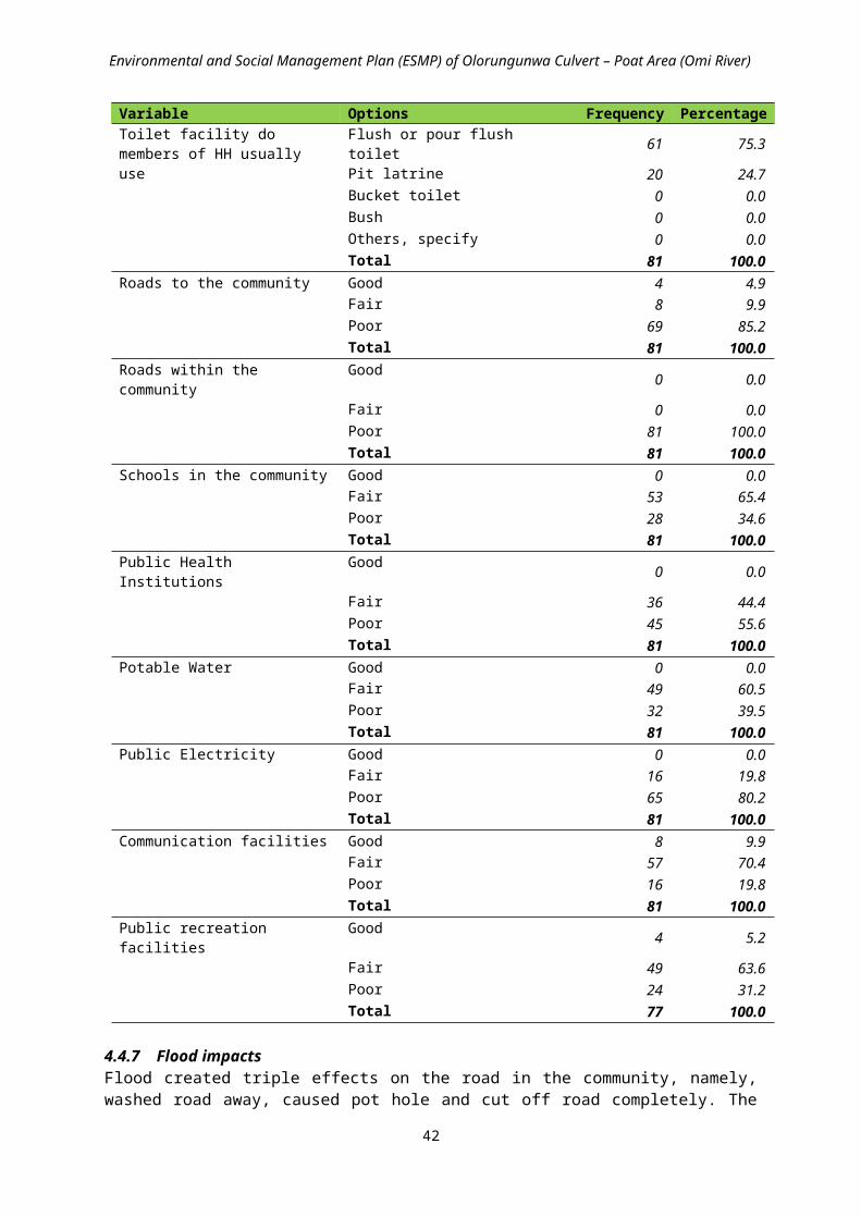
Environmental and Social Management Plan (ESMP) of Olorungunwa Culvert – Poat Area (Omi River)
Category Roles & Responsibilities Monitoring and evaluation process and criteria
Other relevant State Government MDAs
Other MDAs come in as and when relevant areas or resources under their jurisdiction or management are likely to be affected by or implicated projects.
They participate in the EA processes and in project decision-making that helps prevent or minimize environmental and social impacts and to mitigate them. These institutions may also be required, issue a consent or approval for an aspect of a project; allow an area to be included in a project; or allow impact to a certain extent or impose restrictions or conditions, monitoring responsibility or supervisory oversight
World Bank Overall supervision and provision of technical support and guidance. Recommend additional measures for strengthening the management framework and
implementation performance; Supervising the application and recommendations of sub- project ESMPs.
Local Government Provide oversight function across subproject in LGAs for ESMP compliance Liaising with the PIU. Engage and encourage carrying out comprehensive and practical
awareness campaign for the proposed sub-projects, amongst the various relevant grass roots interest groups
Local Community;Community Development Association (CDA)
Promote environmental awareness Assist and Liaise with other stakeholders to ensure proper siting and provision of approval for
such sites Support with provision of necessary infrastructures and engage/ encourage carrying out
comprehensive and practical awareness campaign for the proposed projects, amongst the various relevant grass roots interest groups.
Ensure Community participation by mobilizing, sensitizing community membersNon-Governmental Organisations (NGOs)
Assist in their respective ways to ensure effective response actions Conducting scientific researches alongside government groups to evolve and devise sustainable
environmental strategies and rehabilitation techniques Organizing, coordinating and ensuring safe use of volunteers in a response action, and actually
identifying where these volunteers can best render services effectively Providing wide support assistance helpful in management planning, institutional / governance
issues and other livelihood related matter, project impacts and mitigation measure, and awareness campaigns
Others/General Public
Identify environmental and social issues that could derail the project and support project impacts and mitigation measures
Assist in awareness campaigns
6.4 Training and Capacity Building/Strengthening PlanIn order to ensure that the ESMP provisions are implemented efficiently and effectively, training and capacity building and strengthening are required. Therefore, based on the assessment of the institutional capacities of the different agencies that will be involved in the implementation of the ESMP, the following broad areas of capacity building/strengthening have been identified and recommended for the PIU and other relevant agencies for effective implementation of the ESMP.
Environmental and Social Management Plan (ESMP); Environmental and Social Monitoring and Audit; Environmental and Social Reporting; Construction Health Safety and Environment; Solid Waste Management; Disaster Risk Reduction/Management.
The type of trainings proposed to be organized during the project period and estimated cost is given in Table 6.3. The cost estimates are based on the assumption that the training program will be held in Ibadan Oyo State; some of the resource persons could come from other parts of the country and therefore require travel allowances; participants will come from MDAs and other institutions at state levels.
56

Environmental and Social Management Plan (ESMP) of Olorungunwa Culvert – Poat Area (Omi River)
Table 6.3: Proposed Training Programme for the Implementation of the ESMPCapacity Building Activity Proposed Topics Target Audience Duration
Type of Training
When Training to be conducted by who
Estimated Budget ($)
Module 1:Training on Environmental and Social Management Plan Implementation
Overview of Environmental and Social Impact Assessment Process
Overview of Potential Environmental and Social Impacts of Project
Environmental Pollution & Control Environmental Engineering Environmental and Social
Management Plan Environmental Performance
Monitoring – Monitoring Mitigation Measures in ESMP
Environmental and Social Audits Environmental Reporting
Relevant staff of Oyo State Ministry of Environment and Water Resources FMEnv (EA) Officers of PIU-Environmental Specialist/Social Development SpecialistOyo State Waste Management Board and other relevant MDAs LGA departments, NGOs, CBOs., Contractor
2 days Lecture Pre-Construction
Environmental Consultant
6000
Module 2:Training on Construction HSE
Introduction to Construction HSE Overview of Health and Safety
Hazards in Construction Incidents: Causation, Investigation &
Reporting Excavation Safety Construction Site Inspection Personal Protective Equipment
Relevant staff of Oyo State Ministry of Environment and Water Resources, FMEnv (EA) Officers of PIU-Environmental Specialist/Social Development Specialist, and other relevant MDAs LGA departments, NGOs, CBOs, Contractor
1½ days Lecture Pre-Construction
Engineering Consultant
5000
Module 3:Training on Disaster Risk Reduction/Management
DRR/DRM concepts and applications Relevant staff of Oyo State Ministry of Environment and Water Resources FMEnv (EA), OYSEMAOfficers of PIU-Environmental Specialist/Social Development Specialist, and other relevant MDAs LGA departments, NGOs, CBOs.
½days Lecture Pre-Construction
Environmental Consultant
2000
TOTAL 4days $13,000
57

Environmental and Social Management Plan (ESMP) of Olorungunwa Culvert – Poat Area (Omi River)
6.5 Implementation ScheduleThe elements of the implementation schedule presented in Table 6.4 have to be observed throughout the project activities
Table 6.4: ESMP Implementation Schedule S/N Activity Responsibility Pre-
Construction (Month)
Construction(Month)
Operation &
Maintenance
Environmental & Social Management 1 2 3 4 5 61 Formal Disclosure of ESMP PIU
2 Develop Environmental/Social Requirements in Bid Documents
PIU-Environmental / Social Development
3 Allocate Budget for ESMP and Appoint Support Staff for ESMP
PIU
4 Finalization and Approval of Engineering Designs
Engineering Consultant / PIU-Engineering
5 Review and Approval of Contractor’s HSE, WMP, SRP, SHM sub-plan
PIU-Environmental / Social Development / Engineering
6 Implementation of Environmental and Social Mitigation Measures
Contractor
7 Supervision of pre-Construction and Construction activities
PIU-Engineering
8 Supervision of ESMP Implementation
PIU-Environmental / Social / Engineering
9 Environmental and Social Monitoring and Auditing
PIU/ Ministry of Environment & Water Resources/Consultant
10 Reporting on ESMP Implementation
PIU/Relevant MDAs
11 Environmental and Social Development Training
Environmental and Social Consultant
6.6 Proposed Budget for ESMP Implementation The total cost for implementing the ESMP is estimated at Forty-four Thousand Three Hundred and Thirty Dollars only (US$44,330.00) which is Seventeen Million, Seven Hundred and Thirty-two Thousand Naira only (N17,732,000.00). The table 6.5 below shows the breakdown of the responsibility and the cost for implementing the ESMP.
58
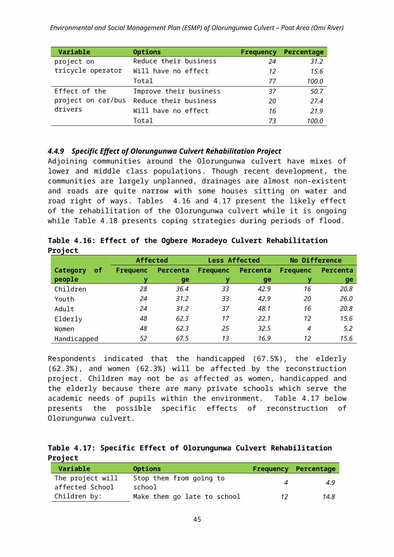
Environmental and Social Management Plan (ESMP) of Olorungunwa Culvert – Poat Area (Omi River)
Table 6.5: Estimated Budget for the Implementation of ESMP
Item Responsibility Cost EstimateIn US Dollars (US$)
Cost EstimateIn Nigerian Naira (N)
Mitigation PIU, Civil Engineering Contractor, Engineering Consultant, Environmental Consultant
16,400.00 6,560,000.00
Monitoring PIU, Oyo State Ministry of Environment and Water Resources, Waste Management Board, Ministry of Health, Ministry of Works & Transport, Environmental Consultant
10,900.00 4,360,000.00
Capacity Building
PIU, Oyo State Ministry of Environment and Water Resources/Other relevant MDAs
13,000.00 5,200,000.00
Sub-Total 40,300.00 16,120,000.00Contingency 10% of Sub-Total 4,030.00 1,612,000.00Total 44,330.00 17,732,000.00
Currency Unit = Nigerian NairaUS$ = N400
6.7 Reporting Reports shall be produced through the course of implementation of monitoring programs, collecting incident/grievances forms, consulting with local community and auditing performance of existing programmes/mitigation measures within the ESMP.
Table 6.6 describes the types of reports that shall be produced.
The PIU should provide the World Bank with report updates, frequency of reporting to the World Bank will vary depending on the nature of the non-compliance and monitoring schedule.
Table 6.6: Types of ReportsResponsibility Type of Report Purpose/Details of
ReportingFrequencyof Submission
Submit to:
Contractor
Accidents/IncidentReport
Filing/notification of accidents or unplanned events
Within 24 hours of the incident
PIU
Non-complianceReport
Detail the cause, nature and effect of any environmental and/or socio-economicnon-compliant actperformed
Within oneweek of theevent
PIU
MonthlyCompliance Report
Report ofcompliance and non-compliance issues /measures
Monthly PIU
PIU-Environmental/Social Development
Daily ComplianceChecklist
Checklist of environmental and social compliance of construction
Daily Internal/PIU
MonthlyCompliance Report
Monthly report of compliance within 10 days of receipt of report from Contractor
Monthly Internal/PIU
6.8 ESMP DisclosuresDisclosures, as described in Table 6.7, shall be made after the ESMP review and clearance by the World Bank.
59

Environmental and Social Management Plan (ESMP) of Olorungunwa Culvert – Poat Area (Omi River)
Table 6.7: Disclosure ProcedureAction Remarks
1. Disclosure on 2 state newspapers The PIU will disclose the ESMP as required by the Nigeria EIA public notice and review procedures
2. Disclosure on 2 local newspapers
The PIU will disclose the ESMP as required by the Nigeria EIA public notice and review procedures
3. Disclosure at the Oyo State Ministry of Environment and Water Resources
The PIU will disclose the ESMP as required by the Nigeria EIA public notice and review procedures
4. Disclosure at the IUFMP office The PIU will disclose the ESMP as required by the Nigeria EIA public notice and review procedures
5. Disclosure at the Local Government Office & the host community
The purpose will be to inform stakeholders about the project activities; environmental and social impacts anticipated and proposed environmental and social mitigation measures.
6. Disclosure at the World Bank Info Shop
The ESMP will be disclosed according to the World Bank Disclosure Policy- OP/BP 17.50
7. Disclosure at the FMEnv Zonal Office in Ibadan
The PIU will disclose the ESMP as required by the Nigeria EIA public notice and review procedures
60

Environmental and Social Management Plan (ESMP) of Olorungunwa Culvert – Poat Area (Omi River)
CHAPTER 7
PUBLIC / STAKEHOLDERS CONSULTATIONS
7.1 Stakeholders’ Meeting
ProcedurePublic consultation has proven to be vital in project conception and implementation. It allows people own the projects and enhances project survival and trust between government and beneficiary community. For this project, we engaged critical stakeholders for the overall success of the project. In order to achieve this, the following procedure was undertaken while engaging the communities.
1. Pre-consultation: Initial visitation to the communities ensured familiarities with the Consultant team. During these pre-public consultation meetings, we contacted and engaged representatives of key community actors including executives of landlord associations, community associations, religious organizations, and non-government organizations such as the Red Cross, transporters associations (Okada Riders Association and National Union of Road Transport Workers), community/opinion leaders, people living with disability, women groups and youth groups. These initial meetings were used to prepare the mind of the community ahead of the forum meeting. Key critical stakeholders are vital in building trust and entering the field for public communication and consultations.
2. Development of Communication plan: The development of a communication plan for this study was influenced greatly by the pre-consultation meetings. This was important as communication strategies must take into consideration the peculiar characteristics of the audiences. Taking cognizance of the peculiar characteristics of our stakeholders, Yoruba was the main language of communication while English was sparingly used. The use of Yoruba helped us in building more trust as stakeholders were able to relate with what we presented and made valid contributions.
3. Discussion with Stakeholders: Further to the above, one-on-one and community meetings, telephone conversations and group discussions were employed in engaging stakeholders. These different strategies enabled us to get more data useful for the execution of the project. Where group discussion took place, we ensured moderation in order to control for dominance. The Consultant socioeconomic team utilized both qualitative and quantitative methods (In-depth interviews, administration of questionnaire as well as key informant interviews).
The project site was visited by the Consultant team, the IUFMP Social Development Specialist and the Engineer, and the relevant MDAs and Local Government representatives. The community forum had women group, representatives of the physically challenged, schools, market men and women, transport unions, social groups, NGOs (Red Cross society), landlord associations, and traditional institutions, among others. This collectivity made the meeting generate diverse issues and robust information as it relates to the socio-economic impacts flooding has on their lives and how the proposed project will affect their livelihoods.
Issues raised and ConclusionsThe public consultation indicated that the socio-economic livelihoods of the communities are negatively affected by flooding. The following are some of the conclusions and issues raised:
1. There was harmony of purpose by the community members at the forum, and everyone who contributed to the discussion spoke as for the entire community.
2. Due to years of unfulfilled promises of construction of affected culvert/bridge, there was trust problem across communities. Hence there is need to build trust across project sites.
61

Environmental and Social Management Plan (ESMP) of Olorungunwa Culvert – Poat Area (Omi River)
3. There was harmony of purpose by the community members at the forum, and everyone who contributed to the discussion spoke as for the entire community.
4. Communities had utilized self-galvanized efforts in reducing adverse impacts of the sites on their livelihoods through periodic contributions.
5. Corruption was identified as responsible of previously poorly constructed culvert/bridges which were not durable. Hence, stakeholders do not want quality of the projects compromised.
6. Communities demand right to grievance and petitions.
7. There was demand for provision of formal garbage and sewage disposal sites to stop dumping of waste in rivers.
8. Communities demand for alternative routes during construction of the new bridge/road infrastructure.
It is expected that the issues raised by stakeholders will be taken into consideration during the implementation of this project. Issues of trust, corruption and poor communication from government to the beneficiary of projects need to be addressed. Trust can be built when communities see execution of projects within the timeframe stipulated and when they are involved in the conception, planning and execution. This is essential for projection development and implementation and gives the feeling of ownership of projects to community. It also has implication for security. This bottom-up approach is suggested. It is expected that the results of the socio-economic impact assessment be communicated to the community through a process of debriefing on results of the study. This will allow the communities to make final input before full project implementation. The summary of the proceedings of the consultation is provided in Table 7.1.
Table 7.1: Summary of Proceedings of ConsultationsItem Description Date of Public Consultation 14 June 2016Name of Stakeholders (community) Adekola/Omirin/Olorungunwa Communities
Key StakeholdersCommunity leaders; executives of landlord associations; women and youth groups; religious groups (Christian and Muslim); opinion groups; representatives of physically challenged; NGOs (Red Cross Society); market women and men; community development associations and councils (CDAs & CDCs); Central Executive of the Progressives (comprising all the communities); IUFMP; relevant State Government officials; Consultant team: experts, research assistants and enumerators.
Attendance 88 (visiting teams exclusive)Language of communication Yoruba (mainly)/English
Introduction
The Progressives chairman gave the welcome address.
The Consultant team leader welcomed everyone present at the forum and gave the general overview of the proposed project after introducing the consultant team. He stressed the importance of community consultation for the smooth implementation of the project. He noted that the meeting was for socio-economic impact assessment of the proposed project and how the project would affect individuals and the community as a whole. He pleaded for cooperation of the communities for successful take-off and execution of the project for the development of the community. He also implored them to attend to the research enumerators who are administering questionnaire as part of the assessment.
The IUFMP engineer informed the communities of the designs of the culverts and the access roads that would be constructed. He explained further that Oyo state is funding the project through the help from the World. He assured of quality construction that would last decades.
62

Environmental and Social Management Plan (ESMP) of Olorungunwa Culvert – Poat Area (Omi River)
Issues / Comments raised by the Stakeholders Response by the Project Officers / ConsultantThe overall community chairman pleaded for the implementation of durable project in order to avoid the catastrophic flood which ravaged the community in 2011 during which many lives and properties were lost.
Comments from members of the communities, including two women, who spoke centered on knowing where the project will be sited, when the project would start and the expected roles from individuals and community.
The project engineer assured of the durability of the project to be constructed. He stated that the starting time depends on the completion of necessary studies, which he believes would be soon. The project will be transparently handled while the local government shall also play relevant roles in the project execution.
The Consultant representative stated that work will start from Omirin and Olorungunwa and maybe later from other communities around as determined by the State Government. She pleaded with the community members to cooperate with the study team for the supply of relevant information for the mitigation/ enhancement of anticipated impacts of the project, and to also cooperate later with the construction team.
7.2 Community Risk Assessment
Table 7.2: Hazards in the communityHazards Ranking*Bad drainage/bridge 1st
Bad roads 2nd
No water supply (pipe borne water and borehole) 3rd
Lack of modern facilities such as medical 4th
No electricity (darkness in the community due to lack of street light) 5th
The topography 6th
No modern markets 7th
Poor transport systems 8th
Okada riders 9th
Heavy/articulated vehicles (due to constructions) 10th
*These rankings were arrived at after the participants were asked to indicate the problems according to the severity of their impacts on the community
Table 7.3: Risk AnalysisThose at risk (ranked) Why they are at riskChildren 1. Children cannot take care of themselves during flooding incidence and other
hazards2. Children don’t have access to phone3. They may not know when to cross bridge or not during rainfall4. They fetch water5. No electricity for them to read6. Children fall sick easily7. Children cannot take care of themselves during bad situation
Women 1. Women are responsible for children2. Pregnant women face more risk3. Women are mostly affected by flooding4. They run errands and go to market
Men 1. They are the breadwinners2. Mind not at rest anytime they go out
When mostly at risk Rainy seasonsOutcome of risk 1. Falling of electricity poles by trucks
2. Collapse of fences, bridges and electric poles during heavy rainfallWhat is increasing risk 1. Attitude
2. Lack of maintenance culture3. Lack of preventive measures
63

Environmental and Social Management Plan (ESMP) of Olorungunwa Culvert – Poat Area (Omi River)
4. Poor waste management5. Lack of good policies6. Children are not given right of way7. No waste disposal facility
How to reduce risk 1. Attitudinal change2. National Orientation Agency (NOA) must step up campaign
Existing organizations1. Social organizations
(e.g., Adekola Legacy Club)
i. Take care of the elderlyii. Free medical outreach
iii. Drugs, foods, eye glasses and moneyiv. Road maintenance
2. Religious groups i. Muslim (rescue communities)ii. Pentecostal Fellowship of Nigeria (PFN) (women wing; very active)
3. Opinion leaders4. Youth groups i. They fill the potholes
ii. Protect the communitiesiii. They mobilize and create awareness
5. Women religious groups i. Prayer to support communityLocal customs/festivals i. Marriages
ii. Naming ceremoniesiii. Birthdayiv. Religious festivalsv. Community support practices
vi. Partnership Gender relations (Women) 1. They support the men
2. They also contribute financially3. Waste management4. Women have voice and they also participate in community development
64

Environmental and Social Management Plan (ESMP) of Olorungunwa Culvert – Poat Area (Omi River)
CHAPTER 8
SUMMARY AND RECOMMENDATIONS
The following conclusions and recommendations were presented.
The contractor and PIU shall coordinate with the Oyo State Federal Road Safety Commission and Oyo State Traffic Management Agency all through pre-construction and construction works on site to ensure that safety is maintained and potential traffic impact managed;
Design and construct a temporary alternative access bridge and approach road for community members for pedestrian and light traffic usage;
Install proper lightening and relevant road signage and barriers for safety precautions; Community members shall be sensitized and duly informed on the time and duration of civil
works through consultations; Community members shall be carried along during project implementation and shall be
mobilized to provide community security for equipment and personnel working on site; Community members shall be given preference for casual labour and semi-skilled labour as
much as practicable in order to minimize social problems at the community level; The stream banks shall be cleared of vegetation and the width widened appropriately along
the project area of influence; The silt, vegetation and solid wastes obstructing the stream shall be cleared and evacuated; Pre-construction and construction works shall be carried out in an environmentally
sustainable and socially responsible and inclusive manner; The topography of the approach roads to the bridge as well as side drains shall be taken into
consideration during the construction for proper discharge downstream and for the avoidance of sheet erosion;
Adequate mitigation measures have been proffered for the few negative environmental and social impacts that may occur due to the activities associated with the proposed works, while enhancement measures are proffered for the potential positive impacts;
Appropriate institutional framework has been drawn up to implement the mitigation measures and the proposed monitoring programmes;
Therefore the proposed intervention work is doable in an environmentally sustainable and socially responsible and inclusive manner, and it is most desirable because of the obvious environmental, health and socio-economic benefits.
65

Environmental and Social Management Plan (ESMP) of Olorungunwa Culvert – Poat Area (Omi River)
REFERENCES
Federal Environmental Protection Agency (1992): Guidelines and Standards for Environmental Pollution Control in Nigeria 238p.
FEPA (1991): S.I.15 - National Environmental Protection Management of Solid and Hazardous Waste Regulation.
IUFMP (2013): Resettlement Policy Framework
IUFMP (2013): Terms of Reference for Design and Supervision of Priority Structural Works.
IUFMP (2014): Environmental and Social Management Framework for Ibadan Urban Flood Management Project Final Report
IUFMP (2015): Environmental and Social Screening of 14 Priority Sites
IUFMP (2015): Project Implementation Manual
IUFMP (2016): Inception Report for the Preparation of Environmental and Social Management Plans (ESMPs), Environmental and Social Impact Assessments (ESIAs) and Resettlement Action Plans (RAPs) for Ten (10) Priority Sites
IUFMP (2016): Terms of Reference for the Preparation of Environmental And Social Management Plans (ESMPs), Environmental and Social Impact Assessments (ESIAs) and Resettlement Action Plans (RAPs) for Ten (10) Priority Sites
IUFMP (2016): Detailed Engineering Design, Preparation of Tender Documents and Construction Supervision for Twelve (10+2) Priority Sites in Ibadan, Draft Final Report, December 2016
World Bank (1996): Environmental Performance Monitoring and Supervision Update No 14
World Bank (1999): Environmental Management Plan , OP 4.01 - Annex C
66

Environmental and Social Management Plan (ESMP) of Olorungunwa Culvert – Poat Area (Omi River)
ANNEX A: BID SPECIFICATIONS FOR ENVIRONMENTAL MANAGEMENT FOR CONSTRUCTION CONTRACTS
A-1: Construction Impact Management PlanIn order to reduce the impact of the construction activities on local communities and the environment, the Construction Contractor shall implement the following Sub-Plans in accordance with the following stipulations:
Erosion and SedimentationSite activities shall be carefully managed in order to avoid site erosion and sedimentation of downstream waterways. In order to minimize negative erosion impacts in the project area, the following activities shall be carried out by the Contractor:
Erosion and sedimentation shall be controlled during the construction. Areas of the site not disturbed by construction activities shall be maintained in their existing state.
Disturb as little ground area as possible; stabilize these areas as soon as possible, control drainage through the area, and trap sediment onsite. Install erosion control barriers around perimeter of cuts, disposal pits, and roadways.
Slope works and earth moving/excavation shall be conducted in order to minimize exposure of the soil surface both in terms of area and duration. Temporary soil erosion control and slope protection works shall be carried out in sequence to construction.
Conserve topsoil with its leaf litter and organic matter, and reapply this material to local disturbed areas to promote the growth of local native vegetation.
Apply local, native grass seed and mulch to barren erosive soil areas or closed construction surfaces. Apply erosion control measures before the rainy season begins, preferably immediately following construction.
Install erosion control measures as each construction site is completed. In all construction sites, install sediment control structures where needed to slow or redirect runoff and trap
sediment until vegetation is re-established. Sediment control structures include windrows of slash, rock berms, sediment catchment basins, straw bales, brush fences, and silt fences.
Control water flow through construction sites or disturbed areas with ditches, berms, check structures, live grass barriers, and rock.
The ground surface at the construction site offices shall be concreted or asphalted in order to minimize soil erosion.
Erosion control measures shall be maintained until vegetation is successfully re-established. Water shall be sprayed as needed on dirt roads, cuts, fill material and stockpiled soil to reduce wind-induced
erosion and dust, and Larger changes in the landscape from quarries, tunnel spoil tips, etc. should be landscaped and replanted, both to
reduce erosion problems and to reduce the visual impact of construction.
Particulate Emissions and DustThe Contractor shall propose methods and actions to control dust resulting from construction related activities, crushing and concrete batching plants, earthworks including road construction, embankment and channel construction, haulage of materials and construction work camps. In particular the Contractor shall undertake the following:
Minimize production of dust and particulate materials at all times, to avoid impacts on surrounding communities, and especially to vulnerable people (children, elderly people).
Time removal of vegetation to prevent large areas from becoming exposed to wind. Place screens around construction areas to minimize dust proliferation, paying particular attention to areas close to
local communities. Spray water as needed on dirt roads, cut areas and soil stockpiles or fill material. Spraying shall be carried out in
dry and windy days, at least twice a day (morning and afternoon). The frequency of spraying near local communities shall be increased as needed.
Pave access roads with gravel in the sections which near the communities and other sensitive receptors to reduce generation of air-borne dust.
Provide an adequate ventilation system and other measures to control concentration of air pollutants within tunnels.
Transportation of materials by vehicles and construction of access roads shall be properly designed. For example, the access road can be constructed and paved by concrete/asphalt, or laid with small graded rocks, prior to major earthworks which may require transportation of substantial amount of materials on-site and off-site.
Ensure adequate maintenance of all vehicles. Construction plant/vehicles that generate serious air pollution and those which are poorly maintained shall not be allowed on site.
Transport of chemicals or materials such as cement, sand and lime shall be covered entirely with clean impervious material to ensure that these materials shall be contained. Overflow of material shall be avoided; and
The exhaust gases from construction machinery and vehicles are accepted. However, the engines shall be inspected and adjusted as required to minimize pollution levels.
Noise
67

Environmental and Social Management Plan (ESMP) of Olorungunwa Culvert – Poat Area (Omi River)
To minimize noise the Contractor shall: Maintain all construction-related traffic on project access roads at established speed limits. Maintain all on-site vehicle speeds at or below 30 kph, or otherwise designated. To the extent possible, maintain noise levels associated with all machinery and equipment at or below 90 db. In sensitive areas (including residential neighbourhoods, hospitals, rest homes, schools, etc.) more strict noise
abatement measures may need to be implemented to prevent undesirable noise levels. Apply proper measures to minimize disruptions from vibration or noise coming from construction activities. Design a transportation schedule for entry of construction materials to minimize the adverse impact on residents,
as well as the traffic on the existing roads. The transportation vehicles shall be required to slow down and banned from using horns when passing sensitive areas. Transportation during peak hours should be minimized. The Contractor shall provide the transportation route in advance to the Engineering Supervisor.
Maintain the construction equipment in its best operating conditions and lowest noise levels possible. Use temporary noise barriers to minimize the noise caused by construction equipment; Provide hearing protection to workers who must work with highly noisy machines such as piling, explosion,
mixing, etc., for noise control and workers protection. Areas for the storage of fuel or lubricants fenced and have a compacted/impervious floor or other surface to
prevent the escape of accidental spillage of fuel and/or lubricants from the site. Surface water drainage from fenced areas shall be discharged through an oil skimmer or other appropriate device to remove hydrocarbons. Empty fuel or oil drums may not be stored on site.
The construction supervision team shall be equipped with portable noise detection devices to monitor the noise level at the sensitive receptors.
Materials leaving the construction site shall be transported during non-peak hours in order to minimize traffic noise due to the increase in traffic volumes.
Use of properly designed silencers, mufflers, acoustically dampened panels and acoustic sheds or shields, etc. shall be made. Mufflers and other noise control devices shall be repaired or replaced if defective.
Use of electric-powered equipment when applicable instead of diesel-powered or pneumatic-powered equipment. Equipment known to emit strong noise intensity in one direction, shall when possible, be oriented to direct noise
away from nearby sensitive receptors. Machines and equipment that may be in intermittent use shall be shut down between work periods or throttled
down to a minimum operation.
Night-time Construction Noise MitigationAlthough in general, night-time construction shall be banned near sensitive receptors, some construction may still occur for technical and other reasons (e.g., bridge piles required and continued around clock concrete pouring). Because night time construction, if occurring near local communities, will result in significant impacts to residents and other sensitive receptors, the following special measures shall be taken during the construction phase:
People living within potentially impacted areas shall be notified ahead of time of the length and noise intensity of the proposed night-time construction. Residents shall be informed as to why night construction is necessary and they shall be provided with the mitigation measures that are going to be implemented to obtain their understanding. These residents shall be allowed to express their concerns, difficulties, and suggestions for noise control prior to the commencement of night time construction. These concerns shall be addressed and suggestions adopted where appropriate;
Concrete batching plants, generators and other stationary equipment shall be carefully placed as far away from local communities to reduce noise impacts from these machines. Where possible, municipal power supply shall be used for night-time construction as diesel generators are extremely noisy and avoiding their use is the best mitigation possible.
Equipment with lower noise levels shall be used for concrete pouring operations, which may require 24 hour non-stop operation.
Temporary noise barriers shall be installed at the appropriate locations to avoid night-time noise impacts, and Notification boards shall be posted at all construction sites providing information about the project, as well as
contact information about the site managers, environmental staff, telephone numbers and other contact information so that any affected people can have a channel to voice their concerns and suggestions.
Earthworks, Cut and Fill SlopesThe contractor shall ensure that the following procedures are undertaken:
All earthworks shall be properly controlled, especially during the rainy season. The Contractor shall maintain stable cut and fill slopes at all times and cause the least possible disturbance to areas
outside the prescribed limits of the works. The Contractor shall complete cut and fill operations to final cross-sections at any one
location as soon as possible and preferably in one continuous operation to avoid partially completed earthworks, especially during the rainy season.
In order to protect any cut or fill slopes from erosion, in accordance with drawings, cut off drains and toe-drains shall be provided at the top and bottom of slopes and be planted with grass or other plant cover. Cut off drains should be provided above high cuts to minimize water runoff and slope erosion.
68
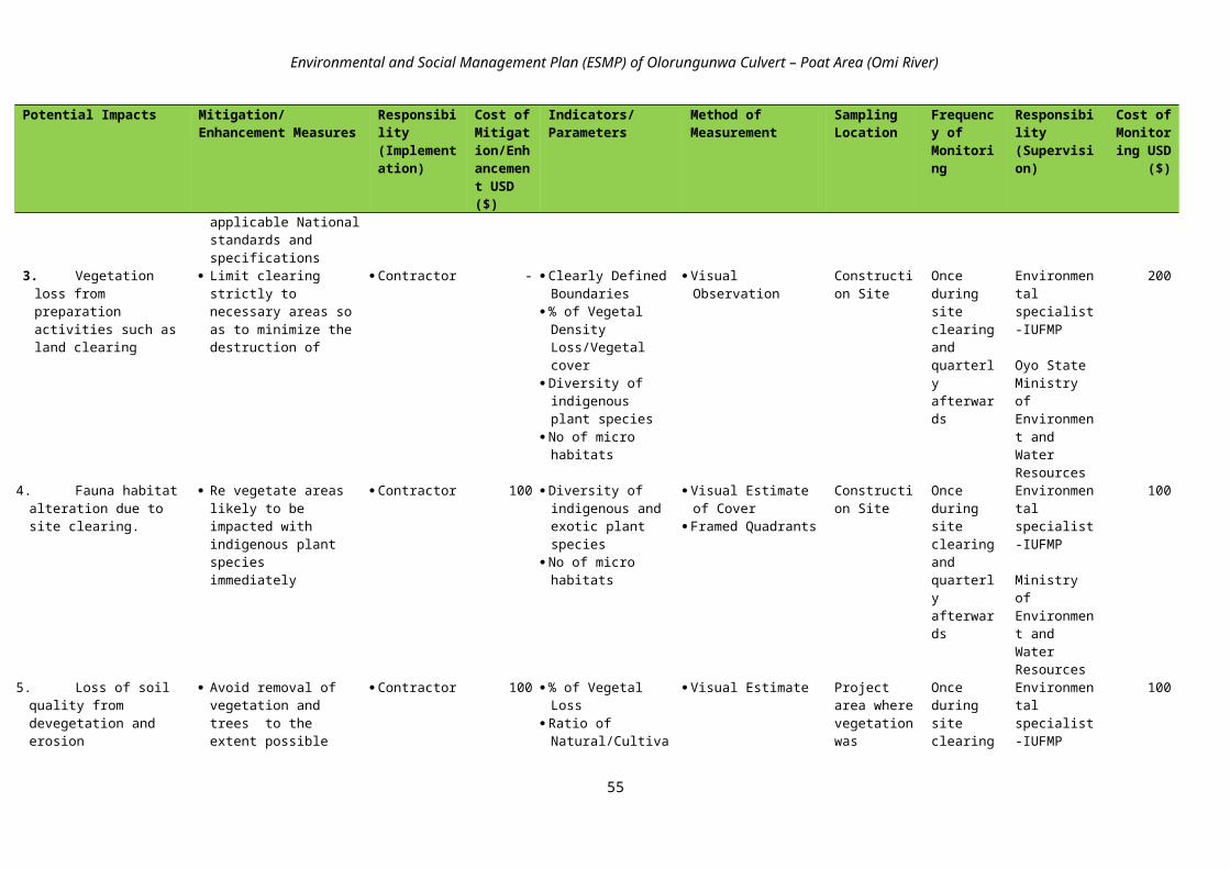
Environmental and Social Management Plan (ESMP) of Olorungunwa Culvert – Poat Area (Omi River)
Any excavated cut or unsuitable material shall be disposed of in designated disposal areas as agreed to by the Supervisory Engineer, and
Disposal sites should not be located where they can cause future slides, interfere with agricultural land or any other properties, or cause runoff from the landfill towards any watercourse. Drains may need to be dug within and around the landfills, as directed by the Supervisory Engineer.
Stockpiles and Borrow PitsThe Contractor shall prepare and overall Stockpiles and Borrow Pits Management Plan for thetotal works. Operation of a new borrowing area, on land, in a river, or in an existing area, shall be subject to prior approval of the Environmental Supervisor, and the operation shall cease if so instructed by the Supervisory Engineer.Borrow pits shall be prohibited where they might interfere with the natural or designed drainage patterns. River locations shall be prohibited if they might undermine or damage riverbanks, or carry too much fine material downstream.The location of crushing plants shall be subject to the approval of the Supervisory Engineer, and not be adjacent to environmentally sensitive areas, or to existing residential settlements, and shall be operated with approved fitted dust control devices.Rock or gravel taken from a river shall be far enough removed to limit the depth of material removed to one-tenth of the width of the river at any one location, and not to disrupt the river flow, or damage or undermine the riverbanks.The Plan shall include:
A map showing the extent of the area to be developed. A method statement defining the proposed working methods. The proposed access and haulage routes between the borrow pits and the destination for the extracted materials. A justification for the quantities of materials to be extracted, an estimation of the waste material to be generated
and disposal details for such waste materials. Details of the measures taken to minimize the borrow pit areas and their visual impact on the surrounding area, and Details of the measures to be taken for the long-term rehabilitation of the borrow pit areas in order to avoid
situations that could constitute a threat to health and safety and cause environmental degradation.
In general terms, the Contractor shall: Identify and demarcate locations for stockpiles and borrow pits, ensuring that they are 15 meters away from critical
areas such as steep slopes, erosion-prone soils, and areas that drain directly into sensitive water bodies. Limit extraction of material to approved and demarcated borrow pits. Stockpile topsoil when first opening the borrow pit. After all usable borrow has been removed, the previously
stockpiled topsoil should be spread back over the borrow area and graded to a smooth, uniform surface, and adequately sloped for drainage. On steep slopes, benches or terraces may have to be established to help control erosion.
Excess overburden should be stabilized and re-vegetated. Where appropriate, organic debris and overburden should be spread over the disturbed site to promote revegetation. Natural re-vegetation is preferred to the best extent practicable.
Existing drainage channels in areas affected by the operation should be kept free of overburden. Once the job is completed, all construction -generated debris should be removed from the site to an approved
disposal location. The Contractor shall ensure that all borrow pits used are left in an appropriate condition with stable side slopes, re-
establishment of vegetation, restoration of natural water courses, avoidance of flooding of the excavated areas wherever possible so no stagnant water bodies are created which could breed mosquitoes, and
When the borrow pits or the local depressions created by the construction activities cannot be refilled or reasonably drained, the Contractor shall consult with the local community to determine their preference for reuse such as fish farming or other community purposes.
Disposal of Construction WasteThe Contractor shall carry out the following activities:
Establish and enforce daily site clean-up procedures, including maintenance of adequate disposal facilities for construction debris.
Debris generated due to the dismantling of the existing structures shall be suitably reused, to the best extent feasible (e.g. as fill materials for embankments). The disposal of remaining debris shall be carried out only at sites identified and approved by the Supervisory Engineer. The Contractor should ensure that these sites (a) are not located within designated forest areas; (b) do not impact natural drainage courses; and (c) do not impact endangered/rare flora. Under no circumstances shall the Contractor dispose of any material in environmentally sensitive areas.
In the event any debris or silt from the sites is deposited on adjacent land, the Contractor shall immediately remove such, debris or silt and restore the affected area to its original state to the satisfaction of Supervisory Engineer.
69

Environmental and Social Management Plan (ESMP) of Olorungunwa Culvert – Poat Area (Omi River)
All arrangements for transportation during construction including provision, maintenance, dismantling and clearing debris, where necessary, will be considered incidental to the work and should be planned and implemented by the contractor as approved and directed by the Supervisory Engineer.
Consult with local communities, if any, living close to spoil disposal sites that may be affected. The consultation shall provide local stakeholders with detailed information of the potential spoil disposal site, and provide an opportunity for them to express their opinions and concerns with the proposed plans. Information and feedback from the consultation process shall be incorporated into the final design for each spoil disposal site.
Include provisions for incorporating the most appropriate stabilization techniques for each disposal site. Assess risk of any potential impact regarding leaching of spoil material on surface water. Include an appropriate analysis to determine that the selected spoil disposal sites do not cause unwanted surface
drainage, and Stabilize spoil disposal sites to avoid erosion in accordance with the requirements of the Landscape and Re-
vegetation Plan.
A-2: Other Management PlansThe contractor shall be responsible for preparing the following management plans in accordance with the stipulated terms of reference:
Waste Management PlanDuring the construction stage, the Contractor shall prepare a Waste Management Plan before commencement of project works. The Plan shall include:
Water and Wastewater A review of the preliminary site drainage design prepared during the detailed design. An update of the preliminary design based on the actual construction program and site specific conditions (e.g. the
geographical conditions, location of slopes and the nature of construction work). Detailed design including drawings, location maps, specifications of drainage collection channels and wastewater
treatment facilities. Proposed discharge locations and treatment standards. A detailed implementation program of the proposed drainage system. As part of the design of the site drainage system, surface runoff within the construction site shall be diverted in
order to avoid flushing away soil material and the water is treated by device such as sediment trap before discharge.
Domestic sewage from site offices, toilets and kitchen shall either be collected by a licensed waste collector or treated by on-site treatment facilities. Discharge of treated wastewater must comply with the discharge limits according to National regulations.
Prior to the rainy season, all exposed surfaces and slopes shall be properly covered or landscaping shall be provided to minimize run-off of sediment laden. Slope protection can be carried out in sequence to construction and in advance of the rainy season.
Drainage control devices such as sediment traps shall be installed at each discharge outlet, and they shall be cleaned regularly, and
Chemical toilets can be provided on each work site employing 5 workers or more. At least one toilet shall be installed per 25 workers. Domestic sewage collected from the site office and chemical
toilets shall be cleaned up on regular basis. Only licensed waste collectors shall be employed for this disposal. The sludge shall be treated according to the requirements of the Contractor’s Waste Management Plan.
Solid Wastes Wastes such as those listed below are expected due to construction activities:
Surplus excavated materials requiring disposal due to earth moving activities and slope cutting. Disposal of used lumber for trenching works, scaffolding steel material, site hoarding, packaging materials,
containers of fuel, lubricant and paint. Waste generated by demolition of existing houses / buildings affected by the project or breaking of existing
concrete surfaces. Waste from on-site wastewater treatment facility (e.g. treatment of bentonite from tunneling works by
sedimentation process), and Domestic waste generated by construction workers, construction campsite and other facilities.
The above wastes must be properly controlled through the implementation of the following measures: Minimize the production of waste that must be treated or eliminated. Identify and classify the type of waste generated. If hazardous or chemical wastes are generated, proper procedures
must be taken regarding their storage, collection, transportation and disposal. (See Emergency Plan for Hazardous Materials and Chemical Waste Management Plan).
Identify and demarcate disposal areas clearly indicating the specific materials that can be deposited in each, and
70

Environmental and Social Management Plan (ESMP) of Olorungunwa Culvert – Poat Area (Omi River)
Control placement of all construction waste (including earth cuts) to approved disposal sites (>300 m from rivers, streams, lakes, or wetlands). Collect and recycle and dispose where necessary in authorized areas all of garbage, metals, used oils, and excess material generated during construction, incorporating recycling systems and the separation of materials.
The Contractor shall make a commitment to waste recycling and re-use methods in consideration of the following; A method statement on waste recycling, re-use and minimization of waste generation. Excavated material shall be re-used on-site or the nearby road segment / other projects as far as possible in order to
minimize the quantity of material to be disposed of. Recyclable materials such as wooden plates for trench works, steel, scaffolding material, site holding, packaging
material, etc. shall be collected and separated on-site from other waste sources. Collected recyclable material shall be re-used for other projects or sold to waste collector for recycling, and
Collected waste shall be disposed of properly through a licensed waste collector.
Pollution Prevention PlanEmergency Plan for Hazardous MaterialsIf the construction site is expected to have or suspected of having hazardous materials (chemicals, asbestos, hydrocarbons, or other similar hazardous materials), the Contractor will be required to prepare a Hazardous Waste Management Plan and Emergency Response Plan to be approved by the Environmental Supervisor. Removal and disposal of existing hazardous wastes in project sites should only be performed by specially trained personnel following national or provincial requirements, or internationally recognized procedures.The Contractor shall:
Make the Hazardous Waste Management Plan available to all persons involved in operations and transport activities;
Hazardous waste (or chemical waste) shall be properly stored, handled and disposed of in accordance with the local legislative requirements. Hazardous waste shall be stored at designed location and warning signs shall be posted;
Inform the Environmental Supervisor, or Construction Supervisor of any accidental spill or incident in accordance with the plan;
Prepare a companion Emergency Response Plan outlining all procedures to be undertaken in the event of a spilled or unplanned release;
Initiate a remedial action following any spill or incident; and Provide a report explaining the reasons for the spill or incident, remedial action taken, consequences/damage from
the spill, and proposed corrective actions. The Emergency Plan for Hazardous Materials shall be subsequently updated and submitted to the PEO for no objection.
Chemical WasteDuring construction there will be a potential for pollution to adjacent habitat areas and watercourses caused by chemical wastes such as spent waste oil, spent lubricant, contaminated soil material due to leakage of hydraulic oil, fuel from construction plant or vehicles, etc.The following measures shall be put into place in order to minimize the damage caused by chemical waste:
All refueling of heavy equipment and machinery shall be undertaken by a service vehicle to prevent any spillage or contamination by chemical wastes such as maintenance oils, lubricants, etc.
All the fuel and hazardous material storage shall be adequately enclosed to prevent any spillage problems; Storm water runoff from open workshops, repair areas, and enclosed storage areas shall be collected and treated in
hydrocarbon separation pits/tanks before discharge to drains and waterways. All explosives shall be transported, stored and handled in accordance with applicable laws and good design
engineering and constructions practices. The contractor shall provide details of proposed storage and security arrangements, and
Pesticides and shall be packaged, labeled, handled, stored and disposed of according to National standards .
Maintenance of Construction EquipmentThe Contractor shall:
Identify and demarcate equipment maintenance areas (>15m from rivers, streams, lakes or wetlands). Fuel storage shall be located in proper areas and approved by the PEO.
Ensure that all equipment maintenance activities, including oil changes, are conducted within demarcated maintenance areas; never dispose spent oils on the ground, in water courses, drainage canals or in sewer systems, and
All spills and collected petroleum products shall be disposed of in accordance with standard environmental procedures/guidelines. Fuel storage and refilling areas shall be located at least 100m from all cross drainage structures and important water bodies.
71

Environmental and Social Management Plan (ESMP) of Olorungunwa Culvert – Poat Area (Omi River)
A-3: Safety During ConstructionThe Contractor’s responsibilities include the protection of every person and nearby property from construction accidents. The Contractor shall be responsible for complying with all national and local safety requirements and any other measures necessary to avoid accidents, including the following:
Present details regarding maximum permissible vehicular speed on each section of road; Establish safe sight distance in both construction areas and construction camp sites; Place signs around the construction areas to facilitate traffic movement, provide directions to various components
of the works, and provide safety advice and warning. All signs shall be in English and the local language; Estimate maximum concentration of traffic (number of vehicles/hour); Be held responsible for any damage caused to local roads and bridges due to the transportation of excessive loads,
and shall be required to repair such damage; Not use any vehicles, either on or off road with grossly excessive, exhaust or noise emissions. In any built up
areas, noise mufflers shall be installed and maintained in good condition on all motorized equipment under the control of the Contractor;
Carefully and clearly mark pedestrian-safe access routes; If school children are in the vicinity, include traffic safety personnel to direct traffic during school hours; Maintain a supply for traffic signs (including paint, easel, sign material, etc.), road marking, and guard rails to
maintain pedestrian safety during construction; Conduct safety training for construction workers prior to beginning work; Provide personal protective equipment and clothing (goggles, gloves, respirators, dust masks, hard hats, steel-toed
boots, etc.) for construction workers and enforce their use; Provide post Material Safety Data Sheets for each chemical present on the worksite; Require that all workers read, or are read, all Material Safety Data Sheets. Clearl explain the risks to them and their
partners, especially when pregnant or planning to start a family. Encourage workers to share the information with their physicians, when relevant;
Ensure that the removal of asbestos-containing materials or other toxic substances be performed and disposed of by specially trained workers;
During heavy rains or emergencies of any kind, suspend all work.
A-4: Environmental Training for Construction WorkersDuring construction there will be a potential for workers to damage protected areas and waterways adjacent to camps and work areas. The Contractor shall prepare an Environmental Training Plan for all construction workers: the Plan shall address the following items:
All Contractor’s employees shall be required to comply with environmental protection procedures and they shall be able to provide evidence that they attended the training sessions detailed in the Plan;
The Plan shall educate all construction workers on the following issues but not limited to them: fire arm possession, traffic regulations, illegal logging and collection of non-timber forestry products, hunting and fishing restrictions, waste management, erosion control, health and safety issues, all prohibited activities, the Code of Conduct requirements and disciplinary procedures, and general information on the environment in which they will be working and living;
Establishment of penalties for those who violate the rules; and Proposed methods for conducting the training program, which shall include formal training sessions, posters, data
in newsletters, signs in construction and camp areas and ‘tool box’ meetings.
72

Environmental and Social Management Plan (ESMP) of Olorungunwa Culvert – Poat Area (Omi River)
ANNEX B: QUESTIONNAIRE
HOUSEHOLD QUESTIONNAIRE FOR THE PREPARATION OF ENVIRONMENTAL AND SOCIAL IMPACT ASSESSMENT (ESIA) AND ENVIRONMENTAL AND SOCIAL MANAGEMENT PLAN (ESMP) FOR THE
IUFMP 10 PRIOIRITY SITES
Ibadan Urban Flood Management project (IUFMP) that aims at developing a long-term flood risk management framework by initiating risk assessment, community awareness, and providing enough flexibility in the project design to make changes based on learning.
This interview forms part of the Environmental and Social Impact Assessment and Environmental and Social Management Plan (ESMP) of the project. We need your cooperation in answering the questions asked below. Your answers will be treated as confidential.
SECTION A: IDENTIFICATION AND BACKGROUND CHARACTERISTICS A1 LGA:A2 Name of Town/City/ Community:A3 Project locationNO. QUESTION AND FILTERS CODING CATEGORIES CODESA4 Stratum Urban 1
Rural 2A5 Age Last Birthday:A6 Gender of Respondent Male 1
Female 2A7 Marital Status Never Married 1
Married 2Separated 3Divorced 4Widow 5
A8 What religion do you practice? ChristianMuslimTraditionalOthers Specify
1234
A9 Highest Educational Attainment No Formal 1Primary School Not Completed 2Primary School Completed 3
Secondary School Not Completed 4Secondary School Completed 5Post Secondary Education 6Koranic Education 7Other (specify)
A10 Primary occupation of respondents Civil servantsFarming FishingArtisanTradingProfessionalRetiredUnemployed Others Specify
123456789
A11 Secondary occupation of respondents Civil servantsFarming FishingArtisanTradingProfessionalRetiredOthers Specify
12345678
A12 Estimated monthly income from primary occupation
A13 Estimated monthly income from secondary
73

Environmental and Social Management Plan (ESMP) of Olorungunwa Culvert – Poat Area (Omi River)
occupationA14 How long have you lived in this community
(Years)A15 Did you receive any financial or in-kind
support from relatives, friends or charitable organizations in the last 12 months?
Yes
No
1
2A16 If YES, complete the following:
Source of financial support Total amount in cash/kind received in the last 12 months 1. Relative & family member N2. Friends N3. Charitable organisations N4. Mutual support groups N
A17 What sort of housing does your household live in?
Bungalow DuplexDetachedSemidetached One room apartmentSelf-containTent
1234567
A18 Type of materials used for your house WoodBrick/MudCement BlockPlastered brick/mudPlastered cement blockAny other, specify
123456
A19 Source of drinking water for members of your household
Piped into housePiped into yard or plotPublic tapTubewell/borehole with pumpProtected dug wellProtected springRainwater collectionBottled waterUnprotected dug well Unprotected spring Pond, river or streamTanker-truck, vendor Other
12345678910111213
A20 What kind of toilet facility do members of your household usually use?
Flush or pour flush toiletPit latrineComposting toiletBucket toiletNo facility/Bush fieldOthers, specify
123456
A21 Estimated Extra-expenses due to culvert/bridge Collapse
Below ₦ 10,000₦ 11,000-20,000₦ 21,000-30,000₦ 31,000-40,000₦ 41,000-50,000₦ 51,000 and above
123456
A22 Perceptions on present socio-economic status due to flooding and culvert collapse
GoodFair DeplorableHopelessOther specify
12345
SECTION B: AVAILABILITY OF AMENITIES AND WASTE DISPOSAL METHODB1 How would you describe the condition of the following amenities in your community?
Amenities Good Fair PoorRoads to the communityRoads within the communitySchools in the communityPublic Health InstitutionsPotable Water
74

Environmental and Social Management Plan (ESMP) of Olorungunwa Culvert – Poat Area (Omi River)
Public ElectricityCommunication facilities (Postal Service, Telephone)Public recreation facilities
B2 What are the sources of electricity supply used by your household? (Please Tick as appropriate)
Hurricane LampRechargeable LampPrivate GeneratorsCompany operating in your communityIBEDC (National Grid)
123456
B3 What are the source of fuel you used for cooking in your household? (Please Tick as appropriate)
FirewoodCharcoalKerosineGasElectricitySaw dustOthers, specify
1234567
B4 How do you dispose your household waste? (Tick all that apply)
BuryingBushBurningOpen dumpOrganised Collection by private organisationOrganised Collection by governmentDumped in the nearby river channelDumped in the nearby gutter Others, Specify........................
12345678910
B5 Please rate the level of effectiveness of solid waste management in your community?
Very effectiveFairly effectiveNot effective
123
SECTION C: FLOODING, CULVERT/BRIDGE AND IMPACTS C1 What has been the impact of the flood event
on road infrastructureWash the road awayCause pot holesCut off the road completelyOthers, specify......................
1234
C2 What has been the impact of the flood event on bridge/culvert infrastructure
Wash off the bridgeCollapsed the bridgeUndermine/Weaken the bridgeOthers, Specify...............
1234
C3 What has been the impact of the flood event on accessibility to the community?
Hinders movementBlock access completelyBlock access for some timeBlock vehicular movementOthers specify......................
12345
C4 State the effect of the flooding and culvert/bridge with respect to the following aspectsSocio-economic aspects Highly Negative Negative No Effect1. Livelihoods 2. Assets 3. Housing4. Health 5. Education6. Production/productivity7. Income earning/profit8. Electricity supply9. Access to safe water source10. Ease of movement 11. Displacement 12. Ease of access to neighbouring
communities 13. Others specify
C5 Please, indicate effect of flooding and culvert/bridges collapse on the following categories of people:Category of people Affected Less Affected No difference1. Children
75

Environmental and Social Management Plan (ESMP) of Olorungunwa Culvert – Poat Area (Omi River)
2. Youth3. Adult4. The Elderly5. Women6. The Handicapped
C6 Describe the level of awareness about this project in your community?
Very awareModerately awareNot aware
123
C7 What positive impacts do you think the project will bring to the community (Tick as many as applicable)?
Increase in employment opportunityIncrease in land priceMore value for local product Better infrastructure FacilityIncrease in business opportunity.Others Specify
123456
C8 What negative impacts do you think the project will bring to the community (Tick as many as applicable)?
Pressure on existing infrastructure Influx of population Conflict with outsiders Increase in antisocial elementsOthers Specify
12345
C9 In what ways do you think the construction will affect Okada riders in this community?
Improve their businessReduce their businessWill have no effect
123
C10 In what ways do you think the construction will affect Tricycle operators in this community?
Improve their businessReduce their businessWill have no effect
123
C11 In what ways do you think the construction will affect Car/Bus drivers in this community?
Improve their businessReduce their businessWill have no effect
123
C12 Please, indicate effect of project on the following categories of people:Category of people Affected Less Affected No difference 1. Children 2. Youth3. Adult4. The Elderly5. Women6. The Handicapped
C13 How will the project affect school children? Stop them from going to schoolMake them go late to schoolCan cause injury while going to schoolMake them return late from schoolHave no effect
12345
C14 What effect will the project have on the elderly?
Disrupt their movementCause injuryDisallow relatives from visitingHave no effect
1234
C15 What effect will the project have on pregnant women?
Deny access to ante natal clinicCause delivery at homeCause injuryHave no effect
1234
C16 What effect will the project have on the handicap/visually impaired?
Impaired movementCause injuryHave no effect
123
C17 What sort of transport does your family own? BicycleMotorcycleTricycleCarTruckBusOthers, Specify..........
1234567
C18 What mode of transport do you frequently use?
BicycleMotorcycleTricycleCarTruck
12345
76

Environmental and Social Management Plan (ESMP) of Olorungunwa Culvert – Poat Area (Omi River)
BusOthers, Specify..........
67
SECTION D: COPING STRATEGIESPlease describe the coping strategy(ies) adopted by you and your household with respect to the effect of flood and culvert collapse on the following. Indicate effectiveness of coping strategies. Codes: very effective(1), effective (2) Not effective (3)Effect of Flood and Culvert collapse Coping Strategy(ies)
Effectiveness1 2 3
D1 Constrained Access to means of Livelihood
1. Adopt low profile living standard2. Rely on neighbours/friends/relations3. Rely on Government relief materials4. Others (Specify)
D2 Lack of access to economic assets
1. Rely on menial jobs2. Adopt low profile living standard3. Rely on neighbours/friends/relations4. Others (Specify)
D3 Damage to Dwelling Unit
1. Stay in poor quality housing2. Squatting3. Staying with neighbours/relations/friends4. Others (Specify)
D4 Constrained Access to health facilities
1. Rely on chemist shops/drug vendors2. Rely on herbs /other traditional remedies3. Rely on religious homes/spiritual options4. Others (Specify)
D5 Constrained access to educational facilities
1. Children abandoned schooling2. Children sent to distant schools outside the community3. Irregular school attendance by children4. Others (Specify)
D6 Income earning/Profit making
1. Adopt low profile living standard2. Rely on neighbours/friends/relations3. Rely on Government relief materials4. Others (Specify)
D7 Poor state of electricity supply
1. Rely on Generating set/Touch light/Rechargeable lamp2. Rely on candle3. Rely on oil lamp4. Others (Specify)
D8 Constrained Access to improved water facility
1. Tanker supply/Water vendor2. Well3. Bore-hole4. Rain water5. River/Stream/Spring6. Dugout/Pond/Lake/Dam/Pool7. Others (Specify)
Thank you for your cooperation
77

Environmental and Social Management Plan (ESMP) of Olorungunwa Culvert – Poat Area (Omi River)
ANNEX C: MINUTES OF STAKEHOLDER’S MEETING
IBADAN URBAN FLOOD MANAGEMENT, IBADAN, OYO STATEReport on Stakeholders’ Forum
14th June, 2016The first stakeholders’ forum was held at Adekola/Omirin/Olorungunwa communities in Oluyole Local Government Area in KSK hotel.
The meeting was slated for 10am and by 10:30am a substantial numbers of stakeholders comprising of community leaders, landlords, different religious leaders, social groups, civic groups and some community members are already seated. As at this time the consultants, government officials, enumerators, experts, research assistants are all around in the venue as well.
The meeting commenced at exactly 11:14am after every necessary stakeholders expected from all parties are sure to have been seated with a prelude by the MC. As the MC was giving the prelude, attendance was been taken consecutively.
Opening prayer was done by representatives from both identified religions (Islam and Christian). Chief Imam Bello represented the Islamic religion while Bishop Dr. A.O. Oyewole represented the Christian religion and they both gave the opening prayers one after the other.
Some key members were called to the high table and they are introduced to all and sundry present at the forum. The MC being a community member introduced and recognized the key members of the community called to the high table and some sitting at the floor while Dr. OludayoTade who is the Public consultant facilitator officer introduced the project actors to the community.
Those introduced are the overall community chairman, the chairman of the 16 progressive communities, chairman of each of the community involved, Egbeda and Ajowa Community Development Council (CDC) chairmen with their secretaries, all other executive members of the communities, the chief consultant/team leader (Prof. Gbenle), Assistant consultant (Mr. Desmond), Dr. Oni, Dr. Olorunfunmi Felix, Dr. MuyiwaAdebowale, MrsOluwagbuyi, Mrs. A.A. Dada, Eng. TajudeenAkanbi among others.
Welcome address was given by the progressive chairman in the person of Mr. Adigun. In his welcome address he welcomed and thanked the community members for their presence and the project actors for organizing the interactive session and he finalized his address by making it known to the project actors that the Adetola community comprises of 16 minor communities which start from Old Ife Road all down to Aba Otun.
Professor Gbenle was called upon as the chief consultant to give overview of the proposed project. He started by thanking every community members present for honouring their invitation to the forum. He told them the reason why they call for the forum which is for them to have social interaction with the community members either directly or indirectly and this is for every step of the project to go smoothly. Though, like another 2 or 3 more of such forum would still be done but they are starting with this one which is for socio-economic assessment/impact of the proposed project on individuals and the community as a whole. He concluded his speech by pleading to the entire community to cooperate with them for the success and accomplishment of the project to be achieved for the development of the community.
Engineer TajudeeenAkanbi, the project engineer was called to speak on the proposed project. He stood on existing protocol and introduced the proposed project to the community members, how it is going to be done and why it is necessary to be done. He buttressed the necessity of the project by making reference to the 2011 flood crises. He explained further that Oyo state is funding the project through the help from the World Bank and that the World Bank representative is also in the team for proper monitoring and evaluation. He concluded his speech by telling them that the reason for this interactive session is for the community members and the project actors to decide on the modus oparandiof how the project can be achieved and how every party involved would be satisfied after at the completion of the project.
Questions, answers and clarificationsThe overall community chairman in person of Mr. Adeosun pleaded to everyone on time management as they are about to ask questions. He said any one asking question should make sure the question is not repetitive, should not be sentimental or for selfish interest and should avoid any form of controversies. We should endeavor to coordinate ourselves properly and cooperate with ourselves for oneness and development of the entire community. He went further to plead with the experts, consultants and engineers on seat to please make
78

Environmental and Social Management Plan (ESMP) of Olorungunwa Culvert – Poat Area (Omi River)
sure they do everything humanly possible to do a long and everlasting project to avoid the kind of flood crises that happened in year 2011 that so many lives and properties were lost.
Mr. Alfa Nurudeen- a community member asked a question on when the work on the project is starting and what are the specific roles expected by the project actors from the community or individuals in the community?
AlhajiOlalomi- an elder state man in the community pleaded that the Olorunwa road should be considered for repair for betterment and long lasting of the culvert they proposed doing and further asked which of the communities are benefitting from this proposed project?
The MC called for response to these questions and Eng. Tajudeen gave responses to the questions. He started by saying for the timing of ‘when’ no one among the team can give an answer to that because no any stipulated date yet but what he is very sure of is that the work will be done and it would commence as soon as possible.
For the bridges to be constructed, the flow of the flood will determine it and other factors needed to be in consideration shall be considered for the betterment of the proposed bridge and culvert. All local governments are consulted and carried along in all these processes and it is not for any other thing than for involvement and transparency.
On the project quality, he affirmed that they have seen several projects that are badly done by past governments and engineers and didn’t even serve a short term purpose, he believes that one work will speak for one to either be prayed for or cursed. He therefore, promised that he would never compromise this project for whatever reason and promised further that any unplanned work that could aid the betterment of the planned ones shall be considered.
Questions continued…….Mr. Timothy from Kupo area- Old Ajia road/Oloruntedo ask if their area is not included in the proposed project because their area is not mentioned and they are also facing flooding in that area as well? Mrs. Oluwagbuyithe resettlement officer responded to this question, that everything is done steadily. She said it is true that Kupo area is not included but could still become a priority site in the next phase of doing another project of this kind. Everything cannot be done at once. Work will start from Omirin and Olorungunwa and maybe later, others will follow. She concluded her speech by pleading to all committees in the community to come together to set priorities of how other communities should follow suite. Though, irrespective of that, we on our own part will still do proper feasibility studies.
Mrs. Oluwagbuyi pleaded to community member present to inform every community members of the community to cooperate with the enumerators in getting information about those who didn’t leave 10 inches set back to the road. The excess shall be demolished, but will be compensated by the government. For any affected persons, pictures will be taken for documentation for the compensation and any one not available to take this picture within this week is vulnerable and might end up not getting any compensation.
Plea was done to members that questions would not further be entertained in the forum because of time but all questions can be asked and would be answered by the enumerators around.
On a final note, Mr. Adigun, Mr. Adeosun and Chief OlabodeJ.P (Egbeda CDC Chairman) all pleaded for cooperation from community members with the government and project workers for development of the community not to be static.
Vote of thanks was done by Elder TayoOrokunle while closing prayer was done by Pastor Shola Taiwo.
The meeting ended at 12:45pm.
Attendance:88
79

Environmental and Social Management Plan (ESMP) of Olorungunwa Culvert – Poat Area (Omi River)
ANNEX D: ATTEDANCE AND PHOTOS AT STAKEHOLDER’S MEETING
Plate I: Stakeholders’ Attendance Sheet
80

Environmental and Social Management Plan (ESMP) of Olorungunwa Culvert – Poat Area (Omi River)
81

Environmental and Social Management Plan (ESMP) of Olorungunwa Culvert – Poat Area (Omi River)
Plate II: Stakeholders’ Pictures
82

Environmental and Social Management Plan (ESMP) of Olorungunwa Culvert – Poat Area (Omi River)
ANNEX E: ATTEDANCE AND PHOTOS AT COMMUNITY RISK ASSESSMENT
Plate III: Community Risk Assessment Attendance Sheet
83
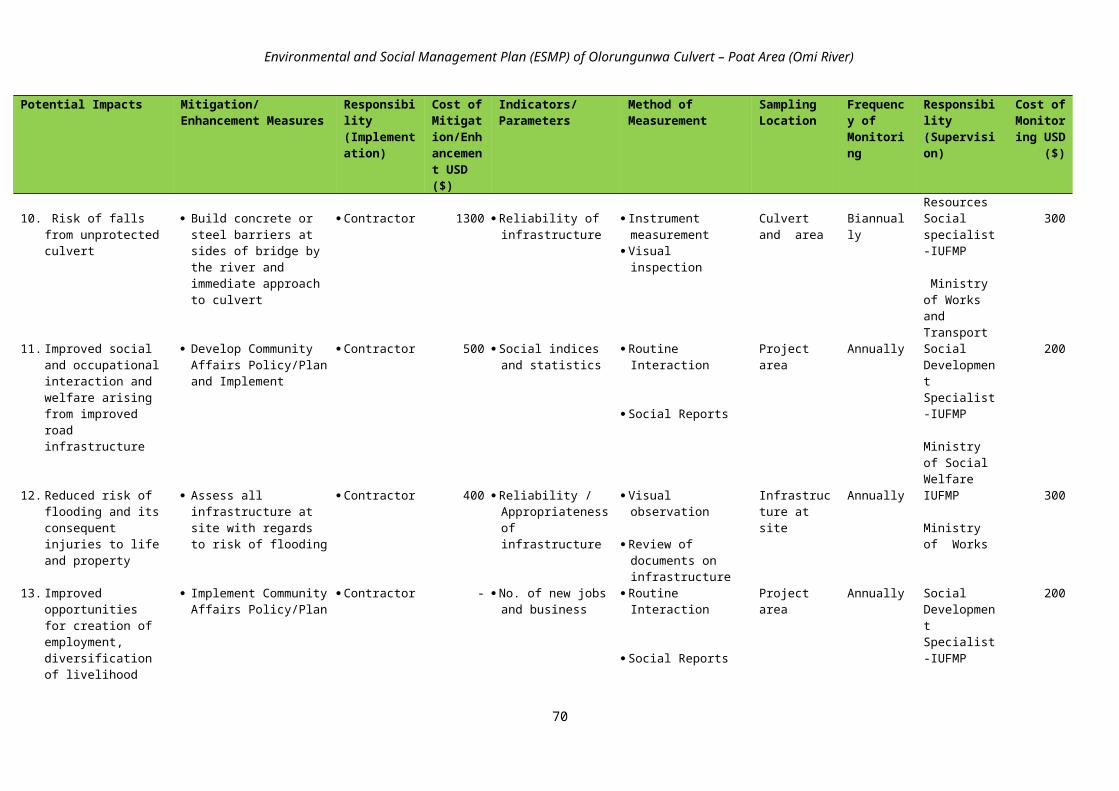
Environmental and Social Management Plan (ESMP) of Olorungunwa Culvert – Poat Area (Omi River)
Plate IV: Community Risk Assessment Pictures
84
Community Risk Assessment Session
Major Road and Environmental Pollution
Trucks and Motorbikes as the Major Hazards in the Community
Livelihoods Activities in the Community

Environmental and Social Management Plan (ESMP) of Olorungunwa Culvert – Poat Area (Omi River)
ANNEX F: SCHEDULE OF FEEDBACK TO STAKEHOLDER COMMUNITIES ON SOCIOECONOMIC/HAZARDS SURVEY
Project Phase Stakeholder Groups Feedback Issues Responsibility /Language of
CommunicationPre – Construction Phase
Community leaders; Executives of Landlord
Associations; Women and Youth groups; Religious groups (Christian
and Muslim); Opinion groups; Representatives of physically
challenged; NGOs (Red Cross Society); Market women and men; Community development
associations and councils (CDAs & CDCs);
Policy and measures for promoting social accountability and environmental sustainability of the project
Need for the cooperation of the community members with the contractor
Security of lives of the construction workers and security of equipment
Sensitizing communities on alternate routes during construction
Availability of local workforce within the community
Perception of likely hazards involved in the project activities
IUFMP- Social Development Specialist / English and/or Yoruba
C construction Phase
Review of cooperation with the contractor
Review of security situation in the environment
Review of likely hazards involved in the project activities
Review of accessibility to the community
Review of how the various groups in the community are coping
IUFMP- Social Development Specialist / English and/or Yoruba
Post-Construction / Operations /Maintenance Phase
Enlightenment on proper solid waste disposal to prevent blockage of water ways
Discussion on proper ways to maintain side drains along the approach roads.
Enlightenment on Disaster Risk Reduction measures.
Enlightenment on how to help in maintaining the bridge/culvert constructed
Appreciation of the community members for their support and cooperation during the construction
IUFMP- Social Development Specialist / English and/or Yoruba
85

Environmental and Social Management Plan (ESMP) of Olorungunwa Culvert – Poat Area (Omi River)
ANNEX G: ENVIRONMENTAL AND SOCIAL CHECKLIST
Project Phase Main Check Items Yes: YNo: N
Confirmation of Environmental Considerations(Reasons, Mitigation Measures)
Pre-Construction (a) Has the ESMP report been disclosed to stakeholders?(b) Has the ESMP report been approved by the relevant authorities? (c) Has training programme for the implementation of the ESMP been conducted?(d) Have the motor vehicles, equipment and machinery for construction been checked for minimizing air and noise pollutions?(e) Have actions been taken to minimize loss of vegetation and fauna habitat alteration?(f) Have actions been taken to minimize loss of soil quality?(g) Have actions been taken to minimize contamination of surface water as a result of runoff from exposed soils and construction spoils?(h) Have actions been taken to minimize generation of spoils and other construction wastes?(i) Has action been taken to minimize risk of road traffic accidents and injuries, occupational and social hazards and risk of environmental diseases?(j) Has action been taken to maximise employment of local labour for site clearing?
(a)
(b)
(c)
(d)
(e)
(f)
(g)
(h)
(i)
(j)
(a)
(b)
(c)
(d)
(e)
(f)
(g)
(h)
(i)
(j)
Construction (a) Are the motor vehicles, equipment and machinery for construction being maintained for minimizing air and noise pollutions?(b) Are burrow pits properly abandoned immediately after use? (c) Are actions taken to minimize loss of soil quality?(d) Are actions taken to minimize contamination of surface water as a result of runoff from exposed soils and construction spoils?(e) Are actions taken to minimize generation of spoils and other construction wastes?(f) Is action taken to minimize surface water run-off due to diversion during construction?(g) Is action taken to mitigate the disruption of river bank due to construction activities?(h) Are actions taken to minimize damage to and disruption of services of existing underground public utility cables and pipes?
(a)
(b)
(c)
(d)
(e)
(f)
(g)
(h)
(a)
(b)
(c)
(d)
(e)
(f)
(g)
(h)
86

Environmental and Social Management Plan (ESMP) of Olorungunwa Culvert – Poat Area (Omi River)
(i) Are actions taken to minimize congestion of traffic and associated risks, as well as occupational and social hazards and risks of environmental and social diseases?(j) Is action taken to maximise employment of local labour for construction activities?
(i)
(j)
(i)
(j)
Post-Construction / Operation / Maintenance
(a) Are actions taken to prevent reoccurrence of flooding as a result of the predisposition of people to solid waste disposal in the stream or side drains?(b) Is the bridge certified as improved and safe? (c) Are the approach road and drains certified as improved and functional?(d) Are actions taken for the restoration of flora and fauna habitat?(e) Is the soil stabilization and restoration certified?(f) Is improved solid waste management implemented?(g) Is the contamination of surface water as a result of waste dumping in and around the river being prevented?(h) Are the risks of occupational and social accidents and injuries in using the new bridge taken care of?(i) Are the social and occupational interaction and welfare arising from improved road infrastructure being enhanced?(j) Are opportunities for creation of employment, diversification of livelihood and increased productivity enhanced?(k) Is the reduction in public spending on replacement and rehabilitation of road infrastructure being maintained?(l) Is the reduced mortality and morbidity from water related diseases maintained?
(a)
(b)
(c)
(d)
(e)
(f)
(g)
(h)
(i)
(j)
(k)
(l)
(a)
(b)
(c)
(d)
(e)
(f)
(g)
(h)
(i)
(j)
(k)
(l)
87

Environmental and Social Management Plan (ESMP) of Olorungunwa Culvert – Poat Area (Omi River)
ANNEX H: TERMS OF REFERENCE
TERMS OF REFERENCEFOR THE PREPARATION OF AN ENVIRONMENTAL AND SOCIAL MANAGEMENT PLANS (ESMPs),
ENVIRONMENTAL AND SOCIAL IMPACT ASSESSMENTS (ESIAs) AND ABREVIATED RESETTLEMENT ACTION PLANS (ARAPs) FOR TEN (10) PRIORITY SITES OF IUFMP
1.0 Background
The World Bank is supporting the Oyo State Government to implement the Ibadan Urban Flood Management project (IUFMP) that aims at developing a long-term flood risk management framework by initiating risk assessment, community awareness, and providing enough flexibility in the project design to make changes based on learning. The project also supports capacity building for flood risk management in the city of Ibadan. It reinforces Oyo State government’s early warning and response capabilities and leverages existing World Bank projects in Oyo State in support of the IUFMP.
Specifically, the Bank’s support will finance some priority investments related to improving the infrastructure of Ibadan City, especially those destroyed by August 26, 2011 floods. The Bank's support will help Ibadan reduce flood risks, improve waste collection and treatment, while developing and improving the quality of existing infrastructural assets.
The project would be designed to keep a good balance between urgent post disaster needs (dredging, reconstruction of bridges, roads, etc.) and medium-to-long term needs (institutional support, upgrading existing and building new infrastructure to upgrade services and mitigate future risks). Selected sub - projects should comply with regional and local government plans, address critical issues described above to integrate planning and operational aspects that maximize the benefits of infrastructure investments to the beneficiary communities in the long run.
The Project Development Objective (PDO) is to “improve the capacity of Oyo State to manage flood risk and to respond effectively and promptly to flooding in the city of Ibadan”.
In Oyo State, IUFMP activities involve medium-sized civil works such as construction of infrastructure and/or stabilization or rehabilitation in and around the Ibadan city. These could result in environmental and social impacts thus triggering the World Bank’s Safeguard Policies including Environmental Assessment OP 4.01; Involuntary Resettlement OP4.12; Natural Habitats OP 4.04; Physical Cultural Resources OP 4.11, and Safety of Dams OP 4.37 and Public Disclosure OP 17.60.
The environmental and social safeguards concerns are being addressed through the national instrument already prepared under the project: an Environmental and Social Management Framework (ESMF). This framework instrument need to be translated into specific cost, measurable, and monitorable actions for specific intervention sites through the preparation of site-specific management and action plans.
ESMF:In general, the ESMF specifies the procedures to be used for preparing, approving and implementing:
(i) Environmental and Social Assessments (ESIA) and or (ii) Environmental and Social Management Plans(ESMPs) for individual civil works packages developed for each project. ESMPs are essential elements for Category B projects.
RPF. The RPF applies when land acquisition leads to the temporary or permanent physical displacement of persons, and/or loss of shelter, and /or loss of livelihoods and/or loss, denial or restriction of access to economic resources due to project activities. It sets out the resettlement and compensation principles, organizational arrangements and design criteria to be applied to meet the needs of project-affected people, and specifies the contents of a Abbreviated Resettlement Action Plan (ARAP) for each package of investments. A Resettlement Policy Framework (RPF), which serves as a practical tool during the programme formulation, design, implementation and monitoring, was prepared for IUFMP which serves as a guide for the present terms of reference.
2.0 SPECIFIC OBJECTIVES:The specific objective is for the Consultant to assist Oyo State to undertake the necessary studies and prepare an Environmental and Social Management Plan (ESMP) Reports; Environmental and Social Impact Assessment (ESIA) Reports and Abbreviated Resettlement Action Plans (ARAP) of the proposed sub-project in compliance with the World Bank environmental, social safeguards policies and procedures as well as the Oyo State Ministry of Environment and Habitat and the Federal Ministry of Environment guidelines and procedures.
This Terms of Reference (TOR) is to request a consultancy firm with extensive experience and skill in the preparation of the following Safeguard Instruments for the respective sites mentioned below:
88

Environmental and Social Management Plan (ESMP) of Olorungunwa Culvert – Poat Area (Omi River)
2.1 Environmental and Social Management Plan Study Reports for:i) Omiri Culvert,Omiri; ii) Olorungunwa Culvert Poat Area; iii) Maje River culvert Iid- Mango Road; iv) Foworogi Culvert, Egbeda Tuba; v) Elere River Culvert, Egbada Tuba; vi) Ebenezery Culvert, Alakia Isebo and vii) Alaro Culv ert, 7-Up Road.
2.2 Environmental and Social Impact Assessments (ESIAs) for:i. Ogbere Moradeyo;
ii. Believers Stream Odo Ona Elewe andiii. Alaro Poly Road – Sango – Eleyele Road
2.3 Abbreviated Resettlement Action Plans for:I. Alaro Poly Road – Sango – Eleyele Road;
II. Omiri Culvert,Omiri andIII. Believers Stream Odo Ona Elewe.
The Terms of Reference (TOR) define the scope of work and core tasks to be assigned to the Consultant. The Consultant is expected to make reference to the feasibility study and designs of the proposed bridge/culverts to be constructed from the Project Implementation Unit (PIU).
3.0 GOAL OF THE WORKThe proposed rehabilitation and stabilization of the hydraulic structures in these priority sites mentioned above will reverse the current trend as much as possible and preserve the by-pass that is being degraded by the flooding pattern in those areas such that the proposed structure can cope with recurrent flood events for several years.The reconstruction of the bridge, culvert and road approaches is classified as category “A” or category “B” projects according to the World Bank categorization and a category I or II projects according to the FMEnv categorization. Thus, it will require an Environmental and Social Impact Assessment (ESIA) or Environmental and Social Management Plan (ESMP) respectively.
From the foregoing, the significant impacts that are likely to occur from the Category A projects are sensitive, diverse and unprecedented and might be felt beyond immediate project environment; while impacts likely to occur for the category B projects are less significant which can be reduced or minimized through compliance with appropriate mitigation measure. Thus, the nature of the category B project is such that it will not represent a large-scale intervention in the site and will not fundamentally change the environment if adequately mitigated.
4.0 PRIORITY SITES WITH ENVIRONMENTAL AND SOCIAL MANAGEMENT PLANS (ESMPs)The ESMP should consist of a well-documented set of mitigation, monitoring, and institutional actions to be taken before and during implementation to eliminate adverse environmental and social impacts, offset them, or reduce them to acceptable levels. It should also include the measures needed to implement these actions, addressing the adequacy of the monitoring and institutional arrangements at upstream and downstream in the intervention site.
4.1.0 OMIRI CULVERT–OMIRI (OMI RIVER)The sub-project activities in components 2 (sub component 2.1) will involve critical infrastructure improvements which includes the construction of a replacement of the existing culvert with a larger capacity single cell box relief culvert and road way approaches etc.
4.1.1 OMIRI CULVERT STUDY AREA:The Omiri Culvert – Omiran (Omi River) priority site is located in Egbeda Local Government Area. The site falls within the Ibadan Metropolis and lies between x and y coordinates N7.37441 and E3.9966 and at altitude 195msl.
4.1.2 RATIONALE OF THE OMIRI CULVERT STUDYOmiri River flowing through Adekola community is channeled by a dilapidated culvert with no protective barriers on both sides of the culvert. This is a hazard to users due to the height of the road. Drainages are blocked with waste preventing free flow of water. The topography of the project area of influence is a gentle slope and characterized by igneous rock formations with sandy soils. The area receives surface water (upstream) from Omi Riverand discharges at Christ Power - Olode. Vegetation in the area is composed mainly of few trees, high shrubs and grasses. However, the original vegetation has been undergoing modifications due to urban expansions and human activities.Human activities have impacted on the environment resulting in series of environmental and social concerns such as existing drains are blocked with solid waste.
89

Environmental and Social Management Plan (ESMP) of Olorungunwa Culvert – Poat Area (Omi River)
Collapsed culvert with debris Collapsed culvert
The proposed civil works include;i. replacement of the existing culvert with a larger capacity single cell box relief culvert with preference given to
providing a single opening to minimize the potential for debris blockage.,ii. construction of appropriate bed scour (upstream and downstream) and side protection to prevent outflanking and
iii. construction of formal roadway approaches and associated drainage (for the full width of the floodplain) and the minimum land area required for the proposed intervention is estimated at about 25m2
Specifically, the design includes:a. Excavation and stabilization;b. Construction of bed and concrete screeding;c. Construction of 9” thick reinforced concrete retaining wall (Abutments);d. Construction of deck concrete; ande. Construction of Parapet wall.
Plate 1: Omiri Culvert – Omiran (Omi River) Schematic Layout
4.2.0 OLORUNGUNWA CULVERT – POAT (OMI RIVER)STUDY AREA:The Olorungunwa Culvert – Poat Area (Omi River) priority site is located in Egbeda Local Government Area. The site falls within the Ibadan Metropolis and lies between x and y coordinates N7.36993 and E3.99749 and at an altitude of 190msl.
4.2.1 RATIONALE OF THE OLORUNGUNWA CULVERT STUDYThe existing inadequate Olorungunwa culvert constructed on an earth road has a flow of water from Olorunguwa stream to Omi River. The existing road has been damaged by erosion. There is excessive growth of weeds which obstructs the flow of water. Drainage exists on only one side of the road. The topography of the project area of influence is a gentle slope and characterized by igneous rock formations with sandy soils. The area receives surface water (upstream) from Olorungunwa stream/springand discharges at Omi River. Vegetation in the area is composed mainly of few trees, high shrubs and grasses. However, the original vegetation has been undergoing modifications due to urban expansions and human activities.
90

Environmental and Social Management Plan (ESMP) of Olorungunwa Culvert – Poat Area (Omi River)
Human activities have impacted on the environment resulting in series of environmental and social concerns such as sheet erosion, presence of undercutting in roads/ erosion, No drainages on existing earth roads; Aquatic weeds restricting flow of water and high sediment load in stream.
Collapsed culvert Collapsed culvert and road approaches without drainages
The proposed civil works include constructing appropriate road drainage to carry the significant flows that can be generated during intense storms and routing these flows through a new single cell box culvert under the road and into the natural channels beyond and the minimum land area required for the proposed intervention is estimated at about 25m2
Specifically, the design includes:f. Excavation and stabilization;g. Construction of bed and concrete screeding;h. Construction of 9” thick reinforced concrete retaining wall. (Abutments);i. Construction of deck concrete; andj. Construction of Parapet wall.
Plate 1: Olorungunwa Culvert – Poat Area (Omi River)Schematic Layout
4.3.0 MAJE – IDI MANGO ROAD (OGUNPA RIVER) STUDY AREA:
91
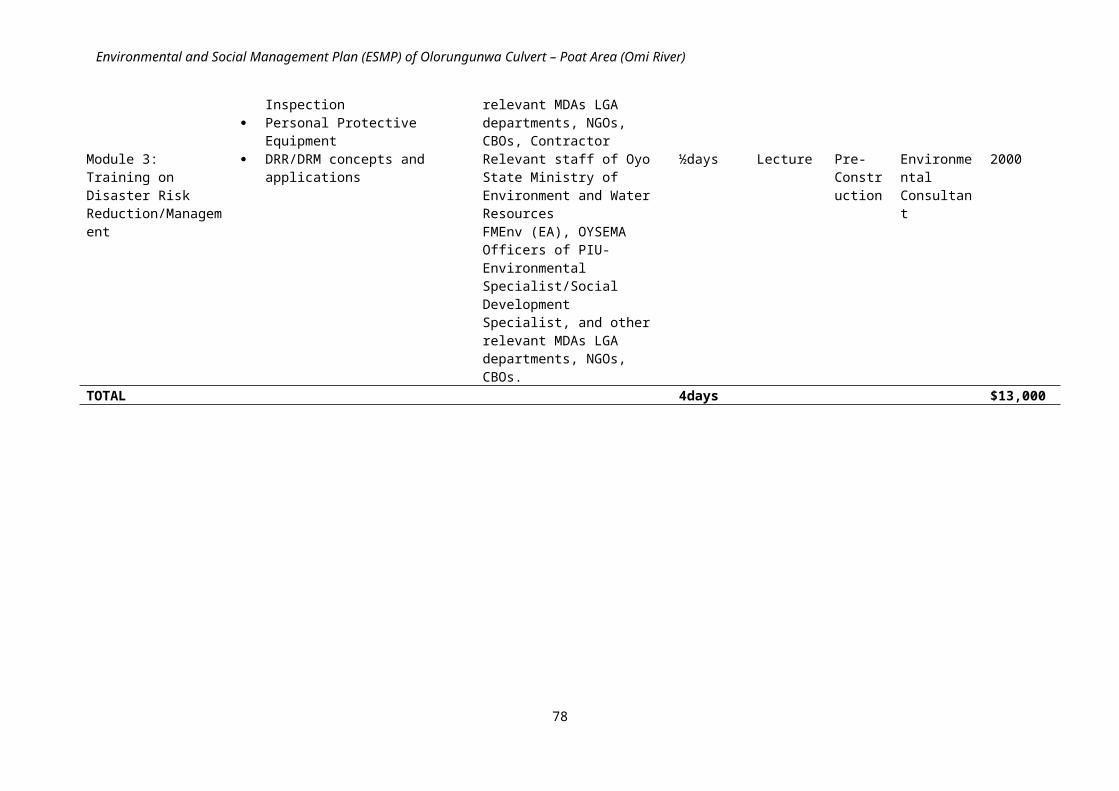
Environmental and Social Management Plan (ESMP) of Olorungunwa Culvert – Poat Area (Omi River)
The Maje River – Maje - Idi Mango Road (Ogunpa River) priority site is located in Oluyole Local Government Area. The site falls within the Ibadan Metropolis and lies between x and y coordinates N7.31603 and E3.89197 at an altitude of 150msl.
4.3.1 RATIONALE OF MAJE – IDI MANGO ROAD (OGUNPA RIVER) STUDYMaje River flows through Maje/Idi-oro community in Oluyole LGA with culvert sited on Idi Mango road. The road crossing here is frequently overtopped, causing significant local disruption to social activities. In 2014 there have been several disruptions which have caused damage to properties. The culvert is damaged and water flow through drains is hampered by water weeds.The topography of the project area of influence is a gentle slope and characterized by lateritic soils. The area receives surface water (upstream) from Ogbere River and flows to Ogunpa River. Vegetation in the area is composed mainly of high shrubs, grasses and water weeds. However, the original vegetation has been undergoing modifications due to urban expansions and human activities.Human activities have impacted on the environment resulting in series of environmental and social concerns such aquatic weeds restricting flow of water; high sediment/solid waste load in stream.
Pipe culvert blocked by debris High sediment/solid waste load in stream
The proposed civil works include:(i) replacement of the existing arrangement of small pipes with a larger capacity and wider Double cell 3x2 box
culvert, (ii) construction of appropriate bed scour (upstream and downstream) and side protection to prevent outflanking
and (iii) construction of formal roadway approaches and associated drainage (for the full width of the floodplain) with
the minimum land area required for the proposed intervention estimated at about 225m2
Specifically, the design includes:a. Excavation and stabilization;b. Construction of bed and concrete screeding;c. Construction of 9” thick reinforced concrete retaining wall. (Abutments);d. Construction of deck concrete; ande. Construction of Parapet wall
Plate 1: Maje River culvert – Maje - Idi Mango Road (Ogunpa River) Schematic Layout
92

Environmental and Social Management Plan (ESMP) of Olorungunwa Culvert – Poat Area (Omi River)
4.4.0 FOWOROGI BRIDGE – EGBEDA TUBA ROAD FOWOROGI (OGBERE RIVER) STUDY AREA:
The culvert is located in the Ifesowapo Idi-osan community in Ibadan; a sub urban community in Oluyole Local Government area of Oyo State. The site falls within the Ibadan Metropolis and lies between x and y coordinates N7.33088 and E3.94549 at an altitude of 189msl.
4.4.1 RATIONALE OF THE FOWOROGI BRIDGE – EGBEDA TUBA ROAD STUDYThe stream in Foworogi channels water from River Ariyo to Fatusi. Existing Culvert is constructed on an earth road used by vehicles (heavy and light) and pedestrians. Culvert is not adequate for the area. Waterway is obstructed by water weeds. The low crossing has suffered severe structural damage and is now actively eroding.The topography of the project area of influence is a gentle slope and characterized by basement formation and sandy soils. Vegetation in the area is composed mainly of some trees, high shrubs, and grasses. However, the original vegetation has been undergoing modifications due to urban expansions and human activities.Human activities have impacted on the environment resulting in series of environmental and social concerns such aquatic weeds restricting flow of water, high sediment load in stream and lack of drainages on existing earth roads.
Site Pictures
The proposed civil works include:i. A 1x15m spans bridge (reflecting the width of the crossing).
ii. Construction of appropriate bed scour (upstream and downstream) and iii. side protection to prevent outflanking will need to be provided. iv. It is likely that an extended length of road construction will be required to ensure the works improve the bridge to
facilitate a reconnection of the communities (this could include approximately 250m of roadway either side of the crossing being repaired) and
v. a simple river level gauge should also be installed upstream of the crossing with the minimum land area required for the proposed intervention estimated at about 1800m2.
Specifically, the design includes:a. Excavation and stabilization;b. Construction of bed and concrete screeding;c. Construction of 9” thick reinforced concrete retaining wall (Abutments);
93
High sediment load in stream
Roadway approaches; no drainages Structural damage actively eroding

Environmental and Social Management Plan (ESMP) of Olorungunwa Culvert – Poat Area (Omi River)
d. Construction of deck concrete; ande. Construction of Parapet wall
Plate 1: Foworogi Culvert – Egbeda Tuba Road Foworogi (Ogbere River) Schematic Layout
4.5.0 ELERE RIVER CULVERT-EGBEDA TUBA ROAD ELERE (OGEBRE RIVER) STUDY AREA:The culvert is located in the Idi Ogun community in Ibadan; a sub urban community in Oluyole Local Government area of Oyo State. The site falls within the Ibadan Metropolis and lies between x and y coordinates N7.32389 and E3.95092 at an altitude of 200msl.
4.5.1 RATIONALE OF THE ELERE RIVER CULVERT-EGBEDA TUBA ROAD (OGEBRE RIVER) STUDYElere River flows through the Idi Ogun community into River Fatusi. The culvert which controls the flow of water is constructed on an untarred earth roadway used by heavy and light vehicles, and pedestrians. This culvert has been inadequately designed as it does not serve its purpose. It is a part of series of connecting bridges that serve multiple communities, and a large area of ongoing and rapid urban growth. The unmade roadway soon becomes impassable during the rains. The existing small temporary bridge can only cope with small vehicles which mean that larger Lorries and vans go through the river resulting in significant deepening of the stream and undermining of the current structure. The topography is a gentle slope and characterized by basement geology formations and sandy soils in some parts. Vegetation in the area is composed basically of wetland/marshy tree species, high shrubs and grasses by the river banks downstream.However, the original vegetation has been undergoing modifications due to urban expansions and human activities.Human activities have impacted negatively on the environment resulting in series of environmental and social concerns such as aquatic weeds restricting flow of water, high sediment load in stream, and lack of drainages on existing earth roads.
Earth road, make shift drainage forms the approach Inadequate single culvert
The proposed civil works include:
94

Environmental and Social Management Plan (ESMP) of Olorungunwa Culvert – Poat Area (Omi River)
(i) replacement of the existing culvert with a larger capacity 2x15m (30meters) span bridge, (ii) construction of appropriate bed scour (upstream and downstream) and side protection to prevent outflanking, (iii) construction of formal roadway approaches and associated drainage (for the full width of the floodplain) and
the minimum land area required for the proposed intervention is estimated at about 375m2
Specifically, the engineering design includes: Piling; Construction of pile caps; Construction of piers; and Construction of reinforced concrete retaining wall.
Plate 1: Elere River Culvert – Egbeda Tuba Road. Elere (Ogbere River) Schematic Layout
4.6.0 ALARO CULVERT-7UP ROAD (ALARO RIVER) STUDY AREA:Alaro culvert is sited in a residential/industrial area on 7Up road in Ibadan South West Local Government Area. The site falls within the Ibadan Metropolis and lies between x and y coordinates N7.3541 and E3.84603 at an altitude of 162msl.
4.6.1 RATIONALE OF THE ALARO CULVERT-7UP ROAD (ALARO RIVER) STUDY:The existing culverts are undersized and capacity is further limited by frequent and severe debris. The complex nature of the upstream entrance to the culvert makes it easy for debris to collect and blind the entrance. Outflanking of the short training walls is also in evidence. There are no protective barriers on both sides of the culvert. Culvert is inadequate and needs to be replaced. Drainage also requires reconstruction. Blockage by natural and anthropogenic debris is a significant issue that further reduces the culvert capacity during times of flood.The topography is a flat and characterized by basement geology formations and sandy soils. Vegetation in the area is composed mainly of high shrubs and grasses. However, the original vegetation has been undergoing modifications due to urban expansions and human activities.Human activities have impacted on the environment resulting in series of environmental and social concerns such as Air pollution from Zartech poultry farm; Sheet erosion, debris blockage– including woody debris and anthropogenic waste.
95

Environmental and Social Management Plan (ESMP) of Olorungunwa Culvert – Poat Area (Omi River)
Upstream towards crossing Natural and anthropogenic debris
The proposed civil works include:i) replacement of the existing culvert with a larger capacity double box culvert ii) construction of appropriate bed scour (upstream and downstream) and side protection to prevent outflanking, iii) reconstruction of roadway approaches and associated drainage (within the floodplain) (50m) and the minimum
land area required for the proposed intervention is estimated at about 400m2
The culvert is to be designed to maximize its capacity without significantly raising the finished roadway level above existing levels (to avoid impeding more extreme flood flows).
Specifically, the engineering design includes:a. Excavation and stabilization;b. Construction of bed and concrete screeding;c. Construction of 9” thick reinforced concrete retaining wall (Abutments);d. Construction of deck concrete; and e. Construction of Parapet wall
Plate 1: Alaro Culvert-7Up Road (Alaro River) Schematic Layout
4.7.0 EBENEZERY CULVERT - ALAKIA-ISEBO (OMI RIVER) STUDY AREA:STUDY AREA:Ebenezery culvert is located in the Ebenezery/Isebo community in Egbeda Local Government Area and it is constructed to channel water from the Omi River. The Alakia – Isebo road is situated on the Airport road with the tendency of high flow of vehicular traffic. The site falls within the Ibadan Metropolis and lies between x and y coordinates N7.40841 and E3.97988at an altitude of 224msl.
96

Environmental and Social Management Plan (ESMP) of Olorungunwa Culvert – Poat Area (Omi River)
4.7.1 RATIONALE OF THE EBENEZERY CULVERT - ALAKIA-ISEBO (OMI RIVER) STUDYThe existing culvert is undersized and capacity is further limited by frequent and severe blockage from floodplain debris. The complex nature of the upstream entrance to the culvert makes it easy for debris to collect and blind the entrance. Outflanking of the short training walls is also in evidence.The topography is a flat and characterized by basement geology formations and sandy soils. Vegetation in the area is composed mainly of few trees, high shrubs and grasses. However, the original vegetation has been undergoing modifications due to urban expansions and human activities.Human activities have impacted on the environment resulting in series of environmental and social concerns such as aquatic weeds restricting flow of water, roadway approaches lack drainage and impassable during heavy rains, turbid surface water; debris blockage – including woody debris and anthropogenic waste.
Structural damage to existing culvert Aquatic weeds restricting flow of water
Debris blockage
The proposed civil works include:(i) reconstruction of the crossing using a double cell box culvert (ii) construction of appropriate bed scour (upstream and downstream) and side protection to prevent outflanking, (iii) reconstruction of roadway approaches and associated drainage (within the floodplain), and (iv) removable of aggressive weeds from upstream channel (then to be managed by the local community) and the
minimum land area required for the proposed intervention is estimated at about 100m2
Specifically, the design includes:a. Excavation and stabilization;b. Construction of bed and concrete screeding;c. Construction of reinforced concrete retaining wall;d. Construction of deck concrete; and e. Construction of Parapet wall
97
Turbid surface water; existing drainage as dump site

Environmental and Social Management Plan (ESMP) of Olorungunwa Culvert – Poat Area (Omi River)
Plate 1: Ebenezery Culvert - Alakia-Isebo (Omi River) Schematic Layout
5.0 ENVIRONMENTAL AND SOCIAL IMPACT ASSESSMENTS (ESIAs) From the study documents the assessment shall include the following; Project site(s) including all project components; Area beyond the project sites (s) which could potentially affect or be affected by the project (justification should be
given on determination of the impact area).
5.1.0 OGBERE MORADEYO BRIDGE STUDY AREA:The proposed bridge is located at Ogbere Moradeyo community in Ibadan; a sub urban community in Egbeda Local Government area of Oyo State. The site falls within the Ibadan Metropolis and lies between x and y coordinates N7.38169 and E3.937 at an altitude of 215msl.
5.1.1 RATIONALE OF THE OGBERE MORADEYO BRIDGE STUDYOgbere is a residential locality with various communities. The Ogbere bridge which links these communities is in a terrible state of disrepair. The existing crossing was badly damaged following the flood event of 2011. It is now highly dangerous, but continues to be used by pedestrians and motorcycles. The existing crossing section is in poor condition leading to local flooding issue, including the flooding of property. The roadway that once connected two parts of the city suburbs is now impassable. Alternative routes do exist but these are much longer.
The topography is predominantly flat with a basement geology formation. The soil is sandy and prone to erosion mostly by water. The area receives surface water (upstream) from Onipepeye stream and drains into Ogbere River Vegetation in the area is rain forest, however, the original vegetation has been undergoing modifications due to urban expansions and activities.
Human activities have impacted on the environment resulting in series of environmental concerns such as flooding, erosion, undercutting of road approaches and improper solid and liquid waste management.
Community intervention on the collapsed bridge Debris collects against a collapsed structure
98

Environmental and Social Management Plan (ESMP) of Olorungunwa Culvert – Poat Area (Omi River)
Aquatic weed; turbid surface water; solid waste disposal Motor bike and pedestrian congestion
The proposed civil works include replacement with a 2x15m span bridge having in mind the principle of resilient design to ensure the bridge and roadway approaches recovery unaided or with minimum repair and the minimum land area required for the proposed intervention is about 2400m2
Specifically, the design includes: Piling; Construction of pile caps; Construction of piers; Construction of reinforced concrete retaining wall (abutments); and Construction of superstructures including parapets, bridge bearings and expansion joints.
Plate 1: Schematic diagram of Ogbere Moradeyo – Ogbere Moradeyo Road – (Ogbere River)
5.2.0 BELIEVERS STREAM-ODO-ONA ELEWE ROAD - ODO ONASTUDY AREA:The proposed bridge is located in Aba-adio/Aba-llepanu community at Oluyole Local Government area of Oyo State. The site falls within the Ibadan Metropolis and lies between x and y coordinates N7.33671 and E3.85919 and at an altitude of 150msl.
5.2.1 RATIONALE OF THE BELIEVERS STREAM-ODO-ONA ELEWE ROAD - ODO ONA STUDYA large bridge at Believers Stream-Odo-Ona Elewe Road - Odo Ona Bridge over Ona River is deteriorating rapidly and is now in a poor condition. Scour of the bed and flanks is an issue. The area is prone to significant flooding. The Ona River flows from Eleyele Dam through Aba-adio/Aba-Ilepanu community. Water flow is guided by inadequate bridge without side protective barriers. Bridge is sited on a damaged stretch of the road used by vehicles and pedestrians with high flow of traffic.
99

Environmental and Social Management Plan (ESMP) of Olorungunwa Culvert – Poat Area (Omi River)
The topography is a gentle slope and the soil is loamy in nature. The area receives surface water (upstream) from Ona River and drains into New Garage-Ogun River. Vegetation in the area is composed basically of tall crowned trees, mixed with thick undergrowth.However, the original vegetation has been undergoing modifications due to urban expansions and activities.Human activities have impacted on the environment resulting in series of environmental concerns such as improper solid waste disposal into surface water body as well as lack of drainages on existing earth road which causes localized flooding.
View from downstream; aquatic weed/manmade Damaged road approach; improper solid wastedebris restricting flow of water
The proposed civil works include replacement with a 3x15m span bridge having in mind the principle of resilient design to ensure the bridge and roadway approaches recovery unaided or with minimum repair and the minimum land area required for the proposed intervention is estimated at about 1800m2
Specifically, the design includes: Piling; Construction of pile caps; Construction of piers; Construction of reinforced concrete retaining wall (abutments); and Construction of superstructures including parapets, bridge bearings and expansion joints.
Plate 1:
Believers Stream-Odo-Ona Elewe Road - Odo Ona Bridge Schematic Layout
5.3.0 ALARO POLY ROAD - SANGO-ELEYELE ROAD - POLY IJOKODO (ALARO STREAM)BRIDGE STUDY AREA:
100

Environmental and Social Management Plan (ESMP) of Olorungunwa Culvert – Poat Area (Omi River)
The proposed bridge is located at Alaro community in Ibadan North Local Government area of Oyo State. The site falls within the Ibadan Metropolis and lies between x and y coordinates N7.42656 and E3.88579 and at an altitude of 201msl.
5.3.1 RATIONALE OF THE ALARO POLY ROAD - SANGO-ELEYELE ROAD - POLY IJOKODO (ALARO STREAM)BRIDGE STUDY:The Alaro Poly is a major archery carrying significant traffic volume – including buses and heavy lorries. Scour of the bed and flanks is an issue. Following serve scour at the outlet of the culvert that passes under the road, and a general lowering of the downstream river bed, the large box section forming the culvert was left unsupported and collapsed. The road verge subsequently eroded and continues to erode, exposing and severing buried power and communication lines as well as placing road users at risk. Alaro stream controls the flow of water that discharges to Ona River. The culvert sits on the expanse of Sango/Ijokodo major road with high vehicular traffic. Also roads, culverts and drainages are badly damaged by erosion; public utilities pipelines (water and telecommunications) were observed. The topography is predominantly flat with a basement geology formation. The soil is clayey-loam and prone to erosion mostly by storm water. The area receives surface water (upstream) from Ogbere River and discharges into Ona River. Vegetation in the area is composed basically of sparse trees and high shrubs. However, the original vegetation has been undergoing modifications due to urban expansions and human activities.
Human activities have impacted on the environment resulting in series of environmental concerns such as Presence of undercutting in roads/ erosion; damaged drainages along asphalt paved road; exposed drinking water and telecom utilities.
Undercutting of road; damaged drainage Exposed telecommunication/water utilities
The proposed civil works include replacement of the collapsed box culvert with a 2 x15m (30meters) span bridge and new road construction having in mind the principle of resilient design to ensure the bridge and roadway approaches recovery unaided or with minimum repair and the minimum land area required for the proposed intervention is estimated at about 2500m2
Specifically, the design includes: Piling; Construction of pile caps; Construction of piers; Construction of reinforced concrete retaining wall; and Construction of superstructures including parapets, bridge bearings and expansion joints. Bush clearing; Scarification; Sub-grade preparation; Earthworks; and Construction of base course and asphalt layers.
101

Environmental and Social Management Plan (ESMP) of Olorungunwa Culvert – Poat Area (Omi River)
Plate 1: Alaro Poly Road - Sango-Eleyele Road - Poly Ijokodo (Alaro Stream) Bridge Schematic Layout
6.0 SCOPE OF WORK FOR PRIORITY SITES WITH ESIAs AND ESMPs.The consultant is expected to work in close collaboration with the engineering design consultants and Project Implementation Unit (PIU) safeguard team, and with other actors and consultants as directed by the PIU. In that respect the sequencing of the technical studies be very critical. The consultant will have to receive the draft technical studies in order to take into account the technical variants of the proposed activities and also in return, inform the technical design consultants of any major constraint that may arise due to the social and environmental situation on the ground. The consultant will visit the whole area as delimited in the given culvert stabilization design. The consultant will take into account the proposed civil engineering designs, vegetative land management measures and other activities aimed at reducing or managing runoff that would be carried out within the sub-watershed. The consultant will assess natural resources and infrastructures potentially affected during project implementation and operation and select the management strategies needed to ensure that environmental and social risks are appropriately mitigated.
The ESIA/ESMP report shall be presented in a concise format containing all studies, processes, analyses, tests and recommendations for the proposed intervention. The report shall focus on the findings, conclusions and any recommended actions, supported by summaries of the data collected and citations for any references used in interpreting those data. It should provide a description of the specialist studies undertaken and the report should include a bibliography, maps, photographs, diagrams and any other diagrammatic representation needed to facilitate understanding of the main text, detailed data should be presented in annexes or a separate volume. Unpublished documents used in the assessment should also be included or referenced in an appendix and the location of the originals of such documents indicated.
6.1.0 THE CORE TASKS FOR THE CONSULTANT
These shall include:
Reviewing existing documentation of the IUFMP such as the ESMF and the PAD; Review Environmental Assessment procedures of the World Bank safeguards policies especially Environmental
Assessment (OP 4.01); Describing the proposed project by providing a synthetic description of the project relevant components and
presenting plans, maps, figures and tables; Identifying the policy, legal and administrative framework relevant to the project. Defining and justifying the project study area for the assessment of environmental and social impacts; Describing and analysing the physical, biological and human environment conditions in the study area before
project implementation. This analysis shall include the interrelations between environmental and social components and the importance that the society and local populations attach to these components, in order to identify the environmental and social components of high value or presenting a particular interest;
Presenting and analysing alternatives to the proposed project, including the “without project” option, by identifying and comparing the alternatives on the basis of technical, economic, environmental and social criteria;
For the selected alternative, identifying and assessing potential importance of beneficial and adverse environmental and social, direct and indirect, short and long-term, temporary and permanent impacts, on the basis of a rigorous method;
Defining appropriate mitigation/enhancement measures to prevent, minimise, mitigate, or compensate for adverse impacts or to enhance the project environmental and social benefits, including responsibilities and associated costs;
Addressing potential cumulative effects taking into account other initiatives planned in the study area; Developing an environmental and social monitoring program, including indicators, institutional responsibilities
and associated costs; As appropriate, preparing an environmental hazard plan including an analysis of the risk of accident, the
identification of appropriate security measures and the development of a preliminary contingency plan; Identifying institutional responsibilities and needs for capacity building if necessary to implement the
recommendations of the environmental and social assessment; Carrying out consultations with primary and secondary stakeholders in order to obtain their views on and
preoccupations about the project. These consultations shall occur during the preparation of the Reports to identify
102

Environmental and Social Management Plan (ESMP) of Olorungunwa Culvert – Poat Area (Omi River)
key environmental and social issues and impacts, and after completion of the draft Reports to obtain comments from stakeholders on the proposed mitigation/enhancement measures; and
Preparing the ESMP and ESIA Reports according to the generic contents presented in Part A and B hereafter respectively.
6.1.1 The following socio-economic issues shall be addressed in the Reports (ESIA & ESMP):
Establish social baseline for pre project intervention Determine the project’s social impacts on health and social well-being ; quality of the living environment;
economic material well-being ;Family and community ; and gender relations
A summary of the impacted communities for the project: location, access, population (number, demographic and social characteristics); economy (employment rate, income distribution); services (types, capacity, and adequacy) and housing. Concern is the ability to provide work force, service new development and absorb and adjust to growth (worker/family). . The report should identify and assess the social impacts identified during the public consultation process and those that, based on consultant’s experience, are also likely to occur. In some instances the affected communities may not be aware of or be in a position to identify all the social impacts that may occur. However, this does not mean that they will not occur. In such cases the consultant should use his/her experience to identify additional social impacts that have not been raised by the public. A summary of the views of the population including vulnerable groups, determined through thoroughly documented discussions with local communities. These meetings and discussions must be documented and should show how issues and problems raised are or will be resolved
Pay particular attention to the impacts of the project on vulnerable and marginalized individuals and groups ( including but not limited to mobility impaired individuals and groups and People Living with Disability)
Detail measures that will need to be taken to mitigate the negative social impacts identified and the procedures for their implementation;
Identifying key uncertainties and risks: Identify and communicate any key uncertainties and risks associated with the accuracy of the findings of the social assessment, as well as of the proposed project. Some sources of uncertainty and risk commonly associated with projects are linked to: (a) Lack of adequate information at the community level; (b) Creation of employment and business opportunities for members from the local, historically disadvantaged communities; (c) The influx of job seekers and construction workers to the area and the impact on services; etc.
Assess the impact of the construction on individuals and groups whose livelihoods are tied to the route/road (motor cycle taxi and tricycle operators etc.). As part of consultations, the ESMP should identify the potential negative impact on the livelihoods of these individuals and groups and propose appropriate mitigation measures
Assess potential impact of the project on property access and suggest measures to minimize the effects on property access
Information will be gathered from field surveys and secondary data sources (interviews, structured questionnaires, in-depth interviews and focus group discussions).
6.2.0 PART A: CONTENT OF THE ENVIRONMENTAL AND SOCIAL MANAGEMENT PLANThe ESMP report will include the following topics:
6.2.1 Preliminary pagesCover pageTable of contentsList of acronyms and their definitionsExecutive Summary
6.2.2 Chapter 1: Introduction
Description of the proposed intervention Rationale for ESMP Relevant Maps
6.2.3 Chapter 2: Institutional and Legal Framework for Environmental Management
Discussion of the World Bank safeguards policies triggered by IUFMP and the intervention Olorungunwa Culvert – Poat Area (Omi River) priority site.
Summary of relevant local and federal policy, legal, regulatory, and administrative frameworks
6.2.4 Chapter 3: Biophysical and Socio Economic Characteristics
Description of the area of influence and environmental baseline conditions
103

Environmental and Social Management Plan (ESMP) of Olorungunwa Culvert – Poat Area (Omi River)
Analysis of existing livelihoods opportunities, income, gender characteristics, age profile, health, transport access, existing community structures.
6.2.5 Chapter 4: Institutional Assessment and framework for Environmental Management. Highlight and define the roles, responsibilities and institutional arrangements for the implementation of the ESMP, as
they are fundamental to the effective implementation of the environmental and social safeguard measures.
6.2.6 Chapter 5: Assessment of Potential Adverse Environmental and Social Impacts and Analysis of Alternatives Methods and techniques used in assessing and analyzing the environmental and social impacts of the proposed project Discussion of alternatives to the current project and reasons for their rejection, including short description of likely
future scenario without intervention; Discussion of the potentially significant adverse environmental and social impacts of the proposed project
6.2.7 Chapter 6: Environmental and Social Management Plan (ESMP), including: The proposed mitigation measures; Monitoring indicators; Institutional responsibilities for monitoring and implementation of mitigation; Summarized table for ESMP including costs ESMP Training requirements
6.2.8 Chapter 7: Consultation with Stakeholders This chapter shall summarize the actions undertaken to consult the groups affected by the project, as well as other
concerned key stakeholders including Civil Society Organizations. The detailed record of the consultation meetings shall be presented in annex to the ESMP.
6.2.9 Chapter 8: Summary and Recommendations
6.2.10 AnnexesAnnex 1: List of site contact.Annex 2: Summary of World Bank Safeguard PoliciesAnnex 3: General Environmental Management Conditions for Constructions/Civil Works.Annex 4: ReferencesAnnex 5: Photos
6.3.0 PART B: CONTENTS OF AN ENVIRONMENTAL AND SOCIAL IMPACT ASSESSMENT REPORT
The typical contents of an ESIA Report are presented hereafter. It shall be noted that the presentation of the Report may be adapted pending on the nature and specific requirements of the priority sites.
6.3.1 Executive SummaryThis section shall present in a non-technical language a concise summary of the ESIA Report with a particular attention on the processes and procedures used; baseline conditions; the alternatives considered; mitigation/enhancement measures; monitoring program; consultations with stakeholders; capabilities of environmental and social units and actions to strengthen those capacities; and cost implications. This Executive Summary shall be written in English and a local language, if necessary for public consultations.6.3.2 IntroductionThe Introduction shall indicate the purpose of the ESIA, present an overview of the proposed project to be assessed, as well as the project’s purpose and needs. This section identifies the project sponsor and the consultant assigned to carry out the ESIA. It shall also briefly mention the contents of the ESIA Report and the methods adopted to complete the assessment.
6.3.3 Policy, Legal and Administrative FrameworkThis chapter concerns the policy, legal and administrative framework within which the ESIA is carried out. It presents the relevant environmental and social policies of the Bank and borrowing country, as well as the national legal requirements and related constraints (e.g. practices that may discriminate or exclude any stakeholder group) relevant to the project. It provides information on the environmental requirements of any co-financiers, and identifies relevant international environmental/social agreements to which the country is a signatory.
6.3.4 Project Description and JustificationThe first part of this chapter shall describe the proposed project and its geographic, ecological, social, economic and temporal context: project location, various project components, capacity, construction activities, facilities, staffing, working conditions, availability and source of raw materials, production methods, products, schedule of works, land tenure, land use system, potential beneficiaries, affected groups (directly and indirectly), and offsite investments that may be required.
104

Environmental and Social Management Plan (ESMP) of Olorungunwa Culvert – Poat Area (Omi River)
This section shall determine and characterise the anticipated liquid, solid and gaseous discharges from the processes, as well as the sources of nuisance such as noise, odours, visual nuisances, etc. It shall indicate the need for any resettlement plan or vulnerable group’s development plan. It shall at least include a map showing the project location and area of influence.
The project justification should be based on combined economic, environmental and social assessments. To this end, this chapter shall describe the current situation in the sector, explain the problems or the needs to be satisfied by the project and present the constraints associated with the project implementation.
Overall the description and justification of the project shall cover at least the following elements:
Spatial requirements (sites required for works). Project layout characteristics (including site location map). Socio-cultural factors or constraints, such as customs and beliefs. Natural and human resources requirements. Temporary (during construction) and permanent infrastructures. Existing and proposed location of human settlements and public services such as health centres and accident and
emergency units. Construction activities (land clearing, burning, excavation, blasting, extracting, filling, compacting, waterways crossing,
use of heavy machinery, etc.). Anticipated liquid, solid (including waste) and gaseous emissions, and sources of nuisances (at construction and
operation stages). Construction schedules and costs. Maintenance works and associated costs. Consultation approaches and participation mechanisms.
6.3.5 Description of the Project Environment This chapter shall first determine the limits of the study area that shall be defined in order to encompass all project direct and indirect impacts. The description and analysis of the physical, biological and human conditions shall address relevant environmental and social issues within this area, including any changes anticipated before project implementation.
Within the human environment, key issues that shall be considered include population characteristics and trends, revenue disparities, gender differences, health problems, natural resource access and ownership, land use patterns and civil society organisation level.
It shall also address the interrelations between the environmental and social components and the importance (value) that the society and local populations attach to these components, in order to identify the environmental and social components of high value or presenting a particular interest. A particular attention shall be given to the rare, threatened, sensitive or valorised environmental and social components.
The information presented shall be relevant to decisions about project location, design, operations as well as environmental and social management. Maps, figures and tables shall be included in this chapter to better illustrate the various environmental and social components.
6.3.6 Project AlternativesThis part of the ESIA Report consists in analysing the various feasible alternatives of the project, including the "without project" option. It normally comprises two sections. The first section identifies and describes the potential feasible alternatives that would allow reaching the project objectives. The second section presents a comparison of the potential alternatives on the basis of technical, economic, environmental and social criteria, as well as of public views and concerns.
The alternative comparison shall address the proposed project site, technology, design, and operation, in terms of their potential environmental and social impacts and the feasibility of mitigating these impacts. For each of the alternatives, the environmental and social impacts shall be quantified as possible, including their economic values where feasible. The selected alternative shall be the most environmentally and socially sustainable, taking into account the technical and economical feasibility.
6.3.7 Potential Environmental and Social Impacts and Mitigation/Enhancement MeasuresThis chapter presents a detailed analysis of beneficial and adverse impacts of various components of the selected project alternative on the physical, biological and human (social, cultural and economic) environments. The methodology of assessment, based on a rigorous scientific method, shall be first presented. Then all environmental and social, direct and indirect, short and long-term, temporary and permanent impacts shall be described and assessed, indicating their importance level and their probability of occurrence. The importance level may be assessed on the basis of the nature, extent, intensity
105

Environmental and Social Management Plan (ESMP) of Olorungunwa Culvert – Poat Area (Omi River)
and duration of the impact, as well as on the sensitivity of the concerned environmental and social components and perceptions of the public. Irreversible or unavoidable impacts shall be clearly identified. Cumulative effects shall also be addressed taking into account other projects or actions planned in the study area.
Appropriate mitigation measures shall be identified to prevent, minimise, mitigate or compensate for adverse environmental and/or social impacts. Moreover, enhancement measures shall be developed in order to improve project environmental and social performance. Roles and responsibilities to implement measures shall be clearly defined. The cost of the measures shall be estimated, including the cost for environmental and social capacity building and gender mainstreaming, if necessary. Residual impacts shall be presented.
6.3.8 Environmental Hazard ManagementWhenever relevant, this chapter shall describe the security measures and propose a preliminary contingency plan for the construction and operation phases of the project (possible contingency situations, major actions to properly react to accidents, responsibilities and means of communications).
For projects that may cause major technological accidents whose consequences may exceed the project site, the ESIA shall include an analysis of the technological accident risk: identification of hazard and potential consequences, estimation of the consequences’ magnitude and frequency, and risk estimation and evaluation.
6.3.9 Environmental and Social Monitoring ProgramThe first section of this chapter shall describe the surveillance measures aiming at ensuring that the proposed mitigation and enhancement measures are effectively implemented during the implementation phase. The second section concerns the environmental and social monitoring activities designed to measure and evaluate the project impacts on some key environmental and social components of concern and to implement remedial measures, if necessary. Indicators, roles and responsibilities shall be clearly defined. The cost of the program shall be estimated, including the cost for environmental and social capacity building if necessary.
6.3.10 Public ConsultationsThis chapter shall summarise the actions undertaken to consult the groups affected by the project, as well as other concerned key stakeholders including Civil Society Organisations. The detailed record of the consultation meetings shall be presented in annex to the ESIA Report.
6.3.11 Summary and RecommendationsThe summary and recommendations shall specify the environmental and social acceptability of the project, taking into account the impacts and measures identified during the assessment process. It shall also identify any other condition or external requirement for ensuring the success of the project.6.3.12 Annexes
Summary of World Bank Safeguard Policies List of the professionals and organisations having contributed to the preparation of the ESIA Report. List of consulted documents, including project-related reports. Baseline data referred to in the Report. Record of consultation meetings with primary and secondary stakeholders. General Environmental Management Conditions for Constructions/Civil Works.
The Environmental and Social Impact Assessment shall include, but not limited to the following:
Cover page Table of Contents List of Acronyms Executive Summary Introduction General Information – Objectives and Justification of the Proposed Project Description of the policy, legal, institutional and administrative framework Description of the Proposed Project Study of existing Environment Description of the Project Alternatives Public/ Stakeholder Consultations with relevant stakeholders Identification & Assessment of potential environmental and social impacts Mitigation measures Environmental & Social Management Plan (ESMP) Preparation of an Environmental & Social Management Monitoring Programme. Compensation in respect of Acquisition of Right-of-Way Final Environmental & Social Impact Assessment, Environmental & Social Management Plan and Resettlement &
Compensation Plan. Description of alternatives to the current project Monitoring indicators for the proposed project
106

Environmental and Social Management Plan (ESMP) of Olorungunwa Culvert – Poat Area (Omi River)
Conclusion and Recommendations References Annexes
o Annex 1: List of site contact.o Annex 2: Summary of World Bank safeguards policies o Annex 3: Records of NGOs/CBO Communicationso Annex 4: Records of Consultations and List of Participantso Annex 5 :General Environmental Management Conditions Construction Contracts
7.0 PRIORITY SITES WITH ABBREVIATED RESETTLEMENT ACTION PLAN (ARAP)These sites are itemized in bullets 2.3 above as;
I. Alaro Poly Road – Sango – Eleyele Road (a-d)II. Omiri Culvert,Omiri; (Picture (e.) below
III. Believers Stream Odo Ona Elewe and pictures (f-g)
a.) b.) Affected business outfits/sources of livelihood
c.) Affected public utility and gas vendor d.)Collapsed outlet fast eroding
107
Environmental and Social Management Plan (ESMP) of Olorungunwa Culvert – Poat Area (Omi River)
e.) Affected kiosks along the drainage way f.) Affected house close to the damaged bridge
g.)Potential affected road side vendors
For projects that involve the displacement of 200 people or more, a full Resettlement Action Plan (RAP) is required. For projects that involve fewer than 200 people, an Abbreviated Resettlement Action Plan (ARAP) is required.
The aim of the ARAP is to identify and assess the human impact of the proposed works at the priority site as described above, and to prepare an Action Plan to be implemented in coordination with the civil works in line with World Bank Policy and Nigeria policies and laws. Experience has shown that involuntary resettlement can cause loss of income, assets, and community ties that, especially among the poor, can be essential for survival and well being. In extreme cases, involuntary resettlement can lead to the dissolution of families, impoverishments and health problems. The Abbreviated Resettlement Action Plan will identify the project affected persons (PAPs), engage them in participatory discussions regarding the plan and formulating a plan of action to adequately compensate people for their losses.
The Policy of the World Bank is to ensure that persons involuntarily resettled caused by the taking of land in the context of a project supported by the Bank, have an opportunity to restore or improve their level of living to at least the pre-project level. Project affected people should participate in the benefits of the project and they should be given options regarding how they restore or improve their previous level of living. In the IUFMP it is not sufficient for communities to passively accept project works and the impacts of these works. Rather they must be mobilized to contribute actively to project design and implementation and to maintain the works following implementation. This feature underscores the need for accurate analysis of local social organization.
7.1.0 Responsibility for the ARAPIn preparing the ARAP, the consultant will:
a) Review relevant Nigerian/Oyo State law and procedures regarding land taking and compensation as well as resettlement;
b) Review Resettlement Plans prepared for other World Bank urban projects in Ibadan and Nigeria;c) Undertake a reconnaissance field survey in the sites/local government areas where sub-projects are proposed.d) Consult with appropriate ministries: Works, Environment, Women Affairs, Lands, etc.e) Consult with persons to be potentially affected by sub-projects works (consultation should look at gender division
of labor, etc).
7.1.1 Steps to be taking by the consultant in Preparing an ARAP:i. Community engagement: This must begin from an early date and a relationship of trust must be formed between
the executing agency and the affected community in which both sides have an opportunity to air their views. In general, small neighbourhood meetings are preferable to large public audiences where there is a greater tendency for matters to be politicized and people tend to “grandstand” and posture rather than exchange information in an atmosphere of cooperation.
ii. It is necessary that member of the PIU and the engineering firm that will design the works be present at these meetings.
iii. Hopes and demands expressed by community members should be taken seriously and, if possible, incorporated into plans.
108

Environmental and Social Management Plan (ESMP) of Olorungunwa Culvert – Poat Area (Omi River)
iv. Identification of the perimeter within which people and land will be affected by displacement or land acquisition. For this purpose, maps, engineering drawings, satellite imagery are necessary.
v. Complete census survey of all the families, businesses, public buildings, farms and other infrastructure located within the perimeter should be done. GIS technology is highly recommended for this purpose with all man-made features being geo-referenced. The use of hand held GPS device will facilitate establishing the coordinates of each property identified. The census includes data on age, gender, occupation, income, sources of livelihood of all persons who live on or derive a living from the area of land as well as information on houses, businesses and other structures in use in the affected area.
vi. Each land parcel and structure should be numbered, geo-referenced, photographed, and described in detail. vii. Construction materials, roofing, and measurements should be noted in accordance with the standards in use in the
particular state or federal standards. viii. All information should be kept in a single folder (physical or virtual) for easy retrieval and cross tabulation.
ix. The use of a simple database manager is recommended such as Access or Foxpro. x. In Nigeria and Ibadan in particular, it is important to include such feature as family compounds, places of worship,
schools, health posts, sports fields, burial grounds and places held sacred by local populations where applicable. Each structure included in the census should be valuated according to its replacement value in the local market (see below).
xi. Because of the linear nature of streams, bridges, culverts and roads, it is important to identify existing features or aspects of the engineering design that could impact on communities. If land is taken for the purpose of flood control or drainage, there is likely to be an impact on communication within and among communities. Barriers to access caused by project works should be considered in the ARAP and, where necessary, mitigation plans should be included.
7.1.2 Socioeconomic Study:Based on the census, community meetings and other data collected in the field, a socioeconomic profile of the affected community should be prepared as part of the ARAP. Some of the topics that shall be included are:
Demographic structure of the community; Leadership patterns and political process; Family structure; Services available in or near the community: schools, health facilities, credit facilities, religious organizations,
government agencies; Existing organizations (e.g. age grades, religious groups) and capacity for community action; Conflicts and divisions (ethnic, religious, etc.) within the community or between communities; Important local customs and festivals; Educational Levels; Permanence of the community; Primary forms of livelihood; Community attitudes towards flood control measures; Relevant aspects of gender relations; women’s vs. men’s roles.
The entire range of social characteristics shall be woven together by a sociologist or other social scientist to paint a coherent picture of how the community is likely to respond to change and how best to make community members active participants in the changes that must take place.
7.1.3 Development of the Resettlement Plan:Based on the census and socioeconomic study, a resettlement plan is designed. The primary issue is to ascertain the impact that the project will have on livelihoods. This applies not only to land owners but also land users, such as tenant farmers, renters, businesses, kiosks and the like. The impact may range from nil to virtually destroying the livelihood of persons who depend heavily on the land for income. The design for the project and the Environmental and Social Impact Assessment (ESIA) shall take account of social organization and propose entry points, communication techniques, incentives and other necessary features of project design that will ensure active community participation before, during and after implementation.
Where people actually occupy the land, the impact of the project may fall on housing, businesses, public infrastructure and other structures.
7.1.4 Mitigation Measures:Resettlement is about finding adequate ways of compensating people for loss of place of business or farmland. However the task does not end with relocation. Perhaps the single most important feature of post-resettlement rehabilitation is the restoration of livelihoods. In some cases, livelihoods are not affected and people are able to continue in their chosen economic activities as before with no loss of income. In other cases, however, loss of farmland, residence or business clientele can create a spiral leading to impoverishment. In such cases, the Resettlement Plan can include specific measures to restore or improve livelihoods.
Mitigation of resettlement can take various forms. When affected people depend primarily on land for their livelihood, Bank Policy strongly recommends offering land in compensation for lost land so that the land-based economy can be maintained. In some cases, cash compensation for lost assets is allowed, but only where there is a free and active market for land, housing or other lost assets. The Bank does not approve of compensation packages that lead people to squat illegally on
109

Environmental and Social Management Plan (ESMP) of Olorungunwa Culvert – Poat Area (Omi River)
public land or that sets them back deeper into poverty. Where poor people are involved, it is often necessary to provide special assistance to assure that people manage their compensation adequately. Other forms of compensation involve retraining people for other professions for which there is a demand. Special care should be taken with vulnerable people who lack social support necessary to allow them to restore their prior life style. Cash compensation may be used, but only under certain conditions. Cash compensation is acceptable only when there is an active market in land or other assets that people can acquire in order to restore their livelihoods. Works may not begin until resettled people have been adequately compensated according to the ARAP. Temporary resettlement is generally not acceptable, except in cases where the works require people to move away from their homes and lands and then allows them to return to the same places.
Design of mitigation plans involves three tools: (a) asset valuation; (b) the definition of entitlements; and (c) an eligibility matrix. Entitlements are goods, services and sometimes cash made available to affected people to offset their losses caused by the taking of land. Note that business losses not caused by the taking of land are not covered by this policy.
7.1.5 Valuation of Assets: Assets that will be lost such as land, homes, fencing, un-harvested crops, permanent crops such as fruit trees, shops etc. should be valued at replacement cost that is the current cost of replacing the asset with a similar asset on the open market. Depreciation is not to be considered in valuing assets. Many states maintain a standard table of values for homes, land, crops, etc for expropriation purposes, but these tables are often out of date and do not reflect actual prices practiced on the market. It may be necessary to conduct a new survey using up-to-date information. Tax records in which the landowner declares the value of his/her land are notoriously inaccurate because landowners frequently understate the value of their homes or land in order to reduce their tax bills. The purpose of valuation is to make it possible for the affected party to acquire new assets that will be equivalent to or better than the assets lost. Depreciation is not to be considered in this survey. Various methods can be used to estimate the value of property such as data on land transactions made within the past year or two, construction costs, estimates by real-estate professionals, and others. The goal is to determine the replacement value of each affected structure for the purpose of compensation. 7.1.6 Definition of entitlements:
Entitlements are goods and services provided to offset losses caused by expropriation of land, houses, farm buildings, shops, etc. Entitlements are intended to offset the losses incurred by people when land is expropriated for project purposes so they should be roughly equal in value. There are some exceptions, however. Entitlements are sometime set at a minimum level to allow people to be resettled without a significant loss of living style. This is often the case with squatters who have lived in place for a long time but who lack legal title to the land they occupy. Entitlements may consist of land, land with improvements (e.g. irrigation), new housing, building materials to build houses, cash payments, training for a new profession, especially where it is not possible to continue in a previous activity because of the resettlement.
7.1.7 Eligibility Matrix: The eligibility matrix matches categories of affected people with specific entitlements or a selection of entitlements. For example, farmers who lose up to one-half of their land may be eligible to receive plot of land equivalent to the land lost or cash compensation for the portion lost. On the other hand, farmers who lose a large portion of their land may be entitled to a new lot equivalent to the entire plot they farmed previously or to cash compensation. The reason is that when a large portion of a farm is taken, it may lose its economic viability and the farmer may opt to be compensated for the entire farm. The eligibility matrix must be crafted carefully to satisfy the needs of the displaced families and the available financial envelope. There is no one-size-fits-all eligibility matrix. Rather the matrix must be worked out in consultation with the community and in accordance with availability of resources. In some cases, for example, land may be so scarce that it will be impossible to provide land-for-land.
7.1.8 Cut – off Date:A cut-off date shall be set and announced to the affected community. Usually the cut-off date corresponds to the date of completion of the census. After this date, no compensation will be made to families or persons who install themselves within the affected area or for improvements made to homes or other structures. The purpose of the cut-off date is to avoid speculative investments inside the affected area by persons seeking entitlements. If two years or more pass after the declaration of a cut-off date, the census must be repeated and new valuations computed for assets.
7.1.9 Businesses:Businesses and service establishments may be displaced by flood control projects. In such cases, business owners may be compensated with cash, with a new place of business or other benefits. Service providers, such as auto repair shops should be provided with a building site in a location where they will be able to attract customers or keep existing ones. Business owners are entitled to compensation for lost profits during the time they are unable to operate due to displacement or while they rebuild their clientele. Small, informal businesses present a problem because they normally do not keep records nor do they pay taxes. In such cases, an estimate of profits may be based on daily turnover, on inventory or other methods of estimation.
7.1.10 Vulnerable People:
110

Environmental and Social Management Plan (ESMP) of Olorungunwa Culvert – Poat Area (Omi River)
The census shall be used to identify vulnerable people among the affected population. Vulnerable people shall be defined as elderly people who lack a social support network to assist them in moving to a new location; persons suffering from a mental or physical disability, single mothers of small children and very poor persons living below the poverty line. The entitlement table shall include this category as having special entitlements including personal assistance with moving, reestablishment of household, reestablishment of a social network and appropriate assistance from informal or formal sources. This role is normally played by social workers.
7.1.11 Conflicts and Clouded Titles:Sometimes it is not possible to compensate landowners and homeowners because of conflicting claims or unsettled estates. In cases, of inheritance, for example, where the heirs to a property cannot all be found, it may be necessary to deposit funds into an escrow account held by a reliable financial or government entity until all claims are settled. The proponent agency has an obligation to proactively assist the affected parties and claimants to settle their differences in a timely manner. In no case, is it acceptable for people to be evicted from their homes or farms without having made provisions for them to be re-housed and rehabilitated.
7.1.12 Public Facilities:Public facilities such as schools, houses of worship, sports facilities that are displaced or become inaccessible because of the taking of land should be rebuilt at project expense at a location and in a manner acceptable to the users of that facility.
7.1.13 Disclosure:After the resettlement plan has been developed, it must be disclosed in a manner that is accessible to the community and other interested parties in the language used by members of the community. Printed copies may be deposited at local agencies and posted on line. Prior to implementation, additional community meetings should be held to discuss the plan and how it will be implemented.
7.1.14 Implementation:Resettlement must be closely coordinated with construction. A timetable shall be included in the resettlement plan and compliance with this timetable shall be monitored. Deviations from the timetable shall be justified in monitoring reports. It is not acceptable for construction to begin with the demolition of homes or schools before appropriate measures have been taken to replace housing and other structures. If cash compensation is used, it must be paid before people are obliged to move.
7.1.15 Responsibilities and Accountabilities:The plan shall contain a matrix listing all entities (public and private) responsible for designing and implementing the resettlement plan. It shall include columns indicating the role of each agency, the resources allocated to it and the source of these resources and the legal instrument to be used to assure performance (e.g. contract, MOU, operating agreement). It is essential that the development of the plan include contact with the management of each agency and their agreement to perform their particular role in a timely fashion. For example, if land is allocated to displaced farmers, the local land registrar must agree to register each land parcel and issue the appropriate certificates of occupancy and land titles in a timely fashion. Such arrangements must not be left until after implementation has begun.
7.1.16 Financing:The Resettlement Plan shall include a detailed budget, a budget justification and a financing plan that shows the source of funding for the overall resettlement plan. Bank financing may be used to pay for studies, prepare resettlement plans, and to pay salaries to social workers and other staff needed to work with the population. Where entitlements include the construction of new housing or infrastructure, loan funds can be used for site preparation, design, and construction. The same procurement rules that apply to other project activities apply to resettlement activities. Solutions that involve environmental impacts such as clearing forested land for new farmland and other activities with significant should be subjected to environmental impact assessments. Loan funds may not be used for land acquisition or for cash compensation. These costs shall be paid out of local counterpart funds. The costs of resettlement shall be included in the overall project costs.
7.1.17 Grievance Procedure:Each Resettlement plan shall include clear procedures for filing and resolving grievances from the affected population. Grievance procedures fall into the following steps.
a. Reception and registration: Affected people shall have the right to file complaints or grievances with regard to any aspect of the resettlement project. They may do so verbally, in writing or through a representative. Grievances shall be recorded by the implementing agency with the name of the griever, address and location information, the nature of the grievance and the resolution desired. Receipt of grievances shall be acknowledged within 48 hours of receipt by an official authorized to receive grievances
b. Resolution: All grievances shall be referred to the appropriate party for resolution and shall be resolved within 15 days after receipt. If additional information is needed, project management can authorize and additional 15 days for resolution. Results of grievances shall be disclosed to the griever in writing with an explanation of the basis of the decision.
111

Environmental and Social Management Plan (ESMP) of Olorungunwa Culvert – Poat Area (Omi River)
c. Appeals: Grievers dissatisfied with the response to their grievance may file an appeal. In such cases, the responsible authority shall assemble a committee to hear cases including at least one disinterested party from outside the company or agency responsible for the resettlement project. There will be no further redress available outside the resettlement project. In such cases, grievances would need to be pursued through the legal system.
d. Monitoring: During project implementation and for at least 3 months following the conclusion of the project, monthly reports will be prepared by the responsible agency regarding the number and nature of grievances filed and made available to project management and included in the trimester reports by the PIU.
7.1.18 Monitoring and Evaluation:The Resettlement Plan must include a timetable and performance indicators. Among the indicators shall be:
o Meetings held with community (date, attendees, topics discussed);o Date of conclusion of census and Announcement of Cutoff Date;o Presentation of Plan to World Bank through PIU;o Date of Presentation of Plan to Community and Posting;o Date of first compensation (e.g. moving families to new housing);o Date of midpoint in project implementation; ando Date at which last family or business leaves the affected area
Monthly monitoring reports shall be filed by the agency or company carrying out the resettlement plan referring to these dates.
After project implementation at the time by which all families and businesses shall have been resettled and compensated and rehabilitation measures carried out, an evaluation shall be carried out using evaluation reports and interviews with the resettled families, farmers and businesses. While satisfaction of the resettled families is an important factor, it can be expected that many people will be dissatisfied with having had to move at all. The most important feature of resettlement is the extent to which resettled people have had the opportunity to rebuild their livelihoods at a level similar to or better than the pre-project level. Surveys that examine the satisfaction of people with the resettlement they underwent are not usually helpful.
7.2.0 STAFF REQUIREMENTS7.2.1 Qualifications and team composition: The consultant should mobilize a team of key experts as follows: It is highly desirable that the consultant have experience with working with international development institutions like the World Bank, and on infrastructure related projects.7.2.2 Key expert 1:Team Leader;
Team Leader, with a strong background in Environmental Management and proven experience in preparation of Environmental and Social Impact Assessments (ESIAs)/Environmental and Social Management Plan (ESMPs).
Must hold a Master Degree in Environmental related courses; Must have at least 15 years of general professional experience in practical safeguards, social and environmental
management with demonstrated proficiency in the preparation, review, and approval of EAs/ESIAs/ESMPs to meet World Bank standards.
Familiarity with the community and environment slated for intervention will be an added advantage. Experience with, and a professional/technical background appropriate for understanding both the environmental
and social management implications of flood risk intervention projects, especially in urban areas, including their design, construction, operation and monitoring.
Excellent analytical, communication and writing skills.
7.2.3 Key expert 2: Social Specialist; Social Specialist with a degree in related social sciences and at least 8 years of professional experience in social
impact assessments, involuntary resettlement and other relevant field. It is highly desirable that the specialist/consultant have experience with working with international development institutions like the World Bank, and on infrastructure related projects. Knowledge about World Bank safeguard policies and experience in similar operation is vital.
The specialist will have substantial experience with socio-economic assessments, preferably in the context of social assessments related to establishment of Community Development Funds, development of social management plans, stakeholder engagement and community development projects, preferably with private sector projects.
S/he should be experienced in the collection and analysis of socio-economic data and preferably have experience with Corporate Social Responsibility (CSR) programs.
7.2.4 Key expert 3: Biologist/biodiversity specialist; A biologist/biodiversity specialist with at least 8 years of experience and degree in Biology or related university
degree. Extensive knowledge of local species of fauna and flora and previous work experience in the community area will
be an advantage.
112

Environmental and Social Management Plan (ESMP) of Olorungunwa Culvert – Poat Area (Omi River)
7.2.5 Other Experts;Other experts will be needed to support the work of the key experts, experts in the field of air quality and noise modeling etc. The consultants are free to develop a complete staffing for their proposal and working plan.
8.0 WORKING ARRANGEMENTSThe Team Leader of the firm will report directly to the Project Coordinator of the PIU, IUFMP, Oyo State, Nigeria.
8.1.0 Deliverables and timing: Inception report: The PIU shall double-check and ensure that the consultant has actually commenced work and
that the consultant understands the tasks. The inception report shall be submitted Four weeks from the date of signing the contract.
Week 8: A draft ESMP, ESIA and ARAP Reports for the respective specific site will be submitted for comments in 8 weeks from the date of signing the contract. It will identify all the areas, the mitigation measures, and the environmental and social issues associated with the site intervention sub-projects, as well as the adequacy of the monitoring and institutional arrangements in the intervention site.
Week 10: The draft final ESMP, ESIA and ARAP Reports for the respective specific site will take into account all comments, and will be submitted to the PIU at the end of Ten weeks after commencement of contract.
Week 12: The Final ESMP, ESIA and ARAP Reports will be submitted to the PIU Twelve weeks after commencement of the consultancy.
The consultant will submit six (6) hard copies and a soft copy of the respective reports at each stage of the report for the specific sites.
Activities Week 1 Week4 Week8 Week10 Week12Contract Signing XSubmission of Inception Reports XSubmission of Draft Reports XSubmission of Draft Final Reports XSubmission of Final Reports X
8.2.0 Responsibilities of IUFMP The Consultant shall report to the Project Coordinator of the Project Implementation Unit (PIU) of IUFMP. The PIU would review and discuss the Inception report with the Consultant and necessary adjustment will be
embarked upon. The Consultant would especially carry the PIU along in the Stakeholders consultative forum. The Consultant may seek Technical assistance from the PIU Specialists, especially the Safeguards Specialists of
the PIU. The Draft Reports and Draft Final Reports would be reviewed by the PIU and relevant MDAs. In addition to the supervision and other responsibilities contained in the contract for this consultancy, the IUFMP
shall provide the consultant with the following:o All relevant project instruments ;o Project Appraisal Document o Project Implementation Manualo World Bank safeguards policies; o Intervention design ;o Access to relevant officials, groups and communities
8.3.0 Payment Schedule10% of Contract sum on submission of inception report30 % of Contract sum on submission of Draft Report40% of Contract sum on submission of Draft Final Report20% of Contract sum of submission and Acceptance of Final Report
113