137010139 rainfall runoff modelling
TRANSCRIPT
8/12/2019 137010139 Rainfall Runoff Modelling
http://slidepdf.com/reader/full/137010139-rainfall-runoff-modelling 1/35
1
RAINFALL RUNOFF MODELLING
RAINFALL RUNOFF MODELLING
CHAPTER 1
INTRODUCTION
1.1 DEFINITION OF RUNOFF:
Runoff may be defined as that portion of the precipitation as we as any other fow
contribution that enters the natura surface stream or channe! "hus it is a fow coected i!e!#
output from the draina$e basin in a $i%en unit of time! It is one of the different phases of
hydroo$ica cyce!
"he runoff from a catchment in any specified period is the tota amount of water that
fows into the natura stream and is e&pressed as'
(i) Miimeters (or centimeters) of water o%er the entire catchment area (aso caed as
draina$e basin) or
(ii) In hectare*meters or sometimes in cubic meters of water per unit area of the
catchment or draina$e basin!
Rainfa is +nown as the main contributor to the $eneration of surface runoff!
"herefore there is a si$nificant and uni,ue reationship between rainfa and surface runoff!
-hen precipitation fas towards the earth# a portion of it is retained by the %e$etation
as .interception/# stored in the depressions of the $round as .depression stora$e/ and as .soi
moisture/ 0art of the precipitation reaches the under$round as .infitration/! -hen a these
re,uirements are satisfied the e&cess precipitation spreads and co%ers the soi surface with a
fim of water caed as .surface detention/ and fows o%er the and surface as .o%erand fows/
and enters the (natura) channe and fows as surface .runoff/!
"he water retained as interception# depression# stora$e and soi moisture (i!e!#
capiary water) constitutes .basin rechar$e/!
"he surface runoff may consist of the foowin$ two portions!
(i) O%erand fow that fows o%er the surface (i!e!# surface runoff) to 1oin the
nearby channe!
(ii) Inter*fow which is the portion of the precipitation that infitrates into the soi
and fows ateray in the surface soi to an ad1acent channe! "his is further
8/12/2019 137010139 Rainfall Runoff Modelling
http://slidepdf.com/reader/full/137010139-rainfall-runoff-modelling 2/35
2
RAINFALL RUNOFF MODELLING
cassified as prompt interfow (with minimum time a$) and deayed
interfow!
"he part of the precipitation that percoates into the $round throu$h the soi to 1oin the
.$round water/ is caed as $round water runoff!
"he o%erand fow and interfow are usuay combined to$ether to form direct runoff!
1.2 CLASSIFICATION OF RUNOFF:
Dependin$ upon the time deay between the precipitation and the runoff# the runoff
may be cassified into'
(i) Direct runoff
(ii) 2ase fow which is deayed fow from the catchment that 1oins the natura channe
as $round water fow
1.3 METHODS OF ESTIMATING RUNOFF:
"he %arious methods of indirect measurement of runoff may be cassified as foows'
(1) Rational Mt!o"
Rationa method is we +nown as one of the basic approach to compute stormwater
fows from rainfa by reatin$ pea+ runoff to rainfa intensity throu$h a proportionay
factor! -hen the first fow rate or dischar$e formua was estabished# the rainfa intensities
were not considered as a si$nificant factor!
where#
Q 3 cacuated fow rate (m45s)#
C 3 runoff coefficient#
I 3 rainfa intensity (mm5h)#
A 3 area of catchment in%o%ed (ha)!

8/12/2019 137010139 Rainfall Runoff Modelling
http://slidepdf.com/reader/full/137010139-rainfall-runoff-modelling 3/35
3
RAINFALL RUNOFF MODELLING
Athou$h the method can be considered as the most reiabe approach in estimatin$
the desi$n storm pea+ runoff# e&perience has shown that it ony pro%ides satisfactory resuts
on sma catchments of up to 67 hectares ony!
(2) #$ Unit H$"%o&%a'! Mt!o":
"he Unit 8ydro$raph (U8) of a draina$e basin is defined as a hydro$raph of direct
runoff resutin$ from one unit of effecti%e rainfa which is uniformy distributed o%er the
basin at a uniform rate durin$ the specified period of time +nown as unit time or unit
duration! "he unit ,uantity of effecti%e rainfa is $eneray ta+en as 9mm or 9cm and the
outfow hydro$raph is e&pressed by the dischar$e ordinates! "he unit duration may be 9 hour#
: hour# 4 hours or so dependin$ upon the si;e of the catchment and storm characteristics!
8owe%er# the unit duration cannot be more than the time of concentration# which is the time
that is ta+en by the water from the furthest point of the catchment to reach the outet!
Fi$ure 9 shows a typica unit hydro$raph!
Fi&% 1 T$'ial Unit H$"%o&%a'!

8/12/2019 137010139 Rainfall Runoff Modelling
http://slidepdf.com/reader/full/137010139-rainfall-runoff-modelling 4/35

8/12/2019 137010139 Rainfall Runoff Modelling
http://slidepdf.com/reader/full/137010139-rainfall-runoff-modelling 5/35

8/12/2019 137010139 Rainfall Runoff Modelling
http://slidepdf.com/reader/full/137010139-rainfall-runoff-modelling 6/35
6
RAINFALL RUNOFF MODELLING
Mode caibration is a process of systematicay ad1ustin$ mode parameter %aues to
$et a set of parameters which pro%ides the best estimate of the obser%ed streamfow (in the
case of rainfa*runoff modes)!
"he term @%aidation# as appied to modes# typicay means confirmation to some
de$ree that the caibration of the mode is acceptabe for the intended purpose! In the conte&t
of rainfa runoff modein$# %aidation is a process of usin$ the caibrated mode parameters
to simuate runoff o%er an independent period outside the caibration period (if enou$h data is
a%aiabe) to determine the suitabiity of the caibrated mode for predictin$ runoff o%er any
period outside the caibration period!
It is a %ery common situation in a pro1ect that in%o%es rainfa runoff modein$ for
fow time series to be re,uired for se%era catchments or sub catchments within the mode
domain and for data to be a%aiabe from two or more stream fow $au$es to faciitate
caibration and %aidation! At ocations where $au$ed fows are a%aiabe and fow estimates
are re,uired# two options are a%aiabe to the modeer'
(9) "he rainfa runoff modes may be caibrated independenty for each $au$ed catchment! In
this case# independent parameter sets wi be deri%ed for the rainfa runoff modes of each
catchmentB or
(:) A 1oint caibration may be performed# with rainfa runoff modes caibrated with
consistent parameters to fit to the $au$e records from two or more $au$es! In this case# a
sin$e set of rainfa runoff mode parameters wi be produced for a of the catchments that
represent a compromise to fit the fows at a of the $au$es within that $roup!
=aibration of a rainfa runoff mode normay in%o%es runnin$ the mode may
times# triain$ different %aues of parameters# with the aim of impro%in$ the fit of the mode
to the caibration data!
=aibration can be faciitated'
• Manuay# with the modeer settin$ the parameter %aues# runnin$ the mode to
inspect the resuts and then repeatin$ this process many timesB
• Usin$ automated optimisation# with an optimiser a$orithm runnin$ the mode
hundreds or thousands of times with different parameter %auesB or

8/12/2019 137010139 Rainfall Runoff Modelling
http://slidepdf.com/reader/full/137010139-rainfall-runoff-modelling 7/35
7
RAINFALL RUNOFF MODELLING
• Usin$ a hybrid approach of automated optimisation phases# interspersed with
manuay impemented trias of parameter sets!
2.- CLIMATIC DATA:
=imatic data is the most important dri%er of any rainfa runoff modein$ process!
"he caibration and %aidation of modes aso in%o%es comparison to obser%ed streamfow
data! =hec+s shoud therefore be performed on the input data and the comparison data set for
caibration and %aidation to be used in rainfa runoff modein$ before any attempt is made
to appy or caibrate the modes! In%esti$ations into data to be used for rainfa runoff
modein$ incude chec+s of'
• >tationarity of the data time series # i!e! has there been any systematic or step chan$e
in the statistica properties o%er the time of data coection# and if so whyB
• >patia coherence of data# i!e!# is the data consistent with re$iona spatia and tempora
patterns and trendsB
• Accuracy of the spatia ocation of the $au$in$ siteB
• =onsistency in the approach used to date and time stamp the data# particuary for data
pro%ided by different a$enciesB
• 0rocedures use for spatiay interpoation of point obser%ations to $ridded data
estimates or estimated series across catchment areas
e!$!# time series pots at different e%es of tempora a$$re$ation# ran+ed pots# residua mass
cur%es# doube mass cur%es# etc!
One ma1or factor which wi appy across a types of time series data used is that the
time base must be +ept consistent so that the data appies to the same time period!
2. CATCHMENT DETAILS:
(1) Loation o/ &a&0 (0t%a/lo %ain/all an" 4a'o%ation):
"he streamfow recorded at the catchment outet is a combined response to the spatia
distribution of rainfa and e%aporation across the catchment! "here are uncertainties

8/12/2019 137010139 Rainfall Runoff Modelling
http://slidepdf.com/reader/full/137010139-rainfall-runoff-modelling 8/35
8
RAINFALL RUNOFF MODELLING
associated with the streamfow measurements due to ratin$ cur%e errors as we as due to
e&trapoation outside the imits of the ratin$ cur%e! "here is spatia %ariabiity in rainfa (and
to smaer e&tent e%aporation) across a catchment which is not captured when underta+in$
umped catchment modein$ usin$ a sin$e rain $au$e! "here mi$ht be probems with the
ocation of the rain $au$e in terms of capturin$ a representati%e rainfa for a the rainfa
e%ents especiay for catchments with hi$h rainfa $radients!
(2) To'o&%a'!$ an" Cat!nt A%a0:
>i;e of catchment may ha%e an effect to the runoff $eneration in terms of the runoff
efficiency (%oume of runoff per unit area)! "he ar$er the si;e of the catchment# the ar$er is
the time of concentration and the smaer the runoff efficiency! "he and use characteristics
aso contributed for the surface fow process whereby the infitration e&cess fow is the main
process in terms of runoff $eneration on de$raded and whie saturation e&cess o%erand fow
is more ree%ant for a$ricutura and!
"he catchment area for a catchment represents the contributin$ area to the catchment
outet where the streamfow is measured! "he catchment boundaries (and the correspondin$
catchment area) can either be deri%ed from topo$raphic map ayers or usin$ the catchment
di$ita ee%ation mode (DEM) and a standard pac+a$e! It is usuay easier to determine
catchment area for the catchments ocated in steeper terrain compared to those ocated in %eryfat areas (especiay when usin$ DEM)!
(3) Soil t$'0:
A catchments rainfa*runoff response is reated to the soi types in the catchment! "he
surface soi characteristics determine the infitration rates and so the contributions from
different fow components (surface runoff# throu$h fow and base fow)! >ois information
can be obtained from any sois fied wor+ that has been underta+en in the catchment or from
ar$e scae soi properties maps! In most practica appications of conceptua rainfa*runoff
modes# soi information is sedom directy used as input in the caibration process because
the inherent spatia %ariabiity in soi properties within a catchment is typicay sufficienty
ar$e that it has been difficut to demonstrate statisticay robust reationships between
conceptua mode parameters and soi properties!
(,) *&tation:
Land co%er5%e$etation co%er in a catchment can often be correated with the amount
of interception stora$e5oss and actua e%apotranspiration in a catchment! "he and co%er

8/12/2019 137010139 Rainfall Runoff Modelling
http://slidepdf.com/reader/full/137010139-rainfall-runoff-modelling 9/35
9
RAINFALL RUNOFF MODELLING
across the catchment can be deri%ed from ar$e scae %e$etation mappin$ based on sateite
ima$ery or remotey sensed data! Ce$etation co%er data has not typicay been used e&picity
in directy determinin$ rainfa runoff mode parameters# athou$h there ha%e been some
recent studies which ha%e demonstrated the importance of catchment and co%er in rainfa*
runoff mode caibration and for predictions in un$au$ed basins!
(-) +at% Mana&nt In/%a0t%t%:
-ater mana$ement infrastructure within a catchment can aow humans to ma+e %ery
substantia modifications to fows within a catchment! -ater mana$ement infrastructure may
incude ar$e dams# farm dams and off stream stora$es# e&tractions# man*made canas or
di%ersion pipeines and dischar$es from sewa$e treatment pants! Locations of these
infrastructures shoud be identified where they e&ist within the catchment so that their
potentia impact on stream fows may be assessed! Recorded fows at the catchment outet
may re,uire ad1ustment to aow for the infuence of water mana$ement infrastructure ocated
upstream of each of the fow $au$in$ ocations!
2.5 FLO+ DATA:
Reiabe measurements of streamfow data are critica for successfuy caibratin$ a
rainfa*runoff mode to a catchment! "he streamfow data for a the $au$ed ocations can be
obtained from the respecti%e state $o%ernment water mana$ement a$encies! =onsiderations in
chec+in$ streamfow data incude'
• "he a$ency coectin$ the data and the ,uaity assurance procedures (if any)
impemented by that or$anisation durin$ data coectionB
• Reiabiity of the ratin$ of e%es to fows for the $au$eB
• "he accuracy# e&tent and currency of cross sections sur%eyed at the $au$e site!
(>ur%eyed cross sections may ony e&tent to the top of the stream ban+ and $au$in$ for fows
e&tendin$ onto the foodpain may use a cross section that is inaccurate)B
• Ce$etation and substrate materia for the channe bed# channe ban+s and foodpain
and the infuence of assumptions made about these on $au$ed fowsB
• "he ratio of the hi$hest fow outputs to the hi$hest fow that the $au$e has been rated
forB
• 8ow hydrauicay stabe (%ariabe o%er time) the ratin$ site isB

8/12/2019 137010139 Rainfall Runoff Modelling
http://slidepdf.com/reader/full/137010139-rainfall-runoff-modelling 10/35
10
RAINFALL RUNOFF MODELLING
• E&amination of potentia bac+water effects for the site from infuences that are
downstream of the site# such as stream confuences# brid$e crossin$s# cu%erts# dams or weirsB
• 8ysteresis effects eadin$ to different fow rates for the same recorded e%e on risin$
and fain$ imbs of hydro$raphsB
• 8ow we maintained the $au$in$ site and instrumentation used for measurin$ water
e%es has beenB
• Any chan$es to the $au$in$ instrumentation o%er timeB
• "he en$th of time since the ast ratin$ at hi$h fowsB
• Len$th of record at the siteB
•
A%aiabiity of ,uaity codes with the fow data recordB
• 0roportion of missin$ dataB
• "rends in when data is missin$ from the record and how this mi$ht infuence any
infiin$ proceduresB and
• If there are a number of $au$es cosey ocated that basicay represent the same
catchment the data sets may be abe to be combined to $i%e a on$er record for the site!
Assessment of the abo%e factors wi inform whether the data is usefu in caibration
of the mode# independent %aidation of the mode or whether the data shoud be i$nored!
2.6 RAINFALL DATA:
Rainfa*runoff modein$ sti depends hea%iy on the records from point rain $au$es#
both recordin$ rain $au$es $i%in$ estimates of rainfa intensities at time steps of one hour or
better and daiy rain $au$es! Recordin$ rain $au$es become more important# but they are
more e&pensi%e to operate and much fewer in number! "hus it may sti be necessary to usedaiy $au$es to $et an estimate of the tota %oume of rainfa o%er a catchment# usin$ the
nearest recordin$ rain $au$e to $i%e an appropriate idea of the distribution of rainfa in time#
the storm profie!
Rain$au$e*measured %oumes may be sub1ect to error! In particuar# they depend on
the desi$n of the rain$au$e in reation to wind conditions at the site and rainfa intensities!
"he best desi$n is thou$ht to be a rain$au$e with the orifice set at $round e%e and
8/12/2019 137010139 Rainfall Runoff Modelling
http://slidepdf.com/reader/full/137010139-rainfall-runoff-modelling 11/35
11
RAINFALL RUNOFF MODELLING
surrounded by an anti*spash $rid but this is not aways practica# particuary in en%ironments
with fre,uent snow! A %ariety of desi$ns of wind shied ha%e been used in different countries
to try to miti$ate this wind effect! "he wind effect can be ar$eB estimates of reductions of up
to :7 ha%e been reported at windy sites for $au$es ony 47cm abo%e the $round compared
to $round*e%e $au$es!
2.7 E*APOTRANSPIRATION:
"he measured pan e%aporation data can be obtained for a the ocations with the
e%aporation $au$es instaed!
Modein$ re,uires potentia e%apotranspiration (0E")! "here are a number of
methods to con%ert pan e%aporation to 0E" incudin$! "hese use cimatic %ariabes in the
con%ersion cacuation incudin$ soar radiation# temperature# %apour pressure# and wind
speed which are recorded at some pan recordin$ stations but not a! "his further imits the
networ+ a%aiabe to draw data from!
-hen a the re,uired data is a%aiabe the con%ersion cacuations wi use the records
but often some %ariabe is missin$ and estimates of that %ariabe are made and used! -here
there is no data for the cimatic %ariabes# cacuated pan to 0E" con%ersion factors from a
nearby station can be used to deri%e 0E" from pan e%aporation!
=ommony the spatia products ha%e interpoated ayers for a ran$e of cimatic factors
and the spatia 0E" ayer is cacuated from data in these ayers rather than interpoatin$ 0E"
cacuated at recordin$ stations!
2.18 RAINFALL RUNOFF PROCESSES
Apart from recordin$ and5or forecastin$ rainfa itsef# the ne&t most important
probem is understandin$ and forecastin$ the runoff $enerated by the rainfa! "his difficut
probem has attracted enormous amounts of attention and effort around the word!
2.18.1 Fato%0 a//tin& %no//
(1) Rain/all
0recipitation# whether it occurs as rain or snow# is the potentia source of water that
may run off the surface of sma watersheds! "he e&tent of the storm and the distribution of
rainfa durin$ the storm are two ma1or factors# which affect the pea+ rate of runoff! "he

8/12/2019 137010139 Rainfall Runoff Modelling
http://slidepdf.com/reader/full/137010139-rainfall-runoff-modelling 12/35
12
RAINFALL RUNOFF MODELLING
storm distribution can be thou$ht of as a measure of how the rate of rainfa (intensity) %aries
within a $i%en time inter%a!
(2) Ant"nt Moi0t% Con"ition
"he runoff from a $i%en storm is affected by the e&istin$ soi moisture content
resutin$ from the amount of precipitation occurrin$ durin$ the precedin$ fi%e days
(antecedent moisture condition)!
(3) +at%0!" A%a
"he watershed area or area drainin$ water to the point of interest is usuay
determined from a topo$raphic map or scaed aeria photo$raph accompanied by a fied
re%iew ocatin$ manmade features that ha%e di%erted the fow of water!
(,) Soil0
Apart from rainfa characteristics such as intensity# duration and distribution# there
are other specific factors which ha%e a direct bearin$ on the occurrence and %oume of runoff!
"he most common factor is the soi type! Due to the %ariation of runoff production# different
studies ha%e been conducted accordin$ to particuar soi conditions!
In $enera# the hi$her the rate of infitration# the ower the ,uantity of stormwater
runoff! Fine*te&tured sois such as cay produce a hi$her rate of runoff than do course*
te&tured sois such as sand! >ites ha%in$ cay sois may re,uire the construction of more
eaborate draina$e systems than sites ha%in$ sandy sois!
(-) S%/a Co4%
"he type of co%er and its condition affects runoff %oume throu$h its infuence on the
infitration rate of the soi! Faow and yieds more runoff than forested or $rass and for a
$i%en soi type! >ome of the intercepted moisture is so on$ drainin$ from the pant down to
the soi that it is withhed from the initia period of runoff!
Ce$etation has a si$nificant effect on the infitration capacity of the soi! A dense
%e$etation co%er shieds the soi from the intense raindrop impact which e%entuay wi cause
a brea+down of the soi a$$re$ate as we as soi dispersion with the conse,uence of dri%in$
fine soi partices into the upper soi pores! Ce$etation# incudin$ $round itter# forms
numerous barriers aon$ the path of the water fowin$ o%er the surface of the and# which
sows the water down and reduces its pea+ rate of runoff! =o%erin$ areas with imper%ious
materia reduces surface stora$e and infitration and thus increases the amount of runoff!
() Ti Pa%at%0

8/12/2019 137010139 Rainfall Runoff Modelling
http://slidepdf.com/reader/full/137010139-rainfall-runoff-modelling 13/35
13
RAINFALL RUNOFF MODELLING
"ime is the parameter that is used to distribute the runoff into a hydro$raph! "he time
is based on the %eocities of fow throu$h se$ments of the watershed! "he sope of the and in
the watershed is a ma1or factor in determinin$ the %eocity! "wo ma1or parameters are time of
concentration ("c) and tra%e time of fow throu$h the se$ments (" t)!
(5) Sto%a& in t! +at%0!"
On %ery fat surfaces where pondin$ or swampy areas occur throu$hout the
watershed# a considerabe amount of the surface runoff may be retained in temporary stora$e#
thus reducin$ the rate at which runoff wi occur! >tora$e areas may be created to reduce the
rate of runoff in an urbani;in$ area! "hese can be effecti%e sediment traps as we as food
detention structures if eft permanenty in the watershed!
Generay the foowin$ processes are usuay identified as ta+in$ pace'
E%apotranspiration at the surface
>urface infitration
O%erand fow
Unsaturated ;one fow
>aturated ;one fow ($roundwater)
=onse,uenty# artificia conduits au$mentin$ any natura channes are constructed to
con%ey e&cess rainfa away from critica areas ,uic+y and efficienty! >uch water can of
course be stored effecti%ey in detention areas dependin$ on the capacity of the (downstream)
conduits and natura channes! Infitration of rainfa in an urban area is by definition imited#
thou$h en$ineers now reco$nise that there is considerabe %aue in artificiay ma&imisin$ the
infitration of rainwater in order to imit the cumuati%e surface runoff# whie ensurin$ that
conse,uent $roundwater e%es do not ad%ersey affect the foundations of urban structures!
CHAPTER 3
RAINFALL RUNOFF MODELS
3.1 DEFINITION OF RAINFALL9RUNOFF MODEL:
"he best mode# is aways that which achie%es the $reatest reaism with the east
parameter and mode compe&ity!

8/12/2019 137010139 Rainfall Runoff Modelling
http://slidepdf.com/reader/full/137010139-rainfall-runoff-modelling 14/35
14
RAINFALL RUNOFF MODELLING
Mode can aso be understood as a system of inter*reated components and the
reationships between them! "he system anaysis in%o%es the brea+in$ down its compe&ity
into simpe mana$eabe subsystems connected by fows of causaity# matter# ener$y or
information! "he purpose of systems anaysis is to ma+e compe& systems more easiy
understood!
-atershed modes simuate natura processes of the fow of water# sediment#
chemicas# nutrients# and microbia or$anisms within watersheds# as we as ,uantify the
impact of human acti%ities on these processes! >imuation of these processes pays a
fundamenta roe in addressin$ a ran$e of water resources# en%ironmenta# and socia
probems!
3.2 CLASSIFICATION OF RAINFALL9RUNOFF MODELS:
Modes are normay characteri;ed or cassified to hep describe and discuss their
capabiities# stren$ths# and imitations! "here is no uni%ersa method to characteri;e rainfa*
runoff modes# and modes ha%e been cassified in se%era ways dependin$ on the criteria of
interest! From the abo%e references fi%e cate$ories are chosen and are presented beow'
9) E%ent and =ontinuous >imuation Modes#
:) =onceptua and 8ydrodynamic Modes#
4) Lumped and Distributed 0arameter Modes# and
<) Modes with Fitted# 0hysicay Determined# or Empiricay Deri%ed 0arameters!
?) =hanne fow routin$ modes
One common cassification scheme not incuded beow is the differentiation between
deterministic and stochastic modes! Deterministic modein$ is simpy a cate$ory of
stochastic modein$ that disre$ards the uncertainties in the mode# its parameters# and its
inputs!
1) E4nt an" Contino0 Silation Mo"l0
Rainfa*runoff modes are either e%ent modes or continuous simuation (=>)
modes! E%ent modes typicay estimate the runoff from an indi%idua storm e%ent# i!e!#
describin$ a reati%ey short period within the hydroo$ic record! E%ent modes ordinariy
e%auate a partia set of the hydroo$ic processes that affect the watershed' infitration#
o%erand and channe fow# and possiby interception and detention stora$e! Most e%ent

8/12/2019 137010139 Rainfall Runoff Modelling
http://slidepdf.com/reader/full/137010139-rainfall-runoff-modelling 15/35
15
RAINFALL RUNOFF MODELLING
modes use a constant time inter%a# whose %aue may typicay ran$e from minutes to
se%era hours!
=ontinuous simuation modes operate for a sustained period that incudes both
rainfa e%ents and interstorm conditions! "o e$itimatey e%auate the stream fow durin$
interstorm periods# continuous simuation modes shoud incude additiona hydroo$ic
properties such as e%apotranspiration# shaow subsurface fow# and $round*water fow! Aso
crucia to these modes is an accountin$ of the soi moisture and how it reates to chan$es in
infitration! "he => time inter%a can be daiy# houry# subhoury# or %ariabe! Modes that
pro%ide ony daiy simuation are not ordinariy usefu for stormwater appications!
For an e%ent mode# the initia conditions (antecedent soi moisture# stream and
reser%oir e%es# etc!) must either be sub1ecti%ey assi$ned by the user# caibrated with some
type of error*reduction procedure# or appro&imated by an e&terna procedure! -hen an
e&picit accountin$ procedure and the past cimatoo$ica record are used to estimate the
initia conditions# the function of the e%ent mode can approach that of a => mode!
In modein$ a on$ period that contains a number of foods of %arious ma$nitudes#
the appication of => modes pro%ides more opportunities to compare mode resuts with
obser%ed runoff! A on$ caibration period with a %ariety of hydroo$ica conditions
increases confidence in mode resuts! E%ent modes are typicay appied to fewer storms#
but increased confidence can be $ained by caibratin$ the mode to as many storms as
possibe!
2) Con'tal an" H$"%o"$nai Mo"l0
"he cate$ori;ation describes the types of e,uations used in the mode to describe
the hydroo$ic processes! "hese cate$ories of modes are identified as'
9) 2ac+*bo& or transfer functions#
:) =onceptua modes# and
4) 8ydrodynamic modes!
2ac+*bo& modes rey upon a statistica correspondence between the mode input
(rainfa) and mode output (runoff) without reation to any underyin$ physica processes!
=onceptua modes are described as modes which are formuated on the basis of a simpe
arran$ement of a reati%ey sma number of eements# each of which is itsef a simpe
representation of a physica reationship! "his definition is sufficienty broad enou$h to
incude hydrodynamic modes# but conceptua modes usuay represent an intermediate
e%e of component sophistication! 8ydrodynamic modes ** sometimes aso termed

8/12/2019 137010139 Rainfall Runoff Modelling
http://slidepdf.com/reader/full/137010139-rainfall-runoff-modelling 16/35
16
RAINFALL RUNOFF MODELLING
physicay based modes ** are aso simpifications of reaity and ha%e a certain amount of
empiricism! 8owe%er# these modes are $eneray based on the most recent physics*based
understandin$ of the hydroo$ic processes that contro the runoff response in the watershed
In reaity# the boundaries between conceptua and hydrodynamic modes are fu;;y!
Indi%idua modes wi normay combine both conceptua and hydrodynamic components!
Not a hydroo$ic properties can be represented by hydrodynamic components# which force
a modes to ha%e some conceptua and empirica aspects! "he predominant manner in which
the components are modeed resuts in the o%era cassification!
3) L'" an" Di0t%it" Pa%at% Mo"l0
In umped conceptua modes the parameters and %ariabes represent a%era$e %aues
o%er the entire catchment! "herefore# the description of the hydroo$ica processes cannot be
based directy on the e,uations that are supposed to be %aid for the indi%idua soi coumns!
As a resut the e,uations are semi empirica# but sti with a physica basis! "he mode
parameters cannot usuay be assessed from fied data aone# but a ha%e to be obtained
throu$h the hep of caibration! "hese modes operate with different but mutuay interreated
stora$es representin$ physica eements in a catchment! "he mode of operation may be
characteri;ed as a boo++eepin$ system that is continuousy accountin$ for the moisture
contents in the stora$es!
"he hydroo$ic parameters used in the rainfa*runoff modes can be represented in
either a umped or distributed manner! "he umpin$ method a%era$es the tota rainfa# its
distribution o%er space# soi characteristics# o%erand fow conditions# etc! for the entire
watershed# i$norin$ a fow*routin$ mechanisms that e&ist within it! "he e&pectation is that
any minor detais of the rainfa*runoff process wi be inconse,uentia# resutin$ in an
a%era$e food condition! Athou$h certain umped parameters may impicity represent
physica attributes of the hydroo$ic system# they cannot be e&pected to ha%e any direct
physica interpretation! Lumped modes can be made to beha%e more i+e distributed
parameter modes by adoptin$ a detaied database and di%idin$ a watershed into %ery sma
sub watersheds!
Distributed parameters both describe the $eo$raphica %ariation of parameters across
the watershed and discriminate between chan$es in the hydroo$ic processes that occur
throu$hout the watershed! In a fuy distributed mode# the hydroo$y of each sma eement
of the watershed is distincty simuated to incude the hydroo$ic interactions with borderin$
eements! In reaity# parameters in the distributed modes ha%e to be umped to a sma de$ree

8/12/2019 137010139 Rainfall Runoff Modelling
http://slidepdf.com/reader/full/137010139-rainfall-runoff-modelling 17/35
17
RAINFALL RUNOFF MODELLING
to match the $rid scae used for computations! In addition# the fittin$ of distributed#
hydrodynamic modes to obser%ed streamfow at present is usuay accompished throu$h the
simpification and caibration of certain parameters! "herefore# without a sufficienty detaied
database# a distributed mode effecti%ey may deteriorate into a umped system mode!
A third approach simuates the hydroo$ic processes for a discrete number of and
use and soi types! A and use and soi type combination# termed a hydroo$ic response unit
(8RU)# may occur in numerous ocations in the same watershedB howe%er# the hydroo$ic
response is modeed for this combination ony once# and this response is assumed to be
homo$eneous for a ocations ha%in$ that 8RU! "he 8RU parameter approach is used in
many rainfa*runoff modes! Dependin$ on how the watershed is partitioned# either the
hydroo$ic response from each 8RU is assi$ned to indi%idua eements throu$hout the
watershed# or the responses from se%era 8RUs are prorated and a$$re$ated to represent the
umped response from a sub watershed!
-ithin the framewor+ of any indi%idua mode# the e%e of distribution can be
user*controed! It has been stated that the appropriate e&tent to which a modeer chooses
to distribute the parameters shoud depend upon the ob1ecti%es of the study and the
a%aiabe data# time# and money!
Many studies su$$est that distributed parameter modes are desirabe because they
ha%e the $reatest potentia for use in describin$ and use chan$e# water*,uaity modein$#
and forecastin$ on un$a$$ed watersheds! "hese ad%anta$es assume that the parameters of
distributed modes are more physicay reaistic than the umped mode parameters# which
shoud be the case when the mode is we desi$ned! Distributed parameters ha%e the
potentia to be physicay interpreted and# when this is the case# $reater confidence can be
paced in the use of the mode! One reason that distributed parameter modes ha%e not seen
widespread use is the a%aiabiity of detaied databases! Future impro%ements in data
ac,uisition# incudin$ the appication of $eo$raphica information systems (GI>)# wi i+ey
ead to more e&tensi%e use of distributed and 8RU parameter modes!
,) Mo"l0 it! Fitt" P!$0iall$ Dt%in" o% E'i%iall$ D%i4" Pa%at%0:
0arameters for rainfa*runoff modes can be
9) Fitted throu$h caibration#
:) Determined from fied measurements# or
4) Empiricay fi&ed!

8/12/2019 137010139 Rainfall Runoff Modelling
http://slidepdf.com/reader/full/137010139-rainfall-runoff-modelling 18/35
18
RAINFALL RUNOFF MODELLING
One $roup of empirica modes are statisticay based usin$ statistica methods such as
ARIMA (Autore$ressi%e Inte$rated Mo%in$ A%era$e)! Another $roup of empirica modes
are based on the unit hydro$raph mode (or appyin$ the principes of unit hydro$raph)! "he
third $roup of empirica modes are data*dri%en modes usin$ methods such as artificia
neura networ+s# mode trees# nearest nei$hbour method# e%outionary a$orithm# support
%ector machines# etc!
Fitted parameters# set in the caibration process# typicay ha%e no itte or no
physica interpretation! 0hysicay determined parameters are deri%ed from measurabe
watershed characteristics such as sope# channe width# hydrauic conducti%ity of sois# etc!
Measured %aues may not aways produce the best resuts when used directy in a mode!
"hus# some physicay determined parameters may be ad1usted durin$ the caibration
process and are not necessariy e,ua to the measured %ariabes! 2ut to maintain the physica
reationship these parameters shoud be simiar in ma$nitude and beha%ior to the measured
%aues!
"he use of fitted %ersus physicay determined parameters is a ma1or issue in the
appication of rainfa*runoff modes! Fitted parameters are ess i+ey to be consistent from
one data set to another# and modes that use these parameters are ess appropriate for
e&trapoation! In $enera# umped modes and most conceptua modes use fitted
parameters! 8owe%er# it has been indicated that fitted parameters cannot reiaby be
transferred for use on un$a$ed watersheds! "hus# empiricay deri%ed parameter methods
are often used with the umped conceptua modes for un$a$ed sites!
Distributed and ,uasi*distributed conceptua modes can use a combination of
fitted# physicay determined# and empirica parameters! Distributed hydrodynamic modes
primariy use measured or physicay determined parameters# with some empiricay
deri%ed parameters!
Empiricay deri%ed parameters are de%eoped by the re$ression anaysis of either
fitted or physicay determined parameters! Empiricay deri%ed parameters may %ary in the
amount of physica interpretation that can be associated with their %aues! "his cate$ory of
parameters incudes the >oi =onser%ation >er%ice (>=>) runoff cur%e numbers that were
de%eoped for estimatin$ rainfa osses on un$a$ed watersheds! Many of these empiricay
fi&ed reationships are re,uired for parameteri;ation of seected components in a modes#
incudin$ the modes that are more physicay based!
In physicay*based distributed modes processes are represented by one or more
partia differentia e,uations and e,uations and parameters are distributed in space! "he

8/12/2019 137010139 Rainfall Runoff Modelling
http://slidepdf.com/reader/full/137010139-rainfall-runoff-modelling 19/35

8/12/2019 137010139 Rainfall Runoff Modelling
http://slidepdf.com/reader/full/137010139-rainfall-runoff-modelling 20/35
20
RAINFALL RUNOFF MODELLING
3., MODEL CALI#RATION *ALIDATION AND *ERIFICATION:
=aibration# %aidation# and %erification are the three crucia steps for the proper
appication of a mode! =aibration is the process of modifyin$ mode parameters to reduce
the error between the simuated streamfow and some portion of the obser%ed fow record!
Mode %aidation tests the abiity of the mode to estimate runoff for periods outside that
used to caibrate the mode! Mode %erification in%esti$ates the ran$e of conditions o%er
which the mode wi produce acceptabe resuts! In norma appication of a mode to a
$a$ed watershed# caibration is often the ony procedure of the three that is foowed! Mode
%aidation and %erification are often not considered practica! If essentia information about
these two procedures is to be obtained# then it is normay up to the mode de%eopers and
researchers! >ome e&panation of mode %erification is especiay important for appications
to un$a$ed watersheds when caibration and %aidation cannot be achie%ed!
Associated with the procedures of caibration# %aidation# and %erification are three
separate issues in%o%in$ mode appication' fe&ibiity# di%er$ence# and e&trapoation! Mode
fe&ibiity describes the capabiity of a mode to caibrate for a %ariety of different watersheds
and fow conditions! Mode di%er$ence defines the reati%e accuracy of the mode between
the caibrated period and the %aidated period! Mode e&trapoation is the use of a mode to
describe hydroo$ic conditions outside of the ran$e used for caibration and %aidation! "hese
three issues are discussed beow in conte&t with other concerns reated to caibration#
%aidation# and %erification!
CHAPTER ,
APPLICATION OF RAINFALL9RUNOFF MODELS
"he tas+s for which rainfa*runoff modes are used are di%erse# and the scae of
appications ran$es from sma catchments# of the order of a few hectares# to that of $oba
modes! "ypica tas+s for hydroo$ica simuation modes incude' modein$ of $au$ed
catchments (e!$! modein$ of ri%er beha%iour# rea*time food forecastin$# ad1ustin$ and
e%auation of water resource mana$ement)B runoff estimation of un$au$ed catchmentsB
effects of ri%ers/ acti%ity (erosion# sedimentation)B prediction of catchment response to
chan$ed conditions (e!$! and use chan$e# cimate chan$e) and water ,uaity in%esti$ations
8/12/2019 137010139 Rainfall Runoff Modelling
http://slidepdf.com/reader/full/137010139-rainfall-runoff-modelling 21/35
21
RAINFALL RUNOFF MODELLING
(e!$! nutrients# mi$ration of microbes# sainity and a+ainity of sois# acid precipitation#
nonpoint source poution)! In contemporary practise# rainfa*runoff modes are standard
toos routiney used for hydroo$ica in%esti$ations in en$ineerin$ and en%ironmenta science!
Aso the topic of watershed mana$ement $ains an increased attention! >ome of the modes
are aso empoyed in miitary operations
,.1 MODELING APPROACHES:
"he approaches used for rainfa * runoff modeling, over a wide r ange, 4 methods from black-bo x models to ve ry detailed deterministic/conceptual models. The determonistic conceptual
models need a thorough understanding of the physics involved a large amount of data for calibration and validation purposes and are computationally demanding. There is m abundance of literature available in the area of rainfall- runoff modeling using deterministic conceptual
methods. Recently, artificial neural networks !""s# have been proposed as efficient tools for modeling complex physical systems . The application of !""s to the field of rainfall runoff modeli ng, which is popularly k nown as hydro informatics, started in the $%%&s.
"he choice of a particuar rainfa*runoff mode# the types of input# and modein$
approach are functions of both the desired products of the modein$ effort and the compe&ity
of the watershed! Fi%e approaches are identified for ,uantifyin$ infre,uent food e%ents and
their fre,uencies! "hese approaches are based on a combination of precipitation inputs into
the hydroo$ic mode and fre,uency anaysis! "he first three approaches (fre,uency anaysis#
continuous modein$ with historica precipitation# and desi$n storm modein$) are commony
used!
,.1.1 C!annl /lo %otin& o"l0
=hanne fow routin$ modes are used to transate a fow hydro$raph from an
upstream site to one downstream! -here the downstream fow infuences this transation %ia
bac+water contro# this situation is treated separatey here under hydrodynamic ri%er modes!
A modeed ri%er reach is normay sub*di%ided into sub*reaches with nodes at their
boundaries! Assi$nin$ a boundary node to a tar$et un$au$ed ocation pro%ides a simpe
e&e of the use of a channe fow routin$ mode as an indirect modein$ approach for
un$au$ed forecastin$! Un$au$ed atera infows commony brin$ further compe&ity and
essen forecast accuracy! >impe scain$ methods or rainfa*runoff modes may be used to
represent such un$au$ed atera infows!
A esser form of @un$au$ed probem is where ony ri%er e%e measurements are
a%aiabe and a sta$e*dischar$e reation cannot readiy be estabished %ia a current meterin$
fied pro$ramme! "he sta$e*dischar$e reation may be embedded within the channe fow
routin$ mode and its form and parameters caibrated aon$ with those of the routin$ mode!
>ome channe fow routin$ modes can be in+ed directy to the >t! Cenant e,uations of

8/12/2019 137010139 Rainfall Runoff Modelling
http://slidepdf.com/reader/full/137010139-rainfall-runoff-modelling 22/35
22
RAINFALL RUNOFF MODELLING
open channe fow and throu$h them to the properties of the ri%er channe and its foodpain!
"his can pro%ide a direct basis for appication to un$au$ed sites but# on account of the
simpifications in%o%ed# is i+ey to benefit $reaty from e&perience $ained in modein$
simiar ri%er reaches that are $au$ed!
=hanne fow routin$ modes ha%e a common basis in the >t! Cenant e,uations and
their simpification! "his pro%ides a forma in+ to channe properties# concernin$ $eometry
and resistance (rou$hness)# and a sound basis for appication to un$au$ed channe reaches!
>impifications of representation and of channe $eometry# to$ether with the essentiay
empirica nature of rou$hness# means that there wi normay be benefit in mode caibration
at $au$ed sites and transfer of this e&perience to un$au$ed sites! "his appies e%en for the
most refined hydrauic modes!
,.1.2 Floo" a''in& tool0
Food mappin$ toos faciitate the mappin$ of water e%es continuousy o%er an area
so the un$au$ed ocation is most typica! "he too may ser%e whoy as a %isua dispay
faciity with the information mapped deri%in$ from obser%ed (remotey*sensed ima$ery)
and5or modeed sources! "he mappin$ too may be pro%ided as an intrinsic component of a
9*D or :*D hydrodynamic ri%er modein$ system!
"here is a de%eopin$ opportunity for area*wide hydroo$ica modes to map
inundation e&tent and depth at an indicati%e e%e and with U co%era$e! "he ri%er fow
%oume aon$ the entire ri%er networ+ can aso be mapped in intensity*coded ine form!
>impe $eomorphoo$ica reations on channe $eometry in+ed to $rid*to*$rid fow routin$
modes and D"Ms pro%ide the modein$ support to such products!
(9) Animated spatia dispays of obser%ed and modeed water e%es are usefu to depict the
spatia e&tent and se%erity of food inundation! It is common for some form of GI>
(Geo$raphica Information >ystem) to be used to pro%ide this functionaity! "he de$ree to
which the GI> itsef is used for inference of mapped information or an e&terna mode or
obser%ations wi depend on the detai of the appication!
(:) -hie food mappin$ toos are commony used with 9*D# :*D and 4*D hydrodynamic
mode outputs# there is aso $reat scope to use distributed hydroo$ica forecastin$ mode
outputs to produce spatia maps of ri%er fow# food inundation and reated ,uantities o%er
time! >ome eary prototypin$ of these opportunities has been done usin$ the Grid*to*Grid
hydroo$ica mode! Mode outputs in $ridded form are e&ported to 8HRAD and dispayed as

8/12/2019 137010139 Rainfall Runoff Modelling
http://slidepdf.com/reader/full/137010139-rainfall-runoff-modelling 23/35
23
RAINFALL RUNOFF MODELLING
animated ima$es of ri%er fows propa$atin$ down the modeed ri%er networ+ aon$ with
fieds of soi moisture deficit and oca runoff! Aso# time*series hydro$raphs can be e&tracted
and %iewed for any ocation ($au$ed or un$au$ed) down the ri%er networ+! Further wor+
eadin$ to operationa impementation is recommended here!
CHAPTER -
THE ROLE OF REMOTE SENSING (RS) GEOGRAPHIC INFORMATION
S;STEM (GIS) AND DIGITAL ELE*ATION MODEL (DEM) RAINFALL RUNOFF
MODELLING
"he %ery ,uic+ de%eopments in R> and GI> technoo$y ha%e payed a critica roe of
appication of R> and GI> in watershed modein$ in $enera and rainfa runoff modein$ in
particuar! "he reason is that R> and GI> ha%e contributed critica information as input of the
modes! Actuay nowadays# we hardy find any rainfa runoff modes that do not utiise R>
and GI> data! >e%era scientists ha%e introduced R> and GI> as powerfu toos in rainfa
runoff modein$!

8/12/2019 137010139 Rainfall Runoff Modelling
http://slidepdf.com/reader/full/137010139-rainfall-runoff-modelling 24/35
24
RAINFALL RUNOFF MODELLING
-eather radar is a $round*based form of remote sensin$ confi$ured for rainfa
measurement! "here are other important forms of monitorin$ by remote*sensin$ that are
sateite*based! >ome ha%e aready been commented on# especiay as a source of ee%ation
and and co%er data! -hist these datasets are often considered static# there is now increasin$
a%aiabiity of time*history spatia datasets of eaf area inde&# snow co%er# area of food
inundation and surface soi moisture! "hese ha%e ree%ance both to the monitorin$ and
modein$5forecastin$ of un$au$ed areas! An e&citin$ prospect is the abiity to remotey sense
ri%er e%e (and width) from which to de%eop fow dischar$e estimates! A combination of
G0> ($oba positionin$ system) technoo$y and a tethered foatin$ buoy has been
in%esti$ated in fied trias and throu$h computer simuation of anticipated sateite position
systems!
A system# usuay computer based# for the input# stora$e# retrie%a# anaysis and
dispay of interpreted $eo$raphic data! "he database is typicay composed of map*i+e
spatia representations# often caed co%era$es or ayers! "hese ayers may in%o%e a three
dimensiona matri& of time# ocation# and attribute or acti%ity! A GI> may incude di$ita ine
$raph (DLG) data# Di$ita Ee%ation Modes (DEM)# $eo$raphic names# and*use
characteri;ations# and ownership# and co%er# re$istered sateite and5or area photo$raphy
aon$ with any other associated or deri%ed $eo$raphic data! GI> processin$ becomes a
critica step in hydroo$ic modein$ since it contributes to $eneratin$ mode parameter
distribution in spatia manner! In these appications# the GI> processin$ steps such as data
storin$# map o%erayin$# map anaysis etc! ha%e heped to deri%e hydroo$ic parameters from
soi# and co%er# rainfa maps etc!
-ith respect to GI> processin$ products# Di$ita Ee%ation Modes (DEM) are more
important in rainfa runoff modein$! "he de%eopment of DEM processin$ a$orithms as
we as ree%ant softwares to e&tract hydroo$ic information from DEM is increasin$ and
ma+es it widey appied!

8/12/2019 137010139 Rainfall Runoff Modelling
http://slidepdf.com/reader/full/137010139-rainfall-runoff-modelling 25/35
25
RAINFALL RUNOFF MODELLING

8/12/2019 137010139 Rainfall Runoff Modelling
http://slidepdf.com/reader/full/137010139-rainfall-runoff-modelling 26/35
26
RAINFALL RUNOFF MODELLING
CHAPTER -
CASE STUD;
DISTRI#UTED RAINFALL RUNOFF MODELING
Pli0!" #$' Diip umar# Ra1ib umar 2hattachar1ya
Pli0!" in' Internationa ourna of Earth >ciences and En$ineerin$
I>>N 7JK<*?J7<# Coume 7<# No 7 >0L# October :799# pp! :K7*:K?
"he present study de%eops a distributed approach to simuate the rainfa runoff
process of a catchment! "he catchment area has been di%ided in to the numbers of di%isions
e,ua to the numbers of rain $au$e station! "he rainfa in a particuar rain $au$e is
considered as uniformy distributed o%er the entire sub catchments! >patiay distributed
catchment characteristics ha%e been obtained from the J7 m resoution >R"M di$ita
ee%ation data! A ump mode is aso de%eoped usin$ a%era$e rainfa of the catchment! In
case of ump mode# a%era$e rainfa is cacuated usin$ thessian poy$on method! In order to
estimate runoff from rainfa e%ents# oss rate or infitration parameters for the basin ha%e to
be cacuated# which is a basic input for further rainfa runoff modein$! "he infitration
capacity of the basin depends on the and use and soi property! 8orton/s and Green*Ampt
e,uations are most commony used e,uations for estimation infitration of a basin! =ur%e
Number (=N) method is aso a widey used method for estimatin$ infitration characteristics
of the watershed# based on the and use property and soi property! "herefore the estimation
of infitration parameters or cur%e number of the basin is made initiay! An in%erse mode is
formuated and so%ed for estimatin$ the cur%e numbers for the ump and distributed modes!
METHODOLOG;:
HEC9HMS Mo"l:
8E=*8E=*8M> is hydroo$ic modein$ software de%eoped by the U> Army =orps
of En$ineers 8ydroo$ic En$ineerin$ =entre (8E=)! It is desi$ned to simuate the
precipitation runoff processes of watershed systems in a wide ran$e of $eo$raphic areas such
as ar$e ri%er basins and sma urban or natura watersheds! In 8E=*8M># the base fow
8/12/2019 137010139 Rainfall Runoff Modelling
http://slidepdf.com/reader/full/137010139-rainfall-runoff-modelling 27/35
27
RAINFALL RUNOFF MODELLING
mode is appied both at the start of simuation of a storm e%ent# and ater in the e%ent as the
deayed subsurface fow reaches the watershed channes! "hree aternati%e modes of base
fow such as ..constant monthy %aryin$ %aue//# ..e&ponentia recession mode//# and ..inear
reser%oir %oume accountin$ mode// are incuded!
STUD; AREA AND DATA USED:
O4%4i o/ 0t"$ a%a:
=onsiderin$ the and and water probems and the a%aiabiity of hydroo$ica#
meteoroo$ica# soi# and other coatera data# the Ran$anadi watershed was seected as the
study area for the present study# as shown in fi$ure :! "he study area is ocated between
J<7:4< E on$itude and :K9<79 N atitude in the 2rahmaputra Ri%er basin of India! It
has an area of 9#J:7!6 +m: encircin$ fi%e sub watershed# namey Ha;ai# 0in$ro%e# Did#
Man$io# 0epron$! A these fi%e are rain$au$e stations# which are considered as outet
ocation of sub watershed in the study! A$ain for this study# Ran$anadi dam site was ta+en as
the main outet of the watershed which is ocated at J4<<:6E on$itude and :K:<4:N
atitude!
Data a<i0ition:
"he data used in this study were (a) daiy rainfa data of the fi%e rain$a$e stations
(Ha;ai# 0in$ro%e# Did# Man$io# and 0epron$!) for the 4*year period (:77:776) (b) daiy
dischar$e data of the watershed at main outet for the 4* year period (:77 :776) (c) di$ita
Ee%ation Mode (DEM) of the Ran$anadi Ri%er basin was ac,uired from the >R"M >ite!
P%'a%ation o/ o"l in't0:

8/12/2019 137010139 Rainfall Runoff Modelling
http://slidepdf.com/reader/full/137010139-rainfall-runoff-modelling 28/35
28
RAINFALL RUNOFF MODELLING
"he rainfa records for fi%e rain$au$e stations are a%aiabe! "hese rain$au$e stations
are Ha;ai# 0in$ro%e# Did# Man$io# and 0epron$! For the distributed mode the rainfa
records obser%ed at a particuar rain$au$e station is consider as uniformy distributed o%er the
entire sub catchment! "his distributed rainfa records are directy used in the mode
de%eoped usin$ distributin$ approach! "hesian poy$on method is used for this purpose!
Fi$ure 4 shows the thesian poy$ons! For the umped mode a%era$e rainfa was cacuated
Fi&% 2 Callation o/ "i0t%it" %ain/all 'att%n $ t!0ian
usin$ -M> (web map se%ice)! "he >R"M di$ita ee%ation data is used to deineate thecatchment watershed and $eneration of stream networ+! Fi$ure ? shows the DEM of study

8/12/2019 137010139 Rainfall Runoff Modelling
http://slidepdf.com/reader/full/137010139-rainfall-runoff-modelling 29/35
29
RAINFALL RUNOFF MODELLING
area and water fow direction# which is cacuated usin$ "O0AP! "he watershed area has
been further sub di%ided into the number of rain $au$e station a%aiabe in the watershed!
"here are fi%e rain$au$e stations a%aiabe in the Ran$anadi catchment! "he sub watersheds
are shown in the fi$ure <! 2asin processin$ modue of -M> was used for the $eneration of
bac+$round map fie of the study area which in turn was used as an input to the 8E=*8M>
mode (Fi$!?)! "he other mode input i+e =N of watershed is assumed for caibration
purpose# as shown in tabe 9! "abe : shows the basic mode input which is described earier!

8/12/2019 137010139 Rainfall Runoff Modelling
http://slidepdf.com/reader/full/137010139-rainfall-runoff-modelling 30/35
30
RAINFALL RUNOFF MODELLING
Fi&% 3 St%a nto%= o/ t! 0t"$ a%a (Di0t%it" a''%oa!)
Cali%ation an" *ali"ation o/ t! Mo"l0
"he successfu appication of a hydroo$ic watershed mode depends on how we the
mode is caibrated# which in turn depends on the technica capabiity of hydroo$ica mode
as we as the ,uaity of input data! 8E=*8M> watershed mode were caibrated usin$ daiy
rainfa data (an! to December) and stream fow data of 9!? years (an!:77May:77K)! "he
ob1ecti%e of the mode caibration was to match simuated %oumes# pea+s# and timin$ of
hydro$raphs with the obser%ed ones! For simuatin$ stream fow by the 8E=*8M> mode#
the >=> unit hydro$raph transform method was used to compute direct surface runoff
hydro$raphs# the >=> cur%e number oss method to compute runoff %oumes# and the
constant monthy method was used for base fow separation! Initia abstraction (Ia)# >=> a$
time# and Mus+in$um constant (Q) were considered as 8E=*8M> caibration parameter!
"hese mode parameters were estimated usin$ the optimi;ation a$orithm a%aiabe in 8E=*
8M>! After each parameter ad1ustment and correspondin$ simuation run# the simuated and
obser%ed stream fow hydro$raphs were %isuay compared!

8/12/2019 137010139 Rainfall Runoff Modelling
http://slidepdf.com/reader/full/137010139-rainfall-runoff-modelling 31/35
31
RAINFALL RUNOFF MODELLING
RESULTS AND DISCUSSION:
Cali%ation %0lt0 o/ HEC9HMS:
"he rainfa runoff data recorded in the Ran$anadi catchment ha%e been used to
caibrate and %aidate the de%eoped mode! "he $eomorphoo$ic information of the
catchment has been e&tracted from the >R"M di$ita ee%ation data! "abe 4 shows the initia
and optimi;ed parameters of the ump approach! >imiary tabe < shows the parameters of
the distributed approach! It is cear from these tabes that the %aues of the caibrated
parameters for the mode %ary from sub watershed to sub watershed! "hese parameters ha%e
been optimi;ed usin$ the optimi;ation toos a%aiabe in 8E=*8M># as discussed earier! "he
%ariation in Ia %aues is attributed to the %ariation in antecedent moisture condition (AM=)
o%er the years and the %ariation in >=> a$ time is attributed to the %aryin$ obser%ed stream
fow o%er the years!
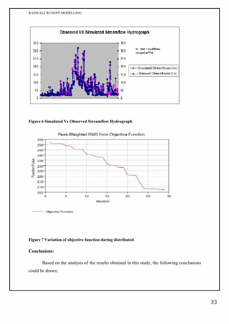
P%/o%an 4alation 0in&
&%a'!ial in"iato%0
Cisua chec+in$ of
obser%ed and simuated stream
fow hydro$raphs# a comparison
of the obser%ed stream fow
hydro$raph with the simuated one
by 8E=*8M> as Lumped
modein$ approach as we as by
Distributed modein$ approach as
shown in Fi$!<*K! It is apparent
from these fi$ures that athou$h there is a simiar trend between the obser%ed and simuated
stream fow hydro$raphs# the pea+s of the two hydro$raphs do not match reasonaby at ean
period of rainfa! As discussed earier that an ob1ecti%e functions is a mathematica too to
measure the $oodness of fit between the obser%ed and $enerated hydro$raphs! "o find the
owest ob1ecti%e function %aue and optimum parameter %aues are the main ob1ecti%es behind
our optimi;ation tria! "he uni%ariate $radient method computes and ad1usts one parameter at
a time whie oc+in$ the other parameters! Aternati%ey# the Neder and Mead method
e%auates a parameters simutaneousy and determines which parameter to ad1ust! "he

8/12/2019 137010139 Rainfall Runoff Modelling
http://slidepdf.com/reader/full/137010139-rainfall-runoff-modelling 32/35
32
RAINFALL RUNOFF MODELLING
search a$orithms are aso +nown as optimi;ation methods! "he optima ob1ecti%e function
%aue is cosed to ;ero!
Fi&% , Silat" *0 O0%4" St%a /lo H$"%o&%a'!
Fi&% - Silat" *0 O0%4" St%a /lo H$"%o&%a'! /o% l'" o"llin& a''%oa!
"%in& 4ali"ation
8/12/2019 137010139 Rainfall Runoff Modelling
http://slidepdf.com/reader/full/137010139-rainfall-runoff-modelling 33/35

8/12/2019 137010139 Rainfall Runoff Modelling
http://slidepdf.com/reader/full/137010139-rainfall-runoff-modelling 34/35

8/12/2019 137010139 Rainfall Runoff Modelling
http://slidepdf.com/reader/full/137010139-rainfall-runoff-modelling 35/35
RAINFALL RUNOFF MODELLING
CHAPTER
REFERENCES
S9T =how C"# Maidment DR# Mays L- (9J66) Appied 8ydroo$y! McGraw 8i# New
Hor+# U>A
S:T >ubramanya# En$ineerin$ 8ydroo$y
S4T eith ! 2e%en# Rainfa*Runoff Modein$' "he 0rimer
S<T Da%id >! 2owes# 0! Enda O=onne# Recent Ad%ances in the Modein$ of 8ydroo$ic
>ystems
S?T "horsten -a$ener# 8oward -heater# 8oshin Ci1ai Gupta# Rainfa*Runoff Modein$ In
Gau$ed And Un$au$ed =atchments
ST Diip umar and Ra1ib umar 2hattachar1ya# @Distributed Rainfa Runoff Modein$#
October :799# Internationa ourna of Earth >ciences and En$ineerin$# I>>N 7JK<*?J7<#
Coume 7<# No 7 >0L# pp! :K7*:K?
SKT M! Rusin Anwar# @"he rainfa*runoff mode usin$ of the watershed physica
characteristic approach# December :799# Internationa ourna of =i%i Q En%ironmenta
En$ineerin$ I=EE*IEN> Co' 99 No' 7
S6T ai Ca;e# 0hiip ordan# Richard 2eecham# Andrew Frost# Gre$ory >ummere#
@Guideines for Rainfa*Runoff Modein$' "owards 2est 0ractice Mode Appication#
December :799# e-ater =ooperati%e Research =entre
SJT atarna DVubW+o%W# @Rainfa*runoff modein$' Its de%eopment# cassification And
possibe appications# A="A GEOGRA08I=A UNICER>I"A"I> =OMENIANAE# Co! ?<#
:797# No! :# pp! 9K4*969
S97T N$uyen 8on$ Xuan# @Rainfa runoff modein$ in the can e catchment# >ai$aon ri%er
basin# March :77# Internationa institute for $eoinformation science and earth obser%ation#
Enschede!# Netherand!