rainfall-runoff modelling in small and middle
TRANSCRIPT

GEOGRAFIE - SBORNIK CESKE GEOGRAFICKE SPOLECNOSTI ROK 2006 • CISLO 3 • ROCNIK 111
MICHAL JENICEK
RAINFALL-RUNOFF MODELLING IN SMALL AND MIDDLELARGECATCHMENTS-ANOVERYmW
M. J e n ice k: Rainfall-runoff. modelling in small and middle-large catchments - an overview. - Geografie-Sbornik CGS, 111, 3, pp. 305-313 (2006). - A rainfall-runoff modelling is nowadays a dynamically developing department of hydrology and water management. This development is caused by a rapid progress of computers and information technologies. This evolution provides the mankind with new possibilities to use water as its basic need and at the same time to evolve an effective protection against it. The aim of this article is to give some basic information about rainfall-runoff modelling, various approaches to it, methods and possibilities of application. This kind of information may help the user with the choice of the suitable rainfall-runoff model. Rainfall-runoff or hydraulic models have many different applications, e.g. in operational hydrology, water resource management or in research. Typical structure of any rainfall-runoff model, come out from a simplified catchment structure as a system of vertical ordered reservoirs, which form a linear cascade model. The main reservoirs are precipitation, evapotranspiration (together with interception), direct runoff, runoff in unsaturated zone (interflow), base flow and channel flow. For computation of processes running in each of these reservoirs (filling or drainage), many equations (model techniques) are applied. This structure and presented modelling techniques are used in the most common models like HEC-HMS, MIKE-SHE, Sacramento (SAC-SMA), NASIM, HBV and many others. KEY WORDS: modelling of hydrological processes - mathematical modelling - rainfallrunoff models - hydraulic models - floods.
The presented research was funded by the Research Plan MSM 0021620831 "Geographical Systems and Risk Processes in Context of Global Changes and European Integration" of the Czech Ministry of Education and Research Project VaV-SMl2/57/05 "Long-term changes of river ecosystems in floodplains affected by extreme floods" of the Ministry of Environment of the Czech Republic which is fully appreciated by the author.
1. Introduction
Mathematical representation of rainfall-runoff process has a long history, but until 80s of the last century became, due to rapid computer technology development, an important instrument for hydrologist and water managers, whether for hydrology forecast or for design purposes.
Mathematical model of rainfall-runoff process (R-R process) represents simplified quantitative relation between input and output variables of the certain hydrological system (Daiihelka et al. 2002). This relation is defined as a system of mainly physical processes affecting input values and transforms them to output values. This means, in mathematical sense, a solution algorithm of equation system. It describes system structure and system behaviour (Clarke 1973, In: Fleming 1979).
Currently many authors deal with the issue of rainfall-runoff and hydrodynamic modelling, both in Czechia and in the world. There are e.g.
305

Buchtele (2002); Daiihelka et al. (2002); Kulhary, Kovar (2002); Ricicova, Krejci (2002) or Stary (2004). Hydrologic and hydraulics models are also used in many Czech institutions like Czech Hydrometeorological Institute, Water Research Institute, Academy of Science and some universities.
But the main research centre lies in the world, above all in the articles and publications of Beven (1996, 2001); Bergstrom (1995); Bloschl, Grayson (2002); Refsgaard, Storm (1996); Smith et al. (2000,2004) and many others. From these studies an effort to accurate analysis of precipitation input (mainly radar estimations) is evident. Very important is also a development of calibration methods, especially automatic optimisation of input parameters. Developing of methods, which describe processes in the soil column (unsaturated soil profile), is also essential. Substantial progress for both R-R and routing models was DMIP project (Distributed Model Intercomparison Project). The aim of this project was a comparison of different R-R and hydrodynamic models and their approaches. Results were published in Journal of hydrology, Volume 298 (October 1994). Theoretical frame of described part of hydrology gives some articles and publications of Clarke (1973), O'Connor (1976), Bear (1972) and many others. Some of this approaches were implemented in methodology of the WMO (World Meteorological Organisation), e.g. Becker, Serb an (1990) or WMO (1983).
Over time of models application, their different approaches to a catchment description, a several groups of models were turned out. Most common is the classification according to the WMO (World Meteorological Organisation) described by Becker, Serban (1990). There we can distinguish several groups of classification criterions. The most common of this criterion is a degree of causality (deterministic and stochastic models) and time or space discretisation (continually vs. event models, lumped vs. distributed or semi-distributed models).
2. Means of application
Rainfall-runoff or hydraulic models have many different applications. It is possible to distinguish three main categories.
First area of application is operational hydrology. Input data are formed, besides state variables, by real-time data from automatic stations or sometimes from meteorological radars. Data are automatically (after checking by hydrologist) given to a model and priority is a velocity of their processing. A result is a short-time forecast of water stage or discharge. Practically it means more specialized models (wave routing or subsurface flow model) which together with software for data collecting and analyses form a Flood Forecast System (FFS).
Second area forms partly long-time solutions of flood protection (dams, dry polders or another flood or drought protection measures) and partly are RR and hydrodynamic models useful by building of several technical water management project like canals, irrigations, cleaners, weirs or bridges.
Another type of application is a possibility for additional development of models, research of particular components of rainfall-runoff process and their more accurate description. For these purposes some experimental catchments use to be created with above standard network of measurement stations.
Rainfall-runoff model results can be also applied as an input of other applications like pollution diffusion models. Interesting could be also application in climate change impact simulations.
306

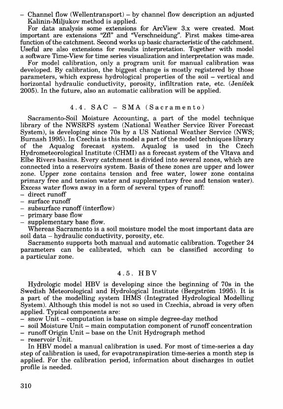
Evapotranspiration
-4-",."'--"""":'- Flowfrom unsaturated zone
.,.L-- Flowfrom saturated zona
Fig. 1 - General structure of a hydrological model
Here are some concrete types of hydrological tasks, where an application of rainfall-runoff model is possible:
flood wave run simulation of any time or space step, both in natural and urban areas flood protection project designing, support of crisis management systems low flows modelling, e.g. for drought period or pollution diffusion support of reservoirs, polders, canals or irrigation management hydrologic balance computation long-time period scenarios, base on climate change models statistic parameters computation (excess probability, etc.).
3. General structure of a Rainfall-Runoff model
General characteristic of the most of R-R models is dividing of the catchment to several zones, mainly vertical ordered. These zones are with help of the linear cascade model (O 'Connor 1976) computed. Their simplified structure is displayed in the figure 1.
For computation of processes running in each of these reservoirs (filling or drainage), many equations (model techniques) are applied.
Precipitation (both rain and snow) - they are entered into models in the form of time series from meteorological stations (as a point rain) or sometimes meteorological radars (as an area rain). For estimation of the snow precipitation influence methods of temperature index, degree-day method or energy balance are applied.
Evapotranspiration (include interception) - actual evapotranspiration and interception are computed from time series from climatologic stations ifthey are
307

available. It is also possible to derive actual evapotranspiration from potential evapotranspiration (there are a lot of equations based on climatologic data).
Surface runoff from the catchment - the most common used method is the Unit hydrograph (UH) and various modifications (Clark's, Snyder's, SCS). Principe of this method is described in the literature (e.g. Chow et al. 1988). User can also use other methods based on kinematic wave model or finite difference method.
Subsurface flow in the unsaturated zone - it is mostly the most important component of runoff concentration. Several methods are available, e.g. SCS CN method (Soil Conservation Service Curve Number), which is used for runoff volume computation in dependence on hydrological parameters of the soil, initial condition (saturation) or soil land use (see e.g. Mack 1995). Some other methods are Green-Ampt method or SMA (Soil Moisture Accounting). Other methods are based on simple or complicated approaches starting with simple two layers model, gravity model and finishing with model based on solution of Richard's equations.
Base flow - in dependence on concrete model, mostly applied are methods based on linear cascade model (see O'Connor, 1976), exponential decrease (Chow et al. 1988) or constant runoff. Common are also 2D or 3D base flow models based on the finite difference method.
Open-channel flow - rainfall-runoff models apply methods together often called hydrologic routing. There are e.g. Muskingum-Cunge method, Lag model, kinematic wave model or transport diffusion equation. These methods are mainly based on a solution of basic equations of open-channel flow - continuity and momentum equations. There are together known as St. Venant's equations (see e.g. Feldman 2000).
Water control facilities - in R-R model are also some possibilities for modelling water control facilities, such as reservoirs, polders or diversion.
4. Characteristic of some rainfall-runoff models
4.1. MIKE-SHE
Rainfall-runoff model MIKE-SHE of Danish firm DHI (Danish Hydraulic Institute) belongs to a group of conceptual distributed or semi-distributed models. It consists of several components computing a volume and distribution of water during particular phases of runoff process:
Precipitation - serves as an input data. Both liquid and compact. Evapotranspiration, included interception (input data) Surface flow - based on 2D finite difference method. Channel flow - ID routing model MIKEll is applied. This model provides several methods, such as Muskingum, Transport Diffusion Equation or method based on solution of St. Venant's equations. Subsurface flow in unsaturated zone - simple two-layer model, gravity flow model or on Richard's equation based model are available. Base flow - MIKE-SHE contains 2D and 3D base flow model based on the finite differences method. For the soil model a database including soil hydrology characteristic
(porosity, hydrauliC conductivity, etc.) was created. Also two extensions of ESRI software ArcView 3.x or ArcGIS 9.1 were created. These extensions
308

work with the input data. First, Geomodel (for ArcGIS 9.1) serve for geological characteristics interpretation. Second, DaisyGIS is a conceptual model (for ArcView 3.x) for description of all important processes bounded on agricultural ecosystem (water, heat or nutrients transport).
In the model both manual and automatic calibration is possible. For automatic calibration the tool AUTOCAL was developed. This tool allows optimisation according to initial and border conditions.
4.2. HEC - HMS
Model HEC-HMS (Hydrologic Engineering Centre - Hydrologic Modelling System) is a continuator of model HEC-1 developing since 60s by the US Army. It is mainly lumped model. Its great advantage is that fact, that it is a freeware, also in Internet available. The basic components are following: - Runoff-volume models - includes some methods, such as SCS CN (Soil
Conservation Service Curve Number), Green-Ampt or SMA (Soil Moisture Accounting). Direct-runoff models - for direct runoff computation a Unit Hydrograph method (UH) or its various modifications is used. (Clark's, Snyder's, SCS). For user a method of kinematic wave is also available. Baseflow models - a user can choose, for instance, linear reservoir model, exponential decrease, or constant runoff model.
- Routing models - there are Muskingum-Cung model, Lag model, kinematic wave model or their modifications available.
- Others models - in special cases there are also possible to simulate the reservoirs, weirs, etc. For HEC-HMS model an extension of ArcView 3.x called HEC-GeoHMS
was also created. This extension is able to derive some basic hydrological characteristics of the basin - watersheds, water flow directions, flow accumulations, slopes, etc.
With HMS both manual and automatic calibration of parameters is possible. Regarding the type of a model (suitable for catchments up to 500 km2) the calibration takes place on short flood events.
4.3. NASIM
Rainfall-runoff model NASIM (Niederschlag-Abfluss Simulation Model) made by German firm Hydrotec is developing since 80s and belongs to a group of conceptual, deterministic, semi-distributed models. The basic components are following: - Rainfall generation (Belastungsbildung) - for differentiation of liquid and
compact precipitation a combined method "Temperature Index/Snow Compaction" is applied.
- Space distribution of precipitation (Belastungsverteilung) - conversion of point values to area precipitation. Runoff components separation (Belastungsaufteilung) - quantification of runoff components (interception, evapotranspiration, accumulation in depressions, infiltration, percolation).
- Runoff concentration (Abflusskonzentration) - water flow in unsaturated (interflow) and saturated (baseflow) zone of the soil profile is by linear or nonlinear cascade model described. For surface runoff a method based on Unit hydrograph was created.
309
- Channel flow (Wellentransport) - by channel flow description an adjusted Kalinin-Miljukov method is applied. For data analysis some extensions for ArcView 3.x were created. Most
important are extensions "Zfl" and "Verschneidung". First makes time-area function ofthe catchment. Second works up basic characteristic ofthe catchment. Useful are also extensions for results interpretation. Together with model a software Time-View for time series visualization and interpretation was made.
For model calibration, only a program unit for manual calibration was developed. By calibration, the biggest change is mostly registered by those parameters, which express hydrological properties of the soil - vertical and horizontal hydraulic conductivity, porosity, infiltration rate, etc. (Jenicek 2005). In the future, also an automatic calibration will be applied.
4.4. SAC - SMA (Sacramento)
Sacramento-Soil Moisture Accounting, a part of the model technique library of the NWSRFS system (National Weather Service River Forecast System), is developing since 70s by a US National Weather Service (NWS; Burnash 1995). In Czechia is this model a part of the model techniques library of the Aqualog forecast system. Aqualog is used in the Czech Hydrometeorological Institute (CHMI) as a forecast system of the Vltava and Elbe Rivers basins. Every catchment is divided into several zones, which are connected into a reservoirs system. Basis of these zones are upper and lower zone. Upper zone contains tension and free water, lower zone contains primary free and tension water and supplementary free and tension water). Excess water flows away in a form of several types of runoff: - direct runoff - surface runoff - subsurface runoff (interflow) - primary base flow - supplementary base flow.
Whereas Sacramento is a soil moisture model the most important data are soil data - hydraulic conductivity, porosity, etc.
Sacramento supports both manual and automatic calibration. Together 24 parameters can be calibrated, which can be classified according to a particular zone.
4.5. HBV
Hydrologic model HBV is developing since the beginning of 70s in the Swedish Meteorological and Hydrological Institute (Bergstrom 1995). It is a part of the modelling system IHMS (Integrated Hydrological Modelling System). Although this model is not so used in Czechia, abroad is very often applied. Typical components are: - snow Unit - computation is base on simple degree-day method
soil Moisture Unit - main computation component of runoff concentration - runoff Origin Unit - base on the Unit Hydrograph method - reservoir Unit.
In HBV model a manual calibration is used. For most of time-series a day step of calibration is used, for evapotranspiration time-series a month step is applied. For the calibration period, information about discharges in outlet profile is needed.
310

5. Conclusion
From this article is clear, that for modelling of rainfall-runoff processes many methods are available. These methods are possible to use by solution of various types of hydrological tasks, such as operational hydrology, flood or drought protection or pollution transport modelling. One of the first steps by the project solution is a choice of the model, which will be suitable for concrete hydrological task. The user should take into account some criterions and claims to a model according to the data which model needs, type of hydrological problem (if model is needed for operative forecast or modelling of catastrophic scenarios, for instance), size of a catchment, connection to GIS or other software for collecting, analysing or presentation of the data and results. The user should also know if data which model needs are available for the catchment. Also previous references, support and of course a price are very important. For more extensive catchments (over 100 km2)
could be also a connection with a routing model for flood wave progress simulation useful. In department of physical geography and geoecology was after consideration of all described factors models MIKE-SHE together with MIKE 11 and HEC-HMS together with HEC-RAS chosen. It is also studied the possibility of using Czech hydrodynamic model Hydrocheck and the R-R model WMS.
References:
BEAR, J. (1972): Dynamics of fluids in porous media. American Elsevier publishing, New York, 764 p.
BECKER, A., SERBAN, P. (1990): Hydrological models for water - resources system design and ope:r:!ltion. Operational Hydrology Report No. 34, WMO, Geneva, 80 p.
BERGSTROM, S (1995): The HBV Model. In: Singh, V. P. (ed.): Computer models of watershed hydrology. Water Resourse Publications, Highland Ranch, pp. 443-476.
BEVEN, K.J. (1996): A discussion of distributed hydrolOgical modelling. In: Abbott, M. B., Refsgaard, J. C. (1996): Distributed hydrological modelling. Kluwer, Dordrecht, pp.255-279.
BEVEN, K. J. (2001): Rainfall-Runoff Modelling, The Primer. John Wiley & Sons, Chichester, 360 p.
BLOSCHL G., GRAYSON R. (2002): Flachendetaillierte Niederschlag-Abfluss Modellierung. In: Wiener Mitteilungen - Band 164 - Niederschlag-Abfluss Modellierung - Simulation und Prognose, Technische Universitat Wien, pp. 33-55.
BUCHTELE, J. (2002): Uvod k metodam a modelum h~drologickych pfedpovedi. In: Patera, A. et al.: Povodne: progn6zy, vodni toky a krajina. CVUT, Praha, pp. 33-35.
BURNASH, R. J. C. (1995): The NWS River Forecast System - catchment modeling. In: Singh, V. P. (ed.): Computer Models of Watershed Hydrology. Water Resourse Publications, Highland Ranch, pp. 311-366.
CLARKE, R. T. (1973): Mathematical models in hydrology. Irrigation and Drainage paper No. 19, FAO, Rome.
CHOW, V. T., MAIDMENT, D. R., MAYS, L. W. (1988): Applied hydrology. McGraw-Hill, New York.
DANHELKA, J., KREJCi, J., SALEK, M., SERCL, P., ZEzULAK, J. (2002): Posouzeni vhodnosti aplikace sra~ko-odtqkovYch modelu s ohledem na simulaci povodnovYch stav-u pro lokality na uzemi CR. CZU, Praha, 214 p.
FELDMAN, A. D. (ed., 2000): HydrolOgic Modeling System HEC-HMS - Technical Reference Manual. US Army Corps of Engineers, Washington, 149 p.
FLEMING, G. (1979): Deterministic models in hydrology. Irrigation and Drainage paper, 3~'vFAO, Rome, 80 p.
JENICEK, M. (2005): Aplikace matematickeho modelu NASIM pro simulaci srazkoodtokovYch pomeru v povodi Cerne vody. Thesis. PfF UK, 104 p.
311

KUqIAVY, Z., KOV Ali, P. (2002): Vyuziti modelu hydrologicke bilance pro mala povodi. VUMOP, Praha, 123 p.
LANGHAMMER, J. et al. (2006): Zmeny krajiny jako ovliviiujici faktor prubehu a projevu extremnich povodni. PfF UK, Praha, 209 p.
MACK, M. J. (1995): HER - Hydrologic evaluation of runoff; The Soil Conservation Service Curve Number technique as an interactive computer model. Computers & Geosciences, Vol. 21, Issue 8, pp. 929-935.
O'CONNOR, K. M. (1976): A discrete linear cascade model for hydrology. Journal of Hydrology, 29, pp. 203-242.
REFSGAARD, J. C., STORM, B. (1996): Construction, calibration and validation of hydrological models. In: Abbott M. B., Refsgaard J. C.: Distributed hydrological
v !Jlodellip.g. Kluwer, lJ9rdrecht, pp. 41-54. RICICOVA, P., KREJCI, J. (2002): Vyuziti hydrologickych modelu a perspektivy jejich
rozvoje u n$is. In; Pocasi - moderni pfedpovedni metody, prevence a snizovani nasledku katastrof, CHMU, Praha, pp. 36-41.
SMITH, M. B., KOREN, V. I., WELLS, E., WANG, D., ZHANG, Z. (2000): Evaluation of the advantages of the continuous SAC-SMA model over an event API model. 15th Conference on Hydrology 9.1-4.1.2000, Long Beach, CA.
SMITH, M. B., KOREN, V. I., ZHANG, Z., REED, S. M., PAN, J-J., MOREDA, F. (2004): Runoff response to spatial variability of precipitation: an analysis of observed data. Journal of Hydrology, 298, pp 267-286.
STARY, M. (2004): Uzitf umelych neuronovYch siti v aplikovane hydrologii - zkracena verze habilitacni prace. VUT, Brno, 40 s.
WMO-No. 168 (1983): Guide to hydrological practices, Volume II - Analysis, Forecasting and other application. WMO, Geneva.
Shrnuti
MODELovANf SRAZKO-ODTOKOvYCH PROCESU NA MALYCH A STREDNE VELKYCH POVODfcH
Matematicka reprezentace srazko-odtokoveho procesu ma dlouhou historii, ale teprve zhruba od 80. let minuleho stoleti se diky postupnemu rozvoji pocitacovych technologii stava vYznamnym nastrojem hydrologU a vodohospodafu, at uz pro operativni pfedpoved' nebo pro navrhove ucely.
Cllem pfispevku je podat zakladni informace 0 pfistupech ke srazko-odtokovemu modelovani, jednotlivYch metodach a take charakterizovat nektere nejcasteji pouzivane modely, jako jsou MIKE-SHE, HEC-HMS, NASIM, Sacramento a HBV.
Problematikou vyuziti hydrologickych a jednorozmernych hydraulickych modelu se v soucasne doM zabYva fada autoru. Z ce§kych jsou to napfiklad Buchtele (2002), Daiihelka a kol. (2002); KulhavY, Koval' (2002); Ricicova, Krejci (2002) nebo Stary (2004). Hlavni teziste vYzkumu a vyYoje vsech typu hydrologickych modelu spociva v zahranici, pfedevsim v pracich Bevena (1996, 2001); Bergstroma (1995); Bloschla, Graysona (2002); Refsgaarda, Storma (1996); Smithe a kol. (2000, 2004) a dalsich, ktefi aplikovali nejruznejsi hydrologicke modely a vfrazne tim pfispeli k vyYoji metod popisujici srazko-odtokovY proces. Tyto prace dokazuji, ze duraz je kladen pfedevsim na pfesnejSi zpracovani srazkovYch polf jako vstupu do modelu (hlavne v podoM radarovYch odhadu). Vyznamny prostor je take venovan postupum kalibrace modelu, pfedevSim pak procesu automaticke optimalizace vstupnich parametru. Zasadni je take vyYoj metod popisujicich proudeni v nenasycene zone pudniho profilu (model pudni vlhkosti). Vyznamnym pfispevkem do problematiky jak hydrologickych, tak hydraulickych modelu byl projekt DMIP (Distributed Model Intercomparison Project), ktery si dal za cll srovnani nekolika srazko-odtokovYch modelu a jejich pfistupu. Vysledky byly publikovany v Journal of Hydrology, 298 (fijen 2004). Mnoho z techto i dfivejsich pfistupu je zahrnuto v metodikach a doporucenich WMO (World Meteorological Organisation), napfiklad Becker, Serban (1990) nebo WMO (1983).
Pouziti matematickych modelu je mozne rozdelit do tfi hlavnich kategorii podle charakteru daneho Ukolu. Prvni oblast vyuzitije operativni hydrologie, druhou oblast tvofijednak dlouhodoMjsi feseni protipovodiiove ochrany a take feseni nejruznejSich vodohospodarskych staveb. Pod tfeti kategorii vyuziti hydrologickeho modelu se skrYvaji moznosti dalsmo vyYoje modelu, vYzkum jednotlivYch komponent srazko-odtokoveho procesu a jejich pfesnejsi popis.
312

Vystupy z hydrologickeho modelu mohou slouzit jako vstupni veliciny dalsich modelu (naphKlad modelu Sireni znecisteni ve vodnim prostfedi) a naopak mohou mit hydrologicke modely mivaznost najine projekty, naphKlad odhad vlivu klimatickych zmen na snizkoodtokove pomery v povodi.
Obecnou charakteristikou vetsiny modelu je rozdeleni povodi na nekolik, vetsinou vertikalne usporadanych zon, ktere jsou pocitany konceptem linearni nadrie. Jedna se 0 nasledujici komponenty:
Srdiky (desfove i snehove) - jde 0 vstupni data ve forme casovjch rad ze srazkomernych stanic. Pro vjpocet snehovjch dat bylo vyvinuto mnozstvi metod.
Evaporace, vcetne intercepce - aktualni evapotranspirace a intercepce bjva pocitana z casovjch rad, pokud jsou uzivatelem zadany.
Povrchovy odtok z povodi - nejcasteji je vyuzivan jednotkovj hydrogram (Unit Hydrograph). Uzivatel take muze vyuzit model kinematicke vlny nebo metodu konecnych diferenci.
Podpovrchovy odtok v nenasycene zone pudnfho profilu - casto se jedna 0 nejdulezitejsi komponentu koncentrace odtoku. K dispozici bjva vice metod napnklad metoda SCS CN kfivek (Soil Conservation Service Curve Number). Jine metody jsou naphKlad Green-Ampt metoda nebo SMA (Soil Moisture Accounting). Dalsi metody jsou zalozeny na jednodussich i pomerne slozitych postupech od dvouvrstveho modelu, pres gravitacni model proudeni, az po model zalozeny na reseni Richardsovy rovnice.
Podzemni odtok - v zavislosti na konkretnim modelu jsou casto pouzivanjmi metodami modellinearni nadrie, exponencialru11O poklesu nebo konstantniho odtoku. Obvykly je take 2D a 3D model proudeni podzemni vody zalozeny na metode konecnych diferenci.
Odtok v koryte - rozsirenjmi modely jsou naph1dad Muskingum-Cunge, Lag model, model kinematicke vlny nebo transportni difuzni rovnice. Tyto metody jsou zalozeny na reseni rovnice kontinuity a momentove rovnice (St. Venantovy rovnice).
Z uvedeneho prehledu je zrejme, ze k modelovani srazko-odtokovjch procesu je k dis pozici cela rada pnstupu, ktere je mozne pouzit pro reseni likolu spojenych s problematikou povodni. Dulezity je vjMr vhodneho modelu. Ten musi odpovidat charakteru projektu, tedy licelu zpracovani. Je potreba take dopredu vedet, jsou-li data, ktera model vyzaduje, dostupna. Pro reseni projektu na stfedne velkych povodich (nad cca 100 km2) je jiz vhodne propojeni srazko-odtokoveho modelu s podrobnejsim korytovjm modelem. Pri zpracovani dat a interpretaci vjsledkuje zadouci take schopnost komunikace modelu, ci modeloveho systemu s geoinformacnimi sysMmy. Aplikace hydrologickeho modelu je vetsinou financne i casove velmi narocny proces a je tedy nutne zvazit zda se investovane penize a cas nakonec vyplati.
Obr. 1 - Obecna struktura hydrologickeho modelu
(Author is with Charles University in Prague, Faculty of Science, Department of Physical Geography and Geoecology, Albertov 6, 128 43 Praha 2, Czechia; e-mail: [email protected].)
Arrived to the editorial board on August 28, 2006
313