2-4-3 socio-economic condition in ulugan bay areaopen_jicareport.jica.go.jp/pdf/11519246_10.pdf2-4-3...
TRANSCRIPT

252
2-4-3 Socio-economic Condition in Ulugan Bay Area
(1) Provincial Level
The Province of Palawan, where Ulugan Bay Area locates, has its limits with
Busuanga Island in the north, the Agutaya Group northeast, Cagayancillo in the
east and with Balabac Island in the farthest south. The west side faces the South
China Sea. As the second largest province in the Philippines, Palawan consists of
1,768 islands, most of which have irregular coastline. Reclining between Mindoro
Island and North Borneo, its extreme length is 650 km. The main island measures
425 km. from tip to tip. A chain of tall mountain ranges runs through the entire
length of the main island, bisecting it into two distinct areas, the east and the west
coasts. The eastern side is characterized by thin strandlines bordered by
swamplands, following a series of wide vast plains and valleys ascending
gradually to emerge with low rolling hills toward the mountains. The west coast is
pinched by craggy foothills and mountains close to the sea. Province of Palawan
has a land area of 14,896.55 sq.km, and a population of 640,486 (as of 1995).
Major products of Palawan are; 1)rice, corn, 2)fishery products, 3)cashew. The
average annual income of the people in Palawan is 49,327 peso (average in 1994).
The socio-economic feature of Palawan is summarized in Table-2-2U-3.
(2) Municipal Level
Ulugan Bay, is located within the jurisdiction of Puerto Princesa City, the only
one City in the Province.
1) Significant Features
Puerto Princesa City is located in the midsection of the long island strip of
Palawan Province, with its total land area of 253,982 ha consisting of 66
Barangay. Total population of the City is 129,557 as of 1995, and mostly engaged
in agriculture, fishing and service industries.

253
TABLE 2-2U-3 GENERAL SOCIO-ECONOMIC CONDITIONPROVINCE : PALAWAN
1. General Feature
Area (ha) 14,896.55 sq.km.No. of City 1 (Puerto Princesa City)No. of Municipality 23No. of Barangay 431Population (Total) 640,486 (1996 census)(Labor force) 37,900(by occupation) - Agriculture 70.29%
- Services 21.76%- Inudstry 7.95%
Average Annual Income 49,327 pesoAverage Annual Expenditure 41,001 peso2. Products
1) Agriculture - Palay 59,300 ha 139,565 metric tons- Cashew 21,508 ha 24,994 metric tons- Coconuts 54,967 ha 57,089 metric tons- Corn 23,865 ha 45,303 metric tons
2) Forestry - Rattan 861,900m- Almaciga 69,340kg- Bamboo 165,830 pieces
3) Fishery - Commercial 18,325 metric tons- Municipal 61,522 metric tons- Aquauclture 350 metric tons
4) Livestocks - Carabao 30,560 heads- Cattle 20,500- Hog 100,000- Goat 36,000- Chicken 469,434- Duck 37,741
3. Infrastructure
Transportation - Road Total 4,022.2 km (incl. 366.5km pavement road)- Ports 41 nos.- Airport 21 nos. (Incl. private, military)
Communication - Tel company 5 nos.- TV Stations 3 nos.
Electricity - Total Capacity 22.41 Megawatts- Served 38,936 hosueholds
Rural Water Supply - Level I 15,802 wells 69,606 households- Level II 54 systems 4,735 households- Level III 22 systems 8024 households
Medical facilities - Hospital 10 (Gov.), 3 (Private)Educational facilities- College/Univ. 2 (state), 4 (Private)
- Highschool 69- Elementary 560
Agri/fishery facilities - Pear 52 (major), 43 (minor)- Fishpond 24 nos. (under FLA) (Total 1,429ha)- Irrigation 1 National System, 49 Communal Systems- warehouse 10 (NFA), 50 (Private)
Source : 1996 Provincial Socio-Economic Profile, PPDO, Prov. Governmentof Palawan

254
2) Development Policy/Strategy
According to “1998 Annual Investment Plan” of the City, emphasis of the
development strategy of the City are; 1) poverty alleviation, 2) ecological concern,
3) tourism development, 4) basic social services, 5) infrastructure upgrading, 6)
increase of investment, and 7) strengthening of local government capability.
(3) Barangay Level
The Study Area is located within the five (5) Barangays, which are:
1) Macarascas
2) Bahile
3) Buenavista
4) Tagbinit
5) Cabayugan
1) Socio-Economic Condition
a. Population
The Barangay in the Study Area has an average number of household of around230. Average number of Family member is less than 5 person.
The result of the Interview Survey by sampling 200 households from 14
Barangays in the Study Area (hereinafter referred as “the Interview Survey)
shows that the average number of family member is 5.3 person (maximum 6.1 in
Barangay Tababinit, minimum 4.4 in Barangay Buenavista). Distribution by age
is indicated in Table 2-2U-4 as below:
Table 2-2U-4 Distribution by Age (Ulugan
Bay)
Age
Ulugan Bay
5 Brgy.(%)
Nationwide
Average (%)
0~4 13.6 13.7
5~9 16.4 13.0
10~14 12.3 11.7
15~19 11.5 10.9

255
20~24 8.3 9.1
25~29 6.8 8.4
30~34 6.5 7.1
35~39 6.2 6.3
40~44 4.8 5.0
45~49 3.8 4.0
50~54 3.2 3.0
55~59 2.7 2.5
60~64 2.0 1.9
65~ 1.8 3.5
b. Income Resource, Production, Marketing
In the Barangay in this area, fishery is the main source of income, followed by
the rice production. However, agricultural production is occasionally for sale
(when there is surplus) and limited for self-consumption. For fishery products,
brackish water fish such as Kalapato is the main catch, and shrimps and crabs
are not common. Most people in all of these five Barangays sell their products in
Puerto Princessa City, since land access can be easily made by commercial-based
Jeepney from these area to the City.
The Interview Survey shows that 32.4% of labor force in this Area is engaged in
the fishery sector, 21.8% in agricultural sector. Monthly average income is
P4,946.90 while expense is P4,159.30. This average income is 0.75 times of the
poverty threshold (expense necessary to secure 2,000 calories per family
member) in Region-4 where Palawan Province is located, and 1.03 times that of
the entire Philippines (average excluding National Capitol Region). Also, this
average income is 0.91 times of the average income of fishery household in the
Philippines (municipal, inland and fishculture fishery, excluding commercial
fishing) which is P5,443.69. As for the employment style, 77.4% of the labor force
in the Study Area is self-employed, of which 9.5 % on permanent basis and 13.2%
on daily basis. An average of 44.6% of the products from fishery and agricultural
sector is domestic consumed. 51.5 % of the respondents sell their product within
their Barangays. This is remarkably large as compared to other two Study Areas
(39.0% in Aparri Area, 33.5% in Ulugan Bay Area). 39.5 % replied that
middlemen/traders visit their area to buy their products.

256
c. Infrastructures
No Barangay located in this area is electrified and totally depend on their own
generators (public and private). Most of Barangays, spring resources are
available as their source of water. There are only limited infrastructure in this
area, such as one port (pier) in Macarascas and small rice mills in each Barangay.
As for educational institute, there are elementary schools in all 5 Barangay, and
3 out of 5 Barangay have highschools. Clinic, day care center are commonly
observed in this area, as well as Barangay hall and church.
According to the result of Interview Survey, 98.8% of families possess the houses
they are staying. 35.7% of households are electrified, and 89.3% of families have
available potable water resources within their Barangay. 60.7% of households
replied that they are using firewood as source of fuel (97.5% in Aparri Area,
40.0% in Lamon Bay Area).
d. People’s Organization
Aside from religious and woman’s groups, there is minimum organized group in
this area observed. Only Macarascas has Multi-Purpose Cooperative, however
their capital are minimum and they have difficulty in rendering micro-credit to
members.
The Interview Survey shows that 25.7% of households in this Area belongs to
any people’s organizations within their Barangay. Likewise, 11.9% of household
replied they are being avail of loan/credits from any organization.
The socio-economic features of these 5 Barangay are summarized in Table-2-4-3
as well as the summary result of interview survey in Table 2-4-4.

257

258

259

260
(4) Condition on Mangrove Use and Other Environmental Issues
1) Implementation of Legal Systems on the Mangrove Use
On June 1992, the Republic Act 7611 was signed for the establishment of the
Strategic Environment Plan (SEP) for Palawan. This Plan has set up the policy on
the conservation of Palawan’s environment as a precondition to any development
projects, by establishment of Palawan Council for Sustainable Development
(PCSD). Furthermore, the Provincial Government of Palawan has declared
“Bantay Palawan” in March 1993, for the intensive control on illegal logging and
illegal catch of fish in entire Palawan Province. Under such circumstance of
environmental protection movement in the Province, Coastal Environment
Program (CEP) is being implemented since 1993 in Ulugan Bay, and some
cooperatives/corporation of beneficiaries has been organized for the contract with
DENR for planting tree, research, technical training and activities for
environmental protection. There is only one (1) existing 50ha fishpond for Prawn
at Barangay Tagabinit in Ulugan Bay Area which is under Fishpond Lease
Agreement (FLA), however, since new application for FLA has been no longer
accepted after 1989, there has been no legal conversion of Mangrove forest into
fishpond. There is also existing one (1) Mangrove Stewardship Agreement in
Barangay Bahile, and two (2) Mangrove Reforestation Projects, 100ha each in
Barangay Bahile and Macarascas in this Area.
2) Actual Condition on the Mangrove Use
Hereunder is the result of aforementioned interview survey (interviewing 200
sampled households) regarding the use condition and intention toward
conservation of Mangrove. (Detailed result is shown on Table-2-4-5 in this Section,
and Figure-2-1-1 to 2-1-11 in the last Section.)
a. Entering Mangrove Area
49.4% of household heads replied that they have entered Mangrove area within
one year. This percentage is intermediate as compared to other 2 Study Areas
(75.5% in Aparri Area, 32.5% in Lamon Bay Area). The purposes for entering is
as follows:
To collect shellfish/crab 59.5%
To catch fish 4.5%

261
To collect woods 3.0%
To collect other plants 1.5%
b. Use Condition of Mangrove
The percentage of people who replied that they are presently using Mangrove
trees, and having used mangrove trees within 3 years past is 14.7% and 15.7%,
respectively. This percentage on present use, 14.7% is intermediate among three
Study Areas (68.0% in Aparri Area, 12.0% in Lamon Bay Area). However, 18.2%
of people replied that they had been used Mangrove trees for more than three
years past, and this percentage is relatively large as compared to other two
Areas (1.0% in Aparri, 6.5% in Lamon Bay Area). It might be considered that the
use of Mangrove in the past in this Area was common, hence, the percentage on
use has been remarkably decreased due to the intensive information activities by
the governmental agency concerned on the environmental protection.
The percentage on Mangrove use by Barangay is as follows:
Name of Brgy. Present Use Use w/in 3 yrs. Past Use 3 more yrs.Bahile 6.1% 15.8% 19.4%Macarascas 2.8% 12.5% 33.2%Buenavista 38.9% 33.3% 11.1%Tagabinit 20.6% 12.1% 16.0%Cabayugan 4.2% 2.1% 8.3%
As for the purpose of use, uses as the material of fence as well as house repair
are dominant. Not so many people use Mangrove as firewood (among people
replied on the use of firewood, 13.7% of people answered that they are using
Mangrove for this purpose). As for the method to obtain Mangrove trees, 39.3%
of people is entering the Mangrove area to cut, 22.4% of people is collecting fallen
tree, and 13.5% of people are buying Mangrove trees.
c. Knowledge of Use of Mangrove
As for the knowledge on what way mangrove can be utilized (regardless whether
they are actually using Mangrove in that way or not), the result is as follows:House repair 98.0%Fuel 94.5%

262
Dyeing 60.5%Make tool 49.0%Furniture 46.5%Make boat 35.5%Cloth 18.5%Food 17.5%Net 11.5%Paper 6.5%Spice 4.5%Tea 4.0%Liquor 2.5%Hair oil 1.5%
d. Future Intention to Use Mangrove
30.0% of households in this Area replied that they have intention to use
Mangrove tree in the future. This percentage is the largest among three Study
Areas (3.2% in Aparri Area, 10.8% in Lamon Bay Area). As the Area where the
intensive governmental campaign on environment protection is well informed
and understood by the people, it is noted that this large percentage, which is
showing their intention to use in the future, may indicate the possibility on
increase of cutting volume of Mangrove, in case the intensity of present
information drive decreases.
For reference, percentage of people having intention to have their own fishponds
was 31.5% which is the lowest in three Study Areas (49.5% in Aparri Area, 67.5%
in Ulugan Bay Area).
Result by Barangays is as follows:
Name of Brgy. Intention to use Mangrove Intention to have FishpondBahile 35.6% 35.1%Macarascas 40.9% 46.3%Buenavista 22.2% 11.1%Tagabinit 19.8% 42.6%
Cabayugan 31.5% 16.7%
e. Knowledge of Legal System on Mangrove Conservation

263
41.5% of people in this Area replied that they have negative sense in cutting
Mangrove threes (38.7% in Aparri Area, 69.8% in Lamon Bay Area). Among
them, only 3.4% of people replied that laws/regulations is the reason of their
negative sense. It shall be noted that people have less aware of legal restriction
on Mangrove, while the intensive governmental campaign on environment
protection seems as well informed well and understood by the people. 45.0% of
people replied that they remember their opportunities of discussing with the
Government official regarding conservation of Mangrove. This figure is
remarkably large as compared to other two Areas (2.5% in Aparri Area and
26.0% in Lamon Bay Area). This figure may indicate that information activities
is well informed and understood by the people, hence, also indicate necessity on
the understanding of the legal regulation in the field revel. Among the people
who are using Mangrove tree presently, 55.5% of people are those who do not
remember such opportunity of discussion.
f. Conservation Sense of Mangrove Forest
For any kind of environmental protection movement (governmental or non-
governmental), not limited on Mangrove protection in the area, 92.0% of people
are aware of such movement, and this figure is the largest in three Study Areas
(34.0% in Aparri Area, 72.0% in Ulugan Bay Area). Also, 96.5% of people replied
that they find importance in protecting Mangrove, 93.5% of people replied their
intention to positively participate on protection Mangrove actively. However,
26.4% of people answered that they grant Mangrove cutting as the way to
improve their economic condition, and this percentage is not so low as compared
to other two Study Areas (35.5% in Aparri Area, 11.5% in Lamon Bay Area). In
consideration together with the much intention of the people to use Mangrove in
the future, the present information activities by the governmental office
concerned shall be maintained.
g. Benefit of Mangrove as Disaster Prevention Method
53.0% of the people in this area replied that they are benefited by Mangrove as
the method of protecting their house and possession from high tide. This
percentage is the largest among three Study Areas (44.5% in Aparri Area, 31.0%
in Lamon Bay Area). Likewise, 57.6% of the people in this area replied that they
are benefited by Mangrove as the method of protecting their house and

264
possession from strong wind by Typhoon.
Furthermore, among 26.4% of people who grant Mangrove cutting mentioned
above, 81.9% of people replied that they are not benefited from Mangrove as
natural disaster prevention method.

265

266
Bibliography (II-2-3)
1_/ PAGASA 1998 Meteorological data in Aparri2_/ Bureau of Mines in coordination with the Board of Technical Surveys and Maps
1963 Geological Map Series NC-523_/ PAGASA 1998 Meteorological data of Alabat, Quezon4_/ PAGASA, Climatology & Agrometeorology Branch 1998 Information on Tropical
Cyclone 1948-19965_/ Bureau of Mines in coordination with the Board of Technical Surveys and Maps
1963 Geological Map Series NF-516_/ PAGASA 1998 Meteorological data in Pueruto Princesa7_/ Bureau of Mines in coordination with the Board of Technical Surveys and Maps
(1963) Geological Map Series NC-50Provincial Government of Cagayan 1995, Provincial Profile, Cagayan Province,Provincial Government of Cagayan 1998, Socio-economic Profile, PPDO,National Statistic Office 1996 Census of Population & Housing Report No. 3-21B:
Socio-Economic and Demographic Characteristics, Cagayan Province,National Statistic Office 1996 Census of Population & Housing Report No.2: Population
by City, Municipalities & Barangay, Cagayan Province,Provincial Government of Cagayan 1994 Regional Physical Framework Plan 1993-
2022, Region II, Cagayan Valley, 1995 Census of Population - CagayanValley, NSO
National Statistic Office 1995 Census of Population - Southern Luzon,NEDA 1990 Regional Development Plan Update 1990-1992 Central Luzon Region,NEDA 1993 Southern Tagalog Regional Development Plan, 1993-1998,NEDA The Luzon Areas Development Framework and Strategic Investment ProgramNational Statistic Office 1990 Census of Population and Housing Report No. 3-70D:
Socio-Economic & Demographic Characteristics, Quezon ProvinceNational Statistic Office 1990 Census of Population and Housing Report No. 2-80D:
Population by City, Municipality and Barangay, Quezon Province, NSOProvincial Government of Quezon Provincial Profiles, Quezon Province,Municipality of Calauag, Quezon 1985-2000 Comprehensive Development Plan,National Statistic Office, Census of Agriculture, Province of Quezon, NSOProvincial Government of Quezon Provincial Profiles:Province of Quezon, 1996,National Statistic Office 1990 Census of Population and Housing Report No.3-67 D:
Socio-Economic and Demographic Characteristics, Palawan, NSOPalawan, Office of the President The Aquino Administration Major Development
Program & Projects 1986-1992,Provincial Government of Palawan 1996 Provincial Socio-economic Profile, PPDO,

267
III Observation and Recommendation
1 Key points for Mangrove Conservation Planning
1-1 Mangrove use and Conservation
Mangrove forests have been utilised in various manners by seashore villagers for
many years. These products are still important in supporting the common daily life of
the villagers. To formulate mangrove forest management planning, the planner has
to keep in mind how to control the uses of the villagers
1-1-1 Common Uses of Mangrove
There are various ways to use mangrove forests that are not limited to timber,
firewood and other wood-related uses and by-products such as tannins including
coastal fishery and marine farming of prawns, crabs and oysters. Although the
value of mangroves as a timber resource cannot be currently appreciated to the full in
the Philippines, they still often provide coastal fishermen with a source of livelihood.
The maintenance and conservation of the mangrove ecosystem is essential to
preserve coastal fisheries in view of sustainable use of fish resources. In this section,
a general view of mangrove resources is taken citing extracts from the FAO Report
(Environment Paper 3 1_/) that concisely describes how they have been used.
(1) Timber and Charcoal
Under favorable conditions, the Rhizophora species may exceed 40 m but the
trees are usually cut down before that height. Furthermore, Rhizophora spp. has
little value as timber and only sizeable mangrove forests are managed for
commercial timber production. A number of other species are used locally in many
countries. Sizeable Sonneratia alba have been commonly used for house
construction. Therefore along Lamon bay, the remaining stumps of large S. alba
can be found.
Rhizopohora spp makes excellent quality charcoal. Other mangrove species (B.
gymnorrhiza and Ceriops spp) are also used but are quantitatively less important.

268
It is mainly used for cooking purposes. Mangrove charcoal is made on a commercial
scale in large ovens (100 - 200 m3), which may be used over 40 years if regularly
worked and maintained.
Mangrove species are used as firewood of which Rhizophora spp is a popular
source. The wood is heavy and burns with high heat, little smoke and is easy to
light. Xylocarpus spp burns very fast but with not such a high heat. Avicennia spp
is a light wood with low calorific value but has a clean white smoke which is
suitable for smoking fish.
(2) Tannin
Tannins are used for leather, inks, plastics. Ceriops spp. yield the best quality
tannins for leather production, but most mangrove species contain tannins.
Mangrove tannins are still used locally for leather and for the preservation of
fishing nets. Nevertheless, these days tannin is not recognized as an important
product due to the introduction of synthetic fishing nets and the development of
other sources such as wattle bark (Acacia spp).
(3) Pulp
Sulphate pulps with relatively strong properties can be produced from
Camptostemon schultzii, Sonneratia caseolaris, Excoecaria agallocha and A.
marina. Rhizophor spp and B. gymnorrhiza are not used for long fiber pulp.
(4) Other Uses
Various parts of mangrove plants may be eaten. The fruits of Avicennia spp,
Sonneratia spp and Heritiera spp are edible as are the seedlings. Avicennia spp.
young roots of Bruguiera can be eaten and the leaves of Sonneratia used in salad.
The foliage of some species may be used as fodder for cattle.
Honey and bees wax is collected from Exocecaria, Avicennia, Aegiceras and
other mangrove species. Oil extracted from Cerbera seeds can be used for medicine,
and Xylocarpus seeds are used for incense and hairdressing.

269
(5) Nipa
The nipa palm is a very useful plant. The lower surface of young leaves is used
for cigarette wrappers, while older leaves are used extensively as thatch. The
leaves may also serve as a potential new material for high-string papers. The
flowers can be tapped for sugar, alcohol or vinegar production. This was once a
major industry in the Philippines.
The main use of each mangrove species is shown in table 3-1 below. 2_/
Table 3-1 Main Mangrove UsesSpecies UsesAegicera corniculatum (L) Bianco firewood, beams, poles (building). fish poison. paper (various
kinds), honeyAvicennia alba Blume firewood, beams. poles (building). fence posts. pipes.
chipboard, glue, wood for smoking fish, fish poison. paper(various kinds) Fodder, green manure, sweetmeats/propagules, medicines
A. mariana Vierh firewood, heavy construction, beams, poles (building), wood forsmoking fish. paper (various kinds), fodder, green manure,vegetables honey, soap
Avicennia officinalis firewood, wood for smoking fish, paper (various kinds), redder,green manure, vegetables, rice mortar
Bruguiera cylindrica. (L)Blume firewood, charcoal, timber, scaffolding, mining pit props,beams, poles (building), poles for fish traps, tannins forleather, rituals
B.gymnorhiza (L) Lam firewood, charcoal, timber, scaffolds, heavy constructionmining pit props, boat building, beams, poles (building), fenceposts, pipes, chipboard, glue, wood for smoking fish,tannins/net preservatives, tannins for leather, condimentsfrom bark, vegetables, medicines, furniture, tool handles
B. parviflora. (Roxb.) Wight andArn
firewood, charcoal, timber, scaffolds, mining pit props, beams,poles (building), tannins for leather, paper (various kinds)
B. sexangula. (Lour.) Poiret firewood, charcoal, timber, scaffolds, beams, poles (building),tannins for leather, condiments from bark, vegetables,medicines, chewing gum, incense
Ceriops tagal (Perrottet)Robinson
firewood, timber, scaffolds, mining pit props, boat building,beams, poles (building), tannins/net preservatives, dye forcloth, tannins for leather, paper (various kinds), teasubstitutes, medicines
Excoecaria agallocha L timber, scaffolds, flooring, panelling, floats, fish poison, paper(various kinds), packing boxes, condiments from bark, honey,toys, matchsticks, incense
Heritiera littoralis Aiton exDryander
Firewood, timber scaffolds, heavy construction, railroad ties,boat building, dock pilings, beams, poles (building), flooring,panelling, fence posts, pipes, chipboard, glue, tannins/netpreservatives, furniture, tool handles, rice mortar

270
Lumnitzera littorea (Jack) Voigt firewood, heavy construction, railroad ties, mining pit props.boat building, dock pilings, beams, poles (building), flooring,panelling, fence posts, pipes, chipboard, glue, poles for fishtraps, wood for smoking fish, furniture, tool handles
Nypa fruticans van Wurmb fuel alcohol, thatch, matting, poles for fish traps, floats,raincoats, umbrellas, hats, sugar, vinegar, fermented drinks,sweetmeats/ propagules, cigarette wrappers, medicines,baskets
Rhizophora apiculata Blume Firewood, charcoal, timber, scaffolds, heavy construction,railroad ties, mining pit props, dock pilings, beams, poles(building), fence posts, pipes, chipboard, glue, poles for fishtrails, furniture, Christmas trees
Rhizophora mucronata Lam Firewood, charcoal, timber, scaffolds, heavy construction,railroad ties, mining pit props, dock pilings, beams, poles(building), fence posts, pipes, chipboard, glue, poles for fishtraps, tannins for leather, paper (various kinds), fodder, greenmanure, fermented drinks, sweetmeats/ propagules, honeymedicines, furniture, Christmas trees
Sonneratia alba Smith Firewood, heavy construction, boat building, dock pilings,beams. poles (building), flooring, panelling, fence post, pipes,chipboard, glue, poles lot fish traps, floats, textile dye, fodder,green manure, vinegar, sweetmeat/propagules, vegetables,furniture
Sonneratia caseolaris (L) Engl firewood, timber, scaffolds, heavy construction, railroad ties,boat building, dock pilings, beams, poles (building), flooring,panelling, fence posts, pipes, chipboard, glue, pallets, floats,paper (various kinds), redder, green manure,sweetmeats/propagules, furniture, cosmetics
Xylocarpus granatum Koxnig firewood, timber scaffolds, railroad ties, boat building, dockpilings, beams, poles (building), flooring, panelling, fenceposts, pipes, chipboard, glue, textile dye, paper (variouskinds), furniture, tool handles, toys, woodware, carvings,pencils
Source: 2_/
1-1-2 Mangrove Plantation
A recent report on mangrove plantations.(Bernardo Dumlao Agaloos 1994)
indicated that of the preliminary attempts on afforestation that are reported, the
largest trial by a Government is the Sulu Mangrove Afforestation Project covering
an area of 4,636.4 ha in the nine islands of Jolo Sulu in Region 1X. Initial
implementation was in the Marungas Island of Sulu in 1981. The project involved the
active participation of the villagers living in the project areas. Initial implementation
planted the species R. apiculata, B. cylindrica, B. parviflora, B. sexangula, A.
officinalis and C. tagal. In Banacon Island of Bohol province, about 150 ha of coastal
areas were planted with R. apiculata and R.styrosa, starting in 1966. Thereafter, in
several areas of Cebu province, about 190 ha. were planted. In 1984, funded by the
World bank, work began on afforestation of an area covering 200 km of coastline,

271
about 200,00 ha, on Cebu, Negros Oriental, Siquijor, and Northern Bohol.” 3_/
Mangrove plantations in the Philippines occupy smaller areas but are widely
spread, and involve many local NGOs. Nevertheless, most projects involve limited
small scale planting of Rhizophora species on tidal flats from direct seeding. Table 3-
3, shows possible planting species and suitable locations. 3_/ The expected
rehabilitating sites are not limit planting to tidal mud flat areas, where the
Rhizophora species is suitable. In middle intertidal zone and high intertidal zone
where many mangrove species other than Rhizophora species are common, therefore,
planting species diversification may be required. The Philippines, of course, have
experience to plant many species other than Rhizophora. However thise knowledge
and experience is not well distributed in other mangrove areas.
At present, there are wide areas of mangrove requiring re-afforestation or
rehabilitation such as open mudflats, exposed sandy beaches, mine tailing areas, and
de-graduated mangrove areas and abandoned former fishpond areas.
The present Government policy on re-afforestation activities of Mangrove areas is
to promote re-afforestation in the following five priority areas.
Priority 1. Inadequately stocked over logged areas, idle and abandoned fishpond
and salt-beds, denuded and open areas inside the mangrove swamp,
Wilderness Areas and Mangrove Swamp Forest Reserves.
Priority 2. Mangrove areas adjacent or nearby the red-tide affected coastal areas.
Priority 3. Mangrove areas in the typhoon belt or stormy surge regions such as in
Bicol, Western Pangasinan, Samar and Leyte, Batanes, Bataan and
Eastern Mindanao.
Priority 4. Mangrove areas, including the adjacent mudflats and tidal flats with
conservation potential as habitat, foraging and resting sites of aquatic
and terrestrial fauna including amphibians and wildlife.
Priority 5. Mangrove areas including mudflats and tidal flats outside the areas
stated above.
The reforestation activities have centered on Priority 1 areas. Physical targets of
the mangrove re-afforestation under the Philippines Master Plan for Forestry

272
Development (1990) is 4,860 ha per / year (including nipa plantation, and on abandoned
fishponds converted to plantations) shown on Table 3-2.
Table 3-2 Mangrove Re-afforestation Plan(1990)
(Unit ha)Targets 1991-95 96-2000 2001-05 2006-10 2011-15 TotalMangrove plantation 19,000 25,000 25,000 25,000 25,000 119,000Nipa plantation 500 500 500 500 500 2,500Abandoned fishpond 5,000 5,000 5,000 5,000 5,000 40,000.
Table 3-3 Zoning of Mangroves and Species to be PlantedZone Tidal inundation
regimeSoil types Common mangrove
species occurringnaturally
Species to beplanted
Seaward Daily, including neaptides
Coral rubble, sandy, Avicennia marina;Sonneratia alba; S.caseolaris; Rhizophorastylosa; R. apiculata
Rhizophorastylosa(coral rubble orsand)R.apiculata
Middle Daily, except duringneap tides
Silty to silty clay Avicennia albaAvicennia officinalisRhizophora apiculataR. mucronataAegiceras floridumA. corniculatumBruguiera cylindrica.B. parviflora.B. gymnorrhiza.B. sexangula.Ceriops tagalC. decandraExcoecaria agallochaLumnitzera racemosaXylocarpus moluccensis
Rhizophoraapiculata(sandy loam,silty)
Rhizophoramucronata(silty clay)
Ceriops tagal(silty to silty clay)
Landward inundated only duringspring tides
Silty to silty clay Avicennia albaBruguiera sexangula.Ceriops tagalExcoecaria agallochaHeritiera littoralisXylocarpus granatumX. moluccensisNypa fruticans
Ceriops tagal(silty to silty clay)
Nypa fruticans(silty to silty clay& only wherethere isfreshwaterintrusion)
Riverinesubdividedriver-mouth andupstreamforebank andback bank
Variable inundation,brackish/freshwaterinfluenced
Silty to silty clay toclay
RivermouthAvicennia marinaA. officinalisAegiceras floridumAegiceras corniculatumRhizophora apiculataR. mucronataR. stylosa
UpstreamAvicennia albaA. officinalisAegiceras floridumA. corniculatum
Rhizophorastylosa(sandy,rivermouth)
R. apiculata(silty to silty clay,rivermouth andupstreambackbank)
R. mucronata(silty to silty clay,rivermouth and

273
Bruguiera cylindrica.B. gymnorrhiza.B. parviflora.Excoecaria agallochaHeritiera littoralisRhizophora mucronataR. apiculataXylocarpus granatum
upstreamforebank)
Nypa fruticans(silty to silty clay,brackish water)
1-1-3 Marine Fishery and Fishpond
(1) Food-web
Mangrove ecosystems support marine fisheries by serving as a nursery and as
a feeding ground for many marine species and by producing large amounts of
confusion for the marine food-web. Mangrove forests serve as a link between
terrestrial and marine ecosystems. There is generally an import source of organic
nutrients from inland to the mangrove and an export of organic matter from the
mangrove to the sea. In addition, within the surrounding environment, there are
valuable small-scale fisheries for local seaside villages. Mangroves also support
food production by acting as shelterbelts.
Many species of commercially important marine organisms depend on
mangroves for at least part of their life cycle. Many species of penaeidea shrimps
spawn off-shore using mangroves as a refuge and feeding ground during the later
stages. If the mangrove forest is removed from the estuarine ecosystem, such
species will disappear from the area "Mangrove-dependent" species only demand
a muddy bottom and a certain saline conditions typically associated with mangrove
environments and therefore might persist even after the destruction of the
mangrove vegetation. Penaeus indicus, P. merguiensis and P. monodon depend on
mangrove forests for shelter during their juvenile stages, that P. semisulcatus live
as juveniles in sea-grass beds, that P. japonicus is mangrove-intolerant and, finally,
that most species of Metapenaeus depend on mangrove creeks, back-waters and
lagoons but might persist even after the destruction of the mangrove vegetation.
5_/

274
(2) Fishpond
Brackish water aqua-culture ponds occupy the largest part surrounding
mangrove areas. Fishpond construction is one of the primary causes of decreasing
mangrove forests all around the world. Nevertheless, regarding the rural economy,
fish or shrimp farming can not be ignored in the efforts to conserve mangrove
forests.
Brackish water ponds are constructed on sheltered areas in mangrove forest,
especially in low bush and scrub areas. After the mangrove trees are cut, dikes are
built around the area. After two or three years, the roots are removed.
Small scale fishponds are mostly used for shrimp and milkfish. Milkfish fry is
common in mangroves and coastal waters. The fry are caught after the post-larval
stage and before the fingerling or late fry stage.
In 1993, more than 600,000 m tons of shrimp were harvested from around
960,000ha of ponds world wide. Shrimp farming has grown up rapidly. Production
of crustaceans by various forms of aquaculture increased by nearly 325% to nearly
1 million tons between 1984 and 1992. In 1992, 90% (884,000 t) of this production
was marine shrimp. 5_/.
The fishpond is suitable on clay, sandy clay, sandy loam or silt loan. Rocky,
sandy, and heavy root-ridden soil with poor water retention capability is avoided.
The productivity of brackish water pond is low on acid sulphite soils and heavy
inputs of lime.
To construct a fishpond, it is essential to maintain a minimum depth of water
in a pond during the rearing tidal level and the elevation of the prospective pond
site is important. Ideal pond sites are those which do not require too much
excavation or filling in and do not need pumping.

275
Figure 3-1 shows suitable sites for fishpond construction based on the
Philippine experience. (Rabanal,1977) 6_/ Following Rabanal’s suggestion, a
suitable location is not along the seaside R. apiculata forest area but the near high
inter-tidal area, 1 to 1.5 m higher than the normal low tide level. It is not suitable
to excavate deeper in order to avoid causing sulphite acid soil contamination,
restricting the approach inland. While small ponds by local villagers were
constructed near the sea since the removal of mangrove roots is easier than inland
areas, recent fish pond construction techniques involve heavy equipment and an
increase in scale. Based on the latest economies of scale in shrimp farming,
fishpond areas have moved from seaside R. apiculata forest areas to H. littoralis
and bush areas, being more friendly to the mangrove ecosystem and coastal
fisheries.
There are many abandoned or deteriorating fishponds all around the world,
and within the survey areas of the Philippines, environmental problems have also
Fig. 3-1 Suitable Mangrove Sites for Fishponds

276
arisen. Main causes of abandonment of fishponds are disease, acid sulphate soil,
natural disasters and management failure.
From unofficial estimates, fishponds left idle after a production period can be
as high as 70%. In Thailand (and probably elsewhere), these are subsequently
converted to other uses, such as redevelopment into factories or housing estates
(Macintosh 1996).
Disease has been widely cited as a cause of production failure, and the shrimp
industry has seen the development of a variety of diseases which have spread from
one shrimp farming nation to another. The problems were the result of a variety of
pathogens including viral, bacterial and protozoan infections as opposed to the
occurrence of one single disease. Monodon Baculovirus (MBV), Yellow Head
Baculovirus (YHDBV), white spot disease are typically reported in all countries.
The development of acid sulphate soils has been cited as either a direct or
indirect cause of production failure. In many places, mangrove soils exist as
'potential acid sulphate soils', and as a result of the excavation and construction of
shrimp ponds the soil may become actual acid sulphate soils. Upon wetting, these
soils release large quantities of acid into the pond water together with toxic levels
of iron and aluminium, which are directly responsible for fish and prawn losses and
general low productivity.
Other reasons separate from the technical aspect affecting the continuation of
pond management include low shrimp prices, mismanagement, licensing problems
and other political and financial failures. 5_/
1-2 Recommendations
The current state and use of mangrove forests in the study area have already
been reviewed including fishponds linked to their existence. Based on this
information, the Philippine side will formulate the Mangrove Conservation and
Management Plan. The survey team's view to this management plan formulating by
the Philippines will be discussed in the following.

277
(1) Definition of the Mangrove Forest on the Land Use Demarcation Plan
The first difficulties in formulating the management plan is to specify the area
of coverage. Mangrove forests were once wildernesses which belonged to nobody.
Today, however, many people wish to convert these forests into fishponds if they
have the opportunity and funding. The few mangrove forests which remain will
rapidly disappear unless central and local administrative agencies together with
the support of the local people take full control over such conversion.
On the other hand, it is also the role of the agencies to support local
communities ,including coastal fishermen, in their livelihoods and economic
development since the existence of fishponds can not be completely denied.
Accordingly, the Mangrove Conservation and Management Plan aiming at the
protection and conservation of mangrove forests and also their reforestation ,if
possible, will be inevitably followed by discussions between forest management and
industrial development departments relating to environmental conservation.
In this respect, co-operation and co-ordination among relevant agencies is the
most important factor. Their co-ordination will be inevitably affected to a
significant extent by the political power of these agencies. Nevertheless, it is
fundamental that the plan must represent rational reasons for co-ordination based
on economic and natural conditions. Demarcations which may limit land use must
a. It is necessary to instil common understanding concerning the extent ofmangrove forests covered by conservation plans. It is appropriate to definemangrove forests as areas covered by sea water at the time of spring hightide, not as areas covered by distinguishable mangrove species such asRhizophora.
b. It is necessary to limit governmental support to facilitate fishpond
rehabilitation or recovering except the fishpond located in upper middle to
lower high inter-tidal zone. As for fish ponds in low inter-tidal zones, land
use plans should basically consider the possibility of restoring them to
mangrove forests, except for those used for small holders of the seaside
villagers.local residents.

278
also be easily understood by the local people.
The mangrove forests which the Conservation and Management Plan will
cover can be represented in simple terms, by the remaining mangrove forests
together with the land to be reforested, and less the area allowable for conversion.
In the present state, a land use plan is officially required to classify and express
areas as Forests Land, A and D on the unified map. This demarcation has been
actually operated by administrative agencies in different ways: an area which
forest departments consider under their jurisdiction sometimes overlaps with an
area outlined by the fisheries departments in the fields. There is such a confused
situation that despite being awareness on the important mangrove areas for
protection from the standpoint of a government agency, development is going on
with the official approval of another agency.
This situation is mainly attributable to the disparity between the demarcation
on the map under the land use plan and the real expanse of mangrove forests.
The limited precision of the map is one of the factor in disparity. The absence of a
land use map drawn on a large scale which can represent minute topographical
features inevitably confuses the field staff.
The second factor is that Barangay boundaries are not indicated on
topographic ways and therefore third parties have no way to know which agency
has or does not have the jurisdiction to allow on permit land development different
from the present land use. Opaque co-ordination of directly interested parties
with other stakeholders directly leads to the approval of competent authorities.
As a result, departments responsible for mangrove conservation are driven into a
less advantageous position.
The third factor is that the accurate boundary of mangrove forest is not shown
on an accurate map and therefore the conversion of mangrove forests under
conservation is permitted on the assumption that they are outside the reserved
areas. There is also a delicate gap in the definition and perception of mangrove
forests among relevant agencies. This seems to obstruct proper administrative
judgement according to accurate information of the current circumstances. The
gap in the perception of mangrove forests and lack of revised situation on map

279
information may lead different views, between the field staff and senior officers or
among relevant agencies consequently makes it difficult to regulate the local
development of fishponds.
In the land use plan, fishery-related administrative agencies do not oppose the
protection of mangrove forests but concentrate on their conservation and
sustainable use. Also, 98% of people interviewed by the socio-economic survey
understand the necessity for protecting mangrove forests. However, it cannot be
said that they have common knowledge as to which areas should be protected. It
is natural for people to think that certain areas are not part of the forest or that it
would be acceptable to fell a small part of such a large Rhizophora forest. In the
case of inland mangrove forests, a line cannot be clearly drawn between real
mangroves and shrubs. In the land use plan, boundaries are drawn and in many
cases on bushy mangrove areas. On other view, the remaining mangrove forests
are limited to some areas; nevertheless, villagers living in surrounded mangrove
forest neither plants nor vegetation in the forests are considered rare by the local
people because they see much mangrove stands very common.
To demarcate mangrove conservation areas in the land use plan, the remaining
mangrove forests should be identified as the first step. It is relatively easy to
distinguish mangrove forests whose species form relatively large crowns and can be
recognised as dense growths on aerial photos, such as A. officinalis and H. littoralis.
Nevertheless, their inland fringe cannot be easily distinguished. However, from a
practical point of view, the mangrove zone should be defined as an area extending
from the coastal area to the high inter-tidal area submerged during the spring high
tide even if the areas are looked almost bush. A conservation and reforestation plan
should cover these areas. Many fishponds have been already constructed in the
zone or received permission and approval from different administrative agencies.
Regardless of the percentage of generally recognised real mangrove species in
forests, it would be understandable to most people if the fore-mentioned remaining
mangrove forest is defined as an area which forms a forest or a swampy grassland
as far as the area is submerged during the spring high tide. This definition would
enable the field staff to locate such an area without opposition.

280
The next problem is how to specify areas which will be provided for permitable
land use in the future. The recent change and use of mangrove forests concentrate
on the development of fishponds. As previously stated, the most suitable site for
developing a fishpond is a zone 1 m to 1.5 m above the usual low-tide level. In
terms of vegetation, this condition is not satisfied by suitable zones for Rhizophora
and Bruguiera and zones dominated by low trees of C. tagal and A. officinalis.
Instead, it is satisfied by zones dominated by H. littoralis, S. hydrophyllacea, and X.
granatum. Moreover, areas near the upper limit of the mangroves are likely to
expose acid sulfate soil, which is unsuitable. In fact, stands of bushy E. agallocha
in the high inter-tidal zone remain intact even in the Kabibihan, and Makahadok
Zone Lamon Bay area where many fishponds have been developed. Relatively
large trees which stand in these suitable fishponds zones have roots which are not
easy to cut and remove. That is why small traditional fishponds have not been
developed there. However, it is reported that modern fishpond development has
shifted to high-inter tidal zones in Thailand and Malaysia.
Accordingly, it would be advisable to permit and approve fishpond renewal or
rationalise limited to zones which are dominated by middle to high-intertidal
mangrove species such as S. hydrophyllacea, H. littoralis, and E. agallocha are
growing, and promote the conservation and restoration of mangrove forests in this
area in parallel with fishpond renewal work so that over 50% of the forests will be
maintained or rehabilitate in the future. These zones can be defined as zones
under the joint control of fishery development agencies and the environment and
forest-related agencies. Specific demarcation on the map will be enabled using the
Mangrove Forest Type Map prepared in this study. Boundaries can be clearly
determined from vegetation at the site. Even if any fishpond is developed without
approval, it will be possible to determine whether the site is to be approved or not.
It will also be made clear whether the ongoing development has complied with
permission or not or whether permission has created any problem or not.
Consequently the transparency of administrative decisions will be improved.
The third issue is to specify land for mangrove reforestation. Currently, many
fishponds exist even in low inter-tidal and middle inter-tidal zone. However, it is
not realistic to prohibit the use of these fishponds and compulsory convert them
into mangrove forests. According to the results of the socio-economic survey, many

281
medium size fishponds are owned and managed by outside enterprises from which
local villagers directly receive limited benefit. However, it is notable that a
considerable number of small traditional fishponds are directly managed by
villagers. In this regard, it is advisable to promote substantiable land use which
will contribute to both the restoration of the mangrove environment and fish
culture by maintaining the productivity of fishponds and facilitating coastal
fisheries while encouraging the owners of less productive fishponds to gradually
plant mangrove species in up to 50% of the area.
Areas which will be covered by the mangrove reforestation plan are found on
unused fishponds. Study revealed, that many very large fishponds were abandoned.
Figure 3-2 shows the area of fishponds by type in Buguey West and Buguey East
zones in the Aparri area, Basiad, Makahadok, Kabibihan, Calauag and Lopez zones
in the Lamon Bay area where fishponds occupy a large area compared with other
zones in the study area.
The total area of fishponds under Type F8 which are probably unused and
fishponds under Types F4 and F2 which are probably seldom used accounts for 36%
of the total area of all fishponds. It is not practical to leave them as they are. If
they are not available for fish farming from an economic point of view, mangrove
plantation on these areas have to be implemented, while it is not easy to solve land
use right or ownership right.
Many abandoned fishponds owned by outsiders who may not the original
fishpond developer; therefore, a guide lines to be formulated to make sure about the
procedures to returned the less used fishponds to the government authorities and
to allocate the areas for local villagers group to be rehabilitate mangrove ecosystem
and sustainable use. These abandoned fishponds are increasingly regarded as a
serious problem all over the world. Implementing measures for these sites will
become an important task in the Mangrove Conservation Plan.

282
Although there are probably various causes for abandonment, the shift of
fishpond development to other mangrove forest areas should be avoided by all
means. In this respect, planning the total conversion of all the abandoned
fishponds into mangrove forests is not only unrealistic but also likely to induce the
shift of fishpond development. Policies should be focused in support for revitalising
fish culture in this area. A suitable waterway system is indispensable for managing
fishponds in this area. Accordingly, it would be advisable to support revitalise fish
farming. The government authorities should apply guidelines to follow strictly.
Mangrove species shall be planted on both sides of waterways. Then the planner
can makes target to rehabilitate mangrove forest at approximately 30% of the total
area of the existing fishpond zone.
(2) Supply of Mangrove Woods
The use of mangroves has been described in the preceding section. Log supply
Fig. 3-2 Condition of Fishponds Occupying Large Areas.
Under mangrove forest management plans, it is difficult to conceive
supplying mangrove lumber on a commercial basis. However, supply for seaside
villagers for fuel use should be considered. For the conservation of mangrove
forests, the planners should consider how to supply substitute lumber/fuel wood
with afforestation activities on other mangrove forest areas as well, so as to reduce
the degree of dependence on mangrove forests.
0%
10%
20%
30%
40%
50%
60%
70%
80%
90%
100%
Bugue
yW
Bugue
yE
S.Tere
sita
Basia
d
Makaha
dok
Kabib
ihanCla
uag Lope
z
F8
F4
F2
F7
F6
F5
F9
F3
F1
Less Used Fishpondsin Fish ponds Dominant Zones
May beActive0.45
May be
Less used0.36
May beRest
0.19
May be Active
May be Rest
May be Less used

283
is expected as the core of mangrove forest management plans in many countries.
The management system of mangroves in Malaysia’s Matan region is famous for
sustainable timber production. In the Philippines, however, it is not very realistic
to expect the sustainable supply of building materials and industrial firewood. At
least in the study area, there is no sizeable mangrove forest in terms of sustainable
timber production and growing stock. The only original forest in Ulugan Bay
consists of trees 20-30 cm in diameter and 20-24 m in height and has a growing
stock of 200 m3 per ha. However, its total area is not more than 100 ha. If the
growth period and sustainable production are taken into account, the harvested
area will be no more than 2-3 ha, and the annual yielding will be no more than 600
m3. This volume of logs 300 to 400 m3 ( at using late of 50% to 70%) is only
equivalent to the quantity of wood required to charge two times for a commercial
charcoal kilns and falls short of the required charcoal output for export.
Mangrove timber is still often used as firewood, fences and house-repairing
materials in agricultural and fishery villages along the coast. Trees cut for these
purposes were observed in every mangrove forest. Young trees 6-8 cm in
diameter are cut in large quantities for firewood and fences especially in the Lamon
Bay area. It was also revealed in the socio-economic survey that firewood is
frequently collected even in the Aparri area where real mangrove forests are
limited.
The Mangrove Conservation Plan also needs to give consideration to the
small-scale traditional use of mangrove timber as firewood by the local people. It
would be impractical for the DENR to prohibit and regulate the collection of
firewood by legal means. A measure to limit the collection at a certain level is
indispensable for the plan. Such a measure should be considered from two points
of view: one is to give an alternative source of firewood which will replace
mangroves; and the other is to build a system for a certain level of mangrove use.
Since mangrove timber is mostly used as firewood and fences, a solution to the
first problem is to give access to the creation of firewood forests in the land area,
especially on the floor of coconut forests. That is to promote agricultural forestry
which will create a new source of income. Coconut forests rather than paddies
extend around mangrove forests in many cases. It is not technically impossible for

284
coconut grove owners and seashore villagers to use different layers of coconut
groves. For example, Citrus, pine apples and coffee are grown under coconut trees
in the Philippines, where various other examples are reported. However, it is an
important role of administrative agencies to resolve conflicts which may occur in
connection with the land use right and occupancy problems to control is not always
easy. A possible measure is to establish a system which will ensure both the right
of coconut owners to administrate their land and the right of cultivators to harvest
and sell farm products grown under coconut trees. It does not seem to be very
difficult for the Philippines that has developed ISF to date. It can be expected
that the participation of the local people in mangrove protection will be promoted
by a package of measures which combines mediation for this type of land use with
the responsibility for mangrove conservation and management.
A solution to the second problem is closely related to the recovery of abandoned
fishponds. It would be important to encourage the local people to conserve
mangroves by combining mangrove reforestation with the right to use fishponds
and partially use mangrove timber. It is expected that a system would be created
to permit people to collect firewood at a certain rate in mangrove plantations and
entrust them with the conservation and management of forest areas around the
plantations.
Mangrove reforestation projects relating to environmental conservation are
unlikely to be adopted by the local people with much enthusiasm. Such a
conservation measure is likely to eventually lead to reforestation directly managed
by the government without the participation of the people. The successful
completion or even implementation of any conservation project will be disrupted
without including the active participation of the local people. Therefore, it should
be considered that areas of mangrove forest be designated to allow a certain level of
timber use as well as conservation in order to involve the local people in the project.
285
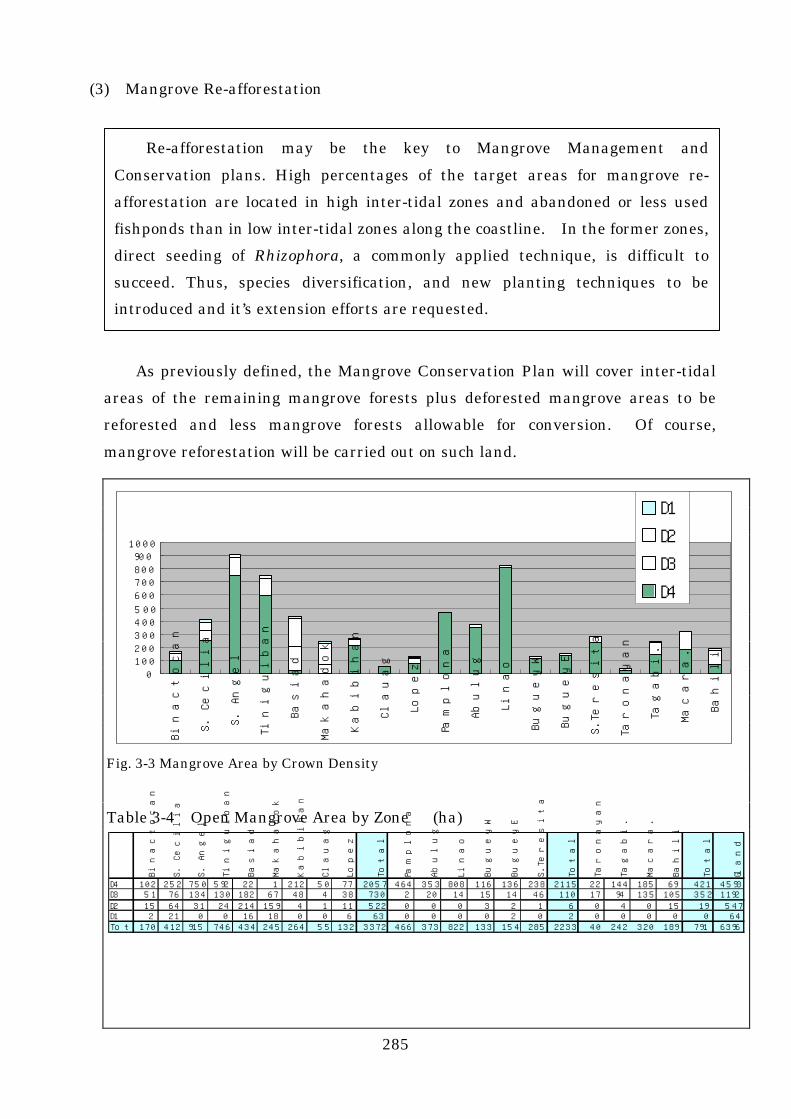
(3) Mangrove Re-afforestation
As previously defined, the Mangrove Conservation Plan will cover inter-tidal
areas of the remaining mangrove forests plus deforested mangrove areas to be
reforested and less mangrove forests allowable for conversion. Of course,
mangrove reforestation will be carried out on such land.
Fig. 3-3 Mangrove Area by Crown Density
Table 3-4 Open Mangrove Area by Zone (ha)
Re-afforestation may be the key to Mangrove Management and
Conservation plans. High percentages of the target areas for mangrove re-
afforestation are located in high inter-tidal zones and abandoned or less used
fishponds than in low inter-tidal zones along the coastline. In the former zones,
direct seeding of Rhizophora, a commonly applied technique, is difficult to
succeed. Thus, species diversification, and new planting techniques to be
introduced and it’s extension efforts are requested.
0100200300400500
600700800900
1000
Bin
acto
can
S. C
eci
lia
S. A
nge
l
Tin
iguib
an
Bas
iad
Mak
ahad
ok
Kab
ibih
an
Cla
uag
Lope
z
Pam
plona
Abu
lug
Lin
ao
Bug
ueyW
Bug
ueyE
S.T
eres
ita
Tar
ona
yan
Tag
abi.
Mac
ara.
Bah
ili
D1
D2
D3
D4
Bin
acto
can
S. C
ecili
a
S. A
ngel
Tin
igui
ban
Bas
iad
Mak
ahad
ok
Kab
ibih
an
Cla
uag
Lope
z
Tota
l
Pam
plona
Abu
lug
Lin
ao
Bug
ueyW
Bug
ueyE
S.T
ere
sita
Tota
l
Tar
ona
yan
Tag
abi.
Mac
ara.
Bah
ili
Tota
l
Gla
nd T
ota
l
D4 102 252 750 592 22 1 212 50 77 2057 464 353 808 116 136 238 2115 22 144 185 69 421 4593D3 51 76 134 130 182 67 48 4 38 730 2 20 14 15 14 46 110 17 94 135 105 352 1192D2 15 64 31 24 214 159 4 1 11 522 0 0 0 3 2 1 6 0 4 0 15 19 547D1 2 21 0 0 16 18 0 0 6 63 0 0 0 0 2 0 2 0 0 0 0 0 64Tot 170 412 915 746 434 245 264 55 132 3372 466 373 822 133 154 285 2233 40 242 320 189 791 6396

286
As a first step, the remaining mangrove forests will be analysed. In this
study, mangrove forests were mainly classified according to vegetation
characteristics into compartments and sub-compartments, which were shown on
the map. At the same time, the current state of forests was determined on a
compartment basis by interpreting aerial photographs and described in the
inventory book. Their descriptions include crown density, which is classified into
D4, D3, D2 and D1:i.e., forests are covered with a crown of more than 70%, 69-40%,
39-10% and less than 10%, respectively.
Figure 3-3 graphically represents the area of mangrove forests in terms of zone
and crown density. The area of mangrove forests with a density of less than 40%
(D2 and D1) is shown in Table 3-4. In the Aparri area, an open forest area
occupies no more than 7 ha of the 2,233 ha mangrove area containing nipa.
Similarly, such areas in the Lamon Bay area and the Ulugan Bay area are 584 ha
of the 3374 ha mangrove area and 19 ha, respectively.
Figure 3-4 shows where the open mangrove areas are connecting with
mangrove forest type. Types LAA, LAX and LBE are mangroves topographically
extending in middle to high inter-tidal zones. They are located in large tidal bays
and featured by a maze of small creeks and mud mounds. Differences in micro-
topography are reflected in the composition of mangrove species. They appear to
be a mixture of small mangrove groups of various types. That is why zonal
distribution cannot be easily seen. To plant mangrove species in these zones,
Fig. 3-4 Open Mangrove Area by Type
Open Mangrove area by Type in Lamon Bay Area
LRD14%
LRB7%
LAS2%
LHS24%
LSA15%
LAB5%
LLX5%
LAX9%
LBE8%
LND2%
LAA9%
Lamon Bay AreaType Ha RemarksLRD 84 Low inter-tidal zone R.aLRB 41 Low inter-tidal zone R.a, Ct, BgLAS 12 Low to Middle inter-tidal Ao, Bg, BsLHS 140 High inter-tidal Zone Hl, XgLSA 85 Sea ward fringe SaLAB 27 Higher Middle inter-tidal Ao, Sh, XgLLX 32 High inter-tidal zone MixLAX 54 Middle to high inter-tidal MixLBE 47 High inter-tidal Ea, & BushLND 11 Riverside NfLAA 52 Middle inter-tidal Ao &MixTotal 584

287
special measures should be taken: e.g., careful selection of suitable species in
response to changes in micro-topograhy and careful planting, or grading the forest
floor to a certain tide level, and provision of waterways.
Thus, according to vegetation characteristics of open mangrove areas analysed
above, there are limited areas available for the direct seeding of Rhizophora or
Bruguiera and Ceriops tagal generally planted in the Philippines. Of all open
mangrove forests with an area of 584 ha, the available area for direct seeding is
estimated at most to be 170 ha or 30%, including LRD (84 ha), LRB (41 ha), and
some of LAX (54 ha), LAS (12 ha) and LAA (52 ha) (40% of the latter is assumed).
These open areas are actually scattered over a wide expanse. If each site is
required to have a certain area for a national reforestation project, it is reasonable
to estimate the available area at about 100 ha.
Areas to be noted next are these deforested which must be reforested in the
future. As already stated, over 50% of mangrove forests have been already
converted into fishponds in some cases, where about 36% of these fishponds do not
seem to be actively used. The total area of such fishponds is 1,300 ha of the seven
combined zones where fishponds account the majority of land use.
There are few reports on silvicultural techniques to reforest abandoned
fishponds. Silvicultural techniques must be examined on a case-by-case basis
because actual planting conditions vary from one another, including the inter-tidal
level and the exposure to acid sulfate soil. Mangroves have already invaded a
considerable area of fishponds in some cases. Stumps were not removed before
fishpond development and sprouts can be expected to grow in some other cases.
Natural conditions are favourable for planting in other cases. On the other hand,
there are also some cases which need to develop techniques and methods for
introducing new planting species. Many abandoned fishponds are actually
distributed in inter-tidal zones higher and more inland than are suitable for
Rhizophora. In many cases, they are surrounded by an environment in which the
Philippines have seldom experienced forestation.
As discussed above, the reforestation of extensively distributed man-grove
forests, including mangrove improvement or fishpond rehabili-tation, will require

288
new technology and funds because the growth of mangrove forests is difficult by
means of conventional direct seeding with Rhizophora apiculata and Rhizophora
mucronata. Seedling production is indispensable for introducing new forest
species. There are only limited number of species with seeds large enough to
collect such as Rhizophora mucronata. On the other hand, Scnneratia alba,
Sonneratia caseolaris, Avicennia officinalis, and Heritiera littoralis do not fit direct
seeding. In the case of Bruguiera and Ceriops tagal, seeds can be collected with
little difficulty but are too small to extensively cover inter-tidal areas, where
seedlings must be planted. To expand rehabilitation planting of mangrove areas
in the future, and diversification of species for forestation is essential. Such
diversification requires the seedling production of many mangrove species, the
establishment of criteria for selecting suitable sites, and the development and
spread of silvicultural techniques. There is also a pressing need to create
nurseries and extend nursery techniques.
There are many attempts to apply various silvicultural techniques at different
inter-tidal levels in Indonesia, Malaysia and other countries. There are many
reports on techniques which are also applicable in the Philippines. It is an urgent
task for this country to launch a pilot project and report its results to the people
concerned.
(4) Who Should Take Charge of Conserving Mangrove Forests?
Mangrove rehabilitation plans usually classify the areas concerned into
protection, limited-utilisation and living-material-utilisation zones. This
classification introduces some utilisation restrictions to inhabitants in and around
the areas. However, conservation of mangrove forests in the Philippines results
Seaside villagers should take charge of conservation activities for mangrove
forests, and those who have been using mangrove forests need to be organized.
To this end, it is necessary to identify the benefits these people will gain by
participating in conservation activities. A swap system should be introduced in
which participants in mangrove conservation activities will be given a guarantee
of a certain concession for mangrove forests, or support for activities in land
areas aimed at realizing cash income or alternative source of mangrove woods.

289
not only in protection of precious natural environments but also, directly, the
conservation of coastal fishpond dikes, tidal protection in coastal areas and
promotion of coastal fisheries. However, benefits from mangrove forest
conservation are not restricted specifically to fishery managers and residents.
Those who will suffer disadvantages from mangrove forest conservation are clearly
identified, nevertheless those who would benefit from larger fish catches due to
mangrove forest recovery may broadly expanded. Therefore, it is difficult to
collect charges from the benefisheries. A system reserving the exclusive fishing
rights to coastal fishermen who have taken part in mangrove rehabilitation is not
established in the Philippines. If such legislation were established, it would not
only be difficult to enforce, but it would also cause conflicts between coastal
fishermen.
If the Lamon Bay area is taken as an example, the recovery of mangrove
forests benefits all the villages and all the fishermen operating in the bay.
Therefore, it would be in the interests of all to set up an association where: funds
are raised in proportion to the catch weights of registered fishing vessels; the
DENR provides the association with grants funded by international support
organisations; and coastal fishermen. Plant mangroves in assigned lots and control
illegal logging. In reality, however, it is quite difficult to establish a system
organising all the coastal fishermen in the entire Lamon Bay area.
Socio-economic Survey show that the proportion of the population engaged in
the fishery industry is not so high even in coastal villages adjacent to mangrove
forests. The owners and the operators of fishing boats are not always the same, and
almost all the owners of the fishponds are also landowners. Therefore, it is
difficult to expect agreement to be reached in some areas.
It is highly preferable to entrust a mangrove forest conservation project to
people who are likely to gain the most benefits from the project. However, if it is
impossible to identify the direct beneficiaries. What is the second best?
Afforestation would be possible, if the government were to invest funds, manage the
undertaking, and employ inhabitants. However, it would be difficult to manage
and maintain these kinds of projects and failures have been reported all over the
world.

290
The plantation may have to be carried out by local people and NGOs. Local
people may, however, have less interest because the direct benefits are limited and
difficult to recognize. (Increasing fish population is one of the good effects, but the
benefit is given to the fishermen in the broad areas as well as fishermen who
planted mangrove trees. Therefore, since many fishermen can obtain the benefit,
they may not be able to have the motivation for the plantation. They are happy if
other villagers plant the mangrove. They can get fish without any obligation.
They have a right to catch fish anywhere.)
To call villagers interest and participation, other significant and substantial
benefit which is not indirect one have to be prepared for the people who would plant
mangrove. A swap system is one of the ideas to enable villagers to realize some kind
of direct benefits and to join Mangrove Rehabilitation Initiatives by the
Government. If a person joined mangrove planting activities, the Government
would prepare some kind of services for example to prepare agro-forestry farm
under the coconut forest. Of course, the Government has to negotiate with coconut
forest owners so as to let them understand the importance of Mangrove forest
rehabilitation.
This is only one of ideas. What kind of assistance is suitable for the swapping
program for the seaside villagers may differ village by village. To find these
programs, it may need to open PRA meeting with villagers and other concerned
people.
An organisation of villagers must be organized in each Barangay to which
mangrove and fishpond maintenance responsibilities are. The assignment is
determined by agreement with all Barangays through the mediation of local
CENROs. The government should demonstrate strong and clear policies
indicating that Barangays participating in the scheme have priority in mangrove
rehabilitation funding.

291
(5) Institutional requirements for promoting re-afforestation activities
For successful implementation of mangrove plantation establishment, some
institutional aspects are also very important. The programs have to be supported
by the local government authorities. And the Barangay committee is also have big
effects to carry out the programs. The procedures to formulate programs and to
draft rules to participate and to share the burden and benefits within the groups
are needed. To take into these matters into account, some kind of implementation
committees should be established.
The committee will act the co-ordination and assistant body to the
implementation of the mangrove plantation activities carried by the Barangay
people's group who have been the costum user of the mangrove forest. The
committee will make basic rules concerning how to assure following matters, and
monitor the program of implementation on step by step bases.
1) Implementation Stage
a. Propriety of the selection of project area, number of beneficiaries geographical
and natural conditions, etc.
b. Confirmation of the land ownership of the project area, and status of other
development projects targeted or being implemented in the area.
c. Delineation of the reforestation plan, and approval from the Local
Governments.
d. Conduction of the explanatory meetings for the local people (including
explanation on the importance, significance and benefit of the projects).
e. Formulation and confirmation of the technical specification for the planting
bodies (NGOs), form and manner of reporting (weekly).
Various rules and agreements are required to assure seaside villagers’
participation from the planning stage and to make it easier for villagers’
organizations to work, so that seaside villagers will be able to join the conservation
activities for mangrove forests. To support seaside villagers’ groups activities,
institutionally as well as technically, a support committee should be established
which will involve relevant administrative bodies and local governments.

292
e. Confirmation of the project status upon the completion of reforestation
activities compared with the specification.
2) Maintenance and Monitoring Stage of Mangrove Reforestation Projects
a To have the people understand the necessity of the cost for
maintenance purposes, and to set the membership fee before accumulating
capital of the organization.
b. To have written regulation of the organization (election of officials,
management of fund, penalties, etc.)
c. To have a system of the periodical project status report, and establish reporting
to CENRO
(6) Further Cooperation with International Cooperation Bodies
Three steps necessary for undertaking and maintaining the mangrove
rehabilitation plan are summarized below.
① Publication of the government’s policy to enforce the mangrove
rehabilitation plan.
② Development and Extension of techniques suitable for newly ecological
sites.
③ Organization of plantation agents, namely local village associations, based
on specified benefits and measures to ensure the benefits, and to maintain
and reinforce promotion facilities to deal with technical problems.
These three steps must be carried out along with the raising of foreign aid
funds. The first step, people will be convinced of the government’s strong
resolution only when it undertakes plantation activities in model areas. At first it
is effective for governmental agencies to conduct model plantation activities. The
plantation activities will function as a demonstration of new and existing
techniques. The activities are conducted in the areas where plantation is possible.
The activities function as a motivation for agent groups to continue plantation
activities. Especially when plantations are carried out in abandoned fishponds,
inhabitants in and around the areas concerned will be greatly impressed with the
government’s determination.

293
The second step is carried out along with establishment of plantation. At an
early stage, plantation activities are carried out in the areas where mangroves can
be planted with existing techniques, but in the future, the activities must be
conducted in areas where new techniques are needed for plantation. It is
necessary to establish a government support system to carry out trial afforestation,
development of plantation techniques, and education.
Considering that it is difficult for the government to carry out plantation
activities continuously, it is necessary to organise people and include the
participation of these organizations. A core organisation for various plantation
activities should be established that mediates joint utilisation of fishponds or
coconut forests, giving technological support to the people, and promotes support to
the local community, including town dwellers.

294
2 Key Points of the Mangrove Survey for Other Areas
In this study, field survey and interpretation of the aerial photographs havebeen carried out, with an emphasis on the geographical expansion of the mangrovezone and the qualitative evaluation of the mangrove stands. The results of themangrove distribution status were summarized in a forest Inventory Book andMangrove Forest Classification Map. The data of the Forest Inventory Book andForest Classification Map were put into the GIS Data Base. Therefore, the settingof conservation and management plans can use the GIS in various forms. Detailsof the methods of this study are shown in Appendix 1. The study wasimplemented to obtain two different objectives. One was to fix the presentconditions of mangrove forests in the study area. The other was to introduce amethod and show a guideline for similar surveys on mangrove forests other thanthe study areas in the Philippines. NAMRIA is expected to play a central role in taking and interpreting aerialphotographs if this survey is to be followed by more field surveys by the Philippineside, aimed at better understanding of the zonation of mangrove forests. Yet it isessential for Community Environment and Natural Resources Offices (CENRO)and municipal governments to participate in field surveys and the gathering ofinformation on local residents, both of which are prerequisites for interpretation ofaerial photographs. To conduct joint field surveys means to deepen commonunderstanding of the actual conditions of mangrove forests. Such commonunderstanding in turn constitutes a precondition for a smooth process of studyingmangrove forest conservation plans that follow.
This survey has put special emphasis on the participation of staff members ofCENRO as well as those of NAMRIA. As greater participation of communityoffices and municipalities will be needed in subsequent surveys, the study team hasprepared technical manuals that explain methods for actual surveys, that is, (1)how to interpret aerial photographs, (2) how to proceed with a field survey, and (3)how to use GIS.
The study team hopes that the two (2) manuals will be used by staff membersof NAMRIA not only for themselves, but as textbooks when they explain operationsto field officers. Although the third (3) manual has been prepared with NAMRIAstaff members in mind, the study team hopes that the people of regional forestryoffices in charge of formulating mangrove conservation plans will also use themanual. The study team is convinced that the manual will help personnel on the

295
process and use of various data from GIS, so that they will understand the presentconditions of mangrove forests from various perspectives.
The Study processes were as follows. First, the Study team took aerialphotographs to understand the general distribution of the mangrove forests.Second, the Study team carried out a transect surveys on mangrove vegetationdistributed areas in an area where mangrove forests were typically distributed, inorder to determine the typical zoning structure. This transect survey was aimedto understand and variations of the changing pattern and land condition ofmangrove vegetation within the inter-tidal area, ranging from the seashore to thelandward fringe.
Third, the team, with a basic knowledge of mangrove vegetation structuresobtained from the transect surveys, carried out pre-interpretation of aerialphotographs. In the pre-interpretation, the aerial photographs were sub-dividedinto the structures of mangrove vegetation/association where the stands produceda homogeneous pattern. The small parts, difficult to divide on a 1:10,000 map,were combined to the adjoining sub-compartments and those that could be seen aspart of the neighbouring stands because of their small areas were marked off.
After the field verification and final interpretation of the aerial photographs,the boundary lines were readjusted. The Areas of mangrove forests/sub-compartments were transfer to the topographical maps and the GIS database. Thesub-compartment areas were calculated by computer and shown on a topographicalmap.
To define the stands structure of each area, the study team carried out sitesurveys to identify stands interpreted from the aerial photographs. The teamaccumulated data to indicate the relationship between the aerial photographs andthe real mangrove forest structures. At the final interpretation of the aerialphotographs, the data was used to indicate the stand structure characteristics suchas average height and crown density.
At the same time, the team carried out a socio-economic survey aimed atunderstanding the relationship between local residents and mangrove forests.The use of mangrove forests by local residents and their awareness of mangroveforest conservation were also studied. The Philippine team, who will continue the survey of the remaining areas, areexpected to follow similar methods the study team introduced. Yet, to follow

296
exactly the same method would not necessarily be to the point because the teamcarried out the survey in a limited period and with limited management purposesin mind. Here are some of the points the Philippine team should take into accountin conducting a survey in the future.
(1) Aerial Photograph
At the beginning of survey comes acquisition of information from aerialphotographs. The proper way to take aerial photographs would be, on theassumption that a HIEI SE II camera is available, low-altitude photography with asmall format camera. It is possible for NAMRIA itself to charter aircraft, but itmight be more efficient to use an aerial survey company; there are such companiesin the Philippines staffed with experienced photographers. It would be wise toexamine the total cost performance of the operations, including not only takingaerial photographs but related processes such as development,enlargement/printing, and reprinting in relation to the budget.
(2) Drawing Basic Maps
In this study, a base map was drawn on a scale of 1:10,000, based on mosaicphotographs and the existing maps on a scale of 1:50,000, after adjusting the scalesof the photographs and the physical relationships of bench marks. This processshould basically be followed. What kind of information should be represented onthe base map should be determined according to the actual situation of each studyarea, and in consultation with Regional Offices of (DENR).
Time should not be used, however, for marking off items with no directrelations to the conservation and management of mangrove forests, such as variouskinds of farmland or non-mangrove swamps. For the sake of efficiency, aerialphotographs should be developed so that their scale will be as near as possible tothe scale for the base map.
(3) Field Survey Field survey plays the most important role. The field surveys, this timearound consist of soil and salinity survey, transect survey, plot survey, and fieldverification survey of pre-interprete aerial photograph.
1) Soil and Salinity SurveyThe soil survey is important in understanding land productivity and in deciding

297
the optimum species to be planted in the case of afforestation. The field surveyin this study provided basic information about the ecological characteristics andthe distribution of mangrove forest communities.
Yet the study team did not allocate survey plots to such a degree of density that amangrove soil distribution map could be obtained. Concerning the relationshipbetween mangrove soil and afforestation, the study team observed the sandquality of mangrove forest soil, the degree of clay soil, the thickness of mangrovesoil (black colored soil ), and the proportion of terrestrial sediments in soil. Thisinformation provides as how a given area of mangroves developed, in other words,whether it was influenced by tides or were significantly affected by sedimentsfrom land.
The salinity survey, on the other hand, can provide effective information forassuming: (i) to what extend mangroves can be recovered, and (ii) whetheroriginal mangrove forests ever existed, in areas along a large river supposedlyinfluenced by the ebb and flow of the tides.
In future studies, the question is upto what extent a similar survey should becarried on. This report contains a certain amount of data on mangrovevegetation and on the structure and physical characteristics of mangrove soil.Besides, many studies on this topic have already been reported in the Philippines.It is not easy to carry out detailed research that will emulate these findings dueto time and economic restraints.
Also, the relationship between soil and vegetation is thought to be basically notso different between the study areas. If small differences are to be verifiedthrough detailed survey, it would be difficult to assume that such differenceswould constitute a decisive factor in managing mangrove forests. Thus, thestudy team thinks it is sufficient to concentrate, as far as possible, on verifyingthe relationship between soil condition and mangrove vegetation as shown in thisreport.
The salinity survey is targeted only at areas near and a little upstream from themouth of a large river like in Aparri which are covered with mangrove or nipaforests. It would not be necessary to repeat a similar survey, unless substantialafforestation is required in a conservation and management plan. Because thesalinity of a river depends on the quantity of its flow at the time of survey, itshould be understood in a relative manner. The empirical knowledge is that theaverage salinity is indicated by the emergence of certain mangrove species. This

298
relationship was commonly observed in this study as well.
2) Transect SurveyThe transect survey is very important for understanding mangrove forests. It isaimed at grasping the changing situation of inter-tidal levels and mangrovevegetation. It is well known that mangrove forests show zoned structure inareas where the level of the tide continuously changed, and this was frequentlyobserved in the study area as well. Yet zoning structures are often difficult tofind in mangrove forests covering tidal flats, because areas with a slightlydifferent inter-tidal level are complexity distributed. This results from theexistence of many small rivers and water channels that emerge at low tide.
A zoning structure is relatively easily seen only on the seashore where mangroveforests extend 200-400 meters in width and there are no rivers that can be seenfrom the seashore. In selecting the survey area, it is important to observemangrove forests and upland forests behind them from the seashore and comparethem with aerial photographs.
The transected structure of mangrove forests varies according to each type ofarea with specific topographic features. For example, the structure is differentat the coast, along a river, in and around a tidal flat, and around the area where ariver flows into a tidal flat. But it is expected that the structure is similarwithin each type of area. Thus, whether the transect survey should becontinued in future studies will depend on whether researchers have sufficientexperience and knowledge. Researchers with good knowledge would be able toeasily get the picture just looking at aerial photographs without conducting atransect survey. In this case, it was not necessary to carry out a transect survey,which requires a lot of time and energy.
Yet in many future studies that will generally require a lot of researchers, notonly experienced technicians but many less experienced researchers willinevitably be involved. If this is the case, a transect survey should be carriedout regardless of its scale. Nothing is more important than a transect survey ifone wants to get a first-hand understanding of the actual condition of themangrove vegetation in a study area. To remember species that emerge invarious locations/land conditions and to learn the relationship between the rangeof the tides and the group of species through a field survey is to acquireknowledge and experience essential for interpreting aerial photographs.

299
3) Plot SurveyThe plot survey is vital. It is designed to gather data that will serve asreferences for aerial photograph interpretation, which is indispensable forcompiling forest inventory results. Marking the precise locations of plots on anaerial photograph and then linking this photograph with the actual standcomposition make it possible to stratify and evaluate the stands structure ofmangrove forests that cover a large area. The larger the number of plots, theeasier the subsequent work.
Here are the procedures for selecting plots. First, group compartments andsub-compartments are tentatively marked off on the aerial photographsaccording to the type of mangrove forest vegetation. Second, estimate the areaof each group. Third, distribute a feasible number of plots proportionallyaccording to area so as to come up with the targeted number of plots for eachgroup. Fourth, observe closely the aerial photographs and mark on the typicalfeatures that are thought to represent each vegetation group.
Before plot selection, the surveyor should conduct a survey for understanding thegeneral condition of the field. It is important to compare the aerial photo imagewith the structure of the actual mangrove forests such as species composition,distribution, tree heights and crown size, topographical features and thedistribution of such forests in areas along rivers and around tidal flats. Suchcomparison makes aerial photo pre-interpretation efficient and precise, leadingto smoother operation of the whole survey. It is effective to carry out this kind ofsurvey in preparation for the pre-interpretation when conducting transectsurveys discussed above.
The above-mentioned survey for holding the general condition should cover aswide an area of mangrove as possible by making the effective use of aerial photos,maps, information from local residents, and by utilizing available land access,marine traffic facilities and rivers. After the plots are mapped out, it isnecessary to visit their exact position. The efficiency of the survey depends onthe accessibility to the plots. What route to choose for reaching the plots andwhat features can be used to confirm land marks must be fully considered.Areas should be excluded from the list of plots if their locations cannot beconfirmed or require a long travel time. Such areas would confuse researchers;if they would take the risk of linking the data of the wrong place with the wrongaerial photo imagery.

300
It is not easy to answer the question of how many plots should be set up.Various factors should be taken into account. These factors include not only theconditions of the mangrove, such as how many kinds of vegetation features areexpected to be shown on the aerial photos and how far the study area extends.The number of available technicians and the budget for travel and other expensescannot be ignored as well. Of course, survey objectives, in other words, to whatextent a forestry inventory book should be detailed and what the mangrove forestmanagement plan will be like are also important factors.
The practical way would be this. First, compute the targeted number of plotsbased on the budget, the number of available technicians, and the number of daysavailable for the survey. Second, take into account the general condition of themangrove shown by the preliminary survey and information obtained from aerialphotos. Third, distribute the targeted number of plots according to the expanse(total area) of each group classified by vegetation type. In the case of our studyteam, four experts visited four plots per day per person.
Then, here is how to determine the size of survey plots. The size depends on thesurvey objectives. If the estimate of growing stock is needed all over the studyarea, the following measures may be necessary. First, classify forests not onlyby vegetation type but by tree height and crown density in parallel with pre-interpretation of the aerial photos. Second, stratify them according to expectedvolume class. Third, distribute plots in accordance with the proportion in areaof each stratification. At the same time, it may be necessary to meet the areastandards set by the Philippine government. (In general, survey criteria formanagement planning of Dipterocarpaceae forests should not necessarily be thesame as those for a mangrove management plan. This is because mangroveforests have a very simple structure compared with Dipterocarpaceae forests.Also, mangrove forests classified as one group according to vegetation or foresttype is much smaller in area.)
In practice, it is perceived that unlike Malaysia and Thailand, mangrove foreststhat can be managed for wood production is quite limited in the Philippines.(Even the Ulugan Bay area, which was perceived as a conservation area in thisstudy and is thought of as virgin forests, would be judged as inappropriate forwood production in terms of volume if it was regarded as a non-conservation area.From a viewpoint of management, sustainable wood production would beinappropriate even in this area.) Therefore, it is safe to say that the mainobjective of a mangrove forest survey is to understand the general condition, anaction necessary for formulating a conservation and management plan. Such a

301
plan focuses on the conservation and recovery of forests and allows limited use offuelwood by local residents, in accordance with basic policies for mangrove forestsin the Philippines. Thus, it is not necessary to put a lot of time and energy intoestimating the growing stock of mangrove forests.
The main objective of the plot survey is to identify the present condition of forests(main species, tree heights, the size of main trees, crown size, stratification,density, species and number of trees to be planted in the case of afforestation, andother information necessary for planning the planting method) for a forestinventory book, and to gather data for interpreting aerial photos. Thus, the areaof each plot does not play a very important role. Yet if a plot is too small in area,this might cause trouble. An area that looks homogeneous on an aerialphotograph may contain spots of different natures. These spots might be chosenas samples. Therefore, the minimum unit of 15m x 15m (1.5mm x 1.5mm on anaerial map on a scale of 1:10,000) would be appropriate. This is appropriate interms of survey efficiency as well. In this survey, the plot size ranged from 14mx 14m to 28m x 28m. The 14m x 14m size was applied for areas that lookedalmost homogeneous on an aerial photograph and was densely covered withshrubs. The 28m x 28m size was applied when the height of dominant treesshould be taken into account.
4) Field VerificationField verification is one of the most important activities for interpretation ofaerial photos, through which researchers judge how actual forests are recognizedand identified on aerial photos. Photo images are expressed in indexes and theircolors in color codes, but this does not mean that it is possible to determinespecies based on such information. The elements of an aerial photograph areshape and size, color tone, pattern and texture, and these elements of the sameobject cannot possibly be represented identically in any photos. Unerringjudgement of aerial photos comes mainly from experience and knowledge aboutthe actual distribution of mangrove forests.
Such judgement will be developed through constant comparison of aerial photoimagery with actual mangrove forests at a time of pre-interpretation,preliminary survey, transect survey, and plot survey. If the survey period ormanpower is limited, more time and energy should be put into the verification ofpre-interpretation aerial photo results than into the plot survey. A survey inwhich researchers spend a lot of time just roaming around mangrove forestscannot be tolerated. Be always critical about the results of pre-interpretation.Choose the appropriate place for verification. Observe the actual stands.

302
Review aerial photo imagery from a different perspective. This will acquire theskills to unerringly judge aerial photo imagery.
(4) Socio-economic Survey
Upon the conduction of the assessment studies on Mangrove areas, survey on
the socio-economic aspects has significant importance and necessity so as to
grasp the concern of community people of the area surrounding Mangrove forest,
in consideration with the fact that the main reason of the decrease of Mangrove
forest is on the human activities such as conversion to fishpond, firewood cutting,
etc.
With regard to the future nationwide expansion of this Study by the
concerned Agencies of the Philippines Government, the following aspect shall be
taken in to consideration on the socio-economic aspects of such studies.
1) Selection of proper Survey Method with Consideration of Resources, Budget and
Time Frame of the Executing Agency
The interview survey on sampled informants used in this Study requires certain
time and cost (employment of survey staff, field cost, etc.) from the time of the
designing of questionnaire to the conduction of interview, tabulation and analysis.
As for the studies in the future, it is necessary to consider alternative option of
the survey method and select most suitable survey method with consideration of
the resources, budget and time limit, such as the interview survey with limited
selected a sample/questionnaire, utilization of RRA (Rapid Rural Appraisal),
partial utilization of existing past studies and group interview by forming group
consists of the representatives of groups with each roles (professional and
geographical distribution) of the target communities.
2) Consideration of Community-based Survey by the Coordination with Local
Government Units
It is necessary to obtain cooperation and understanding from the Local
Government Units, especially by the Municipality level, to conduct survey in the
committees. However, it shall be noted that the following points must be taken

303
into consideration; 1) possibility of the effect to the survey when there are directly
concerned persons and/or prominent officials in municipality who are directly
engaged in the Lumber Permit, Fishpond Lease Agreement, etc. 2) effect to
informants when Municipality Official accompany the survey team on the
community level survey. Sometimes it actually happen that informants refuse
or hesitate to cooperate on such survey, considering it as the basis of taxation, etc.
3) Understanding on the Environment Related Law Systems in the Study Area
and their Implementation Status
There are some legal systems on the conversion of Mangrove forests such as
Private Land Conversion Permit, Fishpond Lease Agreement, and also Coastal
Environment Program as well se Community-based Forest Management on the
conservation of Mangrove forests. It is quite important to recognize the
implementation status of such systems, and there is no use formulating future
projects without considering this aspect. Furthermore, upon the formulation of
project as for the countermeasure on the conversion of Mangrove forest to
fishpond which is one of the biggest factor of the decrease of Mangrove forest in
the Philippines, it is necessary to conduct pre-survey on the use condition of
fishpond, legal statue, ownership, status of mortgage by bank, and absentee
owners who are presently outside study area or abroad.
4) Understanding on the Living Condition, Economic Condition in the Study Area
and Consideration on the Traditional Social Customs in the Area
It is important to consider the living condition of the communities which seems
having less relation to the Mangrove forests, such se to look into the alternative
fuel source on the survey of Mangrove use as firewood. Also, it is necessary to
consider local industrial structure which differs area by area, such as the Nipa
industries in Aparri area was taken into consideration for the understanding of
Mangrove use in this Study. Furthermore, when there is the traditional people's
group (such as "Bayanihan" in the study areas, it is' also important to take such
traditional customs into consideration to estimate the possibility on the
implementation on the small-scale projects in the community level.

304
5) Consideration on the Chronological Aspect
Upon the survey on the use condition of Mangrove by the community people, it is
important to grasp the past use condition and their intention to use in the future,
not only the present use condition. Especially, to grasp their intention in the
future, estimation on the possibility of future use shall be made by considering
the future change of their lifestyle (possibility of alternative fuel sources,
feasibility of fishpond management) and people's recognition on the importance
of the conservation of Mangrove forests.

305
Bibliography (III)
1_/ FAO 1982: management and utilisation of mangroves in Asia and the pacific:
chapter 1-5 FAO Environment Paper No3 Rome
2_/ Lawrense S. Hamilton & Samuel C. Snedaker 1984 Handbook for Mangrove Area
Management: Section 1 Environment and Policy Institute East-West Center,
IUCN, UNESCO
3_/ Bernardo Dumlao Agaloos 1994 Re-afforestation of Mangrove Forests in the
Republic of the Philippines Development and Dissemination of Re-afforestation
Techniques of Mangrove Forests Bangkok, Thailand, International Tropical
Timber Organization
4_/ FAO 1982 Management and utilization of mangroves in asia and the pacific FAO
Environment Paper No 3 (Chapter 2)
5_/ N.J. Stevenson 1997 Disused Shrimp Ponds: Options for Redevelopment of
Mangrove : Center for tropical Coastal Management University of Newcastle UK
6_/ FAO 1994: Traditional and Potential Uses of Mangrove, Mangrove forest
management guideline: FAO Forestry Paper 117 Part II
Colin Field 1996 Restoration of Mangrove Ecosystems, The International Tropical
Timber Organization(ITTO) and The International Society for Mangrove
Ecosystems(ISME)
P.B. Tomlison 1986 The Botany of Mangroves, Press Syndicate of the University of
Cambridge
ISME 1993 Proceeding of VII Pacific Science Inter-Congress Mangrove Session,
Mangrove Ecosystems Proceedings No 3, International Society for Mangrove
Ecosystems
Francic Dov Por , Inka Dor 1983 Hydrobiology of the Mangal, the Ecosystem of the
mangrove forests, Kluwer Academic Publishers Group
Peter Kunstadter, Eric C.F. Bird, Sanga Sabhasri 1985 Man in the Mangroves the
Socio-economic Situation of Human Settlements in Mangrove forest, The United
Nations University
M.Suzuki,S.Hayase, S. Kawahara Sustainable Utilization of Coastal Ecosystems,
Proceedings of the Seminar on Sustainable Utilization of Coastal Ecosystems for
Agriculture, forestry and Fisheries in Developing Regions, JIRCAS Working
Report No 4, Japan International Research Center for Agricultural Sciences

306
(JIRCAS)
Felix R. Gonzales 1977 Mangrove and Estuarine Area Development in the Philippines,
International workshop on Mangrove and Estuarine Area Development for the
Indo Pacific Region
RS. Jara 1985 Traditionalizes of the Mangrove in the Philippines, Mangrove Ecosystem
of Asia and Pacific States, exploitation and management, Proceeding of Research
for Development Seminar, Australian Institute of Marine Scenes, Tawnsville,
Australia
Dioscoro M. Melana 1982 Research and Development Status of Philippine Mangroves,
Symposium on Mangrove Forest Ecosystem Productivity in Southeast Asia
BIOTROP Special Publication No 17
Honorato G. Palis 1997 Community-Based Approach to Restoration of Mangrove Forest
In the Philippines Green Productivity In Pursuit of Better Quality of Life, Asian
Productivity Organization Tokyo