2.0 groundwater resource issues, problems, and … groundwa… · 2.0 groundwater resource issues,...
TRANSCRIPT
2.0 Groundwater Resource Issues, Problems, and Recommendations
13
2.0 GROUNDWATER RESOURCE ISSUES, PROBLEMS, AND RECOMMENDATIONS
The purpose of this section is to lay out the broad range of issues and concerns regarding groundwater conditions in the basin, identify recommended actions to address these issues, and identify the several key areas where the Commission should focus its efforts. Because conditions and needs are constantly changing, it is necessary to continue identifying new problems and working to maintain and improve conditions through planning and cooperative management. Many problems have been brought about by human activities, either directly related to increasing demands for groundwater or indirectly when development alters the natural flow regime in a non-beneficial manner. Other problems are related to water scarcity. Many water resource problems have been solved by human engineered solutions and, in some cases, fortuitously and unintentionally through human activity. The groundwater issues, problems, and solution alternatives are summarized in Table 2.1 and were developed from the shared experience of groundwater professionals working in the Susquehanna River Basin. The table is meant to introduce the relationship of groundwater problems with the wide array of available alternative solutions. Each groundwater problem is then further discussed in the following sections and the best solution(s) is identified in a recommended action. Some confusion exists in discussions of groundwater management issues regarding several key terms relating to the impacts of groundwater withdrawals. The five most important of these terms are: (1) aquifer dewatering; (2) safe yield; (3) sustainable yield; (4) overdraft; and (5) groundwater mining. Definitions of these key terms are included in the Glossary of Terms, though they are discussed here to better clarify their interrelationship and relative meanings (Alley, et. al., 1999; Alley and Leake, 2004; Sophocleous, 1997; Sophocleous, 2000; Bredehoeft, 1997).
All groundwater withdrawals from the water table or unconfined aquifers cause some amount of aquifer dewatering as a cone of depression develops around the point of withdrawal. Averaged over a period of years, the cone of depression reaches equilibrium or “steady state.” However, most established cones of depression in seasonally variable climates, such as that for the Susquehanna River Basin, are in quasi-equilibrium. Cones of depression grow during periods of low recharge and shrink during periods of high recharge. Cones of depression also fluctuate in lateral and vertical extent if the amount of withdrawal is variable over time. The safe yield is generally considered to be less than or equal to the average annual recharge for a groundwater basin. Such a withdrawal maintains a long-term balance between the amount of water received and the amount of water withdrawn. Safe yield ignores the natural (pre-development) balance between recharge to and discharge from a groundwater basin. Therefore, development of groundwater up to the safe yield will result in a substantial reduction in natural discharge. Streamflow, spring flow, and wetlands would be substantially impacted. The sustainable yield is equal to the safe yield minus the amount of water needed to maintain groundwater dependent ecosystems. The amount of flow required to meet ecosystem needs is dependent on the nature, sensitivity, and quality of the habitat. The Commission currently uses an instream flow model to evaluate impacts and determine instream flow needs.
2.0 Groundwater Resource Issues, Problems, and Recommendations
Table 2.1. Groundwater Resource Issues, Problems and Solution Alternatives
Groundwater Problem Solution Alternatives
Groundwater
Issues
Groundwater Problems
Local Water
Budgets
Protected Areas
Groundwater Preserves
Critical Aquifer
Recharge Areas
Cumulative Impact
Analysis
Compliance Enforcement
Upgraded Project
Reviews
Water Use (GIS-based)
Data Management
System
Regional Hydro-
geological Information
Interagency Coordination
Well Interference X X X X X X X X
Exceedence of Sustainable
Yield X X X X X X X X X
Areas of Intensive Growth/Develop-ment and Consequent Water Resource Development
Loss of Recharge
Areas X X X X X X X X
Loss of Base Flow X X X X X X X
Intensive Water Use in Small Basins
Loss of Perennial
Streamflow X X X X X X X
Watershed Transfers
Wastewater Not Returned to Watershed Where It Was
Withdrawn
X X X X X
Loss of Clean Water Input to AMD-Impacted Streams
Degradation of Trunk Stream Quality
X X X X X
Data Gaps Can Prevent Evaluation of
True Sustainability
and Cumulative
Impact
X X X X X X
Severe Loss of Base Flow
During the Growing Season
X X X X
Unknown and Unregulated Groundwater Use
Interference with Existing
Water Sources
X X X X
14
2.0 Groundwater Resource Issues, Problems, and Recommendations Table 2.1. Groundwater Resource Issues, Problems and Solution Alternatives (Continued)
Groundwater Problem Solution Alternatives
Groundwater Issues
Groundwater Problems
Local Water
Budgets
Protected Areas
Groundwater Preserves
Critical Aquifer
Recharge Areas
Cumulative Impact
Analysis
Compliance Enforcement
Upgraded Project
Reviews
Water Use (GIS-based)
Data Management
System
Regional Hydro-
geological Information
Interagency Coordination
Scarcity of Clean Water in Coal-Mined Areas
Preferential Development
of High Quality
Groundwater Sources
X X
Drought Impact to Base Flow
Insufficient Streamflow to
Sustain Instream
Flow Needs or Down-
stream Water Supplies
X X X X X
Beneficial Use of
Discharged Water for
Water Supply
X X X
Extensive Aquifer
Dewatering X X X
Impacts of Mining
Exceedence of Sustainable
Yield X X X X
Flow Compensation for Consumptive Water Uses
Need for Additional Low Flow
Augmentation
X X X
15
2.0 Groundwater Resource Issues, Problems, and Recommendations
16
If the annual withdrawal exceeds the average annual recharge rate, the sustainable yield is exceeded. If the withdrawal also substantially reduces stream and spring flow and dries up wetlands, the sustainable yield is exceeded. A groundwater withdrawal that causes harm, such as the conversion of perennial reaches of a stream to intermittent or ephemeral reaches, but does not cause persistently declining groundwater levels, has exceeded the sustainable yield of the aquifer.
A cone of depression that is in quasi-equilibrium during years of normal recharge grows in size during drought years, and then shrinks again during high or normal recharge periods, has created an overdraft during the drought period. Such overdraft could also be termed seasonal depletion, and if some form of harm is caused during the period of overdraft (e.g., creation of seasonal dry reaches of stream that would normally be perennial), then it would also constitute exceedence of sustainable yield.
A groundwater withdrawal or combination of withdrawals that far exceeds average recharge and that causes groundwater levels in an aquifer to persistently decline is termed either a persistent overdraft or groundwater mining.
Problems of true groundwater mining (persistent overdrafts) are rare in the basin, though
problems relating to extensive aquifer dewatering (e.g., mining cones of depression covering several square miles) and exceedence of sustainable yield, are fairly common. Also, several areas, herein called PSAs, are approaching the sustainable yield of the local groundwater basin.
A guidepost of the plan is to manage the use of water resources to promote sustainability in the face of short-term and long-term growth. The Commission has defined the sustainable limit of water resource development as the average annual base flow (recharge) available in the “local” watershed during a 1-in-10-year average annual drought. This level of recharge represents about 60 percent of the average annual recharge. The total amount of water withdrawn by all users on an annual basis should only exceed the average amount of water recharge on an average of once every 10 years. Users draw water from groundwater storage to meet their needs during the drought years, and the groundwater system is allowed to recover (that is, storage refills) during the intervening years. 2.1 Issue: Areas of Intense Growth and Development, and Consequent Water
Resource Development While the population in the basin has grown only slightly over the last decade, the growth has largely been concentrated in a few metropolitan areas. This growth has resulted in a greater demand for groundwater resources and, at the same time, has impacted the quantity and quality of those resources and their availability to serve as reliable water supplies. Development of water supplies to serve the local needs is particularly challenging in areas where natural conditions severely limit the amount of groundwater resources available and aquifers will support very little water resource development. As such, these areas should be identified for potential project sponsors.
The Commission has identified several geographic PSAs in the basin where existing or projected withdrawals and uses are anticipated to exceed long-term sustainability or cause prevalent conflicts among users. These include areas previously mapped as PSAs and “Water Challenged Areas” (WCAs). The identification of PSAs is a tool developed by Commission staff for the review of projects as part of its regulatory program. As new information becomes available, the identification of these areas is subject to revision on an annual basis as a part of the Commission's Water Resources Program.
To identify PSAs, Commission staff evaluates the following criteria and areas that meet two or more of the criteria are identified:
2.0 Groundwater Resource Issues, Problems, and Recommendations
17
• Diminishing groundwater yields. • Declining groundwater levels. • Diminishing stream or spring flows. • Expanded dry stream reaches. • Withdrawals* within a groundwater basin exceed the recharge during a 1-in-10-year average
annual drought based on a water budget analysis. • Known withdrawals* in rapidly developing areas that exceed 50 percent of the recharge
during a 1-in-10-year average annual drought. • Area where increased withdrawals from a poor or low-yielding (low permeability) bedrock
unit cause conflicts among users.
* Note: Includes existing withdrawals (current use approved by the Commission, plus those not requiring approvals; i.e., residential use, grandfathered uses, and uses below the minimum Commission approval threshold) plus additional approved groundwater use amounts not currently being withdrawn.
Applications submitted to the Commission for review of projects located in PSAs receive a
greater degree of scrutiny. The requests for groundwater withdrawals may be denied, approved at a lesser quantity than requested, or approved with conditions such as water level monitoring, streamflow monitoring, water table mapping, preparation of a water resource management plan, and/or a mitigation strategy such as relocating a discharge location. The additional information is used to provide a clearer picture of the available water resources and allow additional steps to be taken to formulate an effective solution and mitigate potential adverse, or cumulatively adverse, impacts from the withdrawal, as needed.
The Commission will provide available technical information to project proponents for their use
in the preparation of project material and in scoping a sound project. Commission staff can attend stakeholder meetings, if requested, to help identify potential solutions to groundwater use problems. If hydrogeological conditions warrant, a water budget analysis can be developed for a local jurisdiction, provided that Commission staff can be made available and adequate funding is available. In the rare event that issues and/or conflicts cannot be resolved, the Commission has the authority to take actions to assure an equitable use of groundwater resources among competing legitimate users.
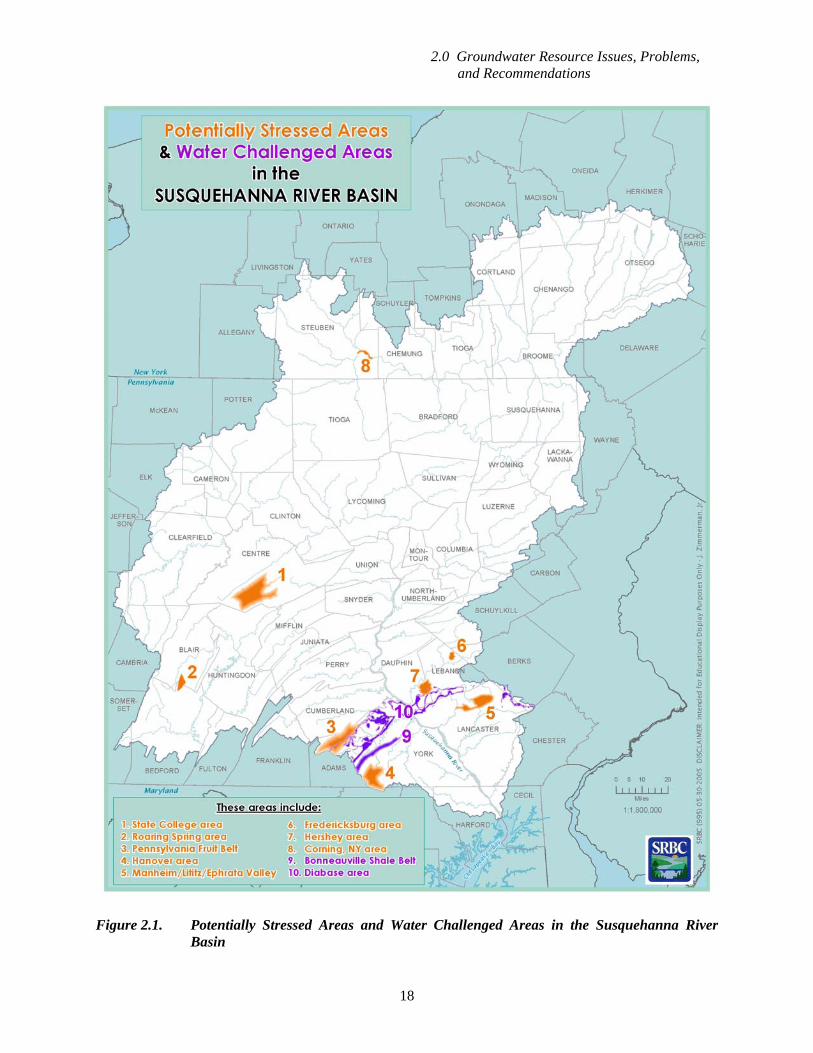
The PSAs that have been identified to date are shown on Figure 2.1 and are briefly discussed
below. The information on these areas is provided to illustrate the variable factors that can lead to overuse of groundwater resources.
Manheim/Lititz/Ephrata Valley. This is a rapidly growing area. A water budget (submitted by a project applicant) indicates that approximately 50 percent of the 1-in-10-year drought recharge is currently being utilized in this rapidly growing area. The Commission completed a detailed water budget for this area in June 2005.
2.0 Groundwater Resource Issues, Problems, and Recommendations
18
Figure 2.1. Potentially Stressed Areas and Water Challenged Areas in the Susquehanna River
Basin
2.0 Groundwater Resource Issues, Problems, and Recommendations
19
The Fruit Belt. This is an area in York and Adams Counties with very intensive fruit production, both orchards and processing, that extends into the Potomac River Basin, and ends near the Pennsylvania-Maryland state line. The fruit growers in this area of York and Adams Counties are gradually turning to irrigation to meet their orchards' water needs, and fruit processing facilities have expanded their operations from primarily seasonal fruit processing to year-round food production. This area includes one of the lowest yielding (Catoctin Formation Metavolcanics) and one of the higher yielding (Gettysburg Formation) bedrock units in the region. The natural ability of the low-yielding Catoctin Formation to provide groundwater is limited. Numerous low-capacity wells in the poor aquifers and stream intakes are utilized to supply the water for irrigation, fruit processing, and food production. Many of the uses are consumptive and do not return any water to surface or groundwater locations. Hanover Area. This area is located on the divide between the Potomac and Susquehanna River Basins. The Hanover area has historically relied on surface water reservoirs for its water supply. However, watersheds are small and Hanover Borough's reservoirs have very long refill times, which has caused water shortages during recent droughts. This is a rapid growth area, particularly in terms of residential development, and commercial and industrial expansions have increased the demand for reliable water supplies.
With the exception of a relatively small area (approximately nine square miles) of carbonate rock, the aquifers do not produce or support the high well yields needed for municipal water supply wells. The carbonate aquifer has well-developed karst permeability, substantial water resource potential, and is essentially the only significant source of groundwater available to the area. But, the carbonate aquifer is continuously depleted by a quarrying operation due to mine dewatering, resulting in widespread perching of streams and widespread depressed groundwater levels during even unusually wet years. Hershey Area (Spring Creek Basin). This area is undergoing rapid commercial, institutional, recreational, industrial, and residential development. A water budget, submitted by a project applicant to the Commission, indicates that virtually 100 percent of the 1-in-10-year drought recharge is already being utilized, even though most of the area's municipal public water needs are being supplied by a stream intake on Swatara Creek. Interestingly, while the Hershey area has reached a PSA status through recent growth and increased water use, this area was the scene of a large-scale, mid-20th century dispute over issues of groundwater withdrawal and artificial recharge to groundwater between two large neighboring water users: a key industry in the basin and a nearby mining company. Fredericksburg Area. This area is undergoing rapid commercial, industrial, and residential development. A water budget, submitted by a project applicant to the Commission, indicated that virtually 100 percent of the 1-in-10-year drought recharge is being utilized. Withdrawals by food processors and a public water supplier are concentrated at the downstream end of three small watersheds and utilize essentially all of the 1-in-10-year flow. The proposed development of groundwater resources in the upstream areas to support substantial planned residential development could adversely impact the existing major withdrawals. Roaring Spring Area. This area has substantial, well-established commercial and industrial water users, including a public municipal water supply, a paper plant, a quarrying operation, and a bottled water company, and is undergoing rapid residential development. A water budget analysis, including substantial detailed geologic mapping and a sophisticated groundwater model, indicated that virtually 100 percent of the 1-in-10-year drought recharge is being utilized. Nearly the entire flow from the spring is utilized during severe droughts. Resource development is well beyond the 1-in-10-year drought recharge for the spring basin. Development of groundwater within the Roaring Spring Watershed to support new uses would impact existing users of the spring.
2.0 Groundwater Resource Issues, Problems, and Recommendations
20
More than 80 percent of the spring water withdrawn is discharged as treated effluent to an
adjacent watershed where sufficient dilution flows are available. This has resulted in a greatly diminished flow in the stream reach between the spring and the Frankstown Branch of the Juniata River. Also, the capacity of the municipal wastewater treatment plant is capped by the limited available dilution flow.
A further complication is the large quarry downstream of the spring, which plans to mine some highly permeable carbonates below stream level and adjacent to the stream. Pumping tests performed on monitoring wells adjacent to the stream suggest that the dewatering required to mine the high calcium beds could impact streamflow. State College Area. This PSA includes most of the Spring Creek Watershed and some of the headwaters of the Spruce Creek Watershed. The area is served by one of the largest regional karst carbonate aquifers in Pennsylvania. The PSA status for the State College area is a result of several factors:
• The State College area is undergoing rapid growth. The area has been growing for several decades, but the nature of the growth has changed from residential and industrial to dominantly residential, educational, and commercial, with a more diverse employment base. The new growth pattern has created stormwater and impervious cover issues.
• The area includes several groundwater contamination sites. As a result, groundwater in some areas is unusable without expensive treatment.
• The mining of high calcium limestone at the foot of the mountains has removed portions of the karst aquifer that previously collected runoff from the mountain slopes. The mine dewatering at some of the quarries has resulted in aquifer dewatering and stream perching.
• Municipal water is currently drawn from several widely scattered well fields located in headwater areas, but is discharged from a single wastewater treatment plant located downstream. This results in the loss of flow in headwater areas upstream of the treated wastewater discharge. Also, some of the water is being withdrawn from the headwaters of the Spruce Creek Watershed, and that water is discharged to the Spring Creek Watershed. This has resulted in diminished flow, and the loss of perennial flow in streams and springs in the Spruce Creek headwaters. The “Living Filter” project, developed by the Pennsylvania State University, utilizes the natural filtration and recharge capability of native soils to return treated wastewater to the regional carbonate aquifer. Similar facilities distributed in the headwaters of the Spring Creek and Spruce Creek Watersheds would help restore natural stream and spring flow in the headwaters areas.
• Municipal well fields contain multiple high capacity wells. These are generally located on fracture traces, which often coincide with stream valleys. The fracture traces are desirable sites for high capacity wells because of the intensive karst conduit development along them. The streams in these valleys have naturally gaining and loosing reaches, their behavior often varying seasonally. The drawdown from the municipal wells interacts with the natural flow system, causing additional loosing reaches, increased flow loss, and additional instream sinkholes.
Corning Area. This area from the confluence of the Tioga River and the Chemung River downstream to South Corning, and surrounding the town of Corning has substantial, well-established
2.0 Groundwater Resource Issues, Problems, and Recommendations
21
commercial and industrial water users, along with public water supply wells. Many of the industrial users are “grandfathered” by the Commission. The high capacity wells are drilled in the glacial valley fill and many induce infiltration from the Chemung River. As in many historic industrial centers, groundwater in some of the area is contaminated, which can limit the availability for some users. As the area continues to evolve as a regional center, future requests for water withdrawals will require special attention because of this combination of factors.
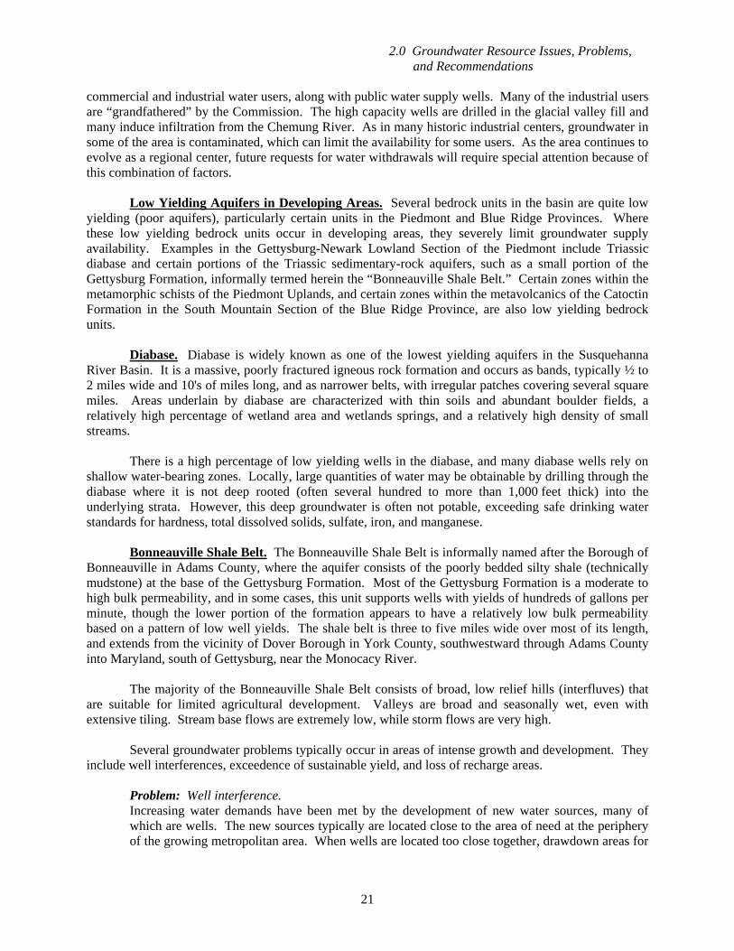
Low Yielding Aquifers in Developing Areas. Several bedrock units in the basin are quite low yielding (poor aquifers), particularly certain units in the Piedmont and Blue Ridge Provinces. Where these low yielding bedrock units occur in developing areas, they severely limit groundwater supply availability. Examples in the Gettysburg-Newark Lowland Section of the Piedmont include Triassic diabase and certain portions of the Triassic sedimentary-rock aquifers, such as a small portion of the Gettysburg Formation, informally termed herein the “Bonneauville Shale Belt.” Certain zones within the metamorphic schists of the Piedmont Uplands, and certain zones within the metavolcanics of the Catoctin Formation in the South Mountain Section of the Blue Ridge Province, are also low yielding bedrock units.
Diabase. Diabase is widely known as one of the lowest yielding aquifers in the Susquehanna River Basin. It is a massive, poorly fractured igneous rock formation and occurs as bands, typically ½ to 2 miles wide and 10's of miles long, and as narrower belts, with irregular patches covering several square miles. Areas underlain by diabase are characterized with thin soils and abundant boulder fields, a relatively high percentage of wetland area and wetlands springs, and a relatively high density of small streams.
There is a high percentage of low yielding wells in the diabase, and many diabase wells rely on shallow water-bearing zones. Locally, large quantities of water may be obtainable by drilling through the diabase where it is not deep rooted (often several hundred to more than 1,000 feet thick) into the underlying strata. However, this deep groundwater is often not potable, exceeding safe drinking water standards for hardness, total dissolved solids, sulfate, iron, and manganese.
Bonneauville Shale Belt. The Bonneauville Shale Belt is informally named after the Borough of Bonneauville in Adams County, where the aquifer consists of the poorly bedded silty shale (technically mudstone) at the base of the Gettysburg Formation. Most of the Gettysburg Formation is a moderate to high bulk permeability, and in some cases, this unit supports wells with yields of hundreds of gallons per minute, though the lower portion of the formation appears to have a relatively low bulk permeability based on a pattern of low well yields. The shale belt is three to five miles wide over most of its length, and extends from the vicinity of Dover Borough in York County, southwestward through Adams County into Maryland, south of Gettysburg, near the Monocacy River.
The majority of the Bonneauville Shale Belt consists of broad, low relief hills (interfluves) that are suitable for limited agricultural development. Valleys are broad and seasonally wet, even with extensive tiling. Stream base flows are extremely low, while storm flows are very high. Several groundwater problems typically occur in areas of intense growth and development. They include well interferences, exceedence of sustainable yield, and loss of recharge areas.
Problem: Well interference. Increasing water demands have been met by the development of new water sources, many of which are wells. The new sources typically are located close to the area of need at the periphery of the growing metropolitan area. When wells are located too close together, drawdown areas for
2.0 Groundwater Resource Issues, Problems, and Recommendations
22
the wells may overlap and result in decreased yields. The loss of operational yield is due to the increased head against which the pumps must work and a less available drawdown.
The overlapping of drawdown areas that result in well interference and the attendant loss of yield
often cannot be directly predicted by the pumping test required by the Commission. Long-term drawdown patterns may require months to years of operation to develop, depending on the hydrogeological setting. However, the information derived from the pumping tests from wells in the area of intensive development provides the input needed for developing a groundwater model. Such models can be used to evaluate the results of long-term well operation. They also can be used to evaluate the problem of additional proposed wells.
The relatively long period over which well interference develops allows the use of water level
monitoring as an evaluation tool. Such monitoring would require the periodic measurement of the water level in a few existing or new wells. As the drawdown areas of the individual wells are observed, well interference can be anticipated and appropriate water resource planning actions taken. The monitoring results also may be used in the development and refinement of a groundwater model.
Recommendation: Where time and water resources are limited, a groundwater model should be used to provide a rapid prediction and evaluation. The use of a model would take into account the appropriateness of the particular approach, as well as the capabilities/limitations of the chosen model. In situations where the availability of water resources allows a more flexible, less time-sensitive approach, water level monitoring is recommended. For many cases, a combination of these approaches will provide the most effective solution, which could include mitigation of impacts. The implementation of such plans may require the coordination of appropriate federal, state and local agencies.
Problem: Exceedence of sustainable yield. The sustainable yield of an aquifer is exceeded when the withdrawal of groundwater causes undesirable effects, such as environmental damage. The clustering of water supply wells around growth centers has locally resulted in loss of base flow in area streams and total maximum daily load (TMDL) exceedences. In the State College area, for example, several widely spaced, dry stream segments have developed on previous perennial stream reaches. These undesirable effects, including environmental damage, are an indication that the sustainable yield of the aquifer has been exceeded.
The Commission has developed and implemented pumping test guidelines that include the requirement for a groundwater availability analysis (water budget) for each new well being submitted for Commission review and approval. The level of effort and sophistication required are determined by the hydrogeological setting and the current and projected level of groundwater development in the area. For PSAs, detailed water budgets should be developed to assist in management of the resource.
Recommendation: Continue to require and review groundwater availability analyses for new projects and detailed water budgets for PSAs. For areas where undesirable effects have stemmed from groundwater withdrawals, and sustainable yields have been exceeded during the last few decades, review and reopen dockets, require a water budget analysis, and adjust the withdrawal rates for sustainability.
2.0 Groundwater Resource Issues, Problems, and Recommendations
23
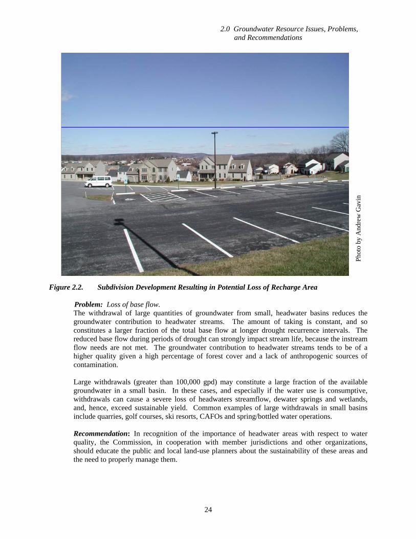
Problem: Loss of recharge areas. As metropolitan areas grow, recharge areas that were once rural are gradually developed (Figure 2.2). Commercial, industrial, and residential development typically results in the creation of impervious surfaces and the interception and diversion of precipitation into nearby streams. The impervious cover is in the form of buildings, walkways, roads, and parking lots. Water from these areas is collected and managed through engineered stormwater drainage systems. These systems are designed to efficiently collect, detain, and dispose of the rejected recharge and surface runoff. However, a portion of the flow is redistributed. A large portion of what would normally have infiltrated and become base flow is conveyed to storm-water storage basins where it is retained and released as surface water. Many storm water basins allow some infiltration; and current best management practices are encouraging storm water infiltration or artificial recharge over detention and release as surface water. The result, absent current application of best management practices encouraging artificial recharge, is a decrease in the amount of groundwater available to water supply wells, a loss of habitat-sustaining base flow, and loss of recharge to the aquifer. An example is the Pump House Springs well field operated by the Borough of Shrewsbury, where a well field located in a small headwater watershed has been gradually surrounded by three malls, an interstate interchange and several commercial complexes. Slope alteration, usually in the form of leveling, is also done in preparation for development. In most cases, the slopes defining the natural drainage net for the area are completely removed. The land then receives a new cover, generally a combination of buildings, pavement, and turf. Of these, only the turf could have a significant infiltration rate. The infiltration rate for turf is among the lowest for all vegetated surfaces. Destruction of soil structure and micropores (decayed rootlets, worm burrows and ice wedging) also substantially reduces the infiltration rate. Recommendation: The Commission should base its sustainable yield determination for approval quantities on estimates of the recharge available to a well that include post build-out conditions.
Further, the Commission should encourage the use of “best management practices” (BMPs) that minimize the loss of recharge, such as those developed by the Commission's member jurisdictions. Available recharge should be verified after build-out and the approval amount increased (or decreased), based on the outcome of the verification study.
2.2 Issue: Intensive Water Use in Small Basins The amount of groundwater available at a given location is proportional to the catchment or recharge area for the aquifer, upgradient of the point of withdrawal. Small groundwater basins have a relatively limited amount of groundwater. Water intensive uses such as quarries, golf courses (for irrigation), and other recreation activities, water exports for bottling operations, and concentrated animal feedlot operations (CAFOs) are rapidly growing in the small headwater basins.
2.0 Groundwater Resource Issues, Problems, and Recommendations
24
Figure 2.2. Subdivision Development Resulting in Potential Loss of Recharge Area
Problem: Loss of base flow.
The withdrawal of large quantities of groundwater from small, headwater basins reduces the groundwater contribution to headwater streams. The amount of taking is constant, and so constitutes a larger fraction of the total base flow at longer drought recurrence intervals. The reduced base flow during periods of drought can strongly impact stream life, because the instream flow needs are not met. The groundwater contribution to headwater streams tends to be of a higher quality given a high percentage of forest cover and a lack of anthropogenic sources of contamination.
Large withdrawals (greater than 100,000 gpd) may constitute a large fraction of the available
groundwater in a small basin. In these cases, and especially if the water use is consumptive, withdrawals can cause a severe loss of headwaters streamflow, dewater springs and wetlands, and, hence, exceed sustainable yield. Common examples of large withdrawals in small basins include quarries, golf courses, ski resorts, CAFOs and spring/bottled water operations.
Recommendation: In recognition of the importance of headwater areas with respect to water
quality, the Commission, in cooperation with member jurisdictions and other organizations, should educate the public and local land-use planners about the sustainability of these areas and the need to properly manage them.
Phot
o by
And
rew
Gav
in
2.0 Groundwater Resource Issues, Problems, and Recommendations
25
Problem: Loss of perennial streamflow. The reduction in base flow may actually exceed the drought groundwater discharge rate to the
nearby stream, thereby changing the previous intermittent reaches to ephemeral reaches, and the uppermost perennial reaches to intermittent reaches. The loss of perennial stream aquatic habitat occurs due to the development of dry stream segments. While the loss of perennial stream length is generally a small fraction of that for the entire stream, it often represents the most pristine portion of the watershed with respect to water quality and habitat.
Recommendation: The Commission, in cooperation with member jurisdictions and other
organizations, should evaluate headwater streams with respect to habitat, and apply special conditions prescribing passby and conservation flows to its approvals for both surface water and groundwater withdrawals in order to manage water quantity and quality of the stream. The recognition and management of critical recharge areas also would benefit these areas.
2.3 Issue: Watershed “Transfers” Groundwater frequently is withdrawn from one watershed and, after use and treatment, discharged to a neighboring watershed.
Problem: Wastewater is not returned to the watershed where it was withdrawn. In order to maintain streamflow quantity, discharges should be located in the same watershed as their associated groundwater withdrawals. Preferably, they should be located close to the area of withdrawal in order to minimize the length of stream with diminished flow. However, in considering where water is withdrawn and returned, a myriad of factors are at work. On the one hand, many have advocated that we avoid sprawl, and concentrate development in and around existing communities rather than spread growing populations across open lands (and open watersheds). This means, in many cases, that the people are located in areas that may not have local water supplies to support that density, thus requiring that water supplies be brought to the people and related enterprises. The alternative policy option is to move the people to the water, which is precisely contrary to the policy goal of preserving open space and avoiding sprawl.
Further, watershed transfers are in some cases virtually mandated by some of our water quality
management policies, which practically preclude or strongly discourage return of water to particular watersheds. Specifically, communities located in watersheds whose streams have been designated as special protection (high quality or exceptional value) find it extremely difficult or impossible to permit new or increased discharges in their host watersheds (even using state-of-the-art tertiary treatment technology). The result is the siting of treatment plants elsewhere, including neighboring watersheds that do not bear such special protection classifications.
Recommendation: The Commission, in cooperation with member jurisdictions and other
organizations, should educate the appropriate professional groups about the options of maintaining groundwater withdrawals and post-use discharges in the same watershed, and the factors involved in this decision. The Commission should evaluate the transfer of water from the source basin during its review.
2.0 Groundwater Resource Issues, Problems, and Recommendations
26
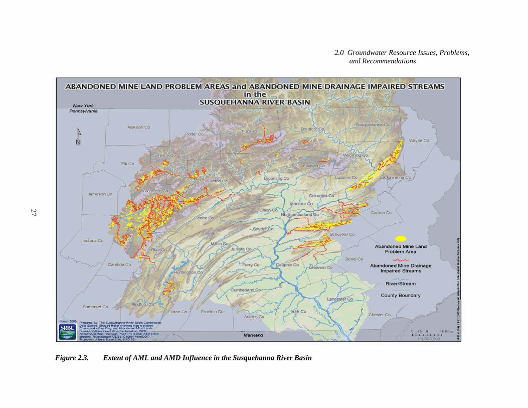
2.4 Issue: Loss of “Clean” Water Input to AMD-Impacted Streams Many watersheds in coal-mined areas are strongly impacted by AMD (Figures 2.3 and 2.4). Considerable time, effort, and money have been expended by state and federal agencies to mitigate this water quality problem. Often, most of the clean water received by these streams is from tributaries draining strata without coal mines, such as the Pocono and Mauch Chunk sandstones and their equivalents.
Problem: Degradation of stream quality. Most AMD-impacted watersheds have adjacent, tributary watersheds that are not AMD impacted
due to a lack of coal and related mining activities. These AMD-free water resources are currently under substantial commercial development pressure for use as bottled and spring water, which are consumptive uses. The consumptive use of clean groundwater in the headwaters of a watershed impacted by AMD deprives the watershed of scarce freshwater sources, degrading stream water quality and quantity. This is especially important in small watersheds and headwater areas where springs provide a large portion of the total flow in the stream. In recent years, a number of springs in AMD-impacted watersheds have been developed for bottled/spring water, and such withdrawals deprive the stream of fresh water. An example of this type of problem exists in the upper reaches of Wiconisco Creek, near Tower City, Pennsylvania, where two spring basins currently are used as spring water sources, and two more are under development. Such business ventures are quite profitable due to the strong demand for bottled spring water. However, as this industry grows, the fresh water input to the AMD-impacted streams is cutoff, spring by spring.
The loss of the flow from these AMD-free watersheds could be a major setback to state, federal,
and Commission efforts at mitigating the AMD problem. Substantial financial, material, and energy resources are being directed at mitigating the AMD problem through various approaches at cleaning the water or preventing the conversion of clean water to AMD-impacted water. Dilution by naturally clean water is far less costly than an equivalent level of mitigation achieved by chemical treatment, constructed wetland treatment, and pump and treat methods.
Tributaries by their nature are smaller than the streams they feed. Hence, the loss of flow from any one area may not be deemed significant unless the cumulative impacts from consumptive uses or inter-watershed transfers are considered. Evaluation of impacts, based on the cumulative effects, will prevent the loss of these clean water contributions in a piecemeal fashion.
Recommendation: The Commission's permitting process should include an evaluation of
cumulative impacts from consumptive water uses to downstream water quality in AMD-impacted areas. The review of consumptive water use projects in watersheds that are tributary to streams not meeting state and federal water quality standards should consider cumulative impacts and the cost of mitigating the impacts. The Commission should coordinate with the appropriate state and federal agencies in its evaluation.
2.0 Groundwater Resource Issues, Problems, and Recommendations
27
Figure 2.3. Extent of AML and AMD Influence in the Susquehanna River Basin
2.0 Groundwater Resource Issues, Problems, and Recommendations
28
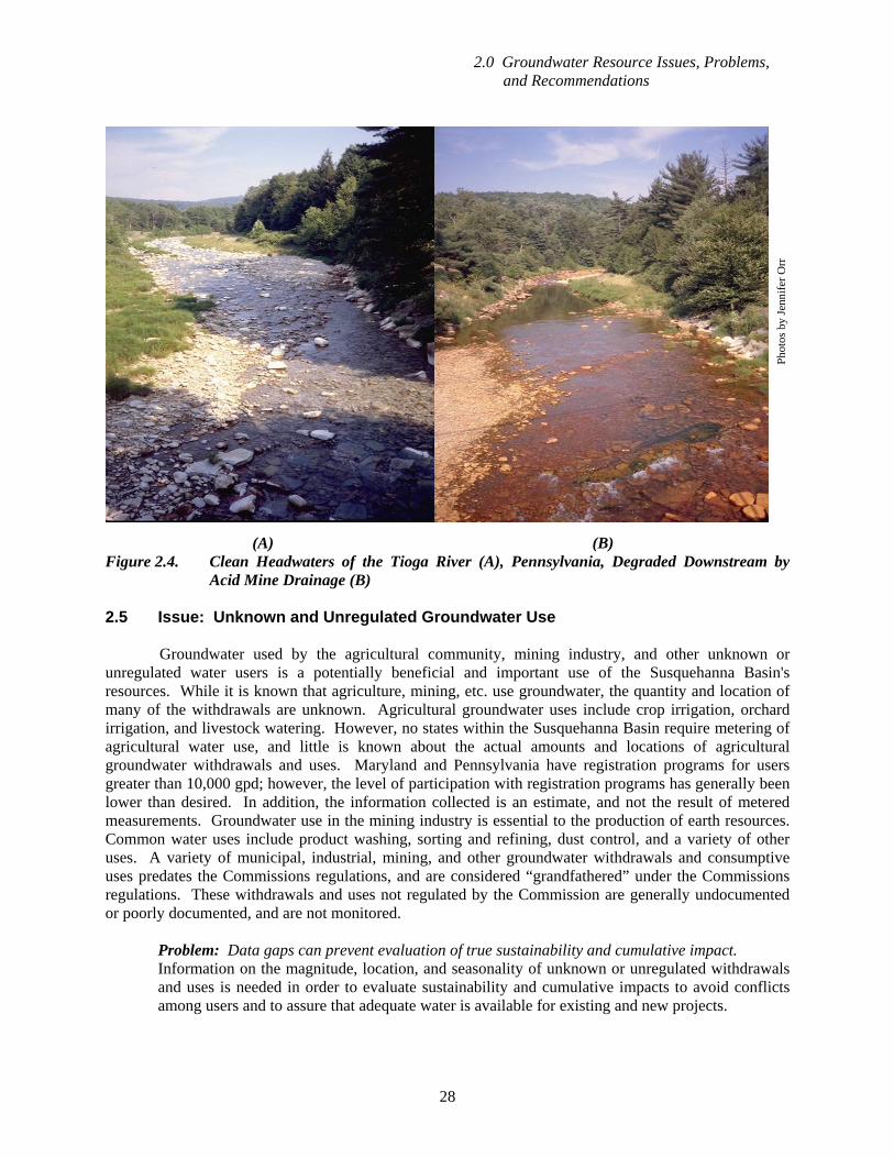
(A) (B) Figure 2.4. Clean Headwaters of the Tioga River (A), Pennsylvania, Degraded Downstream by
Acid Mine Drainage (B) 2.5 Issue: Unknown and Unregulated Groundwater Use Groundwater used by the agricultural community, mining industry, and other unknown or unregulated water users is a potentially beneficial and important use of the Susquehanna Basin's resources. While it is known that agriculture, mining, etc. use groundwater, the quantity and location of many of the withdrawals are unknown. Agricultural groundwater uses include crop irrigation, orchard irrigation, and livestock watering. However, no states within the Susquehanna Basin require metering of agricultural water use, and little is known about the actual amounts and locations of agricultural groundwater withdrawals and uses. Maryland and Pennsylvania have registration programs for users greater than 10,000 gpd; however, the level of participation with registration programs has generally been lower than desired. In addition, the information collected is an estimate, and not the result of metered measurements. Groundwater use in the mining industry is essential to the production of earth resources. Common water uses include product washing, sorting and refining, dust control, and a variety of other uses. A variety of municipal, industrial, mining, and other groundwater withdrawals and consumptive uses predates the Commissions regulations, and are considered “grandfathered” under the Commissions regulations. These withdrawals and uses not regulated by the Commission are generally undocumented or poorly documented, and are not monitored. Problem: Data gaps can prevent evaluation of true sustainability and cumulative impact. Information on the magnitude, location, and seasonality of unknown or unregulated withdrawals
and uses is needed in order to evaluate sustainability and cumulative impacts to avoid conflicts among users and to assure that adequate water is available for existing and new projects.
Phot
os b
y Je
nnife
r Orr
2.0 Groundwater Resource Issues, Problems, and Recommendations
29
Recommendation: The Commission should collect information on the magnitude, location and seasonality of agricultural, grandfathered, and unknown or unregulated withdrawals to improve its evaluation of the resources available to new projects.
Problem: Loss of base flow during the growing season. Streams in areas of intensive irrigation and food processing, such as in Pennsylvania's fruit
growing belt (York-Adams Counties), have experienced drastically-reduced base flows due to groundwater withdrawal. This problem is especially acute during the late summer and early fall months, when temperatures are high, precipitation is at a seasonal minimum, and withdrawals peak. Loss of base flow during low flow periods may result in loss and damage to habitat and the instream community, as well as a reduction in water available to other users.
Recommendation: Where loss of base flow is a recurring problem, a water budget and
cumulative impact analysis will be essential tools needed to manage withdrawals for sustainability, and minimize impact to other water sources and the environment. Adverse impacts to base flow during periods of low flow should be addressed by managing withdrawals, storage, and conjunctive water use.
Problem: Interference with existing water sources. Interference with neighboring water sources is usually an indication of a local overdraw from the
aquifer. Water supplies may be impacted downstream of large unregulated or unknown withdrawals. Such occurrences are contrary to the Commission's goal of management for sustainability.
Water supplies with a passby flow requirement have to reduce or cease their withdrawals when
streamflow is insufficient, and thus may be impacted during seasonal low flows, especially when these coincide with peak unregulated or unknown water use. For example, production from the Hegins Township Authority well field had to be drastically reduced during the 2001 drought, because agricultural water use upstream of the well field reduced streamflow and triggered the authority's passby flow requirement.
Recommendation: A water budget should be performed to determine the available water
resources. Alternating and/or non-synchronous pumping of interfering sources will often address local, marginal overdraws.
2.6 Issue: Scarcity of Clean Water in Coal-Mined Areas In the areas of the basin of extensive coal mining, AMD impacts are widespread and most of the coal-bearing aquifers have been impacted. However, anticlinal geologic structures locally bring older (pre-Pennsylvanian) geologic formations to the surface that do not contain economic coal reserves. Some of these produce high-quality, AMD-free groundwater. The groundwater basins/watersheds situated in pre-Pennsylvanian rocks are often the primary source of clean water in the coal-mined areas. Problem: Preferential development of high quality groundwater sources. Most AMD-impacted watersheds have adjacent, tributary watersheds that are not AMD impacted
due to a lack of coal and related mining activities. Development is occurring preferentially in the areas not impacted by coal mining activities in order to avoid problems, including AMD, subsidence, and over-steepened slopes. These AMD-free water resources are an important and often sole source of clean water for community water supplies. In addition, these watersheds are characterized by their relatively pristine environment and habitat. They are currently under substantial development pressure both for their water resources and developable land that carries
2.0 Groundwater Resource Issues, Problems, and Recommendations
30
no environmental liability. As a result, the water resources in the small, clean-water watersheds are in jeopardy. Many communities in the western part of the basin rely heavily on such areas for their water supplies.
Recommendation: The Commission, in cooperation with member jurisdictions and other
organizations, should act to manage the quantity and quality of water from these watersheds, recognizing that water resources are necessary for the economic growth of mining-affected regions. Education of local government officials and municipal engineering firms is imperative. In the long-term, this would be most effectively accomplished through coordination among the Commission, the appropriate state and federal agencies, and other organizations. The Commission and others must recognize, however, that if municipalities in coal mining affected areas are to experience beneficial economic growth and development, they must turn to these clean watersheds for water supply while maintaining a balance with the need to protect aquatic resources. The Commission should also support efforts by the member jurisdictions for “grayfields” initiatives which encourage the beneficial use of AMD-affected waters.
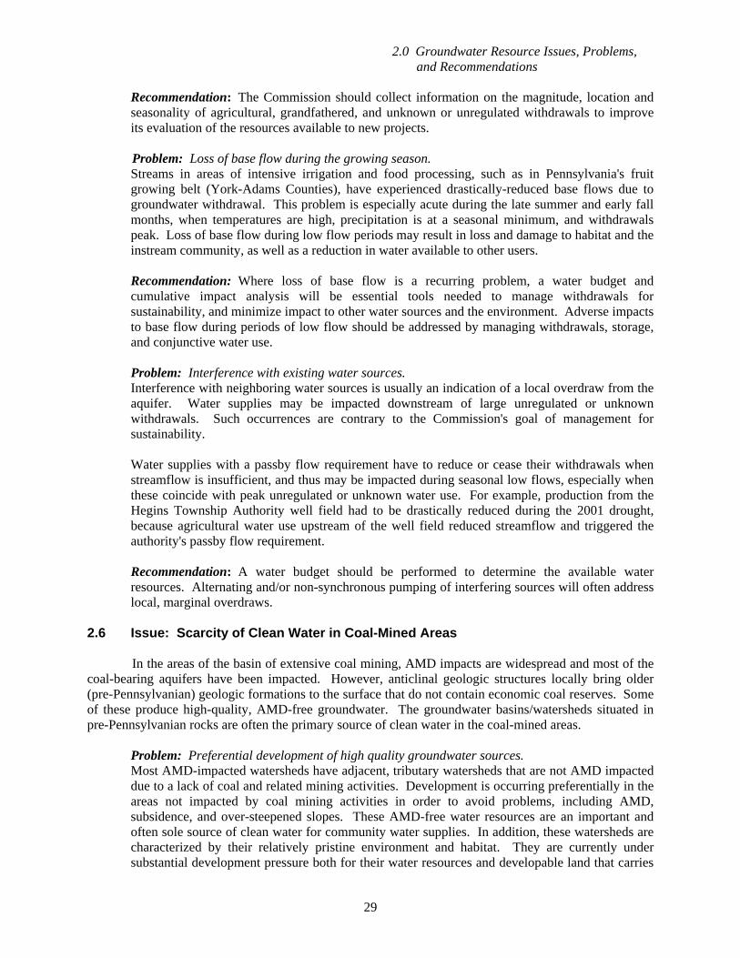
2.7 Issue: Drought Impact to Base Flow During the time between precipitation runoff events, surface water flow is sustained by the discharge of groundwater to streams, termed base flow. During a drought, aquifers steadily release water to streams, but are un-replenished by precipitation for an extended period. As groundwater levels decline, base flow, by necessity, gradually declines. Downstream and instream users of the stream are accustomed to base flows sustained by average precipitation levels. Their demands and needs remain unchanged during periods of drought, despite diminishing supply. Problem: Insufficient streamflow to sustain instream flow needs or downstream water supplies. During periods of extended drought, base flow may decline to levels that are insufficient to
sustain downstream surface water supplies and instream flow needs (Figure 2.5). Many municipalities, industries, and power generation facilities use surface water for their water supplies. In most cases, these needs cannot be significantly reduced without impairment to human health, welfare, and the economy. As a result, sustained droughts have the potential to cause streamflows to diminish to the point where users are impacted. Further, aquatic communities, including both warm and cold water sport/game fisheries, are critically dependent on base flow during periods of extended drought. Damage to, or collapse of, these aquatic communities represents a severe decline in environmental quality, and carries economic impacts as well. In extreme cases, fish kills may occur. The impacts can occur in the local, small headwater basins and can contribute to problems in downstream areas due to the cumulative effect of reduced flows in the headwater areas. Therefore, users in both the local and downstream areas would benefit from actions to maintain streamflows during drought conditions.
The Commission can play a positive role in helping to bring together the key stakeholders in areas affected by growing populations and mineral extraction operations, to help promote the development of reliable surface water supplies and instream flow needs. Mining operations frequently intercept groundwater that might otherwise infiltrate a mine, and release that water to surface streams where it becomes available to downstream communities, habitat, and other users. Indeed, for many years, flows in the Saucon Creek in the Delaware Basin was substantially supported by water pumped from the New Jersey Zinc Mine until the mine was closed. In some areas of the country, including Pennsylvania, both active and abandoned quarries have provided resources for community water systems, and similar cooperative efforts should be promoted in this basin.
2.0 Groundwater Resource Issues, Problems, and Recommendations
31
Figure 2.5 Dry Stream Reach Resulting from Base Flow Decline During Drought Conditions Recommendation: The Commission, in cooperation with member jurisdictions and other
organizations, should act to maintain stream base flow by protecting the groundwater flow that sustains it by: (1) educating local jurisdictions about maximizing high quality groundwater recharge through the support for implementation of stormwater management practices that promote infiltration, identification of CARAs, and application of “best management practices for development”; and (2) carrying out and/or supporting research on fisheries, particularly warm-water fisheries, to provide improved knowledge of required conditions for their survival and a scientific basis for their protection.
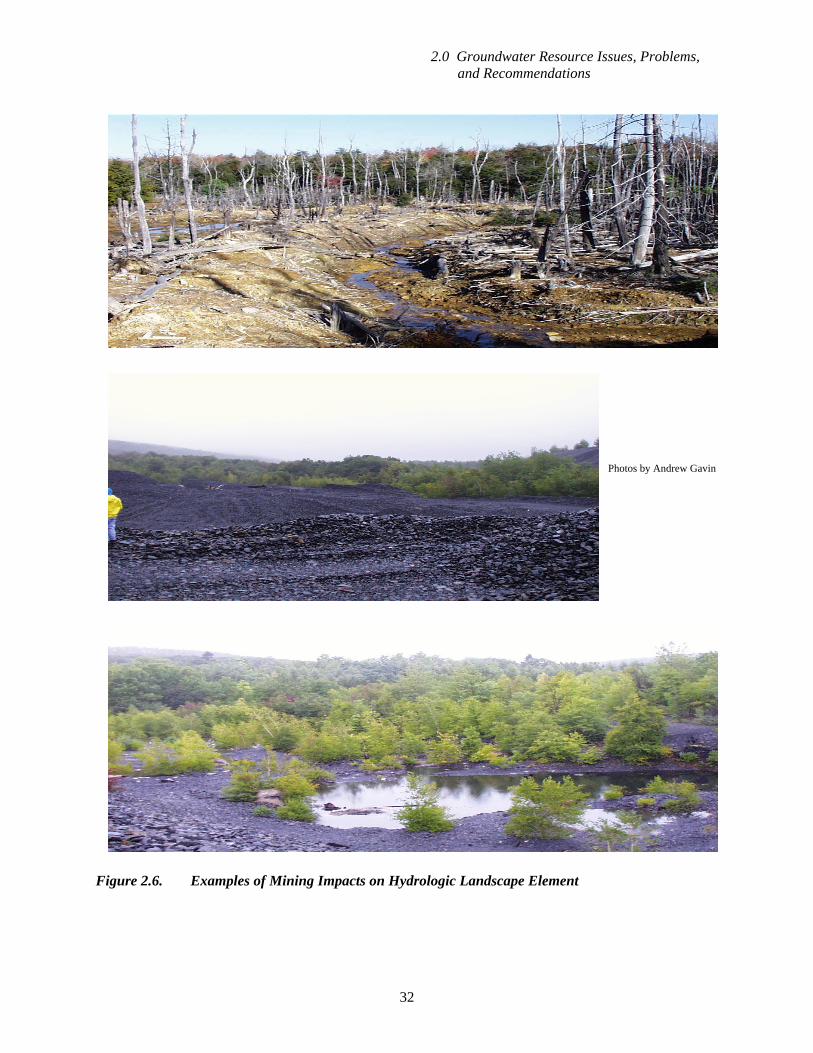
2.8 Issue: Impacts of Mining
Surface and underground mining of consolidated rock and mineral deposits provides valuable
raw materials and rock products, including coal, dimension stone, aggregate, and high-calcium lime. In addition, sand and gravel deposits in the glaciated part of the Susquehanna River Basin are excavated, sometimes leaving large (more than 10 acres) lakes. There are no economically viable alternative sources for these materials, and the Commission recognizes mining as historically important to the economies of its member jurisdictions.
Mining often substantially alters the landscape in ways that affect groundwater, surface water, and environmental resources (Figure 2.6). Streams, springs, and wetlands are often substantially altered, or even removed, from the landscape. Surface mines, by their nature, result in the removal of the landscape within the footprint of the open pit. The removal of key hydrologic landscape elements, such as sinkholes, streams, and springs, may result in substantial alteration of groundwater flow patterns, quantity, and quality. Once mining is completed, abandoned water-filled mines often become an asset to water resource management, given the creation of large volumes of water in storage that previously did not exist. For instance, the abandoned Cornwall Iron Mine in Lebanon County has been used for low
Phot
o by
Rob
ert P
ody
2.0 Groundwater Resource Issues, Problems, and Recommendations
32
Figure 2.6. Examples of Mining Impacts on Hydrologic Landscape Element
Photos by Andrew Gavin

2.0 Groundwater Resource Issues, Problems, and Recommendations
33
streamflow augmentation, and abandoned mines have been used as water supplies at several locations in the basin. Also, potential use of water stored in abandoned, water-filled quarries to offset agricultural consumptive water losses is currently under investigation by Commission staff.
Problem: The positive and beneficial use of water discharged from mining operations is underutilized as a resource. The Commission can play a positive role in helping to bring together the key stakeholders in areas affected by growing populations and mineral extraction operations, to help promote the development of reliable water supplies. Beneficial use requires careful evaluation of water quality to insure its suitability as a source of supply. Although mining operations are seen sometimes as a “negative” to watersheds, mining operations frequently intercept groundwater that might otherwise infiltrate a mine, and release that water to surface streams where it becomes available to downstream communities and other users. Quarrying operations in Hanover, Pennsylvania, discharge groundwater to Slagel’s Run, which is used by the Borough of Hanover as one of several sources for the public water supply system. Flows are sustained as long as quarrying continues below the water table, even during periods of drought. In some areas of the country, including Pennsylvania, both active and abandoned quarries have provided resources for community water systems, and similar cooperative efforts should be promoted in this basin. Mine water pools also can supply non-potable uses, such as a golf course in the anthracite region that has tapped a mine pool for irrigation water. A proposed coal waste gasification and liquefaction plant in Schuylkill County, Pennsylvania, is evaluating a flooded deep coal mine for its large (7.0 mgd) withdrawal and consumptive use. Recommendation: The Commission should encourage cooperative efforts to promote the development of reliable water supplies related to active and abandoned mining operations, for public drinking water, commercial operations, and industrial supplies.
Problem: Extensive aquifer dewatering. Mining of consolidated rock and mineral deposits below the water table requires that enough
water be pumped to keep the mine workings dry. The magnitude of the pumping is often very high, being equivalent to that of a small to medium size city. However, while cities usually withdraw from multiple sources that are aerially distributed, mine pumping is concentrated at the mine and strives to maintain constant drawdown of the water table. This often results in aquifer dewatering of a scale unique to mining, and causes severe impacts to springs, streams, and wetlands. The reduced groundwater flow and groundwater discharge to streams (base flow) frequently results in reduced water availability to existing users and impacts to aquatic resources. Much of the pumped water is discharged to local streams, mitigating the reduced groundwater discharge downstream of the mine discharge point.
Recommendation: The area of influence and capture area for the mine withdrawal should be
delineated, and the impacts identified. This is best accomplished through a study, which may incorporate a water budget analysis, field mapping of aquifer permeability features and water levels, and groundwater modeling. Once identified, the impacts may be mitigated through a variety of methods, including redirection/redistribution of the mine pumpage and modification or replacement of impacted sources. Where exceedence of sustainable yield is occurring, mine pumpage can be reduced through the grouting of water inflow points, or other methods as appropriate, if economically and technically feasible.
2.0 Groundwater Resource Issues, Problems, and Recommendations
34
Problem: Exceedence of sustainable yield. When the quantity of groundwater that must be withdrawn to maintain operational conditions in
mines exceeds the sustainable yield of the aquifer, a variety of problems occur, including loss of stream base flow, sinkholes, and loss of well yield.
Recommendation: Where mining withdrawals of groundwater exceed sustainable yield, mine
pumpage can be reduced through the grouting of water inflow points if technically and economically feasible, or other methods, as appropriate. In cases where the aquifer is otherwise unused, the effects of exceedence of sustainable yield may be mitigated by various means as appropriate. These mitigation procedures should be coordinated through the appropriate state and federal agencies, in concert with the project's engineering and hydrogeological staff and consultants. Mine pumpage may reach or exceed the sustainable groundwater yield of a basin, and thus effectively limit the potential for other withdrawals to be approved.
2.9 Issue: Flow Compensation for Consumptive Water Uses Only a limited number of reservoirs release additional stored water during low flow periods that provides flow compensation for consumptive water uses. Many existing reservoirs have other demands on them, including recreational and public water supply that limit or preclude releases for the purpose of consumptive use compensation. Mining operations frequently intercept groundwater that might otherwise infiltrate a mine and release that water to surface streams where it becomes available to downstream communities, habitat, and other users. The flow augmentation commonly is continuous, although the quantity of water released declines during extended droughts. However, mining operations can provide opportunities for water storage, either as “artificial” aquifers with storage in underground voids created where minerals or rock was removed, or as flooded pits in strip mines or quarries. In Pleasant Gap, Pennsylvania, a flooded limestone quarry is storing water to offset the consumptive use of two mining projects. The Commission is investigating the possibility of using abandoned mines such as Barnes and Tucker in Barr Township, Cambria County, Pennsylvania, as a source of make-up water for consumptive water users.
Problem: Need for additional low flow augmentation to compensate for consumptive water uses.
Recommendation: The Commission should bring together key stakeholders to help promote the use of groundwater stored in “artificial” aquifers created by mining or flooded quarries to offset consumptive water uses and support instream flow needs during droughts.