2.0 site characterization
TRANSCRIPT

2.0 SITE CHARACTERIZATION
The U.S. Department of Energy (DOE) uses the performance assessment methodology described in Section 6.1 to demonstrate that the Waste Isolation Pilot Plant (WIPP) disposal system will meet the environmental performance standards of Title 40 of the Code of Federal Regulations (CFR) Part 191 Subparts B and C. In order to effectively use performance assessment, three inputs are necessary: What can happen to the disposal system? What are the chances of it happening? And what are the consequences if it happens? The answers to these questions are derived from many sources, including field studies, laboratory evaluations, experiments, and, in the case of some features not amenable to direct characterization, professional judgment. The information used in performance assessment is described in terms of features of the disposal system that can be used to describe its isolation capability, events that can affect the disposal system, and processes that are reasonably expected to act on the disposal system.
The DOE selected the Los Medaiios region and present site for the WIPP based on certain defined siting criteria. The site selection process, which was focused on sites that contained certain favorable features while other unfavorable features were excluded, was applied by the DOE with the intent of finding the area that best met the siting criteria. The siting process is discussed in this application in Appendix GCR. See Table 1-2 in Chapter 1.0 for a list of appendices that provide additional information supporting this chapter.
Conceptual models of the WIPP disposal system simulate the interaction between the natural environment (described in this chapter), the engineered structures (described in Chapter 3.0) and the waste (described in Chapter 4.0). One starting point in developing conceptual models of the WIPP disposal system is an understanding of the natural characteristics of the site and of the region around the site. Site characterization and model development is an interactive process that the DOE has used for many years. Basic site information leads to initial models. Initial model sensitivity studies indicate the need for more detailed information. More site characterization then leads to improved models. In addition, an assessment of the impacts of uncertainty inherent in the parameters used to numerically simulate geological features and processes has also led the DOE to conduct more in-depth investigations of the natural system. These investigations generally proceeded until uncertainty was sufficiently reduced or to the point where no further information could be reasonably obtained.
The discussion of conceptual models and initial and boundary conditions is in Section 6.4 and Appendix MASS (Sections MASS.2 and MASS.4 through MASS.18). Conceptual models implement scenarios about the future. Scenario development is discussed in Section 6.3. Scenario development requires as inputs information about the natural features, events, and processes (FEPs) that can reasonably be expected to act on the disposal system. While the list of possible FEPs is derived independently of the disposal system, their screening (in Section 6.2 and Appendix SCR) is based on a basic understanding of the geology, hydrology, and climatology of the region and the site in particular. The screening methodology follows US. Environmental Protection Agency (EPA) criteria on the Scope of Performance Assessments (40 CFR 5 1 s basic understanding is provided in this chapter and its associated appendices.
DOUCAO 1996-2184 October 1996

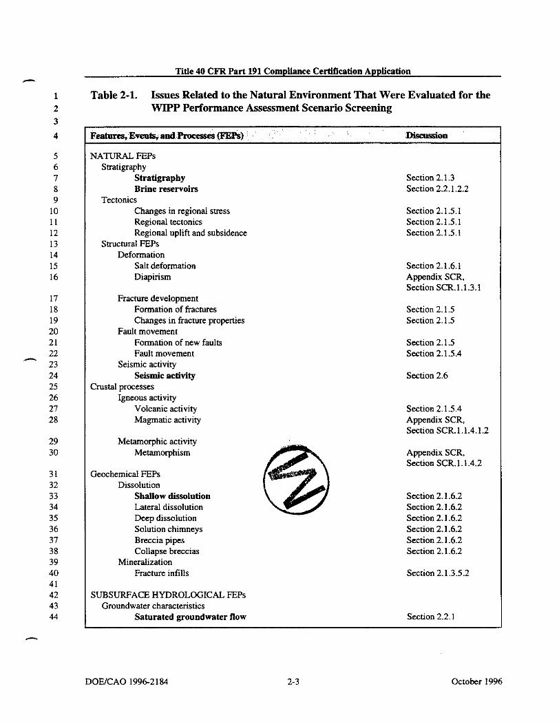
Title 40 CFR Part 191 Compliance Certification Application - Table 2-1 shows the tie between the list of natural FEPs that were identified and screened for the WIPP and the sections of this chapter or Appendix SCR. Those FEPs that have been retained for inclusion in the modeling are shown in bold in Table 2-1. These generally receive a greater level of detail in the following discussions and are supported by additional discussion in Chapter 6.0, Appendix SCR, and Appendix MASS. In addition, parameter values that have been derived for these FEPs are included in Appendix PAR.
In this chapter, the DOE describes the WIPP site geology, hydrology, climatology, air quality, ecology, and cultural and natural resources. This chapter's purpose is to (I) explain characteristics of the site, (2) describe background environmental quality, and (3) discuss features of the site that might be important for inclusion in a quantitative performance assessment. The DOE has used this information to develop and screen FEPs and to develop conceptual, mathematical, and computational models to.evaluate the efficacy of natural and engineered barriers in meeting environmental performance standards (Chapter 6.0). Results of these predictive models are used by the DOE to demonstrate that the DOE has a reasonable expectation that compliance with applicable regulations will be achieved. This chapter has been prepared to describe the site prior to excavating the repository. Excavation of the repository and its associated effects, such as the disturbed rock zone (DRZ), are discussed in Chapter 3.0.
The DOE located the WIPP site 26 miles (42 kilometers) east of Carlsbad, New Mexico, in - Eddy County (Figure 2-1). Additional details related to the location of the WPP site can be found in Section 2.1.4.2 (Figure 2-18) and in Figure 3-1 (see Chapter 3.0). The latitude of the WIPP site center is 32"22' 11" N and the longitude is 103"47' 3 0 W. The region surrounding the WIPP site has been studied for many years, and exploration of both potash and hydrocarbon deposits has provided extensive knowledge of the geology of the region. Two exploratory holes were drilled by the federal government in 1974 at a location northeast of the present site; that location was abandoned in 1975 as a possible repository site after U.S. Energy Research and Development Administration (ERDA)-6 borehole was drilled and unacceptable structure and pressurized brine were encountered. The results of these investigations are reported in Powers et al. (1978,2 - 6; included in this document as Appendix GCR). During late 1975 and early 1976, the ERDA identified the current site, and an initial exploratory hole (ERDA-9) was drilled. By the time an initial phase of site characterization was completed in August 1978.47 holes had been or were being drilled for - - various hydrologic and geologic purposes. Geophysical techniques were applied to augment data collected from boreholes. Since 1978, the DOE has drilled additional holes to support hydrologic studies, geologic studies, and facility design. Geophysical logs, cores, basicdata reports, geochemical sampling and testing, and hydrological testing and analyses are reported by the DOE and its scientific advisor, Sandia National Laboratories (SNL), in numerous public documents. Many of those documents form the basis for the DOE'S assertions in this application. As necessary, specific references from these documents are cited to reinforce the statements being made.
October 1996
-
DOWCAO 1996-2184
Title 40 CFR Part 191 Compliance Certification Application
Table 2-1. Issues Related to the Natural Environment That Were Evaluated for the WIPP Performance Assessment Scenario Screening
VATURAL FEPs Suatigraphy
Stratigraphy Brine reservoirs
Tectonics Changes in regional stress Regional tectonics Regional uplift and subsidence
Structural FEPs Deformation
Salt deformation Diapirism
Fracture development Formation of fractures Changes in fracture properties
Fault movement Formation of new faults Fault movement
Seismic activity Seismic activity
3rustal processes Igneous activity
Volcanic activity Magmatic activity
Metamorphic activity Metamorphism
3eochemical FEPs Dissolution
Shallow dissolution Lateral dissolution Deep dissolution Solution chimneys Breccia pipes Collapse breccias
Mineralization Fracture infills
XJBSURFACE HYDROLOGICAL FEPs Groundwater characteristics
Saturated groundwater flow
Section 2.1.3 Section 2.2.1.2.2
Section 2.1.5.1 Section 2.1.5.1 Section 2.1.5.1
Section 2.1.6.1 Appendix SCR. Section SCR.1.1.3.1
Section 2.1.5 Section 2.1.5
Section 2.1.5 Section 2.1.5.4
Section 2.6
Section 2.1.5.4 Appendix SCR. Section SCR. l.l.4.l.Z
Appendix SCR, Section SCR. 1.1.4.2
Section 2.1.6.2 Section 2.1.6.2 Section 2.1.6.2 Section 2.1.6.2 Section 2.1.6.2 Section 2.1.6.2
Section 2.1.3.5.2
Section 2.2.1
DOWCAO 1996-2184 October 1996

Title 40 CFR Part 191 Compliance Certification Application
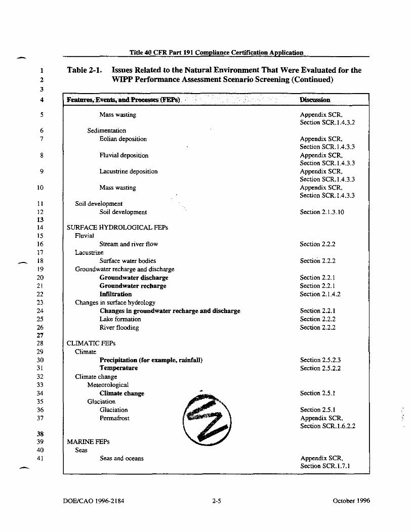
Table 2-1. Issues Related to the Natural Environment That Were Evaluated for the WIPP Performance Assessment Scenario Screening (Continued)
Unsaturated groundwater flow Fracture flow Density effects on groundwater flow Effects of preferential pathways
Changes in groundwater flow Thermal effects on groundwater flow
Saline water intrusion
Freshwater intrusion
Hydrological effects of seismic activity
Natural gas intrusion
XJBSURFACE GEOCHEMICAL FEPs Groundwater geochemistry
Groundwater geochemistry Changes in groundwater geochemistry
Saline water intrusion
Freshwater intrusion
Changes in groundwater Eh
Changes in groundwater pH
Effects of dissolution
jEOMORPHOLOGICAL FEPs Physiography
Physiography Meteorite impact
Impact of a large meteorite
Denudation Weathering
Mechanical weathering
Chemical weathering
Erosion Eolian erosion Fluvial erosion
Section 2.2.1 Section 2.2.1 Section 2.2.1 Section 2.2.1
Appendix SCR. Section SCR.1.2.2.3 Appendix SCR, Section SCR.1.2.2.1 Appendix SCR, Section SCR1.2.2.2 Appendix SCR, Section SCR.1.2.2.5 Appendix SCR, Section SCR.1.2.2.4
Section 2.4.2.1
Appendix SCR, Section SCR.l.2.2.1 Appendix SCR, Section SCR.1.2.2.2 Appendix SCR, Section SCR.1.3.2 Appendix SCR, Section SCR.1.3.2 Appendix SCR, Section SCR.1.3.2
Section 2.1.4
Appendix SCR. Section SCR.1.4.2
Appendix SCR, Section SCR.1.4.3.1 Appendix SCR, Section SCR.1.4.3.1
Section 2.1.3.10 Section 2.2.2
October 1996 2-4 DOEICAO 1996-2184
Title 40 CFR Part 191 Compliance Certification Apptication
Table 2-1. Issues Related to the Natural Environment That Were Evaluated for the WIPP Performance Assessment Scenario Screening (Continued)
Mass wasting
Sedimentation Eolian deposition
Fluvial deposition
Lacustrine deposition
Mass wasting
Soil development Soil development
SURFACE HYDROLOGICAL FEPs Fluvial
Stream and river flow Lacustrine
Surface water bodies Groundwater recharge and discharge
Groundwater discharge Groundwater recharge Infiltration
Changes in surface hydrology Changes in groundwater recharge and discharge Lake formation River flooding
ELIMATIC FEPs Climate
Precipitation (for example, rainfall) Temperature
Climate change Meteorological
Climate change Glaciation
Glaciation Permafrost
MARINE FEPs Seas
Seas and oceans
Appendix SCR. Section SCR.1.4.3.2
Appendix SCR, Section SCR.1.4.3.3 Appendix SCR, Section SCR. 1.4.3.3 Appendix SCR, Section SCR. 1.4.3.3 Appendix SCR, Section SCR.1.4.3.3
Section 2.1.3.10
Section 2.2.2
Section 2.2.2
Section 2.2.1 Section 2.2.1 Section 2.1.4.2
Section 2.2.1 Section 2.2.2 Section 2.2.2
Section 2.5.2.3 Section 2.5.2.2
Section 2.5.1
Section 2.5.1 Appendix SCR, Section SCR.1.6.2.2
Appendix SCR, Section SCR.1.7.1
DOEJCAO 1996-2184 2-5 October 1996

Title 40 CFR Part 191 Compliance Certif~cation Application A
Table 2-1. Issues Related to the Natural Environment That Were Evaluated for the WIPP Performance Assessment Scenario Screening (Continued)
Estuaries
Marine sedimentology Coastal erosion
Marine sediment transport and deposition
Sea level changes Sea level changes
ECOLOGICAL FEPs Flora & fauna
Plants Animals Microbes
I Changes in flora & fauna Natural ecological development
Appendix SCR, Section SCR. 1.7.1
Appendix SCR, Section SCR.1.7.2 Appendix SCR, Section SCR.1.7.2
Appendix SCR, Section SCR.1.7.3
Section 2.4.1 Section 2.4.1 Appendix SCR, Section SCR. 1.8.1
Section 2.4.1
Biological studies of the site began in 1975 to gather information for the Environmental Impact Statement. ~ e t e o r o l o ~ & l studies beg& in 1976, and economic studies were initiated in 1977. Baseline environmental data were initially reported in 1977 and are now updated annually by the DOE.
The DOE located the WIPP disposal horizon within a rock salt deposit known as the Salado Formation (hereafter referred to as the Salado) at a depth of 2,150 feet (650 meters) below the ground surface. The Salado is regionally extensive, includes continuous beds of salt without complicated structure, is deep with little potential for dissolution in the immediate vicinity of the WIPP, and is near enough to the surface to make access reasonable. Particular site selection criteria narrowed the choices when the present site was located during 1975 and 1976, as is discussed in Appendix GCR (2-10 to 2-27) and summarized by Weart (1983).
2.1 Geology
The DOE and its predecessor agencies determined at the outset of the geological disposal program that the geological characteristics of the disposal system are extremely important because the natural barriers provided by the geological units have a significant impact on the performance of the disposal system. Among the DOE'S site selection criteria was the intent to maximize the beneficial impacts of the geology. This was accomplished when the DOE selected (1) a host formation that behaves plastically, thereby creeping closed to encapsulate buried waste, (2) a location where the effects of dissolution are minimal and predictable,
October 1996 2-6 DOWCAO 1996-2184

.- Title 40 CFR Part 191 Compliance Certification Application
a State Highway
Figure 2-1. WIPP Site Location in Southeastern New Mexico
DOEiCAO 1996-2184 2-7 October 1996
Title 40 CFR Part 191 Compliance Cerbir~cation Application
THIS PAGE INTENTIONALLY LEFT BLANK
October 1996

Title 40 CFR Part 191 Compliance Certification Application
(3) an area where deformation of the rocks is low, (4) an area where excavation is relatively easy, (5) an area where future resource development is predictable and minimal, and (6) a repository host rock that is relatively uncomplicated lithologically and structurally. Therefore, a thorough and accurate description of the WIPP facility's natural environmental setting is considered crucial by the DOE for a demonstration of compliance with the disposal standards and is an EPA certification criteria in 40 CFR 5 191.14(a). The DOE is providing the detail necessary to assess the achievable degree of waste isolation. In this chapter, the DOE addresses environmental factors and long-term environmental changes that are important for assessing the waste isolation potential of the disposal system. The first of these environmental factors is geology.
Geological data have been collected from the WIPP site and surrounding area to evaluate the site's suitability as a radioactive waste repository. These data have been collected principally by the DOE, the DOE's predecessor agencies, the United States Geological Survey (USOS), the New Mexico Bureau of Mines and Mineral Resources (NMBMMR), and private organizations engaged in natural resource exploration and extraction. The DOE has analyzed the data and has determined that the data support the DOE's position that the WIPP site is suitable for the long-term isolation of rahoactive waste. Many issues have been discussed, investigated, and resolved in order for the DOE to conclude that the site is suitable. The DOE discusses these issues in the following sections. Most of the data collected have been reported or summarized in Appendices GCR, SUM, HYDRO, and FAC. These appendices represent the majority of the site characterization results for the WIPP site which ended in 1988. A number of more focused geological and hydrological studies continued after this date. These latter studies, many of which were only recently concluded, provided detailed information needed to construct the conceptual models for disposal system performance that are discussed in Section 6.4. An example of these studies is the H-19 multiwell tracer test that was completed in early 1996. Results of this test have been incorporated into the discussions in this chapter and into the conceptual models described in Section 6.4.6. Model parameters derived from the results are displayed in Appendix PAR. A discussion of the test results is included in Appendix MASS (Section MASS. 15).
2.1.1 Data Sources
The geology of southeastern New Mexico has been of great interest for more than a century. The Guadalupe Mountains have become a common visiting and research point for geologists because of the spectacular exposures of Permian-age reef rocks and related facies (see Shumard 1858, Crandall 1929, Newel1 et al. 1953, and Dunharn 1972 in the bibliography). Because of intense interest in both hydrocarbon and potash resources in the region, a large volume of data exists as background information for the WIPP site. though some data are - - proprietary. Finally, there is the geological information developed directly and indirectly by studies sponsored by the DOE for the WIPP project; it ranges from raw data to interpretive reports.
October 1996

Title 40 CFR Part 191 Compliance Certif~cation Application -.
Elements of the geology of southeastern New Mexico have been discussed or described in professional journals or technical documents from many different sources. These types of articles are an important source of information, and where there is consistency among the technical community, the information in these articles is referenced when subject material is relevant. Implicit rules of professional conduct for research and reporting have been assumed, as have journal and editorial review. Elements of the geology presented in such sources have been deemed critical to the WIPP and have been the subject of specific DOE-sponsored WIPP studies.
The geological data that the DOE has developed explicitly for the WIPP project have been produced over a 20-year period by different organizations and contractors using applicable national standards (Quality Assurance Program history is described in Section 5.2). During a ~kma.klng in 1988 related to the underground injection of hazardous wastes, the EPA addressed the use of older geological data in making a long-term demonstration of repository performance. In response to comments on a proposed rule regarding the permitting of underground iniection wells, the EPA concluded that ''[elxcluding historical data or - . .
information which might have been gathered off-site by methodsnot consistent with certain prescribed procedures may be counterproductive." The EPA further stated that such data should be used as long as their limitations are accounted for. In the final rule, the EPA stipulated "that only measurements pertaining to the waste or that result from testing performed to gather data for the petition demonstration comply with prescribed procedures." - Further. the EPA stated that "the concerns about the accuracv of eeoloeic data are addressed . - - more appropriately by requiring that the demonstration identify and account for the limits on data quality rather than by excluding data from consideration" (EPA 1988).
As site characterization activities progressed, the DOE, along with independent review groups such as the National Academy of Sciences WAS), the Environmental Evaluation Group (EEG), and the state of New Mexico acting through the Governor's Radioactive Waste Consultation Task Force, identified natural FEPs that required additional detailed investigation. Because these investigations, in many cases, were to gather data that would either be used in developing conceptual models or in the prediction of disposal system performance, the quality assurance (QA) standards applied to these investigations were more stringent, thereby ensuring accuracy and repeatability to the extent possible for geologic investigations.
Geological data from site characterization have been developed by the DOE through a variety of WIPP-sponsored studies using drilling, mapping or other direct observation, geophysical techniques, and laboratory work. Most of the techniques and statistics of data acquisition will be incorporated by specific discussion. The processes used in deriving modeling parameters from field and laboratory data are discussed in records packages which support the conceptual models in Section 6.4 and the parameters in Appendix PAR. Pointers to these records packages are provided principally in Appendix PAR. Records packages are stored in the Sandia WIPP Central Files (SWCF) in Albuquerque. Access to review of these records packages can be obtained by contacting the person designated in Table 1-10. Borehole
October 1996 2-10 DOWCAO 1996-21 84

Title 40 CFR Part 191 Compliance Certification Application - investigations are a major source of geological data for the WIPP and surrounding area. Borehole studies provide raw data (for example, depth measurements, amount of core, geophysical logs) that support point data and interpreted data sets. These data sets are used in computing other analysis tools such as structure maps for selected stratigraphic horizons or isopachs (thicknesses) of selected stratigraphic intervals.
The borehole data sets that were used specifically for obtaining WIPP geologic information are included as reference information in Appendix BH. This appendix provides some summary information and is a pointer for data reports that contain more detailed results. A map of some borehole locations in the data set is provided in Figure 2-2. These boreholes are the ones used for most of the geological interpretations in this chapter. Other holes are not shown because they were not of sufficient depth, were not cored, or were not drilled for purposes of site characterization. A more comprehensive drillhole database of the entire Delaware Basin is addressed in Section 2.3.1.2 and is presented in Appendix DEL (Figure DEL-4). This database includes all drillholes used in evaluating human intrusion rates for the WIPP performance assessment.
2.1.2 Geologic History
In this section, the DOE summarizes the more important points of the area's geologic history within about 200 miles (320 kilometers) of the WIPP site, with emphasis on more recent or nearby events. Figure 2-3 shows the major elements of the area's geological history from the end of the Precambrian Period.
The geologic time scale that the DOE uses for WIPP is based on the compilation by Palmer (1983,503 - 504) for The Decade of North American Geology (DNAG). There are several compiled sources of chronologic data related to different reference sections or methods (see, for example, Harland et al. 1989 and Salvador 1985 in the bibliography). Although most of
29 these sources show generally similar ages for chronostratigraphic boundaries, there is no 30 consensus on either reference boundaries or most-representative ages. The DNAG scale is 31 accepted by the DOE as a standard that is useful and sufficient for WIPP purposes, as no 32 known critical performance assessment parameters require more accurate or precise dates. 33 34 The geologic history in this region can be conveniently subdivided into three general phases: 35 "
36 - A Precambrian Period, represented by metamo~phic and igneous rocks ranging in age 37 from about 1.5 to 1.1 billion years.
A period from about 1.1 to 0.6 billion years ago, from which no rocks are preserved. Erosion may have been the dominant process during much of this period.
An interval from 0.6 billion years ago to the present represented by a more complex set of mainly sedimentary rocks and shorter periods of erosion and dissolution.
44
DOWCAO 1996-2184 2-1 1 October 1996
Title 40 CFR Part 191 Compliance Certiiication Application
This latter phase is the main subject of the DOE'S detailed discussion in this text.
Only a few boreholes in the WIPP region have bored deep enough to penetrate Precambrian crystalline rocks, and, therefore, relatively little petrological information is available. Foster (1974, Figure 3) extrapolated the elevation of the Precambrian surface under the area of WIPP as being between 14,500 feet (4.42 kilometers) and 15,000 feet (4.57 kilometers) below sea level; the site surface at WIPP is about 3,400 feet (1,036 meters) above sea level. Keesey (1976, Vol. 11, Exhibit No. 2) projected a depth of about 18,200 feet (5,545 meters) from the surface to the top of Precambrian rocks in the vicinity of the WIPP. The depth projection is based on the geology of the nearby borehole in Section 15, T22S, R31E.
Precambrian rocks of several types crop out in the following locations: the Sacramento Mountains northwest of WIPE around the Sierra Diablo and Baylor Mountains near Van Horn, Texas; west of the Guadalupe Mountains at Pump Station Hills; and in the Franklin Mountains near El Paso, Texas. East of the WIPP, a relatively large number of boreholes on the Central Basin Platform have penetrated the top of the Precambrian (Foster 1974, Figure 3). As summarized by Foster (1974, 10). Precambrian rocks in the area considered similar to those in the vicinity of the site range in age from about 1.14 to 1.35 billion years.
For about 500 million years (1.1 to 0.6 billion years ago), there is no certain m k record in the region around the WIPP. The most likely rock record for this period may be the Van Horn
h sandstone (McGowan and Groat 1971), but there is no conclusive evidence that it represents part of this time period (Appendix GCR, Section 3.3.1). The region is generally thought to have been subject to erosion for much of the period until the Bliss sandstone began to accumulate during the Cambrian.
2.1.3 Stratigraphy and Lithology in the Vicinity of the WZPP Site
The conceptual model of the disposal system uses information about the geometry of the various rock layers as a model input as described in Section 6.4.2.1. This means that . - stratigraphic information (thickndss and lateral extent) provided in the following sections are important inputs. In addition, less important features such as the lithology and the presence geochemically significant minerals are provided to support screening arguments in Appendi SCR. Consequently, this discussion has focused on the general properties of the various r units as determined from field studies. Specific parameters used in the modeling describe Sections 6.4.5 and 6.4.6 are summarized in Appendix PAR (Tables PAR-25 to PAR-32 an PAR-34 to PAR-36). Stratigraphy-related parameters are input as constants. Stratigraphic thicknesses of units considered in modeling are compiled in Appendix PAR (Table PAR-57).
This section describes the stratigraphy and lithology of the Paleozoic and younger rocks underlying the WIPP site and vicinity (Figure 2-4), emphasizing the units nearer the surface. After briefly describing pre-Permian rocks, the section provides detailed information on the Permian (Guadalupian) Bell Canyon Formation (hereafter referred to as the Bell - Canyon)-the upper unit of the Delaware Mountain Group-because this is the uppermost
October 1996 2-12 D O K A O 1996-21 84

- Title 40 CFR Part 191 Compliance Certification Application
WIPP Sll<
Borehole Location
-.-
Figure 2-2. WIPP
2 0 2 Miles
0 3 Km
Site and Vicinity Borehole Location Map (partial)
Title 40 CFR Part 191 Compliance Certif~cation Application - THIS PAGE INTENTIONALLY LEFT BLANK
October 1996 DOUCAO 1996-2 184

Title 40 CFR Part 191 Compliance Certifcation Application
I I
I pliocene 3.700.~0
Cretaceous 77,600,000
Triassic 37.W0.000
Permian 41,000,000
Pennsylvanian 34,OWIXX)
Mississippian 40,000,000 -1 Silurian 30.000,OW
Ordovician 67,000,000
Cambrian 65,000,000 I I . .
PRECAMBRIAN
Major Geologic Events
Eallan and emslanlsoluoon acbvlty Development of present landscape
Continued dewsition of Gatuira sediments. I ~
Deposition of Gannia sediments. Formation of caliche caprock. Re~ona l u~l i f t and &-southeastward tiltine: Basin-Ran= u~lif i of ~ & m e n t ~ and Guadalupe-Delaware ~ w n 2 n s .
- I
Erosion dominant. No Early to Mid-Temary mks present. I Laamide revolution. Uplifi of Rocky Mountains. Mild tectonism
Submergence, lnterminent shallow rear. Thin limestone and clmijtlcs deposited.
- ~ -
Emergent conditions. Erosion. formatian of rolling terrain. I Deposition of fluvial clartics. I Erosion. Broad flwd plain develops.
Deposition of evaporire sequence followed by continental r e d W .
Sedimentadon continuous in Delaware. Midland. Val Verde basins
Marsivc depsition of clanin. Shelf, m q i n , basin panem of denwition develom.
Regional tectonic activity accelerates. folding up Cennal Basin platform. Matador arch, ancestral Rccldes.
Regional erosion. Deep. bmad basins to east and west of platform develop.
Renewed submergence.
Shallow sea retreats from New MexiM; erosion
Mdon-Quachita geosyncline. to south, begins subsiding. I Deepning of Tobsa basin area; shelf deposition of clastlcs. derived ~artlv fmm ancestral Cenoal Basin o l a d m and carbonates. I
~ ~- -- --
Clastic sedimentation -Bliss sandstone.
Erosion 10 a nearly level plain.
Mwnmin building. igneous activity. metamorphism, erosional cycls.
- Southeast New Mexico Region
October 1996

Title 40 CFR Part 191 Compliance Certification Application
1 THIS PAGE INTENTIONALLY LEFT BLANK
October 1996

- Title 40 CFR Part 191 Compliance Certification Application
'ystem
Recent
laternary
Tertiary
Triassic
s .- E L
a, a
-% .:,
Series
Recent
'leistocenc
lid-Pliocenm
Group Formation Member
CCA-M3-2
Figure 2-4. Partial Site Geologic Column
2-17 October 1996
n u e 40 CFR Part 191 Compliance Ce-cation Application n
THIS PAGE INTENTIONALLY LEFT BLANK
October 1996 DOUCAO 1996-2184

transmissive formation below the evaporites. The principal stratigraphic data are the chronologic sequence, age, and extent of rock units, including some of the nearby relevant facies changes. For deeper rocks, characteristics such as thickness and depth are summarized from published sources, and for shallower rocks, they are mainly based on data sets presented in Appendix BH (above the Bell Canyon). The lithologies of upper formations and some formation members are described. A comprehensive discussion of stratigraphy in the WIPP area is presented in this application in Appendix GCR. Detailed referencing to original investigations by the USGS and others is included.
2.1.3.1 General Stratimuhv and J.itholow below the Bell Canyon
As stated previously, the Precambrian basement near the site is projected to be about 18,200 feet (5,545 meters) below the surface (Keesey 1976, Vol. II, Exhibit No. 2), consistent with information presented by Foster in 1974. Ages of similar rock suites in the region range from about 1.14 to 1.35 billion years.
A detailed discussion of the distribution of Precambrian rocks in southeastern New Mexico and Texas can be found in this application in Appendix GCR (Section 3.3.1). Figure 3.4-2 in Appendix GCR provides a structure contour map of the Precambrian.
The basal Paleozoic units overlying Precambrian rocks are clastic rocks commonly attributed either to the Cambrian Bliss sandstone or the Ellenberger Group (Foster 1974, 10). considered most likely to be Ordovician in age in this area. The Ordovician System comprises the Ellenberger, Simpson, and Montoya Groups in the northern Delaware Basin. Carbonates are predominant in these groups, with sandstones and shales common in the Simpson Group. Foster (1974, Figure 4) reported 975 feet (297 meters) of Ordovician-age rocks north of the site area and extrapolated a thicker section of about 1,300 feet (396 meters) at the present site (Foster 1974, Figure 5). Keesey (1976, Vol. 11, Exhibit No. 2) projected a thickness of 1,200 feet (366 meters) for the Ordovician System within the site boundaries.
Silurian-Devonian rocks in the Delaware Basin are not stratigraphically well defined, and there are various notions for extending nomenclature into the basin. Common drilling practice is not to differentiate, though the Upper Devonian Woodford shale at the top of the sequence is frequently distinguished from the underlying dolomite and limestone (Foster 1974, 18). Foster (1974, Figure 6) showed a reference thickness of 1,260 and 160 feet (384 and 49 meters) for the carbonates and the Wwdford shale, respectively; he estimated thickness of these units at the present WIPP site to be about 1,150 feet (35 1 meters) (Foster 1974, Figure 7) and 170 feet (52 meters) (Foster 1974, Figure 8), respectively. Keesey (1976, Vol. 11, Exhibit No. 2) projected 1,250 feet (381 meters) of carbonate and showed 82 feet (25 meters) of the Wwdford shale.
The Mississippian System in the northern Delaware Basin is commonly attributed to Mississippian limestone and the overlying Barnett shale (Foster 1974,24), but the - - . - nomenclature is not consisten the reference well used by Foster (1974.25). the
DOWCAO 1996-21 84 2-19 October 1996

Title 40 CFR Part 191 Compliance Certifkation Application -. limestone is 540 feet (165 meters) thick and the shale is 80 feet (24 meters); isopachs at the WIPP are 480 feet (146 meters) (Foster 1974, Figure 10) and less than 200 feet (61 meters). Keesey (1976, Vol. 11, Exhibit No. 2) indicates 51 1 feet (156 meters) and 164 feet (50 meters), respectively, withm the site boundaries.
The nomenclature of the Pennsylvanian System applied within the Delaware Basin is both varied and commonly inconsistent with accepted stratigraphic rules. Chronostratigraphic, or time-stratigraphic, names are applied from base to top to these lithologic units: the Morrow, Atoka, and Strawn (Foster 1974,31). Foster (1974, Figure 13) extrapolated thicknesses of about 2,200 feet (671 meters) for the Pennsylvanian at the WIPP site. Keesey (1976, Vol. II, Exhibit No. 2) reports 2,088 feet (636 meters) for these units. The Pennsylvanian rocks in this area are mixed clastics and carbonates, with carbonates more abundant in the upper half of the sequence.
The Permian is the thickest system in the northern Delaware Basin, and it is divided into four series from the base to top: Wolfcampian, Leonardian, Guadalupian, and Ochoan. According to Keesey (1976, Vol. 11, Exhibit No. 2), the three lower series total 8,684 feet (2,647 meters) near the site. Foster (1974, Figures 14, 16, and 18) indicates a total thickness for the lower three series of 7,665 feet (2,336 meters) for a reference well north of WIPP. Foster's isopach maps of these series (Foster 1974, Figures 15, 17, and 19) indicate about 8,500 feet (2,591 meters) for the WIPP site area. The Ochoan Series at the top of the Permian is considered in - more detail later because the formations host and surround the WIPP repository horizon. Its thickness at DOE-2, about 2 miles (3.2 kilometers) north of the site center, is 3,938 feet (1,200 meters), according to Mercer et al. (1987.23).
The Wolfcampian Series is also referred to as the Wolfcamp Formation (hereafter referred to as the Wolfcamp) in the Delaware Basin. In the site area, the lower part of the Wolfcamp is dominantly shale with carbonate and some sandstone, according to Foster (1974, Figure 14); carbonate increases to the north (Foster 1974,36). Clastics increase to the east toward the margin of the Central Basin Platform. Keesey (1976, Vol. 11, Exhibit No. 2) reports the Wolfcamp to be 1,493 feet (455 meters) thick at a well near the WIPP site.
The Leonardan Series is represented by the Bone Spring Limestone or Formation (hereafter referred to as the Bone Spring). According to Foster (1974.35 - 36), the lower part of the formation is commonly interbedded carbonate, sandstone, and some shale, while the upper part is dominantly carbonate. Near the site the Bone Spring is 3,247 feet (990 meters) thick, according to Keesey (1976, Vol. 11, Exhibit No. 2).
The Guadalupian Series is represented in the general area of the site by a number of formations exhibiting complex facies relationships (Figure 2-5). The Guadalupian Series is known in considerable detail west of the site from outcrops in the Guadalupe Mountains, where numerous outcrops and subsurface studies have been undertaken. (See, for P.B. King 1948, Newel1 et al. 1953, and Dunham 1972 in the bibliography.) -
October 1996 2-20 DOW

Seven Rive1
Queen
Grayburg
San Andres
xas . . . . . . . .,
Dolomite ii , ~ ~ ~ ~ ~ ~ , . i i ii Halite Permian - Ochoan Basin Limestone Sandstone Permian - Guadalupian
Anhydrite Siltstone GCA 024-2
Figure 2-5. Schematic Cross Section from Delaware Basin (southeast) through Marginal Reef Rocks to Back-Reef Facies (based on King, P. B., 1948)

Title 40 CFR Part 191 Compliance Certification Application - TAIS PAGE INTENTIONALLY LEFT BLANK
October 1996 DOWCAO 1996-2 184

within the Delaware Basin, the Guadalupian Series, known as the Delaware Mountain Group, comprises three formations: Brushy Canyon, Cherry Canyon, and Bell Canyon, from base to to^. These formations are dominated bv submarine channel sandstones with interbedded limestone and some shale. The Lamar limestone generally tops the series, immediately underneath the Castile Formation (hereafter referred to as the Castile). Around the margin of - the Delaware Basin, reefs developed when the Cherry Canyon and Bell Canyon were being deposited. These massive reef limestones, the Goat Seep and Capitan Limestones, are equivalent in time to the basin sandstone formations but were developed topographically much higher around the basin margin. A complex set of limestone-to-sandstone and evaporite beds was deposited further away from the basin, behind the reef limestones. The Capitan reef and back-reef limestones are well known because numerous caves, including the Carlsbad Caverns, are partially developed in these rocks.
2.1.3.2 The Bell Canvon
As will be discussed in Section 2.1.3.3, the Castile is a 1,400-to-1,600-foot- (427-to-487- meter-) thick layer of nearly impermeable anhydrites and halites that isolate the Salado from the deeper water-bearing rocks. This notwithstanding, the DOE is interested in the Bell Canyon because it is the first laterally continuous transmissive unit below the WIPP repository. The significance of this unit is related to the FEP in Table 2-1 for deep dissolution. In evaluating this FEP, the DOE considers the potential for groundwater to migrate from the Bell Canyon or lower units into the repository and cause dissolution. The following dmussion summarizes the basic understanding of the Bell Canyon lithology. Dissolution is discussed in Section 2.1.6. Bell Canyon hydrology is presented in Section 2.2.1.2. A thorough discussion of dissolution is in Appendix DEF (Section DEF.3.1).
The Bell Canyon is known from outcrops on the west side of the Delaware Basin and from subsurface intercepts for oil and gas drilling. Several informal lithologic units are commonly named during such drilling. Mercer et al. (1987,28) stated that DOE-2 penetrated the Lamar limestone, the Ramsey sand, the Ford shale, the Olds sand, and the Hays sand. This informal nomenclature is used for the Bell Canyon in some other WIPP reports.
The Clayton Williams Badger Federal borehole (Section 15, T22S. R31E) intercepted 961 feet (293 meters) of Bell Canyon, including the Lamar limestone, according to Keesey (1976, Vol. 11, Exhibit No. 2). Reservoir sandstones of the Bell Canyon were deposited in channels that are straight to slightly sinuous. In their 1988 paper, Harms and Williamson proposed that density currents flowed from shelf regions, cuaing channels and depositing the sands.
Within the basin, the Bell Canyon- (Lamar limestone-) Castile contact is distinctive on geophysical logs because of the contrast in low natural gamma of the basal Castile anhydrite compared to the underlying limestone. Density or acoustic logs are also distinctive because of the massive and uniform lithology of the anhydrite compared to the underlying beds. In cores, the transition is sharp, as described by Mercer et al. (1987,312) for DOE-2. A structure contour map of the top of the Bell Canyon is shown in Figure 2-6. Also see Appendix MASS
DOWCAO 1996-21 84 2-23 October 1996

Title 40 CFR Part 191 Compliance CerMcation Application -.
(Section MASS.18, MASS Attachment 18-6, Figure 5.3-3). According to Powers et al. 1978 (Appendix GCR, 4 - 59) this structure does not reflect the structure of deeper formations, suggesting different deformation histories. The rootless character of at least some of the normal faulting in the lower Permian suggests these are shallow-seated features.
2.1.3.3 The Cast&
The Castile is the lowermost lithostratigraphic unit of the Late Permian Ochoan Series (Figure 2-7) and is part of the thick layer of evaporites within the WIPP disposal system. It was originally named by Richardson (1904,43) for outcrops in Culberson County, Texas. The Castile crops out along a lengthy area of the western side of the Delaware Basin. The two distinctive lithologic sequences now known as the Castile and the Salado were separated into the Upper and Lower Castile by Cartwright (1930). Lang in 1939 clarified the nomenclature by restricting the Castile to the lower unit and naming the upper unit the Salado. By defining an anhydrite resting on the marginal Capitan limestone as part of the Salado, Lang in 1939 effectively restricted the Castile to the Delaware Basin inside the reef rocks.
Through detailed studies of the Castile, Anderson et al. (1972) introduced an informal system of names that is widely used and included in many WIPP reports. The units are named from the base as anhydrite I (Al), halite I (Hl), anhydrite II (A2), etc. The informal nomenclature varies through the basin from A3 up because of complexity of the depositional system. The Castile consists almost entirely of thick beds of two lithologies: (1) interlaminated carbonate and anhydrite and (2) high-purity halite.
In the eastern part of the Delaware basin, the Castile is commonly 1,400 to 1,600 feet (427 to 487 meters) thick (derived from Borns and Shaffer 1985, Figures 9, 11, 16). At DOE-2, the Castile is 989 feet (301 meters) thick. The Castile is thinner in the western part of the Delaware Basin, and it lacks halite units. Anderson et al. (1978 and Anderson 1978, Figures 1,3,4,5) correlated geophysical logs throughout the WIPP region, interpreting thin zones equivalent to halite units as dissolution residues. Anderson et al. (1972, 81) further attributed the lack of halite in the basin to its removal by dissolution. A structure contour map of the top of the Castile is reported in Figure 4.4-6 of Appendix GCR based on seismic data gathered for site characterization. In addition, Borns et al. (1983) prepared a seismic time structure of the middle Castile for identifying deformation. This map is shown in Figure DEF-2.2 in Appendix DEF.
For borehole DOE-2, a primary objective was to ascertain whether a series of depressions in the Salado 2 miles (3.3 kilometers) north of the site was from dissolution in the Castile and related processes, as proposed by Davies in his doctoral thesis (1984, 175). Studies have suggested that these depressions were not from dissolution but from halokinesis in the Castile (see, for example, Borns 1987). Robinson and Powers (1987,22 and 78) interpreted one deformed zone in the Castile as partly caused by synsedimentary, gravity-driven, clastic deposition and suggested that the extent of dissolution may have been overestimated by pr&ious workers. NO Castile dissolution is known to be present in the immediate vicinity of
October 1996 2-24 DOWCAO 1996-21 84
%,, '\,
'-.

Modified from Boms et al., 1983, Figure 2-3 0 3 6 Miles w
CCA 0682
Figure 2-6. Structure Contour Map of Top of Bell Canyon

Title 40 CFR Part 191 Compliance Certif~cation Application ,--. THIS PAGE INTENTIONALLY LEFT BLANK
October 1996 DOWCAO 1996-2184

h Title 40 CFR Part 191 Compliance Certification Application
Not to Scale Sand and Sandstone Quaternary - Recent
E3 Mudstone and Siltstone Triassic - Upper F;.\?iJ Anhydrite Perm~an - Ochoan >
Halite 0 Permian - Guadaiupian
W Limestone
B Dolomite
Mudstonel Siltstone layer in Anhydrite Unit
CCA-025-2
Figure 2-7. Generalized Stratigraphic Cross Section above Bell Canyon Formation at WIPP Site
DOEICAO 1996-2184 2-27 October 1996

- Title 40 CFR Part 191 Compliance Certification Application
THIS PAGE INTENTIONALLY LEFT BLANK
October 1996 DOWCAO 1996-21 84

Title 40 CFR Part 191 Compliance Certification Application
the WLPP site. The process of dissolution and the resulting features are discussed later in this chapter. See Appendix DEF (Section DEF.3) for a more in-depth discussion of the study of dissolution in the Castile.
In Culberson County, Texas, the Castile hosts major native sulfur deposits. The outcrops of Castile on the Gypsum Plain south of White's City, New Mexico, have been explored for native sulfur without success, and there is no reported indication of native sulfur anywhere in the vicinity of the WIPP.
In part of the area around the WIPP, the Castile has been significantly deformed and there are pressurized brines associated with the deformed areas; borehole ERDA-6 encountered both deformation and pressurized brine. WIPP-12, 1 mile (1.6 kilometers) north of the site center, revealed lesser Castile structure, but it also encountered a zone of pressurized brine within the Castile. Castile deformation is described and discussed in Section 2.1.5 and in Appendix DEF, which detail structural features. Pressurized brine is described in Section 2.2.1, which details the area's hydrology.
Where they exist, Castile brine reservoirs in the northern Delaware Basin are believed to be fractured systems, with high-angle fractures spaced widely enough that a borehole can penetrate through a volume of rock containing a brine reservoir without intersecting any fractures and therefore not produce brine. They occur in the upper portion of the Castile (Popielak et al. 1983). Appreciable volumes of brine have been produced from several reservoirs in the Delaware Basin, but there is little direct information on the areal extent of the reservoirs or the interconnection between them. The presence of a pressurized brine pocket is treated in the conceptual model of WIPP as discussed in Section 6.4.8.
The Castile continues to be an object of research interest unrelated to the WIPP m o m as an - . - example of evaporites supposedly deposited in deep water. Anderson (1993, 12 - 13) discusses alternatives and contradictorv evidence. Althou~h these discussions and a - resolution might eventually affect some concepts of Castile deposition and dissolution, this issue is largely of academic interest and bears no impact on the suitability of the Los Medaiios region for the-WLPp site. Additional discussion of dastile deformation &d the associated WIPP studies appears in Section 2.1.6.1 and Appendix DEF. The Castile is included in the conceptual model as described in Section 6.4.8. As shown in Appendix PAR in Table PAR-49, no stratigraphic or lithologic parameters are of importance for this unit. Important hydrological parameters are discussed subsequently.
2.1.3.4 The Salado
The Salado is of interest because it contains the repository horizon and provides the primary natural barrier for the long-term containment of radionuclides. The following section provides basic information regarding the genesis and lithology of the Salado. Subsequent sections discuss Salado~deformation, Salado dissolution, and Salado hydrology. Appendlx GCR provides detailed i t the Salado from early site characterization studies.
DOECAO 1996-2 184 2-29 October 1996

Title 40 CFR Part 191 Compliance Certir~cation Application
The Salado is dominated by halite, in contrast to the underlying Castile. The Salado extends well beyond the Delaware Basin, and Lowenstein (1988,592) has termed the Salado a saline giant.
While the Fletcher Anhydrite Member, which is deposited on the Capitan reef rocks, is defined by Lang (1939; 1942) as the base of the Salado, some investigators consider that the Fletcher Anhydrite Member may interfinger with anhydntes normally considered part of the Castile. The Castile-Salado contact is not uniform across the basin, and whether it is conformable is unresolved. Around the WlPP site, the Castile-Salado contact is commonly placed at the top of a thick anhydrite informally designated A3; the overlying halite is called the infra-Cowden salt and is included within the Salado. Bodine (1978,28 - 29) suggests that the clay mineralogy of the infra-Cowden in ERDA-9 cores changes at about 15 feet (4.6 meters) above the lowermost Salado and that the lowermost clays are more like Castile clays. At the WIPP site, the DOE recognizes the top of the thick A3 anhydrite as the local contact for differentiating the Salado from the Castile and notes that the distinction is related only to nomenclature and has no relevance to the performance of the WIPP disposal system.
The Salado in the northern Delaware Basin is broadly divided into three informal members. The middle member is known locally as the McNutt Potash Zone (hereafter referred to as McNutt) or member, and it includes 11 defined potash zones, 10 of which are of economic significance in the Carlsbad Potash District. The lower and upper members remain unnamed. The WIPP repository level is located below the McNutt in the lower member. Figure 2-8 shows details of the Salado stratigraphy near the excavated regions. Elements of this stratigraphy are important to the conceptual model. The conceptual model for the Salado is discussed in Section 6.4.5. The thicknesses used in the model are given in Appendix PAR (Table PAR-57).
Within the Delaware Basin, a system is used for numbering the more significant sulfate beds within the Salado, designating these beds as marker beds (MBs) from MB 100 (near the top of the formation) to MB144 (near the base). The system is generally used within the Carlsbad Potash District as well as at and around the WIPP site. The repository is located between MB139 and MBl38.
In the central and eastern part of the Delaware Basin, the Salado is at its thickest, ranging up to about 2,000 feet (about 600 meters) thick and consisting mainly of interbeds of sulfate minerals and halite, with halite dominating. The thinnest portions of the Salado consist of a brecciated residue of insoluble material a few tens-of-feet thick, which is exposed in parts of
4 the western Delaware Basin. The common sulfate minerals are anhydrite (CaSO,), gypsum .! (CaSO, 2H,O) near the surface, and polyhdite (K,SO, MgSO, 2CaS0, 2H,O). They form interbeds and are also found along halite grain boundaries. Isopach maps of various intervals of the Salado above the repository horizon have been provided to assist in
, r
understanding regional structure. These are Figures 4.3-4 to 4.3-7 in Appendix GCR. A structure contour map of the Salado can be found in Appendix GCR (Figure 4.4-10).
October 1996 2-30 DOEICAO 1996-2184

Title 40 CFR Part 191 Compliance Certification Applicstion
I I l i l member
. . '., Elevabon (m) . . . Polyhalite
ME131
ME132 * ME133
.i
i 4
.............................................................. Clay ME1
403.30 39h& 39640
Clay I 5 389 23 Anhydr~te a 387 07 Anhydnte b
ME139 Clay D
- 379 11 378 26
Anhydrite c I 373.00 Clay 8
Argllacmus
Clay f
Halite 0
Not to Scale
CCA026-2 Figure 2-8. Salado Stratigraphy
DOUCAO 1996-2184 October 1996

Title 40 CFR Part 191 Compliance Certifcation Application ,--\
THIS PAGE INTENTIONALLY LEFT BLANK
October 1996 DOUCAO 1996-2184

Title 40 CFR Part 191 Compliance Certif~cation Application
In the vicinity of the repository, authigenic quartz (SiO,) and magnesite (MgCO,) are also present as accessory minerals. Interbeds in the salt are predominantly anhydrite with seams of clay. The clays within the Salado are enriched in magnesium and depleted in aluminum (Bodine 1978, 1). The magnesium enrichment probably reflects the intimate contact of the clays with brines derived from evaporating sea water, whch are relatively high in magnesium.
Powers et al. (Appendix GCR, Chapter 7) studied the geochemistry of the rocks in the vicinity of the disposal system. A partial list of minerals found in the Delaware Basin evaporites, together with their chemical formulas, is given in Table 2-2. The table also indicates the relative abundances of the minerals in the evaporite rocks of the Castile, Salado, and Rustler. Minerals found either only at depth, removed from influence of weathering, or only near the surface, as weathering products, are also identified.
Table 2-2. Chemical Formulas, Distributions, and Relative Abundances of Minerals in the Castile, Salado, and Rustler Formations
Mineral Fmmola OeealTelIe5snd Alnudame
1 Legend:
Amesite Anhydrite
Calcite Carnallite Chlorite
Corrensite Dolomite Feldspar
Glauberite Gypsum Halite Illite
Kainite Kieserite
Langbeinih Magnesite Polyhalite
Pyrite Q u a
Serpentine Smectile
Sylvite
S. R CCC, SSS. RRR (rarely near surface)
S, RR SS
S, R S, R RR
C, S, R C, S (never near surface)
CCC (only near surface), S, RRR CCC, SSS, RRR (rarely near surface)
S. R SS SS S
C, S, R SS, R (never near surface)
C, S, R C, S, R
S, R S, R
C = Castile S = Salado R = Rustler 3 letters = abundant 2 letters = common I letter = rare or accessory
DOWCAO 1996-2184 October 1996

Tide 40 CFR Part 191 Compliance Certif~cation Application .--
Although the most common Delaware Basin evaporite mineral is halite, the presence of less soluble interbeds (dominantly anhydrite, polyhalite, and claystone) and more soluble admixtures (for example, sylvite, glauberite, kainite) has resulted in chemical and physical properties of the bulk Salado that are significantly different from those of pure halite layers contained within it. In particular, the McNutt, between MB116 and MB126, is locally explored and mined for potassium-bearing minerals of economic interest. Under differential stress, interbeds (anhydrite, polyhalite, magnesite, dolomite) may fracture while, under the same stress regime, pure halite would undergo plastic deformation. Fracturing of relatively brittle beds, for example, has locally enhanced the permeability, allowing otherwise nonporous rock to carry groundwater. Some soluble minerals incorporated in the rock salt can be radiometrically dated, and their dates indicate the time of their formation. The survival of such minerals is significant, in that such dating is impossible in pure halite or anhydrite.
Liquids were collected from fluid inclusions and from seeps and boreholes within the WIPP drifts. Analysis of these samples indicated that there is compositional variability in the fluids that shows the effects of various phase transformations on brine composition. The fluid inclusions belong to a different chemical population than do the fluids emanating from the walls. It was concluded that much of the brine is completely immobilized within the salt and that the free liquid emanating from the walls is present as a fluid film along intergranular boundaries, mainly in clays and in fractures in anhydrites. Additional information can be found in Appendix GCR (Sections 7.5 and 7.6).
-.
Early investigators of the Salado recognized a repetitious vertical succession or cycle of beds in the Salado: clay - anhycbite - polyhalite - halite and minor polyhalite - halite. Later investigators described the cyclical units as clay - magnesite - anhydrite or polyhalite or glauberite - halite - argillaceous halite capped by mudstone. Lowenstein (1988.592 - 608) defined a depositional cycle (Type I) consisting of (1) basal mixed siliciclastic and carbonate (magnesite) mudstone, (2) laminated to massive anhydrite or polyhalite, (3) halite, and (4) halite with mud. Lowenstein also recognized repetitious sequences of halite and halite with mud as incomplete Type I cycles and termed them Type II cycles. Lowenstein (1988, 592 - 608) interpreted the Type I cycles as having formed in a shallowing upward, desiccating basin beginning with a perennial lake or lagoon of marine origin and evaporating to saline lagoon and salt pan environments. Type II cycles are differentiated because they do not exhibit features of prolonged subaqueous deposition and also have more siliciclastic influx than do Type I cycles.
From detailed mapping of the Salado in the air intake shaft (AIS) at WIPP, Holt and Powers (1990a) constructed a more detailed sedimentological analysis of Salado depositional cycles, similar in broad aspects to the Type I cycle of Lowenstein. Argillaceous halites and halitic mudstone at the top of many depositional cycles were interpreted by Holt and Powers (1990a. 3 - 26) in terms of modem features such as those at Devil's Golf Course at Death Valley National Monument, California. The evaporative basin was desiccated, and varying amounts of insoluble res' ues had collected on the surface through surficial dissolution, eolian sedimentation, d imentation from temporary flooding caused from f October 1996 2-34 DOEICAO 199621 84

surrounding areas. The surface developed local relief that could be mapped in some cycles, while the action of continuing desiccation and exposure increasingly concentrated insoluble residues. Flooding, most commonly from marine sources, reset the sedimentary cycle by depositing a sulfate bed.
The details available from the shaft demonstrated the important role of syndepositional water level to water table changes that created solution pits and pipes within the halitic beds while they were at the surface. Holt and Powers (1990a, Appendix F) concluded that passive halite cements filled the pits and pipes, as well as less dramatic voids, as the water table rose. Early diagenetic to synsedimentary cements filled the porosity early and rather completely with commonly clear and coarsely crystalline halite, reducing the porosity to a very small volume according to Casas and Lowenstein (1989).
Although Holt and Powers (1990a) found no evidence for postdepositional halite dissolution in the AIS, dissolution of the upper Salado halite has occurred west of the WIPP. Effects of dissolution are visible in Nash Draw and at other localities where gypsum karst has formed, where units above the Salado such as the Rustler Formation (hereafter referred to as the Rustler), Dewey Lake Redbeds (hereafter referred to as the Dewey Lake), and post-Permian rocks have subsided. Dissolution studies are summarized in Appendix DEF (Section DEF.3).
- 2 1 Within Nash Draw, Robinson and Lang (1938,87 - 88) recognized a zone equivalent to the 22 upper Salado but lacking halite. Test wells in southern Nash Draw produced brine from this
interval, and it has become known as the brine aquifer. Robinson and Lang considered this zone a residuum from dissolution of Salado halite (see Section 2.1.6.2.1). Jones et al. (1960) remarked that the residuum should be considered part of the Salado, though in geophysical logs it may resemble the Lower Rustler. The approximate eastern limit of the residuum and brine aquifer lies near Livingston Ridge (the eastward margin of Nash Draw) and is marked by a thickening of the Salado (see Section 2.1.6.2.2).
At the center of the site, Holt and Powers (1984,4 - 9) in their 1984 report recognized clasts of fossil fragments and mapped channeling in siltstones and mudstones above the halite; they considered these beds to be a normal part of the transition from the shallow evaporative lagoons and desiccated salt pans of the Salado to the saline lagoon of the Lower Rustler. Although some Salado halite dissolution at the WIPP may have occurred prior to deposition of the Rustler elastics, this process was quite different from the subsurface removal of salt from the Salado in more recent time that caused the residuum and associated brine aquifer in Nash Draw. Where the Salado halite is buried at deuths greater than about 1.000 feet -
38 (approximately 300 meters), physical evidence for large-scale dissolution (for example, 39 postdepositional accumulation of insoluble residues, brecciation from differential collapse, 40 and mass removal) is not observed. 4 1 42 Geochronological investigations provide a means to confirm the physical evidence indicating -- 43 that little or no rock-water interactions have occurred in the Salado at the WIPP since the Late 44 Permian Period. Radiometric techniques provide a means of determining the approximate
DOEKAO 1996-21 84 2-35 October 1996

Title 40 CFR Part 191 Compliance Certification Application -.
time of the latest episode of regional recrystallization of evaporite minerals, which can be inferred to be the approximate time of the latest episode of freely circulating groundwater. Radiometric dates for minerals of the Salado are available from mines and boreholes in the vicinity of the WIPP (Register and Brookins 1980.39 - 42; Brookins 1980.29 - 31; Brookins et al. 1980,635 - 637; Brookins 1981; and Brookins and Lambert 1987,771 - 780). The distribution of dates shows that rubidium-strontium (Rb-Sr) isochron determinations on evaporite minerals, largely sylvite (214 5 14 million years ago), are in good agreement with potassium-argon (K-Ar) determinations on pure polyhalites (198 to 216 million years ago). i~otassium-argon ages for sylvite are significantly younger than Rb-Sr ages for the same rocks because of the loss of radiogenic argon. Radiogenic strontium, as a solid, is less mobile than argon and therefore the Rb-Sr isochron method is preferred for sylvite.) Clay minerals have both Rb-Sr and K-Ar ages significantly older (390 r 77 million years [Register 19811) than the evaporite minerals, presumably reflecting the detrital origin of the clays.
One significantly younger recrystallization event has been identified in evaporites in the WIPP region and has been shown to be a contact phenomenon associated with the emplacement of an Oligocene igneous dike (see Section 2.1.5.4). Polyhalite near the dike yields a radiometric age of 21 million years, compared to the 32- to 34-million-year age determined for the dike (Brookins 1980.29 - 31: and Calzia and Hiss 1978.441 (this number was recalculated to 34.8 . ,~
r 0.8 million years [Appendix GCR, 3-80]). This exception notwithstanding, the results of radiometric determinations araue for the absence of ~ervasive recrvstallization of the - evaporites in the Salado in the last 200 million years. This conclusion is supported by the number of replicate determinations, the wide distribution of similarly dated minerals throughout the Delaware Basin, and the concordance of dates obtained by various radiometric methods.
The Salado is of primary importance to the containment of waste. Because it is the principal natural barrier, many of the properties of the Salado have been characterized by the DOE, and numerical codes are used by the DOE to simulate the natural processes within the Salado that affect the disposal system performance.
Two conceptual models of the Salado are used in the performance assessment. One models the creep closure properties of the Salado and the other, the hydrological properties. The creep closure of the Salado is discussed in Appendix PORSURF. This model uses key parameters derived from both in-situ measurements and laboratory testing on Salado core samples. Summaries of these parameters are in Appendix PORSURF (PORSURF Attachment 1, Table 2).
The second conceptual model is titled the Salado conceptual model and is discussed in Section 6.4.5. This model divides the Salado into two lithologic units: impure halite and Salado interbeds. The impure halite in this conceptual model is characterized entirely by its hydrological parameters as shown in Table 6-14. The interbeds are characterized by both hydrological parameters in Table 6-15 and fracture properties in Table 6-17. This latter information is neede e model in Section 6.4.5.2 incorporates the possibility of
October 1996 2-36 DOUCAO 1996-2 184

interbed fracturing should pressures in the repository become high enough. The modeling assumptions surrounding the fracturing model are discussed in Appendix MASS (Section MASS.13.3).
The Rustler is the youngest evaporite-bearing formation in the Delaware Basin. It was originally named by Richardson in 1904 for outcrops in the Rustler Hills of Culberson County, Texas. Adam (1944,1614) first used the names Culebra Member and Magenta Member to describe the two carbonates in the formation, indicating that Lang favored the names, although Lang did not use these names to subdivide the Rustler in his 1942 publication. Vine (1963, B 1) extensively described the Rustler in Nash Draw and proposed the four formal names and one informal term that arestill used for the stratigraphic subdivisions of the Rustler. These are as follows (from the base): unnamed lower member, Culebra Dolomite Member, Tamarisk Member, Magenta Dolomite Member, and Forty-niner Member (Figure 2-9). Though it has been suggested by some investigators that the unnamed lower member might be named the Los Medaiios Member, this nomenclature has not been formalized and is not adopted here.
Two studies of the Rustler since Vine's 1963 work contribute important information about the stratigraphy, sedimentology, and regional relationships while examining more local details as well. Eager (1983) published a report on relationships of the Rustler observed in the southern Delaware Basin as part of sulfur exploration in the area. Holt and Powers (1988, Section 5.0), reproduced in thls application as Appendix FAC, reported the details of sedimentologic and stratigraphic studies of WIPP shafts and cores as well as of geophysical logs from about 600 boreholes in southeastern New Mexico. Their work resulted in the more detailed subdivisions of the Rustler indicated in the right-hand column of Figure 2-9.
The Rustler is regionally extensive; a similar unit in the Texas Panhandle is also called the Rustler. Within the area around WIPP, evaporite units of the Rustler are interbedded with significant siliciclastic beds and the carbonates. Both the Magenta and the Culebra extend regionally beyond areas of direct interest to the WIPP. In the general area of the WIPP, both the Tamarisk and the Forty-niner have similar lithologies: lower and upper sulfate beds and a middle unit that varies principally from mudstone to halite from west to east (Figure 2-9).
In a general sense, halite in the unnamed lower member broadly persists to the west of the WIPP site, and halite is found east of the center of the WIPP in the Tamarisk and the Forty-niner (Figure 2-10).
Two different explanations have been used to account for the halite distribution. An implicit assumption in many documents is that halite was originally deposited relatively unifonnly in the noncarbonate members across southeastern New Mexico, including the WIPP site. The modem distribution resulted from dissolution of Rustler halite to the west of the site. As shown in Appendix FAC, sedimentary features and textures within WIPP shafts and cores led
DOEKAO 1996-2 184 2-37 October 1996

- Holt and Powers to propose an alternatwe interpretatlon of depositional facies for the - -
mudstone-halite units: halite was dissolved syndepositionally~from mudflat facies, especially to the west, and was redeposited in a halite pan to the east. As discussed in Section 2.2.1.4.1.2, regional Culebra transmissivity shows about six orders of magnitude variation across the area around the site and about three orders of magnitude across the site itself. Although some investigators have called attention to the correlation between the distribution of halite in the Rustler and variations in Culebra transmissivity and have attributed the variation to fracturing resulting from postdepositional dissolution of Rustler halite (see, for example, Snyder 1985, 10; and Appendix DEF, Section DEF-3.2), Holt and Powers' work in Appendix FAC largely rules out this explanation. Variations in transmissivity of the Culebra (Beauheim and Holt 1990) have also been correlated qualitatively to the thickness of overburden above the Culebra (see discussion in Section 2.1.5.2), the amount of dissolution of the upper Salado, and the distribution of gypsum fillings in fractures in the Culebra. The DOE believes that variations in Culebra transmissivity are primarily caused by the relative abundance of open fractures in the unit, which may be related to each of these factors. As discussed in section 6.4.6.2 and Appendix TFIELD, uncertainty in spatial variability in the transmissivity of the Culebra has been incorporated in the performance assessment.
In the region around the WIPP, the Rustler reaches a maximum thickness of more than 500 feet (152 meters) (Figure 2-1 I), while it is about 300 to 350 feet (91 to 107 meters) thick within most of the WIPP site. Much of the difference in Rustler thickness can be attributed to - variations in the amount of halite contained in the formation. Variation in Tamarisk thickness accounts for a larger part of thickness changes than do variations in either the unnamed lower member or the Forty-niner. Details of the Rustler thickness can be found in Appendix GCR (4-39 to 4-42 and Figure 4.3-8; see also Appendix FAC).
Much project-specific information about the Rustler is contained in Appendix FAC. The WIPP shafts were a crucial element in Holt and Powers' 1988 study, exposing features not previously reported. Cores were available from several WIPP boreholes, and their lithologies were matched to geophysical log signatures to extend the interpretation throughout a larger area in southeastern New Mexico. These data are included in Appendix II to Appendix FAC.
2.1.3.5.1 Unnamed Lower Member
The unnamed lower member rests on the Salado with apparent conformity at the WIPP site. It consists of significant proportions of bedded and burrowed siliciclastic sedimentary rocks with cross-bedding and fossil remains. These beds record the transition from strongly evaporative environments of the Salado to saline lagoonal environments. The upper part of the unnamed lower member includes halitic and sulfatic beds wirhin elastics. Holt and Powers (Appendx FAC, 6 - 8) interpret these as facies changes within a saline playa environment and not dissolution residues from postdepositional dissolution.
According to Holt and Powers (Appendix FAC, Figure 4-4), the unnamed lower member ranges in thickness from about 96 to 126 feet (29 to 38 meters) within the site boundaries.
October 1996 2-38 DOUCAO 1996-21 84

m Title 40 CFR Part 191 Compliance Certification Application
After Vine
Forty-niner
Magenta
Tamarisk
Culebra
unnamed lower member
... .: .: ... , Dolomite ii .: ....... ; i i; Halite (H) a Permian - Ochoan a Limestone Sandstone
Anhydrite a Mudstone (M)
Figure 2-9. Rustler Stratigraphy (From Appendix FAC, Figure 3.2)
MlEiCAO 1996-2184 2-39 October 1996

ntle 40 CFR Part 191 Compliance Certification Applica~on n
THIS PAGE INTENTIONALLY LEFT BLANK
October 1996

P Title 40 CFR Part 191 Compliance Certification Application
Pierct . . . . . . . . . . .
' Forty-niner Halite Margin Tamarisk Halite Margin M-21 H 4 Halite Margin M-11 H-1 Halite Margin Borehole
Noit: Halit* is przseni cast of rhs line and within enclosed arcas. Also, ths horeholc locations used in this study arc shown as black dots. Thsse i r e dacribcd in Powers and Holt 1995 (Figure 6 and Appendix A). Thir iefsrcncc also contains summarizsd borcholz data. (Powers and Halt 1995, Figurs
0 4 Miles
Scale
Figure 2-10. Halite Margins in the Rustler
DOEICAO 1996-2 184 2-41 October 1996

Title 40 CFR Part 191 Compliance Certif~cation Application 1 THIS PAGE INTENTIONALLY LEFT BLANK
October 1996

/4 Title 40 CFR Part 191 Compliance Certification Application
Contour Interval = 50 feet
Source: Powers and Holt (1 990)
Figure 2-11. Isopach Map of the Entire Rustler
2-43 October 1996

Title 40 CFR Part 191 Compliance Certification Application - THIS PAGE INTENTIONALLY LEFT BLANK
October 1996 DOWCAO 199621 84
Title 40 CFR Part 191 Compliance Certif~cation Application
The maximum thickness recorded during that study was 208 feet (63 meters) southeast of the WIPP site. An isopach of the unnamed lower member is shown as Figure 4-7 in Appendix FAC.
Halite is present in the MUHI unit of the unnamed lower member west of most of the site area (see Figure 2-10 for an illustration of the halite margins). Cross sections based on geophysical log interpretations by Holt and Powers (Appendix FAC) show that the unit is thicker to the east where the halite is more abundant.
The unnamed lower member is incorporated into the conceptual model as described in Section 6.4.6.1. Model parameters are in Appendix PAR (Table PAR-3 1).
2.1.3.5.2 The Culebra
The Culebra rests with apparent conformity on the unnamed lower member, though the underlying unit ranges from claystone to its lateral halitic equivalent in the site area. West of the WIPP site, in Nash Draw, the Culebra is disrupted from dissolution of underlying halite. Holt and Powers (Appendix FAC, Section 8.9.3) principally attribute this to dissolution of Salado halite, while Snyder (1985.6) indicates that salt was dissolved postdepositionally from the unnamed lower member. These alternative interpretations offer differing explanations of how the existing Rustler hydrologic system developed and might continue to develop. Culebra hydrology and its significance to disposal system performance are discussed in detail in Section 2.2.1.4.1.2.
The Culebra was described by Robinson and Lang (1938,83) as a dolomite 35 feet (1 1 meters) in thickness. The Culebra is generally brown, finely crystalline, locally argillaceous and arenaceous dolomite with rare to abundant vugs with variable gypsum and anhydrite filling; Adarns (1944, 1614) noted that oolites are present in some outcrops as well. Holt and Powers (Appendix FAC, 5 - 11) describe the Culebra features in detail, noting that most of the Culebra is microlaminated to thinly laminated, while some zones display no depositional fabric. Holt and Powers (1984) described an upper interval of the Culebra consisting of medium brown, microlaminated carbonate that thickens up to 2 feet (.6 meters) in the vicinity of dome structures and is of probable algal origin. This is underlain by a .25-to- l-inch- (64-to-2.56-centimeter-) thick bed of cohesive black claystone. Because of the unique organic composition of this thin layer, Holt and Powers did not include it in the Culebra for thickness computations, and this will be factored into discussions of Culebra thickness. Based on core descriptions from the WIPP project, Holt and Powers (Appendix FAC) concluded that there is very little variation of depositional sedimentary features throughout the Culebra.
Vugs are an important part of Culebra porosity. They are commonly zoned parallel to bedding. In outcrop, vugs are commonly empty. In the subsurface, wgs range from open to partially filled or filled with anhydrite, gypsum, or clay (Holt and Powers 1990a. 3-18 to 3-20). Lowenstein (1987, 19 - 20) noted similar features. Holt and Powers (Appendix FAC)
.. UCAO 1996-2184 October 1996

Title 40 CFR Part 191 Compliance Certification Application - attributed vugs partly to syndepositional growth as nodules and partly as later repiacive textures. Lowenstein (l987,29 - 31) also described textures related to later replacement and alteration of sulfates. Vug or pore fillings vary across the WIPP site and contribute to the porosity structure of the Culebra. As pointed out by Holt and Powers (see Appendix FAC, Section 8.8). natural fractures filled with gypsum are common east of the WIPP site center and in a smaller area west of the site center (Figure 2-12). Section 2.1.5.2 discusses Culebra fracture mechanisms. Additional discussion of Culebra fractures and their role in groundwater flow and transport is in Section 2.2.1.4.1.1 and Appendix MASS (Sections MASS.14.2 and MASS. 15).
Sewards et al. (1991, IX-1) report that the Culebra is primarily dolomite with some quartz and clay. Clay minerals include corrensite, illite, serpentine, and chlorite. Clay occurs in bulk rock and on fractwre surfaces. Even though these clays occur, the conceptual model discussed in Section 6.4.6.2.1 takes no credit for their presence.
In the WIPP area4 the Culebra varies in thickness. Depending on the area considered and the horizons chosen fm the upper and lower boundaries of the Culebra, different data sources provide varying wtimates (Table 2-3). Holt and Powers (Appendix FAC, 4-4) considered the organic-rich layed at the Culebra-Tamarisk contact separately from the Culebra in interpreting geophysical logs.
Table 2-3. Culebra Thickness Data Sets
Data Set hcation
Richey (1989) 7 7.5 m 1.04 m 115 7.9 m 1.45 m 633 7.7 m 1.65 m
Append~x FAC 35 6.4 m 0.59 m 122 7.0 m 1.26m 508 6.5 m 1.89 m
LaVenue et al. (1988) 78 7.7m
Source WIPP Potssh Drillholes I Jones (1978)
Appendix FAC
Legend: n number of breholes or data points ave average or wean std dev standard devhation m meters
October 1996 DOWCAO 199621 84

m Title 40 CFR Part 191 Compliance Certification Application .- . ,- ~ , .. . ~- ~ - .~ .. . ~ ~
Pierce Canyon
* 0
WlPP Site Boundary
* Boreholes Examined Contour Interval = 10%
0 2 4 Miles
5% Line Shown for Clarity -
cc/i.mo-2 Source: Beauheim and Holt (1990)
F
Figure 2-12. Percentage of Natural Fractures in the Culebra Filled with Gypsum
October 1996

Title 40 CFR Part 191 Compliance Certification Application ,?
THIS PAGE INTENTIONALLY LEFT BLANK
October 1996 DOWCAO 1996-21 84

Title 40 CFR Part 191 Compliance Certification Application
Comparing data sets, Holt and Powers (Appendix FAC) typically interpret the Culebra as being about 3 feet (about 1 meter) thinner than do other interpretations. In general, this reflects the difference between including or excluding the unit at the Culebra-Tamarisk contact. Holt and Powers isopach of the Culebra is shown as Figure 4.8 in Appendix FAC.
LaVenue et al. (1988, Table B.l) calculated a mean thickness of 25 feet (7.7 meters) for the Culebra within their model domain based on thicknesses measured in 78 boreholes. Mercer (1983, reproduced here as Appendix HYDRO) reported a data set similar to that of LaVenue et al (Table 1 of Appendix HYDRO). The borehole database for the region of interest is provided in Appendix BH.
The treatment of the Culebra in the conceptual model is discussed in Section 6.4.6.2 and associated parameter values in Table 6-18. A more thorough discussion of Culebra features, such as fractures, is provided in Appendix MASS (Section MASS.15).
2.1.3.5.3 The Tamarisk
Vine (1963, B14) named the Tamarisk for outcrops near Tamarisk Flat in Nash Draw. Outcrops of the Tamarisk are distorted, and subsurface information was used to establish member characteristics. Vine reported two sulfate units separated by a siltstone, about 5 feet (1.5 meters) thick, interpreted by Jones et al. in 1960 as a dissolution residue.
The Tamarisk is generally conformable with the underlying Culebra. The transition is marked by an organic-rich unit interpreted as being present over most of southeastern New Mexico. The Tamarisk around the WIPP site consists of lower and upper sulfate units separated by a unit that varies from mudstone (generally to the west) to mainly halite (to the east). Near the center of the WIPP site, the lower anhydrite was partially eroded during deposition of the middle mudstone unit, as observed in the WIPP waste-handling and exhaust shafts. The lower anhydrite was completely eroded at WIPP-19. Before shaft exposures were available, the lack of the Lower Tamarisk anhydrite at WIPP-19 was interpreted as the result of dissolution and the mudstone was considered a cave filling.
Jones interprets halite to be present east of the center of the WIPP site based on geophysical logs and drill cuttings. Based mainly on cores and cuttings records from the WIPP potash drilling program, Snyder prepared a map in 1985 showing the halitic areas of each of the noncarbonate members of the Rustler (Snyder 1985, Figure 4). A very similar map based on geophysical log characteristics was prepared by Holt and Powers (1988).
October 1996
Holt and Powers (Appendix FAC) describe the mudstones and halitic facies in the middle of the Tamarisk and postulate that the unit formed in a salt-pan-to-mudflat system. Holt and Powers cited sedimentary features and the lateral relationships as evidence of syndepositional dissolution of halite in the marginal mudflat areas. In contrast, other investigators interpreted
DOFJCAO 19962)184

Title 40 CFR Part 191 Compliance Certification Application
the lateral decrease in thickness and absence of halite to the west as evidence of postdepositional dissolution (see, for example, Jones et al. 1960, Jones 1978, and Snyder 1985).
The Tamarisk thickness varies greatly in southeastern New Mexico, principally as a function of the thickness of halite in the middle unit. Within T22S, R31E. the thickness ranges from 84 to 184 feet (26 to 56 meters) for the entire Tamarisk and from 6 to 110 feet (2 to 34 meters) for the interval of mudstone-halite between lower and upper anhydrites (Appendix FAC, Figures 4-9 and 4-1 1). Expanded geophysical logs with corresponding lithology illustrate some of the lateral relationships for this interval (Figure 2-13).
The Tamarisk is modeled as discussed in Section 6.4.6.3. Tamarisk parameter values are given in Appendix PAR (Table PAR-29).
2.1.3.5.4 The Magcg&
Adams (1944, 1614) attributes the name Magenta Member to Lang, based on a feature named Magenta Point north of Laguna Grande de la Sal. According to Holt and Powers (Appendix FAC), the Magenta is a gypsiferous dolomite with abundant primary sedimentary structures and well-developed algal features. It does not vary greatly in sedimentary features across the site area.
Holt and Powers (Appendix FAC, 5-22) reported that the Magenta varies from 23 to 28 feet (7.0 to 8.5 meters) around the WIPP site. Additional detail on the Magenta can be found in Section 4.3.2 of Appendix GCR and in Sections 4.1.4,4.2.4, and 5.4 i f ~ ~ ~ e n d i x FAC. Holt and Powers did not prepare a regional Magenta isopach.
The Magenta is included in the conceptual model as discussed in Section 6.4.6.4. Modeling values are in Table 6-22.
2.1.3.5.5 The Form-niner
Vine (1963) named the Forty-niner for outcrops at Forty-niner Ridge in eastern Nash Draw, but the unit is poorly exposed there. In the subsurface around the WIPP, the Forty-niner consists of basal and upper sulfates separated by a mudstone. It is conformable with the underlying Magenta. As with other members of the Rustler, geophysical log characteristics can be correlated with core and shaft descriptions to extend geological inferences across a large area.
The Forty-niner varies from 43 to 77 feet (13 to 23 meters) thick within T22S, R31E. East and southeast of the WIPE', the Forty-niner exceeds 80 feet (24 meters), and some of the geophysical logs from this area indicate that halite is present in the beds between the sulfates. A regional i s o p ~ h map of the Forty-niner is in Appendix FAC (Figures 4-13).
DOWCAO 19962184

W20 S32 FENIX & SClSSON HELBING & PODPECHAN
WlPP NO. 22 SHELL STATE NO. 1-B T.22S.4.31 E. T.22S.- R.33E.
0 Halite I-".i Permian-Ochoan Mudstone Sulfate
1","1 Polyhalite Dolomite
0' CCA-031-2
c? ;; ID o\ Figure 2-13. Log Character of the Rustler Emphasizing Mudstone-Halite Lateral Relationships

Title 40 CFR Part 191 Compliance Certir~cation Application -
1
THIS PAGE INTENTIONALLY LEFT BLANK
October 1996
- DOEJCAO 1996-2 184

Title 40 CFR Part 191 Compliance Certir~cation Application
Within the waste-handling shaft, the Forty-niner mudstone displayed sedimentary features and bedding relationships indicating sedimentary transport. The mudstone has commonly been interpreted as a residue from the dissolution of halitic beds because it is thinner where there is no halite. These beds are not known to have been described in detail prior to mapping in the waste-handling shaft at WIPP, and the features found there led Holt and Powers (Appendix FAC) to reexamine the available evidence for, and interpretations of, dissolution of halite in Rustler units.
The inclusion of the Forty-niner in the conceptual model is discussed in Section 6.4.6.5.
2.1.3.6 pewev Lake Redbeds
The nomenclature for rocks included in the Dewey Lake was introduced during the 1960s to clarify relationships between these rocks assigned to the Upper Permian and the Cenozoic Gatuiia Formation (hereafter referred to as the Gatuiia).
There are three main sources of data about the Dewey Lake in the area around WIPP. Miller reported the petrology of the unit in 1955 and 1966. Schiel(1988) described outcrops in the Nash Draw areas and interpreted geophysical logs of the unit in southeastern New Mexico and west Texas to infer the depositional environments and stratigraphic relationships in 1988 and 1994. Holt and Powers (1990a) were able to describe the Dewey Lake in detail at the AIS for WIPP in 1990, confuming much of Schiel's information and adding data regarding the Lower Dewey Lake.
The Dewey Lake overlies the Rustler conformably, though local examples of the contact (for example, the AIS described by Holt and Powers in 1990a) show minor disruption by dissolution of some of the upper Rustler sulfate. The formation is predominantly reddish-brown fine sandstone to siltstone or silty claystone with greenish-gray reduction spots. Thin bedding, ripple cross-bedding, and larger channeling are common features in outcrops, and additional soft sediment deformation features and early fracturing from the lower part of the fomation are described by Holt and Powers. Schiel(1988, 143; 1994,9) attributed the Dewey Lake to deposition on "a large, arid fluvial plain subject to ephemeral flood events."
There is little direct faunal or radiometric evidence of the age of the Dewey Lake. It is assigned to the Ochoan Series of Late Permian age, and it is regionally correlated with units of similar lithology and stratigraphic position. Schiel(1988, 1994) reviewed the limited radiometric data from lithologically similar rocks (Quartermaster Formation) and concluded that much of the unit could be Early Triassic in age.
Near the center of the WIPP site, Holt and Powers (1990a, Figure 5) mapped 498 feet (152 meters) of the Dewey Lake (Figure 2-14). The formation is thicker to the east (Schiel 1994, Figure 2) of the WIPP site, in part because western areas were eroded before the overlying Triassic rocks were deposited. 1
! i
DOERA0 1996-2 184 2-53 . October 1996

Title 40 CFR Part 191 Compliance Certif~cation Application
The Dewey Lake contains fractures, which are filled with minerals to varying degrees. Both cements and fracture fillings have been examined and used to infer groundwater infiltration. Holt and Powers (1990a. 3-10) described the Dewey Lake as cemented by carbonate above 164.5 feet (50 meters) in the AIS; some fractures in the lower part of this interval were also filled with carbonate, and the entire interval surface was commonly moist. Below this point, the cement is harder, the shaft is dry, and fractures are filled with gypsum. Holt and Powers (1990a, 3 - 11, Figure 16) suggested that the cement change might be related to infiltration of meteoric water. They also determined that some of the gvvsum-filled fractures are -- A syndepositional. Dewey Lake fractures include horizontal to subvertical trends, some of which were mapped in detail (Holt and Powers 1986, Figures 6,7, and 8).
Lambert (in Siegel et al. 1991,5 - 65) analyzed the deuteriumlhydrogen (DM) ratios of gypsum in the Rustler and gypsum veins in the Dewey Lake. He suggests that none of the gypsum formed from evaporitic fluid such as Permian seawater but that the D/H ratios all show influence of meteoric water. Furthermore, Lambert (in Siegel et al. 1991,5 - 66) infers that the gypsum D/H ratio is not consistent with modem meteoric water; it may, however, be consistent with older meteoric fluids. There is no obvious correlation with depth to indicate infiltration. Strontium isotope ratios (87Sr/86Sr) indicate no intermixing or homogenization of fluids between the Rustler and the Dewey Lake, but there may have been lateral movement of water within the Dewey Lake (Siegel et al. 1991,5 - 54). Dewey Lake carbonate-vein material shows a broader range of strontium ratios than does surface caliche, and the ratios - barely overlap.
The treatment of the Dewey Lake in the conceptual model can be found in Section 6.4.6.6. Dewey Lake parameter values are in Table 6-23.
2.1.3.7 &e Santa &
There have been different approaches to the nomenclature of rocks of Triassic age in southeastern New Mexico. Bachman generally described the units in 1974 as "Triassic, undivided" or as the Dockum Group, without dividing it. Vine in 1963 used "Santa Rosa Sandstone," and Santa Rosa has become common usage. Lucas and Anderson (1993a, b) import other formation names that are unlikely to be useful for WIPP.
The Santa Rosa has been called disconformable over the Dewey Lake by Vine (1963, B25). These rocks have more variegated hues than the underlying uniformly colored Dewey Lake. Coarse-grained rocks, including conglomerates, are common, and the formation includes a variety of cross-bedding and sedimentary features (Lucas and Anderson 1993a. 231 - 235).
Within the WIPP site boundary, the Santa Rosa is relatively thin to absent (Figure 2-15). At the AIS, Holt and Powers (1990a, Figure 5) attributed about 2 feet (0.6 meter) of rock to the Santa Rosa. The Santa Rosa is a maximum of 255 feet (78 meters) thick in potash holes drilled for W T east of the site boundary. The Santa Rosa is thicker to the Last.
t i
October 1996 1 ) 2-54 DOUCAO 1996-21 84
'.

F Title 40 CFR Part 191 Compliance Certification Application
. . Laguna Grande.
De La Sal (Sail Lake)
. 20( . . t
Paduca Breaks
R 30 E R 3 1 E R 32 E
Note: The bol-ehole locations used in this
Con,our = feet study are shown as shaded dots. These are described in Powers and Holt 1995 (Fizure 6 and Au~endix A). This reference . - . . also contains summarized borehole data. (Powers and Holt 1995, Figure 26)
Figure 2-14. Isopach of the Dewey Lake
October 1996

Title 40 CFR Part 191 Compliance Certification Application - THIS PAGE INTENTIONALLY LEFT BLANK
October 1996
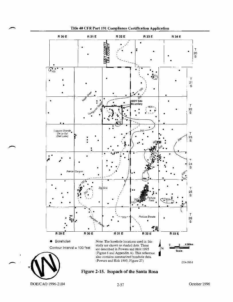
m Title 40 CFR Part 191 Compliance Certification Application
iaguoa Giande3 De La Sal [Salt LskeJ
0 Boreholes Note: The borehole locations used in this study we shown as shaded dots. These (1 2 4 Miles
Contour lnterva' = loo feet are described in Powers and Holt 1995 (Figure 6 and Appendix A). This reference
I N T z F also contains summarized borehole data. (Powers and Holt 1995, Figure 27) - CCA-033-2
Figure 2-15. Isopach of the Santa Rosa
October 1996

Title 40 CFR Part 191 Compliance Certif~cation Application T
THIS PAGE INTENTIONALLY LEFT BLANK
October 1996

Title 40 CFR Part 191 Compliance Certif~cation Application
The Santa Rosa and younger rocks are modeled in the WIPP performance assessment as a single region as discussed in Section 6.4.6.7. The model parameters for this supra-Dewey Lake region are given in Table 6-24.
2.1.3.8 The Ga-
Lang (in Robinson and Lang 1938,84) named the Gatuiia for outcrops in the vicinity of Gatuiia Canyon in the Clayton Basin. Rocks now attributed to the Gatuiia in Pierce Canyon were once included in the Pierce Canyon Formation with rocks now assigned to the Dewey Lake. The formation has been mapped from the Santa Rosa, New Mexico, area south to the vicinity of Pecos, Texas. It is unconformable with underlying units.
Vine in 1963 and Bachman in 1974 provided some limited description of the Gatuiia. The most comprehensive study of the Gatuiia is based on WIPP investigations and landfill studies for the City of Carlsbad and Eddy County (Powers and Holt 1993). Much of the formation is colored light reddish-brown. It is broadly similar to the Dewey Lake and the Santa Rosa, though the older units have more intense hues. The formation is highly variable, ranging from coarse conglomerates to claystones with some highly gypsiferous sections. Sedimentruy structures are abundant. Analysis of lithofacies indicates that the formation is dominantly fluvial in origin with areas of low-energy deposits and evaporitic minerals.
The thickness of the Gatuiia is not very consistent regionally, as shown in Figure 2-16. Thicknesses range up to about 300 feet (91 meters) at Pierce Canyon, with thicker areas generally subparallel to the Pecos River. To the east, the Gatufia is thin or absent. Holt and Powers in (1990a) reported about 9 feet (2.7 meters) of undisturbed Gatuiia in the AIS at WIPP.
The Gatufia has been considered Pleistocene in age based on a volcanic glass in the Upper Gatuiia along the eastern margin of Nash Draw that has been identified as the Lava Creek B ash, dated at 0.6 million years by Jzett and Wilcox (1982). This upper-limit age is corroborated by the age determinations from the Mescalero caliche (hereafter referred to as the Mescalero) that overlies the Gatuiia (see Section 2.1.3.9). An additional volcanic ash from the Gatuiia in Texas yields consistent K-Ar and geochemical data, indicating that it is about 13 million years old at that location (Powers and Holt 1993,271). Thus, the Gatuiia ranges in age over a period of time that may be greater than that spanned by the Ogallala Formation (hereafter referred to as the Ogallala) on the High Plains east of WIPP.
2.1.3.9 Mescalero Caliche
The Mescalero caliche is an informal stratigraphic unit apparently first differentiated by Bachman in 1974, though Bachman (1973, 17.27) described the caliche on the Mescalero Plain. He differentiated the Mescalero from the older, widespread Ogallala caliche or caprock on the basis of textures, noting that breccia and pisolitic textures are much more common in the Ogallala caliche. The Mescalero has been noted over significant areas in the Pecos
DOUCAO 1996-2 184 2-59 October 1996

, including the WIPP area, and it has been formed over a variety of substrates. ~achman (1973) described the Mescalero as a two-part unit: (1) an upper dense laminar caprock and (2) a basal, earthy-to-firm, nodular calcareous deposit. Machette (1985,5) classified the Mescalero as having Stage V morphologies of a calcic soil (the more mature Ogallala caprock that occurs east of the WIPP site reaches Stage VI).
Bachman (1976, Figure 8) provided structure contours on the Mescalero caliche for a large area of southeastern New Mexico, including the WIPP site. From the contours and Bachman's discussion of the Mescalero as a soil, it is clear that the Mescalero is expected to be continuous over large areas. Explicit WIPP data are limited mainly to boreholes, though some borehole reports do not mention the Mescalero. The unit may be as much as 10 feet (3 meters) thick.
The Mescalero overlies the Gatufia and was interpreted by Bachman (1976) on basic stratigraphic grounds as having accumulated during the early-to-middle Pleistocene. Samples of the Mescalero from the vicinity of the WIPP were studied using uranium-trend methods. Based on early written communication from Rosholt, Bachman (1985,20) reports that the basal Mescalero began to form about 5 10,000 years ago and the upper part began to form about 410,000 years ago; these ages are commonly cited in WIPP literature. The samples are interpreted by Rosholt and McKinney (1980, Table 5) in the formal report as indicating ages of 570,000 -c 110,000 years for the lower part of the Mescalero and 420,000 + 60,000 years
A for the upper part.
According to Bachman (1985, 19), where the Mescalero is flat-lying and not breached by erosion, it is an indicator of stability or integrity of the land surface over the last 500,000 years. An additional discussion of the Mescalero caliche can be found in Appendix GCR (Section 4.2.2).
Soils of the region have developed mainly from Quaternary and Permian parent material. Parent material from the Quaternary System is represented by alluvial deposits of major streams, dune sand, and other surface deposits. These are mostly loamy and sandy sediments containing some coarse fragments. Parent material from the Permian System is represented by limestone, dolomite, and gypsum bedrock. Soils of the region have developed in a semiarid, continental climate with abundant sunshine, low relative humidity, erratic and low rainfall, and a wide variation in daily and seasonal temperatures. Subsoil colors are normally light brown to reddish brown but are often mixed with lime accumulations (caliche) that result from limited, erratic rainfall and insufficient leaching.
A soil association is a landscape with a distinctive pattern of soil types (series). It normally consists of one or more major soils and at least one minor soil. There are three soil associations within 5 miles (8.3 kilometers) of the WIPP site: the Kermit-Berino, the Simona- Pajarito, and the Pyote-Maljamar-Kermit. Of these three associations, only the Kermit-Berino
October 1996 2-60 DOWCAO 1996-2184

Title 40 CFR Part 191 Compliance Certifmtion Application
Modified from Mercer, J. W., 1983, Figure l a
o Test Hole for Oil and Gas
Test Hole for Basic Data or Potash IN -- 2 4
Miles Contour lntewal= 25 feet
CCM71-2
Figure 2-16. Isopach of the Gatuiia
October 1996

Title PO CFR Part 191 Compliance Certilication Application
THIS PAGE INTENTIONALLY LEFT BLANK
October 1996 DOUCAO 199621 84

Title 40 CFR Part 191 Compliance Certif~cation Application C
1 soil series has been mapped across the WIPP site by Chugg et al. (1952, Sheet No. 113). 2 These are sandy soils developed on eolian material. The Kermit-Berino soils include active 3 dune areas. The Berino soil has a sandy A horizon; the B horizons include more argillaceous 4 material and weak-to-moderate soil structures. A and B horizons are described as 5 noncalcareous, and the underlying C horizon is commonly caliche. Bachman (1980,44) 6 interpreted the Berino soil as a paleosol that is a remnant B horizon of the underlying - -
~esEalero. Rosholt and ~ c ~ i n n e ~ (1980, Table 5) applied uranium-trend methods to samples of the Berino soil from the WIPP site area. They interpreted the age of formation of the Berino soil as 330,000 + 75,000 years.
Generally, the Berino Series, which covers about 50 percent of the site, consists of deep, noncalcareous, yellow-red to red sandy soils that developed from wind-worked material of mixed origin. These soils are described as undulating to hummocky and gently sloping (0 to 3 percent slopes). The soils are the most extensive of the deep, sandy soils in the Eddy County area. Berino soils are subject to continuing wind and water erosion. If the vegetative cover is seriously depleted, the water-erosion potential is slight, but the wind-erosion potential is very high. These soils are particularly sensitive to wind erosion in the months of March, April, and May, when rainfall is minimal and winds are highest. These soil characteristics are a consideration for the design of long-term passive controls such as monuments and markers (see Appendix PIC, Section IU).
The Kermit Series consists of deep, light-colored, noncalcareous, excessively drained loose sands, typically yellowish-red fine sand. The surface is undulating to billowy (from 0 to 3 percent slopes) and consists mostly of stabilized sand dunes. Kermit soils are slightly to moderately eroded. Permeability is very high, and, if vegetative cover is removed, the water- erosion potential is slight, but the wind-erosion potential is very high.
Surface soils appear to play a role in the infiltration of precipitation. Mercer (Appendix HYDRO) points out that where surface deposits are thickest, they may contain localized -'--.-:".,, urn
perched zones of groundwater. A more &rough discussion of this tipic can be found in Appendix HYDRO.
2.1.3.11 Z ~ ~ Q U L Y
The stratigraphy and lithology at the WIPP site has been summarized from the lowermost Cambrian units to the surface soils. While these are important for an understanding of the - and its stability, not all of these units are important to the performance of the disposal system. As a result, the DOE has developed a conceptual model that describes the lithology as thirteen discrete model regions ranging from the Castile to a region that generally includes units above the Dewey Lake. In this model, emphasis is placed on the Castile, the Salado, the five members of the Rustler, the Dewey Lake, and the supra-Dewey Lake units. The Salado is divided into five stratigraphic units to capture the variations in properties near the horizon of the repository (see Section 6.4.2.1). The identification and definition of the appropriate
DOWCAO 1996-2184 2-63 October 1996

Title 40 CFR Part 191 Compliance Certif~eation Application -.
modeling units is based on the identification of FEPs that can impact the performance of the disposal system. Details of the conceptual model can be found in Section 6.4.2.
2.1.4 Physiography and Geomorpholoa
In thls section, the DOE presents a discussion of the physiography and geomorphology of the WIPP site and surrounding area. This information is taken from DOE 1980 (7-21 to 7-23). Geomorphology and physiography are determined by the DOE to be features that are potentially important to disposal system performance. They are included in the consequence analysis through consideration of the topography and its influence on the regional water table. (See discussion of regional water table characteristics in Section 2.2.1.) Consequently, topographic information is presented in this section. In addition, several geomorphological processes have been screened out on the basis of either low consequence or low probability, as discussed in Appendix SCR. These include weathering, erosion, sedimentation, and soil development. Information is presented in this section to support this screening. In order to perform this screening, such factors as slopes, proximity to watercourses, dissection, and historic and existing processes are important. These are presented in this section in terms of the regional and local physiographic and geomorphological characteristics. Tectonic processes that may alter the physiography of the region or site area are discussed in Section 2.1.5. In addition. Section 2.1.6 presents more specific details on nontectonic processes identified during site characterization as having the potential for affecting the repository over the longer term and as requiring detailed investigation. These include halite deformation and dissolution.
2.1.4.1 m o n a l Phvsi~pra~hv and Geo
The WIPP site is in the Pecos Vallev section of the southern Great Plains ~ h v s i o ~ r a ~ h i c . . . , &
province (Figure 2-17), a broad, highland belt sloping gently eastward from the Rocky Mountains and the Basin and Range Province to the Central Lowlands hovince. The Pecos Valley section itself is dominatedby the Pecos River Valley, a long north-south trough that is from 5 to 30 miles (8.3 to 50 kilometers) wide and as much as 1,000 feet (305 meters) deep in the north. The Pecos River System has evolved from the south, cutting headward through the Ogallala sediments and becoming entrenched some time after the Middle Pleistocene. It receives almost all the surface and subsurface drainage of the region; most of its tributaries are intermittent because of the semiarid climate. The surface locally has a karst terrain containing sinkholes, dolines, and solution-subsidence troughs from both surface erosion and subsurface dissolution. The valley has an uneven rock- and alluvium-covered floor with widespread solution-subsidence features, the result of dissolution in the underlying Upper Permian rocks. - - - The terrain varies from plains and lowlands to rugged canyonlands, and contains such erosional features as scarps, cuestas, terraces, and mesas. The surface slopes gently eastward, reflecting the underlying&k strata. Elevations vary from more than 6,000 feet (1.829 meters) in the northwest to about 2,000 feet (610 meters) in the south.
October 1996 i 2-64 h
DOWCAO 1996-2184

r" Title 40 CFR Part 191 Compliance Certification Application
Figure 2-17. Physiographic Provinces and Sections
2-65 October 1996

Title 40 CFR Part 191 Compliance Certif~cation Application
THIS PAGE INTENTIONALLY LEFT BLANK
October 1996 DOEKAO 1996-21 84

Title 40 CFR Part 191 Compliance Certification Application - The Pecos Valley section is bordered on the east by the virtually uneroded plain of the Llano Estacado. The Llano Estacado is part of the High Plains section of the Great Plains physiographic province and is a poorly drained eastward-sloping surface covered by gravels, wind-blown sand, and caliche that has developed since early-to-middle Pleistocene time. Few and minor topographic features are present in the High Plains section, formed when more than 500 feet (152 meters) of Tertiary silts, gravels, and sands were laid down in alluvial fans by streams draining the Rocky Mountains. In many areas, the nearly flat surface is cemented by a hard caliche layer.
To the west of the Pecos Valley section are the Sacramento Mountains and the Guadalupe Mountains, part of the Sacramento section of the Basin and Range Province. The Capitan
, escarpment along the southeastern side of the Guadalupe Mountains marks the boundary between the Basin and Range and the Great Plains provinces. The Sacramento section has large basinal areas and a series of intervening mountain ranges (DOE 1980).
2.1.4.2 Site P h y s w p h v and Geomorph-
The land surface in the area of the WIPP site is a semiarid, wind-blown plain sloping gently to the west and southwest, and is hummocky with sand ridges and dunes. A hard caliche layer (Mescalero rocks) is typically present beneath the sand blanket and on the surface of the - underlying Gatuiia. Figure 2-18 is a topographic map of the area. Detailed topographic maps are attached at the end of this volume. Elevations at the site range from 3,570 feet (1,088 meters) in the east to 3,250 feet (990 meters) in the west. The average east-to-west slope is 50 feet per mile (9.4 meters per kilometer).
Livingston Ridge is the most prominent physiographic feature near the site. It is a west-facing escarpment that has about 75 feet (23 meters) of topographic relief and marks the eastern edge of Nash Draw, the drainage course nearest to the site (see Figure 2-1). Nash Draw is a shallow 5-mile-wide (8-kilometer-wide) basin, 200 to 300 feet (61 to 91 meters) deep and open to the southwest. It was caused, at least in part, by subsurface dissolution and the accompanying subsidence of overlying sediments. Livingston Ridge is the approximate boundary between terrain that has undergone erosion and/or solution collapse to the west and terrain that has been little affected to the east.
About 15 miles (24 kilometers) east of the site is the southeast-trending San Simon Swale, a depression caused, at least in part, by subsurface dissolution. Between San Simon Swale and the site is a broad, low mesa named the Divide. Lying about 6 miles (9.7 kilometers) east of the site and about 100 feet (30 meters) above the surrounding terrain, it is a boundary between southwest drainage toward Nash Draw and southeast drainage toward San Simon Swale. The - - Divide is capped by the Ogallala and the overlying caliche, upon which have formed small, elongated depressions similar to those in the adjacent High Plains section to the east.
Surface drainage is intermittent; the nearest perennial stream is the Pecos River, 12 miles (19 kilometers) southwest of the WIPP site boundary. The site's location near a natural divide
DOWCAO 1996-2 184 2-67 October 1996

Title 40 CFR Part 191 Compliance Certif~cation Application A
protects it from flooding and serious erosion caused by heavy runoff. Should the climate become more humid, any perennial streams should follow the present basins, and Nash Draw and San Simon Swale would be the most eroded, leaving the area of the Divide relatively intact.
2.1.5 Tectonic Setting and Site Structural Features
The DOE has screened out, on the basis of either probability or consequence or both, all tectonic, magmatic, and structural related processes. The screening discussions can be found in Appendix SCR. The information needed for this screening is included here and covers regional tectonic processes such as subsidence and uplift and basin tilting, magmatic processes such as igneous intrusion and events such as volcanism, and structural processes such as faulting and loading and unloading of the rocks because of long-term sedimentation 01
erosion. Discussions of structural events, such as earthquakes, are considered to the extent that they may create new faults or activate old faults. The seismicity of the area is considered in Section 2.6 for the purposes of determining seismic design parameters for the facility.
2.1.5.1 Tectonics
The processes and features included in this section are those more traditionally considered part of tectonics, processes that develop the broad-scale features of the earth. Salt dissolution
-,
is a different process that can develop some features resembling those of tectonics.
Most broad-scale structural elements of the area around the WIPP developed during the Late Paleozoic (Appendix GCR, 3-58 to 3-77). There is little historical or geological evidence of significant tectonic activity in the vicinity, and the level of stress in the region is low. The entire region tilted slightly during the Tertiary, and activity related to Basin and Range tectonics formed major structures southwest of the area. Seismic activity is specifically addressed in a separate section.
Broad subsidence began in the area as early as the Ordovician, developing a sag called the Tobosa Basin. By Late Pennsylvanian to Early Permian time, the Central Basin Platform developed (Figure 2-19), separating the Tobosa Basin into two parts: the Delaware Basin to the west and the Midland Basin to the east. The Permian Basin refers to the collective set of depositional basins in the area during the Permian Period. Southwest of the Delaware Basin, the Diablo Platform began developing either in the Late Pennsylvanian or Early Permian. The Marathon Uplift and Ouachita tectonic belt limited the southern extent of the Delaware Basin.
According to Brokaw et al. (1972,30), pre-Ochoan sedimentary rocks in the Delaware Basin show evidence of gentle downwarping during deposition, while Ochoan and younger rocks do not. A relatively uniform eastward tilt, generally from about 75 to 100 feet per mile (14 to
October

Contour Interval = 100 feet Note: Full size map of this figure is in a pocket at the end of this volume. CCA-083~2
Figure 2-18. Topographic Map of Area Around the WIPP Site

Title 40 CFR Part 191 Compliance Certification Application I
THIS PAGE INTENTIONALLY LEFT BLANK
October 1996 DOUCAO 1996-2 184

m Title 40 CFR Part 191 Compliance Certification Application
Figure 2-19. Structural Provinces of the Permian Basin Region
October 1996

Title 40 CFR Part 191 Compliance Certification Application T
THIS PAGE INTENTIONALLY LEFT BLANK
October 1996

Title 40 CFR Part 191 Compliance Certif~cation Application
19 meters per kilometer), has been superimposed on the sedimentary sequence.' P.B. King (1948, 108 and 121) generally attributes the uplift of the Guadalupe and Delaware mountains along the west side of the Delaware Basin to the later Cenozoic, though he also notes that some faults along the west margin of the Guadalupe Mountains have displaced Quaternary gravels.
P.B. King (1948, 144) also infers the uplift from the Pliocene-age deposits of the Llano Estacado. Subsequent studies of the Ogallala of the Llano Estacado show that it varies in age from Miocene (about 12 milIion years before present) to Pliocene (Hawley 1993). This is the most likely range for uplift of the Guadalupe Mountains and broad tilting to the east of the Delaware Basin sequence.
Analysis of the present regional stress field indicates that the Delaware Basin lies within the Southern Great Plains stress province. This province is a transition zone between the extensional stress regime to the west and the region of compressive stress to the east. An interpretation by Zoback and Zoback (1991,350) of the available data indicates that the level of stress in the Southern Great Plains stress province is low. Changes to the tectonic setting, such as the development of subduction zones and a consequent change in the driving forces, would take much longer than 10,000 years to occur.
To the west of the Southern Great Plains province is the Basin and Range province, or Cordilleran Extension province, where according to Zoback and Zoback (1991,348 - 351) normal faulting is the characteristic style of deformation. The eastern boundary of the Basin and Range province is marked by the Rio Grande Rift. Sanford et al. (1991,230) note that, as a geological structure, the Rift extends beyond the relatively narrow geomorphological feature seen at the surface, with a magnetic anomaly at least 300 miles (500 kilometers) wide. On this basis, the Rio Grande Rift can be regarded as a system of axial grabens along a major north-south trending structural uplift (a continuation of the Southern Rocky Mountains). The magnetic anomaly extends beneath the Southern Great Plains stress province, and regional- scale uplift of about 3,300 feet (1,000 meters) over the past 10 million years also extends into eastern New Mexico.
To the east of the Southern Great Plains province is the large Mid-Plate province that encompasses central and eastern regions of the conterminous United States and the Atlantic basin west of the Mid-Atlantic Ridge. The Mid-Plate province is characterized by low levels of paleo- and historic seismicity. Where Quaternary faulting has occurred, it is generally strike-slip and appears to be associated with the reactivation of older structural elements.
Zoback et al. (1991) report no stress measurements from the Delaware Basin. The stress field in the Southern Great Plains stress province has been defined from borehole measurements in west Texas and from volcanic lineaments in northern New Mexico. These measurements
' Local dip of the Salado has been determined by mapping in the WIPP underground excavations. This dip is modeled as one degree to the south as discussed in Section 6.4.2.1.
DOWCAO 1996-2184 2-73 October 1996

Title 40 CFR Part 191 Compliance Certification Application - .
were interpreted by Zoback and Zoback (1991,353) to indicate that the least principal horizontal stress is oriented north-northeast and south-southwest and that most of the province is characterized by an extensional stress regime.
There is an abrupt change between the orientation of the least principal horizontal stress in the Southern Great Plains and the west-northwest orientation of the least principal horizontal stress characteristic of the Rio Grande Rift. In addition to the geologi&J inkcations of a transition zone as described above, Zoback and Zoback (1980,6134) point out that there is also evidence for a sharp boundary between these two provinces. This is reinforced by the change in crustal thickness from about 24 miles (40 kilometers) beneath the Colorado Plateau to about 30 miles (50 kilometers) or more beneath the Southern Great Plains east of the Rio Grande Rift. The base of the crust within the Rio Grande Rift is poorly defined but is shallower than that of the Colorado Plateau (Thompson and Zoback 1979, 152). There is also markedly lower heat flow in the Southern Great Plains (typically < 60 mWm.') reported by Blackwell et al. (1991,428) compared with that in the Rio Grande Rift (typically > 80 mWm'2) reported by Reiter et al. (1991,463).
On the eastern boundary of the Southern Great Plains province, there is only a small rotation in the direction of the least principal horizontal stress. There is, however, a change from an extensional, normal faulting regime to a compressive, strike-slip faulting regime in the Mid- Plate province. According to Zoback and Zoback (1980,6134). the available data indicate that this change is not abrupt and that the Southern Great Plains province can be viewed as a marginal part of the Mid-Plate province.
2.1.5.2 Loading and Unloading
Loading and unloading during the geological history since deposition is considered an influence on the hydrology of the Permian units because of its possible effect on the development of fractures.
The sedimentary loading, depth of total burial, and erosion events combine in a complex history reconstructed here from regional geological trends and local data. The history is presented in Figure 2-20 with several alternatives, depending on the inferences that are drawn, ranging from minimal to upper-bound estimates (Powers and Holt 1995, Section 5.3). Borns (1987) also made a generalized estimate of loading that is similar. The estimates are made with a reference point and depth to the Culebra at the AIS.
Given the maximum local thickness of the Dewey Lake, the maximum load at the end of the Permian was no more than approximately 787 feet (240 meters). Given the present depth to the Culebra from the top of the Dewey Lake in the AIS, approximately 115 feet (35 meters) of Dewey Lake might have been eroded during the Early Triassic before additional sediments were deposited. The Triassic thickness at the AIS is approximately 26 feet (8 meters). Northeast of the WIPP site (T21S. R33E), Triassic rocks (Dockum Group) have a maximum local thickness of approximately 1,233 feet (373 meters). This thickness is a reasonable
October 1996 2-74 DOWCAO 1996-2184

.- Title 40 CFR Part 191 Compliance Certification Application
estimate of the maximum thickness also attained at the WIPP site prior to the Jurassic Period. At the end of the Triassic, the total thickness at the WIPP site may have then attained approximately 1,863 feet (586 meters) in two similar loading stages of a few million years each, over a period of approximately 50 million years.
The Jurassic outcrops nearest to the WIPP site are in the Malone Mountains of west Texas. There is no evidence that Jurassic rocks were deposited at or in the vicinity of the WIPP site. As a consequence, the Jurassic is considered a time of erosion or nondeposition at the site, though erosion is most likely.
Widespread erosion during the Jurassic obviously cannot be broadly inferred for the area or there would not be thick Triassic rocks still preserved. Triassic rocks of this thickness are preserved nearby, indicating either preJurassic tilting or that erosion did not occur until later (but still after tilting to preserve the Triassic rocks near the WIPP site). It is also possible that the immediate site area had little Triassic deposition or erosion, but very limited Triassic deposition (that is, 26 feet [8 meters]) at the WIPP site seems unlikely.
Lang (1947) reported fossils from Lower Cretaceous rocks in the Black River Valley southwest of the WIPP site. Bachman (1980.28) also reported similar patches of probable Cretaceous rocks near Carlsbad and south of White's City. From these reports, it is likely that some Cretaceous rocks were deposited at the WIPP site. Approximately 70 miles (1 10 kilometers) south-southwest of the WIPP site, significant Cretaceous outcrops of both Early and Late Cretaceous age have a total maximum thickness of approximately 1,000 feet (300 meters). Southeast of the WIPP, the nearest Cretaceous outcrops are thinner and represent only the Lower Cretaceous. Based on outcrops, a maximum thickness of 1,000 feet (300 meters) of Cretaceous rocks could be estimated for the WIPP site. Compared to the estimate of Triassic rock thickness, it is less likely that Cretaceous rocks were this thick at the site. The uppermost lines of Figure 2-20 summarize the assumptions of maximum thickness of these units.
A more likely alternative is that virtually no Cretaceous rocks were deposited, followed by erosion of remaining Triassic rocks during the Late Cretaceous to the Late Cenozoic. Such erosion may also have taken place over an even longer period, beginning with the Jurassic Period. Ewing (1993) favors Early Cretaceous uplift and erosion for the Trans-Pecos Texas area, but he does not analyze later uplift and erosional patterns.
In the general vicinitv of the WIPP site. there are outcrovs of Cenozoic rock from the Late - Miocene (Gatuiia and Ogallala Formations). There is little reason to infer any significant Early Cenozoic sediment accumulation at the WIPP site. Erosion is the main process inferred to have occurred during this period and an average erosion rate of approximately 10 meters per million years is sufficient during the Cenozoic to erode the maximum inferred Triassic &d cretaceous thickness prior to ~atuf ia and Ogallala deposition. Significant thicknesses of Cretaceous rocks may not have been deposited, however, and average erosion rates could have been lower.
DOWCAO 19962184 2-75 October 1996

Title 40 CFR Part 191 Compliance Certif~cation Application - Maximum-known Gatuiia thickness in the area around the WIPP is approximately 330 feet (100 meters); at the WIPP site the Gatuiia is very thin to absent. Ogallala deposits are known from the Divide east of the WIPP site, as well as from the High Plains further east and north. On the High Plains northeast of the WIPP, the upper Ogallala surface slopes to the southeast at a rate of approximately 20 feet per mile (4 meters per kilometer). A straight projection of the 4,100-foot (1,250-meter) contour line from this High Plains surface intersects the site area, which is at an elevation slightly above 3,400 feet (1,036 meters). This difference in elevation of 700 feet (213 meters) represents one estimate, probably near an upper bound, of possible unloading subsequent to deposition of the Ogallala Formation.
Alternatively, the loading and unloading of the Ogallala could have been closer to 330 feet (100 meters). In any case, it would have occurred as a short-lived pulse over a few million years at most.
While the above inferences about greater unit thicknesses and probable occurrence are permissible, a realistic assessment suggests a more modest loading and unloading history (Powers and Holt 1995). It is likely that the Dewey Lake accumulated to near local maximum thickness of approximately 787 feet (240 meters) before being slightly eroded prior to the deposition of Triassic rocks. It also is most probable that the Triassic rocks accumulated at the site to near local maximum thickness. In two similar cycles of rapid loading, the Culebra was buried to a depth of approximately 2,132 feet (650 meters) by the end of the Triassic. - It also seems unlikely that a significant thickness of Cretaceous rock accumulated at the WIPP site. Erosion probably began during the Jurassic, slowed or stopped during the Early Cretaceous as the area was nearer or at base level, and then accelerated during the Cenozoic, especially in response to uplift as Basin and Range tectonics encroached on the area and the basin was tilted more. Erosional beveling of Dewey Lake and Santa Rosa suggest considerable erosion since tilting in the mid-Cenozoic. Erosion rates for this shorter period could have been relatively high, resulting in the greatest stress relief on the Culebra and surrounding units. Some filling occurred during the Late Cenozoic as the uplifted areas to the west formed an apron of Ogallala sediment across much of the area, but it is not clear how much Gatuiia or Ogallala sediment was deposited in the site area. From general reconstruction of Gatufia history in the area (Powers and Holt 1993,281), the DOE infers that Gatuiia or Ogallala de~osits likelv were not much thicker at the WIPP site than thev are now. - The loading and unloading spike<~igure 2-20) representing Ogallala thickness probably did not occur. Cutting and headward erosion by the Pecos River has created local relief and - unloading by erosion.
At the WIPP site, this history is little complicated by dissolution, though locally (for example, Nash Draw) the effects of erosion and dissolution are more significant. The underlying evaporites have responded to foundering of anhydrite in less dense halite beds. These have caused local uplift of the Culebra (as at ERDA 6) but little change in the overburden at the WIPP. Areas east of the WLPP site are likely to have histories similar to that of the site. West -
October 1996 2-76 DOWCAO 1996-2184

Title 40 CFR Part 191 Compliance Certif~cation Application
Permian / Triassic (Ti)\ Jurassic (J) I Cretaceous (K) I Cenozoic
Max. K Thickness 1300 m) 7O+ mi
1.' Max. Local 6
60 m TO^ of Rustler
250 200 150 100 SO 0
Million Years (my) before present (Reference point is AIS)
Note: The estimates are made witb a reference point and depth to the base of the Culebra at the AIS. Source: Powers and Holt 1995, Figure 34.
A
Figure 2-20. Loading and Unloading History Estimated to the Base of the Culebra
DOEtCAO 1996-2 184 2-77 October 19%

Title 40 CFR Part 191 Compliance Certif~eation Application - THIS PAGE INTENTIONALLY LEFT BLANK
October 1996 DOEJCAO 1996-2184

Title 40 CFR Part 191 Compliance Certification Application - of the site, the final unloading is more complicated by dissolution and additional erosion leading to exposure of the Culebra along stretches of the Pecos River Valley.
Fault zones are well known along the Central Basin Platform, east of WIPP, from extensive drilling for oil and gas, as reported by Hills (1984). Holt and Powers performed a more recent analysis in 1988 (Appendix FAC, 4-14) of geophysical logs from oil and gas welIs to examine the regional geology for the Rustler. This analysis showed that faults along the margin of the Central Basin Platform displaced Rustler rocks of at least Late Permian age. The overlying Dewey Lake shows marked thinning along the same trend, according to Schiel(1988, Figure 21), but the structure contours of the top of the Dewey Lake are not clearly offset. Schiel concluded that the fault was probably reactivated during the Dewey Lake's deposition, but movement ceased at least by the time the Santa Rosa was deposited. No surface displacement or fault has been reported along this trend.
Muehlberger et al. (1978) have mapped Quatemary fault scarps along the Salt Basin graben west of both the Guadalupe and Delaware mountains. These are the nearest known Quaternary faults of tectonic origin to the W W . Kelley in 1971 inferred the Carlsbad and Barrera faults along the eastern escarpment of the Guadalupe Mountains based mainly on vegetative lineaments. Hayes and Bachman reexamined the field evidence for these faults in 1979 and concluded that they were nonexistent. Figure 2-21 illustrates major regional structures, including faults.
On a national basis, Howard et al. (1971, sheets 1 and 2) assessed the location and potential for activity of young faults. For the region around the WIPP site, Howard et al. (1971, sheet 1) located faults along the western escarpment of the Delaware and Guadalupe mountain trend. These faults were judged to be Late Quaternary (approximately the last 500,000 years) or older.
In summary, there are no known Quatemary or Holocene faults of tectonic origin that offset rocks at the surface nearer to the site than the western escarpment of the Guadalupe Mountains. A significant part of the tilt of basin rocks is attributed to a mid-Miocene to Pliocene uplift trend along the Guadalupe-Sacramento Mountains that is inferred on the basis of High Plains sediments of the Ogallala.
Within the Delaware Basin, only one feature of igneous origin is known to have formed since the Precambrian. An igneous lamprophyre dike or series of dikes occurs along a linear trace about 75 miles (120 kilometers) long from the Yeso Hills south of White's City to the northeast of the WIPP site (Elliot Geophysical Company 1976). At its closest, the dike trend passes about 8 miles (13 kilometers) northwest of the WIPP site center, as shown in
DOEICAO 1996-2 184 2-79 October 1996

Figure 2-22. Evidence for the extent of the dike includes outcroppings at Yeso Hills, subsurface intercepts in boreholes and mines, and airborne magnetic responses.
An early radiometric determination for the dike by Urry (1936) yielded an age of 30 a 1.5 million years. More recent work on dike samples by Calzia and Hiss (1978) is consistent with early work, indicating an age of 34.8 a 0.8 million years.2 Work by Brookins (1980) on polyhalite samples in contact with the dike indicated an age of about 21.4 million years.
Volcanic ashes found in the Gatufia (Section 2.1.3.8) were airborne from distant sources and do not represent volcanic activity at the WIPP site.
2.1.6 Nontectonic Processes and Features
Nontectonic processes and features, which include evaporite deformation and dissolution of strata, are known to be active in the Delaware Basin. These processes are of interest because they represent mechanisms that are potentially disruptive to the repository in the long term. Both processes have been investigated extensively. The conclusions from these investigations are summarized in this section.
Halite in evaporite sequences is relatively plastic, which can lead to the process of deformation; it is also highly soluble, whlch can lead to the process of dissolution. Both processes (deformation and dissolution) can produce structural features similar to those e produced by tectonic processes. The features developed by dissolution and deformation can be distinguished from similar-loolung tectonic features where the underlying units do not reflect the same feature as do the evaporites. As an example, the evaporite deformation commonly does not affect the underlying Bell Canyon. Beds underlying areas of dissolved salt are not affected, but overlying units to the surface may be affected. The deformation in the Castile and Salado also tends to die out in overlying units, and the Rustler or the Dewey Lake may show little, if any, effects from deformed evaporites.
The most recent review of evaporite deformation in the northern Delaware Basin and original work to evaluate deformation is summarized here. More detail is provided in Appendix DEF.
2.1.6.1.1 B as~c ' WIPP Histon ofDefomation Invesri~ations
The Castile has been known for many years to be deformed in parts of the Delaware Basin, especially along the northern margin. Jones et al. in 1973 clearly showed the Castile to be thicker from the northwestern to northern part of the basin margin, just inside the Capitan reef (hereafter referred to as the Capitan). A dissertation by Snider (1966, Figures 11 and 14)
.?
' Calzia and Hiss (1978,44) reported 32.2 to 33.9 million years. However, Powers et al. 1978 (Appendix GCR, 3-80) reported a recalculated value of 34.8 2 0.8 million years based on a change in measured decay constant.
October 1996 2-80 DOEICAO 1996-21 84

Title 40 CFR Part 191 Compliance Certification Application -
0 25 50 75 100 Mdes
--- ...... Fault, type unspecified: dashed + AXIS of major synciine 0 50 100 150Km where inferred, doned where concealed - ---- Normal fault e Dome - Thrust fault; saw t w t h on upthrown s~de. Boundaries of major structural dashed where inferred, dotted where elements (from Oriel et al.. 1967) concealed
Elongate, closely compressed anticline; Jifl vadth suggest he~ght, steepness, or slze Ouachita tectonic belt of fold
-+ Axis of major anticline
Figure 2-21. Regional Structures
Octobrr 1996
Title 40 CFR Part 191 Compliaace Certif~cation Application - THIS PAGE INTENTIONALLY LEFT BLANK
October 1996 DOWCAO 19962184

-. Title 40 CFR Part 191 Compliance Certification Application
Source: Elliot i1976) CCA-076~2
Figure 2-22. Igneous Dike in the Vicinity of the WIPP Site
DOEICAO 1996-2184 2-83 October 1996

- Title 40 CFR Part 191 Compliance Cerlification Application
THIS PAGE INTENTIONALLY LEFT BLANK
October 1996
h Title 40 CFR Part 191 Compliance Certification Application
and a paper by Anderson et al. (1972, Figure 10) also presented maps showing some evidence of thicker sections of Castile next to the Capitan. ERDA-6 was drilled during 1975 as part of the program to characterize an initial site for WIPP. The borehole penetrated increasingly deformed beds through the Salado into the Castile, and, at 2,711 feet (826 meters) depth, the borehole began to produce pressurized brine and gas. Anderson and Powers (1978,79) and Jones (1981a) interpreted beds to have been displaced structurally by as much as 950 feet (289.5 meters). Some of the lower beds may have pierced overlying beds. The beds were considered too structurally deformed to mine reasonably along single horizons for a repository. Therefore, the site was abandoned in 1975, and the current site was located in 1976 (Appendix GCR). The deformed beds around ERDA-6 were considered part of a deformed zone within about 6 miles (10 kilometers) of the inner margin of the Capitan reef. As a consequence, the preliminary selection criteria were revised to prohibit locating a new site within 6 miles (10 kilometers) of the Capitan Reef margin.
General criteria for the present site for the WIPP appeared to be met based on initial data from drilling (ERDA-9) and geophysical surveys. Beginning in 1977, the new site was more intensively characterized through geophysical surveys, including seismic reflection and drilling. Extensive seismic reflection work revealed good reflector quality in the southern part of the site and poor-quality or disturbed reflectors in a sector of the northern part of the site (see Figure DEF-2.2 in Appendix DEF). The area of disturbed reflectors became known as the disturbed zone, the area of anomalous seismic reflectors, or the zone of anomalous seismic reflection data. (The disturbed zone based on poor Castile seismic reflectors is completely different from the DRZ that describes the deformation around mined underground openings at the WIPP.)
Powers et al., in Appendix GCR (Figures 4.4,4.5, and 4.6), generally shows the disturbed zone beginning about 1 mile (1.6 kilometers) north of the WIPP site center. Borns et al., in 1983, included two areas south of the WIPP site as showing the same features of the disturbed zone. Neil1 et al., also in 1983, summarized the limits of the disturbed zone based on differing interpretations and included the area less than 1 mile (1.6 kilometers) north of the site center, where the dip in the Castile begins to steepen. WIPP-11 was drilled in early 1978 about 3 miles (5 kilometers) north of the site center over part of the disturbed zone where proprietary petroleum company data had also indicated significant seismic anomalies. The borehole encountered highly deformed beds within the Castile and altered thicknesses of halite units, but no press&zed brine and gas were found.
Less than 1 mile (1.6 kilometers) north of the site center, seismic data indicated possible faulting of the upper Salado and the lower Rustler over the area of steepening Castile dips. Four boreholes (WIPP-18, -19, -21, -22) were drilled into the upper Salado and demonstrated neither faulting nor significant deformation of the Rustler-Salado contact. Lateral changes in the seismic velocity of the upper sections contributed to the interpretation of a possible fault and thus complicate interpretations of deeper structure.
October 1996

WIPP-12 was located about 1 mile (1.6 kilometers) north of the center of the site and drilled during 1978 to a depth of 2,785 feet (850 meters) in the upper Castile to determine the significance of structure on possible repository horizons. The top of the Castile was encountered at an elevation about 160 feet (49 meters) above the same contact in ERDA-9 at the site center.
WIPP-12 was deepened during late 1981 to a depth of 3,925 feet (1,200 meters) to test for possible brine and gas in the deformed Castile. The probability of encountering brine and gas was considered low because ERDA-6 and other known brine reservoirs in the Castile occurred in areas with greater deformation. During drilling, fractured anhydrite in the upper Castile (lower A3) began to yield pressurized brine and gas. The borehole was deepened to the basal anhydrite (Al) of the Castile. Subsequent reservoir testing (Popielak et al. 1983) was conducted to estimate reservoir properties (see Section 2.2.1.2.2 and Section 6.4.8).
As a consequence of discovering pressurized brine and gas in WIPP-12, the EEG recommended that the design of the facility be changed and that proposed waste disposal areas in the north be moved or reoriented to the south. After additional drilling of DOE- 1, the DOE concluded that the design change had advantages, and the disposal facilities were placed south of the site center.
A microgravity survey of the site was designed to delineate further the structure within the - disturbed zone, based on the large density differences between halite and anhydrite. The gravity survey was unsuccessful in yielding any improved resolution of the Castile structure.
DOE-2 was the last WIPP borehole to examine structure within the Castile. Potash drillhole data suggested a low point in Salado units about 2 miles (3.3 kilometers) north of the site center. It was proposed by Davies (1984, 175) that the Salado low might indicate deeper dissolution of Castile halite, somewhat similar to the dissolution causing breccia pipes (see Section 2.1.6.2 on evaporite dissolution). The borehole demonstrated considerable Castile deformation, but there was no indication that halite had been removed by dissolution (Mercer et al. 1987; Boms 1987).
2.1.6.1.2 Extent of the Disturbed Zone at the Site
Nearby surface drilling, shafts, and underground drilling during early excavations at WIPP showed that the repository horizon varies modestly from the regional structure over the central part of the site; north of the site center, the beds dip gently to the south. Boms in 1987 suggested that the south dip is probably related to the dip on the underlying Castile.
The upper surface of MB139, under the repository horizon, exhibited local relief in the exploratory salt-handling shaft. Jarolimek et al. (1983a. 4 - 6) interpreted the relief as mainly caused by syndepositional growth of gypsum at the water-sediment interface to form mounds and by subsequent partial crushing. Jarolimek et al. concluded that the MI3 relief was not caused by deformation because the base of the MB showed no comparable relief. Based on
October 1996 2-86 DOElCAO 1996-21 84

concerns of the EEG, MI3139 was reevaluated. Borns (1985) found less relief on the upper surface of the MB in the areas they examined; he also concluded that depositional processes were responsible for the relief. In both cases, deformation is not thought to have caused the relief on MB139.
2.1.6.1.3 Deformation Mechanism
In analyzing Castile structure in the northern Delaware Basin, Boms et al. (1983,3) proposed five processes as the principal hypotheses to explain the structure: gravity foundering, dissolution, gravity sliding, gypsum dehydration, and depositional processes. Gravity foundering is the most comprehensive and best-accepted hypothesis of the five. It is based on the fact that anhydrite is much more dense (about 2.9 grams per cubic centimeter) than halite (about 2.15 grams per cubic centimeter), and anhydrite beds therefore have a potential for sinking into underlying halite. Regardless of which mechanism caused the disturbed zone, the important consideration is the long-term future effects. To evaluate this, Boms et al. postulated that both gravity-driven deformation mechanisms could be ongoing. The strain rates from such deformation are such that deformation would progress over the next 250,000 years and that such deformation would not directly jeopardize the disposal system.
2.1.6.1.4 Timin~ o f Deformation of the Disturbed Zone at the Sire
Jones (1981a. 18) estimated that deformation of the Castile and overlying rocks took place before the Ogallala Formation was deposited, as he believes the unit is undeformed. Anderson and Powers (1978,79) inferred that data from ERDA-6 indicate that the Castile was deformed after the basin was tilted. Though these lines of evidence could be consistent with mid-Miocene deformation, there are other interpretations consistent with older deformation (Madsen and Raup 1988). There is no known evidence of surface deformation or other features to indicate recent deformation.
2.1.6.2' Eva~orite Dissolution
Because evaporites are much more soluble than most other rocks, project investigators have considered it important to understand the dissolution processes and rates that occur within the site being considered for long-term isolation. These dissolution processes and rates constitute the limiting factor in q y evaluation of the site. Over the course of the WIPP project, extensive resources have been committed to identify and study a variety of features in southeastern New Mexico interpreted to have been caused by dissolution. The subsurface distribution of halite for various units has been mapped. Several different kinds of surface features have been attributed to dissolution of salt or karst formation. The processes proposed or identified include point-source (brecciation), deep dissolution, shallow dissolution, and karst. These are each discussed in more detail in Appendix DEF (Section DEF.3). Screening arguments relative to dissolution are presented in Appendix SCR (including dissolution
DOWCAO 1996-2 184 October 1996

associated with abandoned boreholes in Sections SCR.1.2.1 and SCR.3.3.1). These arguments are based principally on the observed rates and processes in the region. These are described below.
2. I.6.2.I Brief Historv o f Project Studies
Well before the WIPP project, several geologists recognized that dissolution is an impottant process in southeastern New Mexico and that it contributed to the subsurface distribution of halite and to the surficial features. Early studies include those by Lee (1925). Maley and Hufington (1953), and Olive (1957) (in the Bibliography). Robinson and Lang (1938, 100) identified an area under Nash Draw where brine occurred at about the stratigraphic position of the umer Salad-basal Rustler and considered that salt had been dissolved to uroduce a .- dissolution residue. Vine (1963, B38 and B40) mapped Nash Draw and surrounding areas. Vine reported surficial domal structures, later called breccia pipes and identified as - - deep-seated dissolution and collapse features.
As the USGS and Oak Ridge National Laboratory (ORNL) began to survey southeastern New Mexico as an area in which to locate a repository site in salt, Brokaw et al. in 1972 prepared a summary of the geology that included solution and subsidence as significant processes in creating the features of southeastern New Mexico. Brokaw et al. also recognized a solution residue at the top of the salt in the Salado in the Nash Draw area, and the unit commonly - became known as the brine aquifer because it yielded brine. Brokaw et al. also interpreted the east-west decrease in thickness of the Rustler to be a consequence of removal by dissolution of halite and other soluble minerals.
During the early 1970s, the basic ideas about shallow dissolution of salt (generally from higher stratigraphic units and within a few hundred feet of the surface) were set out in a series of reports by Bachrnan, Jones, and collaborators, as discussed in the following sections. Piper (1973, 1974) independently evaluated the geological survey data for ORNL. Claiborne and Gera (1974) concluded that salt was being dissolved too slowly from the near-surface units to affect a repository for several million years, at least.
By 1978, shallower drilling around the WIPP site to evaluate potash resources was interpreted by Jones (1978,9), and he felt that the Rustler included "dissolution debris, convergence of beds, and structural evidence for subsidence." Halite in the Rustler has been reevaluated by the DOE, but there are only minor differences in inferred distributions among the various investigators. These investigators do have different explanations about how this distribution occurred (see Section 2.1.3.5 on Rustler stratigraphy): (1) through extensive dissolution of the Rustler's halite after the Rustler was deposited or (2) through syndepositional dissolution of halite from saline mud flat environments during Rustler deposition.
Anderson (1978) and Anderson et al. (1978) reevaluated halite distribution in deeper units, especially the Castile and Salado formations. He identified local anomalies proposed as features developed after deep dissolution of halite by water flowing upward from the
October 1996 2-88 DOEICAO 1996-21 84

underlying Bell Canyon. Anderson mapped geophysical log signatures of the Castile and interpreted lateral thinning and change from halite to non-halite lithology as evidence of lateral dissolution of deeper units (part of deep dissolution), and he proposed that deep dissolution might threaten the WIPP site. In response to Anderson's developing concepts, ERDA-10 was drilled south of the WIPP area during the latter part of 1977. ERDA-10 intercepted a stratigraphic sequence without evidence of solution residues in the upper Castile.
A set of annular or ring fractures is evident in the surface around San Simon Sink, about 18 miles (30 kilometers) east of the WIPP site. Nicholson and Clebsch (1961, 14) suggested that San Simon Sink developed as a result of deep-seated collapse. WIPP- 15 was drilled at about the center of the sink to a depth of 81 1 feet (245 meters) to obtain samples for paleoclimatic data and stratigraphic data to interpret collapse. Anderson (1978) and Bachman (1980) both interpret San Simon Sink as dissolution and collapse features, and the annular fractures are not considered evidence of tectonic activity.
Following the work by Anderson, Bachman (1980, 1981) mapped surficial features in the Pecos Valley, especially at Nash Draw, and differentiated between those surface features in the basin that were formed by karst and those that were formed by deep collapse features over the Capitan Reef. WIPP-32, WIPP-33, and two boreholes over the Capitan reef were eventually drilled. Their data, which demonstrated the concepts proposed by Bachman, are documented in Snyder and Gard (1982,65).
A final program concerning dissolution and karst was initiated following a microgravity survey of a portion of the site during 1980. Based on localized low-gravity anomalies, Barrows et al. in 1983 interpreted several areas within the site as locations of karst. WIPP-14 was drilled during 1981 at a low-gravity anomaly. It revealed normal stratigraphy through the zones proposed to be affected by karst. As a followup, in 1985 Bachman also reexamined surface features around the WIPP and concluded that there was no evidence for active karst within the WIPP site. The nearest karst feature is northwest of the site boundaries at WIPP-33.
2.1.6.2.2 Extent o f Dissolutioq
The margins of halite within the anhydrite and claystone members of the Rustler have been mapped by different methods, the findings of which were consolidated by Beauheim (in 1987a, 131 - 134). There are few differences in interpretation, despite the different methods used (Figure 2-10). Lower members of the Rustler are halitic west of the site, and higher members generally show halite only further east. Snyder interprets these margins as a consequence of post-depositional dissolution of halite. Holt and Powers (Appendix FAC, 6-29) report and interpret sedimentary structures within the Rustler mudstone equivalent to halite beds, indxating that most halite was removed during the depositional process and redeposited in a salt pan in the eastern part of the depositional basin.
DOWCAO 1996-21 84 October 1996

Title 40 CFR Part 191 Compliance Certification Application -.
Upper intervals of the Salado thin dramatically west and south of the WIPP site (Figure 2-23) compared to deeper Salado intervals. There are no cores for further consideration of possible depositional variations. As a consequence, this zone of thinning is interpreted by the DOE as the edge of dissolution of the upper Salado.
2.1.6.2.3 m i n P o f D issolution
The dissolution of Ochoan evaporites through the near-surface processes of weathering and groundwater recharge has been studied extensively (Anderson 198 1, Lambert 1983a. Lambert 1983b, Bachman 1984, and see also Appendix FAC). The work of Lambert (1983a) was specifically mandated by the agreement between the DOE and the state of New Mexico to evaluate in detail the conceptual models of evaporite dissolution proposed by Anderson (1981). There was no clear consensus among investigators on the volume of rock salt removed. Hence, estimates of the instantaneous rate of dissolution vary significantly. Dissolution may have taken place as early as the Ochoan, during or shortly after deposition. For the Delaware Basin as a whole, Anderson (1981) proposed that up to 40 percent of the rock salt in the Castile and Salado formations was dissolved during the past 600,000 years. Lambert (1983b, 292) suggested that in many places the variations in salt-bed thicknesses inferred from borehole geophysical logs that were the basis for Anderson's calculation were depositional in origin, compensated by thickening of adjacent nonhalite beds, and were not associated with the characteristic dissolution residues. Boms and Shaffer (1985,44 - 45) also suggested in 1985 a depositional origin for many apparent structural features attributed to dissolution.
Snyder (1985,8), as well as earlier workers (for example, Vine 1963, Lambert 1983b, and Bachman 1984), attributes the variations in thickness in the Rustler, which crops out in Nash Draw, to postdepositional evaporite dissolution. Holt and Powers (Appendix FAC, 9-2) have challenged this view and attribute the east-to-west thinning of salt beds in the Rustler to depositional facies variability rather than postdepositional dissolution. Bachman (1974, 1976, and 1980) envisioned several episodes of dissolution since the Triassic, each dominated by greater degrees of evaporite exhumation and a wetter climate, interspersed with episodes of evaporite burial andlor a drier climate. Evidence for dissolution after deposition of the Salado and before deposition of the Rustler along the western part of the Basin was cited by Adam (1944, 1612). Others have argued that the evaporites in the Delaware Basin were above sea level and therefore potentially subject to dissolution, during the Triassic, Jurassic, Tertiary, and Quaternary periods. Because of dwontinuous deposition, not all of these times are separable in the geological record of southeastern New Mexico. Bachman (1980) contends that dissolution was episodic during the past 225 million years as a function of regional base level, climate, and overburden.
There have been several attempts to estimate the rates of shallow dissolution in the basin. Bachman provided initial estimates of dissolution rates in 1974 based on a reconstruction of Nash Draw relationships, including the observation that portions of the Gatuiia were deposited - over areas of active dissolution and subsidence of the underlying evaporites. Though these
October 1996 2-90 DOUCAO 1996-2184

F Title 40 CFR Part 191 Compliance Certification Application
R 3 0 E - ~ - ~~~
R31 E - --- R 32 E ~ ~~~
R 33 E ~~
R 3 4 E , -
Borehole Note: Toe borehole locations used in this study are shown as shaded dots. These 0 2 4 Miles are described in Powers and Holt 1995
Contour Interval = 50 Feet Scale (Figure 6 and Appendix A). This reference also contains summarized borehole data (Powers and Holt 1995, Figure 15).
CCA-038-2
Figure 2-23. lsopach from the Base of MB103 to the Top of the Salado
DOEICAO 1996-2184 2-91 October 1996

I Title 40 CFR Par! 191 Compliance Certif~cation Application
THIS PAGE INTENTIONALLY LEFT BLANK
October 1996 DOWCAO 1996-2 184

Title 40 CFR Part 191 Compliance Certification Application - rates indicate no hazard to the WIPP related to Nash Draw dissolution, Bachman (1980, 85) later reconsidered the Nash Draw relationships and concluded that pre-Cenozoic dissolution had also contributed to salt removal. Thus, the initial estimated rates were too high.
With regards to deep dissolution, Anderson concluded in 1978 that the integrity of the WIPP to isolate radioactive waste would not be jeopardized by dissolution within about 1 million years. Anderson and Kirkland (1980.66 - 69) expanded on the concept of brine density flow proposed by Anderson in 1978 as a means of dissolving evaporites at a point by circulating water from the underlying Bell Canyon. Wood et al. (1982, 100) examined the mechanism and concluded that, while it was physically feasible, it would not be effective enough in removing salt to threaten the ability of the WIPP to isolate transuranic (TRU) waste.
2.1.6.2.4 Features Related to Dissolution . .
Bachman (1980,97) separated breccia pipes, formed over the Capitan reef by dissolution and collapse of a cylindrical mass of rock, from evaporite karst features that appear similar to breccia pipes. There are surficial karst features, including sinks and caves, in large areas of the basin. Nash Draw is the result of combined dissolution and erosion. Within the site boundaries, there are no known surficial features caused by dissolution or karst.
The subsurface structure of the Culebra is shown in Figure 2-24. South of the WIPP site between Pierce Canyon and Paduca Breaks there is a relationship between this structure and dissolution. Salt has been removed from the underlying Salado to create a general anticline from near Laguna Grande de la Sal to the southeast of the WIPP site. Beds generally dip to the east, and salt removed to the west created the other limb of the structure. Units below the evaporites apparently do not show the same structure.
2.2 Surface Water and Groundwater Hydrology
The DOE has determined that the hydrological characteristics of the disposal system are important because contaminant transport via fluid flow has a potential to impact the performance of the disposal system. In addition, the EPA has provided numerous criteria related to groundwater in 40 CFR 5 194.14(a). At the WIPP site, one of the DOE'S selection criteria was to choose a location that would minimize thls impact. This was accomplished when the DOE selected (1) a host formation that contains little groundwater and transmits it poorly, (2) a location where the effects of groundwater flow are minimal and predictable, (3) an area where groundwater use is low, (4) an area where there are no permanent surface waters, (5) an area where future groundwater use is unlikely, and (6) a repository host rock that will not likely be affected by anticipated possible long-term climate changes within 10,000 years.
The following discussion summarizes the characteristics of the groundwater and surface water at and around the WIPP site. This summary is based on data collection programs that were initiated with the WIPP program and that continue to some extent today. The purpose of these
DOEICAO 1996-2 184 2-93 October 1996

Title 40 CFR Part 191 Compliance Certification Application - programs was to provide information sufficient for the development and use of predictive models of the groundwater movement at the WIPP site.
For a comprehensive understanding of the impact of groundwater and surface water on the d~sposal system, the following factors have been evaluated:
Groundwater
Horizontal and vertical flow fluxes and velocities
Hydraulic interconnectivity between rock units
Hydraulic parameters (porosity, etc.)
General groundwater use
Chemistry (including, but not limited to, salinity, mineralization, age, Eh, and 1
Surface Water
Regional precipitation and evapotranspiration rates
Location and size of surface-water bodies
Water volume, flow rate, and direction
Drainage network
Hydraulic connection with groundwater
Soil hydraulic properties (infiltration)
General water chemistry and use.
Changes to the hydrological system due to human activity are evaluated in Chapter 6.0.
The specifics of groundwater modeling are found in Section 6.4.6 and Appendix MASS (Section MASS. 14.2). The hydrological system is divided into four segments for the discussion in this chapter. These are ( I ) the rock units below the Salado, which may impact the disturbed (human intrusion) performance of the disposal system; (2) the Salado, which mostly addresses the undisturbed performance of the disposal system; (3) the rock units above the Salado, which essentially impact only the disturbed (human intrusion) performance of the disposal system; and (4) the surface waters. The groundwater regime is discussed in Section 2.2.1, and the surface-water regime in Section 2.2.2.
October 1996 2-94 DOFJCAO 19962184

/4 Title 40 CFR Part 191 Compliance Certification Application
1 Marks general areas of . mcornplete contouring
Contour Interval = 100 feet
X
Source: Powers and Holt (1995)
Represents bofehole and data as reported in Appendix FAC or interpreted 0 4 Miles from additional geophysical log data N A
Scale Represents borehole and data as reported in Richey (1989)
CCA-C4-2
Figure 2-24. Structure Contour Map of Culebra Dolomite Base
DOEICAO 1996-2 184 2-95 October 1996

- Title 40 CFR Part 191 Compliance Certirication Application
THIS PAGE INTENTIONALLY LEFT BLANK
October 1996 DOWCAO 1996-2184
The WIPP site lies within the Pecos River drainage area (Figure 2-25, see also Section 2.2.2, Figure 2-36). As discussed in the Final Environmental Impact Statement (FEIS) (DOE 1980, Section 7.1. I), the climate is semiarid, with a mean annual precipitation of about 13 inches (0.33 meter), a mean annual runoff of 0.1 to 0.2 inch (2.5 to 5 millimeters), and a mean annual pan evaporation of more than 100 inches (2.5 meters). Runoff is practically nonexistent and the WIPP does not have a well defined drainage pattern. The general movement of runoff can be inferred from the topography in Figure 2-25. Only one stream flow gaging station has been operated in the vicinity. This is at the location shown as Hi1 Tank in Figure 2-25. Observations at Hill Tank are discussed in Section 2.2.2.
Additional information about climatic conditions at the WIPP is given in Section 2.5.2. Brackish water with total dissolved solids (TDS) concentrations of more than 3,000 parts per million is common in the shallow wells near the WIPP site. Surface waters typically have high TDS concentrations, particularly of chloride, sulfate, sodium, magnesium, and calcium. Additional information about water quality is given in Section 2.4.2.
2.2.1 Groundwater Hydrology
At the WIPP site, the DOE obtains groundwater hydrologic data from conventional and special-purpose test configurations in multiple surface boreholes. (Figure 2-2 is a map of borehole locations.) Geophysical logging of the boreholes has provided hydrologic information on the rock strata intercepted. Pressure measurements, fluid samples, and ranges of rock permeability have been obtained for selected formations through the use of standard and modified drill-stem tests. Slug injection or withdrawal tests and other flow-rate tests have provided data to aid in the estimation of transmissivity and storage. The hydraulic heads of groundwaters within many water-bearing zones in the region have been mapped from measured depths to water in the boreholes.
Rock units that are shown in the conceptual models in Section 6.4 to be important to disposal system performance from a hydrological standpoint are the Castile, the Salado, the Rustler, and the Dewey Lake (Figures 2-26 and 2-27). However, other units which are discussed due to their significance in screening hydrological processes or because they are less important to the conceptual model includes the Bell Canyon, the Capitan, the Rustler-Salado contact zone, and the Supra-Dewey Lake units. These will also be discussed because they are features of the groundwater flow system of the WIPP region.
The Bell Canyon is of interest to the DOE because it is the first regionally continuous water- bearing unit beneath the WIPP. The halite and anhydnte layers of the Castile provide a hydrologic barrier between the Salado and the underlying Bell Canyon. The Castile is of interest to performance assessment because it contains isolated high-permeability zones containing pressurized brine. As discussed in Section 2.1.6.1, several such zones of pressurized brine have been intercepted by boreholes near the WIPP site, and one or more may exist at the WIPP site.
October 1996

Title 40 CFR Part 191 Compliance Certification Application - The Salado comprises low-permeability beds of variable composition. The low permeability of the Salado provides a hydrologic barrier in all directions between the repository and the accessible environment or more transmissive beds.
The Rustler contains two laterally transmissive members. The Culebra is the f is t laterally continuous unit located above the WIPP underground facility to display hydraulic conductivity sufficient to warrant concern about lateral contaminant transport. It is also the most transmissive unit above the Salado at the WIPP site. Therefore, except for a breach directly to the surface, the Culebra provides the most direct pathway between the WIPP underground and the accessible environment. The hydrology and fluid geochemistry of the Culebra are complex and, as a result, have received a great deal of study (see, for example, LaVenue et al. 1988, 1990; Haug et al. 1987; and Siege1 et al. 1991 in the bibliography). The Magenta, although more transmissive than the anhydrite and claystone members of the Rustler, has lower transmissivity than the Culebra, and is unfractured at the WIPP.
There was no inflow of water from the Dewey Lake into the WIPP shafts after they were completed and prior to their lining, indicating unsaturated con&tions or low transmissivity. Flow from a fractured zone has been observed at Water Quality Sampling Program (WQSP)-6a. The Santa Rosa is shallow and unsaturated at the site, and the only flow through it is infiltration, which likely occurs at low rates because of the evaporative climate.
In conclusion, at the WIPP site, the DOE recognizes the Salado as the most significant nontransmissive unit and the Culebra and the Magenta as the most significant transmissive units. Other units are considered to have less important roles. The DOE's sampling and analysis of non-Salado groundwater has focused on the Culebra and Magenta, and their hydrologic background, presented here, is more detailed than for other non-Salado rock units. Table 2-4 ~rovides an overview of the hvdrologic characteristics of the Rustler rock units at - the WIPP site and the Rustler-Salado contact zone in Nash Draw. In developing this position on modeling the hydrology of the WIPP, the DOE considered several modeling approaches. These are summarized in Appendix MASS (Section MASS.14.1 generally and Section MASS.15.1 for the Culebra). The DOE's conceptual models for hydrology are in Sections 6.4.5 and 6.4.6.
2.2.1.1 b e p t u a l Models of Groundwater Flow
The DOE addresses issues related to groundwater flow and rahonuclide trans~ort within the - context of a conceptual model of how the natural hydrologic system works on a large scale. The conceptual model of regional flow around the WIPP that is presented here is based on - widely accepted concepts of regional groundwater flow in groundwater basins (see, for example, Hubbert 1940, T6th 1963, and Freeze and Witherspoon 1967 in the bibliography).
See Appendix MASS (Sections MASS. 14.1 and MASS.14.2) for a summary of the DOE's activities leading to the acceptance of the groundwater basin model as a reasonable representation of groundwater flow in the region.
October 1996 2-98 DOWCAO 19962184

Title CFR Part 191 Compliance Certfieation Application -
Note: WIPP Site and Vicinity. Eddy County. New Mexico: Drainage towards Pecos River. Full-size map is in a pocket at the end of this volume.
Figure 2-25. Drainage Pattern in the Vicinity of the WIPP Facility
DOE/CAO 1996-2 184 2-99 October 1996

Title 40 CFR Part 191 Compliance Certif~cation Apptication - THIS PAGE INTENTIONALLY LEFT BLANK
October 1996 DOWCAO 1996-2184

/4 Title 40 CFR Part 191 Comuliance Certification Aoulication
East West
Castile Formation
Dewey Lake Redb Rustler Formation Salado Formation
Limestone and Dolomite
a Sandstone and Siltstone Approximate Scale
a Halite Insoluble Residue from Halite Dissolution Anhydrite ( gypsum near 0 ground surface)
1,000 f t r (300 m)
12 mi (20 km)
P
Figure 2-26. Schematic West-East Cross Section through the North Delaware Basin
DOEICAO 1996.2184 2-101 October 1996

T Title 40 CFR Part 191 Compliance Certification Application
THIS PAGE INTENTIONALLY LEFT BLANK
October 1996

rn Title 40 CFR Part 191 Compliance Certification Application
North
r - Formation
South
Approximate
Limestone and Dolomite
Sandstone and Siltstone
a Halite
@ Anhydrite with Dolomite Bed ( - - - )
Salad0 Formation
Sastile Formation
Bell Canyon Formation
Approximate Scale 0 1 2 mi I , I
0 1 2 3 k m 2x Vertical Exaggeration
Figure 2-27. Schematic North-South Cross Section through the North Delaware Basin
DOEICAO 1996-2 184 2-103 October 1996

Title 40 CFR Part 191 Compliance Certif~cation Application 1
THIS PAGE INTENTIONALLY LEFT BLANK
October 1996 DOUCAO 1996-2 184

Title 40 CFR Part 191 Compliance Certif~cation Application
Table 2-4. Hydrologic Characteristics of the Rustler a t the WIPP and in Nash Draw
Forty-niner 23 13 8 x 3 x 10' - -
Magenta 8.5 7 4 x lod 1x10" 0.25 0.03
Tamarisk 56' 26 2.7 x lo-" - - -
Culebra 11.6 4 1 x 10" 1 x lo-9 0.30 0.03
I unnamed lower 38 29 2.9 x 10.'~ 2.2 x lo-13 - - I
I Rustler-Salado -..I 18 3 8.6 x lo4 3.2 x 10"' Contact Zone in Nash Draw
An idealized groundwater basin is a three-dimensional closed hydrologic unit bounded on the bottom by an impermeable rock unit (units with much smaller permeability than the units above), on the top by the ground surface, and on the sides by groundwater divides. The water table is the upper boundary of the region of saturated liquid flow. All rocks in the basin are expected to have finite permeability; in other words, hydraulic continuity exists throughout the basin. This means that the potential for liquid flow from any unit to any other units exists, although the existence of any particular flow path is dependent on a number of conditions related to gradients and permeabilities. All recharge to the basin is by infiltration of precipitation to the water table and all discharge from the basin is by flow across the water table to the land surface.
Differences in elevation of the water table across an idealized basin provide the driving force for groundwater flow. The pattern of groundwater flow depends on the lateral extent of the basin, the shape of the water table, and the heterogeneity of the permeability of the rocks in the basin. Water flows along gradients of hydraulic head from regions of high head to regions of low head. The highest and lowest heads in the basin occur at the water table at its highest and lowest points, respectively. Therefore, groundwater flows from the elevated regions of the water table, downward across confining layers (layers with relatively small permeability), then laterally along more conductive layers, and finally upward to exit the basin in regions where the water table (and by association, the land surface) is at low elevations. Recharge is necessary to maintain relief on the water table, without which flow does not occur.
Groundwater divides are boundaries across which it is assumed that no groundwater flow occurs. In general, these are located in areas where groundwater flow is dominantly downward (recharge areas) or where groundwater flow is upward (discharge areas). Topography and surface-water drainage patterns provide clues to the location of groundwater divides. Ridges between creeks and valleys may serve as recharge-type divides, and rivers, lakes, or topographic depressions may serve as discharge-type divides.
DOUCAO 1996-2 184 2-105 October 1996

Title 40 CFR Part 191 Compliance Certification Application
In the groundwater basin model, rocks can be classified into hydrostratigraphic units. A hydrostratigraphic unit is a continuous region of rock across which hydraulic properties are similar or vary w i t h described or stated limits. The definition, of hydrostratigraphic units is a practical exercise to separate rock regions with similar hydrologic characteristics from rock regions with dissimilar hydrologic characteristics. Although hydrostratigraphic units often are defined to be similar to stratigraphic units, this need not be the case. Hydrostratigraphic unit boundaries can reflect changes in hydraulic properties related to differences in composition, fracturing, dissolution, or a variety of other factors that may not be reflected in the definition of stratigraphic formations.
Confining layers in a groundwater basin model can be characterized as allowing vertical flow only. The amount of vertical flow occurring in a confining layer generally decreases in relation to the depth of the layer. Flow in conductive units is more complicated. In general, flow will be lateral through conductive units. The magnitude (in other words, volume flux) of lateral flow is related to the thickness, conductivity, and gradient present in the unit. Gradients generally decrease in deeper units. The direction of flow is generally related to the distance the unit is from the land surface. Near the land surface, flow directions are influenced primarily by the local slope of the land surface. In deeper conductive units, flow directions are generally oriented parallel to the direction between the highest and lowest points in a groundwater basin. Thus, flow rates, volumes, and directions in conductive units in a groundwater basin are generally not expected to be the same. - In the WIPP region, the Salado provides an extremely low-permeability layer that forms the base for a regional groundwater-flow basin in the overlying rocks of the Rustler, Dewey Lake, and Santa Rosa. The Castile and Salado together form their own groundwater system, and they separate flow in units above them from that in units below. Because of the plastic nature of halite and the resulting low permeability, fluid pressures in the evaporites are more related to lithostatic stress than to the shape of the water table in the overlying units, and regionally neither vertical nor horizontal flow will occur as a result of natural pressure gradients in time scales relevant to the disposal system. (On a repository scale, however, the excavations themselves create pressure gradients that may induce flow near the excavated region.) Consistent with the recognition of the Salado as the base of the groundwater basin of primary interest, the following discussion is divided into three sections: hydrology of units below the Salado, hydrology of the Salado, and hydrology of the units above the Salado. The DOE has implemented the groundwater basin model in the conceptual model for groundwater flow within the rocks above the Salado. The details of the model are discussed in Section 6.4.6. Key modeling assumptions associated with the implementation are provided in Appendix MASS (Section MASS.14.2).
2.2.1.2 Units Below the Salado
Units of interest to the WIPP project below the Salado are the Bell Canyon and the Castile. These units have quite different hydrologic characteristics. Because of its potential to contain -.
October 1996 2-106 DOUCAO 1996-2 184

brine reservoirs below the repository, the hydrology of the Castile is regarded as having the most potential of all units below the Salado to impact the performance of the disposal system.
2.2.1.2.1 Hvdrolo_ev o f the Bell Canvon Formation
The Bell Canyon is considered for the purposes of regional groundwater flow to form a single hydrostratigraphic unit about 1,000 feet (300 meters) thick. Tests at five boreholes (Atomic Energy Commission [AECJ-7, AEC-8, ERDA-10, DOE-2, and Cabin Baby) (Appendix HYDRO, 29 - 31; Beauheim et al. 1983,4-9 to 4-12; Beauheim 1986,61- 71) indicate a range of hydraulic conductivities for the Bell Canyon from 5 x 10" feet per day to 1 x feet per day (1.7 x 10.' to 3.5 x 10.'' meters per second). The pressure measured in the Bell Canyon at the DOE-2 and Cabin Baby boreholes ranges from 12.6 to 13.3 - megapascals. Fluid flow in the Bell Canyon is markedly influenced by the presence of the extremely low-permeability Castile and Salado above it, which effectively isolate it from interaction with overlying "nits except where the Castile is absent because of erosion or nondeposition, such as in the Guadalupe Mountains, or where the Capitan reef is the overlying unit (Figures 2-26 and 2-27). Because of the isolating nature of the Castile and Salado, fluid flow directions in the Bell Canyon are sensitive only to gradients established over very long distances. At the WIPP, the brines in the Bell Canyon flow northeasterly under an estimated hydraulic gradient of 25 to 40 feet per mile (4.7 to 7.6 meters per kilometer) and discharge into the Capitan aquifer. Velocities are on the order of tenths of feet per year, and groundwater yields from wells in the Bell Canyon are 0.6 to 1.5 gallons (2.3 to 5.8 liters) per minute. The fact that flow directions in the Bell Canyon under the WIPP are inferred to be almost opposite to the flow directions in units above the Salado (see Section 2.2.1.4) is not of concern because, as discussed above, the presence of the Castile and Salado makes the flow in the Bell Canyon sensitive to gradients established over long distances, whereas flow in the units above the Salado is sensitive to gradients established by more local variations in water table elevation.
2.2.1.2.2 Castile Hvdrolo~y
As described in Section 2.1.3, the Castile is dominated by low-permeability anhydrite and halite zones. However, fracturing in the upper anhydrite has generated isolated regions with much greater permeability than the surrounding intact anhydrite. These regions are located in the area of structural deformation, as discussed in Section 2.1.6.1.1. The higher-permeability regions of the Castile contain brine at pressures greater than hydrostatic and have been referred to as brine reservoirs (see Figure 2-28). The fluid pressure measured by Popielak et al. in 1983 in the WIPP-12 borehole (12.7 megapascals) is greater than the nominal hydrostatic pressure for a column of equivalent brine at that depth (1 1.1 megapascals). Therefore, under open-hole conditions, brine could flow upward to the surface through a borehole.
Results of hydraulic tests performed in the ERDA-6 and WIPP-12 boreholes suggest that the extent of the highly permeable portions of the Castile is limited. As discussed in Section
DOUCAO 1996-2184 2-107 October 1996

Title 40 CFR Part 191 Compliance Certitkation Application - permeability microfractures; about 5 percent of the overall brine volume is stored in large open fractures. The volumes of the ERDA-6 and WIPP-12 brine reservoirs were estimated by Popielak et al. in 1983 to be 3.5 x lo6 cubic feet (100,000 cubic meters) and 9.5 x lo7 cubic feet (2,700,000 cubic meters), respectively. The conceptual model of the Castile brine region is discussed in Section 6.4.8. The model uses parameter values derived from the ERDA-6 and WIPP-12 tests for quantifying some reservoir characteristics. The derivation of some model parameters in Appendix PAR (Tables PAR-49 and PAR-50) from the data discussed here is given in Appendix MASS (Section MASS.18).
A geophysical survey using time-domain electromagnetic (TDEM) methods was completed over the WIPP-12 brine reservoir and the waste disposal panels (The Earth Technology Corporation 1988). The TDEM measurements detected a conductor interpreted to be the WIPP-12 brine reservoir and also indicated that similar brine occurrences may be present within the Castile under a portion of the waste disposal panels. In a recent geostatistical analysis, Powers et al. (1996) used 354 drill holes and 27 Castile brine occurrences to establish that there is an 8 percent probability of a hole drilled into the waste panel region encountering brine in the Castile. This analysis is included in the application as Attachment 18-6 in Appendix MASS.
The origin of brine in the Castile has been investigated geochemically. Popielak et al. (1983.2) concluded that the ratios of major and minor element concentrations in the brines indicate that these fluids originated from ancient seawater and that no evidence exist for fluid contribution from present meteoric waters. The Castile brine chemistries from the ERDA-6 and WIPP-12 reservoirs are distinctly different from each other and from local groundwaters. These geochemical data indicate that brine in reservoirs has not mixed to any significant extent with other waters and has not circulated. The brines are saturated, or nearly so, with respect to halite and, consequently, have little potential to dissolve halite. The chemical composition of Castile brine is given in Table 2-5. Its use as a Dararneter model in the - conceptual model of repository performance is discussed in Appendix SOTERM (Section SOTERM.2.2.1).
2.2.1.3 Hvdrologv of the salad^
As described in Section 2.1.3. the Salado conststs mainlv of halite and anhvdrite. A considerable amount of information about the hydraulic properties of these rocks has been collected through field and laboratory experiments. Appendices HYDRO (41 - 42) and Appendix PAR summarize thls information.
Hydraulic testing in the Salado in boreholes in the WIPP underground provided quantitative estimates of the hydraulic properties controlling brine flow through the Salado (Beauheim et al. 1991; Beauheim et al. 1993; Domslu et al. 1996). The stratigraphic intervals tested include both pure and impure halite. Tests influence rock as far as 33 feet (10 meters) distant from the test zone and therefore provide results that are not significantly influenced by disturbances
October 1996 2-108 DOEJCAO 1996-21 84

Title 40 CFR Part 191 Compliance Certification Application
THIS PAGE INTENTIONALLY LEFT BLANK
October 1996 DOWCAO 1996-2 184

Note: Full-sized map of this figure is in a pocket at the end of this volume
+ Castile Brine Well Locations
DOEICAO 19Yh-2 184
Figure 2-28. Recent Occurrences of Pressurized Brine in the Castile
, . . . , -- n -
Kilometers

Title 40 CFR Part 191 Compliance Certification Application
Table 2-5. WIPP Salado and Castile Brine Compositions
Specific Gravity
pH
Sodium
Potassium
Calcium
Magnesium
Boron
Lithium
Silicon
Strontium
Ammonium
Nitrate
Chloride
Sulfate
Bromide
Iodide
Alkalinity (as HCO; equivalent)'
Total Organic Carbon
Total Dissolved Solids
+ 0.01
* 2,100
+ 800
t 38
+ 1,400
+ 120
+ 0.7
+ 0.6
* 16
(median)
+ 4,000
+ 900
+ 60
+ 3.1
+ 123
+ 50
t 13.000
Alkalinity measured to an endpoint pH of 2.5 and expressed as equivalent bicarbonate.
Legend: nd not determined
Note: All determinands reported in units of milligrams per liter, except for pH and Specific Gravity. Only determinands with a concentration in excess of 10 milligrams per liter in at least one of the brines are shown. Data taken from DOE (1994, Table 3-3) and Popeliak et al. (1983, Table C.2).
DOEICAO 1996-2184 2-111 October 1996

Title 40 CFR Part 191 Compliance CeM~cation Application .-
associated with the tests themselves. Because tests close to the repository are within the DRZ that surrounds the excavated regions (see Section 3.2). results of the tests farthest from the repository are most representative of undisturbed conditions.
Twenty-two hydraulic tests have been performed in impure halite, and two in pure halite. Interpreted permeabilities using a Darcy-flow model vary from 1 x to 4 x lo-'' square meters for impure halite intervals. Interpreted formation pore pressures vary from 0.3 to 9.7 megapascals for impure halite, with the lower pressures believed to show effects of the DRZ. Tests in pure halite show no observable response, indicating either extremely low permeability square meters), or no flow whatsoever, even though appreciable pressures are applied to the test interval.
Fourteen hydraulic tests have been performed in anhydrite. Interpreted permeabilities using a Darcv-flow model varv from 2 x to 7 x lo-'' sauare meters for anhvdrite intervals. Interpreted formation pore pressures vary from atmospheric to 12.5 megapascals for anhydrite intervals (Beauheim et al. 1993, 139). Lower values are caused by depressurization near the excavation.
The properties of anhydrite interbeds have also been investigated in the laboratory. Tests were performed on three groups of core samples from MB139 as part of the Salado Two- Phase Flow Laboratory Program. The laboratory experiments provided porosity, intrinsic - permeability, and capillary pressure data. Analysis of capillary pressure test results indicate a threshold pressure of less than 1 megapascal. Both laboratory and field data were used to establish hydraulic parameters for the Salado for performance assessment as summarized in Appendix PAR (Tables PAR-6 and PAR-7).
Fluid pressure above hydrostatic is a hydrologic characteristic of the Salado (and the Castile) that plays a potentially important role in the repository behavior. It is difficult to accurately measure natural pressures in these formations because the boreholes or repository excavations required to access the rocks decrease the stress in the region measured. Stress released instantaneously decreases fluid pressure in the pores of the rock, so measured pressures must be considered as a lower bound of the natural pressures. Stress effects related to test location and the difficulty of making long-duration tests in lower-permeability rocks result in higher pore pressures observed to date in anhydrites. The highest observed pore pressure in halite- rich units, near Room Q, is on the order of 9 megapascals, whereas the highest pore pressures observed in anhydrite are 12.5 megapascals (Beauheim et al. 1993, 139). Far-field pore pressures in halite-rich and anhydrite beds in the Salado at the repository level are expected to be similar because the anhydrites are too thin and of too low permeabilities to have liquid pressures much different than those of the surrounding salt. For comparison, the hydrostatic pressure for a column of brine at the depth of the repository is about 7 megapascals, and the lithostatic pressure calculated from density measurements in ERDA-9 is about 15

Title 40 CFR Part 191 Compliance Certitication Application
Fluid pressure in sedimentary basins that are much higher or much lower than hydrostatic are referred to as abnormal pressures by the petroleum industry, where they have received considerable anention. In the case of the Delaware Basin evaporites, the high pressures are almost certainly maintained because of the large compressibility and plastic nature of the halite and, to a lesser extent, the anhydrite. The lithostatic pressure at a particular horizon must be supported by a combination of the stress felt by both the rock matrix and the pore fluid. In highly deformable rocks, the portion of the stress that must be borne by the fluid exceeds hydrostatic pressure but cannot exceed lithostatic pressure.
Brine content within the Salado is estimated at 1 to 2 percent by weight, although the thin clay seams have been observed by Deal et al. (1993,4-3) to contain up to 25 percent brine by volume. Where sufficient permeability exists, this brine will move towards areas of lower hydraulic potential, such as a borehole or mined section of the Salado.
Observation of the response of pore fluids in the Salado to changes in pressure boundary conditions at walls in the repository, in boreholes without packers, in packer-sealed boreholes, or in laboratory experiments is complicated by low permeability and low porosity. Qualitative data on brine flow to underground workings and exploratory boreholes have been collected routinely since 1985 under the Brine Sampling and Evaluation Program (BSEP) and have been documented in a series of reports (Deal and Case 1987; Deal et al. 1987, 1989, 1991a, 1991b, and 1993). These and other investigations are discussed in Appendix SUM (Section 3.3.1.3). A discussion of alternative conceptual models for Salado fluid flow is given in Appendix MASS (Section MASS.7). Additional data on brine inflow are available from the Large-Scale Brine Inflow Test (Room Q). Flow has been observed to move to walls in the repository, to boreholes without packers, and to packer-sealed boreholes. These qualitative and relatively short-term observations suggest that brine flow in the fractured DRZ is a complex process. In some locations, evidence for flow is no longer observed where it once was; in others, flow has begun where it once was not observed. In many cases, observations and experiments must last for months or years to obtain useful results.
For performance assessment modeling, brine flow is a calculated term dependent on local hydraulic gradients and properties of the Salado units. Data on pore pressure and permeability of halite and anhydrite layers are available from the Room Q test and other borehole tests, and these data form the basis for the quantification of the material properties used in the performance assessment. See Section 6.4.3.2 for a description of the repository fluid flow model.
Because brine is an important factor in repository performance, several studies of its chemistry have been conducted. Initial investigations were reported in Powers et al. (Appendix GCR, Section 7.5) and were continued once access to the underground was established. The most comprehensive data were developed by the Brine Sampling and Evaluation Program (Deal and Case 1987; Deal et al. 1987, 1989, 1991a. 1991b. 1993). Results are summarized in Table 2-5. Appendix SOTERM discusses the role of brine chemistry in the conceptual model for actinide dissolution. The conceptual model is describg&in Section 6.4.3.5.
DOEICAO 1996-21 84 2-113 October 1996

Title 40 CFR Part 191 Compliance Certification Application - 2.2.1.4 units Above the &&&
In evaluating groundwater flow above the Salado, the DOE considers the Rustler, Dewey Lake, Santa Rosa, and overlying units to form a groundwater basin with boundaries coinciding with selected groundwater divides as discussed in Section 2.2.1.1. The model boundary follows Nash Draw and the Pecos River valley to the west and south and the San Simon Swale to the east (Figure 2-29). The boundary continues up drainages and dissects topographic highs along its northern part. These boundaries represent groundwater divides whose positions remain fixed over the past several thousand years and 10,000 years into the future. For reasons described in Section 2.2.1.2.1, the lower boundary of the groundwater basin is the upper surface of the Salado.
Nash Draw and the Pecos River are areas where discharge to the surface occurs. Hunter in 1985 described discharge at Surprise Spring and into saline lakes in Nash Draw. She reported groundwater discharge into the Pecos River between Avalon Dam north of Carlsbad and a point south of Malaga Bend as approximately 32.5 cubic feet per second (0.92 cubic meter per second), mostly in the region near Malaga Bend.
Within this groundwater basin, hydrostratigraphic units with relatively high permeability are called conductive units, and those with relatively low permeability are called confining layers. - .
The confining layers consist of halite and anhydrite i d are perhaps five orders of magnitude - less permeable than conductive units.
In a groundwater basin, the position of the water table moves up and down in response to changes in recharge. The amount of recharge is generally a very small fraction of the amount of rainfall; this condition is expected for the WIPP. Modeling of recharge changes within the groundwater basin as a function of climate variation is discussed in Section 6.4.9. The water table would stabilize at a particular position if the pattern of recharge remained constant for a long time. The equilibrated position depends, in part, on the distribution of hydraulic conductivity in all hydrostratigraphic units in the groundwater basin. However, the position of the water table depends mainly on the topography and geometry of the groundwater basin and the hydraulic conductivity of the uppermost strata. The position of the water table can adjust slowly to changes in recharge. Consequently, the water table can be at a position that is very much different from its equilibrium position at any given time. Generally, the water table drops very slowly in response to decreasing recharge but might rise rapidly in times of increasing recharge.
The asymmetry of response occurs because the rate at which the water table drops is limited by the rate at which water flows through the entire basin. In contrast, the rate at which the water table rises depends mainly on the recharge rate and the porosity of the uppermost strata. From groundwater basin modeling, the head distribution in the groundwater basin appears to
the position of the water table.
DOEJCAO 1996-2 184

- Title 40 CFR Part 191 Compliance Certification Application
Note: Contour level for elevation above mean sea level is 50 meters
- ccmsz
Figure 2-29. Outline of the Groundwater Basin Model Domain on a Topographic Map
DOWCAO 1996-2184 2-115 October 1996

Title 40 CFR Part 191 Compliance CertiTcation Application - THIS PAGE INTENTIONALLY LEFT BLANK
October 1996

Title 40 CFR Part 191 Compliance Certif~cation Application
The groundwater basin conceptual model (Corbet and Knupp 1996) described above has been implemented in a numerical model as described in Section 6.4.6.2 and Appendix MASS (Section MASS.14.2). This model has been used to simulate the interactive nature of flow through conductive layers and confining units for a variety of possible rock properties and climate futures. Thus, this model has allowed insight into the magnitude of flow through various units. The DOE has used this insight as a basis for model simplifications used in performance assessment that are described here and in Chapter 6.0.
One conclusion from the regional groundwater basin modeling is pertinent here. In general, vertical leakage through confining layers is directed downward over all of the controlled area. Th~s downward leakage uniformly over the WIPP site is the result of a well-developed discharge area, Nash Draw and the Pecos River, along the western and southern boundaries of the groundwater basin. This area acts as a drain for the laterally conductive units in the - groundwater basin, causing most vertical leakage in the groundwater basin to occur in a downward direction. This conclusion is important in performance assessment simplifications related to the relative importance of lateral flow in t h e ~ a ~ e n t a versus the ~ulebra, which will be discussed later in this chapter and in Section 6.4.6.
2.2.1.4.1 Hvdrolo~v of the Rustler Format&
The Rustler is of particular importance for WIPP because it contains the most transmissive units above the repository. Fluid flow in the Rustler is characterized by very slow rates of vertical leakage through confining layers and faster lateral flow in conductive units. To illustrate this point, regional modeling with the groundwater basin model indicates that lateral specific discharges in the Culebra, for example, are perhaps two to three orders of magnitude greater than the vertical specific discharges across the top of the Culebra.
2.2.1.4.1.1 Unnamed Lower Member
The unnamed lower member makes up a single hydrostratigraphic unit in WIPP models of the Rustler, although its composition varies somewhat. Overall, it acts as a confining layer. The basal interval of the unnamed lower member, approximately 64 feet (19.5 meters) thick, is composed of siltstone, mudstone, and claystone and contains the water-producing zones of the lowermost Rustler. Transmissivities of 2.7 x square feet per day (2.9 x 10-lOsquare meters per second) and 2.2 x square feet per day (2.4 x 10-lo square meters per second) were reported by Beauheim (1987a. 50) from tests at well H-16 that included this interval. The porosity of the unnamed lower member was measured in 1995 as part of testing at the H-19 hydropad. Two claystone samples had effective porosities of 26.8 and 27.3 percent. One anhydrite sample had an effective porosity of 0.2 percent. The transmissivity values correspond to hydraulic conductivities of 4.2 x 10⁻⁶feet per day (1.5 x lo-" meters per second) and 3.4 x feet per day (1.2 x lo-" meters per second). Hydraulic conductivity in the lower portion of the unnamed lower member is believed by the DOE to increase to the west in and near Nash Draw. where dissolution at the underlvinp. Rustler-Salado contact has . - caused subsidence and fracturing of the sandstone and siltstone
DOEYCAO 1996-21 84 2-117 October 1996

Title 40 CFR Part 191 Compliance Certification Application - The remainder of the unnamed lower member contains mudstones, anhydrite, and variable amounts of halite. The hydraulic conductivity of these lithologies is extremely low; tests of mudstones and claystones in the waste-handling shaft gave hydraulic conductivity values varying from 2 x feet per day (6 x meters per second) to 3 x 10.' feet per day (1 x lo-" meters per second) according to Saulnier and Avis (1988.6 - 11). It is for this reason the unnamed lower member is treated as a single hydrostratigraphic unit that overall acts as a confining unit. The conceptual model incorporating the unnamed lower member is discussed in Section 6.4.6.1. Important hydrologic model properties of the unnamed lower member are discussed in Section 6.4.6.1 and are summarized in Appendix PAR (Table PAR-3 1).
2.2.1.4.1.2 The Culebra
The Culebra is of interest because it is the most transmissive unit at the WIPP site, and hvdroloeic research has been concentrated on the unit for over a decade. Althoueh it is < .. - relatively thin, it is an entire hydrostratigraphic unit in the WIPP hydrological conceptual model, and it is the most important conductive unit in this model. Implementation of the Culebra in the conceptual model is discussed in detail in Section 6.4.6.2. Model discussions cover groundwater flow and transport characteristics of the Culebra. These are supported by parameter values in Table 6-18,6-19,6-20, and 6-21. Additional background for the Culebra model is in Appendix MASS (Sections MASS.14 and MASS.15). - The two primary types of field tests that are being used to characterize the flow and transport characteristics of the Culebra are hydraulic tests and tracer tests.
The hydraulic testing consists of pumping, injection, and slug testing of wells across the study area (for example, Beauheim 1987a, 3). The most detailed hydraulic test data exist for the WIPP hydropads (for example, H-19). The hydropads generally comprise a network of three or more wells located within a few tens of meters of each other. Long-term pumping tests have been conducted at hydropads H-3, H-1 1, and H-19 and at well WIPP-13 (Beauheim 1987b. 1987~. 1989; Beauheim et al. 1995). These pumping tests provided transient pressure data at the hydropad and over a much larger area. Tests often included use of automated data- acquisition systems, providing high-resolution (in both space and time) data sets. In addition to long-term pumping tests, slug tests and short-term pumping tests have been conducted at individual wells to provide pressure data that can be used to interpret the transmissivity at that well (Beauheim 1987a). (Additional short-term pumping tests have been conducted in the WQSP wells [Stensmd 19951). Detailed cross-hole hydraulic testing has recently been conducted at the H-19 hydropad (Kloska et al. 1995).
The hydraulic tests are designed to yield pressure data for the interpretation of such characteristics as transmissivity, permeability, and storativity. The pressure data from long- term pumping tests and the interpreted transmissivity values for individual wells are used for the generation of transmissivity fields in performance assessment flow modeling (see - - Appendix T~%LD.~). Some of the hydraulic test data and interpetations
October 199 2-118 DOEKAO 1996-21 84
.

Title 40 CFR Part 191 Compliance Certification Application
are also important for the interpretation of transport characteristics. For instance, the permeability values interpreted from the hydraulic tests at a given hydropad are needed for interpretations of tracer test data at that hydropad.
To evaluate transport properties of the Culebra, a series of tracer tests has been conducted at six locations (the H-2, H-3, H-4, H-6, H-11, and H-19 hydropads) near the WIPP site. Tests at the first five of these locations consisted of two-well dipole tests andlor multiwell convergent flow tests and are described in detail in Jones et al. (1992). Tracer tests at the H-19 hydropad and additional tracer tests performed at the H-11 hydropad are described in Beauheim et al. (1995). The more recent tracer test program consisted of single-well injection-withdrawal tests and multi-well convergent flow tests. Unique features of this testing program include the single-well test at both H-19 and H-1 1, the injection of tracers into six wells during the H-19 convergent-flow test, the injection of tracer into upper and lower zones of the Culebra at the H-19 hvdropad, reueated iniections under different . - . . - convergent-flow pumping rates, and the use of tracers with different free-water diffusion coefficients. The recent tracer tests were specifically designed to evaluate the importance of heterogeneity (both horizontal and verticalj and diffusion on transport processes.'
The Culebra is a fractured dolomite with nonuniform properties both horizontally and vertically. Examination of core and shaft exposures has revealed that there are multiple scales of porosity within the Culebra including fractures ranging from microscale to potentially large, wggy zones, and interparticle and intercrystalline porosity. Porosity measurements made on core samples give porosity measurements ranging from 0.03 to 0.30 (Kelley and - - - - Saulnier 1990). This large range in porosity for small samples is expected given the variety of porosity types within the Culebra. However, the effective porosity for flow and transport at larger scales will have a smaller range due to the effects of spatial averaging. The core measurements indicate that the Culebra has significant quantities of connected porosity.
Flow in the Culebra occurs within fractures, within vugs where they are connected by fractures, and to some extent within interparticle porosity where the porosity (and permeability) is high, such as chalky lenses. At any given location, flow will occur in response to hydraulic gradients in all places that are permeable. When the permeability contrast between different scales of connected porosity is large, the total porosity can
as fracture porosity) and diffusive porosity (often referred to as matrix porosity). The
@ effectively be conceptualized by dividing the system into advective porosity (often referred to
advective porosity can be defined as the portion of the porosity where flow is the dominant process (for example fractures and to some extent vugs connected by fractures and interparticle porosity). Diffusive porosity can be defined as the portion of the porosity where diffusion is the dominant process (for example, intercrystalline porosity and to some extent microfractures, vugs and portions of the interparticle porosity.)
For the Culebra in the vicinity of the WIPP site, defining advective porosity is not a simple matter. In some regions the permeability of the fractures is inferred to be significantly larger than the permeability of the other porosity types, thus advective porosity can be
DOWCAO 1996-2 184 2-119 October 1996
Title 40 CFR Part 191 Compliance Certif~cation Application h
conceptualized as predominantly fracture porosity (low porosity). In some regions, there appear to be no high permeability fractures. This may be due to a lack of large fractures or may be the result of gypsum fillings in a portion of the porosity. Where contrasts between porosity types are small, the advective porosity can be conceptualized as a combination of fractures, vugs connected by fractures and permeable portions of the interparticle porosity. In each case, the diffusive porosity can be conceptualized as the porosity where advection is not dominant.
The major physical transport processes that affect actinide transport through the Culebra include advection (through fractures and other permeable porosity), diffusion from the advective porosity into the rest of the connected porosity (diffusive porosity) and dispersive spreading due to heterogeneity. Diffusion can be an important process for effectively retarding solutes by transferring mass from the porosity where advection (flow) is the dominant process into other portions of the rock. Diffusion into stagnant portions of the rock also provides access to additional surface area for sorption. A further discussion of transport of actinides in the Culebra as either dissolved species or as colloids is given in Section 6.4.6.2. Parameter values determined from tests of the Culebra are given in Appendix PAR and are described in Section 6.4.6.2.2. A summary of input values to the conceptual model are in Tables 6-20 and 6-2 1.
Fluid flow in the Culebra is dominantly lateral and southward except in discharge areas along - the west or south boundaries of the basin. Where transmissive fractures exist, flow is dominated by fractures but may also occur in wgs connected by microfractures and interparticle porosity. Regions where flow is dominantly through vugs connected by microfractures and interparticle porosity have been inferred from pumping tests and tracer tests. Flow in the Culebra may be concentrated along zones that are thinner than the total thickness of the Culebra. Ln general, the upper portion of the Culebra is massive dolomite with a few fractures and vugs, and appears to have low permeability. The lower portion of the Culebra appears to have many more vuggy and fractured zones and to have a significantly higher permeability.
There is strong evidence that the permeability of the Culebra varies spatially and varies sufficiently that it cannot be characterized with a uniform value or range over the region of interest tothe WIPP. The transmissivity of the Culebra varies spatially over six orders of magnitude from east to west in the vicinity of the WIPP (Figure 2-30). Over the site, Culebra transmissivity varies over three to four orders of magnitude. Appendix TFIELD (Section TFIELD.2) contains the data used to develop Figure 2-30, which shows variation in transmissivity in the Culebra in the WIPP region. Appendix MASS (Section MASS.15, including MASS Attachment 15-6) provides modeling rationale. The discussion in Appendix TFIELD addresses how data collected over a number of years were correlated for the generations of transmissivity fields. Transmissivities are from about 1 x 10.' square feet per day (1 x square meters per second) at well P-18 east of the WIPP site to about 1 x lo3
October 1996

Title 40 CFR Part 191 Compliance Certification Application -
Laguna Grande De La Sal
Observation Well
Note: Transmissivities are given in square feet per day. Fisure is 4 modified from Cauffman et al. 1990 (Figure 5.22a). See Appendix WIELD for details of the performance assessment implementation.
Figure 2-30. Transmissivities of the Culebra
2-121 October 1996

Title 40 CFR Part 191 Compliance Certfication Application
THIS PAGE INTENTIONALLY LEFT BLANK
October 1996 DOWCAO 1996-21 84

Title 40 CFR Part 191 Compliance Certification Application
square feet per day (1 x square meters per second) at well H-7 in Nash Draw (see Figure 2-2 for the locations of these wells and see Figure 4-8 in Appendix FAC for a Culebra isopach map).
Transmissivity variations in the Culebra are believed to be controlled by the relative abundance of open fractures rather than by primary (that is, depositional) features of the unit. Lateral variations in depositional environments were small within the mapped region, and primary features of the Culebra show little mapscale spatial variability, according to Holt and Powers (Appendix FAC). Direct measurements of the density of open fractures are not . A -
available from core samples because of incomplete recovery and fracturing during drilling, but observation of the relatively unfractured exposures in the WIPP shafts suggests that the - -
density of open fractures in the Culebra decreases to the east. Qualitative correlations have been noted between transmissivity and several geologic features possibly related to open- fracture density, including (1) the distribution of overburden above the Culebra, (2) the distribution of halite in other members of the Rustler, (3) the dissolution of halite in the upper portion of the Salado, and (4) the distribution of gypsum fillings in fractures in the Culebra (see Section 2.1.3.5.2 and Figure 2-12).
Geochemical and radioisotope characteristics of the Culebra have been studied. There is considerable variation in groundwater geochemistry in the Culebra. The variation has been described in terms of different hydrogeochemical facies that can be mapped in the Culebra (see Section 2.4.2). A halite-rich hydrogeochemical facies exists in the region of the WIPP site and to the east, approximately corresponding to the regions in which halite exists in units above and below the Culebra (Figure 2-10). and in which a large portion of the Culebra . - - A
fractures are gypsum filled (Figure 2-12). An anhydrite-rich hydrogeochemical facies exists west and south of the WIPP site, where there is relatively less halite in adjacent strata and where there are fewer gypsum-filled fractures. Radiogenic isotopic signatures suggest that the age of the groundwater in the Culebra is on the order of 10,000 years or more (see, for example, Lambert 1987, Lambert and Carter 1987, and Lambert and Harvey 1987 in the bibliography).
The radiogenic ages of the Culebra groundwater and the geochemical differences provide information potentially relevant to the groundwater flow directions and groundwater interaction with other units and are important constraints on conceptual models of groundwater flow. Previous conceptual models of the Culebra (see for example, Chapman 1986, Chapman 1988, LaVenue et al. 1990, and Siege1 et al. 1991 in the bibliography) have not been able to consistently relate the hydrogeochemical facies, radiogenic ages, and flow constraints (that is, transmissivity, boundary conditions, etc.) in the Culebra.
The groundwater basin modeling that has been conducted, although it did not model solute transport processes, provides flow fields that can be used to develop the following concepts that help explain the observed hydrogeochemical facies and radiogenic ages. The groundwater basin model combines and tests three fundamental processes: (1) it calculates vertical leakage, which may carry solutes into the Culebra; (2) it calculates lateral fluxes in the
DOWCAO 1996-2184 2-123 October 1996

- bra (directions as well as rates); and (3) it calculates a range of possible effects of climate
change. The presence of the halite-rich groundwater facies is explained by vertical leakage of solutes into the Culebra from the overlying halite-containing Tamarisk by advective or diffusive Drocesses. Because lateral flow rates here are low, even slow rates of solute transport into the Culebra can result in high solute concentration. Vertical leakage occurs slowly over the entire model region, and thus the age of groundwater in the Culebra is old, consistent with radiogenic information. Lateral fluxes within the anhydrite zone are larger because of higher transmissivity, and where the halite and anhydrite facies regions converge, the halite facies signature is lost by dilution with relatively large quantities of anhydrite facies groundwater. Response of groundwater flow in the Culebra as the result of increasing recharge is modeled through the variation in climate. This is discussed in Section 6.4.9.
Groundwater levels in the Culebra in the WIPP region have been measured continuously for several decades. Water-level rises have been observed in the WIPP region and are attributed to three causes as discussed below. The extent of water-level rise observed at a particular well depends on several factors, but the proximity of the observation point to the cause of the water-level rise appears to be a primary factor.
In the vicinity of the WIPP site, water-level rises are unquestionably caused by recovery from drainage into the shafts. Drainage into shafts has been reduced by a number of grouting programs over the years, most recently in 1993 around the AIS. Northwest of the site, in and near Nash Draw, water levels appear to fluctuate in response to effluent discharge from potash mines. Correlation of water-level fluctuation with potash mine discharge cannot be proven because sufficient data on the timing and volumes of discharge are not available. Head distribution in the Culebra (Figure 2-31) is consistent with groundwater basin modeling results (discussed in Section 6.4.6 and Appendix MASS, Section MASS.14.2) indicating that the generalized direction of groundwater flow is north to south . However, caution should be used when making assumptions based on groundwater-level data alone. Studies in the Culebra have shown that fluid density variations in the Culebra can affect flow direction (Davies 1989.35). The fractured nature of the Culebra, coupled with variable fluid densities, can also cause localized flow patterns to differ from general flow patterns. Water-level rises in the vicinity of the H-9 hydropad, about 6.5 miles (10.46 kilometers) south of the site, are not thought to be caused by either WIPP activities or potash mining discharge. They remain unexplained. The DOE continues to monitor groundwater levels throughout the region, but only water level changes at or near the site have the potential to affect performance. The DOE has implemented water level changes in its conceptual model through variations in climate as discussed in Section 6.4.9. These variations bring the water level to the surface for some calculations. This modeling simplification bounds the possible effects of anomalous water level changes regardless of their origin.
Inferences about vertical flow directions in the Culebra have been made from well data collected by the DOE. Beauheim (l987a) reported flow directions towards the Culebra from both the unnamed lower member and the Magenta over the WIPP site, indicating that the Culebra acts as a drain for the units around it. Ths indication is consistent with results of
October 1996 2-124 DOUCAO 19962184

Title 40 CFR Part 191 Compliance Certification Application -
Observation Well Heads in meters Contour Interval:4m
Note: Elevations in meters above the mean sea level adjusted to equivalent freshwater values.
0 I:" 0 2 4 6bn
Figure 2-31. Hydraulic Heads in the Culebra
2-125 October 1996

Title 40 CFR Part 191 Compliance Certif~cation Application - THIS PAGE INTENTIONALLY LEFT BLANK
October 1996 DOWCAO 1996-21 84

Title 40 CFR Part 191 Compliance Certif~cation Application .- I groundwater basin modeling. A more detailed discussion of Culebra flow and transport can 2 be found in Appendices MASS (Sections MASS.14 and MASS.15) and FIELD. 3 4 2.2.1.4.1.3 The Tamarisk 5 6 The Tamarisk acts as a confining layer in the groundwater basin model. Attempts were made 7 in two wells, H-14 and H-16, to test a 7.9-foot (2.4-meter) sequence of the Tamarisk that 8 consists of claystone, mudstone, and siltstone overlain and underlain by anhydrite. 9 Permeability was too low to measure in either well within the time allowed for testing;
lo consequently, Beauheim (1987a, 108 - 110) estimated the transmissivity of the claystone 11 sequence to be one or more orders of magnitude less than that of the tested interval in the 12 unnamed lower member (that is, less than approximately 2.5 x lo-' square feet per day
[2.7 x lo-" square meters per second]). The porosity of the Tamarisk was measured in 1995 as part of testing at the H-19 hydropad. Two claystone samples had an effective porosity of 21.3 to 21.7 percent. Five anhydrite samples had effective porosities of 0.2 to 1.0 percent.
The Tamarisk is incorporated into the conceptual model as discussed in Section 6.4.6.3. The role of the Tamarisk in the groundwater basin model is in Appendix MASS (Section
19 MASS. 14.1). Tamarisk hydrological model parameters are in Appendix PAR (Table
2.2.1.4.1.4 The Magenta
The Magenta is a conductive hydrostratigraphic unit about 26 feet (7.9 meters) thick at the WIPP. The Magenta is saturated except near outcrops along Nash Draw, and hydraulic data are available from 15 wells. According to Mercer (Appendix HYDRO, 65), transmissivity ranges over five orders of magnitude from 4 x 10.' to 3.75 x lo2 square feet per day (1 x to 4 x square meters per second). The porosity of the Magenta was measured in 1995 as part of testing at the H-19 hydropad. Four samples had effective porosities ranging from 2.7 to 25.2 percent.
The hydraulic transmissivities of the Magenta, based on sparse data, show a decrease in conductivity from west to east, with slight indentations of the contours north and south of the WIPP that correspond to the topographic expression of Nash Draw. In most locations, the hydraulic conductivity of the Magenta is one to two orders of magnitude less than that of the Culebra. The Magenta does not have hydraulically significant fractures in the vicinity of the WIPP. Treatment of the Magenta in the model is discussed in Section 6.4.6.4 with modeling parameters in Table 6-22.
The hydraulic gradient across the site varies from 16 to 20 feet per mile (3 to 4 meters per kilometer) on the eastern side, steepening to about 32 feet per mile (6 meters per kilometer) along the western side near Nash Draw (Figure 2-32).
DOUCAO 1996-21 84 .' October 1996

Title 40 CFR Part 191 Compliance Certification Application
Regional modeling using the groundwater basin model indicates that leakage occurs into the Magenta from the overlying Forty-niner and out of the Magenta downwards into the Tamarisk. Regional modeling also indicates that flow directions in the Magenta are dominantly westward, similar to the slope of the land surface in the immediate area of the WIPP. This flow direction is different than the dominant flow direction in the next underlying conductive unit, the Culebra. This difference is consistent with the groundwater basin conceptual model, in that flow in shallower units is expected to be more sensitive to local
to~ography.
Inferences about vertical flow directions in the Magenta have been made from well data collected by the DOE. Beauheim (1987a, 137) reported flow directions downwards out of the Magenta over the W P P site, consistent with results of groundwater basin modeling. However, Beauheim (1987a. 139) concluded that flow directions between the Forty-niner and Magenta would be upward in the three boreholes from which reliable pressure data are available for the Forty-niner (H-3. H-14. and H-16). which is not consistent with the results of . . groundwater modeling. This inconsistency may be the result of local heterogeneity in rock properties that affect flow on a scale that cannot be duplicated in regional modeling.
As is the case for the Culebra, groundwater elevations in the Magenta have changed over the period of observation. The pattern of changes is similar to that observed for the Culebra, and is attributed to the same causes (see Section 2.2.1.4.1.2).
2.2.1.4.1.5 The Forty-niner
The Forty-niner is a confining hydrostratigraphic layer about 66 feet (20 meters) thick throughout the WIPP area and consists of low-permeability anhydrite and siltstone. Tests by Beauheim (l987a, 119 - 123 and Table 5-2) in H-14 and H-16 yielded transmissivities of about 3 x 10.' to 7 x 10.' square feet per day (3 x 10.' to 8 x lo-' square meters per second) and 5 x to 6 x square feet per day (3 x to 6 x square meters per second), respectively. The porosity of the Forty-niner was measured as part of testing at the H-19 hydropad. Three claystone samples had effective porosities ranging from 9.1 to 24.0 percent. Four anhydrite samples had effective porosities ranging from 0.0 to 0.4 percent. Model consideration of the Forty-niner is in Section 6.4.6.5. Modeling parameters are in Appendix PAR (Table PAR-27).
2.2.1.4.2 &&doe r o f the Dewev Jake and the Sun ta Rosa
The Dewey Lake and the Santa Rosa, and surficial soils, overlie the Rustler and are the uppermost hydrostratigraphic units considered by the DOE. The Dewey Lake and overlying rocks are more permeable than the anhydrites at the top of the Rustler. Consequently, basin modeling indicates that most (probably more than 70 percent) of the water that recharges the groundwater basin (that is, percolates into the Dewey Lake from surface water) flows only in the rocks above the Rustler. As modeled, the rest leaks vertically through the upper anhydrites of the R the Magenta or continues downward to the ~ulebra. More
October 1996 4 2-128 DOEICAO 1996-21 84
.

Title 40 CFR Part 191 Compliance Certification Application
Legend
Well Tested
Measured Water-Level Ekvatwn. rn amsl
H-2a. 961 - Eslimated Freshwater-Head Elevatbn. rn amsl
9 5 0 Freshwater-Head Elevation Contour
Contour Interval = 5 mefen
0 4 Miles - Scale 6 Km
Figure 2-32. Hydraulic Heads in the Magenta
October 1996
Title 40 CFR Part 191 Compliance Certif~cation Application 6
THlS PAGE INTENTIONALLY LEFT BLANK
October 1996 DOUCAO 1996-21 84

Title 40 CFR Part 191 Compliance Certifncation Application
flow occurs into the Rustler units at times of greater recharge. Even though it carries most of the modeled recharge, lateral flow in the Dewey Lake is slow because of its low permeability in most areas.
2.2.1.4.2.1 The Dewey Lake
The Dewey Lake contains a productive zone of saturation, probably under water-table conditions, in the southwestern to south-central portion of the WIPP site and south of the site. Several wells operated by the J.C. Mills Ranch south of the WIPP site produce sufficient quantities of water from the Dewey Lake to supply livestock. Short-term production rates of 25 to 30 gallons per minute (5.7 to 6.8 cubic meters per hour) were observed in boreholes P-9 (Jones 1978, Vol. I., 167 and 168), WQSP-6, and WQSP-6a (see Appendix USDW). The productive zone is typically found in the middle of the Dewey Lake, 180 to 265 feet (55 to 81 meters) below ground surface and appears to derive much of its transrnissivity from open fractures. Where present, the saturated zone may be perched or simply underlain by less transmissive rock. Fractures below the productive zone tend to be completely filled with gypsum. Open fractures andlor moist (but not fully saturated) conditions have been observed at similar depths north of the zone of saturation, at the H- I, H-2, and H-3 boreholes (Appendix HYDRO, 69). The Dewey Lake has not produced water within the WIPP shafts or in boreholes in the immediate vicinity of the panels. For modeling purposes, the hydraulic conductivity of the Dewey Lake, assuming saturation, is estimated to be 3 x feet per day
meters per second), corresponding to the hydraulic conductivity of fine-grained sandstone and siltstone (Davies 1989, 110). The porosity of the Dewey Lake was measured as part of testing at the H-19 hydropad. Four samples taken above the gypsum-sealed region had measured effective porosities of 14.9 to 24.8 percent. Four samples taken from within the gypsum-sealed region had porosities from 3.5 to 11.6 percent.
The Dewey Lake is the uppermost important layer in the hydrological model. Its treatment is discussed in Section 6.4.6.6 and Appendix MASS (Section MASS.14.2). Model parameters are in Table 6-23.
The DOE has estimated the position of the water table in the southern half of the WIPP site from an analysis of drillers' logs from three potash exploration boreholes and five hydraulic test holes. These logs record the elevation of the first moist cuttings recovered during drilling. Assuming that the first recovery of moist cuttings indicates a minimum elevation of the water table, an estimate of the water table elevation can be made, and the estimated water table surface can be contoured. This method indicates that the elevation of the water table over the WIPP waste panels may be about 3,215 feet (980 meters) above sea level, as shown in Figure 2-33. Changes in this water table in the future, due to wetter conditions, are part of the conceptual model discussed in Sections 6.4.6 and 6.4.9.
DOUCAO 19962 184 October 1996

Title 40 CFR Part 191 Compliance Certifcation Application
2.2.1.4.2.2 The Santa Rosa
The Santa Rosa ranges from 0 to about 300 feet (0 to 91 meters) thick and is present over the eastern half of the WIPP site. It is absent over the western portion of the site. It crops out northeast of Nash Draw. The Santa Rosa near the WIPP site may have a saturated thickness of limited extent. It has a porosity of about 13 percent and a specific capacity of 0.14 to 0.20 gallons per minute per foot (0.029 to 0.041 liters per second per meter) of drawdown, where it yields water in the WIPP region.
2.2.1.5 Hvdrolow of Other Groundwater Zones of Regiondlmportance
The groundwater regimes in the Capitan Limestone, which is generally regarded as the northern boundary of the Delaware Basin, and Nash Draw have been evaluated by the DOE as part of the WIPP project because of their importance in some processes, notably dissolution features, that the DOE has determined to be of low probability at the WIPP site.
2.2.1.5.1 .The Capitan Limestone
The Capitan, which outcrops in the southern end of the Guadalupe Mountains, is a massive limestone unit that grades basinward into recemented, partly dolomitized reef breccia and shelfward into bedded carbonates and evaporites. A deeply incised submarine canyon near the Eddy-Lea county line has been identified (Hiss 1976). This canyon is filled with sediments of lower permeability than the Capitan and, according to Hiss (1975, 199) restricts fluid flow. The hydraulic conductivity of the Capitan ranges from 1 to 25 feet per day (3 x to 9 x 10.' meters per second) in southern Lea County and is 5 feet per day (1.7 x meters per second) east of the Pecos River at Carlsbad (Appendix HYDRO, 34). Hiss (1975, 199) reported in 1975 that average transmissivities around the northern and eastern margins of the Delaware Basin are 10,000 square feet per day (0.01 square meters per second) in thick sections and 500 square feet per day (5.4 x square meters per second) in incised submarine canyons. Water table conditions are found in the Capitan aquifer southwest of the Pecos River at Carlsbad; however, artesian conditions exist to the north and east. The hydraulic gradient to the southeast of the submarine canyon near the Eddy-Lea county line has been affected by large oil field withdrawals. The Capitan limestone is recharged by percolation through the northern shelf aquifers, by flow from the south and west from underlying basin aquifers (see information on the Bell Canyon, Section 2.2.1.2.1), and by direct infiltration at its outcrop in the Guadalupe Mountains. The Capitan is important in the regional hydrology because breccia pipes in the Salado have formed over it, most likely in response to the effects of dissolution by groundwater flowing in the Castile along the base of the Salado. See Appendix DEF (Section DEF.3.1) for a more thorough discussion of breccia pipe formation.
October 1996

.- Title 40 CFR Part 191 Compliance Certification Application
WlPP Land Withdrawal Boundary
Data points Contour Interval 10m
Note: Meters Above Mean Sea Level
Figure 2-33. Interpreted Water Table Surface
2-133 October 1996

Title 40 CFR Part 191 Compliance Certif~cation Application - I THIS PAGE INTENTIONALLY LEFT BLANK
October 1996 DOWCAO 1996-2184

Title 40 CFR Part 191 Compliance Certif~cation Application
2.2.1.5.2 Hydrolog of the Rustler-Salado Contact 70ne in Nash Draw
As discussed in Sections 2.1.3.4 and 2.1.6.2.1, in Nash Draw the contact between the Rustler and the Salado is an unstructured residuum of gypsum, clay, and sandstone created by the dissolution of halite and has been known as the brine aquifer, Rustler-Salado residuum, and residuum. The residuum is absent under the WIPP site. It is clear that dissolution in Nash Draw occurred after deposition of the Rustler (see Appendix DEF, Section DEF.3.2, for a discussion of lateral dissolution of the Rustler-Salado contact). As described previously, the topographic low formed by Nash Draw is a groundwater divide in the groundwater basin conceptual model of the units above the Salado. The brine aquifer is shown in Figure 2-34.
Robinson and Lang described the brine aquifer (Section 2.1.3.4) in 1938 and suggested that the structural conditions that caused the development of Nash Draw might control the occurrence of the brine; thus, the brine aquifer boundary may coincide with the topographic surface expression of Nash Draw, as shown in Figure 2-29. Their studies show brine concentrated along a strip from 2 to 8 miles (3.3 to 13 kilometers) wide and about 26 miles (43 kilometers) long. Data from the test holes that Robinson and Lang drilled indicate that the residuum (containing the brine) ranges in thickness from 10.5 to 60 feet (3 to 18 meters) and averages about 24 feet (7 meters).
In 1954, hydraulic properties were determined by Hale et al., primarily for the area between Malaga Bend on the Pecos River and Laguna Grande de la Sal. Thev calculated a - - transmissivity value of 8,000 square feet per day (8.6 x square meters per second) and estimated the potentiometric gradient to be 1.4 feet per mile (0.27 meter per kilometer). In - this area, the Rustler-~alado residuum apparently iskart of a continuous hydrologic system, as evidenced by the coincident fluctuation of water levels in the test holes (as far away as Laguna Grande de la Sal) with pumping rates in irrigation wells along the Pecos River.
In the northern half of Nash Draw. the a~~roximate outline of the brine aauifer as described . . by Robinson and Lang in 1938 has been supported by drilling associated with the WIPP hydrogeologic studies. These studies also indicate that the main differences in areal extent - - occur along the eastern side where the boundary is very irregular and, in places (test holes P-14 and H-07). extends farther east than previously indicated by Robinson and Lang.
Other differences from the earlier studies include the variability in thickness of residuum present in test holes WIPP-25 through WIPP-29. These holes indicate thicknesses ranging from 11 feet (3.3 meters) in WIF'P-25 to 108 feet (33 meters) in WIPP-29 in Nash Draw, com~ared to 8 feet (2.4 meters) in test hole P-14. east of Nash Draw. The s~ecific geohydrologic mechanism that has caused dissolution to be greater in one area than in another is not apparent, although a general increase in chloride concentration in water from the north - - to the south may indicate the effects of movement down the natural hydraulic gradient in Nash Draw.
DOWCAO 1996-2184 October 1996

TiUe 40 CFR Part 191 Compliance Certification Application
The average hydraulic gradient within the residuum in Nash Draw is about 10 feet per mile (1.9 meters per kilometer); in contrast, the average gradient at the WIPP site is 39 feet per mile (7.4 meters per kilometer) (Appendix HYDRO, 50). This difference reflects the changes in transmissivity, which are as much as five orders of magnitude greater in Nash Draw. The transmissivity determined from aquifer tests in test holes completed in the Rustler-Salado contact residuum of Nash Draw ranges from 2 x square feet per day (2.1 x lo-'' square meters per second) at WIPP-27 to 8 square feet per day (8.6 x square meters per second) at WIPP-29. This is in contrast to the WIPP site proper, where transmissivities range from 3 x 10.' square feet per day (3.2 x lo-" square meters per second) at test holes P-18 and H-5c to 5 x 10.' square feet per day (5.4 x 10.' square meters per second) at test hole P-14 (Appendix HYDRO, 50). Locations and estimated hydraulic heads of these wells are illustrated in Figure 2-35.
Hale et al. (1954) believed the Rustler-Salado contact residuum discharges to the alluvium near Malaga Bend on the Pecos River. Because the confining beds in this area are probably fractured because of dissolution and collapse of the evaporites, the brine (under artesian head) moves up through these fractures into the overlying alluvium and then discharges into the Pecos River.
According to Mercer (Appendix HYDRO, 55), water in the Rustler-Salado contact residuum in Nash Draw contains the largest concentrations of dissolved solids in the WIPP area, - ranging from 41,500 milligrams per liter in borehole H-1 to 412,000 milligrams per liter in borehole H-5c. These waters are classified as brines. The dissolved mineral constituents in the brine consist mostly of sulfates and chlorides of calcium, magnesium, sodium, and ~otassium: the maior constituents are sodium and chloride. Concentrations of the other maior - A
ions vary according to the spatial location of the sample, are probably directly related to the interaction of the brine and the host rocks, and reflect residence time within the rocks. Residence time of the brine depends upon the transmissivity of the rock. For example, the presence of large concentrations of potassium and magnesium in water is correlated with minimal permeability and a relatively undeveloped flow system.
2.2.2 Surface- Water Hydrology
The WIPP site is in the Pecos River basin, which contains about 50 percent of the drainage area of the Rio Grande Water Resources Region. The Pecos River headwaters are northeast of Santa Fe, and the river flows to the south through eastern New Mexico and western Texas to the Rio Grande. The Pecos River has an over'all length of about 500 miles (805 kilometers), a maximum basin width of about 130 miles (209 kilometers), and a drainage area of about 44,535 square miles (1 15,301 square kilometers). (About 20,500 square miles [53,075 square kilometers] contained within the basin have no external surface drainage and their surface waters do not contribute to Pecos River flows.) Figure 2-36 shows the Pecos River drainage area.
, October 1996 . . ,. 2-136 DOUCAO 1996-2184

- Title 10 CFR Part 191 Compliance Certification Application
4 0 4 Miles
6 0 6 Km
CCA-075-2
Figure 2-34. Brine Aquifer in the Nash Draw (Redrawn from Appendix HYDRO, Figure 14)
October 1996

Title 40 CFR Part 191 Compliance Certir~cation Application T
THIS PAGE INTENTIONALLY LEFT BLANK
October 1996

Title 40 CFR Part 191 Compliance Certification Application
Well Tested
Measured Water-Level 7 Elevation, rn amsl WIPP.28. - Estimated Freshwater-Head
Elevabn, rn amsl
Other Obsswation Wells
Figure 2-35. Measured Water Levels of the Unnamed Lower Member and Rustler-Salado Contact Zone
October 1996

Title 40 CFR Part 191 Compliance Certification Application -\
THIS PAGE INTENTIONALLY LEFT BLANK
October 1996 DOEICAO 1996-21 84

Title 40 CFR Part 191 Compliance Certification Application
Figure 2-36. Location of Reservoirs and Gauging Stations in the Pecos River Drainage Area
October 1996

Title 40 CFR Part 191 Compliance Certification Application - THIS PAGE INTENTIONALLY LEFT BLANK
October 1996

Title 40 CFR Part 191 Compliance Certification Application
The Pecos River generally flows year-round, except in the reach below Anton Chico and between Fort Sumner and Roswell, where the low flows percolate into the stream bed. The main stem of the Pecos River and its major tributaries have low flows, and the tributary streams are frequently dry. About 75 percent of the total annual precipitation and 60 percent of the annual flow result from intense local thunderstorms between April and September.
There are no perennial streams at the WIPP site. At its nearest point, the Pecos River is about 12 miles (19 kilometers) southwest of the WIPP site boundary. A few small creeks and draws are the only westward flowing tributaries of the Pecos River within 20 miles (32 kilometers) north or south of the site. Nash Draw, the largest surface drainage feature east of the Pecos River in the WIPP region, is a closed depression and does not provide surface flow into the Pecos. The Black River (drainage area: 400 square miles [1,035 square kilometers]) joins the Pecos from the west about 16 miles (25 kilometers) southwest of the site. The Delaware River (drainage area: 700 square miles [1,812 square kilometers]) and a number of small creeks and draws also join the Pecos River along this reach. The flow in the Pecos River below Fort Surnner is regulated by storage in Sumner Lake, Brantley Reservoir, Lake Avalon, and several other smaller irrigation dams.
Five major reservoirs are located on the Pecos River: Santa Rosa Lake, Sumner Lake, Brantley Reservoir, Lake Avalon, and the Red Bluff Reservoir, the last located just over the border in Texas (Figure 2-36). The storage capacities of these reservoirs and the Two Rivers Reservoir in the Pecos River Basin are shown in Table 2-6.
Table 2-6. Capacities of Reservoirs in the Pecos River Drainage
Total StOragpCapadty' Resemoir River (nm-feet) --. Us@
Santa Rosa Pecos 282,000 FC
Sumner Pecos 122,100 IR, R
Brantley Pecos 42,000 IR, R, FC
Avalon Pecos 5,000 IR
Red Bluff Pecos 310.000 IR. P
Two Rivers Rio Hondo 167,900 FC
a Capacity below the lowest uncontrolled outlet or spillway. Legend:
FC flood control IR irrigation R recreation P hydroelec!&
DOUCAO 19962184 October 1996

--.
ith regard to surface drainage onto and off of the WIPP site, there are no major natural lakes or within 5 miles (8 kilometers) of the site. Laguna Gatuiia, Laguna onto, Laguna Plata, and Laguna Toston are playas more than 10 miles (16 kilometers) north and are at elevations of 3,450 feet (1,050 meters) or higher. Thus, surface runoff from the site (elevation 3,310 feet [1,010 meters] above sea level) would not flow toward any of them. To the northwest, west and southwest, Red Lake, Lindsey Lake, and Laguna Grande de la Sal are more than 5 miles (8 kilometers) from the site, at elevations of 3,000 to 3,300 feet (914 to 1,006 meters). A low-flow investigation has been initiated by the USGS within the Hill Tank Draw drainage area, the most prominent drainage feature near the WIPP site. The drainage area is about 4 square miles (10.3 square kilometers), with an average channel slope of 1 to 100, and the drainage is westward into Nash Draw. Two years of observations showed only four flow events. The USGS estimates that the flow rate for these events was under 2 cubic feet per second (0.057 cubic meters per second) (DOE 1980,7 - 74).
As discussed in Section 2.5.2.3, the mean annual precipitation in the region is 13 inches (0.33 meter), and the mean annual runoff is 0.1 to 0.2 inches (2.5 to 5 millimeters). The maximum recorded 24-hour precipitation at Carlsbad was 5.12 inches (130 millimeters) in August 1916. The predicted maximum 6-hour, 100-year precipitation event for the site is 3.6 inches (91 millimeters) and is most likely to occur during the summer. The maximum recorded daily snowfall at Carlsbad was 10 inches (254 millimeters) in December 1923.
The maximum recorded flood on the Pecos River occurred near the town of Malaga, New Mexico, on August 23, 1966, with a discharge of 120,000 cubic feet (3,396 cubic meters) per second and a stage elevation of about 2,938 feet (895 meters) above mean sea level. The minimum surface elevation at the WIPP is over 300 feet above the elevation of this maximum historic flood (DOE 1980, 5 7.4.1).
As discussed in the FEIS (DOE 1980.7 - 71). more than 90 uercent of the mean annual , . precipitation at the site is lost by evapotranspiration. On a mean monthly basis, evapotranspiration at the site greatly exceeds the available rainfall; however, intense local thunderstorms may produce runoff and percolation.
Water quality in the Pecos River basin is affected by mineral pollution from natural sources and from irrigation return flows (see Section 2.4.2.2 for discussion of surface-water quality). At Santa Rosa, New Mexico, the average suspended-sediment discharge of the river is about 1,650 tons per day (1,497 metric tons per day). Large amounts of chlorides from Salt Creek and Bitter Creek enter the river near Roswell. River inflow in the Hageman area contributes increased amounts of calcium, magnesium, and sulfate; and waters entering the river near Lake Arthur are high in chloride. Below Brantley Reservoir, springs flowing into the river are usually submerged and difficult to sample; springs that could be sampled had TDS concentrations of 3,350 to 4,000 milligrams per liter. Concentrated brine entering at Malaga Bend adds an estimated 370 tons per day (64 metric tons per day) of chloride to the Pecos River (Appendix GCR, 6-7).
October 1996

Title 40 CFR Part 191 Compliance Certification Application
2.3 Resources
At the outset of the repositoy program, the DOE understood the importance of resources in the vicinity of a disposal system. Several of the siting criteria emphasized avoidance of resources that would impact the performance of the disposal system. In this regard, the DOE selected a site that (1) maximized the use of federal lands. (2) avoided known oil and pas . , . . , - trends, (3) minimized the impacts on potash deposits, and (4) avoided existing drill holes. While the DOE could not meet all these criteria totally, this application shows that the - favorable characteristics of the location compensate for any increased risks due to the presence of resources. Consequently, the DOE has prepared this section to discuss resources that may exist at or beneath the WIPP site. The topic of resources is used to broadly define both economic (mineral and nonmineral) and cultural resources associated with the WIPP site. These resources are important because they (1) provide evidence of past uses of the area and (2) indicate potential future use of the area with the possibility that such use could lead to disruption of the closed repositorv. Because of the depth of the disposal horizon, it is believed that only the mineral resources are of significance in predicting the long-term performance of the disposal system. However, the nonmineral and cultural resources are presented for compidteness~because they are included in the FEP screening discussions~n Chapter 6 and Appendix SCR. Information needed to make screening decisions includes natural resource distributions, including potable groundwaters, the distribution of drillholes, mines, excavations, and other man-made features that exploit these resources, the distribution of drillholes and excavation used for disposal or injection purposes, activities that significantly alter the land surface, agricultural activities that may affect the disposal system, archaeological resources requiring deep excavation to exploit, and technological changes that may alter local demographics. This information is presented here or is referenced.
With respect to minerals or hydrocarbons, reserves are the portion of resources that are economic at today's market prices and with existing technology. For hydrocarbons, proved (proven) reserves are an estimated quantity that engineering and geologic data analysis demonstrates, with reasonable certainty, is recoverable in the future from dxovered oil and gas pools. Probable resources (extensions) consist of oil and gas in pools that have been discovered but not yet developed by drilling. Their presence and distribution can generally be surmised with a high degree of confidence. Probable resources (new pools) consist of oil and gas surmised to exist in undiscovered pools within existing fields. (Definitions are from NMBMMR 1995, V-2 and V-3.)
Mineral resource discussions are focused principally on hydrocarbons and potassium salts, both of which have long histories of development in the region. Development of either resource potentially could be disruptive to the disposal system. The information regarding the mineral resources concentrates on the following factors:
number, location, depth, and present state of developme uding penetrations through the disposal horizon;
DOUCAO 1996-2184 2-145 October 1996

Title 40 CFR Part 191 Compliance Certification Application - type of resource;
accessibility, quality, and demand; and *:
mineral ownership in the area.
The specific impacts of resource development are discussed scenarios related to mineral development are included for evaluation of disposal system performance. This discussion uses information presented in Appendices DEL and MASS as indicated in the following text. The discussion of cultural and economic resources is focused on describing past and present land uses unrelated to the development of minerals. The archaeological record supports the observation that changes in land use are principally associated with climate and the availabilih, of forage for wild and domestic animals. In no - case does it appear that past or present land use has had an impact on the subsurface beyond the development of shallow groundwater wells to water livestock.
2.3.1 Extractable Resources
The geologic studies of the WIPP site included the investigation of potential natural resources to evaluate the impact of denying access to these resources and other consequences of their occurrence. Studies were completed in support of the FEIS to ensure knowledge of natural resources, and the impacts of denying access were included in the decision-making process for WIPP. Of the natural resources expected to occur beneath the site, five are of practical concern: the two potassium salts sylvite and langbeinite, which occur in the McNutt; and the three hydrocarbons, crude oil, natural gas, and distillate liquids associated with natural gas, all three of which occur elsewhere in strata below the Castile. Other mineral resources beneath the site are calkhe, salt, gypsum, and lithium; enormous deposits of these minerals near the site and elsewhere in the country are more than adequate (and more economically attractive) to meet future requirements for these materials. In 1995, the NMBMMR performed a reevaluation of the mineral resources at and within 1 mile (1.6 kilometers) around the WIPP site. The following discussion is based in part on information from NMBMMR (1995).
t the WIPP Site 2.3.1.1 Potash Resources a
Throughout the Carlsbad Potash District, commercial quantities of potassium salts are restricted to the middle portion of the Salado, locally called the McNutt. A total of 11 zones (or distinct ore layers) have been recognized in the McNun. Horizon Number 1 is at the base, and Number 11 is at the top. The l lth ore zone is not mined.
The USGS uses three standard grades-low, lease, and high-to quantify the potash resources at the site. The USGS assumes that the lease and high grades comprise reserves because some lease-grade ore is mined in the Carlsbad Potash District. Most of the potash that is mined,
October 1996 DOWCAO 1996-2 184

- Title 40 CFR Part 191 Compliance Certification Application
however, is better typified as high-grade. Even the high-grade resources may not be reserves, however, if properties such as high clay content make processing uneconomical. The analysis in the 1995 NMBMMR report distinguishes between lease-grade ore and economically mineable ore.
The NMBMMR 1995 study contains a comprehensive summary of all previous potash resource evaluations. Griswold (NMBMMR 1995, Chapter VII) used 40 existing boreholes drilled on and around the WIPP site to perform a reevaluation of potash resources. He selected holes that were drilled using brine so that the dissolution of potassium salts was inhibited. The conclusion reached by Griswold is that only the 4th and 10th ore zones contain economic potash reserves. The quantities are summarized in Table 2-7.
Table 2-7. Current Estimates of Potash Resources at the WIPP Site
Recoverable Ore (lo6 tons) One-Mile Strip Adjacent
Mining Unit Product Within the WIPP site to the WIPP site
4th Ore Zone Langbeinite 40.5 @ 6.99 percent* 126.0 @ 7.30 percent
10th Ore Zone Sylvite 52.3 @ 13.99 percent 105.0 @ 14.96 percent
Source: NMBMMR 1995, Chapter VII.
*For example, read as 40.5 x lo6 tons of ore at a grade of 6.99 percent or higher.
Within the Carlsbad Known Potash Leasing Area, exploration holes have been drilled to evaluate the grade of the various ore zones. These are included in the drillhole database in Appendix DEL. None of the economically minable reserves identified by the NMBMMR lie directly above the waste panels. The known potash leases within the Delaware Basin are shown in Figure 2-37 and are detailed in Appendix DEL (Figure DEL-8). From information in this figure and other data which is provided in Appendix MASS (Attachment 15-5), the DOE evaluates the extent of future mining outside the land withdrawal area. The extent of possible future mining within the controlled area is shown in Figure 2-38. The DOE also addresses this subject with respect to performance assessment in Section 6.4.6.2.3.
2.3.1.2 Hydrocarbon Resources at the WIPP Site
In 1974, Foster of the NMBMMR conducted a hydrocarbon resource study in southeastern New Mexico under contract to the ORNL. The study included an area of 1,5 12 square miles (3,914 square kilometers). At the time of that study, the proposed repository site was about 5 miles (8 kilometers) northeast of the current site. The 1974 NMBMMR evaluation included a more detailed study of a four-township area centered on the old site; the present site is in the southwest quadrant of that area. The 1974 NMBMMR hydrocarbon resources study (Foster
DOEICAO 1996-2 184 2-147 October 1996

Title 40 CFR Part 191 Compliance Certification Application -.
1974) is presented in more detail in the FEIS (DOE 1980, $9.2.3.5). The reader is referred to the FEIS or the original study for additional information.
The resource evaluation was based both on the known reserves of crude oil and natural gas in the region and on the probability of discovering new reservoirs in areas where past unsuccessful drilling was either too widely spread or too shallow to have allowed discovery. Potentially productive zones were considered in the evaluation; therefore, the findings may be used for estimating the total hydrocarbon resources at the site. A fundamental assumption in the study was that the WIPP area has the same potential for containing hydrocarbons as the larger region studied for which exploration data are available. Whether such resources actually exist can be satisfactorily established only by drilling at spacings close enough to give a high probability of discovery.
The NMBMMR 1995 mineral resource reevaluation contains a comprehensive summary of all previous evaluations. Broadhead et al. (NMBMMR 1995, Chapter XI) provided a reassessment of hydrocarbon resources within the WIPP site boundary and within the first mile adjacent to the boundary. Calculations were made for resources that are extensions of known, currently productive oil and gas resources that are thought to extend beneath the study area with reasonable certainty (called probable resources in the report). Qualitative estimates are also made concerning the likelihood that oil and gas may be present in undiscovered pools and fields in the area (referred to as possible resources). Possible resources were not quantified in the study. The results of the study are shown in Tables 2-8 and 2-9.
The DOE has compiled statistics on the historical development of hydrocarbon resources in the Delaware Basin and has included them in Appendix DEL. For these purposes, the Delaware Basin is described as the surface and subsurface features that lie inside the boundary formed to the north, east, and west by the innermost edge of the Capitan Reef and formed to the south by a straight line drawn from the southeastern point of the Davis Mountains to the southwestern point of the Glass Mountains (see Figure 2-39).
Several important modeling parameters result from the study of hydrocarbon resources and the history of their exploitation. These include parameters related to the number of human intrusions, the size of boreholes, the operational histories of such holes, the plugging of these holes, and the use of such holes for other purposes, such as liquid disposal. Each of these topics is discussed in detail in endice ices DEL and ~ ~ p e n d i x MASS (Section Appendix MASS.16) and is addressed in Sections 6.4.7 and 6.4.12. The distribution of existing boreholes is shown in Figure DEL-4 for the entire Delaware Basin and Figure DEL-6 for the vicinity of the WIPP site. In addition, Appendix DEL includes an assessment of current drilling and plugging practices in the Delaware Basin. Appendix DEL also discusses the regulatory constraints placed on the use of wells for injection.
October 1996 2-148 DOWCAO 1996-21 84

- C)-.'a!arh area as :+-,gra!+C 3, :he s;c.aarv, i : i ec tv i . :: ma6 4ssjas 5.5 ACWS
730 51 SO. Miles
Figure 2-37. Known Potash Leases Within the Delaware Basin
DOEIC.40 1YYh-2184 1.149 Octohcr 1496

TiUe 40 CFR Part 191 Compliance Certification Appliution - THIS PAGE INTENTIONALLY LEFT BLANK
October 1996

Title 40 CFK Part 191 Compliance Certification Application -
4th Ore Zone -- -
10th Ore Zone
0 2 Miles 1
Figure 2-38. Extent of Economicallj >lineable Reserves Inside the Site Boundary (Based on NhIB;CI\IR Report)

Title 40 CFR Part 191 Compliance Certitieation Application n
THlS PAGE INTENTIONALLY LEFT BLANK
October 1996

h Title 40 CFR Part 19 1 Compliance Certification Application
- Indicates Delaware Basin boundary 1 0 Miles 1. L
Figure 2-39. Delaware Basin Boundary
I-l.i3
Title 40 CFR Part 191 Compliance Certif~cation Application - THIS PAGE INTENTIONALLY LEFT BLANK
October 1996

Title 40 CFR Part 191 Compliance Certification Application
Table 2-8. In-Place Oil within Study Area
One-milestrip adjacent to the WW
Within WIPP site site Total FFormation (106 bbn (106 bM) (106 bbf)
Delaware 10.33 20.8 31 13
Bone Spnng 0 44 0 8 1.25
Strawn 0 4 0 4 0.8
Atoka 1.1 0.1 0.2
Total 12.3 22.9 35.3
r
-
Source: NMBMMR 1995. Chapter XI.
3 b l =barrel = 42 gallons
Table 2-9. In-Place Gas within Study Area
Delaware 18,176 32,873
Bone Springs
Strawn
Atoka 123.336 94,410
Morrow 32,000 28,780
iource: NMBMMR 1995, Chapter XI.
a Mcf = thousand cubic feet
2.3.1.3 Other R e s o u a
While the focus of studies at the WIPP has been on potash and hydrocarbon, other resources are known to occur within the Delaware Basin and are considered in the screening. For example, sulfur is produced in the vicinity of Orla, Texas. Sulfur wells are included in Appendix DEL; however, no sulfur resources have been identified in the vicinity of the WIPP; therefore, there are no projected impacts. Another resource that is extensively produced is groundwater. Potable water occurs in numerous places within the Delaware Basin. Several communities rely solely on groundwater sources for drinking water. Appendix DEL includes
DOUCAO 199621 84 2-155 October 1996

Title 40 CFR Part 191 Compliance Certification Application - a distribution of groundwater wells in the Delaware Basin. All such wells in the vicinity of the WIPP are shallow, generally no deeper than the Culebra. An evaluation of underground sources of drinking water in the vicinity of the disposal system 1s presented in Appendix USDW. Figure USDW-4 shows the distribution of groundwater wells in the vicinity of the disposal system. Sand, gravel, and caliche are produced in numerous areas within the Delaware Basin. In all cases, these are surface quarries that are generally shallow (tens of feet). No impact to the disposal system is expected from these activities.
2.3.2 Cultural and Economic Resources
The demographics, land use, and history and archaeology of the WIPP site and its environs are characterized in the sections that follow.
The WIPP facility is located 26 miles (42 kilometers) east of Carlsbad in Eddy County in southeastern New Mexico and includes an area of 10,240 acres (16 square miles, or approximately 41 square kilometers). The facility is located in a sparsely populated area with fewer than 30 permanent residents living within a 10-mile (16-kilometer) radius of the facility. The area surrounding the facility is used primarily for grazing, potash mining, and hydrocarbon production. No resource development that would affect WIPP facility operations - or the long-term integrity of the facility is allowed within the 10,240 acres that have been set aside for the WIPP project.
The permanent residence nearest to the WIPP site boundary is the J.C. Mills Ranch, which is 1.2 miles (2 kilometers) to the south. The community nearest to the WIPP site is the town of Loving, New Mexico, 18 miles (29 kilometers) west-southwest of the site center. The population of Loving decreased from 1,355 in 1980 to 1,243 in 1990. The nearest population center is the city of Carlsbad, New Mexico, 26 miles (42 kilometers) west of the site. The population of Carlsbad has decreased from 25,496 in 1980 to 24,896 in 1990. Hobbs, New Mexico, 36 miles (58 kilometers) to the east of the site had a 1980 population of 29,153 and a 1990 population of 29,115. Eunice, New Mexico, 40 miles (64 kilometers) east of the site, had a 1980 population of 2,970 and a 1990 population of 2,731. Jal, New Mexico, 45 miles (72 kilometers) southeast of the site, had a population of 2,575 in 1980 and of 2,153 in 1990.
The WIPP site is located in Eddy County near the border to Lea County, New Mexico. The Eddy County population increased from 47,855 in 1980 to 48,605 in 1990. The Lea County population decreased from 55,993 in 1980 to 55,765 in 1990. Population figures are taken from the 1980 and 1990 censuses (US. Department of Commerce 1980, 1990).
I
October 1996 2-156 DOWCAO 19962184

Title 40 CFR Part 191 Compliance Certif~cation Application
2.3.2.2 .Land Use
At present, land within 10 miles (16 kilometers) of the site is used for potash mining operations, active oil and gas wells and activities associated with hydrocarbon production, and grazing.
The WIPP Land Withdrawal Act (LWA) (U.S. Congress 1992) withdrew certain public lands from the jurisdiction of the Bureau of Land Management (BLM). The law provides for the transfer of the WIPP site lands from the U.S. Department of the Interior (DO0 to the DOE and effectively withdraws the lands, subject to existing rights, from entry, sale, or disposition; appropriation under mining laws; and operation of the mineral and geothermal leasing laws. The LWA directed the Secretary of Energy to produce a management plan to provide for grazing, hunting and trapping, wildlife habitat, mining, and the disposal of salt and tailings.
Between 1978 and 1988, the DOE acquired all active potash and hydrocarbon leases within the WIPP site boundary. These were acquired either through outright purchase or through condemnation. In one condemnation proceeding, the court awarded the DOE the surface and top 6,000 feet (1.82 kilometers) of Section 31 and allowed the leaseholder to retain the subsurface below 6,000 feet (1.82 kilometers). This was allowed because analysis showed that wells developed within this lease below the 6,000-foot (1.82-kilometer) limit would be too far away from the waste panels to be of consequence to the WIPP (see, for example, Brausch et al. 1982). This is corroborated by the results of performance assessment discussed in Section 6.2.5.1 and Appendix SCR (Section SCR.3.3.1). Consequently, as the result of the DOE'S acquisition activities, there are no producing hydrocarbon wells within the volumetric boundary defined by the land withdrawal (T22S. R31E, S15-22,27-34). One active well, referred to as James Ranch 13, was drilled in 1982 to tap gas resources beneath Section 3 1. This well was initiated in Section 6, outside the WIPP site boundary. The well enters Section 3 1 below a depth of 6,000 feet (1.82 kilometers) beneath ground level. Except for the leases in Section 31, the LWA prohibits all drilling into the controlled area unless such drilling is in support of the WIPP.
Grazing leases have been issued for all land sections immediately surrounding the WIPP facility. Grazing within the WIPP site lands occurs within the authorization of the Taylor Grazing Act of 1934, the Federal Land Policy and Management Act (FLPMA), the Public Rangelands Improvement Act of 1978, and the Bankhead-Jones Farm Tenant Act of 1973.
The responsibilities of the DOE include supervision of ancillary activities associated with grazing (for example, wildlife access to livestock water development); tracking of water
I@
developments inside WIPP lands to ensure that they are configured according to the regulatory requirements; and ongoing coordination with respective allottees. Administration of grazing rights is in cooperation with the BLM according to the memorandum of understanding (MOU) and the coinciding Statement of Work through guidance established in the East Roswell Grazing Environmental Impact Statement. The WIPP site is composed of two grazing allotments administered by the BLM: the Livingston Ridge (No. 77027) and the Antelope Ridge (No. 77032).
DOWCAO 1996-2184 2-157 October 1996

Title 40 CFR Part 191 Compliance Certif~cation Application -
From about 10,000 B.C. to the late 1800s. the WIPP site and surrounding region were inhabited by nomadic aboriginal hunters and gatherers who subsisted on various wild plants and animals. From about A.D. 600 onward, as trade networks were established with Puebloan peoples to the west, domesticated plant foods and materials were acquired in exchange for dried meat, hides, and other products from the Pecos Valley and Plains. In the late 1500s, the Spanish Conquistadors encountered Jumano and Apachean peoples in the region who practiced hunting and gathering and engaged in trade with Puebloans. After the Jumanos abandoned the southern Plains region, the Comanches became the major population of the area. Neighboring populations with whom the Comanches maintained relationships ranging from mutual trade to open warfare included the Lipan, or Southern Plains Apache, several Puebloan Groups, Spaniards, and the Mescalero Apaches.
The best documented indigenous culture in the WIPP region is that of the Mescalero Apaches, - who lived west of the Pecos. The lifestyle of the Mescalero Apaches represents a transition between the full sedentism of the Pueblos and the nomadic hunting and gathering of the Jumanos. In 1763, the San Saba expedition encountered and camped with a group of Mescaleros in Los Medaiios. Expedition records indicate the presence of both Lipan and Mescalero Apaches in the regon.
A
A peace accord reached between the Comanches and the Spaniards in 1786 resulted in two historically important economic developments: (1) organized buffalo hunting by Hispanic and Puebloan ciboleros and (2) renewal and expansion of the earlier extensive trade networks by Comancheros. These events placed eastern New Mexico in a position to receive a wide array of both physical and ideological input from the Plains culture area to the east and north and from Spanish-dominated regions to the west and south. Comanchero trade began to mesh with the Southwest American trade influence in the early nineteenth century. However, by the late 1860s the importance of Comanchero trade was cut short by Texan influence.
The first cattle trail in the area was established along the Pecos River in 1866 by Charles Goodnight and Oliver Loving. By 1868, Texan John Chisum dominated much of the area by controlling key springs along the river. Overgrazing, drought, and dropping beef prices led to the demise of open-range cattle ranching by the late 1880s.
Following the demise of open-range livestock production, ranching developed using fenced grazing areas and production of hay crops for winter use. Herd grazing patterns were influenced by the availability of water supplies as well as by the storage of summer grasses for winter feeding.
The town of Carlsbad was founded as Eddy in 1889 as a health spa. In addition to ranching, the twentieth century brought the development of the potash, oil, and gas industries that have increased the population eightfold in the last 50 years.
October 1996 2-158 DOUCAO 1996-2184

Title 40 CFR Part 191 Compliance Certification Application
Although technological change has altered some of the aspects, ranching remains an important economic activity in the WIPP region. This relationship between people and the land is still an important issue in the area. Ranch-related sites dating to the 1940s and 1950s are common in parts of the WIPP area These will be considered historical properties within the next several years, and thus will be treated as such under current law.
The National Historic Preservation Act (NHPA, 16 USC Part 470 et seq.) was enacted to protect the nation's cultural resources in conjunction with the states, local governments, Indian tribes, and private organizations and individuals. The policy of the federal government includes (1) providing leadership in preserving the prehistoric and historic resources of the nation; (2) administering federally owned, administered, or controlled prehistoric resources for the benefit of present and future generations; (3) contributing to the preservation of nonfederally owned prehistoric and historic resources; and (4) assisting state and local governments and the national trust for historic preservation in expanding and accelerating their historic preservation programs and activities. The act also established the National Register of Historic Places (National Register). At the state level, the State Historic Preservation Officer (SHPO) coordinates the state's participation in implementing the NHPA. The NHPA has been amended by two acts: the Archeological and Historic Preservation Act (16 USC Part 469 et seq.) and the Archeological Resource Protection Act (16 USC Part 470aa et seq.).
To Drotect and preserve cultural resources found within the WIPP site boundarv. the WIPP . A .
submitted a mitigation plan to the New Mexico SHPO describing the steps to either avoid or excavate archaeological sites. A site was defined as a place used and occupied by prehistoric people. In May 1980, the SHPO made a determination of "no adverse effect from GC?PP facility activities" on cultural resources. The Advisory Council on Historic Preservation concurred that the WIPP Mitigation Plan is appropriate to protect cultural resources.
Known historical sites (more than 50 years old) in southeastern New Mexico consist primarily of early twentieth century homesteads that failed or isolated features from late nineteenth century and early twentieth century cattle or sheep ranching and military activities. To date, no Spanish or Mexican sites have been identified. Historic components are rare but are occasionally noted in the WIPP area. These include features and debris related to ranching.
Since 1976, cultural resource investigations have recorded 98 archaeological sites and numerous isolated artifacts within the 16-square-mile (41-square-kilometer) area enclosed by the WIPP site. In the central 4-square-mile (10.4-square-kilometer) area, 33 sites were determined to be eligible for inclusion on the National Register as archaeological districts. Investigations since 1980 have recorded an additional 14 individual sites outside the central 4-square-mile (10.4-square-kilometer) area that are considered eligible for inclusion on the National Register. The following major cultural resource investigations to date are broken out in the list that follows. Additional information can be found in the bibliography.
October 1996

Title 40 CFR Part 191 Compliance Certif~cation Application - 1977. The first survey of the area was conducted for SNL by Nielson of the Agency for Conservation Archaeology (ACA). This survey resulted in the location of 33 sites and 64 isolated artifacts.
1979. MacLennan and Schermer of ACA conducted another survey to determine access roads and a railroad right-of-way for Bechtel, Inc. The survey encountered two sites and 12 isolated artifacts.
1980. Schermer conducted another survey to relocate the sites originally recorded by Nielson. This survey redescribed 28 of the original 33 sites.
1981. Hicks (198la, b) directed the excavation of nine sites in the WIPP core area.
1982. Bradley (Lord and Reynolds 1985) recorded one site and four isolated artifacts in an -- archaeological survey for a proposed water pipeline.
1985. Lord and Reynolds examined three sites within the WIPP core area that consisted of ,
two plant-collecting and processing sites and one base camp used between I000 B.c. and , A.D. 1400. The artifacts recovered from the excavations are in the Laboratory of Anthropology at the Museum of New Mexico in Santa Fe.
1987. Mariah Associates, Inc., identified 40 sites and 75 isolates in an inventory of 2,460 acres in 15 quarter-section units surrounding the WIPP site. In this investigation, 19 of the sites were located within the WIPP site's boundary. Sites encountered in this investigation tended to lack evident or intact features. Of the 40 new sites defined, 14 were considered eligible for inclusion in the National Register, 24 were identified as having insufficient data to determine eligibility, and two were determined to be ineligible for inclusion. The eligible and potentially eligible sites have been mapped and are avoided by the DOE in its current activities at the WIPP site.
1988-1992. Several archaeological clearance reports have been prepared for seismic testing lines on public lands in Eddy County, New Mexico.
All archaeological sites are surface or near-surface sites, and no reasons exist (either geological or archeological) to suspect that deep drilling would uncover or investigate archaeological sites.
The Delaware Basin has been used in the past for an isolated nuclear test. This test, Project Gnome, took place in 1961 at a location approximately 8 miles (13 kilometers) southwest of the WIPP. The primary objective of Project Gnome was to study the effects of an underground nuclear explosion in salt. The Gnome experiment involved the detonation of a 3.1-kiloton nuclear device at a depth of 1,200 feet (361 meters) in the bedded salt of the Salado (Rawson et al. 1965). The explosion created a cavity of approximately 1,000,000 cubic feet (28,000 cubic meters) and caused surface displacements over an area of about a
October 1996 2-160 DOWCAO 1996-2184

Title 40 CFR Part 191 Compliance Certification Application
1,200-foot (360-meter) radius. Fracturing and faulting caused measurable changes in rock permeability and porosity at distances up to approximately 330 feet (100 meters) from the cavity. No earth tremors were reported at distances over 25 miles (40 kilometers) from the explosion. Project Gnome was decommissioned in 1979.
2.4 Background Environmental Conditions
One of the criteria established for the selection of a repository site was that the impacts on the ecology from constructions and operations be minimal. Consequently, as the DOE assessed the geological and hydrological characteristics of the site, they also assessed the ecological characteristics. The result was a demonstration, documented in the FEIS, that the ecological impacts are minimal and within acceptable bounds. The =IS concluded that adverse impacts on the ecology were expected to be slight for the following reasons:
(1) No natural areas proposed for protection are present on or near the site,
(2) No endangered species of plants or animals are known to inhabit the site or the vicinity of the site; nor are any critical habitats known to exist on or near the site,
(3) Water requirements for the site are low,
(4) The land contains soil types and vegetation associations that are common throughout the region, and
(5) Access in the form of dirt roads is already available throughout the area; therefore, recreational use of the area is not likely to increase significantly.
The results of the DOE'S assessment of background environmental conditions are provided in this application as part of the complete description of the WIPP and its vicinity. Background environmental conditions form the baseline for determining if releases to the environment have occurred during the operational period or during any postoperational monitoring period (Wolfe et al. 1977). For this reason, the EPA considers these are important criteria for certification as stated in 40 CFR 5 194.14(g), The DOE routinely collects environmental information at and around the WIPP site in accordance with the WIPP Environmental Monitoring Plan (see Appendix EMP). The EMP satisfies the criteria of 40 CFR 194.14(g) in that it provides programmatic specifications for implementing and operating the WIPP environmental monitoring program. Appendix EMP includes a description of sampling locations, sampling frequencies, sample management practices, and where appropriate, analytical procedures. Specific field procedures are maintained at the WIPP site in a separate Environmental Monitoring Procedures Manual. Emphasis is placed on ecological conditions, water quality, and air quality and includes the following:
October 1996

Title 40 CFR Part 191 Compliance Certification Application - Ecological Conditions
Vegetation
Mammals
Reptiles and amphibians
Birds
Arthropods
Aquatic ecology
Endangered species.
Quality of Environmental Media
Surface water
Groundwater
Air.
. * 2.4.1 Terrestrial and Aquatic Ecology
The vegetation, mammals, reptiles and amphibians, birds, arthropods, aquatic ecology, and endangered species of the WIPP site and its environs are characterized in the sections that follow. Much of the information in this section was reported in the FEIS (DOE 1980). Where this information has been updated with more recent data, this update is noted.
2.4.1.1 Vegetation
The WIPP site is in an area characterized by stabilized sand dunes. The vegetation is dominated by shinnery oak, mesquite, sand sage, dune yucca, smallhead snakeweed, three- awn, and numerous species of forbs and perennial grasses. The dominant shrubs are deep- rooted species with extensive root systems. The shrubs not only stabilize the dune sand but serve as food, shelter, and nesting sites for many species of wildlife inhabiting the area.
The vegetation in the vicinity of the WIPP site is not a climax vegetation, at least in part because of past grazing management. The composition of the plant life at the site is heterogeneous because of variations in terrain and in the type and depth of soil. Shrubs are conspicuous members of all plant communities. The site lies within a region of transition
October 1996 2-162 DOUCAO 1996-21 84


Title 40 CFR Part 191 Compliance Certif~cation Application - To the west and southwest, the soil changes again, becoming more dense and shallow (less than 10 inches [254 millimeters] to caliche) than in the dune area. The composition of the plant life is radically altered, and creosote bushes become dominant. Toward Livingston Ridge to the west and northwest, creosote bushes gradually give way to an acacia-dominated association at the top of the escarpment. The western face of the ridge drops sharply to a valley floor (flats) that is densely populated with tobosa grass, which is rare elsewhere in the study area.
The most conspicuous wild mammals at the site are the black-tailed jack rabbit and the desert cottontail. Common small mammals found at the WIPP site include the Ord's kangaroo rat, the Plains pocket mouse, and the northern grasshopper mouse. Big-game species, such as the mule deer and the pronghorn antelope, and carnivores, such as the coyote, are present in small numbers.
. . 2.4.1.3 Reptiles and Am~hibians
Commonly observed reptiles in the study area are the side-blotched lizard, the western box turtle, the western whiptail lizard, and several species of snakes, including the bullsnake, the prairie rattlesnake, the western diamondback rattlesnake, the coachwhip, the western hognose, - and the glossy snake. Of these, only the side-blotched lizard is found in all habitats. The others are mainly restricted to one or two associations within the central dunes area, although the western whptail lizard and the western diamondback rattlesnake are found in areas dominated by creosote bush as well. The yellow mud turtle is found only in the limited number of aquatic habitats in the study area (that is, dirt stock ponds and metal stock tanks), but it is common in these locales.
Amphibians are similarly restricted by the availability of aquatic habitat. Stock-watering ponds and tanks may be frequented by tiger salamanders and occasional frogs and toads. Fish are sometimes stocked in the ponds and tanks.
Numerous birds inhabit the area either as transients or year-long residents. Loggerhead shrikes, pyrrhuloxias, and black-throated sparrows are examples of common residents. Migrating or breeding waterfowl species do not frequently occur in the area. Some r*rs (for example, Harris hawks) are residents. The density of large avian predators' n&ts has been documented as among the highest recorded in the scientific literature. -,.#
i
October 1996 DOWCAO 1996-2184

- Title 40 CFR Part 191 Compliance Certif~cation Application
About 1,000 species of insects have been collected in the study area. Of special interest are subterranean termites. Vast colonies of these organisms are located across the study area; they are detritivores and play an important part in the recycling of nutrients in the study area.
2.4.1.6 ,Quatic Ecology
Aquatic habitats within a 5-mile (8-kilometer) radius of the WIPP site are limited. Stock- watering ponds and tanks constitute the only permanent surface waters. Ephemeral surface- water puddles form after heavy thunderstorms. At greater distances, seasonally wet, shallow lakes (playas) and permanent salt lakes are found.
Laguna Grande de la Sal is a large, permanent salt lake at the south end of Nash Draw. Natural brine springs, effluent brine from nearby potash refineries, and surface and subsurface runoff discharge into the lake. One of the natural brine springs at the northern margin of the lake has been found to support a small population of the Pecos River pupfish. This species is among the species recognized as threatened by the state of New Mexico. The spring, now called Surprise Spring, is about 11 miles (18 kilometers) west-southwest of the WIPP site.
Several marine organisms are present in the Lower Pecos River and in the Red Bluff Reservoir. They include small, shelled protozoans (Foraminifera), a Gulf Coast shrimp, an estuarine oligochaete and a dragonfly, and several species of marine algae. These species have presumably been introduced. Salt-tolerant species of insects, oligochaetes, and nematodes and unusual algal assemblages characterize this stretch of the river. The combination of high salinity, elevated concentrations of heavy metals, and salt-tolerant and marine fauna makes the Lower Pecos River a unique system (DOE 1980, 5 7.1.3.).
2.4.1.7 Endanoered Species
The DOE consulted with the U.S. Fish and Wildlife Service (FWS) in 1979 to determine the presence of threatened and endangered species at the WIPP site. At that time the FWS listed the Lee pincushion cactus, the black-footed ferret, the American peregrine falcon, the bald eagle, and the Pecos gambusia as threatened or endangered and as occuning or having the potential to occur on lands within or outlying the WIPP site. In 1989, the FWS advised the DOE that the list of species provided in 1979 is still valid, with the exception of the black- footed ferret. The DOE believes that the actions described in the 1990 Final Supplement Environmental Impact Statement (SEIS, in the bibliography) will have no impact on any threatened or endangered species because these activities do not involve any ground disturbance that was not already evaluated in the FEIS. In addition, there is no critical habitat for terrestrial species identified as endangered by either the FWS or the New Mexico Department of Game and Fish (NMDG&F) at the site area.
-4,.
DOWCAO 1996-2 184 October 1996

Title 40 CFR Part 191 Compliance Certif~cation Application - Also in 1989, the DOE consulted with the NMDG&F regarding the endangered species listed by the state in the vicinity of the WIPP site. The NMDG&F currently lists (based on NMDG&F Regulation 657, dated January 9, 1988) seven birds and one reptile that are in one of two endangerment categories and that occur or are likely to occur at the site. The NMDG&F agreed in 1989 that the proposed WIPP activities would probably not have appreciable impacts on endangered species listed by the state in the area. A Handbook of Rare and Endemic Plants of New Mexico, published by the University of New Mexico (UNM) (UNM 1984), lists the plants in New Mexico classified as threatened, endangered, or sensitive, and includes 20 species, representing 14 families, that are found in Eddy County and could occur at or near the WIPP site.
2.4.2 Water Quality
In this section, the DOE presents a discussion of the quality of groundwater and surface water in the WIPP area.
,
2.4.2.1 Groundwater Ouality Iq Based on the major solute compositions described in Siege1 et al. (1991, Section 2.3.2.1), dour hydrochemical facies are delineated for the Culebra, as shown in Figure 2-40.
A
Zone A. A sodium chloride brine (approximately 3.0 molar) with a magnesium/calcium (MgICa) mole ration between 1.2 and 2.0 exists here. This water is found in the eastern third of the WIPP site. The zone is roughly coincident with the region of low transmissivity described by LaVenue et al. (1988,6-1). On the western side of the zone, halite in the Rustler has been found only in the unnamed lower member. In the eastern portion of the zone, halite has been observed throughout the Rustler.
Zone B. A dilute anhydrite-rich water (ionic strength c 0.1 molar) occurs in the southern part of the site. The MgICa mole ratios are uniformly low (0.0 to 0.5). This zone is coincident with a high-transmissivity region, and halite is not found in the Rustler in this zone.
Zone C. Waters of variable composition with low to moderate ionic strength (0.3 to 1.6 molar) occur in the western part of the WIPP site and along the eastern side of Nash Draw. MgICa mole ratios range from 0.3 to 1.2. This zone is coincident with a region of variable transmissivity. In the eastern part of this zone, halite is present in the lower member of the Rustler. Halite is not observed in the formation on the western side of the zone. The most halite-rich water is found in the eastern edge of the zone, close to core locations where halite is observed in the Tamarisk Member.
Zone D. A fourth zone can be defined based on inferred contamination related to potash refining operations in the area. Waters from these wells have anomalously high solute concentrations (3 to 7 molar) and potassium/sodium ( m a ) weight ratios (0.2) compared to - waters from other zones ( m a = 0.01 to 0.09). In the extreme southwestern part of this zone,
October 1996 2-166 DOUCAO 1996-2184

Title 40 CFR Part 191 Compliance Certif~cation Application -
WIPP28* \
Natural Chemistry Effected by Potash 10,000-1 00,000 mg/L Mining Effluent
0 0
- WIPP29*
~10,000 mg/L CaSO Type
B
Wells Tested
Figure 2-40. Hydrochemical Zones of the Culebra
2-167 October 1996

Title 40 CFR Part 191 Compliance Certification Application - THIS PAGE INTENTIONALLY LEFT BLANK
October 1996 DOUCAO 1996-21 84

Title 40 CFR Part 191 Compliance Certification Application A
I the composition of the Culebra well water has changed over the course of a seven-year 2 monitoring period. The MgICa mole ratio at WIPP-29 is anomalously high, ranging from 10 3 to 30 during the monitoring period (Siegel et al. 1991, Figure 2-19). 4
5 This zonation is consistent with that described by Ramey in 1985, who defined three zones. 6 The fourth zone (D) was added by Siegel et al. in 1991 to account for the local potash 7 contamination, 8 9 Together, the variations in solutes and the distribution of halite in the Rustler exhibit a mutual
10 interdependence. Concentrations of solutes are lowest where Rustler halite is less abundant, 11 consistent with the hypothesis that solutes in Rustler groundwaters are derived locally by
.,**+ dissolution of minerals (for example, halite, gypsum, and dolomite) in adjacent strata.
13 The TDS in the Magenta groundwater ranges in concentration from 3,240 to 222,000 milligrams per liter (Siegel et al. 1991, Table 4-6). This water is considered saline to briny. The transmissivity in areas of lower TDS concentrations is very low, thus greatly decreasing its usability, and the Magenta is not considered as a water supply. In general, the chemistry of Magenta water is variable. Groundwater types range from a predominantly sodium chloride type to a calcium-magnesium-sodium-sulfate type chemistry. The water chemistry may indicate a general overall increase in TDS concentrations to the south and southwest, away from the WIPP site, and a potential change to a predominantly sodium chloride water in that area.
In the WIPP area, the water quality of the Magenta is better than that of the Culebra. However, water from the Magenta is not used anywhere in the vicinity of the WIPP. The DOE has performed an analysis to determine whether there are underground source of drinking water (USDWs) in the vicinity of the WIF'P. This analysis has resulted in a conclusion that there could be three USDWs as defined by 40 CFR Part 191 exist in the area, as given in Appendix USDW. The impact of the WIPP on USDWs is discussed in Chapter 8.0.
2.4.2.2 Surface-Water Ouality
The Pecos River is the nearest permanent surface water source to the WIPP site. Natural brine springs, representing outfalls of the brine aquifers in the Rustler, feed the Pecos River at Malaga Bend, southwest of the site. This natural saline inflow adds approximately 370 tons of chloride per day to the Pecos River (Appendix GCR, 6-7). Return flow from irrigated areas above Malaga Bend further contributes to the salinity. The concentrations of potassium, mercury, nickel, silver, selenium, zinc, lead, manganese, cadmium, and barium also show significant elevations at Malaga Bend but tend to decrease downstream. The metals presumably are rapidly adsorbed onto the river sediments. Natural levels of certain heavy metals in the Pecos River below Malaga Bend exceed the water quality standards of the World
October 1996

Title 40 CFR Part 191 Compliance Certif~cation Application
Health Organization, the EPA, and the state of New Mexico. For example, the maximum level for lead is 50 parts per billion, and levels of up to 400 parts per billion have been measured in the Pecos River.
As it flows into Texas south of Carlsbad, the Pecos River is a major source of dissolved salt in the west Texas portion of the Rio Grande Basin. Natural discharge of highly saline groundwater into the Pecos River in New Mexico keeps TDS levels in the water in and above the Red Bluff Reservoir very high. The TDS levels in this interval exceed 7,500 milligrams per liter 50 percent of the time and, during low flows, can exceed 15,000 milligrams per liter. Additional inflow from saline water-bearing aquifers below the Red Bluff Reservoir, irrigation return flows, and runoff from oil fields continues to degrade water quality between the reservoir and northern Pecos County in Texas. Annual discharge-weighted average TDS concentrations exceed 15,000 milligrams per liter. Water use is varied in the southwest Texas, portion of the Pecos River drainage basin. For the most part, water use is restricted to I
irrigation, mineral production and refining, and livestock. In many instances, surface-water ;'
supplies are supplemented by groundwaters that are being depleted and are increasing in : salinity.
2.4.3 Air Quality 4
Measurements of selected air pollutants at the WIPP site began in 1976 and were reported by - the DOE in the FEIS. Since the preparation of that document, a more extensive air quality monitoring program has been established. Seven classes of atmospheric gases regulated by the EPA have been monitored at the WIPP site between August 27, 1986, and October 30, 1994. These gases are carbon monoxide (CO), hydrogen sulfide (H,S), ozone (0,), nitrogen oxides (NO, NO,, NO,), and sulfur dioxide (SO,). The total suspended particulates (TSPs) are monitored in conjunction with the air-monitoring programs of the WIPP. The results of the monitoring program are detailed in the annual reports for the WIPP Environmental Monitoring Program (see Appendix SER; Westinghouse 1991b, 1992, 1993, 1994, 1995 in the Bibliography).
2.4.4 Environmental Radioactivity
The background radiation conditions in the vicinity of the WIPP site are influenced by natural sources of radiation, fallout from nuclear tests, and one local research project (Project Gnome). Prior to the WIPP project, long-term radiological monitoring programs were established in southeastern New Mexico to determine the widespread impacts of nuclear tests at the Nevada Test Site and to evaluate the effects of Project Gnome. As discussed in Section 2.3.2.3, Project Gnome resulted in the underground detonation of a nuclear device on December 10, 1961, at a site approximately 8 miles (13 kilometers) southwest of the WIPP site.
The WIPP Radiological Baseline Program (RBP), which included the Radiological A
Environmental Surveillance Program, was initiated in July 1985 to describe background levels
October 1996 2-170 DOEKAO 1996-2184

Title 40 CFR Part 191 Compliance Certification Application
of radiation and radionuclides in the WIPP environment prior to the underground emplacement of radioactive waste. The RBP consisted of five subprograms: (1) atmospheric baseline; (2) ambient radiation (measuring gamma radiation); (3) terrestrial baseline (sampling soils); (4) hydrologic baseline (sampling surface water and bottom sediments and groundwater); and (5) biotic baseline (analyzing radiological parameters in key organisms along potential radionuclide migration pathways). The RBP has been succeeded by the Environmental Monitoring Plan (EMP). The final report on the RBP is included as Appendix RBP. This report summarizes the statistical approach used to analyze the RBP data. In addition, the RBP discusses how values below detection limits are handled. The sampling locations for the RBP are the same as those reported on Figures 5-2 through 5-7 in Appendix EMP. This appendix discusses the statistical analyses used to support data.
. . 2.4.4.1 m ~ h e r i c Radlatlon Baseline
Historically, most gross alpha activity in airborne particulates has shown little variation and is within the range of from 1 x to 3 x 10-15 microcuries per milliliter, which is equivalent to 3.7 x lo-'' to 11 x lo-'' becquerels per milliliter. Mean gross beta activity in airborne particulates fluctuates but is typically within the range of from 1 x 10-l4 to 4 x microcuries per milliliter (3.7 x to 15 x becquerels per milliliter). A peak of 3.5 x 10." microcuries per milliliter (1.2 x becquerels per milliliter) in mean gross beta activity occurred in May 1986 and has been attributed to atmospheric fallout from the Chernobyl incident in the former Soviet Union. The average level of gamma radiation in the environment is approximately 7.5 microroentgens per hour, or approximately 66 millirem per year.
For 1995, the mean gross alpha concentrations show limited fluctuation throughout the year and range from 2.0 x lo-" to 2.6 x microcuries per milliliter (7.5 x lo-" to 9.6 x 10-lo becquerels per milliliter). These fluctuations appeared to be consistent among all sampling locations. The mean gross beta concentrations fluctuate throughout the year within the range of 2.4 x to 4.0 x lO-I4 microcuries per milliliter (8.9 x to 1.5 x becquerels per milliliter). Individual gross alpha and beta concentrations reported for each location are documented in Appendix SER.
. . 2.4.4.2 Ambient Rad-
Using the average rate of 7.5 microroentgens per hour, the estimated annual dose is approximately 66 millirem. The fluctuations noted are primarily due to calibration of the system and meteorological events such as the high-intensity thunderstorms that frequent this area in late summer. A seasonal rise in ambient radiation has been observed in the first and .-.-I "
fourth quarters each year. It is speculated that this fluctuation may be due to variations in the emission and dispersion of radon-222 from the soil around the WIPP site. These variation can be caused by meteorological conditions, such as inversions, which would slow the dispersion of the radon and its progeny.
October 1996

Title 40 CFR Part 191 Compliance Certification Application .-
2.4.4.3 Terrestrial B a s h
Data were collected as part of the RBP at the WIPP in December 1985 and July 1987. Soil samples were collected and analyzed from a total of 37 locations within a 50-mile (80-kilometer) radius of the WIPP (see Table 2-10). The soil samples were analyzed for 19 radionuclides: @K, "Co, %.r, 137Cs, two isotopes of radium, three isotopes of thorium,
2 3 7 ~ four isotopes of uranium, p, four isotopes of plutonium (239P~ and were measured together), 241Am, and 2MCm. Four isotopes ("K, '"U , 235 U, and 238U) exhibited significant differences among the three geographic groups, with samples from the outer sites having significantly higher levels of radioactivity than those from the 5-mile (8-kilometer) ring sites (that is, 16 sampling sites in a ring around the WIPP with a 5-mile [8-kilometer] radius). For 2 3 4 ~ 2 3 5 u ,d , ''%, the 5-mile (8-kilometer) ring sites also showed higher levels than the WIPP sites. The isotopes "'Cs, 226Ra , 228Th, and 23?h exhibited differences between the outer sites and the other two groups, which were indistinguishable. Again, the outer sites had ..~. significantly higher levels of radioactivity than the other two groups. Measured mean ~ a l u ~ - - " ~ - ' . for "K, 137C~, 226Ra, the three thorium isotopes, and the three uranium isotopes were above detection limits, as shown in Table 2-10. The mean values for "Co, %, "'Ra, "'U 7 237N P. the plutonium isotopes, 24'Am, and '"Cm fell below detection limits.
2.4.4.4 Hydrologic Radioactivity
The hydrologic radioactivity monitoring program is designed to establish characteristic radioactivity levels in surface-water bodies, bottom sediments, and groundwater.
2.4.4.4.1 M c e Wate . . rand Sediment Back~round Radu&on Levels
Samples of both surface water and groundwater were collected for the RBP. These samples were analyzed for 19 radionuclides ('H, 40K, M C ~ , 90Sr, 137C~, two isotopes of radium, three isotopes of thorium, four isotopes of uranium, Z37Np, and four isotopes of plutonium [23% and '%I were measured together]). The resulting data from the sampling of surface water and groundwater were analyzed independently.
2.4.4.4.1.1 Suface Water
Sam~les of surface water were collected from 12 locations over the course of the RBP. Sampling locations were divided into three groups for an initial analysis of geographic variability. Stock tanks represented the largest group, with five locations; they are located - - closest td WIPP. Stock tanks in this area are typically man-made earthen ~ a t ~ h m e n t basins with no surface outflow. The Pecos River represents the next major surface-water group. Four sampling locations were used along the Pecos River, from a northern (upriver) point near the town of Artesia to a southern (downriver) point near the town of Malaga, New Mexico. The third group, called Laguna Grande de la Sal, represents water from a series of playa lakes at the lower end of Nash Draw.
October 1996 DOEKAO 1996-2184

Title 40 CFR Part 191 Compliance Certification Application
Table 2-10. Ranges of Mean Values Measured for Radioactive Isotopes In Soils at WIPP s i t e , Miles from WIPP, and beyond 5 Miies from WIPP
L Source: Appendix RBP, Table 4-1.
The ranges of mean values are expressed in terms of microcuries per gram of soil and becquerels per gram of soil. Below minimum detection limit of 3.7 x becquerels per gram.
The sample mean radioactivity levels for most radionuclides were below their respective detection limits. Peak levels of 40K from Laguna Grande de la Sal were 2.7 x microcuries per gram (1.0 becquerels per gram), whereas the mean level at all other sampling locations was less than 2.7 x 10.' microcuries per gram (0.01 becquerels per gram). All four isotopes of uranium exhibited significant differences among the three geographic groups. For all four isotopes, radionuclide levels in the tanks were at least one order of magnitude lower than levels found in the Pecos River and Laguna Grande de la Sal. Similar to 40K, levels of uranium were highest in Laguna Grande de la Sal. Only 60Co, 13'Cs, '"Ra, '%, and 23sU were found to be above detection limits. (See Appendix RBP, Table 5-1 for details.)
DOWCAO 1996-21 84 October 1996

Title 40 CFR Part 191 Compliance Certification Application - 2.4.4.4.1.2 Sediments
Sediments were collected for the WIPP RBP from six locations: Hill Tank, Indian Tank, Noye Tank, Laguna Grande de la Sal, and two sites along the Pecos River. These samples were analyzed for 18 radionuclides (tritium, 3H, was not analyzed in the sediments).
In all five cases where differences were found among location groups, the stock tanks had higher concentrations of radionuclides, possibly indicating an accumulation effect from the closed nature of the tanks. Laguna Grande de la Sal sediments contained significantly higher concentrations of 234U than did the stock tanks and the Pecos River, which were indistinguishable.
2.4.4.4.2 Groundwater Radiolo~ical Characteri7ation *.. .?
Groundwater samples were collected from 37 wells: 23 completed by the DOE in the Culebra, four completed by the DOE in the Magenta, and 10 privately owned in various units. The samples were analyzed for the same 19 radionuclides as the surface-water samples. Elevated levels of 40K were found in the Magenta and private wells, and in the Culebra (2.0 x 10.' to 5.4 x lo-' microcuries per gram, or 7.3 x to 20 x becquerels per gram, respectively). The increased levels of *K can be attributed to the generally high levels of dissolved solids in groundwater in these formations. Only "Co, "'Cs, 234U, Z 3 8 ~ , and '"Ra, -,
which were found to have a distinct geographic pattern in the Culebra, were found above detection limits, as shown in Table 2-1 1. Means from individual wells show that levels of 226Ra increase in concentration from west to east. Means of radionuclide concentrations from wells around the WIPP site are shown in Table 2-1 1.
Groundwater samples were collected in accordance with the EMP (Appendix EMP) and the Groundwater Monitoring Plan (Appendix GWMP) (Westinghouse 1991a). The primary objective of the WQSP is to obtain representative and repeatable groundwater quality data from selected wells under rigorous field and laboratory procedures and protocols. At each well site, the well is pumped and the groundwater serially analyzed for specific field parameters. Once the field parameters have stabilized, denoting a chemical steady-state with respect to these parameters, a final groundwater sample is collected for analysis of radionuclides.
This subprogram characterizes background radioactivity levels in key organisms along possible food-chain pathways to man. Vegetation, rabbits, quail, beef, and fish are sampled, and palatable tissues are analyzed for concentrations of transuranics and common naturally occurring radionuclides. Because of the small sample sizes in this program, no attempt has been made to interpret these data. The results are presented in Appendix RBP (Section 7).
October 1996
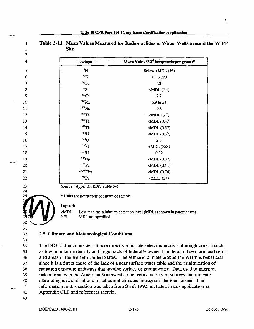
Title 40 CFR Part 191 Compliance Certification Application
Table 2-11. Mean Values Measured for Radionuclides in Water Wells around the WIPP Site
'H Below &DL (56)
"K 73 to 200
"Co 12
%r &DL (7.4)
'"Cs 7.2
'16Ra 6.9 to 52
nsRa 9.6 azam <MDL (3.7)
*% &DL (0.37)
'32Th &DL (0.37)
='U &DL (0.37)
2YJ 2.6 "'U <MDL (NIS)
w8U 0.72
mNp <MDL (0.37) 2 3 8 p U (MDL (0.11)
U9R"p" &DL (0.74) 2"p" <MDL (37)
Source: Appendix RBP, Table 5-4
* Units are becquerels per gram of sample.
Legend: &DL Less than the minimum detection level (MDL is shown in parentheses) NIS MDL not specified
31
32 2.5 Climate and Meteorological Conditions 33
The DOE did not consider climate directly in its site selection process although criteria such as low population density and large tracts of federally owned land tend to favor arid and semi- arid areas in the western United States. The semiarid climate around the WIPP is beneficial since it is a direct cause of the lack of a near surface water table and the minimization of radiation exposure pathways that involve surface or groundwater. Data used to interpret paleoclimates in the American Southwest come from a variety of sources and indicate alternating arid and subarid to subhumid climates throughout the Pleistocene. The information in this section was taken from Swift 1992, included in this application as Appendix CLI, and references therein.
D O W A O 1996-2 184 2-175 October 1996

Title 40 CFR Part 191 Compliance Certification Application - 2.5.1 Historic Climatic Conditions
Prior to 18,000 years ago, radiometric dates are relatively scarce, and the record is incomplete. From 18,000 years ago to the present, however, the climatic record is relatively well constrained by floral, faunal, and lacustrine data. These data span the transition from the last full-glacial maximum to the present interglacial period; given the global consistency of glacial fluctuations described below, they can be taken to be broadly representative of extremes for the entire Pleistocene.
Early and middle Pleistocene paleoclimatic data for the southwestern United States are incomplete and permit neither continuous reconstructions of paleoclimates nor direct correlations between climate and glaciation prior to the last glacial maximum, which occurred 22,000 to 18,000 years ago. Stratigraphic and soil data from several locations, however, indicate that cyclical alternation of wetter and drier climates in the Southwest had begun by the Early Pleistocene. Fluvial gravels in the Gatuiia exposed in the Pecos River Valley of eastern New Mexico suggest wetter conditions 1.4 million years ago and again 600,000 years ago. The Mescalero caliche, exposed locally over much of southeastern New Mexico, suggests drier conditions 510,000 years ago, and loosely dated spring deposits in Nash Draw west of the WIPP imply wetter conditions occurring again later in the Pleistocene. The Blackwater Draw Formation of the southern High Plains of eastern New Mexico and western Texas, correlating in time to both the Gatuiia Formation and the Mescalero caliche, contains alternating soil and eolian sand horizons that show at least six climatic cycles beginning more than 1.4 million years ago and continuing to the present.
Data used to construct the more detailed climatic record for the latest Pleistocene and Holocene come from six independent lines of evidence dated using carbon-14 techniques: plant communities preserved in packrat middens throughout the Southwest, including sites in Eddy and Otero counties, New Mexico; pollen assemblages from lacustrine deposits in western New Mexico and other locations in the Southwest; gastropod assemblages from western Texas; ostracod assemblages from western New Mexico; paleolake levels throughout the Southwest; and faunal remains from caves in southern New Mexico.
Prior to the last glacial maximum 22,000 to 18,000 years ago, evidence from faunal assemblages in caves in southern New Mexico, including the presence of species such as the desert tortoise that are now restricted to warmer climates, suggests hot summers and mild, dry winters. Lacustrine evidence confirms the interpretation of a relatively dry climate prior to and during the glacial advance. Permanent water did not appear in what was later to become a major lake in the Estancia Valley in central New Mexico until some time before 24,000 years ago, and water depths in lakes at higher elevations in the San Agustin Plains in western New Mexico did not reach a maximum until sometime between 22,000 and 19,000 years ago. Ample floral and lacustrine evidence documents cooler, wetter conditions in the Southwest during the glacial peak. These changes were not caused by the immediate proximity of glacial ice. None of the Pleistocene continental glaciations advanced farther southwest than northeastern Kansas, and the most recent, late-Wisconsinan ice sheet reached its limit in
October 1996 2-176 DOWCAO 19962184

Title 40 CFR Part 191 Compliance Certification Application
South Dakota, approximately 750 miles (1,200 kilometers) from W P . Discontinuous alpine glaciers formed at the highest elevations throughout the Rocky Mountains, but these isolated ice masses were symptoms, rather than causes, of cooler and wetter conditions and had little influence on regional climate at lower elevations. The closest such glacier to WPF' was on the northeast face of Sierra Blanca Peak in the Sacramento Mountains, approximately 135 miles (220 kilometers) to the northwest.
Global climate models indicate that the dominant glacial effect in the Southwest was the disruption and southward displacement of the westerly jet stream by the physical mass of the ice sheet to the north. At the glacial peak, major Pacific storm systems followed the jet stream across New Mexico and the southern Rocky Mountains, and winters were wetter and longer than either at the present or during the previous interglacial period.
Gastropod assemblages at Lubbock Lake in western Texas suggest mean annual temperatures 5 degrees Celsius below present values. Both floral and faunal evidence indicate that annual precipitation throughout the region was 1.6 to 2.0 times greater than today's values. Floral evidence also suggests that winters may have continued to be relatively mild, perhaps because the glacial mass blocked the southward movement of arctic air. Summers at the glacial maximum were cooler and drier than at present, without a strongly developed monsoon.
The jet stream shifted northward following the gradual retreat of the ice sheet after 18,000 years ago, and the climate responded accordingly. By approximately 11,000 years ago, conditions were significantly warmer and drier than previously, although still dominated by winter storms and still wetter than today. Major decreases in total precipitation and the shift toward the modem monsoonal climate did not occur until the ice sheet had retreated into northeastern Canada in the early Holocene.
By middle Holocene time, the climate was similar to that of the present, with hot, monswn- dominated summers and cold, dry winters. The pattern has persisted to the present, but not without significant local variations. Soil studies show that the southern High Plains were drier from 6,500 to 4,500 years ago than before or since. Gastropod data from Lubbock Lake indicate the &est conditions from 7,000 to 5,000 years ago (precipitation, 0.89 times present values; mean annual temperature, 2.5 degrees Celsius higher than present values), with a cooler and wetter period 1,000 years ago (precipitation, 1.45 times present values; mean annual temperature, 2.5 degrees Celsius lower than present). Plant assemblages from southwestern Arizona suggest steadily decreasing precipitation from the middle Holocene to the present, except for a brief wet period approximately 990 years ago. Stratigraphic work at r Lake Cochise (the present Willcox playa in southeast Arizona) shows two mid-Holocene lake stands, one near or before 5,400 years ago and one between or before 3,000 to 4,000 years ago; however, both were relatively short-lived, and neither reached the maximum depths of the Late Pleistocene high stand that existed before 14,000 years ago.
Inferred historical precipitation indicates that during the Holocene, wet periods were relatively drier and shorter in duration than those of the late Pleistocene. Historical records over the last
DOWCAO 1996-2184 2-177 October 1996

Title 40 CFR Part 191 Compliance Certification Application - several hundred years indicate numerous lower-intensity climatic fluctuations, some too short in duration to affect floral and faunal circulation. Sunspot cycles and the related change in the amount of energy emitted by the sun have been linked to historical climatic changes elsewhere in the world, but the validity of the correlation is uncertain. Correlations have also been proposed between volcanic activity and climatic change. In general, however, causes for past short-term changes are unknown.
The climatic record presented here should be interpreted with caution because its resolution and accuracy are limited by the nature of the data used to construct it. Floral and faunal assemblages change gradually and show only a limited response to climatic fluctuations that occur at frequencies that are higher than the typical life span of the organisms in question. For long-lived species such as trees, resolution may be limited to hundreds or even thousands of years. Sedimentation in lakes and playas has the potential to record higher-frequency fluctuations, including single-storm events, but only under a limited range of circumstances. Once water levels reach a spill point, for example, lakes show only a limited response to further increases in precipitation.
With these observations in mind, three significant conclusions can be drawn from the climatic record of the American Southwest. First, maximum precipitation in the past coincided with the maximum advance of the North American ice sheet. Minimum precipitation occurred after the ice sheet had retreated to its present limits. Second, past maximum long-term - average precipitation levels were roughly twice the present levels. Minimum levels may have been 90 percent of the present levels. Third, short-term fluctuations in precipitation have occurred during the present relatively dry, interglacial period, but they have not exceeded the upper limits of the glacial maximum.
Too little is known about the relatively short-term behavior of global circulation patterns to accurately predict precipitation levels over the next 10,000 years. The long-term stability of patterns of glaciation and deglaciation, however, do permit the conclusion that future climatic extremes are unlikely to exceed those of the late Pleistocene. Furthermore, the periodicity of glacial events suggests that a return to full-glacial conditions is highly unlikely within the next 10,000 years.
2.5.2 Recent Climatie Conditions
Recent climatic conditions are provided to allow for the assessment of impacts of these factors on the disposal unit and the site. Data are taken from the WIPP environmental monitoring reports (see Westinghouse 1991a. b, 1992, 1993, 1994, 1995 in the Bibliography).
The climate of the region is semiarid, with generally mild temperatures, low precipitation and humidity, and a high evaporation rate. Winds are mostly from the so~itheast and moderate. In -

Title 40 CFR Part 191 Compliance Certification Application
weather is often dominated by a high-pressure system situated in the central portion of the western United States and a low-pressure system located in north-central Mexico. During the - summer, the region is affected by a low-pressure system normally situated over Arizona.
2.5.2.2 Temuerature Summary
Temperatures are moderate throughout the year, although seasonal changes are distinct. The mean annual temperature in southeastern New Mexico is 63 degrees Fahrenheit. In the winter (December through February), nighttime lows average near 23 degrees Fahrenheit, and maxima average in the 50s. The lowest recorded temperature at the nearest Class-A weather station in Roswell was -29 degrees Fahrenheit in February 1905. In the summer (June through August), the daytime temperature exceeds 90°F approximately 75 percent of the time. The National Weather Service recently documented 122 degrees Fahrenheit at the WIPP site as the record high temperature for New Mexico. This temperature was recorded on June 27, 1994, Table 2-12 shows the annual average, maximum, and minimum temperatures from 1990 through 1994. Temperature data for 1995 are summarized in Appendix SER.
Table 2-12. Annual Average, Maximum, and Minimum Temperatures
Average 17.6 63.6 44.9 112.8 - 13 8.6
Source: WIPP Annual Site Environmental Repon for Calendar Years 1990 through 1994.
2.5.2.3 -tion S u m
Precipitation is light and unevenly distributed throughout the year, averaging 13 inches (33 centimeters) per year for the past 5 years. Winter is the season of least precipitation, averaging less than 0.6 inches (1.5 centimeters) of rainfall per month. Snow averages about 5 inches (13 centimeters) per year at the site and seldom remains on the ground for more than a day. Approximately half the annual precipitation comes from frequent thunderstorms in June through September. Rains are usually brief but occasionally intense when moisture from the Gulf of Mexico spreads over the region. Monthly average, maximum, and minimum
DOUCAO 1996-2 184 2-179 October 1996
- cipitations recorded at the WIPP site from 1990 through 1994 are summarized in
Figure 2-41. Precipitation data for 1995 are summarized in Appendix SER.
2.5.2.4 Wind Speed and Wind Direction Summary
The frequencies of wind speeds and directions are depicted by windroses in Figures 2-42 through 2-45 for the WIPP site and Figure 2-46 for Carlsbad, New Mexico. In general, the predominant wind direction at the WIPP site is from the southeast, and the predominant wind directions in Carlsbad are from the south, southeast, and west. Wind data for 1995 are summarized in Appendix SER.
2.6 Seismology
The DOE used tectonic activity as a siting criterion. The intent was to avoid tectonic conditions such as faulting and igneous activity that would jeopardize waste isolation over the long term and to avoid areas where earthquake size and frequency could impact facility design and operations. The WIPP site met both aspects of this criterion fully. Long-term tectonic activity is discussed in Section 2.1.5. The favorable results of the seismic (earthquake) studies are discussed here. The purpose of the seismic studies is to build a basis from which to predict ground motions that the WIPP repository may be subjected to in the near and distant future. The concern about seismic effects in the near future, during the operational period,
-4.
pertains mainly to the design requirements for surface and underground structures for providing containment during seismic events. The concern about effects occuning over the long term, after the repository has been decommissioned and sealed, pertains more to relative motions (faulting) within the repository and possible effects of faulting on the integrity of the salt beds and/or shaft seals.
In this discussion, the magnitudes are reported in terms of the Richter scale, and all intensities are based on the modified Mercalli intensity scale. Most of the magnitudes were determined by the New Mexico Institute of Mining and Technology or are described in Appendix GCR and references therein.
2.6.1 Seismic History
Seismic data are presented in two time frames, before and after the time when seismographic data for the region became available. The earthquake record in southern New Mexico dates back only to 1923, and seismic instruments have been in place in the state since 1961. Various records have been examined to determine the seismic history of the area within 180 miles (288 kilometers) of the site. With the exception of a weak shock in 1926 at Hope, New Mexico (approximately 40 miles [64 kilometers] northwest of Carlsbad), and shocks in 1936 and 1949 felt at Carlsbad, all known shocks in the region before 1961 occurred to the west and southwest of the site more than 100 miles (160 kilometers) away.
October 1996
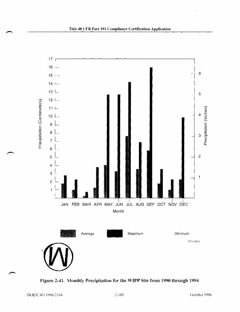
Title 40 CFR Part 191 Compliance Certification Application
' JUN . Month
AUG 5
Average Maximum
OCT NOV I
Minimum
CC4254-2
Figure 2-41. Vonthly Precipitation for the WIPP Site from 1990 through 1994
M)EIC -\o IWh-1184 7-181 U m k r 1996

Title PO CFR Part 191 Compliance Certir~cation Application m
THIS PAGE INTENTIONALLY LEFT BLANK
October 1996

Title 40 CFR Part 191 Compliance Certification Application -
Legend Calm c 0.5
Wind Velocity in Meters per Second
1991 WIPP Site
Figure 2-42. 1991 Annual Windrose - WIPP Site
October 1996

Title 40 CFR Part 191 Compliance Certif~cation Applicntion - THIS PAGE INTENTIONALLY LEFT BLANK
October 1996

Title 40 CFR Part 191 Compliance Certification Application
Legend
0.5-1.3 1.4-2.7 2.8-3.6 3.7-6.3 >6.3
Wind Velocity in Meters per Second
1992 WIPP Site
Figure 2-43. 1992 Annual Windrose - WIPP Site
October 1996

TiUe 40 CFR Port 191 Compliance Certir~ration Application - THIS PAGE INTENTIONALLY LEFT BLANK
Octokr 1996 DOWCAO 1996-2184

r- Title 10 CFR Part 191 Compliance Certification Application
NNW N
NNE
Legend
0 5 1 3 1 1 2 7 2 8 3 6 3 7 6 3 >63
W ~ n d Veloc~ty In Meters per Second
1993 WIPP Site
Figure 2-44. 1993 Annual Windrose - WIPP Site

TiUe 40 CFR Part 191 Compliance Certir~cation Application - THIS PAGE INTENTIONALLY LEFT BLANK
October 1996 W U C A O 199621 84

Title 10 CFR Part 191 Compliance Certification Application
NNW NNE PC-
Legend
\ < 0.5
Wind Velocity in Meters per Second
1994 WIPP Site
Figure 2-15. 1994 Annual Windrose - WIPP Site

Title 40 CFR Part 191 Compliance Certif~cation Application I
THIS PAGE INTENTIONALLY LEFT BLANK
October 1996 2-190
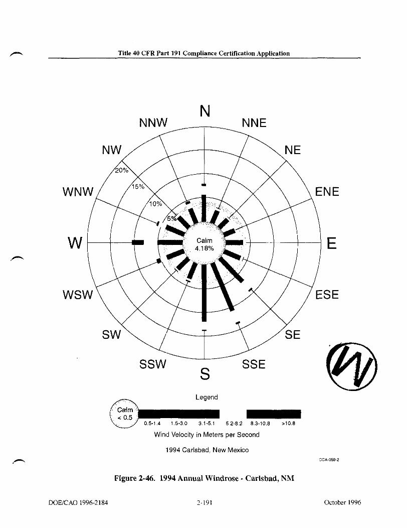
Title 40 CFR Part 191 Compliance Certification Application
Legend
05-14 15-30 31-51 5 2 8 2 83-108 ,108
Wmd Veloclty In Meters per Second
1994 Carlsbad. New Mexico CCA-059-2
Figure 2-46. 1994 Annual Windrose - Carlsbad, NM
DOEICAO 1996-2 184 7-191 October 1996

Title 40 CFR Part 191 Compliance Certification Application n
THIS PAGE INTENTIONALLY LEFT BLANK
October 1996

Title 40 CFR Part 191 Compliance Certif~cation Application
The strongest earthquake on record occurring within 180 miles (288 kilometers) of the site was the Valentine, Texas, earthquake of August 16, 1931. It has been estimated to have been of magnitude 6.4 on the Richter scale (Modified Mercalli Intensity of VIII). The Valentine earthquake was 130 miles (208 kilometers) south-southwest of the site. Its Modified Mercalli Intensity at the site is estimated to have been V; this is believed to be the highest intensity felt at the site in this century.
In 1887, a major earthquake occurred in northeast Sonora, Mexico. Although about 335 miles (536 kilometers) west-southwest of the site, it is indicative of the size of earthquakes possible in the eastern portion of the Basin and Range Province, west of the province containing the site. Its magnitude was estimated to have been 7.8 (Vm to M in Modified Mercalli Intensity). It was felt over an area of 0.5 million square miles (1.3 million square kilometers) (as far as Santa Fe to the north and Mexico City to the south); fault displacements near the epicenter were as large as 26 feet (18 meters).
Since 1961, instrumental coverage has become comprehensive enough to locate most of the moderately strong earthquakes (local magnitude ~ 3 . 5 ) in the region. Instrumentally determined shocks that occurred within 180 miles (288 kilometers) of the site between 1961 and 1994 are shown in Figure 2-47. The distribution of these earthquakes may be biased by the fact that seismic stations were more numerous and were in operation for longer periods north and west of the site. Pre-1961 earthquakes can be found in Appendix GCR (Figure 5.2-1).
Except for the activity southeast of the site, the distribution of epicenters since 1961 differs little from that of shocks before that time. There are two clusters, one associated with the Rio Grande Rift on the Texas-Chihuahua border and another associated with the Central Basin Platform in Texas near the southeastern comer of New Mexico. The latter activity was not reported before 1964. It is not clear from the record whether earthquakes were occurring in the Central Basin Platform before 1964, although local historical societies and newspapers tend to c o n f m their absence before that time.
A station operating for 10 months at Fort Stockton, Texas, indicated many small shocks from the Central Basin Platform. Activity was observed at the time the station opened on June 21, 1964. This activity may be related to the underground injection of water for oil recovery. In the Ward-Estes North oilfield, operated by the Gulf Oil Corporation, the cumulative total of water injected up to 1970 was over 1 billion barrels. Accounting for 42 percent of the water injected in Ward and Winkler counties, Texas, the quantity is three times the total injected in all the oil fields of southeastern New Mexico during the same period. The nearest oil fields in the Delaware Basin, where secondary recovery might be attempted in the future, are adjacent to the WIPP site boundary in the Delaware Mountain Group.
The most recent earthauakes to be felt at the WIPP site occurred in Januarv 1992 and A ~ r i l

Title 40 CFR Part 191 Compliance Certification Application ---. respectively. The Rattlesnake earthquake occurred 60 miles (100 kilometers) east-southeast of the WIPP site. The earthquake was assigned a magnitude of 5.0. This event had no effect on any of the structures at the WET' as documented by post-event inspections by the WIPP staff and the New Mexico Environment Department. This event was within the parameters used to develop the seismic risk assessment of the WIPP facility for the purpose of construction and operation. The Rattlesnake Canyon event likely was tectonic in origin based on the 12 a 2-kilometer depth.
The April 14, 1995, earthquake near Marathon, Texas, was located 150 miles (240 kilometers) south of the WIPP site. The USGS estimated that moment magnitude for this event was 5.7. At a distance of 149 miles (240 kilometers), an event of magnitude 5.7 would produce a maximum acceleration at the WIPP site of less than 0.01 g.
The Marathon earthquake should not be considered an unanticipated event. The shock occurred in the Basin and Range Province, a seismotectonic province with evidence for 24 Quarternary faults in West Texas and adjacent parts of Mexico. Two of these faults had recent surface-faulting events in the Holocene. Strong earthquakes have occurred within the West Texas part of the Basin and Range Province, most notably the M, = 6.4 (Richter) Valentine, Texas earthquake on August 15, 193 1.
The WIPP site is located within the Great Plains seismotectonic province, a region that has no - evidence of Quarternary faulting, even above major buried structures such as the Central Basin Platform. Because the Great Plains seismotectonic province is geologically distinct from the Basin and Range Province and lacks evidence for recent faulting, the maximum possible or credible earthquake for this region would be substantially smaller than that for the Basin and Range Province of West Texas.
2.6.2 Seismic Risk
Procedures exist that allow for formal determination of earthquake probabilistic design parameters. In typical seismic risk analyses of this kind, the region of study is divided into seismic source areas within which future events are considered equally likely to occur at any location. For each seismic source area, the rate of occurrence of events above a chosen threshold level is estimated using the observed frequency of historical events. The sizes of successive events in each source are assumed to be independent and exponentially distributed; the slope of the log number versus frequency relationship is estimated from the relative frequency of different sizes of events observed in the historical data. This slope, often termed the b value, is determined either for each seismic source individually or for all sources in the region jointly. Finally, the maximum possible size of events for each source is determined using judgement and the historical record. Thus, all assumptions underlying a measure of earthquake risk derived from this type of analysis are explicit, and a wide range of assumptions may be employed in the analysis procedure.
October 1996

Title 40 CFR Part 191 Compliance Certification Application
Magnitude Note: Locations of earthquakes within 180 mi. of the WIPP Site. Epicenters were determined instrumentally and cover 50 0 50 100 Miles the period from 1961 through 1994. For drafting clarity no earthquake with a magnitude less than 2.0 Scale 0 2.5-3.5 is shown. In areas where crowding occurs some eoi-
0 c2.5 centers an: slightly offset for drafting convenience. CCA.060.2
Figure 2-47. Regional Earthquake Epicenters Occurring between 1961 and 1994
DOEiCAO 1996-2 184 2-195 October 1996

Title 40 CFR Part 191 Compliance Certif~cation Application h
THIS PAGE INTENTIONALLY LEFT BLANK
October 1996 DOUCAO 1996-2 184

Title 40 CFR Part 191 Compliance Certification Application
In this section, the particular earthquake risk parameter calculated is peak acceleration expressed as a function of annual probability of being exceeded at the WIPP site. The particular analysis procedure applied to the calculation of this probabilistic peak acceleration is taken from a computer program written by McGuire in 1976. In that program, the seismic source zones are modeled geometrically as quadrilaterals of arbitrary shape. Contributions to site earthquake risk from individual source zones are integrated into the probability distribution of acceleration, and the average annual probability of exceedence then follows directly.
In the analysis, the principal input parameters are as follows: site region acceleration attenuation, source zone geometry, recurrence statistics, and maximum magnitudes. Based on these parameters, several curves showing probabilistic peak acceleration are developed, and the conclusions that may be drawn from these curves are considered. The data treated in this way are used to anive at a general statement of risk from vibratory ground motion at the site during its active phase of development and use.
The first input pararneters considered have to do with acceleration attenuation in the site region as a function of earthquake magnitude and hypocentral distance. The risk analysis used in this study employs an attenuation law of the form
where a is acceleration in centimeters per second squared, M, is Richter local magnitude, and R is the distance in kilometers. The particular formula used in this study is based on a central United States model developed by Nuttli (1973). The formula coefficients b, = 17, b, = 0.92, and b, = 1.0 were selected. A iustification for this assumption can be found in Section 5.3.2 of ~ i ~ e n d i x GCR.
-
2.6.2.2 .&ismic Source 7 ~ ~ 3
Geologic, tectonic, and seismic evidence indicates that three seismic source zones may be used to adequately characterize the region. These are well approximated by the Basin and Range subregion, the Permian Basin subregion exclusive of the Central Basin Platform, and the Central Basin Platform itself. Specific boundaries are taken from a 1976 study by Algermissen and Perkins of earthquake risks throughout the United States. Additional details on this study are in Appendix GCR (Section 5.3.2).
Site region seismic source zones are shown in Figure 2-48. Superposed on these zones are the earthquake epicenters of Figure 2-47. The zonation presented generally conforms with historical seismicity. The source zonation of Figure 2-48 has no explicit analog to the Permian Basin subregion exclusive of the Central Basin Platform. This is considered part of the broad background region.
October 1996

Title 40 CFR Part 191 Compliance Certification Application -.
For the purposes of this study, some minor modifications of the Algermissen and Perkins source zones were made. Geologic and tectonic evidence suggests that the physiographic boundary between the Basin and Range and Great Plains provinces provides a good and conservative approximation of the source zones (Appendix GCR). In addition, information from the Kermit seismic array (Appendix to Rogers and Malkiel 1979) indicates that the eeometrv used to model the limits of the Central Basin Platform source zone mav be modified " . somewhat from the original analogous Algermissen and Perkins zone. These modifications are shown in Figure 2-49 and constitute the preferred model for the WIPP site region seismic - - source zones in this study. This model is prefemed because it more completely considers geologic and tectonic information, as well as seismic data, and because it results in a more realistic development of risks at the WIPP facility.
With regard to earthquake focal depth, there is little doubt that the focal depths of earthquakes in the WIPP facility region should be considered shallow. Early instrumental locations were achieved using an arc intersection method employing travel-time-distance curves calculated from a given crustal model, and the assumption of focal depths of 3.1 miles (5 kilometers), 6.2 miles (10 kilometers), or, for later calculations, 5 miles (8 kilometers). Good epicentral locations could generally be obtained under these assumptions. For conservatism, a focal depth of 3.1 miles (5 kilometers) is used in all source zones of this study including that of the site. For smaller hypocentral distances, the form of the attenuation law adopted here severely exaggerates the importance of small, close shocks in the estimation of probabilistic acceleration at the WIPP site. Additional discussion is included in this application in Chapter 5 of Appendix GCR.
Formul 2.6.2.3 Source Zone Recurrence as and Maxlrnum Magnitudes -
The risk calculation procedure used in this study requires that earthquake recurrence rates for each seismic source zone be specified. This is done formally by computing the constants a and b in the equation
where N is the number of earthquakes of magnitude greater than or equal to M within a specified area occurring during a specified period.
For the WIPP facility region, three formulas of this type are needed: one for the province west and southwest of the site (the Basin and Range subregion or Rio Grande rift source zone), another for the province of the WIPP facility exclusive of the Central Basin Platform (the Permian Basin subregion or background source zone), and a final one for the Central Basin Platform. In practice, the difficulties in finding meaningful recurrence formulas for such small areas in , , 9 region of low historical earthquake activity are formidable.
I
October 1996

Title 10 CFR Part 191 Compliance Certification Application
Magnitude 50 0 50 100Miles
0 > 3 5 -
Scale 0 2 5-35
0 ~ 2 . 5 . . JCA-161-2
Figure 2-48. Seismic Source Zones

Title 40 CFR Part 191 Compliance Certincation Application h
THIS PAGE INTENTIONALLY LEFT BLANK
October 1996 DOUCAO 1996-2 184

Title 10 CFR Part 191 Compliance Certification Application
- ~ -.. .- ..
106' 1 0 4 O l ? F 100° m ', m m,
Utah Kansas
1 I Oklahoma
Colo ado -I- - New
Central Basm Platlorm source zone 1 based on data from Rogers an3 Malk~el (1979)
50 0 50 100 M~les - Llmlts suggested by geological or tecton~c evldence I Scale
1- Algermissen and Perkins (1976) source zones 1 I
Figure 2-49. Alternate Source Geometries
2-201 Ocloher 1 YYh

Title 40 CFR Part 191 Compliance CeMtcation Application h
THIS PAGE INTENTIONALLY LEFT BLANK
October 1996 DOWCAO 1996-2 184

Title 40 CFR Part 191 Compliance Certif~cation Appticstion
The formulas have been determined to be
log N = 2.43 - Mco, Site source zone (background)
log N = 3.25 - worn Basin and Range subregion
log N = 3.19 - 0.9 Mco, Central Basin Platform
The rationale for their development and the relationship used to determine M,, can be found in Appendix GCR (Section 5.3).
2.6.2.4 Design Basis Earthquake
The term Design Basis Earthquake (DBE) is used for the design of surface confinement structures and components at the WIPP facility. As used here, the DBE is equivalent to the design earthquake used in Regulatory Guide 3.24 (National Regulatory Commission [NRC] 1974). That is, in view of the limited consequences of seismic events in excess of those used as the basis, the DBE is such that it produces ground motion at the WIPP facility with a recurrence interval of 1,000 years. In practice, the DBE is defined in terms of the 1,000-year acceleration and design response spectra.
The generation of curves expressing probability of occurrence or risk as a function of peak WIPP facility ground acceleration is discussed in detail in Appendix GCR (Section 5.3) for a number of possible characterizations of WIPP facility region source zones and source zone earthquake parameters. The most conservative (and the least conservative) risk curves are shown in Figure 2-50.
From this fi~ure. the most conservative calculated estimate of the 1.000-vear acceleration at " . . the WIPP facility is approximately 0.075 g.3 The geologic and seismic assumptions leading to this 1.000-vear ~ e a k acceleration include the consideration of a Richter magnitude 5.5 - earthquake at the site, a 6.0 magnitude earthquake on the Central Basin Platform, and a 7.8 magnitude earthquake in the Basin and Range subregion. These values, especially the first two, are considered quite conservative, as are the other parameters used in the 0.075-g derivation. For additional conservatism, a peak design acceleration of 0.1 g is selected for the WIPP facility DBE. The design response spectra for vertical and horizontal motions are taken from Regulatory Guide 1.60 (NRC 1973) with the high-frequency asymptote scaled to this 0.1 -g peak acceleration value.
Ths DBE and the risk analysis that serves an important role in its definition are directly applicable to surface confinement structures and components at the WIPP facility.
g = acceleration due to gravity.
DOEJCAO 1996-2184 October 1996

Title 40 CFR Part 191 Compliance Certification Application - 1 Underground structures and components are not subject to DBE design requirements because 2 according to Pran et al. (1979), mine experience and studies on earthquake damage to 3 underground facilities show that tunnels are not damaged at sites having peak surface 4 accelerations below 0.2 g. 5
October 1996 DOUCAO .l996-2184
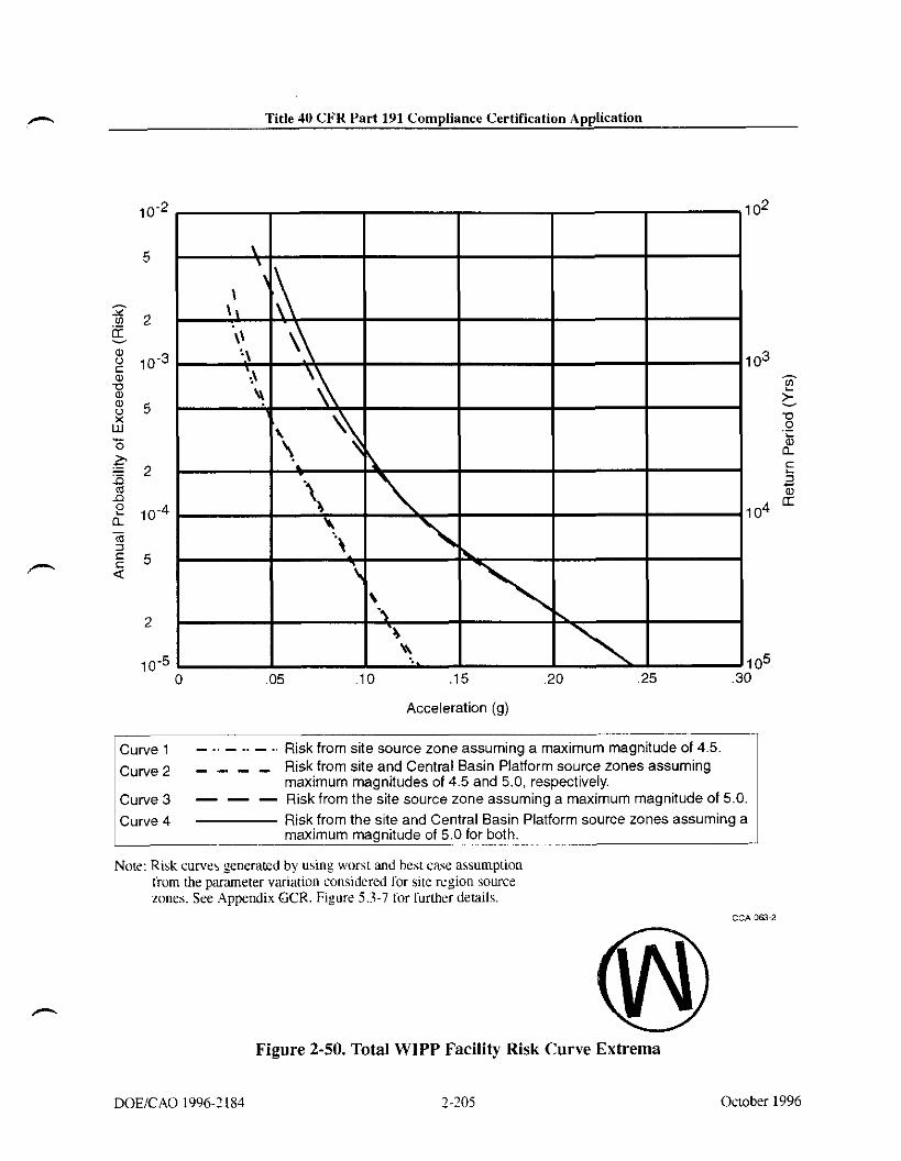
m Title 10 CFR Part 191 Compliance Certification Application
Acceleration (g)
curve 1 - .. - .. - ., Risk from site source zone assuming a maximum magnitude of 4.5.
curve 2 - - - - Risk from site and Central Basin Platform source zones assuming maximum magnitudes of 4.5 and 5.0, respectively.
Curve3 - - - Risk from the site source zone assuming a maximum magnitude of 5.0.
Curve 4 Risk from the site and Central Basin Platform source zones assuming a maximum magnitude of 5.0 for both.
Note: Risk curve5 senerated by using worst and best case assumption tiom the parameter variation considered for site region source zones. See .4ppendix GCR. Figure 5.3-7 Cor further details.
Figure 2-50. Total WIPP Facility Risk Curve Extrema
October 1996

TiUe 40 CFR Part 191 Compliance Cerliiication Application - THIS PAGE INTENTIONALLY LEFT BLANK
October 1996

Title 40 CFR Part 191 Compliance Certification Application
REFERENCES
Adams, J.E. 1944. "Upper Permian Ochoa Series of the Delaware Basin, West Texas and Southeastern New Mexico." American Association of Petroleum Geologists Bulletin, Vol. 28, NO. 11, 1596-1625. WPO 37940.
Algennissen, S.T., and Perkins, D.M. 1976. A Probabilistic Estimate of Maximum Ground Acceleration in the Contiguous United States. Open-file Report 76-416, pp. 1 - 45. U.S. Geological Survey.
Anderson, R.Y. 1978. Deep Dissolution of Salt, Northern Delaware Basin, New Mexico. Report to Sandia National Laboratories, Albuquerque, NM. WPO 29527 - WPO 29530.
Anderson, R.Y., and Kirkland, D.W. 1980. Dissolution of Salt Deposits by Brine Density How. Geology, Vol. 8, No. 2, pp. 66 - 69.
Anderson, R.Y. 1981. "Deep-seated Salt Dissolution in the Delaware Basin, Texas and New Mexico." In Environmental Geology and Hydrology in New Mexico, S.G. Wells and W. Lambert, eds., Special Publication No. 10, pp. 133 - 145. New Mexico~Geological Society.
Anderson, R.Y. 1993. "The Castile as a 'Nonmarine' Evaporite." In Carlsbad Region, New Mexico and Texas, New Mexico Geological Sociery, Forty-Fourth Annual Field Conference, Carlsbad, NM, October 6-9, 1993, D.W. Love et al., eds., pp. 12 - 13. New Mexico Geological Society, Socorro, NM.
Anderson, R.Y., Dean, W.E., Jr., Kirkland, D.W., and Snider, H. I. 1972. "Permian Castile Varved Evaporite Sequence, West Texas and New Mexico." Geological Sociery of America Bulletin, Vol. 83, No. 1, pp. 59 - 85.
Anderson, R.Y., and Powers, D.W. 1978. "Salt Anticlines in the Castile-Salado Evaporite Sequence, Northern Delaware Basin, New Mexico." In Geology and Mineral Deposits of Ochoan Rocks in Delaware Basin and Adjacent Areas, G.S. Austin, ed., Circular 159. pp. 79 - 83. New Mexico Bureau of Mines and Mineral Resources, Socono, NM.
Anderson, R.Y., Kietzke, K.K., and Rhodes, D.J. 1978. "Development of Dissolution Breccias, Northern Delaware Basin, New Mexico and Texas." In Geology and Mineral Deposits of Ochoan Rocks in Delaware Basin and Adjacent Areas, G.S. Austin, ed., Circular 159. New Mexico Bureau of Mines and Mineral Resources, Socono, NM.
Bachman, G.O. 1973. Sulficial Features and Late Cenozoic History in Southeastern New Mexico. Open-File Report 4339-8. U.S. Geological Survey, Reston, VA.
DOWCAO 1996-2184 October 1996

Title 40 CFR Part 191 Compliance Certification Application - Bachman, G.O. 1974. Geologic Processes and Cenozoic History Related to Salt Dissolution in Southeastern New Mexico. Open-File Report 74-194. US. Geological Survey, Denver, CO
Bachman, G.O. 1976. "Cenozoic Deposits of Southeastern New Mexico and an Outline of the History of Evaporite Dissolution." Journal of Research, Vol. 4, No. 2, pp. 135 - 149. U.S. Geological Survey.
Bachman, G.O. 1980. Regional Geology and Cenozoic History of Pecos Region, Southeastern New Mexico. Open-File Report 80-1099. U.S. Geological Survey, Denver, CO.
Bachman, G.O. 1981. Geology of Nash Draw, Eddy County, New Mexico. Open-File Report 81-31. US. Geological Survey, Denver, CO.
Bachman, G.O. 1984. Regional Geology of Ochoan Evaporites, Northern Part of Delaware Basin. Circular 184, pp. 1 - 22. New Mexico Bureau of Mines and Mineral Resources, Socorro, NM.
Bachman, G.O. 1985. Assessment of Near-Surjace Dissolution at and Near the Waste Isolation Pilot Plant (WIPP), Southeastern New Mexico. SAND84-7 178. Sandia National Laboratories, Albuquerque, NM. WPO 24609.
-. Barrows, L.J., Shaffer, S.E., Miller, W.B., and Fett, J.D. 1983. Waste Isolation Pilot Plant (WIPP) Site Gravity Survey and Interpretation. SAND82-2922. Sandia National Laboratories, Albuquerque, NM.
Beauheim, R.L., Hassinger, B.W., and Kleiber, J.A. 1983. Basic Data Reportfor Borehole Cabin Baby-I Deepening and Hydrologic Testing, Waste Isolation Pilot Plant (WIPP) Project, Southeastern New Mexico. WTSD-TME-020. United States Department of Energy, Albuquerque, NM.
Beauheim, R.L. 1986. Hydraulic-Test Interpretations for Well DOE-2 at the Waste Isolation Pilot Plant (WIPP) Site. SAND86-1364. Sandia National Laboratories, Albuquerque, NM. WPO 27656.
Beauheim, R.L. 1987a. Interpretations of Single- Well Hydraulic Tests Conducted at and Near the Waste Isolation Pilot Plant (WIPP) Site, 1983-1987. SAND87-0039. Sandia National Laboratories, Albuquerque, NM. WPO 27679.
Beauheim, R.L. 1987b. Analysis of Pumping Tests of the Culebra Dolomite Conducted at the H-3 Hydropad at the Waste Isolation Pilot Plant (WIPP) Site. SAND86-23 11. Sandia National Laboratories, Albuquerque, NM.
;"
October 1996

Title 40 CFR Part 191 Compliance Certif~cation Application
Beauheim, R.L. 1987c. Interpretation of the WIPP-13 Multipad Pumping Test of the Culebra Dolomite at the Waste Isolation Pilot Plant (WIPP) Site. SAND87-2456. Sandia National Laboratories, Albuquerque, NM.
Beauheim, R.L. 1989. Interpretation of H-14t.d Hydraulic Tests and the H-11 Multipad Pumping Test of the Culebra Dolomite at the Waste Isolation Pilot Plant (WIPP) Site. SAND89-0536. Sandia National Laboratories, Albuquerque, NM.
Beauheim, R.L., and Holt, R.M. 1990. "Hydrogeology of the WIPP Site." In Geological and Hydrological Studies of Evaporites in the Northern Delaware Basin for the Waste Isolation Pilot Plant (WIPP), New Mexico, Geologic Sociefy of America 1990 Annual Meeting Field Trip #14 Guidebook, pp. 13 1 - 179. Dallas Geologic Society, Dallas, TX. WPO 29378.
Beauheim, R.L., Roberts, R.M., Dale, T.F., Fort, M.D., and Stensmd, W.A. 1993. Hydraulic Testing of Salado Formation Evaporites at the Waste Isolation Pilot Plant Site: Second Interpretive Report. SAND92-0533. Sandia National Laboratories, Albuquerque, NM. WPO 23378.
Beauheim, R.L., Saulnier, Jr., G.J., and Avis, J.D. 1991. Interpretation of Brine-Permeabiliry Tests of the Salado Formation at the Waste Isolation Pilot Plant Site: First Interim Report. SAND90-0083. Sandia National Laboratories, Albuquerque, NM.
Beauheim, R.L., Meigs, L.C., Saulnier, G.J., and Stensmd, W.A. 1995. Culebra Transport Program Test Plan: Tracer Testing of the Culebra Dolomite Member of the Rustler Formation at the H-19 and H-I1 Hydropads on the WIPP Site. On file in the Sandia WIPP Central Files.
Blackwell, D.D., Steele, J.L., and Carter, L.S. 1991. "Heat-Flow Patterns of the North American Continent; A Discussion of the Geothermal Map of North America." In Neotectonics of North America, D.B. Slernmons, E.R. Engdahl, M.D. Zoback, and D.D. Blackwell, eds., pp. 423 - 436. Geological Society of America, Boulder, CO.
Bodine, Jr., M.W. 1978. "Clay-Mineral Assemblages from Drill Core of Ochoan Evaporites, Eddy County, New Mexico." In Geology and Mineral Deposits of Ochoan Rocks in Delaware Basin and Adjacent Areas, G.S. Austin, ed., Circular 159. pp. 21 - 3 1. New Mexico Bureau of Mines and Mineral Resources, Socorro, NM.
Borns, D.J. 1987. The Geologic Structures Observed in Drillhole DOE-2 and Their Possible Origins: Waste Isolation Pilot Plant. SAND86-1495. Sandia National Laboratories, Albuquerque, NM.
Borns, D.J., Barrows, L.J., Powers, D.W., and Snyder, R.P. 1983. Deformation of Evaporites Near the Waste Isolation Pilot Plant IWIPP) Site. SAND82-1069. Sandia National Laboratories, Albuquerque, NM. WPO 27532.
DOEICAO 1996-2184 2-209 October 1996

Title 40 CFR Part 191 Compliance Certif~cation Application
Borns, D.J. 1985. Marker Bed 139: A study of Drillcore from a Systematic Array. SAND85-0023. Sandia National Laboratories, Albuquerque, NM. WPO 24529.
Borns, D.J., and Shaffer, S.E. 1985. Regional Well-Log Correlation in the New Mexico Portion of the Delaware Basin. SAND83-1798. Sandia National Laboratories, Albuquerque, NM. WPO 245 1 1.
Brausch, L.M., Kuhn, A.K., and Register, J.K. 1982. Natural Resources Study, Waste Isolation Pilot Plant (WIPP) Project, Southeastern New Mexico. TME 3156. Albuquerque, NM: U.S. Department of Energy, Waste Isolation Pilot Plant. WPO 39094.
Brokaw, A.L., Jones, C.L., Cooley, M.E., and Hays, W.H. 1972. Geology and Hydrology of the Carlsbad Potash Area, Eddy and Lea Counties, New Mexico. Open-File Report 4339-1. U.S. Geological Survey, Denver, CO.
Brookins, D.G. 1980. "Polyhalite K-Ar Radiometric Ages from Southeastern New Mexico." In Isochron/West, No. 29, pp. 29 - 3 1.
Brookins, D.G. 1981. "Geochronologic Studies Near the WIPP Site, Southeastern New Mexico." In Environmental Geology and Hydrology in New Mexico, S.G. Wells, and W. Lambert, ed., Special Publication 10, pp. 147 - 152. New Mexico Geological Society.
Brookins, D.G., and Lambert, S.J. 1987. "Radiometric Dating of Ochoan (Permian) Evaporites, WIPP Site, Delaware Basin, New Mexico, USA." Scientific Basis for Nuclear Waste Management X, Materials Research Society Symposia Proceedings, Boston, MA, December 1-4, 1986, J.K. Bates and W.B. Seefeldt, eds., Vol. 84, pp. 771 - 780, Materials Research Society, Pittsburgh, PA.
Brookins, D.G., Register, J.K. Jr., and Krueger, H.W. 1980. "Potassium-Argon Dating of Polyhalite in New Mexico." Geochimica et Cosmochimica Acta, Vol. 44, No. 5, pp. 635 - 637.
Calzia, J.P., and Hiss, W.L. 1978. "Igneous Rocks in Northern Delaware Basin, New Mexico, and Texas." In Geology and Mineral Deposits of Ochoan Rocks in Delaware Basin and Adjacent Areas, G.S. Austin, ed., Circular 159, pp. 39 - 45. New Mexico Bureau of Mines and Resources, Socorro, NM.
Cartwright, Jr., L.D. 1930. Transverse Section of Permian Basin, West Texas and Southeastern New Mexico. American Association of Petroleum Geologists Bulletin, Vol. 14.
Casas, E., and Lowenstein, T.K. 1989. Diagenesis of Saline Pan Halite: Comparison of Petrographic Features of Modem, Quaternary and Permian Halites. Journal of Sedimentary Petrology, Vol.'59.
October 1996 DOUCAO 199621 84

Title 40 CFR Part 191 Compliance Certif~cation Application
Chugg, J.C., Anderson, G.W., Kink, D.L., and Jones, L.H. 1971. Soil Survey of Eddy Area, New Mexico. Prepared by the U.S. Soil Conservation Service in cooperation with New Mexico Agricultural Experiment Station. For sale by the Superintendent of Documents, U.S. Government Printing Office, Washington, D.C.
Claibome, H.C., and Gera, F. 1974. Potential Containment Failure Mechanisms and Their Consequences at a Radioactive Waste Repository in Bedded Salt in New Mexico. ORNL-TM 4639. Oak Ridge National Laboratories, Oak Ridge, TN.
Corbet, T.F. and Knupp, P.M. 1996. The Role of Regional Groundwater Flow in the Hydrogeology of the Culebra Member of the Rustler Formation at the Waste Isolation Pilot Plant (WIPP), Southeastern New Mexico. SAND96-2 133. Sandia National Laboratories: Albuquerque, NM.
Davies, P.B. 1984. "Deep-seated Dissolution and Subsidence in Bedded Salt Deposits." Ph.D. Thesis. Stanford University, Palo Alto, CA.
Davies, P.B. 1989. Variable-Density Ground-Water Flow and Paleohydrology in the Waste Isolation Pilot Plant (WIPP) Region, Southeastern New Mexico. Open-File Report 88-490. US. Geological Survey, Albuquerque, NM. WPO 38854.
Deal, D.E., and Case, J.B. 1987. Brine Sampling and Evaluation Program Phase I Report. DOE-WIPP 87-008. Westinghouse Electric Corporation, Carlsbad, NM.
Deal, D.E., Case, J.B., Deshler, R.M., Drez, P.E., Myers, J., and Tyburski, J.R. 1987. Brine Sampling and Evaluation Program Phase 11 Report. DOE-WIPP-87-010. Westinghouse Electric Corporation, Carlsbad, NM.
Deal, D.E., Abitz, R.J., Belski, D.S., Case, J.B., Crawley, M.E., Deshler, R.M., Drez, P.E., Givens, C.A., King, R.B., Lauctes, B.A., Myers, J., Niou, S., Pietz, J.M., Roggenthen, W.M., Tyburski, J.R., and Wallace, M.G. 1989. Brine Sampling and Evaluation Program, I988 Report. DOE-WIPP-89-015. Carlsbad, NM: Westinghouse Electric Corporation.
Deal, D.E., Abitz, R.J., Belski, D.S., Clark, J.B., Crawley, M.E., andMartin, M.L. 1991a. Brine Sampling and Evaluation Program, 1989 Report. DOE-WIPP-91-009. Carlsbad, NM: Westinghouse Electric Corporation.
Deal, D.E., Abitz, R.J., Myers, J. Case, J.B., Martin, M.L., Roggenthen, W.M., and Belski, D.S. 1991b. Brine Samplinf and Evaluation Profram, 1990 Report. DOE-WIPP-91-036. . - - Prepared for U.S. Department of Energy by IT Corporation and westinghouse Electric Corporation. Westinghouse Electric Corporation, Waste Isolation Division, Carlsbad, NM.
2-21 1 October 1996

DOE (U.S. Department of Energy). 1980. Final Environmental Impact Statement, Waste Isolation Pilot Plant. DOEEIS-0026, Vols. 1 and 2. Office of Environmental Restoration and Waste Management, Washington, D.C.
Deal, D.E., Abitz, R.J., Myers, J., Martin, M.L., Milligan, D.J., Sobocinski, R.W., Lipponer, P.P.J., and Belski, D.S. 1993. Brine Sampling and Evaluation Program, 1991 Report. DOE-WIPP-93-026. Carlsbad, NM: Westinghouse Electric Corporation.
DOE (U.S. Department of Energy). 1995. Brine Sampling and Evaluation Program, 1992 - 1993 Report and Summary of BSEP Data Since 1982. DOE-WIPP-94-011. Carlsbad, NM: Westinghouse Electric Corporation.
Domski, P.S., Upton, D.T., and Beauheim, R.L. 1996. Hydraulic Testing AroundRoom Q: Evaluation of the Effects of Mining on the Hydraulic Properties of Salado Evaporites. SAND96-0435. Sandia National Laboratories, Albuquerque, NM. WPO 37380.
Eager, G.P. 1983. Core from the Lower Dewey Lake, Rustler, and Upper Salado Formation, Culberson County, Texas. In Permian Basin Cores, R.L. Shaw and B.J. Pollen, eds., P.B.S.- S.E.P.M. Core Workshop No. 2, pp. 273-283. Permian Basin Section, Society of Economic Paleontologists and Mineralogists, Midland, TX.
Earth Technology Corporation. 1988. Final Report for Time Domain Electromagnetic (TDEM) Surveys at the WIPP Site. SAND87-7144. Albuquerque, NM: Sandia National Laboratories.
Elliot Geophysical Company. 1976. A Preliminary Geophysical Study of a Trachyte Dike in Close Proximity to the Proposed Los Medaiios Nuclear Waste Disposal Site, Eddy and Lea Counties, New Mexico. Elliot Geophysical Company, Tucson, AZ.
EPA (US. Environmental Protection Agency). 1988. "40 CFR Parts 124, 144, 146, and 148 Underground Insertion Control Program: Hazardous Waste Disposal Injection Restrictions; Amendments to Technical Requirements for Class 1 Hazardous Waste Injection Wells, and Additional Monitoring Requirements Applicable to All Class 1 Wells." Federal Register, Vol. 53,28188, July 26, 1988.
EPA (US. Environmental Protection Agency). 1993. 40 CFR Part 191 Environmental Radiation Protection Standards for the Management and Disposal of Spent Nuclear Fuel, High-Level and Transuranic Radioactive Wastes; Final Rule. Federal Register, Vol. 58, No. 242, pp. 66398 - 66416, December 20, 1993. Office of Radiation and Indoor Air, Washington, D.C. WPO 39133.
EPA (U.S. Environmental Protection Agency). 1996. 40 CFR Part 194: Criteria for the Certification and Re-Certification of the Waste Isolation Pilot Plant's Compliance with the 40 CFR Part I91 Disposal Regulations; Final Rule. Federal Register, Vol. 61, No. 28,
October 1996 2-212 DOUCAO 1996-21 84
pp. 5224 - 5245, February 9, 1996. Office of Air and Radiation, Washington, D.C. In NWM Library as KF70.A35.C75 1. 1996 (Reference).
Foster, R.W. 1974. Oil and Gas Potential of a Proposed Site for the Disposal of High-level Radioactive Waste. BNLtSUB-4423111. Ridge National Laboratory, Oak Ridge, TN. Available fro NTIS. NTIS Accession number: ORNL/SUB-4423-1.
Hale, W.E., Hughes, L.S., and Cox, E.R. 1954. Possible Improvement of Quality of Water of the Pecos River by Diversion of Brine at Malaga Bend, Eddy County, NM. Pecos River Commission New Mexico and Texas, in cooperation with United States Department of the Interior, Geological Survey, Water Resources Division, Carlsbad, NM.
Hawley, J.W. 1993. "The Ogallala and Gatuiia Formations in the southeastern New Mexico Region, a Progress Report." In Carlsbad Region, New Mexico and West Texas. New Mexico Geological Society, Forty-Fourth Annual Field Conference, Carlsbad, NM, October 6-9, 1993, D.W. Love et al., eds., pp. 261 - 269. New Mexico Geological Society, Socorro, NM.
Hayes, P.T., and Bachman, G.O. 1979. Examination and Reevaluation of Evidence for the Barrera Fault, Guadalupe Mountains, New Mexico. Open-File Report 79-1520. U.S. Geological Survey, Denver, CO.
Hills, J.M. 1984. Sedimentation, 'kctonism, and Hydrocarbon Generation in Delaware Basin, West Texas and Southeastern New Mexico. American Association of Petroleum Geologists Bulletin, Vol. 68.
Hiss, W.L. 1975. "Stratigraphy and Ground-Water Hydrology of the Capitan Aquifer, Southeastern New Mexico and Western Texas." PhD dissertation. University of Colorado, Department of Geological Sciences, Boulder, CO.
Hiss, W.L. 1976. Structure of the Premium Guadalupian Capitan Aquifer, Southeast New Mexico and West Texas. Resource Map. New Mexico Bureau of Mines and Mineral Resources, Socorro, NM.
Holt, R.M., and Powers, D.W. 1984. Geotechnical Activities in the Waste Handling Shafi Waste Isolation Pilot Plant (WIPP) Project Southeastern New Mexico. WTSD-TME-038. U.S. Department of Energy, Carlsbad, NM.
Holt, R.M., and Powers, D.W. 1986. Geotechnical Activities in the Exhaust Shafi. DOE-WIPP-86-008. U.S. Department of Energy, Carlsbad, NM.
Holt, R.M., and Powers, D.W. 1988. Facies Variability and Post-Depositional Alteration Within the Rustler Formation in the Vicinity of the Waste Isolation Pilot Plant, Southeastern New Mexico. DOE/WIPP 88-004. U.S. Department of Energy, Carlsbad, NM. (This document is included as Appendix GCR.)
DOWCAO 1996-2184 2-213 October 1996

Title 40 CFR Part 191 Compliance Certitkation Application - Holt, R.M., and Powers, D.W. 1990. Geologic Mapping of the Air Intake Shaft at the Waste Isolation Pilot Plant. DOENIPP 90-051. US. Department of Energy, Carlsbad, NM.
Howard, K.A., Aaron, J.M., Brabb, E.E., Brock, M.R., Gower, H.D., Hunt, S.J., Milton, D.J., Muehlberger, W.R., Nakata, J.K., Plafker, G., Prowell, D.C., Wallace, R.E., and Witkind, I.J. 1971 [reprinted 19911. Preliminary Map of Young Faults in the United States as a Guide to Possible Fault Activity. Miscellaneous Field Studies Map MF-916, 15,000,000. 4 maps on 2 sheets. U.S. Geological Survey, Denver, CO.
Hunter, R.L. 1985. A Regional Water Balance for the Waste Isolation Pilot Plant (WIPP) Site and Surrounding Area. SAND84-2233. Sandia National Laboratories, Albuquerque, NM.
Izett, G.A., and Wilcox, R.E. 1982. Map Showing Localities and Inferred Distribution of the Huckleberry Ridge, Mesa Falls, and Lava Creek Ash Be& in the Western United States and Southern Canadn. Misc. Investigations Map 1-1325, scale 1:4,000,000. U.S. Geological Survey.
Jarolimek, L., Timmer, M.J., and McKinney, R.F. 1983. Geotechnical Activities in the Exploratory ShaftSelection of the Facility Interval, Waste Isolation Pilot Plant (WIPP) Project, Southeastern New Mexico. TME 3178. U.S. Department of Energy, Albuquerque, NM.
Jones, C.L., Bowles, C.G., and Bell, K.G. 1960. Experimental Drillhole Logging in Potash Deposits of the Carlsbad District, New Mexico. Open-File Report. U.S. Geological Survey, Denver, CO.
Jones, C.L., Cooley, M.E., and Bachman, G.O. 1973. Salt Deposits of Los Medaiios Area, Eddy and Lea Counties, New Mexico. Open-File Report 4339-7. U.S. Geological Survey, Denver, CO.
Jones, C.L. 1978. Test Drilling for Potash Resources: Waste Isolation Pilot Plant Site, Eddy County, New Mexico. Open-File Report 78-592. Vols. 1 and 2. U.S. Geological Survey, Denver. CO.
Jones, C.L. 1981. Geologic Data for Borehole ERDA-6, Eddy County, New Mexico. Open-File Report 81-468. U.S. Geological Survey, Denver, CO.
Jones, T.L., Kelley, V.A., Pickens, J.T., Upton, D.T., Beauheim, R.L., and Davies, P.B. 1992. Integration of Interpretation Results of Tracer Tests Performed in the Culebra Dolomite at the Waste Isolation Pilot Plant Site. SAND92-1579. Sandia National Laboratories, Albuquerque, NM.
October 1996

Title 40 CFR Part 191 Compliance Certification Application
Keesey, J. J. 1976. Hydrocarbon Evaluation, Proposed Southeastern New Mexico Radioactive Material Storage Site, Eddy County, New Mexico. SAND7 1-7033. Vols. I and 11. Sipes, Williamson, and Aycock, Midland, TX.
Kelley, V.A. 1971. Geology of the Pecos Country, Southeastern New Mexico. Memoir 24. New Mexico Bureau of Mines and Mineral Resources, Socorro, NM.
Kelley, V.A., and Saulnier, Jr., G.J. 1990. Core Analyses for Selected Samples from the Culebra Dolomite at the Waste Isolation Pilot Plant Site. SAND90-7011. Sandia National Laboratories, Albuquerque, NM.
King, P.B. 1948. Geology ofthe Southern Guadalupe Mountains, Texas. Professional Paper 215. U.S. Geological Survey, Washington, D.C.
Kloska, M.B., Saulnier, Jr., G.J., and Beauheim, R.L. 1995. Culebra Transport Program Test Plan: Hydraulic Characterization of the Culebra Dolomite Member of the Rustler Formation at the H-19 Hydropad on the WIPP Site. On file in the Sandia WIPP Central Files.
Lambert, S.J. 1983a. Dissolution of Evaporites in and around the Delaware Basin, Southeastern New Mexico and West Texas. SAND82-0461. Sandia National Laboratories, Albuquerque, NM.
Lambert, S.J. 1983b. "Evaporite Dissolution Relevant to the WIPP Site, Northern Delaware Basin, Southeastern New Mexico." In Scientific Basis for Nuclear Waste Management VI, Materials Research Society Symposia Proceedings, Boston, MA, November 1-4, 1982, SAND82-1416C. D.G. Brookins, ed., pp. 291 - 298. Elsevier Science Publishing Company, New York, NY.
Lambert, S.J. 1987. Feasibility Study: Applicability of Geochronologic Methods Involving Radiocarbon and other Nuclides to the Groundwater Hydrology of the Rustler Formation, Southeastern New Mexico. SAND86-1054. Sandia National Laboratories, Albuquerque, NM.
Lambert, S.J., and Carter, J.A. 1987. Uranium-Isotope Systematics in Groundwaters of the Rustler Formation, Northern Delaware Basin, Southeastern New Mexico. I. Principles and Preliminary Results. SAND87-0388. Sandia National Laboratories, Albuquerque, NM.
Lambert, S.J., and Harvey, D.M. 1987, Stable-Isotope Geochemistry of Groundwaters in the Delaware Basin of Southeastern New Mexico. SAND87-0138. Sandia National Laboratories, Albuquerque, NM.
Lang, W.B. 1939. Salado Formation of the Permian Basin. American Association of Petroleum Geologists Bulletin, Vol. 23, pp. 1569 - 1572.
October 1996

Title 40 CFR Part 191 Compliance Certification Application -,
Lang, W.B. 1942. Basal Beds of Salado Formation in Fletcher Potash Core Test near Carlsbad, New Mexico. American Association of Petroleum Geologists Bulletin, Vol. 26.
LaVenue, A.M., Haug, A., and Kelley, V.A. 1988. Numerical Simulation of Ground-Water Flow in the Culebra Dolomite at the Waste Isolation Pilot Plant (WIPP) Site: Second Interim Report. SAND88-7002. Sandia National Laboratories, Albuquerque, NM. WPO 28558.
Lord, K.J., and Reynolds, W.E., eds. 1985. Archaeological Investigations of Three Sites within the WIPP Core Area. Prepared for the U.S. Army Corps of Engineers (COE), Albuquerque District in NM. Eddy County, NM, Chambers Consultants and Planner, Albuquerque, NM.
Lowenstein, T.K. 1987. Post Burial Alternation of the Permian Rustler Formation Evaporites, WIPP Site, New Mexico: Textural Stratigraphic and Chemical Evidence. EEG-36, New Mexico Health and Environment Department, Santa Fe, New Mexico.
Lowenstein, T.K. 1988. "Origin of Depositional Cycles in a Permian Saline Giant: The Salado (McNutt Zone) Evaporites of New Mexico and Texas." Geological Society of America Bulletin, Vol. 100, No. 4, pp. 20 - 21, 592 - 608.
Lucas, S.G., and Anderson, O.J. 1993a. "Triassic Stratigraphy in Southeastern New Mexico - and Southwestern Texas." In Carlsbad Region, New Mexico and West Texas, New Mexico Geological Society, Forty-Fourth Annual Field Conference, Carlsbad, NM, October 6-9, 1993. D.W. Love et al., eds., pp. 231 - 235. New Mexico Geological Society, Socom, NM.
Lucas, S.G., and Anderson, O.J. 1993b. "Stratigraphy of the Permian-Triassic Boundary in Southeastern New Mexico and West Texas." In Geology of the Carlsbad Region, New Mexico and West Texas, D.W. Love et al., eds., Forty-Fourth Annual Field Conference Guidebook. New Mexico Geological Society, Socorro, NM.
Machette, M.N. 1985. "Calcic Soils of the Southwestern United States." In Soils and Quaternary Geology of the Southwestern United States, D.L. Weide and M.L. Faber, eds., Special Paper Vol. 203, pp. 1 - 21. Geological Society of America, Denver, CO.
Madsen, B.M., and Raup, O.B. 1988. Characteristics of the Boundary between the Castile and Salado Formations near the Western Edge of the Delaware Basin, Southeastern New Mexico. New Mexico Geology, Vol. 10, No. 1.
McGowen, J.H., and Groat, C.G. 1971. Van Horn Sandstone, West Texas: An Alluvial Fan Model for Mineral Exploration. Report of Investigations No. 72. Bureau of Economic Geology, Austin, TX.
McGuire, R.K. 1976. FORTRAN Computer Program for Seismic Risk Analysis. Open-File - Report No. 76-67, pp. 1 - 68. U.S. Geological Survey.
October 1996 2-216 DOUCAO 199621 84

Title 40 CFR Part 191 Compliance Certification Application
Mercer, J.W. 1983. Geohydrology of the Proposed Waste Isolation Pilot Plant Site, Los Medafios Area, Southeastern New Mexico. Water Resources Investigation Report 83-4016. U.S. Geological Survey, Albuquerque, NM. (This document is included as Appendix HYDRO.)
Mercer, J.W., Beauheim, R.L., Snyder, R.P., and Fairer, G.M. 1987. Basic Data Report for Drilling and Hydrologic Testing of Drillhole DOE-2 at the Waste Isolation Pilot Plant (WIPP) Site. SANDS6-0611. Sandia National Laboratories, Albuquerque, NM. WPO 27646.
Miller, D.N. 1955. Petrology of the Pierce Canyon Formation, Delaware Basin, Texas and New Mexico [Ph.D. Dissertation]. University of Texas, Austin.
e , D.N. 1966. Petrology of Pierce Canyon Redbeds, Delaware Basin, Texas and New Mexico. American Association of Petroleum Geologists Bulletin, Vol. 80.
Muehlberger, W.R., Belcher, R.C., and Goetz, L.K. 1978. Quaternary Faulting on Trans-Pecos, Texas. Geology, Vol. 6, No. 6, pp. 337 - 340.
Nicholson, Jr., A., and Clebsch. Jr., A. 1961. Geology and Ground-Water Conditions in Southern Lea County, New Mexico. Ground-Water Report 6. New Mexico Bureau of Mines and Mineral Resources, Socorro, NM.
NMBMMR (New Mexico Bureau of Mines and Mineral Resources). 1995. Final Report Evaluation of Mineral Resources at the Waste Isolation Pilot Plant (WIPP) Site. Vols. 1 to 4.
NRC (US. Nuclear Regulatory Commission). 1973. Design Spectra for Seismic Design of Nuclear Power Plants, Revision 1. Regulatory Guide 1.60, December 1973.
Nutth, O.W. 1973. Design Earthquakes for the Central United States. Miscellaneous Paper S-73-1, pp. 1 - 45. U.S. Army Waterways Experiment Station, Vicksburg, MS.
Palmer, A.R. 1983. "The Decade of North American Geology 1983 Geologic Time Scale." Geology, Vol. 1 1, No. 9, pp. 503 - 504.
Piper, A.M. 1973. Subrosion in and about the Four-Township Study Area near Carlsbad, New Mexico. Report to Oak Ridge National Laboratories, Oak Ridge, TN.
Piper, A.M. 1974. The Four-Township Study Area near Carlsbad, New Mexico: Vulnerability to Future Subrosion. Report to Oak Ridge National Laboratories, Oak Ridge, TN.
Popielak, R.S., Beauheim, R.L., Black, S.B., Coons, W.E., Ellingson, C.T., and Olsen, R.L. 1983. Brine Reservoirs in the Castile Formation, Waste Isolation Pilot Plant (WIPP), Project
October 1996

Title 40 CFR Part 191 Compliance Certification Application - Southeastern New Mexico. TME-3153. Vols. 1 and 2. Westinghouse Electric Corporation, Carlsbad, NM.
Powers, D.W., Larnbert, S.J., Shaffer, S.E., Hill, L.R., and Weart, W.D., eds. 1978. Geological Characterization Report for the Waste Isolation Pilot Plant (WIPP) Site, Southeastern New Mexico. SAND78-1596, Vols. I and 11. Sandia National Laboratories, Albuquerque, NM. (This document is included as Appendix GCR.)
Powers, D.W., and Holt, R.M. 1995. Regional Geological Processes Affecting Rustler Hydrogeology. Prepared for U.S. Department of Energy by IT Corporation, Albuquerque, NM.
Powers, D.W., and Holt, R.M. 1993. "The Upper Cenozoic Gatuiia Formation of Southeastern New Mexico." In Carlsbad Region, New Mexico and West Texas, New Mexico Geological Society, Foriy-Fourth Annual Field Conference, Carlsbad, NM, October 6-9, 1993, D.W. Love et al., eds., pp. 271-282. New Mexico Geological Society, Roswell, NM.
Powers, D.W., Sigda, J.M., and Holt, R.M. 1996. "Probability of Intercepting a Pressurized Brine Reservoir Under the WIPP." Unpublished report, July 10, 1996. Albuquerque, NM: Sandia National Laboratories. (Copy on file in the SWCF.)
Pratt, H.R., Stephenson, D.E., Zandt, G., Bouchon, M., and Hustrulik, W.A. 1979. Earthquake Damage to Underground Facilities. Proceedings of the 1979 RETC, Vol. 1. AIME, Littleton, CO.
Ramey, D.S. 1985. Chemistry of Rustler Fluids. EEG-31. New Mexico Environmental Evaluation Group, Santa Fe, NM.
Rawson, D., Boardman, C., and Jaffe-Chazan, N. 1965. The Environment Created by a Nuclear Explosion in Salt. PNE-107F. US. Atomic Energy Commission Plowshare Program, Project Gnome, Carlsbad, NM.
Register, J.K. 198 1. Rubidium-Strontium and Related Studies of the Salado Formation, Southeastern New Mexico. SAND81-7072. Sandia National Laboratories, Albuquerque, NM.
Register, J.K., and Brookins, D.G. 1980. "Rb-Sr Isochron Age of Evaporite Minerals from the Salado Formation (Late Permian), Southeastern New Mexico." IsochrodWest, No. 29, pp. 39 - 42.
Reiter, M., Barroll, M.W., and Minier, J. 1991. "An Overview of Heat Flow in southwestern United States and Northern Chihuahua, Mexico." In Neotectonics of North America, D.B. Slemmons, E.R. Engdahl, M.D. Zoback, and D.D. Blackwell, eds., pp. 457 - 466. Geological Society of America, Boulder, CO.
October 1996 .
Title 40 CFR Part 191 Compliance Certification Application
Richardson, G.B. 1904. "Report of a Reconnaissance of Trans-Pecos Texas, North of the Texas and Pacific Railway." Texas University Bulletin 23. Var Boeckmann-Jones Company, Austin, TX.
Richter, C.F. 1958. Elementary Seismology. W.H. Freeman & Co., San Francisco, CA.
Robinson, T.W., and Lang, W.B. 1938. "Geology and Ground-Water Conditions of the Pecos River Valley in the Vicinity of Laguna Grande de la Sal, New Mexico, with Special Reference to the Salt Content of the River Water." Twelfth and Thirteenth Biennial Reports of the State Engineer of New Mexico for the 23rd, 24th, 25th, and 26th Fiscal Years, July I , 1934 to July 30, 1938. State Engineer, Santa Fe, NM. WPO 37942.
Robinson, J.Q., and Powers, D.W. 1987. "A Clastic Deposit within the Lower Castile Formation, Western Delaware Basin, New Mexico." In Geology of the Western Delaware Basin, West Texas and Southeastern New Mexico, D.W. Powers, and W.C. James, eds., El Paso Geological Society Guidebook 18, pp. 66 - 79. El Paso Geological Society, El Paso, TX.
Rogers, A.M., and Mallciel, A. 1979. A Study of Earthquakes in the Permian Basin of Texas-New Mexico. Bulletin of the Seismological Society of America, Vol. 69, pp. 843 - 865.
Rosholt, J.N., and McKinney, C.R. 1980. Uranium Series Disequilibrium Investigations Related to the WIPP Site, New Mexico (USA), Part 11. Uranium Trend Dating of Surjicial Deposits and Gypsum Spring Deposit Near WZPP Site, New Mexico. Open-File Report 80-879. U.S. Geological Survey, Denver, CO.
Sanford, A.R., Jaksha, L.H., and Cash, D.J. 1991. "Seismicity of the Rio Grand Rift in New Mexico." In Neotectonics of North America, D.B. Slemmons, E.R. Engdahl, M.D. Zoback, and D.D. Blackwell, eds., pp. 229 - 244. Geological Society of America, Boulder, CO.
Saulnier, Jr., G.J., and Avis, J.D. 1988. Interpretation of Hydraulic Tests Conducted in the Waste-Handling Shaji at the Waste Isolation Pilot Plant (WIPP) Site. SAND88-7001. Sandia National Laboratories, Albuquerque, NM. WPO 24164.
Schiel, K.A. 1988. "The Dewey Lake Formation: End Stage Deposit of a Peripheral Foreland Basin." Master's thesis. University of Texas at El Paso, El Paso, TX.
Schiel, K.A. 1994. "A New Look at the Age, Depositional Environment and Paleogeographic Setting of the Dewey Lake Formation (Late Permian)." West Texas Geological Society Bulletin, Vol. 33, No. 9, pp. 5 - 13. WPO 20465.
October 1996

Title 40 CFR Part 191 Compliance Certification Application - Sewards, T., Williams, M.L., and Keil, K. 1991. Mineralogy of the Culebra Dolomite Member of the Rustler Formation. SAND90-7008. Sandia National Laboratories, Albuquerque, NM. WPO 23879.
Siegel, M.D., Lambert, S.J., and Robinson, K.L., eds. 1991. Hydrogeochemical Studies of the Rustler Formation and Related Rocks in the Waste Isolation Pilot Plant Area, Southeastern New Mexico. SAND88-0196. Sandia National Laboratories, Albuquerque, NM. WPO 25624.
Snider, H.I. 1966. "Stratigraphy and Associated Tectonics of the Upper Permian Castile- Salado-Rustler Evaporite Complex, Delaware Basin, West Texas and Southeast New Mexico." Ph.D. dissertation. University of New Mexico, Albuquerque, NM.
Snyder, R.P. 1985. Dissolution of Halite and Gypsum, and Hydration of Anhydrite to Gypsum, Rustler Formation, in the Vicinity of the Waste Isolation Pilot Plant, Southeastern New Mexico. Open-File Report 85-229. U.S. Geological Survey, Denver, CO.
Snyder, R.P., Gard, Jr., L.M., and Mercer, J.W. 1982. Evaluation of Breccia Pipes in Southeastern New Mexico and Their Relation to the Waste Isolation Pilot Plant (WIPP) Site, with Section on Drill-Stem Tests. Open-File Report 82-968. U.S. Geological Survey, Denver, c o .
Stensrud, W.A. 1995. Culebra Transport Program Test Plan: Hydraulic Tests at Wells WQSP-I, WQSP-2, WQSP-3, WQSP-4, WQSP-5, WQSP-6 and WQSP-6a at the Waste Isolation Pilot Plant (WIPP) Site. On file in the Sandia WIPP Central Files.
Swift, P.N. 1992. Long-Term Climate Variability at the Waste Isolation Pilot Plant, Southeastern New Mexico, USA. SAND91-7055. Sandia National Laboratories, Albuquerque, NM. (This document is included as Appendix CLI.)
Thompson, G.A. and Zoback, M.L. 1979. Regional Geophysics of the Colorado Plateau. Tectonophysics, Vol. 61, Nos. 1 - 3, pp. 149 - 181.
UNM (University of New Mexico). 1984. A Handbook of Rare and Endemic Plants of New Mexico. New Mexico Native Plants Protection Advisory Committee, eds. University of New Mexico Press, Albuquerque, NM.
U.S. Congress. 1992. Waste Isolation Pilot Plant Land Withdrawal Act. Public Law 102-579, October 1992. 102nd Congress, Washington, D.C.
U.S. Department Commerce. 1980. Census of Population, General Population Characteristics f New Mexico. Bureau of the Census.
m :i
i October 1996 . 2-220 DOEICAO 1996-2184

Title 40 CFR Part 191 Compliance Certification Application
US. Department of Commerce. 1990. Census of Population, General Population Characteristics of New Mexico. Bureau of the Census.
Vine, J.D. 1963. "Surface Geology of the Nash Draw Quadrangle, Eddy County, New Mexico." U.S. Geological Survey Bulletin 1141-B. U.S. Government Printing Office, Washington, DC. WPO 29558.
Weart, W.D. 1983. Summary Evaluation of the Waste Isolation Pilot Plant (WIPP) Site Suitability. SAND83-0450. Albuquerque, NM: Sandia National Laboratories.
Westinghouse Electric Corporation. 1991a. Waste Isolation Pilot Plant Groundwater Monitoring Program Plan and Procedures Manual. WP02- 1. Westinghouse Electric Corporation, Waste Isolation Division, Carlsbad, NM.
Westinghouse Electric Corporation. 1991b. Waste Isolation Pilot Plant Site Environmental Report for Calendar Year 1990. DOE/WIPP 91-008. Westinghouse Electric Corporation, Waste Isolation Division, Carlsbad, NM.
Westinghouse Electric Corporation. 1992. Waste Isolation Pilot Plant Site Environmental Report for Calendar Year 1991. DOEIWIF'P 92-007. Westinghouse Electric Corporation, Waste Isolation Division, Carlsbad, NM.
Westinghouse Electric Corporation. 1993. Waste Isolation Pilot Plant Site Environmental Report for Calendar Year 1992. DOEIWIF'P 93-017. Westinghouse Electric Corporation, Waste Isolation Division, Carlsbad, NM.
Westinghouse Electric Corporation. 1994. Waste Isolation Pilot Plant Site Environmental Report for Calendar Year 1993. DOEIWIF'P 94-2003. Westinghouse Electric Corporation, Waste Isolation Division, Carisbad, NM.
Westinghouse Electric Corporation. 1995. Waste Isolation Pilot Plant Site Environmental Report for Calendar Year 1994. DOE/WIPP 95-Draft-2094. Westinghouse Electric Corporation, Waste Isolation Division, Carlsbad, NM.
Wolfe, H.G., et al., eds. 1977. An Environmental Baseline Study of the Los Medaiios Waste Isolation Pilot Plant (WfPP) Project Area of New Mexico: A Progress Report. SAND77-7017. Sandia National Laboratories, Albuquerque, NM.
Wood, B.J., Snow, R.E., Cosler, D.J., and Haji-Djafari, S. 1982. Delaware Mountain Group (DMG) Hydrology-Salt Removal Potential, Waste Isolation Pilot Plant (WIPP) Project, Southeastern New Mexico. TME 3 166. US. Department of Energy, Albuquerque, NM.
Zoback, M.L., and Zoback, M.D 1980. "State of Stress in the Conterminous United States." Journal of Geophysical Researc 85,No.Bll.pp. 6113-6156.
f DOEICAO 1996-2184 \ 2-22 1 October 1996

Title 40 CFR Part 191 Compliance Certification Application - Zoback, M.L., Zoback, M.D., Adarns, J., Bell, S., Suter, M., Suarez, G., Estabrook, C., and Magee, M. 1991. Stress Map of North America. Continent Scale Map CSM-5, Scale 1:5,000,000. Geological Society of America, Boulder, CO.
Zoback, M.D., and Zoback, M.L. 1991. "Tectonic Stress Field of North America and Relative Plate Motions." In Neotectonics of North America, D.B. Slemmons, E.R. Engdahl, M.D. Zoback, and D.D. Blackwell, eds., pp. 339 - 366. Geological Society of America, Boulder, CO.
October 1996

Title 40 CFR Part 191 Compliance Certir~eation Application
BIBLIOGRAPHY
AIM (Agricultural and Industrial Minerals, Inc.). 1979. Resource Study for the [WIPP], Eddy County, NM. AIM, Inc., San Carlos, CA.
Anderson, R.Y. 1982. "Deformation-Dissolution Potential of Bedded Salt, Waste Isolation Pilot Plant Site, Delaware Basin, New Mexico." In Scienttjic Basis for Nuclear Waste Management, Materials Research Society Proceedings, V. W. Lutze, ed., Vol. 11. Elsevier Science Publishing Co., New York.
Anderson, R.Y. 1993. "The Castile as a 'Nonmarine' Evaporite." In Geology of the Carlsbad Region, New Mexico and Texas, D.W. Love et al., eds., Forty-Fourth Annual Field Conference Guidebook. New Mexico Geological Society, Socorro, NM.
Anderson, R.Y., Dean, W.E., Kirkland, Jr., D.W., and Snider, H. I. 1972. Permian Castile Varved Evaporite Sequence, West Texas and New Mexico. Geological Society of America Bulletin, Vol. 83, No. 1, pp. 59 - 85.
Anderson, R.Y., and Kirkland, D.W. 1980. Dissolution of Salt Deposits by Brine Density Flow. Geology, Vol. 8, No. 2, pp. 66 - 69.
Anderson, R.Y., and Powers, D.W. 1978. "Salt Anticlines in the Castile-Salado Evaporite Sequence, Northern Delaware Basin, New Mexico." In Geology and Mineral Deposits of Ochoan Rocks in Delaware Basin and Adjacent Areas, G.S. Austin, ed., Circular 159. New Mexico Bureau of Mines and Mineral Resources, Socorro, NM.
Bachman, G.O. 1973. Surficial Features andLate Cenozoic History in Southeastern New Mexico. Open-File Report 4339-8. U.S. Geological Survey, Reston, VA.
Bachman, G.O. 1985. Assessment of Near-Sulface Dissolution at and near the Waste Isolation Pilot Plant (WIPP), Southeastern New Mexico. SAND84-7178. Sandia National Laboratories, Albuquerque, NM.
Bachman, G.O., and Johnson, R.B. 1973. Stability of Salt in the Permian Salt Basin of Kansas, Oklahoma, Texas, and New Mexico. Open-File Report 4339-4. U.S. Geological Survey, Denver, CO.
Bachman, G.O., and Machette, M. N. 1977. Calcic Soils and Calcretes in the Southwestern United States. Open-File Report 77-794. U.S. Geological Survey.
Balazs, E.I. 1978 [undated]. Report on First-Order Leveling Survey for Sandia Laboratories Waste Isolation Pilot Plant (WIPP) Project. Report to Sandia National Laboratories, Albuquerque, NM. ~ational'beodetic Survey, Rockville, MD.
DOFJCAO 1996-2184 2-223 October 1996

Title 40 CFR Part 191 Compliance Certification Application - Balazs, E.I. 1982. Vertical Movement in the Los Medarios and Nash Draw Areas, New Mexico, as Indicated by 1977 and 1981 Leveling Surveys. NOAA Technical Memorandum NOS NGS 37, National Geodetic Survey, Rockville, MD.
Barker, J.M., and Austin, G.S. 1993. "Economic Geology of the Carlsbad Potash District, New Mexico, in Carlsbad Region, New Mexico and West Texas." In Geology of the Carlsbad Region, New Mexico and Texas, D.W. Love et al., eds., Forty-Fourth Annual Field Conference Guidebook, pp. 283 - 291. New Mexico Geological Society, Socorro, NM.
Barrows, L.J., and Fen, J.D. 1985. A High-Precision Gravity Survey in the Delaware Basin of southeastern New Mexico. Geophysics, Vol. 50, No. 5, pp. 825 - 833.
Beauheim, R.L. 1986. Hydraulic-Test Interpretations for Well DOE-2 at the Waste Isolation Pilot Plant (WIPP) Site. SAND86-1364. Sandia National Laboratories, Albuquerque, NM.
Beauheim, R.L., and Holt, R.M. 1990. "Hydrology of the WIPP Site." In Geological and Hydrological Studies of Evaporites in the Northern Delaware Basin for the Waste Isolation Pilot Plmt (WIPP), New Mexico, Geologic Society of America 1990 Annual Meeting Field Trip #14 Guidebook, pp. 131 - 179. Dallas Geologic Society, Dallas, TX.
Beauheim, R.L., Roberts, R.M., Dale, T.F., Fort, M.D., and Stensrud, W.A. 1993. Hydraulic -,
Testing of Salado Formation Evaporites at the Waste Isolation Pilot Plant Site: Second Interpretive Report. SAND92-0533. Sandia National Laboratories, Albuquerque, NM.
Bertram-Howery, S.G., and Hunter, R.L. 1989. Plans for Evaluation of the Waste Isolation Pilot Plant Compliance with EPA Standards for Radioactive Waste Management and Disposal. SAND88-287 1. Sandia National Laboratories, Albuquerque, NM.
Blaney, H.F., and Hanson, E.G. 1965. Consumptive Use and Water Requirements in New Mexico. Technical Report 32. New Mexico State Engineer's Office.
Blackwell, D.D., Steele, J.L., and Carter, L.S. 1991. "Heat-Flow Patterns of the North American Continent; A Discussion of the Geothermal Map of North America." In Neotectonics of North America, D.B. Slernmons, E.R. Engdahl, M.D. Zoback, and D.D. Blackwell, eds., pp. 423 - 436. Geological Society of America, Boulder, CO.
Bodine, Jr., M.W. 1978. "Clay-Mineral Assemblages from Drill Core of Ochoan Evaporites, Eddy County, New Mexico." In Geology and Mineral Deposits of Ochoan Roch in Delaware Basin and Adjncent Areas, G.S. Austin, ed., Circular 159. New Mexico Bureau of Mines and Mineral Resources, Socorro, NM.
Boms, D.J., and Shaffer, S.E. 1985. Regional Well-Log Correlation in the New Mexico Portion of the Delaware Basin. SAND83-1798. Sandia National Laboratories,
October 1996: 2-224 DOEICAO 1996-21 84

Title 40 CFR Part 191 Compliance Certif~cation Application
Borns, D.J., and Stormont, J.C. 1987. Delineation of the Disturbed Rock Zone around Excavations in Salt, Waste Isolation Pilot Plant (WIPP), SE New Mexico: Abstracts with Programs. 1987 Annual Meeting and Exposition of the Geological Society of America, Vol. 19, No. 7. Geological Society of America, Phoenix, AZ.
Brinster, K.F. 1991. Preliminary Geohydrologic Conceptual Model of the Los Medaiios Region near the Waste Isolation Pilot Plant for the Purpose of Performance Assessment. SAND89-7147 and addendum. Sandia National Laboratories, Albuquerque, NM.
Brokaw, A.L., Jones, C.L., Cooley, M.E., and Hays, W.H. 1972. Geology and Hydrology af the Carlsbad Potash Area, Eddy and Lea Counties, New Mexico. Open-File Report 4339-1. U.S. Geological Survey, Denver, CO.
Brookins, D.G. 1980. Polyhalite K-Ar Radiometric Ages From Southeastern New Mexico. In Zsochron/West pp. 29 - 3 1.
Brookins. D.G., and Lambert, S.J. 1987. Radiometric Dating of Ochoan (Permian) Evaporites, WIPP site, Delaware Basin, New Mexico, USA. Materials Research Society, ed., Vol. 84, pp. 771 - 780.
Brookins, D.G., Lambert, S.J., and Ward, D.B. 1990. Authigenic Clay Minerals in the Rustler Formation, WIPP Site Area, New Mexico. SAND89-1405. Sandia National Laboratories, Albuquerque, NM.
Brookins, D.G., Register, J.K., and Krueger, H. 1980. Potassium-Argon Dating of Polyhalite in Southeast New Mexico. Geochimica et Cosmochimica Acta, Vol. 44, pp. 635 - 637.
Cauffrnan, T.L., LaVenue, A.M., and McCord, J.P. 1990. Ground-Water Flow Modeling of the Culebra Dolomite. Volume II: Data Base. SAND89-706812. Sandia National Laboratories, Albuquerque, NM.
Chapman, J.B. 1986. Stable Isotopes in the Southeastern New Mexico Groundwater: Zmplications for Dating Recharge in the WIPP Area. EEG-35, DOE/AL/10752-35. Environmental Evaluation Group, Santa Fe, NM.
Chapman, J.B. 1988. Chemical and Radiochemical Characteristics of Groundwater in the Culebra Dolomite, Southeastern NM. EEG-39. Environmental Evaluation Group, Santa Fe, NM.
Chaturvedi, L., ed. 1987. The Rustler Formation at the WIPP Site, Report of a Workshop on the Geology and Hydrology of the Rustler as It Relates to the WIPP Project. EEG-34, DOWAU10752-34. Environmental Evaluation Group, Santa Fe, NM.
DOWCAO 19962184 October 1996

Title 40 CFR Part 191 Compliance Certif~cation Application -.
Chugg, J.C., Anderson, G.W., Kink, D.L., and Jones, L.H. 1952. Soil Survey ofEddy Area, New Mexico. U.S. Department of Agriculture.
Comell, C.A. 1968. Engineering Seismic Risk Analysis. Seismological Society of America Bulletin. Vol. 58, pp. 1583 - 1606.
Comell, C.A. 1971. "Probabilistic Analysis of Damage to Structures Under Seismic Load." In Dynamic Waves in Civil Engineering, D.A. Howell, I.P. Haigh, and C. Taylor, eds., pp. 473 - 488.
Cornell, C.A., and Merz, H.A. 1975. Seismic Risk Analysis of Boston. Journal of the Structural Engineering American Society of Civil Engineering, Vol. 10, pp. 2027 - 2043.
Cornell, C.A., and Vanmarke, E.H. 1969. "The Major Influences on Seismic Risk." In Fourth World Conference on Earthquake Engineering, Vol. I , pp. 69 - 83. Santiago, Chile.
Crandall, K.H. 1929. Permian Stratigraphy of Southeastern New Mexico and Adjacent Parts of Western Texas. American Association of Petroleum Geologists Bulletin, Vol. 13.
Crawford, J.E., and Wallace, C.S. 1993. "Geology and Mineralization of the Culberson Sulfur Deposit." In Geology of the Carlsbad Region, New Mexico and West Texas, D.W. Love et al., eds., Forty-Fourth Annual Field Guidebook, pp. 301 - 316. New Mexico Geological Society, Socorro, NM.
Crawley, M.E. 1988. Hydrostatic Pressure and Fluid-Density Distribution of the Culebra Dolomite Member of the Rustler Formation near the Waste Isolation Pilot Plant, Southeastern New Mexico. D O E W P 88-030. U.S. Department of Energy, Carlsbad, NM.
Dalrymple, G.B. and Lanphere, M.A. 1969. Potassium-Argon Dating. W.H. Freeman and Company.
Davies, P.B. 1984. Deep-seated Dissolution and Subsidence in Bedded Salt Deposits [Ph.D. Thesis]. Stanford University, Palo Alto, CA.
DOE (U.S. Department of Energy). 1989. Draft Supplement Environmental Impact Statement Waste Isolation Pilot Plant. DOEEIS-0026-DS. U.S. Depamnent of Energy, Washington, D.C.
DOE (U.S. Department of Energy). 1983. Basic Data Report for Borehole Cabin Baby-I Deepening and Hydrologic Testing. WTSD-TME-020. United States Department of Energy, Albuquerque, NM.
.." -
DOWCAO 1996-21 84

Title 40 CFR Part 191 Compliance Certif~cation Application
DOE (U.S. Department of Energy). 1990. Final Supplement, Environmental Impact Statement, Waste Isolation Pilot Plant. DOEIEIS-0026-FS. Office of Environmental Restoration and Waste Management, Washington, D.C.
DOE (U.S. Department of Energy). 1993. Waste Isolation Pilot Plant Land Management Plan. DO-P 93-004. U.S. Department of Energy, Carlsbad Area Office Carlsbad, NM.
DOE (U.S. Department of Energy). 1994. Format and Content Guide for Title 40 CFR 191 and Title 40 CFR 268.6 Compliance Reports. DOEKAO-94-2004. Carlsbad, NM.
DOE (U.S. Department of Energy). 1994. Waste Isolation Pilot Plant Environmental Monitoring Plan. DO-P 94-024. US. Department of Energy, Carlsbad, NM.
DOE (US. Department of Energy) and state of New Mexico. 1981. Consultation and Cooperation Agreement. Appendix A to the Stipulated Agreement Resolving Civil Action, 81-0363JB, state of New Mexico vs. United States Department of Energy, United States District Court, Albuquerque, NM.
Doser, D.I., Baker, M.R., Luo, M., Marroquin, P., Ballesteros, L., Kingwell, J., Diaz, H.L., and Kaip, G. Undated. The Not So Simple Relationship between Seismicity and Oil Production in the Permian Basin, West Texas. Department of Geological Sciences, University of Texas at El Paso, El Paso, Texas.
Dunham, R.J. 1972. Capitan Reef; New Mexico and Texas: Facts and Questions to Aid Interpretation and Group Discussion. Publication 72-14, p. 297. Permian Basin Section, Society of Economic Paleontologists and Mineralogists.
EPA (U.S. Environmental Protection Agency). 1990. "Background Document for the U. S. Environmental Protection Agency's Proposed Decision on the No Migration Variance for U.S. Department of Energy's Waste Isolation Pilot Plant," U.S. Environmental Protection Agency, Washington, D.C.
EPA (U.S. Environmental Protection Agency). 1990. Conditional No-Migration Determination for the Department of Energy Waste Isolation Pilot Plant Federal Register, Vol. 55, No. 220, p. 47700, November 14, 1990. Office of Solid Waste and Emergency Response, Washington, D.C.
EPA (U.S. Environmental Protection Agency). 1992. "No Migration" Variances to the Hazardous Waste Land Disposal Prohibitions: A Guidance Manual for Petitioners [Draft]. EPA530-R-92-023. officeif solid Waste, Washington, D.C.
Esteva, L. and Rosenblueth, E. 1964. Espectros de Temblores a Distancias Moderas y Grandes. Bol. Soc. Mex. Ing. Sism, Vol. 2, pp. 1 - 18.
October 1996

Title 40 CFR Part 191 Compliance Certification Application - Evernden, J.F. 1967. Magnitude Determination at Regional and Near-Regional Distances in the United States. Seismological Society of America Bulletin, Vol. 57, pp. 591 - 639.
Ewing, T.E. 1993. "Erosional Margins and Panerns of Subsidence in the Lake Paleozoic West Texas Basin and Adjoining Basins of West Texas and New Mexico," New Mexico Geological Society Guidebook, 44th Field Conference, Carlsbad Region New Mexico and West Texas, D.W. Lowe et al., eds., pp. 155 - 166.
Ferrall, C.C., and Gibbons, J.F. 1980. Core Study of Rustler Formation over the WIPP Site. SAND79-7110. Sandia National Laboratories, Albuquerque, NM.
Foster, R.W. 1974. Oil and Gas Potential of a Proposed Site for the Disposal of High-level Radioactive Waste. Open-File Report, Contract No. AF(40-1)-4423. Oak Ridge National Laboratoly, Oak Ridge, TN.
Freeze, R.A., and Witherspoon, P.A. 1967. "Theoretical Analysis of Regional Groundwater Flow: 2. Effect of Water-Table Configuration and Subsurface Permeability Variation," Water Resources Research. Vol. 3, No. 2, pp. 623 - 634.
FWS (U.S. Fish and Wildlife Services). 1989. Letter from John C. Peterson, Field Supervisor, Albuquerque, NM, to Jack B. Tillman, Project Manager, U.S. DOE-Carlsbad, May 25, 1989.
Galley, J.E. 1958. "Oil and Geology in the Permian Basin of Texas and New Mexico." In Habitat of Oil-A Symposium, L. G. Weeks, ed.
Garber, R.A., Grover, G.A., and Harris, P.M. 1989. "Geology of the Capitan Shelf Margin-Subsurface Data from the Northern Delaware Basin." In Subsu$ace and Outcrop Examination of the Capitan SheZfMargin, Northern Delaware Basin, P.M. Harris and G.A Grover, eds., Core Workshop No. 13, p. 3-269. Society of Economic Paleontologists and Mineralogists (SEPM).
Griswold, G.B. 1977. Site Selection and Evaluation Studies of the Waste Isolation Pilot Plant (WIPP), Los Medaiios, Eddy County, New Mexico. SAND77-0946. Sandia National Laboratories, Albuquerque, NM.
Guilinger, J.R. 1993. "The Geology and Development of the Phillips Ranch Sulfur Deposit." In Geology of the Carlsbad Region, New Mexico and West Texas, D.W. Love et al., eds., Forty-Fourth Annual Field Conference Guidebook, pp. 21 - 23. New Mexico Geological Society, Socorro, NM.
Gutenberg, B. and Richter, C.F. 1942. Earthquakes Magnitude, Intensity, Energy and Accelerations. Seismological Society of America Bulletin. Vol. 32, pp. 163 - 191.
October 1996 DOEKAO 1996-2184

Title 40 CFR Part 191 Compliance Certification Application
Harding, S.T., Carver, D., Henrisey, R.F., Dart, R.L., and Langer, C.J. 1978. The Scuny County, Texas, Earthquake Series of 1977-1978: Induced Seismicity? Earthquake Notes, Vol. 49, no. 3.
Harland, W.B., Armstrong, R.L., Cox, A.V., Craig, L.E., Smith, A.G., and Smith, D.G. 1989. A Geologic Time Scale 1989. Cambridge Earth Science Series. Cambridge University Press.
Harms, J.C., and Williamson, C.R. 1988. Deep-Water Density Current Deposits of Delaware Mountain Group (Permian), Delaware Basin, Texas and New Mexico. American Association of Petroleum Geologists Bulletin, Vol. 72.
Haug, A., Kelley, V.A., LaVenue, A.M., and Pickens, J. F. 1987. Modeling of Ground-Water Flow in the Culebra Dolomite at the Waste Isolation Pilot Plant (WIPP) Site: Interim Report. SAND86-7 167. Sandia National Laboratories, Albuquerque, NM.
Hawley, J.W. 1993. "The Ogallala and Gatuiia Formations in the Southeastern New Mexico Region, a Progress Report." In Geology of the Carlsbad Region, New Mexico and West Texas, D.W. Love et al., eds., Forty-Fourth Annual Field Conference Guidebook. New Mexico Geological Society, Socorro, NM.
Hendrickson, G.E., and Jones, R. S. 1952. Geology and Ground-Water Resources of Eddy County, New Mexico. Ground-Water Report, Vol. 3, p. 169. New Mexico Bureau of Mines and Mineral Resources, Socorro, NM.
Hem, J.L., Powers, D.W., and Barrows, L.J. 1979. Seismic Reflection Data Report Waste Isolation Pilot Plant (WIPP) Site, Southeastern New Mexico. SAND79-0264, Vols. 1 and 2. Sandia National Laboratories, Albuquerque, NM.
Hicks, P.A. 1981. Mitigative Collection and Testing of Five Archaeological Sites on the Waste Isolation Pilot Project near Carlsbad, New Mexico for Westinghouse, Inc. Agency for Conservation Archaeology, Eastern New Mexico University, Portales, NM.
Hicks, P.A. 198 1. Mitigation of Four Archaeological Sites on the Waste Isolation Pilot Project near Carlsbad, New Mexico for Westinghouse, Inc. Agency for Conservation Archeology, Eastern New Mexico University, Portales, NM.
Hills, J.M., and Kottlowski, F.E. 1983. Southwest/Southwest Mid-Continent Region. Correlation Chart Series. American Association of Petroleum Geologists.
Holt, R.M. 1993. Sedimentary Textures, Structures, and Lithofacies in the Salado Formation: A Guide for Recognition, Classifcation, and Interpretation. DOEtWIPP 93-056. U.S. Department of Energy, Carlsbad, NM.
October 1996

Title 40 CFR Part 191 Compliance Certiracation Application - Holt, R.M., and Powers, D.W. 1986. Geotechnical Activities in the Exhaust Shaft. DOE-WIPP-86-008. U.S. Depattment of Energy, Carlsbad, NM.
Holt, R.M., and Powers, D.W. 1988. Facies Variability and Post-Depositional Alteration within the Rustler Formation in the Vicinity of the Waste Isolation Pilot Plant, Southeastern New Mexico. DOE/WIPP 88-004. U.S. Department of Energy, Carlsbad, NM. (This document is included as Appendix FAC.)
Holt, R.M., and Powers, D.W. 1990. "Halite Sequences within the Late Permian Salado Formation in the Vicinity of the Waste Isolation Pilot Plant." In Geological and Hydrological Studies of Evaporites in the Northern Delaware Basin for the Waste Isolation Pilot Plant (WIPP), New Mexico, D. Powers et al., eds., Field Trip #14. Geological Society of America, Dallas, TX.
Holt, R.M., and Powers, D.W. 1993. ''Summary of Delaware Basin End-Stage Deposits." In Geology of the Carlsbad Region, New Mexico and West Texas, D.W. Love et al., eds., Forty- Fourth Annual Field Conference Guidebook, pp. 90-92. New Mexico Geological Society, Socorro, NM.
Howard, K.A., Aaron, J.M., Brabb, E.E., Brock, M.R., Gower, H.D., Hunt, S.J., Milton, D.J., Muehlberger, W.R., Nakata, J.K., Plafker, G., Prowell, D.C., Wallace, R.E., and Witkind, I.J. 1971 [reprinted 19911. Preliminary Map of Young Faults in the United States as a Guide to Possible Fault Activity: Miscellaneous Field Studies Map MF-916, 1:5,000,000. 2 sheets. U.S. Geological Survey.
Hubbert, M.K. 1940. "The Theory of Ground-Water Motion," The Journal of Geology. Vol. 48, no. 8, pt. I., pp. 785 - 944.
Jarolimek, L., Tirnmer, M.J., and McKinney, R.F. 1983. Geotechnical Activities in the Exploratory Shaft-Selection of the Facility Interval, Waste Isolation Pilot Plant (WZPP) Project, Southeastern New Mexico. TME 3178. U.S. Department of Energy, Albuquerque, NM.
Jarolimek, L., Timmer, M.J., and Powers, D.W. 1983. Correlation of Drillhole and Shaft Logs, Waste Isolation Pilot Plant (WZPP) Project, Southeastern New Mexico. TME 3179. U.S. Department of Energy, Albuquerque, NM.
John, C.B., Cheeseman, R.J., Lorenz, J.C., and Milligate, M.L. 1978. Potash Ore Reserves in the Proposed [WIPP] Plant Area. Open-File Report for Eddy County, southeastern NM. U.S. GeologicalSurvey.
DOEICAO 1996-21 84

Title 40 CFR Part 191 Compliance Certification Application
Johnson, K.S. 1978. "Stratigraphy and Mineral Resources of Guadalupian and Ochoan Rocks in the Texas Panhandle and Western Oklahoma." In Geology and Mineral Deposits of Ochoan Rocks in Delaware Basin and Adjacent Areas, G.S. Austin, ed., Circular 159, pp. 57 - 62. New Mexico Bureau of Mines and Mineral Resources, Socorro, NM.
Jones, C.L. 1954. The Occurrence and Distribution of Potassium Minerals in Southeastern New Mexico. Guidebook to Southeastern New Mexico. New Mexico Geographical Society, Albuquerque, NM.
Jones, C.L. 1978. Test Drilling for Potash Resources: Waste Isolation Pilot Plant Site, Eddy County, New Mexico. Open-File Report 78-592. Vols. 1 and 2. U.S. Geological Survey, Denver. CO.
Jones, C.L. 1981. Geologic Data for Borehole ERDA-9, Eddy County, New Mexico. Open-File Report 81-469. U.S. Geological Survey, Denver, CO.
Keesey, J. J. 1976. Hydrocarbon Evaluation, Proposed Southeastern New Mexico Radioactive Material Storage Site, Eddy County, New Mexico. Vols. I and II. Sipes, Williamson and Aycock, Midland, TX.
Keesey, J.J. 1977. Hydrocarbon Evaluation, Waste Isolation Pilot Plant Site Area to State and Federal Royalty Interests. Eddy County, NM.
Kelley, V.A., and Pickens, J.F. 1986. Interpretation of the Convergent-Flow Tracer Tests Conducted in the Culebra Dolomite at the H-3 and H-4 Hydropads at the Waste Isolation Pilot Plant (WIPP) Site. SAND86-7161. Sandia National Laboratories, Albuquerque, NM,
Kenney, J.W., Downes, P.S., Gray, D.H., and Ballard, S.C. 1995. Radionuclide Baseline In Soil Near Project Gnome and the Waste Isolation Pilot Plant. EEG-58. Environmental Evaluation Group, Albuquerque, NM.
King, P.B. 1948. Geology of the Southern Guadalupe Mountains, Texas. Professional Paper 215. U.S. Geological Survey, Washington, D.C.
King, R.H. 1947. Sedimentation in Permian Castile Sea. American Association of Petroleum Geologists Bulletin, Vol. 3 1, pp. 470 - 477.
Klemmick, G.F. 1993. "Geology of the Pokomy Sulfur Deposit, Culberson County, Texas." In Geology of the Carlsbad Region, New Mexico and West Texas, D.W. Love et al., eds., Forty-Fourth Annual Field Conference Guidebook, pp. 18 - 19. New Mexico Geological Society, Socorro, NM.
Kunkler, J.L. 1980. Evaluation of the Malaga Bend Salinity Alleviation Project. Open-File Report 80- 1 1 1 1. U.S. Geological Survey, Denver, CO. .
DOEICAO 1996-2184 2-23 1 October 1996 i

Title 40 CFR Part 191 Compliance Certification Application ,-
Lambert, S.J., and Carter, J.A. 1984. "Uranium-Isotope Disequilibrium in Brine Reservoirs of the Castile Formation." In Principles and Methods, Northern Delaware Basin, Southeastern New Mexico. SAND83-0144. Sandia National Laboratories, Albuquerque, NM.
Lang, W.B. 1935. Upper Pennian Formation of Delaware Basin of Texas and New Mexico. American Association of Petroleum Geologists Bulletin, Vol. 19, pp. 262 - 276.
Lang, W.B. 1947. "Occurrence of Comanche Rocks in Black River Valley, New Mexico," American Association of Petroleum Geologists Bulletin, Vol. 3 1, pp. 1472 - 1478.
Lappin, A.R., Hunter, R.L., Garber, D.P., Davies, P.B., Beauheim, R.L., Borns, D.J., Brush, L.H., Butcher, B.M. Cauffman, T., Chu, M.S.Y., Gomez, L.S., Guzowski, R.V., Iuzzolino, H.J., Kelley, V., Lambert, S.J., Marietta, M.G., Mercer, J.W., Nowak, E.J., Pickens, J.F., Rechard, R.P., Reeves, M., Robinson, K.L., and Siegel, M.D., eds. 1989. Systems Analysis, Long-Term Radionuclide Transport, and Dose Assessments. Waste Isolation Pilot Plant (WIPP), southeastern New Mexico: March 1989. SAND89-0462. Sandia National Laboratories, Albuquerque, NM.
LaVenue, A.M., Cauffman, T.L., and Pickens, J.F. 1990. Ground- Water Flow Modeling of the Culebra Dolomite. Volume I : Model Calibration SAND89-706811. Sandia National Laboratories, Albuquerque, NM.
A
LaVenue, A.M., Haug, A,, and Kelley, V.A. 1988. Numerical Simulation of Ground-Water Flow in the Culebra Dolomite at the Waste Isolation Pilot Plant (WIPP) Site: Second Interim Report. SAND88-7002. Sandia National Laboratories, Albuquerque, NM.
Lee, W.T. 1925. "Erosion by Solution and'Fill." In Contributions to Geography in the United States: USGS Bulletin, 760-C.
Leslie, A., Kendall, A., and Hamood, G. 1993. "The Castile Formation: A Continuing Paradox." In Geology of the Carlsbad Region, New Mexico and West Texas, D.W. Love et al., eds., Forty-Fourth Annual Field Conference Guidebook. New Mexico Geological Society, Socorro, NM.
Long, G.J., and Associates, Inc. 1976. Interpretation of Geophysical Data, Los Medaiios and Vicinity, Lea and Eddy Counties, New Mexico. Report to Sandia National Laboratories.
Lowenstein, T.K. 1987. Postal Burial Alternation of the Permian Rustler Formation Evaporites, WIPP Sire, New Mexico. EEG-36, New Mexico Health and Environment Department, Santa Fe, New Mexico.
Lowenstein, T.K. 1988. Origin of Depositional Cycles in a Pennian "Saline Giant": The Salado (McNytt Zone) Evaporites of New Mexico and Texas. Geological Society of America ,-
Bulletin, Vo1. "100
2-232 DOWCAO 1996-2184

Lucas, S.G., and Anderson, O.J. 1993. "Triassic Stratigraphy in Southeastern New Mexico and Southwestern Texas." In Geology of the Carlsbad Region, New Mexico and West Texas, D.W. Love et al., eds., Forty-Fourth Annual Field Conference Guidebook. New Mexico Geological Society, Socorro, NM.
Machette, M.N. 1985. "Calcic Soils of the Southwestern United States." In Soils and Quaternary Geology of the Southwestern United States, D.L. Weide, and M.L. Faber, eds., Special Paper Vol. 203, pp. 1 - 21. Geological Society of America, Denver, CO.
MacLennan, R.B., and Schemer, S.C. 1979. An Archaeological Survey for the Waste Isolation Pilot Project: Access Roads and Railroad Right-of- Way. Agency for Conservation Archaeology Report 79-23. Eastern New Mexico University, Portales, NM.
Maley, V.C., and Huffington, R.M. 1953. Cenozoic Fill and Evaporate Solution in the Delaware Basin, Texas and New Mexico. Geological Society of America Bulletin, Vol. 64.
Mariah Associates, Inc. 1987. Report of Class I1 Survey and Testing of Cultural Resources at the WIPP Site at Carlsbad, NM. Prepared for the US. Corps of Engineers, Albuquerque District in NM.
McTigue, D.F. 1993. Permeability and Hydraulic Dimiv i fy of Waste Isolation Pilot Plant Repository Salt Inferred from Small-Scale Brine Inji'ow Experiments. SAND92-1911. Sandia National Laboratories, Albuquerque, NM.
Mercer, J.W. 1983. Geohydrology of the Proposed Waste Isolation Pilot Plant Site. Los Medaiios Area, Southeastern New Mexico. Water Resources Investigation Report 83-4016. U.S. Geological Survey, Albuquerque, NM. (This document is included as Appendix HYDRO.)
Mercer, J.W. 1987. Compilation of Hydrologic Data From Drilling the Salado and Castile Formations Near the Waste Isolation Pilot Plant (WIPP) Site in Southeastern New Mexico. SAND86-0954. Sandia National Laboratories, Albuquerque, NM.
Mercer, J.W., Beauheim, R.L., Snyder, R.P., and Fairer, G.M. 1987. Basic Data Report for Drilling and Hydrologic Testing of Drillhole DOE-2 at the Waste Isolation Pilot Plant (WIPP) Site. SAND86-0611. Sandia National Laboratories, Albuquerque, NM.
Mercer, J.W. and Orr, B.R. 1977. Review and Analysis of Hydrogeologic Condition Near the Site of a Potential Nuclear- Waste Repository. Eddy and Lea Counties, New Mexico. USGS Open-File Report 77-123. US. Geological Survey, Albuquerque, NM.
Mercer, J.W., and Orr, B.R. 1979. Interim Data Report on Geohydrology of Proposed Waste Isolation Pilot Plant Site, Southeast New Mexico. Watee Resou U.S. Geological Survey, Albuquerque, NM.
\ DOEICAO 199621 84 2-233 i October 1996
k

Title 40 CFR Part 191 Compliance Certification Application - Men, H.A., and Cornell, C.A. 1973. Seismic Risk Analysis Based on a Quadratic Magnitude-Frequency Law. Seismological Society of America Bulletin. Vol. 63, pp. 1999 - 2006.
Meyer, R.F. 1966. Geology of Pennsylvania and Wolfcampian Rocks in Southeast New Mexico. Memoir 17. New Mexico Bureau of Mines and Mineral Resources, Socorro, NM.
Mitchell, B.J. 1973. Radiation and Attenuation of Rayleigh Waves from the Southeastern Missouri Earthquake of October 21, 1965. Journal of Geophysical Research. Vol. 78, pp. 886 - 889.
NAS-NRC (National Academy of Science-National Research Council). 1957. Disposal of Radioactive Wastes on Land. Publication 5 19. National Academy of Sciences, Washington, D.C.
Neill, R.H., Channell, J.K., Chaturvedi, L., Little, M.S., Rehfeldt, K., and Spiegler, P. 1983. Evaluation of the Suitability of the WIPP Site. EEG-23. Environmental Evaluation Group, Santa Fe, NM.
Newell, N.D., et al. 1953. The Permian Reef Complex of the Gundalupe Mountains Region, Texas and New Mexico-A Study in Paleoecology. W.H. Freeman and Co., San Francisco.
Nicholson, Jr., A., and Clebsch, Jr., A. 1961. Geology and Ground-Water Conditions in Southern Lea County, New Mexico. Ground-Water Report 6. New Mexico Bureau of Mines and Mineral Resources, Socorro, NM.
Nielson, J. 1977. An Archaeological Reconnaissance of a Proposed Site for the Waste Isolation Pilot Plant (WIPP). Sandia National Laboratories, Albuquerque, NM.
NRC (U.S. Nuclear Regualtory Commission). 1974. Guidance on the License Application, Siting, Design, and Plant Protection for an Independent Spent Fuel Storage Installation. Regulatory Guide 3.24, December 1974.
Nuttli, O.W. 1973. The Mississippi Valley Earthquakes of 181 1 and 1812-Intensities, Ground Motion and Magnitudes. Seismological Society of America Bulletin. Vol. 63, pp. 227 - 248.
Nuttli, O.W. 1973. Seismic Wave Attenuation and Magnitude Relations for Eastern North America. Journal Geophysical Research, Vol. 78, pp. 876 - 885.
Olive, W.W. 1957. Solution-Subsidence Troughs, Castile Formation of Gypsum Plain, Texas and New Mexico. Geological Society of America Bulletin, Vol. 68.
October 1996

Title 40 CFR Part 191 Compliance Certif~cation Application
Orphal, D.L., and Lahoud, J.A. 1974. Prediction of Peak Ground Motion from Earthquakes. Seismological Society ofAmerica Bulletin, Vol. 64, pp. 1563 - 1574.
Palmer, A.R. 1983. The Decade of North American Geology 1983 Geologic Time Scale. Geology, Vol. 11, pp. 503 - 504.
Powers, D.W. 1995. Tracing Early Breccia Pipe Studies, Waste Isolation Pilot Plant, Southeastern New Mexico: A Study of the Documentation Available and Decision-Making during the Early Years of WIPP. SAND94-099 1 . Sandia National Laboratories, Albuquerque, New Mexico.
Powers, D.W., and Holt, R.M. 1993. "The Upper Cenozoic Gatuiia Formation of Southeastern New Mexico." In Geology of the Carlsbad Region, New Mexico and West Texas, D.W. Love et al., eds., Forty-Fourth Annual Field Conference Guidebook, pp. 271 - 282. New Mexico Geological Society, Socorro, NM.
Powers, D.W., and Holt, R.M. 1995. "Regional Geological Processes Affecting Rustle1 Hydrogeology," Westinghouse Electric Corporation, Carlsbad, NM.
Powers, D.W., and LeMone, D.V. 1987. A Summary of Ochoan Stratigraphy, Western Delaware Basin. Guidebook 18, pp. 63 - 68. El Paso Geological Society.
Powers, D.W., and Martin, M.L. 1993. A Select Bibliography with Abstracts of Reports Related to Waste Isolation Pilot Plant (WIPP) Geotechnical Studies (1972-1990). SAND92-7277. Sandia National Laboratories, Albuquerque, NM.
Powers, D.W. and Holt, R. 1990. Sedimentology of the Rustler Formation Near the Waste Isolation Pilot Plant (WIPP) Site. pp. 77-106. GSA Field Trip #14. Geological Society of America 1990 Annual Meeting. October 29-November 1, 1990. Dallas, TX.
Register, J.K., and Brookins, D.G. 1980. Rb-Sr Isochron Age of Evaporite Minerals from the Salado Formation (Late Permian), Southeastern New Mexico. In Isochron/West, 29, pp. 39 - 42.
Reilinger, R., Brown, L., and Powers, D. 1980. New Evidence for Tectonic Uplift in the Diablo Plateau Region, West Texas. Geophysical Research Letters, Vol. 7, No. 3.
Reiter, M., Barroll, M.W., and Minier, J. 1991. "An Overview of Heat Flow in Southwestern United States and Northern Chihuahua, Mexico." In Neotectonics of North America, D.B. Slernmons, E.R. Engdahl, M.D. Zoback, and D.D. Blackwell, eds., pp. 457466. Geological Society of America, Boulder, CO.
=
DOEJCAO 1996-2 184 October 1996

Title 40 CFR Part 191 Compliance Certif~cation Application - Richey, S.F. 1989. Geologic and Hydrologic Data for the Rustler Formation Near the Waste Isolation Pilot Plant, Southeastern New Mexico. Open-File Report 89-32. US. Geological Survey, Albuquerque, NM.
Robinson, T.W., and Lang, W.B. 1938. Geology and Ground- Water Conditions of the Pecos River Valley in the Vicinity of Laguna Grande de la Sal, New Mexico, with Special Reference to the Salt Content of the River Water. Twelfth and Thirteenth Biennial Reports of the State Engineer of New Mexico for the 23rd, 24th, 25th, and 26th Fiscal Years, July 1, 1934 to July 30, 1938. State Engineer, Santa Fe, NM.
Salvador, A. 1985. Chronostratigraphic and Geochronometric Scales in Colorado SUNA Stratigraphic Correlation Charts of the United States. American Association of Petroleum Geologists Bulletin, Vol. 69.
Sandia National Laboratories. 1992. Preliminary Perfomnce Assessment for the Waste Zsolation Pilot Plant, December 1992, Volume 3: Model Parameters. SAND92-0700/3. Sandia National Laboratories, Albuquerque, NM.
Sandia National Laboratories and D' Appolonia Consulting Engineers. 1982. Basic Data Report for Drillhole WIPP I2 (Waste Isolation Pilot Plant-WZPP). SAND82-2336. Sandia National Laboratories, WIPP Performance Assessment Division, Albuquerque, NM.
Sandia National Laboratories and D'Appolonia Consulting Engineers. 1982. Basic Data Report for Drillhole WZPP 14 (Waste Isolation Pilot Plant-WZPP). SAND82- 1783. Sandia National Laboratories, Albuquerque, NM.
Sandia National Laboratories and D' Appolonia Consulting Engineers. 1983. Basic Data Report for Drillhole ERDA I0 (Waste Isolation Pilot Plant-WZPP). SAND79-027 1. Sandia National Laboratories, Albuquerque, NM.
Sandia National Laboratories and UNM (University of New Mexico). 1981. Basic Data Report for Drillhole WZPP 15 (Waste Isolation Pilot Plant-WIPP). SAND79-0274. Sandia National Laboratories, Albuquerque, NM.
Sandia National Laboratories and USGS (U.S. Geological Survey). 1979. Basic Data Report for Drillhole WZPP 13 (Waste Isolation Pilot Plant-WZPP). SAND79-0273. Sandia National Laboratories, Albuquerque, NM.
Sandia National Laboratories and USGS (U.S. Geological Survey). 1980. Basic Data Report for Drillhole WIPP I8 (Waste Isolation Pilot Plant-WZPP). SAND79-0275. Sandia National Laboratories, Albuquerque, NM.
October 1996

Title 40 CFR Part 191 Compliance Certifkation Application
Sandia National Laboratories and USGS (U.S. Geological Survey). 1980. Basic Data Report for Drillhole WIPP 32 (Waste Isolation Pilot Plant-WIPP). SAND80-1102. Sandia National Laboratories, Albuquerque, NM.
Sandia National Laboratories and USGS (U.S. Geological Survey). 1981. Basic Data Report for Drillhole WIPP 33 (Waste Isolation Pilot Plant-WIPP). SAND80-2011. Sandia National Laboratories, Albuquerque, NM.
Sandia National Laboratories and USGS (U.S. Geological Survey). 1982. Basic Data Report for Drillhole WIPP 11 (Waste Isolation Pilot Plant-WIPP). SAND79-0272. Sandia National Laboratories, Albuquerque, NM.
Sandford, A., Sandford, S., Wallace, T., Barrows, L., Sheldon, J., Ward, R., Johansen, S., and Memtt, L. 1980. Seismicity in the Area of the Waste Isolation Pilot Plant (WIPP). Report by the New Mexico Institute of Mining and Technology to Sandia National Laboratories. SAND80-7096. Sandia National Laboratories, Albuquerque, NM.
Sandford, A.R, and Toppozada, T.R. 1974. Seismicity of Proposed Radioactive Waste Isolation Disposal Site in Southeastern New Mexico. New Mexico Bureau of Mines and Mineral Resources, Circular 143, pp. 1 - 15.
Sandford, A.R, Toppozada, T.R., Ward, R.M., and Wallace, T.C. 1976. The Seismicity of New Mexico 1962 through 1972. Geological Society of America Abstracts with Programs, Vol. 8, p. 625.
Sanford, A.R., Jaksha, L.H., and Cash, D.J. 1991. "Seismicity of the Rio Grand Rift in New Mexico." In Neotectonics of North America. D.B. Slemmons, E.R. Engdahl, M.D. Zoback, and D.D. Blackwell, eds., pp. 229 - 244.
Saulnier, Jr., G.J., and Avis, J.D. 1988. Interpretation of Hydraulic Tests Conducted in the Waste-Handling Shaft at the Waste Isolation Pilot Plant (WIPP) Site. SAND88-7001. Sandia National Laboratories, Albuquerque, NM.
Saulnier, Jr., G.J., Domski, P.S., Palmer, J.B., Roberts, R.M., and Stensrud, W.A. 1991. WIPP Salado Hydrology Program Data Report # I . SAND90-7000. Sandia National Laboratories, Albuquerque, NM.
Schaller, W.T., and Henderson, E.P. 1932. Mineralogy of Drill Cores from the Potash Field of New Mexico and Texas. U.S. Geological Survey Bulletin, Vol. 833.
Schemer, S.C. 1980. A Report on the Archaeological Site Locations in the WIPP Core Area with Mitigation Recommendations for Bechtel National, Inc. Report 80-176. Agency for Conservation Archaeology, Eastern New Mexico University, Portales, NM.
DOEICAO 1996-2 184 2-237 October 1996
Title 40 CFR Part 191 Compliance Certification Application - Schiel, K.A. 1988. The Dewey Lake Formation: End Stage Deposit of a Peripheral Foreland Basin [M.S. thesis]. University of Texas at El Paso, El Paso, TX.
Schiel, K.A. 1994. A New Look at the Age, Depositional Environment and Paleogeographic Setting of the Dewey Lake Formation (Late Permian). West Texas Geological Society Bulletin, Vol. 33, No. 9, pp. 5 - 13.
Seed, H.B., Idriss, LM., and Kiefer, R.W. 1976. Characteristics of Rock Motions during Earthquakes. Report No. 68-5. Earthquake Engineering Research Center.
Schnabel, P.B., and Seed, H.B. 1973. Accelerations in Rock for Earthquakes in the Western United States. Seismological Society of America Bulletin, Vol. 63, pp. 501 - 516.
Sewards, T., Glenn, R., and Keil, K. 1991. Mineralogy of the Rustler Formation in the WIPP-19 Core. SAND87-7036. Sandia National Laboratories, Albuquerque, NM.
Shah, H.C., Mortgat, C.P., Kirernidjian, A., and Zsutty, T.C. 1975. A Study of Seismic Risk for Nicaragua. Report 11. Department of Civil Engineering, Stanford University, Palo Alto, C A.
Shumard, G.G. 1858. "Observations on the Geological Formation of the Country between - the Rio Pecos and the Rio Grande, in New Mexico, Near the Line of the 32nd Parallel, Being an Abstract of Portion of the Geological Report of the Expedition Under Capt. John Pope, Corps of Topographical Engineers, US. Army, in the Year 1855." In St. Louis Academy of Sciences Transactions, Vol. 1.
Siegel, M.D., Lambert, S.J., and Robinson, K.L. eds. 1991. Hydrogeochemical Studies of the Rustler Formation and Related Rock in the Waste Isolation Pilot Plant Area, Southeastern New Mexico. SAND88-0196. Sandia National Laboratories, Albuquerque, NM.
Siemers, W.T., Hawley, J.W., Rautman, C., and Austin, G. 1978. Evaluation of the Mineral Potential (Excluding Hydrocarbons, Potash, and Water) of the Waste Isolation Pilot Plant Site, Eddy County, New Mexico. Open-File Report 87. New Mexico Bureau of Mines and Mineral Resources, Socorro, NM.
Snider, H.I. 1966. Stratigraphy and Associated Tectonics of the Upper Permian Castile- Salado-Rustler Evaporite Complex, Delaware Basin, West Texas and Southeast New Mexico [Ph.D. dissertation]. University of New Mexico, Albuquerque.
Snyder, R.P. 1985. Dissolution of Halite and Gypsum, and Hydration of Anhydrite to Gypsum, Rustler Formation, in the Vicinity of the Waste Isolation Pilot Plant, Southeastern New Mexico. ~ ~ d h - ~ i l e Report 85-229. U.S. Geological Survey, Denver, CO.
October 1996 DOWCAO 1996-2184

Title 40 CFR Part 191 Compliance Certification Application
Snyder, R.P., and Gard, Jr., L.M. 1982. Evaluation of Breccia Pipes in Southeastern New Mexico and Their Relation to the Waste Isolation Pilot Plant (WZPP) Site, with Section on Drill-Stem Tests. Open-File Report 82-968. U.S. Geological Survey, Denver, CO.
Stensmd, W.A., Dale, T.F., Domski, P.S., Palmer, J.B., Roberts, R. M., Fort, M.D., and Saulnier, Jr., G.J. 1992. Waste Isolation Pilot Plant Salado Hydrology Program Data Report #2. SAND92-7072. Sandia National Laboratories, Albuquerque, NM.
Thompson, G.A. and Zoback, M.L. 1979. Regional Geophysics of the Colorado Plateau. Tectonophysics, Vol. 61, Nos. 1-3, pp. 149 - 18 1.
T6th, J., 1963. "A Theoretical Analysis of Groundwater How in Small Drainage Basins," Journal of Geophysical Research. Vol. 68, no. 16, pp. 4795 - 4812.
Uny, W.E. 1936. Post-Keweenawan Timescale. Exhibit 2, pp. 35 - 40. National Research Council, Report Committee on Measurement of Geologic Time 1935-36.
USBM (U.S. Bureau of Mines). 1977. Valuation of Potash Occurrences within the [WZPP] Site in Southeastern New Mexico. Prepared for the US. Energy Research and Development Administration.
Vail, P.R., Mitchum, Jr., R.M., Thompson, 111, S. 1977. "Seismic Stratigraphy and Global Changes of Sea Level, Part 4: Global Cycles of Relative Changes of Sea Level," in Seismic Stratigraphy Applications to Hydrocarbon Exploration, C.E. Payton ed., AAPG Memoir 26, pp. 83-97, American Association of Petroleum Geologists.
Vine, J.D. 1963. Surface Geology of the Nash Draw Quadrangle, Eddy County, New Mexico. U.S. Geological Survey Bulletin, 1141-B.
Von Hake, C., and Cloud, W.K. 1968. United States Earthquakes 1966. Coast and Geodetic Survey. U.S. Department of Commerce, Washington, D.C.
Westinghouse Electric Corporation. 1990. WZPP Final Safety Analysis Report. WP 02-9, Rev. 0. Westinghouse Electric Corporation, Waste Isolation Division, Carlsbad, NM.
Westinghouse Electric Corporation. 1991b. Waste Isolation Pilot Plant Site Environmental Report for Calendar Year 1990. DOEIWIPP 91-008. Westinghouse Electric Corporation, Waste Isolation Division, Carlsbad, NM.
Westinghouse Electric Corporation. 1992. Waste Isolation Pilot Plant Site Environmental Report for Calendar Year 1991. DOElWIPP 92-007. Westinghouse Electric Corporation, Waste Isolation Division, Carlsbad, NM.
Westinghouse Electric Corporation. 1993. Waste Isolation Pilot Plant Site Environmental Report for Calendar Year 1992. DOElWIPP 93-017. West Waste Isolation Division, Carlsbad, NM.
DOEICAO 1996-2184 2-239 October 1996
Title 40 CFR Part 191 Compliance Certification Application
Westinghouse Electric Corporation. 1994. Waste Isolation Pilot Plant Site Environmental Report for Calendar Year 1993. DOENIPP 94-2003. Westinghouse Electric Corporation, Waste Isolation Division, Carlsbad, NM.
Westinghouse Electric Corporation. 1995. Waste Isolation Pilot Plant Site Environmental Report for Calendar Year 1994. DOENIPP 95-Draft-2094. Westinghouse Electric Corporation, Waste Isolation Division, Carlsbad, NM.
Zoback, M.L., and Zoback, M.D. 1980. State of Stress in the Conterminous United States. Journal of Geophysical Research, Vol. 85, No. B11, pp. 61 13 - 6156.
Zoback, M.D., and Zoback, M.L. 1991. "Tectonic Stress Field of North America and Relative Plate Motions." In Neotectonics of North America, D.B. Slemmons, E.R. Engdahl, M.D. Zoback, and D.D. Blackwell, eds., pp. 339 - 366. Geological Society of America, Boulder, CO.
October 1996